Embed Size (px)
Citation preview

27 28
30
29
32
Gre
enpi
a San
riku
Miy
ako
San
no D
istr
ict
Resi
dents
' A
ssocia
tion L
ear
nin
g C
ente
r
Are
a a
t risk o
f extr
em
e d
am
age
Are
a a
t risk o
f d
am
age
Are
a a
t risk o
f d
am
age, an
d d
eta
iled
stu
dy
to
be c
on
du
cte
d.
Evacu
ation
direction
fro
m
sed
imen
t d
isaste
rs
≪W
arn
ing A
rea b
y S
ed
imen
t D
isaste
rs≫
Actu
al In
un
dation
Are
a
(T
yph
oon
10
in
20
16
)
5.0
m a
nd
over
2.0
~5
.0m
1.0
~2
.0m
0.5
~1
.0m
un
der 0
.5m
≪In
un
dation
Are
a a
nd
Dep
th b
y Flo
od
ing≫
5.0
m
2.0
m
1.0
m0.5
m
(ref
eren
ce)
exte
nt o
f in
unda
tion
dept
h
Inunda
ted
to t
he h
eig
ht
of
adults’
knees
Inunda
ted
to t
he h
eig
ht
of
adults’
wai
st
Inun
date
d to
the
cei
ling
of 1
st flo
or
Inun
date
d to
the
cei
ling
of 2
nd flo
or
Post
Off
ice
Evacu
ation
Are
a
Evacu
ation
Sh
elter
Fire S
tation
/B
ran
ch
Hosp
ital
Firefigh
tin
g
Corp
s
Polic
e S
tation
Polic
e B
ox/
Su
bsta
tion
City
Govern
men
t
Gen
era
l O
ffic
e/
Bra
nch
Off
ice
Helip
ort
Su
b U
nit o
f M
un
icip
al
Dis
aste
r M
an
agem
en
t R
adio
C
om
mu
nic
ation
s S
yste
ms
Main
Road
City
Bou
nd
ary
Kan
an
Kan
an
City
Are
aC
ity
Are
aS
akiy
am
aS
akiy
am
aT
ash
iro
Tash
iro
Taro
Taro
Niis
ato
Niis
ato
Han
aw
aH
an
aw
aS
en
toku
Sen
toku
Om
oe
Om
oe
Tsu
garu
ish
iT
su
garu
ish
iK
aw
ai
Kaw
ai
Kan
an
Kan
an
City
Are
aC
ity
Are
aS
akiy
am
aS
akiy
am
aT
ash
iro
Tash
iro
Taro
Taro
Niis
ato
Niis
ato
Han
aw
aH
an
aw
aS
en
toku
Sen
toku
Om
oe
Om
oe
Tsu
garu
ish
iT
su
garu
ish
iK
aw
ai
Kaw
ai
Flooding /Flooding /Sediment DisasterSediment Disaster

29 30
28 28
3434
32
Sanno District Residents' Association Learning Center
Miyako-kita High School
Taro General Office
* NoteSediment disaster warning areas shown in the map is based on the condition before reconstruction and community development projects are completed.
5.0m
2.0m
1.0m0.5m
(reference) extent of inundation depth
Inundated to the height of adults’ kneesInundated to the height of adults’ waist
Inundated to the ceiling of 1st floor
Inundated to the ceiling of 2nd floor
Post OfficeEvacuation Area
Evacuation Shelter
Fire Station/Branch
Hospital
Firefighting Corps
Police Station
Police Box/Substation
City Government
General Office/Branch Office
Heliport
Sub Unit of Municipal Disaster Management Radio Communications Systems
Main Road
City Boundary
Area at risk of extreme damage
Area at risk of damage
Area at risk of damage, and detailed study to be conducted. Evacuation direction from sediment disasters
≪Warning Area by Sediment Disasters≫
Actual Inundation Area (Typhoon 10 in 2016)
5.0m and over
2.0 ~ 5.0m
1.0 ~ 2.0m
0.5 ~ 1.0m
under 0.5m
≪Inundation Area and Depth by Flooding≫
Kan
an
Kan
an
City
Are
aC
ity
Are
aS
akiy
am
aS
akiy
am
aT
ash
iro
Tash
iro
Taro
Taro
Niis
ato
Niis
ato
Han
aw
aH
an
aw
aS
en
toku
Sen
toku
Om
oe
Om
oe
Tsu
garu
ish
iT
su
garu
ish
iK
aw
ai
Kaw
ai
Kan
an
Kan
an
City
Are
aC
ity
Are
aS
akiy
am
aS
akiy
am
aT
ash
iro
Tash
iro
Taro
Taro
Niis
ato
Niis
ato
Han
aw
aH
an
aw
aS
en
toku
Sen
toku
Om
oe
Om
oe
Tsu
garu
ish
iT
su
garu
ish
iK
aw
ai
Kaw
ai
Flooding /Flooding / Sediment Disaster Sediment Disaster
31 32
0 0.5 1
km
0 0.5 1
km
32
28
29
33
31
33
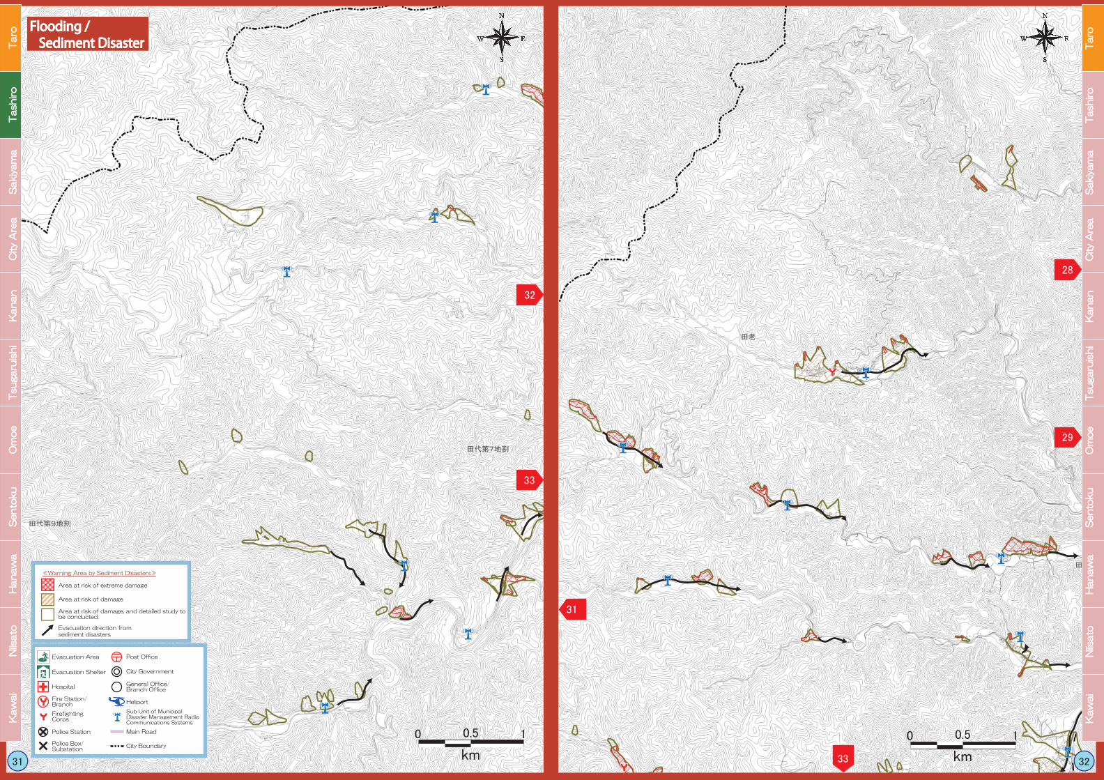
Area at risk of extreme damage
Area at risk of damage
Area at risk of damage, and detailed study to be conducted. Evacuation direction from sediment disasters
≪Warning Area by Sediment Disasters≫
Post OfficeEvacuation Area
Evacuation Shelter
Fire Station/Branch
Hospital
Firefighting Corps
Police Station
Police Box/Substation
City Government
General Office/Branch Office
Heliport
Sub Unit of Municipal Disaster Management Radio Communications Systems
Main Road
City Boundary
Kan
an
Kan
an
City
Are
aC
ity
Are
aS
akiy
am
aS
akiy
am
aT
ash
iro
Tash
iro
Taro
Taro
Niis
ato
Niis
ato
Han
aw
aH
an
aw
aS
en
toku
Sen
toku
Om
oe
Om
oe
Tsu
garu
ish
iT
su
garu
ish
iK
aw
ai
Kaw
ai
Kan
an
Kan
an
City
Are
aC
ity
Are
aS
akiy
am
aS
akiy
am
aT
ash
iro
Tash
iro
Taro
Taro
Niis
ato
Niis
ato
Han
aw
aH
an
aw
aS
en
toku
Sen
toku
Om
oe
Om
oe
Tsu
garu
ish
iT
su
garu
ish
iK
aw
ai
Kaw
ai
Flooding /Flooding / Sediment Disaster Sediment Disaster
33 34
32
3939
31
36 41 42
3029
0 0.5 1
km
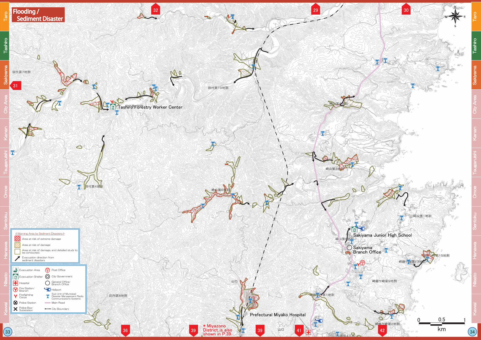
Tashiro Forestry Worker Center
Sakiyama Junior High School
Prefectural Miyako Hospital
Sakiyama Branch Office
Area at risk of extreme damage
Area at risk of damage
Area at risk of damage, and detailed study to be conducted. Evacuation direction from sediment disasters
≪Warning Area by Sediment Disasters≫
Post OfficeEvacuation Area
Evacuation Shelter
Fire Station/Branch
Hospital
Firefighting Corps
Police Station
Police Box/Substation
City Government
General Office/Branch Office
Heliport
Sub Unit of Municipal Disaster Management Radio Communications Systems
Main Road
City Boundary
* Miyazono District is also shown in P.39.
Kan
an
Kan
an
City
Are
aC
ity
Are
aS
akiy
am
aS
akiy
am
aT
ash
iro
Tash
iro
Taro
Taro
Niis
ato
Niis
ato
Han
aw
aH
an
aw
aS
en
toku
Sen
toku
Om
oe
Om
oe
Tsu
garu
ish
iT
su
garu
ish
iK
aw
ai
Kaw
ai
Kan
an
Kan
an
City
Are
aC
ity
Are
aS
akiy
am
aS
akiy
am
aT
ash
iro
Tash
iro
Taro
Taro
Niis
ato
Niis
ato
Han
aw
aH
an
aw
aS
en
toku
Sen
toku
Om
oe
Om
oe
Tsu
garu
ish
iT
su
garu
ish
iK
aw
ai
Kaw
ai
Flooding /Flooding / Sediment Disaster Sediment Disaster