Embed Size (px)
Citation preview
20
Flux: A Platform for Dynamically Reconfigurable Mobile
Crowd-Sensing
NUNO SILVA, EDUARDO R. B. MARQUES, and LUÍS M. B. LOPES, Faculty of Science,
University of Porto & CRACS/INESC-TEC
Flux is a platform for dynamically reconfigurable crowd-sensing using mobile devices like smartphones and
tablets, programmed under a notion of region-based sensing. Each region is defined by a set of physical con-
straints that determine the sensing scope, e.g., based on device position or other environmental variables,
plus a set of periodic tasks that perform the actual sensing. The resulting behavior is inherently dynamic: as
a device’s state changes, e.g., moves in space, it enters and/or leaves different regions, thereby changing the
set of active tasks; moreover, regions can be added, deleted, and reprogrammed on-the-fly. Flux makes use
of a domain-specific language for sensing tasks that is compiled into abstract bytecode, later executed by a
low-footprint virtual machine within a device, guaranteeing runtime safety by construction. For region/task
dissemination, Flux employs a broker that holds a changeable region configuration plus gateways that mir-
ror the configuration throughout different network access points to which devices connect. Sensing data is
streamed by devices to gateways and then back to the broker. Live or archived data streams are in turn fed
by the broker to data-processing clients, which interface with the broker using a publish/subscribe API. We
conducted two case-study experiments illustrating Flux: a single-region deployment to monitor WiFi signal
quality, and a multi-region deployment to monitor noise, temperature, and places-of-interest based on device
movement.
CCS Concepts: • Information systems → Sensor networks; • Networks → Mobile networks; • Com-
puter systems organization → Sensor networks; • Software and its engineering → Virtual ma-
chines; Domain specific languages;
Additional Key Words and Phrases: Mobile crowd-sensing, software architecture, domain-specific language,
virtual machine, android
ACM Reference format:
Nuno Silva, Eduardo R. B. Marques, and Luís M. B. Lopes. 2018. Flux: A Platform for Dynamically Reconfig-
urable Mobile Crowd-Sensing. ACM Trans. Sen. Netw. 14, 3–4, Article 20 (November 2018), 25 pages.
https://doi.org/10.1145/3200202
This work was supported by projects TEC4Growth - RL SMILES - Smart, Mobile, Intelligent and Large scale Sensing and
analytics (NORTE-01-0145-FEDER-000020, NORTE 2020) and HYRAX (CMUP-ERI/FIA/0048/2013, FCT). An earlier version
of the work presented in this article was published in the ACM International Conference on Systems for Energy-Efficient
Built Environments (BuildSys 2017), Delft, The Netherlands, November 2017.
Authors’ addresses: N. Silva, E. R. B. Marques, and L. M. B. Lopes, Faculty of Science, University of Porto & CRACS/
INESC-TEC, Rua do Campo Alegre, 1021, Porto, 4169-007, Portugal; emails: [email protected], [email protected],
Permission to make digital or hard copies of all or part of this work for personal or classroom use is granted without fee
provided that copies are not made or distributed for profit or commercial advantage and that copies bear this notice and
the full citation on the first page. Copyrights for components of this work owned by others than ACM must be honored.
Abstracting with credit is permitted. To copy otherwise, or republish, to post on servers or to redistribute to lists, requires
prior specific permission and/or a fee. Request permissions from [email protected].
© 2018 Association for Computing Machinery.
1550-4859/2018/11-ART20 $15.00
https://doi.org/10.1145/3200202
ACM Transactions on Sensor Networks, Vol. 14, No. 3–4, Article 20. Publication date: November 2018.
20:2 N. Silva et al.
1 INTRODUCTION
The use of sensors to monitor physical or environmental phenomena has manifold applications.Traditionally, such tasks were performed using Wireless Sensor Networks (WSN), networksof low cost, low power, devices typically composed of a radio transceiver, a microcontroller, apower source, and multiple specialised sensors (Akyildiz et al. 2002). The nodes communicateusing energy efficient protocols like ZigBee and report sensor readings to one or more networkgateways, also known as base-stations, and are programmed using domain-specific languages (Foket al. 2009; Gay et al. 2003; Newton and Welsh 2004). Today, however, we have more than 1billion potential multi-sensor personal devices in our smartphones or wearables that are moreflexible and becoming more attractive to use than WSNs. Smartphones have become ubiqui-tous and typically feature powerful multi-core processors, several gigabytes of storage space,multiple communication interfaces and sensors, and can be programmed using general-purposeprogramming languages (Piejko 2017; Society 2015).
Given the ubiquity of mobile devices, their density in some locations and the increasing sophisti-cation and quantity of sensors, we witnessed the emergence of Mobile Crowd-Sensing (MCS) (Guoet al. 2015; Lane et al. 2010). MCS applications may concern passive monitoring in a spatially awaremanner, e.g., environment variables or user mobility patterns, but also explicitly engage users insensing actions, by triggering sensing actions that require their intervention (e.g., photo acquisi-tion) or using the human as “sensor” for event reporting (e.g., accidents in road traffic).
In this context, most proposals focus on the infrastructure required to move the data from thedevices into the cloud infrastructure, for storage or processing, or on specific applications forthe context of mobile networks. Comparatively little work has been done to address the need ofdynamically re-programming these systems and the varying nature of sensing tasks attending toenvironmental conditions/parameterisation, e.g., changing location due to device mobility. Currentsystems are often inflexible and have a low degree of automation, mostly relying on applicationinstallations/updates and user intervention to control the sensing process.
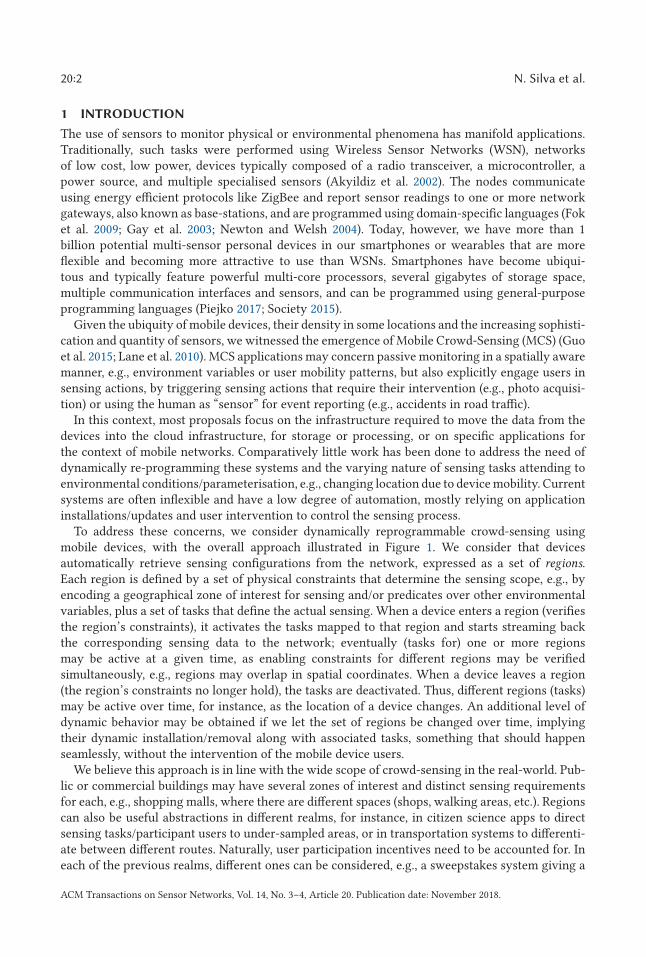
To address these concerns, we consider dynamically reprogrammable crowd-sensing usingmobile devices, with the overall approach illustrated in Figure 1. We consider that devicesautomatically retrieve sensing configurations from the network, expressed as a set of regions.Each region is defined by a set of physical constraints that determine the sensing scope, e.g., byencoding a geographical zone of interest for sensing and/or predicates over other environmentalvariables, plus a set of tasks that define the actual sensing. When a device enters a region (verifiesthe region’s constraints), it activates the tasks mapped to that region and starts streaming backthe corresponding sensing data to the network; eventually (tasks for) one or more regionsmay be active at a given time, as enabling constraints for different regions may be verifiedsimultaneously, e.g., regions may overlap in spatial coordinates. When a device leaves a region(the region’s constraints no longer hold), the tasks are deactivated. Thus, different regions (tasks)may be active over time, for instance, as the location of a device changes. An additional level ofdynamic behavior may be obtained if we let the set of regions be changed over time, implyingtheir dynamic installation/removal along with associated tasks, something that should happenseamlessly, without the intervention of the mobile device users.
We believe this approach is in line with the wide scope of crowd-sensing in the real-world. Pub-lic or commercial buildings may have several zones of interest and distinct sensing requirementsfor each, e.g., shopping malls, where there are different spaces (shops, walking areas, etc.). Regionscan also be useful abstractions in different realms, for instance, in citizen science apps to directsensing tasks/participant users to under-sampled areas, or in transportation systems to differenti-ate between different routes. Naturally, user participation incentives need to be accounted for. Ineach of the previous realms, different ones can be considered, e.g., a sweepstakes system giving a
ACM Transactions on Sensor Networks, Vol. 14, No. 3–4, Article 20. Publication date: November 2018.
Flux: A Platform for Dynamically Reconfigurable Mobile Crowd-Sensing 20:3
Fig. 1. Dynamic region-based sensing tasks for mobile devices.
bonus for payments in certain shops or movie tickets in shopping malls, co-authorship of a paperin citizen science, or the possibility of obtaining a global view of information in transport systemsshaped from data collected by all participants.
In this article, we present Flux, a MCS platform using region-based programming. Flux takesform through an Android service that is installed in devices for data collection and a cloud-basedinfrastructure for global region-based programming and dissemination. The Android service main-tains a set of regions that may be (re)configured through the network for the host device and ex-ecutes sensing tasks for the regions that become active over time. Tasks are programmed usinga domain-specific language and received by devices in a compiled bytecode format amenable tosafe execution by a low-footprint virtual machine within the Android service. For region dissem-ination, Flux employs a cloud broker that holds a changeable set of region configurations, plusgateways that propagate these configurations through different network access points to which de-vices may connect. The idea is that, if necessary, gateways can typically be deployed near the edgeof the network (e.g., as special-purpose access points or cloudlets), alleviating the burden and/orfunctioning as proxy for the centralised broker. Sensing data is streamed by devices to gatewaysand then back to the broker. Data-processing clients may in turn interface with the broker usinga publish/subscribe API to access live or archived data streams.
To illustrate the applicability of Flux, we asked volunteer students to install the Flux servicein their smartphones and conducted two case-study experiments in the physical space of our de-partment building and surrounding gardens. In the first case-study, we defined a single regionwhere geo-referenced WiFi coverage data was sampled. The streams generated by the personaldevices as the students moved through the survey area were gathered and post-processed to pro-vide a real time map of the WiFi coverage at the facilities. In the second case-study, we defined athree-region setting where we took geo-referenced measures of (1) audio noise in the departmentbuilding, (2) places-of-interest based on (absence of) device movement in surrounding gardens,(3) and temperature in the entire survey area.
The remainder of the article is structured as follows. Section 2 provides an overview of Flux interms of underlying requirements, architecture, and component sub-systems. Section 3 describeshow the region-based programming works, in terms of region specification, the domain-specificlanguage used to define tasks, and the virtual machine used to execute them. Section 4 describesthe main traits of the implementation in technical terms, along with a performance evaluationfor the Android service. Section 5 describes our two case-study experiments. Section 6 discussesrelated work, and Section 7 concludes the article with a discussion of ongoing work and futureresearch topics.
ACM Transactions on Sensor Networks, Vol. 14, No. 3–4, Article 20. Publication date: November 2018.
20:4 N. Silva et al.
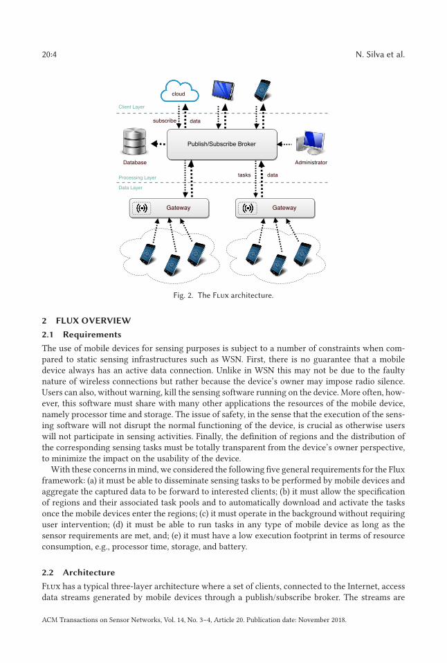
Fig. 2. The Flux architecture.
2 FLUX OVERVIEW
2.1 Requirements
The use of mobile devices for sensing purposes is subject to a number of constraints when com-pared to static sensing infrastructures such as WSN. First, there is no guarantee that a mobiledevice always has an active data connection. Unlike in WSN this may not be due to the faultynature of wireless connections but rather because the device’s owner may impose radio silence.Users can also, without warning, kill the sensing software running on the device. More often, how-ever, this software must share with many other applications the resources of the mobile device,namely processor time and storage. The issue of safety, in the sense that the execution of the sens-ing software will not disrupt the normal functioning of the device, is crucial as otherwise userswill not participate in sensing activities. Finally, the definition of regions and the distribution ofthe corresponding sensing tasks must be totally transparent from the device’s owner perspective,to minimize the impact on the usability of the device.
With these concerns in mind, we considered the following five general requirements for the Fluxframework: (a) it must be able to disseminate sensing tasks to be performed by mobile devices andaggregate the captured data to be forward to interested clients; (b) it must allow the specificationof regions and their associated task pools and to automatically download and activate the tasksonce the mobile devices enter the regions; (c) it must operate in the background without requiringuser intervention; (d) it must be able to run tasks in any type of mobile device as long as thesensor requirements are met, and; (e) it must have a low execution footprint in terms of resourceconsumption, e.g., processor time, storage, and battery.
2.2 Architecture
Flux has a typical three-layer architecture where a set of clients, connected to the Internet, accessdata streams generated by mobile devices through a publish/subscribe broker. The streams are
ACM Transactions on Sensor Networks, Vol. 14, No. 3–4, Article 20. Publication date: November 2018.
Flux: A Platform for Dynamically Reconfigurable Mobile Crowd-Sensing 20:5
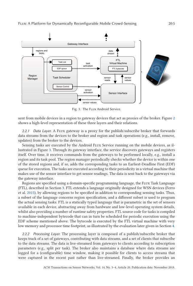
Fig. 3. The Flux Android Service.
sent from mobile devices in a region to gateway devices that act as proxies of the broker. Figure 2shows a high-level representation of these three layers and their relations.
2.2.1 Data Layer. A Flux gateway is a proxy for the publish/subscribe broker that forwardsdata streams from the devices to the broker and region and task operations (e.g., install, remove,updates) from the broker to the devices.
Sensing tasks are executed by the Android Flux Service running on the mobile devices, as il-lustrated in Figure 3. Through its gateway interface, the service discovers gateways and registersitself. Over time, it receives commands from the gateways to be performed locally, e.g., install aregion and its task pool. The region manager periodically checks whether the device is within oneof the stored regions and, if so, adds the corresponding tasks to an Earliest-Deadline First (EDF)queue for execution. The tasks are executed according to their periodicity in a virtual machine thatmakes use of the sensor interface to get sensor readings. The data is sent back to the gateways viathe gateway interface.
Regions are specified using a domain-specific programming language, the Flux Task Language(FTL), described in Section 3. FTL extends a language originally designed for WSN devices (Ferroet al. 2015), by allowing regions to be specified in addition to corresponding sensing tasks. Thus,a subset of the language concerns region specification, and a different subset is used to programthe actual sensing tasks. FTL is a statically typed language that is parametric in the set of sensorsavailable in each device, abstracting away from hardware and low-level operating system details,whilst also providing a number of runtime safety properties. FTL source code for tasks is compiledto machine-independent bytecode that can in turn be scheduled for periodic execution using theEDF scheme mentioned above. The bytecode is executed by the FTL virtual machine with verylow memory and processor time footprint, as illustrated by the evaluation later given in Section 4.
2.2.2 Processing Layer. The processing layer is composed of a publish/subscribe broker thatkeeps track of a set of gateways, contributing with data streams, and a set of clients that subscribeto the data streams. The data is live-streamed from gateways to clients according to subscriptionparameters (e.g., split per task). The broker also maintains a database where data streams arelogged for a (configurable) time window, making it possible for clients to access streams thatwere captured in the recent past rather than live-streamed. Finally, the broker provides an
ACM Transactions on Sensor Networks, Vol. 14, No. 3–4, Article 20. Publication date: November 2018.
20:6 N. Silva et al.
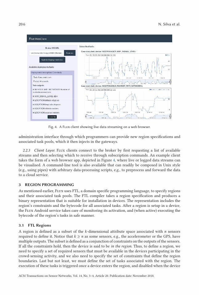
Fig. 4. A Flux client showing live data streaming on a web browser.
administration interface through which programmers can provide new region specifications andassociated task pools, which it then injects in the gateways.
2.2.3 Client Layer. Flux clients connect to the broker by first requesting a list of availablestreams and then selecting which to receive through subscription commands. An example clienttakes the form of a web browser app, depicted in Figure 4, where live or logged data streams canbe visualised. A command-line tool is also available that can readily be composed in Unix style(e.g., using pipes) with arbitrary data-processing scripts, e.g., to preprocess and forward the datato a cloud service.
3 REGION PROGRAMMING
As mentioned earlier, Flux uses FTL, a domain specific programming language, to specify regionsand their associated task pools. The FTL compiler takes a region specification and produces abinary representation that is suitable for installation in devices. The representation includes theregion’s constraints and the bytecode for all associated tasks. After a region is setup in a device,the Flux Android service takes care of monitoring its activation, and (when active) executing thebytecode of the region’s tasks in safe manner.
3.1 FTL Regions
A region is defined as a subset of the k-dimensional attribute space associated with n sensorsrequired to define it. Notice that k ≥ n as some sensors, e.g., the accelerometer or the GPS, havemultiple outputs. The subset is defined as a conjunction of constraints on the outputs of the sensors.If all the constraints hold, then the device is said to be in the region. Thus, to define a region, weneed to specify a set of required sensors that must be available in the devices participating in thecrowd-sensing activity, and we also need to specify the set of constraints that define the regionboundaries. Last but not least, we must define the set of tasks associated with the region. Theexecution of these tasks is triggered once a device enters the region, and disabled when the device
ACM Transactions on Sensor Networks, Vol. 14, No. 3–4, Article 20. Publication date: November 2018.
Flux: A Platform for Dynamically Reconfigurable Mobile Crowd-Sensing 20:7
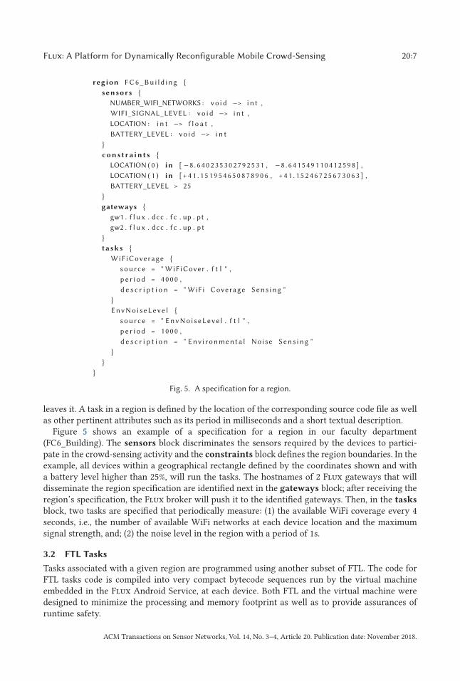
Fig. 5. A specification for a region.
leaves it. A task in a region is defined by the location of the corresponding source code file as wellas other pertinent attributes such as its period in milliseconds and a short textual description.
Figure 5 shows an example of a specification for a region in our faculty department(FC6_Building). The sensors block discriminates the sensors required by the devices to partici-pate in the crowd-sensing activity and the constraints block defines the region boundaries. In theexample, all devices within a geographical rectangle defined by the coordinates shown and witha battery level higher than 25%, will run the tasks. The hostnames of 2 Flux gateways that willdisseminate the region specification are identified next in the gateways block; after receiving theregion’s specification, the Flux broker will push it to the identified gateways. Then, in the tasks
block, two tasks are specified that periodically measure: (1) the available WiFi coverage every 4seconds, i.e., the number of available WiFi networks at each device location and the maximumsignal strength, and; (2) the noise level in the region with a period of 1s.
3.2 FTL Tasks
Tasks associated with a given region are programmed using another subset of FTL. The code forFTL tasks code is compiled into very compact bytecode sequences run by the virtual machineembedded in the Flux Android Service, at each device. Both FTL and the virtual machine weredesigned to minimize the processing and memory footprint as well as to provide assurances ofruntime safety.
ACM Transactions on Sensor Networks, Vol. 14, No. 3–4, Article 20. Publication date: November 2018.
20:8 N. Silva et al.
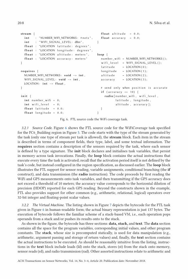
Fig. 6. FTL source code the WiFi coverage task.
3.2.1 Source Code. Figure 6 shows the FTL source code for the WiFiCoverage task specifiedfor the FC6_Building region in Figure 5. The code starts with the type of the stream generated bythe task (only one type of stream per task is allowed), the stream block. Each item in the streamis described in terms of component fields, their type, label, and some textual information. Therequires section contains a description of the sensors required by the task, where each sensoris defined by a type signature. The init block declares and initialises task variables, that persistin memory across task invocations. Finally, the loop block contains the actual instructions thatexecute every time the task is activated; recall that the activation period itself is not defined by thetask’s code, but instead configured in the region specification, as discussed earlier. The loop blockillustrates the FTL support for sensor reading, variable assignments, conditional branching (the if
construct), and data transmission (the radio instruction). The code proceeds by first reading theWiFi and GPS measurements onto task variables, and then transmitting if the GPS accuracy doesnot exceed a threshold of 10 meters; the accuracy value corresponds to the horizontal dilution ofprecision (HDOP) reported for each GPS reading. Beyond the constructs shown in the example,FTL also provides support for other common (e.g., arithmetic, relational, logical) operators over32-bit integer and floating-point scalar values.
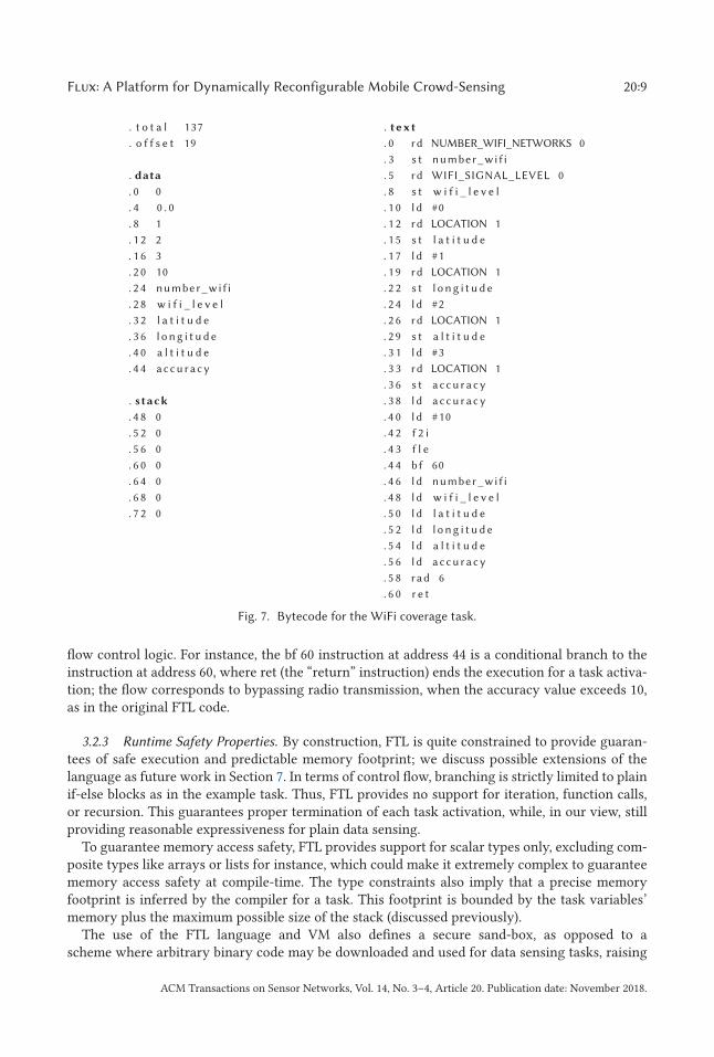
3.2.2 The Virtual Machine. The listing shown in Figure 7 depicts the bytecode for the FTL taskgiven in Figure 6 in human-readable form; the actual binary representation is just 137 bytes. Theexecution of bytecode follows the familiar scheme of a stack-based VM, i.e., each operation popsoperands from a stack and/or pushes its results onto to the stack.
As shown in the figure, the bytecode has three sections: data, stack, and text. The data sectioncontains all the space for the program variables, corresponding initial values, and other programconstants. The stack, whose size is precomputed statically, is used for data manipulation (e.g.,arithmetic, argument passing and storage of return values) and, finally, the text section containsthe actual instructions to be executed. As should be reasonably intuitive from the listing, instruc-tions in the text block include loads (ld) onto the stack, stores (st) from the stack onto memory,sensor reads (rd), and radio transmission (rad). Other assorted instructions relate to arithmetic and
ACM Transactions on Sensor Networks, Vol. 14, No. 3–4, Article 20. Publication date: November 2018.
Flux: A Platform for Dynamically Reconfigurable Mobile Crowd-Sensing 20:9
Fig. 7. Bytecode for the WiFi coverage task.
flow control logic. For instance, the bf 60 instruction at address 44 is a conditional branch to theinstruction at address 60, where ret (the “return” instruction) ends the execution for a task activa-tion; the flow corresponds to bypassing radio transmission, when the accuracy value exceeds 10,as in the original FTL code.
3.2.3 Runtime Safety Properties. By construction, FTL is quite constrained to provide guaran-tees of safe execution and predictable memory footprint; we discuss possible extensions of thelanguage as future work in Section 7. In terms of control flow, branching is strictly limited to plainif-else blocks as in the example task. Thus, FTL provides no support for iteration, function calls,or recursion. This guarantees proper termination of each task activation, while, in our view, stillproviding reasonable expressiveness for plain data sensing.
To guarantee memory access safety, FTL provides support for scalar types only, excluding com-posite types like arrays or lists for instance, which could make it extremely complex to guaranteememory access safety at compile-time. The type constraints also imply that a precise memoryfootprint is inferred by the compiler for a task. This footprint is bounded by the task variables’memory plus the maximum possible size of the stack (discussed previously).
The use of the FTL language and VM also defines a secure sand-box, as opposed to ascheme where arbitrary binary code may be downloaded and used for data sensing tasks, raising
ACM Transactions on Sensor Networks, Vol. 14, No. 3–4, Article 20. Publication date: November 2018.
20:10 N. Silva et al.
well-known security issues that are complex to detect and mitigate; e.g., see Arzt et al. (2014), Daset al. (2010), and Enck et al. (2011).
4 IMPLEMENTATION
In this section, we describe the details of the prototype implementation of the Flux architectureand present a basic performance and resource footprint evaluation for the Flux Android Service.
4.1 Programming Framework
We used Java as the development language for all components, except for the Web browser clientthat was implemented in Javascript. The gateway and P/S broker were implemented as ApacheTomcat web-services,1 the Flux service was programmed on Android Studio2 to run on Android 4.4or higher, and the FTL compiler was implemented using the ANTLR compiler infrastructure.3 Allcomponents of the Flux architecture communicate using a common message format, specifiedusing Google’s Protocol Buffers.4 Plain TCP/IP sockets were used for gateway-device communica-tions and Web-sockets for interactions of the broker with gateways, administration module, andclients. For logging data streams at the broker, we used an SQLite database.5
4.2 The Flux Broker
4.2.1 Region Administration and Dissemination. The Flux broker maintains a list of all the re-gion specifications uploaded to the broker by authenticated users using the administrative inter-face. Users upload a region specification plus the source code of FTL tasks used by it. The sourcecode of tasks are compiled by the broker into Flux virtual machine bytecode, and then packagedtogether with the region specification for delivery to the gateways specified by it (cf. the gateways
block, Section 3.1).For each sensing task in a region, the broker also considers the meta-data information for the
task’s data stream (cf. the stream block, Section 3.2) to create a corresponding SQLite databasetable. The table will store values received for the data stream, hence it will have the same fields asdefined for the stream, along with extra information identifying data collection timestamps plusthe originating devices and gateways.
4.2.2 Client Interface. Clients interface with the broker through a publish/subscribe service.Clients specify the data streams they are interested in from a list of available data streams providedby the broker. Subscriptions may optionally be bounded by a time window, possibly in the past. Ina live stream setting, data received from gateways is published (forwarded) immediately to clientswho subscribed to it. Archived data streams in the broker’s database are also supplied to clients ifthe data for the specified time window is available.
4.3 Flux Gateways
4.3.1 Gateway Discovery and Region Dissemination. Each gateway manages a set of regions,previously uploaded by the broker, that will be injected or updated in mobile devices that connectto it. The gateways advertise themselves over wireless networks, so the Flux Android Service doesnot need any prior knowledge of the location or IP address of any gateway, i.e., it just probes thenetwork for possible gateway advertisements. When a mobile device connects to the gateway, the
1http://tomcat.apache.org.2https://developer.android.com/studio/.3http://www.antlr.org.4https://developers.google.com/protocol-buffers.5http://sqlite.org.
ACM Transactions on Sensor Networks, Vol. 14, No. 3–4, Article 20. Publication date: November 2018.
Flux: A Platform for Dynamically Reconfigurable Mobile Crowd-Sensing 20:11
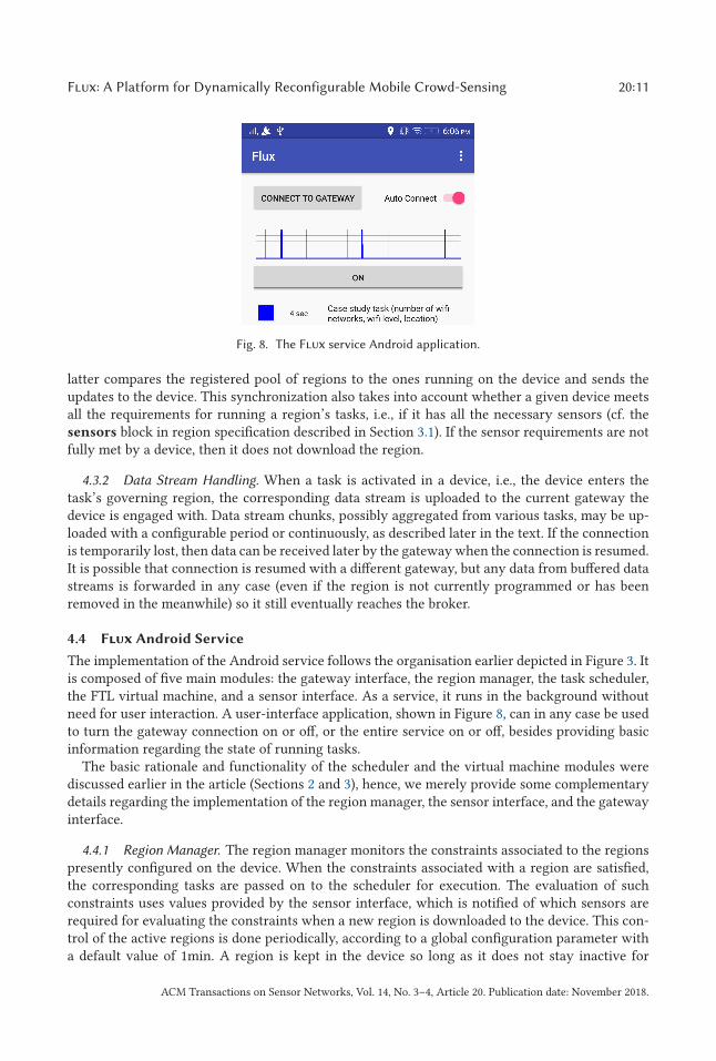
Fig. 8. The Flux service Android application.
latter compares the registered pool of regions to the ones running on the device and sends theupdates to the device. This synchronization also takes into account whether a given device meetsall the requirements for running a region’s tasks, i.e., if it has all the necessary sensors (cf. thesensors block in region specification described in Section 3.1). If the sensor requirements are notfully met by a device, then it does not download the region.
4.3.2 Data Stream Handling. When a task is activated in a device, i.e., the device enters thetask’s governing region, the corresponding data stream is uploaded to the current gateway thedevice is engaged with. Data stream chunks, possibly aggregated from various tasks, may be up-loaded with a configurable period or continuously, as described later in the text. If the connectionis temporarily lost, then data can be received later by the gateway when the connection is resumed.It is possible that connection is resumed with a different gateway, but any data from buffered datastreams is forwarded in any case (even if the region is not currently programmed or has beenremoved in the meanwhile) so it still eventually reaches the broker.
4.4 Flux Android Service
The implementation of the Android service follows the organisation earlier depicted in Figure 3. Itis composed of five main modules: the gateway interface, the region manager, the task scheduler,the FTL virtual machine, and a sensor interface. As a service, it runs in the background withoutneed for user interaction. A user-interface application, shown in Figure 8, can in any case be usedto turn the gateway connection on or off, or the entire service on or off, besides providing basicinformation regarding the state of running tasks.
The basic rationale and functionality of the scheduler and the virtual machine modules werediscussed earlier in the article (Sections 2 and 3), hence, we merely provide some complementarydetails regarding the implementation of the region manager, the sensor interface, and the gatewayinterface.
4.4.1 Region Manager. The region manager monitors the constraints associated to the regionspresently configured on the device. When the constraints associated with a region are satisfied,the corresponding tasks are passed on to the scheduler for execution. The evaluation of suchconstraints uses values provided by the sensor interface, which is notified of which sensors arerequired for evaluating the constraints when a new region is downloaded to the device. This con-trol of the active regions is done periodically, according to a global configuration parameter witha default value of 1min. A region is kept in the device so long as it does not stay inactive for
ACM Transactions on Sensor Networks, Vol. 14, No. 3–4, Article 20. Publication date: November 2018.
20:12 N. Silva et al.
too long, currently 24h. Likewise, it can be removed when a gateway command is received todisable it.
4.4.2 Sensor Interface. The sensor interface is responsible for obtaining sensor readings, inter-acting with assorted Android OS APIs for that purpose. In addition to the requests from the regionmanager, the task scheduler also uses the sensor interface to enable sensors on/off as tasks arescheduled for execution, so the virtual machine can obtain the sensor readings at runtime. Thescheduler implements an adaptive activation/de-activation strategy for sensors. Active sensorsmay consume significant battery power (e.g., GPS), whilst their repeated initialisation/shutdownmay cause unnecessary latency. In particular, initialisation may imply high latency until validreadings are obtained (e.g., again GPS).
The sensor activation strategy takes into account the periodicity of tasks with respect to thesensors they read. For a task with small period (high-frequency), below a certain threshold, thesensors it uses are enabled before the first task activation and henceforth left on. Otherwise, for atask with larger period (low-frequency), the sensors it uses are turned on and off respectively be-fore and after each task activation. In the latter case, to avoid stale reads when the task is activatedagain, the module also takes care to schedule the sensor activation for a configurable amount oftime before the deadline of the next task activation is reached. The period threshold is configuredper each type of sensor, attending to a (for now empirical) balance between initialisation latencyand battery consumption (e.g., the current value is set to 2 minutes for GPS).
4.4.3 Gateway Interface. Regarding the gateway interface, the Android service employs somebuilt-in data buffering mechanisms for network resilience and for reducing battery/bandwidthconsumption. Data produced by tasks is buffered when a connection to the gateway is lost, makingthe service robust to network outages. Moreover, time and buffer size limits may be set and fine-tuned if desired, so that transmission to the gateway occurs periodically using buffered data, ratherthan continuously using live data.
4.5 Performance Evaluation
We conducted an evaluation of the Android service in terms of resource consumption and virtualmachine performance during bytecode execution. For the evaluation, we used a Google Nexustablet running Android 6.0 with 2GB of RAM and a dual-core 2.3GHz CPU, plus a gateway installedon a 4-core machine with 12GB of RAM that was connected to the same network as the mobiledevice. This was done to mitigate exterior interference on the communication between the deviceand the gateway, as we wished to evaluate the performance of the service in isolation. Note alsothat a much more lightweight configuration can be used for hosting a gateway (and/or a broker),like the one for the case-study experiments discussed in Section 5.
The service was setup using five distinct configurations. The first configuration had no tasksrunning, with the purpose of measuring the footprint of the service when idle. The four other con-figurations resulted from successively increasing the number of running tasks by one and doublingthe frequency of each new task by a factor of two. The four tasks were: (1) the example WiFi surveytask running at 1Hz, (2) an atmospheric pressure sensing task at 2Hz, (3) a gyroscope sensing taskat 4Hz, and (4) an accelerometer sensing task at 8Hz.
For each configuration, we then conducted five monitoring sessions of a 2min run of the ser-vice using the Android Debug Shell (adb). In terms of resource consumption, we sampled the CPUutilisation and RAM usage in 1s intervals, plus the total of the TCP/IP data transmitted by the ser-vice in each 2min interval. We also measured the power consumption by sampling the remainingenergy on the device battery (watt-hours) before and after each configuration, through the use of
ACM Transactions on Sensor Networks, Vol. 14, No. 3–4, Article 20. Publication date: November 2018.
Flux: A Platform for Dynamically Reconfigurable Mobile Crowd-Sensing 20:13
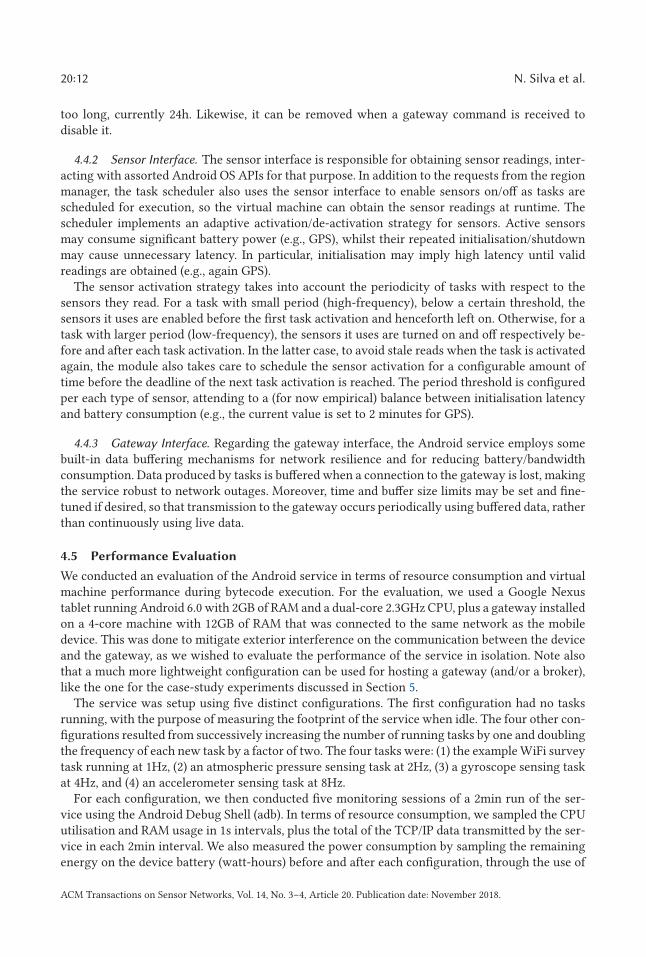
Table 1. Resource Consumption
Tasks CPU (%) RAM (KB) Net. (bytes/s) Battery (J/min)None (∅) 0.17 ± 0.04 9731 ± 2.8 6.2 ± 1.1 12.8 ± 0.6WS 0.25 ± 0.06 9851 ± 3.3 86.3 ± 15.8 31.7 ± 2.8WS + AP 0.32 ± 0.06 9864 ± 3.3 139.0 ± 25.0 34.2 ± 3.3WS + AP + GS 0.58 ± 0.08 9877 ± 3.8 288.9 ± 52.4 35.9 ± 2.9WS + AP + GS + AS 1.39 ± 0.10 9915 ± 5.6 576.6 ± 104.0 36.5 ± 3.6
WS: WiFi survey (1Hz); AP: atmospheric pressure sensing (2Hz);
GS: gyroscope sensing (4Hz); AS: accelerometer sensing (8Hz).
the Android BatteryManager API, converted to the scales of Joules. To withdraw the total energyconsumed by the device, we calculated the difference between the sampled values. The evaluationwas performed with the device screen turned off, seeking to minimize the power consumption un-related to the Flux Android service, but with WiFi turned on to measure the consumed networkbandwidth. The results for the resource consumption (with the corresponding 95% confidence in-tervals) are shown in Table 1, in terms of average CPU and RAM usage during the interval, theaverage network bandwidth used to send the sensed data and the power consumption measuredin Joules per minute.
Overall, we can observe that the service has a very low footprint for all the measures we consid-ered. On average, CPU usage is below 2% in all configurations, the RAM used is under 10MB, andthe consumed network bandwidth is less than 1KB/s. Moreover, the implementation scales wellas the number of tasks increase: The CPU and RAM overhead of adding one more task at doublethe frequency is almost negligible, whereas the consumed network bandwidth increases naturallyowing up to the need of transmitting more sensed data.
Regarding battery consumption, we can observe that the service consumes little battery. Whenno tasks are running, the average consumption observed was 12.7J/min. This value is significantlyincreased to 31.7J/min for the second configuration: the WiFi survey task activates the GPS sen-sor, that is the most power-hungry of all the sensors used on this evaluation. In the remainingconfigurations, even though we introduced tasks with higher frequencies, the increment in thepower consumption was small, namely, because the remaining sensors are more constraint in en-ergy consumption. Overall, the peak value of battery consumption is close to 40 J/min. To put thisin perspective, given that the devices at stake have a nominal battery capacity of 96, 480J, assum-ing an average voltage of 4V, 40J per minute represent a battery consumption of roughly 2.5% ofthe battery capacity per hour. This is not to say that, in proportion, the Android service shouldwithstand about 40h of operation non-stop. Power consumption levels do not generally evolvelinearly, depend on several factors, and are reasonably complex to reason on (Tarkoma et al. 2014).In addition, note that our evaluation considers the device in stand-by mode with the screen turnedoff, mitigating interference from apps and services that are active (or more active) during normaluse of a device.
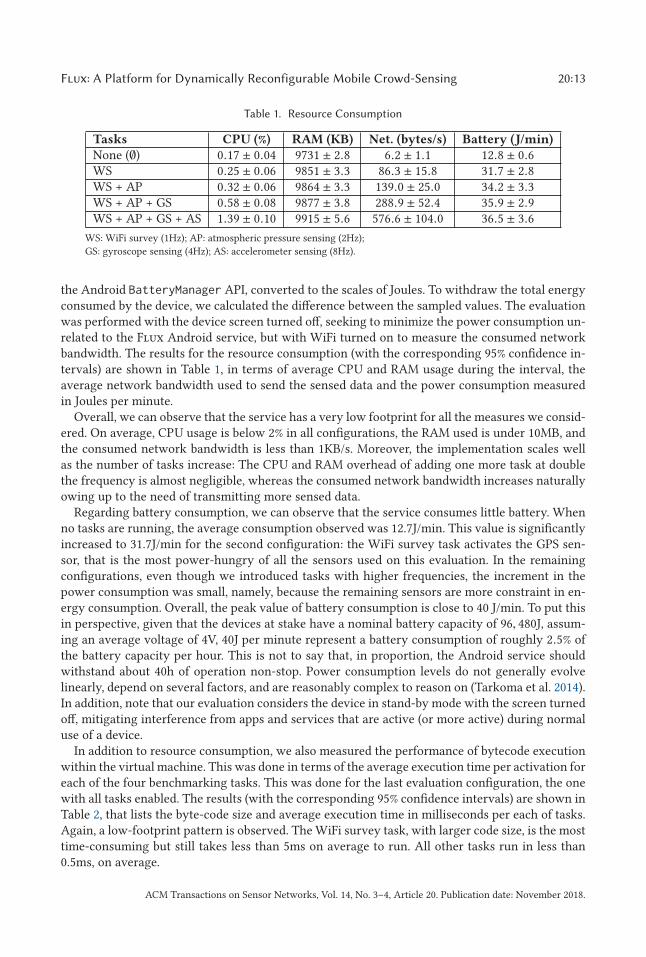
In addition to resource consumption, we also measured the performance of bytecode executionwithin the virtual machine. This was done in terms of the average execution time per activation foreach of the four benchmarking tasks. This was done for the last evaluation configuration, the onewith all tasks enabled. The results (with the corresponding 95% confidence intervals) are shown inTable 2, that lists the byte-code size and average execution time in milliseconds per each of tasks.Again, a low-footprint pattern is observed. The WiFi survey task, with larger code size, is the mosttime-consuming but still takes less than 5ms on average to run. All other tasks run in less than0.5ms, on average.
ACM Transactions on Sensor Networks, Vol. 14, No. 3–4, Article 20. Publication date: November 2018.
20:14 N. Silva et al.
Table 2. Bytecode Size and Execution Time
Task Size (bytes) Exec. time (ms)WiFi survey (WS) 137 4.55 ± 0.20Atmospheric pressure sensing (AP) 26 0.23 ± 0.01Gyroscope sensing (GS) 74 0.44 ± 0.02Accelerometer sensing (AS) 74 0.42 ± 0.01
5 CASE STUDIES
In this section, we present two case-studies that aim to demonstrate: (a) the dynamic injection andactivation of tasks in mobile devices moving around in a given region, with the acquisition of thecorresponding data streams, and; (b) the activation/de-activation of tasks as devices roam betweenregions. For each experiment, we also present a synthetic analysis of the data streams gatheredduring the experiments.
5.1 WiFi Coverage Case-Study
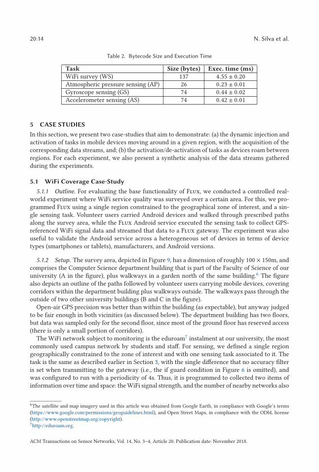
5.1.1 Outline. For evaluating the base functionality of Flux, we conducted a controlled real-world experiment where WiFi service quality was surveyed over a certain area. For this, we pro-grammed Flux using a single region constrained to the geographical zone of interest, and a sin-gle sensing task. Volunteer users carried Android devices and walked through prescribed pathsalong the survey area, while the Flux Android service executed the sensing task to collect GPS-referenced WiFi signal data and streamed that data to a Flux gateway. The experiment was alsouseful to validate the Android service across a heterogeneous set of devices in terms of devicetypes (smartphones or tablets), manufacturers, and Android versions.
5.1.2 Setup. The survey area, depicted in Figure 9, has a dimension of roughly 100 × 150m, andcomprises the Computer Science department building that is part of the Faculty of Science of ouruniversity (A in the figure), plus walkways in a garden north of the same building.6 The figurealso depicts an outline of the paths followed by volunteer users carrying mobile devices, coveringcorridors within the department building plus walkways outside. The walkways pass through theoutside of two other university buildings (B and C in the figure).
Open-air GPS precision was better than within the building (as expectable), but anyway judgedto be fair enough in both vicinities (as discussed below). The department building has two floors,but data was sampled only for the second floor, since most of the ground floor has reserved access(there is only a small portion of corridors).
The WiFi network subject to monitoring is the eduroam7 instalment at our university, the mostcommonly used campus network by students and staff. For sensing, we defined a single regiongeographically constrained to the zone of interest and with one sensing task associated to it. Thetask is the same as described earlier in Section 3, with the single difference that no accuracy filteris set when transmitting to the gateway (i.e., the if guard condition in Figure 6 is omitted), andwas configured to run with a periodicity of 4s. Thus, it is programmed to collected two items ofinformation over time and space: the WiFi signal strength, and the number of nearby networks also
6The satellite and map imagery used in this article was obtained from Google Earth, in compliance with Google’s terms
(https://www.google.com/permissions/geoguidelines.html), and Open Street Maps, in compliance with the ODbL license
(http://www.openstreetmap.org/copyright).7http://eduroam.org.
ACM Transactions on Sensor Networks, Vol. 14, No. 3–4, Article 20. Publication date: November 2018.
Flux: A Platform for Dynamically Reconfigurable Mobile Crowd-Sensing 20:15
Fig. 9. Survey area for WiFi coverage analysis.
detected by Android. The aim was to analyse a suspected inverse correlation between eduroam’sWiFi signal strength and interference from other active networks, in addition to physical location.
In terms of the cloud setup, we used a CentOS Linux virtual machine (CentOS VM) with twocores and 1,837MB of RAM, hosted on a OpenStack cloud infrastructure. An Apache Tomcat appli-cation server instance runs on the VM, hosting a Flux gateway and a Flux P/S broker. The CentOSVM is accessible over the Internet, allowing devices running the Flux Android service to installtasks (and relay data) from (to) the gateway, and external clients to access the P/S broker. This is arelatively simple setup, but one that served the purpose of the experiment; note that, as mentionedearlier in the article, multiple gateways running on different hosts can be used, interacting with abroker on another, possibly distinct, host.
For measurements, we used a total of 23 devices, divided in two groups: 9 Google Nexus tabletsrunning Android 6.0 that we provided the volunteers for use, plus 12 personal smartphones ownedby the volunteer themselves from various vendors and running assorted Android versions, pre-dominantly Android 6.0 (the 9 Google tablets + 9 smartphones) but also 7.0, 5.1, and 4.4 (one deviceper each version). Table 3 summarises the basic characteristics of these devices. The Android ser-vice was installed in each of the devices, followed by an automatic download and installation ofthe FTL task for the survey by the service itself, as soon as it got a connection to the gateway.
5.1.3 Results. After setup, the volunteers conducted 33 trips along the prescribed survey paths,resulting in the collection of 2,726 data sample measurements, 1,193 inside the department build-ing and 1,533 outside. For data analysis, we filtered out measurements for which the GPS accuracyexceed 10 meters, reducing our data set to 1,922 samples (69% of the original) inside the build-ing and to 1,212 samples (79% of the original) outside. Figure 10 depicts the filtered data set as
ACM Transactions on Sensor Networks, Vol. 14, No. 3–4, Article 20. Publication date: November 2018.
20:16 N. Silva et al.
Table 3. Android Device Characteristics
Type Version VendorTablet 6.0 Google (9)
Smartphone 7.0 Samsung (1)6.0 Asus (1), Huawei (1), Lenovo (1),
LG (1), OnePlus (2), Vodafone (1),Wiko (2)
5.1 Xiaomi (1)4.4 Alcatel (1)
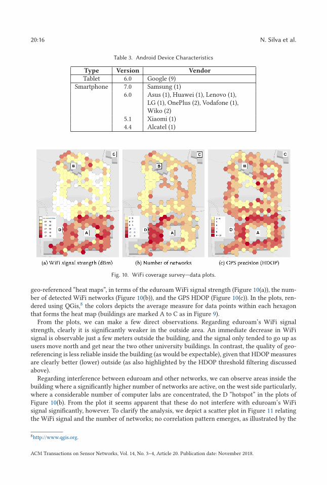
Fig. 10. WiFi coverage survey—data plots.
geo-referenced “heat maps”, in terms of the eduroam WiFi signal strength (Figure 10(a)), the num-ber of detected WiFi networks (Figure 10(b)), and the GPS HDOP (Figure 10(c)). In the plots, ren-dered using QGis,8 the colors depicts the average measure for data points within each hexagonthat forms the heat map (buildings are marked A to C as in Figure 9).
From the plots, we can make a few direct observations. Regarding eduroam’s WiFi signalstrength, clearly it is significantly weaker in the outside area. An immediate decrease in WiFisignal is observable just a few meters outside the building, and the signal only tended to go up asusers move north and get near the two other university buildings. In contrast, the quality of geo-referencing is less reliable inside the building (as would be expectable), given that HDOP measuresare clearly better (lower) outside (as also highlighted by the HDOP threshold filtering discussedabove).
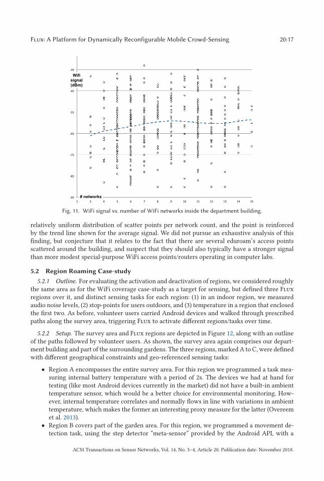
Regarding interference between eduroam and other networks, we can observe areas inside thebuilding where a significantly higher number of networks are active, on the west side particularly,where a considerable number of computer labs are concentrated, the D “hotspot” in the plots ofFigure 10(b). From the plot it seems apparent that these do not interfere with eduroam’s WiFisignal significantly, however. To clarify the analysis, we depict a scatter plot in Figure 11 relatingthe WiFi signal and the number of networks; no correlation pattern emerges, as illustrated by the
8http://www.qgis.org.
ACM Transactions on Sensor Networks, Vol. 14, No. 3–4, Article 20. Publication date: November 2018.
Flux: A Platform for Dynamically Reconfigurable Mobile Crowd-Sensing 20:17
Fig. 11. WiFi signal vs. number of WiFi networks inside the department building.
relatively uniform distribution of scatter points per network count, and the point is reinforcedby the trend line shown for the average signal. We did not pursue an exhaustive analysis of thisfinding, but conjecture that it relates to the fact that there are several eduroam’s access pointsscattered around the building, and suspect that they should also typically have a stronger signalthan more modest special-purpose WiFi access points/routers operating in computer labs.
5.2 Region Roaming Case-study
5.2.1 Outline. For evaluating the activation and deactivation of regions, we considered roughlythe same area as for the WiFi coverage case-study as a target for sensing, but defined three Fluxregions over it, and distinct sensing tasks for each region: (1) in an indoor region, we measuredaudio noise levels, (2) stop-points for users outdoors, and (3) temperature in a region that enclosedthe first two. As before, volunteer users carried Android devices and walked through prescribedpaths along the survey area, triggering Flux to activate different regions/tasks over time.
5.2.2 Setup. The survey area and Flux regions are depicted in Figure 12, along with an outlineof the paths followed by volunteer users. As shown, the survey area again comprises our depart-ment building and part of the surrounding gardens. The three regions, marked A to C, were definedwith different geographical constraints and geo-referenced sensing tasks:
• Region A encompasses the entire survey area. For this region we programmed a task mea-suring internal battery temperature with a period of 2s. The devices we had at hand fortesting (like most Android devices currently in the market) did not have a built-in ambienttemperature sensor, which would be a better choice for environmental monitoring. How-ever, internal temperature correlates and normally flows in line with variations in ambienttemperature, which makes the former an interesting proxy measure for the latter (Overeemet al. 2013).
• Region B covers part of the garden area. For this region, we programmed a movement de-tection task, using the step detector “meta-sensor” provided by the Android API, with a
ACM Transactions on Sensor Networks, Vol. 14, No. 3–4, Article 20. Publication date: November 2018.
20:18 N. Silva et al.
Fig. 12. Multi-region survey area.
period of 1 second. To impose stopping points, we instructed volunteers to stop near twoprescribed points in the garden walkways, marked as stars in Figure 12, for approximately10s.
• Region C corresponds to the department building. For this region we programmed an audionoise sensing task using built-in device microphones, also with a period of 1s. The aim wasto get a sense of possible noise variations in different parts of the building, e.g., possiblyhigher levels of noise near classrooms, and less so near offices.
The hardware setup for the broker and gateway were the same as for the WiFi coverage case-study. As for mobile devices, we employed six of the Google Nexus tablets also used in the previousexperiment. We decided not to use heterogeneous devices, given that internal temperature andaudio measurements may vary widely for distinct devices.
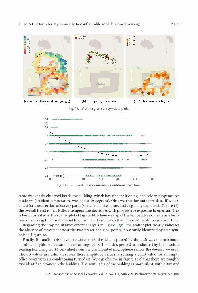
The volunteers walked several times along the prescribed survey paths over a period of twohours. As in the WiFi survey experiment, we filtered out measurements for which the GPS accu-racy exceeded 10m, obtaining 3,161 data sample measurements, 1,031 of which inside the depart-ment building and the remaining 2,130 outside. Figure 13 depicts this data set as geo-referenced“heat maps” for temperature measurements (Figure 13(a)) and audio noise levels (Figure 13(c)) rep-resenting average values in regions A and C, and as a scatter plot for stop-point/movement data(Figure 13(b)) in region B.
5.2.3 Results. Regarding the temperature data in Figure 13(a), the plots show an overall varia-tion of internal battery temperature between 20 and 30 Celsius degrees. Higher temperatures are
ACM Transactions on Sensor Networks, Vol. 14, No. 3–4, Article 20. Publication date: November 2018.
Flux: A Platform for Dynamically Reconfigurable Mobile Crowd-Sensing 20:19
Fig. 13. Multi-region survey—data plots.
Fig. 14. Temperature measurements outdoors over time.
more frequently observed inside the building, which has air conditioning, and colder temperaturesoutdoors (ambient temperature was about 10 degrees). Observe that for outdoors data, if we ac-count for the direction of survey paths (sketched in the figure, and originally depicted in Figure 12),the overall trend is that battery temperature decreases with progressive exposure to open air. Thisis best illustrated in the scatter plot of Figure 14, where we depict the temperature outside as a func-tion of walking time, and a trend line that clearly indicates that temperature decreases over time.
Regarding the stop-points/movement analysis in Figure 13(b), the scatter plot clearly indicatesthe absence of movement near the two prescribed stop-points, previously identified by star sym-bols in Figure 12.
Finally, for audio noise level measurements, the data captured by the task was the maximumabsolute amplitude measured in recordings of 1s (the task’s period), as indicated by the absolutereading (an unsigned 16-bit value) from the uncalibrated microphone sensor the devices we used.The dB values are estimates from these amplitude values, assuming a 30dB value for an emptyoffice room with air conditioning turned on. We can observe in Figure 13(c) that there are roughlytwo identifiable zones in the building. The south area of the building is more silent, with estimated
ACM Transactions on Sensor Networks, Vol. 14, No. 3–4, Article 20. Publication date: November 2018.
20:20 N. Silva et al.
noise predominantly lower than 51dB, coinciding with the zone where staff offices can be found,while the remaining areas are louder, with estimated noise usually between 52 and 62dB, coincidingwith rooms used for classes and by the student union.
6 RELATED WORK
6.1 MCS Platforms
We now survey some state-of-the-art MCS platforms and then make an overall comparison withFlux.
The Medusa (Ra et al. 2012) platform is designed for general purpose crowd-sensing using An-droid smartphones, in interface with Amazon Mechanical Turk (AMT) to recruit workers for sens-ing tasks and manage monetary incentives. Each task is defined in MedScript, an XML-baseddomain-specific language, as a sequence of stages. Stages may define human actions (e.g., tak-ing a photo) or passive sensing, and are supported by binary modules that are downloaded (once)when needed. For security, these binary modules are verified by static Java bytecode analysis thatdetects the use of disallowed APIs. Medusa is not reconfigurable in the sense of Flux regions, astasks and stages do not have associated constraints, instead the dynamics of the system are drivenby the AMT crowd-sourcing model. Like FTL bytecode, the use of MedScript makes for compacttask specifications, which the authors found to several orders of magnitude small to equivalentbinary modules in a few examples.
Sensus (Xiong et al. 2016) is an Android and iOS crowd-sensing application oriented towardhuman studies surveys. Human studies surveys can be scheduled or sensor-triggered, and alsointegrate sensor data in survey responses, including internal and external smartphone sensors likeBluetooth LE beacons or smart-watch sensors. Sensus is self-contained in the sense that the samemobile application is used both for programming surveys, taking them, and storing the results. TheAmazon S3 cloud service can also be used for storage, and an R toolkit library (SensusR) allowsfor processing, analysis, and visualisation of aggregated data. Tasks, called sensing protocols, arespecified using the app stored on a cloud server, and disseminated using email, URLs, or othermeans. Sensing protocols are expressed in a domain-specific JSON-based language. As in Flux,constraints may be specified for sensing, e.g., geographical locations for triggering user surveys.
In PRISM (Das et al. 2010), implemented for Windows Mobile smartphones, sensing tasks aredisseminated from a central server using a push model that implements a two-level predicatecharacterisation for task installation, overall in line with the aims of Flux regions. A high-levelpredicate is defined by a set of coarse-grained geographical regions, the required devices in eachregion, and the required sensors for a task. A low-level predicate, evaluated per device, may be ex-pressed accounting for more fine-grained conditions for task activations, such as precise locationsand speed or temperature ranges. Tasks take form as executable binaries that may be untrusted,raising concerns of safety and security. To cope with these, tasks run in sandboxed environmentwhere all system calls are relayed through the PRISM daemon through a system call interposi-tion scheme. The daemon uses access control and dynamic taint analysis mechanisms to regulatesensor access and obtained data, and monitors execution to terminate tasks that cause resourcedepletion (e.g., CPU and memory), or to enforce limit for resource usage in other cases (e.g., sensorand file system access).
AnonySense (Cornelius et al. 2008), a platform for Linux-based PDAs and iPhones, allows ap-plications to submit sensing tasks to mobile devices to obtain sensed data reports in return. A taskis programmed using a declarative language, AnonyTL, that specifies acceptance conditions basedon device characteristics (e.g., sensor payload), data report statements, and an expiration time forsensing. Report statements express the desired sensor data, along with conditions for reporting
ACM Transactions on Sensor Networks, Vol. 14, No. 3–4, Article 20. Publication date: November 2018.
Flux: A Platform for Dynamically Reconfigurable Mobile Crowd-Sensing 20:21
them, expressed, for instance, in terms of a geographical area, periodicity, or time of day. Appli-cations inject tasks and receive back data in interface with the AnonySense server, organised as aset of services for device registration, task dissemination, and data streaming. Security, in general,and anonymization, in particular, are core concerns of the system, by employing the use of mixnetworks, trust models, and peer certification.
USense (Agarwal et al. 2013) is an Android smartphone crowd-sensing platform for environmen-tal sensing. Tasks, called sensing moments, are programmed using an XML-based domain-specificlanguage. They have a periodic or event-based nature to monitor specified sensor values, and canbe configured with sensing constraints such as geographical location and time. Additionally, anutility value from 0 to 1 denotes the urgency or importance of the task. A significant feature of theruntime system is the use of adaptive sampling strategies, enabling and disabling sensors on-the-fly, that factor in event detection and task utility values that seek to minimize energy consumption.As discussed in Section 4, the current version of Flux, in spite of having low-footprint, follows verysimple heuristics in this regard.
SARANA (Hari et al. 2008) supports the development of applications that execute tasks on re-mote devices based on the services they can provide (e.g., camera, image analysis). It providesa language and a run-time system that allow programmers to express spatial regions of interestas well as resource constraints needed to run the tasks, in particular device location may be ac-counted for when assigning tasks. SARANA makes use of a domain-specific language, a superset ofJava, that provides macro-programming abstractions for device discovery, task distribution underspatial, temporal, and resource constraints, and processing of aggregated data.
Summarising the above discussion of MCS frameworks, Flux more closely relates with Anony-Sense, Medusa, Sensus, SARANA, USense, in the sense of using a domain-specific language forexpressing sensing tasks and associated execution environment. We believe these approaches aremore principled to promote safety and security, as opposed to relatively more complex handling ofthese issues in arbitrary binary code as the PRISM platform is obliged to. Like Flux, AnonySense,Medusa, PRISM, Sensus, SARANA, and USense provide the necessary infrastructure to inject sens-ing tasks into the mobile devices. In the spirit of Flux regions, most platforms allow the specifi-cation of constraints to parameterise task dissemination, except Medusa, which relies on AmazonMechanical Turk’s crowd-sourcing engine for that purpose. Unlike Medusa and Sensus, but similarto AnonySense, PRISM, SARANA, and USense, Flux tasks run in the background gathering sensordata, without user participation in sensing.
To finish this survey, we additionally make a brief reference to MCS frameworks where the“human” is the sensor, more often called crowd-sourcing frameworks, since sensor data doesnot play a pivotal role, apart from typically GPS for geo-tagging purposes. Two examples areZooniverse (Simpson et al. 2014) and Ushahidi (Okolloh 2009). Zooniverse is a quite successfulcitizen-science platform that allows users of mobile devices to contribute to scientific projects,typically by helping with the processing of large datasets with classification tasks. Ushahidi, inits cloud and mobile app form, is a general purpose system to aggregate data supplied by humansusing disparate means (e.g., SMS, Twitter) and its use has been specially noteworthy for crisismanagement in disaster scenarios.
6.2 WSN Platforms
Flux comes in sequence to previous work on the SONAR (Ferro et al. 2015) and Callas (Lopes andMartins 2016) systems for programming static WSN deployments. As in Flux, SONAR’s architec-ture is organised in terms of client, broker, and data layers. SONAR, however, does not supportthe notion of regions. FTL is an extension of the SONAR Task Language (STL) with support forthe specification of regions, and the virtual machine that runs FTL bytecode for sensing tasks is
ACM Transactions on Sensor Networks, Vol. 14, No. 3–4, Article 20. Publication date: November 2018.
20:22 N. Silva et al.
essentially a Java/Android port of the STL virtual machine originally written in C. Similar to Fluxand SONAR, Callas used a domain-specific language and an associated virtual machine environ-ment. Like SONAR, Callas does not support regions. The Callas language is quite different in naturefrom STL and FTL, as it takes a process-calculi approach to define running modules in a WSN. STLand FTL are simpler, as their expressiveness is limited to simple periodic sensing tasks that run inlogical isolation without any explicit concurrency constructs.
The concept of regions in Flux is similar to attribute-based regions proposed for WSN in Welshand Mainland (2004), where a region can be defined based on several criteria, such as device lo-cation, radio connectivity, or values for sensed data. WSN languages like Regiment (Newton andWelsh 2004), for example, use regions in combination with data streams as fundamental program-ming abstractions, but as a functional macro-programming language, Regiment does not supportthe dynamical reconfiguration of the tasks, since the sensor network needs to be reprogrammedas a whole. Agilla (Fok et al. 2009), however, implements a mobile-agent programming flavour forWSN, where each agent (a task) can proactively migrate across the network, executing code thatdepends on the conditions sensed at each node. Agilla differs from Flux in that nodes are typicallygeographically fixed, whereas tasks may migrate across devices.
The driving goals for the use of regions in the WSN setting are to enable online data pre-processing or aggregation to reduce the bandwidth and energy required to send the streams tothe base stations. In the mobile setting, however, bandwidth and energy limitations are much lessstrict, but device mobility and churn are important factors to account for, unlike in WSN that aretypically composed of a fixed set of static nodes.
6.3 MCS Applications
There are several crowd-sensing applications powered by the use of personal devices. We highlighta few key areas of interest and related works.
For environmental sensing, crowd-sensing smartphone applications have been successfully usedto collect data that serves monitoring, modelling or forecasting purposes. For instance, noise levelsfrom a region for the purpose of generating accurate noise models as in NoizCrowd (Wisniewskiet al. 2013) smartphones, sensor readings for barometric pressure can be used for weather mon-itoring and forecasting as in PressureNet (Mass and Madaus 2014) and WeatherSignal (Price andShachaf 2017), custom sensors can be connected to smartphones to monitor air pollution as in Gas-Mobile (Hasenfratz et al. 2012), and (as illustrated in our second case-study experiment) internalbattery temperature can be used as a proxy value for ambient temperature (Overeem et al. 2013).
Another common application is monitoring urban infrastructure such as networks or roads.Large-scale coverage maps of cellular networks have been derived using OpenSignal (OpenSignal2010) and Epitiro (Wakefield 2011), and other applications like Palz (Radu et al. 2013) can be usedto monitor WiFi networks. Urban traffic can also through sensing or road incident reports fromusers, as in the works for Crotis (Roopa et al. 2013), SignalGuru (Koukoumidis et al. 2011), orSmartRoad (Hu et al. 2015), besides well-known commercial apps that engage millions of userslike Waze or Google Traffic.
We finish by reporting on applications that monitor mobile device usage, as enablers for dataanalytics. The DeviceAnalyzer project (Wagner et al. 2013, 2014) is particularly noteworthy. Theproject’s application has been used over the years to collect data for mobile phone characteristicsand usage, building up a publicly available data set containing billions of records collected fromthousands of devices. This data set used by the research community at large for several studies,e.g., as in Hintze et al. (2017) and Thomas et al. (2015). Similar initiatives to DeviceAnalyzer are Or-ange’s D4D challenge (Blondel et al. 2012) and the Lausanne data collection campaign (Kiukkonenet al. 2010).
ACM Transactions on Sensor Networks, Vol. 14, No. 3–4, Article 20. Publication date: November 2018.
Flux: A Platform for Dynamically Reconfigurable Mobile Crowd-Sensing 20:23
7 CONCLUSIONS
In this article, we presented the Flux framework for streaming sensor data from dynamically re-programmable tasks injected into mobile devices. The fundamental concept is that of a region, asubset of the multi-dimensional “sensor space” (the cartesian product of the sets of sensor ranges).Regions are thus defined through constraints on the output of a set of sensors plus a set of asso-ciated sensing tasks. As devices move through the sensor space they alternatively enter and leaveregions, activating and de-activating the corresponding task pools, respectively. Regions are spec-ified using a domain-specific programming language called FTL. The subset used to implementtasks is sufficiently expressive for basic sensing operations and provides compile time guaranteesof runtime safety. FTL source code is compiled into a compact bytecode that is in turn executedwith a low-footprint virtual machine in the devices. We implemented a complete prototype ofthe framework and two case-studies that demonstrate: (a) the dynamic injection and activation oftasks in mobile devices moving around in a given region, with the acquisition of the correspondingdata streams, and; (b) the activation/de-activation of tasks as devices enter/leave regions.
The key issues in the implementation of regions are, of course, related to the way their bound-aries are detected and their impact on activation/de-activation semantics. There are issues relatedto sensor readings we wish to address as future work. For instance, missing a reading or getting animprecise value may make it difficult to establish whether or not a device is still within a region’sboundaries. Moreover, errors related to rapidly changing conditions, e.g., devices moving too fastbetween regions, may make it hard to enforce region activation constraints accurately. We are alsolooking at event-driven activation for tasks, beyond the current support for strict periodic activa-tion. The motivation is that many sensing activities are not continuous over time but are insteadtriggered explicitly by users or by the onset of certain environmental conditions in complementto (possibly too coarse-grained) region constraints.
Extending FTL for more expressive online data processing, whilst preserving runtime-timesafety guarantees, is another topic worthy of future research. Currently, the language is quite min-imalistic with scalar types, simple sensor and network interfaces, and basic arithmetic and controlflow. Adding constructs, e.g., in support of iteration or array types, can in principle be built-in intothe FTL compiler leveraging technologies like SMT solvers (Lahiri and Qadeer 2008) to preserveruntime safety. Furthermore, FTL currently has no communication constructs that allow neigh-bouring nodes to exchange data for aggregation or pre-processing purposes. This is particularlydesirable given the rich networking capabilities of mobile devices, in particular in the context ofmobile edge-clouds, where nearby devices form a network to work collaboratively, a topic we arealso currently working on (Rodrigues et al. 2017, 2018; Silva et al. 2017).
Finally, a few technical implementation aspects are worth future work, such as: extending theplatform to accommodate for sensing actions with user intervention, e.g., as is normally requiredfor crafted image acquisition or guided sensing steps; support for interface with external sen-sors, e.g., Bluetooth LE beacons, sensors embedded in smart-watches, or generic IoT sensors;and a more principled approach toward battery management and its relation with sensor acti-vation/deactivation or data uploading through the network.
REFERENCES
V. Agarwal, N. Banerjee, D. Chakraborty, and S. Mittal. 2013. USense—A smartphone middleware for community sensing.
In Proceedings of the MDM, Vol. 1. IEEE, 56–65.
I. Akyildiz, W. Su, Y. Sankarasubramaniam, and E. Cayirci. 2002. A survey on sensor networks. IEEE Commun. Mag. 40, 8
(2002), 102–114.
S. Arzt, S. Rasthofer, C. Fritz, E. Bodden, A. Bartel, J. Klein, Y. Le Traon, D. Octeau, and P. McDaniel. 2014. FlowDroid:
Precise context, flow, field, object-sensitive, and lifecycle-aware taint analysis for Android apps. In Proceedings of the
PLDI. ACM, 259–269.
ACM Transactions on Sensor Networks, Vol. 14, No. 3–4, Article 20. Publication date: November 2018.
20:24 N. Silva et al.
V. D. Blondel, M. Esch, C. Chan, F. Clérot, P. Deville, E. Huens, F. Morlot, Z. Smoreda, and C. Ziemlicki. 2012. Data for
development: The D4D challenge on mobile phone data. arXiv preprint arXiv:1210.0137 (2012).
C. Cornelius, A. Kapadia, D. Kotz, D. Peebles, M. Shin, and N. Triandopoulos. 2008. Anonysense: Privacy-aware people-
centric sensing. In Proceedings of the MobiSys. ACM, 211–224.
T. Das, P. Mohan, V. N. Padmanabhan, R. Ramjee, and A. Sharma. 2010. PRISM: Platform for remote sensing using smart-
phones. In Proceedings of the MobiSys. ACM, 63–76.
W. Enck, D. Octeau, P. McDaniel, and S. Chaudhuri. 2011. A study of Android application security. In Proceedings of the
SEC. USENIX, 21–21.
G. Ferro, R. Silva, and L. Lopes. 2015. Toward out-of-the-box programming of wireless sensor-actuator networks. In Pro-
ceedings of the CSE. IEEE, 110–119.
C. L. Fok, G. C. Roman, and C. Lu. 2009. Agilla: A mobile agent middleware for self-adaptive wireless sensor networks.
ACM Trans. Auton. Adapt. Syst. (2009), 16:1–16:26.
D. Gay, P. Levis, R. von Behren, M. Welsh, E. Brewer, and D. Culler. 2003. The nesC language: A holistic approach to
network embedded systems. In Proceedings of the PLDI. ACM, 1–11.
B. Guo, Z. Wang, Z. Yu, Y. Wang, N. Y. Yen, R. Huang, and X. Zhou. 2015. Mobile crowd sensing and computing: The review
of an emerging human-powered sensing paradigm. ACM Computi. Surveys 48, 1 (2015), 1–31.
P. Hari, K. Ko, E. Koukoumidis, U. Kremer, M. Martonosi, D. Ottoni, L.-S. Peh, and P. Zhang. 2008. SARANA: Language,
compiler and run-time system support for spatially aware and resource-aware mobile computing. Philos. Trans. Roy.
Soc. A 366 (2008), 3699–3708.
D. Hasenfratz, O. Saukh, S. Sturzenegger, and L. Thiele. 2012. Participatory air pollution monitoring using smartphones. In
Proceedings of the MobiSys. ACM, 1–5.
D. Hintze, P. Hintze, R. D. Findling, and R. Mayrhofer. 2017. A large-scale, long-term analysis of mobile device usage
characteristics. Proceedings of the IMWUT 1, 2 (2017), 13.
S. Hu, L. Su, H. Liu, H. Wang, and T. F. Abdelzaher. 2015. SmartRoad: Smartphone-based crowd sensing for traffic regulator
detection and identification. ACM Trans. Sensor Netw. (2015), 55:1–55:27.
N. Kiukkonen, J. Blom, O. Dousse, D. Gatica-Perez, and J. Laurila. 2010. Toward rich mobile phone datasets: Lausanne data
collection campaign. Proceedings of the ICPS.
E. Koukoumidis, L. S. Peh, and M. R. Martonosi. 2011. SignalGuru: Leveraging mobile phones for collaborative traffic signal
schedule advisory. In Proceedings of the MobiSys. ACM, 127–140.
S. Lahiri and S. Qadeer. 2008. Back to the future: Revisiting precise program verification using SMT solvers. In Proceedings
of the POPL. ACM, 171–182.
N. D. Lane, E. Miluzzo, H. Lu, D. Peebles, T. Choudhury, and A. T. Campbell. 2010. A survey of mobile phone sensing. IEEE
Commun. Mag. 48, 9 (2010), 140–150.
L. Lopes and F. Martins. 2016. A safe-by-design programming language for wireless sensor networks. J. Syst. Arch. 63 (2016),
16–32.
C. F. Mass and L. E. Madaus. 2014. Surface pressure observations from smartphones: A potential revolution for high-
resolution weather prediction?Bull. Amer. Meteorol. Soc. 95, 9 (2014), 1343–1349.
R. Newton and M. Welsh. 2004. Region streams: Functional macroprogramming for sensor networks. In Proceedings of the
DMSN. ACM, 78–87.
O. Okolloh. 2009. Ushahidi, or ‘testimony’: Web 2.0 tools for crowdsourcing crisis information. Participat. Learn. Action 59,
1 (2009), 65–70.
OpenSignal. 2010. OpenSignal. Retrieved from https://opensignal.com/.
A. Overeem, J. C. R. Robinson, H. Leijnse, G. H. Steeneveld, B. K. P. Horn, and R. Uijlenhoet. 2013. Crowdsourcing urban
air temperatures from smartphone battery temperatures. Geophys. Res. Lett. 40, 15 (2013), 4081–4085.
P. Piejko. 2017. Global Mobile Statistics 2017. Retrieved from https://mobiforge.com/research-analysis/13-statistics-on-
mobile-web-performance-in-2017.
C. Price and H. Shachaf. 2017. Using smartphone data for studying natural hazards. In EGU General Assembly Conference
Abstracts (EGU General Assembly Conference Abstracts), Vol. 19. EGU, 2659.
M.-R. Ra, B. Liu, T. F. La Porta, and R. Govindan. 2012. Medusa: A programming framework for crowd-sensing applications.
In Proceedings of the MobiSys. ACM, 337–350.
V. Radu, L. Kriara, and M. K. Marina. 2013. Pazl: A mobile crowdsensing based indoor WiFi monitoring system. In Proceed-
ings of the CNSM. IEEE, 75–83.
J. Rodrigues, E. R. B. Marques, L. Lopes, and F. Silva. 2017. Toward a middleware for mobile edge-cloud applications. In
Proceedings of the MECC. ACM, Article 1, 1:1–1:6 pages.
J. Rodrigues, E. R. B. Marques, J. Silva, L. Lopes, and F. Silva. 2018. Video dissemination in untethered edge-clouds: A case
study. In Proceedings of the DAIS (to appear). Springer.
ACM Transactions on Sensor Networks, Vol. 14, No. 3–4, Article 20. Publication date: November 2018.
Flux: A Platform for Dynamically Reconfigurable Mobile Crowd-Sensing 20:25
T. Roopa, A. N. Iyer, and S. Rangaswamy. 2013. Crotis – crowdsourcing based traffic information system. In Proceedings of
the BDC. IEEE, 271–277.
P. M. P. Silva, J. Rodrigues, J. Silva, R. Martins, L. Lopes, and F. Silva. 2017. Using edge-clouds to reduce load on traditional
WiFi infrastructure and improve quality of experience. In Proceedings of the ICFEC. IEEE, 61–67.
R. Simpson, K. R. Page, and D. De Roure. 2014. Zooniverse: Observing the world’s largest citizen science platform. In
Proceedings of the WWW. ACM, 1049–1054.
The Internet Society. 2015. Internet Society Global Report 2015—Mobile Evolution and Development of the Internet. Re-
trieved from https://www.internetsociety.org/globalinternetreport/2015/assets/download/IS_web.pdf.
S. Tarkoma, M. Siekkinen, E. Lagerspetz, and Y. Xiao. 2014. Smartphone Energy Consumption: Modeling and Optimization.
Cambridge University Press.
D. R. Thomas, A. R. Beresford, and A. Rice. 2015. Security metrics for the Android ecosystem. In Proceedings of the 5th
Annual ACM CCS Workshop on Security and Privacy in Smartphones and Mobile Devices. ACM, 87–98.
D. T. Wagner, A. Rice, and A. R. Beresford. 2013. Device analyzer: Understanding smartphone usage. In Proceedings of the
MobiQuitous. Springer, 195–208.
D. T. Wagner, A. Rice, and A. R. Beresford. 2014. Device analyzer: Large-scale mobile data collection. ACM SIGMETRICS
Perform. Eval. Rev. 41, 4 (2014), 53–56.
J. Wakefield. 2011. 3G mobile data network crowd-sourcing map by BBC News. Retrieved from http://www.bbc.com/news/
business-14574816.
M. Welsh and G. Mainland. 2004. Programming sensor networks using abstract regions. In Proceedings of the NSDI. USENIX
Association.
M. Wisniewski, G. Demartini, A. Malatras, and P. Cudré-Mauroux. 2013. NoizCrowd: A crowd-based data gathering and
management system for noise level data. In Proceedings of the MobiWIS. Springer, 172–186.
H. Xiong, Y. Huang, L. E. Barnes, and M. S. Gerber. 2016. Sensus: A cross-platform, general-purpose system for mobile
crowdsensing in human-subject studies. In Proceedings of the UbiComp. ACM, 415–426.
Received January 2018; accepted March 2018
ACM Transactions on Sensor Networks, Vol. 14, No. 3–4, Article 20. Publication date: November 2018.