Embed Size (px)
Citation preview

This article was downloaded by: [82.106.67.134]On: 08 February 2013, At: 12:48Publisher: RoutledgeInforma Ltd Registered in England and Wales Registered Number: 1072954 Registered office: Mortimer House,37-41 Mortimer Street, London W1T 3JH, UK
Geografisk Tidsskrift-Danish Journal of GeographyPublication details, including instructions for authors and subscription information:http://www.tandfonline.com/loi/rdgs20
For every solution there are many problems: the roleand study of technical systems in socio-environmentalcoevolutionSander van der Leeuw aa School of Sustainability, Arizona State University, 800 S. Cady Mall, P.O. Box 875402,Tempe, AZ, 85287-5402, USAVersion of record first published: 14 Jan 2013.
To cite this article: Sander van der Leeuw (2012): For every solution there are many problems: the role and study oftechnical systems in socio-environmental coevolution, Geografisk Tidsskrift-Danish Journal of Geography, 112:2, 105-116
To link to this article: http://dx.doi.org/10.1080/00167223.2012.741887
PLEASE SCROLL DOWN FOR ARTICLE
Full terms and conditions of use: http://www.tandfonline.com/page/terms-and-conditions
This article may be used for research, teaching, and private study purposes. Any substantial or systematicreproduction, redistribution, reselling, loan, sub-licensing, systematic supply, or distribution in any form toanyone is expressly forbidden.
The publisher does not give any warranty express or implied or make any representation that the contentswill be complete or accurate or up to date. The accuracy of any instructions, formulae, and drug doses shouldbe independently verified with primary sources. The publisher shall not be liable for any loss, actions, claims,proceedings, demand, or costs or damages whatsoever or howsoever caused arising directly or indirectly inconnection with or arising out of the use of this material.

For every solution there are many problems: the role and study of technical systems insocio-environmental coevolution
Sander van der Leeuw*
School of Sustainability, Arizona State University, 800 S. Cady Mall, P.O. Box 875402, Tempe AZ 85287-5402, USA
(Received 16 February 2012; final version received 5 September 2012)
This paper uses a case study on the evolution of the Rhine river delta to illustrate the coevolution of the environment,the technology used to exploit it, and the institutions governing it. Three strands are interwoven:
(1) Achieving equilibrium between protecting and utilizing land is difficult. In this area, as a result of exploitation, agri-culture on fertile peat is succeeded by stock raising on infertile peat, peat extraction, inundation, and drainage to regainfertile soil.(2) In the dynamic between collective and individual action that accompanies these changes, individuals beget institu-tions and institutions beget individuals.(3) New technologies are invented, helping overcome challenges posed by the natural environment. Their unexpectedconsequences undermine the solutions found, leading to new technologies, etc.
The ultimate cause is the interaction between human cognition and action. Our cognition is limited in the number ofdimensions it can simultaneously handle, and our action (directly or indirectly) affects all the dimensions of the complexadaptive system that is the environment, triggering unintended consequences, and new actions. This feedback takes thesystem from perceived challenges to solutions to new, unintended challenges, driving the region further and further fromits point of departure, towards the bottom of the sea.
Keywords: socio-environmental coevolution; technology; unintended consequences; water management
Introduction
The purpose of this paper is to illustrate by means of anexample some of the long-term dynamics at work in anyinteraction that involves humans in modifying their natu-ral environment. Its point of departure is the fact that: (1)though we all live in a very complex system (2) ourperception of that system has been extremely limited.
The complexity of the Earth system or any of itssubsystems is so generally accepted that it hardlyrequires demonstration. It implies that we need to alsoconceive of the Earth system and its (natural, social, andsocio-natural) subsystems as complex adaptive systems(CAS) in the theoretical sense of the word, i.e. as funda-mentally unstable systems of many active agents, inwhich both agents and processes mutually affect manyother components of these (open) systems. The study ofsuch CAS focuses on the complex, emergent and macro-scopic properties of the system that are due to the inter-actions of these agents. For all intents and purposes, inpractice, the number of interactive actors and processesat all scales approaches infinity.
As to the limitations to human perception, experimen-tal research, as well as a monitoring of the archeologicalrecord, lead us to conclude that the short-term workingmemory of modern human individuals limits their percep-tion biologically to at most 6 ± 2 information sourcessimultaneously (Read & van der Leeuw, 2009). Althoughover the course of human history our species has devel-oped an amazing array of techniques to overcome thathandicap, from introducing narratives that symbolicallyrefer to more dimensions to the introduction of manyabstract concepts capturing more dimensions to workingtogether in a group to extend the number of dimensionsthat can simultaneously be perceived, nevertheless humanperception has never captured the virtually infinitenumber of dimensions that constitute the dynamics of theEarth system, far from it …
The consequence of this constraint is that any humanintervention in the environment is based on a verysimplified perspective on the processes actually going onin that complex environmental system. On the otherhand, our impact on our environment is highly multidi-
*Email: [email protected]
Geografisk Tidsskrift-Danish Journal of GeographyVol. 112, No. 2, November 2012, 105–116
ISSN 0016-7223 print/ISSN 1903-2471 online� 2012 Taylor & Francishttp://dx.doi.org/10.1080/00167223.2012.741887http://www.tandfonline.com
Dow
nloa
ded
by [
82.1
06.6
7.13
4] a
t 12:
48 0
8 Fe
brua
ry 2
013

mensional, as any of our actions affects directly or indi-rectly the many dimensions of the natural systemsinvolved. As a consequence, any human action upon theenvironment leads to numerous ‘unintended’ or ‘unantic-ipated’ consequences. Over long-term time, although theincrease of our knowledge about a certain system mayincrease (linearly or even geometrically), due to the dif-ference in dimensionality between our cognitive spaceon the one hand and the total complex system of whichwe are part on the other hand, the unintended conse-quences of our actions increase exponentially. Or in sim-pler terms, though we may think we know more andmore, in effect we know less and less about the environ-mental systems we are dealing with.
In every socio-environmental system, we thereforeencounter a number of ‘tipping points’ that are inherentto the system itself, although they cannot be predicted ‘apriori’. They occur whenever the system is overwhelmedby the unintended consequences of its trajectory. Often,‘crises’ are seen as events that are brought about byextraneous or unexpected disturbances, whether these aretriggered inside or outside of the socio-environmentalsystem. In our case, however, we argue that such ‘crises’(sudden tipping points, or in René Thom’s words ‘catas-trophes’) are actually the inevitable result of humanintervention in the environment and occur whenever thesystem is overwhelmed by the unintended consequencesof past actions. We might therefore rephrase the defini-tion of ‘crisis’ as: ‘a temporary incapacity of a system toprocess the information needed to keep it co-evolvingwith the context in which it finds itself as a result of itsown antecedent actions’.
Under such circumstances, another particular aspectof human cognitive systems comes to play a major role.This is the fact that our theories (including categories andperceived relations between phenomena) are in effectunderdetermined by our observations. This is nicely illus-trated by Atlan (1992), who takes as example a set of fivetraffic lights that can each assume three states (red,orange, and green). The total number of states of this sys-tem is 35 or 243. But the number of potential connectionsbetween these states, which could potentially explaintheir dynamics, is actually 325, or 847,288,609,443. Todecide which among these is the ‘right’ one wouldrequire a number of observations close to the number ofpossibilities – something we never achieve in real life.The corollary of this phenomenon is that our theories aregenerally overdetermined by those among our priorexperiences that we consider relevant (more often thannot without a real basis for this assumption). As a result,the trajectory our socio-environmental systems follow ispath-dependent in the sense that ‘change is hard’ it isvery difficult to deviate from a particular trajectory onceone has invested substantive thought (let alone materialor financial means) in it. In times of crises such as
mentioned above, this affects both the speed and theextent of change that may be implemented.
These are some of the reasons why technical systemshave a very particular place in our dealings with theenvironment, and should have such a particular positionin our research on those dealings. Technical systems donot follow the logic of the societal systems in which theyare embedded, nor do they follow the logic of the envi-ronmental systems with which they interact. In fact, theyhave their own logic that needs to be investigated byappropriate means. What those are is best illustrated afterthe presentation of this case study.
The pre- and proto-history of the Rhine delta
The area presently called ‘Rijnland’ in the Netherlands issituated just behind the Dutch coastline between twoancient branches of the Rhine near its mouth. The term‘Rijnland’, however, is also used for the administrativeentity that governs water management in the area. In thischapter, I will try to show that such a conjunction is notaccidental. Indeed, the management of the environmenthas not only given rise to new technologies (such aswindmills, polders, locks, and dikes), but it has alsoshaped the institutional development of the Netherlandsand many aspects of its societal dynamics.
To do so, I will describe the genesis and evolution ofthe area through time from around 2000 BC to thepresent. In that period, the natural dynamics of theregion were completely brought under control of human-kind, or to use the term of Ingold (1986): ‘Nature wasappropriated’.
Like every river, the Rhine has for tens of millenniadeposited large amounts of gravel and sand in front ofits mouth, along the North Sea. As the sea level roseunder the impact of climate change, and the depositsbuilt up simultaneously, the river’s flow slowed down,and the difference in level between water and landdiminished until in many places it was only a few feet.A true delta emerged, in which the sea and the rivercontinually struggled for dominance. Sometimes aboveand sometimes underwater, the natural levees becameareas on which vegetation took root. But as long as thesea regularly inundated it during winter storms, anddeposited large amounts of sand on the levees, thevegetation could not really establish itself.
Around 2000 BC, currents in the North Sea shiftedand caused the slow buildup of a row of levees (dunes)that protected the area immediately behind it from thesea (Brandt & van der Leeuw, 1988; van der Leeuw,1987). The largest mouth of the Rhine shifted towardsthe North, freshwater accumulated behind the leveesfurther south, and as the vegetation flourished in thisarea, which was now protected from the sea, it became apeat marsh.
106 S. van der Leeuw
Dow
nloa
ded
by [
82.1
06.6
7.13
4] a
t 12:
48 0
8 Fe
brua
ry 2
013

Eventually, people settled in that marsh, initially onsmall tufts of peat that were a little higher than the sur-rounding landscape and on the edges of the creeks thatdrained it. These early settlements consisted of a verysmall number of houses (generally 1–4). People exploitedthe land by planting some cereals and other edible plantsand by allowing some domesticated cattle and sheep tograze there (Brandt et al., 1984). But the battle againstwater dominated their lives. One finds drainage ditchesaround the individual houses, and with time individualhouses were built on small artificial mounds (‘terpen’ inDutch) to ensure that they were not inundated in periodsof high water when storms or high tides in the North Seablocked the Rhine’s mouth and freshwater accumulatedbehind the dunes (Brandt et al., 1987).
To cultivate their crops, people also had to drain thepeat. But as soon as the water table was lowered, the (dry-ing) peat either oxidized or blew away, lowering the levelof the land. This engendered a positive feedback loop thatlowered the land, made drainage more and more difficult,and heightened the danger of inundations. The drainageditches grew longer and longer, eventually creating acomplicated network. These longer ditches are the firstsign that people began to collaborate and organizethemselves in the battle against the water.
By about AD 900, the inhabitants’ strategy in dealingwith the water changed – rather than building individualmounds for themselves, they began to collaborate inenclosing certain small surfaces by means of artificialdefense systems (dikes, ‘dijken’ in Dutch, ‘levees’ in USEnglish) several meters high. We may interpret this as asign that local organization had reached a new level.
The middle ages: keeping the land dry leads to theformation of Rijnland
Around 1000 AD, another factor entered into effect: thepolitical organization of the area (cf. van Tielhof & vanDam, 2006, the most recent authoritative work on thehistory of Rijnland, upon which I have heavily relied forthis paper, including for the illustrations). Feudal lordsbegan to play a role in the western part of what is nowthe Netherlands. An endless series of skirmishes betweensmall local potentates ultimately created a politicalhierarchy. Not surprisingly, this process was somewhatmore advanced in the drier parts of the delta than in thewetter areas nearest the coast. In particular, the bishopricof Utrecht, situated on ‘higher’ ground (the sandy mor-aines left by the last Ice Age), had a longer history as apolitical entity than the ‘lower’ areas immediately behindthe dunes, collectively called ‘Holtland’ (‘the woodland’,from which the current ‘Holland’ derives). Holland andUtrecht remained politically distinct for most of theMiddle Ages, and there was a continuous series of
political and military conflicts between their rulers, theCounts of Holland and the Bishops of Utrecht.
During this time, Holland was administrativelydivided into several administrative entities (so-called‘baljuwschappen’), of which two are particularly impor-tant for this story: ‘Rijnland’, with Leyden at its center,and ‘Kennemerland’ with Haarlem as its focus (cf.Figure 1(a)). Both towns were located at the easternmostedge of the natural levees (dunes) that protected thelandscape from the sea and were therefore themselvesrelatively safe from inundation.
Around AD 1150, the mouth of the (Old) Rhine tothe west of Leyden was definitively closed by the move-ment of large amounts of sand in the northward currentalong the coast. This caused the area behind the dunes tosuffer more frequently from river inundation, and by AD1280 collective action had to be taken on a larger scale.Not surprisingly, the first major collective intervention –the damming of the Rhine upstream to protect the inhab-itants of Rijnland from flooding by the river – occurredat the boundary between Utrecht and Holland (cf.Figure 1(b)). Canals were then dug from Leyden to theNorth and the South, to ensure that the area’s surfacewater could be evacuated without danger to the popula-tion of Rijnland. But canals have the unfortunateproperty that they can, if the water level inverts, also besources of flooding. Hence, locks had to be constructedat the mouth of both canals (see Figure 1(b)).
Notwithstanding these efforts, Rijnland remainedvery vulnerable to flooding, especially from the North,via the two large lakes (‘Zoetermeer’ & ‘Haarlemmer-meer’ respectively) to the north of Leyden. It quicklybecame clear that to protect the Rijnland from this dan-ger, cooperation was necessary with Kennemerland sothat a dam and a sluice could be built at the hydrologi-cally most propitious location; this was along the edgeof the open mouth of the Rhine to the north of Haarlem.
This cooperation is the first tangible sign that watermanagement has its own rules and its own geography,which do not necessarily follow those of politics oradministration. One cannot safeguard against flooding ifthere is no unified management. The risk is too great thatdifferences of opinion lead to disaster. Hence, for thepurposes of water management, and water managementonly, the southern part of Kennemerland soon becamepart of Rijnland. In doing so, a typically Dutch solutionwas found: to create a ‘water authority’ that couldimpose its power on all the other political and adminis-trative authorities within its territory, including thehighest, in so far as water issues were concerned. Fromthis point forward, there were two ‘Rijnlands’, that ofthe baljuw (the highest civil administrator representingthe count), and that of the ‘dijkgraaf’ (not accidentallycalled the ‘count of the dijken’ (dikes or artificial
Geografisk Tidsskrift-Danish Journal of Geography 107
Dow
nloa
ded
by [
82.1
06.6
7.13
4] a
t 12:
48 0
8 Fe
brua
ry 2
013

Figure 1. (a) Map of the Rijnland area around AD 1280. The map indicates the location of the Baljuwschappen, theHoogheemraadschap, and the natural drainage system of the area (after van Tielhof & van Dam, 2006). As an approximate scale, thedistance between Haarlem and Leiden as the crow flies is 28 km. (b) Map of the area around 1300. The map indicates the location ofthe earliest civil engineering works: bridges, locks, and dikes (after van Tielhof & van Dam, 2006).
108 S. van der Leeuw
Dow
nloa
ded
by [
82.1
06.6
7.13
4] a
t 12:
48 0
8 Fe
brua
ry 2
013

levees). The territory of the latter (marked by a dottedline in Figure 1(a)) exceeded that of the former.
The early modern period: land is turned into water
When drained, peat is incredibly fertile as it consistsentirely of decaying or decayed organic matter. Once themedieval water problems at the regional scale had been
solved, the area very quickly became a rich andintensively cultivated agricultural zone. But maintainingthe agricultural intensity depended on the ability to con-tinually drain the land. Between plots of cultivated land,narrow ditches (sloten) were dug to drain them. Thesedrainage ditches ended at larger artificial or naturalwaterways, evacuating excess water to the main streamsor canals crossing the territory of Rijnland.
Figure 2. Map of the Kagerplassen area in the Hoogheemraadschap van Rijnland by Floris Balthasars and Balthasar Florisz. vanBerckenrode (1615).Source: Archive of the Hoogheemraadschap Rijnland number: A-4071.The map shows the many windmills concentrated in that area.
Geografisk Tidsskrift-Danish Journal of Geography 109
Dow
nloa
ded
by [
82.1
06.6
7.13
4] a
t 12:
48 0
8 Fe
brua
ry 2
013
As a result of the shrinking of the peat inherent inthis loss of water, as well as the oxidation of the organicmaterial due to the intensive cultivation, the surface ofthe peat descended about one meter per century, comingcloser and closer to the subsurface water table. Initially,because the land became wetter, its fertility declined, asdid the yields of the farmers cultivating it. Butultimately, the surface of the land actually descendedbelow that of the water. Urgent solutions were needed,again requiring major investments.
As a consequence, dams (dijken) were built on bothsides of the draining waterways to prevent the land fromfurther flooding. But to remove excess water, it now hadto be moved up and away, instead of downward. Tosolve that problem, horse- or wind-driven watermillswere introduced in AD 1408, which pumped the waterup from the drainage ditches into the major waterways.A map from around AD 1615 (Figure 2) shows thenumber of mills dotting the landscape at that time.
However, lowering of the land surface with respectto the water table also changed the economy of the area.The local reduction in the cereal yield occurred at a timewhen, elsewhere, grain was cheap and easy to obtain.Hence, it became more attractive to let the land (nowoften soggy) revert to pasture for grazing cattle andsheep. Milk and butter, as well as meat, fetched goodprices in the growing towns of the area and requiredmuch less labor than cereal cultivation. In turn, thisforced many marginal farmers to find other means ofsubsistence. Some adopted other rural professions, suchas fishing, but many of them moved to the towns, wherethere was demand for cheap labor in such typical urbanactivities as trade and industry.
The fourteenth to sixteenth centuries saw a veryimportant expansion of urbanization in the area, underthe impact of rapidly growing long-distance trade andthe industrial production of trade goods. Continued mis-ery in rural areas maintained the influx of poor peasantsinto the cities and kept the price of labor low, thus stim-ulating shipbuilding and other crafts and industries that,in turn, drove this rapid urban growth. In particular, theDutch coastal towns of the thirteenth century becameinvolved in trade between the Baltic countries, GreatBritain, and the Atlantic coast of France. They broughtdried fish, pelts, and other Nordic items to Britain andFrance, exported British wool to Flanders and Flemish(woolen) cloth to France and the Baltic, as well as trans-porting wine from the Garonne area in Aquitaine to bothBritain and the Baltic. As that trade intensified, theDutch coastal towns of Leyden, Haarlem, and especiallyAmsterdam grew rapidly and increased the production oftheir own trade goods.
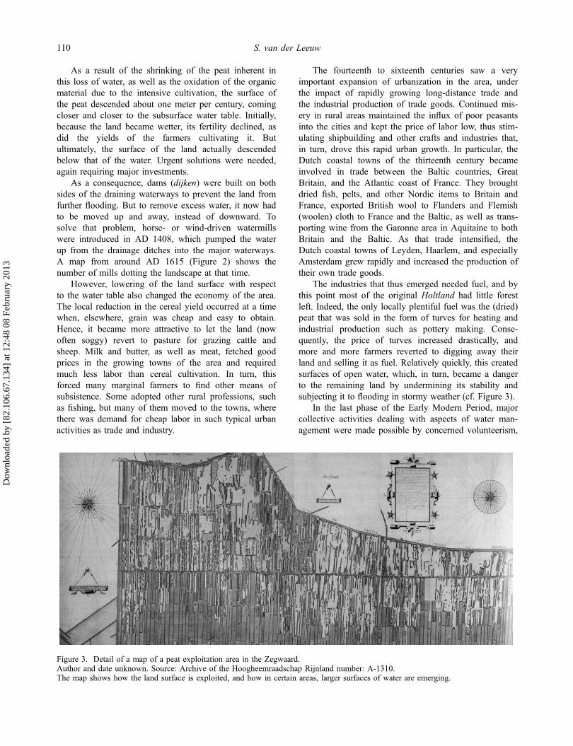
The industries that thus emerged needed fuel, and bythis point most of the original Holtland had little forestleft. Indeed, the only locally plentiful fuel was the (dried)peat that was sold in the form of turves for heating andindustrial production such as pottery making. Conse-quently, the price of turves increased drastically, andmore and more farmers reverted to digging away theirland and selling it as fuel. Relatively quickly, this createdsurfaces of open water, which, in turn, became a dangerto the remaining land by undermining its stability andsubjecting it to flooding in stormy weather (cf. Figure 3).
In the last phase of the Early Modern Period, majorcollective activities dealing with aspects of water man-agement were made possible by concerned volunteerism,
Figure 3. Detail of a map of a peat exploitation area in the Zegwaard.Author and date unknown. Source: Archive of the Hoogheemraadschap Rijnland number: A-1310.The map shows how the land surface is exploited, and how in certain areas, larger surfaces of water are emerging.
110 S. van der Leeuw
Dow
nloa
ded
by [
82.1
06.6
7.13
4] a
t 12:
48 0
8 Fe
brua
ry 2
013
which was subsequently replaced by wage labor paidfor by a land tax imposed by the authorities of the(now) Hoogheemraadschap Rijnland. As land wasprogressively dug away, of course, this reduced the taxrevenue necessary for the maintenance of the dams,canals and locks that kept the water under control.Hence, the water authorities tried to limit peat extractionby forcing those who practiced it to buy other tax-liableland to compensate for the loss of income. In theprocess, the water authorities gained control over aspectsof land management.
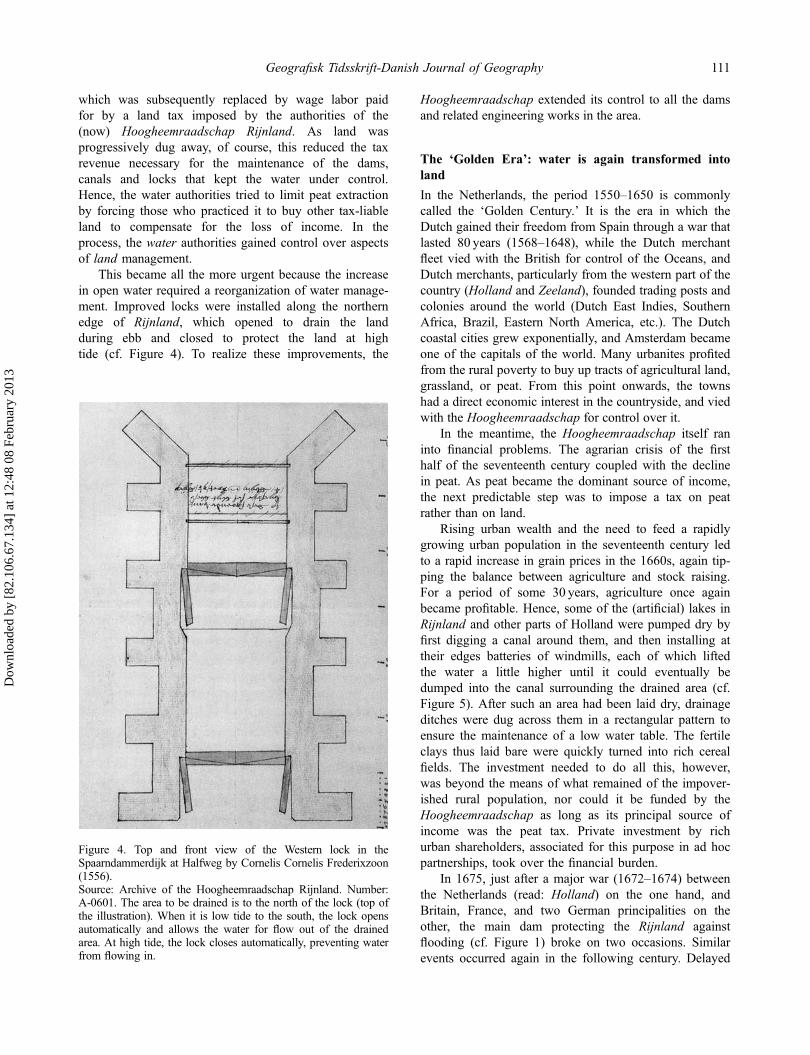
This became all the more urgent because the increasein open water required a reorganization of water manage-ment. Improved locks were installed along the northernedge of Rijnland, which opened to drain the landduring ebb and closed to protect the land at hightide (cf. Figure 4). To realize these improvements, the
Hoogheemraadschap extended its control to all the damsand related engineering works in the area.
The ‘Golden Era’: water is again transformed intoland
In the Netherlands, the period 1550–1650 is commonlycalled the ‘Golden Century.’ It is the era in which theDutch gained their freedom from Spain through a war thatlasted 80 years (1568–1648), while the Dutch merchantfleet vied with the British for control of the Oceans, andDutch merchants, particularly from the western part of thecountry (Holland and Zeeland), founded trading posts andcolonies around the world (Dutch East Indies, SouthernAfrica, Brazil, Eastern North America, etc.). The Dutchcoastal cities grew exponentially, and Amsterdam becameone of the capitals of the world. Many urbanites profitedfrom the rural poverty to buy up tracts of agricultural land,grassland, or peat. From this point onwards, the townshad a direct economic interest in the countryside, and viedwith the Hoogheemraadschap for control over it.
In the meantime, the Hoogheemraadschap itself raninto financial problems. The agrarian crisis of the firsthalf of the seventeenth century coupled with the declinein peat. As peat became the dominant source of income,the next predictable step was to impose a tax on peatrather than on land.
Rising urban wealth and the need to feed a rapidlygrowing urban population in the seventeenth century ledto a rapid increase in grain prices in the 1660s, again tip-ping the balance between agriculture and stock raising.For a period of some 30 years, agriculture once againbecame profitable. Hence, some of the (artificial) lakes inRijnland and other parts of Holland were pumped dry byfirst digging a canal around them, and then installing attheir edges batteries of windmills, each of which liftedthe water a little higher until it could eventually bedumped into the canal surrounding the drained area (cf.Figure 5). After such an area had been laid dry, drainageditches were dug across them in a rectangular pattern toensure the maintenance of a low water table. The fertileclays thus laid bare were quickly turned into rich cerealfields. The investment needed to do all this, however,was beyond the means of what remained of the impover-ished rural population, nor could it be funded by theHoogheemraadschap as long as its principal source ofincome was the peat tax. Private investment by richurban shareholders, associated for this purpose in ad hocpartnerships, took over the financial burden.
In 1675, just after a major war (1672–1674) betweenthe Netherlands (read: Holland) on the one hand, andBritain, France, and two German principalities on theother, the main dam protecting the Rijnland againstflooding (cf. Figure 1) broke on two occasions. Similarevents occurred again in the following century. Delayed
Figure 4. Top and front view of the Western lock in theSpaarndammerdijk at Halfweg by Cornelis Cornelis Frederixzoon(1556).Source: Archive of the Hoogheemraadschap Rijnland. Number:A-0601. The area to be drained is to the north of the lock (top ofthe illustration). When it is low tide to the south, the lock opensautomatically and allows the water for flow out of the drainedarea. At high tide, the lock closes automatically, preventing waterfrom flowing in.
Geografisk Tidsskrift-Danish Journal of Geography 111
Dow
nloa
ded
by [
82.1
06.6
7.13
4] a
t 12:
48 0
8 Fe
brua
ry 2
013

maintenance may well have been a factor because theHoogheemraadschap was no longer solvent. The disasterof 1675 was of such proportions that the towns (ledby Amsterdam, Haarlem, and Leiden) loaned the Hoo-gheemraadschap the necessary funds for repairs andimprovements. Subsequently, the Hoogheemraadschapbegan raising funds for maintenance and investment byemitting bonds against future revenue from the peat tax.The cities’ inhabitants, many of whom already ownedland in Rijnland, subscribed to most of these bonds. Theloans set in motion a process whereby the cities and theirinhabitants ultimately established control over theHoogheemraadschap.
Regaining lost ground
After about 1700, agriculture did not return to profit in amajor way until the second half of the eighteenth cen-tury. At the same time, underwater peat exploitationneared the limits of what was feasible with the technicalmeans available at the time. Income from peat (and thepeat tax) declined, while protecting the banks of thelakes became an increasingly urgent and costly affair.Inhabitants and authorities were therefore faced withthe question whether it was worthwhile to continueexploitation of the area. Yet, deserting it would have ledto major inundations and other problems.
The solution chosen was to further transform waterinto land. The few attempts at draining small man-madelakes in the seventeenth century had demonstrated that therich soils at the bottom could be profitably used to producemeat, milk, and milk products. Hence, Rijnland and otherauthorities devised schemes to fund the dry land reclama-tion of many of the lakes, borrowing money against futuretax freedom, or investing some of their own funds. Thepositive results of this venture initiated a phase of majorland reclamation focused on lakes of limited depth andsize all across Rijnland and, in effect, all over Holland.
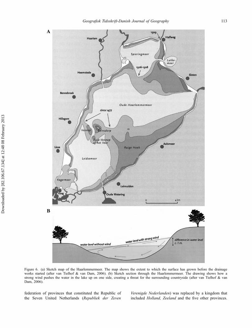
During the eighteenth century, plans to drain the(huge) Haarlemmermeer were considered and reconsid-ered several times. This large surface of open water wasan important part of the transportation network, yet itssize and shallow depth made it very dangerous toshipping whenever there were high winds or storms, andits edges were regularly inundated. In particular, withstrong western winds, its eastern edge became a realcemetery for ships (hence the name for Amsterdam’s air-port, Schiphol, which literally means ‘hell for ships’).But the huge costs involved could not be borne by theHoogheemraadschap or other local or regional authori-ties, in part because the eighteenth century was a muchless wealthy time for the Netherlands than the precedingone. Time and again, the plans were postponed.However, after the French occupation of 1795–1814, the
Figure 5. Set of three windmills near Reeuwijk.Author and date unknown. Source: Archive of the Hoogheemraadschap Rijnland number: A-0517.Three windmills are required to pump the water from the polder into the drainage canal surrounding it.
112 S. van der Leeuw
Dow
nloa
ded
by [
82.1
06.6
7.13
4] a
t 12:
48 0
8 Fe
brua
ry 2
013
federation of provinces that constituted the Republic ofthe Seven United Netherlands (Republiek der Zeven
Verenigde Nederlanden) was replaced by a kingdom thatincluded Holland, Zeeland and the five other provinces.
Figure 6. (a) Sketch map of the Haarlemmermeer. The map shows the extent to which the surface has grown before the drainageworks started (after van Tielhof & van Dam, 2006). (b) Sketch section through the Haarlemmermeer. The drawing shows how astrong wind pushes the water in the lake up on one side, creating a threat for the surrounding countryside (after van Tielhof & vanDam, 2006).
Geografisk Tidsskrift-Danish Journal of Geography 113
Dow
nloa
ded
by [
82.1
06.6
7.13
4] a
t 12:
48 0
8 Fe
brua
ry 2
013

Simultaneously, in the Dutch East Indies, a novel land-holding and exploitation system (in the form of planta-tions) substantively increased the income of the nationand the state. The State now had the resources neededfor the project, and the invention of steam engines todrive the pumps made it technically feasible.
But it was not until a furious hurricane in November1836 drove the waters as far as the gates of Amsterdam,and another on Christmas Day the same year that sentwaves in the opposite direction to submerge the streetsof Leiden, that the mind of the nation seriously turned tothe matter (Figure 6(a) and (b)). On 1 August 1837,King William I appointed a royal commission of inquiry,and in the following May the work began. First, a canalwas dug around the lake, fittingly called Ringvaart (RingCanal), to enable water drainage and boat traffic that hadpreviously gone across the lake. This canal was 61 kmlong, and the dug-out earth was used to build a dikebetween 30 and 50m wide around the lake. The areaenclosed was more than 180 km², and the average depthof the lake was 4m. As the area had no natural drainage,around 800 million tons of water was pumped into theRingvaart by mechanical means.
Unlike the historic practice to drain polders usingwindmills, steam-powered pumping stations were usedfirst at that time. Three steam engines were built: theLeeghwater, the Cruquius (the largest Watt-designreciprocal stroke steam engine ever built and now amuseum), and the Lijnden. Pumping began in 1848, andthe lake was dry by 1 July 1852. Rather than beingincorporated into any particular existing administrativeorganization, it was given the status of an independentmunicipality within the province of Noord-Holland. Thestate thus directly assumed control over the newlyreclaimed territory.
With the reclamation of the Haarlemmermeer, thehistory of water and land in Rijnland comes to a provi-sional end, as no major reversals or new reclamationsoccurred in the area subsequently.
The Aftermath
Elsewhere in the Netherlands, this project was followedby other increasingly ambitious ones, well into thetwentieth century. Initially, these reclamation projectswere concerned with large parts of the so-called‘Zuiderzee’, the large open water in the center of thecountry. In 1929, it was closed off from open sea by adam connecting the provinces of Noord-Holland andFriesland. Draining the first of the ‘polders’ in whatwas now called the IJsselmeer (ex-‘Zuiderzee’), theWieringermeerpolder, was completed in 1930. Duringthe World War II, this was followed by completion ofthe Noord-Oost Polder (1942). After the war, two hugenew polders were also reclaimed, respectively, called
Oost Flevoland and Zuid Flevoland. In total, 1650 km2
of land were reclaimed between the 1950s and 1980s.A last major flood occurred in 1953 when a large
part of Zeeland and Brabant were inundated by a combi-nation of an extremely high tide and a strong westerlystorm. This came at a time when the dams protectingthese areas had been weakened by lack of maintenanceduring the World War II and its aftermath. It led to amajor project (the so-called ‘Deltawerken’) that nowprotects the area, but the idea to reclaim more land wasabandoned when the Netherlands opened its tradeborders more and more to agricultural products fromelsewhere in Europe.
Both in the case of the reclamation projects in theIJsselmeer and in that of the Deltawerken, only thenational government had the means to undertake them,and it therefore exerted its authority over them. In effect,from its first emergence out of the sea until 1986, thewhole of Flevoland and its inhabitants was subjected tothe authority of a single person appointed by thegovernment, the ‘Landdrost’!
Summary and conclusion
The outline of the story recounted here is well known;the western Netherlands were created, rather than merelypeopled, by its inhabitants. Water was initially a threat tobe fled and then to be contained. The point here is thatnot only the land itself, but new technologies, institutions,a new spatial organization and much of Dutch cultureemerged from the interaction between people and water.
The need for drainage and containment first ledpeople to collaborate and to develop new techniques todeal with the dangers of both short-term floods andlonger-term degradation of terrestrial resources. Thedynamics coupling environmental limitations and socialinitiatives resulted in newly invented management tech-niques that addressed and frequently solved differences ofopinion and created powerful institutions. Thus, the firstsupraregional authority, the Hoogheemraadschap, underits president, the Dijkgraaf, was created in response to thewater management issue – an issue that could not be leftin the hands of much smaller principalities.
In the struggle, water was transformed into land forcultivation and grazing, land was then transformed intolakes by selling it in the form of turves to fuel hearthsand industries, and ultimately, these lakes were drainedto recreate agricultural land when the need was felt. As aresult, the surfaces of large parts of the western Nether-lands were lowered to between 1 and 6m below sealevel, creating a situation of extreme vulnerability to anysea-level rise that might be caused by climate change.
But one of the important lessons of this story is thatit is also a kind of cyclical Tragedy of the Commons. Itevidences the ongoing battle between individuals,
114 S. van der Leeuw
Dow
nloa
ded
by [
82.1
06.6
7.13
4] a
t 12:
48 0
8 Fe
brua
ry 2
013

institutions creating opportunities for individuals by con-taining the water, individuals creating new water-relatedthreats, calling for strengthened institutions, etc.
Individuals first colonized these low-lying parts of thedelta. As they drained it for cultivation, or to built smallartificial mounds (terpen) to keep their houses and animalsdry during floods, other longer-term threats emerged thatcould not be dealt with individually. Large-scale drainagesystems were dug, and instead of building individualartificial mounds, people began collectively to protect landagainst floods by building dikes (artificial levees). Inthe process, they created institutions such as theHoogheemraadschap to guard their collective interests.
Once that was done, and cultivation enabled people tomake a good living in the area, land degradation arose andthe economy shifted to grazing. Grazing is less demandingof the land and the drainage infrastructure than agriculture.When land became unsuitable for even that form ofexploitation, the same individual interests transformedland into fuel. Thus, they created open water and under-mined collective safety as well as the institutions that hadbeen put in place to protect against the water.
From yet another perspective, it is all about spatialand temporal scales. Ultimately, when water became alocal and regional threat once more, and there was insuf-ficient land to provide food, the tendency was inverted bynonrural individuals who saw the interest and providedthe means to collectively transform water into land. Thesemeans were derived from activities elsewhere, first in dif-ferent urban sectors of the regional economy (succes-sively fishing, regional trade, industry, and banking), andlater on the high seas (long-distance trade and piracy), orin the Dutch colonies. In the process, the area becameincreasingly dependent on other parts of the world, otherresources, or other feedback cycles (the spatial scale ofthe system was stepped up each time a disaster threatenedor hit). Thus, the reclamation of the Haarlemmermeerwas funded in part by the increasing stream of richesgained in the Dutch East Indies, where a system of inten-sive agriculture for the European market had been insti-tuted after 1815. In turn, the reclamation of Flevolandwas made possible by the economic boom after WorldWar II, to which the birth and growth of the EuropeanUnion was also closely related.
Temporally, as long as the local and regional cyclic‘lows’ did not coincide, the highly artificial and verycostly system could be maintained. Local profits couldbe made thanks to investment of funds gained elsewhere.In Rijnland, this was the case when either urbanites orthe cities collectively intervened to fund the protectionof land against water. Nevertheless, if there was a tempo-ral overlap between ‘lows’ in both regional and moreglobal cycles, problems hit with redoubled severity, suchas in the eighteenth century and the first half of the nine-teenth century. Then, disaster could only be averted by
yet another increase in the spatial and the temporal scaleof the system. For example, by invoking the help of thenational government to drain the Haarlemmermeer, itdramatically reduced the frequency with which problemshit and strengthened both the material and institutionalinfrastructure that maintained the polder in a ‘steadystate.’ In the process, the scope and scale of threatsand institutions bootstrapped themselves to eventuallyencompass all of the Low Countries, shaping much ofDutch society to this day.
Finally, the story beautifully illustrates the role ofrisk perception in generating unintended consequences inenvironmental management by society. In their attemptto deal with frequently occurring events in the interactionbetween people and their environment (such as the sea-sonal inundations that led people to ‘invent’ artificialmounds (terpen)), human intervention would lead to newperspectives and new actions (such as the enclosing ofwhole areas by artificial levees (dijken)). However, fre-quently these changes engendered new risks, of whichneither the nature nor the spectrum of periodicities wasknown. When these risks materialized (in the form ofdecadal or even centennial floods, for example), othermeans were sought to deal with them, and the changeswrought in the environment introduced yet other risks –again of unknown nature and temporal spectrum. Theinvestment to maintain these solutions could prove toocostly for the local population resulting, in the additionalrisk of an area becoming dependent on another region’seconomic cycles.
In each instance, the ‘solution’ to an imminent chal-lenge was based on interventions in the environment thattriggered other challenges down the line. The latter wereless frequent and involved a larger spatial scale. As aresult, over time the ‘risk spectrum’ shifted fromrelatively frequent, spatially limited risks to less frequent,but more consequential risks. Ultimately, the accumula-tion of risks with unknown, longer, temporalities led toan accumulation of risks that could burst upon the scenesimultaneously: ‘a time-bomb’ or ‘crisis’ such as thecurrent environmental crisis.
Although such consequences may be unintended,they are far from unexpected. Similar situations andchains of events have occurred whenever and whereverpeople tried to impose particular ‘solutions’ to the chal-lenges posed by the environment. They seem profoundlyinherent in human interactions with the environment, asoften those interactions are based on making a distinc-tion between ‘us’ and ‘our environment.’ Indeed, thatenvironment is not ‘ours’ to possess or on which toimpose ‘our solutions’. In the current extreme form, theaforementioned position is a particularity of westernculture that has become more and more prevalent sincethe fourteenth century. Maybe we should take a closerlook at the worldview of societies like the Achuar, who
Geografisk Tidsskrift-Danish Journal of Geography 115
Dow
nloa
ded
by [
82.1
06.6
7.13
4] a
t 12:
48 0
8 Fe
brua
ry 2
013

do not make such a Manichaean distinction betweenourselves and our environment (Descola, 2005).
That, at least, seems to be the way forward in studyingthe emergence of sustainability issues and the role technol-ogy plays in them. To conclude, let us therefore spend alittle time looking at how one might indeed change ourperspective so as to get a better grip on these dynamics.
First of all, and inherent in the CAS perspective, thepoint of view that we choose should be an ex anteperspective rather than the much more common ex postperspective. To understand the emergence of newphenomena, we should be following the process of theiremergence, rather than be studying the origins of thecurrent situation. We should develop a perspective thatgoes with the arrow of time, rather than against it. Anecessary corollary of that position is that our approachshould not reduce the number of dimensions taken intoaccount in order to generate understanding (as much ofscience still does), but should enhance the number ofdimensions taken into account. Instead of studying tolearn from the past, we should study in order to learn forthe future.
Part of this is the fact that we must move away fromsingle causal chains to ‘explain’ the present, and in gen-eral start thinking in alternative scenarios. By evaluatingthese, and in particular by comparing the unintendedconsequences of the choices made (by individuals orsystems) with those that would have occurred hadanother option been chosen, we will get a much bettergrip on the relationship between choices and unintendedconsequences, and thus reduce (unperceived) risk as wemove into the future.
Crucial in all this is the fact that we, as humans, havenot been able to do all this until now – indeed, our centu-ries-long intellectual tradition, the inherent limitations toour information processing, as well as other factors, mili-tate against such an approach. But with the informationage, a number of barriers may be about to be taken away,or at least reduced. For one, modern terabyte data-densemonitoring may overcome, at least to some extent, theunderdetermination of our ideas by our observations.Secondly, by (much) more closely integrating computinginto our societal information processing than has beendone to date, we may be able to take into account manymore dimensions of the phenomena and processes wedeal with in our decision-making. But for that to happen,
we must begin to harness computing in a different way,emphasizing our capability to move from lower to higherdimensionality as well as in the inverse direction (as wedo now) – this amounts to creating the tools to movefrom the past to the future, as well as in the reverse direc-tion. Core in developing that capability is the need to usemuch more extensive modeling, and in particular agent-based modeling, to enable us to understand how theensemble of individual actions creates collective patternsand processes (van der Leeuw et al., 2011).
AcknowledgmentI greatly owe Jan Kolen (Free University, Amsterdam), fordrawing my attention to the magnificent overview of thehistory of Rijnland presented in van Tielhof and van Dam,2006, and for procuring me a copy of it.
ReferencesAtlan, H. (1992). Self-organising networks: Weak, strong and
intentional. The role of their underdetermination. La NuovaCritica Nuova Seria, 19–20, 51–70.
Brandt, R.W., Groenman-van Waateringe, W., & van der Leeuw,S.E. (Eds.). (1987). Assendelver polder papers, Vol. I.Amsterdam: Amsterdam University Press.
Brandt, R.W., & van der Leeuw, S.E. (1988). Research designand wet site archaeology in the Netherlands: An example.In B. Purdy (Ed.), Wet Site Archaeology (pp. 153–176).New York, NY: Telford Press.
Brandt, R.W., van Wijngaarden-Bakker, L.H., & van der Leeuw,S.E. (1984). Transformations in a Dutch estuary: Research ina wet landscape. World Archaeology, 16(1), 1–17.
Descola, Ph. (2005). Par-delà la nature et la culture. Paris:Gallimard (Bibliothèque des sciences humaines).
Ingold, T. (1986). The appropriation of nature: Essays on humanecology and social relations Manchester. Manchester:Manchester University Press.
Read, D.W., & van der Leeuw, S.E. (2009). Biology is onlypart of the story …. In A.C. Renfrew & L. Malafouris(Eds.), Sapient mind (pp. 33–49). Oxford: OxfordUniversity Press.
van der Leeuw, S.E. (1987). The Assendelver polders of theNetherlands and a wet perspective on the European IronAge. In J.M. Coles & A.J. Lawson (Eds.), The Europeanwetlands in prehistory (pp. 203–225). Oxford: Blackwell.
van der Leeuw, S.E., Costanza, R., Aulenbach, S., Brewer, S.,Burek, M., Cornell, S. … Steffen, W. (2011). Toward anintegrated history to guide the future. Ecology and Society,16(4), 2. Retrieved from http://www.ecologyandsociety.org/vol16/iss4/art2
van Tielhof, M., & van Dam, P.J.E.M. (2006). Waterstaat instedenland. Utrecht: Matrijs Publishers.
116 S. van der Leeuw
Dow
nloa
ded
by [
82.1
06.6
7.13
4] a
t 12:
48 0
8 Fe
brua
ry 2
013
![Explain why scarcity and choice are basic economic problems faced by every society.[12.1A] October 2014ECONOMICS](https://img.pdfslide.net/doc/110x75/56649e3b5503460f94b2cae0/explain-why-scarcity-and-choice-are-basic-economic-problems-faced-by-every.jpg)


![Your anaesthetic for1].pdf · 5 women (most are not severe) Sore throat 1 in every Common 5 women Feeling sick 1 in every Common 10 women Airway problems leading 1 in every Uncommon](https://img.pdfslide.net/doc/110x75/5f4792ba6a9ab067fd32b30f/your-anaesthetic-for-1pdf-5-women-most-are-not-severe-sore-throat-1-in-every.jpg)