Embed Size (px)
Citation preview

Forecasting fog and stratus in aviation weather service
3.12.2018
Aviation Event Week
EUMeTrain
Elina Tuhkalainen
About formation and dissipation of fog and stratus, their occurrence around the year and effects on the
airport services in Finland.
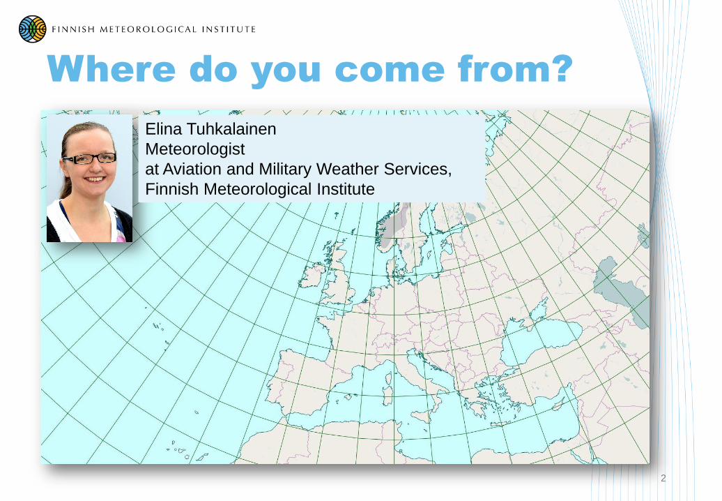
Where do you come from?
2
Elina Tuhkalainen
Meteorologist
at Aviation and Military Weather Services,
Finnish Meteorological Institute
3
Click your arrow in the group you belong to:
Aviation forecasters Other forecasters Other

Content
4
• Fog types, definitions
• Formation and dissipation
• Occurrence of fog and stratus around the year (examples in Finland)
• Orography effects
• Tools we’re using to forecast stratus and fog
• Effects on the airport
• Case studies

Definitions
5
• Fog and mist
• High humidity reduces visibility
• 1-5 km: mist
• ≤ 1 km: fog
• Stratus
• Low cloud
• Base 0-1000 ft (approx. 300 m)
• On ground fog
• TAF codes:
• FG - fog
• BR - mist
• MIFG - shallow fog (≤ 2 m)
• PRFG - partial fog
• BCFG - paches of fog
• FZFG - freezing fog (T ≤ 0oC)Eija Vallinheimo
Hannu Manninen

Formation and dissipation
6
• Interaction between the air and the ground
• Formation: The air cools down or becomes more moist
• Dissipation of fog: air warms up or dries
• Radiation: cools the ground and the air (sunrise, sunset)
• Advection: brings cold air over moist surface
• Rain: can either clean the fog or make the low levels more
humid and thus lower the ceiling
• Cloudiness above the fog:
• Higher clouds may
slow down the dissipation
• It can also prevent
the fog to develop
Juval Cohen

7
Radiation:
• Clear night
• T decreases
Warm and
moist air
Cold ground
(or water)
Advection:
• Warm and moist air moves on
cold ground
• Reverse: cold air over warm
water
Cold
air
Warm
(moist)
air
Warm and cold air
mixing
Cold groundWarm water
Orography
Warm Coldfog
Warm front:
Warm precipitation falls
into cold air
Reijo Hyvönen
Very cold air (<-20oC):
• Water vapour
condenses into ice
crystals

8
9
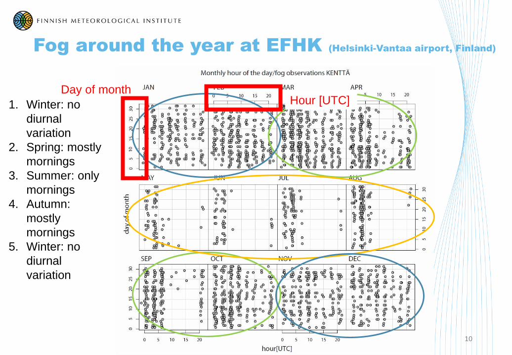
Fog around the year at EFHK (Helsinki-Vantaa airport, Finland)
10
1. Winter: no
diurnal
variation
2. Spring: mostly
mornings
3. Summer: only
mornings
4. Autumn:
mostly
mornings
5. Winter: no
diurnal
variation
Day of monthHour [UTC]

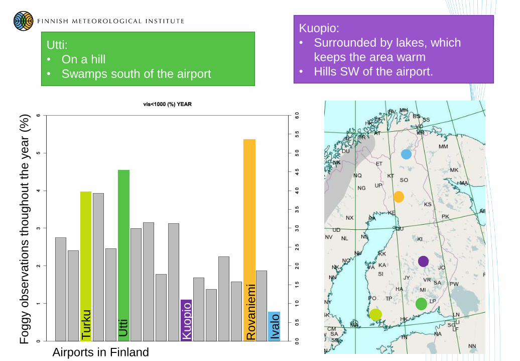
Airports in Finland
Fo
ggy
observ
ations
thoughout
the
year
(%)
Rovanie
mi
Iva
lo
Turk
u
Utt
i
Kuopio
11
Rovaniemi:
• On a hill, 100 m (300 ft) higher than the
surrounding area
Turku:
• The Baltic Sea is usually open here
around the year a lot of moisture

12
Ivalo:
• Fogs are rare here
• Surrounded by hills (1400-1700 ft high)
from west, southwest and south
FELLS
RUNWAY
13
Utti:
• On a hill
• Swamps south of the airport
Kuopio:
• Surrounded by lakes, which
keeps the area warm
• Hills SW of the airport.
Airports in Finland
Fo
ggy
observ
ations
thoughout
the
year
(%)
Rovanie
mi
Iva
lo
Turk
u
Utt
i
Kuopio

Effects on the airportservices
14
• LVP = low visibility procedures
• Horizontal and vertical visibility
• Airport-specific thresholds
• For safe operations
• Increasing spacing between aircrafts
(approach, taxi)
Reduced capacity
• Alternative airports fuel costs
• Cancelled flights
Kim Frisk
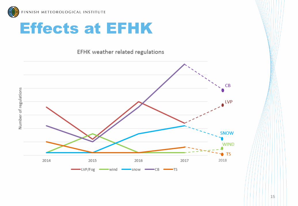
Effects at EFHK
15

16
Our products (with stratus and fog)
TAF
TAF EFHK 222325Z 2300/2324 VRB02KT 5000 BKN005
TEMPO 2300/2309 0500 FZFG VV001
TEMPO 2306/2309 2000 BR BKN004
BECMG 2309/2311 27010KT 9999 BKN012
BECMG 2311/2313 BKN015=
TREND forecast in the end of METAR:
METAR EFHK 222220Z 01005KT 0900
R04R/P1500N R15/P1500N R22L/P1500N
R04L/P1500N FZFG VV002 M02/M02 Q1025
TEMPO 0700=
GA-FCST FOR AREAS 11/17 VALID 0312 WX LAAJALTI
ST/SC-PILVISYYTTÄ, AAMULLA PAIKOIN UTUA TAI
JÄÄTÄVÄÄ SUMUA. LÄNNESSÄ PAIKOIN ON SELKEÄÄ.
WINDS 11/17 SFC VRB-320/01-08KT MAR 08-20KT
2000FT 250-320/10-35KT 5000FT 280-340/15-35KT 0-C
LEVEL 11/17 NIL/NEAR SFC PS DEG BTN 200-1000FT
AND 3000FT-FL080 ICE NIL LCA MOD INC TURB NIL
GAFOR EFHK 0312 BBBB 11/15,17 M/X ST/BR/FZFG
BECMG 0810 O/D LCA M ST 16 O LCA 0307 M/X
FZFG/BR=

Airport forecast
17
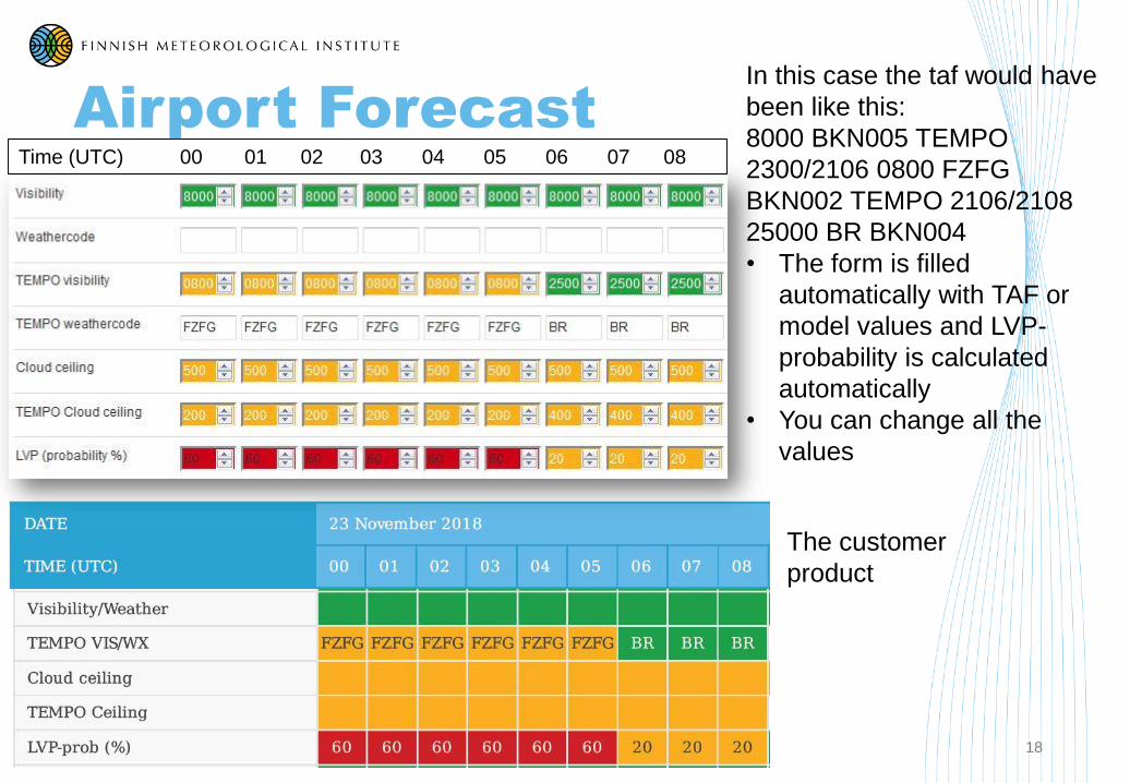
Airport Forecast
18
In this case the taf would have
been like this:
8000 BKN005 TEMPO
2300/2106 0800 FZFG
BKN002 TEMPO 2106/2108
25000 BR BKN004
• The form is filled
automatically with TAF or
model values and LVP-
probability is calculated
automatically
• You can change all the
values
Time (UTC) 00 01 02 03 04 05 06 07 08
The customer
product

19
Model:
• Model fields on map (cloud base, visibility, IMC)
• Meteograms
• Airport forecast model (+ taf) input
Observations:
• Metars on map with colours
• Advection with ground wind speed
• Satellite
• Web-cameras
• Mast-observations, wind speed on different levels
• Radar
• Does the rain clean the fog or just increase humidity
• What is actually coming down. Some particles make the visibility even worse
• Sunrise and sunset: radiation effects both ways
• Higher clouds
• Ice chart
• Ceilometer data
Forecasting tools

Model fields
20
Green: low clouds (< FL060)
Yellow/orange/red/pink: ceiling ≤1500 ftGreen: low clouds (< FL060)
Purple/red/pink: IMC (vis < 5 km and/or ceiling < 1000 ft)
21
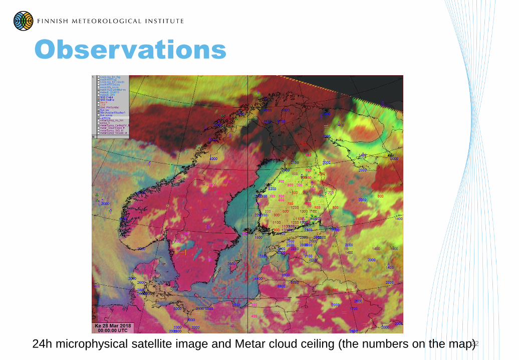
Observations
2224h microphysical satellite image and Metar cloud ceiling (the numbers on the map)

Observations (ilmailusaa.fi)
23
over 5000 ft
below 5000 ft
below 2000 ft
below 1500 ft
below 1000 ft
below 500 ft
missing
over 10 km
below 10 km
below 8000 m
below 5000 m
below 3000 m
below 1500 m
missing

24

Mast observations
25

Nowcasting with ceilometer
26
Cloud base (m)

Case 25.11.2018at EFHK
27
• Low cloud came from the north
• Big lakes probably increased the
humidity
• Small area of stratus stayed long
right over EFHK
• AWS-Metars north of EFHK
detected the cloud
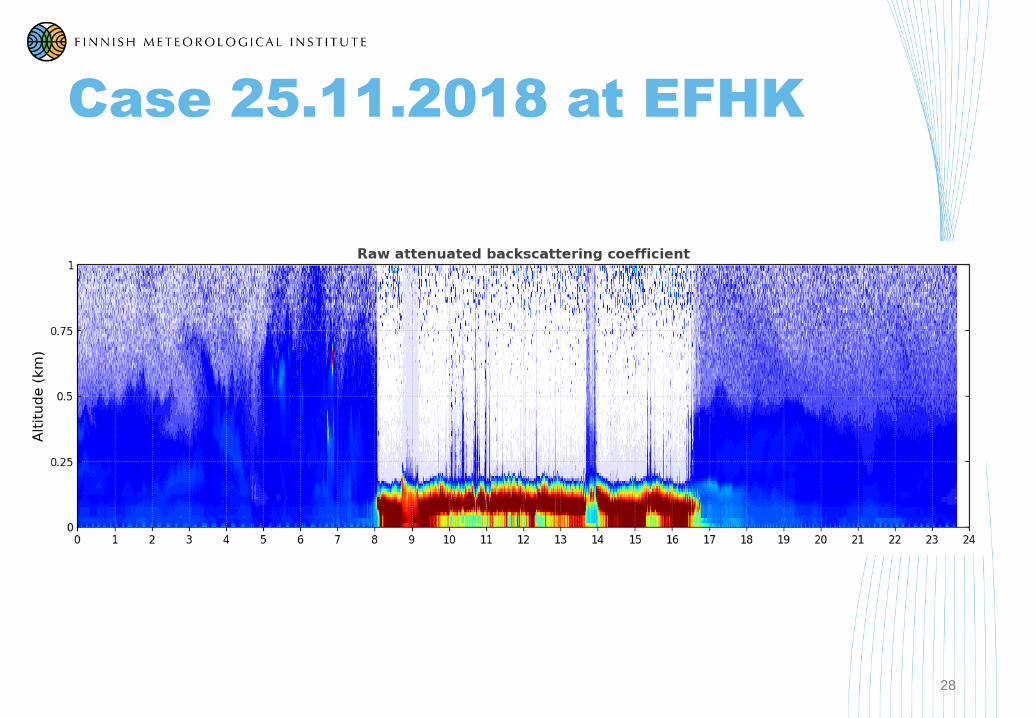
Case 25.11.2018 at EFHK
28

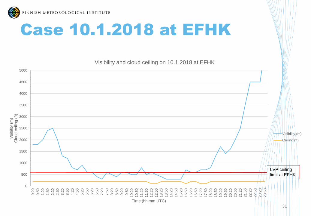
Case 10.1.2018 at EFHK
29
10.1.2018
12 UTC analysis
• High pressure over southern
Finland
• Wintertime
• Temperatures in southern
Finland 0...-5oC
• Large area of fog in
southern Finland
• Weather related regulations
at EFHK:
• Average delay 20 min

Case 10.1.2018 at EFHK
30
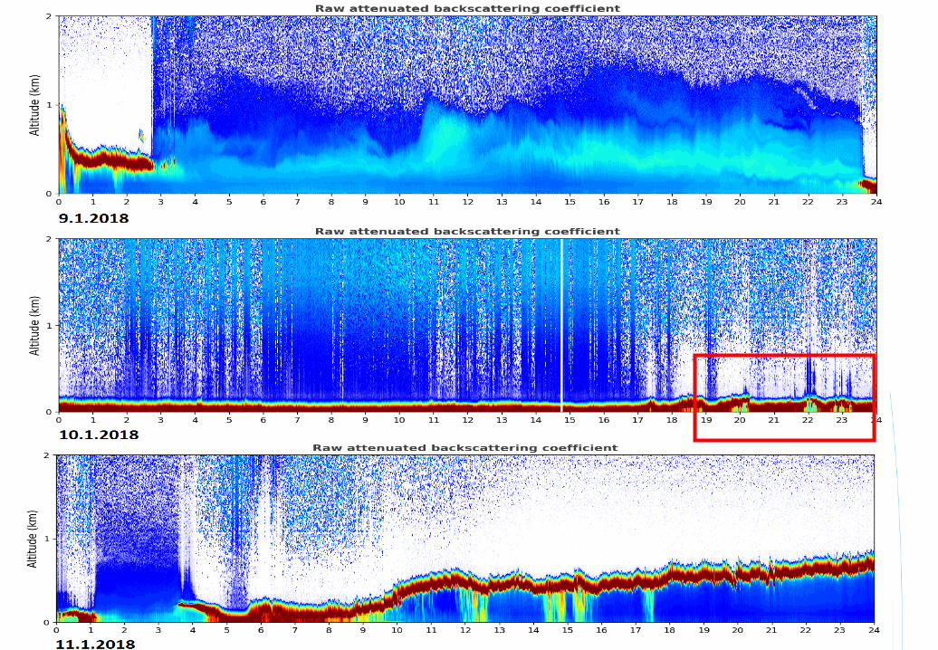
24h Microphysical animation
9.1. 19:45 – 10.1. 23:45
Analysis 10.1.218 12 UTC
Case 10.1.2018 at EFHK
31
0
500
1000
1500
2000
2500
3000
3500
4000
4500
5000
0:2
0
0:5
0
1:2
0
1:5
0
2:2
0
2:5
0
3:2
0
3:5
0
4:2
0
4:5
0
5:2
0
5:5
0
6:2
0
6:5
0
7:2
0
7:5
0
8:2
0
8:5
0
9:2
0
9:5
0
10:2
0
10:5
0
11:2
0
11:5
0
12:2
0
12:5
0
13:2
0
13:5
0
14:2
0
14:5
0
15:2
0
15:5
0
16:2
0
16:5
0
17:2
0
17:5
0
18:2
0
18:5
0
19:2
0
19:5
0
20:2
0
20:5
0
21:2
0
21:5
0
22:2
0
22:5
0
23:2
0
23:5
0
Vsib
ility
(m
)C
loud c
eili
ng (
ft)
Time (hh:mm UTC)
Visibility and cloud ceiling on 10.1.2018 at EFHK
Visibility (m)
Ceiling (ft)
LVP ceiling
limit at EFHK
32
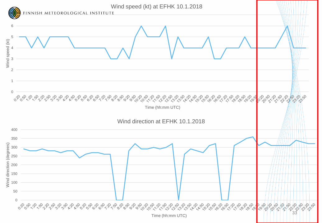
33
0
1
2
3
4
5
6
7
Win
d s
peed (
kt)
Time (hh:mm UTC)
Wind speed (kt) at EFHK 10.1.2018
0
50
100
150
200
250
300
350
400
Win
d d
irection (
degre
es)
Time (hh:mm UTC)
Wind direction at EFHK 10.1.2018

34
22:45 UTC23:00 UTC23:15 UTC23:30 UTC23:45 UTC

35
Visibility observations near EFHK
0
5000
10000
15000
20000
25000
30000
Vis
ibili
ty (
m)
Time (hh:mm UTC)
Visibility observations near EFHK
Salo
Mäntsälä
Nurmijärvi
Hyvinkää
Jokioinen
Hämeenlinna
EFHK

Cloud ceiling observations near EFHK
36
0
20
40
60
80
100
120
Clo
ud c
eili
ng (
m)
Time (hh:mm UTC)
Cloud ceiling observations near EFHK
Salo
Mäntsälä
Nurmijärvi
Hyvinkää
Jokioinen
Hämeenlinna
EFHK

Thank you for participating!
Questions?
37
Jenni Rauhala
Ilmatieteen laitos
Erik Palménin aukio 1,
00560 Helsinki
PL 503, 00101 Helsinki,
puh. 029 539 1000
Finnish Meteorological Institute
Erik Palménin aukio 1,
FI-00560 Helsinki
P.O.Box 503, FI-00101 Helsinki
tel. +358 29 539 1000
Meteorologiska institutet
Erik Palméns plats 1,
00560 Helsingfors
PB 503, 00101 Helsingfors
tel. 029 539 1000
Twitter: @meteorologit ja @IlmaTiede Facebook: FMIBeta


![Stratus [stratus] The word stratus is a Latin word which means “flattened” or “spread out” or “layers” Stratus Clouds](https://img.pdfslide.net/doc/110x75/56649dc55503460f94ab81ce/stratus-stratus-the-word-stratus-is-a-latin-word-which-means-flattened.jpg)