Embed Size (px)
Citation preview
FOREST INVENTORY AND ANALYSIS NATIONAL CORE FIELD GUIDE
VOLUME I: FIELD DATA COLLECTION PROCEDURES FOR PHASE 2 PLOTS
Version 7.0

National Core Field Guide, Version 7.0, October, 2015 Table of Contents
iii
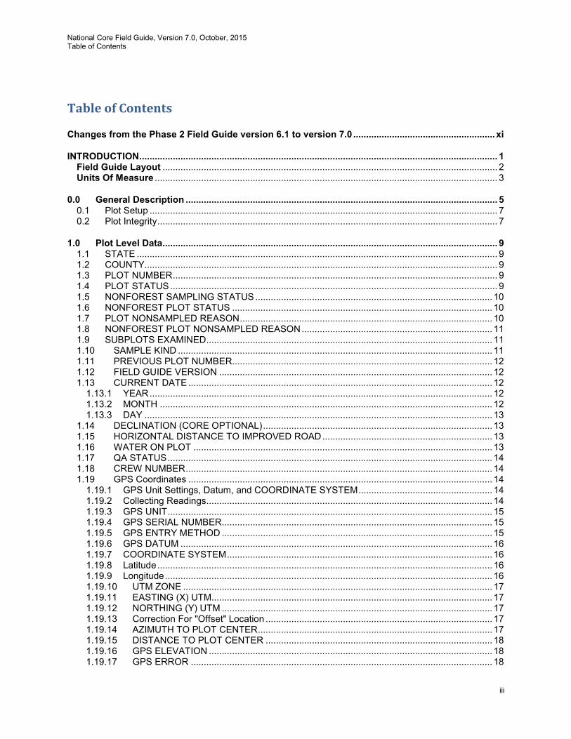
Table of Contents
Changes from the Phase 2 Field Guide version 6.1 to version 7.0 ....................................................... xi
INTRODUCTION ........................................................................................................................................... 1 Field Guide Layout .................................................................................................................................. 2 Units Of Measure ..................................................................................................................................... 3
0.0 General Description ......................................................................................................................... 5 0.1 Plot Setup ....................................................................................................................................... 7 0.2 Plot Integrity .................................................................................................................................... 7
1.0 Plot Level Data.................................................................................................................................. 9 1.1 STATE ............................................................................................................................................ 9 1.2 COUNTY......................................................................................................................................... 9 1.3 PLOT NUMBER .............................................................................................................................. 9 1.4 PLOT STATUS ............................................................................................................................... 9 1.5 NONFOREST SAMPLING STATUS ............................................................................................ 10 1.6 NONFOREST PLOT STATUS ..................................................................................................... 10 1.7 PLOT NONSAMPLED REASON .................................................................................................. 10 1.8 NONFOREST PLOT NONSAMPLED REASON .......................................................................... 11 1.9 SUBPLOTS EXAMINED ............................................................................................................... 11 1.10 SAMPLE KIND .......................................................................................................................... 11 1.11 PREVIOUS PLOT NUMBER..................................................................................................... 12 1.12 FIELD GUIDE VERSION .......................................................................................................... 12 1.13 CURRENT DATE ...................................................................................................................... 12
1.13.1 YEAR ..................................................................................................................................... 12 1.13.2 MONTH ................................................................................................................................. 12 1.13.3 DAY ....................................................................................................................................... 13
1.14 DECLINATION (CORE OPTIONAL) ......................................................................................... 13 1.15 HORIZONTAL DISTANCE TO IMPROVED ROAD .................................................................. 13 1.16 WATER ON PLOT .................................................................................................................... 13 1.17 QA STATUS .............................................................................................................................. 14 1.18 CREW NUMBER ....................................................................................................................... 14 1.19 GPS Coordinates ...................................................................................................................... 14
1.19.1 GPS Unit Settings, Datum, and COORDINATE SYSTEM .................................................... 14 1.19.2 Collecting Readings ............................................................................................................... 14 1.19.3 GPS UNIT .............................................................................................................................. 15 1.19.4 GPS SERIAL NUMBER......................................................................................................... 15 1.19.5 GPS ENTRY METHOD ......................................................................................................... 15 1.19.6 GPS DATUM ......................................................................................................................... 16 1.19.7 COORDINATE SYSTEM ....................................................................................................... 16 1.19.8 Latitude .................................................................................................................................. 16 1.19.9 Longitude ............................................................................................................................... 16 1.19.10 UTM ZONE ........................................................................................................................ 17 1.19.11 EASTING (X) UTM............................................................................................................. 17 1.19.12 NORTHING (Y) UTM ......................................................................................................... 17 1.19.13 Correction For "Offset" Location ........................................................................................ 17 1.19.14 AZIMUTH TO PLOT CENTER ........................................................................................... 17 1.19.15 DISTANCE TO PLOT CENTER ........................................................................................ 18 1.19.16 GPS ELEVATION .............................................................................................................. 18 1.19.17 GPS ERROR ..................................................................................................................... 18
National Core Field Guide, Version 7.0, October, 2015 Table of Contents
iv
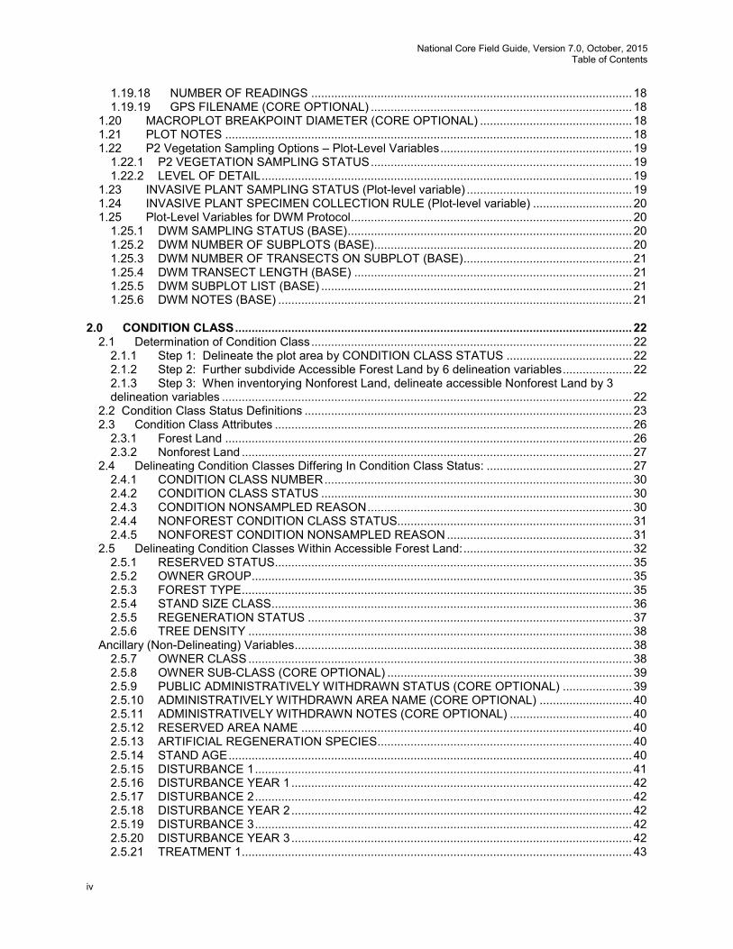
1.19.18 NUMBER OF READINGS ................................................................................................. 18 1.19.19 GPS FILENAME (CORE OPTIONAL) ............................................................................... 18
1.20 MACROPLOT BREAKPOINT DIAMETER (CORE OPTIONAL) .............................................. 18 1.21 PLOT NOTES ........................................................................................................................... 18 1.22 P2 Vegetation Sampling Options – Plot-Level Variables .......................................................... 19
1.22.1 P2 VEGETATION SAMPLING STATUS ............................................................................... 19 1.22.2 LEVEL OF DETAIL ................................................................................................................ 19
1.23 INVASIVE PLANT SAMPLING STATUS (Plot-level variable) .................................................. 19 1.24 INVASIVE PLANT SPECIMEN COLLECTION RULE (Plot-level variable) .............................. 20 1.25 Plot-Level Variables for DWM Protocol ..................................................................................... 20
1.25.1 DWM SAMPLING STATUS (BASE) ...................................................................................... 20 1.25.2 DWM NUMBER OF SUBPLOTS (BASE).............................................................................. 20 1.25.3 DWM NUMBER OF TRANSECTS ON SUBPLOT (BASE) ................................................... 21 1.25.4 DWM TRANSECT LENGTH (BASE) .................................................................................... 21 1.25.5 DWM SUBPLOT LIST (BASE) .............................................................................................. 21 1.25.6 DWM NOTES (BASE) ........................................................................................................... 21
2.0 CONDITION CLASS ........................................................................................................................ 22 2.1 Determination of Condition Class ................................................................................................. 22
2.1.1 Step 1: Delineate the plot area by CONDITION CLASS STATUS ...................................... 22 2.1.2 Step 2: Further subdivide Accessible Forest Land by 6 delineation variables ..................... 22 2.1.3 Step 3: When inventorying Nonforest Land, delineate accessible Nonforest Land by 3 delineation variables ............................................................................................................................ 22
2.2 Condition Class Status Definitions ................................................................................................... 23 2.3 Condition Class Attributes ............................................................................................................ 26
2.3.1 Forest Land ........................................................................................................................... 26 2.3.2 Nonforest Land ...................................................................................................................... 27
2.4 Delineating Condition Classes Differing In Condition Class Status: ............................................ 27 2.4.1 CONDITION CLASS NUMBER ............................................................................................. 30 2.4.2 CONDITION CLASS STATUS .............................................................................................. 30 2.4.3 CONDITION NONSAMPLED REASON ................................................................................ 30 2.4.4 NONFOREST CONDITION CLASS STATUS....................................................................... 31 2.4.5 NONFOREST CONDITION NONSAMPLED REASON ........................................................ 31
2.5 Delineating Condition Classes Within Accessible Forest Land: ................................................... 32 2.5.1 RESERVED STATUS ............................................................................................................ 35 2.5.2 OWNER GROUP ................................................................................................................... 35 2.5.3 FOREST TYPE ...................................................................................................................... 35 2.5.4 STAND SIZE CLASS ............................................................................................................. 36 2.5.5 REGENERATION STATUS .................................................................................................. 37 2.5.6 TREE DENSITY .................................................................................................................... 38
Ancillary (Non-Delineating) Variables ...................................................................................................... 38 2.5.7 OWNER CLASS .................................................................................................................... 38 2.5.8 OWNER SUB-CLASS (CORE OPTIONAL) .......................................................................... 39 2.5.9 PUBLIC ADMINISTRATIVELY WITHDRAWN STATUS (CORE OPTIONAL) ..................... 39 2.5.10 ADMINISTRATIVELY WITHDRAWN AREA NAME (CORE OPTIONAL) ............................ 40 2.5.11 ADMINISTRATIVELY WITHDRAWN NOTES (CORE OPTIONAL) ..................................... 40 2.5.12 RESERVED AREA NAME .................................................................................................... 40 2.5.13 ARTIFICIAL REGENERATION SPECIES ............................................................................. 40 2.5.14 STAND AGE .......................................................................................................................... 40 2.5.15 DISTURBANCE 1 .................................................................................................................. 41 2.5.16 DISTURBANCE YEAR 1 ....................................................................................................... 42 2.5.17 DISTURBANCE 2 .................................................................................................................. 42 2.5.18 DISTURBANCE YEAR 2 ....................................................................................................... 42 2.5.19 DISTURBANCE 3 .................................................................................................................. 42 2.5.20 DISTURBANCE YEAR 3 ....................................................................................................... 42 2.5.21 TREATMENT 1 ...................................................................................................................... 43

National Core Field Guide, Version 7.0, October, 2015 Table of Contents
v
2.5.22 TREATMENT YEAR 1 ........................................................................................................... 43 2.5.23 TREATMENT 2 ...................................................................................................................... 43 2.5.24 TREATMENT YEAR 2 ........................................................................................................... 43 2.5.25 TREATMENT 3 ...................................................................................................................... 44 2.5.26 TREATMENT YEAR 3 ........................................................................................................... 44 2.5.27 PHYSIOGRAPHIC CLASS .................................................................................................... 44 2.5.28 LAND COVER CLASS .......................................................................................................... 45 2.5.29 PRESENT NONFOREST LAND USE ................................................................................... 49 2.5.30 CANOPY COVER SAMPLE METHOD ................................................................................. 50 2.5.31 LIVE CANOPY COVER ......................................................................................................... 53 2.5.32 LIVE PLUS MISSING CANOPY COVER .............................................................................. 54 2.5.33 CURRENT AFFORESTATION CODE .................................................................................. 55 2.5.34 PREVIOUS AFFORESTATION CODE ................................................................................. 55 2.5.35 TOTAL STEMS ...................................................................................................................... 55 2.5.36 CHAINING CODE .................................................................................................................. 55
2.6 Optional Fuels Variables for DWM Protocol ................................................................................. 55 2.6.1 CONDITION FUELBED TYPE (OPTIONAL)......................................................................... 55
3.0 SUBPLOT INFORMATION .............................................................................................................. 58 3.1 SUBPLOT NUMBER .................................................................................................................... 58 3.2 SUBPLOT/MACROPLOT STATUS .............................................................................................. 58 3.3 SUBPLOT NONSAMPLED REASON .......................................................................................... 58 3.4 NONFOREST SUBPLOT/MACROPLOT STATUS ...................................................................... 59 3.5 NONFOREST SUBPLOT/MACROPLOT NONSAMPLED REASON .......................................... 60 3.6 SUBPLOT CENTER CONDITION ................................................................................................ 60 3.7 MICROPLOT CENTER CONDITION ........................................................................................... 60 3.8 SUBPLOT SLOPE ........................................................................................................................ 60 3.9 SUBPLOT ASPECT ..................................................................................................................... 61 3.10 SNOW/WATER DEPTH ............................................................................................................ 61 3.11 SUBPLOT/MACROPLOT CONDITION LIST ............................................................................ 61 3.12 P2 VEG SUBPLOT SAMPLE STATUS .................................................................................... 62 3.13 VEGETATION NONSAMPLED REASON ................................................................................ 62 3.14 VEGETATION SUBPLOT NOTES ............................................................................................ 62 3.15 INVASIVE PLANT SUBPLOT SAMPLE STATUS (Subplot-level variable) .............................. 62 3.16 INVASIVE PLANT NONSAMPLED REASON (Subplot-level variable) .................................... 63 3.17 INVASIVE PLANT DATA NOTES ............................................................................................. 63
4.0 BOUNDARY REFERENCES ........................................................................................................... 64 4.1 Reference Procedure ................................................................................................................... 64 4.2 Boundary Data .............................................................................................................................. 66
4.2.1 SUBPLOT NUMBER ............................................................................................................. 66 4.2.2 PLOT TYPE ........................................................................................................................... 66 4.2.3 BOUNDARY CHANGE .......................................................................................................... 66 4.2.4 CONTRASTING CONDITION ............................................................................................... 67 4.2.5 LEFT AZIMUTH ..................................................................................................................... 67 4.2.6 CORNER AZIMUTH .............................................................................................................. 67 4.2.7 CORNER DISTANCE ............................................................................................................ 67 4.2.8 RIGHT AZIMUTH .................................................................................................................. 67
5.0 TREE AND SAPLING DATA ........................................................................................................... 68 5.1 SUBPLOT NUMBER .................................................................................................................... 69 5.2 TREE RECORD NUMBER ........................................................................................................... 69 5.3 CONDITION CLASS NUMBER .................................................................................................... 69 5.4 AZIMUTH ...................................................................................................................................... 70 5.5 HORIZONTAL DISTANCE ........................................................................................................... 70 5.6 PREVIOUS TREE STATUS ......................................................................................................... 71
National Core Field Guide, Version 7.0, October, 2015 Table of Contents
vi
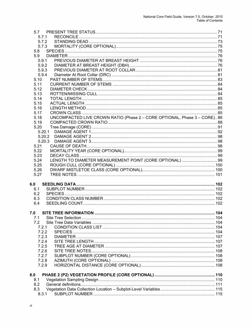
5.7 PRESENT TREE STATUS ........................................................................................................... 71 5.7.1 RECONCILE .......................................................................................................................... 71 5.7.2 STANDING DEAD ................................................................................................................. 73 5.7.3 MORTALITY (CORE OPTIONAL) ......................................................................................... 75
5.8 SPECIES ...................................................................................................................................... 75 5.9 DIAMETER ................................................................................................................................... 76
5.9.1 PREVIOUS DIAMETER AT BREAST HEIGHT .................................................................... 76 5.9.2 DIAMETER AT BREAST HEIGHT (DBH) ............................................................................. 76 5.9.3 PREVIOUS DIAMETER AT ROOT COLLAR ........................................................................ 81 5.9.4 Diameter At Root Collar (DRC) ............................................................................................. 81
5.10 PAST NUMBER OF STEMS ..................................................................................................... 83 5.11 CURRENT NUMBER OF STEMS ............................................................................................ 84 5.12 DIAMETER CHECK .................................................................................................................. 84 5.13 ROTTEN/MISSING CULL ......................................................................................................... 84 5.14 TOTAL LENGTH ....................................................................................................................... 85 5.15 ACTUAL LENGTH .................................................................................................................... 85 5.16 LENGTH METHOD ................................................................................................................... 85 5.17 CROWN CLASS ....................................................................................................................... 85 5.18 UNCOMPACTED LIVE CROWN RATIO (Phase 2 – CORE OPTIONAL, Phase 3 – CORE) .. 86 5.19 COMPACTED CROWN RATIO ................................................................................................ 88 5.20 Tree Damage (CORE) .............................................................................................................. 91
5.20.1 DAMAGE AGENT 1 ............................................................................................................... 92 5.20.2 DAMAGE AGENT 2 ............................................................................................................... 98 5.20.3 DAMAGE AGENT 3 ............................................................................................................... 98
5.21 CAUSE OF DEATH ................................................................................................................... 98 5.22 MORTALITY YEAR (CORE OPTIONAL) .................................................................................. 99 5.23 DECAY CLASS ......................................................................................................................... 99 5.24 LENGTH TO DIAMETER MEASUREMENT POINT (CORE OPTIONAL) ............................... 99 5.25 ROUGH CULL (CORE OPTIONAL) ....................................................................................... 100 5.26 DWARF MISTLETOE CLASS (CORE OPTIONAL)................................................................ 100 5.27 TREE NOTES ......................................................................................................................... 101
6.0 SEEDLING DATA .......................................................................................................................... 102 6.1 SUBPLOT NUMBER .................................................................................................................. 102 6.2 SPECIES .................................................................................................................................... 102 6.3 CONDITION CLASS NUMBER .................................................................................................. 102 6.4 SEEDLING COUNT .................................................................................................................... 102
7.0 SITE TREE INFORMATION .......................................................................................................... 104 7.1 Site Tree Selection ..................................................................................................................... 104 7.2 Site Tree Data Variables ............................................................................................................ 104
7.2.1 CONDITION CLASS LIST ................................................................................................... 104 7.2.2 SPECIES ............................................................................................................................. 104 7.2.3 DIAMETER .......................................................................................................................... 107 7.2.4 SITE TREE LENGTH .......................................................................................................... 107 7.2.5 TREE AGE AT DIAMETER ................................................................................................. 107 7.2.6 SITE TREE NOTES ............................................................................................................. 108 7.2.7 SUBPLOT NUMBER (CORE OPTIONAL) .......................................................................... 108 7.2.8 AZIMUTH (CORE OPTIONAL) ........................................................................................... 108 7.2.9 HORIZONTAL DISTANCE (CORE OPTIONAL) ................................................................. 108
8.0 PHASE 2 (P2) VEGETATION PROFILE (CORE OPTIONAL) ..................................................... 110 8.1 Vegetation Sampling Design ...................................................................................................... 110 8.2 General definitions ...................................................................................................................... 111 8.3 Vegetation Data Collection Location – Subplot-Level Variables ................................................ 115
8.3.1 SUBPLOT NUMBER ........................................................................................................... 115
National Core Field Guide, Version 7.0, October, 2015 Table of Contents
vii
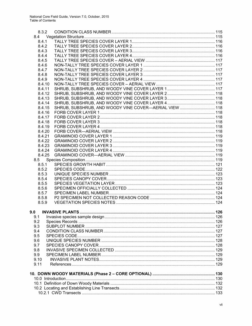
8.3.2 CONDITION CLASS NUMBER ........................................................................................... 115 8.4 Vegetation Structure ................................................................................................................... 115
8.4.1 TALLY TREE SPECIES COVER LAYER 1......................................................................... 116 8.4.2 TALLY TREE SPECIES COVER LAYER 2......................................................................... 116 8.4.3 TALLY TREE SPECIES COVER LAYER 3......................................................................... 116 8.4.4 TALLY TREE SPECIES COVER LAYER 4......................................................................... 116 8.4.5 TALLY TREE SPECIES COVER – AERIAL VIEW ............................................................. 117 8.4.6 NON-TALLY TREE SPECIES COVER LAYER 1 ............................................................... 117 8.4.7 NON-TALLY TREE SPECIES COVER LAYER 2 ............................................................... 117 8.4.8 NON-TALLY TREE SPECIES COVER LAYER 3 ............................................................... 117 8.4.9 NON-TALLY TREE SPECIES COVER LAYER 4 ............................................................... 117 8.4.10 NON-TALLY TREE SPECIES COVER – AERIAL VIEW .................................................... 117 8.4.11 SHRUB, SUBSHRUB, AND WOODY VINE COVER LAYER 1 .......................................... 117 8.4.12 SHRUB, SUBSHRUB, AND WOODY VINE COVER LAYER 2 .......................................... 118 8.4.13 SHRUB, SUBSHRUB, AND WOODY VINE COVER LAYER 3 .......................................... 118 8.4.14 SHRUB, SUBSHRUB, AND WOODY VINE COVER LAYER 4 .......................................... 118 8.4.15 SHRUB, SUBSHRUB, AND WOODY VINE COVER—AERIAL VIEW ............................... 118 8.4.16 FORB COVER LAYER 1 ..................................................................................................... 118 8.4.17 FORB COVER LAYER 2 ..................................................................................................... 118 8.4.18 FORB COVER LAYER 3 ..................................................................................................... 118 8.4.19 FORB COVER LAYER 4 ..................................................................................................... 118 8.4.20 FORB COVER—AERIAL VIEW .......................................................................................... 118 8.4.21 GRAMINOID COVER LAYER 1 .......................................................................................... 119 8.4.22 GRAMINOID COVER LAYER 2 .......................................................................................... 119 8.4.23 GRAMINOID COVER LAYER 3 .......................................................................................... 119 8.4.24 GRAMINOID COVER LAYER 4 .......................................................................................... 119 8.4.25 GRAMINOID COVER—AERIAL VIEW ............................................................................... 119
8.5 Species Composition .................................................................................................................. 119 8.5.1 SPECIES GROWTH HABIT ................................................................................................ 121 8.5.2 SPECIES CODE .................................................................................................................. 122 8.5.3 UNIQUE SPECIES NUMBER ............................................................................................. 123 8.5.4 SPECIES CANOPY COVER ............................................................................................... 123 8.5.5 SPECIES VEGETATION LAYER ........................................................................................ 123 8.5.6 SPECIMEN OFFICIALLY COLLECTED ............................................................................. 124 8.5.7 SPECIMEN LABEL NUMBER ............................................................................................. 124 8.5.8 P2 SPECIMEN NOT COLLECTED REASON CODE ......................................................... 124 8.5.9 VEGETATION SPECIES NOTES ....................................................................................... 124
9.0 INVASIVE PLANTS ....................................................................................................................... 126 9.1 Invasive species sample design ................................................................................................. 126 9.2 Species Records ........................................................................................................................ 126 9.3 SUBPLOT NUMBER .................................................................................................................. 127 9.4 CONDITION CLASS NUMBER .................................................................................................. 127 9.5 SPECIES CODE ......................................................................................................................... 127 9.6 UNIQUE SPECIES NUMBER .................................................................................................... 128 9.7 SPECIES CANOPY COVER ...................................................................................................... 128 9.8 INVASIVE SPECIMEN COLLECTED ........................................................................................ 129 9.9 SPECIMEN LABEL NUMBER .................................................................................................... 129 9.10 INVASIVE PLANT NOTES ...................................................................................................... 129 9.11 References .............................................................................................................................. 129
10. DOWN WOODY MATERIALS (Phase 2 – CORE OPTIONAL) ....................................................... 130 10.0 Introduction ................................................................................................................................... 130 10.1 Definition of Down Woody Materials ............................................................................................ 132 10.2 Locating and Establishing Line Transects .................................................................................... 132
10.2.1 CWD Transects ..................................................................................................................... 133

National Core Field Guide, Version 7.0, October, 2015 Table of Contents
viii
10.2.2 FWD Transects ...................................................................................................................... 134 10.3 Transect Line Segmenting ........................................................................................................... 135
10.3.1 SUBPLOT NUMBER (BASE) .............................................................................................. 135 10.3.2 TRANSECT (BASE) ............................................................................................................ 135 10.3.3 SEGMENT CONDITION CLASS NUMBER (BASE) ........................................................... 136 10.3.4 SEGMENT BEGINNING DISTANCE (BASE) ..................................................................... 136 10.3.5 SEGMENT ENDING DISTANCE (BASE) ........................................................................... 136 10.3.6 DWM TRANSECT SEGMENT SAMPLE STATUS (BASE) ................................................ 136 10.3.7 DWM TRANSECT SEGMENT NONSAMPLED REASON (BASE) .................................... 137
10.4 Sampling Methods for COARSE WOODY DEBRIS (CWD)......................................................... 137 10.4.1 Tally Rules for Coarse Woody Debris (CWD) ....................................................................... 137 10.4.2 Marking CWD (OPTIONAL) ................................................................................................ 139 10.4.3 Recording Procedures for CWD .......................................................................................... 139
10.5 SAMPLING RESIDUE PILES ....................................................................................................... 147 10.5.1 PILE SUBPLOT NUMBER (BASE) ..................................................................................... 149 10.5.2 PILE TRANSECT (BASE) ................................................................................................... 150 10.5.3 PILE CONDITION CLASS NUMBER (BASE) ..................................................................... 150 10.5.4 PILE BEGINNING DISTANCE (BASE) ............................................................................... 150 10.5.5 PILE ENDING DISTANCE (BASE) ..................................................................................... 150 10.5.6 COMPACTED HEIGHT OF CWD IN PILE (BASE) ............................................................. 150 10.5.7 PILE DECAY CLASS (BASE) ............................................................................................. 151 10.5.8 PILE SPECIES (BASE) ....................................................................................................... 151
10.6 Sampling Methods for Fine Woody Debris (FWD) ....................................................................... 151 10.6.1 FWD SUBPLOT NUMBER (BASE) ..................................................................................... 152 10.6.2 FWD TRANSECT (BASE) ................................................................................................... 152 10.6.3 FWD CONDITION CLASS NUMBER (BASE)..................................................................... 153 10.6.4 FWD TRANSECT SEGMENT SAMPLE STATUS (BASE) ................................................. 153 10.6.5 FWD TRANSECT SEGMENT NONSAMPLED REASON (BASE) ..................................... 153 10.6.6 SMALL FWD COUNT (BASE) ............................................................................................. 153 10.6.7 MEDIUM FWD COUNT (BASE) .......................................................................................... 154 10.6.8 LARGE FWD COUNT (BASE) ............................................................................................ 154 10.6.9 HIGH COUNT REASON (BASE) ........................................................................................ 154
10.7 DUFF AND LITTER DEPTH MEASUREMENTS ......................................................................... 154 10.7.1 Definitions .............................................................................................................................. 154 10.7.2 Overview of Measurements ................................................................................................... 155 10.7.3 DUFF/LITTER SUBPLOT NUMBER (BASE) ...................................................................... 156 10.7.4 DUFF/LITTER TRANSECT (BASE) .................................................................................... 156 10.7.5 DUFF/LITTER CONDITION CLASS NUMBER (BASE) ...................................................... 156 10.7.6 DUFF/LITTER SAMPLE STATUS (BASE) .......................................................................... 156 10.7.7 DUFF/LITTER NONSAMPLED REASON (BASE) .............................................................. 157 10.7.8 DUFF DEPTH (BASE) ......................................................................................................... 157 10.7.9 LITTER DEPTH (BASE) ...................................................................................................... 157 10.7.10 DUFF AND LITTER METHOD (BASE)............................................................................ 157
10.8 References ................................................................................................................................... 157 10.9 Contact Information ...................................................................................................................... 157
APPENDICES ........................................................................................................................................... 158 Appendix 1. State and County, Parish, or Borough FIPS Codes ......................................................... 159 Appendix 2. FIA Forest Type Codes .................................................................................................... 181 Appendix 3. FIA Tree Species Codes .................................................................................................. 201 Appendix 4. Was previously: Site Tree Selection Criteria and Species List (This information is now located in 7.2.2 SPECIES) ................................................................................................................... 254 Appendix 5. Determination of Stocking Values for Land Use Classification ........................................ 255 Appendix 6. Glossary ........................................................................................................................... 283 Appendix 7. Tolerance / MQO / Value / Units / Field Width/ When Collected Table ........................... 288 Appendix 8. Tree Coding Guide ........................................................................................................... 316

National Core Field Guide, Version 7.0, October, 2015 Table of Contents
ix
Appendix 9. Invasive Plant List ............................................................................................................ 320 Appendix 10. Unknown Plant Specimen Collection .............................................................................. 321 Appendix 11. Damage Codes .............................................................................................................. 324 Appendix 12. Reserved and Administratively Withdrawn Status by Owner and Land Designation ..... 376 Appendix 13. Ownership Prefield Procedures ..................................................................................... 380
A13.1 Introduction .......................................................................................................................... 380 A13.2 STATE ................................................................................................................................. 380 A13.3 COUNTY ............................................................................................................................. 380 A13.4 PLOT NUMBER ................................................................................................................... 380 A13.5 INVYEAR ............................................................................................................................. 380 A13.6 OWNERSHIP TYPE ............................................................................................................ 381 A13.6.1 OWNERSHIP CONDITION LIST ......................................................................................... 381 A13.7 PLOT CENTER OWNER (CORE OPTIONAL) ................................................................... 381 A13.8 OWNER SHORT NAME ...................................................................................................... 381 A13.9 AGENCY ............................................................................................................................. 382 A13.10 COMPANY ....................................................................................................................... 382 A13.11 MANAGEMENT UNIT ...................................................................................................... 382 A13.12 NAME ............................................................................................................................... 382 A13.13 ATTENTION ..................................................................................................................... 383 A13.14 ADDRESS LINE 1............................................................................................................ 383 A13.15 ADDRESS LINE 2............................................................................................................ 383 A13.16 ADDRESS LINE 3............................................................................................................ 383 A13.17 ADDRESS CITY .............................................................................................................. 384 A13.18 ADDRESS STATE ........................................................................................................... 384 A13.19 ADDRESS PROVINCE .................................................................................................... 384 A13.20 ADDRESS POSTAL CODE ............................................................................................. 384 A13.21 ADDRESS COUNTRY ..................................................................................................... 385 A13.22 OWNERSHIP PHONE NUMBER 1 (CORE OPTIONAL) ................................................ 385 A13.23 OWNERSHIP PHONE NUMBER 1 EXTENSION (CORE OPTIONAL) .......................... 385 A13.24 OWNERSHIP PHONE NUMBER 1 TYPE (CORE OPTIONAL) ..................................... 385 A13.25 OWNERSHIP PHONE NUMBER 2 (CORE OPTIONAL) ................................................ 386 A13.26 OWNERSHIP PHONE NUMBER 2 EXTENSION (CORE OPTIONAL) .......................... 386 A13.27 OWNERSHIP PHONE NUMBER 2 TYPE (CORE OPTIONAL) ..................................... 386 A13.28 OWNERSHIP E-MAIL ADDRESS (CORE OPTIONAL) .................................................. 386 A13.29 DATA SOURCE (CORE OPTIONAL) .............................................................................. 387 A13.30 DATA SOURCE OTHER (CORE OPTIONAL) ................................................................ 387 A13.31 MERIDIAN (CORE OPTIONAL) ...................................................................................... 387 A13.32 TOWNSHIP (CORE OPTIONAL) .................................................................................... 388 A13.33 RANGE (CORE OPTIONAL) ........................................................................................... 388 A13.34 SECTION (CORE OPTIONAL) ........................................................................................ 388 A13.35 QUARTER SECTION (CORE OPTIONAL) ..................................................................... 388 A13.36 QUARTER QUARTER SECTION (CORE OPTIONAL) .................................................. 389 A13.37 QUARTER QUARTER QUARTER SECTION (CORE OPTIONAL) ................................ 389 A13.38 MAP NUMBER (CORE OPTIONAL) ............................................................................... 389 A13.39 BLOCK NUMBER (CORE OPTIONAL) ........................................................................... 390 A13.40 PARCEL NUMBER (CORE OPTIONAL) ......................................................................... 390 A13.41 TRACT SIZE (CORE OPTIONAL) ................................................................................... 390 A13.42 TRACT PERCENT FOREST COVER (CORE OPTIONAL) ............................................ 390 A13.43 OWNER NOTES .............................................................................................................. 390 A13.44 OWNERSHIP CONTACT NAME (CORE OPTIONAL) .................................................... 391 A13.45 OWNERSHIP CONTACT ATTEMPT NUMBER (CORE OPTIONAL) ............................ 391 A13.46 OWNERSHIP CONTACT DATE (CORE OPTIONAL) .................................................... 391 A13.47 OWNERSHIP CONTACT METHOD (CORE OPTIONAL) .............................................. 391 A13.48 LAND POSTED (CORE OPTIONAL) .............................................................................. 392 A13.49 ACCESS GRANTED (CORE OPTIONAL) ...................................................................... 392 A13.50 ACCESS GRANTED DATE (CORE OPTIONAL) ............................................................ 392
National Core Field Guide, Version 7.0, October, 2015 Table of Contents
x
A13.51 ACCESS GRANTED BY(CORE OPTIONAL) ................................................................. 392 A13.52 ACCESS NOTES (CORE OPTIONAL)............................................................................ 392 A13.53 OWNERSHIP REQUESTS NOTICE (CORE OPTIONAL) .............................................. 393 A13.54 OWNERSHIP REQUESTS INFORMATION (CORE OPTIONAL) .................................. 393 A13.55 INFORMATION REQUEST DETAILS (CORE OPTIONAL) ............................................ 393 A13.56 INFORMATION REQUEST FULFILLED (CORE OPTIONAL) ........................................ 393 A13.57 Supplemental Information for Ownership Prefield Procedures ....................................... 394
Appendix 14. FIA Pacific Islands Tree Species Codes ........................................................................ 402
National Core Field Guide, Version 7.0, October, 2015 List of Changes
xi
Changes from the Phase 2 Field Guide version 6.1 to version 7.0 Changes documented in change proposals are indicated in bold type. The corresponding proposal name can be seen using the comments feature in the electronic file. These change pages are intended to highlight significant changes to the field guide and do not contain all of the details or minor changes. • 1.12 FIELD GUIDE VERSION. Changed Values from “6.0” to “7.0”.
• 1.19.2 Collected Readings. Modified introductory text. • 1.19.3 GPS UNIT. Deleted code 1 and modified text of codes 2, 3, and 4.
• 1.19.14 AZIMUTH TO PLOT CENTER. Modified the When collected from “When GPS UNIT = 1,
2, 3, or 4” to “When GPS UNIT = 2, 3, or 4”.
• 1.19.15 DISTANCE TO PLOT CENTER. Modified the When collected from “When GPS UNIT = 1, 2, 3, or 4” to “When GPS UNIT = 2, 3, or 4”.
• 1.19.16 GPS ELEVATION. Modified the When collected from “When GPS UNIT = 1, 2 or 4” to
“When GPS UNIT = 2 or 4”.
• 1.19.17 GPS ERROR. Deleted the following text: “As described in Section 1.19.2, make every effort to collect readings only when the error less than or equal to 70 feet. However, if after trying several different times during the day, at several different locations, this is not possible, record readings with an error of” and “071 to 999 if an error of less than 70 cannot be obtained”. Modified the When collected from “When GPS UNIT = 1 or 2” to “When GPS UNIT = 2”.
• 1.19.18 NUMBER OF READINGS. Modified the When collected from “When GPS UNIT = 1 or 2”
to “When GPS UNIT = 2”.
• 2.3.1 Forest Land. The page numbers associated with the attributes of interest were corrected for current content.
• 2.3.2 Nonforest Land. The page numbers associated with the attributes of interest were corrected for
current content.
• 2.5.7 OWNER. This variable was deleted in version 6.0 but left as a placeholder until version 7.0. It is repeated here for the convenience of the user. All the variables after the deleted variable have been renumbered.
• 2.5.10 ADMINISTRATIVELY WITHDRAWN AREA NAME. Corrected this variable to be listed as
CORE OPTIONAL. This correction is consistent with the intent of the original change proposal for version 6.0 (Reserve_AdminWithdrawn_Change_proposal2.doc)
• 5.0 Tree and Sapling Data. Introductory paragraphs. Added standing dead saplings to
definition of tally sapling and modified the text to reflect this by changing “5.0 inches” to “1.0 inch”. Also corrected the text in the first bullet under the paragraph starting “The following apply at remeasurement:”
• 5.1 SUBPLOT NUMBER. Modified the When collected for saplings.
• 5.2 TREE RECORD NUMBER. Modified the When collected for saplings.
• 5.4 AZIMUTH. Modified the When collected for saplings.
National Core Field Guide, Version 7.0, October, 2015 List of Changes
xii
• 5.5 HORIZONTAL DISTANCE. Modified the When collected for saplings.
• 5.7 PRESENT TREE STATUS. Modified the When collected for saplings. Also modified the text
of code 2 – dead tree, and the note listed under the list of codes.
• 5.7.1 RECONCILE. Modified the When collected for saplings. Also added a new table, which is an abbreviated table from appendix 8, describing how to tally standing dead saplings with respective PRESENT TREE STATUS, RECONCILE CODE, and STANDING DEAD, which are being collected for the first time in Field Guide version 7.0.
• 5.7.1 RECONCILE. The following text was added to codes 3 and 4 in version 6.1 and repeated here
for the convenience of the user: “Includes previously nonsampled subplots.”
• 5.7.2 STANDING DEAD. Modified the descriptive text for saplings. Also modified the captions for figures 20-22 for saplings.
• 5.7.3 MORTALITY. Modified the text and the When collected for saplings.
• 5.8 SPECIES. Modified the When collected for saplings.
• 5.9 DIAMETER. Deleted the following text from the introductory text: “Macroplot tree diameter
thresholds are determined according to regional specifications (see regional field guides for more information).” Also modified the When collected and Tolerance for saplings.
• 5.9.2 DIAMETER AT BREAST HEIGHT (DBH). Corrected several figure references in the text.
• 5.12 DIAMETER CHECK. Modified the When collected for saplings.
• 5.14 TOTAL LENGTH. Modified the When collected for saplings. Also corrected the Values
from “005 to 400” to “001 to 400”.
• 5.15 ACTUAL LENGTH. Modified the When collected for saplings. Also corrected the Values from “005 to 400” to “001 to 400”.
• 5.16 LENGTH METHOD. Modified the When collected for saplings. • 5.20.1 DAMAGE AGENT 1. The following text was added in version 6.1 and is repeated here for the
convenience of the user: “Note: in some cases, thresholds for specific agents may be different from the threshold for the corresponding general agent. If a region is collecting a specific insect agent and no one is collecting the general agent, then the specific insect agent is collapsed into the general insect category 10000.” Also, added text to the general agent column for code 13000.
• 5.23 DECAY CLASS. Modified the text and the When collected for saplings. • 8.0 Phase 2 (P2) Vegetation Profile (Core Optional). The introductory text was clarified. • 8.3.2 LEVEL OF DETAIL. Modified the text in codes 2 and 3. • 8.6.1 SPECIES GROWTH HABIT. The text was modified. All five codes were also revised.
• 8.6.4 SPECIES CANOPY COVER. The introductory text was modified.
National Core Field Guide, Version 7.0, October, 2015 List of Changes
xiii
• Appendix 1. State and County, Parish, or Borough FIPS Codes. Added the county codes for the following Pacific islands: 60 – American Samoa; 64 – Federated States of Micronesia; 66 – Guam; 68 – Marshall Islands; 69 – Northern Mariana Islands; and 70 – Palau.
• Appendix 2. FIA Forest Type Codes. Added code 988 and description. Modified code names of
codes 982, 987, and 989 to match the names in the FIA database.
• Appendix 3. Made the following corrections to the species code list:
FIA code Changes (in red type) 6573 Changed common name from grapefruit to key lime 6574 Changed common name from citris xaurantium to sour orange 6575 Changed common name from shaddock to lemon 6576 Changed common name citron to grapefruit 6577 Changed common name from tangerine to sweet orange 7279 Corrected scientific name from Guajacum officianale to Guaiacum officianale 8750 Corrected common name from troipical almond to tropical almond
• Appendix 7. Tolerance/MQO/VALUE/Units Table. Updated this appendix based on changes in the
rest of the document.
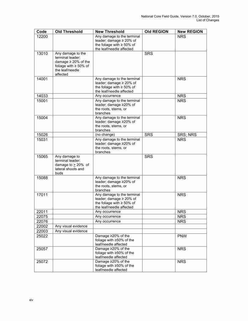
• Appendix 8. Tree Coding Guide. Updated this appendix for changes in sapling measurement. • Appendix 11. Damage Codes. The following changes were made in version 6.1 and are
repeated here for the convenience of the user. The sixth column heading was changed from “New Category?” to “General Category Designation”. The following changes were made to the appendix: Code Old Threshold New Threshold Old REGION New REGION 11012 Any evidence of a
successful attack. NRS
12005 Any damage to the terminal leader; damage ≥ 20% of the foliage with ≥ 50% of the leaf/needle affected
NRS
12029 Any damage to the terminal leader; damage ≥ 20% of the foliage with ≥ 50% of the leaf/needle affected
NRS
12047 Any damage to the terminal leader; damage ≥ 20% of the foliage with ≥ 50% of the leaf/needle affected
NRS
12048 Any damage to the terminal leader; damage ≥ 20% of the foliage with ≥ 50% of the leaf/needle affected
NRS
12068 Any occurrence NRS 12086 Any damage to the terminal
leader; damage ≥ 20% of the foliage with ≥ 50% of the leaf/needle affected
NRS
12136 Any damage to the terminal leader; damage ≥ 20% of the foliage with ≥ 50% of the leaf/needle affected
NRS
12197 Any occurrence NRS
National Core Field Guide, Version 7.0, October, 2015 List of Changes
xiv
Code Old Threshold New Threshold Old REGION New REGION 12200 Any damage to the terminal
leader; damage ≥ 20% of the foliage with ≥ 50% of the leaf/needle affected
NRS
13010 Any damage to the terminal leader; damage ≥ 20% of the foliage with ≥ 50% of the leaf/needle affected
SRS
14001 Any damage to the terminal leader; damage ≥ 20% of the foliage with ≥ 50% of the leaf/needle affected
NRS
14033 Any occurrence NRS 15001 Any damage to the terminal
leader; damage ≥20% of the roots, stems, or branches
NRS
15004 Any damage to the terminal leader; damage ≥20% of the roots, stems, or branches
NRS
15026 (no change) SRS SRS; NRS 15031 Any damage to the terminal
leader; damage ≥20% of the roots, stems, or branches
NRS
15065 Any damage to terminal leader; damage to > 20% of lateral shoots and buds
SRS
15088 Any damage to the terminal leader; damage ≥20% of the roots, stems, or branches
NRS
17011 Any damage to the terminal leader; damage ≥ 20% of the foliage with ≥ 50% of the leaf/needle affected
NRS
22011 Any occurrence NRS 22075 Any occurrence NRS 22076 Any occurrence NRS 22002 Any visual evidence 22003 Any visual evidence 25022 Damage ≥20% of the
foliage with ≥50% of the leaf/needle affected
PNW
25057 Damage ≥20% of the foliage with ≥50% of the leaf/needle affected
NRS
25072 Damage ≥20% of the foliage with ≥50% of the leaf/needle affected
NRS
National Core Field Guide, Version 7.0, October, 2015 List of Changes
xv
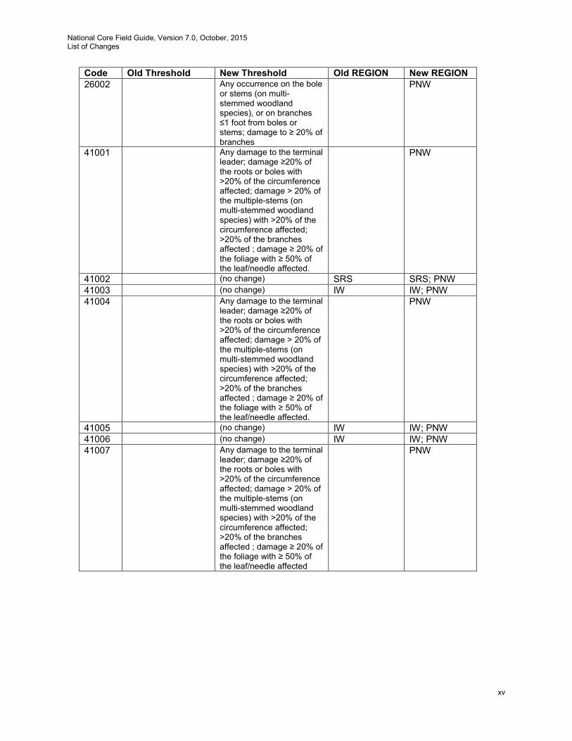
Code Old Threshold New Threshold Old REGION New REGION 26002 Any occurrence on the bole
or stems (on multi-stemmed woodland species), or on branches ≤1 foot from boles or stems; damage to ≥ 20% of branches
PNW
41001 Any damage to the terminal leader; damage ≥20% of the roots or boles with >20% of the circumference affected; damage > 20% of the multiple-stems (on multi-stemmed woodland species) with >20% of the circumference affected; >20% of the branches affected ; damage ≥ 20% of the foliage with ≥ 50% of the leaf/needle affected.
PNW
41002 (no change) SRS SRS; PNW 41003 (no change) IW IW; PNW 41004 Any damage to the terminal
leader; damage ≥20% of the roots or boles with >20% of the circumference affected; damage > 20% of the multiple-stems (on multi-stemmed woodland species) with >20% of the circumference affected; >20% of the branches affected ; damage ≥ 20% of the foliage with ≥ 50% of the leaf/needle affected.
PNW
41005 (no change) IW IW; PNW 41006 (no change) IW IW; PNW 41007 Any damage to the terminal
leader; damage ≥20% of the roots or boles with >20% of the circumference affected; damage > 20% of the multiple-stems (on multi-stemmed woodland species) with >20% of the circumference affected; >20% of the branches affected ; damage ≥ 20% of the foliage with ≥ 50% of the leaf/needle affected
PNW
National Core Field Guide, Version 7.0, October, 2015 List of Changes
xvi
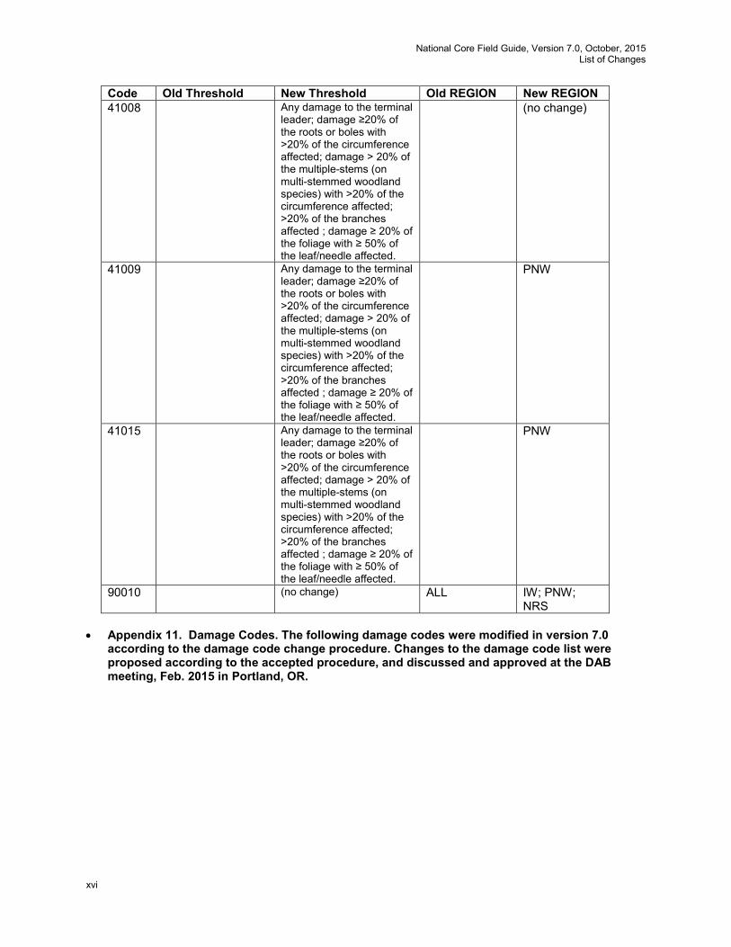
Code Old Threshold New Threshold Old REGION New REGION 41008 Any damage to the terminal
leader; damage ≥20% of the roots or boles with >20% of the circumference affected; damage > 20% of the multiple-stems (on multi-stemmed woodland species) with >20% of the circumference affected; >20% of the branches affected ; damage ≥ 20% of the foliage with ≥ 50% of the leaf/needle affected.
(no change)
41009 Any damage to the terminal leader; damage ≥20% of the roots or boles with >20% of the circumference affected; damage > 20% of the multiple-stems (on multi-stemmed woodland species) with >20% of the circumference affected; >20% of the branches affected ; damage ≥ 20% of the foliage with ≥ 50% of the leaf/needle affected.
PNW
41015 Any damage to the terminal leader; damage ≥20% of the roots or boles with >20% of the circumference affected; damage > 20% of the multiple-stems (on multi-stemmed woodland species) with >20% of the circumference affected; >20% of the branches affected ; damage ≥ 20% of the foliage with ≥ 50% of the leaf/needle affected.
PNW
90010 (no change) ALL IW; PNW; NRS
• Appendix 11. Damage Codes. The following damage codes were modified in version 7.0
according to the damage code change procedure. Changes to the damage code list were proposed according to the accepted procedure, and discussed and approved at the DAB meeting, Feb. 2015 in Portland, OR.
National Core Field Guide, Version 7.0, October, 2015 List of Changes
xvii
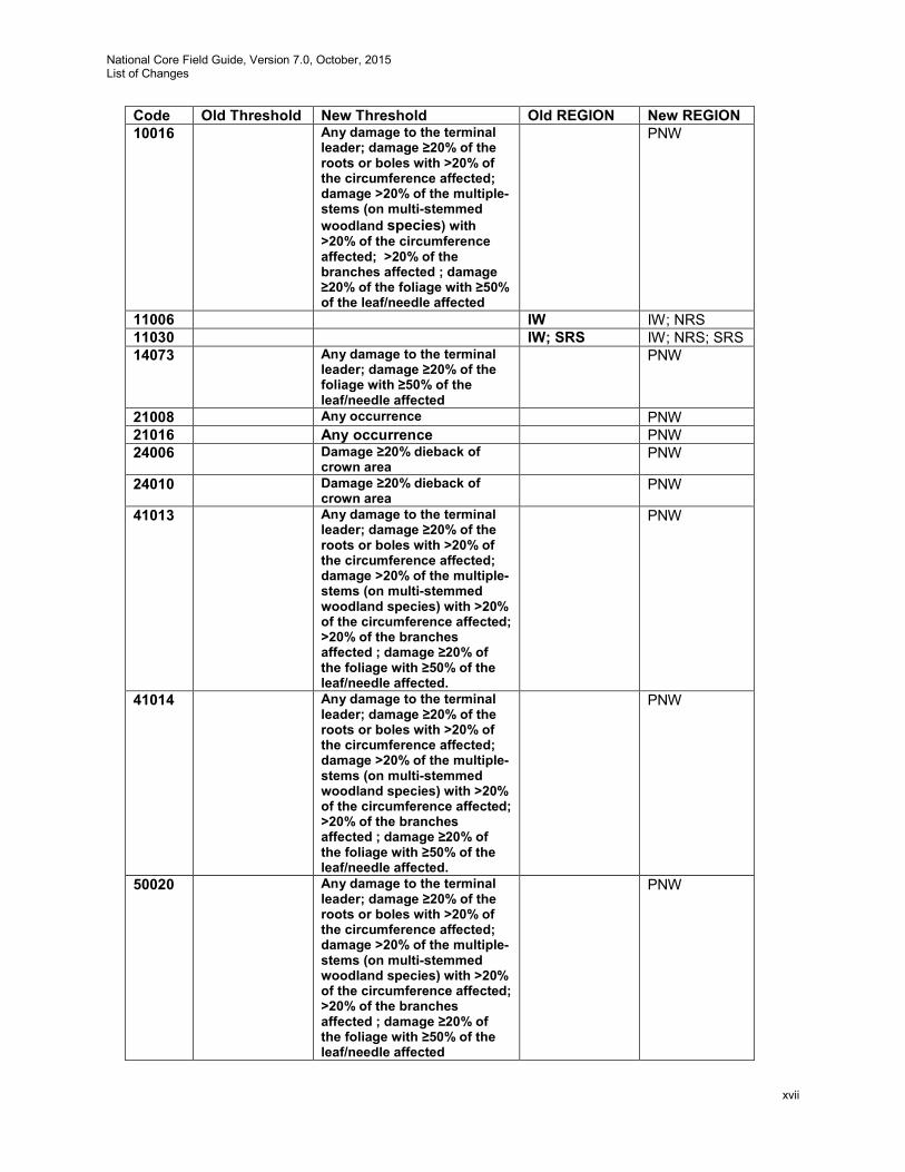
Code Old Threshold New Threshold Old REGION New REGION 10016 Any damage to the terminal
leader; damage ≥20% of the roots or boles with >20% of the circumference affected; damage >20% of the multiple-stems (on multi-stemmed woodland species) with >20% of the circumference affected; >20% of the branches affected ; damage ≥20% of the foliage with ≥50% of the leaf/needle affected
PNW
11006 IW IW; NRS 11030 IW; SRS IW; NRS; SRS 14073 Any damage to the terminal
leader; damage ≥20% of the foliage with ≥50% of the leaf/needle affected
PNW
21008 Any occurrence PNW 21016 Any occurrence PNW 24006 Damage ≥20% dieback of
crown area PNW
24010 Damage ≥20% dieback of crown area
PNW
41013 Any damage to the terminal leader; damage ≥20% of the roots or boles with >20% of the circumference affected; damage >20% of the multiple-stems (on multi-stemmed woodland species) with >20% of the circumference affected; >20% of the branches affected ; damage ≥20% of the foliage with ≥50% of the leaf/needle affected.
PNW
41014 Any damage to the terminal leader; damage ≥20% of the roots or boles with >20% of the circumference affected; damage >20% of the multiple-stems (on multi-stemmed woodland species) with >20% of the circumference affected; >20% of the branches affected ; damage ≥20% of the foliage with ≥50% of the leaf/needle affected.
PNW
50020 Any damage to the terminal leader; damage ≥20% of the roots or boles with >20% of the circumference affected; damage >20% of the multiple-stems (on multi-stemmed woodland species) with >20% of the circumference affected; >20% of the branches affected ; damage ≥20% of the foliage with ≥50% of the leaf/needle affected
PNW
National Core Field Guide, Version 7.0, October, 2015 List of Changes
xviii
• Appendix 14. FIA Pacific Islands Tree Species Codes. Added this appendix.
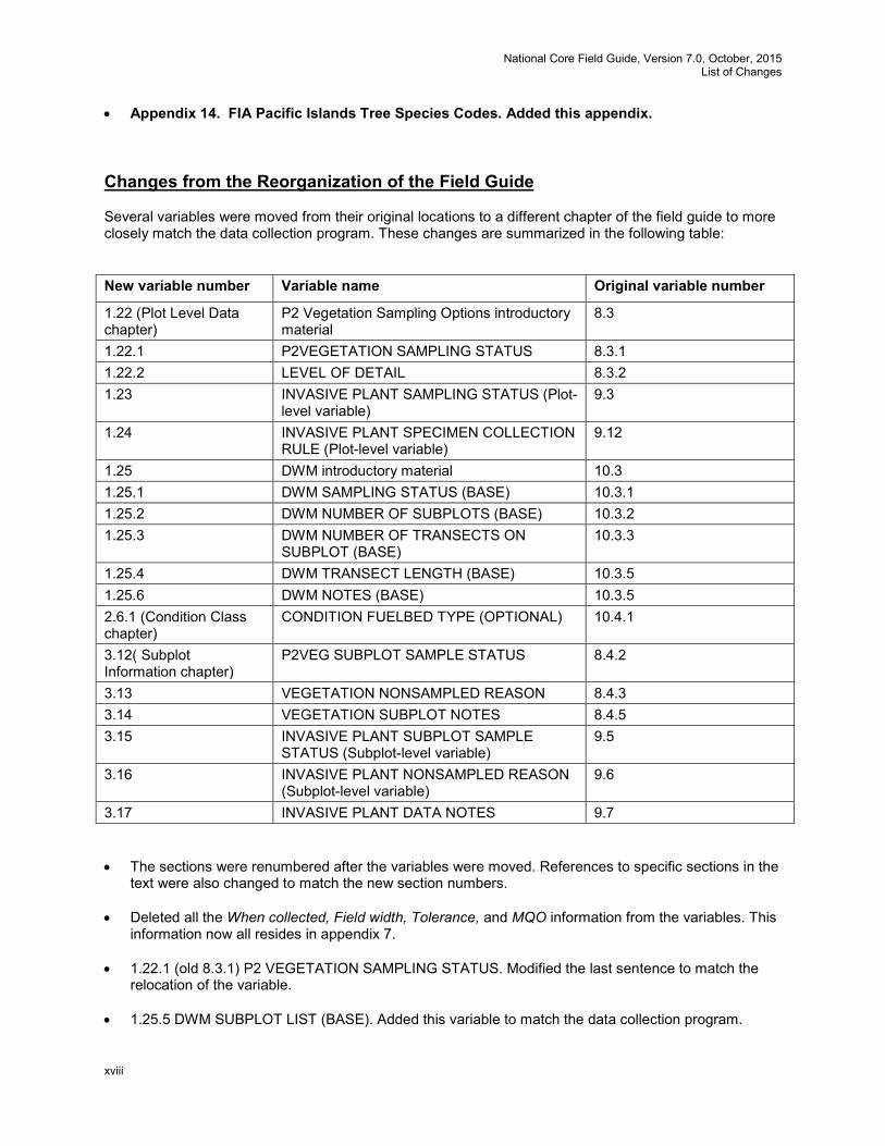
Changes from the Reorganization of the Field Guide Several variables were moved from their original locations to a different chapter of the field guide to more closely match the data collection program. These changes are summarized in the following table: New variable number Variable name Original variable number
1.22 (Plot Level Data chapter)
P2 Vegetation Sampling Options introductory material
8.3
1.22.1 P2VEGETATION SAMPLING STATUS 8.3.1 1.22.2 LEVEL OF DETAIL 8.3.2 1.23 INVASIVE PLANT SAMPLING STATUS (Plot-
level variable) 9.3
1.24 INVASIVE PLANT SPECIMEN COLLECTION RULE (Plot-level variable)
9.12
1.25 DWM introductory material 10.3 1.25.1 DWM SAMPLING STATUS (BASE) 10.3.1 1.25.2 DWM NUMBER OF SUBPLOTS (BASE) 10.3.2 1.25.3 DWM NUMBER OF TRANSECTS ON
SUBPLOT (BASE) 10.3.3
1.25.4 DWM TRANSECT LENGTH (BASE) 10.3.5 1.25.6 DWM NOTES (BASE) 10.3.5 2.6.1 (Condition Class chapter)
CONDITION FUELBED TYPE (OPTIONAL) 10.4.1
3.12( Subplot Information chapter)
P2VEG SUBPLOT SAMPLE STATUS 8.4.2
3.13 VEGETATION NONSAMPLED REASON 8.4.3 3.14 VEGETATION SUBPLOT NOTES 8.4.5 3.15 INVASIVE PLANT SUBPLOT SAMPLE
STATUS (Subplot-level variable) 9.5
3.16 INVASIVE PLANT NONSAMPLED REASON (Subplot-level variable)
9.6
3.17 INVASIVE PLANT DATA NOTES 9.7 • The sections were renumbered after the variables were moved. References to specific sections in the
text were also changed to match the new section numbers.
• Deleted all the When collected, Field width, Tolerance, and MQO information from the variables. This information now all resides in appendix 7.
• 1.22.1 (old 8.3.1) P2 VEGETATION SAMPLING STATUS. Modified the last sentence to match the
relocation of the variable.
• 1.25.5 DWM SUBPLOT LIST (BASE). Added this variable to match the data collection program.
National Core Field Guide, Version 7.0, October, 2015 List of Changes
xix
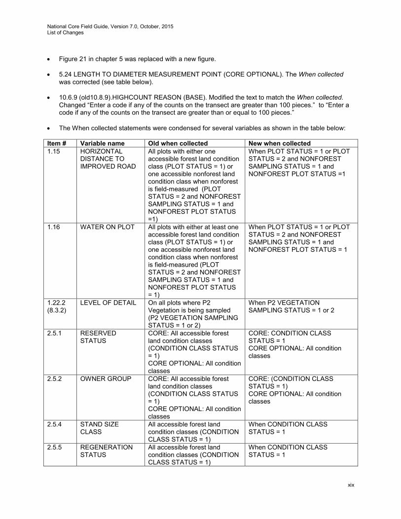
• Figure 21 in chapter 5 was replaced with a new figure.
• 5.24 LENGTH TO DIAMETER MEASUREMENT POINT (CORE OPTIONAL). The When collected
was corrected (see table below).
• 10.6.9 (old10.8.9).HIGHCOUNT REASON (BASE). Modified the text to match the When collected. Changed “Enter a code if any of the counts on the transect are greater than 100 pieces.” to “Enter a code if any of the counts on the transect are greater than or equal to 100 pieces.”
• The When collected statements were condensed for several variables as shown in the table below: Item # Variable name Old when collected New when collected 1.15 HORIZONTAL
DISTANCE TO IMPROVED ROAD
All plots with either one accessible forest land condition class (PLOT STATUS = 1) or one accessible nonforest land condition class when nonforest is field-measured (PLOT STATUS = 2 and NONFOREST SAMPLING STATUS = 1 and NONFOREST PLOT STATUS =1)
When PLOT STATUS = 1 or PLOT STATUS = 2 and NONFOREST SAMPLING STATUS = 1 and NONFOREST PLOT STATUS =1
1.16 WATER ON PLOT All plots with either at least one accessible forest land condition class (PLOT STATUS = 1) or one accessible nonforest land condition class when nonforest is field-measured (PLOT STATUS = 2 and NONFOREST SAMPLING STATUS = 1 and NONFOREST PLOT STATUS = 1)
When PLOT STATUS = 1 or PLOT STATUS = 2 and NONFOREST SAMPLING STATUS = 1 and NONFOREST PLOT STATUS = 1
1.22.2 (8.3.2)
LEVEL OF DETAIL On all plots where P2 Vegetation is being sampled (P2 VEGETATION SAMPLING STATUS = 1 or 2)
When P2 VEGETATION SAMPLING STATUS = 1 or 2
2.5.1 RESERVED STATUS
CORE: All accessible forest land condition classes (CONDITION CLASS STATUS = 1) CORE OPTIONAL: All condition classes
CORE: CONDITION CLASS STATUS = 1 CORE OPTIONAL: All condition classes
2.5.2 OWNER GROUP CORE: All accessible forest land condition classes (CONDITION CLASS STATUS = 1) CORE OPTIONAL: All condition classes
CORE: (CONDITION CLASS STATUS = 1) CORE OPTIONAL: All condition classes
2.5.4 STAND SIZE CLASS
All accessible forest land condition classes (CONDITION CLASS STATUS = 1)
When CONDITION CLASS STATUS = 1
2.5.5 REGENERATION STATUS
All accessible forest land condition classes (CONDITION CLASS STATUS = 1)
When CONDITION CLASS STATUS = 1
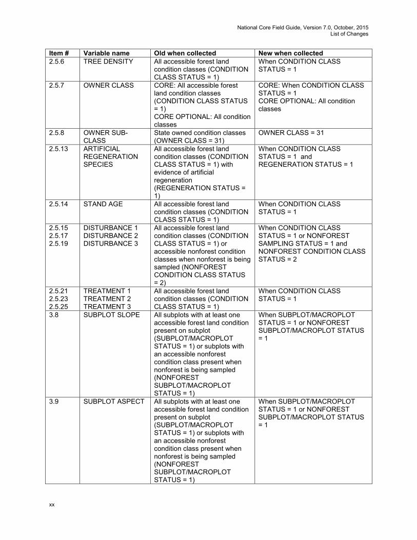
National Core Field Guide, Version 7.0, October, 2015 List of Changes
xx
Item # Variable name Old when collected New when collected 2.5.6 TREE DENSITY All accessible forest land
condition classes (CONDITION CLASS STATUS = 1)
When CONDITION CLASS STATUS = 1
2.5.7 OWNER CLASS CORE: All accessible forest land condition classes (CONDITION CLASS STATUS = 1) CORE OPTIONAL: All condition classes
CORE: When CONDITION CLASS STATUS = 1 CORE OPTIONAL: All condition classes
2.5.8 OWNER SUB-CLASS
State owned condition classes (OWNER CLASS = 31)
OWNER CLASS = 31
2.5.13 ARTIFICIAL REGENERATION SPECIES
All accessible forest land condition classes (CONDITION CLASS STATUS = 1) with evidence of artificial regeneration (REGENERATION STATUS = 1)
When CONDITION CLASS STATUS = 1 and REGENERATION STATUS = 1
2.5.14 STAND AGE All accessible forest land condition classes (CONDITION CLASS STATUS = 1)
When CONDITION CLASS STATUS = 1
2.5.15 2.5.17 2.5.19
DISTURBANCE 1 DISTURBANCE 2 DISTURBANCE 3
All accessible forest land condition classes (CONDITION CLASS STATUS = 1) or accessible nonforest condition classes when nonforest is being sampled (NONFOREST CONDITION CLASS STATUS = 2)
When CONDITION CLASS STATUS = 1 or NONFOREST SAMPLING STATUS = 1 and NONFOREST CONDITION CLASS STATUS = 2
2.5.21 2.5.23 2.5.25
TREATMENT 1 TREATMENT 2 TREATMENT 3
All accessible forest land condition classes (CONDITION CLASS STATUS = 1)
When CONDITION CLASS STATUS = 1
3.8 SUBPLOT SLOPE All subplots with at least one accessible forest land condition present on subplot (SUBPLOT/MACROPLOT STATUS = 1) or subplots with an accessible nonforest condition class present when nonforest is being sampled (NONFOREST SUBPLOT/MACROPLOT STATUS = 1)
When SUBPLOT/MACROPLOT STATUS = 1 or NONFOREST SUBPLOT/MACROPLOT STATUS = 1
3.9 SUBPLOT ASPECT All subplots with at least one accessible forest land condition present on subplot (SUBPLOT/MACROPLOT STATUS = 1) or subplots with an accessible nonforest condition class present when nonforest is being sampled (NONFOREST SUBPLOT/MACROPLOT STATUS = 1)
When SUBPLOT/MACROPLOT STATUS = 1 or NONFOREST SUBPLOT/MACROPLOT STATUS = 1
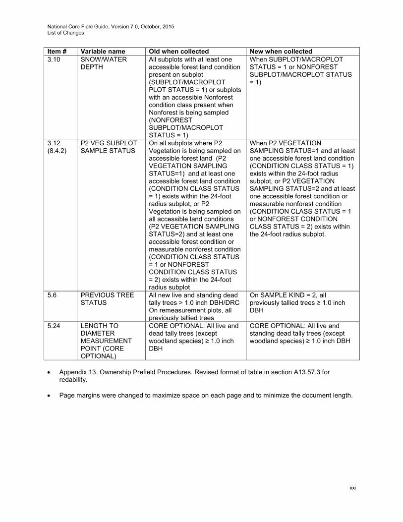
National Core Field Guide, Version 7.0, October, 2015 List of Changes
xxi
Item # Variable name Old when collected New when collected 3.10 SNOW/WATER
DEPTH All subplots with at least one accessible forest land condition present on subplot (SUBPLOT/MACROPLOT PLOT STATUS = 1) or subplots with an accessible Nonforest condition class present when Nonforest is being sampled (NONFOREST SUBPLOT/MACROPLOT STATUS = 1)
When SUBPLOT/MACROPLOT STATUS = 1 or NONFOREST SUBPLOT/MACROPLOT STATUS = 1)
3.12 (8.4.2)
P2 VEG SUBPLOT SAMPLE STATUS
On all subplots where P2 Vegetation is being sampled on accessible forest land (P2 VEGETATION SAMPLING STATUS=1) and at least one accessible forest land condition (CONDITION CLASS STATUS = 1) exists within the 24-foot radius subplot, or P2 Vegetation is being sampled on all accessible land conditions (P2 VEGETATION SAMPLING STATUS=2) and at least one accessible forest condition or measurable nonforest condition (CONDITION CLASS STATUS = 1 or NONFOREST CONDITION CLASS STATUS = 2) exists within the 24-foot radius subplot
When P2 VEGETATION SAMPLING STATUS=1 and at least one accessible forest land condition (CONDITION CLASS STATUS = 1) exists within the 24-foot radius subplot, or P2 VEGETATION SAMPLING STATUS=2 and at least one accessible forest condition or measurable nonforest condition (CONDITION CLASS STATUS = 1 or NONFOREST CONDITION CLASS STATUS = 2) exists within the 24-foot radius subplot.
5.6 PREVIOUS TREE STATUS
All new live and standing dead tally trees > 1.0 inch DBH/DRC On remeasurement plots, all previously tallied trees
On SAMPLE KIND = 2, all previously tallied trees ≥ 1.0 inch DBH
5.24 LENGTH TO DIAMETER MEASUREMENT POINT (CORE OPTIONAL)
CORE OPTIONAL: All live and dead tally trees (except woodland species) ≥ 1.0 inch DBH
CORE OPTIONAL: All live and standing dead tally trees (except woodland species) ≥ 1.0 inch DBH
• Appendix 13. Ownership Prefield Procedures. Revised format of table in section A13.57.3 for
redability.
• Page margins were changed to maximize space on each page and to minimize the document length.

National Core Field Guide, Version 7.0, October, 2015 List of Changes
xxii
National Core Field Guide, Version 7.0,October, 2015 Introduction
1
FOREST INVENTORY AND ANALYSIS NATIONAL CORE FIELD GUIDE
VOLUME I: FIELD DATA COLLECTION PROCEDURES FOR PHASE 2 PLOTS
Version 7.0 Version History: 1.1 March 1999 (first version implemented, Maine, 1999) 1.2 August 1999 1.3 September 1999 (revised from Bangor, ME Data Acquisition Band meeting, Aug. 1999) 1.4 February 2000 (revised from Charleston, SC Data Acquisition Band meeting, Dec 1999) 1.5 January 2001 (revised from Portland, OR Data Acquisition Band meeting, Sept. 2000) 1.6 March 2002 (revised from Tucson, AZ Joint Band meeting, Jan. 2002) 1.7 February 2003 (revised from Charleston, SC Joint Band Meeting, Feb. 2003) 2.0 April 2003 (revised from Atlantic City, NJ, Data Acquisition Band Meeting, Mar. 2003) October 2003 (revised from Anchorage, AK, Data Acquisition Band Meeting, Aug. 2003) January 2004 (revised from Data Acquisition Band conference calls with FIA Management Team
Approval) August 2004 (revised from Asheville, NC, Data Acquisition Band Meeting, Aug. 2004) 3.0 October 2005 (revised from change management process, change proposals approved by FIA
Management Team, from Asheville, NC, Data Acquisition Meeting, Aug. 2004, and from Las Vegas, NV, Data Acquisition Meeting, Mar. 2005)
4.0 October 2007 (revised from change management process, change proposals approved by FIA Management Team, from Flagstaff, AZ, Data Acquisition Band Meeting, Sept. 2006, and from multiple Data Acquisition Band conference calls)
5.0 July 2009 (revised from change management process, change proposals approved by FIA Management Team, from Charleston, SC, Data Acquisition Band Meeting, Mar. 2009, and from multiple Data Acquisition Band conference calls)
October 2010 (revised from change management process and from Portland, OR, Data Acquisition Band Meeting, Feb. 2010 and subsequent conference calls)
6.0 October 2012 (revised from change management process, change proposals approved by FIA Management Team; from Portland, OR, Data Acquisition Band Meeting, Feb. 2011; and multiple Data Acquisition Band conference calls)
7.0 October 2015 (revised from change management process, change proposals approved by FIA Management Team; multiple Data Acquisition Band conference calls, from Portland, OR, Data Acquisition Band Meeting, Feb. 2015; and from results of a field guide reorganization team)
Mention of trade names or commercial products does not constitute endorsement or recommendation for use. INTRODUCTION
This document describes the standards, codes, methods, and definitions for Forest Inventory and Analysis (FIA) field data items. The objective is to describe CORE FIA field procedures that are consistent and uniform across all FIA units. This CORE is the framework for regional FIA programs; individual programs may add variables, but may not change the CORE requirements. Unless otherwise noted, the items in this field guide are considered CORE, that is, the information will be collected by all FIA units as specified. Items or codes specified as CORE OPTIONAL are not required by individual units; however, if the item is collected or coded, it will be done as specified in this field guide. It is expected that on average all items in this guide (Volume I of the FIA field methods guide) can be measured by a two-person field crew in less than one day, including travel time to and from the plot.
National Core Field Guide, Version 7.0, October, 2015 Introduction
2
The FIA program is in transition, changing in response to legislation and new customer demands. One of these demands is for increased consistency, which this field guide begins to address. Another change was the merger of the FIA program with the field plot component of the Forest Health Monitoring (FHM) program’s Detection Monitoring. A systematic grid was established that includes some, but not all former FIA plots. This grid contains the Phase 2 plots, the annual survey plots that are designed for measurement on a rotation such that a portion of the plots are measured each year. The rotation length varies by region. The former FHM Detection Monitoring field plots are the Phase 3 plots, a subset of the Phase 2 plots. The same basic plot and sampling designs are used on all the plots.
The focus of Volume I is on data that are collected in the field on all Phase 2 plots in the FIA sample. The methods in Volume I are also used on Phase 3 plots except when specifically noted otherwise in the methods text. Volume II of the series describes an additional, expanded suite of data collected on the Phase 3 subset of plots. Volume II contains methods for the following indicators: ozone bioindicator plants; lichen communities; soils (physical and chemical characteristics); crown condition; and vegetation diversity and structure. Note that the down woody materials field procedures are now included only in Volume I. Volume III of the series (in preparation) will document the office procedures including data elements measured in the office, data from other sources that are merged into the FIA database, and CORE compilation and analysis algorithms. When complete, the three-volume set will describe the CORE FIA program field data, all of which are measured consistently across the country.
Field Guide Layout
Each section of the field guide corresponds to one of the following sections:
0 General Description 1 Plot Level Data 2 Condition Class 3 Subplot Information 4 Boundary References 5 Tree Measurements and Sapling Data 6 Seedling Data 7 Site Tree Information 8 Phase 2 (P2) Vegetation Profile (core optional) 9 Invasive Plants 10 Down Woody Materials
Each section begins with a general overview of the data elements collected at that level and background necessary to prepare field crews for data collection. Descriptions of data elements follow in this format:
DATA ELEMENT NAME -- <brief variable description> When collected: <when data element is recorded>
Field width: <X digits> Tolerance: <range of measurement that is acceptable> MQO: <measurement quality objective> Values: <legal values for coded variables>
Data elements, descriptions of when to collect the data elements, field width, tolerances, MQO’s, and values, apply to both Phase 2 plots (formerly called FIA plots) and Phase 3 plots (formerly called FHM Detection Monitoring plots) unless specifically noted. Field width designates the number of columns (or spaces) needed to properly record the data element.
National Core Field Guide, Version 7.0,October, 2015 Introduction
3
Tolerances may be stated in +/- terms or number of classes for ordered categorical data elements (e.g., +/- 2 classes); in absolute terms for some continuous variables (e.g., +/- 0.2 inches); or in terms of percent of the value of the data element (e.g., +/- 10 percent of the value). For some data elements, no errors are tolerated (e.g., PLOT NUMBER).
MQO’s state the percentage of time that the collected data are required to be within tolerance. Percentage of time within tolerance is generally expressed as "at least X percent of the time," meaning that crews are expected to be within tolerance at least X percent of the time. PLOT NOTES will be available on every PDR screen for ease in recording notes.
Units Of Measure
The field guide will use ENGLISH units as the measurement system.
Plot Dimensions:
Subplot:
Radius = 24.0 feet Area = 1,809.56 square feet or approximately 0.04 acre or approximately 1/24 acre
Microplot:
Radius = 6.8 feet Area = 145.27 square feet or approximately 0.003 acre or approximately 1/300 acre
Macroplot:
Radius = 58.9 feet Area = 10,899 square feet or 0.25 acre (ac) or 1/4 acre
Annular plot:
Radius = from 24.0 feet to 58.9 feet Area = 9088.4 square feet or approximately 0.21 acre or 5/24 acre
The distance between subplot centers is 120.0 feet horizontal. The minimum area needed to qualify as accessible forest land is 1.0 acre. The minimum width to qualify as accessible forest land is 120.0 ft
Tree Limiting Dimensions:
breast height 4.5 ft stump height 1.0 ft merchantable top 4.0 in DOB merchantable top for woodland 1.5 in DOB minimum conifer seedling length 0.5 ft minimum hardwood seedling length 1.0 ft seedling/sapling DBH/DRC break 1.0 in DOB sapling/tree DBH/DRC break 5.0 in DOB

National Core Field Guide, Version 7.0, October, 2015 Introduction
4
National Core Field Guide, Version 7.0,October, 2015 Section 0.0. General Description
5
0.0 General Description
The CORE field plot consists of four subplots approximately 1/24 acre in size with a radius of 24.0 feet. The center subplot is subplot 1. Subplots 2, 3, and 4 are located 120.0 feet horizontal (+/- 7 feet) at azimuths of 360, 120, and 240 degrees from the center of subplot 1, respectively (see fig. 1). Throughout this field guide, the use of the word ‘plot’ refers to the entire set of four subplots. ‘Plot center’ is defined as the center of subplot 1. As a CORE OPTION, the field plot may also include macroplots that are ¼ acre in size with a radius of 58.9 feet; each macroplot center coincides with the subplot’s center. Macroplots are numbered in the same way as subplots. If the macroplots are not installed, the subplots are used to collect data on trees with a diameter (at breast height, DBH, or at root collar, DRC) of 5.0 inches or greater. If the macroplots are installed, then subplots are used to collect data on trees from a diameter 5.0 inches to the breakpoint diameter and the macroplot is used to collect data on trees with diameter greater than the breakpoint diameter.
Each subplot contains a microplot of approximately 1/300 acre in size with a radius of 6.8 feet. The center of the microplot is offset 90 degrees and 12.0 feet horizontal (+/- 1 foot) from each subplot center. Microplots are numbered in the same way as subplots. Microplots are used to select and collect data on saplings (DBH/DRC of 1.0 inch through 4.9 inches) and seedlings (DBH/DRC less than 1.0 inch in diameter and greater than 0.5 foot in length [conifers] or greater than 1.0 foot in length [hardwoods]).
As a CORE OPTION for a Phase 2 plot that is not part of the Phase 3 subset, data for one or more of the Phase 3 indicators may be collected on the plot. If a region exercises the option to collect one or more Phase 3 indicator(s) on a Phase 2 only plot, the entire suite of measurements for the particular indicator(s) described in the appropriate chapter must be collected for the data for that indicator to be core optional. Each unit may choose which Phase 3 indicators to collect as core optional on a Phase 2 plot that is not a Phase 3 plot. They may choose no indicators, all indicators or a subset. If they choose to collect data for a Phase 3 indicator, all the procedures for the indicator must be followed for that indicator to be considered core optional (data in the National Information Management System [NIMS]). If a subset of measurements for an indicator are collected, that is considered a regional enhancement and the data will be in the regional database.
Macroplots may be used to provide a better sample of rare population elements, such as very large trees. The annular plot may be used for destructive sampling such as collecting soil samples. Also the term annular plot will be used for instructions in the field guide, for example, instructions on numbering trees when the macroplots are installed. Data are collected on field plots at the following levels:
Plot Data that describe the entire cluster of four subplots.
Subplot Data that describe a single subplot of a cluster.
Condition Class A discrete combination of landscape attributes that describe the
environment on all or part of the plot. These attributes include CONDITION CLASS STATUS, RESERVED STATUS, OWNER GROUP, FOREST TYPE, STAND SIZE CLASS, REGENERATION STATUS, and TREE DENSITY.
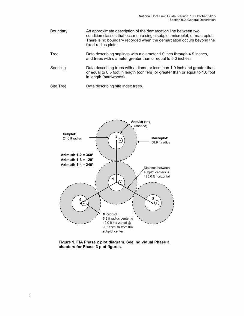
National Core Field Guide, Version 7.0, October, 2015 Section 0.0. General Description
6
Boundary An approximate description of the demarcation line between two condition classes that occur on a single subplot, microplot, or macroplot. There is no boundary recorded when the demarcation occurs beyond the fixed-radius plots.
Tree Data describing saplings with a diameter 1.0 inch through 4.9 inches,
and trees with diameter greater than or equal to 5.0 inches.
Seedling Data describing trees with a diameter less than 1.0 inch and greater than or equal to 0.5 foot in length (conifers) or greater than or equal to 1.0 foot in length (hardwoods).
Site Tree Data describing site index trees.
4
2
3
1
Macroplot: 58.9 ft radius
Subplot: 24.0 ft radius
Annular ring (shaded)
Distance between subplot centers is 120.0 ft horizontal
Microplot: 6.8 ft radius center is 12.0 ft horizontal @ 90° azimuth from the subplot center
Azimuth 1-2 = 360° Azimuth 1-3 = 120° Azimuth 1-4 = 240°
Figure 1. FIA Phase 2 plot diagram. See individual Phase 3 chapters for Phase 3 plot figures.
National Core Field Guide, Version 7.0,October, 2015 Section 0.0. General Description
7
0.1 Plot Setup
Plots will be established according to the regional guidelines of each FIA unit. When the crew cannot occupy the plot center because safety hazards exist, or the plot center is inaccessible or out of the sample, the crew should check the other subplots. If any subplot centers can be occupied and are in the sample, the subplots that can be occupied should be established and sampled following normal procedures. When a subplot center or microplot center cannot be occupied, no data will be collected from that subplot or microplot; instead, the entire subplot or microplot should be classified according to the condition preventing occupancy. The following table provided can assist in locating subplot 2-4 from a subplot other than subplot 1.
Subplot Numbers Azimuth Backsight Distance
From To degrees feet 2 3 150 330 207.8 2 4 210 030 207.8 3 4 270 090 207.8
If a subplot was installed incorrectly at the previous visit, the current crew should remeasure the subplot in its present location and contact the field supervisor. In cases where individual subplots are lost (cannot be relocated), use the following procedures:
• Assign the appropriate present CONDITION CLASS STATUS Code(s) to the new subplot (usually CONDITION CLASS STATUS = 1 or 2).
• Assign TREE STATUS = 0 to all downloaded trees (i.e., incorrectly tallied at the previous
survey). • Assign RECONCILE codes 3 or 4 (i.e., missed live or missed dead) to all trees on the
new subplot. • Assign the next TREE RECORD NUMBER.
0.2 Plot Integrity
Each FIA unit is responsible for minimizing damage to current or prospective sample trees and for specifying how these trees are monumented for remeasurement. The following field procedures are permitted:
• Scribing and nailing tags on witness trees so that subplot centers can be relocated.
• Boring trees for age on subplots and macroplots to determine tree age, site index, stand
age, or for other reasons.
• Nailing and tagging trees on microplots, subplots, and macroplots so that these trees can be identified and relocated efficiently and positively at times of remeasurement.
• Nailing, scribing, or painting microplot, subplot, and macroplot trees so that the point of
diameter measurement can be accurately relocated and remeasured.
All other potentially damaging procedures that may erode subplot integrity are prohibited. The following practices are specifically prohibited:

National Core Field Guide, Version 7.0, October, 2015 Section 0.0. General Description
8
• Boring and scribing some specific tree species that are known to be negatively affected (e.g., the initiation of infection or callusing).
• Chopping vines from tally trees. When possible, vines should be pried off trunks to
enable accurate measurement. If this is not possible, alternative tools (calipers, biltmore sticks) should be used.
Note: Avoid becoming part of the problem! There is a risk that field crews walking into plot locations could pick up seeds along roadsides or other patches of invasive plants and spread them through the forest and on to the plot. Be aware of the vegetation you are traveling through and consider stopping and removing seeds from boots and clothing before entering uninvaded lands, particularly remote areas that are rarely visited.
National Core Field Guide, Version 7.0,October, 2015 Section 1.0. Plot Level Data
9
1.0 Plot Level Data
All variables listed in Section 1.0 are collected on plots with at least one accessible forest land condition (PLOT STATUS = 1) and all NONFOREST/NONSAMPLED plots (PLOT STATUS = 2 or PLOT STATUS = 3). In general, plot level data apply to the entire plot and they are recorded from the center of subplot 1. A plot is considered nonforest if no part of it is currently located in forest land (CONDITION CLASS STATUS = 1). A plot is nonsampled if the entire plot is not sampled for one of the reasons listed in PLOT NONSAMPLED REASON. If a forest plot has been converted to nonforest or becomes a nonsampled plot, the previous data are reconciled and an attempt is made to visit the plot during the next inventory. If a nonforest plot becomes forest or access is gained to a previously nonsampled plot, a new forest ground plot is installed. All nonforest and nonsampled plots are visited if there is any reasonable chance that they might include some forest land condition class. Trees on previously forest land plots will be reconciled during data processing. There is a distinction between plots that have been clearcut, and plots that have been converted to another land use. A clearcut plot is considered to be forest land until it is actively converted to another land use. Additional information concerning land use classifications is contained in Section 2.3.
1.1 STATE
Record the unique FIPS (Federal Information Processing Standard) code identifying the State where the plot center is located.
Values: See Appendix 1
1.2 COUNTY
Record the unique FIPS (Federal Information Processing Standard) code identifying the county, parish, or borough (or unit in AK) where the plot center is located.
Values: See Appendix 1
1.3 PLOT NUMBER
Record the identification number, unique within a county, parish, or borough (survey unit in AK), for each plot. If SAMPLE KIND = 3, the plot number will be assigned by the National Information Management System (NIMS).
Values: 00001 to 99999
1.4 PLOT STATUS
Record the code that describes the sampling status of the plot. In cases where a plot is inaccessible, but obviously contains no forest land, record PLOT STATUS = 2. In cases where a plot is access-denied or hazardous land use and has the possibility of forest, record PLOT STATUS = 3.
Values: 1 Sampled – at least one accessible forest land condition present on plot
2 Sampled – no accessible forest land condition present on plot 3 Nonsampled – possibility of forest land
National Core Field Guide, Version 7.0, October, 2015 Section 1.0. Plot Level Data
10
1.5 NONFOREST SAMPLING STATUS
Record whether this plot is part of a nonforest inventory. If NONFOREST SAMPLING STATUS = 1, then the entire suite of attributes that are measured on the forest lands will be measured and only those suites of attributes that are measured on forest lands will be measured on nonforest lands. Values:
1.6 NONFOREST PLOT STATUS
Record the code that describes the plot status of the nonforest plot, i.e., PLOT STATUS = 2. In cases where the plot is inaccessible, but obviously contains no nonforest land, i.e., plot is either noncensus water or census water, record NONFOREST PLOT STATUS = 2. Values:
1.7 PLOT NONSAMPLED REASON
For entire plots that cannot be sampled, record one of the following reasons. Values:
01 Outside U.S. boundary – Entire plot is outside of the U.S. border. 02 Denied access – Access to the entire plot is denied by the legal owner, or by the
owner of the only reasonable route to the plot. Because a denied-access plot can become accessible in the future, it remains in the sample and is re-examined at the next occasion to determine if access is available.
03 Hazardous – Entire plot cannot be accessed because of a hazard or danger, for example cliffs, quarries, strip mines, illegal substance plantations, high water, etc. Although most hazards will not change over time, a hazardous plot remains in the sample and is re-examined at the next occasion to determine if the hazard is still present.
05 Lost data – Plot data file was discovered to be corrupt after a panel was completed and submitted for processing. This code is applied at the time of processing after notification to the units. This code is for office use only.
06 Lost plot – Entire plot cannot be found. Whenever this code is assigned, a replacement plot is required. The plot that is lost is assigned SAMPLE KIND = 2 and NONSAMPLED REASON = 6. The replacement plot is assigned SAMPLE KIND = 3.
07 Wrong location – Previous plot can be found, but its placement is beyond the tolerance limits for plot location. Whenever this code is assigned, a replacement plot is required. The plot being relocated is assigned SAMPLE KIND = 2 and NONSAMPLED REASON = 7. Its replacement plot is assigned SAMPLE KIND = 3.
0 Nonforest plots / conditions are not inventoried 1 Nonforest plots / conditions are inventoried
1 Sampled – at least one accessible nonforest land condition present on the plot 2 Sampled – no nonforest land condition present on plot, i.e., plot is either
census and/or noncensus water 3 Nonsampled nonforest

National Core Field Guide, Version 7.0,October, 2015 Section 1.0. Plot Level Data
11
08 Skipped visit – Entire plot skipped. Used for plots that are not completed prior to the time a panel is finished and submitted for processing. This code is for office use only.
09 Dropped intensified plot - Intensified plot dropped due to a change in grid density. This code used only by units engaged in intensification. This code is for office use only.
10 Other – Entire plot not sampled due to a reason other than one of the specific reasons already listed. A field note is required to describe the situation.
11 Ocean – Plot falls in ocean water below mean high tide line. 1.8 NONFOREST PLOT NONSAMPLED REASON
For entire nonforest plots that cannot be sampled, record one of the following reasons.
Values:
02 Denied access – Access to the entire plot is denied by the legal owner, or by the owner of the only reasonable route to the plot. Because a denied-access plot can become accessible in the future, it remains in the sample and is re-examined at the next occasion to determine if access is available.
03 Hazardous – Entire plot cannot be accessed because of a hazard or danger, for example cliffs, quarries, strip mines, illegal substance plantations, high water, etc. Although most hazards will not change over time, a hazardous plot remains in the sample and is re-examined at the next occasion to determine if the hazard is still present.
08 Skipped visit – Entire plot skipped. Used for plots that are not completed prior to the time a panel is finished and submitted for processing. This code is for office use only.
09 Dropped intensified plot - Intensified plot dropped due to a change in grid density. This code used only by units engaged in intensification. This code is for office use only.
10 Other – Entire plot not sampled due to a reason other than one of the specific reasons already listed. A field note is required to describe the situation.
1.9 SUBPLOTS EXAMINED
Record the number of subplots examined. By default, PLOT STATUS = 1 plots have all 4 subplots examined.
Values:
1 Only subplot 1 center condition examined and all other subplots assumed (inferred) to be the same
4 All four subplots fully described (no assumptions/inferences) 1.10 SAMPLE KIND
Record the code that describes the kind of plot being installed.
Values:
1 Initial plot establishment - the initial establishment and sampling of a national design plot (FIA Field Guide versions 1.1 and higher). SAMPLE KIND 1 is assigned under the following circumstances:
National Core Field Guide, Version 7.0, October, 2015 Section 1.0. Plot Level Data
12
• Initial activation of a panel or subpanel • Reactivation of a panel or subpanel that was previously dropped • Resampling of established plots that were not sampled at the previous
visit 2 Remeasurement – remeasurement of a national design plot that was sampled at
the previous inventory. 3 Replacement plot - a replacement plot for a previously established plot. Assign
SAMPLE KIND = 3 if a plot is re-installed at a location other than the original location (i.e., plots that have been lost, moved, or otherwise replaced). Note that replacement plots require a separate plot file for the replaced plot. Replaced plots are assigned SAMPLE KIND = 2, PLOT STATUS = 3, and the appropriate NONSAMPLED REASON code. The plot number for the new (replacement) plot is assigned by NIMS.
1.11 PREVIOUS PLOT NUMBER
Record the identification number for the plot that is being replaced. Values: 00001 to 99999 1.12 FIELD GUIDE VERSION
Record the version number of the National Core Field Guide that was used to collect the data on this plot. FIELD GUIDE VERSION will be used to match collected data to the proper version of the field guide.
Values: 7.0
1.13 CURRENT DATE
Record the year, month, and day that the current plot visit was completed as described in 1.13.1 – 1.13.3.
1.13.1 YEAR
Record the year that the plot was completed.
Values: > 2003 1.13.2 MONTH
Record the month that the plot was completed.
Values:
January 01 May 05 September 09 February 02 June 06 October 10 March 03 July 07 November 11 April 04 August 08 December 12

National Core Field Guide, Version 7.0,October, 2015 Section 1.0. Plot Level Data
13
1.13.3 DAY
Record the day of the month that the plot was completed.
Values: 01 to 31
1.14 DECLINATION (CORE OPTIONAL)
Record the azimuth correction used to adjust magnetic north to true north. All azimuths are assumed to be magnetic azimuths unless otherwise designated. The Portland FIA unit historically has corrected all compass readings for true north. This field is to be used only in cases where units are adjusting azimuths to correspond to true north; for units using magnetic azimuths, this field will always be set = 0 in the office. This field carries a decimal place because the USGS corrections are provided to the nearest half degree. DECLINATION is defined as:
DECLINATION = (TRUE NORTH - MAGNETIC NORTH) Values: +/- 50 1.15 HORIZONTAL DISTANCE TO IMPROVED ROAD
Record the straight-line distance from plot center (subplot 1) to the nearest improved road. An improved road is a road of any width that is maintained as evidenced by pavement, gravel, grading, ditching, and/or other improvements.
Values:
1 100 ft or less 2 101 to 300 ft 3 301 to 500 ft 4 501 to 1000 ft 5 1001 ft to 1/2 mile 6 1/2 to 1 mile 7 1 to 3 miles 8 3 to 5 miles 9 Greater than 5 miles
1.16 WATER ON PLOT
Record the water source that has the greatest impact on the area within the accessible forest/nonforest land portion of any of the four subplots. The coding hierarchy is listed in order from large permanent water to temporary water. This variable can be used for recreation, wildlife, hydrology, and timber availability studies.
Values:
0 None – no water sources within the accessible forest/nonforest land 1 Permanent streams or ponds too small to qualify as noncensus water 2 Permanent water in the form of deep swamps, bogs, marshes without standing trees
present and less than 1.0 ac in size, or with standing trees 3 Ditch/canal – human-made channels used as a means of moving water, such as
irrigation or drainage which are too small to qualify as noncensus water 4 Temporary streams 5 Flood zones – evidence of flooding when bodies of water exceed their natural banks 9 Other temporary water – specify in plot notes

National Core Field Guide, Version 7.0, October, 2015 Section 1.0. Plot Level Data
14
1.17 QA STATUS
Record the code to indicate the type of plot data collected, using the following codes: Values:
1 Standard production plot 2 Cold check 3 Reference plot (off grid) 4 Training/practice plot (off grid) 5 Botched plot file (disregard during data processing) 6 Blind check 7 Hot check (production plot)
1.18 CREW NUMBER
Record up to 5 crew numbers as assigned to the field crew; always record the crew leader first. The first 2 digits are for the responsible unit’s station number (NRS – 24xxxx, SRS – 33xxxx, RMRS – 22xxxx, and PNW – 26xxxx).
Values:
NRS 240001 – 249999 SRS 330001 – 339999 RMRS 220001 – 229999 PNW 260001 - 269999
1.19 GPS Coordinates
Use a global positioning system (GPS) unit to determine the plot coordinates and elevation of all field-visited plot locations even if GPS has been used to locate the plot in the past.
1.19.1 GPS Unit Settings, Datum, and COORDINATE SYSTEM
Consult the GPS unit operating manual or other regional instructions to ensure that the GPS unit internal settings, including Datum and Coordinate system, are correctly configured. Each FIA unit will use the NAD83 Datum to collect coordinates.
Each FIA unit will determine which coordinate system to use. Regions using a Geographic system will collect coordinates in Degrees, Minutes, and Seconds of Latitude and Longitude; the regions using the UTM coordinate system will collect UTM Easting, Northing, and Zone.
1.19.2 Collecting Readings
Critical GPS settings such as maximum PDOP, maximum EHE, minimum satellite elevation, minimum SNR, and number of readings to average will be determined by each region based on recommendations from the Mobile Geospatial Technology Advisory Group (MGTAG) where available. These may be collected in a file for post-processing or may be averaged by the GPS unit.
National Core Field Guide, Version 7.0,October, 2015 Section 1.0. Plot Level Data
15
Soon after arriving at plot center, use the GPS unit to attempt to collect coordinates. If suitable positions cannot be obtained, try again before leaving the plot center.
If it is still not possible to get suitable coordinates from plot center, attempt to obtain them from a location within 200 feet of plot center. Obtain the azimuth and horizontal distance from the "offset" location to plot center. Record the azimuth and horizontal distance as described in Sections 1.19.14 and 1.19.15. Coordinates may be collected further away than 200 feet from the plot center if a laser measuring device is used to determine the horizontal distance from the "offset" location to plot center. Record the azimuth and horizontal distance as described in Sections 1.19.14 and 1.19.15.
Coordinates not collected by automatic means shall be manually double-entered into the data
recorder. 1.19.3 GPS UNIT
Record the kind of GPS unit used to collect coordinates. If suitable coordinates cannot be obtained, record 0.
Values:
0 GPS coordinates not collected 2 Models capable of field-averaging 3 Models capable of producing files that can be post-processed 4 Models not capable of field-averaging or post-processing
1.19.4 GPS SERIAL NUMBER
Record the last six digits of the serial number on the GPS unit used.
Values: 000001 to 999999 1.19.5 GPS ENTRY METHOD
Identify the method used to record GPS data. If GPS data are manually entered, record 0. If GPS data are transferred electronically from the GPS receiver to the data recorder, record 1. Upon entering a 1 the following variables are automatically populated in accordance with the GPS receiver setup in 1.19.1 (coordinates LATITUDE, LONGITUDE or UTM, GPS ELEVATION, GPS ERROR, and NUMBER OF READINGS). All other GPS variables must be populated via manual key-entry. Values:
0 GPS data manually entered 1 GPS data electronically transferred
National Core Field Guide, Version 7.0, October, 2015 Section 1.0. Plot Level Data
16
1.19.6 GPS DATUM
Record the acronym indicating the map datum that the GPS coordinates are collected in (i.e., the map datum selected on the GPS unit to display the coordinates).
Values:
NAD83 North American Datum of 1983 1.19.7 COORDINATE SYSTEM
Record a code indicating the type of coordinate system used to obtain readings. Values:
1 Geographic coordinate system 2 UTM coordinate system
1.19.8 Latitude
Record the latitude of the plot center to the nearest hundredth second, as determined by GPS. Note: The following can be customized at the region level (e.g., decimal minutes to the nearest thousandth) as long as the final results recorded are within the specified tolerance to the nearest hundredth of a second or +/- 1.01 ft.
1.19.8.1 LATITUDE DEGREES
Record the latitude degrees of the plot center as determined by GPS. Values: 0-90
1.19.8.2 LATITUDE MINUTES
Record the latitude minutes of the plot center as determined by GPS. Values: 0 – 59 1.19.8.3 LATITUDE SECONDS
Record the latitude decimal seconds of the plot center to the nearest hundredth place as determined by GPS.
Values: 0.00 - 59.99 1.19.9 Longitude
Record the longitude of the plot center, to the nearest hundredth second, as determined by GPS. Note: The following can be customized at the region level (e.g., decimal minutes to the nearest thousandth) as long as the final results recorded are within the specified tolerance to the nearest hundredth of a second or +/- 1.01 ft.

National Core Field Guide, Version 7.0,October, 2015 Section 1.0. Plot Level Data
17
1.19.9.1 LONGITUDE DEGREES
Record the longitude degrees of the plot center as determined by GPS.
Values: 1-180 1.19.9.2 LONGITUDE MINUTES
Record the longitude minutes of the plot center as determined by GPS.
Values: 0 – 59 1.19.9.3 LONGITUDE SECONDS Record the longitude decimal seconds of the plot center to the nearest hundredth place as
determined by GPS. Values: 0.00 – 59.99 1.19.10 UTM ZONE
Record a 2-digit and 1 character field UTM ZONE as determined by GPS. Values: Number varies from 2 in Alaska to 19 on the East Coast. The letter varies from Q in
Hawaii to W in Alaska. 1.19.11 EASTING (X) UTM
Record the Easting coordinate of the plot center as determined by GPS. Values: 0000000 - 9999999
1.19.12 NORTHING (Y) UTM
Record the Northing coordinate of the plot center as determined by GPS. Values: 0000000 - 9999999
1.19.13 Correction For "Offset" Location
As described in Section 1.19.2, coordinates may be collected at a location other than the plot center (an “offset” location). If the GPS unit is capable of calculating plot center coordinates then AZIMUTH TO PLOT CENTER and DISTANCE TO PLOT CENTER both equal 000.
1.19.14 AZIMUTH TO PLOT CENTER
Record the azimuth from the location where coordinates were collected to actual plot center. If coordinates are collected at plot center or are corrected in the field to plot center, record 000.
Values: 000 when coordinates are collected at plot center
001 to 360 when coordinates are not collected at plot center
National Core Field Guide, Version 7.0, October, 2015 Section 1.0. Plot Level Data
18
1.19.15 DISTANCE TO PLOT CENTER
Record the horizontal distance in feet from the location where coordinates were collected to the actual plot center. If coordinates are collected at plot center or are corrected in the field to plot center, record 000. As described in Section 1.19.2, if a laser range finder is used to determine DISTANCE TO PLOT CENTER, offset locations may be up to 999 feet from the plot center. If a range finder is not used, the offset location must be within 200 feet.
Values: 000 when coordinates are collected at plot center
001 to 200 when a Laser range finder is not used to determine distance 001 to 999 when a Laser range finder is used to determine distance
1.19.16 GPS ELEVATION
Record the elevation above mean sea level of the plot center, in feet, as determined by GPS.
Values: -00100 to +20000 1.19.17 GPS ERROR
Record the error as shown on the GPS unit to the nearest foot up to 999 feet. Values: 000 - 999
1.19.18 NUMBER OF READINGS
Record a 3-digit code indicating how many readings were averaged by the GPS unit to calculate the plot coordinates. Values: 001 to 999
1.19.19 GPS FILENAME (CORE OPTIONAL)
Record the filename containing the GPS positions collected on the plot.
Values: English words, phrases and numbers
1.20 MACROPLOT BREAKPOINT DIAMETER (CORE OPTIONAL)
When the macroplot core option is being utilized, record the value selected for breakpoint diameter for that particular plot. If macroplots are not being installed, this item will be left blank. A macroplot breakpoint diameter is the diameter (either DBH or DRC) above which trees are measured on the plot extending from 0.01 to 58.9 feet horizontal distance from the center of each subplot. Examples of different breakpoint diameters used by western FIA units are 24 inches or 30 inches (Pacific Northwest), or 21 inches (Interior West). Installation of macroplots is core optional and is used to have a larger plot size in order to more adequately sample large trees.
Values: 21, 24, and 30 1.21 PLOT NOTES
Use these fields to record notes pertaining to the entire plot. If the notes apply only to a specific subplot or other specific aspect of the plot, then make that clear in the notes.
National Core Field Guide, Version 7.0,October, 2015 Section 1.0. Plot Level Data
19
Values: English language words, phrases and numbers 1.22 P2 Vegetation Sampling Options – Plot-Level Variables
The following options are set by the inventory unit prior to field season and are not set by field crews upon arriving at a plot. Therefore, each unit can customize the PDR program to automatically fill these variables. These variables are included to aid data management and allow various units to be compared appropriately.
1.22.1 P2 VEGETATION SAMPLING STATUS
This plot-level variable determines whether P2 Vegetation data will be recorded on the plot, and the land condition class(es) on which it will be recorded. The code used will be determined by regional needs. If P2 VEGETATION SAMPLING STATUS = 0, no further data collection is required within the P2 Vegetation field guide section. Values:
0 Not sampling P2 Vegetation 1 P2 Vegetation data collected only on accessible forest land conditions
(CONDITION CLASS STATUS = 1 and NONFOREST SAMPLING STATUS = 0)
2 P2 Vegetation data collected on all accessible land conditions (CONDITION CLASS STATUS=1 or NONFOREST CONDITION CLASS STATUS = 2)
1.22.2 LEVEL OF DETAIL
This plot-level variable determines whether data are collected for Vegetation Structure only or for Species Composition as well. If LEVEL OF DETAIL = 3, then a tree species could be recorded twice, but it would have two different SPECIES GROWTH HABITs (see 8.6.1). Values:
1 Collect data for Vegetation Structure only; total aerial canopy cover and canopy
cover by layer for tally tree species (all sizes), non-tally tree species (all sizes), shrubs/subshrubs/woody vines, forbs, and graminoids.
2 Collect Vegetation Structure data (LEVEL OF DETAIL = 1) plus understory Species Composition data including up to four most abundant species per SPECIES GROWTH HABIT per subplot of: seedlings and saplings of any tree species (tally or non-tally) <5 inches DBH (DRC for woodland species), non-tally tree species ≥5 inches DBH, shrubs/subshrubs/woody vines, forbs, and graminoids.
3 Collect Vegetation Structure data, understory Species Composition data (LEVEL OF DETAIL = 2), plus up to four most abundant tree species (tally or non-tally) ≥5 inches DBH (DRC for woodland species) per SPECIES GROWTH HABIT per subplot.
1.23 INVASIVE PLANT SAMPLING STATUS (Plot-level variable)
Determines whether invasive plant data will be recorded on the plot and the land class(es) on which it will be recorded.
National Core Field Guide, Version 7.0, October, 2015 Section 1.0. Plot Level Data
20
Values:
0 Not collecting invasive plant data 1 Invasive plant data collected only on accessible forest land conditions
(CONDITION CLASS STATUS = 1) 2 Invasive plant data collected on all accessible land conditions (CONDITION
CLASS STATUS =1 or NONFOREST CONDITION CLASS STATUS=2) 1.24 INVASIVE PLANT SPECIMEN COLLECTION RULE (Plot-level variable)
Downloaded code to indicate if collection of specimens of unknown invasive species is required. Values:
0 FIA unit does not require specimen collection for invasive plants 1 FIA unit requires specimen collection for invasive plants
1.25 Plot-Level Variables for DWM Protocol
The codes in this section define the type of variables and transect configuration used for measuring DWM. The variables will help define the design of previously-collected data and directly feed into compilation of expansion factors for measured DWM. These variables are predefined for an inventory and generally will be downloaded to the PDR.
1.25.1 DWM SAMPLING STATUS (BASE)
Record the code that describes whether DWM data will be recorded and which variables will be recorded. If code = 0, no further data collection is required within this manual section. Values:
0 Not sampling DWM 1 BASE biomass DWM variables collected on measured land conditions
(CONDITION CLASS STATUS = 1 or NONFOREST CONDITION CLASS STATUS = 2).
2 BASE biomass and wildlife/ecological package DWM variables collected on measured land conditions (CONDITION CLASS STATUS = 1 or NONFOREST CONDITION CLASS STATUS = 2). Required for P3 DWM
3 Rapid assessment DWM variables collected on measured land conditions (CONDITION CLASS STATUS = 1 or NONFOREST CONDITION CLASS STATUS = 2).
1.25.2 DWM NUMBER OF SUBPLOTS (BASE)
Identify the number of subplots on which DWM is measured. When DWM SAMPLING STATUS = 1 or 2, number of subplots = 4. When DWM SAMPLING STATUS = 3, value can range from 1 to 4. Values: 1 to 4
National Core Field Guide, Version 7.0,October, 2015 Section 1.0. Plot Level Data
21
1.25.3 DWM NUMBER OF TRANSECTS ON SUBPLOT (BASE)
Identify the number of transects per subplot on which DWM is measured. A “transect” is defined as a line starting from subplot center and ending at or beyond the subplot boundary. When DWM SAMPLING STATUS = 1, number of transects per subplot = 2. When DWM SAMPLING STATUS = 2, number of transects per subplot = 2 or 3. When DWM SAMPLING STATUS = 3, value can range from 1 to 3. Values: 1 to 3
1.25.4 DWM TRANSECT LENGTH (BASE)
Identifies the length of each transect on which DWM is measured. The minimum transect length when DWM SAMPLING STATUS >0 is 24.0 feet, measured to the nearest 0.1 foot. On plots where the core-optional condition classes are defined and measured on the macroplot, transect length can extend into the 58.9 foot macroplot. When DWM SAMPLING STATUS = 1 or 2, transect length equals 24 feet or 58.9 feet; when DWM SAMPLING STATUS = 3, the length can be some specified value between 24 feet and 58.9 feet (if conditions are mapped on the macroplot). Values: 24.0 to 58.9 feet
1.25.5 DWM SUBPLOT LIST (BASE)
Identifies the subplots on which DWM is measured. When DWM SAMPLING STATUS = 1 or 2, subplots = 1234. When DWM SAMPLING STATUS = 3, value can range from 1000 to 4000. Values: 1000 to 4000
1.25.6 DWM NOTES (BASE)
Use these fields to record notes pertaining to the Down Woody Materials indicator. If the notes apply only to a specific subplot or other specific aspect of the plot, then make that clear in the notes.
Values: English language words, phrases and numbers
National Core Field Guide, Version 7.0,October, 2015 Section 2.0. Condition Class
22
2.0 CONDITION CLASS
The Forest Inventory and Analysis (FIA) plot is cluster of four subplots in a fixed pattern. Subplots are never reconfigured or moved in order to confine them to a single condition class; a plot may straddle more than one condition class. Every plot samples at least one condition class: the condition class present at plot center (the center of subplot 1).
2.1 Determination of Condition Class
2.1.1 Step 1: Delineate the plot area by CONDITION CLASS STATUS
The first attribute considered when defining a condition class is CONDITION CLASS STATUS. The area sampled by a plot is assigned to condition classes based upon the following differences in CONDITION CLASS STATUS:
1. Accessible forest land 2. Nonforest land 3. Noncensus water 4. Census water 5. Nonsampled – possibility of forest land
Accessible forest land defines the population of interest for FIA purposes. This is the area where most of the data collection is conducted. Additionally, nonforest land is sampled in some areas of special interest.
2.1.2 Step 2: Further subdivide Accessible Forest Land by 6 delineation variables
Any condition class sampled as accessible forest land must be further subdivided, in order of listed priority, into smaller condition classes if distinct, contrasting condition classes are present because of variation in any of the following attributes within the sampled area:
1. RESERVED STATUS 2. OWNER GROUP 3. FOREST TYPE 4. STAND SIZE CLASS 5. REGENERATION STATUS 6. TREE DENSITY
At time of re-inventory, one additional attribute, PRESENT NONFOREST LAND USE, is used to define new condition classes if the sampled area on a plot has changed from accessible forest land to nonforest land (Note: see Section 2.5.30). This allows tracking of land use changes without requiring mapping of all nonforest land condition classes on all plots.
No other attribute shall be the basis for recognizing contrasting accessible forest land condition classes. For each condition class recognized, several “ancillary attributes” that help describe the condition will be collected, but will not be used for delineation purposes (see Section 2.3.1).
2.1.3 Step 3: When inventorying Nonforest Land, delineate accessible Nonforest Land by 3 delineation variables

National Core Field Guide, Version 7.0, October, 2015 Section 2.0. Condition Class
23
Any condition class sampled as accessible nonforest land must be further subdivided, in order of listed priority, into smaller condition classes if distinct, contrasting condition classes are present because of variation in any of the following attributes within the sampled area: 1. RESERVED STATUS 2. OWNER GROUP 3. PRESENT NONFOREST LAND USE
2.2 Condition Class Status Definitions
1. Accessible Forest Land
Land that is within the population of interest, is accessible, is on a subplot that can be occupied at subplot center, can safely be visited, and meets the following criteria:
Forest Land has at least 10 percent canopy cover of live tally tree species of any size or has had at least 10 percent canopy cover of live tally species in the past, based on the presence of stumps, snags, or other evidence. Additionally, the condition is not subject to nonforest use(s) that prevent normal tree regeneration and succession, such as regular mowing, intensive grazing, or recreation activities. In contrast to regular mowing, chaining treatments are recognized as long-term periodic or one-time treatments. Although the intent of chaining may be permanent removal of trees, reoccupation is common in the absence of additional treatments and sometimes the treatment does not remove enough to reduce canopy cover below the threshold of forest land. As a result, only live canopy cover should be considered in areas that have been chained; missing (dead or removed) canopy cover is not considered in the forest land call.
In the cases of land on which either forest is encroaching on adjacent nonforest land, or the land that was previously under a nonforest land use (e.g., agriculture or mining) is reverting to forest naturally, only the live cover criterion applies. In the case of deliberate afforestation – human-assisted conversion of other land use / land cover to forest land -- there must be at least 150 established trees per acre (all sizes combined) to qualify as forest land. Land that has been afforested at a density of less than 150 trees per acre is not considered forest land (see nonforest land below). If the condition experiences regeneration failure or is otherwise reduced to less than 150 survivors per acre after the time of planting / seeding but prior to achieving 10 percent canopy cover, then the condition should not be classified forest land. To qualify as forest land, the prospective condition must be at least 1.0 acre in size and 120.0 feet wide measured stem-to-stem from the outer-most edge. Forested strips must be 120.0 feet wide for a continuous length of at least 363.0 feet in order to meet the acre threshold. Forested strips that do not meet these requirements are classified as part of the adjacent nonforest land. When a forest land condition encroaches into a nonforest land condition, the border between forest and nonforest is often a gradual change in tree cover with no clear and abrupt boundary. In addition, it may be difficult to determine exactly where the forested area meets the minimum cover criteria and where it does not. For these situations, determine where the land clearly meets the 10 percent minimum canopy cover, and where it clearly is less than required cover; divide the zone between these points in half, and determine the side of the zone on which the subplot center is located. Classify the condition class of the subplot based on this line (fig. 2), using the class criteria above.

National Core Field Guide, Version 7.0, October, 2015 Section 2.0. Condition Class
24
For example, at measurement time 1, a clear and distinct boundary existed between the forest and nonforest land condition classes. At time 2, however, there now exists a zone of regeneration or small-diameter trees between the previous forest condition and where the nonforest clearly remains. If the zone of encroachment is clearly forest where it meets the nonforest, classify the entire zone as forest. If the zone is clearly nonforest up to the original stand, call it all nonforest. If the encroachment or transition zone is not clearly stocked where it meets the nonforest, determine where it is clearly forest and where it is clearly nonforest; divide this zone in half, and classify the entire subplot based on which side of the line the subplot center falls. Treated strips – Occasionally, crews will come across plantations of trees, in which rows of trees alternate with strips of vegetation that have been bulldozed, mowed, tilled, treated with herbicide, or crushed. Because these strip treatments are conducted to optimize growth or to release the stand, the areas are considered forest land, and the treatment is considered a timber stand improvement operation. Do not confuse these practices with similar treatments on nonforest lands such as yards or rights-of-way. Contact with the landowner may help determine the intent of a treatment. Indistinct boundary due to the condition minimum-width definition – Do not subdivide subplots where a condition class may change due only to the forest vs. nonforest minimum width (120.0 feet) definition. Although the point where the definition changes from forest to nonforest creates an invisible “line” between conditions, this definitional boundary is not distinct and obvious. See figures 3 and 4. Where the point of the definition change occurs on the subplot, determine only if the subplot center is on the forest or nonforest side of that approximate boundary, and classify the entire subplot based on the condition of the subplot center. If the boundary crosses
Figure 2. Example of classifying the condition class of the subplot in a transition zone with forest/nonforest encroachment.
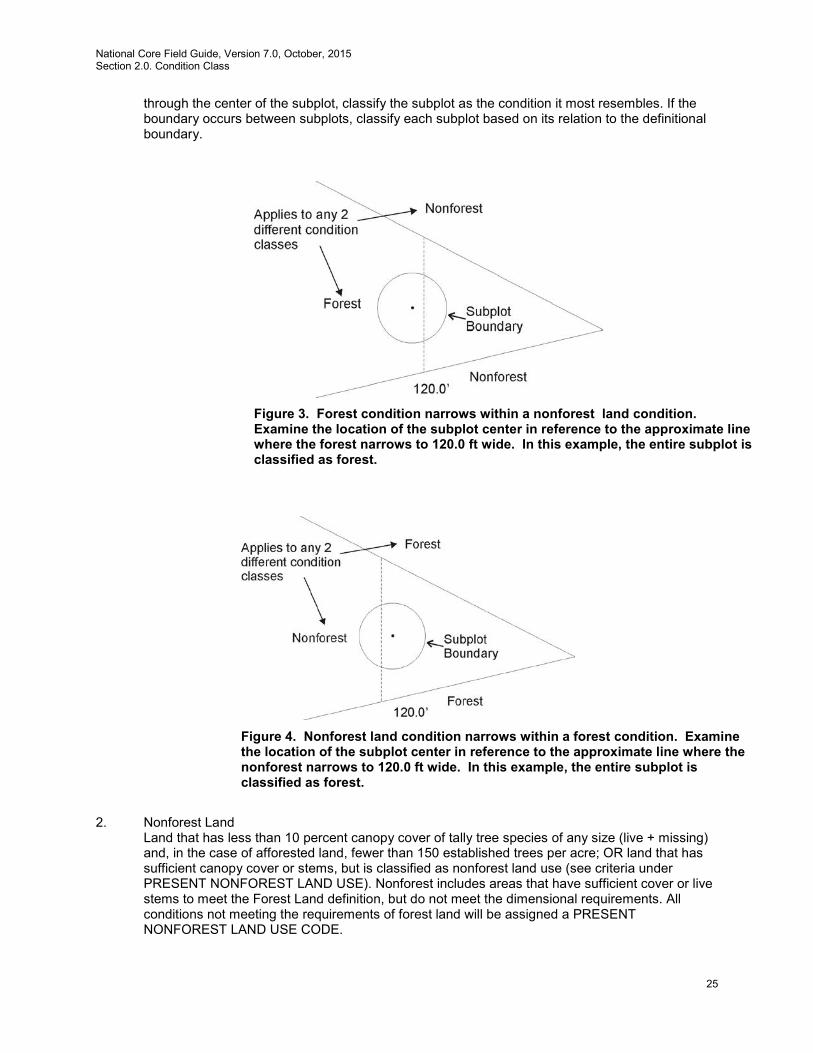
National Core Field Guide, Version 7.0, October, 2015 Section 2.0. Condition Class
25
through the center of the subplot, classify the subplot as the condition it most resembles. If the boundary occurs between subplots, classify each subplot based on its relation to the definitional boundary.
2. Nonforest Land
Land that has less than 10 percent canopy cover of tally tree species of any size (live + missing) and, in the case of afforested land, fewer than 150 established trees per acre; OR land that has sufficient canopy cover or stems, but is classified as nonforest land use (see criteria under PRESENT NONFOREST LAND USE). Nonforest includes areas that have sufficient cover or live stems to meet the Forest Land definition, but do not meet the dimensional requirements. All conditions not meeting the requirements of forest land will be assigned a PRESENT NONFOREST LAND USE CODE.
Figure 3. Forest condition narrows within a nonforest land condition. Examine the location of the subplot center in reference to the approximate line where the forest narrows to 120.0 ft wide. In this example, the entire subplot is classified as forest.
Figure 4. Nonforest land condition narrows within a forest condition. Examine the location of the subplot center in reference to the approximate line where the nonforest narrows to 120.0 ft wide. In this example, the entire subplot is classified as forest.

National Core Field Guide, Version 7.0, October, 2015 Section 2.0. Condition Class
26
Other Wooded Land – Other wooded land has at least 5 percent, but less than 10 percent, canopy cover of live tally tree species of any size or has had at least 5 percent, but less than 10 percent, canopy cover of tally species in the recent past, based on the presence of stumps, snags, or other evidence. Other wooded land is recognized as a subset of nonforest land, and therefore is not currently considered a separate condition class. Additionally, the condition is not subject to nonforest use(s) that prevent normal tree regeneration and succession, such as regular mowing, intensive grazing, or recreation activities. In addition, other wooded land is classified according to the same nonforest land use rules as forest land (e.g., 6 percent cover in an urban setting is not considered other wooded land). Other wooded land is therefore defined as having >5 percent and <10 percent canopy cover at present, or evidence of such in the past, and PRESENT NONFOREST LAND USE CODE = 20, 40, 42, 43 or 45.
3. Noncensus Water
Lakes, reservoirs, ponds, and similar bodies of water 1.0 acre to 4.5 acres in size. Rivers, streams, canals, etc., 30.0 feet to 200 feet wide.
4. Census Water
Lakes, reservoirs, ponds, and similar bodies of water 4.5 acres in size and larger; and rivers, streams, canals, etc., more than 200 feet wide (1990 U.S. Census definition).
5. Nonsampled, possibility of forest
See section 2.4.3 CONDITION NONSAMPLED REASON for descriptions of land that qualifies as nonsampled. In cases where a condition is access-denied or hazardous land use, but obviously contains no forest land, record CONDITION CLASS STATUS = 2, 3 or 4. In cases where a condition is access-denied or hazardous land use and has the possibility of forest, record CONDITION CLASS STATUS = 5.
2.3 Condition Class Attributes
A CONDITION CLASS NUMBER and a classification for CONDITION CLASS STATUS are required for every condition class sampled on a plot.
2.3.1 Forest Land
For each condition class classified as accessible forest land, a classification is required for each of the following attributes:
2.5.1 RESERVED STATUS 2.5.2 OWNER GROUP 2.5.3 FOREST TYPE Attributes where a change causes 2.5.4 STAND SIZE CLASS a separate condition class 2.5.5 REGENERATION STATUS 2.5.6 TREE DENSITY 2.5.7 OWNER CLASS 2.5.13 ARTIFICIAL REGENERATION SPECIES 2.5.14 STAND AGE Ancillary - changes do not 2.5.15 DISTURBANCE (up to 3 coded) delineate a new condition class 2.5.16 DISTURBANCE YEAR (1 per disturbance) 2.5.21 TREATMENT (up to 3 coded) 2.5.22 TREATMENT YEAR (1 per treatment) 2.5.27 PHYSIOGRAPHIC CLASS
National Core Field Guide, Version 7.0, October, 2015 Section 2.0. Condition Class
27
2.5.29 PRESENT NONFOREST LAND USE (for area converted from accessible forest land condition class to nonforest land since last inventory).
2.3.2 Nonforest Land
For each condition class classified as nonforest land, a classification is required for each of the following attributes:
2.5.1 RESERVED STATUS 2.5.2 OWNER GROUP Attributes where a change causes 2.5.29 PRESENT NONFOREST a separate condition class LAND USE
2.5.7 OWNER CLASS 2.5.15 DISTURBANCE (up to 3 coded) Ancillary - changes do not 2.5.16 DISTURBANCE YEAR (1 per disturbance) delineate a new condition class 2.5.21 TREATMENT (up to 3 coded) 2.5.22 TREATMENT YEAR (1 per treatment) 2.5.27 PHYSIOGRAPHIC CLASS
2.4 Delineating Condition Classes Differing In Condition Class Status:
The first step in delineating condition classes is to recognize differences in CONDITION CLASS STATUS. The most common difference is adjacent accessible forest land and nonforest land. Adjacent accessible forest land and nonforest land condition classes are recognized only if each of the two prospective condition classes is at least 1.0 acre in size, and each is at least 120.0 feet in width. These size and width minimums apply to both accessible forest land and nonforest land.
Within an accessible forest land condition class, unimproved roads, rock outcrops, and natural nonforest openings less than 1.0 acre in size and less than 120.0 feet in width are considered forest land and are not delineated and classified as a separate nonforest land condition class. Within a nonforest land condition class, forested areas or linear strips of trees less than 1.0 acre in size and less than 120.0 feet in width are considered part of the nonforest land condition class.
Five exceptions to these size and width requirements apply:
1. Developed nonforest land condition: human-caused nonforest land condition classes
such as homes or cabins that are less than 1.0 acre in size and 120.0 feet in width and are surrounded by forest land. There are three kinds of developed nonforest land conditions that do not have to meet area or width requirements (figs. 5).
(a) Improved roads: paved roads, gravel roads, or improved dirt roads regularly
maintained for long-term continuing use. Unimproved traces and roads created for skidding logs are not considered improved road.

National Core Field Guide, Version 7.0, October, 2015 Section 2.0. Condition Class
28
(b) Maintained rights-of-way: corridors created for railroads, power lines, gas
lines, and canals that are periodically treated to limit the establishment and growth of trees and shrubs.
(c) Developments: structures and the maintained area next to a structure, all
less than 1.0 acre in size and surrounded by forest land. Examples of developments are houses or trailers on very small lots, communication installations in a small cleared area within forest land, and barns and sheds.
2. Distinct, alternating strips of forest and nonforest land: this situation occurs when a plot or subplot samples a condition class that is less than 1.0 acre in size and less than 120.0 feet in width. The condition class is one of a series of parallel strips of forest and nonforest land in which none of the strips meet the minimum width requirement. This exception applies only to nonforest land conditions that are not listed under #1, e.g., improved roads, maintained rights-of-way, and developments.
(a) Many small intermingled strips: For many small intermingled strips,
determine the total area that the intermingled strips occupy, and classify according to the CONDITION CLASS STATUS (forest land or nonforest land) that occupies the greater area. If the area of intermingled strips is so large or indistinct as to make a total area determination impractical, then classify the sample as forest land.
(b) Two alternating strips: For two alternating strips of forest and nonforest between two qualifying areas of nonforest land and forest land, see figure 6. Figure 6 delineates the boundary between the forest and nonforest land condition classes for four different examples. The plot center defines the plot condition for all strips covered by the arrow. Any subplot that falls in the alternating strips uses the rule. Any subplot that falls in assigned nonforest / forest is assigned that type. Again, this exception applies only to nonforest land conditions that are not listed under number 1, e.g., improved roads, maintained rights-of-way, and developments.
Figure 5. Example of a switchback road. All the cross-hatched area is forest and the improved road is a nonforest condition.
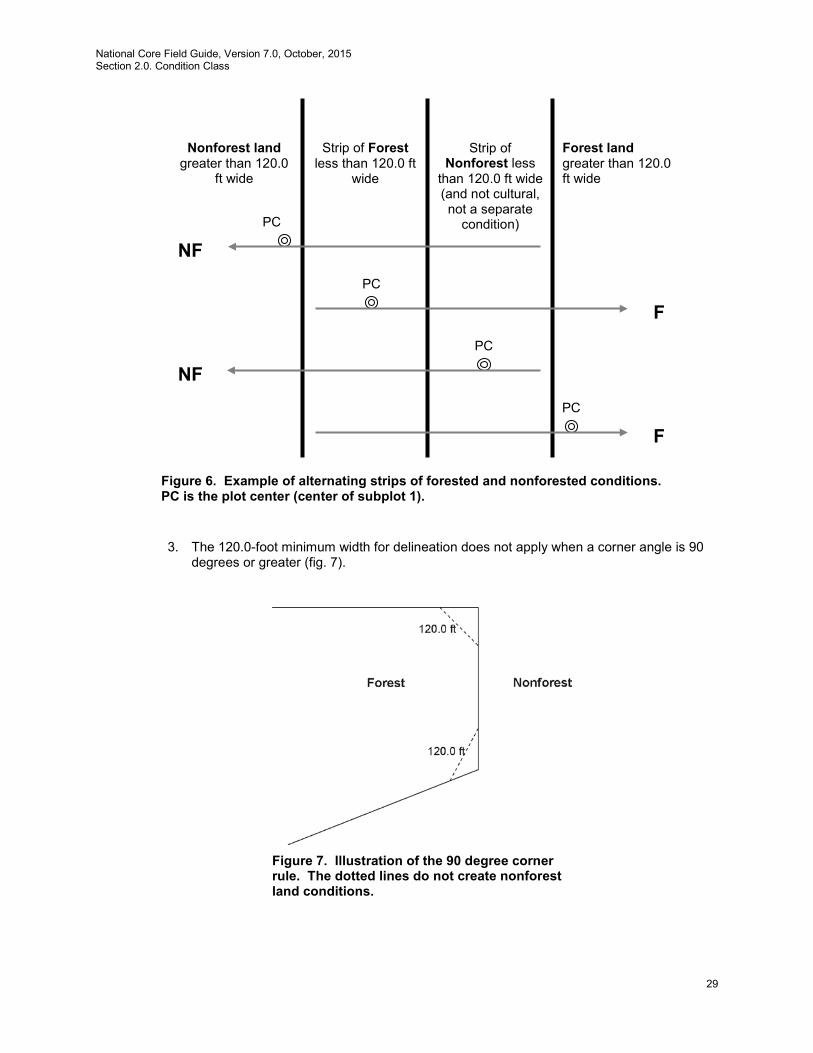
National Core Field Guide, Version 7.0, October, 2015 Section 2.0. Condition Class
29
3. The 120.0-foot minimum width for delineation does not apply when a corner angle is 90
degrees or greater (fig. 7).
Nonforest land greater than 120.0
ft wide
Forest land greater than 120.0 ft wide
Strip of Forest less than 120.0 ft
wide
Strip of Nonforest less
than 120.0 ft wide (and not cultural, not a separate
condition)
PC
PC
PC
PC
NF
NF
F
F
Figure 6. Example of alternating strips of forested and nonforested conditions. PC is the plot center (center of subplot 1).
Figure 7. Illustration of the 90 degree corner rule. The dotted lines do not create nonforest land conditions.
National Core Field Guide, Version 7.0, October, 2015 Section 2.0. Condition Class
30
4. Linear water features: natural water features that are linear in shape such as streams and rivers. A linear water feature must meet the definition for census or noncensus water to be nonforest area. Therefore, a linear water feature must be at least 30.0 feet wide and cover at least 1.0 acre. The width of a linear water feature is measured across its channel between points on either side up to which water prevents the establishment and survival of trees. To determine whether a linear water feature qualifies as nonforest, rely on all available information on hand such as aerial photos, topographic maps, past survey land calls, and ocular estimates at the current survey visit. Linear water features that do not meet the definition for census or noncensus water should be classified as forest land only if bounded by forest land on both shores. Crews are NOT expected to measure the length of a linear water feature to determine if it meets the 1.0 acre requirement; use professional judgment and common sense on any linear water feature.
5. Nonsampled conditions are delineated as a separate condition class regardless of size.
2.4.1 CONDITION CLASS NUMBER
On a plot, assign and record a number for each condition class. The condition class at plot center (the center of subplot 1) is designated condition class 1. Other condition classes are assigned numbers sequentially at the time each condition class is delineated.
Values: 1 to 9
2.4.2 CONDITION CLASS STATUS
Record the code that describes the sampling status of the condition class. The instructions in Sections 2.3 and 2.4 apply when delineating condition classes that differ by CONDITION CLASS STATUS. In situations where a condition is denied access or hazardous, but obviously contains no forest land, record CONDITION CLASS STATUS = 2, 3 or 4. In cases where a condition is access-denied or hazardous land use and has the possibility of forest, record CONDITION CLASS STATUS = 5. Values:
1 Accessible forest land 2 Nonforest land 3 Noncensus water 4 Census water 5 Nonsampled – possibility of forest land
2.4.3 CONDITION NONSAMPLED REASON
For portions of plots that cannot be sampled (CONDITION CLASS STATUS = 5), record one of the following reasons.
Values:
01 Outside U.S. boundary – Assign this code to condition classes beyond the U.S. border.
02 Denied access area – Any area within the sampled area of a plot to which access is denied by the legal owner, or to which an owner of the only reasonable route to the plot denies access. There are no minimum area or width requirements for a condition class delineated by denied access. Because a denied-access condition
National Core Field Guide, Version 7.0, October, 2015 Section 2.0. Condition Class
31
can become accessible in the future, it remains in the sample and is re-examined at the next occasion to determine if access is available.
03 Hazardous situation – Any area within the sampled area on plot that cannot be accessed because of a hazard or danger, for example cliffs, quarries, strip mines, illegal substance plantations, temporary high water, etc. Although the hazard is not likely to change over time, a hazardous condition remains in the sample and is re-examined at the next occasion to determine if the hazard is still present. There are no minimum size or width requirements for a condition class delineated by a hazardous condition.
05 Lost data – Plot data file was discovered to be corrupt after a panel was completed and submitted for processing. Used for the single condition that is required for this plot. Applied at the time of processing and used only in conjunction with PLOT NONSAMPLED REASON code 05. This code is for office use only.
06 Lost plot – Entire plot cannot be found. Used for the single condition that is required for this plot. Used only in conjunction with PLOT NONSAMPLED REASON code 06. Can be either generated by the data recorder or in the office.
07 Wrong location – Previous plot can be found, but its placement is beyond the tolerance limits for plot location. Used for the single condition that is required for this plot. Used only in conjunction with PLOT NONSAMPLED REASON code 07. Can be either generated by the data recorder or in the office.
08 Skipped visit – Entire plot skipped. Used for the single condition that is required for this plot. Applied at the time of processing and used only in conjunction with PLOT NONSAMPLED REASON code 08. This code is for office use only.
09 Dropped intensified plot – Used for the single condition that is required for this plot. Used only by units engaged in intensification. Applied at the time of processing and used only in conjunction with PLOT NONSAMPLED REASON code 09. This code is for office use only.
10 Other – This code is used whenever a condition class is not sampled due to a reason other than one of the specific reasons listed. A field note is required to describe the situation.
11 Ocean – Condition falls in ocean water below mean high tide line.
2.4.4 NONFOREST CONDITION CLASS STATUS
Record the code that describes the sampling status of the condition class (see the nonforest nonsampled reasons below for additional information). Values:
2 Accessible nonforest land 5 Nonsampled nonforest
2.4.5 NONFOREST CONDITION NONSAMPLED REASON
For portions of plots that are nonforest land and cannot be sampled (NONFOREST CONDITION CLASS STATUS = 5), record one of the following reasons.

National Core Field Guide, Version 7.0, October, 2015 Section 2.0. Condition Class
32
Values:
02 Denied access – Any area within the sampled area of a plot to which access is denied by the legal owner, or to which an owner of the only reasonable route to the plot denies access. There are no minimum area or width requirements for a condition class delineated by denied access. Because a denied-access condition can become accessible in the future, it remains in the sample and is re-examined at the next occasion to determine if access is available.
03 Hazardous situation – Any area within the sampled area on plot that cannot be accessed because of a hazard or danger, for example cliffs, quarries, strip mines, illegal substance plantations, temporary high water, etc. Although the hazard is not likely to change over time, a hazardous condition remains in the sample and is re-examined at the next occasion to determine if the hazard is still present. There are no minimum size or width requirements for a condition class delineated by a hazardous condition.
10 Other – This code is used whenever a condition class is not sampled due to a reason other than one of the specific reasons listed. A field note is required to describe the situation.
2.5 Delineating Condition Classes Within Accessible Forest Land:
Accessible forest land is subdivided into condition classes that are based on differences in RESERVED STATUS, OWNER GROUP, FOREST TYPE, STAND SIZE CLASS, REGENERATION STATUS, and TREE DENSITY. Section 2.1 applies when delineating contrasting forest condition classes. Specific criteria apply for each of the six attributes and are documented by attribute in 2.5.1 to 2.5.6. “Stands” are defined by plurality of stocking for all live trees, saplings, and seedlings that are not overtopped.
Additionally, each separate forest condition class recognized within accessible forest land must be at least 1.0 acre in size and at least 120.0 feet in width. If prospective contrasting forest land condition classes do not each meet these minimum size and width requirements, the most similar prospective conditions should be combined until these minimums are attained.
No other attribute shall be the basis for recognizing contrasting condition classes within accessible forest land. For each condition class recognized, many “ancillary attributes” that help describe the condition will be collected, but will not be used for delineation purposes (see Sections 2.5.7 to 2.5.23). General instructions for delineating condition classes within accessible forest lands:
1. Distinct boundary within a macroplot (if applicable), subplot, or microplot – Separate
condition classes ARE recognized if, within a subplot, two (or more) distinctly different condition classes are present and delineated by a distinct, abrupt boundary. The boundary is referenced; see Section 4.0.
2. Indistinct boundary within a subplot – Separate condition classes are NOT recognized if
the prospective condition classes abut along an indistinct transition zone, rather than on an abrupt, obvious boundary. Only one condition is recognized, and the subplot is classified entirely as the condition it most resembles.
Example: The four subplots all sample only accessible forest land. Subplots 1, 3, and
4 sample what is clearly a stand of large-diameter trees. Subplot 2 falls in the middle
National Core Field Guide, Version 7.0, October, 2015 Section 2.0. Condition Class
33
of a stand-size transition zone. In the zone, the large-diameter stand phases into a sapling stand.
Subplot 2 must not be divided into two condition classes on the basis of stand size. Instead, it is treated entirely as part of the large-diameter condition class or is assigned entirely to a new condition class that is classified as a seedling-sapling stand. The latter occurs only if the crew thinks the entire subplot is more like a stand of seedlings-saplings than a stand of large-diameter trees; then the boundary between the large- and small-diameter stands is assumed to occur between and not on the subplots.
3. A boundary or transition zone between fixed-radius subplots that sample distinctly
different condition classes – Separate condition classes are recognized and recorded when a valid attribute obviously differs between two fixed-radius subplots, but a distinct boundary or indistinct transition zone exists outside the sampled (fixed-radius) area of the subplots. In such cases, a boundary, if present, is not referenced.
Example: The northernmost subplot (2) samples entirely accessible forest land. The other three subplots, 1, 3, and 4, fall clearly in a nonforest meadow. Between subplot 1 and 2 is a transition zone; the number of trees present goes from none to what clearly represents forest land. Two condition classes are sampled: accessible forest land sampled on subplot 2, and nonforest land sampled on the other subplots.
4. Riparian forest area – A riparian forest area is defined as a forest area between 30.0 and
120.0 feet wide, and 1.0 acre or more in size, cumulative, and adjacent to but not necessarily present on both sides of a naturally occurring or artificially created body of water or watercourse with continuous or intermittent flow. Riparian forest areas may be associated with but not limited to streams, rivers, lakes, sloughs, seeps, springs, marsh, bogs, beaver ponds, sink holes, cypress domes and ponds, man-made ditches and canals. A riparian forest area must be associated “within forest” and contain at least one distinct and obvious change in a condition class delineation attribute from its adjacent accessible forest land condition class. Figures 8-13 provide examples of when to delineate riarian forest area as a separate condition class.
Note: When the width of forest adjacent to a body of water or water course is between 120.0 feet and 150.0 feet and the width of the riparian forest is at least 30.0 feet wide, the rules for identifying the non-riparian forest (at least 30.0 feet but less than 120.0 feet) need to be modified. The non-riparian forest can be between 30.0 feet and 120.0 feet and mapped as a separate condition as long as it meets the criteria for delineating a separate condition class, otherwise it will be an inclusion in the riparian forest condition class.
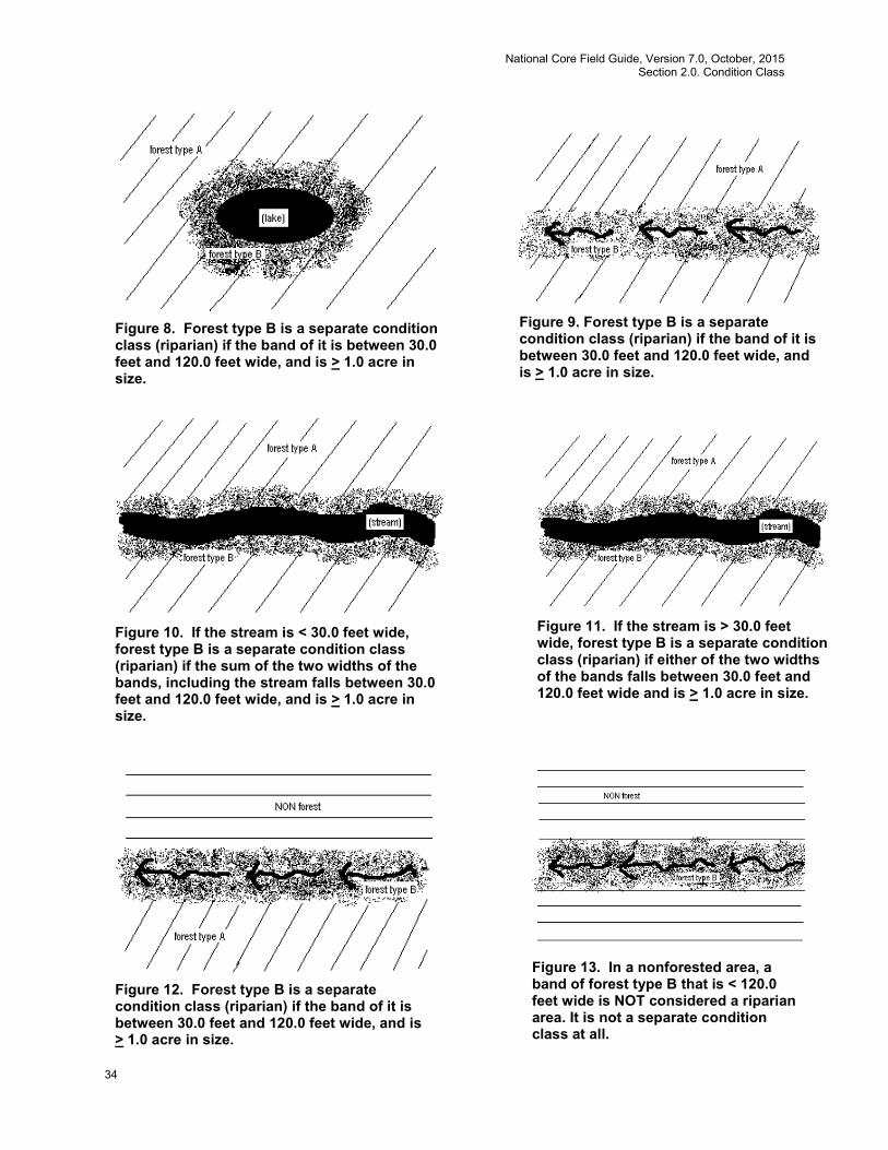
National Core Field Guide, Version 7.0, October, 2015 Section 2.0. Condition Class
34
Figure 8. Forest type B is a separate condition class (riparian) if the band of it is between 30.0 feet and 120.0 feet wide, and is > 1.0 acre in size.
Figure 9. Forest type B is a separate condition class (riparian) if the band of it is between 30.0 feet and 120.0 feet wide, and is > 1.0 acre in size.
Figure 10. If the stream is < 30.0 feet wide, forest type B is a separate condition class (riparian) if the sum of the two widths of the bands, including the stream falls between 30.0 feet and 120.0 feet wide, and is > 1.0 acre in size.
Figure 11. If the stream is > 30.0 feet wide, forest type B is a separate condition class (riparian) if either of the two widths of the bands falls between 30.0 feet and 120.0 feet wide and is > 1.0 acre in size.
Figure 12. Forest type B is a separate condition class (riparian) if the band of it is between 30.0 feet and 120.0 feet wide, and is > 1.0 acre in size.
Figure 13. In a nonforested area, a band of forest type B that is < 120.0 feet wide is NOT considered a riparian area. It is not a separate condition class at all.
National Core Field Guide, Version 7.0, October, 2015 Section 2.0. Condition Class
35
2.5.1 RESERVED STATUS
Record the code that identifies the reserved designation for the condition. Reserved land is withdrawn by law(s) prohibiting the management of land for the production of wood products (not merely controlling or prohibiting wood-harvesting methods). Such authority is vested in a public agency or department, and supersedes rights of ownership. The prohibition against management for wood products cannot be changed through decision of the land manager (management agency) or through a change in land management personnel, but rather is permanent in nature. Ownership and the name (designation) of an area are critical for determining reserved status. All private lands (OWNGRPCD = 40) are considered not reserved (due to difficulty in determining legal status); this includes in-holdings, where they can be identified. FIA has adopted a default national list of federal land designations which are considered reserved (see appendix 12). All federally-owned lands managed by the National Park Service or Fish and Wildlife Service (OWNCD = 21 or 23) are considered reserved. Some lands owned by State or local governments are considered reserved, even in the absence of specific laws covering them, if the agency mandate for that land designation precludes management to produce wood products (e.g., most State Parks). In the absence of State-specific lists of reserved areas, any State or local government land area that includes “park”, “wilderness”, “wild river”, “reserve”, or “preserve” in the name is by default considered reserved. There are less common designations that are not on the CORE list and units may add exceptions to the list for specific areas that are managed under different legal guidance than is usual for that designation. All designations must be documented using the RESERVED AREA NAME field. Note that harvest can occur in reserved areas, for example for restoration, safety, or recreation. For the core optional procedure, nonforest areas are reserved if forest lands in the same designated area are considered reserved, or if the area would be considered reserved if forestland was present. Values:
0 Not reserved 1 Reserved
2.5.2 OWNER GROUP
Record the OWNER GROUP code identifying the ownership (or the managing Agency for public lands) of the land in the condition class. Conditions will be delineated based on changes in OWNER GROUP only; separate conditions due to changes in OWNER GROUP are recognized only where differences can be clearly identified on the ground when visiting the plot.
Values:
10 Forest Service 20 Other Federal 30 State and Local Government 40 Private
2.5.3 FOREST TYPE
Record the code corresponding to the FOREST TYPE (from Appendix 2) that best describes the species with the plurality of stocking for all live trees in the condition class that are not overtopped. Note: Canopy cover is used to determine whether an area is forest or nonforest. Stocking is used with other variables such as this one.
National Core Field Guide, Version 7.0, October, 2015 Section 2.0. Condition Class
36
If STAND SIZE CLASS is nonstocked, then FOREST TYPE is determined by the following hierarchy:
• For SAMPLE KIND = 2 plots, record the FOREST TYPE of the condition at the previous inventory.
• For all other plots: 1. Evaluate any seedlings available to determine the FOREST TYPE. 2. If no seedlings exist, use adjacent stands and your best professional judgment to
determine FOREST TYPE.
Values: See Appendix 2
The instructions in Sections 2.1 and 2.4 apply when delineating, within accessible forest land, contrasting conditions based on differences in FOREST TYPE.
2.5.4 STAND SIZE CLASS
Record the code that best describes the predominant size class of all live trees, seedlings and saplings in the condition class. Note: Canopy cover is used to determine whether an area is forest or nonforest. Stocking is used with other variables such as this one. Values:
0 Nonstocked Meeting the definition of accessible forest land, and one of the following applies:
(a) less than 10 percent stocked by trees, seedlings, and saplings, and not classified as
cover trees, or
(b) for several woodland species where stocking standards are not available, less than 10 percent canopy cover of trees, seedlings, and saplings .
1 < 4.9 inches (seedlings / saplings) At least 10 percent stocking (or 10 percent canopy cover if stocking standards are not
available) in trees, seedlings, and saplings; and at least 2/3 of the canopy cover is in trees less than 5.0 inches DBH/DRC.
2 5.0 – 8.9 inches (softwoods) / 5.0 – 10.9 inches (hardwoods)
At least 10 percent stocking (or 10 percent canopy cover if stocking standards are not available) in trees, seedlings, and saplings; and at least 1/3 of the canopy cover is in trees greater than 5.0 inches DBH/DRC and the plurality of the canopy cover is in softwoods between 5.0 – 8.9 inches diameter and/or hardwoods between 5.0 – 10.9 inches DBH, and/or woodland trees 5.0 – 8.9 inches DRC.
3 9.0 – 19.9 inches (softwoods) / 11.0 – 19.9 inches (hardwoods) At least 10 percent stocking (or 10 percent canopy cover if stocking standards are not
available) in trees, seedlings, and saplings; and at least 1/3 of the canopy cover is in trees greater than 5.0 inches DBH/DRC and the plurality of the canopy cover is in softwoods between 9.0 – 19.9 inches diameter and/or hardwoods between 11.0 – 19.9 inches DBH, and for woodland trees 9.0 – 19.9 inches DRC.
4 20.0 – 39.9 inches
At least 10 percent stocking (or 10 percent canopy cover if stocking standards are not available) in trees, seedlings, and saplings; and at least 1/3 of the canopy cover is in trees greater than 5.0 inches DBH/DRC and the plurality of the canopy cover is in trees between 20.0 – 39.9 inches DBH.
National Core Field Guide, Version 7.0, October, 2015 Section 2.0. Condition Class
37
5 40.0 + inches
At least 10 percent stocking (or 10 percent canopy cover if stocking standards are not available) in trees, seedlings, and saplings; and at least 1/3 of the canopy cover is in trees greater than 5.0 inches DBH/DRC and the plurality of the canopy cover is in trees >40.0 inches DBH.
The instructions in Sections 2.1 and 2.4 apply when delineating, on accessible forest land, contrasting conditions based on differences in STAND SIZE CLASS.
Within the sampled area on microplot, subplot, or macroplot, recognize only very obvious contrasting stands of different mean diameter with an abrupt boundary. Example: an obvious abrupt boundary exists within the sampled (fixed-radius) area of a subplot and demarcates a STAND SIZE CLASS change. Use tree stocking of all live trees, seedlings, and saplings that are not overtopped to differentiate between stand-size classes; for most woodland forest types (e.g., pinyon, juniper, gambel oak) where stocking standards are not readily available, use percent tree cover to represent stocking.
When using canopy cover as the surrogate for stocking to determine STAND SIZE CLASS, view the plot from the top down and examine canopy cover. The stand must have at least 10 percent of the canopy cover in STAND SIZE CLASSES of 1, 2, 3, 4, or 5 or any combination of these STAND SIZE CLASSES; otherwise the STAND SIZE CLASS is 0. If 2/3 of the canopy cover is STAND SIZE CLASS = 1, classify the condition as STAND SIZE CLASS = 1. If less than 2/3 of the canopy cover is STAND SIZE CLASS = 1, classify the condition as STAND SIZE CLASS = 2, 3, 4, or 5, based on which of these STAND SIZE CLASSES has the most canopy cover.
2.5.5 REGENERATION STATUS
Record the code that best describes the artificial regeneration that occurred in the condition.
Values:
0 Natural – present stand shows no clear evidence of artificial regeneration. Includes unplanted, recently cut lands
1 Artificial – present stand shows clear evidence of artificial regeneration
The instructions in section 2.1 and 2.4 apply when delineating, within accessible forest land, contrasting conditions based on differences in REGENERATION STATUS.
For a forest land condition to be delineated and/or classified as artificially regenerated, the condition must show distinct evidence of planting or seeding. If it is difficult to determine whether or not a stand has been planted or seeded, then use code 0. If no distinct boundary exists within the sampled (fixed-radius) area on any subplot, then do not recognize separate conditions. In many regions of the West, trees are not planted in rows, and planted stands do not differ in physical appearance from natural conditions. In these cases, there is no need to differentiate conditions based on regeneration status. Note: Plot records or verbal evidence from landowner is acceptable for determining regeneration status.
National Core Field Guide, Version 7.0, October, 2015 Section 2.0. Condition Class
38
2.5.6 TREE DENSITY
Record a code to indicate the relative tree density classification. Base the classification on the number of stems/unit area, basal area, tree cover, or stocking of all live trees, seedlings, and saplings in the condition that are not overtopped, compared to any previously defined condition class TREE DENSITY.
The instructions in Sections 2.1 and 2.4 apply when delineating, within accessible forest land, contrasting conditions based on differences in TREE DENSITY.
Codes 2 and higher are used ONLY when all other attributes used to delineate separate condition classes are homogenous, i.e., when a change in density is the ONLY difference within what would otherwise be treated as only one forest condition. Otherwise, code 1 for all condition classes. Codes 2 and higher are usually, but not always, used to demarcate areas that differ from an adjacent area due to forest disturbance, e.g., a partial harvest or heavy, but not total tree mortality due to a ground fire. Delineation by density should only be done when the less-dense condition is 50 percent or less as dense as the more dense condition. Do not distinguish between low-stocked stands or stands of sparse and patchy forest.
Values:
1 Initial density class 2 Density class 2 - density different than 1 3 Density class 3 - density different than 1 and 2
In order to qualify as a separate condition based on density, there MUST be a distinct, easily observed change in the density of an area's tree cover or basal area.
Examples of valid contrasting conditions defined by differences in tree density are:
• the eastern half of an otherwise homogeneous, 20-acre stand has many trees killed by a
bark beetle outbreak, • one portion of a stand is partially cut over (with 40 square feet basal area per acre) while
the other portion is undisturbed (with 100 square feet basal area per acre).
Note: In these examples, RESERVED STATUS, OWNER GROUP, FOREST TYPE, STAND SIZE CLASS, and REGENERATION STATUS are the same.
Ancillary (Non-Delineating) Variables
2.5.7 OWNER CLASS
Record the OWNER CLASS code that best corresponds to the ownership (or the managing Agency for public lands) of the land in the condition class. Conditions will NOT be delineated based on changes in OWNER CLASS. If multiple OWNER CLASSes occur within a condition class (i.e., within an OWNER GROUP), record the OWNER CLASS closest to the center of the lowest numbered subplot in the condition.
Values:
Owner Classes within Forest Service Lands (Owner Group 10)
11 National Forest 12 National Grassland and/or Prairie 13 Other Forest Service land

National Core Field Guide, Version 7.0, October, 2015 Section 2.0. Condition Class
39
Owner Classes within Other Federal Lands (Owner Group 20) 21 National Park Service 22 Bureau of Land Management 23 Fish and Wildlife Service 24 Departments of Defense/Energy 25 Other Federal
Owner Classes within State and Local Government Lands (Owner Group 30)
31 State including state public universities 32 Local (County, Municipality, etc.) including water authorities 33 Other Non Federal Public
Owner Classes within Private lands (Owner Group 40)
41 Corporate, including Native Corporations in Alaska and private universities 42 Non Governmental Conservation / Natural Resources Organization
Examples: Nature Conservancy, National Trust for Private Lands, Pacific Forest Trust, Boy Scouts of America, etc.
43 Unincorporated Partnerships / Associations / Clubs. Examples: Hunting Clubs that own, not lease property, recreation associations, 4H, churches etc..
44 Native American (Indian) – within reservation boundaries 45 Individual and Family, including trusts, estates, and family partnerships
2.5.8 OWNER SUB-CLASS (CORE OPTIONAL)
Record the OWNER SUB-CLASS code that best corresponds to the ownership (or the managing Agency for public lands) of the land. Currently, there are sub-classes for only the State category, but other sub-classes may be added in the future. Values:
1 State forestry agency 2 State wildlife agency 3 State park agency 4 Other state lands
2.5.9 PUBLIC ADMINISTRATIVELY WITHDRAWN STATUS (CORE OPTIONAL)
Record the code that best corresponds to the administratively withdrawn designation for the condition. Conditions will NOT be delineated based on this variable; if multiple administratively withdrawn status types occur on a single condition class, record the administratively withdrawn status closest to the plot center. Administratively withdrawn land is public land withdrawn by management plans or government regulations prohibiting the management of land for the production of wood products (not merely controlling or prohibiting wood-harvesting methods). Such plans and regulations are formally adopted by land managers and the prohibition against management for wood products cannot be changed through decision of the land manager except by a formal modification of management plans or regulations. Values:
0 Not administratively withdrawn 1 Administratively withdrawn
National Core Field Guide, Version 7.0, October, 2015 Section 2.0. Condition Class
40
2.5.10 ADMINISTRATIVELY WITHDRAWN AREA NAME (CORE OPTIONAL)
Record the specific name of the area that identifies the administratively withdrawn designation for the condition. If a drop-down list is provided in the PDR, either select the correct name or select “Other” and type the correct name in the CONDITION NOTES field. Values: English language words, phrases, and numbers
2.5.11 ADMINISTRATIVELY WITHDRAWN NOTES (CORE OPTIONAL)
Describe the source of the information used to classify Administratively Withdrawn Status, the method used to assign the information to individual conditions, the geographic area (e.g. states and counties), condition status, and owner class combinations to which the designation was applied, and date stamp for which the information is current. Values: English language words, phrases and numbers
2.5.12 RESERVED AREA NAME
Record the specific name of the area that identifies the reserved designation for the condition. If a drop-down list is provided in the PDR, either select the correct name or select “Other” and type the correct name in the notes field. Values: English language words, phrases, and numbers
2.5.13 ARTIFICIAL REGENERATION SPECIES
Record the species code of the predominant tree species for which evidence exists of artificial regeneration in the stand. This attribute is ancillary; that is, contrasting condition classes are never delineated based on variation in this attribute.
Values: See Appendix 3
2.5.14 STAND AGE
Record the average total age, to the nearest year, of the trees (plurality of all live trees, seedlings, and saplings not overtopped) in the predominant STAND SIZE CLASS of the condition, determined using local procedures. Record 000 for nonstocked stands. Note: Canopy cover is used to determine whether an area is forest or nonforest. Stocking is used with other variables such as this one.
An estimate of STAND AGE is required for every forest land condition class defined on a plot. Stand age is usually highly correlated with stand size and should reflect the average age of all trees that are not overtopped. Unlike the procedure for site tree age (TREE AGE AT DIAMETER), estimates of STAND AGE should estimate the time of tree establishment (e.g., not age at the point of diameter measurement). Note: For planted stands, estimate age based on the year the stand was planted (e.g., do not add in the age of the planting stock).
To estimate STAND AGE, select two or three dominant or codominant trees from the overstory. If the overstory covers a wide range of tree sizes and species, try to select the trees accordingly, but it is not necessary to core additional trees in such stands. The variance associated with mean stand age increases with stand heterogeneity, and additional cores are not likely to improve the estimate. Core each tree at the point of diameter measurement and count the rings between the outside edge and the core to the pith. Add in the number of years that passed from germination
National Core Field Guide, Version 7.0, October, 2015 Section 2.0. Condition Class
41
until the tree reached the point of core extraction to determine the total age of the tree. Unless more specific information is provided at training or by the unit, add 5 years to all eastern species, 5 years to western hardwoods, and 10 years to western softwoods. Assign a weight to each core by visually estimating the percentage of total overstory trees it represents. Make sure the weights from all cores add up to 1.0, compute the weighted average age, and record. For example, if three trees aged 34, 62, and 59 years represent 25 percent, 60 percent, and 15 percent of the overstory, respectively, the weighted stand age should be:
(34 x 0.25) + (62 x 0.60) + (59 x 0.15) = 55 years.
In some cases, it may be possible to avoid coring trees to determine age. If a stand has not been seriously disturbed since the previous survey, simply add the number of years since the previous inventory to the previous STAND AGE. In other situations, cores collected from site trees can be used to estimate STAND AGE.
If a condition class is nonstocked, assign a STAND AGE of 000.
If all of the trees in a condition class are of a species which, by regional standards, cannot be bored for age (e.g., mountain mahogany, tupelo) record 998. This code should be used in these cases only. If tree cores are not counted in the field, but are collected and sent to the office for the counting of rings, record 999. Note on the core the percent of stand that type of core represents so that STAND AGE can be calculated later. Values: 000 to 997, 998, 999
2.5.15 DISTURBANCE 1
Record the code corresponding to the presence of the following disturbances. Disturbance can connote positive or negative effects. The area affected by any natural or human-caused disturbance must be at least 1.0 acre in size. Record up to three different disturbances per condition class from most important to least important. This attribute is ancillary; that is, contrasting conditions are never delineated based on variation in this attribute.
For initial plot establishment (SAMPLE KIND =1 or 3), the disturbance must be within the last 5 years. For remeasured plots recognize only those disturbances that have occurred since the previous inventory.
Disturbance codes require "significant threshold" damage, which implies mortality and/or damage to 25 percent of all trees in a stand or 50 percent of an individual species’ count. Additionally, some disturbances affect land and/or vegetation, but initially may not affect vegetation growth or health (e.g., grazing, browsing, flooding, etc.). In these cases, a disturbance should be coded when at least 25 percent of the soil surface or understory vegetation has been affected.
Values:
00 None - no observable disturbance 10 Insect damage
11 insect damage to understory vegetation 12 insect damage to trees, including seedlings and saplings
20 Disease damage 21 disease damage to understory vegetation 22 disease damage to trees, including seedlings and saplings
30 Fire (from crown and ground fire, either prescribed or natural)

National Core Field Guide, Version 7.0, October, 2015 Section 2.0. Condition Class
42
31 ground fire 32 crown fire
40 Animal damage 41 beaver (includes flooding caused by beaver) 42 porcupine 43 deer/ungulate 44 bear (CORE OPTIONAL) 45 rabbit (CORE OPTIONAL) 46 domestic animal/livestock (includes grazing)
50 Weather damage 51 ice 52 wind (includes hurricane, tornado) 53 flooding (weather induced) 54 drought
60 Vegetation (suppression, competition, vines) 70 Unknown/not sure/other (include in NOTES) 80 Human-caused damage – any significant threshold of human-caused damage not
described in the DISTURBANCE codes listed or in the TREATMENT codes listed. Must include a condition-level note to describe further.
90 Geologic disturbances 91 landslide 92 avalanche track 93 volcanic blast zone 94 other geologic event 95 earth movement/avalanches
2.5.16 DISTURBANCE YEAR 1
Record the year in which DISTURBANCE 1 occurred. If the disturbance occurs continuously over a period of time, record 9999.
Values: Since the previous plot visit, or the past 5 years for plots visited for the first time; 9999
2.5.17 DISTURBANCE 2
Record the second disturbance here. See DISTURBANCE 1 for coding instructions. 2.5.18 DISTURBANCE YEAR 2
Record the year in which DISTURBANCE 2 occurred. See DISTURBANCE YEAR 1 for coding instructions.
2.5.19 DISTURBANCE 3
Record the third disturbance here. See DISTURBANCE 1 for coding instructions. 2.5.20 DISTURBANCE YEAR 3
Record the year in which DISTURBANCE 3 occurred. See DISTURBANCE YEAR 1 for coding instructions.

National Core Field Guide, Version 7.0, October, 2015 Section 2.0. Condition Class
43
2.5.21 TREATMENT 1
Forestry treatments are a form of disturbance. These human disturbances are recorded separately here for ease of coding and analysis. The term treatment further implies that a silvicultural application has been prescribed. This does not include occasional stumps of unknown origin or sparse removals for firewood, Christmas trees, or other miscellaneous purposes. The area affected by any treatment must be at least 1.0 acre in size. Record up to three different treatments per condition class from most important to least important as best as can be determined. This attribute is ancillary; that is, contrasting conditions are never delineated based on variation in this attribute.
For initial plot establishment (SAMPLE KIND = 1 or 3), the treatment must be within the last 5 years. For remeasured plots recognize only those treatments that have occurred since the previous inventory.
Values:
00 None - No observable treatment.
10 Cutting - The removal of one or more trees from a stand.
20 Site preparation - Clearing, slash burning, chopping, disking, bedding, or other practices clearly intended to prepare a site for either natural or artificial regeneration.
30 Artificial regeneration - Following a disturbance or treatment (usually cutting), a
new stand where at least 50% of the live trees present resulted from planting or direct seeding.
40 Natural regeneration - Following a disturbance or treatment (usually cutting), a
new stand where at least 50% of the live trees present (of any size) were established through the growth of existing trees and/or natural seeding or sprouting.
50 Other silvicultural treatment - The use of fertilizers, herbicides, girdling, pruning,
or other activities (not covered by codes 10-40) designed to improve the commercial value of the residual stand, or chaining, which is a practice used on woodlands to encourage wildlife forage.
2.5.22 TREATMENT YEAR 1
Record the year in which TREATMENT 1 occurred.
Values: Since the previous plot visit, or the past 5 years for plots visited for the first time 2.5.23 TREATMENT 2
If a stand has experienced more than one treatment, record the second treatment here. See TREATMENT 1 for coding instructions; code 00 if none.
2.5.24 TREATMENT YEAR 2
Record the year in which TREATMENT 2 occurred. See TREATMENT YEAR 1 for coding instructions.
National Core Field Guide, Version 7.0, October, 2015 Section 2.0. Condition Class
44
2.5.25 TREATMENT 3
If a stand has experienced more than two treatments, record the third treatment here. See TREATMENT 1 for coding instructions; code 00 if none.
2.5.26 TREATMENT YEAR 3
Record the year in which TREATMENT 3 occurred. See TREATMENT YEAR 1 for coding instructions.
2.5.27 PHYSIOGRAPHIC CLASS
Record the code that best describes the PHYSIOGRAPHIC CLASS of the condition within the plot area; land form, topographic position, and soil generally determine physiographic class.
Values:
Xeric Sites that are normally low or deficient in moisture available to support
vigorous tree growth. These areas may receive adequate precipitation, but experience a rapid loss of available moisture due to runoff, percolation, evaporation, etc.
11 Dry Tops - Ridge tops with thin rock outcrops and considerable exposure to sun
and wind.
12 Dry Slopes - Slopes with thin rock outcrops and considerable exposure to sun and wind. Includes most steep slopes with a southern or western exposure.
13 Deep Sands - Sites with a deep, sandy surface subject to rapid loss of moisture
following precipitation. Typical examples include sand hills, sites along the beach and shores of lakes and streams, and many deserts.
19 Other Xeric - All dry physiographic sites not already described.
Mesic Sites that have moderate but adequate moisture available to support
vigorous tree growth except for periods of extended drought. These sites may be subjected to occasional flooding during periods of heavy or extended precipitation.
21 Flatwoods - Flat or fairly level sites outside flood plains. Excludes deep sands and
wet, swampy sites.
22 Rolling Uplands - Hills and gently rolling, undulating terrain and associated small streams. Excludes deep sands, all hydric sites, and streams with associated flood plains.
23 Moist Slopes and Coves - Moist slopes and coves with relatively deep, fertile soils.
Often these sites have a northern or eastern exposure and are partially shielded from wind and sun. Includes moist mountain tops and saddles.
24 Narrow Flood plains/Bottomlands - Flood plains and bottomlands less than 1/4-mile
in width along rivers and streams. These sites are normally well drained but are subjected to occasional flooding during periods of heavy or extended precipitation.

National Core Field Guide, Version 7.0, October, 2015 Section 2.0. Condition Class
45
Includes associated levees, benches, and terraces within a 1/4 mile limit. Excludes swamps, sloughs, and bogs.
25 Broad Flood plains/Bottomlands - Flood plains and bottomlands 1/4 mile or wider in
width along rivers and streams. These sites are normally well drained but are subjected to occasional flooding during periods of heavy or extended precipitation. Includes associated levees, benches, and terraces. Excludes swamps, sloughs, and bogs with year-round water problems.
29 Other Mesic - All moderately moist physiographic sites not already described.
Hydric Sites that generally have a year-round abundance or over-abundance of
moisture. Hydric sites are very wet sites where excess water seriously limits both growth and species occurrence.
31 Swamps / Bogs - Low, wet, flat forested areas usually quite extensive that are
flooded for long periods of time except during periods of extreme drought. Excludes cypress ponds and small drains.
32 Small Drains - Narrow, stream-like, wet strands of forest land often without a well-
defined stream channel. These areas are poorly drained or flooded throughout most of the year and drain the adjacent higher ground.
33 Bays and wet pocosins - Low, wet, boggy sites characterized by peaty or organic
soils. May be somewhat dry during periods of extended drought. Examples include the Carolina bays in the southeast US.
34 Beaver ponds
35 Cypress ponds
39 Other hydric - All other hydric physiographic sites.
2.5.28 LAND COVER CLASS
Record this variable for all mapped conditions. As with 2.4.2 CONDITION CLASS STATUS, LAND COVER CLASSes must meet the minimum area and width requirements (except those cases where the condition has been solely defined due to developed land uses, such as roads and rights-of-ways). If the condition is less than 1 acre, then apply the key to the condition. Within larger mapped conditions, evaluate the potential for multiple land cover classes as follows: if no prospective land cover classes meet the minimum width and area requirements, apply the key to the acre area that is within the condition being evaluated and closest to the lowest numbered subplot center associated with the condition. If multiple land cover classes (i.e., those which meet minimum area and width requirements) exist in the condition, assign the first land cover class that is encountered to the condition. As with other condition attributes, inclusions (of less than 1 acre) within the condition should be ignored when assigning the LAND COVER CLASS. Therefore, areas of the inclusion within the acre area are ignored when making the relative cover assessments. Apply the key as a guide and/or to verify the LAND COVER CLASS selection. Assignment of LAND COVER CLASS code is hierarchical in nature, and should be performed using the following hierarchical key. Following the guidance of the key, codes should be examined in succession, and the first definition which describes the area of the condition should be chosen. For example, if an area has 15% tree cover that is taller than the 50% shrub cover, it is classified as class 01 (Treeland). Note: Treeland is not equivalent to Forestland (e.g., a recent clearcut could be Forestland, but would not be Treeland). Vegetative cover, as used below, includes the area of

National Core Field Guide, Version 7.0, October, 2015 Section 2.0. Condition Class
46
ground covered by the vertical projection of the live plant canopy (or other vegetation components like flowers, basal structures or vines) on the area defined by the condition. If foliage is absent due to senescence or dormancy, the cover should be estimated based on the position of plant remains or other evidence of the foliar distribution during the growing season. If burned, then classify based on the remaining live vegetation, including the canopy cover of remaining live trees and shrubs. When the land surface of a condition is covered by deep non-permanent snow, ice, or water, and/or a condition is defined as CONDITION CLASS STATUS 5 (denied access or hazardous), field crews should use aerial imagery, local knowledge, and field observations to best determine LAND COVER CLASS.
Full Land Cover Class Definitions
• Dominant: Refers to the highest (tallest) life form present, typically trees, then shrubs, then herbaceous layers.
• Predominant: Refers to the cover class with the highest percent cover in the condition.
• Vegetated: Contains at least 10% vegetation cover (modification of NVCS 2008)
• Sparsely Vegetated: Does not contain at least 10% vegetation cover
• Natural vegetation is defined as vegetation where ecological processes primarily determine species and site characteristics; that is, vegetation comprised of a largely spontaneously growing set of plant species that are shaped by both site and biotic processes. Human activities influence these interactions to varying degrees (e.g., logging, livestock grazing, fire, introduced pathogens), but do not eliminate or dominate the spontaneous processes. Wherever doubt exists as to the naturalness of a vegetation type (e.g., old fields, various forest plantations), it is classified as part of the natural / semi-natural vegetation (NVCS 2008).
• Semi-natural vegetation typically encompasses vegetation types where the species composition and/or vegetation growth forms have been altered through anthropogenic disturbances such that no clear natural analogue is known, but they are a largely spontaneous set of plants shaped by ecological processes. Natural (or near-natural) and semi-natural vegetation are part of a continuum of change within natural vegetation that reflects varying degrees of anthropogenic and other disturbances (NVCS 2008). Semi-natural vegetation includes vegetation types where the current structure and/or composition is anthropic, but where it is obvious that natural processes have since resumed (e.g., agricultural lands that have naturally reverted to forest).
• Anthropic Vegetation is defined as vegetation with a distinctive structure, composition, and development determined by regular human activity. Developed vegetation has typically been planted or treated, and has relatively distinctive growth form, floristic, or site features when compared to natural vegetation. Distinctive growth form and structural attributes typically include one or more of the following:
a. Dominant herbaceous vegetation that is regularly-spaced and/or growing in rows, often in areas with substantial cover of bare soil for significant periods of the year, usually determined by tillage or chemical treatment.
b. Dominant vegetation with highly-manipulated growth forms or structure rarely found as a result of natural plant development, usually determined by mechanical pruning, mowing, clipping, etc.
National Core Field Guide, Version 7.0, October, 2015 Section 2.0. Condition Class
47
c. Dominant vegetation comprised of species not native to the area that have been intentionally introduced to the site by humans and that would not persist without active management by humans (NVCS 2008).
Land Cover Classification Key
Follow the key in sequence. If a class described the condition, then look no further. 1. >10% vegetative Cover = Vegetated, else 2.
1.1. Areas where the majority of vegetation (>50% relative cover) has been highly-manipulated = Anthropic Vegetation, else 1.2
1.1.1. Areas that are predominantly covered by vegetation grown for the production of food, non-woody fiber, and/or ornamental horticulture, including land in any stage of annual crop production, and land being regularly cultivated for production of crops from perennial plants = 06 Agricultural Vegetation
1.1.2. Other areas predominantly covered by vegetation with highly-manipulated growth forms = 07 Developed, Vegetated
1.2. Areas where majority of vegetation (>50% relative cover) is natural or semi-natural = Natural/Semi-natural Vegetation
1.2.1. Areas on which trees provide 10% or greater canopy cover and are part of the dominant (uppermost) vegetation layer, including areas that have been planted to produce woody crops = 01 Treeland
1.2.2. Areas on which shrubs provide 10% or greater cover and are part of the dominant (uppermost) vegetation layer = 02 Shrubland
1.2.3. Areas on which herbaceous vegetation provide 10% or greater cover and are part of the dominant (uppermost) vegetation layer = 03 Grassland
1.2.4. Areas on which non-vascular vegetation provide 10% or greater cover and are part of the dominant vegetation layer = 04 Non-vascular Vegetation
1.2.5. Areas with 10% or greater vegetative cover but no one life form has 10% or more cover = 05 Mixed Vegetation
2. <10% vegetative cover = Sparsely Vegetated 2.1. Areas persistently and predominantly covered by water (census and noncensus water,
permanent snow and ice) and with less that 10% cover of emergent vegetation. = 10 Water 2.2. Areas predominantly covered with constructed materials with limited plant life = 09 Developed 2.3. Natural areas with limited vegetation. Areas predominantly covered by bare rock, gravel, sand,
silt, clay, or other earthen material, with little (<10% cover) or no "green" vegetation present regardless of its inherent ability to support life = 08 Barren
Values:
Codes are >10% vegetative cover: 01 Treeland: Areas on which trees provide 10% or greater canopy cover and are
part of the dominant (uppermost) vegetation layer, including areas that have been planted to produce woody crops. Only include tree species that can be tallied in the region, i.e., that are on the regional species list. Example areas include forests, forest plantations, reverting fields with >10% tree canopy cover, clearcuts with >10% tree canopy cover. This category includes cypress swamps and mangroves (not to be confused with aquatic vegetation).
02 Shrubland: Areas on which shrubs or subshrubs provide 10% or greater cover and are part of the dominant (uppermost) vegetation layer, provided these areas do not qualify as Treeland. Shrub/Subshrub — a woody plant that generally has several erect, spreading, or prostrate stems which give it a bushy appearance. This includes dwarf shrubs, and low or short woody vines (NVCS 2008) and excludes any species on FIA’s tree list. Examples include cranberry bogs and other shrub-dominated wetlands, chaparral, and sagebrush.
National Core Field Guide, Version 7.0, October, 2015 Section 2.0. Condition Class
48
03 Grassland: Areas on which herbaceous vegetation provide 10% or greater cover and are part of the dominant (uppermost) vegetation layer, provided these areas do not qualify as Treeland or Shrubland. This includes herbs, forbs, and graminoid species. Examples include meadows and prairies. Grazed land is also included, but not if the pasture is improved to such an extent that it meets the requirements for Agricultural Vegetation. This category also includes emergent wetland vegetation like seasonally flooded grasslands, cattail marshes, etc.
04 Non-vascular Vegetation: Areas on which non-vascular vegetation provide 10% or greater cover and are part of the dominant vegetation layer, provided these areas do not qualify as Treeland, Shrubland, or Grassland. Examples include mosses, sphagnum moss bogs, liverworts, hornworts, lichens, and algae.
05 Mixed Vegetation: Areas with 10% or greater vegetative cover but no one life form has 10% or more cover. That is, these areas do not qualify as Treeland, Shrubland, Grassland, or Non-vascular Vegetation, and thus are a mixture of plant life forms. Examples can include early stages of reverting fields and high deserts,
06 Agricultural Vegetation: Areas that are dominated by vegetation grown for the production of crops (food, non-woody fiber and/or ornamental horticulture), including land in any stage of annual crop production, and land being regularly cultivated for production of crops from perennial plants. Agricultural vegetation shows a) rapid turnover in structure, typically at least on an annual basis, either through harvesting and/or planting, or by continual removal of above ground structure (e.g., cutting, haying, or intensive grazing), or b) showing strong linear (planted) features. The herbaceous layer may be bare at various times of the year (NVCS 2008). Examples include row crops and closely sown crops; sod farms, hay and silage crops; orchards (tree fruits and nuts, Christmas trees, nurseries of trees and shrubs), small fruits, and berries; vegetables and melons; unharvested crops; cultivated or improved pasture; idle cropland (can include land in cover and soil-improvement crops and cropland on which no crops were planted) (NRI Field guide). When idle or fallow land ceases to be predominantly covered with manipulated vegetation, then it is no longer Agricultural Vegetation.
07 Developed, Vegetated: Areas predominantly covered by vegetation with highly-manipulated growth forms (usually by mechanical pruning, mowing, clipping, etc.), but are not Agricultural. This vegetation type typically contains an almost continuous herbaceous (typically grass) layer, with a closely cropped physiognomy, typically through continual removal of above ground structure (e.g., cutting, mowing), and where tree cover is highly variable, or other highly manipulated planted gardens (NVCS 2008). Examples can include lawns, maintained utility rights-of-way, office parks, and cemeteries.
Codes are < 10% cover 08 Barren: Natural areas of limited plant life (< 10%). Areas generally characterized
by bare rock, gravel, sand, silt, clay, or other earthen material, with little or no "green" vegetation present regardless of its inherent ability to support life. Examples include naturally barren areas such as lava fields, gravel bars and sand dunes, as well as areas where land clearance has removed the vegetative cover. Can include the natural material portions of quarries, mines, gravel pits, and cut or burned land <10% vegetation.
09 Developed: Areas predominantly covered with constructed materials with limited plant life (< 10%). Examples include completely paved surfaces like roads, parking lots and densely developed urban areas.
10 Water: Areas persistently covered and predominated by water and have <10% emergent vegetative cover. Examples include census and noncensus water and permanent snow and ice. For example, only the open water portion of a bog is to be included.
National Core Field Guide, Version 7.0, October, 2015 Section 2.0. Condition Class
49
2.5.29 PRESENT NONFOREST LAND USE
Record this attribute for every nonforest condition class sampled. Recognizing multiple nonforest conditions on a plot is not required unless conducting a nonforest inventory (NONFOREST SAMPLING STATUS = 1); or when areas that were sampled and classified at last inventory as accessible forest land and are now nonforest or partially nonforest land. For those areas that have changed from forest to nonforest, this variable is used to track land use change. Conversions from forest to nonforest become new nonforest conditions whenever they occur, except when a previously defined nonforest condition has expanded into an adjacent previously defined forest condition. This expanded condition will be captured through boundary changes on respective subplots and does not constitute a new separate condition. Instructions in Sections 2.1 and 2.4 apply.
Values:
10 Agricultural land - Land managed for crops, pasture, or other agricultural use. The
area must be at least 1.0 acre in size and 120.0 feet wide (with the exception of windbreak/shelterbelt, which has no minimum width.) Use the 10 code only for cases not better described by one of the following:
11 Cropland 12 Pasture (improved through cultural practices) 13 Idle farmland 14 Orchard 15 Christmas tree plantation 16 Maintained wildlife opening 17 Windbreak/Shelterbelt
20 Rangeland - Land primarily composed of grasses, forbs, or shrubs. This includes
lands vegetated naturally or artificially to provide a plant cover managed like native vegetation and does not meet the definition of pasture. The area must be at least 1.0 acre in size and 120.0 feet wide.
30 Developed - Land used primarily by humans for purposes other than forestry or
agriculture. Use the 30 code only for land not better described by one of the following:
31 Cultural: business (industrial/commercial), residential, and other places
of intense human activity. 32 Rights-of-way: improved roads, railway, power lines, maintained canal 33 Recreation: parks, skiing, golf courses 34 Mining
40 Other - Land parcels greater than 1.0 acre in size and greater than 120.0 feet wide,
which do not fall into one of the uses described above. Examples include undeveloped beaches, barren land (rock, sand), marshes, bogs, ice, and snow. Use the 40 code only for cases not better described by one of the following:
41 Nonvegetated 42 Wetland 43 Beach 45 Nonforest-Chaparral
National Core Field Guide, Version 7.0, October, 2015 Section 2.0. Condition Class
50
2.5.30 CANOPY COVER SAMPLE METHOD
Record the CANOPY COVER SAMPLE METHOD used to determine LIVE CANOPY COVER and LIVE PLUS MISSING CANOPY COVER for the condition. If the ocular method is not used, the appropriate plot-based method should be selected according to the condition’s dimensions and shape.
Ocular method - The Ocular method is only used in areas that are obviously 0% LIVE PLUS MISSING CANOPY COVER or obviously greater than 10% LIVE PLUS MISSING CANOPY COVER. In addition to visual inspections of what is on the ground, crews can also use various types of aerial imagery to help determine LIVE CANOPY COVER and LIVE PLUS MISSING CANOPY COVER values using this method. The Ocular method may also be used on condition status 2 plots where access to the nonforest landcover area may be limited or the nonforest condition is a developed non-forest land use. Note that when the Ocular method is used, it is likely to be easier for the observer to ignore subplot boundaries and assess the percentage of tree canopy cover over the condition in question, without regard to the locations of the stems supporting the canopy over the plot.
Subplot method - The Subplot method is used when the ocular method is not appropriate and in cases where the terrain, vegetation, and dimensions of a condition or the size of the field crew DO NOT allow a safe or practical sample using the acre method.
1. To estimate cover using the subplot method, the crew measures the crowns of all live trees,
seedlings, and saplings on each of the four 1/24 acre subplots. To estimate total stems per acre, stems >5.0 inches diameter are counted on the subplots and stems <5.0 inches diameter are counted only on the four 1/300 acre microplots located 90 degrees and 12.0 feet from the subplot centers. The sample may consist of any combination of regular subplots and/or phantom subplots, provided all subplots fall entirely in the questionable condition.
2. Install phantom subplots as necessary to yield four 1/24-acre sample areas that fall entirely
within the questionable condition. Record the location of these phantom or temporary subplots on your four point plot sketch and monument. Establish phantom subplots using the following protocol (fig. 14):
a. Begin by locating the phantom subplots using the “highest” numbered regular subplot
that falls in the questionable condition (e.g., 4 is the highest numbered regular subplot, next 3 and then 2). The phantom subplots are located in the following fashion (1) 120.0 feet at 360 degrees, (2) 120.0 feet at 120 degrees, then (3) 120.0 feet at 240 degrees.
b. If this fails to yield 4 subplots that fall entirely within the questionable condition, install the remaining phantom subplots off the next highest numbered regular subplot that falls in the questionable condition.
c. If this fails to produce a suitable location, rotate the phantom subplot off the other phantom subplots in the attempted order of installation until 4 subplots have been located in the questionable condition.
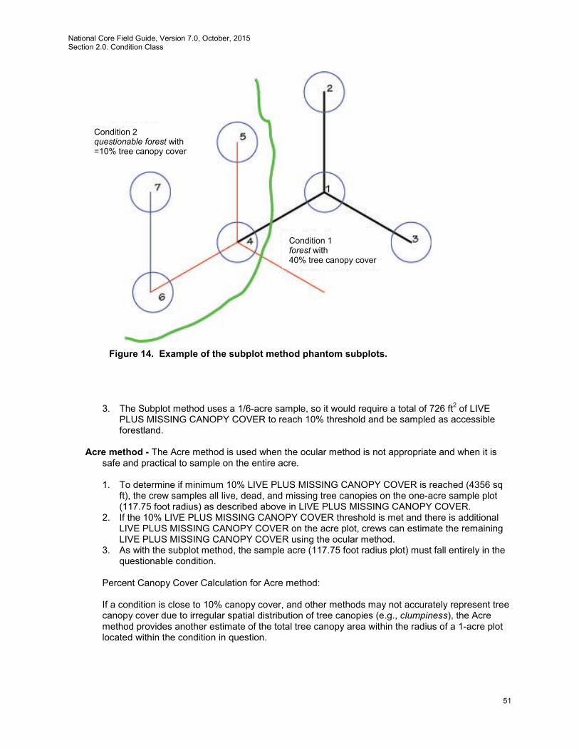
National Core Field Guide, Version 7.0, October, 2015 Section 2.0. Condition Class
51
3. The Subplot method uses a 1/6-acre sample, so it would require a total of 726 ft2 of LIVE PLUS MISSING CANOPY COVER to reach 10% threshold and be sampled as accessible forestland.
Acre method - The Acre method is used when the ocular method is not appropriate and when it is
safe and practical to sample on the entire acre.
1. To determine if minimum 10% LIVE PLUS MISSING CANOPY COVER is reached (4356 sq ft), the crew samples all live, dead, and missing tree canopies on the one-acre sample plot (117.75 foot radius) as described above in LIVE PLUS MISSING CANOPY COVER.
2. If the 10% LIVE PLUS MISSING CANOPY COVER threshold is met and there is additional LIVE PLUS MISSING CANOPY COVER on the acre plot, crews can estimate the remaining LIVE PLUS MISSING CANOPY COVER using the ocular method.
3. As with the subplot method, the sample acre (117.75 foot radius plot) must fall entirely in the questionable condition.
Percent Canopy Cover Calculation for Acre method:
If a condition is close to 10% canopy cover, and other methods may not accurately represent tree canopy cover due to irregular spatial distribution of tree canopies (e.g., clumpiness), the Acre method provides another estimate of the total tree canopy area within the radius of a 1-acre plot located within the condition in question.
Figure 14. Example of the subplot method phantom subplots.
Condition 2 questionable forest with =10% tree canopy cover
Condition 1 forest with 40% tree canopy cover

National Core Field Guide, Version 7.0, October, 2015 Section 2.0. Condition Class
52
Given: 1. The area of an acre is 43,560 ft2. 2. A 1-acre circle has a radius of 117.75 ft. 3. 10% of 1-acre is 4,356 ft2.
and assuming the canopies to be ellipses:
1. Measure the approximate canopy diameter (long axis and short axis) for each tree on the
acre. 2. Calculate the canopy area for each tree as Canopy Area = pi*((long axis diameter/2)*(90
degrees axis diameter/2)). 3. Add up the Canopy Areas, and divide by 435.6 (1% of an acre) to obtain percent cover
(truncate)
Transition zones and forest/nonforest encroachment – When an accessible forest land condition encroaches into a nonforest condition, the border between forest and nonforest is often a gradual change in tree cover with no clear and abrupt boundary. This may cause difficulties determining exactly where the forested area meets the minimum canopy cover or stem count criteria. For these cases, determine where the land clearly meets the minimum requirements, and where it clearly is less than required. Divide the zone between these points in half, and determine the side of the zone on which the subplot center is located. Classify the condition class of the subplot based on this line.
If the Acre plot falls on or very near a transition, the Acre plot should be moved into the condition identified at plot center (fig. 15).
Clearly Nonforest
Clearly Forest
Original Acre plot
Moved Acre plot
Figure 15. Example of using the Acre plot method when determining CANOPY COVER when the Acre plot is in a transition zone with forest/nonforest encroachment.
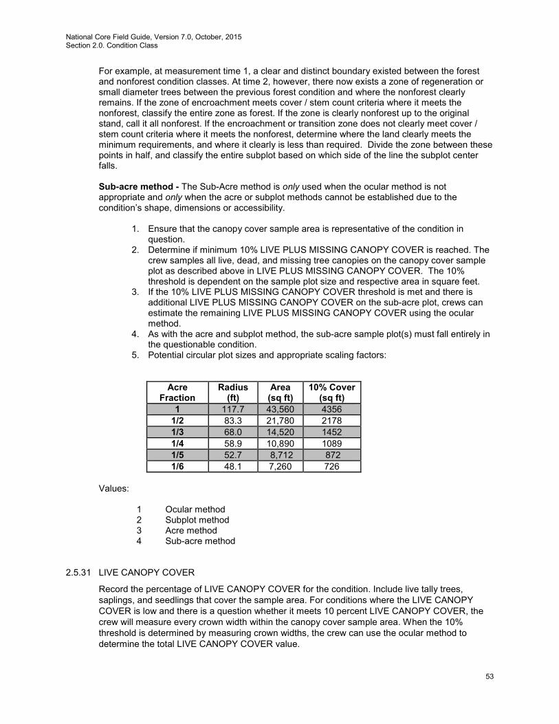
National Core Field Guide, Version 7.0, October, 2015 Section 2.0. Condition Class
53
For example, at measurement time 1, a clear and distinct boundary existed between the forest and nonforest condition classes. At time 2, however, there now exists a zone of regeneration or small diameter trees between the previous forest condition and where the nonforest clearly remains. If the zone of encroachment meets cover / stem count criteria where it meets the nonforest, classify the entire zone as forest. If the zone is clearly nonforest up to the original stand, call it all nonforest. If the encroachment or transition zone does not clearly meet cover / stem count criteria where it meets the nonforest, determine where the land clearly meets the minimum requirements, and where it clearly is less than required. Divide the zone between these points in half, and classify the entire subplot based on which side of the line the subplot center falls.
Sub-acre method - The Sub-Acre method is only used when the ocular method is not appropriate and only when the acre or subplot methods cannot be established due to the condition’s shape, dimensions or accessibility.
1. Ensure that the canopy cover sample area is representative of the condition in
question. 2. Determine if minimum 10% LIVE PLUS MISSING CANOPY COVER is reached. The
crew samples all live, dead, and missing tree canopies on the canopy cover sample plot as described above in LIVE PLUS MISSING CANOPY COVER. The 10% threshold is dependent on the sample plot size and respective area in square feet.
3. If the 10% LIVE PLUS MISSING CANOPY COVER threshold is met and there is additional LIVE PLUS MISSING CANOPY COVER on the sub-acre plot, crews can estimate the remaining LIVE PLUS MISSING CANOPY COVER using the ocular method.
4. As with the acre and subplot method, the sub-acre sample plot(s) must fall entirely in the questionable condition.
5. Potential circular plot sizes and appropriate scaling factors:
Acre
Fraction Radius
(ft) Area (sq ft)
10% Cover (sq ft)
1 117.7 43,560 4356 1/2 83.3 21,780 2178 1/3 68.0 14,520 1452 1/4 58.9 10,890 1089 1/5 52.7 8,712 872 1/6 48.1 7,260 726
Values:
1 Ocular method 2 Subplot method 3 Acre method 4 Sub-acre method
2.5.31 LIVE CANOPY COVER
Record the percentage of LIVE CANOPY COVER for the condition. Include live tally trees, saplings, and seedlings that cover the sample area. For conditions where the LIVE CANOPY COVER is low and there is a question whether it meets 10 percent LIVE CANOPY COVER, the crew will measure every crown width within the canopy cover sample area. When the 10% threshold is determined by measuring crown widths, the crew can use the ocular method to determine the total LIVE CANOPY COVER value.

National Core Field Guide, Version 7.0, October, 2015 Section 2.0. Condition Class
54
Canopy widths are measured using the ellipse formula for calculation of canopy area. This requires two measurements. The first measurement is the long axis diameter. The second measurement is made at 90 degrees to the first measurement at the widest point of the crown (fig. 16). Canopy area = pi*((long axis diameter/2)*(90 degrees axis diameter/2)).
• Do not include the crown portion of trees, saplings, or seedlings that are vertically overtopped by other trees, saplings or seedlings.
• Only include tree canopy measurements from trees with stems that originate within the sample area, although canopy measurements can extend outside the sample area.
• Occasionally, a branch may protrude abnormally, but the lateral crown line is drawn across the portion of the branch which includes the “normal outline” of the tree.
• For leaning trees, ocularly upright the trees and measure crowns as if the trees were upright.
Figure 16. Examples of where to measure canopy widths. LIVE CANOPY COVER can be based on an ocular estimate when the condition in question is certain to contain greater than 10% LIVE PLUS MISSING CANOPY COVER or CURRENT AFFORESTATION CODE = 1 and TOTAL STEMS greater than or equal to 150. For LIVE CANOPY COVER <1 percent (trace), record 01. Values: 00 – 99 (where 99=99-100%)
2.5.32 LIVE PLUS MISSING CANOPY COVER
Record the percentage of LIVE PLUS MISSING CANOPY COVER for the condition by adding the LIVE CANOPY COVER plus the estimated missing canopy cover that existed prior to disturbance (harvesting, fire, etc). Include live and dead and removed tally trees, saplings, and seedlings. Dead trees and dead portions of live trees are not considered as missing unless it is part of the condition disturbance. Base the estimate on field observations, aerial photos, historical aerial imagery, and similar evidence of undisturbed conditions. The total of the LIVE PLUS MISSING CANOPY COVER cannot exceed 100%.
Values: 00 – 99 (where 99=99-100%)
Long axis Short axis Short axis
Long axis
National Core Field Guide, Version 7.0, October, 2015 Section 2.0. Condition Class
55
2.5.33 CURRENT AFFORESTATION CODE
Record the code identifying a condition that has no evidence of prior forest, but does have evidence suggesting deliberate afforestation attempts (planted or prepared to promote tree establishment) to convert to forest in the current inventory cycle or since the last measurement. Values:
0 No 1 Yes
2.5.34 PREVIOUS AFFORESTATION CODE
Record the code identifying a condition that has no evidence of prior forest, but does have evidence suggesting deliberate afforestation attempts (planted or prepared to promote tree establishment) to convert to forest the prior inventory cycle or prior to the last measurement. Values:
0 No 1 Yes
2.5.35 TOTAL STEMS
Record the estimated number of live stems per acre of the condition. Base the estimate on actual stem count of tally tree species within the sample area. When using the subplot method, use the appropriate expansion factor according to tree and subplot size to obtain an estimate of the number of live stems per acre. Using microplots (i.e., the subplot method) to estimate stems <5.0 inches diameter in conditions with wide spacing or ‘clumping’ is discouraged. Values: 00000 – 99999
2.5.36 CHAINING CODE
Record the code identifying if a condition has been chained, shear bladed, roller chopped, etc., for the purpose of increased forage production. These treatments contrast with silvicultural removals in that little or none of the woody material is removed from the site and there are few residual live trees. Values:
0 No 1 Yes
2.6 Optional Fuels Variables for DWM Protocol
2.6.1 CONDITION FUELBED TYPE (OPTIONAL)
Record the fuelbed code from the Scott and Burgan (2005; RMRS-GTR-153) fuel model guide that best corresponds with the combined fire behavior characteristics of live and dead materials on and near the ground surface. The visual appearance of the condition on the plot is not as

National Core Field Guide, Version 7.0, October, 2015 Section 2.0. Condition Class
56
important as the amount and packing density of live and dead fuels of different sizes. Refer to fuelbed descriptions, keys, and photos in Scott and Burgan (2005) to select the fuel model which best matches conditions on the condition class. This is a CORE-OPTIONAL field. Values:
GR1 Short, Sparse Dry Climate Grass GR2 Low Load, Dry Climate Grass GR3 Low Load, Very Coarse, Humid Climate Grass GR4 Moderate Load, Dry Climate Grass GR5 Low Load, Humid Climate Grass GR6 Moderate Load, Humid Climate Grass GR7 High Load, Dry Climate Grass GR8 High Load, Very Coarse, Humid Climate Grass GR9 Very High Load, Humid Climate Grass GS1 Low Load, Dry Climate Grass-Shrub GS2 Moderate Load, Dry Climate Grass-Shrub GS3 Moderate Load, Humid Climate Grass-Shrub GS4 High Load, Humid Climate Grass-Shrub SB1 Slash-Blowdown: Low Load Activity Fuel SB2 Moderate Load Activity Fuel or Low Load Blowdown SB3 High Load Activity Fuel or Moderate Load Blowdown SB4 High Load Blowdown SH1 Low Load Dry Climate Shrub SH2 Moderate Load Dry Climate Shrub SH3 Moderate Load, Humid Climate Shrub SH4 Low Load, Humid Climate Timber-Shrub SH5 High Load, Dry Climate Shrub SH6 Low Load, Humid Climate Shrub SH7 Very High Load, Dry Climate Shrub SH8 High Load, Humid Climate Shrub SH9 Very High Load, Humid Climate Shrub TL1 Low Load Compact Conifer Litter TL2 Low Load Broadleaf Litter TL3 Moderate Load Conifer Litter TL4 Small downed logs TL5 High Load Conifer Litter TL6 Moderate Load Broadleaf Litter TL7 Large Downed Logs TL8 Long-Needle Litter TL9 Very High Load Broadleaf Litter TU1 Low Load Dry Climate Timber-Grass-Shrub TU2 Moderate Load, Humid Climate Timber-Shrub TU3 Moderate Load, Humid Climate Timber-Grass-Shrub TU4 Dwarf Conifer With Understory TU5 Very High Load, Dry Climate Timber-Shrub NB1 Nonburnable Urban/developed NB2 Nonburnable Snow/ice NB3 Nonburnable Agricultural NB8 Nonburnable Open water NB9 Nonburnable Bare ground

National Core Field Guide, Version 7.0, October, 2015 Section 2.0. Condition Class
57

National Core Field Guide, Version 7.0, October, 2015 Section 3.0. Subplot Information
58
3.0 SUBPLOT INFORMATION
Each subplot is described by a series of area parameters relating to topographic features and existing cover type. These data also relate to the microplot, since the microplot is contained within the subplot perimeter.
3.1 SUBPLOT NUMBER
Record the code corresponding to the number of the subplot.
Values:
1 Center subplot 2 North subplot 3 Southeast subplot 4 Southwest subplot
3.2 SUBPLOT/MACROPLOT STATUS
Indicate whether or not this subplot currently has at least one accessible forest land condition class. In regions measuring the CORE OPTIONAL macroplot, indicate whether or not this macroplot currently has at least one forested condition class. In situations where a subplot/macroplot is denied access or hazardous, but obviously contains no forest land, record SUBPLOT/MACROPLOT STATUS = 2. In cases where a subplot/macroplot is access-denied or hazardous land use and has the possibility of forest, record SUBPLOT/MACROPLOT STATUS = 3.
Values:
1 Sampled – at least one accessible forest land condition present on subplot 2 Sampled – no accessible forest land condition present on subplot 3 Nonsampled – possibility of forest land 4 Sampled – QA crew did not measure trees, saplings, or seedlings. QA crew did
measure all other data items (condition, boundary, and subplot-level data). For use only on check plots (QA STATUS = 2 - 6). Not a legal entry on production plots (QA STATUS = 1 or 7).
3.3 SUBPLOT NONSAMPLED REASON
For entire subplots that cannot be sampled, record one of the following reasons. Values:
01 Outside U.S. boundary – Assign this code to condition classes beyond the U.S. border.
02 Denied access area – Any area within the sampled area of a plot to which access is denied by the legal owner, or to which an owner of the only reasonable route to the plot denies access. There are no minimum area or width requirements for a condition class delineated by denied access. Because a denied-access condition can become accessible in the future, it remains in the sample and is re-examined at the next occasion to determine if access is available.
03 Hazardous situation – Any area within the sampled area on plot that cannot be accessed because of a hazard or danger, for example cliffs, quarries, strip mines, illegal substance
National Core Field Guide, Version 7.0,October, 2015 Section 3.0. Subplot Information
59
plantations, temporary high water, etc. Although the hazard is not likely to change over time, a hazardous condition remains in the sample and is re-examined at the next occasion to determine if the hazard is still present. There are no minimum size or width requirements for a condition class delineated by a hazardous condition
04 Time limitation – This code applies to full subplots that cannot be sampled due to a time restriction. This code is reserved for areas with limited access, and in situations where it is imperative for the crew to leave before the plot can be completed (e.g., scheduled helicopter rendezvous). Use of this code requires notification to the field supervisor. This code should not be used for an entire plot (use code 8 [skipped visit] when an entire plot is skipped; see Section 1.5).
05 Lost data – The plot data file was discovered to be corrupt after a panel was completed and submitted for processing. This code is assigned to entire plots or full subplots that could not be processed, and is applied at the time of processing after notification to the region. Note: This code is for office use only.
06 Lost plot – Entire plot cannot be found. Used for the four subplots that are required for this plot. Used only in conjunction with PLOT NONSAMPLED REASON code 06. Can be either generated by the data recorder or in the office.
07 Wrong location – Previous plot can be found, but its placement is beyond the tolerance limits for plot location. Used for the four subplots that are required for this plot. Used only in conjunction with PLOT NONSAMPLED REASON code 07. Can be either generated by the data recorder or in the office.
08 Skipped visit – Entire plot skipped. Used for the four subplots that are required for this plot. Applied at the time of processing and used only in conjunction with PLOT NONSAMPLED REASON code 08. This code is for office use only.
09 Dropped intensified plot – Used for the four subplots that are required for this plot. Used only by units engaged in intensification. Applied at the time of processing and used only in conjunction with PLOT NONSAMPLED REASON code 09. This code is for office use only.
10 Other – This code is used whenever a plot or condition class is not sampled due to a reason other than one of the specific reasons already listed. A field note is required to describe the situation.
11 Ocean – Subplot falls in ocean water below mean high tide line. 3.4 NONFOREST SUBPLOT/MACROPLOT STATUS
Record the code that describes the sampling status of the other-than-forest subplot, i.e., SUBPLOT/MACROPLOT STATUS = 2. In cases where subplot is denied access or hazardous, but obviously contains no nonforest land, i.e., subplot is either noncensus water or census water, record NONFOREST SUBPLOT/MACROPLOT STATUS = 2. Values:
1 Sampled – at least one accessible nonforest land condition present on the subplot. 2 Sampled – no nonforest land condition present on subplot, i.e., subplot is either
census and/or noncensus water. 3 Nonsampled nonforest
National Core Field Guide, Version 7.0, October, 2015 Section 3.0. Subplot Information
60
3.5 NONFOREST SUBPLOT/MACROPLOT NONSAMPLED REASON
For entire nonforest subplots that cannot be sampled, record one of the following reasons. Values:
02 Denied access – A subplot/macroplot to which access is denied by the legal owner, or to which an owner of the only reasonable route to the plot denies access. Because a denied-access subplot can become accessible in the future, it remains in the sample and is re-examined at the next occasion to determine if access is available.
03 Hazardous situation – A subplot/macroplot that cannot be accessed because of a hazard or danger, for example cliffs, quarries, strip mines, illegal substance plantations, temporary high water, etc. Although the hazard is not likely to change over time, a hazardous condition remains in the sample and is re-examined at the next occasion to determine if the hazard is still present.
04 Time limitation – This code applies to a full subplot/macroplot that cannot be sampled due to a time restriction. This code is reserved for areas with limited access, and in situations where it is imperative for the crew to leave before the plot can be completed (e.g., scheduled helicopter rendezvous). Use of this code requires notification to the field supervisor.
10 Other – This code is used whenever a subplot/macroplot is not sampled due to a reason other than one of the specific reasons already listed. A field note is required to describe the situation.
3.6 SUBPLOT CENTER CONDITION
Record the CONDITION CLASS NUMBER of the condition class at the subplot center.
Values: 1 to 9 3.7 MICROPLOT CENTER CONDITION
Record the CONDITION CLASS NUMBER of the condition class at the microplot center.
Values: 1 to 9 3.8 SUBPLOT SLOPE
Record the angle of slope across the subplot to the nearest 1 percent. SUBPLOT SLOPE is determined by sighting the clinometer along a line parallel to the average incline (or decline) of each subplot. This angle is measured along the shortest pathway down slope before the drainage direction changes. To measure SUBPLOT SLOPE, Observer 1 should stand at the uphill edge of the subplot and sight Observer 2, who stands at the downhill edge of the subplot. Sight Observer 2 at the same height as the eye-level of Observer 1. Read the slope directly from the percent scale of the clinometer:
• If slope changes gradually across the subplot, record an average slope. • If slope changes across the subplot but the slope is predominantly of one direction, code
the predominant slope percentage rather than the average. • If the subplot falls directly on or straddles a canyon bottom or narrow ridge top, code the
average slope of the side hill(s).
National Core Field Guide, Version 7.0,October, 2015 Section 3.0. Subplot Information
61
• If the subplot falls on a canyon bottom or on a narrow ridge top, but most of the area lies on one side hill, code the slope of the side hill where most of the area lies.
Values: 000 to 155
3.9 SUBPLOT ASPECT
Record the aspect across the subplot, to the nearest 1 degree. SUBPLOT ASPECT is determined along the direction of slope for land surfaces with at least 5 percent slope in a generally uniform direction. SUBPLOT ASPECT is measured with a hand compass along the same direction used to determine slope.
• If aspect changes gradually across the subplot, record an average aspect. • If aspect changes across the subplot but the aspect is predominately of one direction,
code the predominate direction rather than the average. • If the subplot falls on or straddles a canyon bottom or narrow ridge top, code the aspect
of the ridge line or canyon bottom. • If the subplot falls on a canyon bottom or on a narrow ridge top, but most of the area lies
on one side hill, code the aspect of the side hill. Values:
000 no aspect, slope < 5 percent 001 1 degree 002 2 degrees . . . . 360 360 degrees, due north
3.10 SNOW/WATER DEPTH
Record to the nearest 0.1 foot the average approximate depth of water or snow covering the subplot at the time of data collection. This variable is used to indicate subplots where some variables (e.g., seedling count, total lengths) may be measured with less certainty due to conditions at the time of measurement.
Values: 0.0 to 9.9
3.11 SUBPLOT/MACROPLOT CONDITION LIST
This is a listing of all condition classes located within the 24.0-foot radius around the subplot center. In regions measuring the CORE OPTIONAL macroplot, this is a listing of all condition classes located within the 58.9-foot radius around the macroplot center. A maximum of four conditions is permitted at any individual subplot / macroplot. If a condition class has already been defined at a previously completed subplot / macroplot, use the same condition class number whenever that condition is encountered. Define new condition classes as they are encountered. If more than one condition class is listed here, boundary data are required. If only one condition class is listed, this condition is automatically assigned to the subplot center and microplot center. If less than four condition classes occur on this subplot, complete the remainder of this field with zeros. For example, if condition 1 is the only condition class on a subplot, record 1000.
Values: 1000 to 9876
National Core Field Guide, Version 7.0, October, 2015 Section 3.0. Subplot Information
62
3.12 P2 VEG SUBPLOT SAMPLE STATUS
Record the code to indicate if the subplot was sampled for P2 Vegetation. A subplot may be sampled for P2 Vegetation but not have any vascular plants present. If there is any part of an accessible portion of the subplot where other plot measurements are made but all the P2 Vegetation measurements cannot be completed on the subplot (for example, deep snow or water, hazardous weather, time limitation), enter code 2 and do not record any P2 Vegetation measurements. Values:
1 Subplot sampled for P2 Vegetation 2 Subplot not sampled for P2 Vegetation
3.13 VEGETATION NONSAMPLED REASON
Record the reason why P2 Vegetation on a subplot cannot be sampled. Values:
04 Time limitation 05 Lost data (for office use only) 10 Other (for example, snow or water covering vegetation that is
supposed to be sampled) 3.14 VEGETATION SUBPLOT NOTES
Use this field to record notes pertaining to the subplot, and any unusual conditions encountered. When plant specimens are collected, use this field to record a community type description for each subplot sampled for P2 Vegetation. The community description is intended to fully automate the specimen collection process by providing a description of the community in which this plant was found. Some examples of community descriptions are as follows:
• 25 year aspen boundary of mature trees. very little slope. a lot of light entry • acer saccharum floodplain forest. hummock-hollow microtopography. • mature mesic hemlock-hardwood forest adjacent to pond
The community type description field is a note that is accessible via Ctrl+E from the P2 Subplot screen for P2VEG. Values: English language words, phrases, and numbers
3.15 INVASIVE PLANT SUBPLOT SAMPLE STATUS (Subplot-level variable)
Record the code to indicate whether the subplot was sampled for invasive plants. A subplot may be sampled but not have any invasive plants present. If there is any part of an accessible portion of the subplot where other plot measurements are made but invasive plants cannot be assessed (e.g., because of snow, water, hazardous weather, time limitation), enter code 3 and do not record any invasive plant measurements.
National Core Field Guide, Version 7.0,October, 2015 Section 3.0. Subplot Information
63
Values: 1 Subplot sampled, invasive plants present 2 Subplot sampled, no invasive plants present 3 Subplot not sampled for invasive plants
3.16 INVASIVE PLANT NONSAMPLED REASON (Subplot-level variable)
Record the reason why a subplot cannot be sampled for invasive plants. Values: 4 Time limitation 5 Lost data (office use only) 10 Other (for example, snow or water covering vegetation that is supposed to be sampled)
3.17 INVASIVE PLANT DATA NOTES
Use this field to record any notes about the condition on the subplot, particularly any unusual conditions encountered.
Values: English language words, phrases, and numbers
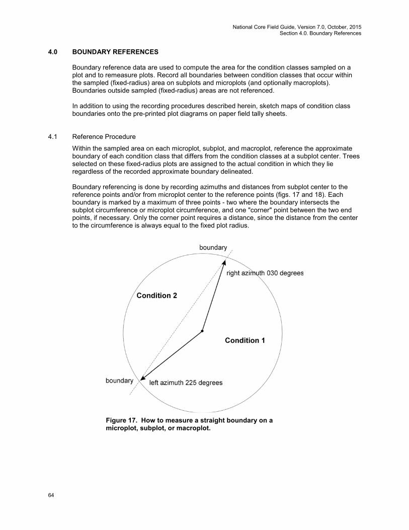
National Core Field Guide, Version 7.0, October, 2015 Section 4.0. Boundary References
64
4.0 BOUNDARY REFERENCES
Boundary reference data are used to compute the area for the condition classes sampled on a plot and to remeasure plots. Record all boundaries between condition classes that occur within the sampled (fixed-radius) area on subplots and microplots (and optionally macroplots). Boundaries outside sampled (fixed-radius) areas are not referenced.
In addition to using the recording procedures described herein, sketch maps of condition class boundaries onto the pre-printed plot diagrams on paper field tally sheets.
4.1 Reference Procedure
Within the sampled area on each microplot, subplot, and macroplot, reference the approximate boundary of each condition class that differs from the condition classes at a subplot center. Trees selected on these fixed-radius plots are assigned to the actual condition in which they lie regardless of the recorded approximate boundary delineated.
Boundary referencing is done by recording azimuths and distances from subplot center to the reference points and/or from microplot center to the reference points (figs. 17 and 18). Each boundary is marked by a maximum of three points - two where the boundary intersects the subplot circumference or microplot circumference, and one "corner" point between the two end points, if necessary. Only the corner point requires a distance, since the distance from the center to the circumference is always equal to the fixed plot radius.
Figure 17. How to measure a straight boundary on a microplot, subplot, or macroplot.

National Core Field Guide, Version 7.0,October, 2015 Section 4.0. Boundary References
65
Microplot boundaries are referenced to the microplot center, and macroplot boundaries are referenced to the subplot center in the same manner described for subplots. Note that the larger the plot, the greater likelihood of a need for a boundary corner to record boundaries that are not straight lines.
Refer to Sections 2.1 and 2.4 for general condition class delineation guidelines. The following additional rules apply when referencing a boundary within a subplot, microplot, or macroplot:
1. When a boundary between accessible forest land and nonforest land or between two
contrasting accessible forest land condition classes is clearly marked, use that feature to define the boundary. Examples of clear demarcation are a fence line, plowed field edge, sharp ridge line, and water's edge along a stream course, ditch, or canal.
2. When a boundary between forest land and nonforest land is not clearly marked by an
obvious feature, the boundary should follow the nonforest side of the stems of the trees at the forest edge.
3. When a boundary between two contrasting forest land condition classes is not clearly
marked, map along the stems of the contrasting condition. When the boundary between two contrasting forest land condition classes is separated by a narrow linear inclusion (creek, fire line, narrow meadow, unimproved road), establish the boundary at the far edge of the inclusion relative to subplot center.
4. When a plot is remeasured, the crew will examine the boundaries referenced at last
inventory. If no change has occurred, the current crew will retain the boundary data that were recorded at last inventory. If a boundary has changed, or a new boundary is
Figure 18. How to measure a boundary with a corner on a subplot or macroplot.
National Core Field Guide, Version 7.0, October, 2015 Section 4.0. Boundary References
66
present, or the previous crew made an obvious error, record new or updated boundary data. Delete boundaries that are no longer distinct.
5. Although individual tolerances are specified for the azimuths and distances, in practice a
crew will be considered ‘correct’ when the difference in areas as mapped by the original crew and by the QA crew is less than 10 percent of the subplot or microplot area. This allows for slight variations in azimuths or distances due to the approximate nature of mapping procedures.
4.2 Boundary Data
Record the appropriate values for each boundary mapped on the subplot, microplot, or macroplot as follows:
4.2.1 SUBPLOT NUMBER
Record the code corresponding to the number of the subplot.
Values:
1 Center subplot 2 North subplot 3 Southeast subplot 4 Southwest subplot
4.2.2 PLOT TYPE
Record the code to specify whether the boundary data are for a subplot, microplot, or macroplot.
Values:
1 Subplot boundary 2 Microplot boundary 3 Macroplot boundary (coded only when macroplots are taken) 4 Hectare plot boundary (coded from subplot 1 only)
4.2.3 BOUNDARY CHANGE
Remeasurement (SAMPLE KIND = 2) locations only. Record the appropriate code to indicate the relationship between previously recorded and current boundary information.
Values:
0 No change - boundary is the same as indicated on plot map and/or data collected
by a previous crew. 1 New boundary, or boundary data has been changed to reflect an actual on-the-
ground physical change resulting in a difference from the boundaries recorded. 2 Boundary has been changed to correct an error from previous crew. 3 Boundary has been changed to reflect a change in variable definition.
National Core Field Guide, Version 7.0,October, 2015 Section 4.0. Boundary References
67
4.2.4 CONTRASTING CONDITION
Record the CONDITION CLASS NUMBER of the condition class that contrasts with the condition class located at the subplot center (for boundaries on the subplot or macroplot) or at the microplot center (for boundaries on the microplot), e.g., the condition class present on the other side of the boundary line. See section 3.0 for subplot data.
Values: 1 to 9
4.2.5 LEFT AZIMUTH
Record the azimuth from the subplot, microplot, or macroplot center to the farthest left point (facing the contrasting condition) where the boundary intersects the subplot, microplot, or macroplot circumference.
Values: 001 to 360
4.2.6 CORNER AZIMUTH
Record the azimuth from the subplot, microplot, or macroplot center to a corner or curve in a boundary. If a boundary is best described by a straight line between the two circumference points, then record 000 for CORNER AZIMUTH (000=none).
Values: 000 to 360
4.2.7 CORNER DISTANCE
Record the horizontal distance, to the nearest 1 foot, from the subplot, microplot, or macroplot center to a boundary corner point.
Values:
microplot 001 to 007 ft (actual limiting distance is 6.8 ft) subplot 001 to 024 ft macroplot 001 to 059 ft (actual limiting distance is 58.9 ft) hectare 001 to 185 ft
4.2.8 RIGHT AZIMUTH
Record the azimuth from subplot, microplot, or macroplot center to the farthest right point (facing the contrasting condition) where the boundary intersects the subplot, microplot, or macroplot circumference.
Values: 001 to 360
National Core Field Guide, Version 7.0, October, 2015 Section 5.0. Tree and Sapling Data
68
5.0 TREE AND SAPLING DATA
Trees at least 5.0 inches in diameter are sampled within the subplot. ‘Tally trees’ are defined as all live and standing dead trees in accessible forest land condition classes encountered on the subplot the first time a subplot is established, and all trees that grow into a subplot thereafter. These data yield information on tree volume, growth, mortality, and removals; wildlife habitats; forest structure and composition; biomass; and carbon sequestration.
Trees with a diameter at least 1.0 inch but less than 5.0 inches, termed saplings, are sampled within the microplot. ‘Tally saplings’ are defined as all live and standing dead saplings in accessible forest land condition classes encountered the first time a microplot is established, and all saplings that grow into each microplot thereafter are included until they grow to 5.0 inches or larger, at which time they are tallied on the subplot and referenced (new AZIMUTH and HORIZONTAL DISTANCE taken) to the subplot center. For multi-stemmed woodland species, a cumulative DRC is used to compute diameter as described in Sections 5.9 and 5.9.4.
Trees are alive if they have any living parts (leaves, buds, cambium) at or above the point of diameter measurement, either diameter at breast height (DBH) or diameter at root collar (DRC). Trees that have been temporarily defoliated are still alive. Once tallied, dead trees 1.0 inch and greater in diameter are tracked until they no longer qualify as standing dead. Working around dead trees is a safety hazard - crews should exercise extreme caution! Trees that are deemed unsafe to measure should be estimated. To qualify as a standing dead tally tree, dead trees must be at least 1.0 inch in diameter, have a bole which has an unbroken ACTUAL LENGTH of at least 4.5 feet, and lean less than 45 degrees from vertical as measured from the base of the tree to 4.5 feet.
The portion of a bole on dead trees that are separated greater than 50 percent (either above or below 4.5 feet), are considered severed and may qualify as Down Woody Material (DWM). See DWM procedures for tally criteria. For woodland species (Appendix 3) with multiple stems, a tree is considered down if more than 2/3 of the volume is no longer attached or upright; do not consider cut and removed volume. For woodland species with single stems to qualify as a standing dead tally tree, dead trees must be at least 1.0 inch in diameter, be at least 1.0 foot in unbroken ACTUAL LENGTH, and lean less than 45 degrees from vertical.
Live and dead standing tally trees, and partially separated boles of dead tally trees, do not have
to be self-supported. They may be supported by other trees, branches, or their crown. Trees that have been cut above DBH qualify as tally trees, provided they meet the size
requirement. The following apply at remeasurement:
• If at the previous visit a forked tree was recorded as two separate trees but should have been recorded as one tree, reconcile one tree and correct the diameter for the remaining tree. Give one of the tree data lines a PRESENT TREE STATUS = 0, RECONCILE = 7, and a TREE NOTE. The remaining tree data line receives PRESENT TREE STATUS = 1 or 2 with DIAMETER CHECK = 2, and a TREE NOTE.
• If at the previous visit a forked tree was recorded as one tree but should have been recorded as two separate trees, correct the diameter for the remeasured tree to
National Core Field Guide, Version 7.0,October, 2015 Section 5.0. Tree and Sapling Data
69
represent one tree, and add the other fork as a missed tree. Use the existing tree data line to represent one of the stems. PRESENT TREE STATUS = 1 or 2, DIAMETER CHECK = 2, and a TREE NOTE. The second stem would get PRESENT TREE STATUS = 1 or 2, RECONCILE 3 or 4, and a TREE NOTE.
Begin tallying trees at an azimuth of 001 degrees from subplot center and continue clockwise around the subplot. Repeat this sequence for trees on the microplot and again on the annular plot.
5.1 SUBPLOT NUMBER
Record the subplot number where the tree occurs. Values:
1 Center subplot 2 North subplot 3 Southeast subplot 4 Southwest subplot
5.2 TREE RECORD NUMBER
Record a code to uniquely and permanently identify each tree on a given subplot. The TREE RECORD NUMBERs must be unique within a subplot – being unique is more important than being sequential. In general, work clockwise from azimuth 001 to 360, and work outwards from subplot center to subplot perimeter. On remeasured plots, use the previously assigned tree number. Saplings tallied on microplots will retain their initially assigned tree number if they grow to tree size. Missed trees and ingrowth trees (trees that either grew over the 1.0-inch threshold on the microplot or grew onto the subplot) will be assigned the next available tree number. DO NOT renumber all plot trees in order to assign a more “correct” tree number to a missed tree. Numbers assigned to trees that are subsequently found to be extra will be dropped and not reused. If TREE RECORD NUMBERs are not assigned in the field, record 000.
Note: If this is a Phase 3 plot, match the trees on this point to the hard copy list provided. Record
the three-digit FHM tree number assigned to each standing tree.
Values: 000 or 001 to 999 5.3 CONDITION CLASS NUMBER
Record the CONDITION CLASS NUMBER in which each tree is located. Often, a referenced boundary is approximate, and trees selected for tally are assigned to the actual condition in which they lie regardless of the recorded approximate boundary (fig. 19).
Values: 1 to 9
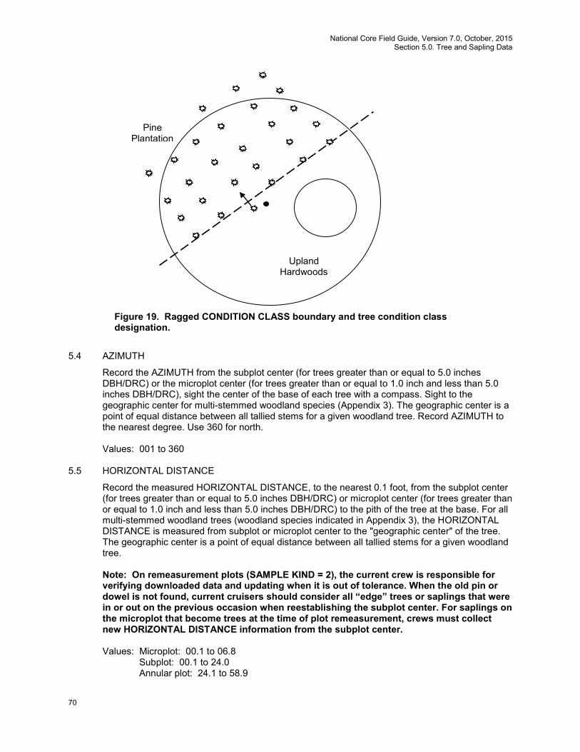
National Core Field Guide, Version 7.0, October, 2015 Section 5.0. Tree and Sapling Data
70
5.4 AZIMUTH
Record the AZIMUTH from the subplot center (for trees greater than or equal to 5.0 inches DBH/DRC) or the microplot center (for trees greater than or equal to 1.0 inch and less than 5.0 inches DBH/DRC), sight the center of the base of each tree with a compass. Sight to the geographic center for multi-stemmed woodland species (Appendix 3). The geographic center is a point of equal distance between all tallied stems for a given woodland tree. Record AZIMUTH to the nearest degree. Use 360 for north. Values: 001 to 360
5.5 HORIZONTAL DISTANCE
Record the measured HORIZONTAL DISTANCE, to the nearest 0.1 foot, from the subplot center (for trees greater than or equal to 5.0 inches DBH/DRC) or microplot center (for trees greater than or equal to 1.0 inch and less than 5.0 inches DBH/DRC) to the pith of the tree at the base. For all multi-stemmed woodland trees (woodland species indicated in Appendix 3), the HORIZONTAL DISTANCE is measured from subplot or microplot center to the "geographic center" of the tree. The geographic center is a point of equal distance between all tallied stems for a given woodland tree.
Note: On remeasurement plots (SAMPLE KIND = 2), the current crew is responsible for verifying downloaded data and updating when it is out of tolerance. When the old pin or dowel is not found, current cruisers should consider all “edge” trees or saplings that were in or out on the previous occasion when reestablishing the subplot center. For saplings on the microplot that become trees at the time of plot remeasurement, crews must collect new HORIZONTAL DISTANCE information from the subplot center.
Values: Microplot: 00.1 to 06.8
Subplot: 00.1 to 24.0 Annular plot: 24.1 to 58.9
Pine Plantation
Upland Hardwoods
Figure 19. Ragged CONDITION CLASS boundary and tree condition class designation.
National Core Field Guide, Version 7.0,October, 2015 Section 5.0. Tree and Sapling Data
71
5.6 PREVIOUS TREE STATUS
If not downloaded from the previous inventory, record PREVIOUS TREE STATUS for each remeasured tally tree. This code is used to track the status of sample trees over time. This information is needed to correctly assign the tree’s volume to the proper component of volume change.
Values:
1 Live Tree – alive at the previous inventory 2 Dead tree – standing dead tree at the previous inventory
5.7 PRESENT TREE STATUS
Record a current PRESENT TREE STATUS for each tallied tree; this code is used to track the status of sample trees over time: as they first appear, as ingrowth, as they survive, and when they die or are removed. This information is needed to correctly assign the tree’s volume to the proper component of volume change.
Values:
0 No status – tree is not presently in the sample (remeasurement plots only). Tree was incorrectly tallied at the previous inventory, currently is not tallied due to definition or procedural change, or is not tallied due to natural causes. Requires RECONCILE code = 5-9.
1 Live tree – any live tree (new, remeasured or ingrowth) 2 Dead tree – any dead tree (new, remeasured, or ingrowth), regardless of cause of
death. Includes all previously standing dead trees that no longer qualify as standing dead, trees killed by silvicultural or land clearing activity and assumed not to have been utilized, as well as dead trees that may have been present at the time of plot establishment but only tallied now due to procedural change
3 Removed – a tree that has been cut and removed by direct human activity related to harvesting, silviculture or land clearing (remeasurement plots only). The tree is assumed to have been utilized.
Note: On remeasured plots, crews must collect new AZIMUTH and HORIZONTAL
DISTANCE information from the subplot center for microplot saplings that grow to become subplot trees. For live or standing dead subplot trees that shrink to become live or dead saplings on the microplot, crews must collect new AZIMUTH and HORIZONTAL DISTANCE information from the microplot center.
5.7.1 RECONCILE
For remeasurement locations only, record a RECONCILE code for any new tally tree that was not tallied in the previous inventory, and for all no status remeasurement trees (PRESENT TREE STATUS = 0). This code is used to identify the reason a new tree appeared in the inventory, and identify the reason a remeasurement tree no longer qualifies as a tally tree. This information is needed to correctly assign volume information to the proper component of volume change.
Values: Codes 1-4 are valid for new trees on the plot:
1 Ingrowth – either a new tally tree not qualifying as through growth or a new tree on land that was formerly nonforest and now qualifies as forest land (reversion or encroachment).

National Core Field Guide, Version 7.0, October, 2015 Section 5.0. Tree and Sapling Data
72
2 Through growth – new tally tree 5.0 inches DBH/DRC and larger, within the microplot, which was not missed at the previous inventory.
3 Missed live – a live tree missed at previous inventory and that is live or dead now. Includes currently tallied trees on previously nonsampled conditions.
4 Missed dead – a dead tree missed at previous inventory that is dead now. Includes currently tallied trees on previously nonsampled conditions.
Codes 5-9 are valid for remeasured trees that no longer qualify as tally:
5
Shrank – live tree that shrank below threshold diameter on microplot/subplot/ macroplot.
6 Missing (moved) – tree was correctly tallied in previous inventory, but has now moved beyond the radius of the plot due to natural causes (e.g., small earth movement, hurricane). Tree must be either live before and still alive now or dead before and dead now. If tree was live before and now dead, this is a mortality tree and should have PRESENT TREE STATUS = 2 (not 0).
7 Cruiser error – erroneously tallied at previous inventory. 8 Procedural change – tree was tallied at the previous inventory, but is no longer
tallied due to a definition or procedural change. 9 Tree was sampled before, but now the area where the tree was located is
nonsampled. All trees on the nonsampled area have RECONCILE = 9.
Code 5 is used to indicate live trees that shrink below the diameter threshold on the microplot/subplot/macroplot. For example, if a live remeasurement tree shrinks below the 5.0-inch DBH/DRC, then record the following combination of codes: PREVIOUS TREE STATUS = 1, PRESENT TREE STATUS = 0, RECONCILE = 5. If a live measured tree shrinks below the 5.0-inch threshold on the subplot and is currently greater than or equal to 1.0 inch on the microplot, then record PREVIOUS TREE STATUS = 1, PRESENT TREE STATUS = 1. Record all required items for a tally sapling. Use the tree coding guide in Appendix 8 to determine the national coding method for remeasurement trees. The following table, which is an abbreviated list from appendix 8, describes how to tally standing dead saplings with respective PRESENT TREE STATUS, RECONCILE CODE, and STANDING DEAD, which are being collected for the first time in Field Guide version 7.0:
Dead Sapling Tally – New plots PRESENT TREE STATUS
RECONCILE CODE
STANDING DEAD
CAUSE of DEATH
Standing dead 1.0 – 4.9 DBH/DRC 2 Null Auto-populated
Core optional
Dead Sapling Tally – Remeasure plots
PRESENT TREE STATUS
RECONCILE CODE
STANDING DEAD
CAUSE of DEATH
Previous live <1.0 and has grown to ≥1.0 and died
2 1 1 10-80
Previous live 1.0+; now standing dead 5.0+ DBH/DRC
2 Null 1 10-80
Previous ≥ 1 inch and <5 inches and was dead and is still standing dead
2 4 1 Null
Previous live 1+ missed; now 1+ DBH/DRC and dead
2 3 1 10-80
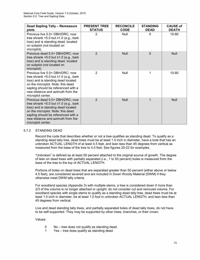
National Core Field Guide, Version 7.0,October, 2015 Section 5.0. Tree and Sapling Data
73
Dead Sapling Tally – Remeasure plots
PRESENT TREE STATUS
RECONCILE CODE
STANDING DEAD
CAUSE of DEATH
Previous live 5.0+ DBH/DRC; now tree shrank <5.0 but ≥1.0 (e.g., bark loss) and is standing dead, located on subplot (not located on microplot).
2 Null 0 10-80
Previous dead 5.0+ DBH/DRC; now tree shrank <5.0 but ≥1.0 (e.g., bark loss) and is standing dead, located on subplot (not located on microplot).
2 Null 0 Null
Previous live 5.0+ DBH/DRC; now tree shrank <5.0 but ≥1.0 (e.g., bark loss) and is standing dead located on the microplot. Note: this dead sapling should be referenced with a new distance and azimuth from the microplot center.
2 Null 1 10-80
Previous dead 5.0+ DBH/DRC; now tree shrank <5.0 but ≥1.0 (e.g., bark loss) and is standing dead located on the microplot. Note: this dead sapling should be referenced with a new distance and azimuth from the microplot center.
2 Null 1 Null
5.7.2 STANDING DEAD
Record the code that describes whether or not a tree qualifies as standing dead. To qualify as a standing dead tally tree, dead trees must be at least 1.0 inch in diameter, have a bole that has an unbroken ACTUAL LENGTH of at least 4.5 feet, and lean less than 45 degrees from vertical as measured from the base of the tree to 4.5 feet. See figures 20-22 for examples. “Unbroken” is defined as at least 50 percent attached to the original source of growth. The degree of lean on dead trees with partially separated (i.e., 1 to 50 percent) boles is measured from the base of the tree to the top of ACTUAL LENGTH. Portions of boles on dead trees that are separated greater than 50 percent (either above or below 4.5 feet), are considered severed and are included in Down Woody Material (DWM) if they otherwise meet DWM tally criteria. For woodland species (Appendix 3) with multiple stems, a tree is considered down if more than 2/3 of the volume is no longer attached or upright; do not consider cut and removed volume. For woodland species with single stems to qualify as a standing dead tally tree, dead trees must be at least 1.0 inch in diameter, be at least 1.0 foot in unbroken ACTUAL LENGTH, and lean less than 45 degrees from vertical.
Live and dead standing tally trees, and partially separated boles of dead tally trees, do not have
to be self-supported. They may be supported by other trees, branches, or their crown. Values:
0 No – tree does not qualify as standing dead. 1 Yes – tree does qualify as standing dead.
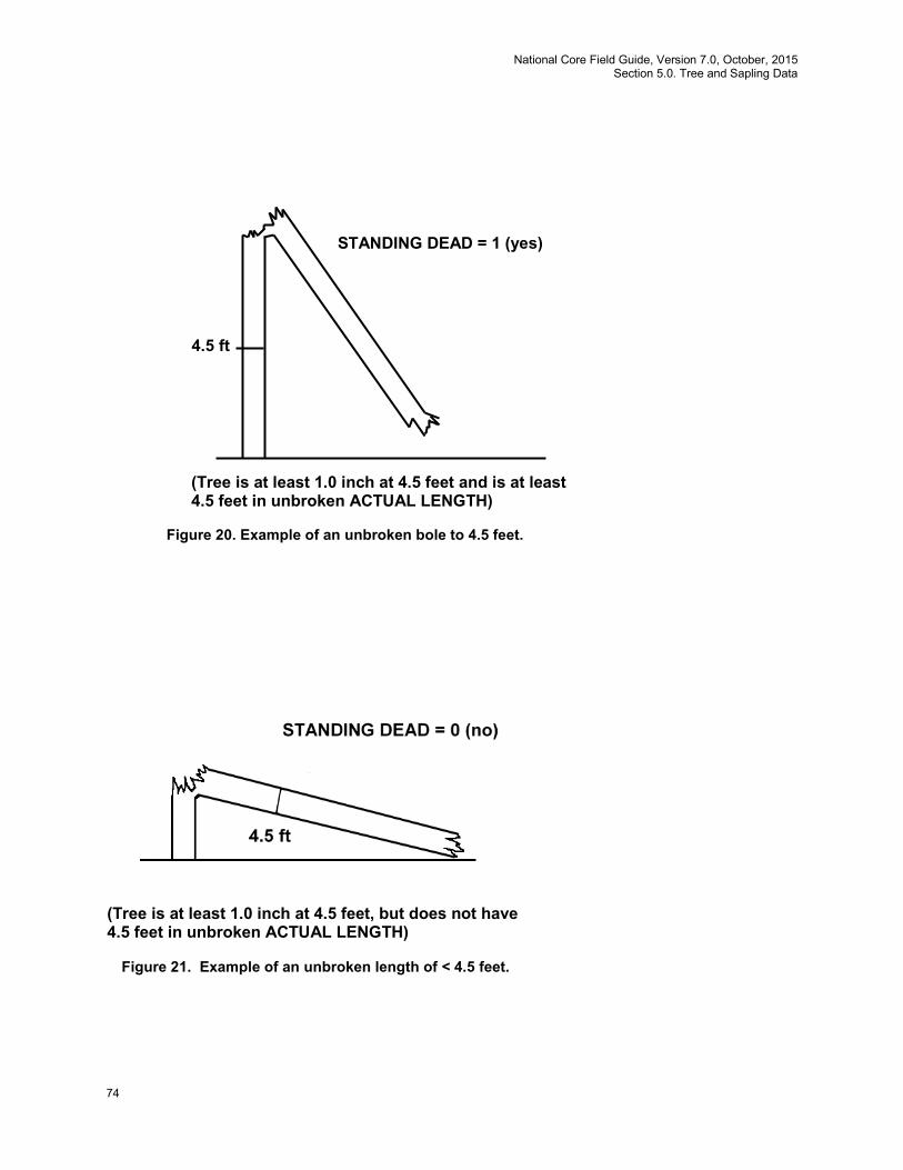
National Core Field Guide, Version 7.0, October, 2015 Section 5.0. Tree and Sapling Data
74
STANDING DEAD = 1 (yes)
4.5 ft
(Tree is at least 1.0 inch at 4.5 feet and is at least 4.5 feet in unbroken ACTUAL LENGTH)
Figure 20. Example of an unbroken bole to 4.5 feet.
(Tree is at least 1.0 inch at 4.5 feet, but does not have 4.5 feet in unbroken ACTUAL LENGTH)
Figure 21. Example of an unbroken length of < 4.5 feet.
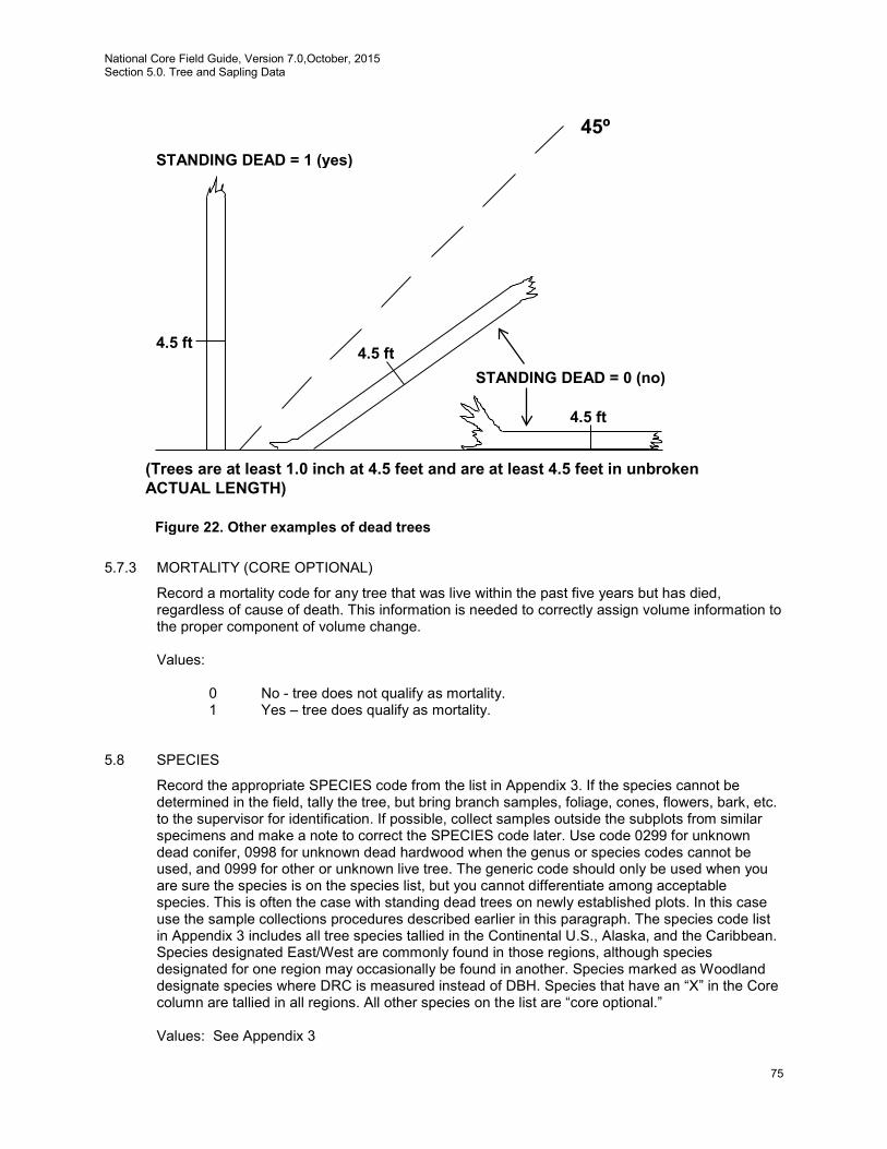
National Core Field Guide, Version 7.0,October, 2015 Section 5.0. Tree and Sapling Data
75
5.7.3 MORTALITY (CORE OPTIONAL)
Record a mortality code for any tree that was live within the past five years but has died, regardless of cause of death. This information is needed to correctly assign volume information to the proper component of volume change.
Values:
0 No - tree does not qualify as mortality. 1 Yes – tree does qualify as mortality.
5.8 SPECIES
Record the appropriate SPECIES code from the list in Appendix 3. If the species cannot be determined in the field, tally the tree, but bring branch samples, foliage, cones, flowers, bark, etc. to the supervisor for identification. If possible, collect samples outside the subplots from similar specimens and make a note to correct the SPECIES code later. Use code 0299 for unknown dead conifer, 0998 for unknown dead hardwood when the genus or species codes cannot be used, and 0999 for other or unknown live tree. The generic code should only be used when you are sure the species is on the species list, but you cannot differentiate among acceptable species. This is often the case with standing dead trees on newly established plots. In this case use the sample collections procedures described earlier in this paragraph. The species code list in Appendix 3 includes all tree species tallied in the Continental U.S., Alaska, and the Caribbean. Species designated East/West are commonly found in those regions, although species designated for one region may occasionally be found in another. Species marked as Woodland designate species where DRC is measured instead of DBH. Species that have an “X” in the Core column are tallied in all regions. All other species on the list are “core optional.” Values: See Appendix 3
Figure 22. Other examples of dead trees
4.5 ft
4.5 ft 4.5 ft
STANDING DEAD = 1 (yes)
STANDING DEAD = 0 (no)
45º
(Trees are at least 1.0 inch at 4.5 feet and are at least 4.5 feet in unbroken ACTUAL LENGTH)
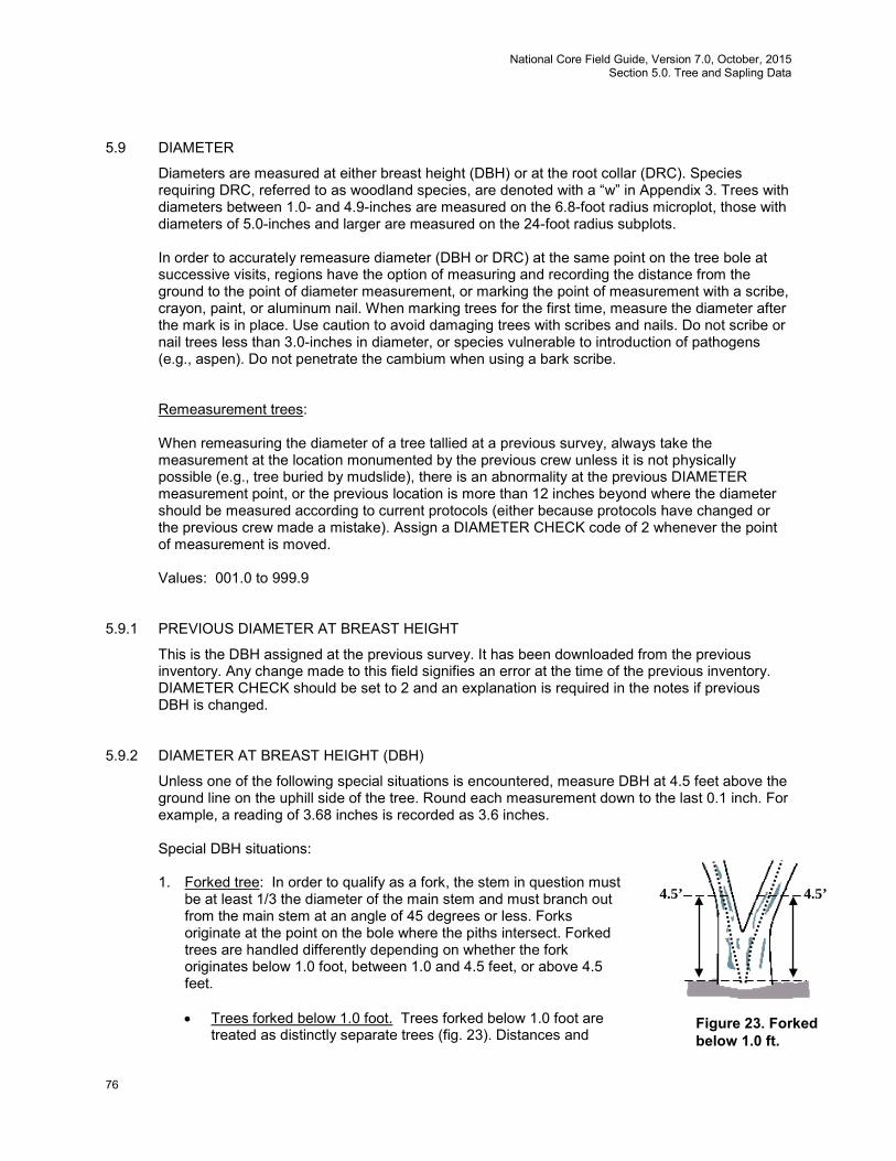
National Core Field Guide, Version 7.0, October, 2015 Section 5.0. Tree and Sapling Data
76
5.9 DIAMETER
Diameters are measured at either breast height (DBH) or at the root collar (DRC). Species requiring DRC, referred to as woodland species, are denoted with a “w” in Appendix 3. Trees with diameters between 1.0- and 4.9-inches are measured on the 6.8-foot radius microplot, those with diameters of 5.0-inches and larger are measured on the 24-foot radius subplots. In order to accurately remeasure diameter (DBH or DRC) at the same point on the tree bole at successive visits, regions have the option of measuring and recording the distance from the ground to the point of diameter measurement, or marking the point of measurement with a scribe, crayon, paint, or aluminum nail. When marking trees for the first time, measure the diameter after the mark is in place. Use caution to avoid damaging trees with scribes and nails. Do not scribe or nail trees less than 3.0-inches in diameter, or species vulnerable to introduction of pathogens (e.g., aspen). Do not penetrate the cambium when using a bark scribe.
Remeasurement trees:
When remeasuring the diameter of a tree tallied at a previous survey, always take the measurement at the location monumented by the previous crew unless it is not physically possible (e.g., tree buried by mudslide), there is an abnormality at the previous DIAMETER measurement point, or the previous location is more than 12 inches beyond where the diameter should be measured according to current protocols (either because protocols have changed or the previous crew made a mistake). Assign a DIAMETER CHECK code of 2 whenever the point of measurement is moved. Values: 001.0 to 999.9
5.9.1 PREVIOUS DIAMETER AT BREAST HEIGHT
This is the DBH assigned at the previous survey. It has been downloaded from the previous inventory. Any change made to this field signifies an error at the time of the previous inventory. DIAMETER CHECK should be set to 2 and an explanation is required in the notes if previous DBH is changed.
5.9.2 DIAMETER AT BREAST HEIGHT (DBH)
Unless one of the following special situations is encountered, measure DBH at 4.5 feet above the ground line on the uphill side of the tree. Round each measurement down to the last 0.1 inch. For example, a reading of 3.68 inches is recorded as 3.6 inches. Special DBH situations:
1. Forked tree: In order to qualify as a fork, the stem in question must
be at least 1/3 the diameter of the main stem and must branch out from the main stem at an angle of 45 degrees or less. Forks originate at the point on the bole where the piths intersect. Forked trees are handled differently depending on whether the fork originates below 1.0 foot, between 1.0 and 4.5 feet, or above 4.5 feet.
• Trees forked below 1.0 foot. Trees forked below 1.0 foot are
treated as distinctly separate trees (fig. 23). Distances and
4.5’ 4.5’
Figure 23. Forked below 1.0 ft.
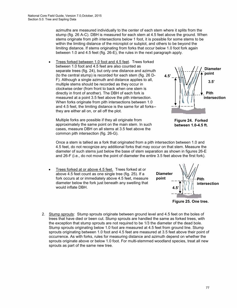
National Core Field Guide, Version 7.0,October, 2015 Section 5.0. Tree and Sapling Data
77
azimuths are measured individually to the center of each stem where it splits from the stump (fig. 26 A-C). DBH is measured for each stem at 4.5 feet above the ground. When stems originate from pith intersections below 1 foot, it is possible for some stems to be within the limiting distance of the microplot or subplot, and others to be beyond the limiting distance. If stems originating from forks that occur below 1.0 foot fork again between 1.0 and 4.5 feet (fig. 26-E), the rules in the next paragraph apply.
• Trees forked between 1.0 foot and 4.5 feet. Trees forked
between 1.0 foot and 4.5 feet are also counted as separate trees (fig. 24), but only one distance and azimuth (to the central stump) is recorded for each stem (fig. 26 D-F). Although a single azimuth and distance applies to all, multiple stems should be recorded as they occur in clockwise order (from front to back when one stem is directly in front of another). The DBH of each fork is measured at a point 3.5 feet above the pith intersection. When forks originate from pith intersections between 1.0 and 4.5 feet, the limiting distance is the same for all forks--they are either all on, or all off the plot.
Multiple forks are possible if they all originate from approximately the same point on the main stem. In such cases, measure DBH on all stems at 3.5 feet above the common pith intersection (fig. 26-G). Once a stem is tallied as a fork that originated from a pith intersection between 1.0 and 4.5 feet, do not recognize any additional forks that may occur on that stem. Measure the diameter of such stems just below the base of stem separation as shown in figures 26-E and 26-F (i.e., do not move the point of diameter the entire 3.5 feet above the first fork).
• Trees forked at or above 4.5 feet. Trees forked at or above 4.5 feet count as one single tree (fig. 25). If a fork occurs at or immediately above 4.5 feet, measure diameter below the fork just beneath any swelling that would inflate DBH.
2. Stump sprouts: Stump sprouts originate between ground level and 4.5 feet on the boles of trees that have died or been cut. Stump sprouts are handled the same as forked trees, with the exception that stump sprouts are not required to be 1/3 the diameter of the dead bole. Stump sprouts originating below 1.0 foot are measured at 4.5 feet from ground line. Stump sprouts originating between 1.0 foot and 4.5 feet are measured at 3.5 feet above their point of occurrence. As with forks, rules for measuring distance and azimuth depend on whether the sprouts originate above or below 1.0 foot. For multi-stemmed woodland species, treat all new sprouts as part of the same new tree.
4.5’ 3.5’
Diameter point
Pith intersection
Figure 24. Forked between 1.0-4.5 ft.
4.5’
Diameter point Pith
intersection
Figure 25. One tree.
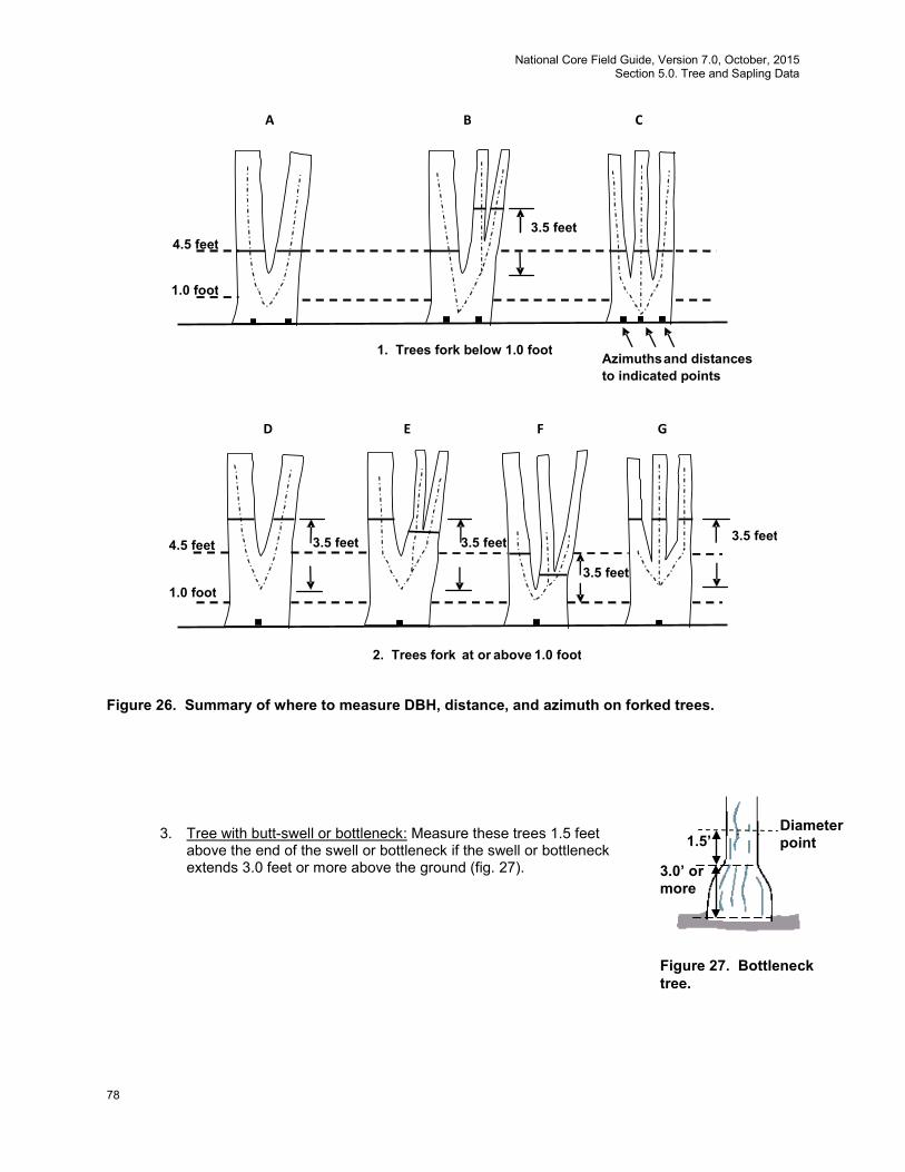
National Core Field Guide, Version 7.0, October, 2015 Section 5.0. Tree and Sapling Data
78
Figure 26. Summary of where to measure DBH, distance, and azimuth on forked trees.
3. Tree with butt-swell or bottleneck: Measure these trees 1.5 feet
above the end of the swell or bottleneck if the swell or bottleneck extends 3.0 feet or more above the ground (fig. 27).
2. Trees fork at or above 1.0 foot
1. Trees fork below 1.0 foot
4.5 feet
1.0 foot
3.5 feet
D
3.5 feet
E
3.5 feet
G F
3.5 feet
A
3.5 feet
B
Azimuths and distances to indicated points
C
1.0 foot
4.5 feet
3.0’ or more
Diameter point 1.5’
Figure 27. Bottleneck tree.
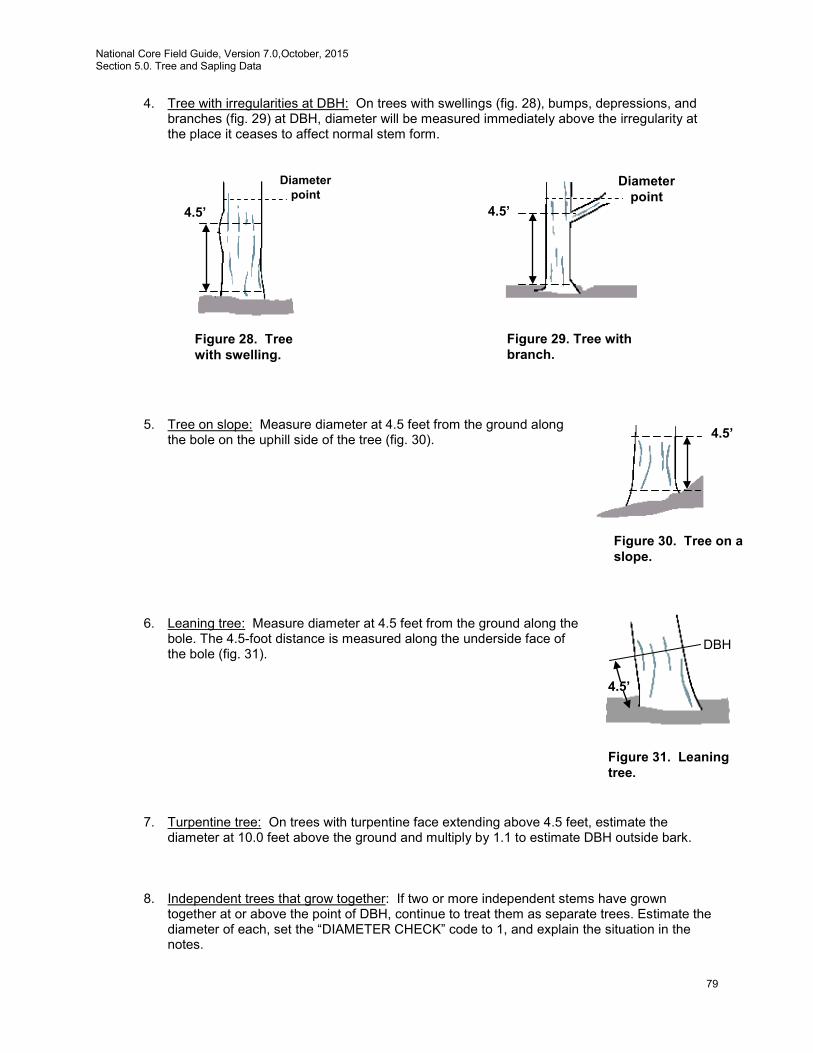
National Core Field Guide, Version 7.0,October, 2015 Section 5.0. Tree and Sapling Data
79
4. Tree with irregularities at DBH: On trees with swellings (fig. 28), bumps, depressions, and branches (fig. 29) at DBH, diameter will be measured immediately above the irregularity at the place it ceases to affect normal stem form.
5. Tree on slope: Measure diameter at 4.5 feet from the ground along
the bole on the uphill side of the tree (fig. 30). 6. Leaning tree: Measure diameter at 4.5 feet from the ground along the
bole. The 4.5-foot distance is measured along the underside face of the bole (fig. 31).
7. Turpentine tree: On trees with turpentine face extending above 4.5 feet, estimate the
diameter at 10.0 feet above the ground and multiply by 1.1 to estimate DBH outside bark. 8. Independent trees that grow together: If two or more independent stems have grown
together at or above the point of DBH, continue to treat them as separate trees. Estimate the diameter of each, set the “DIAMETER CHECK” code to 1, and explain the situation in the notes.
4.5’
Diameter point
Figure 28. Tree with swelling.
4.5’
Diameter point
Figure 29. Tree with branch.
4.5’
Figure 30. Tree on a slope.
Figure 31. Leaning tree.
DBH
4.5’
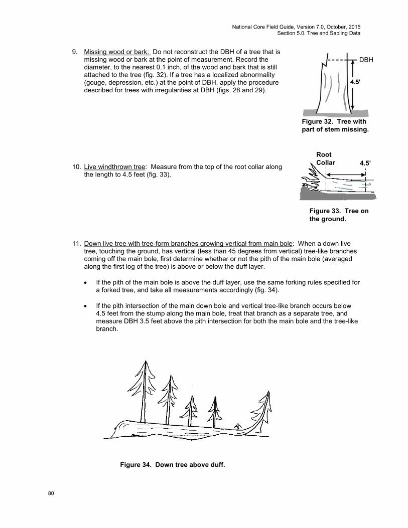
National Core Field Guide, Version 7.0, October, 2015 Section 5.0. Tree and Sapling Data
80
9. Missing wood or bark: Do not reconstruct the DBH of a tree that is missing wood or bark at the point of measurement. Record the diameter, to the nearest 0.1 inch, of the wood and bark that is still attached to the tree (fig. 32). If a tree has a localized abnormality (gouge, depression, etc.) at the point of DBH, apply the procedure described for trees with irregularities at DBH (figs. 28 and 29).
10. Live windthrown tree: Measure from the top of the root collar along
the length to 4.5 feet (fig. 33).
11. Down live tree with tree-form branches growing vertical from main bole: When a down live tree, touching the ground, has vertical (less than 45 degrees from vertical) tree-like branches coming off the main bole, first determine whether or not the pith of the main bole (averaged along the first log of the tree) is above or below the duff layer.
• If the pith of the main bole is above the duff layer, use the same forking rules specified for
a forked tree, and take all measurements accordingly (fig. 34). • If the pith intersection of the main down bole and vertical tree-like branch occurs below
4.5 feet from the stump along the main bole, treat that branch as a separate tree, and measure DBH 3.5 feet above the pith intersection for both the main bole and the tree-like branch.
Figure 34. Down tree above duff.
4.5’ Root Collar
Figure 33. Tree on the ground.
Figure 32. Tree with part of stem missing.
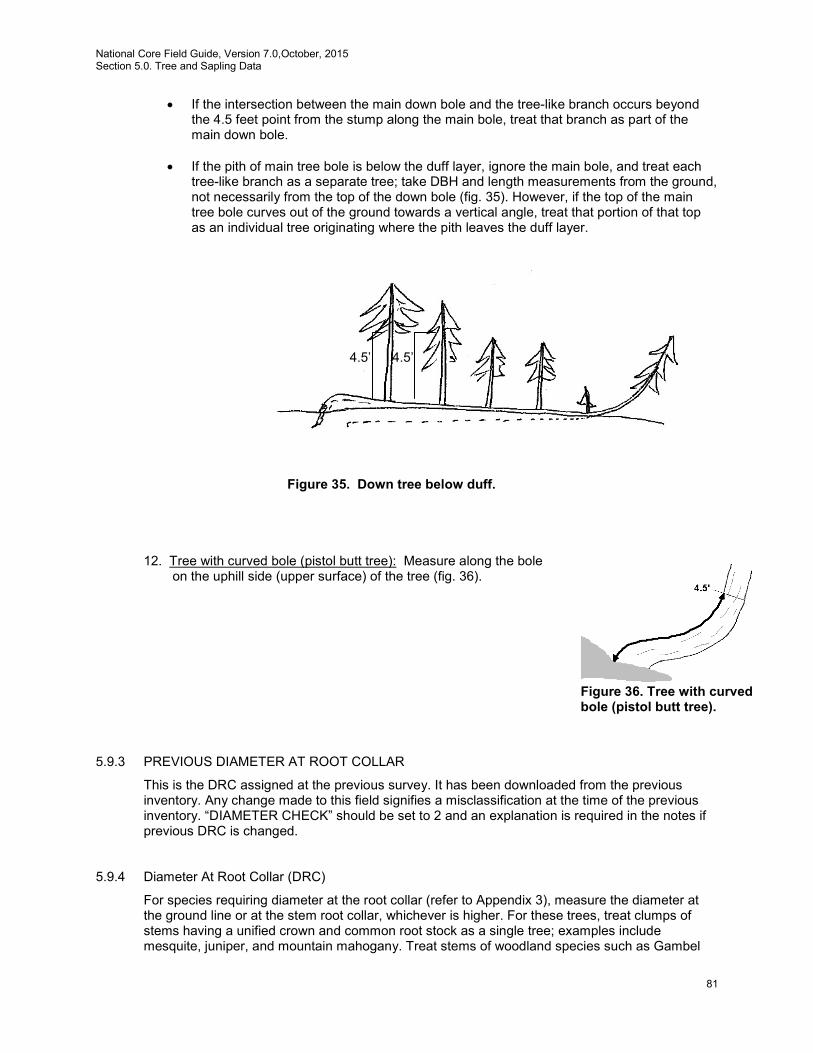
National Core Field Guide, Version 7.0,October, 2015 Section 5.0. Tree and Sapling Data
81
• If the intersection between the main down bole and the tree-like branch occurs beyond the 4.5 feet point from the stump along the main bole, treat that branch as part of the main down bole.
• If the pith of main tree bole is below the duff layer, ignore the main bole, and treat each tree-like branch as a separate tree; take DBH and length measurements from the ground, not necessarily from the top of the down bole (fig. 35). However, if the top of the main tree bole curves out of the ground towards a vertical angle, treat that portion of that top as an individual tree originating where the pith leaves the duff layer.
Figure 35. Down tree below duff.
12. Tree with curved bole (pistol butt tree): Measure along the bole
on the uphill side (upper surface) of the tree (fig. 36).
5.9.3 PREVIOUS DIAMETER AT ROOT COLLAR
This is the DRC assigned at the previous survey. It has been downloaded from the previous inventory. Any change made to this field signifies a misclassification at the time of the previous inventory. “DIAMETER CHECK” should be set to 2 and an explanation is required in the notes if previous DRC is changed.
5.9.4 Diameter At Root Collar (DRC)
For species requiring diameter at the root collar (refer to Appendix 3), measure the diameter at the ground line or at the stem root collar, whichever is higher. For these trees, treat clumps of stems having a unified crown and common root stock as a single tree; examples include mesquite, juniper, and mountain mahogany. Treat stems of woodland species such as Gambel
4.5’ 4.5’
Figure 36. Tree with curved bole (pistol butt tree).

National Core Field Guide, Version 7.0, October, 2015 Section 5.0. Tree and Sapling Data
82
oak and bigtooth maple as individual trees if they originate below the ground. For woodland trees, record DRC STEM DIAMETER and DRC STEM STATUS (described below). Then compute and record the DRC value from the individual stem diameter information. Measuring woodland stem diameters: Before measuring DRC, remove the loose material on the ground (e.g., litter) but not mineral soil. Measure just above any swells present, and in a location so that the diameter measurements are a good representation of the volume in the stems (especially when trees are extremely deformed at the base). Stems must be at least 1 foot in length and at least 1.0 inch in diameter 1 foot up from the stem diameter measurement point to qualify for measurement. Whenever DRC is impossible or extremely difficult to measure with a diameter tape (e.g., due to thorns, extreme number of limbs), stems may be estimated and recorded to the nearest 1.0-inch class. Additional instructions for DRC measurements are illustrated in figure 38. For each qualifying stem of the woodland tree, measure and record DRC STEM DIAMETER (5.9.4.1) and indicate the DRC STEM STATUS (5.9.4.2).
Computing and Recording DRC: For all tally trees requiring DRC, with at least one stem 1 foot in length and at least 1.0 inch in diameter 1 foot up from the stem diameter measurement point, DRC is computed as the square root of the sum of the squared stem diameters. For a single-stemmed DRC tree, the computed DRC is equal to the single diameter measured.
Use the following formula to compute DRC:
DRC = SQRT [SUM (stem diameter2)]
Round the result to the nearest 0.1 inch. For example, a multi-stemmed woodland tree with stems of 12.2, 13.2, 3.8, and 22.1 would be calculated as:
DRC = SQRT (12.22 + 13.22 + 3.82 + 22.12)
= SQRT (825.93) = 28.74 = 28.7
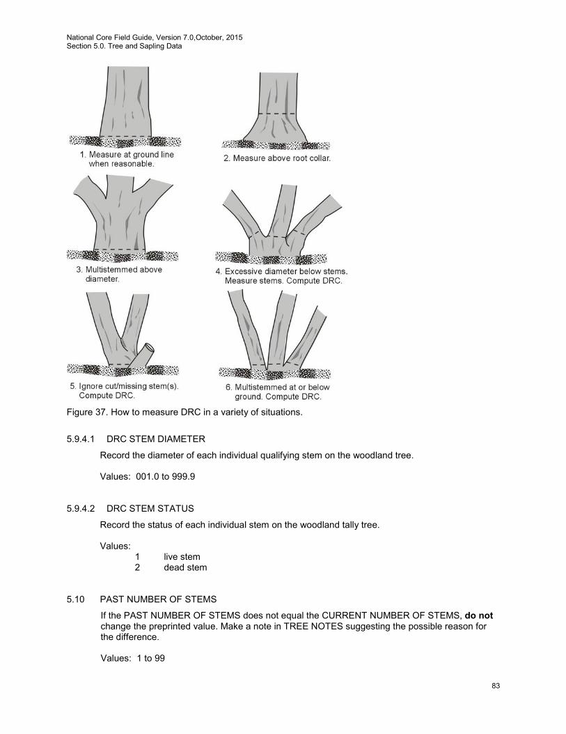
National Core Field Guide, Version 7.0,October, 2015 Section 5.0. Tree and Sapling Data
83
Figure 37. How to measure DRC in a variety of situations.
5.9.4.1 DRC STEM DIAMETER
Record the diameter of each individual qualifying stem on the woodland tree. Values: 001.0 to 999.9 5.9.4.2 DRC STEM STATUS
Record the status of each individual stem on the woodland tally tree. Values:
1 live stem 2 dead stem
5.10 PAST NUMBER OF STEMS
If the PAST NUMBER OF STEMS does not equal the CURRENT NUMBER OF STEMS, do not change the preprinted value. Make a note in TREE NOTES suggesting the possible reason for the difference.
Values: 1 to 99
National Core Field Guide, Version 7.0, October, 2015 Section 5.0. Tree and Sapling Data
84
5.11 CURRENT NUMBER OF STEMS
Record the total number of stems that were measured for DRC (e.g., record 1 stem as 01; record 12 stems as 12). Count only the number of qualifying stems used to calculate DRC. Qualifying stems are those that are at least 1.0 foot in length and at least 1.0 inch in diameter, 1 foot up from the measurement point.
Values: 1 to 99
5.12 DIAMETER CHECK
Record this code to identify the accuracy of the diameter measurement (due to factors such as abnormal swellings, diseases, damage, new measurement positions, etc.) that may affect use of this tree in diameter growth/change analyses.
Values:
0 Diameter measured accurately. 1 Diameter estimated. 2 Diameter measured at different location than previous measurement (remeasurement trees only).
Note: If both codes 1 and 2 apply, use code 2. Note: If either code 1 or code 2 is used, a tree-level note is required. 5.13 ROTTEN/MISSING CULL
Record the percent rotten or missing cubic-foot cull for all live tally trees greater than or equal to 5.0 inches DBH/DRC (CORE) and all standing dead tally trees greater than or equal to 5.0 inches DBH/DRC (CORE OPTIONAL).
Record the percentage of rotten and missing cubic-foot volume, to the nearest 1 percent. When estimating volume loss (tree cull), only consider the cull on the merchantable bole/portion of the tree, from a 1-foot stump to a 4-inch DOB top. Do not include any cull estimate above ACTUAL LENGTH. For woodland species, the merchantable portion is between the point of DRC measurement to a 1.5-inch DOB top.
Rotten and missing volume loss is often difficult to estimate. Refer to supplemental disease and insect pests field guides and local defect guidelines as an aid in identifying damaging agents and their impact on volume loss. Use your best judgment and be alert to such defect indicators as the following:
• Cankers or fruiting bodies. • Swollen or punky knots. • Dull, hollow sound of bole (use regional standards). • Large dead limbs, especially those with frayed ends. • Sawdust around the base of the tree. • Metal imbedded in the wood.
Values: 00 to 99

National Core Field Guide, Version 7.0,October, 2015 Section 5.0. Tree and Sapling Data
85
5.14 TOTAL LENGTH
Record the TOTAL LENGTH of the tree, to the nearest 1.0 foot from ground level to the top of the tree. For trees growing on a slope, measure on the uphill side of the tree. If the tree has a missing top (top is broken and completely detached from the tree), estimate what the total length would be if there were no missing top. Forked trees should be treated the same as unforked trees.
Values: 001 to 400
5.15 ACTUAL LENGTH
Record for trees with missing tops (top on live trees is completely detached; top on dead trees is greater than 50 percent detached from the tree). If the top is intact, this item may be omitted. Record the ACTUAL LENGTH of the tree to the nearest 1.0 foot from ground level to the break. Use the length to the break for ACTUAL LENGTH until a new leader qualifies as the new top for TOTAL LENGTH; until that occurs, continue to record ACTUAL LENGTH to the break. Trees with previously broken tops are considered recovered (i.e., ACTUAL LENGTH = TOTAL LENGTH) when a new leader (dead or alive) is 1/3 the diameter of the broken top at the point where the top was broken (not where the new leader originates from the trunk). Forked trees should be treated the same as unforked trees.
Note: Some regions will measure ACTUAL LENGTH differently due to growth form. Some examples are swamp tupelo, cypress, and trees growing off of old high stumps with stilted roots in the West. Check regional field guides for regional guidance. Values: 001 to 400
5.16 LENGTH METHOD
Record the code that indicates the method used to determine tree lengths.
Values:
1 Total and actual lengths are field measured with a measurement instrument (e.g., clinometer, relascope, tape).
2 Total length is visually estimated, actual length is measured with an instrument. 3 Total and actual lengths are visually estimated.
5.17 CROWN CLASS
Rate tree crowns in relation to the sunlight received and proximity to neighboring trees (fig. 38). Base the assessment on the position of the crown at the time of observation. Example: a formerly overtopped tree that is now dominant due to tree removal is classified as dominant.
Values:
1 Open Grown – trees with crowns that received full light from above and from all
sides throughout most of its life, particularly during its early developmental period.
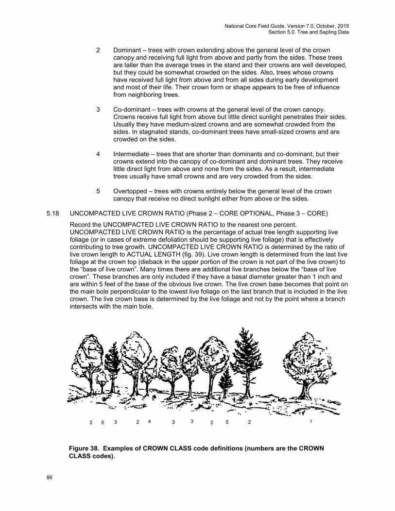
National Core Field Guide, Version 7.0, October, 2015 Section 5.0. Tree and Sapling Data
86
2 Dominant – trees with crown extending above the general level of the crown canopy and receiving full light from above and partly from the sides. These trees are taller than the average trees in the stand and their crowns are well developed, but they could be somewhat crowded on the sides. Also, trees whose crowns have received full light from above and from all sides during early development and most of their life. Their crown form or shape appears to be free of influence from neighboring trees.
3 Co-dominant – trees with crowns at the general level of the crown canopy. Crowns receive full light from above but little direct sunlight penetrates their sides. Usually they have medium-sized crowns and are somewhat crowded from the sides. In stagnated stands, co-dominant trees have small-sized crowns and are crowded on the sides.
4 Intermediate – trees that are shorter than dominants and co-dominant, but their crowns extend into the canopy of co-dominant and dominant trees. They receive little direct light from above and none from the sides. As a result, intermediate trees usually have small crowns and are very crowded from the sides.
5 Overtopped – trees with crowns entirely below the general level of the crown canopy that receive no direct sunlight either from above or the sides.
5.18 UNCOMPACTED LIVE CROWN RATIO (Phase 2 – CORE OPTIONAL, Phase 3 – CORE)
Record the UNCOMPACTED LIVE CROWN RATIO to the nearest one percent. UNCOMPACTED LIVE CROWN RATIO is the percentage of actual tree length supporting live foliage (or in cases of extreme defoliation should be supporting live foliage) that is effectively contributing to tree growth. UNCOMPACTED LIVE CROWN RATIO is determined by the ratio of live crown length to ACTUAL LENGTH (fig. 39). Live crown length is determined from the last live foliage at the crown top (dieback in the upper portion of the crown is not part of the live crown) to the “base of live crown”. Many times there are additional live branches below the “base of live crown”. These branches are only included if they have a basal diameter greater than 1 inch and are within 5 feet of the base of the obvious live crown. The live crown base becomes that point on the main bole perpendicular to the lowest live foliage on the last branch that is included in the live crown. The live crown base is determined by the live foliage and not by the point where a branch intersects with the main bole.
Figure 38. Examples of CROWN CLASS code definitions (numbers are the CROWN CLASS codes).
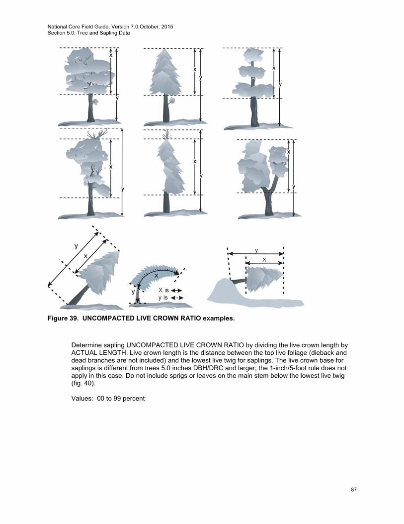
National Core Field Guide, Version 7.0,October, 2015 Section 5.0. Tree and Sapling Data
87
Figure 39. UNCOMPACTED LIVE CROWN RATIO examples.
Determine sapling UNCOMPACTED LIVE CROWN RATIO by dividing the live crown length by ACTUAL LENGTH. Live crown length is the distance between the top live foliage (dieback and dead branches are not included) and the lowest live twig for saplings. The live crown base for saplings is different from trees 5.0 inches DBH/DRC and larger; the 1-inch/5-foot rule does not apply in this case. Do not include sprigs or leaves on the main stem below the lowest live twig (fig. 40).
Values: 00 to 99 percent
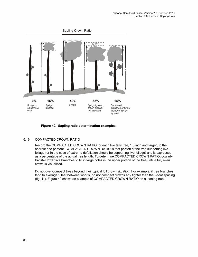
National Core Field Guide, Version 7.0, October, 2015 Section 5.0. Tree and Sapling Data
88
5.19 COMPACTED CROWN RATIO
Record the COMPACTED CROWN RATIO for each live tally tree, 1.0 inch and larger, to the nearest one percent. COMPACTED CROWN RATIO is that portion of the tree supporting live foliage (or in the case of extreme defoliation should be supporting live foliage) and is expressed as a percentage of the actual tree length. To determine COMPACTED CROWN RATIO, ocularly transfer lower live branches to fill in large holes in the upper portion of the tree until a full, even crown is visualized.
Do not over-compact trees beyond their typical full crown situation. For example, if tree branches tend to average 2 feet between whorls, do not compact crowns any tighter than the 2-foot spacing (fig. 41). Figure 42 shows an example of COMPACTED CROWN RATIO on a leaning tree.
Figure 40. Sapling ratio determination examples.
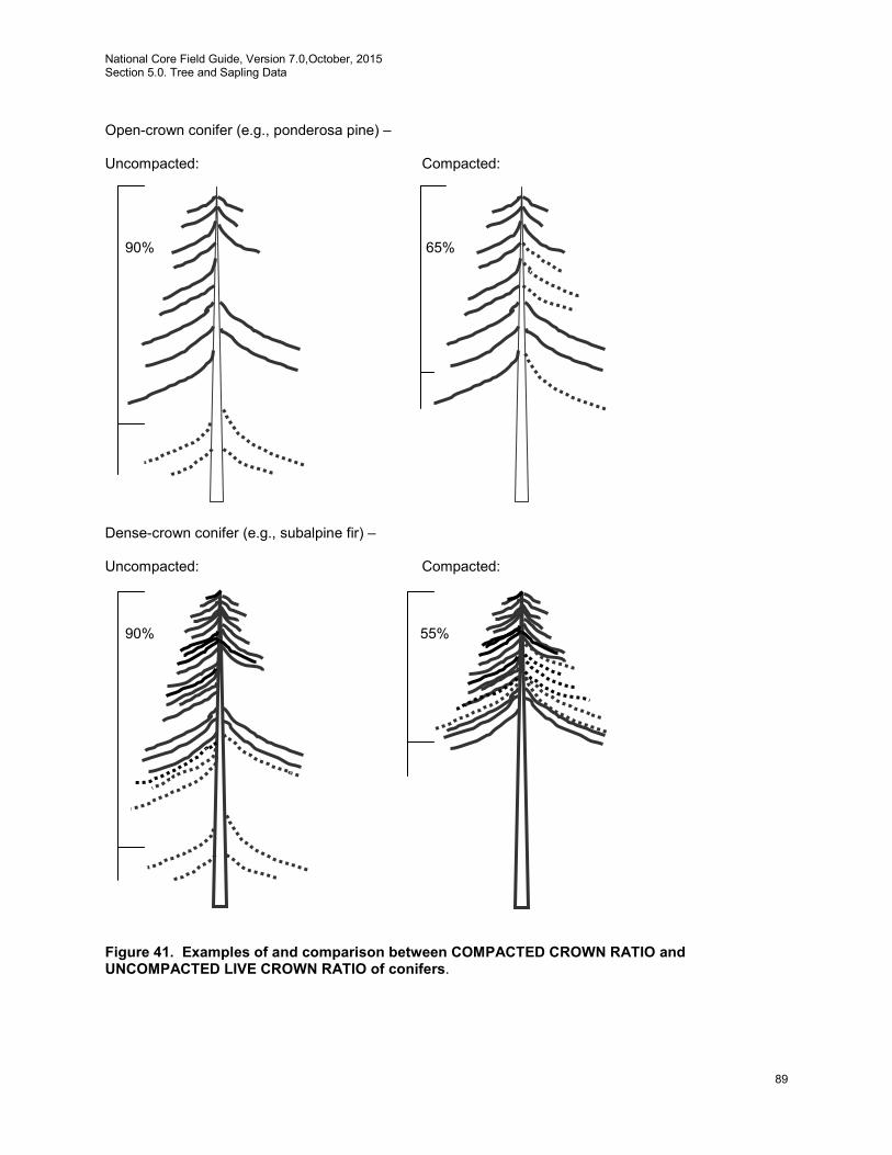
National Core Field Guide, Version 7.0,October, 2015 Section 5.0. Tree and Sapling Data
89
Open-crown conifer (e.g., ponderosa pine) – Uncompacted: Compacted: 90% 65% Dense-crown conifer (e.g., subalpine fir) – Uncompacted: Compacted: 90% 55% Figure 41. Examples of and comparison between COMPACTED CROWN RATIO and UNCOMPACTED LIVE CROWN RATIO of conifers.
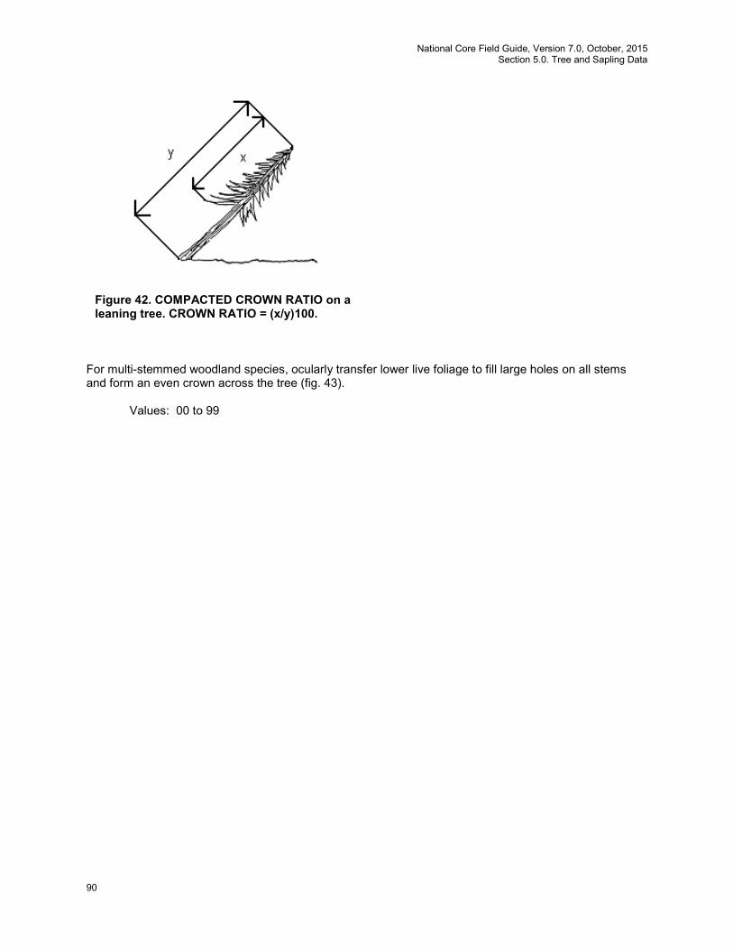
National Core Field Guide, Version 7.0, October, 2015 Section 5.0. Tree and Sapling Data
90
For multi-stemmed woodland species, ocularly transfer lower live foliage to fill large holes on all stems and form an even crown across the tree (fig. 43).
Values: 00 to 99
Figure 42. COMPACTED CROWN RATIO on a leaning tree. CROWN RATIO = (x/y)100.

National Core Field Guide, Version 7.0,October, 2015 Section 5.0. Tree and Sapling Data
91
Uncompacted: Compacted: 35% 80% Uncompacted: Compacted: 28% 76% Uncompacted: Compacted: 20% 30%
Figure 43. Examples of and comparison between COMPACTED CROWN RATIO and UNCOMPACTED LIVE CROWN RATIO of woodland species.
5.20 Tree Damage (CORE)
Damage is a composite variable. Up to three damaging agents may be recorded per tree. Many damaging agents are host specific and their potential for damage could vary by region. In general, a recorded damage is likely to:
National Core Field Guide, Version 7.0, October, 2015 Section 5.0. Tree and Sapling Data
92
1. Prevent the tree from surviving more than 1-2 years 2. Reduce the growth of the tree in the near term 3. Negatively affect a tree’s marketable products (cubic, BF, or other)
It is not necessary to record damage agents in order of their severity unless there are more than three agents. If there are more than three agents, record only the most important ones using the list of impacts above as a guide (i.e., agents threatening survival are more important than agents that reduce wood quality). In general, agents that affect the roots or bole tend to be most threatening, because they have the capacity to affect the entire tree; damage to peripheral parts of the tree may be temporary because leaves, shoots, and reproductive structures may be replaced. Codes used for this variable come from a January 2012 Pest Trend Impact Plot System, (PTIPS) list from the Forest Health Technology Enterprise Team (FHTET) that has been modified to meet FIA needs. This list is made up of General Agents and then further subdivided into specific agents. Not every General Agent PTIPS code will be available for use for this variable; some do not cause tree damage as defined above while others are better recorded in a different General Agent. Not every specific agent PTIPS code will be available for use for this variable. Regions will decide which specific agents they will identify in their areas. Record the general agent unless the Region opts to collect specific agents. Specific agents can later be collapsed into the general agent categories for cross-region comparisons. In the unusual instance when more than one specific agent in the same general category occurs on the same tree, record them both. If a specific agent is identified on that plot but that agent is not on the regionally recognized list of codes for damage agents, use its General Agent code. Appendix 11 contains the regionally recognized list of codes for damage agent based on the modified PTIPS list from FHTET. Only the specific agent codes from appendix 11 may be used instead of the general codes listed under DAMAGE AGENT 1. Any damage code in appendix 11 may be used for DAMAGE AGENT 1, DAMAGE AGENT 2, or DAMAGE AGENT 3 5.20.1 DAMAGE AGENT 1
Inspect the tree from bottom to top – roots, bole, branches, foliage (including buds and shoots), Record the first damage agent observed from the list of agents (unless you observe more than 3 damages). If there are more than three agents, record only the most important ones using the list of impacts listed in section 5.20 as a guide (i.e., agents threatening survival are more important than agents that reduce wood quality). The general agent codes, damage thresholds, and general agent descriptions are listed here. Specific agents within the general categories, if required by your Region, are listed in appendix 11, along with their associated thresholds. These codes can be collapsed into the national core general codes. Note: in some cases, thresholds for specific agents may be different from the threshold for the corresponding general agent. If a region is collecting a specific insect agent and no one is collecting the general agent, then the specific insect agent is collapsed into the general insect category 10000. Values: General Agent Damage Codes, Damage Thresholds, and Descriptions. Specific agent codes are in appendix 11.
Code General Agent Damage Threshold* Descriptions
0 No damage

National Core Field Guide, Version 7.0,October, 2015 Section 5.0. Tree and Sapling Data
93
Code General Agent Damage Threshold* Descriptions
10000 General insects Any damage to the terminal leader; damage >20% of the roots or boles with >20% of the circumference affected; damage >20% of the multiple-stems (on multi-stemmed woodland species) with >20% of the circumference affected; >20% of the branches affected; damage ≥20% of the foliage with ≥50% of the leaf/needle affected.
Insect damage that cannot be placed in any of the following insect categories.
11000 Bark beetles Any evidence of a successful attack (successful attacks generally exhibit boring dust, many pitch tubes and/or fading crowns).
Bark beetles (Dendroctonus, Ips, and other genera) are phloem-feeding insects that bore through the bark and create extensive galleries between the bark and the wood. Symptoms of beetle damage include fading or discolored tree crown (yellow or red), pitch tubes or pitch streaks on the bark, extensive egg galleries in the phloem, boring dust in the bark crevices or at the base of the tree. Bark chipping by woodpeckers may be conspicuous. They inflict damage or destroy all parts of trees at all stages of growth by boring in the bark, inner bark, and phloem. Visible signs of attack include pitch tubes or large pitch masses on the tree, dust and frass on the bark and ground, and resin streaming. Internal tunneling has various patterns. Most have tunnels of uniform width with smaller galleries of variable width radiating from them. Galleries may or may not be packed with fine boring dust.
12000 Defoliators Any damage to the terminal leader; damage ≥20% of the foliage with ≥50% of the leaf/needle affected.
These are foliage-feeding insects that may reduce growth and weaken the tree causing it to be more susceptible to other damaging agents. General symptoms of defoliation damage include large amounts of missing foliage, browning foliage, extensive branch mortality, or dead tree tops.
13000 Chewing insects Note: this is only collected by IW and SRS
Any damage to the terminal leader; damage ≥20% of the foliage with ≥50% of the leaf/needle affected
Insects, like grasshoppers and cicadas that chew on trees (those insects not covered by defoliators in code 12000).
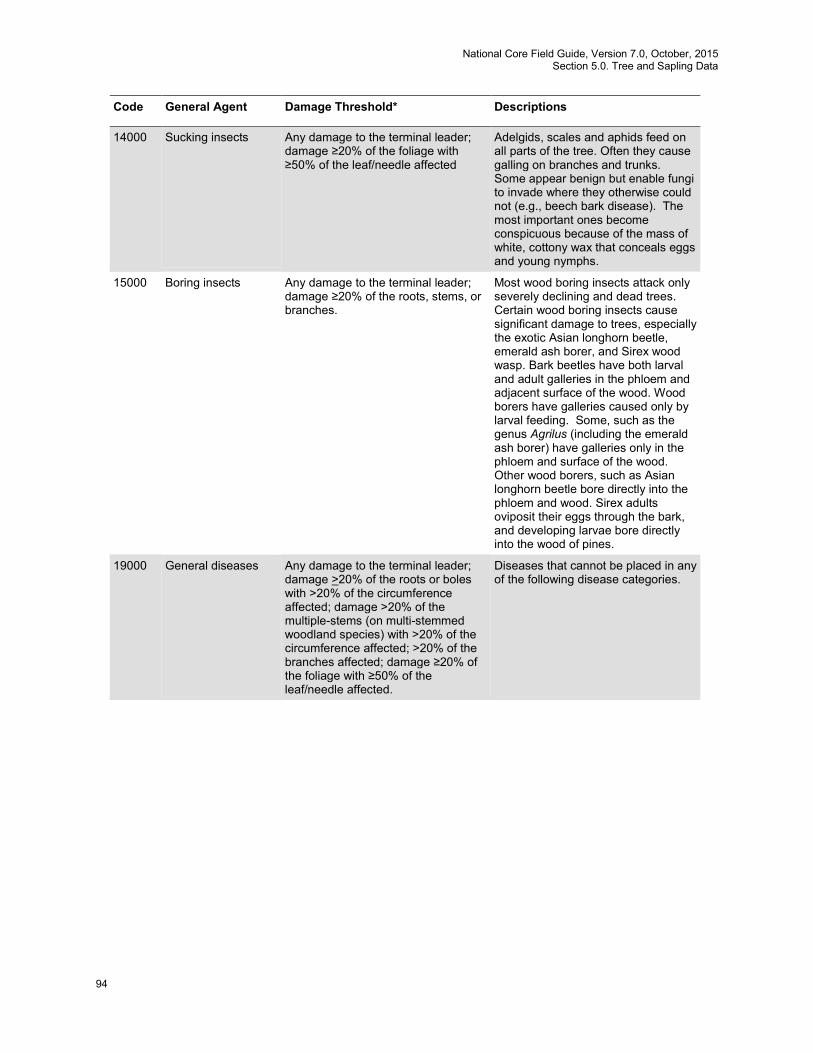
National Core Field Guide, Version 7.0, October, 2015 Section 5.0. Tree and Sapling Data
94
Code General Agent Damage Threshold* Descriptions
14000 Sucking insects Any damage to the terminal leader; damage ≥20% of the foliage with ≥50% of the leaf/needle affected
Adelgids, scales and aphids feed on all parts of the tree. Often they cause galling on branches and trunks. Some appear benign but enable fungi to invade where they otherwise could not (e.g., beech bark disease). The most important ones become conspicuous because of the mass of white, cottony wax that conceals eggs and young nymphs.
15000 Boring insects Any damage to the terminal leader; damage ≥20% of the roots, stems, or branches.
Most wood boring insects attack only severely declining and dead trees. Certain wood boring insects cause significant damage to trees, especially the exotic Asian longhorn beetle, emerald ash borer, and Sirex wood wasp. Bark beetles have both larval and adult galleries in the phloem and adjacent surface of the wood. Wood borers have galleries caused only by larval feeding. Some, such as the genus Agrilus (including the emerald ash borer) have galleries only in the phloem and surface of the wood. Other wood borers, such as Asian longhorn beetle bore directly into the phloem and wood. Sirex adults oviposit their eggs through the bark, and developing larvae bore directly into the wood of pines.
19000 General diseases Any damage to the terminal leader; damage >20% of the roots or boles with >20% of the circumference affected; damage >20% of the multiple-stems (on multi-stemmed woodland species) with >20% of the circumference affected; >20% of the branches affected; damage ≥20% of the foliage with ≥50% of the leaf/needle affected.
Diseases that cannot be placed in any of the following disease categories.

National Core Field Guide, Version 7.0,October, 2015 Section 5.0. Tree and Sapling Data
95
Code General Agent Damage Threshold* Descriptions
21000 Root/butt diseases Any occurrence. Root disease kills all or a portion of a tree’s roots. Quite often, the pathogenic fungus girdles the tree at the root collar. Tree damage includes mortality (often occurring in groups or “centers”), reduced tree growth, and increased susceptibility to other agents (especially bark beetles). General symptoms include resin at the root collar, thin, chlorotic (faded) foliage, and decay of roots. A rot is a wood decay caused by fungi. Rots are characterized by a progression of symptoms in the affected wood. First, the wood stains and discolors, then it begins to lose its structural strength, and finally the wood starts to break down, forming cavities in the stem. Even early stages of wood decay can cause cull due to losses in wood strength and staining of the wood. Rot can lead to mortality, cull, an increased susceptibility to other agents (such as insects), wind throw, and stem breakage.
22000 Cankers (non-rust) Any occurrence. A canker -- a sunken lesion on the stem caused by the death of cambium -- may cause tree breakage or kill the portion of the tree above the canker. Cankers may be caused by various agents but are most often caused by fungi. A necrotic lesion begins in the bark of branches, trunk or roots, and progresses inward killing the cambium and underlying cells. The causal agent may or may not penetrate the wood. This results in areas of dead tissue that become deeper and wider. There are two types of cankers, annual and perennial. Annual cankers enlarge only once and do so within an interval briefer than the growth cycle of the tree, usually less than one year. Little or no callus is associated with annual cankers, and they may be difficult to distinguish from mechanical injuries. Perennial cankers are usually the more serious of the two, and grow from year to year with callus forming each year on the canker margin, often resulting in a target shape. The most serious non-rust cankers occur on hardwoods, although branch mortality often occurs on conifers.
22500 Stem decays Any visual evidence (conks; fruiting bodies; rotten wood)
Rot occurring in the bole/stems of trees above the roots and stump.
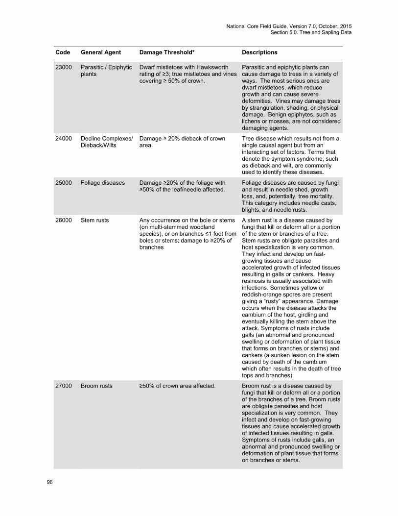
National Core Field Guide, Version 7.0, October, 2015 Section 5.0. Tree and Sapling Data
96
Code General Agent Damage Threshold* Descriptions
23000 Parasitic / Epiphytic plants
Dwarf mistletoes with Hawksworth rating of ≥3; true mistletoes and vines covering ≥ 50% of crown.
Parasitic and epiphytic plants can cause damage to trees in a variety of ways. The most serious ones are dwarf mistletoes, which reduce growth and can cause severe deformities. Vines may damage trees by strangulation, shading, or physical damage. Benign epiphytes, such as lichens or mosses, are not considered damaging agents.
24000 Decline Complexes/ Dieback/Wilts
Damage ≥ 20% dieback of crown area.
Tree disease which results not from a single causal agent but from an interacting set of factors. Terms that denote the symptom syndrome, such as dieback and wilt, are commonly used to identify these diseases.
25000 Foliage diseases Damage ≥20% of the foliage with ≥50% of the leaf/needle affected.
Foliage diseases are caused by fungi and result in needle shed, growth loss, and, potentially, tree mortality. This category includes needle casts, blights, and needle rusts.
26000 Stem rusts Any occurrence on the bole or stems (on multi-stemmed woodland species), or on branches ≤1 foot from boles or stems; damage to ≥20% of branches
A stem rust is a disease caused by fungi that kill or deform all or a portion of the stem or branches of a tree. Stem rusts are obligate parasites and host specialization is very common. They infect and develop on fast-growing tissues and cause accelerated growth of infected tissues resulting in galls or cankers. Heavy resinosis is usually associated with infections. Sometimes yellow or reddish-orange spores are present giving a “rusty” appearance. Damage occurs when the disease attacks the cambium of the host, girdling and eventually killing the stem above the attack. Symptoms of rusts include galls (an abnormal and pronounced swelling or deformation of plant tissue that forms on branches or stems) and cankers (a sunken lesion on the stem caused by death of the cambium which often results in the death of tree tops and branches).
27000 Broom rusts ≥50% of crown area affected. Broom rust is a disease caused by fungi that kill or deform all or a portion of the branches of a tree. Broom rusts are obligate parasites and host specialization is very common. They infect and develop on fast-growing tissues and cause accelerated growth of infected tissues resulting in galls. Symptoms of rusts include galls, an abnormal and pronounced swelling or deformation of plant tissue that forms on branches or stems.
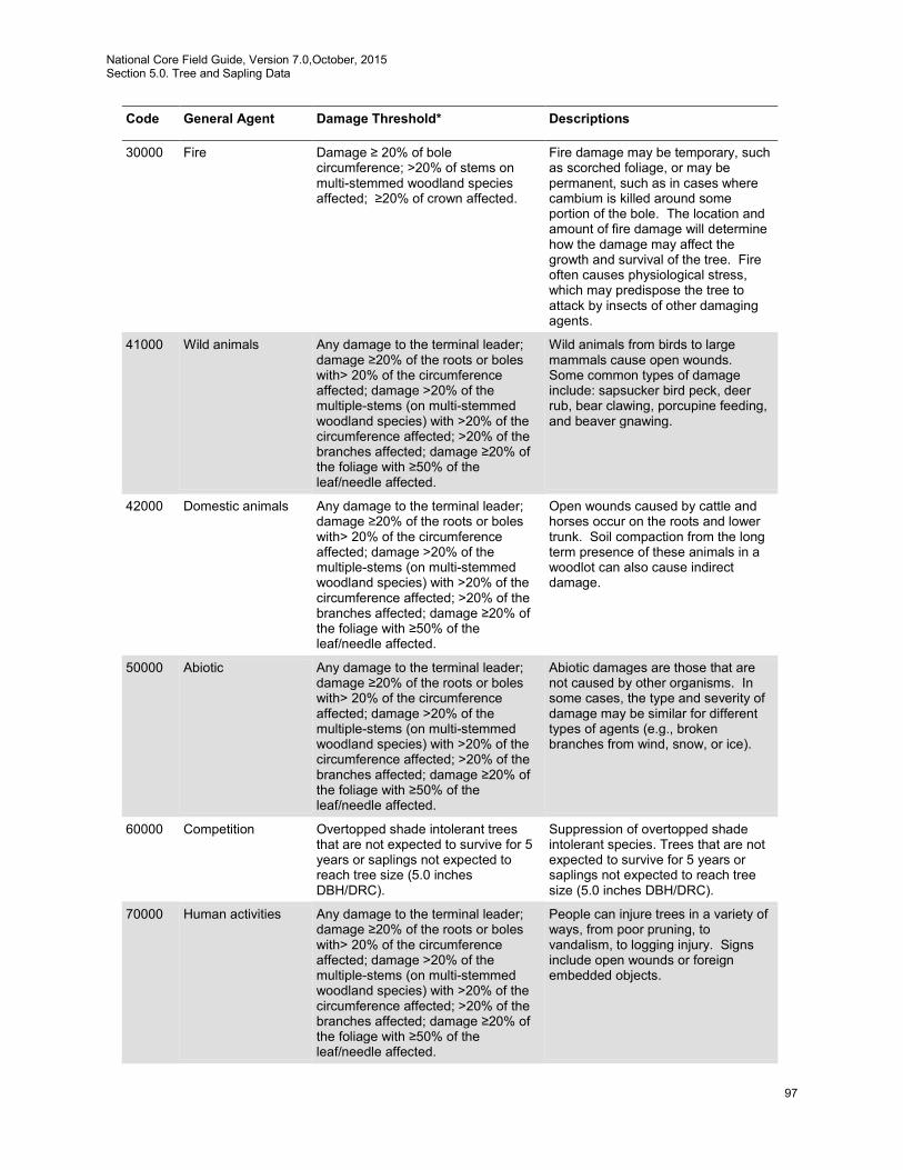
National Core Field Guide, Version 7.0,October, 2015 Section 5.0. Tree and Sapling Data
97
Code General Agent Damage Threshold* Descriptions
30000 Fire Damage ≥ 20% of bole circumference; >20% of stems on multi-stemmed woodland species affected; ≥20% of crown affected.
Fire damage may be temporary, such as scorched foliage, or may be permanent, such as in cases where cambium is killed around some portion of the bole. The location and amount of fire damage will determine how the damage may affect the growth and survival of the tree. Fire often causes physiological stress, which may predispose the tree to attack by insects of other damaging agents.
41000 Wild animals Any damage to the terminal leader; damage ≥20% of the roots or boles with> 20% of the circumference affected; damage >20% of the multiple-stems (on multi-stemmed woodland species) with >20% of the circumference affected; >20% of the branches affected; damage ≥20% of the foliage with ≥50% of the leaf/needle affected.
Wild animals from birds to large mammals cause open wounds. Some common types of damage include: sapsucker bird peck, deer rub, bear clawing, porcupine feeding, and beaver gnawing.
42000 Domestic animals Any damage to the terminal leader; damage ≥20% of the roots or boles with> 20% of the circumference affected; damage >20% of the multiple-stems (on multi-stemmed woodland species) with >20% of the circumference affected; >20% of the branches affected; damage ≥20% of the foliage with ≥50% of the leaf/needle affected.
Open wounds caused by cattle and horses occur on the roots and lower trunk. Soil compaction from the long term presence of these animals in a woodlot can also cause indirect damage.
50000 Abiotic Any damage to the terminal leader; damage ≥20% of the roots or boles with> 20% of the circumference affected; damage >20% of the multiple-stems (on multi-stemmed woodland species) with >20% of the circumference affected; >20% of the branches affected; damage ≥20% of the foliage with ≥50% of the leaf/needle affected.
Abiotic damages are those that are not caused by other organisms. In some cases, the type and severity of damage may be similar for different types of agents (e.g., broken branches from wind, snow, or ice).
60000 Competition Overtopped shade intolerant trees that are not expected to survive for 5 years or saplings not expected to reach tree size (5.0 inches DBH/DRC).
Suppression of overtopped shade intolerant species. Trees that are not expected to survive for 5 years or saplings not expected to reach tree size (5.0 inches DBH/DRC).
70000 Human activities Any damage to the terminal leader; damage ≥20% of the roots or boles with> 20% of the circumference affected; damage >20% of the multiple-stems (on multi-stemmed woodland species) with >20% of the circumference affected; >20% of the branches affected; damage ≥20% of the foliage with ≥50% of the leaf/needle affected.
People can injure trees in a variety of ways, from poor pruning, to vandalism, to logging injury. Signs include open wounds or foreign embedded objects.
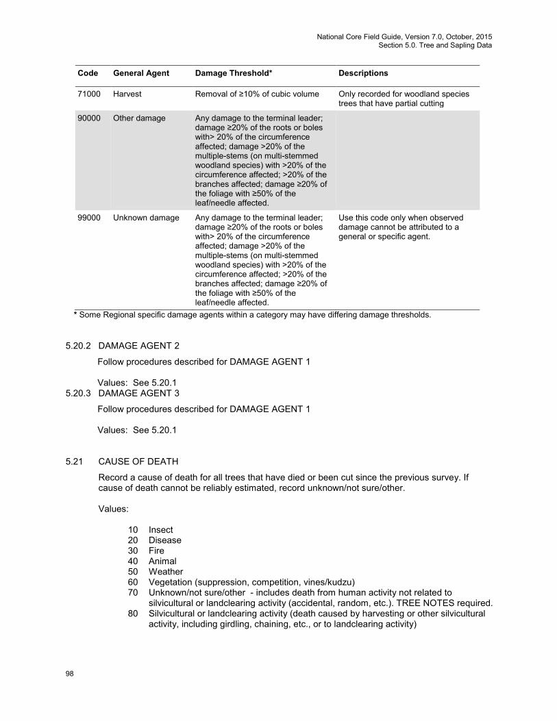
National Core Field Guide, Version 7.0, October, 2015 Section 5.0. Tree and Sapling Data
98
Code General Agent Damage Threshold* Descriptions
71000 Harvest Removal of ≥10% of cubic volume Only recorded for woodland species trees that have partial cutting
90000
Other damage Any damage to the terminal leader; damage ≥20% of the roots or boles with> 20% of the circumference affected; damage >20% of the multiple-stems (on multi-stemmed woodland species) with >20% of the circumference affected; >20% of the branches affected; damage ≥20% of the foliage with ≥50% of the leaf/needle affected.
99000 Unknown damage Any damage to the terminal leader; damage ≥20% of the roots or boles with> 20% of the circumference affected; damage >20% of the multiple-stems (on multi-stemmed woodland species) with >20% of the circumference affected; >20% of the branches affected; damage ≥20% of the foliage with ≥50% of the leaf/needle affected.
Use this code only when observed damage cannot be attributed to a general or specific agent.
* Some Regional specific damage agents within a category may have differing damage thresholds. 5.20.2 DAMAGE AGENT 2
Follow procedures described for DAMAGE AGENT 1
Values: See 5.20.1 5.20.3 DAMAGE AGENT 3
Follow procedures described for DAMAGE AGENT 1
Values: See 5.20.1 5.21 CAUSE OF DEATH
Record a cause of death for all trees that have died or been cut since the previous survey. If cause of death cannot be reliably estimated, record unknown/not sure/other.
Values:
10 Insect 20 Disease 30 Fire 40 Animal 50 Weather 60 Vegetation (suppression, competition, vines/kudzu) 70 Unknown/not sure/other - includes death from human activity not related to
silvicultural or landclearing activity (accidental, random, etc.). TREE NOTES required. 80 Silvicultural or landclearing activity (death caused by harvesting or other silvicultural
activity, including girdling, chaining, etc., or to landclearing activity)
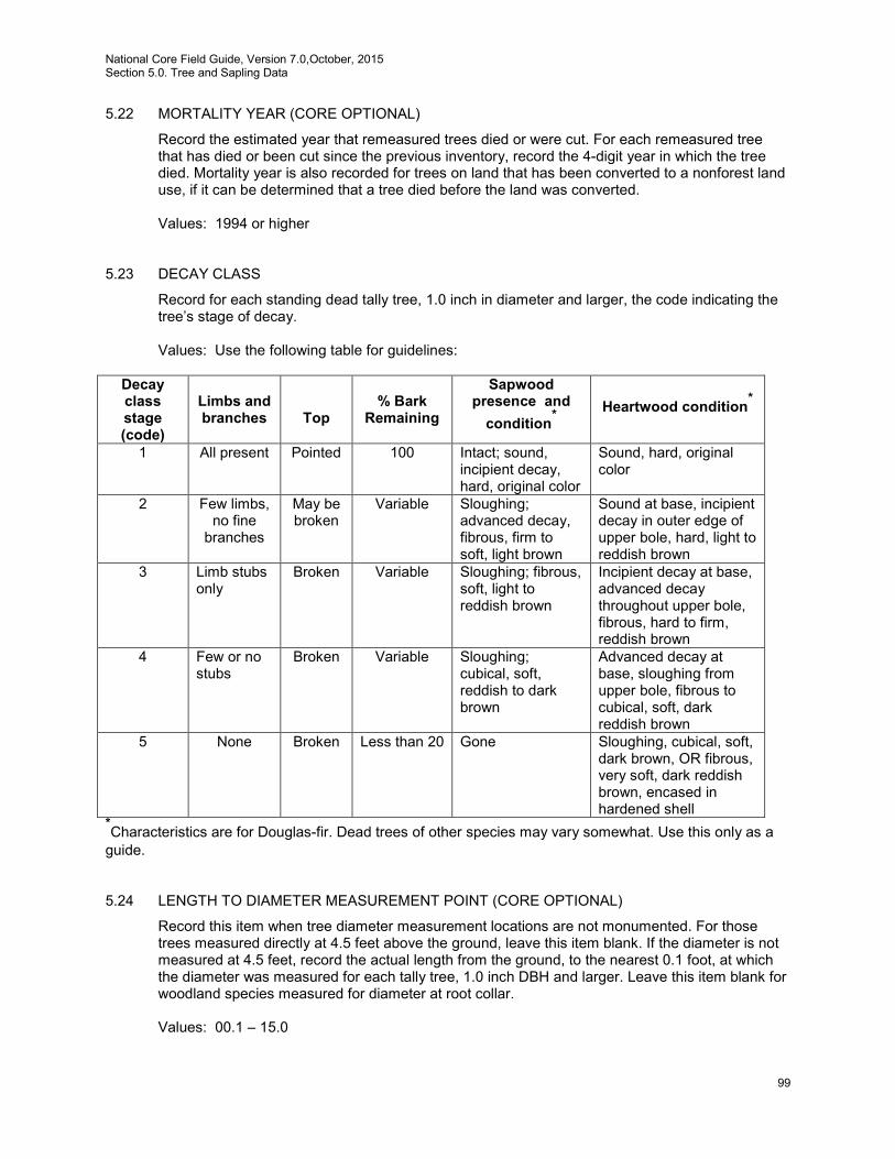
National Core Field Guide, Version 7.0,October, 2015 Section 5.0. Tree and Sapling Data
99
5.22 MORTALITY YEAR (CORE OPTIONAL)
Record the estimated year that remeasured trees died or were cut. For each remeasured tree that has died or been cut since the previous inventory, record the 4-digit year in which the tree died. Mortality year is also recorded for trees on land that has been converted to a nonforest land use, if it can be determined that a tree died before the land was converted.
Values: 1994 or higher
5.23 DECAY CLASS
Record for each standing dead tally tree, 1.0 inch in diameter and larger, the code indicating the tree’s stage of decay.
Values: Use the following table for guidelines:
Decay class stage (code)
Limbs and branches
Top
% Bark
Remaining
Sapwood presence and
condition*
Heartwood condition*
1 All present Pointed 100 Intact; sound, incipient decay, hard, original color
Sound, hard, original color
2 Few limbs, no fine
branches
May be broken
Variable Sloughing; advanced decay, fibrous, firm to soft, light brown
Sound at base, incipient decay in outer edge of upper bole, hard, light to reddish brown
3 Limb stubs only
Broken Variable Sloughing; fibrous, soft, light to reddish brown
Incipient decay at base, advanced decay throughout upper bole, fibrous, hard to firm, reddish brown
4 Few or no stubs
Broken Variable Sloughing; cubical, soft, reddish to dark brown
Advanced decay at base, sloughing from upper bole, fibrous to cubical, soft, dark reddish brown
5 None Broken Less than 20 Gone Sloughing, cubical, soft, dark brown, OR fibrous, very soft, dark reddish brown, encased in hardened shell
*Characteristics are for Douglas-fir. Dead trees of other species may vary somewhat. Use this only as a guide. 5.24 LENGTH TO DIAMETER MEASUREMENT POINT (CORE OPTIONAL)
Record this item when tree diameter measurement locations are not monumented. For those trees measured directly at 4.5 feet above the ground, leave this item blank. If the diameter is not measured at 4.5 feet, record the actual length from the ground, to the nearest 0.1 foot, at which the diameter was measured for each tally tree, 1.0 inch DBH and larger. Leave this item blank for woodland species measured for diameter at root collar.
Values: 00.1 – 15.0
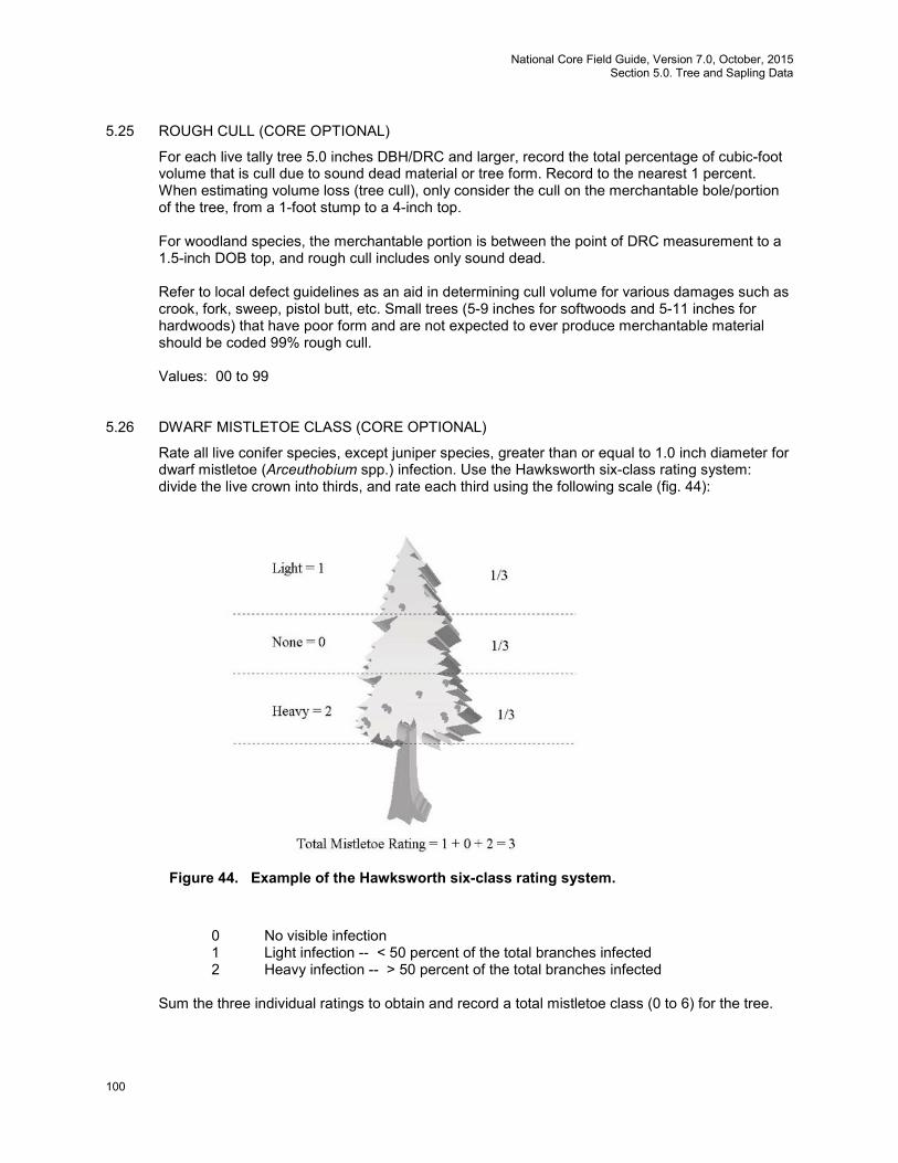
National Core Field Guide, Version 7.0, October, 2015 Section 5.0. Tree and Sapling Data
100
5.25 ROUGH CULL (CORE OPTIONAL)
For each live tally tree 5.0 inches DBH/DRC and larger, record the total percentage of cubic-foot volume that is cull due to sound dead material or tree form. Record to the nearest 1 percent. When estimating volume loss (tree cull), only consider the cull on the merchantable bole/portion of the tree, from a 1-foot stump to a 4-inch top. For woodland species, the merchantable portion is between the point of DRC measurement to a 1.5-inch DOB top, and rough cull includes only sound dead. Refer to local defect guidelines as an aid in determining cull volume for various damages such as crook, fork, sweep, pistol butt, etc. Small trees (5-9 inches for softwoods and 5-11 inches for hardwoods) that have poor form and are not expected to ever produce merchantable material should be coded 99% rough cull.
Values: 00 to 99
5.26 DWARF MISTLETOE CLASS (CORE OPTIONAL)
Rate all live conifer species, except juniper species, greater than or equal to 1.0 inch diameter for dwarf mistletoe (Arceuthobium spp.) infection. Use the Hawksworth six-class rating system: divide the live crown into thirds, and rate each third using the following scale (fig. 44):
0 No visible infection 1 Light infection -- < 50 percent of the total branches infected 2 Heavy infection -- > 50 percent of the total branches infected
Sum the three individual ratings to obtain and record a total mistletoe class (0 to 6) for the tree.
Figure 44. Example of the Hawksworth six-class rating system.
National Core Field Guide, Version 7.0,October, 2015 Section 5.0. Tree and Sapling Data
101
Note: In addition to these requirements, longleaf pine (0121) seedlings must be greater than or equal to 0.5 inches DRC.
Values: 0 to 6
5.27 TREE NOTES
Record notes pertaining to an individual tree as called for to explain or describe another variable.
Values: English language words, phrases and numbers
National Core Field Guide, Version 7.0, October, 2015 Section 6.0. Seedling Data
102
6.0 SEEDLING DATA
Regeneration information is obtained by counting live seedlings within the 6.8-foot radius microplot located 90 degrees and 12.0 feet from each subplot center within each of the four subplots. Conifer seedlings must be at least 6.0 inches in length and less than 1.0 inch at DBH/DRC in order to qualify for tallying. Hardwood seedlings must be at least 12.0 inches in length and less than 1.0 inch at DBH/DRC in order to qualify for tallying. For woodland species, each stem on a single tree must be less than 1.0 inch in DRC. Seedlings are counted in groups by species and condition class, up to five individuals per species. Counts beyond five estimated. Only count seedlings occurring in accessible forest land condition classes.
6.1 SUBPLOT NUMBER
Use the same procedures described in Section 3.1. 6.2 SPECIES
Use the same procedures described in Section 5.8. Values: See Appendix 3
6.3 CONDITION CLASS NUMBER
Use the same procedures described in Section 2.0. 6.4 SEEDLING COUNT
On each microplot, record the number of live tally tree seedlings, by species and condition class. Count up to five individuals by species: estimate the total count if there are more than five individuals of any given species in any given condition class. When seedlings are distributed evenly on a microplot, a suggested method of estimating is to count the number of seedlings on one quarter of the microplot and multiply by four (given that there is only one condition class on the microplot). Repeat for each species. Conifer seedlings must be at least 6.0 inches in length and less than 1.0 inch at DBH to qualify for counting. Hardwood seedlings must be at least 12.0 inches in length and less than 1.0 inch at DBH in order to qualify for counting. For woodland species, each stem on a single tree must be less than 1.0 inch at DRC. Multiple “suckers” that originate from the same location, and stump sprouts are considered one seedling. Do not tally or count “layers” (undetached branches partially or completely covered by soil, usually at the base) as seedlings. Do not tally any seedlings that sprout from a live tally tree.
Values: 001 through 999

National Core Field Guide, Version 7.0,October, 2015 Section 6.0. Seedling Data
103
National Core Field Guide, Version 7.0, October, 2015 Section 7.0. Site Tree Information
104
7.0 SITE TREE INFORMATION
Site trees are a measure of site productivity expressed by the height to age relationship of dominant and co-dominant trees. If suitable site trees are available, site tree data are required for every accessible forest land condition class defined on a plot. An individual site tree may be used for more than one condition class where differences in condition classes are not the result of differences in site productivity. For example, when different condition classes are caused solely due to differences in reserved status, owner class, and/or disturbance-related differences in density (e.g., heavily thinned vs. unthinned), a site tree may be used for more than one condition class. When in doubt, do not use a site tree for more than one condition class.
7.1 Site Tree Selection
Select at least one site tree for each accessible forest land condition class where no previous site tree data exist. The absence of site tree data may occur because: • This is the first visit to the site • On the previous visit no suitable site tree could be found for the condition • Since the last visit there has been a change in condition class that renders the previous data
incompatible with the current conditions If a site tree is needed; select tree from a species common to the condition class being sampled, based on the criteria listed below. Select trees off the subplot where possible. Use only trees that have remained in a dominant or co-dominant crown position throughout their entire life span. If possible, trees should be 5.0 inches in diameter, or larger, and at least 20 years old. Trees that are visibly damaged, trees with ring patterns that exhibit signs of suppression, and trees with rotten cores should be rejected. If there are no acceptable site trees, record that in the plot notes and leave this section blank.
7.2 Site Tree Data Variables
7.2.1 CONDITION CLASS LIST
List all CONDITION CLASSES that the site index data from this tree represent.
Values: 1000 to 9876 7.2.2 SPECIES
Use the same procedures described in Section 5.8. Ideally, site trees in the eastern U.S. should be between 20-70 years old. If preferred trees cannot be found in this age range, expand the age range to 15-120 years. Reject trees outside the 15-120 year age range, trees that exhibit signs of damage, trees with ring patterns that show signs of suppression, trees less than 5.0 inches DBH, trees with abnormalities at DBH, and trees with rotten cores. A list of preferred site-tree species is provided. Site trees should be selected in the following order of preference:
• 1st Choice: representative of the stand, on the list for your region. • 2nd Choice: representative of the stand, on the list for an adjoining eastern region. • 3rd Choice: not representative of the stand, on the list for your region. • 4th Choice: not representative of the stand, on the list for an adjoining eastern region.
National Core Field Guide, Version 7.0,October, 2015 Section 7.0. Site Tree Information
105
Ideally, site trees in the western U.S. should be between 35-80 years old. If preferred trees cannot be found in this age range, expand the age range to 15-250 years. Reject trees outside the 15-250 year age range, trees that exhibit signs of damage, trees with ring patterns that show signs of suppression, trees less than 5.0 inches DBH, trees with abnormalities at DBH, trees with rotten cores, and woodland species. A list of preferred site-tree species is provided. Site trees should be selected in the following order of preference:
• 1st Choice: representative of the stand, on the list for your region. • 2nd Choice: representative of the stand, on the list for an adjoining western region. • 3rd Choice: not representative of the stand, on the list for your region. • 4th Choice: not representative of the stand, on the list for an adjoining western region.
Values:
Eastern U.S. Site-Tree Species: NE = Northeast, NC = North Central, SO = Southern Code Common Name Region
-------------------- Softwood Species -------------------- 0012 balsam fir NE, NC 0043 Atlantic white-cedar NE 0068 eastern redcedar NE, NC 0070 larch (introduced) NE 0071 tamarack (native) NE, NC 0094 white spruce NE, NC 0095 black spruce NE, NC 0097 red spruce NE 0105 jack pine NE, NC 0107 sand pine SO 0110 shortleaf pine NE, NC, SO 0111 slash pine SO 0121 longleaf pine SO 0122 Ponderosa pine NC 0125 red pine NE, NC 0128 pond pine NE, SO 0129 eastern white pine NE, NC, SO 0130 Scotch pine NE, NC 0131 loblolly pine NE, SO 0132 Virginia pine NE, SO 0241 northern white cedar NE, NC 0261 eastern hemlock NE, NC
-------------------- Hardwood Species --------------------
0316 red maple NE, NC 0317 silver maple NE, NC 0318 sugar maple NE, NC 0371 yellow birch NE, NC 0375 paper birch NE, NC 0402 bitternut hickory NE, NC 0403 pignut hickory NC 0404 pecan NC 0405 shellbark hickory NC 0407 shagbark hickory NE, NC 0408 black hickory NC 0409 mockernut hickory NC 0462 hackberry NC 0531 American beech NE, NC 0541 white ash NE, NC 0543 black ash NE, NC 0544 green ash NE, NC
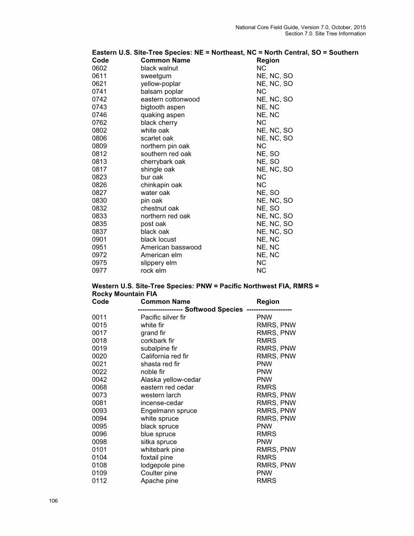
National Core Field Guide, Version 7.0, October, 2015 Section 7.0. Site Tree Information
106
Eastern U.S. Site-Tree Species: NE = Northeast, NC = North Central, SO = Southern Code Common Name Region 0602 black walnut NC 0611 sweetgum NE, NC, SO 0621 yellow-poplar NE, NC, SO 0741 balsam poplar NC 0742 eastern cottonwood NE, NC, SO 0743 bigtooth aspen NE, NC 0746 quaking aspen NE, NC 0762 black cherry NC 0802 white oak NE, NC, SO 0806 scarlet oak NE, NC, SO 0809 northern pin oak NC 0812 southern red oak NE, SO 0813 cherrybark oak NE, SO 0817 shingle oak NE, NC, SO 0823 bur oak NC 0826 chinkapin oak NC 0827 water oak NE, SO 0830 pin oak NE, NC, SO 0832 chestnut oak NE, SO 0833 northern red oak NE, NC, SO 0835 post oak NE, NC, SO 0837 black oak NE, NC, SO 0901 black locust NE, NC 0951 American basswood NE, NC 0972 American elm NE, NC 0975 slippery elm NC 0977 rock elm NC
Western U.S. Site-Tree Species: PNW = Pacific Northwest FIA, RMRS = Rocky Mountain FIA Code Common Name Region
-------------------- Softwood Species -------------------- 0011 Pacific silver fir PNW 0015 white fir RMRS, PNW 0017 grand fir RMRS, PNW 0018 corkbark fir RMRS 0019 subalpine fir RMRS, PNW 0020 California red fir RMRS, PNW 0021 shasta red fir PNW 0022 noble fir PNW 0042 Alaska yellow-cedar PNW 0068 eastern red cedar RMRS 0073 western larch RMRS, PNW 0081 incense-cedar RMRS, PNW 0093 Engelmann spruce RMRS, PNW 0094 white spruce RMRS, PNW 0095 black spruce PNW 0096 blue spruce RMRS 0098 sitka spruce PNW 0101 whitebark pine RMRS, PNW 0104 foxtail pine RMRS 0108 lodgepole pine RMRS, PNW 0109 Coulter pine PNW 0112 Apache pine RMRS

National Core Field Guide, Version 7.0,October, 2015 Section 7.0. Site Tree Information
107
Western U.S. Site-Tree Species: PNW = Pacific Northwest FIA, RMRS = Rocky Mountain FIA Code Common Name Region 0116 Jeffrey pine RMRS, PNW 0117 sugar pine RMRS, PNW 0119 western white pine RMRS, PNW 0120 bishop pine PNW 0122 ponderosa pine RMRS, PNW 0135 Arizona pine RMRS 0201 bigcone Douglas-fir PNW 0202 Douglas-fir RMRS, PNW 0211 redwood PNW 0231 Pacific yew RMRS, PNW 0242 western redcedar RMRS, PNW 0263 western hemlock RMRS, PNW 0264 mountain hemlock RMRS, PNW
-------------------- Hardwood Species -------------------- 0312 bigleaf maple PNW 0351 red alder RMRS, PNW 0375 paper birch RMRS, PNW 0462 hackberry RMRS 0544 green ash RMRS 0741 balsam poplar RMRS, PNW 0742 eastern cottonwood RMRS 0745 plains cottonwood RMRS 0746 quaking aspen RMRS, PNW 0747 black cottonwood RMRS, PNW 0748 Fremont poplar/cottonwood RMRS 0749 narrowleaf cottonwood RMRS 0972 American elm RMRS
7.2.3 DIAMETER
Use the same procedures described in Section 5.9.
Values: 001.0 to 999.9 7.2.4 SITE TREE LENGTH
With a clinometer or other approved instrument, measure the total length of the site tree from the ground to the top of the tree. Record to the nearest 1.0 foot. SITE TREE LENGTH must be measured; no estimates are permitted on site trees.
Values: 005 to 999
7.2.5 TREE AGE AT DIAMETER
Record the tree age as determined by an increment sample. Bore the tree at the point of diameter measurement (DBH) with an increment borer. Count the rings between the outside edge of the core and the pith. Do not add years to get total age.
Values: 001 to 999
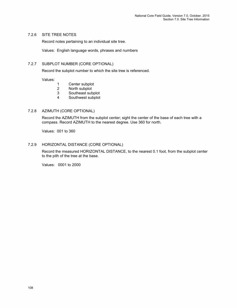
National Core Field Guide, Version 7.0, October, 2015 Section 7.0. Site Tree Information
108
7.2.6 SITE TREE NOTES
Record notes pertaining to an individual site tree.
Values: English language words, phrases and numbers 7.2.7 SUBPLOT NUMBER (CORE OPTIONAL)
Record the subplot number to which the site tree is referenced.
Values: 1 Center subplot 2 North subplot 3 Southeast subplot 4 Southwest subplot
7.2.8 AZIMUTH (CORE OPTIONAL)
Record the AZIMUTH from the subplot center; sight the center of the base of each tree with a compass. Record AZIMUTH to the nearest degree. Use 360 for north.
Values: 001 to 360
7.2.9 HORIZONTAL DISTANCE (CORE OPTIONAL)
Record the measured HORIZONTAL DISTANCE, to the nearest 0.1 foot, from the subplot center to the pith of the tree at the base.
Values: 0001 to 2000

National Core Field Guide, Version 7.0,October, 2015 Section 7.0. Site Tree Information
109
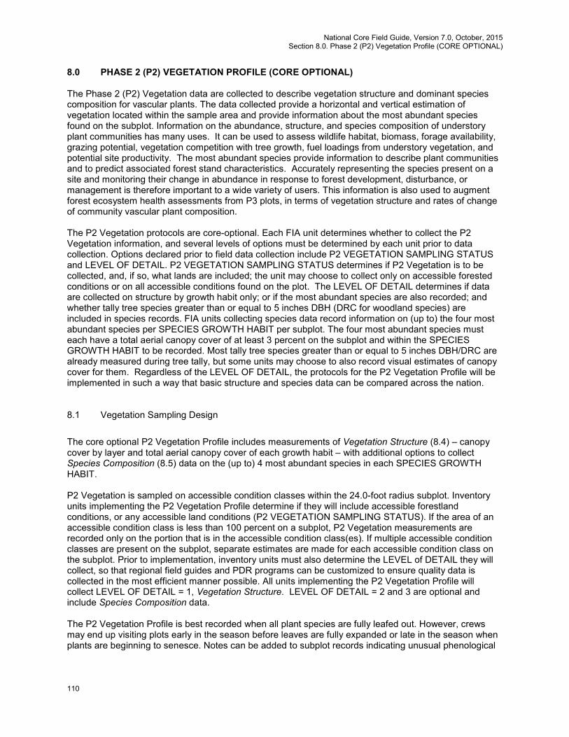
National Core Field Guide, Version 7.0, October, 2015 Section 8.0. Phase 2 (P2) Vegetation Profile (CORE OPTIONAL)
110
8.0 PHASE 2 (P2) VEGETATION PROFILE (CORE OPTIONAL) The Phase 2 (P2) Vegetation data are collected to describe vegetation structure and dominant species composition for vascular plants. The data collected provide a horizontal and vertical estimation of vegetation located within the sample area and provide information about the most abundant species found on the subplot. Information on the abundance, structure, and species composition of understory plant communities has many uses. It can be used to assess wildlife habitat, biomass, forage availability, grazing potential, vegetation competition with tree growth, fuel loadings from understory vegetation, and potential site productivity. The most abundant species provide information to describe plant communities and to predict associated forest stand characteristics. Accurately representing the species present on a site and monitoring their change in abundance in response to forest development, disturbance, or management is therefore important to a wide variety of users. This information is also used to augment forest ecosystem health assessments from P3 plots, in terms of vegetation structure and rates of change of community vascular plant composition. The P2 Vegetation protocols are core-optional. Each FIA unit determines whether to collect the P2 Vegetation information, and several levels of options must be determined by each unit prior to data collection. Options declared prior to field data collection include P2 VEGETATION SAMPLING STATUS and LEVEL OF DETAIL. P2 VEGETATION SAMPLING STATUS determines if P2 Vegetation is to be collected, and, if so, what lands are included; the unit may choose to collect only on accessible forested conditions or on all accessible conditions found on the plot. The LEVEL OF DETAIL determines if data are collected on structure by growth habit only; or if the most abundant species are also recorded; and whether tally tree species greater than or equal to 5 inches DBH (DRC for woodland species) are included in species records. FIA units collecting species data record information on (up to) the four most abundant species per SPECIES GROWTH HABIT per subplot. The four most abundant species must each have a total aerial canopy cover of at least 3 percent on the subplot and within the SPECIES GROWTH HABIT to be recorded. Most tally tree species greater than or equal to 5 inches DBH/DRC are already measured during tree tally, but some units may choose to also record visual estimates of canopy cover for them. Regardless of the LEVEL OF DETAIL, the protocols for the P2 Vegetation Profile will be implemented in such a way that basic structure and species data can be compared across the nation. 8.1 Vegetation Sampling Design
The core optional P2 Vegetation Profile includes measurements of Vegetation Structure (8.4) – canopy cover by layer and total aerial canopy cover of each growth habit – with additional options to collect Species Composition (8.5) data on the (up to) 4 most abundant species in each SPECIES GROWTH HABIT. P2 Vegetation is sampled on accessible condition classes within the 24.0-foot radius subplot. Inventory units implementing the P2 Vegetation Profile determine if they will include accessible forestland conditions, or any accessible land conditions (P2 VEGETATION SAMPLING STATUS). If the area of an accessible condition class is less than 100 percent on a subplot, P2 Vegetation measurements are recorded only on the portion that is in the accessible condition class(es). If multiple accessible condition classes are present on the subplot, separate estimates are made for each accessible condition class on the subplot. Prior to implementation, inventory units must also determine the LEVEL of DETAIL they will collect, so that regional field guides and PDR programs can be customized to ensure quality data is collected in the most efficient manner possible. All units implementing the P2 Vegetation Profile will collect LEVEL OF DETAIL = 1, Vegetation Structure. LEVEL OF DETAIL = 2 and 3 are optional and include Species Composition data. The P2 Vegetation Profile is best recorded when all plant species are fully leafed out. However, crews may end up visiting plots early in the season before leaves are fully expanded or late in the season when plants are beginning to senesce. Notes can be added to subplot records indicating unusual phenological
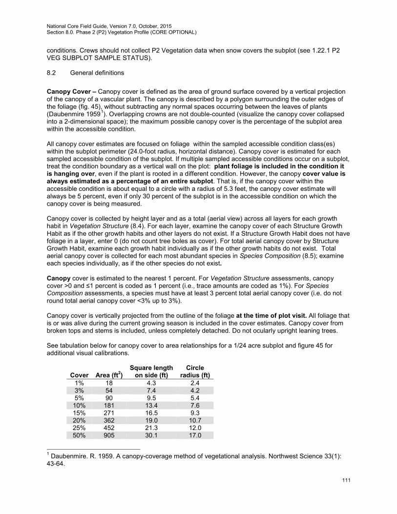
National Core Field Guide, Version 7.0, October, 2015 Section 8.0. Phase 2 (P2) Vegetation Profile (CORE OPTIONAL)
111
conditions. Crews should not collect P2 Vegetation data when snow covers the subplot (see 1.22.1 P2 VEG SUBPLOT SAMPLE STATUS). 8.2 General definitions
Canopy Cover – Canopy cover is defined as the area of ground surface covered by a vertical projection of the canopy of a vascular plant. The canopy is described by a polygon surrounding the outer edges of the foliage (fig. 45), without subtracting any normal spaces occurring between the leaves of plants (Daubenmire 19591). Overlapping crowns are not double-counted (visualize the canopy cover collapsed into a 2-dimensional space); the maximum possible canopy cover is the percentage of the subplot area within the accessible condition. All canopy cover estimates are focused on foliage within the sampled accessible condition class(es) within the subplot perimeter (24.0-foot radius, horizontal distance). Canopy cover is estimated for each sampled accessible condition of the subplot. If multiple sampled accessible conditions occur on a subplot, treat the condition boundary as a vertical wall on the plot: plant foliage is included in the condition it is hanging over, even if the plant is rooted in a different condition. However, the canopy cover value is always estimated as a percentage of an entire subplot. That is, if the canopy cover within the accessible condition is about equal to a circle with a radius of 5.3 feet, the canopy cover estimate will always be 5 percent, even if only 30 percent of the subplot is in the accessible condition on which the canopy cover is being measured. Canopy cover is collected by height layer and as a total (aerial view) across all layers for each growth habit in Vegetation Structure (8.4). For each layer, examine the canopy cover of each Structure Growth Habit as if the other growth habits and other layers do not exist. If a Structure Growth Habit does not have foliage in a layer, enter 0 (do not count tree boles as cover). For total aerial canopy cover by Structure Growth Habit, examine each growth habit individually as if the other growth habits do not exist. Total aerial canopy cover is collected for each most abundant species in Species Composition (8.5); examine each species individually, as if the other species do not exist. Canopy cover is estimated to the nearest 1 percent. For Vegetation Structure assessments, canopy cover >0 and ≤1 percent is coded as 1 percent (i.e., trace amounts are coded as 1%). For Species Composition assessments, a species must have at least 3 percent total aerial canopy cover (i.e. do not round total aerial canopy cover <3% up to 3%). Canopy cover is vertically projected from the outline of the foliage at the time of plot visit. All foliage that is or was alive during the current growing season is included in the cover estimates. Canopy cover from broken tops and stems is included, unless completely detached. Do not ocularly upright leaning trees. See tabulation below for canopy cover to area relationships for a 1/24 acre subplot and figure 45 for additional visual calibrations.
Cover
Area (ft2)
Square length on side (ft)
Circle radius (ft)
1% 18 4.3 2.4 3% 54 7.4 4.2 5% 90 9.5 5.4
10% 181 13.4 7.6 15% 271 16.5 9.3 20% 362 19.0 10.7 25% 452 21.3 12.0 50% 905 30.1 17.0
1 Daubenmire. R. 1959. A canopy-coverage method of vegetational analysis. Northwest Science 33(1): 43-64.
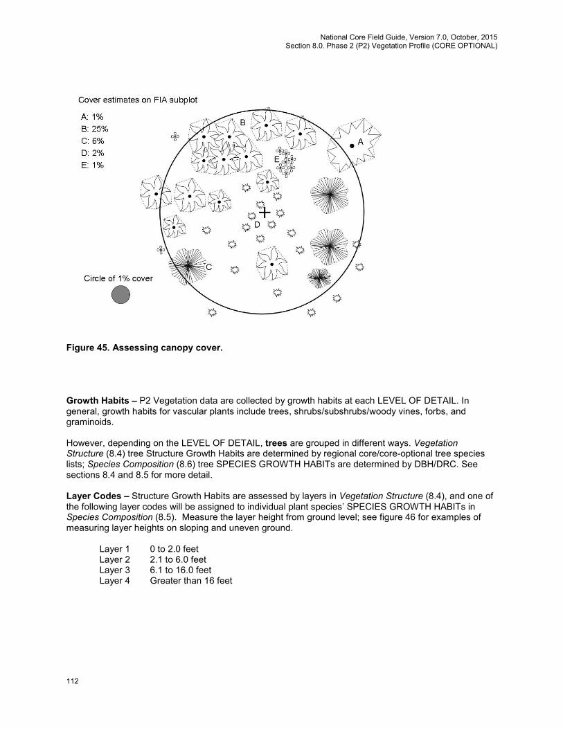
National Core Field Guide, Version 7.0, October, 2015 Section 8.0. Phase 2 (P2) Vegetation Profile (CORE OPTIONAL)
112
Figure 45. Assessing canopy cover. Growth Habits – P2 Vegetation data are collected by growth habits at each LEVEL OF DETAIL. In general, growth habits for vascular plants include trees, shrubs/subshrubs/woody vines, forbs, and graminoids. However, depending on the LEVEL OF DETAIL, trees are grouped in different ways. Vegetation Structure (8.4) tree Structure Growth Habits are determined by regional core/core-optional tree species lists; Species Composition (8.6) tree SPECIES GROWTH HABITs are determined by DBH/DRC. See sections 8.4 and 8.5 for more detail. Layer Codes – Structure Growth Habits are assessed by layers in Vegetation Structure (8.4), and one of the following layer codes will be assigned to individual plant species’ SPECIES GROWTH HABITs in Species Composition (8.5). Measure the layer height from ground level; see figure 46 for examples of measuring layer heights on sloping and uneven ground.
Layer 1 0 to 2.0 feet Layer 2 2.1 to 6.0 feet Layer 3 6.1 to 16.0 feet Layer 4 Greater than 16 feet
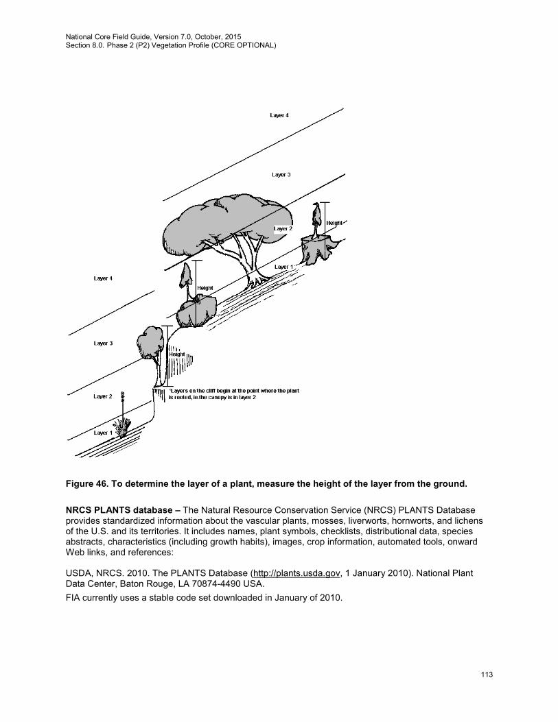
National Core Field Guide, Version 7.0, October, 2015 Section 8.0. Phase 2 (P2) Vegetation Profile (CORE OPTIONAL)
113
Figure 46. To determine the layer of a plant, measure the height of the layer from the ground.
NRCS PLANTS database – The Natural Resource Conservation Service (NRCS) PLANTS Database provides standardized information about the vascular plants, mosses, liverworts, hornworts, and lichens of the U.S. and its territories. It includes names, plant symbols, checklists, distributional data, species abstracts, characteristics (including growth habits), images, crop information, automated tools, onward Web links, and references: USDA, NRCS. 2010. The PLANTS Database (http://plants.usda.gov, 1 January 2010). National Plant Data Center, Baton Rouge, LA 70874-4490 USA. FIA currently uses a stable code set downloaded in January of 2010.
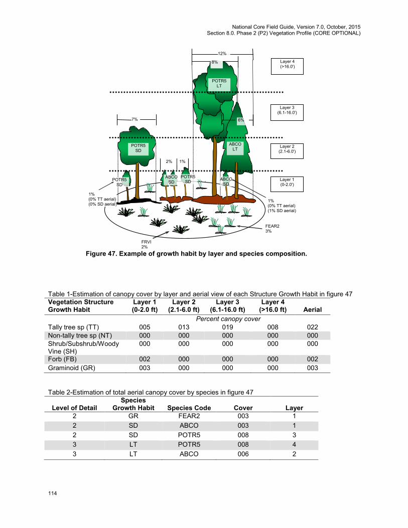
National Core Field Guide, Version 7.0, October, 2015 Section 8.0. Phase 2 (P2) Vegetation Profile (CORE OPTIONAL)
114
Table 1-Estimation of canopy cover by layer and aerial view of each Structure Growth Habit in figure 47 Vegetation Structure Growth Habit
Layer 1 (0-2.0 ft)
Layer 2 (2.1-6.0 ft)
Layer 3 (6.1-16.0 ft)
Layer 4 (>16.0 ft)
Aerial
Percent canopy cover Tally tree sp (TT) 005 013 019 008 022 Non-tally tree sp (NT) 000 000 000 000 000 Shrub/Subshrub/Woody Vine (SH)
000 000 000 000 000
Forb (FB) 002 000 000 000 002 Graminoid (GR) 003 000 000 000 003 Table 2-Estimation of total aerial canopy cover by species in figure 47
Level of Detail
Species Growth Habit
Species Code
Cover
Layer
2 GR FEAR2 003 1 2 SD ABCO 003 1 2 SD POTR5 008 3 3 LT POTR5 008 4 3 LT ABCO 006 2
Layer 4 (>16.0')
2%
Layer 1 (0-2.0')
Layer 2 (2.1-6.0')
Layer 3 (6.1-16.0')
7%
FEAR2 3%
FRVI 2%
1% (0% TT aerial) (1% SD aerial)
POTR5 SD
POTR5 SD
POTR5 LT
ABCO LT
ABCO SD
1%
6%
8%
1% (0% TT aerial) (0% SD aerial)
Figure 47. Example of growth habit by layer and species composition.
POTR5 SD
ABCO SD
12%
National Core Field Guide, Version 7.0, October, 2015 Section 8.0. Phase 2 (P2) Vegetation Profile (CORE OPTIONAL)
115
Note: FRVI, estimated at 2%, was not recorded, and ABCO and POTR5 are present as two different SPECIES GROWTH HABITs (seedling/sapling and large tree) with at least 3% total aerial canopy cover within the SPECIES GROWTH HABIT on the subplot. 8.3 Vegetation Data Collection Location – Subplot-Level Variables
8.3.1 SUBPLOT NUMBER
Record the code corresponding to the number of the subplot. Values:
1 Center subplot 2 North subplot 3 Southeast subplot 4 Southwest subplot
8.3.2 CONDITION CLASS NUMBER
Record the number for the sampled accessible condition class in which the vegetation is found. If multiple sampled accessible conditions occur on the same subplot, data will be collected for each accessible condition separately. Values: 1 to 9
8.4 Vegetation Structure
In this section, use ocular methods to estimate canopy cover by layer and aerial view cover for each Structure Growth Habit, and record to the nearest percent (canopy cover >0 and <1% is coded as 1%; i.e., trace amounts are coded as 1%.) Canopy cover by layer: Estimate the canopy cover in each Structure Growth Habit for each of the four layers. Include Structure Growth Habits with foliage present on the accessible condition and with foliage overhanging the accessible condition. For each layer canopy cover, examine the canopy cover of each Structure Growth Habit as if the other growth habits and other layers do not exist. Do not double-count overlapping crowns within a Structure Growth Habit; visualize the canopy cover within the layer collapsed into a 2-dimensional space. If a Structure Growth Habit does not have foliage in a layer, enter 0 (do not count tree boles as cover). Aerial View Coverage: Determine the total aerial canopy cover by Structure Growth Habit. .Examine each Structure Growth Habit individually as if the other growth habits do not exist. Do not double-count overlapping crowns within a Structure Growth Habit (maximum cover = the percentage of the subplot area in the accessible condition.) The total aerial canopy cover for a Structure Growth Habit must be equal to or greater than the highest canopy cover recorded for an individual layer in that growth habit, but cannot be greater than the sum of the canopy covers recorded for all the layers in that growth habit.
National Core Field Guide, Version 7.0, October, 2015 Section 8.0. Phase 2 (P2) Vegetation Profile (CORE OPTIONAL)
116
Vegetation Structure Growth Habits: Apply the definitions that follow based on the species and appearance of the plants on the subplot-condition (i.e., do not put the same species in multiple Structure Growth Habits on the same subplot-condition.) If a tree species has been selected as a tally tree species by the particular FIA unit, always record that species in the tally tree species growth habit (TT), even if it grows as a shrub in some environments. Woody plants not on the unit’s tally tree species list may have a tree growth habit in some environments, and these should be recorded as non-tally tree species (NT). If the growth habit is shrub in another environment, record that species as a shrub (SH). The definitions (adapted from NRCS PLANTS) are: TT Tally Tree Species (TT): All core tree species and any core optional tree species
selected by a particular FIA unit. Any plant of that species is included, regardless of its shape and regardless of whether it was tallied on the subplot or microplot during tree tally. Seedlings (any length, no minimum), saplings, and mature plants are included.
NT Non-tally Tree Species (NT): Tree species not on a particular FIA unit’s tree tally list that are woody plants with a single well-defined, dominant main stem, not supported by other vegetation or structures (not vines), and which are, or are expected to become, greater than 13 feet in height. Seedlings (any length, no minimum), saplings, and mature plants are included.
SH Shrubs/Subshrubs/Woody Vines (SH): Woody, multiple-stemmed plants of any size, subshrubs (low-growing shrubs under 1.5 feet tall at maturity), and woody vines. Most cacti are included in this category.
FB Forbs (FB): Herbaceous, broad-leaved plants; includes non-woody-vines, ferns (does not include mosses and cryptobiotic crusts).
GR Graminoids (GR): Grasses and grass-like plants (includes rushes and sedges).
8.4.1 TALLY TREE SPECIES COVER LAYER 1
Record canopy cover for all tally tree species in layer 1 (0-2.0 feet) to the nearest percent. Canopy cover includes all tally tree species present, regardless of DBH or DRC. Values: 000-100
8.4.2 TALLY TREE SPECIES COVER LAYER 2
Record canopy cover for all tally tree species in layer 2 (2.1- 6.0 feet) to the nearest percent. Canopy cover includes all tally tree species present, regardless of DBH or DRC. Follow the same procedures as for TALLY TREE SPECIES COVER LAYER 1.
8.4.3 TALLY TREE SPECIES COVER LAYER 3
Record canopy cover for all tally tree species in layer 3 (6.1- 16.0 feet) to the nearest percent. Canopy cover includes all tally tree species present, regardless of DBH or DRC. Follow the same procedures as for TALLY TREE SPECIES COVER LAYER 1.
8.4.4 TALLY TREE SPECIES COVER LAYER 4
Record canopy cover for all tally tree species in layer 4 (16.1 feet and above) to the nearest percent. Canopy cover includes all tally tree species present, regardless of DBH or DRC. Follow the same procedures as for TALLY TREE SPECIES COVER LAYER 1.
National Core Field Guide, Version 7.0, October, 2015 Section 8.0. Phase 2 (P2) Vegetation Profile (CORE OPTIONAL)
117
8.4.5 TALLY TREE SPECIES COVER – AERIAL VIEW
Record the total aerial canopy cover for all tally tree species over all layers. Canopy cover includes all tally tree species present, regardless of DBH or DRC. Follow the same procedures as for TALLY TREE SPECIES COVER LAYER 1, but include all layers.
8.4.6 NON-TALLY TREE SPECIES COVER LAYER 1
Record canopy cover for species not on the tally tree species list with tree growth habit in layer 1 (0-2.0 feet) to the nearest percent. Canopy cover includes all non-tally tree species present, regardless of DBH or DRC. Values: 000-100
8.4.7 NON-TALLY TREE SPECIES COVER LAYER 2
Record canopy cover for species not on the tally tree species list with tree growth form in layer 2 (2.1- 6.0 feet) to the nearest percent. Canopy cover includes all non-tally tree species present, regardless of DBH or DRC. Follow the same procedures as for NON-TALLY TREE SPECIES COVER LAYER 1.
8.4.8 NON-TALLY TREE SPECIES COVER LAYER 3
Record canopy cover for species not on the tally tree species list with tree growth form in layer 3 (6.1- 16.0 feet) to the nearest percent. Canopy cover includes all non-tally tree species present, regardless of DBH or DRC. Follow the same procedures as for NON-TALLY TREE SPECIES COVER LAYER 1.
8.4.9 NON-TALLY TREE SPECIES COVER LAYER 4
Record canopy cover for species not on the tally tree species list with tree growth habit in layer 4 (16.1 feet and above) to the nearest percent. Canopy cover includes all non-tally tree species present, regardless of DBH or DRC. Follow the same procedures as for NON-TALLY TREE SPECIES COVER LAYER 1.
8.4.10 NON-TALLY TREE SPECIES COVER – AERIAL VIEW
Record the total aerial canopy cover for species not on the tally tree species list with tree growth habit over all layers. Canopy cover includes all non-tally tree species present, regardless of DBH or DRC. Follow the same procedures as for NON-TALLY TREE SPECIES COVER LAYER 1, but include all layers.
8.4.11 SHRUB, SUBSHRUB, AND WOODY VINE COVER LAYER 1
Record canopy cover for shrubs/subshrubs/woody vines in layer 1 (0-2.0 feet) to the nearest percent. Values: 000-100
National Core Field Guide, Version 7.0, October, 2015 Section 8.0. Phase 2 (P2) Vegetation Profile (CORE OPTIONAL)
118
8.4.12 SHRUB, SUBSHRUB, AND WOODY VINE COVER LAYER 2
Record canopy cover for shrubs/subshrubs/woody vines in layer 2 (2.1-6.0 feet) to the nearest percent. Follow the same procedures as for SHRUB, SUBSHRUB, AND WOODY VINE COVER LAYER 1.
8.4.13 SHRUB, SUBSHRUB, AND WOODY VINE COVER LAYER 3
Record canopy cover for shrubs/subshrubs/woody vines in layer 3 (6.1-16.0 feet) to the nearest percent. Follow the same procedures as for SHRUB, SUBSHRUB, AND WOODY VINE COVER LAYER 1.
8.4.14 SHRUB, SUBSHRUB, AND WOODY VINE COVER LAYER 4
Record canopy cover for shrubs/subshrubs/woody vines in layer 4 (16.1 feet and above) to the nearest percent. Follow the same procedures as for SHRUB, SUBSHRUB, AND WOODY VINE COVER LAYER 1.
8.4.15 SHRUB, SUBSHRUB, AND WOODY VINE COVER—AERIAL VIEW
Record the total aerial canopy cover for the shrub/subshrub/woody vine growth habit over all layers. Follow the same procedures as for SHRUB, SUBSHRUB, AND WOODY VINE COVER LAYER 1, but include all layers.
8.4.16 FORB COVER LAYER 1
Record canopy cover for forbs in layer 1 (0-2.0 feet) to the nearest percent.
Values: 000-100 8.4.17 FORB COVER LAYER 2
Record canopy cover for forbs in layer 2 (2.1-6.0 feet) to the nearest percent. Follow the same procedures as for FORB COVER LAYER 1.
8.4.18 FORB COVER LAYER 3
Record canopy cover for forbs in layer 3 (6.1-16.0 feet) to the nearest percent. Follow the same procedures as for FORB COVER LAYER 1.
8.4.19 FORB COVER LAYER 4
Record canopy cover for forbs in layer 4 (16.1 feet and above) to the nearest percent. Follow the same procedures as for FORB COVER LAYER 1.
8.4.20 FORB COVER—AERIAL VIEW
Record the total aerial canopy cover for the forb growth habit over all layers. Follow the same procedures as for FORB COVER LAYER 1, but include all layers.

National Core Field Guide, Version 7.0, October, 2015 Section 8.0. Phase 2 (P2) Vegetation Profile (CORE OPTIONAL)
119
8.4.21 GRAMINOID COVER LAYER 1
Record canopy cover for graminoids in layer 1 (0-2.0 feet) to the nearest percent. Values: 000-100
8.4.22 GRAMINOID COVER LAYER 2
Record canopy cover for graminoids in layer 2 (2.1-6.0 feet) to the nearest percent. Follow the same procedures as for GRAMINOID COVER LAYER 1.
8.4.23 GRAMINOID COVER LAYER 3
Record canopy cover for graminoids in layer 3 (6.1-16.0 feet) to the nearest percent. Follow the same procedures as for GRAMINOID COVER LAYER 1.
8.4.24 GRAMINOID COVER LAYER 4
Record canopy cover for graminoids in layer 4 (16.1 feet and above) to the nearest percent. Follow the same procedures as for GRAMINOID COVER LAYER 1.
8.4.25 GRAMINOID COVER—AERIAL VIEW
Record the total aerial canopy cover for the graminoid growth habit over all layers. Follow the same procedures as for GRAMINOID COVER LAYER 1, but include all layers.
8.5 Species Composition
Species are recorded when LEVEL OF DETAIL = 2 or 3. Identify the (up to) four most abundant species within each SPECIES GROWTH HABIT (tree seedlings and saplings, shrubs/subshrubs/woody vines, forbs, graminoids, and large trees) that occupy 3 percent or greater total aerial canopy cover on the subplot and within the SPECIES GROWTH HABIT (do not round total aerial canopy cover <3% up to 3%.) Although up to four species per SPECIES GROWTH HABIT can be recorded, crews should not spend more than 5 minutes searching for additional species when less than four species are not readily observable. The methods described assume that only one field crew member per plot is entering P2 Vegetation Profile data. When there are multiple accessible conditions within a subplot, the species must be present at 3 percent or more total aerial canopy cover on the full 24-foot radius subplot and within the SPECIES GROWTH HABIT in order to be recorded. If part of the subplot is a non-sampled condition (e.g., nonforest condition, not sampled for P2 Vegetation because 8.3.1 P2 VEGETATION SAMPLING STATUS = 1; or inaccessible condition, not sampled because 2.1.1 CONDITION CLASS STATUS = 5), estimate total aerial canopy cover for the full subplot if possible; otherwise assume the species canopy cover is the same on the non-sampled portion. If a species is present at 3 percent total aerial canopy cover or more on the full subplot and within the SPECIES GROWTH HABIT, record SPECIES GROWTH HABIT, SPECIES CANOPY COVER, and SPECIES VEGETATION LAYER separately for each accessible condition,. SPECIES CANOPY COVER values less than 3 percent for an accessible condition are valid as long as the total aerial canopy cover of the species on the full subplot and within the SPECIES GROWTH HABIT is at least 3 percent. See figure 48 for an example of species total aerial canopy cover estimation. See figure 49 for a Species Composition subplot flow.

National Core Field Guide, Version 7.0, October, 2015 Section 8.0. Phase 2 (P2) Vegetation Profile (CORE OPTIONAL)
120
Figure 48. Example of species total aerial canopy cover estimation on a subplot with 2 accessible conditions. See figure 45 for total aerial canopy cover across the subplot. In figure 45, species A, D, and E would be included in estimates of Vegetation Structure by Structure Growth Habit, but not recorded for Species Composition. Note that species with subplot total aerial canopy cover <3% are not recorded, but that SPECIES CANOPY COVER recorded on an accessible condition can be less than 3%.
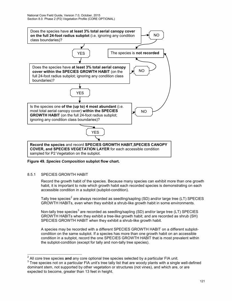
National Core Field Guide, Version 7.0, October, 2015 Section 8.0. Phase 2 (P2) Vegetation Profile (CORE OPTIONAL)
121
Figure 49. Species Composition subplot flow chart. 8.5.1 SPECIES GROWTH HABIT
Record the growth habit of the species. Because many species can exhibit more than one growth habit, it is important to note which growth habit each recorded species is demonstrating on each accessible condition in a subplot (subplot-condition). Tally tree species2 are always recorded as seedling/sapling (SD) and/or large tree (LT) SPECIES GROWTH HABITs, even when they exhibit a shrub-like growth habit in some environments. Non-tally tree species3 are recorded as seedling/sapling (SD) and/or large tree (LT) SPECIES GROWTH HABITs when they exhibit a tree-like growth habit; and are recorded as shrub (SH) SPECIES GROWTH HABIT when they exhibit a shrub-like growth habit. A species may be recorded with a different SPECIES GROWTH HABIT on a different subplot-condition on the same subplot. If a species has more than one growth habit on an accessible condition in a subplot, record the one SPECIES GROWTH HABIT that is most prevalent within the subplot-condition (except for tally and non-tally tree species).
2 All core tree species and any core optional tree species selected by a particular FIA unit. 3 Tree species not on a particular FIA unit’s tree tally list that are woody plants with a single well-defined dominant stem, not supported by other vegetation or structures (not vines), and which are, or are expected to become, greater than 13 feet in height.
The species is not recorded YES
NO
NO
YES
Does the species have at least 3% total aerial canopy cover on the full 24-foot radius subplot (i.e. ignoring any condition class boundaries)?
Does the species have at least 3% total aerial canopy cover within the SPECIES GROWTH HABIT (on the full 24-foot radius subplot; ignoring any condition class boundaries)?
YES
NO Is the species one of the (up to) 4 most abundant (i.e. most total aerial canopy cover) within the SPECIES GROWTH HABIT (on the full 24-foot radius subplot; ignoring any condition class boundaries)?
Record the species and record SPECIES GROWTH HABIT,SPECIES CANOPY COVER, and SPECIES VEGETATION LAYER for each accessible condition sampled for P2 Vegetation on the subplot.
National Core Field Guide, Version 7.0, October, 2015 Section 8.0. Phase 2 (P2) Vegetation Profile (CORE OPTIONAL)
122
For tally and non-tally tree species, both tree SPECIES GROWTH HABITs (SD and LT) are coded for the same species within the subplot-condition the species has a total aerial canopy cover of at least 3% in each SPECIES GROWTH HABIT. Values:
SD Seedlings and Saplings: Small trees less than 5 inches DBH or DRC (refer to field guide sections 5.9.2 and 5.9.4), including tally and non-tally tree species. Seedlings of any length are included (i.e., no minimum.) Up to four species are recorded if individual species total aerial canopy cover is at least 3% on the subplot and within the SPECIES GROWTH HABIT.
SH Shrubs/Subshrubs/Woody Vines: Woody, multiple-stemmed plants of any size, subshrubs (low-growing shrubs under 1.5 feet tall at maturity), and woody vines. Most cacti are included in this category. Subshrub species are usually included in this category. However, there are many species that can exhibit either subshrub or forb/herb growth habits. Each FIA region will develop a list of common species that can exhibit either growth habits (according to the NRCS PLANTS database) with regional guidance as to which growth habit the species should normally be assigned, while still allowing species assignments to different growth habits when the species is obviously present in a different growth habit. Up to four species are recorded if individual species total aerial canopy cover is at least 3% on the subplot and within the SPECIES GROWTH HABIT.
FB Forbs: Herbaceous, broad-leaved plants; includes non-woody-vines, ferns (does not include mosses and cryptobiotic crusts). Up to four species are recorded if individual species total aerial canopy cover is at least 3% on the subplot and within the SPECIES GROWTH HABIT.
GR Graminoids: Grasses and grass-like plants (includes rushes and sedges). Up to four species are recorded if individual species total aerial canopy cover is at least 3% on the subplot and within the SPECIES GROWTH HABIT
LT Large Trees: Large trees greater than or equal to 5 inches DBH or DRC (refer to field guide sections 5.9.2. and 5.9.4). For LEVEL OF DETAIL = 2,include only non-tally tree species; for LEVEL OF DETAIL = 3, include tally and non-tally tree species. Up to four species of large trees (DBH or DRC at least 5 inches) are recorded if individual species aerial canopy cover is at least 3% on the subplot and within the SPECIES GROWTH HABIT.
8.5.2 SPECIES CODE
Record a code for each most abundant (see section 8.5) vascular plant species. Species codes must be the standardized codes in the Natural Resource Conservation Service (NRCS) PLANTS database (currently January 2010 version). Identification to species only is expected. However, if subspecies information is known, enter the appropriate NRCS code. For graminoids, genus and unknown codes are acceptable, but do not lump species of the same genera or unknown code. For example, if several unknown CAREX species are present, only record the individual most abundant species. If a plant cannot be identified quickly and confidently, assign a NRCS PLANTS genus or unknown code appropriate to the species. Collect a specimen away from the subplot unless the species is locally sparse or another SPECIMEN NOT COLLECTED REASON CODE (8.5.8) applies. A species is “locally sparse” if 5 or fewer plants are present in the entire plot (4 subplots) and immediate surrounding area. A species may be sparse and still meet the criteria for inclusion in species composition, but this will be rare. See appendix 10, Unknown Specimen Collection.
National Core Field Guide, Version 7.0, October, 2015 Section 8.0. Phase 2 (P2) Vegetation Profile (CORE OPTIONAL)
123
Acceptable unknown codes Code Common Name 2FERN Fern or Fern Ally 2FORB Forb (herbaceous, not grass nor grasslike) 2FD Forb, dicot 2FM Forb, monocot 2GRAM Graminoid (grass or grasslike) 2GA Grass, annual 2GP Grass, perennial 2GL Grass-like, (sedges and rushes) 2PLANT Plant 2SHRUB Shrub (>0.5m) 2SUBS Subshrub (<0.5m) 2TREE Tree 2VH Vine, herbaceous 2VW Vine, woody
Values: Accepted NRCS species code when the species is known, or an accepted NRCS genus
or unknown code when the species is not known 8.5.3 UNIQUE SPECIES NUMBER
When any code is entered for the first time on a plot, it is assigned UNIQUE SPECIES NUMBER = 1. If more than one unidentified species is discovered that is described by the same genus or unknown code, the next sequential number is assigned. If a recorded unidentified species is encountered again elsewhere on the plot, the field crew records the species with the same genus or unknown code with the same unique species number. Values: 1-99, assigned in sequential numbers
8.5.4 SPECIES CANOPY COVER
For each species recorded, estimate and record the total aerial canopy cover present on the subplot-condition to the nearest 1 percent. Examine each species individually as if the other species do not exist. When recording SPECIES CANOPY COVER for seedlings and saplings (SPECIES GROWTH HABIT = SD), do not include any canopy cover from trees greater than or equal to 5 inches DBH (DRC for woodland species), regardless of how close to the ground the canopy cover extends A separate estimate is made for the SPECIES CANOPY COVER of trees greater than or equal to 5 inches DBH/DRC (SPECIES GROWTH HABIT = LT). Values: 001-100
8.5.5 SPECIES VEGETATION LAYER
For each individual species recorded, assign one of the vegetation layers. These layers illustrate the vertical diversity of the most abundant species found on the subplot. Assign each plant species record to only one of the vegetation layers per SPECIES GROWTH HABIT per subplot-condition. If a plant species is found in more than one layer, assign the species to the layer where most of the canopy cover occurs. If a species occupies multiple layers equally, assign the highest of the equally occupied layers. If a plant has a seed head that grows
National Core Field Guide, Version 7.0, October, 2015 Section 8.0. Phase 2 (P2) Vegetation Profile (CORE OPTIONAL)
124
much taller than the rest of the plant, record the layer that the main part of the plant is in, not the top of the seed head.
Values: 1-4
1 0 to 2.0 feet 2 2.1 to 6.0 feet 3 6.1 to 16.0 feet 4 Greater than 16 feet
8.5.6 SPECIMEN OFFICIALLY COLLECTED
Record a code to indicate whether or not a specimen was collected for each species, genus or unknown code entered as a new unique species. Values:
0 No, a specimen was not collected 1 Yes, a specimen was collected
8.5.7 SPECIMEN LABEL NUMBER
Record the label number for the collected specimen. Pre-numbered labels are provided to each crew by the regional coordinator or auto-generated with the data collection software. Values: 1 to 99999, as pre-printed and assigned by region or auto-generated in the PDR
8.5.8 P2 SPECIMEN NOT COLLECTED REASON CODE
Record the code that describes why a specimen has not been collected. Values:
01 Species is locally sparse (fewer than 5 individual plants in area of the plot) 02 Species has no mature foliage or reproductive parts present, so is unlikely to be
identifiable if collected. 03 Hazardous situation 04 Time limitation 05 Wilderness or reserved land where plant collections are not allowed 06 Specimen collected for immediate/local identification 07 Not required by inventory unit 10 Other (explain in notes)
8.5.9 VEGETATION SPECIES NOTES
Notes may be entered for any species encountered, but are required for each new species that is not identified. Enter text that describes the species. This text may be used in the specimen label and unknown report. Values: English language words, phrases, and numbers

National Core Field Guide, Version 7.0, October, 2015 Section 8.0. Phase 2 (P2) Vegetation Profile (CORE OPTIONAL)
125
National Core Field Guide, Version 7.0, October, 2015 Section 9.0. Invasive Plants
126
9.0 INVASIVE PLANTS
The objectives of the Phase 2 (P2) invasive plants protocol are to document abundance and monitor changes in abundance of selected species over time. Combined with other plot data and other datasets, these data can be used to predict the future spread of selected species. Invasive plant species are having tremendous economic and ecological impacts on our nation’s forests, and the impacts are increasing over time. Providing accurate, statistically valid estimates of the distribution and abundance of some of the most damaging species will give managers and policy-makers a better understanding of the problem than they would otherwise have.
Each FIA unit, in collaboration with vegetation experts, has developed lists of the most important invasive species to monitor on forested lands. Depending on local needs or forest conditions, there may be different lists of species for individual states or portions of states. Changes to the species on these lists are managed by the individual FIA units using local change procedures. However, when an FIA unit samples invasive species, they will use the field protocols contained in this chapter.
Data will be collected by crew members who have been trained and certified in the Invasive plants protocol methods. These crew members are expected to have field guides that allow for unambiguous identification of the plant species on the list they are to use, and training in field identification and cover estimation of those species under different conditions.
Note: Avoid becoming part of the problem! There is a risk that field crews walking into plot locations could pick up seeds along roadsides or other patches of invasive plants and spread them through the forest and on to the plot. Be aware of the vegetation you are traveling through and consider stopping and removing seeds from boots and clothing before entering uninvaded lands, particularly remote areas that are rarely visited.
9.1 Invasive species sample design
Phase 2 sampling of invasive species is most often focused on accessible forest condition classes within the 24.0-foot radius subplot. If the total area of all accessible forest land condition classes is less than 100 percent on a subplot, invasive species measurements are done only on the portion that is in accessible forest land condition classes. If multiple accessible forested condition classes are present on the subplot, separate estimates are made for each condition class on the subplot. Canopy cover estimates are only made for the area within accessible forest condition(s)—for example, vegetation cover over-hanging a nonforest road condition is not included in the estimate.
However, each FIA unit has the option to also sample invasive species on accessible nonforest land conditions (condition status 2), where desired or funded by specific landowners (e.g., on some National Forests in the West). Where this is done, estimates of invasive species abundance are maintained separately on forest and nonforest conditions.
Canopy cover is estimated for any listed invasive species present on the measured condition(s) of a subplot, regardless of abundance (i.e., there is not minimum cover threshold for sampling). When crews are not sure about the identification of a plant that might be a listed invasive, they are encouraged to collect specimens for later identification (appendix 10). Rules and expectations for plant collection and identification are specified by individual FIA units.
9.2 Species Records
The invasive plant recorder does a search of each measured condition on the subplot. Only listed species rooted in or overhanging (and rooted out of) this condition are included. For tree species, there are no minimum (or maximum) height limits as are required for seedling counts. All foliage that is or was alive during the current growing season is included in the cover estimates (e.g.,
National Core Field Guide, Version 7.0, October, 2015 Section 9.0. Invasive Plants
127
brown Canada thistle in late summer is counted, live buds on Russian olive in late fall are used to estimate canopy cover).
Total cover is estimated on measured conditions on each 24.0-foot radius subplot for every species on the invasive plant list found. If multiple conditions are being sampled on the same subplot, separate cover estimates for every species must be made.
9.3 SUBPLOT NUMBER
Record the code corresponding to the number of the subplot. Values:
1 Center subplot 2 North subplot 3 Southeast subplot 4 Southwest subplot
9.4 CONDITION CLASS NUMBER
Record the number for the measured condition class in which the invasive plant(s) is found. If multiple measured conditions occur on the same subplot, data will be collected for each condition separately. Values: 1-9
9.5 SPECIES CODE
Record the code for any species listed in your region’s invasive plant species list that is found rooted in or overhanging (and rooted out of) the measured condition within the subplot. Species codes must be the standardized codes in the Natural Resource Conservation Service (NRCS) PLANTS database January 2010 version maintained by the FIA IM group (USDA, NRCS. 2010. The PLANTS database [http://plants.usda.gov/plants]. National Plant Data Center, Baton Rouge, LA 70874-4490). In many of the invasive plant ID guides used by FIA units, some species are grouped together in the ID descriptions, and it may be difficult to distinguish between them with the information provided. In addition, some plants may be hybrids of listed species. Enter the code for the most likely species in the group, or the first one in the group if you are not sure.
If a species is suspected of being a listed invasive but cannot be identified quickly and confidently, and the FIA unit’s protocols require specimen collection, assign a NRCS PLANTS unknown code. A subset of acceptable unknown codes that can be used is listed below. Collect a specimen unless the species is locally sparse. A species is “locally sparse” if five or fewer plants are present in the entire plot (4 subplots) and immediate surrounding area.
Unknown Code Common Name 2FERN Fern or Fern Ally 2FORB Forb (herbaceous, not grass nor
grasslike) 2GRAM Graminoid (grass or grasslike) 2PLANT Plant 2SHRUB Shrub (>.5m)
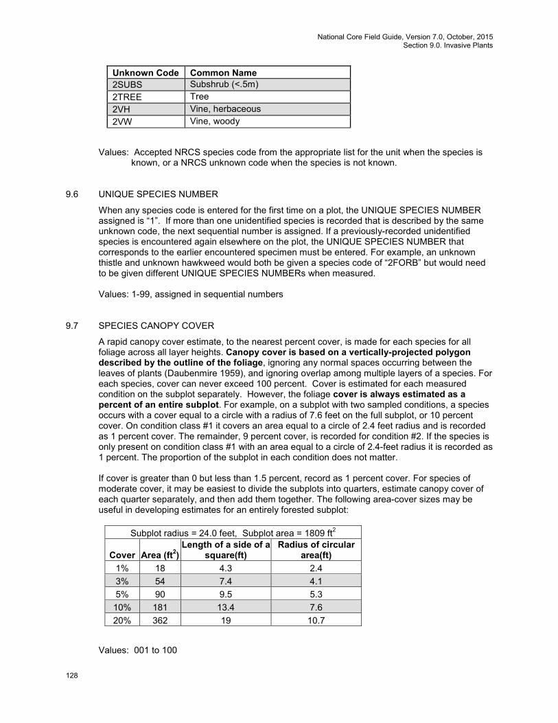
National Core Field Guide, Version 7.0, October, 2015 Section 9.0. Invasive Plants
128
Unknown Code Common Name 2SUBS Subshrub (<.5m) 2TREE Tree 2VH Vine, herbaceous 2VW Vine, woody
Values: Accepted NRCS species code from the appropriate list for the unit when the species is
known, or a NRCS unknown code when the species is not known. 9.6 UNIQUE SPECIES NUMBER
When any species code is entered for the first time on a plot, the UNIQUE SPECIES NUMBER assigned is “1”. If more than one unidentified species is recorded that is described by the same unknown code, the next sequential number is assigned. If a previously-recorded unidentified species is encountered again elsewhere on the plot, the UNIQUE SPECIES NUMBER that corresponds to the earlier encountered specimen must be entered. For example, an unknown thistle and unknown hawkweed would both be given a species code of “2FORB” but would need to be given different UNIQUE SPECIES NUMBERs when measured.
Values: 1-99, assigned in sequential numbers
9.7 SPECIES CANOPY COVER
A rapid canopy cover estimate, to the nearest percent cover, is made for each species for all foliage across all layer heights. Canopy cover is based on a vertically-projected polygon described by the outline of the foliage, ignoring any normal spaces occurring between the leaves of plants (Daubenmire 1959), and ignoring overlap among multiple layers of a species. For each species, cover can never exceed 100 percent. Cover is estimated for each measured condition on the subplot separately. However, the foliage cover is always estimated as a percent of an entire subplot. For example, on a subplot with two sampled conditions, a species occurs with a cover equal to a circle with a radius of 7.6 feet on the full subplot, or 10 percent cover. On condition class #1 it covers an area equal to a circle of 2.4 feet radius and is recorded as 1 percent cover. The remainder, 9 percent cover, is recorded for condition #2. If the species is only present on condition class #1 with an area equal to a circle of 2.4-feet radius it is recorded as 1 percent. The proportion of the subplot in each condition does not matter. If cover is greater than 0 but less than 1.5 percent, record as 1 percent cover. For species of moderate cover, it may be easiest to divide the subplots into quarters, estimate canopy cover of each quarter separately, and then add them together. The following area-cover sizes may be useful in developing estimates for an entirely forested subplot:
Subplot radius = 24.0 feet, Subplot area = 1809 ft2
Cover Area (ft2) Length of a side of a
square(ft) Radius of circular
area(ft) 1% 18 4.3 2.4 3% 54 7.4 4.1 5% 90 9.5 5.3 10% 181 13.4 7.6 20% 362 19 10.7
Values: 001 to 100
National Core Field Guide, Version 7.0, October, 2015 Section 9.0. Invasive Plants
129
9.8 INVASIVE SPECIMEN COLLECTED
Record a code to indicate whether or not a specimen was collected for each species genus or unknown code entered as a new unique species. If the record is an unknown code, your unit requires specimen collection, and a plant specimen is not collected, describe the reason it was not collected in 9.10, INVASIVE PLANT NOTES. Values:
0 No, a specimen was not officially collected 1 Yes, a specimen was officially collected
9.9 SPECIMEN LABEL NUMBER
Record the label number for the collected specimen. Where plant specimen collection is required, numbered labels are provided to each crew.
Values: 1 to 99999, as pre-printed and assigned by FIA unit.
9.10 INVASIVE PLANT NOTES
Notes are required for each species record with an unknown code. Enter text that describes the species or that explains why it was not collected if collection was required but not done. This text may be used on the specimen label and any spreadsheet used to track specimens.
Values: English language words, phrases, and numbers
9.11 References
Daubenmire, R. 1959. A canopy-coverage method of vegetational analysis. Northwest Science 33(1): 43-64.
National Core Field Guide, Version 7.0, October, 2015 Section 10.0. Down Woody Materials (Phase 2 – CORE OPTIONAL)
130
10. DOWN WOODY MATERIALS (Phase 2 – CORE OPTIONAL) 10.0 Introduction
Down woody materials (DWM) are important components of forest ecosystems across the country. DWM is dead material on the ground in various stages of decay. Wildlife biologists, ecologists, mycologists, foresters, and fuels specialists are some of the people interested in DWM because it helps describe the:
• Quality and status of wildlife habitats. • Structural diversity within a forest. • Fuel loading and fire behavior. • Carbon sequestration – the amount of carbon tied up in dead wood. • Storage and cycling of nutrients and water – important for site productivity.
Down wood components and fuels estimated by the FIA program are coarse wood, slash, fine wood, and litter and duff depth. The DWM protocol includes the following three suites of measurement options: OPTION I. BASE: The BASE option provides a minimum set of variables necessary to produce estimates for volume, biomass, carbon, and fuel load per acre on a broad scale. Base variables are required any time DWM is measured, and are labeled “BASE” in this chapter. Measurements include: OPTION I: BASE Variables
BASE Layout: DWM SAMPLING STATUS, DWM NUMBER OF SUBPLOTS, DWM NUMBER OF TRANSECTS ON SUBPLOT, DWM TRANSECT LENGTH, DWM NOTES
BASE Transect Line Segmenting: SUBPLOT NUMBER,TRANSECT, SEGMENT CONDITION CLASS NUMBER, SEGMENT BEGINNING DISTANCE (HD), SEGMENT ENDING DISTANCE (HD), DWM TRANSECT SEGMENT SAMPLE STATUS, DWM TRANSECT NONSAMPLED REASON
BASE CWD: SUBPLOT NUMBER, TRANSECT, CWD CONDITION CLASS, PIECE ON SUBPLOT OR ANNULAR PLOT?, CWD DECAY CLASS, SPECIES, DIAMETER AT POINT OF INTERSECTION, DIAMETER OF HOLLOW AT POINT OF INTERSECTION, CWD LENGTH >=3 FEET
BASE Pile: PILE SUBPLOT NUMBER, PILE TRANSECT, PILE CONDITION CLASS NUMBER, PILE BEGINNING DISTANCE, PILE ENDING DISTANCE, COMPACTED HEIGHT OF CWD IN PILE, PILE DECAY CLASS, PILE SPECIES
BASE FWD: FWD SUBPLOT NUMBER, FWD TRANSECT, FWD CONDITION CLASS NUMBER, FWD TRANSECT SEGMENT SAMPLE STATUS, FWD TRANSECT NONSAMPLED REASON, SMALL FWD COUNT, MEDIUM FWD COUNT, LARGE FWD COUNT, HIGH COUNT REASON
BASE Duff/Litter Depth: DUFF/LITTER SUBPLOT NUMBER, DUFF/LITTER TRANSECT, DUFF/LITTER CONDITION CLASS NUMBER, DUFF/LITTER SAMPLE STATUS, DUFF/LITTER NONSAMPLED REASON, DUFF DEPTH, LITTER DEPTH, DUFF AND LITTER METHOD
OPTION II. WILDLIFE/ECOLOGICAL This option includes all the BASE Option variables plus additional CWD structural variables. These additional measurements allow users to quantify wildlife habitat. This option is required when measuring P3 DWM. OPTION II: WILDLIFE / ECOLOGICAL
BASE Layout Variables BASE Transect Line Segmenting Variables BASE CWD Variables plus the following variables required for P3 DWM:CWD HORIZONTAL
DISTANCE, DIAMETER AT SMALL END, DIAMETER AT LARGE END, CWD TOAL LENGTH BASE Pile Variables BASE FWD Variables BASE Duff/Litter Depth Variables
National Core Field Guide, Version 7.0, October, 2015 Section 10.0. Down Woody Materials (Phase 2 – CORE OPTIONAL)
131
OPTION III. RAPID ASSESSMENT (CUSTOMIZED PROTOCOL):
Rapid assessments may be desired to quantify down wood abundance in specific instances (for example, following a hurricane or volcanic eruption). Because information needs and funds will vary depending on the situation, a rapid assessment option is available where the transect configuration (number of transects and subplots and transect length) can be defined by the FIA unit. However, the base variables needed to estimate biomass are still required for rapid assessments. Additional variables found to be useful by FIA units in the past are also defined in this protocol to ensure consistency if additional information is desired by different FIA units. FIA units may also choose to classify the fuelbed conditions that determine fire behavior on each condition class using standardized national fuel models. These variables are labeled “OPTIONAL” in this chapter. ADDITIONAL OPTIONAL VARIABLES
Optional CWD Variables (for all OPTIONs): IS THE PIECE HOLLOW?, PIECE INCLINATION, CWD HISTORY, PERCENT OF LOG CHARRED BY FIRE, LARGE END DIAMETER CLASS
Optional Fuels Variable: CONDITION FUELBED TYPE (Scott and Burgan 2005; RMRS-GTR-153) DWM is sampled on accessible forest conditions intersected by a transect, and on accessible nonforest conditions if they are being measured on the plot (NONFOREST CONDITION CLASS STATUS = 2). If a transect crosses a condition boundary, the boundary locations on the transect are recorded. All DWM in the inventory is sampled using the line intersect sampling method (also called planar intercept method). In this method, transects are established, and individual pieces of Coarse Woody Debris (CWD, ≥3 inches diameter and ≥0.5 foot long) or Fine Woody Debris (FWD, <3 inches diameter) are tallied if the central axis of the piece is intersected by the plane of the transect.
Note: DWM is a CORE OPTIONAL indicator on all Phase 2 plots. When measured on Phase 2 plots, all the BASE data items must be measured and other data items can be added as desired (designated as P2 OPTIONAL on data items.) However, DWM is a CORE indicator on all Phase 3 plots, and both BASE and WILDLIFE/ECOLOGICAL data items must be measured (see table 3).
Table 3. DWM Protocol Options Variables OPTION I: BASE OPTION II: WILDLIFE /
ECOLOGICAL ADDITIONAL OPTIONAL VARIABLES
REQUIRED: BASE Layout Variables
REQUIRED: BASE Layout Variables
REQUIRED: BASE Transect Line Segmenting Variables
REQUIRED: BASE Transect Line Segmenting Variables
REQUIRED: BASE CWD Variables P2 OPTIONAL: CWD HORIZONTAL DISTANCE, DIAMETER AT SMALL END, DIAMETER AT LARGE END, CWD TOTAL LENGTH
REQUIRED: BASE CWD Variables, CWD HORIZONTAL DISTANCE, DIAMETER AT SMALL END, DIAMETER AT LARGE END, CWD TOTAL LENGTH, IS THE PIECE HOLLOW?
OPTIONAL CWD Variables (for all OPTIONs): IS THE PIECE HOLLOW?, PIECE INCLINATION, CWD HISTORY, PERCENT OF LOG CHARRED BY FIRE, LARGE END DIAMETER CLASS
REQUIRED: BASE Pile Variables REQUIRED: BASE Pile Variables REQUIRED: BASE FWD Variables REQUIRED: BASE FWD Variables REQUIRED: BASE Duff/Litter Depth Variables
REQUIRED: BASE Duff/Litter Depth Variables
National Core Field Guide, Version 7.0, October, 2015 Section 10.0. Down Woody Materials (Phase 2 – CORE OPTIONAL)
132
OPTION I: BASE OPTION II: WILDLIFE / ECOLOGICAL
ADDITIONAL OPTIONAL VARIABLES
Optional Fuels Variable: Photo-series (Scott & Burgan 2005 RMRS-GTR-153)
10.1 Definition of Down Woody Materials
Coarse Woody Debris – In this inventory, CWD includes downed, dead tree and shrub boles, large limbs, and other woody pieces that are ≥3 inches in diameter and severed from their original source of growth. CWD also includes dead tally species trees or single-stemmed woodland species trees (either self-supported by roots, severed from roots, or uprooted and supported by other objects) that are leaning >45 degrees from vertical and not considered part of the standing tree inventory. Portions of dead trees that are separated greater than 50 percent (either above or below 4.5 feet), are considered severed and are included in the CWD inventory (see discussion and diagrams in section 5.7.2 - Standing Dead). For multi-stemmed woodland species (Appendix 3) such as juniper, only tally stems that are dead and detached. Include as CWD all dead multi-stemmed woodland tree stems that do not qualify as standing dead if they meet the size requirements for CWD pieces. Also included are non-machine processed round wood such as fence posts and cabin logs. CWD is measured primarily using intersect diameter. In rare instances when pieces are in a pile and it is impossible to estimate the size of individual pieces, use the pile protocol. CWD does not include:
1. Woody pieces <3.0 inches in diameter at the point of intersection with the transect. 2. Dead trees leaning 0 to 45 degrees from vertical (see discussion and diagrams in section 5.7.2 -
Standing Dead). 3. Dead shrubs, self-supported by their roots. 4. Trees showing any sign of life. 5. Stumps that are rooted in the ground (i.e., not uprooted). 6. Dead foliage, bark or other non-woody pieces that are not an integral part of a bole or limb. (Bark
attached to a portion of a piece is an integral part). 7. Roots or main bole below the root collar.
Fine Woody Debris – In this inventory, FWD includes downed, dead branches, twigs, and small tree or shrub boles <3 inches in diameter that are not attached to a living or standing dead source. FWD can be connected to a larger branch, as long as this branch is on the ground and not connected to a standing dead or live tree. Only the woody branches, twigs, and fragments that intersect the transect are counted. FWD can be connected to a down, dead tree bole or down, dead shrub. FWD can be twigs from shrubs and vines. FWD must be no higher than 6 feet above the ground to be counted. FWD does not include:
1) Woody pieces >3.0 inches in diameter at the point of intersection with the transect. 2) Dead branches connected to a live tree or shrub; or to a standing dead tree or dead shrub. 3) Dead foliage (i.e., pine or fir needles, or leaf petioles). 4) Bark fragments or other non-woody pieces that are not an integral part of a branch, twig, or small
bole. 5) Small pieces of decomposed wood (i.e., chunks of cubical rot)
10.2 Locating and Establishing Line Transects
Transects are established on each subplot if the subplot center is accessible (i.e., not census water, access denied, or hazardous), and there is at least one forest or measured nonforest land condition class mapped within the 24.0-foot radius subplot (CONDITION CLASS STATUS = 1 or (NONFOREST
National Core Field Guide, Version 7.0, October, 2015 Section 10.0. Down Woody Materials (Phase 2 – CORE OPTIONAL)
133
CONDITION CLASS STATUS = 2)). Transects begin at the subplot center and extend 24.0 feet to the edge of the subplot. The location of condition class boundaries are recorded along the transect, starting at the subplot center and working towards the fixed radius plot boundary. It is extremely important to lay out the transect in a straight line to avoid biasing the selection of pieces and to allow the remeasurement of transect lines and tally pieces for QA purposes.
Transect lines should be marked with a pin or small piece of flagging at the end of the line (24.0 feet, horizontal distance) to help the QA staff identify the path of the transect during the check-plot procedure. Because the tolerance for the transect azimuth is +/- 2 degrees, the line might have been laid down in a slightly different direction from the check-plot crew. This could affect the location of diameter measurements for CWD pieces as well as identifying whether a CWD piece is a valid tally piece. It is also helpful to mark the point where the FWD transect begins (14 feet, horizontal distance). 10.2.1 CWD Transects
Two transects are established that originate at the subplot center and extend out 24.0 feet horizontal distance (the radius of the subplot) (fig. 50). This transect configuration was chosen to avoid sampling bias on sloped land, where it is possible that CWD may be oriented in one direction. This configuration of transects should pick up CWD logs that are lying parallel to the slope, perpendicular to the slope, and across slope. On plots where the macroplot is measured and mapped for condition classes, FIA units have the option of extending transects up to 58.9 feet from subplot center. In addition, an optional third transect on each subplot provides the ability to add or retain transect length on P3 plots.
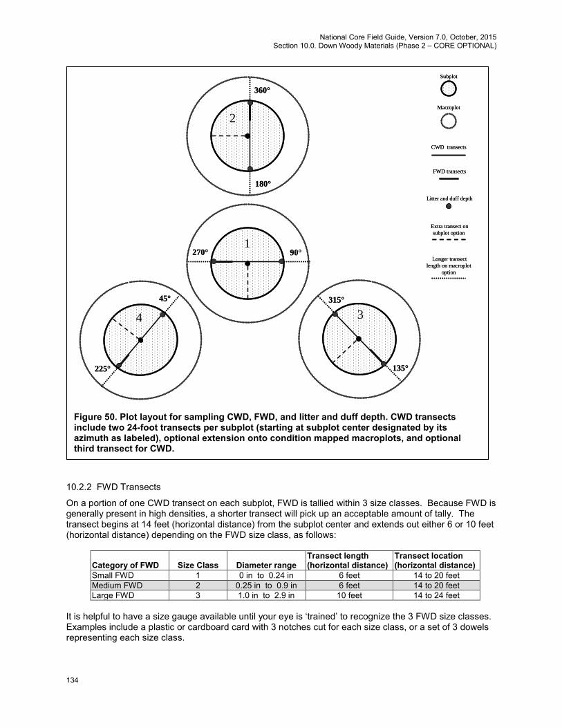
National Core Field Guide, Version 7.0, October, 2015 Section 10.0. Down Woody Materials (Phase 2 – CORE OPTIONAL)
134
10.2.2 FWD Transects
On a portion of one CWD transect on each subplot, FWD is tallied within 3 size classes. Because FWD is generally present in high densities, a shorter transect will pick up an acceptable amount of tally. The transect begins at 14 feet (horizontal distance) from the subplot center and extends out either 6 or 10 feet (horizontal distance) depending on the FWD size class, as follows:
Category of FWD
Size Class
Diameter range
Transect length (horizontal distance)
Transect location (horizontal distance)
Small FWD 1 0 in to 0.24 in 6 feet 14 to 20 feet Medium FWD 2 0.25 in to 0.9 in 6 feet 14 to 20 feet Large FWD 3 1.0 in to 2.9 in 10 feet 14 to 24 feet
It is helpful to have a size gauge available until your eye is ‘trained’ to recognize the 3 FWD size classes. Examples include a plastic or cardboard card with 3 notches cut for each size class, or a set of 3 dowels representing each size class.
4 3
2
1
360°
90°270°
225°
45°
180°
135°
315°
4 3
2
1
360°
90°270°
225°
45°
180°
135°
315°
Subplot
CWD transects
FWD transects
Litter and duff depth
Macroplot
Extra transect on subplot option
Longer transect length on macroplot
option
Subplot
CWD transects
FWD transects
Litter and duff depth
Macroplot
Extra transect on subplot option
Longer transect length on macroplot
option
Figure 50. Plot layout for sampling CWD, FWD, and litter and duff depth. CWD transects include two 24-foot transects per subplot (starting at subplot center designated by its azimuth as labeled), optional extension onto condition mapped macroplots, and optional third transect for CWD.
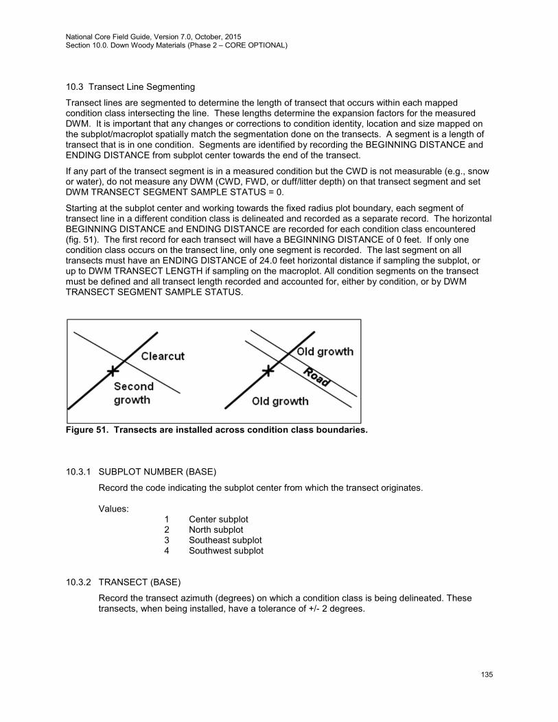
National Core Field Guide, Version 7.0, October, 2015 Section 10.0. Down Woody Materials (Phase 2 – CORE OPTIONAL)
135
10.3 Transect Line Segmenting
Transect lines are segmented to determine the length of transect that occurs within each mapped condition class intersecting the line. These lengths determine the expansion factors for the measured DWM. It is important that any changes or corrections to condition identity, location and size mapped on the subplot/macroplot spatially match the segmentation done on the transects. A segment is a length of transect that is in one condition. Segments are identified by recording the BEGINNING DISTANCE and ENDING DISTANCE from subplot center towards the end of the transect.
If any part of the transect segment is in a measured condition but the CWD is not measurable (e.g., snow or water), do not measure any DWM (CWD, FWD, or duff/litter depth) on that transect segment and set DWM TRANSECT SEGMENT SAMPLE STATUS = 0.
Starting at the subplot center and working towards the fixed radius plot boundary, each segment of transect line in a different condition class is delineated and recorded as a separate record. The horizontal BEGINNING DISTANCE and ENDING DISTANCE are recorded for each condition class encountered (fig. 51). The first record for each transect will have a BEGINNING DISTANCE of 0 feet. If only one condition class occurs on the transect line, only one segment is recorded. The last segment on all transects must have an ENDING DISTANCE of 24.0 feet horizontal distance if sampling the subplot, or up to DWM TRANSECT LENGTH if sampling on the macroplot. All condition segments on the transect must be defined and all transect length recorded and accounted for, either by condition, or by DWM TRANSECT SEGMENT SAMPLE STATUS.
Figure 51. Transects are installed across condition class boundaries. 10.3.1 SUBPLOT NUMBER (BASE)
Record the code indicating the subplot center from which the transect originates. Values:
1 Center subplot 2 North subplot 3 Southeast subplot 4 Southwest subplot
10.3.2 TRANSECT (BASE)
Record the transect azimuth (degrees) on which a condition class is being delineated. These transects, when being installed, have a tolerance of +/- 2 degrees.
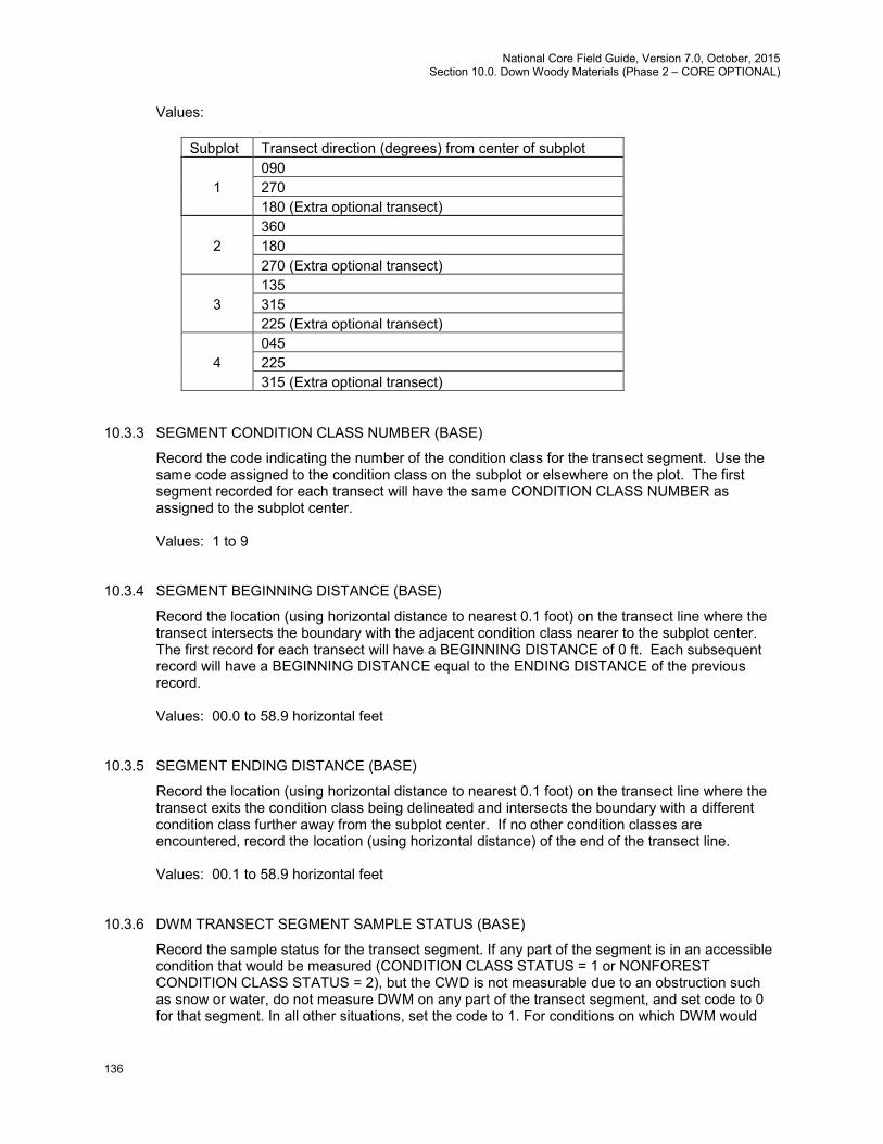
National Core Field Guide, Version 7.0, October, 2015 Section 10.0. Down Woody Materials (Phase 2 – CORE OPTIONAL)
136
Values:
Subplot Transect direction (degrees) from center of subplot 090 1 270 180 (Extra optional transect) 360 2 180 270 (Extra optional transect) 135 3 315 225 (Extra optional transect) 045 4 225 315 (Extra optional transect)
10.3.3 SEGMENT CONDITION CLASS NUMBER (BASE)
Record the code indicating the number of the condition class for the transect segment. Use the same code assigned to the condition class on the subplot or elsewhere on the plot. The first segment recorded for each transect will have the same CONDITION CLASS NUMBER as assigned to the subplot center. Values: 1 to 9
10.3.4 SEGMENT BEGINNING DISTANCE (BASE)
Record the location (using horizontal distance to nearest 0.1 foot) on the transect line where the transect intersects the boundary with the adjacent condition class nearer to the subplot center. The first record for each transect will have a BEGINNING DISTANCE of 0 ft. Each subsequent record will have a BEGINNING DISTANCE equal to the ENDING DISTANCE of the previous record. Values: 00.0 to 58.9 horizontal feet
10.3.5 SEGMENT ENDING DISTANCE (BASE)
Record the location (using horizontal distance to nearest 0.1 foot) on the transect line where the transect exits the condition class being delineated and intersects the boundary with a different condition class further away from the subplot center. If no other condition classes are encountered, record the location (using horizontal distance) of the end of the transect line. Values: 00.1 to 58.9 horizontal feet
10.3.6 DWM TRANSECT SEGMENT SAMPLE STATUS (BASE)
Record the sample status for the transect segment. If any part of the segment is in an accessible condition that would be measured (CONDITION CLASS STATUS = 1 or NONFOREST CONDITION CLASS STATUS = 2), but the CWD is not measurable due to an obstruction such as snow or water, do not measure DWM on any part of the transect segment, and set code to 0 for that segment. In all other situations, set the code to 1. For conditions on which DWM would
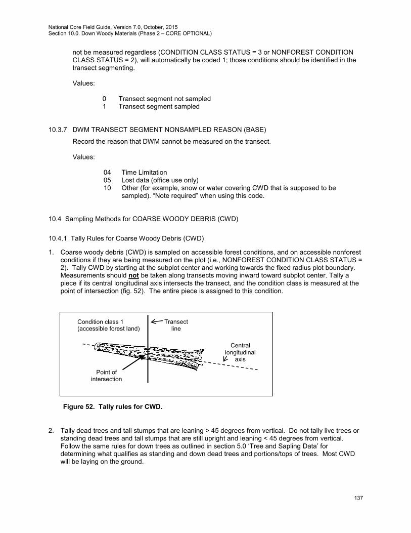
National Core Field Guide, Version 7.0, October, 2015 Section 10.0. Down Woody Materials (Phase 2 – CORE OPTIONAL)
137
not be measured regardless (CONDITION CLASS STATUS = 3 or NONFOREST CONDITION CLASS STATUS = 2), will automatically be coded 1; those conditions should be identified in the transect segmenting. Values:
0 Transect segment not sampled 1 Transect segment sampled
10.3.7 DWM TRANSECT SEGMENT NONSAMPLED REASON (BASE)
Record the reason that DWM cannot be measured on the transect. Values:
04 Time Limitation 05 Lost data (office use only) 10 Other (for example, snow or water covering CWD that is supposed to be
sampled). “Note required” when using this code.
10.4 Sampling Methods for COARSE WOODY DEBRIS (CWD)
10.4.1 Tally Rules for Coarse Woody Debris (CWD)
1. Coarse woody debris (CWD) is sampled on accessible forest conditions, and on accessible nonforest conditions if they are being measured on the plot (i.e., NONFOREST CONDITION CLASS STATUS = 2). Tally CWD by starting at the subplot center and working towards the fixed radius plot boundary. Measurements should not be taken along transects moving inward toward subplot center. Tally a piece if its central longitudinal axis intersects the transect, and the condition class is measured at the point of intersection (fig. 52). The entire piece is assigned to this condition.
2. Tally dead trees and tall stumps that are leaning > 45 degrees from vertical. Do not tally live trees or standing dead trees and tall stumps that are still upright and leaning < 45 degrees from vertical. Follow the same rules for down trees as outlined in section 5.0 ‘Tree and Sapling Data’ for determining what qualifies as standing and down dead trees and portions/tops of trees. Most CWD will be laying on the ground.
Figure 52. Tally rules for CWD.
Condition class 1 (accessible forest land)
Central longitudinal
axis
Transect line
Point of intersection
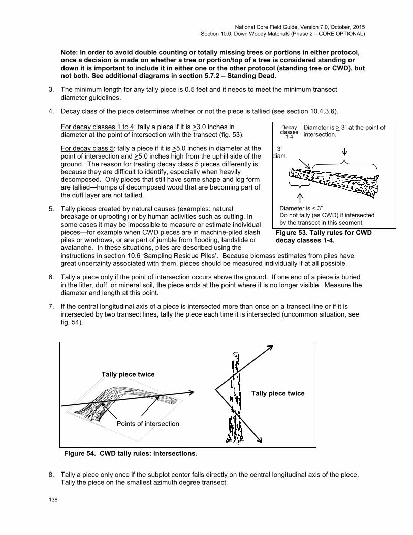
National Core Field Guide, Version 7.0, October, 2015 Section 10.0. Down Woody Materials (Phase 2 – CORE OPTIONAL)
138
Note: In order to avoid double counting or totally missing trees or portions in either protocol, once a decision is made on whether a tree or portion/top of a tree is considered standing or down it is important to include it in either one or the other protocol (standing tree or CWD), but not both. See additional diagrams in section 5.7.2 – Standing Dead.
3. The minimum length for any tally piece is 0.5 feet and it needs to meet the minimum transect diameter guidelines.
4. Decay class of the piece determines whether or not the piece is tallied (see section 10.4.3.6). For decay classes 1 to 4: tally a piece if it is >3.0 inches in diameter at the point of intersection with the transect (fig. 53).
For decay class 5: tally a piece if it is >5.0 inches in diameter at the point of intersection and >5.0 inches high from the uphill side of the ground. The reason for treating decay class 5 pieces differently is because they are difficult to identify, especially when heavily decomposed. Only pieces that still have some shape and log form are tallied—humps of decomposed wood that are becoming part of the duff layer are not tallied.
5. Tally pieces created by natural causes (examples: natural breakage or uprooting) or by human activities such as cutting. In some cases it may be impossible to measure or estimate individual pieces—for example when CWD pieces are in machine-piled slash piles or windrows, or are part of jumble from flooding, landslide or avalanche. In these situations, piles are described using the instructions in section 10.6 ‘Sampling Residue Piles’. Because biomass estimates from piles have great uncertainty associated with them, pieces should be measured individually if at all possible.
6. Tally a piece only if the point of intersection occurs above the ground. If one end of a piece is buried in the litter, duff, or mineral soil, the piece ends at the point where it is no longer visible. Measure the diameter and length at this point.
7. If the central longitudinal axis of a piece is intersected more than once on a transect line or if it is intersected by two transect lines, tally the piece each time it is intersected (uncommon situation, see fig. 54).
8. Tally a piece only once if the subplot center falls directly on the central longitudinal axis of the piece. Tally the piece on the smallest azimuth degree transect.
Figure 54. CWD tally rules: intersections.
Points of intersection
Tally piece twice
Tally piece twice
Figure 53. Tally rules for CWD decay classes 1-4.
Diameter is > 3” at the point of intersection.
3” diam.
Diameter is < 3” Do not tally (as CWD) if intersected by the transect in this segment.
Decay classes
1-4
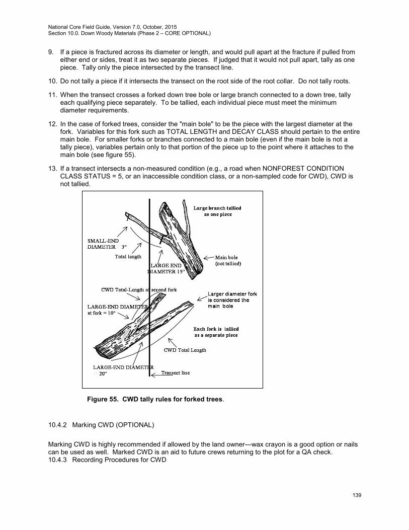
National Core Field Guide, Version 7.0, October, 2015 Section 10.0. Down Woody Materials (Phase 2 – CORE OPTIONAL)
139
9. If a piece is fractured across its diameter or length, and would pull apart at the fracture if pulled from either end or sides, treat it as two separate pieces. If judged that it would not pull apart, tally as one piece. Tally only the piece intersected by the transect line.
10. Do not tally a piece if it intersects the transect on the root side of the root collar. Do not tally roots.
11. When the transect crosses a forked down tree bole or large branch connected to a down tree, tally each qualifying piece separately. To be tallied, each individual piece must meet the minimum diameter requirements.
12. In the case of forked trees, consider the "main bole" to be the piece with the largest diameter at the fork. Variables for this fork such as TOTAL LENGTH and DECAY CLASS should pertain to the entire main bole. For smaller forks or branches connected to a main bole (even if the main bole is not a tally piece), variables pertain only to that portion of the piece up to the point where it attaches to the main bole (see figure 55).
13. If a transect intersects a non-measured condition (e.g., a road when NONFOREST CONDITION CLASS STATUS = 5, or an inaccessible condition class, or a non-sampled code for CWD), CWD is not tallied.
10.4.2 Marking CWD (OPTIONAL)
Marking CWD is highly recommended if allowed by the land owner—wax crayon is a good option or nails can be used as well. Marked CWD is an aid to future crews returning to the plot for a QA check. 10.4.3 Recording Procedures for CWD
Figure 55. CWD tally rules for forked trees.
National Core Field Guide, Version 7.0, October, 2015 Section 10.0. Down Woody Materials (Phase 2 – CORE OPTIONAL)
140
10.4.3.1 SUBPLOT NUMBER (BASE)
Record the code indicating the number of the subplot center from which the transect originates. Values:
1 Center subplot 2 North subplot 3 Southeast subplot 4 Southwest subplot
10.4.3.2 TRANSECT (BASE)
Record the azimuth of the transect on which the CWD piece is sampled. Values:
Subplot Transect direction (degrees) from center of subplot 090 1 270 180 (Extra optional transect) 360 2 180 270 (Extra optional transect) 135 3 315 225 (Extra optional transect) 045 4 225 315 (Extra optional transect)
10.4.3.3 CWD CONDITION CLASS (BASE)
Record the condition class number for each CWD piece at the point where the central longitudinal axis of the piece intersects the transect. If there is only one condition on the plot all CWD pieces will be assigned to CWD condition class = 1. If more than one condition has been identified and/or mapped on the plot/subplot, record the appropriate condition based on the location of the transect diameter measurement. All CWD pieces require a condition class and only classes that have been identified and/or mapped are valid. If extending the transect onto the macroplot the entire macroplot needs to be mapped for conditions. Values: 1 to 9
10.4.3.4 PIECE ON SUBPLOT OR ANNULAR PLOT? (BASE)
Identify whether point of transect intersection with piece is on the subplot or macroplot. If not extending transects onto annular plots all pieces will be assigned code = 1. Values:
1 Central longitudinal axis of piece intersects the transect on the subplot (<= 24.0 horizontal feet)
2 Central longitudinal axis of piece intersects the transect on the macroplot (24.1 – 58.9 horizontal feet)
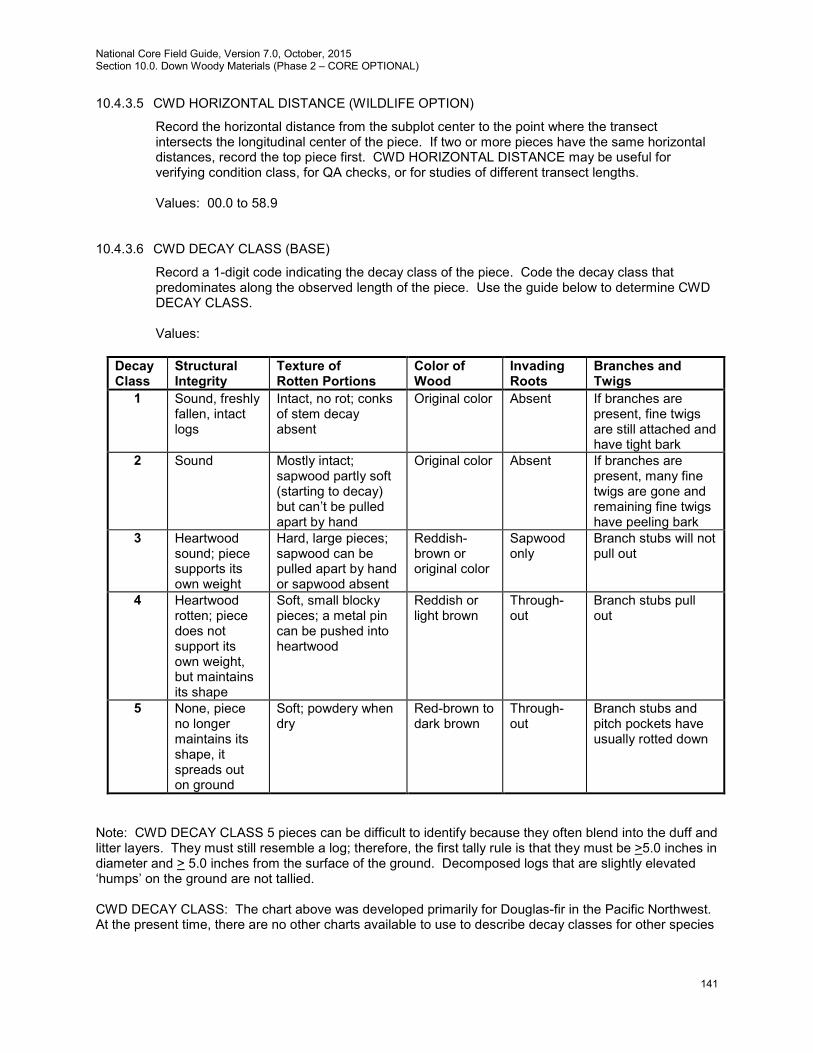
National Core Field Guide, Version 7.0, October, 2015 Section 10.0. Down Woody Materials (Phase 2 – CORE OPTIONAL)
141
10.4.3.5 CWD HORIZONTAL DISTANCE (WILDLIFE OPTION)
Record the horizontal distance from the subplot center to the point where the transect intersects the longitudinal center of the piece. If two or more pieces have the same horizontal distances, record the top piece first. CWD HORIZONTAL DISTANCE may be useful for verifying condition class, for QA checks, or for studies of different transect lengths. Values: 00.0 to 58.9
10.4.3.6 CWD DECAY CLASS (BASE)
Record a 1-digit code indicating the decay class of the piece. Code the decay class that predominates along the observed length of the piece. Use the guide below to determine CWD DECAY CLASS. Values:
Decay Class
Structural Integrity
Texture of Rotten Portions
Color of Wood
Invading Roots
Branches and Twigs
1 Sound, freshly fallen, intact logs
Intact, no rot; conks of stem decay absent
Original color Absent If branches are present, fine twigs are still attached and have tight bark
2 Sound Mostly intact; sapwood partly soft (starting to decay) but can’t be pulled apart by hand
Original color Absent If branches are present, many fine twigs are gone and remaining fine twigs have peeling bark
3 Heartwood sound; piece supports its own weight
Hard, large pieces; sapwood can be pulled apart by hand or sapwood absent
Reddish- brown or original color
Sapwood only
Branch stubs will not pull out
4 Heartwood rotten; piece does not support its own weight, but maintains its shape
Soft, small blocky pieces; a metal pin can be pushed into heartwood
Reddish or light brown
Through-out
Branch stubs pull out
5 None, piece no longer maintains its shape, it spreads out on ground
Soft; powdery when dry
Red-brown to dark brown
Through-out
Branch stubs and pitch pockets have usually rotted down
Note: CWD DECAY CLASS 5 pieces can be difficult to identify because they often blend into the duff and litter layers. They must still resemble a log; therefore, the first tally rule is that they must be >5.0 inches in diameter and > 5.0 inches from the surface of the ground. Decomposed logs that are slightly elevated ‘humps’ on the ground are not tallied. CWD DECAY CLASS: The chart above was developed primarily for Douglas-fir in the Pacific Northwest. At the present time, there are no other charts available to use to describe decay classes for other species

National Core Field Guide, Version 7.0, October, 2015 Section 10.0. Down Woody Materials (Phase 2 – CORE OPTIONAL)
142
or locations. Concentrate on the structural integrity and texture when estimating a decay class for CWD logs. If a log is case hardened (hard, intact outer sapwood shell) but the heartwood is rotten, code this log as a CWD DECAY CLASS 2. CWD DECAY CLASS 1 should be reserved for ‘freshly fallen’ logs that are completely intact (i.e., recent windfalls, or harvest). 10.4.3.7 SPECIES (BASE)
Record the code indicating the species of the piece. Since CWD pieces are not necessarily always tally species, record the most detailed available species code (see appendix 3). Some species codes are only genus specific (e.g., Prunus), or hardwood-softwood specific. Search for the species code that has the most detail for the identified piece. For shrubs or vines enter unknown softwood (0299) or hardwood (0998). Species identification may be uncertain for some pieces. The piece's bark (either attached or sloughed and laying beside the piece), branching pattern (if the branches are still present), or heartwood smell (particularly if cedars, Douglas-fir, or western hemlock) may provide clues. On remeasurement plots, see what tree species were tallied in past inventories. One way to distinguish hardwoods from softwoods is by the type of decay present. Hardwoods usually have a white or grayish stringy rot, while softwoods usually have a reddish-brown blocky rot. If it is not possible to identify the species, attempt to estimate if it is softwood or hardwood. Enter code 0299 for unknown dead conifer or 0998 for unknown dead hardwood. If all else fails, enter the unknown SPECIES code (0999). Values: See species codes in appendix 3
10.4.3.8 Diameters
If possible, the best way to measure diameter is to wrap the tape perpendicular to the longitudinal axis at the point of transect intersection (fig. 56). If that is not possible it is useful to carry a steel carpenters retracting tape to measure diameters. Other methods include wrapping a tape around the bole if possible, holding a straight-edge ruler above the piece, or using calipers.
For pieces that cannot be taped and are not round in cross-section because of missing chunks of wood or "settling" due to decay, measure the diameter in two directions and take an average.
3.0 inch small-end diameter
6.0 inch small-end diameter
18.0 inch large-end diameter
Small-end diameter tapers to 3” before the end of log
Small-end diameter measured at the point before the log
splinters or crumbles
Large-end diameter measured at the point that best represents the overall log volume. (before the wood crumbles and falls
apart due to decay)
Figure 56. Diameter measurements
DIAMETER MEASUREMENTS
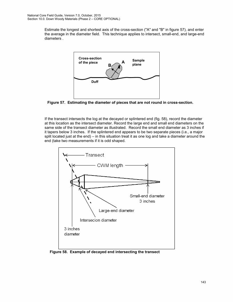
National Core Field Guide, Version 7.0, October, 2015 Section 10.0. Down Woody Materials (Phase 2 – CORE OPTIONAL)
143
Estimate the longest and shortest axis of the cross-section ("A" and "B" in figure 57), and enter the average in the diameter field. This technique applies to intersect, small-end, and large-end diameters .
If the transect intersects the log at the decayed or splintered end (fig. 58), record the diameter at this location as the intersect diameter. Record the large end and small end diameters on the same side of the transect diameter as illustrated. Record the small end diameter as 3 inches if it tapers below 3 inches. If the splintered end appears to be two separate pieces (i.e., a major split located just at the end) – in this situation treat it as one log and take a diameter around the end (take two measurements if it is odd shaped.
Figure 58. Example of decayed end intersecting the transect
A B
Duff
Cross-section of the piece Sample
plane
Figure 57. Estimating the diameter of pieces that are not round in cross-section.

National Core Field Guide, Version 7.0, October, 2015 Section 10.0. Down Woody Materials (Phase 2 – CORE OPTIONAL)
144
10.4.3.8.1 DIAMETER AT POINT OF INTERSECTION (BASE) Record the piece's diameter at the point where the transect intersects the longitudinal center of the piece. Record the diameter to the nearest inch. If the diameter is close to 3 inches, measure the diameter to the nearest 0.1 inch to determine if the piece is actually >3.0 inches and a valid tally piece. Values: 003 to 200 inches
10.4.3.8.2 DIAMETER OF HOLLOW AT POINT OF INTERSECTION (BASE) Record the diameter of hollow at the point of intersection. This variable contributes to reducing bias in biomass estimate and only applies to the point of intersection. If it can be ascertained that the piece is hollow at the transect diameter location, measure or estimate the diameter of hollow to the nearest inch, otherwise record as 0. Diameter of hollow must be less than the transect diameter. Note: Record a hollow diameter only when it is obvious that a piece is hollow at the point of intersection (a hole or crack in the piece, evidence of hollow as observed from the end, etc.). Unlike 10.4.3.10, there is no hollow size requirement for this variable. Values: 000, 001 to 200 inches
10.4.3.8.3 DIAMETER AT THE SMALL END (WILDLIFE OPTION) Record the diameter at the piece's small end. The diameter is recorded to the nearest inch. The DIAMETER AT THE SMALL END occurs either at (1) the actual end of the piece, if the end has a diameter >3.0 inches, or (2) at the point where the piece tapers down to 3.0 inches in diameter. If the end is splintered or decomposing (sloughing off), measure the diameter at the point where it best represents the overall log volume. Use the same measuring procedures described in 10.4.3.8 (see figure 56). Values: 003 to 200 inches
10.4.3.8.4 DIAMETER AT THE LARGE END (WILDLIFE OPTION) Record the diameter at the piece's large end. The diameter is recorded to the nearest inch. The large end will occur either at a broken or sawn end, at a fracture, or at the root collar. If the end is splintered or decomposing (sloughing off), measure the diameter at the point where it best represents the overall log volume. Use the same measuring procedures used for 10.4.3.8. Values: 003 to 250 inches
10.4.3.9 Length Measurements
Measure the length of the piece (to the nearest foot) along its centerline, either to the end of the piece or to the point where the diameter reaches 3 inches. If the piece tapers at both sides, due to decay or breakage, the length is measured for the 3-inch diameter cutoff at both ends, regardless of where the large end-diameter may be (see fig. 58). No length is recorded for pieces <3 feet long.
10.4.3.9.1 CWD LENGTH >= 3 FEET (BASE)
Record the code that indicates whether the CWD TOTAL LENGTH is less than 3 feet long (and at least 0.5 foot long). Distinguished length orientation by direction of the pith. Note: the
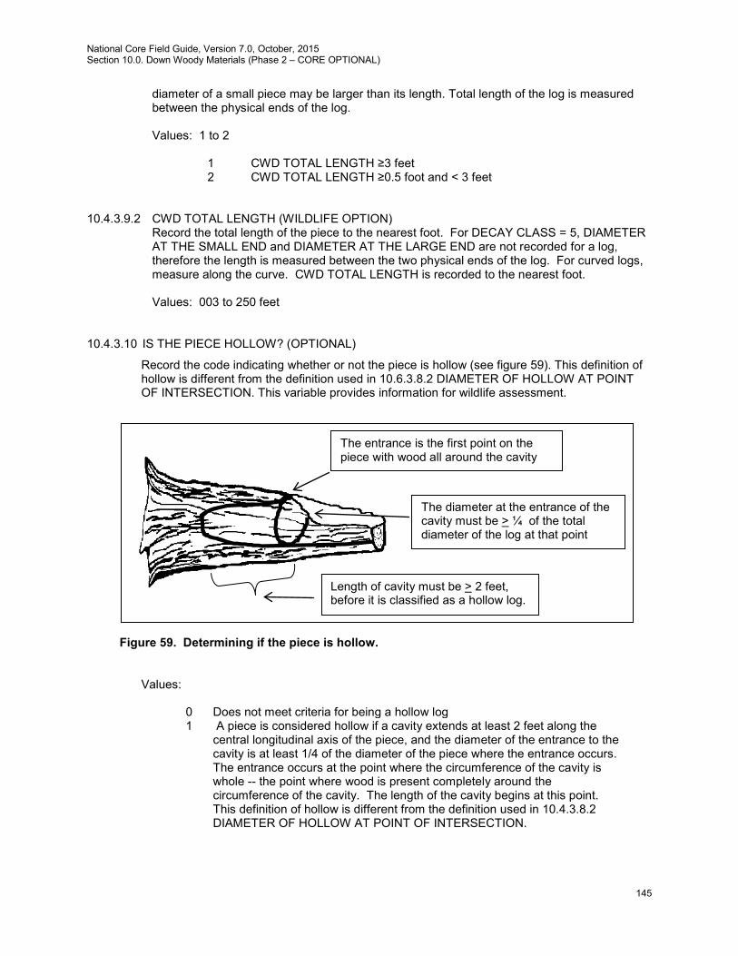
National Core Field Guide, Version 7.0, October, 2015 Section 10.0. Down Woody Materials (Phase 2 – CORE OPTIONAL)
145
diameter of a small piece may be larger than its length. Total length of the log is measured between the physical ends of the log. Values: 1 to 2
1 CWD TOTAL LENGTH ≥3 feet 2 CWD TOTAL LENGTH ≥0.5 foot and < 3 feet
10.4.3.9.2 CWD TOTAL LENGTH (WILDLIFE OPTION)
Record the total length of the piece to the nearest foot. For DECAY CLASS = 5, DIAMETER AT THE SMALL END and DIAMETER AT THE LARGE END are not recorded for a log, therefore the length is measured between the two physical ends of the log. For curved logs, measure along the curve. CWD TOTAL LENGTH is recorded to the nearest foot. Values: 003 to 250 feet
10.4.3.10 IS THE PIECE HOLLOW? (OPTIONAL)
Record the code indicating whether or not the piece is hollow (see figure 59). This definition of hollow is different from the definition used in 10.6.3.8.2 DIAMETER OF HOLLOW AT POINT OF INTERSECTION. This variable provides information for wildlife assessment.
Figure 59. Determining if the piece is hollow.
Values:
0 Does not meet criteria for being a hollow log 1 A piece is considered hollow if a cavity extends at least 2 feet along the
central longitudinal axis of the piece, and the diameter of the entrance to the cavity is at least 1/4 of the diameter of the piece where the entrance occurs. The entrance occurs at the point where the circumference of the cavity is whole -- the point where wood is present completely around the circumference of the cavity. The length of the cavity begins at this point. This definition of hollow is different from the definition used in 10.4.3.8.2 DIAMETER OF HOLLOW AT POINT OF INTERSECTION.
The entrance is the first point on the piece with wood all around the cavity
The diameter at the entrance of the cavity must be > ¼ of the total diameter of the log at that point
Length of cavity must be > 2 feet, before it is classified as a hollow log.
National Core Field Guide, Version 7.0, October, 2015 Section 10.0. Down Woody Materials (Phase 2 – CORE OPTIONAL)
146
10.4.3.11 PIECE INCLINATION (OPTIONAL)
Record the inclination from horizontal of the piece in degrees. Measure the inclination with a clinometer. Inclination from horizontal should be estimated rapidly by setting a clinometer along the top of the log, adjusting if necessary to match the angle between the location of the large end diameter and the location of the small end diameter, and reading the inclination from the face of the clinometer in degrees. Values: 00 to 90 degrees
10.4.3.12 CWD HISTORY (OPTIONAL)
Record the code that indicates whether or not the piece of CWD is on the ground as a result of harvesting operations or as a result of natural circumstances. One objective of this item is to identify those pieces that are considered logging residue. If the piece appears to have fallen to the ground as a result of natural causes such as decomposition or windfall, enter a code of 1. This category would include blown out tops, snapped off boles, wind-fallen trees on clearcut edges, and trees that basically collapsed and fell over due to decomposition. If the piece is on the ground as a result of recent (since last annual remeasurement; if the plot is new, the time between the panel remeasurements) harvesting activity, either because the tree was cut down with a chainsaw (or other device) or pushed over by harvesting equipment (bulldozer), enter a code of 2. A code of 2 would be considered logging residue (usually you are in the middle of a recent clearcut). If the piece is on the ground as a result of older (more than 15 years) harvesting activity, enter a code of 3. This would be a situation where you tally an old decomposing log that has a sawn end – if it appears that the log was cut and left on site, then enter a code of “3”. If a piece is on the ground as a result of incidental harvest (such as a standing tree was cut for firewood or small clearing), enter a code of “4”. Incidental harvest involves a few trees and is not a part of a major organized harvesting operation. If the crew cannot decide the history of the CWD log, classify it as “unknown”, and give it a code of “5”. Values:
10.4.3.13 PERCENT OF LOG CHARRED BY FIRE (OPTIONAL)
Record a code that represents the percentage of the log’s surface area that has been charred by fire. Only examine the visible surface of the log. These data will be used by wildlife biologists to determine the impact fire has had on wildlife habitat. Wildlife tend to avoid charred logs because fire seals the wood making it slow to rot and hard to excavate. Values:
1 CWD piece is on the ground as a result of natural causes 2 CWD piece is on the ground as a result of major recent harvest activity (<= 15 yrs old) 3 CWD piece is on the ground as a result of older harvest activity (> 15 yrs old) 4 CWD piece is on the ground as a result of an incidental harvest (such as firewood cutting) 5 Exact Reason Unknown
0 None of the log is charred by fire 1 Up to 1/3 of the log is charred by fire 2 1/3 to 2/3 of the log is charred by fire 3 2/3 or more of the log is charred by fire
National Core Field Guide, Version 7.0, October, 2015 Section 10.0. Down Woody Materials (Phase 2 – CORE OPTIONAL)
147
10.4.3.14 LARGE END DIAMETER CLASS (OPTIONAL)
Estimate the appropriate class code for the large end diameter for each CWD piece. If the large end diameter is close to a class breaking point it may be necessary to directly measure the diameter. Use the same established rules for determining the large end diameter point (see figure 58). Values:
10.5 SAMPLING RESIDUE PILES
A pile is an accumulation of large woody material in which individual pieces are impossible to tally separately. Piles may be created by human activity or natural causes. However, loose piles created by windthrow, landslides, fires or other natural causes, or by thinning or logging operations, should be tallied using the regular CWD protocols unless it is physically impossible to separate individual pieces. The pile protocol should only be used as a last resort, when the regular CWD protocols cannot be used. Piles are tallied only if intersected by a transect and located in an accessible forest condition class (CONDITION CLASS STATUS = 1) or a measurable nonforest condition (NONFOREST CONDITION CLASS STATUS = 2). An estimate of the length and depth of the pile, species composition and decay class are recorded:
1. Tally individual pieces along the transect until it is not possible to measure them separately and record the horizontal transect distance to this point. Then, record the horizontal transect distance to the point where individual pieces can again be tallied separately (see figure 60).
2. If the pile straddles two condition classes, assign it to the condition class that is closest to subplot center along the transect.
3. Estimate the average height of the pile along the transect. Visually compact the pile to estimate
the height of wood, excluding air, rocks, debris and pieces of wood less than 3 inches in diameter at the plane of intersection with the transect. There is a tendency to overestimate the proportion of the cross-section of the pile made of wood. Note that when packing perfect circles of equal diameter, the maximum attainable packing ratio is less than 90% (see figure 61).
4. Record the predominant species in the pile. If it is not possible to identify the species, or if there is an even mixture of several species, record the genus, or hardwood / softwood code.
5. Record the predominant decay class of the pieces in the pile.
1 3.0 to 4.9 inches 2 5.0 to 8.9 inches 3 9.0 to 14.9 inches 4 15.0 to 20.9 inches 5 21.0 to 39.9 inches 6 40.0+ inches
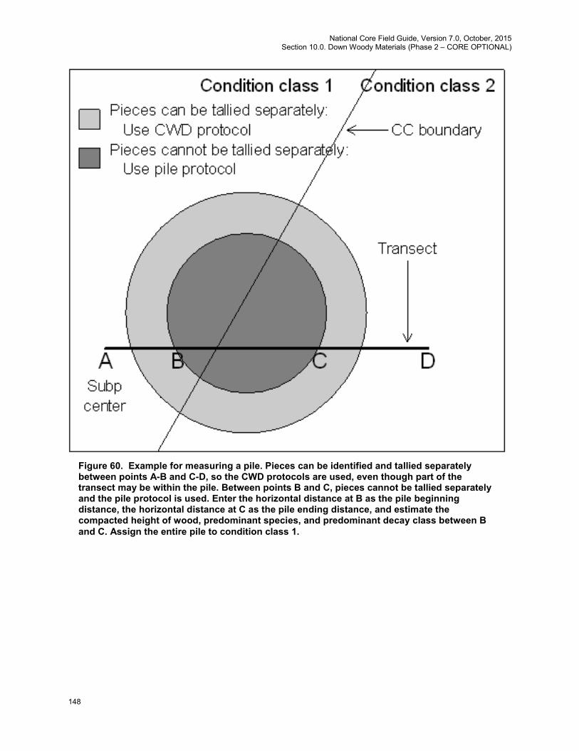
National Core Field Guide, Version 7.0, October, 2015 Section 10.0. Down Woody Materials (Phase 2 – CORE OPTIONAL)
148
Figure 60. Example for measuring a pile. Pieces can be identified and tallied separately between points A-B and C-D, so the CWD protocols are used, even though part of the transect may be within the pile. Between points B and C, pieces cannot be tallied separately and the pile protocol is used. Enter the horizontal distance at B as the pile beginning distance, the horizontal distance at C as the pile ending distance, and estimate the compacted height of wood, predominant species, and predominant decay class between B and C. Assign the entire pile to condition class 1.
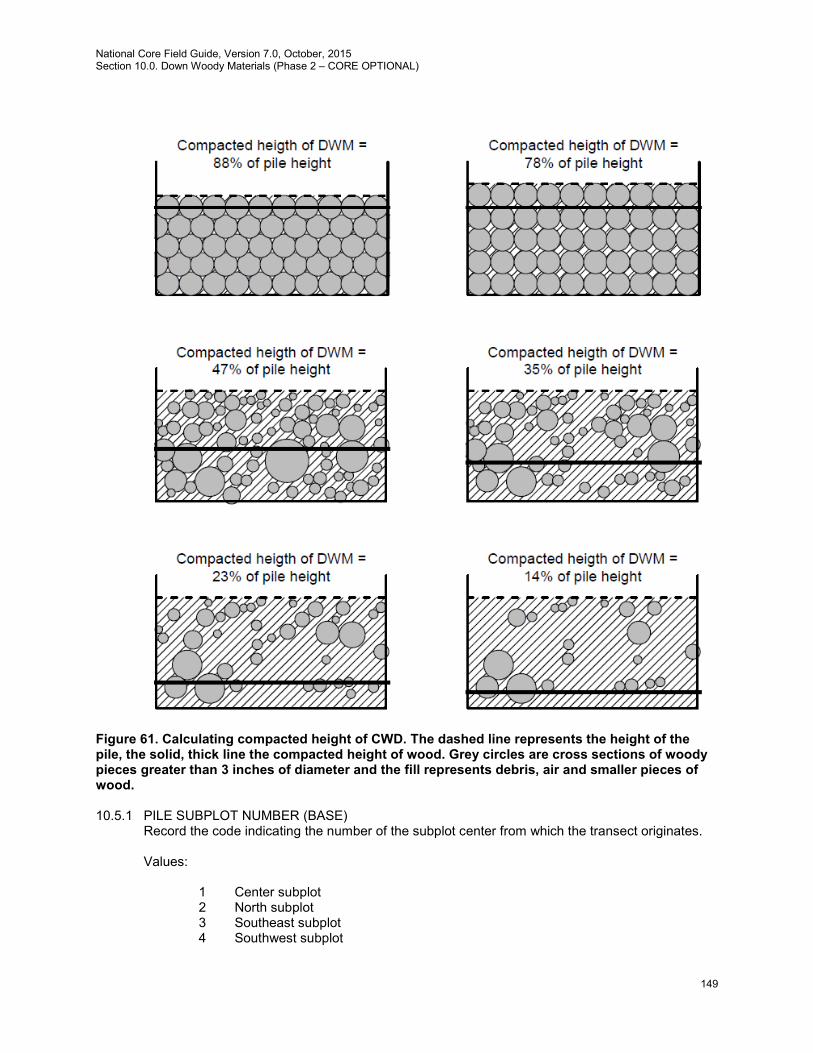
National Core Field Guide, Version 7.0, October, 2015 Section 10.0. Down Woody Materials (Phase 2 – CORE OPTIONAL)
149
Figure 61. Calculating compacted height of CWD. The dashed line represents the height of the pile, the solid, thick line the compacted height of wood. Grey circles are cross sections of woody pieces greater than 3 inches of diameter and the fill represents debris, air and smaller pieces of wood.
10.5.1 PILE SUBPLOT NUMBER (BASE)
Record the code indicating the number of the subplot center from which the transect originates. Values:
1 Center subplot 2 North subplot 3 Southeast subplot 4 Southwest subplot
National Core Field Guide, Version 7.0, October, 2015 Section 10.0. Down Woody Materials (Phase 2 – CORE OPTIONAL)
150
10.5.2 PILE TRANSECT (BASE)
Record the azimuth of the transect on which the pile is sampled. Values:
Subplot Transect direction (degrees) from center of subplot 090 1 270 180 (Extra optional transect) 360 2 180 270 (Extra optional transect) 135 3 315 225 (Extra optional transect) 045 4 225 315 (Extra optional transect)
10.5.3 PILE CONDITION CLASS NUMBER (BASE)
Record the code indicating the number of the condition class. If the pile straddles two condition classes, assign it to the one closest to subplot center along the transect. Values: 1 to 9
10.5.4 PILE BEGINNING DISTANCE (BASE) Record the horizontal length of the transect to the beginning of the pile (to the nearest 0.1 foot), defined as the point when pieces cannot be tallied individually. If the pile occupies subplot center, record 00.0 for the beginning distance. Values: 00.0 to 58.8 feet
10.5.5 PILE ENDING DISTANCE (BASE) Record the horizontal length of the transect to the end of the pile, defined as the point when pieces can be tallied individually again. If the transect ends within the pile, record DWM TRANSECT LENGTH. Values: 00.1 to 58.9 feet
10.5.6 COMPACTED HEIGHT OF CWD IN PILE (BASE)
Record average height of wood pieces greater than 3 inches in diameter at the intersection of the transect with the pile. Record value to the nearest foot. Visually compact the pile to estimate the height of wood, excluding air, debris and pieces of wood less than 3 inches in diameter at the point of intersection with the transect. If the transect starts or ends within a pile, only consider the portion of cross-section of the pile above the measured transect. Values: 1 to 99 feet

National Core Field Guide, Version 7.0, October, 2015 Section 10.0. Down Woody Materials (Phase 2 – CORE OPTIONAL)
151
10.5.7 PILE DECAY CLASS (BASE)
Record a 1-digit code indicating the predominant decay class in the pile. Use the guide below to determine CWD DECAY CLASS. Values:
Decay Class
Structural Integrity
Texture of Rotten Portions
Color of Wood
Invading Roots
Branches and Twigs
1 Sound, freshly fallen, intact logs
Intact, no rot; conks of stem decay absent
Original color Absent If branches are present, fine twigs are still attached and have tight bark
2 Sound Mostly intact; sapwood partly soft (starting to decay) but can’t be pulled apart by hand
Original color Absent If branches are present, many fine twigs are gone and remaining fine twigs have peeling bark
3 Heartwood sound; piece supports its own weight
Hard, large pieces; sapwood can be pulled apart by hand or sapwood absent
Reddish- brown or original color
Sapwood only
Branch stubs will not pull out
4 Heartwood rotten; piece does not support its own weight, but maintains its shape
Soft, small blocky pieces; a metal pin can be pushed into heartwood
Reddish or light brown
Through-out
Branch stubs pull out
5 None, piece no longer maintains its shape, it spreads out on ground
Soft; powdery when dry
Red-brown to dark brown
Through-out
Branch stubs and pitch pockets have usually rotted down
10.5.8 PILE SPECIES (BASE)
Record the code indicating the predominant species / species group in the pile. If it is not possible to identify the species, or if there is an even mixture of several species, record the genus, or hardwood / softwood code. Values: See species codes in appendix 3
10.6 Sampling Methods for Fine Woody Debris (FWD)
1. Fine Woody Debris (FWD) is only sampled on accessible forest land conditions (CONDITION
CLASS STATUS = 1) and measurable nonforest conditions (NONFOEST CONDITION CLASS STATUS = 2) intersected by the transect. FWD is tallied on the outer portion of the following transects: 270°on subplot 1, 360°on subplot 2, 135°on subplot 3, and 225°on subplot 4. The length of FWD transects is measured in horizontal distance, starting at 14.0 feet and extending for 6.0 or 10.0 feet depending on FWD size class.
2. If the start of the FWD transect segment is in a measured condition (see item 1 above) but a portion of the transect segment is not visible due to the presence of snow or standing water, consider the entire transect segment not measurable. In this situation, do not sample anything on

National Core Field Guide, Version 7.0, October, 2015 Section 10.0. Down Woody Materials (Phase 2 – CORE OPTIONAL)
152
the transect segment--set FWD TRANSECT SEGMENTSAMPLE STATUS code = 0 and record the reason in FWD TRANSECT SEGMENT NONSAMPLED REASON.
3. Only sample FWD that intersects the transect in a plane from the ground to a height of 6 feet.
4. FWD is sampled in three size classes, along transect azimuths described in item 1 above (see section 10.2 for details on transects). Pieces in two FWD size classes (0.01 to 0.24 inches and 0.25 to 0.9 inches) are counted on a 6-foot transect, from 14 to 20 feet horizontal distance. Pieces in the largest size class (1.0 to 2.9 inches) are counted on a 10-foot transect, from 14 to 24 feet. These transects overlap. Note: individual diameters are not recorded for FWD.
5. Count a piece of FWD if it intersects the transect. Be sure to count only woody material such as a twig, branch, wood fragment, or small shrub or tree bole Do not count material that is actually litter, such as pine or fir needles, non-woody parts (e.g., petiole and rachis) of a shrub or tree, etc.
6. Accumulate the number of pieces counted within each size class and enter the total count on one record for the subplot. If there is no tally on a transect, enter zeros for the count. If the transect is not measured (FWD TRANSECT SAMPLE STATUS = 0) the count is null.
7. Accurate counts of FWD can be conducted efficiently up to about 50 pieces for small and medium size classes, and up to 20 pieces for the large size class. After that, crews can begin estimating counts in a systematic fashion. Transects that fall on very dense FWD where counting is nearly impossible, can be sub-sampled and calculated. For example, an accurate count can be conducted on a 2.0-foot section of the transect and then multiplied by 3 to provide an estimate for the 6 foot transect, as long as the crew feels that the remaining transect has a similar density of FWD pieces.
8. If a transect intersects a large pile of material such as a wood rat’s nest, recently fallen tree (with many attached fine branches), or a residue pile, crews should estimate a count based on # 7 above, but also enter a code indicating that this is an unusual situation (see section 10.3.7 ). In the case of a residue pile on the transect, estimate a count by looking at the transect just before and after the pile along with assessing what’s inside the pile, and enter a count for the whole transect.
9. If rocks or logs are present along the transect (14- to 24-foot section) include any FWD that is present on top of these things in the respective FWD counts. If the obstructions are so large (huge boulder) that the top surface cannot be seen, assume the count is zero in this area, and continue counting if there is transect line beyond the boulder.
10. If a transect crosses a condition class boundary, record the condition class number and enter a count for each condition on separate records. Transect lengths within each condition class will be obtained from the transect segmenting data entered for the plot.
10.6.1 FWD SUBPLOT NUMBER (BASE) Record the code indicating the subplot center from which the transect originates. Values:
1 Center subplot 2 North subplot 3 Southeast subplot 4 Southwest subplot
10.6.2 FWD TRANSECT (BASE)
Record the azimuth (degrees) of the transect on which FWD is sampled.

National Core Field Guide, Version 7.0, October, 2015 Section 10.0. Down Woody Materials (Phase 2 – CORE OPTIONAL)
153
Values: degrees
Subplot Transect direction (degrees) from center of subplot 1 270 2 360 3 135 4 225
10.6.3 FWD CONDITION CLASS NUMBER (BASE) Record the code indicating the number of the condition class at the start of the transect (14.0 feet horizontal distance from subplot center). Values: 1 to 9
10.6.4 FWD TRANSECT SEGMENT SAMPLE STATUS (BASE)
Record the sample status for FWD on the transect. There may be situations where the CWD is measurable, but the FWD is hidden from view by snow or water and not measurable. If any part of the FWD transect segment is on a measured condition but the FWD is not measurable, do not count any FWD and set the STATUS code to 0 and the FWD TRANSECT NONSAMPLED REASON code to 10. In all other situations, set the code to 1. Conditions on which FWD would not be measured regardless (CONDITION CLASS STATUS = 3 or CONDITION CLASS STATUS = 2 AND NONFOREST CONDITION CLASS STATUS = 5) should always be coded 1. Values:
0 FWD transect segment not sampled 1 FWD transect segment sampled
10.6.5 FWD TRANSECT SEGMENT NONSAMPLED REASON (BASE) Record the reason that FWD cannot be measured on the transect. Values:
04 Time Limitation 05 Lost data (office use only) 10 Other (for example, snow or water covering CWD that is supposed
to be sampled). “Note required” when using this code. 10.6.6 SMALL FWD COUNT (BASE)
Record the number of pieces counted in this size class (0.01 to 0.24-inch diameter) along the transect segment. An accurate count should be conducted up to 50 pieces. If the count exceeds 50, the transect can be sub-sampled to estimate a total count for the transect length (see 10.6, #8). Values: 000 to 999 pieces
National Core Field Guide, Version 7.0, October, 2015 Section 10.0. Down Woody Materials (Phase 2 – CORE OPTIONAL)
154
10.6.7 MEDIUM FWD COUNT (BASE) Record the number of pieces counted in this size class (0.25 to 0.99-inch diameter) along the transect segment. An accurate count should be conducted up to 50 pieces. If the count exceeds 50, the transect can be sub-sampled to estimate a total count for the transect segment (see 10.6, # 8). Values: 000 to 999 pieces
10.6.8 LARGE FWD COUNT (BASE) Record the number of pieces counted in this size class (1.0 to 2.9 inch diameter) along the transect segment. An accurate count should be conducted up to 20 pieces. If the count exceeds 20, the transect can be sub-sampled to estimate a total count for the transect segment (see 10.6, # 8). Values: 000 to 500 pieces
10.6.9 HIGH COUNT REASON (BASE) Enter a code that applies to the situation encountered on the transect. Enter a code if any of the counts on the transect are greater than 100 pieces. Values:
10.7 DUFF AND LITTER DEPTH MEASUREMENTS
Depth measurements are sampled in accessible forest land conditions (and accessible nonforest conditions, where nonforest conditions are measured). The depth of the duff layer and litter layer are important components of carbon tracking and fire models that estimate fire behavior, fire spread, fire effects, and smoke production. These measurements are taken at the 24-foot location on each transect. If an object such as a rock, log, or residue pile is present at the sample point, depths will be estimated by examining the surface of the object or the area surrounding the object. In the office, an average depth will be calculated and stored with other information about the condition class on the plot. 10.7.1 Definitions
1. Litter is the layer of freshly fallen leaves, needles, twigs (<0.25 inch in diameter), cones, detached bark chunks, dead moss, dead lichens, detached small chunks of rotted wood, dead herbaceous stems, and flower parts (detached and not upright). Litter is the loose plant material found on the top surface of the forest floor which is undecomposed or only partially decomposed organic material. The components of the litter layer can still be readily identified (e.g., plant leaves, twigs, and peat, etc.).
Litter is flash fuel – so think about it as the loose material that is exposed to the air, capable of igniting quickly and carrying a fire across the surface of the forest floor.
Litter does not include bark that is still attached to a down log, or rotten chunks of wood that are still inside a decaying log or log end (i.e., if a decayed log end has a lot of rotten cubes or pieces
1 High count is due to an overall high density of FWD across the transect 2 Wood Rat’s nest located on transect 3 Tree or shrub laying across transect 4 Other reason 5 Residue pile
National Core Field Guide, Version 7.0, October, 2015 Section 10.0. Down Woody Materials (Phase 2 – CORE OPTIONAL)
155
laying on a log surface and exposed to air, they are considered part of the log and not litter – fire would burn differently if it hit a pile of rotten punky wood chips cradled by the unrotted sapwood shell). If these rotten chunks have spilled out to the ground and are actually on the ground surface, then they would be included in the litter layer.
Litter does not include animal manure.
2. Duff is the layer just below litter located just above the A-horizon (or uppermost soil mineral horizon). Duff is a dark soil layer dominated by organic material derived from the decomposition of plant and animal litter (pine straw, leaves, twigs, etc) and deposited on top of an organic or mineral surface. This layer is distinguished from the litter layer in that the original organic material has undergone sufficient decomposition that the source of this material (e.g., individual plant parts) can no longer be identified. You should see no recognizable plant parts. When moss is present, the top of the duff layer is just below the green portion of the moss.
If peat is present in your part of the country, record it with the duff layer. Peat is an accumulation of partially decayed vegetation matter that forms under conditions of poor drainage such as those found in wetlands or bogs. A layer of peat develops when dead plant material is inhibited from decaying fully because of acidic or anaerobic conditions. In some areas of the U.S. the depth of this layer can be extensive.
10.7.2 Overview of Measurements
Depth measurements will be taken at the 24-foot (horizontal distance) location on each transect. If a log, rock, or residue pile occurs at the sample location, record the depth of the litter on top and below these objects and estimate the duff depth as close to the object as possible. Examine the area around the object to develop an average depth for these layers.
DUFF/LITTER SAMPLE STATUS identifies whether or not the duff and litter depth could be measured or reasonably estimated. Examples of situations where measurement is not possible include the presence of snow or standing water at the sample location. In this case, the STATUS code is set to 0 with the DUFF/LITTER NONSAMPLED REASON code set to 10.
The DUFF AND LITTER METHOD variable has three options for indicating if duff and litter were measured or estimated at each sample location. The default value for this variable is 1, indicating that both depths were measured and recorded. A code of 2 means that litter depth was measured, but duff depth was estimated and a code of 3 indicates that both duff and litter depths were estimated.
Carefully expose a shallow profile of the forest floor by digging out an area at the sample point using a knife, hatchet, or other tool. Estimate the depth of each layer with a ruler to the nearest 0.1 inch. As you dig the hole for this measurement, if you encounter a subsurface rock, root, or buried log – stop the depth measurement at this point. If there is a log, rock, or residue pile on the surface at the sample point, and there appears to be duff and litter under it (or litter on top of it), record a reasonable estimate for each depth. Most likely, the area immediately adjacent to the obstruction will have to be examined to determine an average depth. Depths of zero are perfectly valid: for example if the point falls on bedrock or on top of a log that it resting on mineral soil.
As a general rule, duff depth should rarely exceed a few inches (except when a peat layer is present). Crews should be absolutely sure they are measuring deep duff depths, instead of mineral soil layers or parts of the litter layer. Duff can easily weigh more than 6 times that of litter. If unsure of the bottom of the duff layer, crews should feel the texture of the suspect material in their hand. Rub the soil between your fingers. Does it crumble (duff) or feel more like modeling clay (mineral). If the layer includes a substantial amount of peat, stop the measurement at 2 feet.
The height of the litter should be measured at the top of the loose material located at the sample point on the transect (or nearby if an obstruction exists). Try to preserve the conditions of this location by walking around this point, so the QA staff will measure the same height as the original crew.
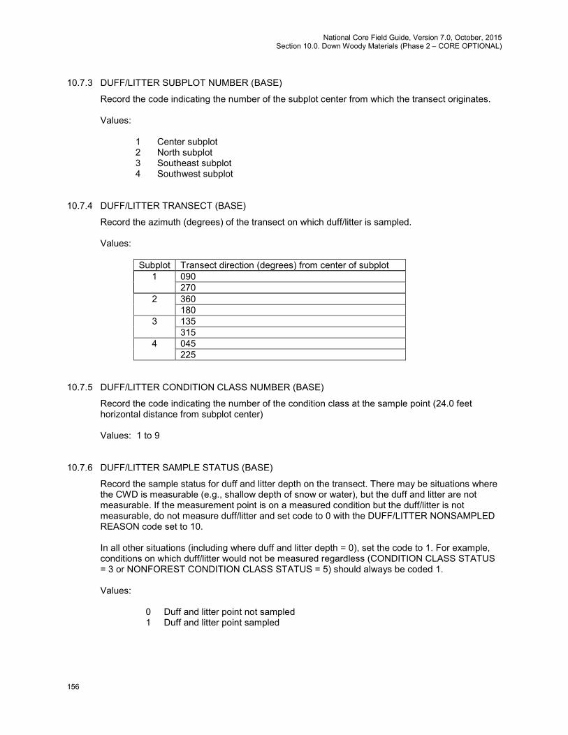
National Core Field Guide, Version 7.0, October, 2015 Section 10.0. Down Woody Materials (Phase 2 – CORE OPTIONAL)
156
10.7.3 DUFF/LITTER SUBPLOT NUMBER (BASE)
Record the code indicating the number of the subplot center from which the transect originates. Values:
10.7.4 DUFF/LITTER TRANSECT (BASE)
Record the azimuth (degrees) of the transect on which duff/litter is sampled. Values:
Subplot Transect direction (degrees) from center of subplot 1 090 270 2 360 180 3 135 315 4 045 225
10.7.5 DUFF/LITTER CONDITION CLASS NUMBER (BASE)
Record the code indicating the number of the condition class at the sample point (24.0 feet horizontal distance from subplot center) Values: 1 to 9
10.7.6 DUFF/LITTER SAMPLE STATUS (BASE)
Record the sample status for duff and litter depth on the transect. There may be situations where the CWD is measurable (e.g., shallow depth of snow or water), but the duff and litter are not measurable. If the measurement point is on a measured condition but the duff/litter is not measurable, do not measure duff/litter and set code to 0 with the DUFF/LITTER NONSAMPLED REASON code set to 10. In all other situations (including where duff and litter depth = 0), set the code to 1. For example, conditions on which duff/litter would not be measured regardless (CONDITION CLASS STATUS = 3 or NONFOREST CONDITION CLASS STATUS = 5) should always be coded 1. Values:
0 Duff and litter point not sampled 1 Duff and litter point sampled
1 Center subplot 2 North subplot 3 Southeast subplot 4 Southwest subplot
National Core Field Guide, Version 7.0, October, 2015 Section 10.0. Down Woody Materials (Phase 2 – CORE OPTIONAL)
157
10.7.7 DUFF/LITTER NONSAMPLED REASON (BASE)
Record the reason that duff/litter cannot be measured on the transect. Values:
04 Time Limitation 05 Lost data (office use only) 10 Other (for example, snow or water covering measurement point
that is supposed to be sampled). “Note required” when using this code
10.7.8 DUFF DEPTH (BASE)
Record the code indicating the depth of the duff layer to the nearest 0.1 inch. Record 24.0 inches when DUFF DEPTH is >24.0 inches and enter Code #4 (Litter depth was measured, duff (peat) depth exceeds 24.0 inches) for 10.9.8 DUFF AND LITTER METHOD. Values: 00.0 to 24.0 inches
10.7.9 LITTER DEPTH (BASE)
Record the code indicating the depth of the litter layer to the nearest 0.1 inch. Values: 00.0 to 99.9 inches
10.7.10 DUFF AND LITTER METHOD (BASE)
Record the code indicating whether duff and litter depths were measured or estimated. Values:
1 Both duff and litter depth were measured 2 Litter depth was measured, duff depth (≤ 24.0 inches) was estimated 3 Both duff and litter depth were estimated 4 Litter depth was measured, duff (peat) depth exceeds 24.0 inches (note
required)
10.8 References
Scott, J.E.; Burgan, R.H. 2005. Standard Fire Behavior Fuel Models: A Comprehensive Set for Use with
Rothermel's Surface Fire Spread Model. General Technical Report RMRS-GTR-153. Fort Collins, CO: U.S. Department of Agriculture, Forest Service, Rocky Mountain Research Station. 72 p.
10.9 Contact Information
Contact information for the National Advisor for this indicator is: Chris Woodall, USDA Forest Service, Northern Research Station, 1992 Folwell Ave, St. Paul, MN 55108, [email protected], http://www.ncrs.fs.fed.us/4801/national-programs/indicators/dwm/ (Note: this web address may be revised in the future. Please visit the Northern Research Station web site for an updated link www.nrs.fs.fed.us .)
National Core Field Guide, Version 7.0, October, 2015 List of Appendices
158
APPENDICES 1. State and County, Parish or Borough FIPS Codes
These are the standard federal 2- and 3-digit codes for States and Counties, Parishes, or Boroughs, respectively.
2. FIA Forest Type Codes
These are the codes that correspond to the National FIA forest typing algorithm. Units may choose to also add local forest type groupings.
3. FIA Tree Species Codes
This list includes all species deemed to be tally trees with woodland trees measured for DRC indicated.
4. Was previously: Site Tree Selection Criteria and Species List 5. Determination of Stocking Values for Land Use Classification 6. Glossary 7. Tolerance / MQO / Value / Units Table 8. Tree Coding Guide 9. Invasive Plant List 10. Unknown Plant Specimen Collection 11. Damage Codes 12. Reserved and Administratively Withdrawn Status by Owner and Land Designation 13. Ownership Prefield Procedures 14. FIA Pacific Islands Tree Species Codes

National Core Field Guide, Version 7.0, October, 2015 Appendix 1. State and County, Parish, or Borough FIPS Codes
159
Appendix 1. State and County, Parish, or Borough FIPS Codes
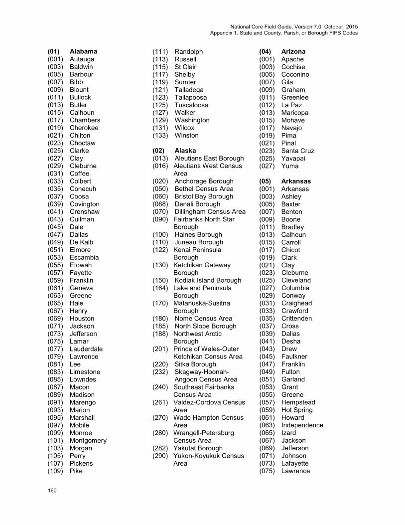
National Core Field Guide, Version 7.0, October, 2015 Appendix 1. State and County, Parish, or Borough FIPS Codes
160
(01) Alabama (001) Autauga (003) Baldwin (005) Barbour (007) Bibb (009) Blount (011) Bullock (013) Butler (015) Calhoun (017) Chambers (019) Cherokee (021) Chilton (023) Choctaw (025) Clarke (027) Clay (029) Cleburne (031) Coffee (033) Colbert (035) Conecuh (037) Coosa (039) Covington (041) Crenshaw (043) Cullman (045) Dale (047) Dallas (049) De Kalb (051) Elmore (053) Escambia (055) Etowah (057) Fayette (059) Franklin (061) Geneva (063) Greene (065) Hale (067) Henry (069) Houston (071) Jackson (073) Jefferson (075) Lamar (077) Lauderdale (079) Lawrence (081) Lee (083) Limestone (085) Lowndes (087) Macon (089) Madison (091) Marengo (093) Marion (095) Marshall (097) Mobile (099) Monroe (101) Montgomery (103) Morgan (105) Perry (107) Pickens (109) Pike
(111) Randolph (113) Russell (115) St Clair (117) Shelby (119) Sumter (121) Talladega (123) Tallapoosa (125) Tuscaloosa (127) Walker (129) Washington (131) Wilcox (133) Winston (02) Alaska (013) Aleutians East Borough (016) Aleutians West Census
Area (020) Anchorage Borough (050) Bethel Census Area (060) Bristol Bay Borough (068) Denali Borough (070) Dillingham Census Area (090) Fairbanks North Star
Borough (100) Haines Borough (110) Juneau Borough (122) Kenai Peninsula
Borough (130) Ketchikan Gateway
Borough (150) Kodiak Island Borough (164) Lake and Peninsula
Borough (170) Matanuska-Susitna
Borough (180) Nome Census Area (185) North Slope Borough (188) Northwest Arctic
Borough (201) Prince of Wales-Outer
Ketchikan Census Area (220) Sitka Borough (232) Skagway-Hoonah-
Angoon Census Area (240) Southeast Fairbanks
Census Area (261) Valdez-Cordova Census
Area (270) Wade Hampton Census
Area (280) Wrangell-Petersburg
Census Area (282) Yakutat Borough (290) Yukon-Koyukuk Census
Area
(04) Arizona (001) Apache (003) Cochise (005) Coconino (007) Gila (009) Graham (011) Greenlee (012) La Paz (013) Maricopa (015) Mohave (017) Navajo (019) Pima (021) Pinal (023) Santa Cruz (025) Yavapai (027) Yuma (05) Arkansas (001) Arkansas (003) Ashley (005) Baxter (007) Benton (009) Boone (011) Bradley (013) Calhoun (015) Carroll (017) Chicot (019) Clark (021) Clay (023) Cleburne (025) Cleveland (027) Columbia (029) Conway (031) Craighead (033) Crawford (035) Crittenden (037) Cross (039) Dallas (041) Desha (043) Drew (045) Faulkner (047) Franklin (049) Fulton (051) Garland (053) Grant (055) Greene (057) Hempstead (059) Hot Spring (061) Howard (063) Independence (065) Izard (067) Jackson (069) Jefferson (071) Johnson (073) Lafayette (075) Lawrence
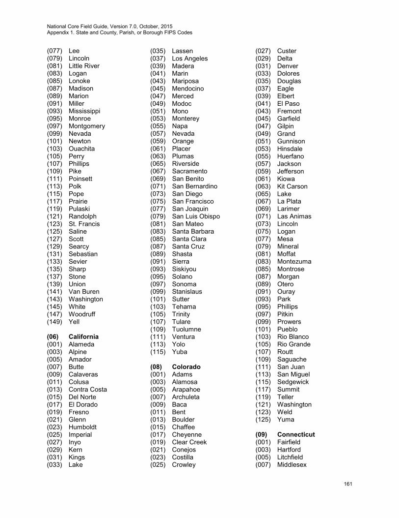
National Core Field Guide, Version 7.0, October, 2015 Appendix 1. State and County, Parish, or Borough FIPS Codes
161
(077) Lee (079) Lincoln (081) Little River (083) Logan (085) Lonoke (087) Madison (089) Marion (091) Miller (093) Mississippi (095) Monroe (097) Montgomery (099) Nevada (101) Newton (103) Ouachita (105) Perry (107) Phillips (109) Pike (111) Poinsett (113) Polk (115) Pope (117) Prairie (119) Pulaski (121) Randolph (123) St. Francis (125) Saline (127) Scott (129) Searcy (131) Sebastian (133) Sevier (135) Sharp (137) Stone (139) Union (141) Van Buren (143) Washington (145) White (147) Woodruff (149) Yell (06) California (001) Alameda (003) Alpine (005) Amador (007) Butte (009) Calaveras (011) Colusa (013) Contra Costa (015) Del Norte (017) El Dorado (019) Fresno (021) Glenn (023) Humboldt (025) Imperial (027) Inyo (029) Kern (031) Kings (033) Lake
(035) Lassen (037) Los Angeles (039) Madera (041) Marin (043) Mariposa (045) Mendocino (047) Merced (049) Modoc (051) Mono (053) Monterey (055) Napa (057) Nevada (059) Orange (061) Placer (063) Plumas (065) Riverside (067) Sacramento (069) San Benito (071) San Bernardino (073) San Diego (075) San Francisco (077) San Joaquin (079) San Luis Obispo (081) San Mateo (083) Santa Barbara (085) Santa Clara (087) Santa Cruz (089) Shasta (091) Sierra (093) Siskiyou (095) Solano (097) Sonoma (099) Stanislaus (101) Sutter (103) Tehama (105) Trinity (107) Tulare (109) Tuolumne (111) Ventura (113) Yolo (115) Yuba (08) Colorado (001) Adams (003) Alamosa (005) Arapahoe (007) Archuleta (009) Baca (011) Bent (013) Boulder (015) Chaffee (017) Cheyenne (019) Clear Creek (021) Conejos (023) Costilla (025) Crowley
(027) Custer (029) Delta (031) Denver (033) Dolores (035) Douglas (037) Eagle (039) Elbert (041) El Paso (043) Fremont (045) Garfield (047) Gilpin (049) Grand (051) Gunnison (053) Hinsdale (055) Huerfano (057) Jackson (059) Jefferson (061) Kiowa (063) Kit Carson (065) Lake (067) La Plata (069) Larimer (071) Las Animas (073) Lincoln (075) Logan (077) Mesa (079) Mineral (081) Moffat (083) Montezuma (085) Montrose (087) Morgan (089) Otero (091) Ouray (093) Park (095) Phillips (097) Pitkin (099) Prowers (101) Pueblo (103) Rio Blanco (105) Rio Grande (107) Routt (109) Saguache (111) San Juan (113) San Miguel (115) Sedgewick (117) Summit (119) Teller (121) Washington (123) Weld (125) Yuma (09) Connecticut (001) Fairfield (003) Hartford (005) Litchfield (007) Middlesex
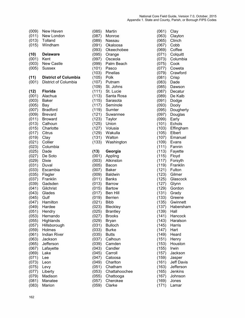
National Core Field Guide, Version 7.0, October, 2015 Appendix 1. State and County, Parish, or Borough FIPS Codes
162
(009) New Haven (011) New London (013) Tolland (015) Windham (10) Delaware (001) Kent (003) New Castle (005) Sussex (11) District of Columbia (001) District of Columbia (12) Florida (001) Alachua (003) Baker (005) Bay (007) Bradford (009) Brevard (011) Broward (013) Calhoun (015) Charlotte (017) Citrus (019) Clay (021) Collier (023) Columbia (025) Dade (027) De Soto (029) Dixie (031) Duval (033) Escambia (035) Flagler (037) Franklin (039) Gadsden (041) Gilchrist (043) Glades (045) Gulf (047) Hamilton (049) Hardee (051) Hendry (053) Hernando (055) Highlands (057) Hillsborough (059) Holmes (061) Indian River (063) Jackson (065) Jefferson (067) Lafayette (069) Lake (071) Lee (073) Leon (075) Levy (077) Liberty (079) Madison (081) Manatee (083) Marion
(085) Martin (087) Monroe (089) Nassau (091) Okaloosa (093) Okeechobee (095) Orange (097) Osceola (099) Palm Beach (101) Pasco (103) Pinellas (105) Polk (107) Putnam (109) St. Johns (111) St. Lucie (113) Santa Rosa (115) Sarasota (117) Seminole (119) Sumter (121) Suwannee (123) Taylor (125) Union (127) Volusia (129) Wakulla (131) Walton (133) Washington (13) Georgia (001) Appling (003) Atkinston (005) Bacon (007) Baker (009) Baldwin (011) Banks (013) Barrow (015) Bartow (017) Ben Hill (019) Berrien (021) Bibb (023) Bleckley (025) Brantley (027) Brooks (029) Bryan (031) Bulloch (033) Burke (035) Butts (037) Calhoun (039) Camden (043) Candler (045) Carroll (047) Catoosa (049) Charlton (051) Chatham (053) Chattahoochee (055) Chattooga (057) Cherokee (059) Clarke
(061) Clay (063) Clayton (065) Clinch (067) Cobb (069) Coffee (071) Colquitt (073) Columbia (075) Cook (077) Coweta (079) Crawford (081) Crisp (083) Dade (085) Dawson (087) Decatur (089) De Kalb (091) Dodge (093) Dooly (095) Dougherty (097) Douglas (099) Early (101) Echols (103) Effingham (105) Elbert (107) Emanuel (109) Evans (111) Fannin (113) Fayette (115) Floyd (117) Forsyth (119) Franklin (121) Fulton (123) Gilmer (125) Glascock (127) Glynn (129) Gordon (131) Grady (133) Greene (135) Gwinnett (137) Habersham (139) Hall (141) Hancock (143) Haralson (145) Harris (147) Hart (149) Heard (151) Henry (153) Houston (155) Irwin (157) Jackson (159) Jasper (161) Jeff Davis (163) Jefferson (165) Jenkins (167) Johnson (169) Jones (171) Lamar
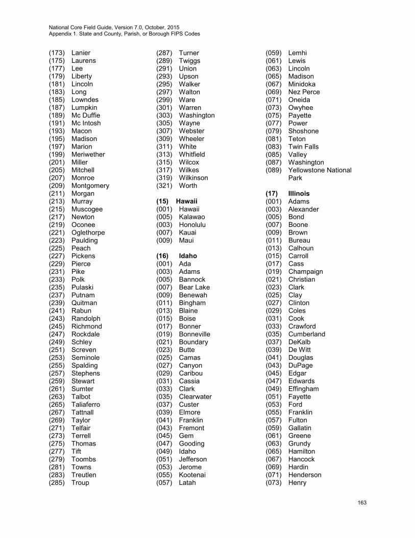
National Core Field Guide, Version 7.0, October, 2015 Appendix 1. State and County, Parish, or Borough FIPS Codes
163
(173) Lanier (175) Laurens (177) Lee (179) Liberty (181) Lincoln (183) Long (185) Lowndes (187) Lumpkin (189) Mc Duffie (191) Mc Intosh (193) Macon (195) Madison (197) Marion (199) Meriwether (201) Miller (205) Mitchell (207) Monroe (209) Montgomery (211) Morgan (213) Murray (215) Muscogee (217) Newton (219) Oconee (221) Oglethorpe (223) Paulding (225) Peach (227) Pickens (229) Pierce (231) Pike (233) Polk (235) Pulaski (237) Putnam (239) Quitman (241) Rabun (243) Randolph (245) Richmond (247) Rockdale (249) Schley (251) Screven (253) Seminole (255) Spalding (257) Stephens (259) Stewart (261) Sumter (263) Talbot (265) Taliaferro (267) Tattnall (269) Taylor (271) Telfair (273) Terrell (275) Thomas (277) Tift (279) Toombs (281) Towns (283) Treutlen (285) Troup
(287) Turner (289) Twiggs (291) Union (293) Upson (295) Walker (297) Walton (299) Ware (301) Warren (303) Washington (305) Wayne (307) Webster (309) Wheeler (311) White (313) Whitfield (315) Wilcox (317) Wilkes (319) Wilkinson (321) Worth (15) Hawaii (001) Hawaii (005) Kalawao (003) Honolulu (007) Kauai (009) Maui (16) Idaho (001) Ada (003) Adams (005) Bannock (007) Bear Lake (009) Benewah (011) Bingham (013) Blaine (015) Boise (017) Bonner (019) Bonneville (021) Boundary (023) Butte (025) Camas (027) Canyon (029) Caribou (031) Cassia (033) Clark (035) Clearwater (037) Custer (039) Elmore (041) Franklin (043) Fremont (045) Gem (047) Gooding (049) Idaho (051) Jefferson (053) Jerome (055) Kootenai (057) Latah
(059) Lemhi (061) Lewis (063) Lincoln (065) Madison (067) Minidoka (069) Nez Perce (071) Oneida (073) Owyhee (075) Payette (077) Power (079) Shoshone (081) Teton (083) Twin Falls (085) Valley (087) Washington (089) Yellowstone National
Park (17) Illinois (001) Adams (003) Alexander (005) Bond (007) Boone (009) Brown (011) Bureau (013) Calhoun (015) Carroll (017) Cass (019) Champaign (021) Christian (023) Clark (025) Clay (027) Clinton (029) Coles (031) Cook (033) Crawford (035) Cumberland (037) DeKalb (039) De Witt (041) Douglas (043) DuPage (045) Edgar (047) Edwards (049) Effingham (051) Fayette (053) Ford (055) Franklin (057) Fulton (059) Gallatin (061) Greene (063) Grundy (065) Hamilton (067) Hancock (069) Hardin (071) Henderson (073) Henry
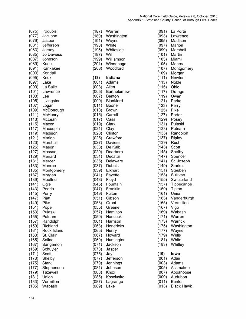
National Core Field Guide, Version 7.0, October, 2015 Appendix 1. State and County, Parish, or Borough FIPS Codes
164
(075) Iroquois (077) Jackson (079) Jasper (081) Jefferson (083) Jersey (085) Jo Daviess (087) Johnson (089) Kane (091) Kankakee (093) Kendall (095) Knox (097) Lake (099) La Salle (101) Lawrence (103) Lee (105) Livingston (107) Logan (109) McDonough (111) McHenry (113) McLean (115) Macon (117) Macoupin (119) Madison (121) Marion (123) Marshall (125) Mason (127) Massac (129) Menard (131) Mercer (133) Monroe (135) Montgomery (137) Morgan (139) Moultrie (141) Ogle (143) Peoria (145) Perry (147) Piatt (149) Pike (151) Pope (153) Pulaski (155) Putnam (157) Randolph (159) Richland (161) Rock Island (163) St. Clair (165) Saline (167) Sangamon (169) Schuyler (171) Scott (173) Shelby (175) Stark (177) Stephenson (179) Tazewell (181) Union (183) Vermilion (185) Wabash
(187) Warren (189) Washington (191) Wayne (193) White (195) Whiteside (197) Will (199) Williamson (201) Winnebago (203) Woodford (18) Indiana (001) Adams (003) Allen (005) Bartholomew (007) Benton (009) Blackford (011) Boone (013) Brown (015) Carroll (017) Cass (019) Clark (021) Clay (023) Clinton (025) Crawford (027) Daviess (033) De Kalb (029) Dearborn (031) Decatur (035) Delaware (037) Dubois (039) Elkhart (041) Fayette (043) Floyd (045) Fountain (047) Franklin (049) Fulton (051) Gibson (053) Grant (055) Greene (057) Hamilton (059) Hancock (061) Harrison (063) Hendricks (065) Henry (067) Howard (069) Huntington (071) Jackson (073) Jasper (075) Jay (077) Jefferson (079) Jennings (081) Johnson (083) Knox (085) Kosciusko (087) Lagrange (089) Lake
(091) La Porte (093) Lawrence (095) Madison (097) Marion (099) Marshall (101) Martin (103) Miami (105) Monroe (107) Montgomery (109) Morgan (111) Newton (113) Noble (115) Ohio (117) Orange (119) Owen (121) Parke (123) Perry (125) Pike (127) Porter (129) Posey (131) Pulaski (133) Putnam (135) Randolph (137) Ripley (139) Rush (143) Scott (145) Shelby (147) Spencer (141) St. Joseph (149) Starke (151) Steuben (153) Sullivan (155) Switzerland (157) Tippecanoe (159) Tipton (161) Union (163) Vanderburgh (165) Vermillion (167) Vigo (169) Wabash (171) Warren (173) Warrick (175) Washington (177) Wayne (179) Wells (181) White (183) Whitley (19) Iowa (001) Adair (003) Adams (005) Allamakee (007) Appanoose (009) Audubon (011) Benton (013) Black Hawk

National Core Field Guide, Version 7.0, October, 2015 Appendix 1. State and County, Parish, or Borough FIPS Codes
165
(015) Boone (017) Bremer (019) Buchanan (021) Buena Vista (023) Butler (025) Calhoun (027) Carroll (029) Cass (031) Cedar (033) Cerro Gordo (035) Cherokee (037) Chickasaw (039) Clarke (041) Clay (043) Clayton (045) Clinton (047) Crawford (049) Dallas (051) Davis (053) Decatur (055) Delaware (057) Des Moines (059) Dickinson (061) Dubuque (063) Emmet (065) Fayette (067) Floyd (069) Franklin (071) Fremont (073) Greene (075) Grundy (077) Guthrie (079) Hamilton (081) Hancock (083) Hardin (085) Harrison (087) Henry (089) Howard (091) Humboldt (093) Ida (095) Iowa (097) Jackson (099) Jasper (101) Jefferson (103) Johnson (105) Jones (107) Keokuk (109) Kossuth (111) Lee (113) Linn (115) Louisa (117) Lucas (119) Lyon (121) Madison (123) Mahaska (125) Marion
(127) Marshall (129) Mills (131) Mitchell (133) Monona (135) Monroe (137) Montgomery (139) Muscatine (141) O’Brien (143) Osceola (145) Page (147) Palo Alto (149) Plymouth (151) Pocahontas (153) Polk (155) Pottawattamie (157) Poweshiek (159) Ringgold (161) Sac (163) Scott (165) Shelby (167) Sioux (169) Story (171) Tama (173) Taylor (175) Union (177) Van Buren (179) Wapello (181) Warren (183) Washington (185) Wayne (187) Webster (189) Winnebago (191) Winneshiek (193) Woodbury (195) Worth (197) Wright (20) Kansas (001) Allen (003) Anderson (005) Atchison (007) Barber (009) Barton (011) Bourbon (013) Brown (015) Butler (017) Chase (019) Chautauqua (021) Cherokee (023) Cheyenne (025) Clark (027) Clay (029) Cloud (031) Coffey (033) Comanche (035) Cowley
(037) Crawford (039) Decatur (041) Dickinson (043) Doniphan (045) Douglas (047) Edwards (049) Elk (051) Ellis (053) Ellsworth (055) Finney (057) Ford (059) Franklin (061) Geary (063) Gove (065) Graham (067) Grant (069) Gray (071) Greeley (073) Greenwood (075) Hamilton (077) Harper (079) Harvey (081) Haskell (083) Hodgeman (085) Jackson (087) Jefferson (089) Jewell (091) Johnson (093) Kearny (095) Kingman (097) Kiowa (099) Labette (101) Lane (103) Leavenworth (105) Lincoln (107) Linn (109) Logan (111) Lyon (113) McPherson (115) Marion (117) Marshall (119) Meade (121) Miami (123) Mitchell (125) Montgomery (127) Morris (129) Morton (131) Nemaha (133) Neosho (135) Ness (137) Norton (139) Osage (141) Osborne (143) Ottawa (145) Pawnee (147) Phillips
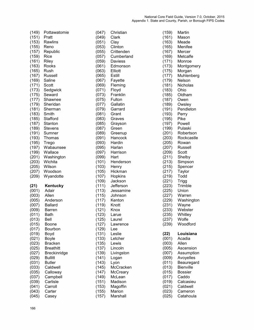
National Core Field Guide, Version 7.0, October, 2015 Appendix 1. State and County, Parish, or Borough FIPS Codes
166
(149) Pottawatomie (151) Pratt (153) Rawlins (155) Reno (157) Republic (159) Rice (161) Riley (163) Rooks (165) Rush (167) Russell (169) Saline (171) Scott (173) Sedgwick (175) Seward (177) Shawnee (179) Sheridan (181) Sherman (183) Smith (185) Stafford (187) Stanton (189) Stevens (191) Sumner (193) Thomas (195) Trego (197) Wabaunsee (199) Wallace (201) Washington (203) Wichita (205) Wilson (207) Woodson (209) Wyandotte (21) Kentucky (001) Adair (003) Allen (005) Anderson (007) Ballard (009) Barren (011) Bath (013) Bell (015) Boone (017) Bourbon (019) Boyd (021) Boyle (023) Bracken (025) Breathitt (027) Breckinridge (029) Bullitt (031) Butler (033) Caldwell (035) Calloway (037) Campbell (039) Carlisle (041) Carroll (043) Carter (045) Casey
(047) Christian (049) Clark (051) Clay (053) Clinton (055) Crittenden (057) Cumberland (059) Daviess (061) Edmonson (063) Elliott (065) Estill (067) Fayette (069) Fleming (071) Floyd (073) Franklin (075) Fulton (077) Gallatin (079) Garrard (081) Grant (083) Graves (085) Grayson (087) Green (089) Greenup (091) Hancock (093) Hardin (095) Harlan (097) Harrison (099) Hart (101) Henderson (103) Henry (105) Hickman (107) Hopkins (109) Jackson (111) Jefferson (113) Jessamine (115) Johnson (117) Kenton (119) Knott (121) Knox (123) Larue (125) Laurel (127) Lawrence (129) Lee (131) Leslie (133) Letcher (135) Lewis (137) Lincoln (139) Livingston (141) Logan (143) Lyon (145) McCracken (147) McCreary (149) McLean (151) Madison (153) Magoffin (155) Marion (157) Marshall
(159) Martin (161) Mason (163) Meade (165) Menifee (167) Mercer (169) Metcalfe (171) Monroe (173) Montgomery (175) Morgan (177) Muhlenberg (179) Nelson (181) Nicholas (183) Ohio (185) Oldham (187) Owen (189) Owsley (191) Pendleton (193) Perry (195) Pike (197) Powell (199) Pulaski (201) Robertson (203) Rockcastle (205) Rowan (207) Russell (209) Scott (211) Shelby (213) Simpson (215) Spencer (217) Taylor (219) Todd (221) Trigg (223) Trimble (225) Union (227) Warren (229) Washington (231) Wayne (233) Webster (235) Whitley (237) Wolfe (239) Woodford (22) Louisiana (001) Acadia (003) Allen (005) Ascension (007) Assumption (009) Avoyelles (011) Beauregard (013) Bienville (015) Bossier (017) Caddo (019) Calcasieu (021) Caldwell (023) Cameron (025) Catahoula

National Core Field Guide, Version 7.0, October, 2015 Appendix 1. State and County, Parish, or Borough FIPS Codes
167
(027) Claiborne (029) Concordia (031) De Soto (033) East Baton Rouge (035) East Carroll (037) East Feliciana (039) Evangeline (041) Franklin (043) Grant (045) Iberia (047) Iberville (049) Jackson (051) Jefferson (053) Jefferson Davis (055) Lafayette (057) LaFourche (059) La Salle (061) Lincoln (063) Livingston (065) Madison (067) Morehouse (069) Natchitoches (071) Orleans (073) Ouachita (075) Plaquemines (077) Pointe Coupee (079) Rapides (081) Red River (083) Richland (085) Sabine (087) St. Bernard (089) St. Charles (091) St. Helena (093) St. James (095) St. John the Baptist (097) St. Landry (099) St. Martin (101) St. Mary (103) St. Tammany (105) Tangipahoa (107) Tensas (109) Terrebonne (111) Union (113) Vermilion (115) Vernon (117) Washington (119) Webster (121) West Baton Rouge (123) West Carroll (125) West Feliciana (127) Winn (23) Maine (001) Androscoggin (003) Aroostook (005) Cumberland
(007) Franklin (009) Hancock (011) Kennebec (013) Knox (015) Lincoln (017) Oxford (019) Penobscot (021) Piscataquis (023) Sagadahoc (025) Somerset (027) Waldo (029) Washington (031) York (24) Maryland (100) Allegany (003) Anne Arundel (005) Baltimore (009) Calvert (011) Caroline (013) Carroll (015) Cecil (017) Charles (019) Dorchester (021) Frederick (023) Garrett (025) Harford (027) Howard (029) Kent (031) Montgomery (033) Prince Georges (035) Queen Annes (037) St. Marys (039) Somerset (041) Talbot (043) Washington (045) Wicomico (047) Worcester (510) Baltimore City (25) Massachusetts (001) Barnstable (003) Berkshire (005) Bristol (007) Dukes (009) Essex (011) Franklin (013) Hampden (015) Hampshire (017) Middlesex (019) Nantucket (021) Norfolk (023) Plymouth (025) Suffolk (027) Worcester (029) Washington
(031) York (26) Michigan (001) Alcona (003) Alger (005) Allegan (007) Alpena (009) Antrim (011) Arenac (013) Baraga (015) Barry (017) Bay (019) Benzie (021) Berrien (023) Branch (025) Calhoun (027) Cass (029) Charlevoix (031) Cheboygan (033) Chippewa (035) Clare (037) Clinton (039) Crawford (041) Delta (043) Dickinson (045) Eaton (047) Emmet (049) Genesee (051) Gladwin (053) Gogebic (055) Grand Traverse (057) Gratiot (059) Hillsdale (061) Houghton (063) Huron (065) Ingham (067) Ionia (069) Iosco (071) Iron (073) Isabella (075) Jackson (077) Kalamazoo (079) Kalkaska (081) Kent (083) Keweenaw (085) Lake (087) Lapeer (089) Leelanau (091) Lenawee (093) Livingston (095) Luce (097) Mackinac (099) Macomb (101) Manistee (103) Marquette (105) Mason

National Core Field Guide, Version 7.0, October, 2015 Appendix 1. State and County, Parish, or Borough FIPS Codes
168
(107) Mecosta (109) Menominee (111) Midland (113) Missaukee (115) Monroe (117) Montcalm (119) Montmorency (121) Muskegon (123) Newaygo (125) Oakland (127) Oceana (129) Ogemaw (131) Ontonagon (133) Osceola (135) Oscoda (137) Otsego (139) Ottawa (141) Presque Isle (143) Roscommon (145) Saginaw (147) St. Clair (149) St. Joseph (151) Sanilac (153) Schoolcraft (155) Shiawassee (157) Tuscola (159) Van Buren (161) Washtenaw (163) Wayne (165) Wexford (27) Minnesota (001) Aitkin (003) Anoka (005) Becker (007) Beltrami (009) Benton (011) Big Stone (013) Blue Earth (015) Brown (017) Carlton (019) Carver (021) Cass (023) Chippewa (025) Chisago (027) Clay (029) Clearwater (031) Cook (033) Cottonwood (035) Crow Wing (037) Dakota (039) Dodge (041) Douglas (043) Faribault (045) Fillmore (047) Freeborn
(049) Goodhue (051) Grant (053) Hennepin (055) Houston (057) Hubbard (059) Isanti (061) Itasca (063) Jackson (065) Kanabec (067) Kandiyohi (069) Kittson (071) Koochiching (073) Lac qui Parle (075) Lake (077) Lake of the Woods (079) Le Sueur (081) Lincoln (083) Lyon (085) McLeod (087) Mahnomen (089) Marshall (091) Martin (093) Meeker (095) Mille Lacs (097) Morrison (099) Mower (101) Murray (103) Nicollet (105) Nobles (107) Norman (109) Olmsted (111) Otter Tail (113) Pennington (115) Pine (117) Pipestone (119) Polk (121) Pope (123) Ramsey (125) Red Lake (127) Redwood (129) Renville (131) Rice (133) Rock (135) Roseau (137) St. Louis (139) Scott (141) Sherburne (143) Sibley (145) Stearns (147) Steele (149) Stevens (151) Swift (153) Todd (155) Traverse (157) Wabasha (159) Wadena
(161) Waseca (163) Washington (165) Watonwan (167) Wilkin (169) Winona (171) Wright (173) Yellow Medicine (28) Mississippi (001) Adams (003) Alcorn (005) Amite (007) Attala (009) Benton (011) Bolivar (013) Calhoun (015) Carroll (017) Chickasaw (019) Choctaw (021) Claiborne (023) Clarke (025) Clay (027) Coahoma (029) Copiah (031) Covington (033) De Soto (035) Forrest (037) Franklin (039) George (041) Greene (043) Grenada (045) Hancock (047) Harrison (049) Hinds (051) Holmes (053) Humphreys (055) Issaquena (057) Itawamba (059) Jackson (061) Jasper (063) Jefferson (065) Jefferson Davis (067) Jones (069) Kemper (071) Lafayette (073) Lamar (075) Lauderdale (077) Lawrence (079) Leake (081) Lee (083) Leflore (085) Lincoln (087) Lowndes (089) Madison (091) Marion (093) Marshall
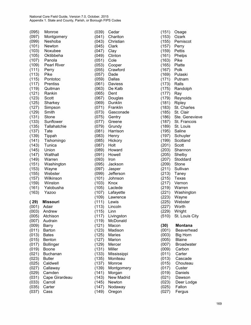
National Core Field Guide, Version 7.0, October, 2015 Appendix 1. State and County, Parish, or Borough FIPS Codes
169
(095) Monroe (097) Montgomery (099) Neshoba (101) Newton (103) Noxubee (105) Oktibbeha (107) Panola (109) Pearl River (111) Perry (113) Pike (115) Pontotoc (117) Prentiss (119) Quitman (121) Rankin (123) Scott (125) Sharkey (127) Simpson (129) Smith (131) Stone (133) Sunflower (135) Tallahatchie (137) Tate (139) Tippah (141) Tishomingo (143) Tunica (145) Union (147) Walthall (149) Warren (151) Washington (153) Wayne (155) Webster (157) Wilkinson (159) Winston (161) Yalobusha (163) Yazoo ( 29) Missouri (001) Adair (003) Andrew (005) Atchison (007) Audrain (009) Barry (011) Barton (013) Bates (015) Benton (017) Bollinger (019) Boone (021) Buchanan (023) Butler (025) Caldwell (027) Callaway (029) Camden (031) Cape Girardeau (033) Carroll (035) Carter (037) Cass
(039) Cedar (041) Chariton (043) Christian (045) Clark (047) Clay (049) Clinton (051) Cole (053) Cooper (055) Crawford (057) Dade (059) Dallas (061) Daviess (063) De Kalb (065) Dent (067) Douglas (069) Dunklin (071) Franklin (073) Gasconade (075) Gentry (077) Greene (079) Grundy (081) Harrison (083) Henry (085) Hickory (087) Holt (089) Howard (091) Howell (093) Iron (095) Jackson (097) Jasper (099) Jefferson (101) Johnson (103) Knox (105) Laclede (107) Lafayette (109) Lawrence (111) Lewis (113) Lincoln (115) Linn (117) Livingston (119) McDonald (121) Macon (123) Madison (125) Maries (127) Marion (129) Mercer (131) Miller (133) Mississippi (135) Moniteau (137) Monroe (139) Montgomery (141) Morgan (143) New Madrid (145) Newton (147) Nodaway (149) Oregon
(151) Osage (153) Ozark (155) Pemiscot (157) Perry (159) Pettis (161) Phelps (163) Pike (165) Platte (167) Polk (169) Pulaski (171) Putnam (173) Ralls (175) Randolph (177) Ray (179) Reynolds (181) Ripley (183) St. Charles (185) St. Clair (186) Ste. Genevieve (187) St. Francois (189) St. Louis (195) Saline (197) Schuyler (199) Scotland (201) Scott (203) Shannon (205) Shelby (207) Stoddard (209) Stone (211) Sullivan (213) Taney (215) Texas (217) Vernon (219) Warren (221) Washington (223) Wayne (225) Webster (227) Worth (229) Wright (510) St. Louis City (30) Montana (001) Beaverhead (003) Big Horn (005) Blaine (007) Broadwater (009) Carbon (011) Carter (013) Cascade (015) Chouteau (017) Custer (019) Daniels (021) Dawson (023) Deer Lodge (025) Fallon (027) Fergus

National Core Field Guide, Version 7.0, October, 2015 Appendix 1. State and County, Parish, or Borough FIPS Codes
170
(029) Flathead (031) Gallatin (033) Garfield (035) Glacier (037) Golden Valley (039) Granite (041) Hill (043) Jefferson (045) Judith Basin (047) Lake (049) Lewis and Clark (051) Liberty (053) Lincoln (055) McCone (057) Madison (059) Meagher (061) Mineral (063) Missoula (065) Musselshell (067) Park (069) Petroleum (071) Phillips (073) Pondera (075) Powder River (077) Powell (079) Prairie (081) Ravalli (083) Richland (085) Roosevelt (087) Rosebud (089) Sanders (091) Sheridan (093) Silver Bow (095) Stillwater (097) Sweet Grass (099) Teton (101) Toole (103) Treasure (105) Valley (107) Wheatland (109) Wibaux (111) Yellowstone (113) Yellowstone National
Park (31) Nebraska (001) Adams (003) Antelope (005) Arthur (007) Banner (009) Blaine (011) Boone (013) Box Butte (015) Boyd (017) Brown (019) Buffalo
(021) Burt (023) Butler (025) Cass (027) Cedar (029) Chase (031) Cherry (033) Cheyenne (035) Clay (037) Colfax (039) Cuming (041) Custer (043) Dakota (045) Dawes (047) Dawson (049) Deuel (051) Dixon (053) Dodge (055) Douglas (057) Dundy (059) Fillmore (061) Franklin (063) Frontier (065) Furnas (067) Gage (069) Garden (071) Garfield (073) Gosper (075) Grant (077) Greeley (079) Hall (081) Hamilton (083) Harlan (085) Hayes (087) Hitchcock (089) Holt (091) Hooker (093) Howard (095) Jefferson (097) Johnson (099) Kearney (101) Keith (103) Keya Paha (105) Kimball (107) Knox (109) Lancaster (111) Lincoln (113) Logan (115) Loup (117) McPherson (119) Madison (121) Merrick (123) Morrill (125) Nance (127) Nemaha (129) Nuckolls (131) Otoe
(133) Pawnee (135) Perkins (137) Phelps (139) Pierce (141) Platte (143) Polk (145) Red Willow (147) Richardson (149) Rock (151) Saline (153) Sarpy (155) Saunders (157) Scotts Bluff (159) Seward (161) Sheridan (163) Sherman (165) Sioux (167) Stanton (169) Thayer (171) Thomas (173) Thurston (175) Valley (177) Washington (179) Wayne (181) Webster (183) Wheeler (185) York (32) Nevada (001) Churchill (003) Clark (005) Douglas (007) Elko (009) Esmeralda (011) Eureka (013) Humboldt (015) Lander (017) Lincoln (019) Lyon (021) Mineral (023) Nye (027) Pershing (029) Storey (031) Washoe (033) White Pine (510) Carson City (33) New Hampshire (001) Belknap (003) Carroll (007) Coos (005) Cheshire (009) Grafton (011) Hillsborough (013) Merrimack (015) Rockingham
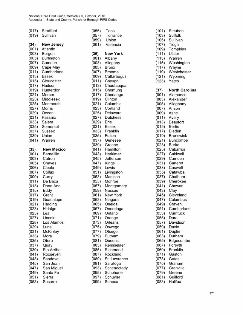
National Core Field Guide, Version 7.0, October, 2015 Appendix 1. State and County, Parish, or Borough FIPS Codes
171
(017) Strafford (019) Sullivan (34) New Jersey (001) Atlantic (003) Bergen (005) Burlington (007) Camden (009) Cape May (011) Cumberland (013) Essex (015) Gloucester (017) Hudson (019) Hunterdon (021) Mercer (023) Middlesex (025) Monmouth (027) Morris (029) Ocean (031) Passaic (033) Salem (035) Somerset (037) Sussex (039) Union (041) Warren (35) New Mexico (001) Bernalillo (003) Catron (005) Chaves (006) Cibola (007) Colfax (009) Curry (011) De Baca (013) Dona Ana (015) Eddy (017) Grant (019) Guadalupe (021) Harding (023) Hidalgo (025) Lea (027) Lincoln (028) Los Alamos (029) Luna (031) McKinley (033) Mora (035) Otero (037) Quay (039) Rio Arriba (041) Roosevelt (043) Sandoval (045) San Juan (047) San Miguel (049) Santa Fe (051) Sierra (053) Socorro
(055) Taos (057) Torrance (059) Union (061) Valencia (36) New York (001) Albany (003) Allegany (005) Bronx (007) Broome (009) Cattaraugus (011) Cayuga (013) Chautauqua (015) Chemung (017) Chenango (019) Clinton (021) Columbia (023) Cortland (025) Delaware (027) Dutchess (029) Erie (031) Essex (033) Franklin (035) Fulton (037) Genesee (039) Greene (041) Hamilton (043) Herkimer (045) Jefferson (047) Kings (049) Lewis (051) Livingston (053) Madison (055) Monroe (057) Montgomery (059) Nassau (061) New York (063) Niagara (065) Oneida (067) Onondaga (069) Ontario (071) Orange (073) Orleans (075) Oswego (077) Otsego (079) Putnam (081) Queens (083) Rensselaer (085) Richmond (087) Rockland (089) St. Lawrence (091) Saratoga (093) Schenectady (095) Schoharie (097) Schuyler (099) Seneca
(101) Steuben (103) Suffolk (105) Sullivan (107) Tioga (109) Tompkins (111) Ulster (113) Warren (115) Washington (117) Wayne (119) Westchester (121) Wyoming (123) Yates (37) North Carolina (001) Alamance (003) Alexander (005) Alleghany (007) Anson (009) Ashe (011) Avery (013) Beaufort (015) Bertie (017) Bladen (019) Brunswick (021) Buncombe (023) Burke (025) Cabarrus (027) Caldwell (029) Camden (031) Carteret (033) Caswell (035) Catawba (037) Chatham (039) Cherokee (041) Chowan (043) Clay (045) Cleveland (047) Columbus (049) Craven (051) Cumberland (053) Currituck (055) Dare (057) Davidson (059) Davie (061) Duplin (063) Durham (065) Edgecombe (067) Forsyth (069) Franklin (071) Gaston (073) Gates (075) Graham (077) Granville (079) Greene (081) Guilford (083) Halifax
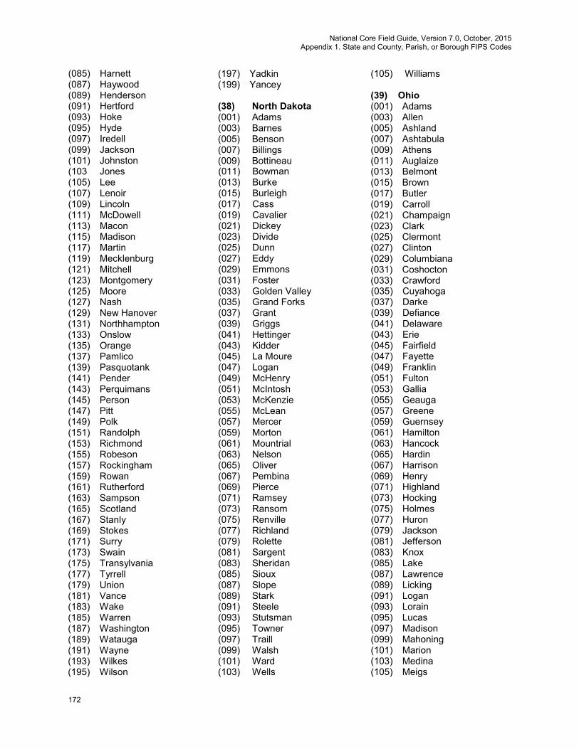
National Core Field Guide, Version 7.0, October, 2015 Appendix 1. State and County, Parish, or Borough FIPS Codes
172
(085) Harnett (087) Haywood (089) Henderson (091) Hertford (093) Hoke (095) Hyde (097) Iredell (099) Jackson (101) Johnston (103 Jones (105) Lee (107) Lenoir (109) Lincoln (111) McDowell (113) Macon (115) Madison (117) Martin (119) Mecklenburg (121) Mitchell (123) Montgomery (125) Moore (127) Nash (129) New Hanover (131) Northhampton (133) Onslow (135) Orange (137) Pamlico (139) Pasquotank (141) Pender (143) Perquimans (145) Person (147) Pitt (149) Polk (151) Randolph (153) Richmond (155) Robeson (157) Rockingham (159) Rowan (161) Rutherford (163) Sampson (165) Scotland (167) Stanly (169) Stokes (171) Surry (173) Swain (175) Transylvania (177) Tyrrell (179) Union (181) Vance (183) Wake (185) Warren (187) Washington (189) Watauga (191) Wayne (193) Wilkes (195) Wilson
(197) Yadkin (199) Yancey (38) North Dakota (001) Adams (003) Barnes (005) Benson (007) Billings (009) Bottineau (011) Bowman (013) Burke (015) Burleigh (017) Cass (019) Cavalier (021) Dickey (023) Divide (025) Dunn (027) Eddy (029) Emmons (031) Foster (033) Golden Valley (035) Grand Forks (037) Grant (039) Griggs (041) Hettinger (043) Kidder (045) La Moure (047) Logan (049) McHenry (051) McIntosh (053) McKenzie (055) McLean (057) Mercer (059) Morton (061) Mountrial (063) Nelson (065) Oliver (067) Pembina (069) Pierce (071) Ramsey (073) Ransom (075) Renville (077) Richland (079) Rolette (081) Sargent (083) Sheridan (085) Sioux (087) Slope (089) Stark (091) Steele (093) Stutsman (095) Towner (097) Traill (099) Walsh (101) Ward (103) Wells
(105) Williams (39) Ohio (001) Adams (003) Allen (005) Ashland (007) Ashtabula (009) Athens (011) Auglaize (013) Belmont (015) Brown (017) Butler (019) Carroll (021) Champaign (023) Clark (025) Clermont (027) Clinton (029) Columbiana (031) Coshocton (033) Crawford (035) Cuyahoga (037) Darke (039) Defiance (041) Delaware (043) Erie (045) Fairfield (047) Fayette (049) Franklin (051) Fulton (053) Gallia (055) Geauga (057) Greene (059) Guernsey (061) Hamilton (063) Hancock (065) Hardin (067) Harrison (069) Henry (071) Highland (073) Hocking (075) Holmes (077) Huron (079) Jackson (081) Jefferson (083) Knox (085) Lake (087) Lawrence (089) Licking (091) Logan (093) Lorain (095) Lucas (097) Madison (099) Mahoning (101) Marion (103) Medina (105) Meigs
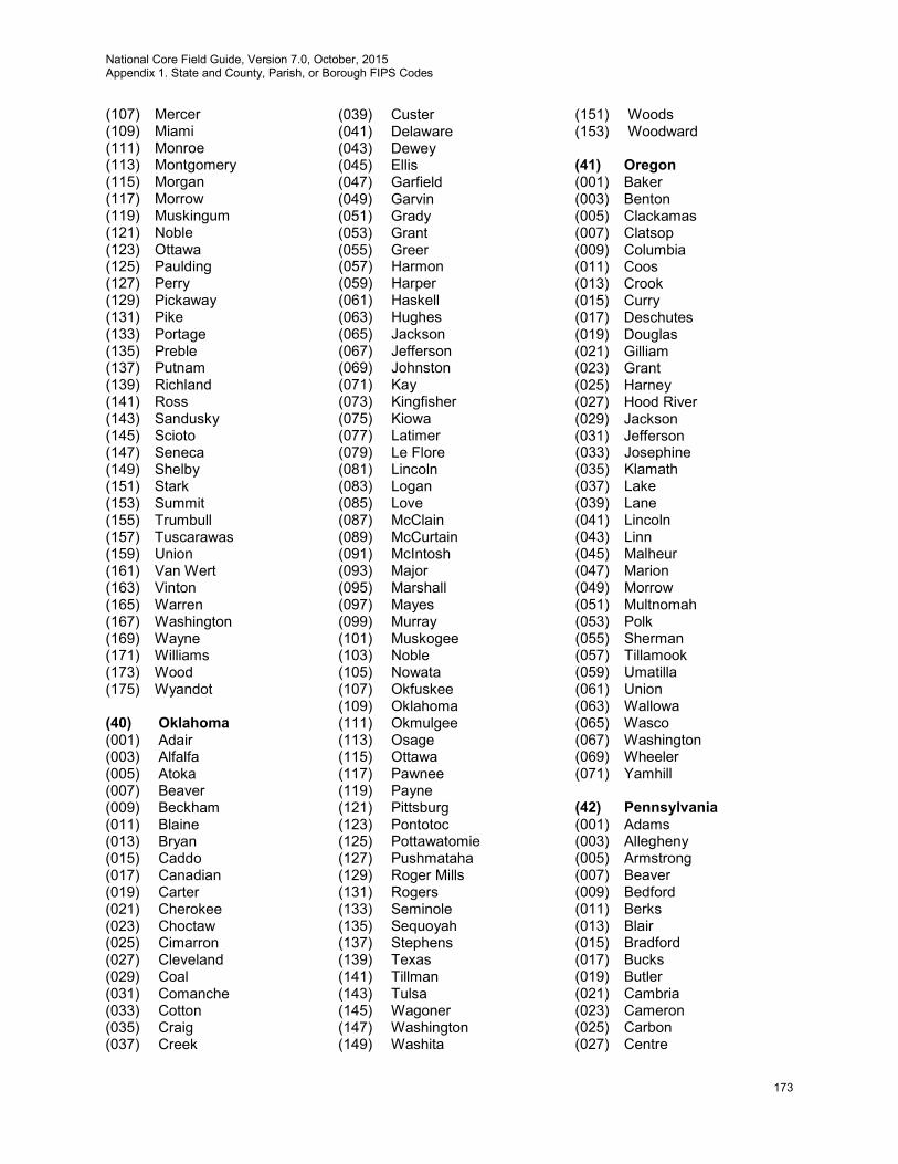
National Core Field Guide, Version 7.0, October, 2015 Appendix 1. State and County, Parish, or Borough FIPS Codes
173
(107) Mercer (109) Miami (111) Monroe (113) Montgomery (115) Morgan (117) Morrow (119) Muskingum (121) Noble (123) Ottawa (125) Paulding (127) Perry (129) Pickaway (131) Pike (133) Portage (135) Preble (137) Putnam (139) Richland (141) Ross (143) Sandusky (145) Scioto (147) Seneca (149) Shelby (151) Stark (153) Summit (155) Trumbull (157) Tuscarawas (159) Union (161) Van Wert (163) Vinton (165) Warren (167) Washington (169) Wayne (171) Williams (173) Wood (175) Wyandot (40) Oklahoma (001) Adair (003) Alfalfa (005) Atoka (007) Beaver (009) Beckham (011) Blaine (013) Bryan (015) Caddo (017) Canadian (019) Carter (021) Cherokee (023) Choctaw (025) Cimarron (027) Cleveland (029) Coal (031) Comanche (033) Cotton (035) Craig (037) Creek
(039) Custer (041) Delaware (043) Dewey (045) Ellis (047) Garfield (049) Garvin (051) Grady (053) Grant (055) Greer (057) Harmon (059) Harper (061) Haskell (063) Hughes (065) Jackson (067) Jefferson (069) Johnston (071) Kay (073) Kingfisher (075) Kiowa (077) Latimer (079) Le Flore (081) Lincoln (083) Logan (085) Love (087) McClain (089) McCurtain (091) McIntosh (093) Major (095) Marshall (097) Mayes (099) Murray (101) Muskogee (103) Noble (105) Nowata (107) Okfuskee (109) Oklahoma (111) Okmulgee (113) Osage (115) Ottawa (117) Pawnee (119) Payne (121) Pittsburg (123) Pontotoc (125) Pottawatomie (127) Pushmataha (129) Roger Mills (131) Rogers (133) Seminole (135) Sequoyah (137) Stephens (139) Texas (141) Tillman (143) Tulsa (145) Wagoner (147) Washington (149) Washita
(151) Woods (153) Woodward (41) Oregon (001) Baker (003) Benton (005) Clackamas (007) Clatsop (009) Columbia (011) Coos (013) Crook (015) Curry (017) Deschutes (019) Douglas (021) Gilliam (023) Grant (025) Harney (027) Hood River (029) Jackson (031) Jefferson (033) Josephine (035) Klamath (037) Lake (039) Lane (041) Lincoln (043) Linn (045) Malheur (047) Marion (049) Morrow (051) Multnomah (053) Polk (055) Sherman (057) Tillamook (059) Umatilla (061) Union (063) Wallowa (065) Wasco (067) Washington (069) Wheeler (071) Yamhill (42) Pennsylvania (001) Adams (003) Allegheny (005) Armstrong (007) Beaver (009) Bedford (011) Berks (013) Blair (015) Bradford (017) Bucks (019) Butler (021) Cambria (023) Cameron (025) Carbon (027) Centre

National Core Field Guide, Version 7.0, October, 2015 Appendix 1. State and County, Parish, or Borough FIPS Codes
174
(029) Chester (031) Clarion (033) Clearfield (035) Clinton (037) Columbia (039) Crawford (041) Cumberland (043) Dauphin (045) Delaware (047) Elk (049) Erie (051) Fayette (053) Forest (055) Franklin (057) Fulton (059) Greene (061) Huntingdon (063) Indiana (065) Jefferson (067) Juniata (069) Lackawanna (071) Lancaster (073) Lawrence (075) Lebanon (077) Lehigh (079) Luzerne (081) Lycoming (083) McKean (085) Mercer (087) Mifflin (089) Monroe (091) Montgomery (093) Montour (095) Northampton (097) Northumberland (099) Perry (101) Philadelphia (103) Pike (105) Potter (107) Schuylkill (109) Snyder (111) Somerset (113) Sullivan (115) Susquehanna (117) Tioga (119) Union (121) Venango (123) Warren (125) Washington (127) Wayne (129) Westmoreland (131) Wyoming (133) York (447) Elk-Anf (453) Forest-Anf (483) McKean-Anf
(523) Warren-Anf (44) Rhode Island (001) Bristol (003) Kent (005) Newport (007) Providence (009) Washington (45) South Carolina (001) Abbeville (003) Aiken (005) Allendale (007) Anderson (009) Bamberg (011) Barnwell (013) Beaufort (015) Berkeley (017) Calhoun (019) Charleston (021) Cherokee (023) Chester (025) Chesterfield (027) Clarendon (029) Colleton (031) Darlington (033) Dillon (035) Dorchester (037) Edgefield (039) Fairfield (041) Florence (043) Georgetown (045) Greenville (047) Greenwood (049) Hampton (051) Horry (053) Jasper (055) Kershaw (057) Lancaster (059) Laurens (061) Lee (063) Lexington (065) Mc Cormick (067) Marion (069) Marlboro (071) Newberry (073) Oconee (075) Orangeburg (077) Pickens (079) Richland (081) Saluda (083) Spartanburg (085) Sumter (087) Union (089) Williamsburg (091) York
(46) South Dakota (003) Aurora (005) Beadle (007) Bennett (009) Bon Homme (011) Brookings (013) Brown (015) Brule (017) Buffalo (019) Butte (021) Campbell (023) Charles Mix (025) Clark (027) Clay (029) Codington (031) Corson (033) Custer (035) Davison (037) Day (039) Deuel (041) Dewey (043) Douglas (045) Edmunds (047) Fall River (049) Faulk (051) Grant (053) Gregory (055) Haakon (057) Hamlin (059) Hand (061) Hanson (063) Harding (065) Hughes (067) Hutchinson (069) Hyde (071) Jackson (073) Jerauld (075) Jones (077) Kingsbury (079) Lake (081) Lawrence (083) Lincoln (085) Lyman (087) McCook (089) McPherson (091) Marshall (093) Meade (095) Mellette (097) Miner (099) Minnehaha (101) Moody (103) Pennington (105) Perkins (107) Potter (109) Roberts

National Core Field Guide, Version 7.0, October, 2015 Appendix 1. State and County, Parish, or Borough FIPS Codes
175
(111) Sanborn (113) Shannon (115) Spink (117) Stanley (119) Sully (121) Todd (123) Tripp (125) Turner (127) Union (129) Walworth (135 Yankton (137) Ziebach (47) Tennessee (001) Anderson (003) Bedford (005) Benton (007) Bledsoe (009) Blount (011) Bradley (013) Campbell (015) Cannon (017) Carroll (019) Carter (021) Cheatham (023) Chester (025) Claiborne (027) Clay (029) Cocke (031) Coffee (033) Crockett (035) Cumberland (037) Davidson (039) Decatur (041) De Kalb (043) Dickson (045) Dyer (047) Fayette (049) Fentress (051) Franklin (053) Gibson (055) Giles (057) Grainger (059) Greene (061) Grundy (063) Hamblen (065) Hamilton (067) Hancock (069) Hardeman (071) Hardin (073) Hawkins (075) Haywood (077) Henderson (079) Henry (081) Hickman (083) Houston
(085) Humphreys (087) Jackson (089) Jefferson (091) Johnson (093) Knox (095) Lake (097) Lauderdale (099) Lawrence (101) Lewis (103) Lincoln (105) Loudon (107) Mc Minn (109) Mc Nairy (111) Macon (113) Madison (115) Marion (117) Marshall (119) Maury (121) Meigs (123) Monroe (125) Montgomery (127) Moore (129) Morgan (131) Obion (133) Overton (135) Perry (137) Pickett (139) Polk (141) Putnam (143) Rhea (145) Roane (147) Robertson (149) Rutherford (151) Scott (153) Sequatchie (155) Sevier (157) Shelby (159) Smith (161) Stewart (163) Sullivan (165) Sumner (167) Tipton (169) Trousdale (171) Unicoi (173) Union (175) Van Buren (177) Warren (179) Washington (181) Wayne (183) Weakley (185) White (187) Williamson (189) Wilson (48) Texas (001) Anderson
(003) Andrews (005) Angelina (007) Aransas (009) Archer (011) Armstrong (013) Atascosa (015) Austin (017) Bailey (019) Bandera (021) Bastrop (023) Baylor (025) Bee (027) Bell (029) Bexar (031) Blanco (033) Borden (035) Bosque (037) Bowie (039) Brazoria (041) Brazos (043) Brewster (045) Briscoe (047) Brooks (049) Brown (051) Burleston (053) Burnet (055) Caldwell (057) Calhoun (059) Callahan (061) Cameron (063) Camp (065) Carson (067) Cass (069) Castro (071) Chambers (073) Cherokee (075) Childress (077) Clay (079) Cochran (081) Coke (083) Coleman (085) Collin (087) Collingsworth (089) Colorado (091) Comal (093) Comanche (095) Concho (097) Cooke (099) Coryell (101) Cottle (103) Crane (105) Crockett (107) Crosby (109) Culberson (111) Dallam (113) Dallas
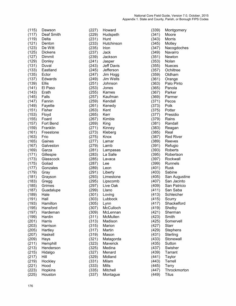
National Core Field Guide, Version 7.0, October, 2015 Appendix 1. State and County, Parish, or Borough FIPS Codes
176
(115) Dawson (117) Deaf Smith (119) Delta (121) Denton (123) De Witt (125) Dickens (127) Dimmit (129) Donley (131) Duval (133) Eastland (135) Ector (137) Edwards (139) Ellis (141) El Paso (143) Erath (145) Falls (147) Fannin (149) Fayette (151) Fisher (153) Floyd (155) Foard (157) Fort Bend (159) Franklin (161) Freestone (163) Frio (165) Gaines (167) Galveston (169) Garza (171) Gillespie (173) Glasscock (175) Goliad (177) Gonzales (179) Gray (181) Grayson (183) Gregg (185) Grimes (187) Guadalupe (189) Hale (191) Hall (193) Hamilton (195) Hansford (197) Hardeman (199) Hardin (201) Harris (203) Harrison (205) Hartley (207) Haskell (209) Hays (211) Hemphill (213) Henderson (215) Hidalgo (217) Hill (219) Hockley (221) Hood (223) Hopkins (225) Houston
(227) Howard (229) Hudspeth (231) Hunt (233) Hutchinson (235) Irion (237) Jack (239) Jackson (241) Jasper (243) Jeff Davis (245) Jefferson (247) Jim Hogg (249) Jim Wells (251) Johnson (253) Jones (255) Karnes (257) Kaufman (259) Kendall (261) Kenedy (263) Kent (265) Kerr (267) Kimble (269) King (271) Kinney (273) Kleberg (275) Knox (277) Lamar (279) Lamb (281) Lampasas (283) La Salle (285) Lavaca (287) Lee (289) Leon (291) Liberty (293) Limestone (295) Lipscomb (297) Live Oak (299) Llano (301) Loving (303) Lubbock (305) Lynn (307) McCulloch (309) McLennan (311) McMullen (313) Madison (315) Marion (317) Martin (319) Mason (321) Matagorda (323) Maverick (325) Medina (327) Menard (329) Midland (331) Milam (333) Mills (335) Mitchell (337) Montague
(339) Montgomery (341) Moore (343) Morris (345) Motley (347) Nacogdoches (349) Navarro (351) Newton (353) Nolan (355) Nueces (357) Ochiltree (359) Oldham (361) Orange (363) Palo Pinto (365) Panola (367) Parker (369) Parmer (371) Pecos (373) Polk (375) Potter (377) Presidio (379) Rains (381) Randall (383) Reagan (385) Real (387) Red River (389) Reeves (391) Refugio (393) Roberts (395) Robertson (397) Rockwall (399) Runnels (401) Rusk (403) Sabine (405) San Augustine (407) San Jacinto (409) San Patricio (411) San Saba (413) Schleicher (415) Scurry (417) Shackelford (419) Shelby (421) Sherman (423) Smith (425) Somervell (427) Starr (429) Stephens (431) Sterling (433) Stonewall (435) Sutton (437) Swisher (439) Tarrant (441) Taylor (443) Terrell (445) Terry (447) Throckmorton (449) Titus
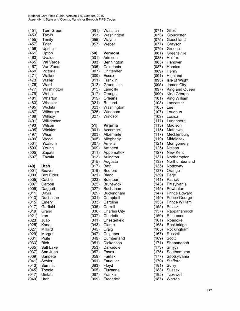
National Core Field Guide, Version 7.0, October, 2015 Appendix 1. State and County, Parish, or Borough FIPS Codes
177
(451) Tom Green (453) Travis (455) Trinity (457) Tyler (459) Upshur (461) Upton (463) Uvalde (465) Val Verde (467) Van Zandt (469) Victoria (471) Walker (473) Waller (475) Ward (477) Washington (479) Webb (481) Wharton (483) Wheeler (485) Wichita (487) Wilbarger (489) Willacy (491) Williamson (493) Wilson (495) Winkler (497) Wise (499) Wood (501) Yoakum (503) Young (505) Zapata (507) Zavala (49) Utah (001) Beaver (003) Box Elder (005) Cache (007) Carbon (009) Daggett (011) Davis (013) Duchesne (015) Emery (017) Garfield (019) Grand (021) Iron (023) Juab (025) Kane (027) Millard (029) Morgan (031) Piute (033) Rich (035) Salt Lake (037) San Juan (039) Sanpete (041) Sevier (043) Summit (045) Tooele (047) Uintah (049) Utah
(051) Wasatch (053) Washington (055) Wayne (057) Weber
(50) Vermont (001) Addison (003) Bennington (005) Caledonia (007) Chittenden (009) Essex (011) Franklin (013) Grand Isle (015) Lamoille (017) Orange (019) Orleans (021) Rutland (023) Washington (025) Windham (027) Windsor (51) Virginia (001) Accomack (003) Albemarle (005) Alleghany (007) Amelia (009) Amherst (011) Appomattox (013) Arlington (015) Augusta (017) Bath (019) Bedford (021) Bland (023) Botetourt (025) Brunswick (027) Buchanan (029) Buckingham (031) Campbell (033) Caroline (035) Carroll (036) Charles City (037) Charlotte (041) Chesterfield (043) Clarke (045) Craig (047) Culpeper (049) Cumberland (051) Dickenson (053) Dinwiddie (057) Essex (059) Fairfax (061) Fauquier (063) Floyd (065) Fluvanna (067) Franklin (069) Frederick
(071) Giles (073) Gloucester (075) Goochland (077) Grayson (079) Greene (081) Greensville (083) Halifax (085) Hanover (087) Henrico (089) Henry (091) Highland (093) Isle of Wight (095) James City (097) King and Queen (099) King George (101) King William (103) Lancaster (105) Lee (107) Loudoun (109) Louisa (111) Lunenberg (113) Madison (115) Mathews (117) Mecklenburg (119) Middlesex (121) Montgomery (125) Nelson (127) New Kent (131) Northampton (133) Northumberland (135) Nottoway (137) Orange (139) Page (141) Patrick (143) Pittsylvania (145) Powhatan (147) Prince Edward (149) Prince George (153) Prince William (155) Pulaski (157) Rappahannock (159) Richmond (161) Roanoke (163) Rockbridge (165) Rockingham (167) Russell (169) Scott (171) Shenandoah (173) Smyth (175) Southampton (177) Spotsylvania (179) Stafford (181) Surry (183) Sussex (185) Tazewell (187) Warren
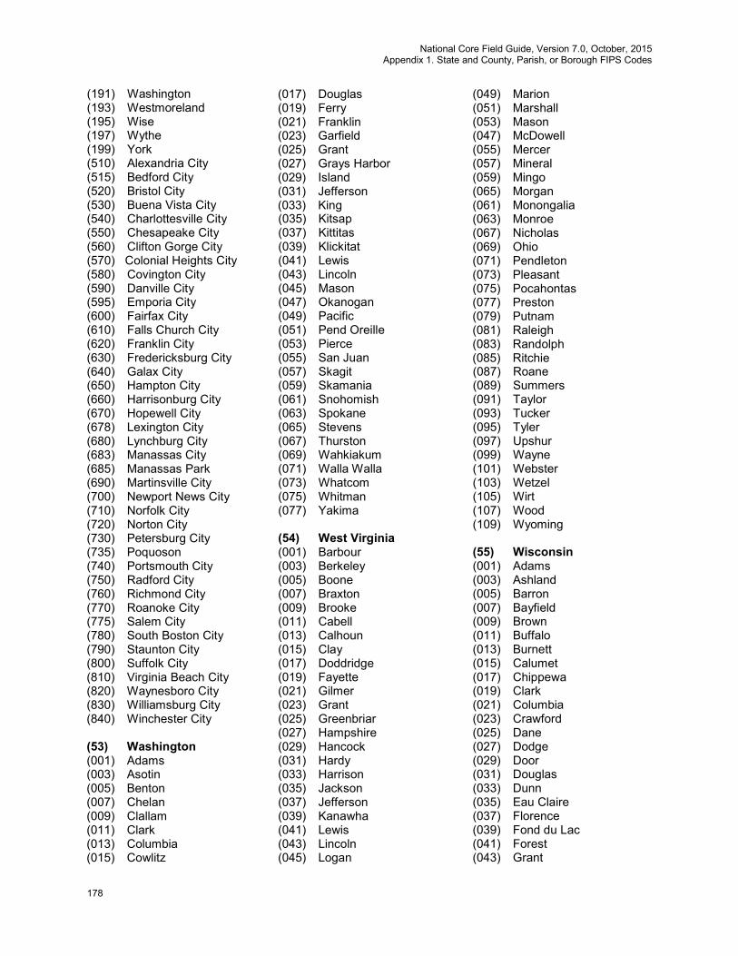
National Core Field Guide, Version 7.0, October, 2015 Appendix 1. State and County, Parish, or Borough FIPS Codes
178
(191) Washington (193) Westmoreland (195) Wise (197) Wythe (199) York (510) Alexandria City (515) Bedford City (520) Bristol City (530) Buena Vista City (540) Charlottesville City (550) Chesapeake City (560) Clifton Gorge City (570) Colonial Heights City (580) Covington City (590) Danville City (595) Emporia City (600) Fairfax City (610) Falls Church City (620) Franklin City (630) Fredericksburg City (640) Galax City (650) Hampton City (660) Harrisonburg City (670) Hopewell City (678) Lexington City (680) Lynchburg City (683) Manassas City (685) Manassas Park (690) Martinsville City (700) Newport News City (710) Norfolk City (720) Norton City (730) Petersburg City (735) Poquoson (740) Portsmouth City (750) Radford City (760) Richmond City (770) Roanoke City (775) Salem City (780) South Boston City (790) Staunton City (800) Suffolk City (810) Virginia Beach City (820) Waynesboro City (830) Williamsburg City (840) Winchester City (53) Washington (001) Adams (003) Asotin (005) Benton (007) Chelan (009) Clallam (011) Clark (013) Columbia (015) Cowlitz
(017) Douglas (019) Ferry (021) Franklin (023) Garfield (025) Grant (027) Grays Harbor (029) Island (031) Jefferson (033) King (035) Kitsap (037) Kittitas (039) Klickitat (041) Lewis (043) Lincoln (045) Mason (047) Okanogan (049) Pacific (051) Pend Oreille (053) Pierce (055) San Juan (057) Skagit (059) Skamania (061) Snohomish (063) Spokane (065) Stevens (067) Thurston (069) Wahkiakum (071) Walla Walla (073) Whatcom (075) Whitman (077) Yakima (54) West Virginia (001) Barbour (003) Berkeley (005) Boone (007) Braxton (009) Brooke (011) Cabell (013) Calhoun (015) Clay (017) Doddridge (019) Fayette (021) Gilmer (023) Grant (025) Greenbriar (027) Hampshire (029) Hancock (031) Hardy (033) Harrison (035) Jackson (037) Jefferson (039) Kanawha (041) Lewis (043) Lincoln (045) Logan
(049) Marion (051) Marshall (053) Mason (047) McDowell (055) Mercer (057) Mineral (059) Mingo (065) Morgan (061) Monongalia (063) Monroe (067) Nicholas (069) Ohio (071) Pendleton (073) Pleasant (075) Pocahontas (077) Preston (079) Putnam (081) Raleigh (083) Randolph (085) Ritchie (087) Roane (089) Summers (091) Taylor (093) Tucker (095) Tyler (097) Upshur (099) Wayne (101) Webster (103) Wetzel (105) Wirt (107) Wood (109) Wyoming (55) Wisconsin (001) Adams (003) Ashland (005) Barron (007) Bayfield (009) Brown (011) Buffalo (013) Burnett (015) Calumet (017) Chippewa (019) Clark (021) Columbia (023) Crawford (025) Dane (027) Dodge (029) Door (031) Douglas (033) Dunn (035) Eau Claire (037) Florence (039) Fond du Lac (041) Forest (043) Grant

National Core Field Guide, Version 7.0, October, 2015 Appendix 1. State and County, Parish, or Borough FIPS Codes
179
(045) Green (047) Green Lake (049) Iowa (051) Iron (053) Jackson (055) Jefferson (057) Juneau (059) Kenosha (061) Kewaunee (063) La Crosse (065) Lafayette (067) Langlade (069) Lincoln (071) Manitowoc (073) Marathon (075) Marinette (077) Marquette (078) Menominee (079) Milwaukee (081) Monroe (083) Oconto (085) Oneida (087) Outagamie (089) Ozaukee (091) Pepin (093) Pierce (095) Polk (097) Portage (099) Price (101) Racine (103) Richland (105) Rock (107) Rusk (109) St. Croix (111) Sauk (113) Sawyer (115) Shawano (117) Sheboygan (119) Taylor (121) Trempealeau (123) Vernon (125) Vilas (127) Walworth (129) Washburn (131) Washington (133) Waukesha (135) Waupaca (137) Waushara (139) Winnebago (141) Wood (56) Wyoming (001) Albany (003) Big Horn (005) Campbell (007) Carbon
(009) Converse (011) Crook (013) Fremont (015) Goshen (017) Hot Springs (019) Johnson (021) Laramie (023) Lincoln (025) Natrona (027) Niobrara (029) Park (031) Platte (033) Sheridan (035) Sublette (037) Sweetwater (039) Teton (041) Uinta (043) Washakie (045) Weston (60) American Samoa (010) Tutuila East (020) Manu’a (030) Rose (040) Swains (050) Tutuila West (64) Federated States of Micronesia (002) Chuuk (005) Kosrae (040) Pohnpei (060) Yap (66) Guam (010) Guam (68) Marshall Islands (007) Ailinginae (010) Ailinglaplap (030) Ailuk (040) Arno (050) Aur (060) Bikar (070) Bikini (073) Bokak (080) Ebon (090) Enewetak (100) Erikub (110_ Jabat (120) Jaluit (130) Jemo (140) Kili (150) Kwajalein (160) Lae (170) Lib
(180) Likiep (190) Majuro (300) Maloelap (310) Mejit (320) Mili (330) Namorik (340) Namu (350) Rongelap (360) Rongrik (385) Toke (390) Ujae (400) Ujelang (410) Utrik (420) Wotho (430) Wotje (69) Northern Mariana Islands (085) Northern Islands (100) Rota (110) Saipan (120) Tinian 70 Palau (002) Aimeliik (004) Airai (010) Angaur (050) Hatoboheit (100) Kayangel (150) Koror (212) Melekeok (214) Ngaraard (218) Ngarchelong (222) Ngardmau (224) Ngatpang (226) Ngchesar (227) Ngernmlengui (228) Ngiwal (350) Peleliu (370) Sonsorol (72) Puerto Rico (001) Adjuntas (003) Aguada (005) Aguadilla (007) Aguas Buenas (009) Aibonito (011) Anasco (013) Arecibo (015) Arroyo (017) Barceloneta (019) Barranquitas (021) Bayamon (023) Cabo Rojo (025) Caguas (027) Camuy
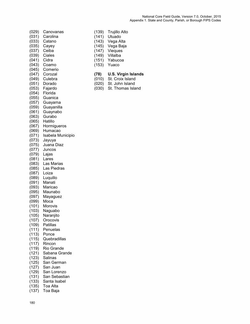
National Core Field Guide, Version 7.0, October, 2015 Appendix 1. State and County, Parish, or Borough FIPS Codes
180
(029) Canovanas (031) Carolina (033) Catano (035) Cayey (037) Ceiba (039) Ciales (041) Cidra (043) Coamo (045) Comerio (047) Corozal (049) Culebra (051) Dorado (053) Fajardo (054) Florida (055) Guanica (057) Guayama (059) Guayanilla (061) Guaynabo (063) Gurabo (065) Hatillo (067) Hormigueros (069) Humacao (071) Isabela Municipio (073) Jayuya (075) Juana Diaz (077) Juncos (079) Lajas (081) Lares (083) Las Marias (085) Las Piedras (087) Loiza (089) Luquillo (091) Manati (093) Maricao (095) Maunabo (097) Mayaguez (099) Moca (101) Morovis (103) Naguabo (105) Naranjito (107) Orocovis (109) Patillas (111) Penuelas (113) Ponce (115) Quebradillas (117) Rincon (119) Rio Grande (121) Sabana Grande (123) Salinas (125) San German (127) San Juan (129) San Lorenzo (131) San Sebastian (133) Santa Isabel (135) Toa Alta (137) Toa Baja
(139) Trujillo Alto (141) Utuado (143) Vega Alta (145) Vega Baja (147) Vieques (149) Villalba (151) Yabucoa (153) Yuaco (78) U.S. Virgin Islands (010) St. Croix Island (020) St. John Island (030) St. Thomas Island

National Core Field Guide, Version 7.0, October, 2015 Appendix 2. FIA Forest Type Codes
181
Appendix 2. FIA Forest Type Codes
This following list includes all forest types in the Continental U.S. and Alaska Types designated East/West are commonly found in those regions, although types designated for one region may occasionally be found in another. East West Code Species Type
White / Red / Jack Pine Group
E 101 Jack pine E 102 Red pine E 103 Eastern white pine E 104 Eastern white pine / eastern hemlock E 105 Eastern hemlock Spruce / Fir Group
E 121 Balsam fir E 122 White spruce E 123 Red spruce E 124 Red spruce / balsam fir E W 125 Black spruce E 126 Tamarack E 127 Northern white-cedar E 128 Fraser fir E 129 Red spruce / Fraser fir Longleaf / Slash Pine Group
E 141 Longleaf pine E 142 Slash pine Tropical Softwoods Group
E 151 Tropical pines Loblolly / Shortleaf Pine Group
E 161 Loblolly pine E 162 Shortleaf pine E 163 Virginia pine E 164 Sand pine E 165 Table-mountain pine E 166 Pond pine E 167 Pitch pine E 168 Spruce pine Other Eastern Softwoods Group
E 171 Eastern redcedar E 172 Florida softwoods Pinyon / Juniper Group
E W 182 Rocky Mountain juniper E W 184 Juniper woodland E W 185 Pinyon-juniper woodland Douglas-fir Group
E W 201 Douglas-fir W 202 Port-Orford-cedar
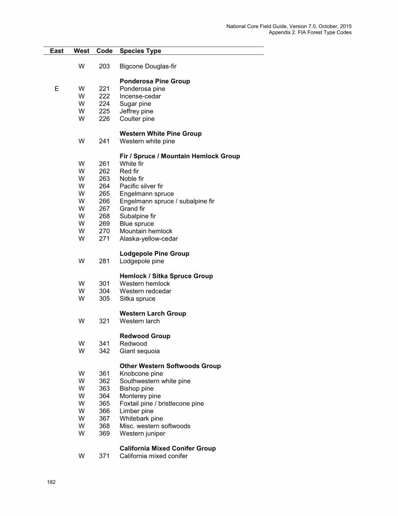
National Core Field Guide, Version 7.0, October, 2015 Appendix 2. FIA Forest Type Codes
182
East West Code Species Type W 203 Bigcone Douglas-fir Ponderosa Pine Group
E W 221 Ponderosa pine W 222 Incense-cedar W 224 Sugar pine W 225 Jeffrey pine W 226 Coulter pine Western White Pine Group W 241 Western white pine Fir / Spruce / Mountain Hemlock Group W 261 White fir W 262 Red fir W 263 Noble fir W 264 Pacific silver fir W 265 Engelmann spruce W 266 Engelmann spruce / subalpine fir W 267 Grand fir W 268 Subalpine fir W 269 Blue spruce W 270 Mountain hemlock W 271 Alaska-yellow-cedar Lodgepole Pine Group W 281 Lodgepole pine Hemlock / Sitka Spruce Group W 301 Western hemlock W 304 Western redcedar W 305 Sitka spruce Western Larch Group W 321 Western larch Redwood Group W 341 Redwood W 342 Giant sequoia Other Western Softwoods Group W 361 Knobcone pine W 362 Southwestern white pine W 363 Bishop pine W 364 Monterey pine W 365 Foxtail pine / bristlecone pine W 366 Limber pine W 367 Whitebark pine W 368 Misc. western softwoods W 369 Western juniper California Mixed Conifer Group W 371 California mixed conifer
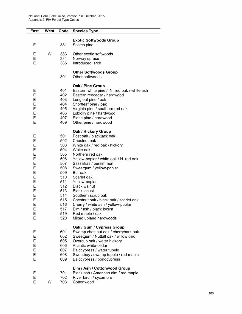
National Core Field Guide, Version 7.0, October, 2015 Appendix 2. FIA Forest Type Codes
183
East West Code Species Type Exotic Softwoods Group
E 381 Scotch pine
E W 383 Other exotic softwoods E 384 Norway spruce E 385 Introduced larch Other Softwoods Group 391 Other softwoods Oak / Pine Group
E 401 Eastern white pine / N. red oak / white ash E 402 Eastern redcedar / hardwood E 403 Longleaf pine / oak E 404 Shortleaf pine / oak E 405 Virginia pine / southern red oak E 406 Loblolly pine / hardwood E 407 Slash pine / hardwood E 409 Other pine / hardwood Oak / Hickory Group
E 501 Post oak / blackjack oak E 502 Chestnut oak E 503 White oak / red oak / hickory E 504 White oak E 505 Northern red oak E 506 Yellow-poplar / white oak / N. red oak E 507 Sassafras / persimmon E 508 Sweetgum / yellow-poplar E 509 Bur oak E 510 Scarlet oak E 511 Yellow-poplar E 512 Black walnut E 513 Black locust E 514 Southern scrub oak E 515 Chestnut oak / black oak / scarlet oak E 516 Cherry / white ash / yellow-poplar E 517 Elm / ash / black locust E 519 Red maple / oak E 520 Mixed upland hardwoods Oak / Gum / Cypress Group
E 601 Swamp chestnut oak / cherrybark oak E 602 Sweetgum / Nuttall oak / willow oak E 605 Overcup oak / water hickory E 606 Atlantic white-cedar E 607 Baldcypress / water tupelo E 608 Sweetbay / swamp tupelo / red maple E 609 Baldcypress / pondcypress Elm / Ash / Cottonwood Group
E 701 Black ash / American elm / red maple E 702 River birch / sycamore E W 703 Cottonwood

National Core Field Guide, Version 7.0, October, 2015 Appendix 2. FIA Forest Type Codes
184
East West Code Species Type
E W 704 Willow E 705 Sycamore / pecan / American elm E 706 Sugarberry / hackberry / elm / green ash E 707 Silver maple / American elm E 708 Red maple / lowland E W 709 Cottonwood / willow W 722 Oregon ash Maple / Beech / Birch Group
E 801 Sugar maple / beech / yellow birch E 802 Black cherry E 805 Hard maple / basswood E 809 Red maple / upland Aspen / Birch Group
E W 901 Aspen E W 902 Paper birch E 903 Gray birch E W 904 Balsam poplar E W 905 Pin cherry
Alder / Maple Group W 911 Red alder W 912 Bigleaf maple Western Oak Group W 921 Gray pine W 922 California black oak W 923 Oregon white oak W 924 Blue oak W 931 Coast live oak W 933 Canyon live oak W 934 Interior live oak W 935 California white oak (valley oak) Tanoak / Laurel Group W 941 Tanoak W 942 California laurel W 943 Giant chinkapin Other Hardwoods Group W 961 Pacific madrone W 962 Other hardwoods Woodland Hardwoods Group W 971 Deciduous oak woodland W 972 Evergreen oak woodland W 973 Mesquite woodland W 974 Cercocarpus (Mountain brush) woodland W 975 Intermountain maple woodland W 976 Misc. woodland hardwoods Tropical Hardwoods Group
E 982 Mangrove
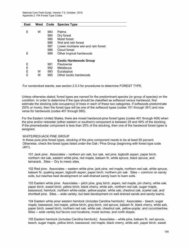
National Core Field Guide, Version 7.0, October, 2015 Appendix 2. FIA Forest Type Codes
185
East West Code Species Type
E W 983 Palms 984 Dry forest 985 Moist forest 986 Wet and rain forest 987 Lower montane wet and rain forest 988 Cloud forest
E 989 Other tropical hardwoods Exotic Hardwoods Group
E 991 Paulownia E 992 Melaleuca E W 993 Eucalyptus E W 995 Other exotic hardwoods
For nonstocked stands, see section 2.5.3 for procedures to determine FOREST TYPE. Unless otherwise stated, forest types are named for the predominant species (or group of species) on the condition. In order to determine if the type should be classified as softwood versus hardwood, first estimate the stocking (site occupancy) of trees in each of these two categories. If softwoods predominate (50% or more), then the forest type will be one of the softwood types (codes 101 through 391) and vice versa for hardwoods (codes 401 through 995).
For the Eastern United States, there are mixed hardwood-pine forest types (codes 401 through 409) when the pine and/or redcedar (either eastern or southern) component is between 25 and 49% of the stocking. If the pine/redcedar component is less than 25% of the stocking, then one of the hardwood forest types is assigned. WHITE/RED/JACK PINE GROUP In these pure pine forest types, stocking of the pine component needs to be at least 50 percent. Otherwise, check the forest types listed under the Oak / Pine Group (beginning with forest type code (401).
101 Jack pine: Associates – northern pin oak, bur oak, red pine, bigtooth aspen, paper birch, northern red oak, eastern white pine, red maple, balsam fir, white spruce, black spruce, and tamarack. Sites -- Dry to mesic sites.
102 Red pine: Associates – eastern white pine, jack pine, red maple, northern red oak, white spruce, balsam fir, quaking aspen, bigtooth aspen, paper birch, northern pin oak. Sites -- common on sandy soils, but reaches best development on well-drained sandy loam to loam soils.
103 Eastern white pine: Associates – pitch pine, gray birch, aspen, red maple, pin cherry, white oak, paper birch, sweet birch, yellow birch, black cherry, white ash, northern red oak, sugar maple, basswood, hemlock, northern white-cedar, yellow-poplar, white oak, chestnut oak, scarlet oak, and shortleaf pine. Sites -- wide variety, but best development on well drained sands and sandy loams.
104 Eastern white pine/ eastern hemlock (includes Carolina hemlock): Associates – beech, sugar maple, basswood, red maple, yellow birch, gray birch, red spruce, balsam fir, black cherry, white ash, paper birch, sweet birch, northern red oak, white oak, chestnut oak, yellow-poplar, and cucumbertree. Sites -- wide variety but favors cool locations, moist ravines, and north slopes.
105 Eastern hemlock (includes Carolina hemlock): Associates – white pine, balsam fir, red spruce, beech, sugar maple, yellow birch, basswood, red maple, black cherry, white ash, paper birch, sweet
National Core Field Guide, Version 7.0, October, 2015 Appendix 2. FIA Forest Type Codes
186
birch, northern red oak, and white oak. Sites -- cool locations, moist ravines, and north and east slopes.
SPRUCE/FIR GROUP These types are mostly in the Eastern United States. See FIR/SPRUCE/MOUNTAIN HEMLOCK for Western United States.
121 Balsam fir: Associates – black, white, or red spruce; paper or yellow birch; quaking or bigtooth aspen, beech; red maple; hemlock; tamarack; black ash; or northern white-cedar. Sites -- upland sites on low-lying moist flats and in swamps.
122 White spruce: Associates – black spruce, paper birch, quaking aspen, red spruce, balsam fir, and balsam poplar. Sites -- Transcontinental; grows well on calcareous and well-drained soils, but is found on acidic rocky and sandy sites, and sometimes in fen peatlands along the maritime coast. 123 Red spruce: Associates – vary widely and may include red maple, yellow birch, eastern hemlock, eastern white pine, white spruce, northern white-cedar, paper birch, pin cherry, gray birch, mountain-ash, beech, striped maple, sugar maple, northern red oak, red pine, and aspen. Sites -- include moderately well-drained to poorly drained flats and thin slopes and on varying acidic soils in abandoned fields and pastures. This code should be used where red spruce comprises a plurality or majority of the stand's stocking but where balsam fir is either nonexistent or has very little stocking (< 5 percent of total). Otherwise the plot would be coded 124, red spruce/balsam fir.
124 Red spruce/balsam fir: Associates – red maple, paper birch, white pine, hemlock, white spruce, and northern white-cedar. Sites -- moderately drained to poorly drained flats or on thin-soiled upper slopes.
125 Black spruce: Associates – white spruce, quaking aspen, balsam fir, paper birch, tamarack, northern white-cedar, black ash, and red maple. Sites -- wide variety from moderately dry to very wet.
126 Tamarack: Associates – black spruce, balsam fir, white spruce, northern white-cedar, and quaking aspen. Sites -- found on wetlands and poorly drained sites.
127 Northern white-cedar: Associates – balsam fir, tamarack, black spruce, white spruce, red spruce, black ash, and red maple. Sites -- mainly occurs in swamps, but also in seepage areas, limestone uplands and old fields. 128 Fraser fir: Associates – red spruce, hemlock, yellow birch, less frequently, beech, sugar maple, yellow buckeye, mountain-ash, and mountain maple. Sites -- mainly occurs in the Appalachian Mountains of North Carolina and Tennessee. This type is used if the stocking of Fraser fir is at least 50 percent of the total stocking. 129 Red spruce/Fraser fir: Associates – hemlock, yellow birch, and less frequently, beech, sugar maple, yellow buckeye, mountain-ash, and mountain maple. Sites -- mainly occurs in the Appalachian Mountains of North Carolina and Tennessee. For this type to be used, the sum of the stocking of red spruce and Fraser fir must be at least 50 percent of the total stocking and red spruce stocking must be between 5 and 49 percent of total and Fraser fir stocking must be between 5 and 49 percent of total.
LONGLEAF/SLASH PINE GROUP
141 Longleaf pine: Longleaf pine occurs as a pure type or comprises a majority of the trees in the overstory. Associates-slash, loblolly and shortleaf pine, southern red oak, blackjack oak, water oak, persimmon, and sweetgum. Sites - -those areas that can and do burn on a periodic basis--usually
National Core Field Guide, Version 7.0, October, 2015 Appendix 2. FIA Forest Type Codes
187
occurs on middle and upper slopes with a low severity of hardwood and brush competition. SRS distribution--coastal plain and piedmont units.
142 Slash pine: Slash pine is pure or provides a majority of the stocking. Associates--on moist sites; a wide variety of moist-site hardwoods, pond pine, and pondcypress. On dry sites; a wide variety of dry-site hardwoods, longleaf, loblolly, and sand pine. Sites -- both moist and well-drained flatwoods, and bays. SRS distribution--coastal plain and piedmont units from North Carolina to Florida.
TROPICAL SOFTWOODS GROUP
151 Tropical pines: Tropical pine forests and plantations comprised of Caribbean pine (Pinus caribea). Associates are P. oocarpa, P. patula and other pine species native to the Florida Keys, Caribbean, Central America and Mexico. Pines are not native to Puerto Rico or the U.S. Virgin Islands but can be found in plantations or naturally regenerating to a limited extent on sites that were formerly plantations. P. caribea was once rare on the South Florida mainland, but practically non-existent there now and it is not used in plantations in Florida.
LOBLOLLY/SHORTLEAF PINE GROUP
161 Loblolly pine: Associates – sweetgum, southern red oak, post oak, blackjack oak, blackgum, yellow-poplar, and pond pine. Sites -- upland soils with abundant moisture but good drainage, and on poorly drained depressions.
162 Shortleaf pine: Associates – white oak, southern red oak, scarlet oak, black oak, hickory, post oak, blackjack oak, blackgum, red maple, pitch pine, and Virginia pine. Sites -- low, well drained ridges to rocky, dry, south slopes and the better drained spur ridges on north slopes and also on old fields.
163 Virginia pine: Associates – shortleaf pine, white oak, chestnut oak, southern red oak, black oak, sweetgum, red maple, blackgum, and pitch pine. Sites--dry sites, often abandoned fields.
164 Sand pine: Sand pine occurs in pure stands or provides a majority of the stocking. Associates--dwarf live oak, dwarf post oak, turkey oak, persimmon, and longleaf pine. Sites -- dry, acidic, infertile sands. SRS distribution--found chiefly in the central peninsula and panhandle of Florida, although planted stands extend into the sandhills of Georgia and South Carolina.
165 Table-mountain pine: Associates – chestnut oak, scarlet oak, pitch pine, and black oak. Sites --poor, dry, often rocky slopes.
166 Pond pine: Associates – loblolly pine, sweetgum, baldcypress, and Atlantic white-cedar. Sites --rare, but found in southern New Jersey, Delaware, and Maryland in low, poorly drained acres, swamps, and marshes.
167 Pitch pine: Associates – chestnut oak, scarlet oak, table-mountain pine, black oak, and blackgum. Sites -- relatively infertile ridges, dry flats, and slopes.
168 Spruce pine: Spruce pine comprises a majority of the stocking. Associates--any of the moist site softwood or hardwood species. Sites - -moist or poorly drained areas. SRS distribution--this type is rarely encountered and is found almost exclusively in the coastal plain.
OTHER EASTERN SOFTWOODS GROUP
171 Eastern redcedar (includes southern redcedar): Associates – gray birch, red maple, sweet birch, Virginia Pine, shortleaf pine, oak. Sites -- usually dry uplands and abandoned fields on limestone outcrops and other shallow soils but can grow well on good sites.
National Core Field Guide, Version 7.0, October, 2015 Appendix 2. FIA Forest Type Codes
188
172 Florida softwoods (includes either Florida yew or Florida torreya): Either of these two species comprises the majority of stocking. Sites -- Along bluffs and ravines of the Apalachicola River and its tributaries in north Florida and South Georgia.
PINYON / JUNIPER GROUP
182 Rocky Mountain juniper: Rocky Mountain juniper comprises the majority of stocking. Associates – ponderosa pine, Douglas-fir, other junipers, pinyons, and oaks. Sites -- often found on calcareous and somewhat alkaline soils. 184 Juniper woodland: Includes Pinchot juniper, redberry juniper, Ashe juniper, California juniper, alligator juniper, Utah juniper, oneseed juniper and pinyon is NOT present. Associates – various woodland oaks and cercocarpus, ponderosa pine, Arizona cypress, and Douglas-fir. Sites -- lower elevation with low annual precipitation. 185 Pinyon-juniper woodland: Includes all pinyons and all junipers except Rocky Mountain and western juniper. Must have pinyon present. Associates – various woodland oaks and cercocarpus, ponderosa pine, Arizona cypress, and Douglas-fir. Sites--occurs at lower elevations with low annual precipitation.
DOUGLAS-FIR GROUP
201 Douglas-fir: Associates – western hemlock, grand fir, Pacific silver fir, white fir, noble fir, California red fir, western redcedar, bigleaf maple, red alder, ponderosa pine, western white pine, western hemlock, Sitka spruce. Sites -- throughout the western U.S. 202 Port-Orford-cedar: Associates – Douglas-fir, western hemlock, Sitka spruce, grand fir, lodgepole pine, western redcedar, redwood, tanoak, red alder, bigleaf maple and California laurel. Sites --higher elevations tending to occur on northerly aspects. 203 Bigcone Douglas-fir: Associates – Canyon live oak, ponderosa, Jeffrey, sugar, knobcone, and Coulter pines, incense-cedar, white fir, California black oak, California laurel, and bigleaf maple. Sites -- Mainly confined to the Transverse and Peninsular Ranges of southern California. Stands are found on many combinations of slope, aspect, soil, but as elevations increase, the preferred aspect shifts from cooler to warmer slopes.
PONDEROSA PINE GROUP
221 Ponderosa pine (includes Arizona pine): Associates – Douglas-fir, lodgepole pine, grand fir, Jeffrey pine, western larch, quaking aspen, Utah juniper, Gambel oak. Sites -- this forest type is distributed over vast areas in the West and therefore can have great differences in environmental conditions. 222 Incense-cedar: Associates – Douglas-fir, ponderosa pine, sugar pine, western white pine, Jeffrey pine, white and grand fir, western hemlock, western redcedar, Port-Orford-cedar, giant sequoia, Oregon white oak, California black oak, tanoak, giant chinkapin, and Pacific madrone; it is rarely found in pure stands. Sites -- Grows from the coastal fog belt to the dry inland slopes of eastern California and central Oregon. Once established, incense-cedar is a good competitor on hot, dry sites and commonly shares an upper canopy position on southwestern slopes. On cooler, moister aspects, it is usually subdominant to other species.
224 Sugar pine: Associates – In the northern part of its range: Douglas-fir, ponderosa pine, grand fir, incense-cedar, western hemlock, western redcedar, Port-Orford-cedar, tanoak, and madrone. In the central part of its range: ponderosa pine, Jeffrey pine, white fir, incense-cedar, California red fir, giant sequoia, and California black oak. Farther south: Jeffrey pine, ponderosa pine, Coulter pine, incense-cedar, white fir, and bigcone Douglas-fir. Sites -- grows in areas that have warm, dry summers and
National Core Field Guide, Version 7.0, October, 2015 Appendix 2. FIA Forest Type Codes
189
cool, wet, mild winters. Terrain is commonly steep and rugged, favoring warm exposures as the elevation increases. Found in Oregon and California, but is most abundant in the mixed conifer forests on the west slope of the Sierra Nevada. 225 Jeffrey pine: Associates – Incense-cedar, ponderosa pine, sugar pine, Douglas-fir, Port-Orford-cedar, western white pine, knobcone pine, Digger pine, red and white fir. Sites -- thrives in fairly harsh environments throughout most of its range, and is cold hardy, drought tolerant, adapted to short growing seasons, and tolerant of infertile sites. The majority of trees are found in California, although its range extends into SW Oregon and western Nevada. 226 Coulter pine: Associates – blue oak, California black oak, interior live oak, interior live oak, coast live oak, valley oak, California scrub oak, buckeye, ponderosa pine. Sites -- grows singly or in small stands primarily on dry, rocky slopes of southern California coastal ranges, between 3,000 and 6,000 feet. Occurs from Mt. Diablo and the Santa Lucia Mountains down to the San Bernardino, San Jacinto, and Cuyamaca Mountains in the south.
WESTERN WHITE PINE GROUP
241 Western white pine: Associates – western larch, grand fir, western redcedar, and western hemlock. Sites -- occurs primarily on moist, mid-elevation sites from 1,500 to 4,000 feet.
FIR/SPRUCE/MOUNTAIN HEMLOCK GROUP
261 White fir: Associates – Douglas-fir, sugar pine, ponderosa pine, Jeffrey pine, incense-cedar, California red fir, blue spruce, limber pine, and aspen. Sites -- deep well-drained sandy loam-covered slopes and benches with a northerly exposure. 262 Red fir (includes California and Shasta red fir): Associates – Jeffrey pine, western white pine, lodgepole pine, mountain hemlock, and sugar pine. Sites -- found at elevations ranging from 5,400 to 7,500 feet. 263 Noble fir: Associates - Douglas-fir, Pacific silver fir, western and mountain hemlocks, lodgepole pine, western redcedar, and Alaska cedar. Sites -- found on a variety of sites where precipitation is high and snowpacks are common, generally above 3,000 feet in elevation in the Cascade and Coast ranges. 264 Pacific silver fir: Associates - western and mountain hemlocks, western redcedar, Alaska cedar, grand fir, Sitka spruce, lodgepole pine, subalpine fir, and Engelmann spruce. Sites -- most abundant on sites where summer drought is minimal and snowpacks are common, such as areas of heavy rainfall, seepage, or prolonged snowmelt. 265 Engelmann spruce: Associates – western white pine, western redcedar, western hemlock, Douglas-fir, western larch, grand fir, subalpine fir, and lodgepole pine. For this type to be used, the total stocking of Engelmann spruce must be at least 75 percent of the total stocking. 266 Engelmann spruce-subalpine fir: Associates – western white pine, western redcedar, western hemlock, Douglas-fir, western larch, grand fir, and lodgepole pine. Sites -- this type is widespread in the Western U.S. For this type to be used, the sum of the stocking of Engelmann spruce and subalpine fir must be at least 75 percent of the total stocking and Engelmann spruce stocking must be between 5 and 74 percent of total and subalpine fir stocking must be between 5 and 74 percent of total. 267 Grand fir: Associates – ponderosa pine, Douglas-fir, western hemlock, western redcedar, western white pine, Pacific yew, lodgepole pine, and western larch. Sites -- in Idaho, found on moist slopes from 1,500 to 5,200-foot elevations; in Oregon, it occupies moist low-elevation sites, but also extends up to mid-elevations to as high as 6,000 feet.
National Core Field Guide, Version 7.0, October, 2015 Appendix 2. FIA Forest Type Codes
190
268 Subalpine fir: Associates – western white pine, western redcedar, western hemlock, Douglas-fir, western larch, grand fir, Engelmann spruce, and lodgepole pine. For this type to be used, the total stocking of subalpine fir must be at least 75 percent of the total stocking. Sites -- found at high elevations, near timberline. 269 Blue spruce: Associates – Douglas-fir, ponderosa pine, white fir, lodgepole pine, and Rocky Mountain juniper. Sites -- restricted to the southern Rocky Mountains, typically located in the montane zone. 270 Mountain hemlock: Associates – Alaska-cedar, Pacific silver fir, western white pine, lodgepole pine, noble fir, and subalpine fir. Sites -- occurs in cold, moist regions and growing conditions are poor.
271 Alaska-yellow-cedar: Associates: In California, California red fir, Brewer spruce, incense-cedar, Pacific yew, and western white pine; in Oregon and Washington, found with mountain hemlock, subalpine fir, Pacific silver fir, noble fir, western white pine, and western hemlock. Sites -- Cool and humid climate, most stands grow within 100 miles of the Pacific coast.
LODGEPOLE PINE GROUP
281 Lodgepole pine: Associates – subalpine fir, Engelmann spruce, white spruce, Douglas-fir, western redcedar, red alder, and western hemlock. Sites -- one of the most widespread types in the Western U.S. tolerating a broad range of temperature and moisture regimes.
HEMLOCK/SITKA SPRUCE GROUP
301 Western hemlock: Associates – Sitka spruce, western redcedar, Douglas-fir, Alaska-yellow-cedar, grand fir, Engelmann spruce, bigleaf maple, and red alder. Sites -- nearly any soil provides a seedbed but requires abundant moisture. Often comes in cut-over or burned-over areas. 304 Western redcedar: Associates – western white pine, western hemlock, western larch, grand fir, Douglas-fir, and Pacific silver fir. Sites -- inhabits moist flats and slopes, the banks of rivers and swamps and can be found in bogs. 305 Sitka spruce: Associates – western hemlock, Douglas-fir, western redcedar, Port Orford-cedar, red alder, bigleaf maple, and black cottonwood. Sites - -limited to a relatively narrow oceanside strip characterized by mild winters, cool summers, and abundant moisture throughout the growing season.
WESTERN LARCH GROUP 321 Western larch: Associates – Douglas-fir, subalpine fir, lodgepole pine, Engelmann spruce, western hemlock, and western redcedar. Sites -- best growth on deep, moist, porous soils in high valleys and on mountain slopes of northern and western exposure.
REDWOOD GROUP 341 Redwood: Associates – Douglas-fir, grand fir, western hemlock, California torreya, Pacific yew, and western redcedar. Sites -- largely confined to coastal topography between 35 degrees 41 minutes and 42 degrees 9 minutes north latitude. 342 Giant sequoia: Associates: California white fir, sugar pine, incense-cedar, California red fir, California white fir, ponderosa pine and California black oak. Sites -- Deep, well-drained soils with high soil moisture available during dry summers. Most stands found above 4,000 feet elevation, rarely forming pure stands.
National Core Field Guide, Version 7.0, October, 2015 Appendix 2. FIA Forest Type Codes
191
OTHER WESTERN SOFWOODS GROUP 361 Knobcone pine: Associates – Digger pine, canyon live oak and many western oaks, Douglas-fir, and Port Orford-cedar. Sites -- found on soils that are shallow, dry, stony or high in magnesium. 362 Southwestern white pine: Associates- Douglas-fir, white fir, ponderosa pine, Gambel oak, and aspen. Sites -- higher elevations in Arizona and New Mexico 363 Bishop pine: Grows singly or in small stands along the coast of California. 364 Monterey pine: Grows singly or in small stands. Sites -- Native stands are found in the high humidity and summer fogs of the central-coast area of California in San Mateo, Santa Cruz, Monterey, and San Luis Obispo Counties. 365 Foxtail pine/bristlecone pine: Associates – limber pine, white fir, Engelmann spruce, ponderosa pine, and pinyon. Sites -- found on rocky outcrops, usually on southern or southwestern exposures and can range in elevation from 8,000 to 11,000 feet. 366 Limber pine: Associates – low to mid elevations: Douglas-fir, ponderosa pine, Rocky Mountain juniper; mid to high elevations: lodgepole pine and aspen; high elevations: Engelmann spruce, subalpine fir, bristlecone pine, and whitebark pine. Sites -- a very wide range of elevations and latitudes across the Rocky mountains; can be the majority species as an early seral stage under a variety of harsh establishment conditions, as climax in dry, high elevation sites in the central and southern Rockies. 367 Whitebark pine: Associates – subalpine fir, subalpine larch, Engelmann spruce, and lodgepole pine. Sites -- poor, high elevation. 368 Miscellaneous western softwoods: A “catch-all” group for such species as all cypress (Cupressus) species, subalpine larch, Brewer spruce, Apache pine, Chihuahua pine, Washoe pine, Torrey pine, Pacific yew, and California torreya. 369 Western juniper: Associates – ponderosa pine and Jeffrey pine. Sites -- found on dry sites and ranges in elevation from just above sea level to 6,500 feet.
CALIFORNIA MIXED CONIFER GROUP 371 California mixed conifer: Associates - a complex association of ponderosa pine, sugar pine, Douglas-fir, white fir, red fir, and incense-cedar. Generally, five or six conifer species are intermixed either as single trees or in small groups. Sites -- Mixed conifer sites are often on east-facing slopes of the California Coast Range and on the west-facing and higher elevation east-facing slopes of the Oregon Cascades and Sierra Nevadas.
EXOTIC SOFTWOODS GROUP 381 Scotch pine: plantation type, not naturally occurring. 383 Other exotic softwoods; Austrian pine 384 Norway spruce: plantation type, not naturally occurring
385 Introduced larch: introduced larch (species code 0070)
National Core Field Guide, Version 7.0, October, 2015 Appendix 2. FIA Forest Type Codes
192
OTHER SOFTWOODS GROUP
391 Other softwoods: All softwood species identified to genus level only, except cypress, baldcypress, and larch.
OAK/PINE GROUP In these oak/pine forest types, stocking of the pine component needs to be 25-49 percent.
401 Eastern white pine/northern red oak/white ash: Associates – red maple, basswood, yellow birch, bigtooth aspen, sugar maple, beech, paper birch, black cherry, hemlock, and sweet birch. Sites --deep, fertile, well-drained soil.
402 Eastern redcedar/hardwood: Associates – oak, hickory, walnut, ash, locust, dogwood, blackgum, hackberry, winged elm, shortleaf pine, and Virginia pine. Sites -- usually dry uplands and abandoned fields.
403 Longleaf pine/oak: Longleaf pine and scrub oaks-primarily turkey, bluejack, blackjack, and dwarf post oak--comprise the type. Associates--southern scrub oaks in the understory. Sites -- common on sandhills where soils are dry, infertile, and coarse textured. SRS distribution-- coastal plain and piedmont units.
404 Shortleaf pine/oak: Associates - (oaks generally include white, scarlet, blackjack, black, post, and southern red) hickory, blackgum, sweetgum, Virginia pine, and pitch pine. Sites -- generally in dry, low ridges, flats, and south slopes. 405 Virginia pine/southern red oak: Associates – black oak, scarlet oak, white oak, post oak, blackjack oak, shortleaf pine, blackgum, hickory, pitch pine, table-mountain pine, chestnut oak. Sites -- dry slopes and ridges.
406 Loblolly pine/hardwood: Associates – wide variety of moist and wet site hardwoods including blackgum, sweetgum, yellow-poplar, red maple, white and green ash, and American elm; on drier sites associates include southern and northern red oak, white oak, post oak, scarlet oak, persimmon, and hickory. Sites -- usually moist to very moist though not wet all year, but also on drier sites.
407 Slash pine/hardwood: Slash pine and a variable mixture of hardwoods comprise the type. Associates-- codominant with the slash pine component are sweetbay, blackgum, loblolly-bay, pondcypress, pond pine, Atlantic white-cedar, red maple, ash, and water oak. Sites -- undrained or poorly drained depressions such as bays or pocosins and along pond margins. SRS distribution--primarily coastal plain units. 409 Other pine/hardwood: A type used for those unnamed pine-hardwood combinations that meet the requirements for oak-pine. These are stands where hardwoods (usually oaks) comprise the plurality of the stocking with at least a 25 to 49 percent pine, eastern redcedar, or southern redcedar component.
OAK/HICKORY GROUP
501 Post oak/blackjack oak (includes dwarf post oak): Associates – black oak, hickory, southern red oak, white oak, scarlet oak, shingle oak, live oak, shortleaf pine, Virginia pine, blackgum, sourwood, red maple, winged elm, hackberry, chinkapin oak, shumard oak, dogwood, and eastern redcedar. Sites -- dry uplands and ridges.
502 Chestnut oak: Associates – scarlet oak, white oak, black oak, post oak, pitch pine, blackgum, sweetgum, red maple, red oak, shortleaf pine, Virginia pine. Sites -- rocky outcrops with thin soil, ridge tops.
National Core Field Guide, Version 7.0, October, 2015 Appendix 2. FIA Forest Type Codes
193
503 White oak/red oak/hickory (includes all hickories except water and shellbark hickory): Associates – pin oak, northern pin oak, chinkapin oak, black oak, dwarf chinkapin oak, American elm, scarlet oak, bur oak, white ash, sugar maple, red maple, walnut, basswood, locust, beech, sweetgum, blackgum, yellow-poplar, and dogwood. Sites -- wide variety of well-drained upland soils.
504 White oak: Associates – black oak, northern red oak, bur oak, hickory, white ash, yellow-poplar. Sites -- scattered patches on upland, loamy soils but on drier sites than type 503.
505 Northern red oak: Associates – black oak, scarlet oak, chestnut oak, and yellow-poplar. Sites --spotty distribution on ridge crests and north slopes in mountains but also found on rolling land, slopes, and benches on loamy soil.
506 Yellow-poplar/white oak/northern red oak: Associates – black oak, hemlock, blackgum, and hickory. Sites -- northern slopes, coves, and moist flats.
507 Sassafras/persimmon: Associates – elm, eastern redcedar, hickory, ash, sugar maple, yellow-poplar, Texas sophora, and oaks. Sites -- abandoned farmlands and old fields.
508 Sweetgum/yellow-poplar: Associates – red maple, white ash, green ash, and other moist site hardwoods. Sites -- generally occupies moist, lower slopes.
509 Bur oak: Associates—northern pin oak, black oak, chinkapin oak, and eastern redcedar in northern and dry upland sites; shagbark hickory, black walnut, eastern cottonwood, white ash, American elm, swamp white oak, honey locust, and American basswood in southern and lowland sites. Sites -- drier uplands to moist bottomlands with the drier uplands more common in the northern part of the range and the moist bottomlands more common in the southern part of the range. 510 Scarlet oak: Associates – black oak, southern red oak, chestnut oak, white oak, post oak, hickory, pitch pine, blackgum, sweetgum, black locust, sourwood, dogwood, shortleaf pine, and Virginia pine. Sites -- dry ridges, south- or west-facing slopes and flats but often moister situations probably as a result of logging or fire.
511 Yellow-poplar: Associates – black locust, red maple, sweet birch, cucumbertree, and other moist-site hardwoods (except sweetgum, see type 508) and white oak and northern red oak (see type 503). Sites -- lower slopes, northerly slopes, moist coves, flats, and old fields.
512: Black walnut: Associates – yellow-poplar, white ash, black cherry, basswood, beech, sugar maple, oaks, and hickory. Sites -- coves and well-drained bottoms.
513 Black locust: Associates – many species of hardwoods and hard pines may occur with it in mixture, either having been planted or from natural seeding. Sites -- may occur on any well-drained soil but best on dry sites, often in old fields.
514 Southern scrub oak: This forest cover type consists of a mixture of scrub oaks that may include several of the following species: turkey oak, bluejack oak, dwarf live oak, Durand oak, and bear oak (otherwise known as scrub oak). Also includes anacahuita. Sites -- dry sandy ridges-the type frequently develops on areas formerly occupied by longleaf pine. SRS distribution--common throughout all coastal plain units and into the lower Piedmont.
515 Chestnut oak/black oak/scarlet oak: Associates—northern and southern red oaks, post oak, white oak, sourwood, shagbark hickory, pignut hickory, yellow-poplar, blackgum, sweetgum, red maple, eastern white pine, pitch pine, Table Mountain pine, shortleaf pine, and Virginia pine. Sites --dry upland sites on thin-soiled rocky outcrops on dry ridges and slopes.
National Core Field Guide, Version 7.0, October, 2015 Appendix 2. FIA Forest Type Codes
194
516 Cherry/white ash/yellow-poplar: Associates – sugar maple, American beech, northern red oak, white oak, blackgum, hickory, cucumbertree, and yellow birch. Sites -- fertile, moist, well-drained sites. 517 Elm/ash/black locust: Associates – Black locust, silver maple, boxelder, blackbead ebony, American elm, slippery elm, rock elm, red maple, green ash predominate. Found in North Central region, unknown in Northeast. Sites -- upland.
519 Red maple/oak: Associates – the type is dominated by red maple and some of the wide variety of central hardwood associates include upland oak, hickory, yellow-poplar, black locust, sassafras as well as some central softwoods like Virginia and shortleaf pines. Sites -- uplands.
520 Mixed upland hardwoods: Includes Ohio buckeye, yellow buckeye, Texas buckeye, red buckeye, painted buckeye, American hornbeam, American chestnut, eastern redbud, flowering dogwood, hawthorn spp., cockspur hawthorn, downy hawthorn, Washington hawthorn, fleshy hawthorn, dwarf hawthorn, honeylocust, Kentucky coffeetree, Osage-orange, all mulberries, blackgum, sourwood, southern red oak, shingle oak, laurel oak, water oak, live oak, willow oak, black locust, blackbead ebony, anacahuita, and September elm. Associates – Any mixture of hardwoods of species typical of the upland central hardwood region, should include at least some oak. Sites--wide variety of upland sites.
OAK/GUM/CYPRESS GROUP
601 Swamp chestnut oak/cherrybark oak: Associates – Shumard oak, Delta post oak, white ash, hickory, white oak, blackgum, sweetgum, southern red oak, post oak, American elm, winged elm, yellow-poplar, and beech. Sites -- within alluvial flood plains of major rivers, on all ridges in the terraces, and on the best fine sandy loam soils on the highest first bottom ridges.
602 Sweetgum/Nuttall oak/willow oak: Associates – American holly, green ash, American elm, pecan, cottonwood, red maple, honeylocust, persimmon, anacahuita. Sites -- very wet.
605 Overcup oak/water hickory (includes shellbark hickory): Associates – pin oak, willow oak, American elm, green ash, hackberry, persimmon, and red maple. Sites -- in South within alluvial flood plains in low, poorly drained flats with clay soils; also in sloughs and lowest backwater basins and low ridges with heavy soils that are subject to late spring inundation.
606 Atlantic white-cedar: Associates – North includes gray birch, pitch pine, hemlock, blackgum, and red maple. South includes pond pine, baldcypress, and red maple. Sites -- usually confined to sandy-bottomed, peaty, interior, and river swamps, wet depressions, and stream banks.
607 Baldcypress/water tupelo: 25-50 percent stocking of baldcypress (either baldcypress or Montezuma baldcypress). Associates – blackgum, willow, red maple, American elm, persimmon, overcup oak, and sweetgum. Sites -- very low, poorly drained flats, deep sloughs, and swamps; wet most all the year. Also, floodplains and stream margins.
608 Sweetbay/swamp tupelo/red maple: Associates – blackgum, Florida maple, water birch, gum bumelia, waterlocust, loblolly bay, all magnolias, red maple, Ogechee tupelo, red bay, water-elm, Oglethorpe oak, loblolly and pond pines, American elm, and other moist-site hardwoods. Sites -- very moist but seldom wet all year--shallow ponds, muck swamps, along smaller creeks in Coastal Plain (rare in Northeast).
609 Baldcypress/pondcypress: > 50 percent stocking of baldcypress and/or pondcypress. Associates – blackgum, willow, red maple, American elm, persimmon, overcup oak, and sweetgum. Sites -- very low, poorly drained flats, deep sloughs, and swamps; wet most all the year. Also, floodplains and stream margins.

National Core Field Guide, Version 7.0, October, 2015 Appendix 2. FIA Forest Type Codes
195
ELM/ASH/COTTONWOOD GROUP
701 Black ash/American elm/red maple (includes slippery and rock elm): Associates – swamp white oak, silver maple, sycamore, pin oak, blackgum, white ash, and cottonwood. Sites -- moist to wet areas, swamps, gullies, and poorly drained flats.
702 River birch/sycamore: Associates – red maple, black willow, and other moist-site hardwoods. Sites -- moist soils at edges of creeks and rivers.
703 Cottonwood: Associates – willow, white ash, green ash, and sycamore. Sites -- streambanks where bare, moist soil is available.
704 Willow (includes peachleaf and black willow): Associates – cottonwood, green ash, sycamore, pecan, American elm, red maple, and boxelder. Sites -- streambanks where bare, moist soil is available.
705 Sycamore/pecan/American elm (includes slippery and rock elm): Associates – sweetgum, green ash, hackberry, silver maple, cottonwood, willow, boxelder, and river birch. Sites -- bottomlands, alluvial flood plains of major rivers.
706 Sugarberry/hackberry/elm/green ash (includes American, winged, cedar, slippery and rock elm): Associates – boxelder, pecan, blackgum, persimmon, honeylocust, red maple, hackberry, and boxelder. Sites -- low ridges and flats in flood plains. 707 Silver maple/American elm: Silver maple and American elm are the majority species in this type. Associates – chalk maple, sweetgum, pin oak, swamp white oak, eastern cottonwood, sycamore, green ash, and other moist-site hardwoods, according to the region. Sites -- primarily on well-drained moist sites along river bottoms and floodplains, and beside lakes and larger streams. 708 Red maple/lowland: Red maple comprises a majority of the stocking. Because this type grows on a wide variety of sites over an extensive range, associates are diverse. Associates include yellow-poplar, blackgum, sweetgum, and loblolly pine. Site -- generally restricted to very moist to wet sites with poorly drained soils, and on swamp borders. 709 Cottonwood/willow (includes peachleaf, black and Bebb willow): Associates – white ash, green ash, sycamore, American elm, red maple and boxelder. Sites -- stream banks where bare, moist soil is available. 722 Oregon ash: Associates - red alder, bigleaf maple, black cottonwood, willow. Sites -- riparian areas, prefers damp, loose soils, below 3000 feet.
MAPLE/BEECH/BIRCH GROUP
801 Sugar maple/beech/yellow birch: Associates – butternut, basswood, red maple, hemlock, northern red oak, white ash, white pine, black cherry, sweet birch, American elm, rock elm, and eastern hophornbeam. Sites -- fertile, moist, well-drained sites.
802 Black cherry: Associates – sugar maple, northern red oak, red maple, white ash, basswood, sweet birch, butternut, American elm, and hemlock. Sites -- fertile, moist, well-drained sites.
805 Hard maple/basswood (includes American, Carolina, and white basswood): Associates – black maple, white ash, northern red oak, eastern hophornbeam, American elm, red maple, eastern white pine, eastern hemlock. Sugar maple and basswood occur in different proportions but together comprise the majority of the stocking. Sites -- fertile, moist, well-drained sites.
National Core Field Guide, Version 7.0, October, 2015 Appendix 2. FIA Forest Type Codes
196
809 Red maple/upland: Associates – the type is dominated by red maple and some of the wide variety of northern hardwood associates include sugar maple, beech, birch, aspen, as well as some northern softwoods like white pine, red pine, and hemlock; this type is often the result of repeated disturbance or cutting. Sites -- uplands. (See Type 519 under oak/hickory group)
ASPEN/BIRCH GROUP
901 Aspen: Associates – Engelmann spruce, lodgepole pine, ponderosa pine, Douglas-fir, subalpine fir, white fir, white spruce, balsam poplar, and paper birch. Sites -- aspen has the capacity to grow on a variety of sites and soils, ranging from shallow stony soils and loamy sands to heavy clays.
902 Paper birch (includes northern paper birch): Associates – aspen, white spruce, black spruce, and lodgepole pine. Sites -- can be found on a range of soils, but best developed on well-drained sandy loam and silt loam soils.
903 Gray birch: Associates – oaks, red maple, white pine, and others. Sites -- poor soils of abandoned farms and burns.
904 Balsam poplar: Associates – paper birch, white spruce, black spruce, and tamarack. Sites --occurs on rich floodplains where erosion and folding are active. 905 Pin cherry: Associates – quaking and bigtooth aspen; paper and yellow birch; striped, red and sugar maple; beech; northern red oak; balsam fir; and red spruce. In the Appalachians, Fraser fir and mountain-ash are additional associates. In the central and Lake states, chokecherry and black cherry are common. Sites -- Occurs over a wide range of soils and drainage classes, found on sites varying from dry rocky ledges and sandy plains to moist loamy soils.
ALDER/MAPLE GROUP
911 Red alder: Associates - Douglas-fir, western hemlock, western redcedar, grand fir, Sitka spruce, black cottonwood, bigleaf maple, willow. Sites -- stream bottoms and lower slopes, west of the Cascades, usually within 125 miles of the coast, below 2,400 feet. 912 Bigleaf maple: Associates - Douglas-fir, western hemlock, western redcedar, black cottonwood, Pacific madrone, Pacific dogwood, red alder. Sites -- Flat interior valleys, gently sloping stream bottoms, and moderate to steep slopes; favors moist, well-drained soils of river terraces and flood plains, but also grows on drier rocky, south-facing slopes in the Coast Ranges of northwestern Oregon.
WESTERN OAK GROUP
921 Gray pine: Associates - Blue oak, California black oak, interior live oak, coast live oak, valley oak, California scrub oak, buckeye, western juniper, Coulter pine. Sites -- dry foothill woodland communities of California's Central Valley, on rocky slopes and steep canyon walls below 3,000 feet. Prefers areas with hot, dry summers and absence of summer fog. Tolerates infertile, low moisture soils. 922 California black oak: Associates – ponderosa pine, Douglas-fir, incense-cedar, knobcone pine, Pacific madrone, tanoak, and Oregon white oak. 923 Oregon white oak: Associates – Douglas-fir, bigleaf maple, and Oregon ash. Sites -- commonly occurs in very moist locations, in mixture with Oregon ash on floodplains of the Willamette Valley, and on poorly drained heavy clay soils.

National Core Field Guide, Version 7.0, October, 2015 Appendix 2. FIA Forest Type Codes
197
924 Blue oak: Associates – Gray pine, interior live oak, canyon live oak, valley oak, and California buckeye. Sites -- low valleys and foothills of the Coast Ranges and Sierras in California. 931 Coast live oak: Associates – knobcone pine, Monterey pine, interior live oak, valley oak, blue oak, tanoak, Pacific madrone, and California laurel. Sites -- usually occupies well-drained soils. 933 Canyon live oak: Associates – Douglas-fir, bigcone Douglas-fir, ponderosa pine, Jeffrey pine, bigleaf maple, Pacific madrone, and California laurel. Sites -- found on steep rocky canyon slopes and boulder-filled bottoms.
934 Interior live oak: Associates - Blue oak, coast live oak, valley oak, canyon live oak, gray pine, ponderosa pine, Douglas-fir. Sites -- from valleys to foothills, below 5,000 feet; grows on moister sites than blue oak. 935 California white oak (valley oak): Associates - Canyon live oak, coast live oak, California black oak, blue oak, California buckeye, gray pine, ponderosa pine. Sites -- hot interior valleys and slopes below 2,000 feet; tolerates cool wet winters and hot dry summers; prefers fertile soils of valley floors.
TANOAK/LAUREL GROUP
941 Tanoak: Associates – Douglas-fir, Pacific madrone, and canyon live oak. Sites -- sea level to 5,000 feet elevation from southern Oregon south along the Coast Ranges to the Santa Ynez Mountains in California.
942 California laurel: Associates - usually found in mixed stands with a wide variety of associated species. Sites -- from the cool, humid conditions of dense coastal forests to hot, dry sites found inland in open woodlands and chaparral, below 4,000 feet.
943 Giant chinkapin: Associates - rarely grows in pure stands, usually a component of other types. Found with Douglas-fir, western hemlock, incense-cedar, white fir, western white pine, sugar pine, ponderosa pine, Pacific madrone, tanoak, and California black oak. Sites -- from valley bottoms to ridgetops, in the coast and cascade ranges, below 5,000 feet. Tolerates infertile and droughty sites.
OTHER HARDWOODS GROUP 961 Pacific madrone: Associates - a wide variety of species, but most common with Douglas-fir and tanoak. Sites -- grows on all aspects but is found most often on those facing south and west, and tolerates low soil moisture in summer. 962 Other hardwoods: A “catch-all” group for hardwood species identified only to the genus level, with the exception of the following species (Note: This code primarily applies to a mapped subplot, where only one or two “uncommon” tree species are tallied): hackberry spp., hawthorn spp., eucalyptus spp., persimmon spp., magnolia spp., mulberry spp., mesquite spp., citrus spp., royal palm spp., willow spp., and saltcedar spp., AND striped maple, mountain maple, California buckeye, Arizona alder, serviceberry, Arizona madrone, pawpaw, sweet birch, Virginia roundleaf birch, Allegany chinkapin, Ozark chinkapin, southern catalpa, northern catalpa, yellowwood, Pacific dogwood, pumpkin ash, blue ash, velvet ash, Carolina ash, Texas ash, all silverbells, California black walnut, southern California black walnut, Texas walnut, Arizona walnut, all apple species, eastern hophornbeam, California sycamore, Arizona sycamore, chokecherry, peach, Canada plum, wild plum, bitter cherry, Allegheny plum, Chickasaw plum, sweet cherry, sour cherry, European plum, Mahaleb plum, western soapberry, American mountain-ash, northern mountain-ash, Joshua tree, smoketree, great leucaena, and berlandier ash.
National Core Field Guide, Version 7.0, October, 2015 Appendix 2. FIA Forest Type Codes
198
WOODLAND HARDWOODS GROUP 971 Deciduous oak woodland: areas with predominantly Gambel oak, which is often associated with ponderosa pine, white fir, Douglas-fir, alligator juniper, bigtooth maple, and chokecherry. Sites -- most soils, on elevations generally ranging from 4,000 to 8,000 feet. 972 Evergreen oak woodland: areas with predominantly evergreen oaks, such as Arizona white oak, Emory oak, Engelmann oak, Mexican blue oak, silverleaf oak, gray oak and/or netleaf oak. Other associates – various pinyons and junipers. Sites -- alluvial soils, from 4,000 to 7,500 feet elevation. 973 Mesquite woodland: Honey mesquite and screwbean mesquite comprise the majority of the stocking of this cover type. Honey mesquite associates, which are many, vary with climate and soils. Sites -- occurs on a wide variety of soils at elevations mostly below 5,000 feet. 974 Cercocarpus (Mountain brush) woodland (includes curlleaf mountain-mahogany): Associates - Rocky Mountain juniper, big sagebrush, and snowberry. Sites -- dry, course-textured soils. 975 Intermountain maple woodland (includes Rocky Mountain and/or bigtooth maple): Associates - chokecherry, boxelder, birchleaf mountain-mahogany, and Gambel oak. Sites -- most soils but does not tolerate long flooding periods. Found growing between 4,500 and 7,500 feet elevation. 976 Miscellaneous woodland hardwoods [includes acacia, New Mexico locust, and/or Arizona ironwood (tesota)]. Sites – occurs on a wide variety of soils at elevations mostly below 5,000 feet.
TROPICAL HARDWOODS GROUP
982 Mangrove: Forests in which mangrove comprises a majority of the stocking. Associates--cabbage palm on some of the higher sites in the area. Sites -- predominantly salt marshes; mangrove frequently develops its own island or shoreline made up of a dense mat of root structures. SRS distribution--restricted to South Florida and the Keys. 983 Palms: Includes paurotia-palm, silver palm, coconut palm, royal palm spp., cabbage palmetto, Mexican palmetto, key thatch palm, Florida thatch palm, and other palms. Associates – Sand live oak, slash pine, live oak, laurel oak, water oak, baldcypress, southern magnolia, red maple, redbay, swamp tupelo, sweetgum, southern redcedar, and loblolly pine. In extreme southern Florida, tropical hardwoods replace temperate hardwoods as associates. Sites -- can tolerate a broad range of soil pH, salinity, and drainage.
984 Dry forest (FGDC – Lowland to Submontane Drought Deciduous, Semi-deciduous and Semi-evergreen Forest; Holdridge life zone - Subtropical Dry Forest): Bursera simaruba (L.) Sarg., Bucida buceras L., Cephalocereus royenii (L.) Britton, and Guaiacum officinale L. are species commonly associated with Puerto Rican dry forest. The more heavily-disturbed dry forest areas have numerous, smaller stemmed Leucaena leucocephala (Lam.) deWit, Prosopis juliflora (Sw.) DC., Acacia macracantha Humb. & Bonpl. and Acacia farnesiana (L.) Willd. individuals. Some of the native tree species that are common in subtropical dry forest in the U.S. Virgin Islands are Bursera simaruba (L.) Sarg., Amyris elemifera L., Capparis cynophallophora L., Cordia rickseckeri Millsp., Pisonia subcordata Sw., Guaiacum officinale L., Plumeria alba L., and Pictetia aculeata (Vahl) Urban. The more heavily-disturbed dry forest areas have numerous, smaller stemmed Leucaena leucocephala (Lam.) deWit, Prosopis juliflora (Sw.) DC., Acacia macracantha Humb. & Bonpl., and Acacia farnesiana (L.) Willd. Individuals. 985 Moist forest (FGDC – Lowland and Submontane Seasonal Evergreen; Holdridge life zone – Subtropical Moist Forest): In the Caribbean, subtropical moist forests are found in areas with 1000 to 2200 mm of annual precipitation. The subtropical moist life zone is the most extensive on Puerto Rico and covers a wide variety of soil parent materials, topographic classes and land uses resulting in highly diverse mixes that typically include Tabebuia heterophylla (DC.) Britton, Spathodea
National Core Field Guide, Version 7.0, October, 2015 Appendix 2. FIA Forest Type Codes
199
campanulata Beauv., Guarea guidonia (L.) Sleumer, Andira inermis (W. Wright) Kunth ex DC., Roystonea borinquena O. F. Cook, Mangifera indica L., Cecropia peltata L., Schefflera morototonii (Aubl.) Maguire, Steyermark and species of the Nectandra, Ocotea, and Coccoloba genera. Some of the many natural indicator species of subtropical moist forest in the U.S. Virgin Islands include the Andira inermis (W. Wright) Kunth ex DC., Guapira fragrans (Dum.-Cours.) Little, Spondias mombin L., Bucida buceras L., Hura crepitans L., Ceiba pentandra (L.) Gaertn., Cedrela odorata L., Pimenta racemosa var. racemosa, Roystonea borinquena O.F. Cook (on St. Croix only), Hymanaea courbaril L., Cecropia schreberiana Miq., and Tabebuia heterophylla (DC.) Britt. While subtropical moist forests have some of the same introduced species found in subtropical dry forest, Tamarindus indica L. and Melicoccus bijugatus Jacq. are also common. 986 Wet and rain forest (FGDC – Submontane Evergreen Forest; Holdridge life zone – Subtropical Wet and Rain Forest): In the Caribbean, subtropical wet and rain forests are found in areas with 2000 to 4000 mm of annual precipitation. Dacryodes excelsa Vahl., Sloanea berteriana Choisy, Manilkara bidentata (A.DC.) are species indicative of the tabonuco forest type. Cecropia peltata L., Schefflera morototonii (Aubl.) Maguire and Ochroma lagopus Sw. are also common in wet forest stands at early stages of succession or recovery from disturbance. Wet forest shade coffee plantations hold species such as Guarea guidonia (L.) Sleumer, Inga laurina (Sw.) Willd., Inga vera Willd., and Erythrina poeppigiana (Walp.) O.F. Cook.
987 Lower montane wet and rain forest (FGDC – Montane Evergreen Forest; Holdridge life zone – Lower Montane Wet and Rain Forest): In the Caribbean, lower montane wet and rain forests are found in areas with elevations between 700-1000 meters. Forest types and their typical species include the palo colorado forest type (Cyrilla racemiflora L., Ocotea spathulata Mez., Micropholis guyanensis (A. DC.) Pierre and Micropholis garciniifolia Pierre), elfin forest type (Eugenia borinquensis Britton, Tabebuia rigida Urban, Weinmannia pinnata L. and Calycogonium squamulosum Cogn.) and the palm brake forest type (Prestoea montana (Graham) Nichols.). 988 Cloud forest - These forests are covered with clouds or fog much of the time. The trees have low canopies and are often dripping with moisture. The trees are typically small-leafed and covered with masses of epiphytic mosses and liverworts, which also form a deep ground cover. 989 Other tropical hardwoods: This type consists of dense forests of hardwood trees and palms. Includes gumbo-limbo, tamarind, poisonwood, pigeon-plum, torchwood, willow bustic, false mastic, pond apple, sheoak, gray sheoak, river sheoak, camphor tree, fiddlewood, citrus spp., soldierwood, Geiger tree, carrotwood, red stopper, inkwood, strangler fig, shortleaf fig, blolly, manchineel, paradise tree, Java plum, false tamarind, mango, fishpoison tree, and octopus tree. Associates –black ironwood (leadwood), lancewood, and mastic as well as more temperate live oak and red bay. Sites -- Occurs on land slightly higher than surrounding fresh and saltwater marshes or on pine land.
EXOTIC HARDWOODS GROUP
991 Paulownia: Stands with the majority of stocking comprised of Paulownia tomentosa, commonly known as Princess tree, royal paulownia or empress tree. Sites -- can be found along roadsides, streambanks, and forest edges. It tolerates infertile and acid soils and drought conditions. It easily adapts to disturbed habitats, including previously burned areas, forests defoliated by pests (such as the gypsy moth) and landslides and can colonize rocky cliffs and scoured riparian zones. Paulownia can also be found in plantations.
992 Melaleuca: Stands with the majority of stocking comprised of melaleuca (Melaleuca quinquenervia). Melaleuca trees, also known as punk trees or paperbark tea trees, are native to Australia. Sites -- In the gulf-coastal plain, it is found in swamps and glades, often eliminating all other forms of vegetation.
National Core Field Guide, Version 7.0, October, 2015 Appendix 2. FIA Forest Type Codes
200
993 Eucalyptus: Associates - As an introduced and naturalized species, it has few common associates. Usually planted as an ornamental, in plantations for firewood, or along roads and parks for cover. Sites -- good drainage, low salinity, mild temperate climates.
995 Other exotic hardwoods: Includes any of the following species: Norway maple, ailanthus, mimosa, European alder, Chinese chestnut, ginkgo, Lombardy poplar, European mountain-ash, West Indian mahogany, Siberian elm, saltcedar spp., chinaberry, Chinese tallowtree, tung-oil-tree, Russian-olive, and avocado. For nonstocked stands, see sections 2.5.3 for procedures to determine FOREST TYPE.
National Core Field Guide, Version 7.0, October, 2015 Appendix 3. FIA Tree Species Codes
201
Appendix 3. FIA Tree Species Codes
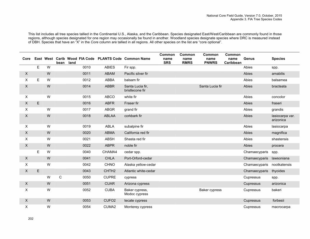
National Core Field Guide, Version 7.0, October, 2015 Appendix 3. FIA Tree Species Codes
202
This list includes all tree species tallied in the Continental U.S., Alaska, and the Caribbean. Species designated East/West/Caribbean are commonly found in those regions, although species designated for one region may occasionally be found in another. Woodland species designate species where DRC is measured instead of DBH. Species that have an “X” in the Core column are tallied in all regions. All other species on the list are “core optional”.
Core
East
West
Carib bean
Wood land
FIA Code
PLANTS Code
Common Name
Common name SRS
Common name RMRS
Common name
PNWRS
Common name
Caribbean
Genus
Species
E W 0010 ABIES Fir spp. Abies spp.
X W 0011 ABAM Pacific silver fir Abies amabilis
X E W 0012 ABBA balsam fir Abies balsamea
X W 0014 ABBR Santa Lucia fir, bristlecone fir
Santa Lucia fir Abies bracteata
X W 0015 ABCO white fir Abies concolor
X E 0016 ABFR Fraser fir Abies fraseri
X W 0017 ABGR grand fir Abies grandis
X W 0018 ABLAA corkbark fir Abies lasiocarpa var. arizonica
X W 0019 ABLA subalpine fir Abies lasiocarpa
X W 0020 ABMA California red fir Abies magnifica
X W 0021 ABSH Shasta red fir Abies shastensis
X W 0022 ABPR noble fir Abies procera
E W 0040 CHAMA4 cedar spp. Chamaecyparis spp.
X W 0041 CHLA Port-Orford-cedar Chamaecyparis lawsoniana
X W 0042 CHNO Alaska yellow-cedar Chamaecyparis nootkatensis
X E 0043 CHTH2 Atlantic white-cedar Chamaecyparis thyoides
W C 0050 CUPRE cypress Cupressus spp.
X W 0051 CUAR Arizona cypress Cupressus arizonica
X W 0052 CUBA Baker cypress, Modoc cypress
Baker cypress Cupressus bakeri
X W 0053 CUFO2 tecate cypress Cupressus forbesii
X W 0054 CUMA2 Monterey cypress Cupressus macrocarpa
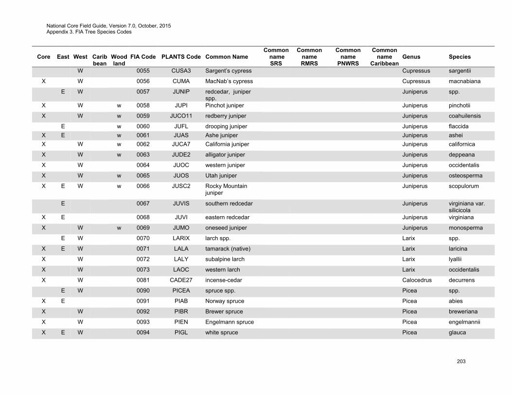
National Core Field Guide, Version 7.0, October, 2015 Appendix 3. FIA Tree Species Codes
203
Core
East
West
Carib bean
Wood land
FIA Code
PLANTS Code
Common Name
Common name SRS
Common name RMRS
Common name
PNWRS
Common name
Caribbean
Genus
Species
W 0055 CUSA3 Sargent’s cypress Cupressus sargentii
X W 0056 CUMA MacNab’s cypress Cupressus macnabiana
E W 0057 JUNIP redcedar, juniper spp.
Juniperus spp.
X W w 0058 JUPI Pinchot juniper Juniperus pinchotii
X W w 0059 JUCO11 redberry juniper Juniperus coahuilensis
E w 0060 JUFL drooping juniper Juniperus flaccida X E w 0061 JUAS Ashe juniper Juniperus ashei X W w 0062 JUCA7 California juniper Juniperus californica
X W w 0063 JUDE2 alligator juniper Juniperus deppeana
X W 0064 JUOC western juniper Juniperus occidentalis
X W w 0065 JUOS Utah juniper Juniperus osteosperma
X E W w 0066 JUSC2 Rocky Mountain juniper
Juniperus scopulorum
E 0067 JUVIS southern redcedar Juniperus virginiana var. silicicola
X E 0068 JUVI eastern redcedar Juniperus virginiana
X W w 0069 JUMO oneseed juniper Juniperus monosperma
E W 0070 LARIX larch spp. Larix spp.
X E W 0071 LALA tamarack (native) Larix laricina
X W 0072 LALY subalpine larch Larix lyallii
X W 0073 LAOC western larch Larix occidentalis
X W 0081 CADE27 incense-cedar Calocedrus decurrens
E W 0090 PICEA spruce spp. Picea spp.
X E 0091 PIAB Norway spruce Picea abies
X W 0092 PIBR Brewer spruce Picea breweriana
X W 0093 PIEN Engelmann spruce Picea engelmannii
X E W 0094 PIGL white spruce Picea glauca
National Core Field Guide, Version 7.0, October, 2015 Appendix 3. FIA Tree Species Codes
204
Core
East
West
Carib bean
Wood land
FIA Code
PLANTS Code
Common Name
Common name SRS
Common name RMRS
Common name
PNWRS
Common name
Caribbean
Genus
Species
X E W 0095 PIMA black spruce Picea mariana
X E W 0096 PIPU blue spruce Picea pungens
X E 0097 PIRU red spruce Picea rubens
X W 0098 PISI Sitka spruce Picea sitchensis
E W C 0100 PINUS pine spp. Pinus spp.
X W 0101 PIAL whitebark pine Pinus albicaulis
X W 0102 PIAR Rocky Mountain bristlecone pine
Pinus aristata
X W 0103 PIAT knobcone pine Pinus attenuata
X W 0104 PIBA foxtail pine Pinus balfouriana
X E 0105 PIBA2 jack pine Pinus banksiana
X W w 0106 PIED Common pinyon, two-needle pinyon
common pinyon
Pinus edulis
X E 0107 PICL sand pine Pinus clausa
X W 0108 PICO lodgepole pine Pinus contorta
X W 0109 PICO3 Coulter pine Pinus coulteri
X E 0110 PIEC2 shortleaf pine Pinus echinata
X E 0111 PIEL slash pine Pinus elliottii
X W 0112 PIEN2 Apache pine Pinus engelmannii
X W 0113 PIFL2 limber pine Pinus flexilis
X W 0114 PIST3 southwestern white pine
Pinus strobiformis
X E 0115 PIGL2 spruce pine Pinus glabra
X W 0116 PIJE Jeffrey pine Pinus jeffreyi
X W 0117 PILA sugar pine Pinus lambertiana
X W 0118 PILE Chihuahuan pine Pinus leiophylla
X W 0119 PIMO3 western white pine Pinus monticola
National Core Field Guide, Version 7.0, October, 2015 Appendix 3. FIA Tree Species Codes
205
Core
East
West
Carib bean
Wood land
FIA Code
PLANTS Code
Common Name
Common name SRS
Common name RMRS
Common name
PNWRS
Common name
Caribbean
Genus
Species
X W 0120 PIMU bishop pine Pinus muricata
X E 0121 PIPA2 longleaf pine Pinus palustris
X E W 0122 PIPO ponderosa pine Pinus ponderosa
X E 0123 PIPU5 Table Mountain pine Pinus pungens
X W 0124 PIRA2 Monterey pine Pinus radiata
X E 0125 PIRE red pine Pinus resinosa
X E 0126 PIRI pitch pine Pinus rigida
X W 0127 PISA2 gray pine, California foothill pine
gray pine Pinus sabiniana
X E 0128 PISE pond pine Pinus serotina
X E 0129 PIST eastern white pine Pinus strobus
X E W 0130 PISY Scotch pine Pinus sylvestris
X E 0131 PITA loblolly pine Pinus taeda
X E 0132 PIVI2 Virginia pine Pinus virginiana
X W w 0133 PIMO singleleaf pinyon Pinus monophylla
X W w 0134 PIDI3 border pinyon Pinus discolor
X W 0135 PIAR5 Arizona pine Pinus arizonica
X E 0136 PINI Austrian pine Pinus nigra
X W 0137 PIWA Washoe pine Pinus washoensis
X W w 0138 PIQU four-leaf pine, Parry pinyon pine
four-leaf pine Pinus quadrifolia
X W 0139 PITO Torrey pine torreya pine Pinus torreyana
X W w 0140 PICE Mexican pinyon pine Pinus cembroides
E w 0141 PIRE5 papershell pinyon pine
Pinus remota
X W 0142 PILO Great Basin bristlecone pine
Pinus longaeva
National Core Field Guide, Version 7.0, October, 2015 Appendix 3. FIA Tree Species Codes
206
Core
East
West
Carib bean
Wood land
FIA Code
PLANTS Code
Common Name
Common name SRS
Common name RMRS
Common name
PNWRS
Common name
Caribbean
Genus
Species
X W w 0143 PIMOF Arizona pinyon pine Pinus monophylla var. fallax
X E 0144 PIELE2 Caribbean pine Pinus elliottii var. elliottii
W 0200 PSEUD7 Douglas-fir spp. Pseudotsuga spp.
X W 0201 PSMA bigcone Douglas-fir Pseudotsuga macrocarpa
X W 0202 PSME Douglas-fir Pseudotsuga menziesii
X W 0211 SESE3 redwood Sequoia sempervirens
X W 0212 SEGI2 giant sequoia Sequoiadendron giganteum
E 0220 TAXOD cypress spp. Taxodium spp.
X E 0221 TADI2 baldcypress Taxodium distichum
X E 0222 TAAS pondcypress Taxodium ascendens
E 0223 TAMU Montezuma baldcypress
Taxodium mucronatum
E W 0230 TAXUS yew spp. Taxus spp.
W 0231 TABR2 Pacific yew Taxus brevifolia
X E 0232 TAFL Florida yew Taxus floridana
E W C 0240 THUJA Thuja spp. Thuja spp.
X E 0241 THOC2 northern white-cedar Thuja occidentalis
X W 0242 THPL western redcedar Thuja plicata
E W 0250 TORRE torreya (nutmeg) spp. Torreya spp.
X W 0251 TOCA California torreya (nutmeg)
Torreya californica
X E 0252 TOTA Florida torreya (nutmeg)
Torreya taxifolia
E W 0260 TSUGA hemlock spp. Tsuga spp.
X E 0261 TSCA eastern hemlock Tsuga canadensis
X E 0262 TSCA2 Carolina hemlock Tsuga caroliniana
X W 0263 TSHE western hemlock Tsuga heterophylla
National Core Field Guide, Version 7.0, October, 2015 Appendix 3. FIA Tree Species Codes
207
Core
East
West
Carib bean
Wood land
FIA Code
PLANTS Code
Common Name
Common name SRS
Common name RMRS
Common name
PNWRS
Common name
Caribbean
Genus
Species
X W 0264 TSME mountain hemlock Tsuga mertensiana
X E W C 0299 2TE unknown dead conifer
Tree evergreen
E W C w 0300 ACACI acacia spp. Acacia spp.
E W C w 0303 ACFA sweet acacia Acacia farnesiana
E W w 0304 ACGR catclaw acacia Acacia greggii
E W 0310 ACER maple spp. Acer spp.
X E 0311 ACBA3 Florida maple Acer barbatum
X W 0312 ACMA3 bigleaf maple Acer macrophyllum
X E W 0313 ACNE2 boxelder Acer negundo
X E 0314 ACNI5 black maple Acer nigrum
X E 0315 ACPE striped maple Acer pensylvanicum
X E 0316 ACRU red maple Acer rubrum
X E 0317 ACSA2 silver maple Acer saccharinum
X E 0318 ACSA3 sugar maple Acer saccharum
E 0319 ACSP2 mountain maple Acer spicatum
E 0320 ACPL Norway maple Acer platanoides
W w 0321 ACGL Rocky Mountain maple
Acer glabrum
W w 0322 ACGR3 bigtooth maple Acer grandidentatum
X E 0323 ACLE chalk maple Acer leucoderme
E W 0330 AESCU buckeye, horsechestnut spp.
Aesculus spp.
X E 0331 AEGL Ohio buckeye Aesculus glabra
X E 0332 AEFL yellow buckeye Aesculus flava
W 0333 AECA California buckeye Aesculus californica
E 0334 AEGLA Texas buckeye Aesculus glabra var. arguta
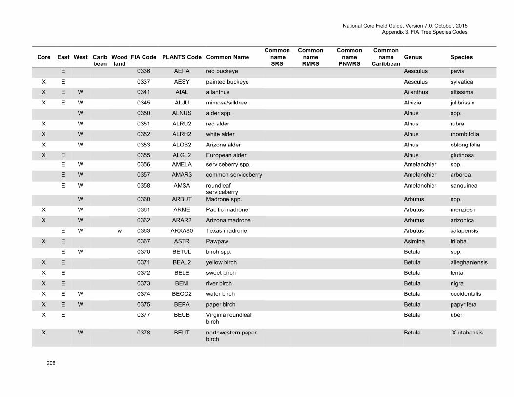
National Core Field Guide, Version 7.0, October, 2015 Appendix 3. FIA Tree Species Codes
208
Core
East
West
Carib bean
Wood land
FIA Code
PLANTS Code
Common Name
Common name SRS
Common name RMRS
Common name
PNWRS
Common name
Caribbean
Genus
Species
E 0336 AEPA red buckeye Aesculus pavia
X E 0337 AESY painted buckeye Aesculus sylvatica
X E W 0341 AIAL ailanthus Ailanthus altissima
X E W 0345 ALJU mimosa/silktree Albizia julibrissin
W 0350 ALNUS alder spp. Alnus spp.
X W 0351 ALRU2 red alder Alnus rubra
X W 0352 ALRH2 white alder Alnus rhombifolia
X W 0353 ALOB2 Arizona alder Alnus oblongifolia
X E 0355 ALGL2 European alder Alnus glutinosa E W 0356 AMELA serviceberry spp. Amelanchier spp.
E W 0357 AMAR3 common serviceberry Amelanchier arborea
E W 0358 AMSA roundleaf serviceberry
Amelanchier sanguinea
W 0360 ARBUT Madrone spp. Arbutus spp.
X W 0361 ARME Pacific madrone Arbutus menziesii
X W 0362 ARAR2 Arizona madrone Arbutus arizonica
E W w 0363 ARXA80 Texas madrone Arbutus xalapensis
X E 0367 ASTR Pawpaw Asimina triloba
E W 0370 BETUL birch spp. Betula spp.
X E 0371 BEAL2 yellow birch Betula alleghaniensis
X E 0372 BELE sweet birch Betula lenta
X E 0373 BENI river birch Betula nigra
X E W 0374 BEOC2 water birch Betula occidentalis
X E W 0375 BEPA paper birch Betula papyrifera
X E 0377 BEUB Virginia roundleaf birch
Betula uber
X W 0378 BEUT northwestern paper birch
Betula X utahensis

National Core Field Guide, Version 7.0, October, 2015 Appendix 3. FIA Tree Species Codes
209
Core
East
West
Carib bean
Wood land
FIA Code
PLANTS Code
Common Name
Common name SRS
Common name RMRS
Common name
PNWRS
Common name
Caribbean
Genus
Species
X E 0379 BEPO gray birch Betula populifolia
E 0381 SILAL3 Chittamwood, gum bumelia
Sideroxylon lanuginosum ssp. lanuginosum
X E 0391 CACA18 American hornbeam, musclewood
Carpinus caroliniana
E 0400 CARYA hickory spp. Carya spp.
X E 0401 CAAQ2 water hickory Carya aquatica
X E 0402 CACO15 bitternut hickory Carya cordiformis
X E 0403 CAGL8 pignut hickory Carya glabra
X E 0404 CAIL2 pecan Carya illinoinensis
X E 0405 CALA21 shellbark hickory Carya laciniosa
X E 0406 CAMY nutmeg hickory Carya myristiciformis
X E 0407 CAOV2 shagbark hickory Carya ovata
X E 0408 CATE9 black hickory Carya texana
X E 0409 CAAL27 mockernut hickory Carya alba
X E 0410 CAPA24 sand hickory Carya pallida
X E 0411 CAFL6 scrub hickory Carya floridana
X E 0412 CAOV3 red hickory Carya ovalis
X E 0413 CACA38 southern shagbark hickory
Carya carolinae-septentrionalis
E W 0420 CASTA chestnut spp. Castanea spp.
E 0421 CADE12 American chestnut Castanea dentata
X E 0422 CAPU9 Allegheny chinkapin Castanea pumila
E 0423 CAPUO Ozark chinkapin Castanea pumila var. ozarkensis
X E W 0424 CAMO83 Chinese chestnut Castanea mollissima
W 0431 CHCHC4 giant chinkapin, golden chinkapin
Chrysolepis chrysophylla var. chrysophylla
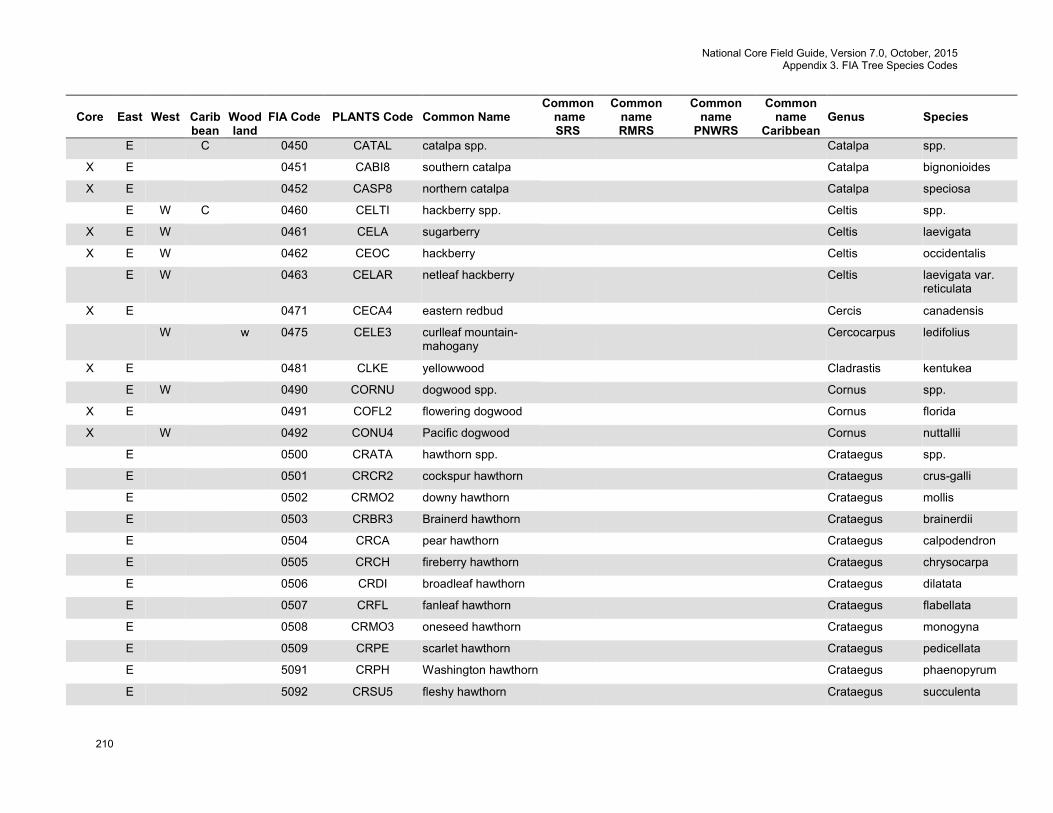
National Core Field Guide, Version 7.0, October, 2015 Appendix 3. FIA Tree Species Codes
210
Core
East
West
Carib bean
Wood land
FIA Code
PLANTS Code
Common Name
Common name SRS
Common name RMRS
Common name
PNWRS
Common name
Caribbean
Genus
Species
E C 0450 CATAL catalpa spp. Catalpa spp.
X E 0451 CABI8 southern catalpa Catalpa bignonioides
X E 0452 CASP8 northern catalpa Catalpa speciosa
E W C 0460 CELTI hackberry spp. Celtis spp.
X E W 0461 CELA sugarberry Celtis laevigata
X E W 0462 CEOC hackberry Celtis occidentalis
E W 0463 CELAR netleaf hackberry Celtis laevigata var. reticulata
X E 0471 CECA4 eastern redbud Cercis canadensis
W w 0475 CELE3 curlleaf mountain-mahogany
Cercocarpus ledifolius
X E 0481 CLKE yellowwood Cladrastis kentukea
E W 0490 CORNU dogwood spp. Cornus spp.
X E 0491 COFL2 flowering dogwood Cornus florida
X W 0492 CONU4 Pacific dogwood Cornus nuttallii
E 0500 CRATA hawthorn spp. Crataegus spp.
E 0501 CRCR2 cockspur hawthorn Crataegus crus-galli
E 0502 CRMO2 downy hawthorn Crataegus mollis
E 0503 CRBR3 Brainerd hawthorn Crataegus brainerdii
E 0504 CRCA pear hawthorn Crataegus calpodendron
E 0505 CRCH fireberry hawthorn Crataegus chrysocarpa
E 0506 CRDI broadleaf hawthorn Crataegus dilatata
E 0507 CRFL fanleaf hawthorn Crataegus flabellata
E 0508 CRMO3 oneseed hawthorn Crataegus monogyna
E 0509 CRPE scarlet hawthorn Crataegus pedicellata
E 5091 CRPH Washington hawthorn Crataegus phaenopyrum
E 5092 CRSU5 fleshy hawthorn Crataegus succulenta
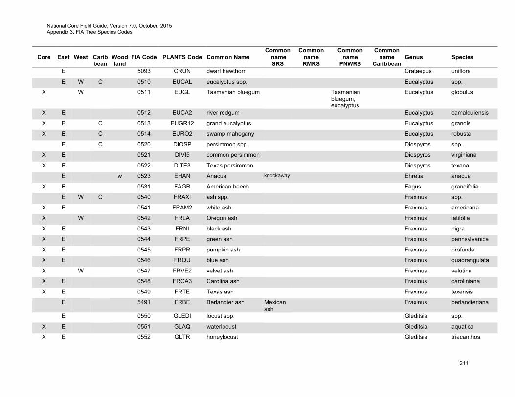
National Core Field Guide, Version 7.0, October, 2015 Appendix 3. FIA Tree Species Codes
211
Core
East
West
Carib bean
Wood land
FIA Code
PLANTS Code
Common Name
Common name SRS
Common name RMRS
Common name
PNWRS
Common name
Caribbean
Genus
Species
E 5093 CRUN dwarf hawthorn Crataegus uniflora
E W C 0510 EUCAL eucalyptus spp. Eucalyptus spp.
X W 0511 EUGL Tasmanian bluegum Tasmanian bluegum, eucalyptus
Eucalyptus globulus
X E 0512 EUCA2 river redgum Eucalyptus camaldulensis
X E C 0513 EUGR12 grand eucalyptus Eucalyptus grandis
X E C 0514 EURO2 swamp mahogany Eucalyptus robusta
E C 0520 DIOSP persimmon spp. Diospyros spp.
X E 0521 DIVI5 common persimmon Diospyros virginiana
X E 0522 DITE3 Texas persimmon Diospyros texana
E w 0523 EHAN Anacua knockaway Ehretia anacua
X E 0531 FAGR American beech Fagus grandifolia
E W C 0540 FRAXI ash spp. Fraxinus spp.
X E 0541 FRAM2 white ash Fraxinus americana
X W 0542 FRLA Oregon ash Fraxinus latifolia
X E 0543 FRNI black ash Fraxinus nigra
X E 0544 FRPE green ash Fraxinus pennsylvanica
X E 0545 FRPR pumpkin ash Fraxinus profunda
X E 0546 FRQU blue ash Fraxinus quadrangulata
X W 0547 FRVE2 velvet ash Fraxinus velutina
X E 0548 FRCA3 Carolina ash Fraxinus caroliniana
X E 0549 FRTE Texas ash Fraxinus texensis
E 5491 FRBE Berlandier ash Mexican ash
Fraxinus berlandieriana
E 0550 GLEDI locust spp. Gleditsia spp.
X E 0551 GLAQ waterlocust Gleditsia aquatica
X E 0552 GLTR honeylocust Gleditsia triacanthos
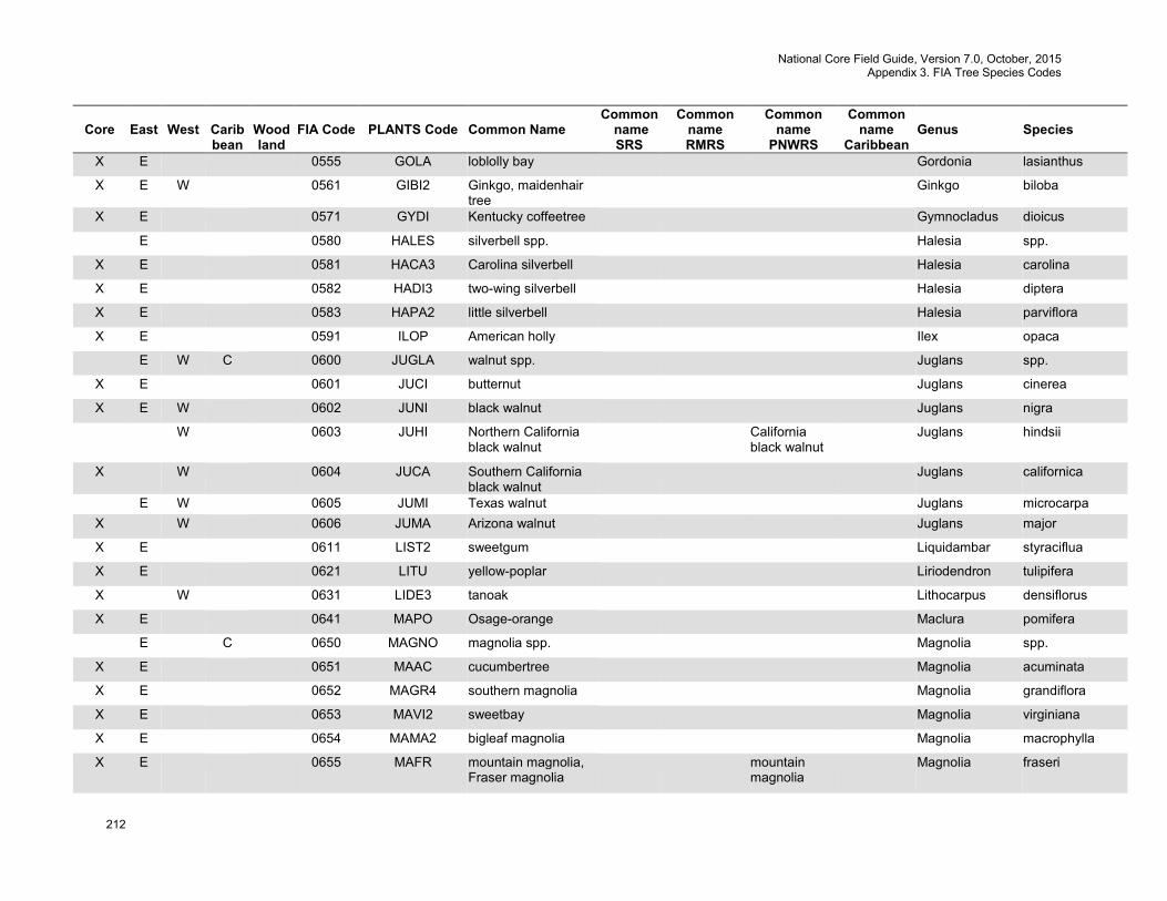
National Core Field Guide, Version 7.0, October, 2015 Appendix 3. FIA Tree Species Codes
212
Core
East
West
Carib bean
Wood land
FIA Code
PLANTS Code
Common Name
Common name SRS
Common name RMRS
Common name
PNWRS
Common name
Caribbean
Genus
Species
X E 0555 GOLA loblolly bay Gordonia lasianthus
X E W 0561 GIBI2 Ginkgo, maidenhair tree
Ginkgo biloba
X E 0571 GYDI Kentucky coffeetree Gymnocladus dioicus
E 0580 HALES silverbell spp. Halesia spp.
X E 0581 HACA3 Carolina silverbell Halesia carolina
X E 0582 HADI3 two-wing silverbell Halesia diptera
X E 0583 HAPA2 little silverbell Halesia parviflora
X E 0591 ILOP American holly Ilex opaca
E W C 0600 JUGLA walnut spp. Juglans spp.
X E 0601 JUCI butternut Juglans cinerea
X E W 0602 JUNI black walnut Juglans nigra
W 0603 JUHI Northern California black walnut
California black walnut
Juglans hindsii
X W 0604 JUCA Southern California black walnut
Juglans californica
E W 0605 JUMI Texas walnut Juglans microcarpa X W 0606 JUMA Arizona walnut Juglans major
X E 0611 LIST2 sweetgum Liquidambar styraciflua
X E 0621 LITU yellow-poplar Liriodendron tulipifera
X W 0631 LIDE3 tanoak Lithocarpus densiflorus
X E 0641 MAPO Osage-orange Maclura pomifera
E C 0650 MAGNO magnolia spp. Magnolia spp.
X E 0651 MAAC cucumbertree Magnolia acuminata
X E 0652 MAGR4 southern magnolia Magnolia grandiflora
X E 0653 MAVI2 sweetbay Magnolia virginiana
X E 0654 MAMA2 bigleaf magnolia Magnolia macrophylla
X E 0655 MAFR mountain magnolia, Fraser magnolia
mountain magnolia
Magnolia fraseri
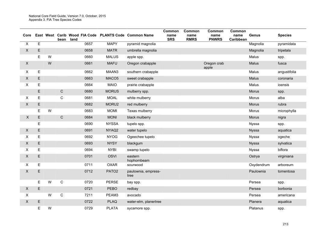
National Core Field Guide, Version 7.0, October, 2015 Appendix 3. FIA Tree Species Codes
213
Core
East
West
Carib bean
Wood land
FIA Code
PLANTS Code
Common Name
Common name SRS
Common name RMRS
Common name
PNWRS
Common name
Caribbean
Genus
Species
X E 0657 MAPY pyramid magnolia Magnolia pyramidata
X E 0658 MATR umbrella magnolia Magnolia tripetala
E W 0660 MALUS apple spp. Malus spp.
X W 0661 MAFU Oregon crabapple Oregon crab apple
Malus fusca
X E 0662 MAAN3 southern crabapple Malus angustifolia
X E 0663 MACO5 sweet crabapple Malus coronaria
X E 0664 MAIO prairie crabapple Malus ioensis
E C 0680 MORUS mulberry spp. Morus spp.
X E C 0681 MOAL white mulberry Morus alba
X E 0682 MORU2 red mulberry Morus rubra
E W 0683 MOMI Texas mulberry Morus microphylla
X E C 0684 MONI black mulberry Morus nigra
E 0690 NYSSA tupelo spp. Nyssa spp.
X E 0691 NYAQ2 water tupelo Nyssa aquatica
X E 0692 NYOG Ogeechee tupelo Nyssa ogeche
X E 0693 NYSY blackgum Nyssa sylvatica
X E 0694 NYBI swamp tupelo Nyssa biflora
X E 0701 OSVI eastern hophornbeam
Ostrya virginiana
X E 0711 OXAR sourwood Oxydendrum arboreum
X E 0712 PATO2 paulownia, empress-tree
Paulownia tomentosa
E W C 0720 PERSE bay spp. Persea spp.
X E 0721 PEBO redbay Persea borbonia
X W C 7211 PEAM3 avocado Persea americana
X E 0722 PLAQ water-elm, planertree Planera aquatica
E W 0729 PLATA sycamore spp. Platanus spp.
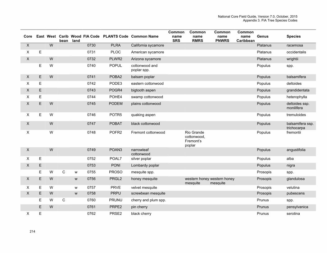
National Core Field Guide, Version 7.0, October, 2015 Appendix 3. FIA Tree Species Codes
214
Core
East
West
Carib bean
Wood land
FIA Code
PLANTS Code
Common Name
Common name SRS
Common name RMRS
Common name
PNWRS
Common name
Caribbean
Genus
Species
X W 0730 PLRA California sycamore Platanus racemosa
X E 0731 PLOC American sycamore Platanus occidentalis
X W 0732 PLWR2 Arizona sycamore Platanus wrightii
E W 0740 POPUL cottonwood and poplar spp.
Populus spp.
X E W 0741 POBA2 balsam poplar Populus balsamifera
X E 0742 PODE3 eastern cottonwood Populus deltoides
X E 0743 POGR4 bigtooth aspen Populus grandidentata
X E 0744 POHE4 swamp cottonwood Populus heterophylla
X E W 0745 PODEM plains cottonwood Populus deltoides ssp. monilifera
X E W 0746 POTR5 quaking aspen
Populus tremuloides
X W 0747 POBAT black cottonwood Populus balsamifera ssp. trichocarpa
X W 0748 POFR2 Fremont cottonwood Rio Grande cottonwood, Fremont’s poplar
Populus fremontii
X W 0749 POAN3 narrowleaf cottonwood
Populus angustifolia
X E 0752 POAL7 silver poplar Populus alba
X E 0753 PONI Lombardy poplar Populus nigra
E W C w 0755 PROSO mesquite spp. Prosopis spp.
X E W w 0756 PRGL2 honey mesquite western honey mesquite
western honey mesquite
Prosopis glandulosa
X E W w 0757 PRVE velvet mesquite Prosopis velutina X E W w 0758 PRPU screwbean mesquite Prosopis pubescens
E W C 0760 PRUNU cherry and plum spp. Prunus spp.
E W 0761 PRPE2 pin cherry Prunus pensylvanica
X E 0762 PRSE2 black cherry Prunus serotina
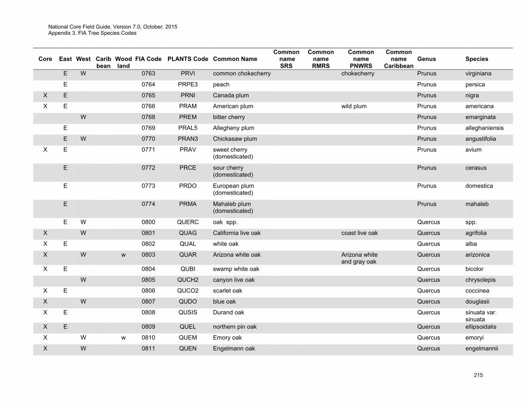
National Core Field Guide, Version 7.0, October, 2015 Appendix 3. FIA Tree Species Codes
215
Core
East
West
Carib bean
Wood land
FIA Code
PLANTS Code
Common Name
Common name SRS
Common name RMRS
Common name
PNWRS
Common name
Caribbean
Genus
Species
E W 0763 PRVI common chokecherry chokecherry Prunus virginiana
E 0764 PRPE3 peach Prunus persica
X E 0765 PRNI Canada plum Prunus nigra
X E 0766 PRAM American plum wild plum Prunus americana
W 0768 PREM bitter cherry Prunus emarginata
E 0769 PRAL5 Allegheny plum Prunus alleghaniensis
E W 0770 PRAN3 Chickasaw plum Prunus angustifolia
X E 0771 PRAV sweet cherry (domesticated)
Prunus avium
E 0772 PRCE sour cherry (domesticated)
Prunus cerasus
E 0773 PRDO European plum (domesticated)
Prunus domestica
E 0774 PRMA Mahaleb plum (domesticated)
Prunus mahaleb
E W 0800 QUERC oak spp. Quercus spp.
X W 0801 QUAG California live oak coast live oak Quercus agrifolia
X E 0802 QUAL white oak Quercus alba
X W w 0803 QUAR Arizona white oak Arizona white and gray oak
Quercus arizonica
X E 0804 QUBI swamp white oak Quercus bicolor
W 0805 QUCH2 canyon live oak Quercus chrysolepis
X E 0806 QUCO2 scarlet oak Quercus coccinea
X W 0807 QUDO blue oak Quercus douglasii
X E 0808 QUSIS Durand oak Quercus sinuata var. sinuata
X E 0809 QUEL northern pin oak Quercus ellipsoidalis
X W w 0810 QUEM Emory oak Quercus emoryi
X W 0811 QUEN Engelmann oak Quercus engelmannii
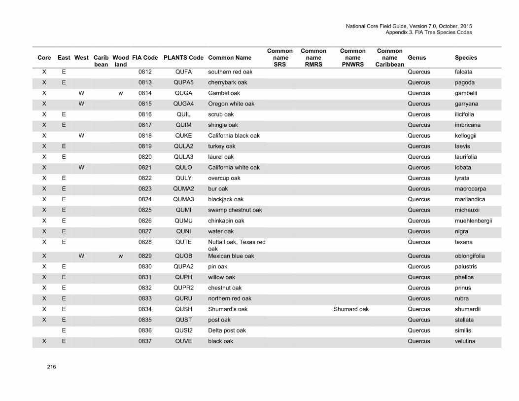
National Core Field Guide, Version 7.0, October, 2015 Appendix 3. FIA Tree Species Codes
216
Core
East
West
Carib bean
Wood land
FIA Code
PLANTS Code
Common Name
Common name SRS
Common name RMRS
Common name
PNWRS
Common name
Caribbean
Genus
Species
X E 0812 QUFA southern red oak Quercus falcata
X E 0813 QUPA5 cherrybark oak Quercus pagoda
X W w 0814 QUGA Gambel oak Quercus gambelii
X W 0815 QUGA4 Oregon white oak Quercus garryana
X E 0816 QUIL scrub oak Quercus ilicifolia
X E 0817 QUIM shingle oak Quercus imbricaria
X W 0818 QUKE California black oak Quercus kelloggii
X E 0819 QULA2 turkey oak Quercus laevis
X E 0820 QULA3 laurel oak Quercus laurifolia
X W 0821 QULO California white oak Quercus lobata
X E 0822 QULY overcup oak Quercus lyrata
X E 0823 QUMA2 bur oak Quercus macrocarpa
X E 0824 QUMA3 blackjack oak Quercus marilandica
X E 0825 QUMI swamp chestnut oak Quercus michauxii
X E 0826 QUMU chinkapin oak Quercus muehlenbergii
X E 0827 QUNI water oak Quercus nigra
X E 0828 QUTE Nuttall oak, Texas red oak
Quercus texana
X W w 0829 QUOB Mexican blue oak Quercus oblongifolia
X E 0830 QUPA2 pin oak Quercus palustris
X E 0831 QUPH willow oak Quercus phellos
X E 0832 QUPR2 chestnut oak Quercus prinus
X E 0833 QURU northern red oak Quercus rubra
X E 0834 QUSH Shumard’s oak Shumard oak Quercus shumardii
X E 0835 QUST post oak Quercus stellata
E 0836 QUSI2 Delta post oak Quercus similis
X E 0837 QUVE black oak Quercus velutina

National Core Field Guide, Version 7.0, October, 2015 Appendix 3. FIA Tree Species Codes
217
Core
East
West
Carib bean
Wood land
FIA Code
PLANTS Code
Common Name
Common name SRS
Common name RMRS
Common name
PNWRS
Common name
Caribbean
Genus
Species
X E 0838 QUVI live oak Quercus virginiana
X W 0839 QUWI2 interior live oak Quercus wislizeni
X E 0840 QUMA6 dwarf post oak Quercus margarettae
X E 0841 QUMI2 dwarf live oak Quercus minima
X E 0842 QUIN bluejack oak Quercus incana
X W w 0843 QUHY silverleaf oak Quercus hypoleucoides
X E 0844 QUOG Oglethorpe oak
Quercus oglethorpensis
E 0845 QUPR dwarf chinkapin oak Quercus prinoides
X W w 0846 QUGR3 gray oak Quercus grisea
X W w 0847 QURU4 netleaf oak Quercus rugosa
E 0851 QUGR Chisos oak Quercus graciliformis
E 8511 QUGR2 Graves oak Chisos red oak
Quercus gravesii
E 8512 QUPO2 Mexican white oak netleaf white oak
Quercus polymorpha
E 8513 QUBU2 Spanish oak Buckley oak, Texas red
Quercus buckleyi
E 8514 QULA lacey oak Quercus laceyi
E C 0852 AMEL torchwood sea torch- wood
Amyris elemifera
E C 0853 ANGL4 pond apple Annona glabra
E C 0854 BUSI gumbo limbo Bursera simaruba
E C 0855 CASUA sheoak spp. Casuarina spp.
X E C 0856 CAGL11 gray sheoak Casuarina glauca
X E C 0857 CALE28 Australian pine Casuarina lepidophloia
Casuarina lepidophloia
E C 0858 CICA camphor tree Cinnamomum camphora
E C 0859 CIFR fiddlewood Citharexylum fruticosum
E C 0860 CITRU2 citrus spp. Citrus spp.
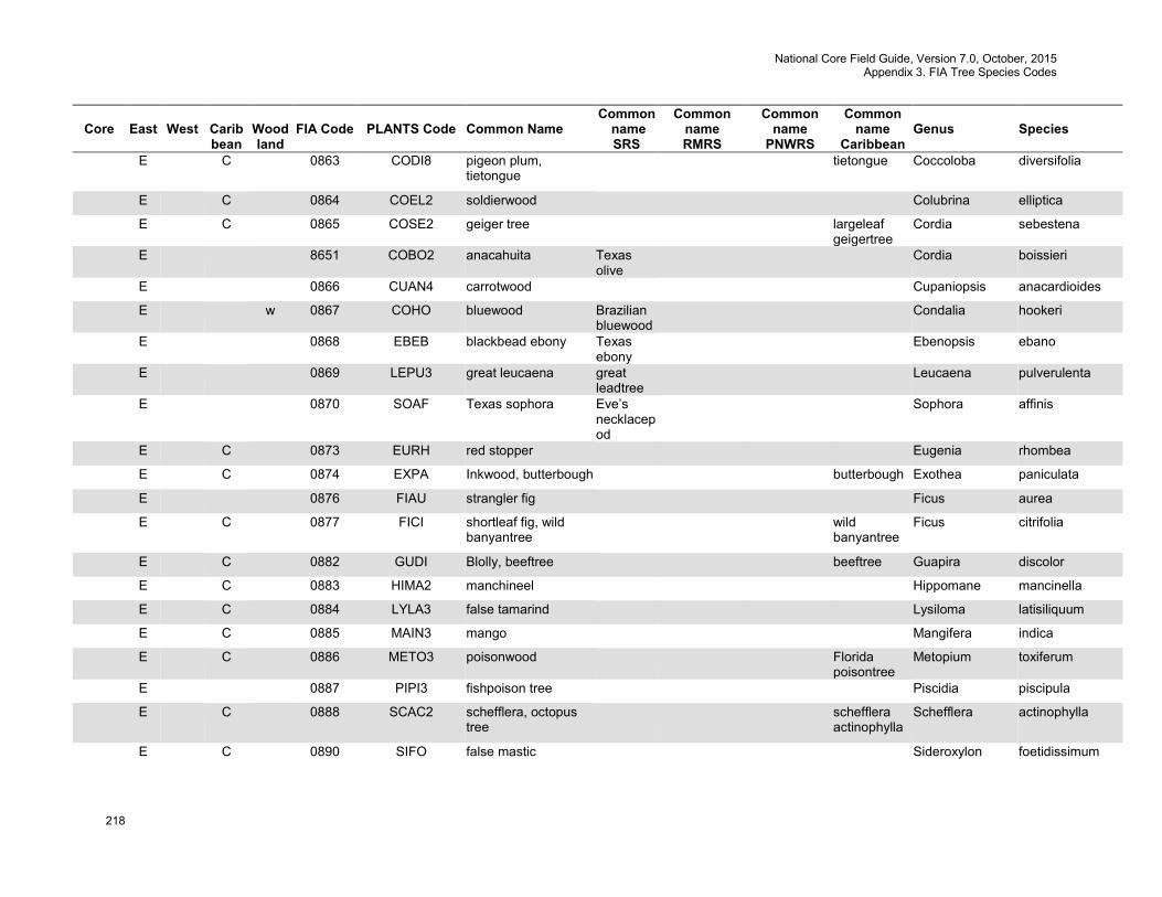
National Core Field Guide, Version 7.0, October, 2015 Appendix 3. FIA Tree Species Codes
218
Core
East
West
Carib bean
Wood land
FIA Code
PLANTS Code
Common Name
Common name SRS
Common name RMRS
Common name
PNWRS
Common name
Caribbean
Genus
Species
E C 0863 CODI8 pigeon plum, tietongue
tietongue Coccoloba diversifolia
E C 0864 COEL2 soldierwood Colubrina elliptica
E C 0865 COSE2 geiger tree largeleaf geigertree
Cordia sebestena
E 8651 COBO2 anacahuita Texas olive
Cordia boissieri
E 0866 CUAN4 carrotwood Cupaniopsis anacardioides
E w 0867 COHO bluewood Brazilian bluewood
Condalia hookeri
E 0868 EBEB blackbead ebony Texas ebony
Ebenopsis ebano
E 0869 LEPU3 great leucaena great leadtree
Leucaena pulverulenta
E 0870 SOAF Texas sophora Eve’s necklacepod
Sophora affinis
E C 0873 EURH red stopper Eugenia rhombea
E C 0874 EXPA Inkwood, butterbough butterbough Exothea paniculata
E 0876 FIAU strangler fig Ficus aurea
E C 0877 FICI shortleaf fig, wild banyantree
wild banyantree
Ficus citrifolia
E C 0882 GUDI Blolly, beeftree beeftree Guapira discolor
E C 0883 HIMA2 manchineel Hippomane mancinella
E C 0884 LYLA3 false tamarind Lysiloma latisiliquum
E C 0885 MAIN3 mango Mangifera indica
E C 0886 METO3 poisonwood Florida poisontree
Metopium toxiferum
E 0887 PIPI3 fishpoison tree Piscidia piscipula
E C 0888 SCAC2 schefflera, octopus tree
schefflera actinophylla
Schefflera actinophylla
E C 0890 SIFO false mastic Sideroxylon foetidissimum
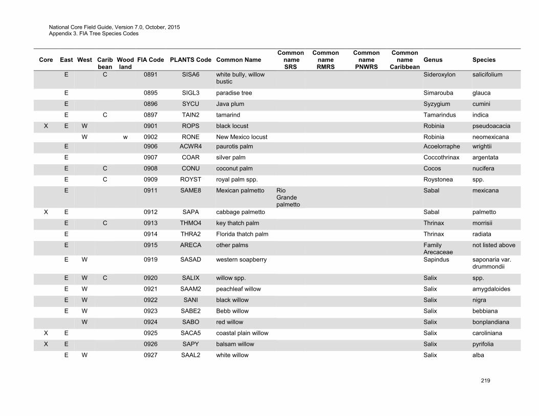
National Core Field Guide, Version 7.0, October, 2015 Appendix 3. FIA Tree Species Codes
219
Core
East
West
Carib bean
Wood land
FIA Code
PLANTS Code
Common Name
Common name SRS
Common name RMRS
Common name
PNWRS
Common name
Caribbean
Genus
Species
E C 0891 SISA6 white bully, willow bustic
Sideroxylon salicifolium
E 0895 SIGL3 paradise tree Simarouba glauca
E 0896 SYCU Java plum Syzygium cumini
E C 0897 TAIN2 tamarind Tamarindus indica
X E W 0901 ROPS black locust Robinia pseudoacacia
W w 0902 RONE New Mexico locust Robinia neomexicana E 0906 ACWR4 paurotis palm Acoelorraphe wrightii
E 0907 COAR silver palm Coccothrinax argentata
E C 0908 CONU coconut palm Cocos nucifera
E C 0909 ROYST royal palm spp. Roystonea spp.
E 0911 SAME8 Mexican palmetto Rio Grande palmetto
Sabal mexicana
X E 0912 SAPA cabbage palmetto Sabal palmetto
E C 0913 THMO4 key thatch palm Thrinax morrisii
E 0914 THRA2 Florida thatch palm Thrinax radiata
E 0915 ARECA other palms Family Arecaceae
not listed above
E W 0919 SASAD western soapberry Sapindus saponaria var. drummondii
E W C 0920 SALIX willow spp. Salix spp.
E W 0921 SAAM2 peachleaf willow Salix amygdaloides
E W 0922 SANI black willow Salix nigra
E W 0923 SABE2 Bebb willow Salix bebbiana
W 0924 SABO red willow Salix bonplandiana
X E 0925 SACA5 coastal plain willow Salix caroliniana
X E 0926 SAPY balsam willow Salix pyrifolia
E W 0927 SAAL2 white willow Salix alba
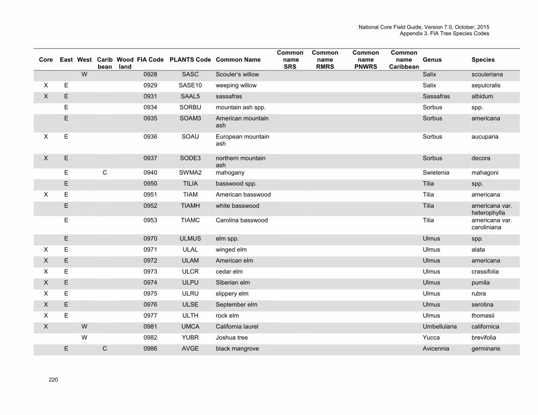
National Core Field Guide, Version 7.0, October, 2015 Appendix 3. FIA Tree Species Codes
220
Core
East
West
Carib bean
Wood land
FIA Code
PLANTS Code
Common Name
Common name SRS
Common name RMRS
Common name
PNWRS
Common name
Caribbean
Genus
Species
W 0928 SASC Scouler’s willow Salix scouleriana
X E 0929 SASE10 weeping willow Salix sepulcralis
X E 0931 SAAL5 sassafras Sassafras albidum
E 0934 SORBU mountain ash spp. Sorbus spp.
E 0935 SOAM3 American mountain ash
Sorbus americana
X E 0936 SOAU European mountain ash
Sorbus aucuparia
X E 0937 SODE3 northern mountain ash
Sorbus decora
E C 0940 SWMA2 mahogany Swietenia mahagoni
E 0950 TILIA basswood spp. Tilia spp.
X E 0951 TIAM American basswood Tilia americana
E 0952 TIAMH white basswood Tilia americana var. heterophylla
E 0953 TIAMC Carolina basswood Tilia americana var. caroliniana
E 0970 ULMUS elm spp. Ulmus spp.
X E 0971 ULAL winged elm Ulmus alata
X E 0972 ULAM American elm Ulmus americana
X E 0973 ULCR cedar elm Ulmus crassifolia
X E 0974 ULPU Siberian elm Ulmus pumila
X E 0975 ULRU slippery elm Ulmus rubra
X E 0976 ULSE September elm Ulmus serotina
X E 0977 ULTH rock elm Ulmus thomasii
X W 0981 UMCA California laurel Umbellularia californica
W 0982 YUBR Joshua tree Yucca brevifolia
E C 0986 AVGE black mangrove Avicennia germinans
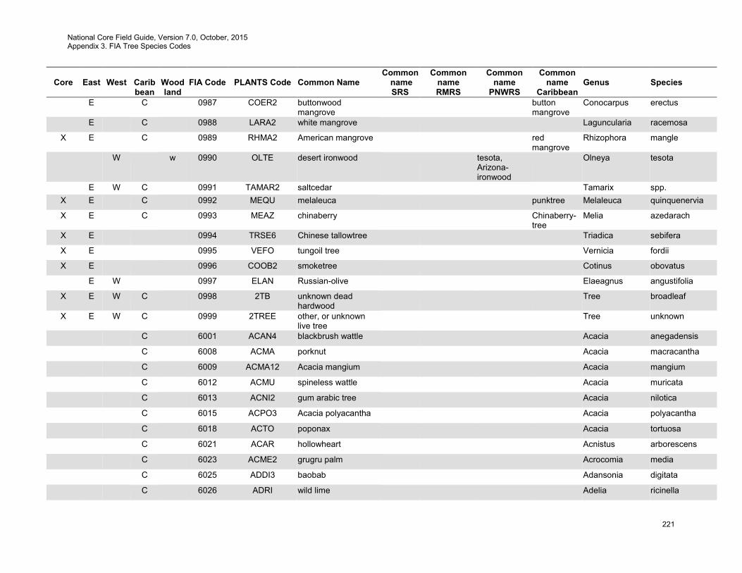
National Core Field Guide, Version 7.0, October, 2015 Appendix 3. FIA Tree Species Codes
221
Core
East
West
Carib bean
Wood land
FIA Code
PLANTS Code
Common Name
Common name SRS
Common name RMRS
Common name
PNWRS
Common name
Caribbean
Genus
Species
E C 0987 COER2 buttonwood mangrove
button mangrove
Conocarpus erectus
E C 0988 LARA2 white mangrove Laguncularia racemosa
X E C 0989 RHMA2 American mangrove red mangrove
Rhizophora mangle
W w 0990 OLTE desert ironwood tesota, Arizona-ironwood
Olneya tesota
E W C 0991 TAMAR2 saltcedar Tamarix spp. X E C 0992 MEQU melaleuca punktree Melaleuca quinquenervia
X E C 0993 MEAZ chinaberry Chinaberry-tree
Melia azedarach
X E 0994 TRSE6 Chinese tallowtree Triadica sebifera
X E 0995 VEFO tungoil tree Vernicia fordii
X E 0996 COOB2 smoketree Cotinus obovatus
E W 0997 ELAN Russian-olive Elaeagnus angustifolia
X E W C 0998 2TB unknown dead hardwood
Tree broadleaf
X E W C 0999 2TREE other, or unknown live tree
Tree unknown
C 6001 ACAN4 blackbrush wattle Acacia anegadensis
C 6008 ACMA porknut Acacia macracantha
C 6009 ACMA12 Acacia mangium Acacia mangium
C 6012 ACMU spineless wattle Acacia muricata
C 6013 ACNI2 gum arabic tree Acacia nilotica
C 6015 ACPO3 Acacia polyacantha Acacia polyacantha
C 6018 ACTO poponax Acacia tortuosa
C 6021 ACAR hollowheart Acnistus arborescens
C 6023 ACME2 grugru palm Acrocomia media
C 6025 ADDI3 baobab Adansonia digitata
C 6026 ADRI wild lime Adelia ricinella
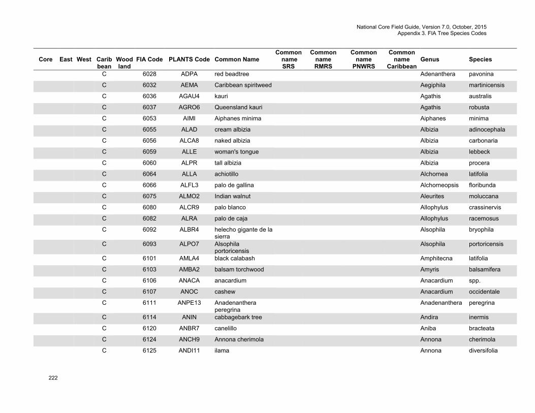
National Core Field Guide, Version 7.0, October, 2015 Appendix 3. FIA Tree Species Codes
222
Core
East
West
Carib bean
Wood land
FIA Code
PLANTS Code
Common Name
Common name SRS
Common name RMRS
Common name
PNWRS
Common name
Caribbean
Genus
Species
C 6028 ADPA red beadtree Adenanthera pavonina
C 6032 AEMA Caribbean spiritweed Aegiphila martinicensis
C 6036 AGAU4 kauri Agathis australis
C 6037 AGRO6 Queensland kauri Agathis robusta
C 6053 AIMI Aiphanes minima Aiphanes minima
C 6055 ALAD cream albizia Albizia adinocephala
C 6056 ALCA8 naked albizia Albizia carbonaria
C 6059 ALLE woman's tongue Albizia lebbeck
C 6060 ALPR tall albizia Albizia procera
C 6064 ALLA achiotillo Alchornea latifolia
C 6066 ALFL3 palo de gallina Alchorneopsis floribunda
C 6075 ALMO2 Indian walnut Aleurites moluccana
C 6080 ALCR9 palo blanco Allophylus crassinervis
C 6082 ALRA palo de caja Allophylus racemosus
C 6092 ALBR4 helecho gigante de la sierra
Alsophila bryophila
C 6093 ALPO7 Alsophila portoricensis
Alsophila portoricensis
C 6101 AMLA4 black calabash Amphitecna latifolia
C 6103 AMBA2 balsam torchwood Amyris balsamifera
C 6106 ANACA anacardium Anacardium spp.
C 6107 ANOC cashew Anacardium occidentale
C 6111 ANPE13 Anadenanthera peregrina
Anadenanthera peregrina
C 6114 ANIN cabbagebark tree Andira inermis
C 6120 ANBR7 canelillo Aniba bracteata
C 6124 ANCH9 Annona cherimola Annona cherimola
C 6125 ANDI11 ilama Annona diversifolia
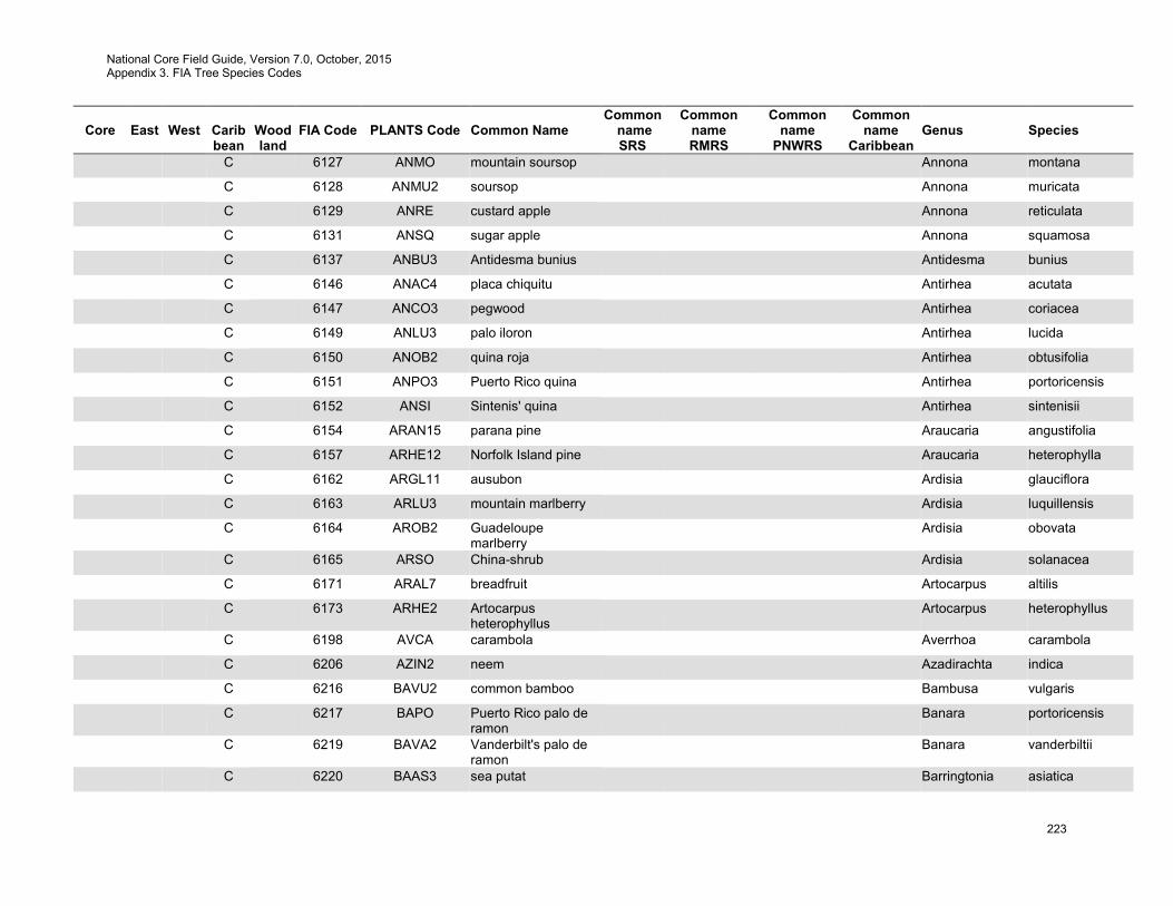
National Core Field Guide, Version 7.0, October, 2015 Appendix 3. FIA Tree Species Codes
223
Core
East
West
Carib bean
Wood land
FIA Code
PLANTS Code
Common Name
Common name SRS
Common name RMRS
Common name
PNWRS
Common name
Caribbean
Genus
Species
C 6127 ANMO mountain soursop Annona montana
C 6128 ANMU2 soursop Annona muricata
C 6129 ANRE custard apple Annona reticulata
C 6131 ANSQ sugar apple Annona squamosa
C 6137 ANBU3 Antidesma bunius Antidesma bunius
C 6146 ANAC4 placa chiquitu Antirhea acutata
C 6147 ANCO3 pegwood Antirhea coriacea
C 6149 ANLU3 palo iloron Antirhea lucida
C 6150 ANOB2 quina roja Antirhea obtusifolia
C 6151 ANPO3 Puerto Rico quina Antirhea portoricensis
C 6152 ANSI Sintenis' quina Antirhea sintenisii
C 6154 ARAN15 parana pine Araucaria angustifolia
C 6157 ARHE12 Norfolk Island pine Araucaria heterophylla
C 6162 ARGL11 ausubon Ardisia glauciflora
C 6163 ARLU3 mountain marlberry Ardisia luquillensis
C 6164 AROB2 Guadeloupe marlberry
Ardisia obovata
C 6165 ARSO China-shrub Ardisia solanacea
C 6171 ARAL7 breadfruit Artocarpus altilis
C 6173 ARHE2 Artocarpus heterophyllus
Artocarpus heterophyllus
C 6198 AVCA carambola Averrhoa carambola
C 6206 AZIN2 neem Azadirachta indica
C 6216 BAVU2 common bamboo Bambusa vulgaris
C 6217 BAPO Puerto Rico palo de ramon
Banara portoricensis
C 6219 BAVA2 Vanderbilt's palo de ramon
Banara vanderbiltii
C 6220 BAAS3 sea putat Barringtonia asiatica
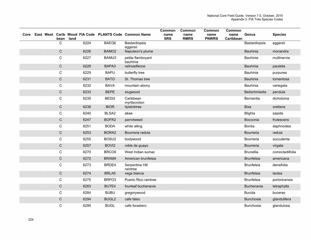
National Core Field Guide, Version 7.0, October, 2015 Appendix 3. FIA Tree Species Codes
224
Core
East
West
Carib bean
Wood land
FIA Code
PLANTS Code
Common Name
Common name SRS
Common name RMRS
Common name
PNWRS
Common name
Caribbean
Genus
Species
C 6224 BAEG6 Bastardiopsis eggersii
Bastardiopsis eggersii
C 6226 BAMO2 Napoleon's plume Bauhinia monandra
C 6227 BAMU3 petite flamboyant bauhinia
Bauhinia multinervia
C 6228 BAPA3 railroadfence Bauhinia pauletia
C 6229 BAPU butterfly tree Bauhinia purpurea
C 6231 BATO St. Thomas tree Bauhinia tomentosa
C 6232 BAVA mountain ebony Bauhinia variegata
C 6233 BEPE slugwood Beilschmiedia pendula
C 6235 BEDI2 Caribbean myrtlecroton
Bernardia dichotoma
C 6238 BIOR lipsticktree Bixa orellana
C 6240 BLSA2 akee Blighia sapida
C 6247 BOFR2 parrotweed Bocconia frutescens
C 6251 BODA white alling Bontia daphnoides
C 6253 BORA2 Bourreria radula Bourreria radula
C 6255 BOSU2 bodywood Bourreria succulenta
C 6257 BOVI2 roble de guayo Bourreria virgata
C 6270 BRCO6 West Indian sumac Brunellia comocladiifolia
C 6272 BRAM4 American brunfelsia Brunfelsia americana
C 6273 BRDE4 Serpentine Hill raintree
Brunfelsia densifolia
C 6274 BRLA5 vega blanca Brunfelsia lactea
C 6275 BRPO3 Puerto Rico raintree Brunfelsia portoricensis
C 6283 BUTE4 fourleaf buchenavia Buchenavia tetraphylla
C 6284 BUBU gregorywood Bucida buceras
C 6294 BUGL2 cafe falso Bunchosia glandulifera
C 6295 BUGL cafe forastero Bunchosia glandulosa

National Core Field Guide, Version 7.0, October, 2015 Appendix 3. FIA Tree Species Codes
225
Core
East
West
Carib bean
Wood land
FIA Code
PLANTS Code
Common Name
Common name SRS
Common name RMRS
Common name
PNWRS
Common name
Caribbean
Genus
Species
C 6297 BUPO5 Bunchosia polystachia
Bunchosia polystachia
C 6303 BULA10 Buxus laevigata Buxus laevigata
C 6304 BUPO Puerto Rico box Buxus portoricensis
C 6306 BUVA Vahl's box Buxus vahlii
C 6308 BYCR maricao cimun Byrsonima crassifolia
C 6311 BYLU Long Key locustberry Byrsonima lucida
C 6313 BYSP doncella Byrsonima spicata
C 6315 BYWA almendrillo Byrsonima wadsworthii
C 6316 CAESA nicker Caesalpinia spp.
C 6317 CACO28 divi divi Caesalpinia coriaria
C 6319 CAPU13 pride-of-Barbados Caesalpinia pulcherrima
C 6320 CASA28 sappanwood Caesalpinia sappan
C 6325 CASU33 Surinamese stickpea Calliandra surinamensis
C 6326 CAAM14 caparosa Callicarpa ampla
C 6328 CACI15 crimson bottlebrush Callistemon citrinus
C 6331 CACO2 Callitris columellaris Callitris columellaris
C 6337 CAEC2 Caloncoba echinata Caloncoba echinata
C 6338 CAAN22 Antilles calophyllum Calophyllum antillanum
C 6341 CAIN4 Alexandrian laurel Calophyllum inophyllum
C 6346 CAPR roostertree Calotropis procera
C 6350 CACA73 degame Calycophyllum candidissimum
C 6351 CAKI Kiaerskov's lidflower Calyptranthes kiaerskovii
C 6352 CAKR limoncillo Calyptranthes krugii
C 6353 CALU12 Luquillo forest lidflower
Calyptranthes luquillensis
C 6354 CAPA8 pale lidflower Calyptranthes pallens
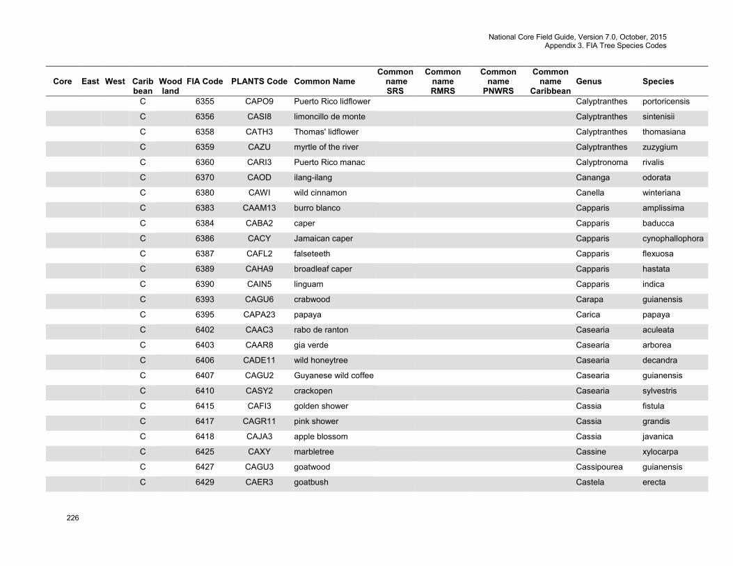
National Core Field Guide, Version 7.0, October, 2015 Appendix 3. FIA Tree Species Codes
226
Core
East
West
Carib bean
Wood land
FIA Code
PLANTS Code
Common Name
Common name SRS
Common name RMRS
Common name
PNWRS
Common name
Caribbean
Genus
Species
C 6355 CAPO9 Puerto Rico lidflower Calyptranthes portoricensis
C 6356 CASI8 limoncillo de monte Calyptranthes sintenisii
C 6358 CATH3 Thomas' lidflower Calyptranthes thomasiana
C 6359 CAZU myrtle of the river Calyptranthes zuzygium
C 6360 CARI3 Puerto Rico manac Calyptronoma rivalis
C 6370 CAOD ilang-ilang Cananga odorata
C 6380 CAWI wild cinnamon Canella winteriana
C 6383 CAAM13 burro blanco Capparis amplissima
C 6384 CABA2 caper Capparis baducca
C 6386 CACY Jamaican caper Capparis cynophallophora
C 6387 CAFL2 falseteeth Capparis flexuosa
C 6389 CAHA9 broadleaf caper Capparis hastata
C 6390 CAIN5 linguam Capparis indica
C 6393 CAGU6 crabwood Carapa guianensis
C 6395 CAPA23 papaya Carica papaya
C 6402 CAAC3 rabo de ranton Casearia aculeata
C 6403 CAAR8 gia verde Casearia arborea
C 6406 CADE11 wild honeytree Casearia decandra
C 6407 CAGU2 Guyanese wild coffee Casearia guianensis
C 6410 CASY2 crackopen Casearia sylvestris
C 6415 CAFI3 golden shower Cassia fistula
C 6417 CAGR11 pink shower Cassia grandis
C 6418 CAJA3 apple blossom Cassia javanica
C 6425 CAXY marbletree Cassine xylocarpa
C 6427 CAGU3 goatwood Cassipourea guianensis
C 6429 CAER3 goatbush Castela erecta

National Core Field Guide, Version 7.0, October, 2015 Appendix 3. FIA Tree Species Codes
227
Core
East
West
Carib bean
Wood land
FIA Code
PLANTS Code
Common Name
Common name SRS
Common name RMRS
Common name
PNWRS
Common name
Caribbean
Genus
Species
C 6430 CAEL5 Panama rubbertree Castilla elastica
C 6433 CACU8 river sheoak Casuarina cunninghamiana
C 6434 CAEQ beach sheoak Casuarina equisetifolia
C 6439 CALO8 Haitian catalpa Catalpa longissima
C 6443 CESC9 pumpwood Cecropia schreberiana
C 6445 CEOD Spanish cedar Cedrela odorata
C 6447 CEAC4 pochote Ceiba acuminata
C 6448 CEAE2 pochote Ceiba aesculifolia
C 6449 CEPE2 kapoktree Ceiba pentandra
C 6454 CETR3 almex Celtis trinervia
C 6457 CESI3 St. John's bread Ceratonia siliqua
C 6468 CEHE3 lady of the night cactus
Cereus hexagonus
C 6469 CEHI3 Cereus hildmannianus
Cereus hildmannianus
C 6474 CEDI6 day jessamine Cestrum diurnum
C 6475 CELA2 galen del monte Cestrum laurifolium
C 6477 CENO night jessamine Cestrum nocturnum
C 6481 CHAR8 jointed sandmat Chamaesyce articulata
C 6519 CHAX2 hueso Chionanthus axilliflorus
C 6520 CHCO12 bridgotree Chionanthus compactus
C 6521 CHDO4 white rosewood Chionanthus domingensis
C 6522 CHHO4 hueso prieto Chionanthus holdridgei
C 6523 CHLI6 cabra blanca Chionanthus ligustrinus
C 6526 CHSE5 puntaj jayuya Chione seminervis
C 6528 CHVE4 fatpork Chione venosa
C 6529 CHEX5 african teak Chlorophora excelsa

National Core Field Guide, Version 7.0, October, 2015 Appendix 3. FIA Tree Species Codes
228
Core
East
West
Carib bean
Wood land
FIA Code
PLANTS Code
Common Name
Common name SRS
Common name RMRS
Common name
PNWRS
Common name
Caribbean
Genus
Species
C 6532 CHSP13 silk-floss tree Chorisia speciosa
C 6535 CHIC icaco coco plum Chrysobalanus icaco
C 6539 CHAR6 bastard redwood Chrysophyllum argenteum
C 6541 CHCA10 star apple Chrysophyllum cainito
C 6542 CHOL satinleaf Chrysophyllum oliviforme
C 6543 CHPA31 camito de perro Chrysophyllum pauciflorum
C 6554 CIAR8 cassia Cinnamomum aromaticum
C 6559 CIEL2 laurel avispillo Cinnamomum elongatum
C 6560 CIMO3 avispillo Cinnamomum montanum
C 6564 CIVE2 cinnamon Cinnamomum verum
C 6565 CICA8 juniper berry Citharexylum caudatum
C 6567 CISP3 spiny fiddlewood Citharexylum spinosum
C 6569 CITR7 threespike fiddlewood Citharexylum tristachyum
C 6573 CIAU7 key lime Citrus ×aurantiifolia
C 6574 CIAU8 sour orange Citrus ×aurantium
C 6575 CILI5 lemon Citrus ×limon
C 6576 CIPA3 grapefruit Citrus ×paradisi
C 6577 CISI3 sweet orange Citrus ×sinensis
C 6581 CIMA5 Citrus maxima Citrus maxima
C 6582 CIME3 Citrus medica Citrus medica
C 6584 CIRE3 Citrus reticulata Citrus reticulata
C 6631 CLAC2 haggarbush Clerodendrum aculeatum
C 6637 CLAL4 teta prieta Cleyera albopunctata
C 6639 CLER jackass breadnut Clibadium erosum
C 6641 CLCY5 Clidemia cymosa Clidemia cymosa
C 6642 CLHI3 soapbush Clidemia hirta
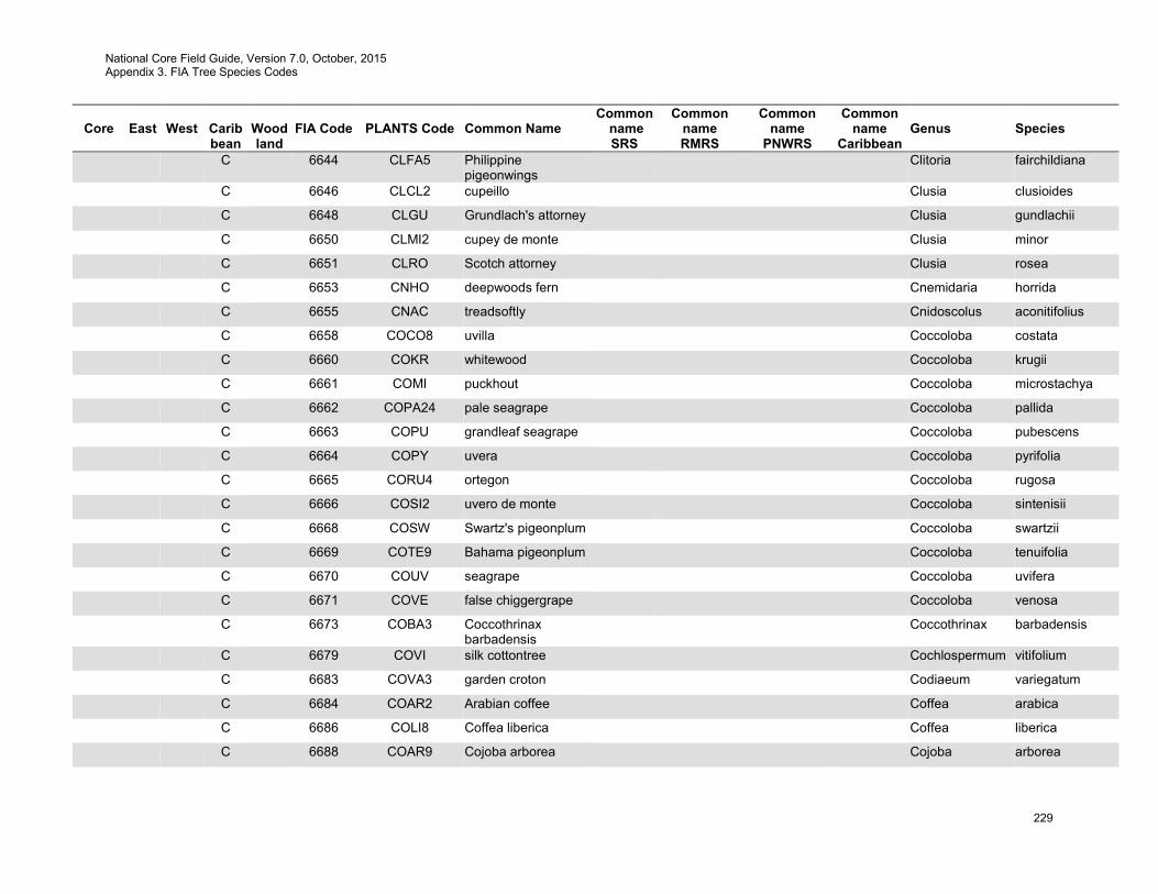
National Core Field Guide, Version 7.0, October, 2015 Appendix 3. FIA Tree Species Codes
229
Core
East
West
Carib bean
Wood land
FIA Code
PLANTS Code
Common Name
Common name SRS
Common name RMRS
Common name
PNWRS
Common name
Caribbean
Genus
Species
C 6644 CLFA5 Philippine pigeonwings
Clitoria fairchildiana
C 6646 CLCL2 cupeillo Clusia clusioides
C 6648 CLGU Grundlach's attorney Clusia gundlachii
C 6650 CLMI2 cupey de monte Clusia minor
C 6651 CLRO Scotch attorney Clusia rosea
C 6653 CNHO deepwoods fern Cnemidaria horrida
C 6655 CNAC treadsoftly Cnidoscolus aconitifolius
C 6658 COCO8 uvilla Coccoloba costata
C 6660 COKR whitewood Coccoloba krugii
C 6661 COMI puckhout Coccoloba microstachya
C 6662 COPA24 pale seagrape Coccoloba pallida
C 6663 COPU grandleaf seagrape Coccoloba pubescens
C 6664 COPY uvera Coccoloba pyrifolia
C 6665 CORU4 ortegon Coccoloba rugosa
C 6666 COSI2 uvero de monte Coccoloba sintenisii
C 6668 COSW Swartz's pigeonplum Coccoloba swartzii
C 6669 COTE9 Bahama pigeonplum Coccoloba tenuifolia
C 6670 COUV seagrape Coccoloba uvifera
C 6671 COVE false chiggergrape Coccoloba venosa
C 6673 COBA3 Coccothrinax barbadensis
Coccothrinax barbadensis
C 6679 COVI silk cottontree Cochlospermum vitifolium
C 6683 COVA3 garden croton Codiaeum variegatum
C 6684 COAR2 Arabian coffee Coffea arabica
C 6686 COLI8 Coffea liberica Coffea liberica
C 6688 COAR9 Cojoba arborea Cojoba arborea
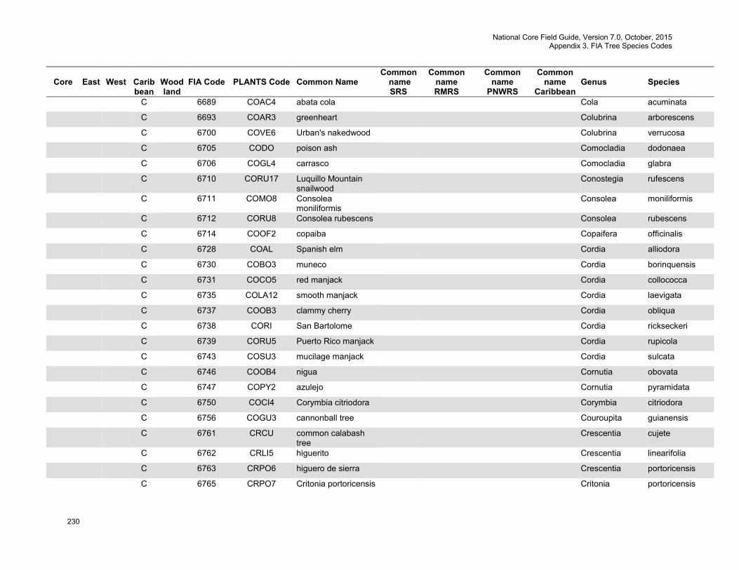
National Core Field Guide, Version 7.0, October, 2015 Appendix 3. FIA Tree Species Codes
230
Core
East
West
Carib bean
Wood land
FIA Code
PLANTS Code
Common Name
Common name SRS
Common name RMRS
Common name
PNWRS
Common name
Caribbean
Genus
Species
C 6689 COAC4 abata cola Cola acuminata
C 6693 COAR3 greenheart Colubrina arborescens
C 6700 COVE6 Urban's nakedwood Colubrina verrucosa
C 6705 CODO poison ash Comocladia dodonaea
C 6706 COGL4 carrasco Comocladia glabra
C 6710 CORU17 Luquillo Mountain snailwood
Conostegia rufescens
C 6711 COMO8 Consolea moniliformis
Consolea moniliformis
C 6712 CORU8 Consolea rubescens Consolea rubescens
C 6714 COOF2 copaiba Copaifera officinalis
C 6728 COAL Spanish elm Cordia alliodora
C 6730 COBO3 muneco Cordia borinquensis
C 6731 COCO5 red manjack Cordia collococca
C 6735 COLA12 smooth manjack Cordia laevigata
C 6737 COOB3 clammy cherry Cordia obliqua
C 6738 CORI San Bartolome Cordia rickseckeri
C 6739 CORU5 Puerto Rico manjack Cordia rupicola
C 6743 COSU3 mucilage manjack Cordia sulcata
C 6746 COOB4 nigua Cornutia obovata
C 6747 COPY2 azulejo Cornutia pyramidata
C 6750 COCI4 Corymbia citriodora Corymbia citriodora
C 6756 COGU3 cannonball tree Couroupita guianensis
C 6761 CRCU common calabash tree
Crescentia cujete
C 6762 CRLI5 higuerito Crescentia linearifolia
C 6763 CRPO6 higuero de sierra Crescentia portoricensis
C 6765 CRPO7 Critonia portoricensis Critonia portoricensis
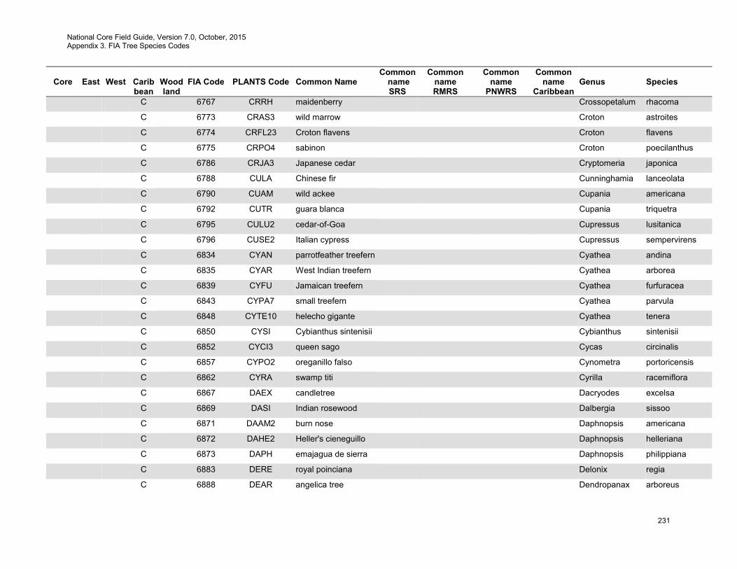
National Core Field Guide, Version 7.0, October, 2015 Appendix 3. FIA Tree Species Codes
231
Core
East
West
Carib bean
Wood land
FIA Code
PLANTS Code
Common Name
Common name SRS
Common name RMRS
Common name
PNWRS
Common name
Caribbean
Genus
Species
C 6767 CRRH maidenberry Crossopetalum rhacoma
C 6773 CRAS3 wild marrow Croton astroites
C 6774 CRFL23 Croton flavens Croton flavens
C 6775 CRPO4 sabinon Croton poecilanthus
C 6786 CRJA3 Japanese cedar Cryptomeria japonica
C 6788 CULA Chinese fir Cunninghamia lanceolata
C 6790 CUAM wild ackee Cupania americana
C 6792 CUTR guara blanca Cupania triquetra
C 6795 CULU2 cedar-of-Goa Cupressus lusitanica
C 6796 CUSE2 Italian cypress Cupressus sempervirens
C 6834 CYAN parrotfeather treefern Cyathea andina
C 6835 CYAR West Indian treefern Cyathea arborea
C 6839 CYFU Jamaican treefern Cyathea furfuracea
C 6843 CYPA7 small treefern Cyathea parvula
C 6848 CYTE10 helecho gigante Cyathea tenera
C 6850 CYSI Cybianthus sintenisii Cybianthus sintenisii
C 6852 CYCI3 queen sago Cycas circinalis
C 6857 CYPO2 oreganillo falso Cynometra portoricensis
C 6862 CYRA swamp titi Cyrilla racemiflora
C 6867 DAEX candletree Dacryodes excelsa
C 6869 DASI Indian rosewood Dalbergia sissoo
C 6871 DAAM2 burn nose Daphnopsis americana
C 6872 DAHE2 Heller's cieneguillo Daphnopsis helleriana
C 6873 DAPH emajagua de sierra Daphnopsis philippiana
C 6883 DERE royal poinciana Delonix regia
C 6888 DEAR angelica tree Dendropanax arboreus
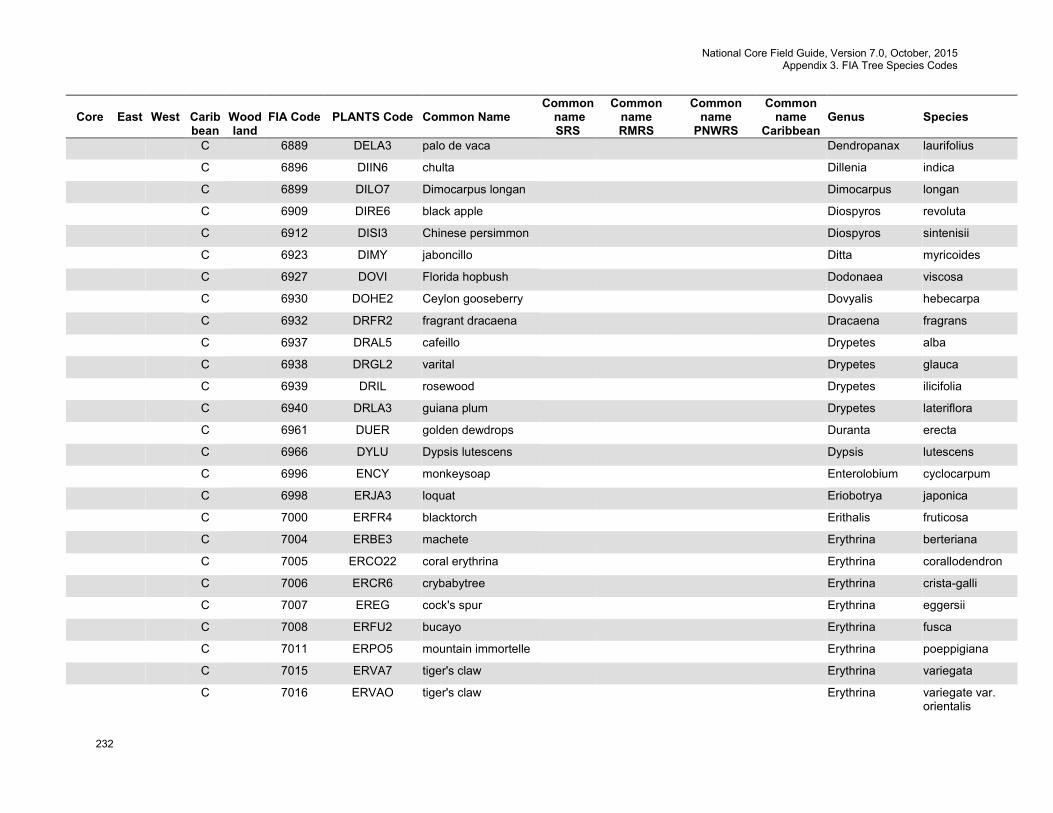
National Core Field Guide, Version 7.0, October, 2015 Appendix 3. FIA Tree Species Codes
232
Core
East
West
Carib bean
Wood land
FIA Code
PLANTS Code
Common Name
Common name SRS
Common name RMRS
Common name
PNWRS
Common name
Caribbean
Genus
Species
C 6889 DELA3 palo de vaca Dendropanax laurifolius
C 6896 DIIN6 chulta Dillenia indica
C 6899 DILO7 Dimocarpus longan Dimocarpus longan
C 6909 DIRE6 black apple Diospyros revoluta
C 6912 DISI3 Chinese persimmon Diospyros sintenisii
C 6923 DIMY jaboncillo Ditta myricoides
C 6927 DOVI Florida hopbush Dodonaea viscosa
C 6930 DOHE2 Ceylon gooseberry Dovyalis hebecarpa
C 6932 DRFR2 fragrant dracaena Dracaena fragrans
C 6937 DRAL5 cafeillo Drypetes alba
C 6938 DRGL2 varital Drypetes glauca
C 6939 DRIL rosewood Drypetes ilicifolia
C 6940 DRLA3 guiana plum Drypetes lateriflora
C 6961 DUER golden dewdrops Duranta erecta
C 6966 DYLU Dypsis lutescens Dypsis lutescens
C 6996 ENCY monkeysoap Enterolobium cyclocarpum
C 6998 ERJA3 loquat Eriobotrya japonica
C 7000 ERFR4 blacktorch Erithalis fruticosa
C 7004 ERBE3 machete Erythrina berteriana
C 7005 ERCO22 coral erythrina Erythrina corallodendron
C 7006 ERCR6 crybabytree Erythrina crista-galli
C 7007 EREG cock's spur Erythrina eggersii
C 7008 ERFU2 bucayo Erythrina fusca
C 7011 ERPO5 mountain immortelle Erythrina poeppigiana
C 7015 ERVA7 tiger's claw Erythrina variegata
C 7016 ERVAO tiger's claw Erythrina variegate var. orientalis
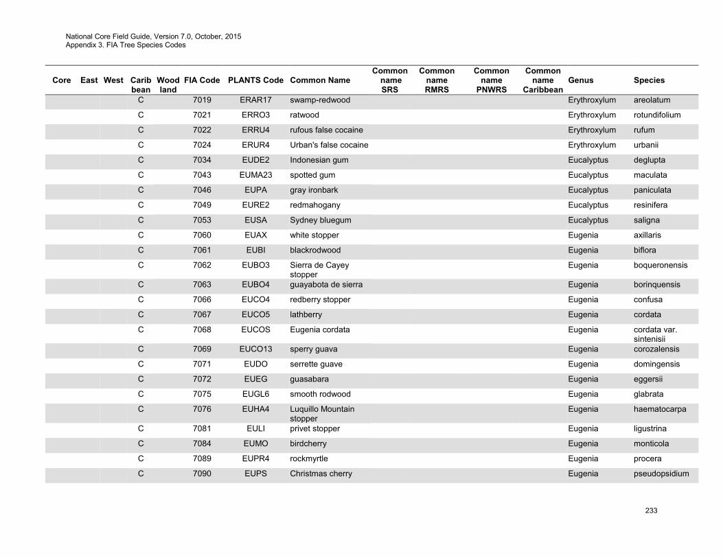
National Core Field Guide, Version 7.0, October, 2015 Appendix 3. FIA Tree Species Codes
233
Core
East
West
Carib bean
Wood land
FIA Code
PLANTS Code
Common Name
Common name SRS
Common name RMRS
Common name
PNWRS
Common name
Caribbean
Genus
Species
C 7019 ERAR17 swamp-redwood Erythroxylum areolatum
C 7021 ERRO3 ratwood Erythroxylum rotundifolium
C 7022 ERRU4 rufous false cocaine Erythroxylum rufum
C 7024 ERUR4 Urban's false cocaine Erythroxylum urbanii
C 7034 EUDE2 Indonesian gum Eucalyptus deglupta
C 7043 EUMA23 spotted gum Eucalyptus maculata
C 7046 EUPA gray ironbark Eucalyptus paniculata
C 7049 EURE2 redmahogany Eucalyptus resinifera
C 7053 EUSA Sydney bluegum Eucalyptus saligna
C 7060 EUAX white stopper Eugenia axillaris
C 7061 EUBI blackrodwood Eugenia biflora
C 7062 EUBO3 Sierra de Cayey stopper
Eugenia boqueronensis
C 7063 EUBO4 guayabota de sierra Eugenia borinquensis
C 7066 EUCO4 redberry stopper Eugenia confusa
C 7067 EUCO5 lathberry Eugenia cordata
C 7068 EUCOS Eugenia cordata Eugenia cordata var. sintenisii
C 7069 EUCO13 sperry guava Eugenia corozalensis
C 7071 EUDO serrette guave Eugenia domingensis
C 7072 EUEG guasabara Eugenia eggersii
C 7075 EUGL6 smooth rodwood Eugenia glabrata
C 7076 EUHA4 Luquillo Mountain stopper
Eugenia haematocarpa
C 7081 EULI privet stopper Eugenia ligustrina
C 7084 EUMO birdcherry Eugenia monticola
C 7089 EUPR4 rockmyrtle Eugenia procera
C 7090 EUPS Christmas cherry Eugenia pseudopsidium
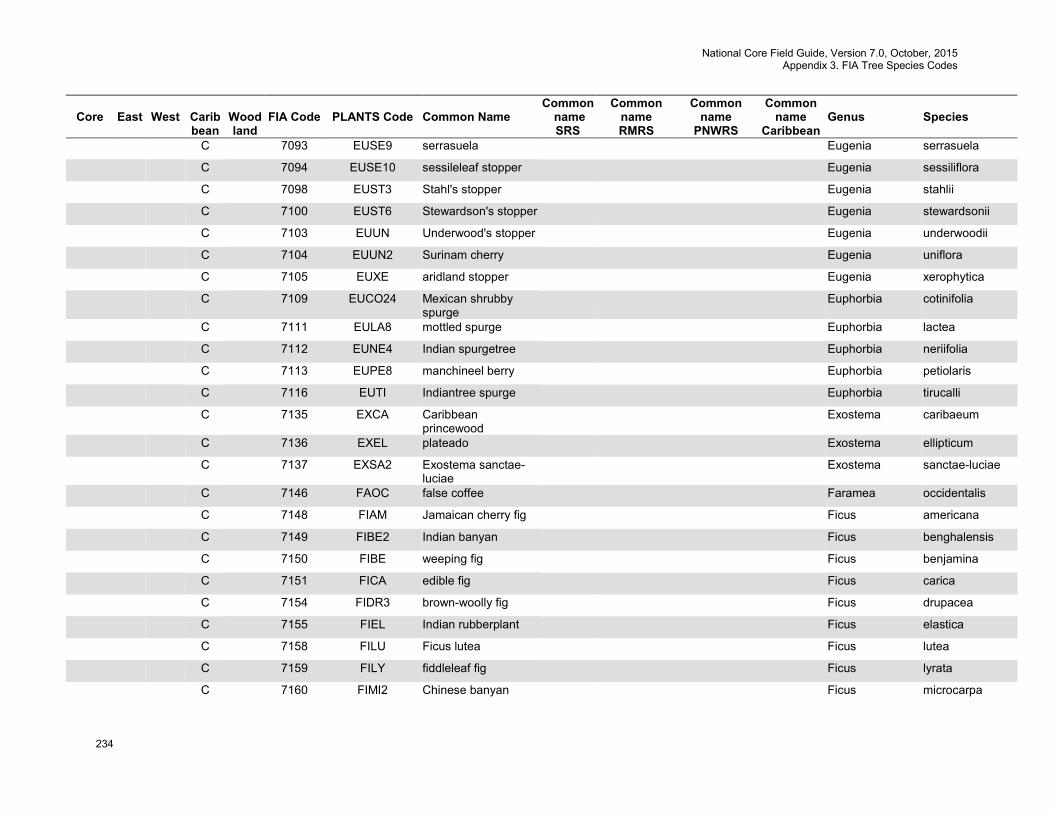
National Core Field Guide, Version 7.0, October, 2015 Appendix 3. FIA Tree Species Codes
234
Core
East
West
Carib bean
Wood land
FIA Code
PLANTS Code
Common Name
Common name SRS
Common name RMRS
Common name
PNWRS
Common name
Caribbean
Genus
Species
C 7093 EUSE9 serrasuela Eugenia serrasuela
C 7094 EUSE10 sessileleaf stopper Eugenia sessiliflora
C 7098 EUST3 Stahl's stopper Eugenia stahlii
C 7100 EUST6 Stewardson's stopper Eugenia stewardsonii
C 7103 EUUN Underwood's stopper Eugenia underwoodii
C 7104 EUUN2 Surinam cherry Eugenia uniflora
C 7105 EUXE aridland stopper Eugenia xerophytica
C 7109 EUCO24 Mexican shrubby spurge
Euphorbia cotinifolia
C 7111 EULA8 mottled spurge Euphorbia lactea
C 7112 EUNE4 Indian spurgetree Euphorbia neriifolia
C 7113 EUPE8 manchineel berry Euphorbia petiolaris
C 7116 EUTI Indiantree spurge Euphorbia tirucalli
C 7135 EXCA Caribbean princewood
Exostema caribaeum
C 7136 EXEL plateado Exostema ellipticum
C 7137 EXSA2 Exostema sanctae-luciae
Exostema sanctae-luciae
C 7146 FAOC false coffee Faramea occidentalis
C 7148 FIAM Jamaican cherry fig Ficus americana
C 7149 FIBE2 Indian banyan Ficus benghalensis
C 7150 FIBE weeping fig Ficus benjamina
C 7151 FICA edible fig Ficus carica
C 7154 FIDR3 brown-woolly fig Ficus drupacea
C 7155 FIEL Indian rubberplant Ficus elastica
C 7158 FILU Ficus lutea Ficus lutea
C 7159 FILY fiddleleaf fig Ficus lyrata
C 7160 FIMI2 Chinese banyan Ficus microcarpa
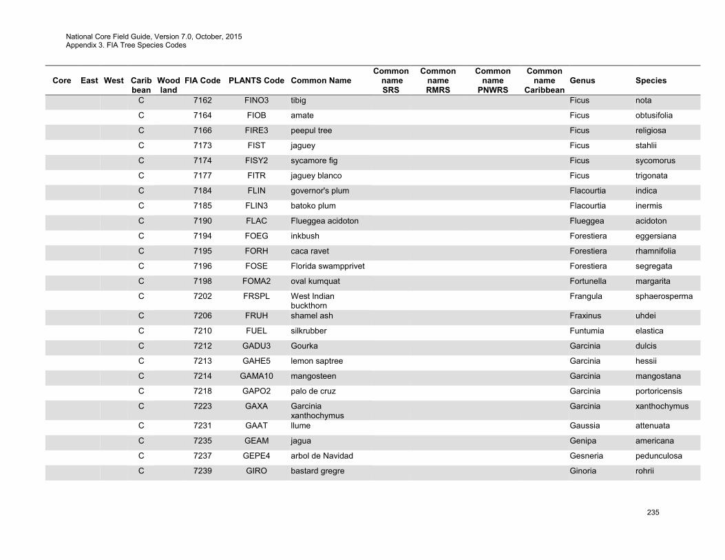
National Core Field Guide, Version 7.0, October, 2015 Appendix 3. FIA Tree Species Codes
235
Core
East
West
Carib bean
Wood land
FIA Code
PLANTS Code
Common Name
Common name SRS
Common name RMRS
Common name
PNWRS
Common name
Caribbean
Genus
Species
C 7162 FINO3 tibig Ficus nota
C 7164 FIOB amate Ficus obtusifolia
C 7166 FIRE3 peepul tree Ficus religiosa
C 7173 FIST jaguey Ficus stahlii
C 7174 FISY2 sycamore fig Ficus sycomorus
C 7177 FITR jaguey blanco Ficus trigonata
C 7184 FLIN governor's plum Flacourtia indica
C 7185 FLIN3 batoko plum Flacourtia inermis
C 7190 FLAC Flueggea acidoton Flueggea acidoton
C 7194 FOEG inkbush Forestiera eggersiana
C 7195 FORH caca ravet Forestiera rhamnifolia
C 7196 FOSE Florida swampprivet Forestiera segregata
C 7198 FOMA2 oval kumquat Fortunella margarita
C 7202 FRSPL West Indian buckthorn
Frangula sphaerosperma
C 7206 FRUH shamel ash Fraxinus uhdei
C 7210 FUEL silkrubber Funtumia elastica
C 7212 GADU3 Gourka Garcinia dulcis
C 7213 GAHE5 lemon saptree Garcinia hessii
C 7214 GAMA10 mangosteen Garcinia mangostana
C 7218 GAPO2 palo de cruz Garcinia portoricensis
C 7223 GAXA Garcinia xanthochymus
Garcinia xanthochymus
C 7231 GAAT llume Gaussia attenuata
C 7235 GEAM jagua Genipa americana
C 7237 GEPE4 arbol de Navidad Gesneria pedunculosa
C 7239 GIRO bastard gregre Ginoria rohrii
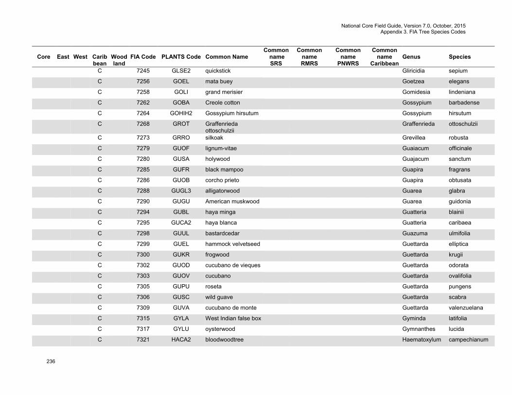
National Core Field Guide, Version 7.0, October, 2015 Appendix 3. FIA Tree Species Codes
236
Core
East
West
Carib bean
Wood land
FIA Code
PLANTS Code
Common Name
Common name SRS
Common name RMRS
Common name
PNWRS
Common name
Caribbean
Genus
Species
C 7245 GLSE2 quickstick Gliricidia sepium
C 7256 GOEL mata buey Goetzea elegans
C 7258 GOLI grand merisier Gomidesia lindeniana
C 7262 GOBA Creole cotton Gossypium barbadense
C 7264 GOHIH2 Gossypium hirsutum Gossypium hirsutum
C 7268 GROT Graffenrieda ottoschulzii
Graffenrieda ottoschulzii
C 7273 GRRO silkoak Grevillea robusta
C 7279 GUOF lignum-vitae Guaiacum officinale
C 7280 GUSA holywood Guajacum sanctum
C 7285 GUFR black mampoo Guapira fragrans
C 7286 GUOB corcho prieto Guapira obtusata
C 7288 GUGL3 alligatorwood Guarea glabra
C 7290 GUGU American muskwood Guarea guidonia
C 7294 GUBL haya minga Guatteria blainii
C 7295 GUCA2 haya blanca Guatteria caribaea
C 7298 GUUL bastardcedar Guazuma ulmifolia
C 7299 GUEL hammock velvetseed Guettarda elliptica
C 7300 GUKR frogwood Guettarda krugii
C 7302 GUOD cucubano de vieques Guettarda odorata
C 7303 GUOV cucubano Guettarda ovalifolia
C 7305 GUPU roseta Guettarda pungens
C 7306 GUSC wild guave Guettarda scabra
C 7309 GUVA cucubano de monte Guettarda valenzuelana
C 7315 GYLA West Indian false box Gyminda latifolia
C 7317 GYLU oysterwood Gymnanthes lucida
C 7321 HACA2 bloodwoodtree Haematoxylum campechianum
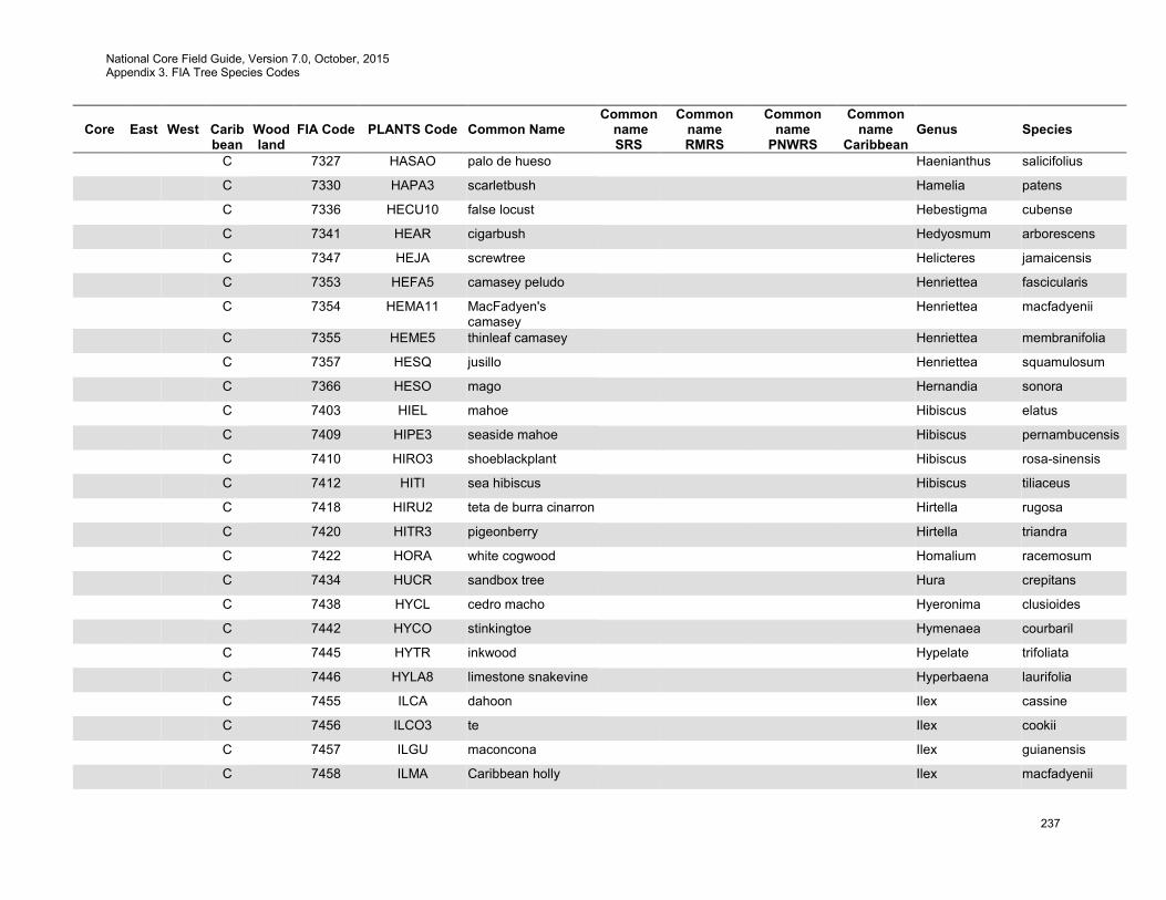
National Core Field Guide, Version 7.0, October, 2015 Appendix 3. FIA Tree Species Codes
237
Core
East
West
Carib bean
Wood land
FIA Code
PLANTS Code
Common Name
Common name SRS
Common name RMRS
Common name
PNWRS
Common name
Caribbean
Genus
Species
C 7327 HASAO palo de hueso Haenianthus salicifolius
C 7330 HAPA3 scarletbush Hamelia patens
C 7336 HECU10 false locust Hebestigma cubense
C 7341 HEAR cigarbush Hedyosmum arborescens
C 7347 HEJA screwtree Helicteres jamaicensis
C 7353 HEFA5 camasey peludo Henriettea fascicularis
C 7354 HEMA11 MacFadyen's camasey
Henriettea macfadyenii
C 7355 HEME5 thinleaf camasey Henriettea membranifolia
C 7357 HESQ jusillo Henriettea squamulosum
C 7366 HESO mago Hernandia sonora
C 7403 HIEL mahoe Hibiscus elatus
C 7409 HIPE3 seaside mahoe Hibiscus pernambucensis
C 7410 HIRO3 shoeblackplant Hibiscus rosa-sinensis
C 7412 HITI sea hibiscus Hibiscus tiliaceus
C 7418 HIRU2 teta de burra cinarron Hirtella rugosa
C 7420 HITR3 pigeonberry Hirtella triandra
C 7422 HORA white cogwood Homalium racemosum
C 7434 HUCR sandbox tree Hura crepitans
C 7438 HYCL cedro macho Hyeronima clusioides
C 7442 HYCO stinkingtoe Hymenaea courbaril
C 7445 HYTR inkwood Hypelate trifoliata
C 7446 HYLA8 limestone snakevine Hyperbaena laurifolia
C 7455 ILCA dahoon Ilex cassine
C 7456 ILCO3 te Ilex cookii
C 7457 ILGU maconcona Ilex guianensis
C 7458 ILMA Caribbean holly Ilex macfadyenii
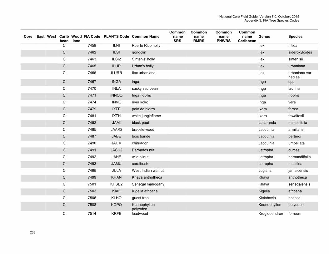
National Core Field Guide, Version 7.0, October, 2015 Appendix 3. FIA Tree Species Codes
238
Core
East
West
Carib bean
Wood land
FIA Code
PLANTS Code
Common Name
Common name SRS
Common name RMRS
Common name
PNWRS
Common name
Caribbean
Genus
Species
C 7459 ILNI Puerto Rico holly Ilex nitida
C 7462 ILSI gongolin Ilex sideroxyloides
C 7463 ILSI2 Sintenis' holly Ilex sintenisii
C 7465 ILUR Urban's holly Ilex urbaniana
C 7466 ILURR Ilex urbaniana Ilex urbaniana var. riedlaei
C 7467 INGA inga Inga spp.
C 7470 INLA sacky sac bean Inga laurina
C 7471 INNOQ Inga nobilis Inga nobilis
C 7474 INVE river koko Inga vera
C 7479 IXFE palo de hierro Ixora ferrea
C 7481 IXTH white jungleflame Ixora thwaitesii
C 7482 JAMI black poui Jacaranda mimosifolia
C 7485 JAAR2 braceletwood Jacquinia armillaris
C 7487 JABE bois bande Jacquinia berteroi
C 7490 JAUM chirriador Jacquinia umbellata
C 7491 JACU2 Barbados nut Jatropha curcas
C 7492 JAHE wild oilnut Jatropha hernandiifolia
C 7493 JAMU coralbush Jatropha multifida
C 7495 JUJA West Indian walnut Juglans jamaicensis
C 7499 KHAN Khaya anthotheca Khaya anthotheca
C 7501 KHSE2 Senegal mahogany Khaya senegalensis
C 7503 KIAF Kigelia africana Kigelia africana
C 7506 KLHO guest tree Kleinhovia hospita
C 7508 KOPO Koanophyllon polyodon
Koanophyllon polyodon
C 7514 KRFE leadwood Krugiodendron ferreum
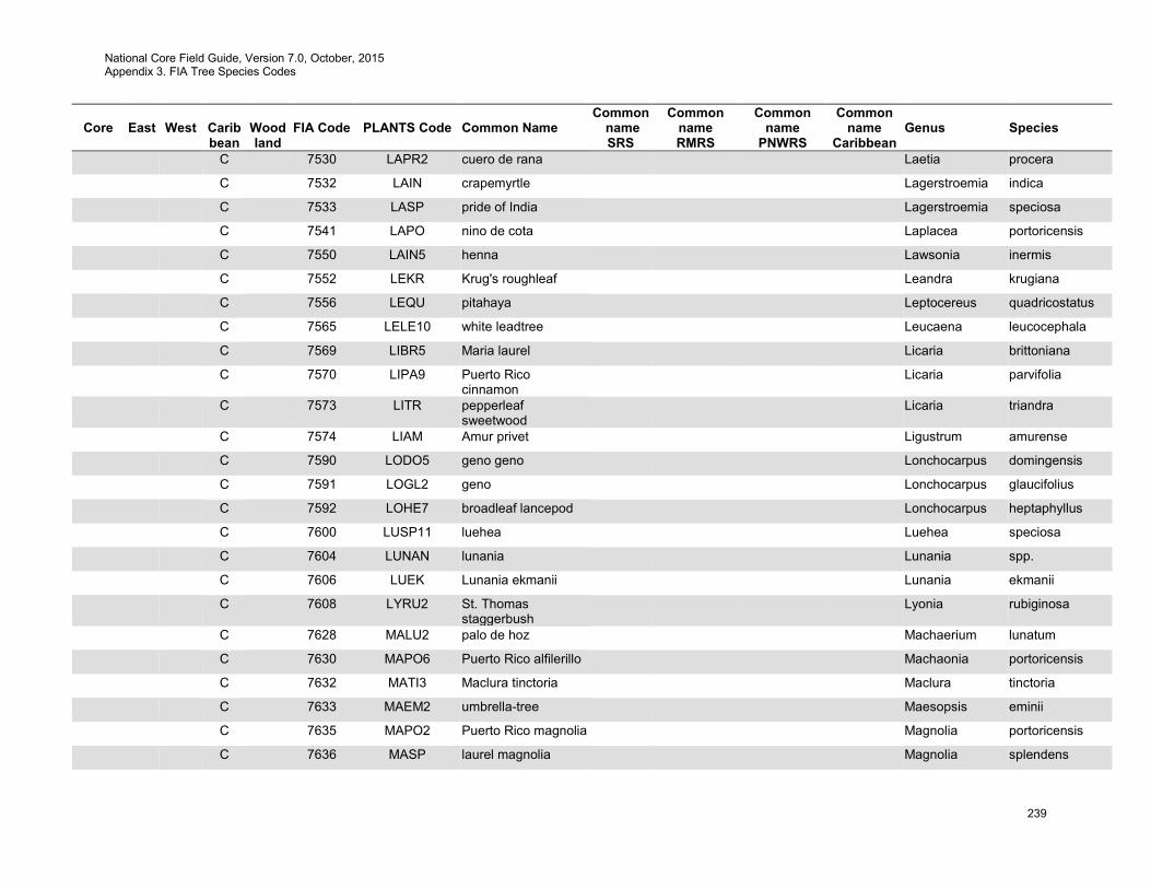
National Core Field Guide, Version 7.0, October, 2015 Appendix 3. FIA Tree Species Codes
239
Core
East
West
Carib bean
Wood land
FIA Code
PLANTS Code
Common Name
Common name SRS
Common name RMRS
Common name
PNWRS
Common name
Caribbean
Genus
Species
C 7530 LAPR2 cuero de rana Laetia procera
C 7532 LAIN crapemyrtle Lagerstroemia indica
C 7533 LASP pride of India Lagerstroemia speciosa
C 7541 LAPO nino de cota Laplacea portoricensis
C 7550 LAIN5 henna Lawsonia inermis
C 7552 LEKR Krug's roughleaf Leandra krugiana
C 7556 LEQU pitahaya Leptocereus quadricostatus
C 7565 LELE10 white leadtree Leucaena leucocephala
C 7569 LIBR5 Maria laurel Licaria brittoniana
C 7570 LIPA9 Puerto Rico cinnamon
Licaria parvifolia
C 7573 LITR pepperleaf sweetwood
Licaria triandra
C 7574 LIAM Amur privet Ligustrum amurense
C 7590 LODO5 geno geno Lonchocarpus domingensis
C 7591 LOGL2 geno Lonchocarpus glaucifolius
C 7592 LOHE7 broadleaf lancepod Lonchocarpus heptaphyllus
C 7600 LUSP11 luehea Luehea speciosa
C 7604 LUNAN lunania Lunania spp.
C 7606 LUEK Lunania ekmanii Lunania ekmanii
C 7608 LYRU2 St. Thomas staggerbush
Lyonia rubiginosa
C 7628 MALU2 palo de hoz Machaerium lunatum
C 7630 MAPO6 Puerto Rico alfilerillo Machaonia portoricensis
C 7632 MATI3 Maclura tinctoria Maclura tinctoria
C 7633 MAEM2 umbrella-tree Maesopsis eminii
C 7635 MAPO2 Puerto Rico magnolia Magnolia portoricensis
C 7636 MASP laurel magnolia Magnolia splendens
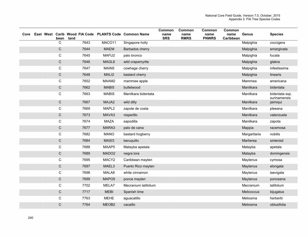
National Core Field Guide, Version 7.0, October, 2015 Appendix 3. FIA Tree Species Codes
240
Core
East
West
Carib bean
Wood land
FIA Code
PLANTS Code
Common Name
Common name SRS
Common name RMRS
Common name
PNWRS
Common name
Caribbean
Genus
Species
C 7643 MACO11 Singapore holly Malpighia coccigera
C 7644 MAEM Barbados cherry Malpighia emarginata
C 7645 MAFU2 palo bronco Malpighia fucata
C 7646 MAGL6 wild crapemyrtle Malpighia glabra
C 7647 MAIN5 cowhage cherry Malpighia infestissima
C 7648 MALI2 bastard cherry Malpighia linearis
C 7652 MAAM2 mammee apple Mammea americana
C 7662 MABI5 bulletwood Manilkara bidentata
C 7663 MABIS Manilkara bidentata Manilkara bidentata ssp. surinamensis
C 7667 MAJA2 wild dilly Manilkara jaimiqui
C 7669 MAPL2 zapote de costa Manilkara pleeana
C 7673 MAVA3 nisperillo Manilkara valenzuela
C 7674 MAZA sapodilla Manilkara zapota
C 7677 MARA3 palo de cana Mappia racemosa
C 7682 MANO bastard hogberry Margaritaria nobilis
C 7684 MASI3 beruquillo Marlierea sintenisii
C 7688 MAAP5 Matayba apetala Matayba apetala
C 7689 MADO2 negra lora Matayba domingensis
C 7695 MACY2 Caribbean mayten Maytenus cymosa
C 7697 MAEL3 Puerto Rico mayten Maytenus elongata
C 7698 MALA8 white cinnamon Maytenus laevigata
C 7699 MAPO5 ponce mayten Maytenus ponceana
C 7702 MELA7 Mecranium latifolium Mecranium latifolium
C 7717 MEBI Spanish lime Melicoccus bijugatus
C 7763 MEHE aguacatillo Meliosma herbertii
C 7764 MEOB2 cacaillo Meliosma obtusifolia
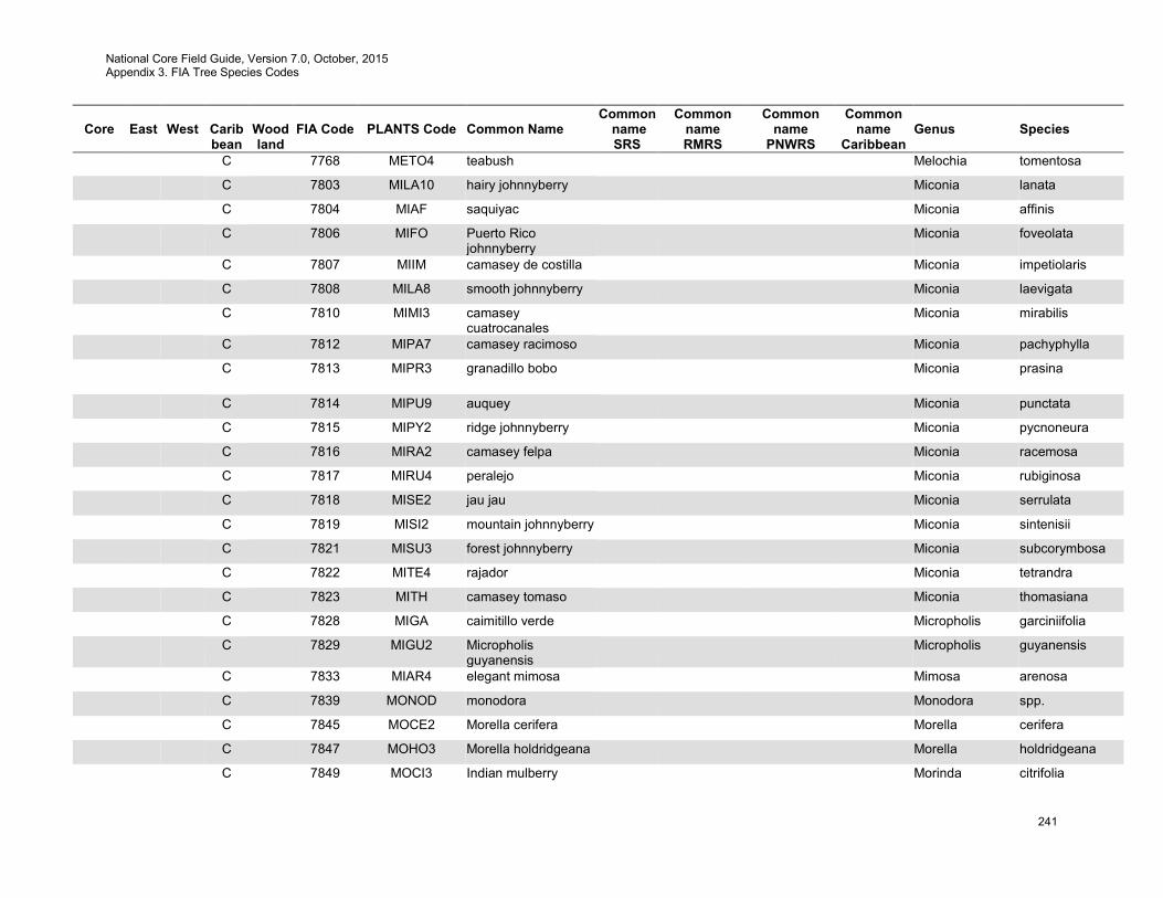
National Core Field Guide, Version 7.0, October, 2015 Appendix 3. FIA Tree Species Codes
241
Core
East
West
Carib bean
Wood land
FIA Code
PLANTS Code
Common Name
Common name SRS
Common name RMRS
Common name
PNWRS
Common name
Caribbean
Genus
Species
C 7768 METO4 teabush Melochia tomentosa
C 7803 MILA10 hairy johnnyberry Miconia lanata
C 7804 MIAF saquiyac Miconia affinis
C 7806 MIFO Puerto Rico johnnyberry
Miconia foveolata
C 7807 MIIM camasey de costilla Miconia impetiolaris
C 7808 MILA8 smooth johnnyberry Miconia laevigata
C 7810 MIMI3 camasey cuatrocanales
Miconia mirabilis
C 7812 MIPA7 camasey racimoso Miconia pachyphylla
C 7813 MIPR3 granadillo bobo Miconia prasina
C 7814 MIPU9 auquey Miconia punctata
C 7815 MIPY2 ridge johnnyberry Miconia pycnoneura
C 7816 MIRA2 camasey felpa Miconia racemosa
C 7817 MIRU4 peralejo Miconia rubiginosa
C 7818 MISE2 jau jau Miconia serrulata
C 7819 MISI2 mountain johnnyberry Miconia sintenisii
C 7821 MISU3 forest johnnyberry Miconia subcorymbosa
C 7822 MITE4 rajador Miconia tetrandra
C 7823 MITH camasey tomaso Miconia thomasiana
C 7828 MIGA caimitillo verde Micropholis garciniifolia
C 7829 MIGU2 Micropholis guyanensis
Micropholis guyanensis
C 7833 MIAR4 elegant mimosa Mimosa arenosa
C 7839 MONOD monodora Monodora spp.
C 7845 MOCE2 Morella cerifera Morella cerifera
C 7847 MOHO3 Morella holdridgeana Morella holdridgeana
C 7849 MOCI3 Indian mulberry Morinda citrifolia
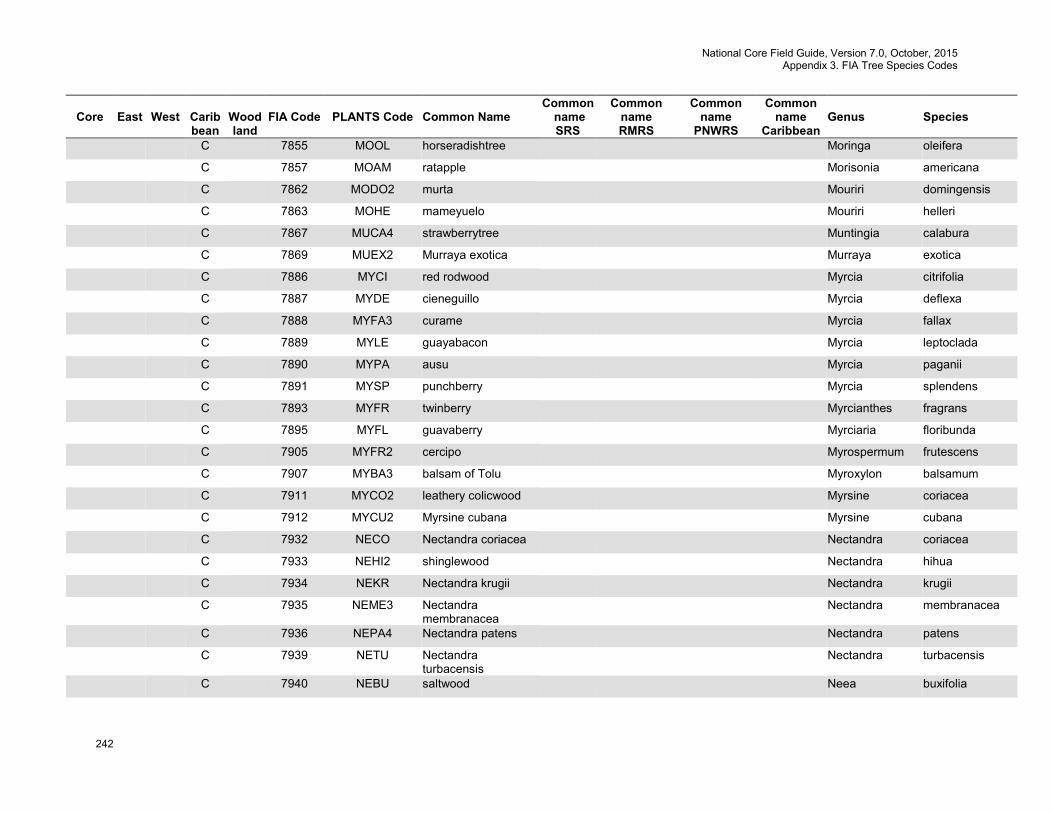
National Core Field Guide, Version 7.0, October, 2015 Appendix 3. FIA Tree Species Codes
242
Core
East
West
Carib bean
Wood land
FIA Code
PLANTS Code
Common Name
Common name SRS
Common name RMRS
Common name
PNWRS
Common name
Caribbean
Genus
Species
C 7855 MOOL horseradishtree Moringa oleifera
C 7857 MOAM ratapple Morisonia americana
C 7862 MODO2 murta Mouriri domingensis
C 7863 MOHE mameyuelo Mouriri helleri
C 7867 MUCA4 strawberrytree Muntingia calabura
C 7869 MUEX2 Murraya exotica Murraya exotica
C 7886 MYCI red rodwood Myrcia citrifolia
C 7887 MYDE cieneguillo Myrcia deflexa
C 7888 MYFA3 curame Myrcia fallax
C 7889 MYLE guayabacon Myrcia leptoclada
C 7890 MYPA ausu Myrcia paganii
C 7891 MYSP punchberry Myrcia splendens
C 7893 MYFR twinberry Myrcianthes fragrans
C 7895 MYFL guavaberry Myrciaria floribunda
C 7905 MYFR2 cercipo Myrospermum frutescens
C 7907 MYBA3 balsam of Tolu Myroxylon balsamum
C 7911 MYCO2 leathery colicwood Myrsine coriacea
C 7912 MYCU2 Myrsine cubana Myrsine cubana
C 7932 NECO Nectandra coriacea Nectandra coriacea
C 7933 NEHI2 shinglewood Nectandra hihua
C 7934 NEKR Nectandra krugii Nectandra krugii
C 7935 NEME3 Nectandra membranacea
Nectandra membranacea
C 7936 NEPA4 Nectandra patens Nectandra patens
C 7939 NETU Nectandra turbacensis
Nectandra turbacensis
C 7940 NEBU saltwood Neea buxifolia

National Core Field Guide, Version 7.0, October, 2015 Appendix 3. FIA Tree Species Codes
243
Core
East
West
Carib bean
Wood land
FIA Code
PLANTS Code
Common Name
Common name SRS
Common name RMRS
Common name
PNWRS
Common name
Caribbean
Genus
Species
C 7944 NECA7 kadam Neolamarckia cadamba
C 7946 NERE2 aquilon Neolaugeria resinosa
C 7956 NEOL oleander Nerium oleander
C 7976 OCMO4 African bird's-eye bush
Ochna mossambicensis
C 7980 OCPY Ochroma pyramidale Ochroma pyramidale
C 7990 OCFL laurel espada Ocotea floribunda
C 7991 OCFO black sweetwood Ocotea foeniculacea
C 7994 OCLE loblolly sweetwood Ocotea leucoxylon
C 7996 OCMO nemoca Ocotea moschata
C 7997 OCNE laurel sassafras Ocotea nemodaphne
C 7999 OCPO laurel de paloma Ocotea portoricensis
C 8001 OCSP nemoca cimarrona Ocotea spathulata
C 8003 OCWR Wright's laurel canelon
Ocotea wrightii
C 8020 ORKR peronia Ormosia krugii
C 8027 OTRH pincho palo de rosa Ottoschulzia rhodoxylon
C 8029 OUIL chicharron amarillo Ouratea ilicifolia
C 8030 OULI abey amarillo Ouratea littoralis
C 8032 OUST guanabanilla Ouratea striata
C 8033 OXLA4 blacklancewood Oxandra lanceolata
C 8034 OXLA5 haya Oxandra laurifolia
C 8037 PAIN7 wild chestnut Pachira insignis
C 8045 PAAL9 tafetan Palicourea alpina
C 8047 PACR3 red cappel Palicourea crocea
C 8049 PACR18 Palicourea croceoides
Palicourea croceoides
C 8051 PAGU showy cappel Palicourea guianensis
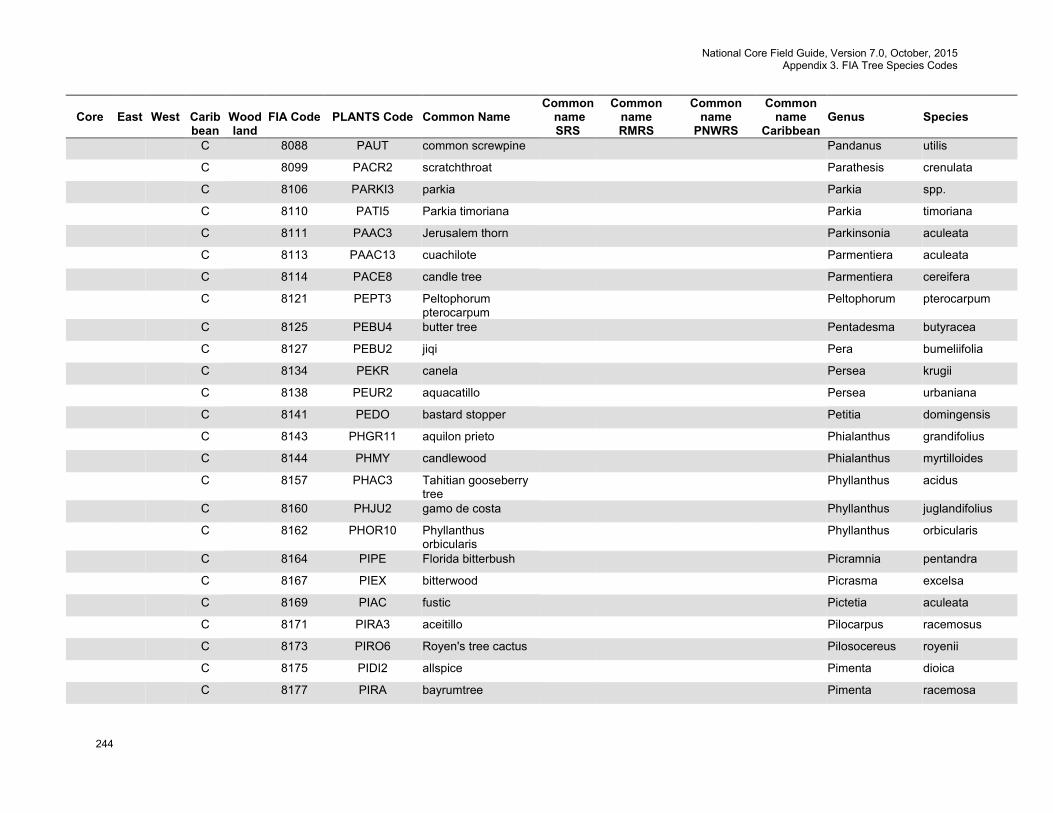
National Core Field Guide, Version 7.0, October, 2015 Appendix 3. FIA Tree Species Codes
244
Core
East
West
Carib bean
Wood land
FIA Code
PLANTS Code
Common Name
Common name SRS
Common name RMRS
Common name
PNWRS
Common name
Caribbean
Genus
Species
C 8088 PAUT common screwpine Pandanus utilis
C 8099 PACR2 scratchthroat Parathesis crenulata
C 8106 PARKI3 parkia Parkia spp.
C 8110 PATI5 Parkia timoriana Parkia timoriana
C 8111 PAAC3 Jerusalem thorn Parkinsonia aculeata
C 8113 PAAC13 cuachilote Parmentiera aculeata
C 8114 PACE8 candle tree Parmentiera cereifera
C 8121 PEPT3 Peltophorum pterocarpum
Peltophorum pterocarpum
C 8125 PEBU4 butter tree Pentadesma butyracea
C 8127 PEBU2 jiqi Pera bumeliifolia
C 8134 PEKR canela Persea krugii
C 8138 PEUR2 aquacatillo Persea urbaniana
C 8141 PEDO bastard stopper Petitia domingensis
C 8143 PHGR11 aquilon prieto Phialanthus grandifolius
C 8144 PHMY candlewood Phialanthus myrtilloides
C 8157 PHAC3 Tahitian gooseberry tree
Phyllanthus acidus
C 8160 PHJU2 gamo de costa Phyllanthus juglandifolius
C 8162 PHOR10 Phyllanthus orbicularis
Phyllanthus orbicularis
C 8164 PIPE Florida bitterbush Picramnia pentandra
C 8167 PIEX bitterwood Picrasma excelsa
C 8169 PIAC fustic Pictetia aculeata
C 8171 PIRA3 aceitillo Pilocarpus racemosus
C 8173 PIRO6 Royen's tree cactus Pilosocereus royenii
C 8175 PIDI2 allspice Pimenta dioica
C 8177 PIRA bayrumtree Pimenta racemosa
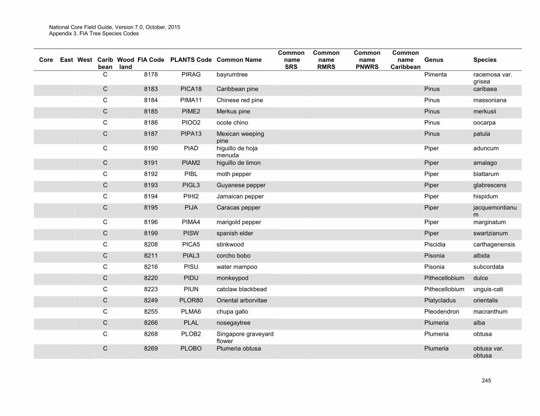
National Core Field Guide, Version 7.0, October, 2015 Appendix 3. FIA Tree Species Codes
245
Core
East
West
Carib bean
Wood land
FIA Code
PLANTS Code
Common Name
Common name SRS
Common name RMRS
Common name
PNWRS
Common name
Caribbean
Genus
Species
C 8178 PIRAG bayrumtree Pimenta racemosa var. grisea
C 8183 PICA18 Caribbean pine Pinus caribaea
C 8184 PIMA11 Chinese red pine Pinus massoniana
C 8185 PIME2 Merkus pine Pinus merkusii
C 8186 PIOO2 ocote chino Pinus oocarpa
C 8187 PIPA13 Mexican weeping pine
Pinus patula
C 8190 PIAD higuillo de hoja menuda
Piper aduncum
C 8191 PIAM2 higuillo de limon Piper amalago
C 8192 PIBL moth pepper Piper blattarum
C 8193 PIGL3 Guyanese pepper Piper glabrescens
C 8194 PIHI2 Jamaican pepper Piper hispidum
C 8195 PIJA Caracas pepper Piper jacquemontianum
C 8196 PIMA4 marigold pepper Piper marginatum
C 8199 PISW spanish elder Piper swartzianum
C 8208 PICA5 stinkwood Piscidia carthagenensis
C 8211 PIAL3 corcho bobo Pisonia albida
C 8216 PISU water mampoo Pisonia subcordata
C 8220 PIDU monkeypod Pithecellobium dulce
C 8223 PIUN catclaw blackbead Pithecellobium unguis-cati
C 8249 PLOR80 Oriental arborvitae Platycladus orientalis
C 8255 PLMA6 chupa gallo Pleodendron macranthum
C 8266 PLAL nosegaytree Plumeria alba
C 8268 PLOB2 Singapore graveyard flower
Plumeria obtusa
C 8269 PLOBO Plumeria obtusa Plumeria obtusa var. obtusa
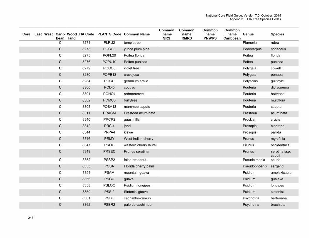
National Core Field Guide, Version 7.0, October, 2015 Appendix 3. FIA Tree Species Codes
246
Core
East
West
Carib bean
Wood land
FIA Code
PLANTS Code
Common Name
Common name SRS
Common name RMRS
Common name
PNWRS
Common name
Caribbean
Genus
Species
C 8271 PLRU2 templetree Plumeria rubra
C 8273 POCO3 yucca plum pine Podocarpus coriaceus
C 8275 POFL20 Poitea florida Poitea florida
C 8276 POPU19 Poitea punicea Poitea punicea
C 8279 POCO5 violet tree Polygala cowellii
C 8280 POPE13 crevajosa Polygala penaea
C 8284 POGU geranium aralia Polyscias guilfoylei
C 8300 PODI5 cocuyo Pouteria dictyoneura
C 8301 POHO4 redmammee Pouteria hotteana
C 8302 POMU6 bullytree Pouteria multiflora
C 8305 POSA13 mammee sapote Pouteria sapota
C 8311 PRACM Prestoea acuminata Prestoea acuminata
C 8340 PRCR2 guasimilla Prockia crucis
C 8342 PRCI4 jand Prosopis cineraria
C 8344 PRPA4 kiawe Prosopis pallida
C 8346 PRMY West Indian cherry Prunus myrtifolia
C 8347 PROC western cherry laurel Prunus occidentalis
C 8349 PRSEC Prunus serotina Prunus serotina ssp. capuli
C 8352 PSSP2 false breadnut Pseudolmedia spuria
C 8353 PSSA Florida cherry palm Pseudophoenix sargentii
C 8354 PSAM mountain guava Psidium amplexicaule
C 8356 PSGU guava Psidium guajava
C 8358 PSLOO Psidium longipes Psidium longipes
C 8359 PSSI2 Sintenis' guava Psidium sintenisii
C 8361 PSBE cachimbo-cumun Psychotria berteriana
C 8362 PSBR2 palo de cachimbo Psychotria brachiata
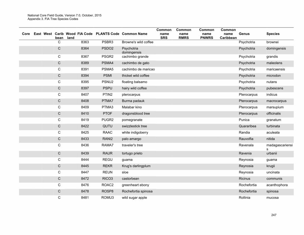
National Core Field Guide, Version 7.0, October, 2015 Appendix 3. FIA Tree Species Codes
247
Core
East
West
Carib bean
Wood land
FIA Code
PLANTS Code
Common Name
Common name SRS
Common name RMRS
Common name
PNWRS
Common name
Caribbean
Genus
Species
C 8363 PSBR3 Browne's wild coffee Psychotria brownei
C 8364 PSDO2 Psychotria domingensis
Psychotria domingensis
C 8367 PSGR2 cachimbo grande Psychotria grandis
C 8389 PSMA4 cachimbo de gato Psychotria maleolens
C 8391 PSMA5 cachimbo de maricao Psychotria maricaensis
C 8394 PSMI thicket wild coffee Psychotria microdon
C 8395 PSNU2 floating balsamo Psychotria nutans
C 8397 PSPU hairy wild coffee Psychotria pubescens
C 8407 PTIN2 pterocarpus Pterocarpus indicus
C 8408 PTMA7 Burma padauk Pterocarpus macrocarpus
C 8409 PTMA3 Malabar kino Pterocarpus marsupium
C 8410 PTOF dragonsblood tree Pterocarpus officinalis
C 8419 PUGR2 pomegranate Punica granatum
C 8422 QUTU swizzlestick tree Quararibea turbinata
C 8425 RAAC white indigoberry Randia aculeata
C 8433 RANI2 palo amargo Rauvolfia nitida
C 8436 RAMA7 traveler's tree Ravenala madagascariensis
C 8439 RAUR tortugo prieto Ravenia urbanii
C 8444 REGU guama Reynosia guama
C 8445 REKR Krug's darlingplum Reynosia krugii
C 8447 REUN sloe Reynosia uncinata
C 8472 RICO3 castorbean Ricinus communis
C 8476 ROAC2 greenheart ebony Rochefortia acanthophora
C 8478 ROSP8 Rochefortia spinosa Rochefortia spinosa
C 8481 ROMU3 wild sugar apple Rollinia mucosa

National Core Field Guide, Version 7.0, October, 2015 Appendix 3. FIA Tree Species Codes
248
Core
East
West
Carib bean
Wood land
FIA Code
PLANTS Code
Common Name
Common name SRS
Common name RMRS
Common name
PNWRS
Common name
Caribbean
Genus
Species
C 8483 ROIN4 cordobancillo Rondeletia inermis
C 8484 ROPI3 cordobancillo peludo Rondeletia pilosa
C 8485 ROPO Juan Tomas Rondeletia portoricensis
C 8489 ROBO Puerto Rico royal palm
Roystonea borinquena
C 8490 ROEL Roystonea elata Roystonea elata
C 8494 SACA Puerto Rico palmetto Sabal causiarum
C 8499 SAUM3 white hogwood Sagraea umbrosa
C 8501 SAHU Salix humboldtiana Salix humboldtiana
C 8505 SASA10 raintree Samanea saman
C 8509 SANIC4 common elderberry Sambucus nigra
C 8529 SASA4 wingleaf soapberry Sapindus saponaria
C 8533 SAGL5 gumtree Sapium glandulosum
C 8535 SALA25 hinchahuevos Sapium laurifolium
C 8536 SALA8 milktree Sapium laurocerasus
C 8546 SASE6 amansa guapo Savia sessiliflora
C 8554 SCFR Florida boxwood Schaefferia frutescens
C 8556 SADO7 guayabilla Samyda dodecandra
C 8557 SCGL6 yuquilla Schefflera gleasonii
C 8558 SCMO10 matchwood Schefflera morototonii
C 8563 SCTE Brazilian peppertree Schinus terebinthifolius
C 8565 SCPA23 Brazilian firetree Schizolobium parahybum
C 8567 SCOL3 lac tree Schleichera oleosa
C 8571 SCAR2 arana Schoepfia arenaria
C 8572 SCOB white beefwood Schoepfia obovata
C 8573 SCSC3 gulf graytwig Schoepfia schreberi
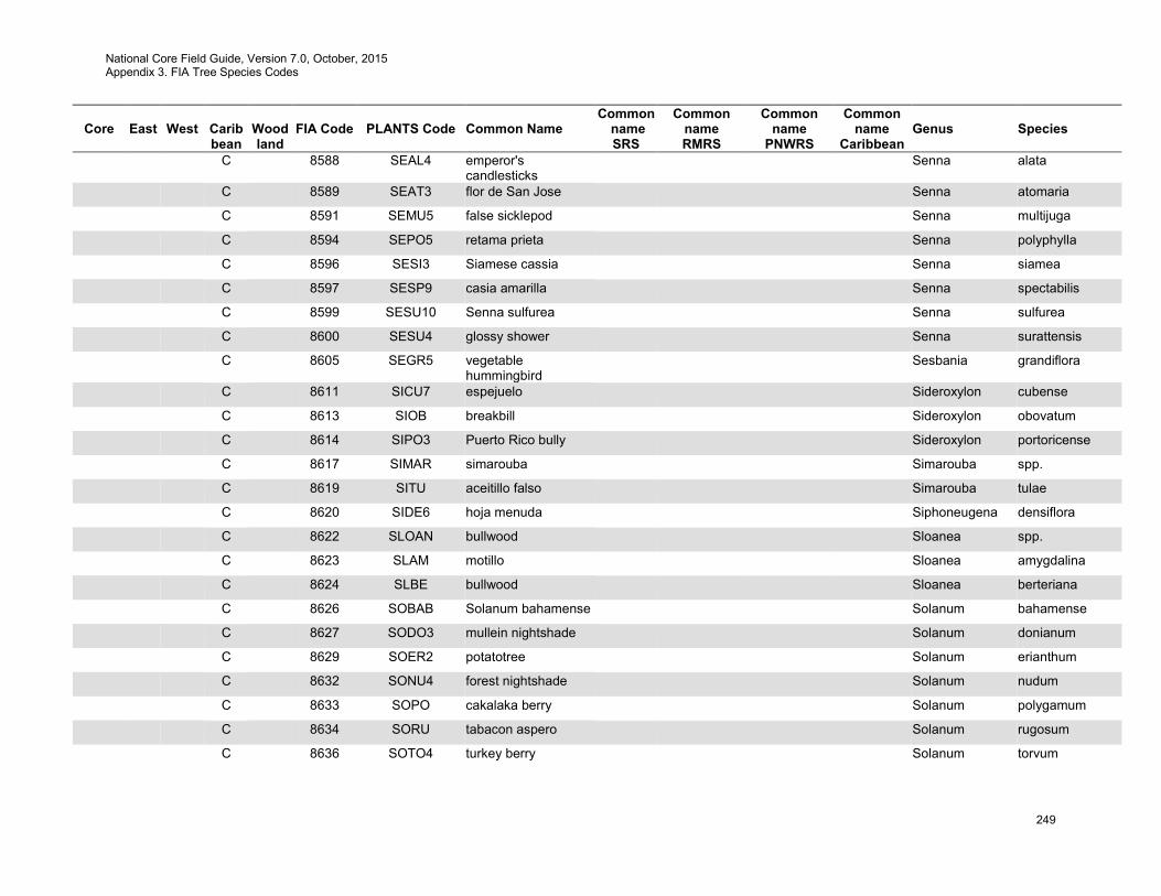
National Core Field Guide, Version 7.0, October, 2015 Appendix 3. FIA Tree Species Codes
249
Core
East
West
Carib bean
Wood land
FIA Code
PLANTS Code
Common Name
Common name SRS
Common name RMRS
Common name
PNWRS
Common name
Caribbean
Genus
Species
C 8588 SEAL4 emperor's candlesticks
Senna alata
C 8589 SEAT3 flor de San Jose Senna atomaria
C 8591 SEMU5 false sicklepod Senna multijuga
C 8594 SEPO5 retama prieta Senna polyphylla
C 8596 SESI3 Siamese cassia Senna siamea
C 8597 SESP9 casia amarilla Senna spectabilis
C 8599 SESU10 Senna sulfurea Senna sulfurea
C 8600 SESU4 glossy shower Senna surattensis
C 8605 SEGR5 vegetable hummingbird
Sesbania grandiflora
C 8611 SICU7 espejuelo Sideroxylon cubense
C 8613 SIOB breakbill Sideroxylon obovatum
C 8614 SIPO3 Puerto Rico bully Sideroxylon portoricense
C 8617 SIMAR simarouba Simarouba spp.
C 8619 SITU aceitillo falso Simarouba tulae
C 8620 SIDE6 hoja menuda Siphoneugena densiflora
C 8622 SLOAN bullwood Sloanea spp.
C 8623 SLAM motillo Sloanea amygdalina
C 8624 SLBE bullwood Sloanea berteriana
C 8626 SOBAB Solanum bahamense Solanum bahamense
C 8627 SODO3 mullein nightshade Solanum donianum
C 8629 SOER2 potatotree Solanum erianthum
C 8632 SONU4 forest nightshade Solanum nudum
C 8633 SOPO cakalaka berry Solanum polygamum
C 8634 SORU tabacon aspero Solanum rugosum
C 8636 SOTO4 turkey berry Solanum torvum

National Core Field Guide, Version 7.0, October, 2015 Appendix 3. FIA Tree Species Codes
250
Core
East
West
Carib bean
Wood land
FIA Code
PLANTS Code
Common Name
Common name SRS
Common name RMRS
Common name
PNWRS
Common name
Caribbean
Genus
Species
C 8644 SPCA2 African tuliptree Spathodea campanulata
C 8649 SPDU3 Spondias dulcis Spondias dulcis
C 8650 SPMO yellow mombin Spondias mombin
C 8652 SPPU purple mombin Spondias purpurea
C 8654 STMO cobana negra Stahlia monosperma
C 8664 STAP Panama tree Sterculia apetala
C 8666 STFO2 hazel sterculia Sterculia foetida
C 8674 STPO3 palo de jazmin Styrax portoricensis
C 8676 SUMA2 bay cedar Suriana maritima
C 8678 SWIET mahogany Swietenia spp.
C 8679 SWMA Honduras mahogany Swietenia macrophylla
C 8683 SYLA2 nispero cimarron Symplocos lanata
C 8684 SYMA Martinique sweetleaf Symplocos martinicensis
C 8685 SYMI3 aceitunilla Symplocos micrantha
C 8701 SYJA Syzygium jambos Syzygium jambos
C 8702 SYMA2 Malaysian apple Syzygium malaccense
C 8709 TACH3 roble amarillo Tabebuia chrysantha
C 8710 TADO2 primavera Tabebuia donnell-smithii
C 8712 TAHA roble cimarron Tabebuia haemantha
C 8713 TAHE white cedar Tabebuia heterophylla
C 8715 TARI roble de sierra Tabebuia rigida
C 8716 TARO pink trumpet-tree Tabebuia rosea
C 8717 TASC2 roble colorado Tabebuia schumanniana
C 8720 TACI milkwood Tabernaemontana
citrifolia
C 8727 TAAP Athel tamarisk Tamarix aphylla
C 8743 TEST yellow trumpetbush Tecoma stans
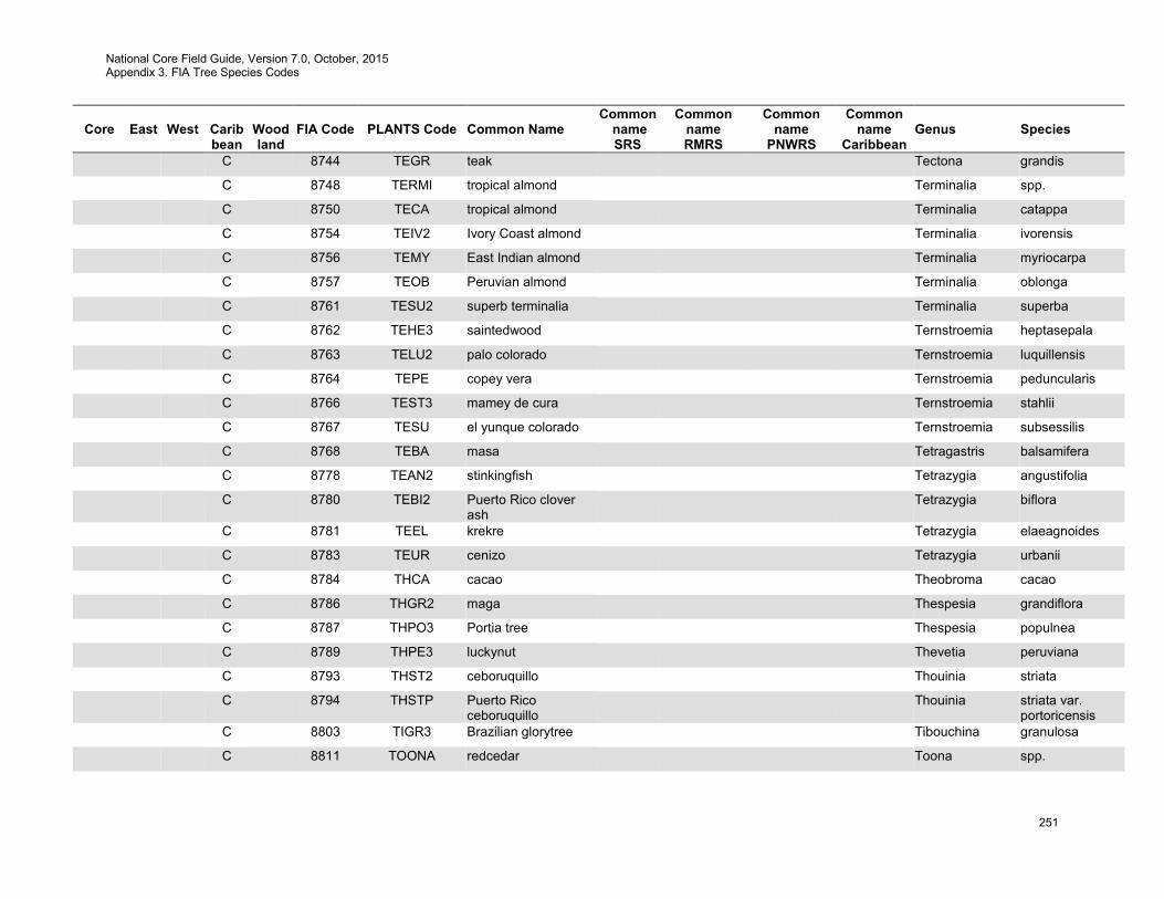
National Core Field Guide, Version 7.0, October, 2015 Appendix 3. FIA Tree Species Codes
251
Core
East
West
Carib bean
Wood land
FIA Code
PLANTS Code
Common Name
Common name SRS
Common name RMRS
Common name
PNWRS
Common name
Caribbean
Genus
Species
C 8744 TEGR teak Tectona grandis
C 8748 TERMI tropical almond Terminalia spp.
C 8750 TECA tropical almond Terminalia catappa
C 8754 TEIV2 Ivory Coast almond Terminalia ivorensis
C 8756 TEMY East Indian almond Terminalia myriocarpa
C 8757 TEOB Peruvian almond Terminalia oblonga
C 8761 TESU2 superb terminalia Terminalia superba
C 8762 TEHE3 saintedwood Ternstroemia heptasepala
C 8763 TELU2 palo colorado Ternstroemia luquillensis
C 8764 TEPE copey vera Ternstroemia peduncularis
C 8766 TEST3 mamey de cura Ternstroemia stahlii
C 8767 TESU el yunque colorado Ternstroemia subsessilis
C 8768 TEBA masa Tetragastris balsamifera
C 8778 TEAN2 stinkingfish Tetrazygia angustifolia
C 8780 TEBI2 Puerto Rico clover ash
Tetrazygia biflora
C 8781 TEEL krekre Tetrazygia elaeagnoides
C 8783 TEUR cenizo Tetrazygia urbanii
C 8784 THCA cacao Theobroma cacao
C 8786 THGR2 maga Thespesia grandiflora
C 8787 THPO3 Portia tree Thespesia populnea
C 8789 THPE3 luckynut Thevetia peruviana
C 8793 THST2 ceboruquillo Thouinia striata
C 8794 THSTP Puerto Rico ceboruquillo
Thouinia striata var. portoricensis
C 8803 TIGR3 Brazilian glorytree Tibouchina granulosa
C 8811 TOONA redcedar Toona spp.
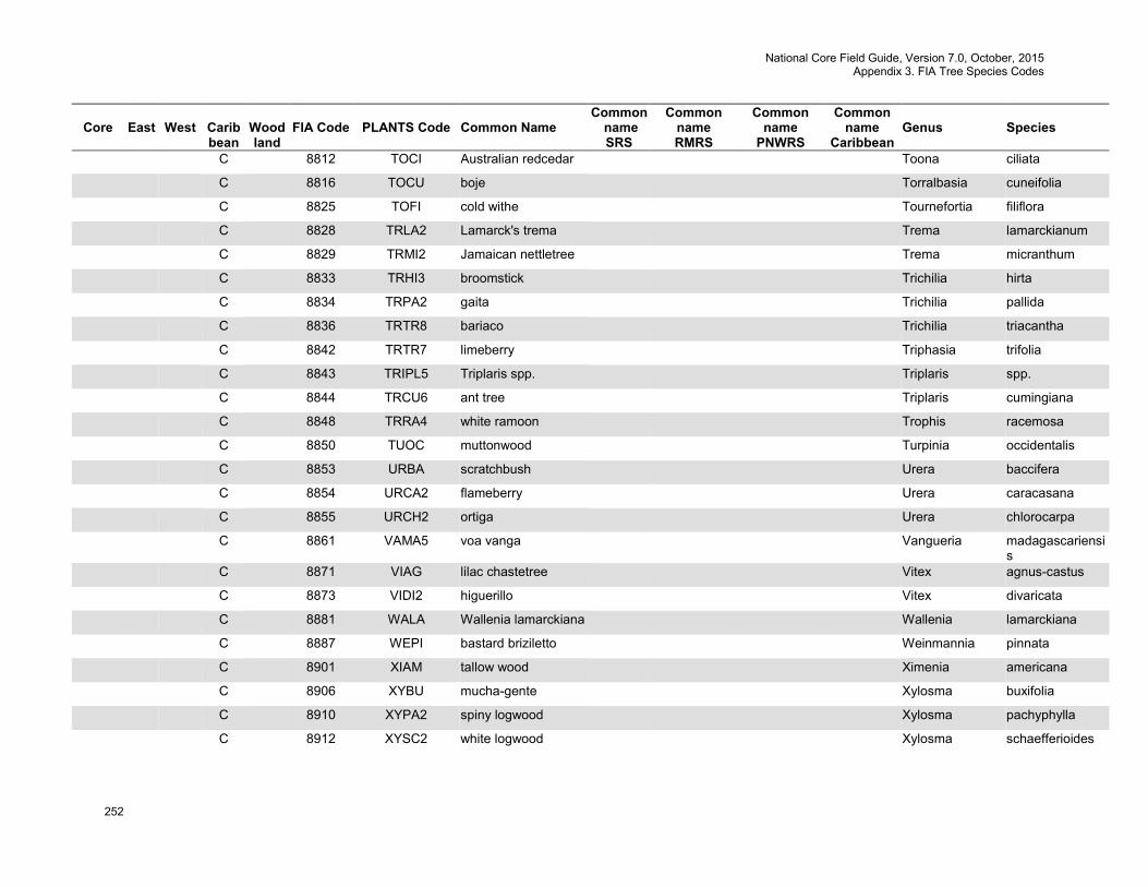
National Core Field Guide, Version 7.0, October, 2015 Appendix 3. FIA Tree Species Codes
252
Core
East
West
Carib bean
Wood land
FIA Code
PLANTS Code
Common Name
Common name SRS
Common name RMRS
Common name
PNWRS
Common name
Caribbean
Genus
Species
C 8812 TOCI Australian redcedar Toona ciliata
C 8816 TOCU boje Torralbasia cuneifolia
C 8825 TOFI cold withe Tournefortia filiflora
C 8828 TRLA2 Lamarck's trema Trema lamarckianum
C 8829 TRMI2 Jamaican nettletree Trema micranthum
C 8833 TRHI3 broomstick Trichilia hirta
C 8834 TRPA2 gaita Trichilia pallida
C 8836 TRTR8 bariaco Trichilia triacantha
C 8842 TRTR7 limeberry Triphasia trifolia
C 8843 TRIPL5 Triplaris spp. Triplaris spp.
C 8844 TRCU6 ant tree Triplaris cumingiana
C 8848 TRRA4 white ramoon Trophis racemosa
C 8850 TUOC muttonwood Turpinia occidentalis
C 8853 URBA scratchbush Urera baccifera
C 8854 URCA2 flameberry Urera caracasana
C 8855 URCH2 ortiga Urera chlorocarpa
C 8861 VAMA5 voa vanga Vangueria madagascariensis
C 8871 VIAG lilac chastetree Vitex agnus-castus
C 8873 VIDI2 higuerillo Vitex divaricata
C 8881 WALA Wallenia lamarckiana Wallenia lamarckiana
C 8887 WEPI bastard briziletto Weinmannia pinnata
C 8901 XIAM tallow wood Ximenia americana
C 8906 XYBU mucha-gente Xylosma buxifolia
C 8910 XYPA2 spiny logwood Xylosma pachyphylla
C 8912 XYSC2 white logwood Xylosma schaefferioides
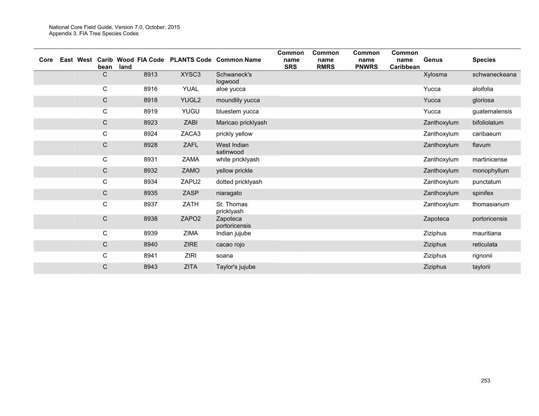
National Core Field Guide, Version 7.0, October, 2015 Appendix 3. FIA Tree Species Codes
253
Core
East
West
Carib bean
Wood land
FIA Code
PLANTS Code
Common Name
Common name SRS
Common name RMRS
Common name
PNWRS
Common name
Caribbean
Genus
Species
C 8913 XYSC3 Schwaneck's logwood
Xylosma schwaneckeana
C 8916 YUAL aloe yucca Yucca aloifolia
C 8918 YUGL2 moundlily yucca Yucca gloriosa
C 8919 YUGU bluestem yucca Yucca guatemalensis
C 8923 ZABI Maricao pricklyash Zanthoxylum bifoliolatum
C 8924 ZACA3 prickly yellow Zanthoxylum caribaeum
C 8928 ZAFL West Indian satinwood
Zanthoxylum flavum
C 8931 ZAMA white pricklyash Zanthoxylum martinicense
C 8932 ZAMO yellow prickle Zanthoxylum monophyllum
C 8934 ZAPU2 dotted pricklyash Zanthoxylum punctatum
C 8935 ZASP niaragato Zanthoxylum spinifex
C 8937 ZATH St. Thomas pricklyash
Zanthoxylum thomasianum
C 8938 ZAPO2 Zapoteca portoricensis
Zapoteca portoricensis
C 8939 ZIMA Indian jujube Ziziphus mauritiana
C 8940 ZIRE cacao rojo Ziziphus reticulata
C 8941 ZIRI soana Ziziphus rignonii
C 8943 ZITA Taylor's jujube Ziziphus taylorii

National Core Field Guide, Version 7.0, October, 2015 Appendix 4. Was Previously: Site Tree Selection Criteria and Species List
254
Appendix 4. Was previously: Site Tree Selection Criteria and Species List (This information is now located in 7.2.2 SPECIES)
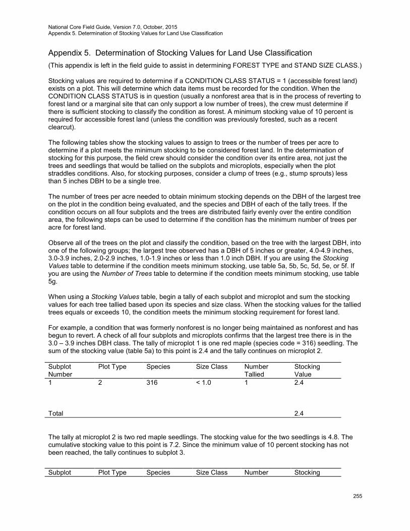
National Core Field Guide, Version 7.0, October, 2015 Appendix 5. Determination of Stocking Values for Land Use Classification
255
Appendix 5. Determination of Stocking Values for Land Use Classification (This appendix is left in the field guide to assist in determining FOREST TYPE and STAND SIZE CLASS.) Stocking values are required to determine if a CONDITION CLASS STATUS = 1 (accessible forest land) exists on a plot. This will determine which data items must be recorded for the condition. When the CONDITION CLASS STATUS is in question (usually a nonforest area that is in the process of reverting to forest land or a marginal site that can only support a low number of trees), the crew must determine if there is sufficient stocking to classify the condition as forest. A minimum stocking value of 10 percent is required for accessible forest land (unless the condition was previously forested, such as a recent clearcut). The following tables show the stocking values to assign to trees or the number of trees per acre to determine if a plot meets the minimum stocking to be considered forest land. In the determination of stocking for this purpose, the field crew should consider the condition over its entire area, not just the trees and seedlings that would be tallied on the subplots and microplots, especially when the plot straddles conditions. Also, for stocking purposes, consider a clump of trees (e.g., stump sprouts) less than 5 inches DBH to be a single tree. The number of trees per acre needed to obtain minimum stocking depends on the DBH of the largest tree on the plot in the condition being evaluated, and the species and DBH of each of the tally trees. If the condition occurs on all four subplots and the trees are distributed fairly evenly over the entire condition area, the following steps can be used to determine if the condition has the minimum number of trees per acre for forest land. Observe all of the trees on the plot and classify the condition, based on the tree with the largest DBH, into one of the following groups; the largest tree observed has a DBH of 5 inches or greater, 4.0-4.9 inches, 3.0-3.9 inches, 2.0-2.9 inches, 1.0-1.9 inches or less than 1.0 inch DBH. If you are using the Stocking Values table to determine if the condition meets minimum stocking, use table 5a, 5b, 5c, 5d, 5e, or 5f. If you are using the Number of Trees table to determine if the condition meets minimum stocking, use table 5g. When using a Stocking Values table, begin a tally of each subplot and microplot and sum the stocking values for each tree tallied based upon its species and size class. When the stocking values for the tallied trees equals or exceeds 10, the condition meets the minimum stocking requirement for forest land. For example, a condition that was formerly nonforest is no longer being maintained as nonforest and has begun to revert. A check of all four subplots and microplots confirms that the largest tree there is in the 3.0 – 3.9 inches DBH class. The tally of microplot 1 is one red maple (species code = 316) seedling. The sum of the stocking value (table 5a) to this point is 2.4 and the tally continues on microplot 2. Subplot Number
Plot Type Species Size Class Number Tallied
Stocking Value
1 2 316 < 1.0 1 2.4 Total 2.4 The tally at microplot 2 is two red maple seedlings. The stocking value for the two seedlings is 4.8. The cumulative stocking value to this point is 7.2. Since the minimum value of 10 percent stocking has not been reached, the tally continues to subplot 3.
Subplot Plot Type Species Size Class Number Stocking
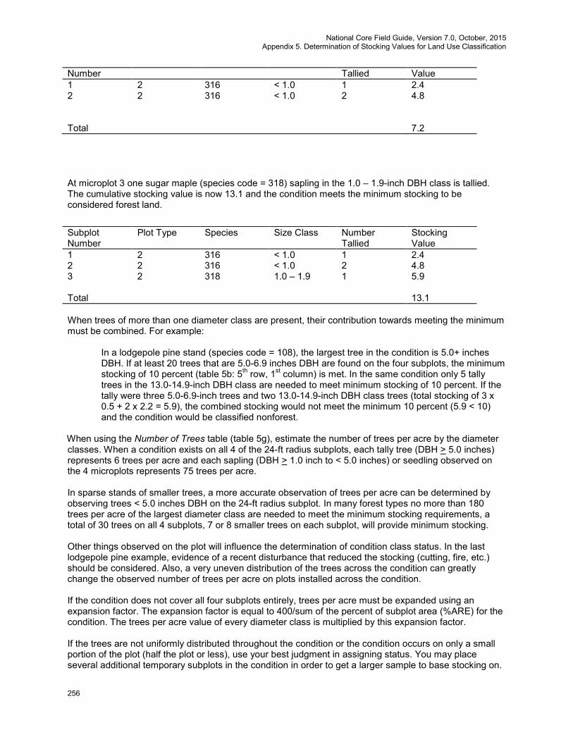
National Core Field Guide, Version 7.0, October, 2015 Appendix 5. Determination of Stocking Values for Land Use Classification
256
Number Tallied Value 1 2 316 < 1.0 1 2.4 2 2 316 < 1.0 2 4.8 Total 7.2
At microplot 3 one sugar maple (species code = 318) sapling in the 1.0 – 1.9-inch DBH class is tallied. The cumulative stocking value is now 13.1 and the condition meets the minimum stocking to be considered forest land.
Subplot Number
Plot Type Species Size Class Number Tallied
Stocking Value
1 2 316 < 1.0 1 2.4 2 2 316 < 1.0 2 4.8 3 2 318 1.0 – 1.9 1 5.9 Total 13.1 When trees of more than one diameter class are present, their contribution towards meeting the minimum must be combined. For example:
In a lodgepole pine stand (species code = 108), the largest tree in the condition is 5.0+ inches DBH. If at least 20 trees that are 5.0-6.9 inches DBH are found on the four subplots, the minimum stocking of 10 percent (table 5b: 5th row, 1st column) is met. In the same condition only 5 tally trees in the 13.0-14.9-inch DBH class are needed to meet minimum stocking of 10 percent. If the tally were three 5.0-6.9-inch trees and two 13.0-14.9-inch DBH class trees (total stocking of 3 x 0.5 + 2 x 2.2 = 5.9), the combined stocking would not meet the minimum 10 percent (5.9 < 10) and the condition would be classified nonforest.
When using the Number of Trees table (table 5g), estimate the number of trees per acre by the diameter classes. When a condition exists on all 4 of the 24-ft radius subplots, each tally tree (DBH > 5.0 inches) represents 6 trees per acre and each sapling (DBH > 1.0 inch to < 5.0 inches) or seedling observed on the 4 microplots represents 75 trees per acre. In sparse stands of smaller trees, a more accurate observation of trees per acre can be determined by observing trees < 5.0 inches DBH on the 24-ft radius subplot. In many forest types no more than 180 trees per acre of the largest diameter class are needed to meet the minimum stocking requirements, a total of 30 trees on all 4 subplots, 7 or 8 smaller trees on each subplot, will provide minimum stocking. Other things observed on the plot will influence the determination of condition class status. In the last lodgepole pine example, evidence of a recent disturbance that reduced the stocking (cutting, fire, etc.) should be considered. Also, a very uneven distribution of the trees across the condition can greatly change the observed number of trees per acre on plots installed across the condition. If the condition does not cover all four subplots entirely, trees per acre must be expanded using an expansion factor. The expansion factor is equal to 400/sum of the percent of subplot area (%ARE) for the condition. The trees per acre value of every diameter class is multiplied by this expansion factor. If the trees are not uniformly distributed throughout the condition or the condition occurs on only a small portion of the plot (half the plot or less), use your best judgment in assigning status. You may place several additional temporary subplots in the condition in order to get a larger sample to base stocking on.

National Core Field Guide, Version 7.0, October, 2015 Appendix 5. Determination of Stocking Values for Land Use Classification
257
When additional temporary subplots or judgment is used to assign land use, a note should be made on the plot sheet. Use the following procedure to establish these temporary subplots in a condition:
A. Consider locations 120.0 feet horizontal distance from the highest numbered subplot in the condition. First consider the location 0o azimuth from the subplot center. If this location is unsuitable, consider in order locations at azimuth 120o, and 240o. When a suitable location has been found, establish the temporary subplot. Temporary subplots should be entirely within the condition (locations should not be within 24.0 feet of a mapped boundary).
B. If Step A fails to yield a suitable subplot location, repeat Step A at each of the next highest-
numbered regular subplots in the condition. C. If Steps A and B have been exhausted and a suitable temporary subplot still has not been
found, repeat Step A at each temporary subplot in turn, beginning with the first temporary subplot that was established.
If more than one temporary subplot is to be established, repeat Steps A and B to establish the second lowest- numbered temporary subplot next, and continue in order until you have enough temporary subplots established in the condition to get a good, representative estimate of stocking. The general rule for establishing temporary subplots is:
• Install the lowest temporary subplot off the highest established subplot, until all the established subplots have been exhausted.
• Then establish the lowest temporary subplot yet to be established off the lowest one already established (lowest off highest, then lowest off lowest).
If there is a transition zone between two conditions use your best judgment to be sure that trees tallied in the transition zone do not have too much weight in the assignment of a land use.
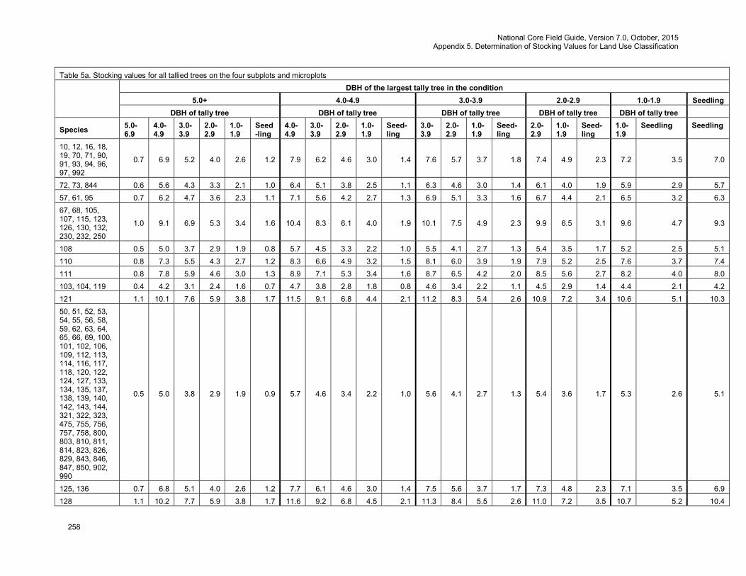
National Core Field Guide, Version 7.0, October, 2015 Appendix 5. Determination of Stocking Values for Land Use Classification
258
Table 5a. Stocking values for all tallied trees on the four subplots and microplots
DBH of the largest tally tree in the condition
5.0+ 4.0-4.9 3.0-3.9 2.0-2.9 1.0-1.9 Seedling DBH of tally tree DBH of tally tree DBH of tally tree DBH of tally tree DBH of tally tree
Species 5.0-6.9
4.0-4.9
3.0-3.9
2.0-2.9
1.0-1.9
Seed-ling
4.0-4.9
3.0-3.9
2.0-2.9
1.0-1.9
Seed-ling
3.0-3.9
2.0-2.9
1.0-1.9
Seed-ling
2.0-2.9
1.0-1.9
Seed-ling
1.0-1.9
Seedling Seedling
10, 12, 16, 18, 19, 70, 71, 90, 91, 93, 94, 96, 97, 992
0.7 6.9 5.2 4.0 2.6 1.2 7.9 6.2 4.6 3.0 1.4 7.6 5.7 3.7 1.8 7.4 4.9 2.3 7.2 3.5 7.0
72, 73, 844 0.6 5.6 4.3 3.3 2.1 1.0 6.4 5.1 3.8 2.5 1.1 6.3 4.6 3.0 1.4 6.1 4.0 1.9 5.9 2.9 5.7 57, 61, 95 0.7 6.2 4.7 3.6 2.3 1.1 7.1 5.6 4.2 2.7 1.3 6.9 5.1 3.3 1.6 6.7 4.4 2.1 6.5 3.2 6.3 67, 68, 105, 107, 115, 123, 126, 130, 132, 230, 232, 250
1.0 9.1 6.9 5.3 3.4 1.6 10.4 8.3 6.1 4.0 1.9 10.1 7.5 4.9 2.3 9.9 6.5 3.1 9.6 4.7 9.3
108 0.5 5.0 3.7 2.9 1.9 0.8 5.7 4.5 3.3 2.2 1.0 5.5 4.1 2.7 1.3 5.4 3.5 1.7 5.2 2.5 5.1 110 0.8 7.3 5.5 4.3 2.7 1.2 8.3 6.6 4.9 3.2 1.5 8.1 6.0 3.9 1.9 7.9 5.2 2.5 7.6 3.7 7.4 111 0.8 7.8 5.9 4.6 3.0 1.3 8.9 7.1 5.3 3.4 1.6 8.7 6.5 4.2 2.0 8.5 5.6 2.7 8.2 4.0 8.0 103, 104, 119 0.4 4.2 3.1 2.4 1.6 0.7 4.7 3.8 2.8 1.8 0.8 4.6 3.4 2.2 1.1 4.5 2.9 1.4 4.4 2.1 4.2 121 1.1 10.1 7.6 5.9 3.8 1.7 11.5 9.1 6.8 4.4 2.1 11.2 8.3 5.4 2.6 10.9 7.2 3.4 10.6 5.1 10.3 50, 51, 52, 53, 54, 55, 56, 58, 59, 62, 63, 64, 65, 66, 69, 100, 101, 102, 106, 109, 112, 113, 114, 116, 117, 118, 120, 122, 124, 127, 133, 134, 135, 137, 138, 139, 140, 142, 143, 144, 321, 322, 323, 475, 755, 756, 757, 758, 800, 803, 810, 811, 814, 823, 826, 829, 843, 846, 847, 850, 902, 990
0.5 5.0 3.8 2.9 1.9 0.9 5.7 4.6 3.4 2.2 1.0 5.6 4.1 2.7 1.3 5.4 3.6 1.7 5.3 2.6 5.1
125, 136 0.7 6.8 5.1 4.0 2.6 1.2 7.7 6.1 4.6 3.0 1.4 7.5 5.6 3.7 1.7 7.3 4.8 2.3 7.1 3.5 6.9 128 1.1 10.2 7.7 5.9 3.8 1.7 11.6 9.2 6.8 4.5 2.1 11.3 8.4 5.5 2.6 11.0 7.2 3.5 10.7 5.2 10.4
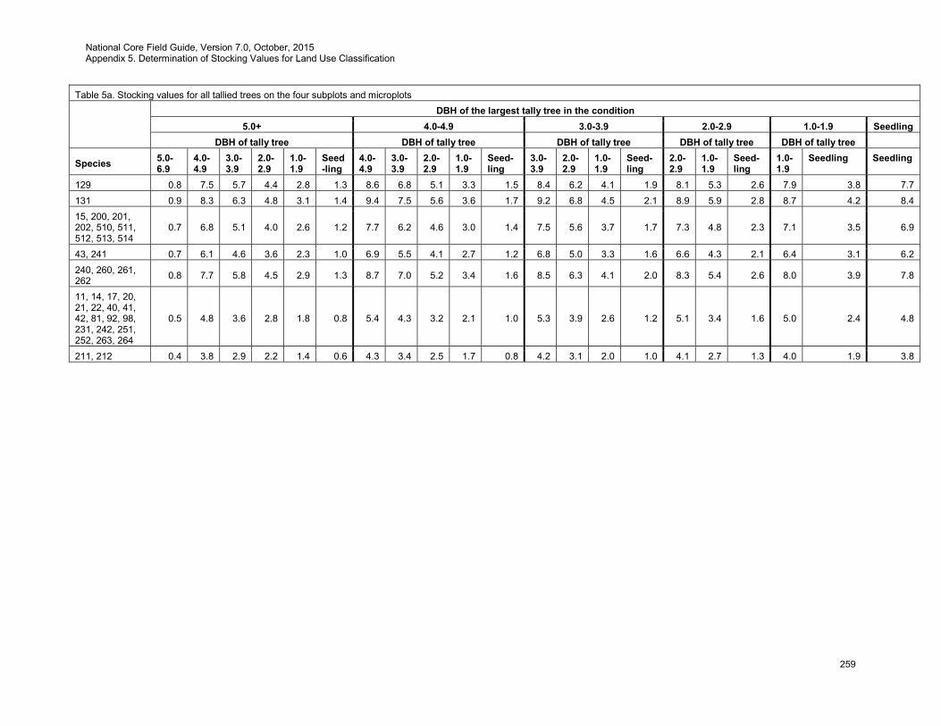
National Core Field Guide, Version 7.0, October, 2015 Appendix 5. Determination of Stocking Values for Land Use Classification
259
Table 5a. Stocking values for all tallied trees on the four subplots and microplots
DBH of the largest tally tree in the condition
5.0+ 4.0-4.9 3.0-3.9 2.0-2.9 1.0-1.9 Seedling DBH of tally tree DBH of tally tree DBH of tally tree DBH of tally tree DBH of tally tree
Species 5.0-6.9
4.0-4.9
3.0-3.9
2.0-2.9
1.0-1.9
Seed-ling
4.0-4.9
3.0-3.9
2.0-2.9
1.0-1.9
Seed-ling
3.0-3.9
2.0-2.9
1.0-1.9
Seed-ling
2.0-2.9
1.0-1.9
Seed-ling
1.0-1.9
Seedling Seedling
129 0.8 7.5 5.7 4.4 2.8 1.3 8.6 6.8 5.1 3.3 1.5 8.4 6.2 4.1 1.9 8.1 5.3 2.6 7.9 3.8 7.7 131 0.9 8.3 6.3 4.8 3.1 1.4 9.4 7.5 5.6 3.6 1.7 9.2 6.8 4.5 2.1 8.9 5.9 2.8 8.7 4.2 8.4 15, 200, 201, 202, 510, 511, 512, 513, 514
0.7 6.8 5.1 4.0 2.6 1.2 7.7 6.2 4.6 3.0 1.4 7.5 5.6 3.7 1.7 7.3 4.8 2.3 7.1 3.5 6.9
43, 241 0.7 6.1 4.6 3.6 2.3 1.0 6.9 5.5 4.1 2.7 1.2 6.8 5.0 3.3 1.6 6.6 4.3 2.1 6.4 3.1 6.2 240, 260, 261, 262 0.8 7.7 5.8 4.5 2.9 1.3 8.7 7.0 5.2 3.4 1.6 8.5 6.3 4.1 2.0 8.3 5.4 2.6 8.0 3.9 7.8
11, 14, 17, 20, 21, 22, 40, 41, 42, 81, 92, 98, 231, 242, 251, 252, 263, 264
0.5 4.8 3.6 2.8 1.8 0.8 5.4 4.3 3.2 2.1 1.0 5.3 3.9 2.6 1.2 5.1 3.4 1.6 5.0 2.4 4.8
211, 212 0.4 3.8 2.9 2.2 1.4 0.6 4.3 3.4 2.5 1.7 0.8 4.2 3.1 2.0 1.0 4.1 2.7 1.3 4.0 1.9 3.8
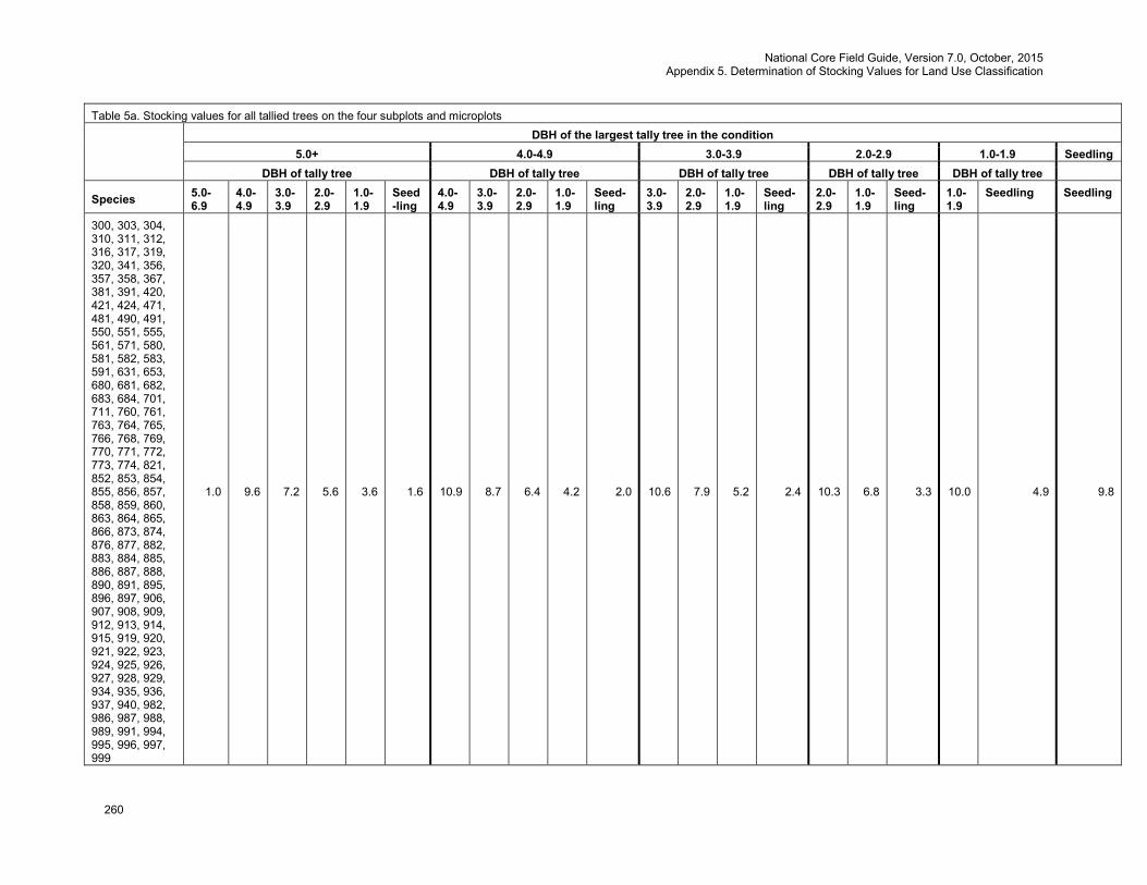
National Core Field Guide, Version 7.0, October, 2015 Appendix 5. Determination of Stocking Values for Land Use Classification
260
Table 5a. Stocking values for all tallied trees on the four subplots and microplots
DBH of the largest tally tree in the condition
5.0+ 4.0-4.9 3.0-3.9 2.0-2.9 1.0-1.9 Seedling DBH of tally tree DBH of tally tree DBH of tally tree DBH of tally tree DBH of tally tree
Species 5.0-6.9
4.0-4.9
3.0-3.9
2.0-2.9
1.0-1.9
Seed-ling
4.0-4.9
3.0-3.9
2.0-2.9
1.0-1.9
Seed-ling
3.0-3.9
2.0-2.9
1.0-1.9
Seed-ling
2.0-2.9
1.0-1.9
Seed-ling
1.0-1.9
Seedling Seedling
300, 303, 304, 310, 311, 312, 316, 317, 319, 320, 341, 356, 357, 358, 367, 381, 391, 420, 421, 424, 471, 481, 490, 491, 550, 551, 555, 561, 571, 580, 581, 582, 583, 591, 631, 653, 680, 681, 682, 683, 684, 701, 711, 760, 761, 763, 764, 765, 766, 768, 769, 770, 771, 772, 773, 774, 821, 852, 853, 854, 855, 856, 857, 858, 859, 860, 863, 864, 865, 866, 873, 874, 876, 877, 882, 883, 884, 885, 886, 887, 888, 890, 891, 895, 896, 897, 906, 907, 908, 909, 912, 913, 914, 915, 919, 920, 921, 922, 923, 924, 925, 926, 927, 928, 929, 934, 935, 936, 937, 940, 982, 986, 987, 988, 989, 991, 994, 995, 996, 997, 999
1.0 9.6 7.2 5.6 3.6 1.6 10.9 8.7 6.4 4.2 2.0 10.6 7.9 5.2 2.4 10.3 6.8 3.3 10.0 4.9 9.8
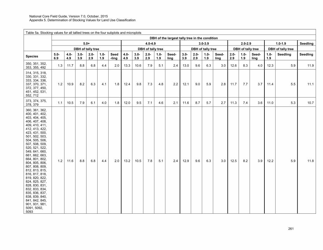
National Core Field Guide, Version 7.0, October, 2015 Appendix 5. Determination of Stocking Values for Land Use Classification
261
Table 5a. Stocking values for all tallied trees on the four subplots and microplots
DBH of the largest tally tree in the condition
5.0+ 4.0-4.9 3.0-3.9 2.0-2.9 1.0-1.9 Seedling DBH of tally tree DBH of tally tree DBH of tally tree DBH of tally tree DBH of tally tree
Species 5.0-6.9
4.0-4.9
3.0-3.9
2.0-2.9
1.0-1.9
Seed-ling
4.0-4.9
3.0-3.9
2.0-2.9
1.0-1.9
Seed-ling
3.0-3.9
2.0-2.9
1.0-1.9
Seed-ling
2.0-2.9
1.0-1.9
Seed-ling
1.0-1.9
Seedling Seedling
350, 351, 352, 353, 355, 492 1.3 11.7 8.8 6.8 4.4 2.0 13.3 10.6 7.9 5.1 2.4 13.0 9.6 6.3 3.0 12.6 8.3 4.0 12.3 5.9 11.9
314, 315, 318, 330, 331, 332, 333, 334, 336, 337, 370, 371, 372, 377, 450, 451, 452, 531, 552, 712
1.2 10.9 8.2 6.3 4.1 1.8 12.4 9.8 7.3 4.8 2.2 12.1 9.0 5.9 2.8 11.7 7.7 3.7 11.4 5.5 11.1
373, 374, 375, 378, 379 1.1 10.5 7.9 6.1 4.0 1.8 12.0 9.5 7.1 4.6 2.1 11.6 8.7 5.7 2.7 11.3 7.4 3.6 11.0 5.3 10.7
360, 361, 362, 400, 401, 402, 403, 404, 405, 406, 407, 408, 409, 410, 411, 412, 413, 422, 423, 431, 500, 501, 502, 503, 504, 505, 506, 507, 508, 509, 520, 521, 522, 549, 641, 660, 661, 662, 663, 664, 801, 802, 804, 805, 806, 807, 808, 809, 812, 813, 815, 816, 817, 818, 819, 820, 822, 824, 825, 827, 828, 830, 831, 832, 833, 834, 835, 836, 837, 838, 839, 840, 841, 842, 845, 901, 931, 981, 5091, 5092, 5093
1.2 11.6 8.8 6.8 4.4 2.0 13.2 10.5 7.8 5.1 2.4 12.9 9.6 6.3 3.0 12.5 8.2 3.9 12.2 5.9 11.8
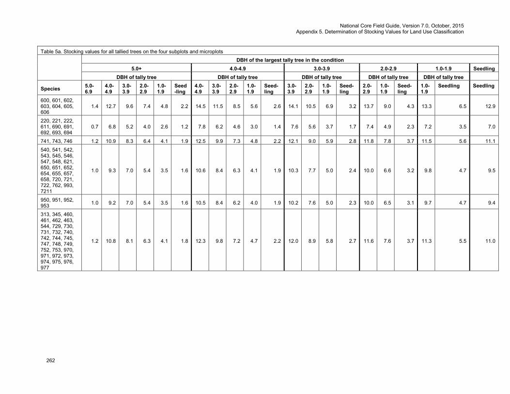
National Core Field Guide, Version 7.0, October, 2015 Appendix 5. Determination of Stocking Values for Land Use Classification
262
Table 5a. Stocking values for all tallied trees on the four subplots and microplots
DBH of the largest tally tree in the condition
5.0+ 4.0-4.9 3.0-3.9 2.0-2.9 1.0-1.9 Seedling DBH of tally tree DBH of tally tree DBH of tally tree DBH of tally tree DBH of tally tree
Species 5.0-6.9
4.0-4.9
3.0-3.9
2.0-2.9
1.0-1.9
Seed-ling
4.0-4.9
3.0-3.9
2.0-2.9
1.0-1.9
Seed-ling
3.0-3.9
2.0-2.9
1.0-1.9
Seed-ling
2.0-2.9
1.0-1.9
Seed-ling
1.0-1.9
Seedling Seedling
600, 601, 602, 603, 604, 605, 606
1.4 12.7 9.6 7.4 4.8 2.2 14.5 11.5 8.5 5.6 2.6 14.1 10.5 6.9 3.2 13.7 9.0 4.3 13.3 6.5 12.9
220, 221, 222, 611, 690, 691, 692, 693, 694
0.7 6.8 5.2 4.0 2.6 1.2 7.8 6.2 4.6 3.0 1.4 7.6 5.6 3.7 1.7 7.4 4.9 2.3 7.2 3.5 7.0
741, 743, 746 1.2 10.9 8.3 6.4 4.1 1.9 12.5 9.9 7.3 4.8 2.2 12.1 9.0 5.9 2.8 11.8 7.8 3.7 11.5 5.6 11.1 540, 541, 542, 543, 545, 546, 547, 548, 621, 650, 651, 652, 654, 655, 657, 658, 720, 721, 722, 762, 993, 7211
1.0 9.3 7.0 5.4 3.5 1.6 10.6 8.4 6.3 4.1 1.9 10.3 7.7 5.0 2.4 10.0 6.6 3.2 9.8 4.7 9.5
950, 951, 952, 953 1.0 9.2 7.0 5.4 3.5 1.6 10.5 8.4 6.2 4.0 1.9 10.2 7.6 5.0 2.3 10.0 6.5 3.1 9.7 4.7 9.4
313, 345, 460, 461, 462, 463, 544, 729, 730, 731, 732, 740, 742, 744, 745, 747, 748, 749, 752, 753, 970, 971, 972, 973, 974, 975, 976, 977
1.2 10.8 8.1 6.3 4.1 1.8 12.3 9.8 7.2 4.7 2.2 12.0 8.9 5.8 2.7 11.6 7.6 3.7 11.3 5.5 11.0

National Core Field Guide, Version 7.0, October, 2015 Appendix 5. Determination of Stocking Values for Land Use Classification
263
Table 5b. Stocking values for all trees tallied on the subplot only
Species 5.0-6.9
7.0-8.9
9.0-10.9
11.0-12.9
13.0-14.9
15.0-16.9
17.0-18.9
19.0-20.9
21.0-22.9
23.0-24.9
25.0-26.9
27.0-28.9 29.0+
10, 12, 16, 18, 19, 70, 71, 90, 91, 93, 94, 96, 97, 992 0.7 1.1 1.6 2.1 2.6 3.2 3.8 4.4 5.1 5.8 6.5 7.2 8.0
72, 73, 844 0.6 1.0 1.5 2.0 2.6 3.3 4.0 4.9 5.7 6.7 7.6 8.7 9.8
57, 61, 95 0.7 0.9 1.1 1.4 1.6 1.9 2.1 2.4 2.6 2.9 3.1 3.4 3.6
67, 68, 105, 107, 115, 123, 126, 130, 132, 230, 232, 250 1.0 1.5 2.2 3.0 3.8 4.7 5.6 6.6 7.7 8.9 10.1 11.4 12.7
108 0.5 0.9 1.3 1.7 2.2 2.8 3.4 4.1 4.8 5.6 6.4 7.3 8.2
110 0.8 1.3 2.0 2.7 3.6 4.6 5.7 6.9 8.2 9.6 11.1 12.7 14.4
111 0.8 1.5 2.2 3.2 4.2 5.5 6.9 8.4 10.1 11.9 13.9 16.0 18.2
103, 104, 119 0.4 0.7 1.1 1.5 1.9 2.4 3.0 3.6 4.2 4.9 5.6 6.4 7.2
121 1.1 1.6 2.3 2.9 3.7 4.4 5.3 6.1 7.0 8.0 8.9 10.0 11.0
50, 51, 52, 53, 54, 55, 56, 58, 59, 62, 63, 64, 65, 66, 69, 100, 101, 102, 106, 109, 112, 113, 114, 116, 117, 118, 120, 122, 124, 127, 133, 134, 135, 137, 138, 139, 140, 142, 143, 144, 321, 322, 323, 475, 755, 756, 757, 758, 800, 803, 810, 811, 814, 823, 826, 829, 843, 846, 847, 850, 902, 990
0.5 1.0 1.5 2.2 2.9 3.8 4.9 6.0 7.3 8.6 10.1 11.8 13.5
125, 136 0.7 1.2 1.7 2.3 3.0 3.7 4.6 5.4 6.4 7.4 8.4 9.5 10.7
128 1.1 1.8 2.6 3.5 4.5 5.6 6.8 8.2 9.6 11.1 12.7 14.3 16.1
129 0.8 1.2 1.7 2.3 2.9 3.6 4.2 5.0 5.7 6.6 7.4 8.3 9.2
131 0.9 1.5 2.1 2.9 3.8 4.8 5.9 7.1 8.3 9.7 11.1 12.6 14.2
15, 200, 201, 202, 510, 511, 512, 513, 514 0.7 1.1 1.6 2.1 2.7 3.3 4.0 4.7 5.4 6.2 7.0 7.8 8.7
43, 241 0.7 1.1 1.6 2.3 3.0 3.8 4.7 5.7 6.8 7.9 9.2 10.5 11.8
240, 260, 261, 262 0.8 1.5 2.4 3.6 4.9 6.5 8.4 10.4 12.8 15.3 18.2 21.2 24.6
11, 14, 17, 20, 21, 22, 40, 41, 42, 81, 92, 98, 231, 242, 251, 252, 263, 264 0.5 0.8 1.2 1.6 2.1 2.6 3.2 3.8 4.5 5.2 5.9 6.7 7.5
211, 212 0.4 0.7 1.0 1.3 1.7 2.1 2.6 3.1 3.6 4.2 4.8 5.4 6.1
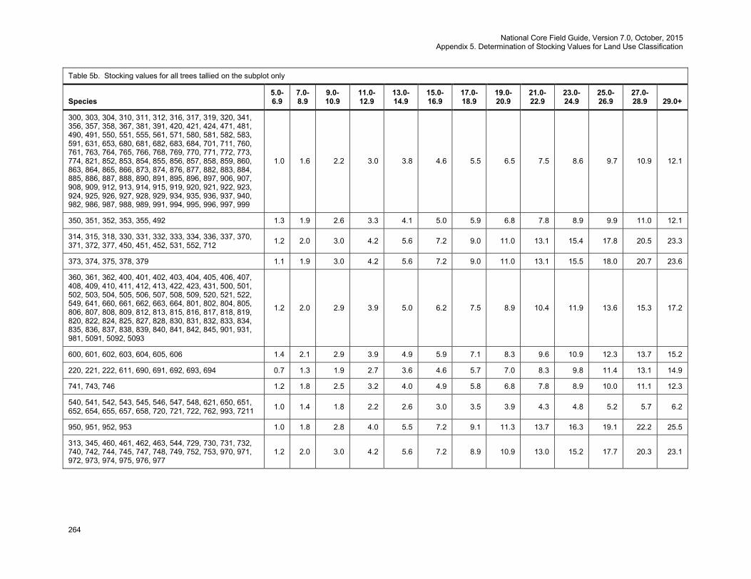
National Core Field Guide, Version 7.0, October, 2015 Appendix 5. Determination of Stocking Values for Land Use Classification
264
Table 5b. Stocking values for all trees tallied on the subplot only
Species 5.0-6.9
7.0-8.9
9.0-10.9
11.0-12.9
13.0-14.9
15.0-16.9
17.0-18.9
19.0-20.9
21.0-22.9
23.0-24.9
25.0-26.9
27.0-28.9 29.0+
300, 303, 304, 310, 311, 312, 316, 317, 319, 320, 341, 356, 357, 358, 367, 381, 391, 420, 421, 424, 471, 481, 490, 491, 550, 551, 555, 561, 571, 580, 581, 582, 583, 591, 631, 653, 680, 681, 682, 683, 684, 701, 711, 760, 761, 763, 764, 765, 766, 768, 769, 770, 771, 772, 773, 774, 821, 852, 853, 854, 855, 856, 857, 858, 859, 860, 863, 864, 865, 866, 873, 874, 876, 877, 882, 883, 884, 885, 886, 887, 888, 890, 891, 895, 896, 897, 906, 907, 908, 909, 912, 913, 914, 915, 919, 920, 921, 922, 923, 924, 925, 926, 927, 928, 929, 934, 935, 936, 937, 940, 982, 986, 987, 988, 989, 991, 994, 995, 996, 997, 999
1.0 1.6 2.2 3.0 3.8 4.6 5.5 6.5 7.5 8.6 9.7 10.9 12.1
350, 351, 352, 353, 355, 492 1.3 1.9 2.6 3.3 4.1 5.0 5.9 6.8 7.8 8.9 9.9 11.0 12.1
314, 315, 318, 330, 331, 332, 333, 334, 336, 337, 370, 371, 372, 377, 450, 451, 452, 531, 552, 712 1.2 2.0 3.0 4.2 5.6 7.2 9.0 11.0 13.1 15.4 17.8 20.5 23.3
373, 374, 375, 378, 379 1.1 1.9 3.0 4.2 5.6 7.2 9.0 11.0 13.1 15.5 18.0 20.7 23.6
360, 361, 362, 400, 401, 402, 403, 404, 405, 406, 407, 408, 409, 410, 411, 412, 413, 422, 423, 431, 500, 501, 502, 503, 504, 505, 506, 507, 508, 509, 520, 521, 522, 549, 641, 660, 661, 662, 663, 664, 801, 802, 804, 805, 806, 807, 808, 809, 812, 813, 815, 816, 817, 818, 819, 820, 822, 824, 825, 827, 828, 830, 831, 832, 833, 834, 835, 836, 837, 838, 839, 840, 841, 842, 845, 901, 931, 981, 5091, 5092, 5093
1.2 2.0 2.9 3.9 5.0 6.2 7.5 8.9 10.4 11.9 13.6 15.3 17.2
600, 601, 602, 603, 604, 605, 606 1.4 2.1 2.9 3.9 4.9 5.9 7.1 8.3 9.6 10.9 12.3 13.7 15.2
220, 221, 222, 611, 690, 691, 692, 693, 694 0.7 1.3 1.9 2.7 3.6 4.6 5.7 7.0 8.3 9.8 11.4 13.1 14.9
741, 743, 746 1.2 1.8 2.5 3.2 4.0 4.9 5.8 6.8 7.8 8.9 10.0 11.1 12.3
540, 541, 542, 543, 545, 546, 547, 548, 621, 650, 651, 652, 654, 655, 657, 658, 720, 721, 722, 762, 993, 7211 1.0 1.4 1.8 2.2 2.6 3.0 3.5 3.9 4.3 4.8 5.2 5.7 6.2
950, 951, 952, 953 1.0 1.8 2.8 4.0 5.5 7.2 9.1 11.3 13.7 16.3 19.1 22.2 25.5
313, 345, 460, 461, 462, 463, 544, 729, 730, 731, 732, 740, 742, 744, 745, 747, 748, 749, 752, 753, 970, 971, 972, 973, 974, 975, 976, 977
1.2 2.0 3.0 4.2 5.6 7.2 8.9 10.9 13.0 15.2 17.7 20.3 23.1

National Core Field Guide, Version 7.0, October, 2015 Appendix 5. Determination of Stocking Values for Land Use Classification
265
Table 5c. Stocking values for all trees < 7 inches, observed on the four subplots only
DBH of the largest tally tree in the condition
5.0+ 4.0-4.9 3.0-3.9 2.0-2.9 1.0-1.9 Seedling DBH of tally tree DBH of tally tree DBH of tally tree DBH of tally tree DBH of tally tree
Species 5.0-6.9
4.0-4.9
3.0-3.9
2.0-2.9
1.0-1.9
Seed-ling
4.0-4.9
3.0-3.9
2.0-2.9
1.0-1.9
Seed-ling
3.0-3.9
2.0-2.9
1.0-1.9
Seed-ling
2.0-2.9
1.0-1.9
Seed-ling
1.0-1.9
Seedling Seedling
10, 12, 16, 18, 19, 70, 71, 90, 91, 93, 94, 96, 97, 992
0.74 0.55 0.42 0.32 0.21 0.09 0.63 0.50 0.37 0.24 0.11 0.61 0.45 0.30 0.14 0.59 0.39 0.19 0.58 0.28 0.56
72, 73, 844 0.60 0.45 0.34 0.26 0.17 0.08 0.51 0.41 0.30 0.20 0.09 0.50 0.37 0.24 0.11 0.49 0.32 0.15 0.47 0.23 0.46 57, 61, 95 0.67 0.50 0.38 0.29 0.19 0.08 0.57 0.45 0.33 0.22 0.10 0.55 0.41 0.27 0.13 0.54 0.35 0.17 0.52 0.25 0.51 67, 68, 105, 107, 115, 123, 126, 130, 132, 230, 232, 250
0.98 0.73 0.55 0.43 0.28 0.12 0.83 0.66 0.49 0.32 0.15 0.81 0.60 0.39 0.19 0.79 0.52 0.25 0.77 0.37 0.74
108 0.53 0.40 0.30 0.23 0.15 0.07 0.45 0.36 0.27 0.17 0.08 0.44 0.33 0.21 0.10 0.43 0.28 0.13 0.42 0.20 0.40 110 0.78 0.58 0.44 0.34 0.22 0.10 0.66 0.53 0.39 0.26 0.12 0.65 0.48 0.31 0.15 0.63 0.41 0.20 0.61 0.30 0.59 111 0.84 0.63 0.47 0.37 0.24 0.11 0.72 0.57 0.42 0.27 0.13 0.70 0.52 0.34 0.16 0.68 0.45 0.21 0.66 0.32 0.64 103, 104, 119 0.45 0.33 0.25 0.19 0.13 0.06 0.38 0.30 0.22 0.15 0.07 0.37 0.27 0.18 0.08 0.36 0.24 0.11 0.35 0.17 0.34 121 1.08 0.81 0.61 0.47 0.30 0.14 0.92 0.73 0.54 0.35 0.16 0.90 0.67 0.44 0.21 0.87 0.57 0.27 0.85 0.41 0.82 50, 51, 52, 53, 54, 55, 56, 58, 59, 62, 63, 64, 65, 66, 69, 100, 101, 102, 106, 109, 112, 113, 114, 116, 117, 118, 120, 122, 124, 127, 133, 134, 135, 137, 138, 139, 140, 142, 143, 144, 321, 322, 323, 475, 755, 756, 757, 758, 800, 803, 810, 811, 814, 823, 826, 829, 843, 846, 847, 850, 902, 990
0.54 0.40 0.30 0.24 0.15 0.07 0.46 0.36 0.27 0.18 0.08 0.45 0.33 0.22 0.10 0.43 0.29 0.14 0.42 0.20 0.41
125, 136 0.73 0.54 0.41 0.32 0.20 0.09 0.62 0.49 0.36 0.24 0.11 0.60 0.45 0.29 0.14 0.59 0.39 0.18 0.57 0.28 0.55
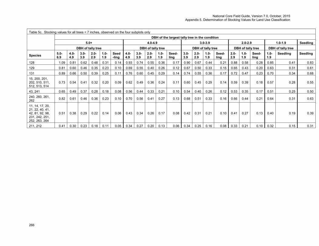
National Core Field Guide, Version 7.0, October, 2015 Appendix 5. Determination of Stocking Values for Land Use Classification
266
Table 5c. Stocking values for all trees < 7 inches, observed on the four subplots only
DBH of the largest tally tree in the condition
5.0+ 4.0-4.9 3.0-3.9 2.0-2.9 1.0-1.9 Seedling DBH of tally tree DBH of tally tree DBH of tally tree DBH of tally tree DBH of tally tree
Species 5.0-6.9
4.0-4.9
3.0-3.9
2.0-2.9
1.0-1.9
Seed-ling
4.0-4.9
3.0-3.9
2.0-2.9
1.0-1.9
Seed-ling
3.0-3.9
2.0-2.9
1.0-1.9
Seed-ling
2.0-2.9
1.0-1.9
Seed-ling
1.0-1.9
Seedling Seedling
128 1.09 0.81 0.62 0.48 0.31 0.14 0.93 0.74 0.55 0.36 0.17 0.90 0.67 0.44 0.21 0.88 0.58 0.28 0.85 0.41 0.83 129 0.81 0.60 0.46 0.35 0.23 0.10 0.69 0.55 0.40 0.26 0.12 0.67 0.50 0.33 0.15 0.65 0.43 0.20 0.63 0.31 0.61 131 0.89 0.66 0.50 0.39 0.25 0.11 0.76 0.60 0.45 0.29 0.14 0.74 0.55 0.36 0.17 0.72 0.47 0.23 0.70 0.34 0.68 15, 200, 201, 202, 510, 511, 512, 513, 514
0.73 0.54 0.41 0.32 0.20 0.09 0.62 0.49 0.36 0.24 0.11 0.60 0.45 0.29 0.14 0.59 0.39 0.18 0.57 0.28 0.55
43, 241 0.65 0.49 0.37 0.28 0.18 0.08 0.56 0.44 0.33 0.21 0.10 0.54 0.40 0.26 0.12 0.53 0.35 0.17 0.51 0.25 0.50 240, 260, 261, 262 0.82 0.61 0.46 0.36 0.23 0.10 0.70 0.56 0.41 0.27 0.13 0.68 0.51 0.33 0.16 0.66 0.44 0.21 0.64 0.31 0.63
11, 14, 17, 20, 21, 22, 40, 41, 42, 81, 92, 98, 231, 242, 251, 252, 263, 264
0.51 0.38 0.29 0.22 0.14 0.06 0.43 0.34 0.26 0.17 0.08 0.42 0.31 0.21 0.10 0.41 0.27 0.13 0.40 0.19 0.39
211, 212 0.41 0.30 0.23 0.18 0.11 0.05 0.34 0.27 0.20 0.13 0.06 0.34 0.25 0.16 0.08 0.33 0.21 0.10 0.32 0.15 0.31
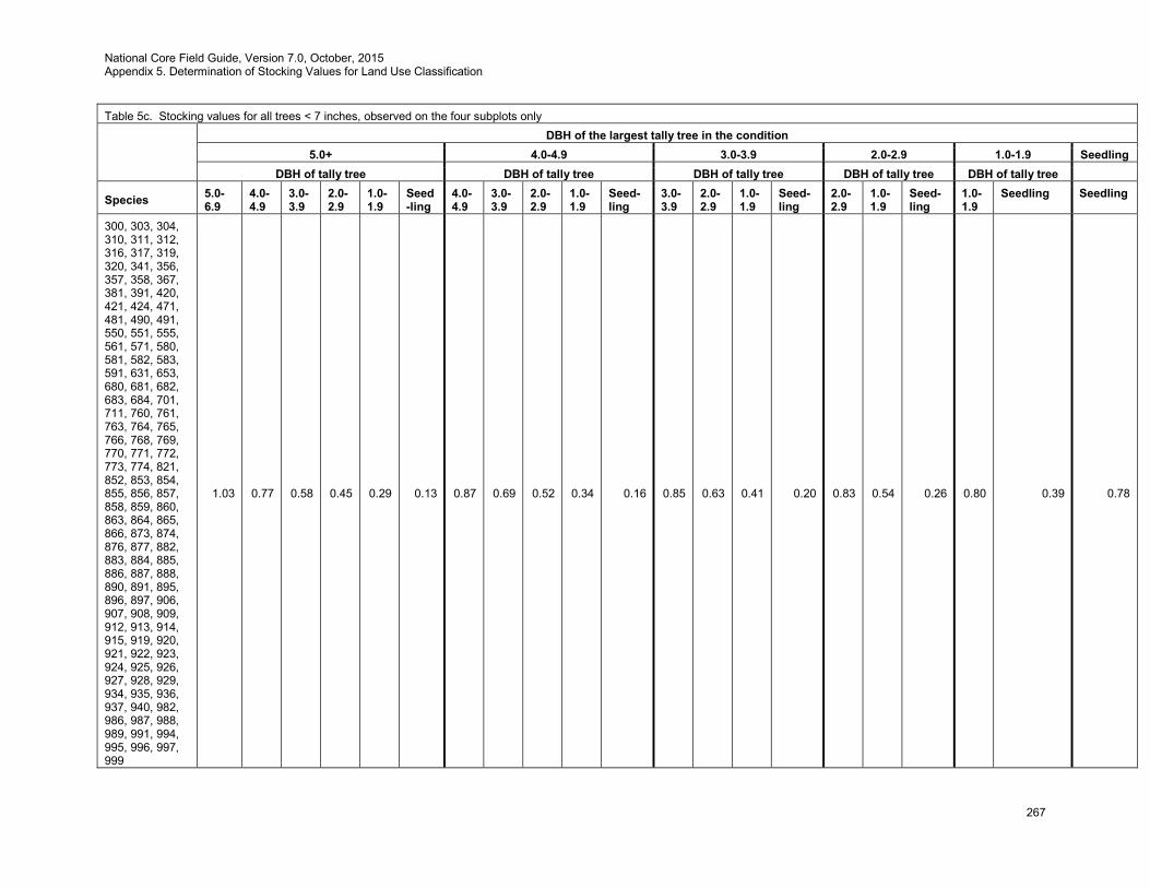
National Core Field Guide, Version 7.0, October, 2015 Appendix 5. Determination of Stocking Values for Land Use Classification
267
Table 5c. Stocking values for all trees < 7 inches, observed on the four subplots only
DBH of the largest tally tree in the condition
5.0+ 4.0-4.9 3.0-3.9 2.0-2.9 1.0-1.9 Seedling DBH of tally tree DBH of tally tree DBH of tally tree DBH of tally tree DBH of tally tree
Species 5.0-6.9
4.0-4.9
3.0-3.9
2.0-2.9
1.0-1.9
Seed-ling
4.0-4.9
3.0-3.9
2.0-2.9
1.0-1.9
Seed-ling
3.0-3.9
2.0-2.9
1.0-1.9
Seed-ling
2.0-2.9
1.0-1.9
Seed-ling
1.0-1.9
Seedling Seedling
300, 303, 304, 310, 311, 312, 316, 317, 319, 320, 341, 356, 357, 358, 367, 381, 391, 420, 421, 424, 471, 481, 490, 491, 550, 551, 555, 561, 571, 580, 581, 582, 583, 591, 631, 653, 680, 681, 682, 683, 684, 701, 711, 760, 761, 763, 764, 765, 766, 768, 769, 770, 771, 772, 773, 774, 821, 852, 853, 854, 855, 856, 857, 858, 859, 860, 863, 864, 865, 866, 873, 874, 876, 877, 882, 883, 884, 885, 886, 887, 888, 890, 891, 895, 896, 897, 906, 907, 908, 909, 912, 913, 914, 915, 919, 920, 921, 922, 923, 924, 925, 926, 927, 928, 929, 934, 935, 936, 937, 940, 982, 986, 987, 988, 989, 991, 994, 995, 996, 997, 999
1.03 0.77 0.58 0.45 0.29 0.13 0.87 0.69 0.52 0.34 0.16 0.85 0.63 0.41 0.20 0.83 0.54 0.26 0.80 0.39 0.78
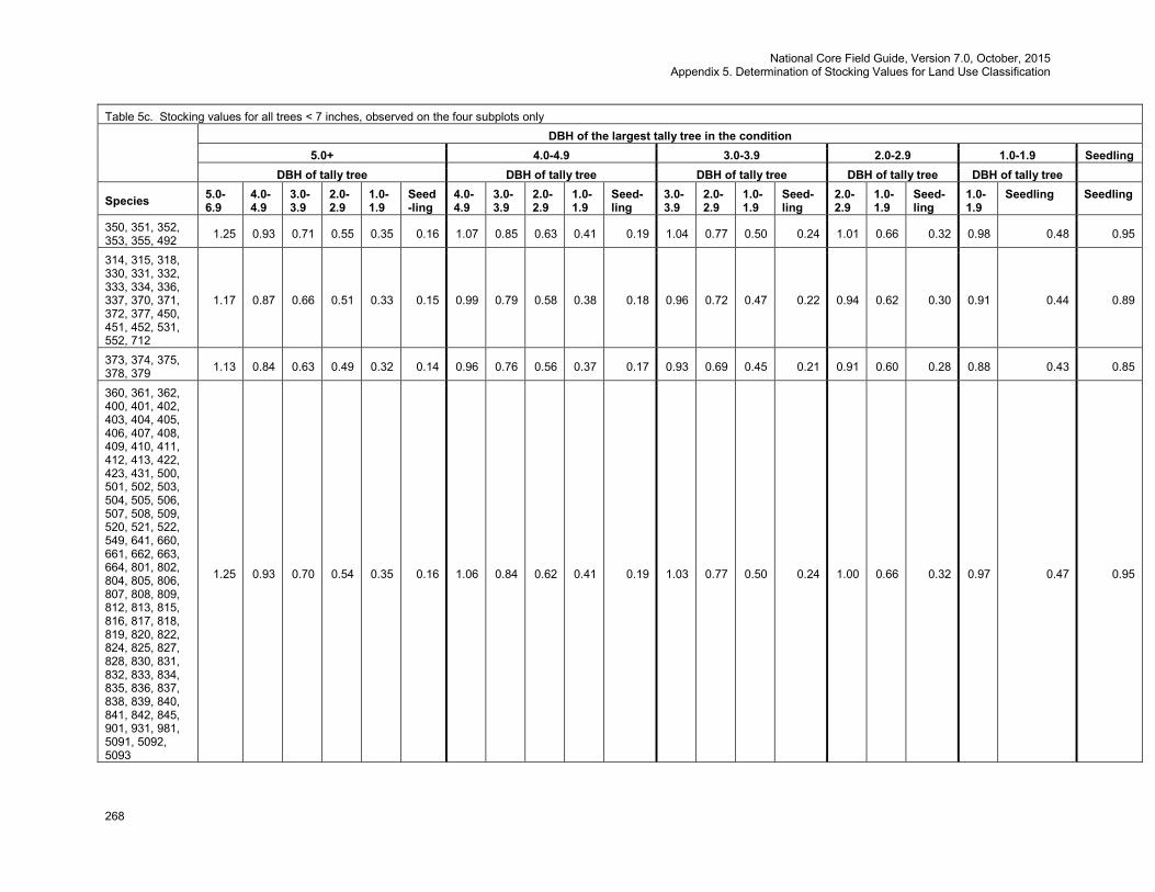
National Core Field Guide, Version 7.0, October, 2015 Appendix 5. Determination of Stocking Values for Land Use Classification
268
Table 5c. Stocking values for all trees < 7 inches, observed on the four subplots only
DBH of the largest tally tree in the condition
5.0+ 4.0-4.9 3.0-3.9 2.0-2.9 1.0-1.9 Seedling DBH of tally tree DBH of tally tree DBH of tally tree DBH of tally tree DBH of tally tree
Species 5.0-6.9
4.0-4.9
3.0-3.9
2.0-2.9
1.0-1.9
Seed-ling
4.0-4.9
3.0-3.9
2.0-2.9
1.0-1.9
Seed-ling
3.0-3.9
2.0-2.9
1.0-1.9
Seed-ling
2.0-2.9
1.0-1.9
Seed-ling
1.0-1.9
Seedling Seedling
350, 351, 352, 353, 355, 492 1.25 0.93 0.71 0.55 0.35 0.16 1.07 0.85 0.63 0.41 0.19 1.04 0.77 0.50 0.24 1.01 0.66 0.32 0.98 0.48 0.95
314, 315, 318, 330, 331, 332, 333, 334, 336, 337, 370, 371, 372, 377, 450, 451, 452, 531, 552, 712
1.17 0.87 0.66 0.51 0.33 0.15 0.99 0.79 0.58 0.38 0.18 0.96 0.72 0.47 0.22 0.94 0.62 0.30 0.91 0.44 0.89
373, 374, 375, 378, 379 1.13 0.84 0.63 0.49 0.32 0.14 0.96 0.76 0.56 0.37 0.17 0.93 0.69 0.45 0.21 0.91 0.60 0.28 0.88 0.43 0.85
360, 361, 362, 400, 401, 402, 403, 404, 405, 406, 407, 408, 409, 410, 411, 412, 413, 422, 423, 431, 500, 501, 502, 503, 504, 505, 506, 507, 508, 509, 520, 521, 522, 549, 641, 660, 661, 662, 663, 664, 801, 802, 804, 805, 806, 807, 808, 809, 812, 813, 815, 816, 817, 818, 819, 820, 822, 824, 825, 827, 828, 830, 831, 832, 833, 834, 835, 836, 837, 838, 839, 840, 841, 842, 845, 901, 931, 981, 5091, 5092, 5093
1.25 0.93 0.70 0.54 0.35 0.16 1.06 0.84 0.62 0.41 0.19 1.03 0.77 0.50 0.24 1.00 0.66 0.32 0.97 0.47 0.95
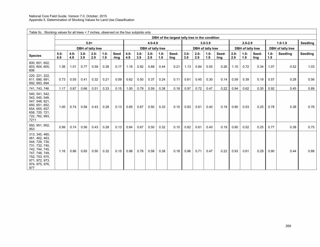
National Core Field Guide, Version 7.0, October, 2015 Appendix 5. Determination of Stocking Values for Land Use Classification
269
Table 5c. Stocking values for all trees < 7 inches, observed on the four subplots only
DBH of the largest tally tree in the condition
5.0+ 4.0-4.9 3.0-3.9 2.0-2.9 1.0-1.9 Seedling DBH of tally tree DBH of tally tree DBH of tally tree DBH of tally tree DBH of tally tree
Species 5.0-6.9
4.0-4.9
3.0-3.9
2.0-2.9
1.0-1.9
Seed-ling
4.0-4.9
3.0-3.9
2.0-2.9
1.0-1.9
Seed-ling
3.0-3.9
2.0-2.9
1.0-1.9
Seed-ling
2.0-2.9
1.0-1.9
Seed-ling
1.0-1.9
Seedling Seedling
600, 601, 602, 603, 604, 605, 606
1.36 1.01 0.77 0.59 0.38 0.17 1.16 0.92 0.68 0.44 0.21 1.13 0.84 0.55 0.26 1.10 0.72 0.34 1.07 0.52 1.03
220, 221, 222, 611, 690, 691, 692, 693, 694
0.73 0.55 0.41 0.32 0.21 0.09 0.62 0.50 0.37 0.24 0.11 0.61 0.45 0.30 0.14 0.59 0.39 0.19 0.57 0.28 0.56
741, 743, 746 1.17 0.87 0.66 0.51 0.33 0.15 1.00 0.79 0.59 0.38 0.18 0.97 0.72 0.47 0.22 0.94 0.62 0.30 0.92 0.45 0.89 540, 541, 542, 543, 545, 546, 547, 548, 621, 650, 651, 652, 654, 655, 657, 658, 720, 721, 722, 762, 993, 7211
1.00 0.74 0.56 0.43 0.28 0.13 0.85 0.67 0.50 0.33 0.15 0.83 0.61 0.40 0.19 0.80 0.53 0.25 0.78 0.38 0.76
950, 951, 952, 953 0.99 0.74 0.56 0.43 0.28 0.13 0.84 0.67 0.50 0.32 0.15 0.82 0.61 0.40 0.19 0.80 0.52 0.25 0.77 0.38 0.75
313, 345, 460, 461, 462, 463, 544, 729, 730, 731, 732, 740, 742, 744, 745, 747, 748, 749, 752, 753, 970, 971, 972, 973, 974, 975, 976, 977
1.16 0.86 0.65 0.50 0.32 0.15 0.98 0.78 0.58 0.38 0.18 0.96 0.71 0.47 0.22 0.93 0.61 0.29 0.90 0.44 0.88
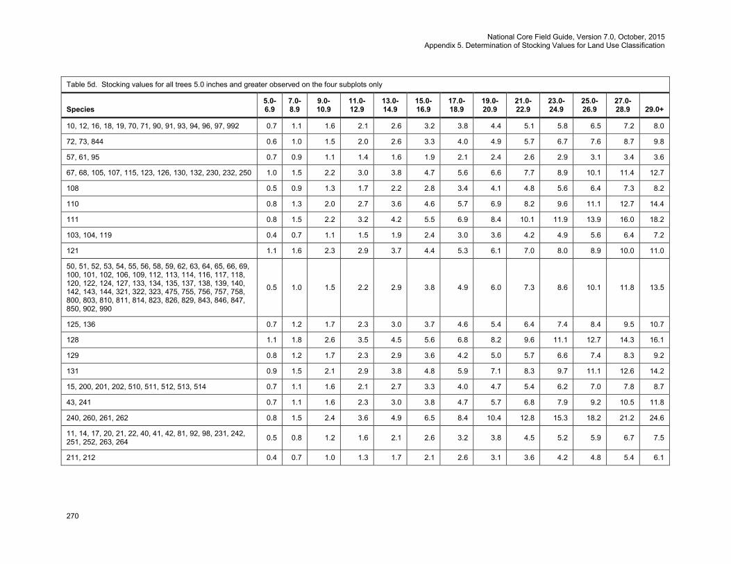
National Core Field Guide, Version 7.0, October, 2015 Appendix 5. Determination of Stocking Values for Land Use Classification
270
Table 5d. Stocking values for all trees 5.0 inches and greater observed on the four subplots only
Species 5.0-6.9
7.0-8.9
9.0-10.9
11.0-12.9
13.0-14.9
15.0-16.9
17.0-18.9
19.0-20.9
21.0-22.9
23.0-24.9
25.0-26.9
27.0-28.9 29.0+
10, 12, 16, 18, 19, 70, 71, 90, 91, 93, 94, 96, 97, 992 0.7 1.1 1.6 2.1 2.6 3.2 3.8 4.4 5.1 5.8 6.5 7.2 8.0
72, 73, 844 0.6 1.0 1.5 2.0 2.6 3.3 4.0 4.9 5.7 6.7 7.6 8.7 9.8
57, 61, 95 0.7 0.9 1.1 1.4 1.6 1.9 2.1 2.4 2.6 2.9 3.1 3.4 3.6
67, 68, 105, 107, 115, 123, 126, 130, 132, 230, 232, 250 1.0 1.5 2.2 3.0 3.8 4.7 5.6 6.6 7.7 8.9 10.1 11.4 12.7
108 0.5 0.9 1.3 1.7 2.2 2.8 3.4 4.1 4.8 5.6 6.4 7.3 8.2
110 0.8 1.3 2.0 2.7 3.6 4.6 5.7 6.9 8.2 9.6 11.1 12.7 14.4
111 0.8 1.5 2.2 3.2 4.2 5.5 6.9 8.4 10.1 11.9 13.9 16.0 18.2
103, 104, 119 0.4 0.7 1.1 1.5 1.9 2.4 3.0 3.6 4.2 4.9 5.6 6.4 7.2
121 1.1 1.6 2.3 2.9 3.7 4.4 5.3 6.1 7.0 8.0 8.9 10.0 11.0
50, 51, 52, 53, 54, 55, 56, 58, 59, 62, 63, 64, 65, 66, 69, 100, 101, 102, 106, 109, 112, 113, 114, 116, 117, 118, 120, 122, 124, 127, 133, 134, 135, 137, 138, 139, 140, 142, 143, 144, 321, 322, 323, 475, 755, 756, 757, 758, 800, 803, 810, 811, 814, 823, 826, 829, 843, 846, 847, 850, 902, 990
0.5 1.0 1.5 2.2 2.9 3.8 4.9 6.0 7.3 8.6 10.1 11.8 13.5
125, 136 0.7 1.2 1.7 2.3 3.0 3.7 4.6 5.4 6.4 7.4 8.4 9.5 10.7
128 1.1 1.8 2.6 3.5 4.5 5.6 6.8 8.2 9.6 11.1 12.7 14.3 16.1
129 0.8 1.2 1.7 2.3 2.9 3.6 4.2 5.0 5.7 6.6 7.4 8.3 9.2
131 0.9 1.5 2.1 2.9 3.8 4.8 5.9 7.1 8.3 9.7 11.1 12.6 14.2
15, 200, 201, 202, 510, 511, 512, 513, 514 0.7 1.1 1.6 2.1 2.7 3.3 4.0 4.7 5.4 6.2 7.0 7.8 8.7
43, 241 0.7 1.1 1.6 2.3 3.0 3.8 4.7 5.7 6.8 7.9 9.2 10.5 11.8
240, 260, 261, 262 0.8 1.5 2.4 3.6 4.9 6.5 8.4 10.4 12.8 15.3 18.2 21.2 24.6
11, 14, 17, 20, 21, 22, 40, 41, 42, 81, 92, 98, 231, 242, 251, 252, 263, 264 0.5 0.8 1.2 1.6 2.1 2.6 3.2 3.8 4.5 5.2 5.9 6.7 7.5
211, 212 0.4 0.7 1.0 1.3 1.7 2.1 2.6 3.1 3.6 4.2 4.8 5.4 6.1
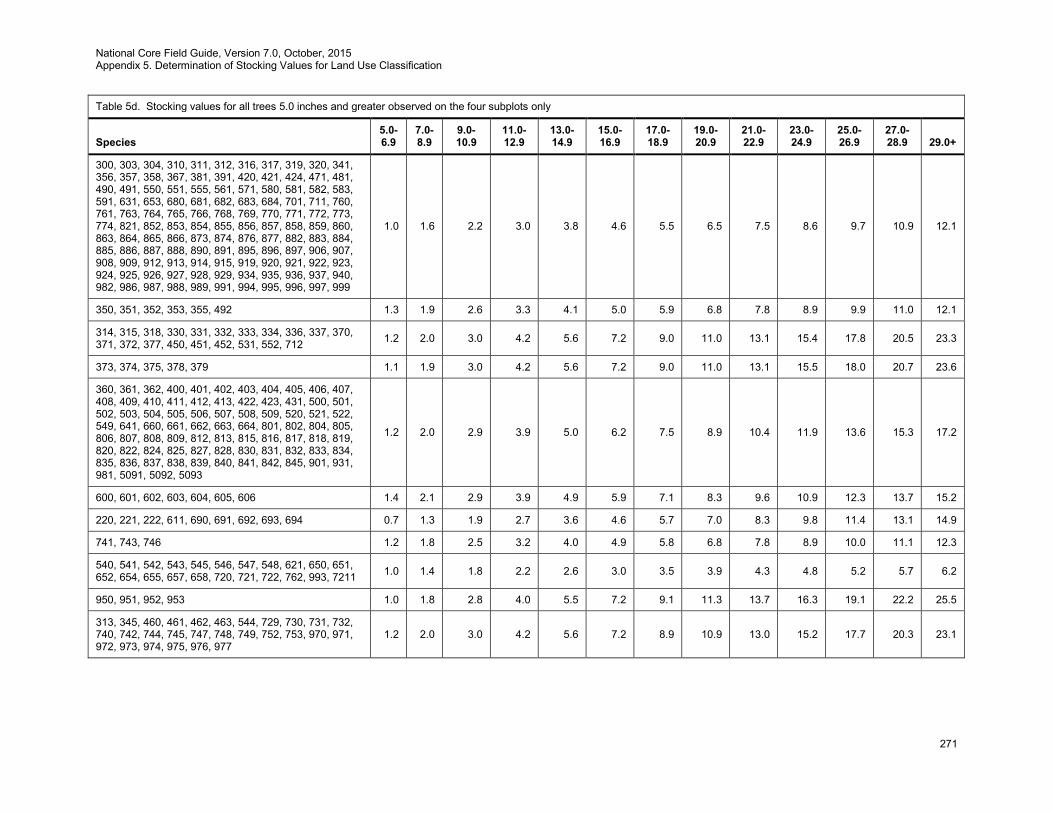
National Core Field Guide, Version 7.0, October, 2015 Appendix 5. Determination of Stocking Values for Land Use Classification
271
Table 5d. Stocking values for all trees 5.0 inches and greater observed on the four subplots only
Species 5.0-6.9
7.0-8.9
9.0-10.9
11.0-12.9
13.0-14.9
15.0-16.9
17.0-18.9
19.0-20.9
21.0-22.9
23.0-24.9
25.0-26.9
27.0-28.9 29.0+
300, 303, 304, 310, 311, 312, 316, 317, 319, 320, 341, 356, 357, 358, 367, 381, 391, 420, 421, 424, 471, 481, 490, 491, 550, 551, 555, 561, 571, 580, 581, 582, 583, 591, 631, 653, 680, 681, 682, 683, 684, 701, 711, 760, 761, 763, 764, 765, 766, 768, 769, 770, 771, 772, 773, 774, 821, 852, 853, 854, 855, 856, 857, 858, 859, 860, 863, 864, 865, 866, 873, 874, 876, 877, 882, 883, 884, 885, 886, 887, 888, 890, 891, 895, 896, 897, 906, 907, 908, 909, 912, 913, 914, 915, 919, 920, 921, 922, 923, 924, 925, 926, 927, 928, 929, 934, 935, 936, 937, 940, 982, 986, 987, 988, 989, 991, 994, 995, 996, 997, 999
1.0 1.6 2.2 3.0 3.8 4.6 5.5 6.5 7.5 8.6 9.7 10.9 12.1
350, 351, 352, 353, 355, 492 1.3 1.9 2.6 3.3 4.1 5.0 5.9 6.8 7.8 8.9 9.9 11.0 12.1
314, 315, 318, 330, 331, 332, 333, 334, 336, 337, 370, 371, 372, 377, 450, 451, 452, 531, 552, 712 1.2 2.0 3.0 4.2 5.6 7.2 9.0 11.0 13.1 15.4 17.8 20.5 23.3
373, 374, 375, 378, 379 1.1 1.9 3.0 4.2 5.6 7.2 9.0 11.0 13.1 15.5 18.0 20.7 23.6
360, 361, 362, 400, 401, 402, 403, 404, 405, 406, 407, 408, 409, 410, 411, 412, 413, 422, 423, 431, 500, 501, 502, 503, 504, 505, 506, 507, 508, 509, 520, 521, 522, 549, 641, 660, 661, 662, 663, 664, 801, 802, 804, 805, 806, 807, 808, 809, 812, 813, 815, 816, 817, 818, 819, 820, 822, 824, 825, 827, 828, 830, 831, 832, 833, 834, 835, 836, 837, 838, 839, 840, 841, 842, 845, 901, 931, 981, 5091, 5092, 5093
1.2 2.0 2.9 3.9 5.0 6.2 7.5 8.9 10.4 11.9 13.6 15.3 17.2
600, 601, 602, 603, 604, 605, 606 1.4 2.1 2.9 3.9 4.9 5.9 7.1 8.3 9.6 10.9 12.3 13.7 15.2
220, 221, 222, 611, 690, 691, 692, 693, 694 0.7 1.3 1.9 2.7 3.6 4.6 5.7 7.0 8.3 9.8 11.4 13.1 14.9
741, 743, 746 1.2 1.8 2.5 3.2 4.0 4.9 5.8 6.8 7.8 8.9 10.0 11.1 12.3
540, 541, 542, 543, 545, 546, 547, 548, 621, 650, 651, 652, 654, 655, 657, 658, 720, 721, 722, 762, 993, 7211 1.0 1.4 1.8 2.2 2.6 3.0 3.5 3.9 4.3 4.8 5.2 5.7 6.2
950, 951, 952, 953 1.0 1.8 2.8 4.0 5.5 7.2 9.1 11.3 13.7 16.3 19.1 22.2 25.5
313, 345, 460, 461, 462, 463, 544, 729, 730, 731, 732, 740, 742, 744, 745, 747, 748, 749, 752, 753, 970, 971, 972, 973, 974, 975, 976, 977
1.2 2.0 3.0 4.2 5.6 7.2 8.9 10.9 13.0 15.2 17.7 20.3 23.1
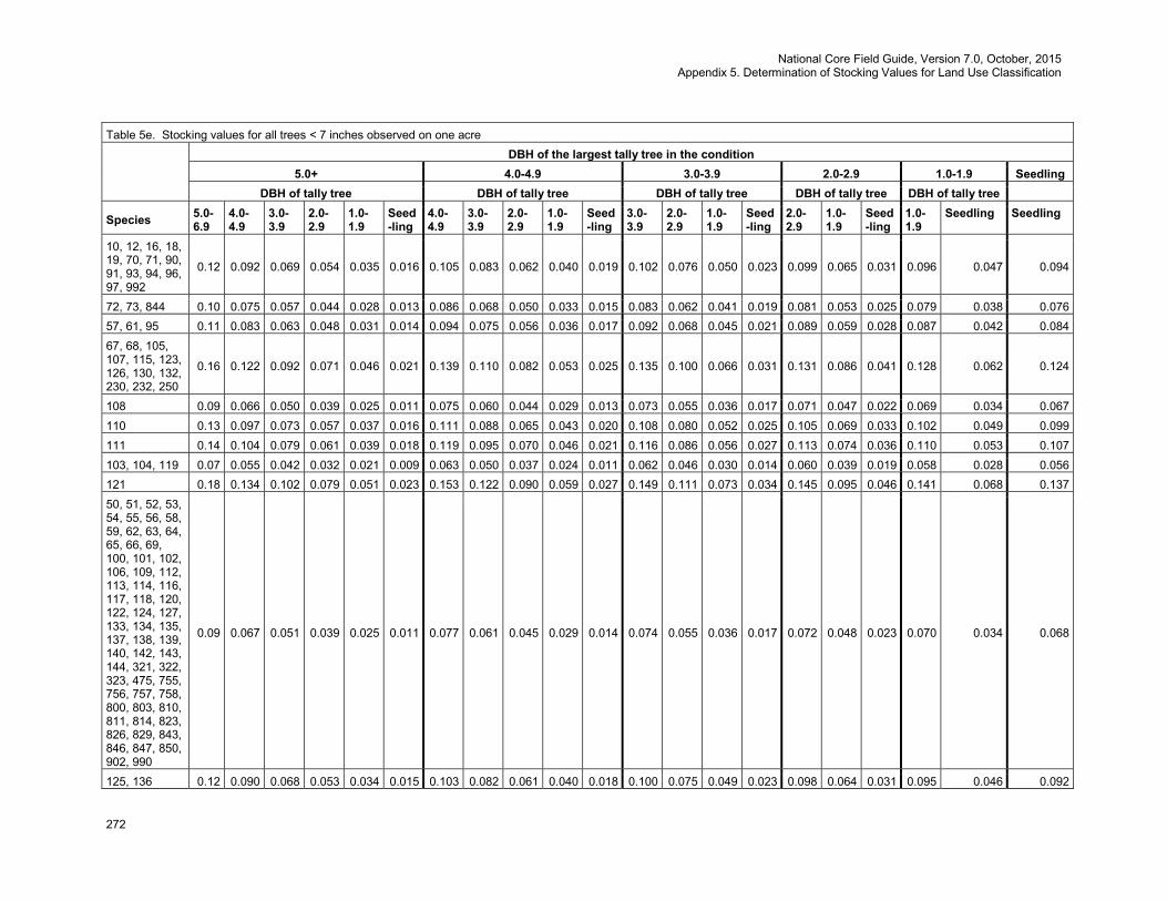
National Core Field Guide, Version 7.0, October, 2015 Appendix 5. Determination of Stocking Values for Land Use Classification
272
Table 5e. Stocking values for all trees < 7 inches observed on one acre
DBH of the largest tally tree in the condition
5.0+ 4.0-4.9 3.0-3.9 2.0-2.9 1.0-1.9 Seedling DBH of tally tree DBH of tally tree DBH of tally tree DBH of tally tree DBH of tally tree
Species 5.0-6.9
4.0-4.9
3.0-3.9
2.0-2.9
1.0-1.9
Seed-ling
4.0-4.9
3.0-3.9
2.0-2.9
1.0-1.9
Seed-ling
3.0-3.9
2.0-2.9
1.0-1.9
Seed-ling
2.0-2.9
1.0-1.9
Seed-ling
1.0-1.9
Seedling Seedling
10, 12, 16, 18, 19, 70, 71, 90, 91, 93, 94, 96, 97, 992
0.12 0.092 0.069 0.054 0.035 0.016 0.105 0.083 0.062 0.040 0.019 0.102 0.076 0.050 0.023 0.099 0.065 0.031 0.096 0.047 0.094
72, 73, 844 0.10 0.075 0.057 0.044 0.028 0.013 0.086 0.068 0.050 0.033 0.015 0.083 0.062 0.041 0.019 0.081 0.053 0.025 0.079 0.038 0.076 57, 61, 95 0.11 0.083 0.063 0.048 0.031 0.014 0.094 0.075 0.056 0.036 0.017 0.092 0.068 0.045 0.021 0.089 0.059 0.028 0.087 0.042 0.084 67, 68, 105, 107, 115, 123, 126, 130, 132, 230, 232, 250
0.16 0.122 0.092 0.071 0.046 0.021 0.139 0.110 0.082 0.053 0.025 0.135 0.100 0.066 0.031 0.131 0.086 0.041 0.128 0.062 0.124
108 0.09 0.066 0.050 0.039 0.025 0.011 0.075 0.060 0.044 0.029 0.013 0.073 0.055 0.036 0.017 0.071 0.047 0.022 0.069 0.034 0.067 110 0.13 0.097 0.073 0.057 0.037 0.016 0.111 0.088 0.065 0.043 0.020 0.108 0.080 0.052 0.025 0.105 0.069 0.033 0.102 0.049 0.099 111 0.14 0.104 0.079 0.061 0.039 0.018 0.119 0.095 0.070 0.046 0.021 0.116 0.086 0.056 0.027 0.113 0.074 0.036 0.110 0.053 0.107 103, 104, 119 0.07 0.055 0.042 0.032 0.021 0.009 0.063 0.050 0.037 0.024 0.011 0.062 0.046 0.030 0.014 0.060 0.039 0.019 0.058 0.028 0.056 121 0.18 0.134 0.102 0.079 0.051 0.023 0.153 0.122 0.090 0.059 0.027 0.149 0.111 0.073 0.034 0.145 0.095 0.046 0.141 0.068 0.137 50, 51, 52, 53, 54, 55, 56, 58, 59, 62, 63, 64, 65, 66, 69, 100, 101, 102, 106, 109, 112, 113, 114, 116, 117, 118, 120, 122, 124, 127, 133, 134, 135, 137, 138, 139, 140, 142, 143, 144, 321, 322, 323, 475, 755, 756, 757, 758, 800, 803, 810, 811, 814, 823, 826, 829, 843, 846, 847, 850, 902, 990
0.09 0.067 0.051 0.039 0.025 0.011 0.077 0.061 0.045 0.029 0.014 0.074 0.055 0.036 0.017 0.072 0.048 0.023 0.070 0.034 0.068
125, 136 0.12 0.090 0.068 0.053 0.034 0.015 0.103 0.082 0.061 0.040 0.018 0.100 0.075 0.049 0.023 0.098 0.064 0.031 0.095 0.046 0.092
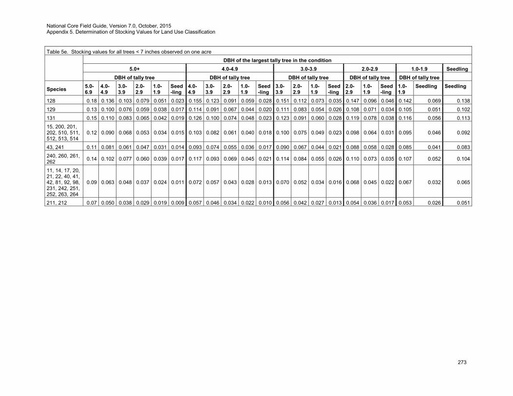
National Core Field Guide, Version 7.0, October, 2015 Appendix 5. Determination of Stocking Values for Land Use Classification
273
Table 5e. Stocking values for all trees < 7 inches observed on one acre
DBH of the largest tally tree in the condition
5.0+ 4.0-4.9 3.0-3.9 2.0-2.9 1.0-1.9 Seedling DBH of tally tree DBH of tally tree DBH of tally tree DBH of tally tree DBH of tally tree
Species 5.0-6.9
4.0-4.9
3.0-3.9
2.0-2.9
1.0-1.9
Seed-ling
4.0-4.9
3.0-3.9
2.0-2.9
1.0-1.9
Seed-ling
3.0-3.9
2.0-2.9
1.0-1.9
Seed-ling
2.0-2.9
1.0-1.9
Seed-ling
1.0-1.9
Seedling Seedling
128 0.18 0.136 0.103 0.079 0.051 0.023 0.155 0.123 0.091 0.059 0.028 0.151 0.112 0.073 0.035 0.147 0.096 0.046 0.142 0.069 0.138 129 0.13 0.100 0.076 0.059 0.038 0.017 0.114 0.091 0.067 0.044 0.020 0.111 0.083 0.054 0.026 0.108 0.071 0.034 0.105 0.051 0.102 131 0.15 0.110 0.083 0.065 0.042 0.019 0.126 0.100 0.074 0.048 0.023 0.123 0.091 0.060 0.028 0.119 0.078 0.038 0.116 0.056 0.113 15, 200, 201, 202, 510, 511, 512, 513, 514
0.12 0.090 0.068 0.053 0.034 0.015 0.103 0.082 0.061 0.040 0.018 0.100 0.075 0.049 0.023 0.098 0.064 0.031 0.095 0.046 0.092
43, 241 0.11 0.081 0.061 0.047 0.031 0.014 0.093 0.074 0.055 0.036 0.017 0.090 0.067 0.044 0.021 0.088 0.058 0.028 0.085 0.041 0.083 240, 260, 261, 262 0.14 0.102 0.077 0.060 0.039 0.017 0.117 0.093 0.069 0.045 0.021 0.114 0.084 0.055 0.026 0.110 0.073 0.035 0.107 0.052 0.104
11, 14, 17, 20, 21, 22, 40, 41, 42, 81, 92, 98, 231, 242, 251, 252, 263, 264
0.09 0.063 0.048 0.037 0.024 0.011 0.072 0.057 0.043 0.028 0.013 0.070 0.052 0.034 0.016 0.068 0.045 0.022 0.067 0.032 0.065
211, 212 0.07 0.050 0.038 0.029 0.019 0.009 0.057 0.046 0.034 0.022 0.010 0.056 0.042 0.027 0.013 0.054 0.036 0.017 0.053 0.026 0.051

National Core Field Guide, Version 7.0, October, 2015 Appendix 5. Determination of Stocking Values for Land Use Classification
274
Table 5e. Stocking values for all trees < 7 inches observed on one acre
DBH of the largest tally tree in the condition
5.0+ 4.0-4.9 3.0-3.9 2.0-2.9 1.0-1.9 Seedling DBH of tally tree DBH of tally tree DBH of tally tree DBH of tally tree DBH of tally tree
Species 5.0-6.9
4.0-4.9
3.0-3.9
2.0-2.9
1.0-1.9
Seed-ling
4.0-4.9
3.0-3.9
2.0-2.9
1.0-1.9
Seed-ling
3.0-3.9
2.0-2.9
1.0-1.9
Seed-ling
2.0-2.9
1.0-1.9
Seed-ling
1.0-1.9
Seedling Seedling
300, 303, 304, 310, 311, 312, 316, 317, 319, 320, 341, 356, 357, 358, 367, 381, 391, 420, 421, 424, 471, 481, 490, 491, 550, 551, 555, 561, 571, 580, 581, 582, 583, 591, 631, 653, 680, 681, 682, 683, 684, 701, 711, 760, 761, 763, 764, 765, 766, 768, 769, 770, 771, 772, 773, 774, 821, 852, 853, 854, 855, 856, 857, 858, 859, 860, 863, 864, 865, 866, 873, 874, 876, 877, 882, 883, 884, 885, 886, 887, 888, 890, 891, 895, 896, 897, 906, 907, 908, 909, 912, 913, 914, 915, 919, 920, 921, 922, 923, 924, 925, 926, 927, 928, 929, 934, 935, 936, 937, 940, 982, 986, 987, 988, 989, 991, 994, 995, 996, 997, 999
0.17 0.128 0.097 0.075 0.048 0.022 0.146 0.116 0.086 0.056 0.026 0.142 0.105 0.069 0.033 0.138 0.091 0.043 0.134 0.065 0.130
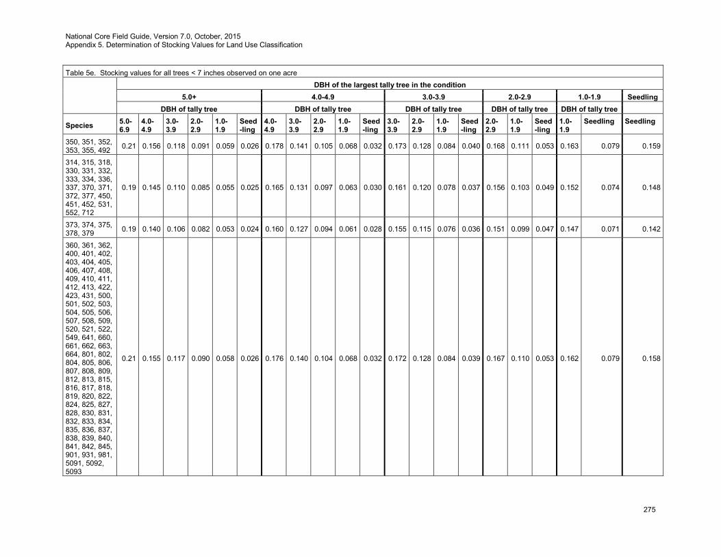
National Core Field Guide, Version 7.0, October, 2015 Appendix 5. Determination of Stocking Values for Land Use Classification
275
Table 5e. Stocking values for all trees < 7 inches observed on one acre
DBH of the largest tally tree in the condition
5.0+ 4.0-4.9 3.0-3.9 2.0-2.9 1.0-1.9 Seedling DBH of tally tree DBH of tally tree DBH of tally tree DBH of tally tree DBH of tally tree
Species 5.0-6.9
4.0-4.9
3.0-3.9
2.0-2.9
1.0-1.9
Seed-ling
4.0-4.9
3.0-3.9
2.0-2.9
1.0-1.9
Seed-ling
3.0-3.9
2.0-2.9
1.0-1.9
Seed-ling
2.0-2.9
1.0-1.9
Seed-ling
1.0-1.9
Seedling Seedling
350, 351, 352, 353, 355, 492 0.21 0.156 0.118 0.091 0.059 0.026 0.178 0.141 0.105 0.068 0.032 0.173 0.128 0.084 0.040 0.168 0.111 0.053 0.163 0.079 0.159
314, 315, 318, 330, 331, 332, 333, 334, 336, 337, 370, 371, 372, 377, 450, 451, 452, 531, 552, 712
0.19 0.145 0.110 0.085 0.055 0.025 0.165 0.131 0.097 0.063 0.030 0.161 0.120 0.078 0.037 0.156 0.103 0.049 0.152 0.074 0.148
373, 374, 375, 378, 379 0.19 0.140 0.106 0.082 0.053 0.024 0.160 0.127 0.094 0.061 0.028 0.155 0.115 0.076 0.036 0.151 0.099 0.047 0.147 0.071 0.142
360, 361, 362, 400, 401, 402, 403, 404, 405, 406, 407, 408, 409, 410, 411, 412, 413, 422, 423, 431, 500, 501, 502, 503, 504, 505, 506, 507, 508, 509, 520, 521, 522, 549, 641, 660, 661, 662, 663, 664, 801, 802, 804, 805, 806, 807, 808, 809, 812, 813, 815, 816, 817, 818, 819, 820, 822, 824, 825, 827, 828, 830, 831, 832, 833, 834, 835, 836, 837, 838, 839, 840, 841, 842, 845, 901, 931, 981, 5091, 5092, 5093
0.21 0.155 0.117 0.090 0.058 0.026 0.176 0.140 0.104 0.068 0.032 0.172 0.128 0.084 0.039 0.167 0.110 0.053 0.162 0.079 0.158
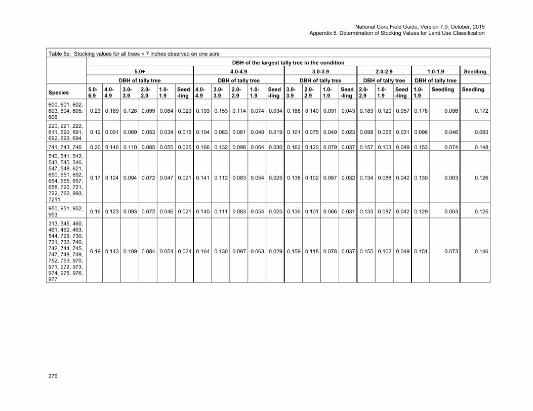
National Core Field Guide, Version 7.0, October, 2015 Appendix 5. Determination of Stocking Values for Land Use Classification
276
Table 5e. Stocking values for all trees < 7 inches observed on one acre
DBH of the largest tally tree in the condition
5.0+ 4.0-4.9 3.0-3.9 2.0-2.9 1.0-1.9 Seedling DBH of tally tree DBH of tally tree DBH of tally tree DBH of tally tree DBH of tally tree
Species 5.0-6.9
4.0-4.9
3.0-3.9
2.0-2.9
1.0-1.9
Seed-ling
4.0-4.9
3.0-3.9
2.0-2.9
1.0-1.9
Seed-ling
3.0-3.9
2.0-2.9
1.0-1.9
Seed-ling
2.0-2.9
1.0-1.9
Seed-ling
1.0-1.9
Seedling Seedling
600, 601, 602, 603, 604, 605, 606
0.23 0.169 0.128 0.099 0.064 0.029 0.193 0.153 0.114 0.074 0.034 0.188 0.140 0.091 0.043 0.183 0.120 0.057 0.178 0.086 0.172
220, 221, 222, 611, 690, 691, 692, 693, 694
0.12 0.091 0.069 0.053 0.034 0.015 0.104 0.083 0.061 0.040 0.019 0.101 0.075 0.049 0.023 0.098 0.065 0.031 0.096 0.046 0.093
741, 743, 746 0.20 0.146 0.110 0.085 0.055 0.025 0.166 0.132 0.098 0.064 0.030 0.162 0.120 0.079 0.037 0.157 0.103 0.049 0.153 0.074 0.148 540, 541, 542, 543, 545, 546, 547, 548, 621, 650, 651, 652, 654, 655, 657, 658, 720, 721, 722, 762, 993, 7211
0.17 0.124 0.094 0.072 0.047 0.021 0.141 0.112 0.083 0.054 0.025 0.138 0.102 0.067 0.032 0.134 0.088 0.042 0.130 0.063 0.126
950, 951, 952, 953 0.16 0.123 0.093 0.072 0.046 0.021 0.140 0.111 0.083 0.054 0.025 0.136 0.101 0.066 0.031 0.133 0.087 0.042 0.129 0.063 0.125
313, 345, 460, 461, 462, 463, 544, 729, 730, 731, 732, 740, 742, 744, 745, 747, 748, 749, 752, 753, 970, 971, 972, 973, 974, 975, 976, 977
0.19 0.143 0.109 0.084 0.054 0.024 0.164 0.130 0.097 0.063 0.029 0.159 0.118 0.078 0.037 0.155 0.102 0.049 0.151 0.073 0.146
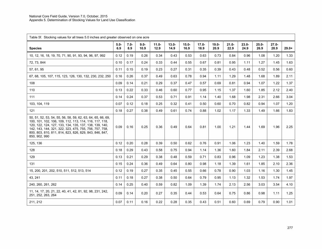
National Core Field Guide, Version 7.0, October, 2015 Appendix 5. Determination of Stocking Values for Land Use Classification
277
Table 5f. Stocking values for all trees 5.0 inches and greater observed on one acre
Species 5.0-6.9
7.0-8.9
9.0-10.9
11.0-12.9
13.0-14.9
15.0-16.9
17.0-18.9
19.0-20.9
21.0-22.9
23.0-24.9
25.0-26.9
27.0-28.9 29.0+
10, 12, 16, 18, 19, 70, 71, 90, 91, 93, 94, 96, 97, 992 0.12 0.19 0.26 0.34 0.43 0.53 0.63 0.73 0.84 0.96 1.08 1.20 1.33
72, 73, 844 0.10 0.17 0.24 0.33 0.44 0.55 0.67 0.81 0.95 1.11 1.27 1.45 1.63
57, 61, 95 0.11 0.15 0.19 0.23 0.27 0.31 0.35 0.39 0.43 0.48 0.52 0.56 0.60
67, 68, 105, 107, 115, 123, 126, 130, 132, 230, 232, 250 0.16 0.26 0.37 0.49 0.63 0.78 0.94 1.11 1.29 1.48 1.68 1.89 2.11
108 0.09 0.14 0.21 0.29 0.37 0.47 0.57 0.69 0.81 0.94 1.07 1.22 1.37
110 0.13 0.22 0.33 0.46 0.60 0.77 0.95 1.15 1.37 1.60 1.85 2.12 2.40
111 0.14 0.24 0.37 0.53 0.71 0.91 1.14 1.40 1.68 1.98 2.31 2.66 3.04
103, 104, 119 0.07 0.12 0.18 0.25 0.32 0.41 0.50 0.60 0.70 0.82 0.94 1.07 1.20
121 0.18 0.27 0.38 0.49 0.61 0.74 0.88 1.02 1.17 1.33 1.49 1.66 1.83
50, 51, 52, 53, 54, 55, 56, 58, 59, 62, 63, 64, 65, 66, 69, 100, 101, 102, 106, 109, 112, 113, 114, 116, 117, 118, 120, 122, 124, 127, 133, 134, 135, 137, 138, 139, 140, 142, 143, 144, 321, 322, 323, 475, 755, 756, 757, 758, 800, 803, 810, 811, 814, 823, 826, 829, 843, 846, 847, 850, 902, 990
0.09 0.16 0.25 0.36 0.49 0.64 0.81 1.00 1.21 1.44 1.69 1.96 2.25
125, 136 0.12 0.20 0.28 0.39 0.50 0.62 0.76 0.91 1.06 1.23 1.40 1.59 1.78
128 0.18 0.29 0.43 0.58 0.75 0.94 1.14 1.36 1.60 1.84 2.11 2.39 2.68
129 0.13 0.21 0.29 0.38 0.48 0.59 0.71 0.83 0.96 1.09 1.23 1.38 1.53
131 0.15 0.24 0.36 0.49 0.64 0.80 0.98 1.18 1.39 1.61 1.85 2.10 2.36
15, 200, 201, 202, 510, 511, 512, 513, 514 0.12 0.19 0.27 0.35 0.45 0.55 0.66 0.78 0.90 1.03 1.16 1.30 1.45
43, 241 0.11 0.18 0.27 0.38 0.50 0.64 0.79 0.95 1.13 1.32 1.53 1.74 1.97
240, 260, 261, 262 0.14 0.25 0.40 0.59 0.82 1.09 1.39 1.74 2.13 2.56 3.03 3.54 4.10
11, 14, 17, 20, 21, 22, 40, 41, 42, 81, 92, 98, 231, 242, 251, 252, 263, 264 0.09 0.14 0.20 0.27 0.35 0.44 0.53 0.64 0.75 0.86 0.98 1.11 1.25
211, 212 0.07 0.11 0.16 0.22 0.28 0.35 0.43 0.51 0.60 0.69 0.79 0.90 1.01
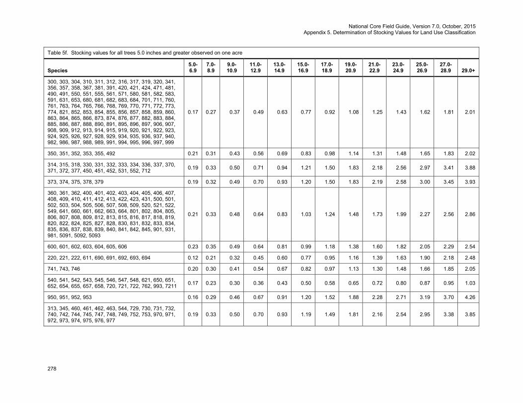
National Core Field Guide, Version 7.0, October, 2015 Appendix 5. Determination of Stocking Values for Land Use Classification
278
Table 5f. Stocking values for all trees 5.0 inches and greater observed on one acre
Species 5.0-6.9
7.0-8.9
9.0-10.9
11.0-12.9
13.0-14.9
15.0-16.9
17.0-18.9
19.0-20.9
21.0-22.9
23.0-24.9
25.0-26.9
27.0-28.9 29.0+
300, 303, 304, 310, 311, 312, 316, 317, 319, 320, 341, 356, 357, 358, 367, 381, 391, 420, 421, 424, 471, 481, 490, 491, 550, 551, 555, 561, 571, 580, 581, 582, 583, 591, 631, 653, 680, 681, 682, 683, 684, 701, 711, 760, 761, 763, 764, 765, 766, 768, 769, 770, 771, 772, 773, 774, 821, 852, 853, 854, 855, 856, 857, 858, 859, 860, 863, 864, 865, 866, 873, 874, 876, 877, 882, 883, 884, 885, 886, 887, 888, 890, 891, 895, 896, 897, 906, 907, 908, 909, 912, 913, 914, 915, 919, 920, 921, 922, 923, 924, 925, 926, 927, 928, 929, 934, 935, 936, 937, 940, 982, 986, 987, 988, 989, 991, 994, 995, 996, 997, 999
0.17 0.27 0.37 0.49 0.63 0.77 0.92 1.08 1.25 1.43 1.62 1.81 2.01
350, 351, 352, 353, 355, 492 0.21 0.31 0.43 0.56 0.69 0.83 0.98 1.14 1.31 1.48 1.65 1.83 2.02
314, 315, 318, 330, 331, 332, 333, 334, 336, 337, 370, 371, 372, 377, 450, 451, 452, 531, 552, 712 0.19 0.33 0.50 0.71 0.94 1.21 1.50 1.83 2.18 2.56 2.97 3.41 3.88
373, 374, 375, 378, 379 0.19 0.32 0.49 0.70 0.93 1.20 1.50 1.83 2.19 2.58 3.00 3.45 3.93
360, 361, 362, 400, 401, 402, 403, 404, 405, 406, 407, 408, 409, 410, 411, 412, 413, 422, 423, 431, 500, 501, 502, 503, 504, 505, 506, 507, 508, 509, 520, 521, 522, 549, 641, 660, 661, 662, 663, 664, 801, 802, 804, 805, 806, 807, 808, 809, 812, 813, 815, 816, 817, 818, 819, 820, 822, 824, 825, 827, 828, 830, 831, 832, 833, 834, 835, 836, 837, 838, 839, 840, 841, 842, 845, 901, 931, 981, 5091, 5092, 5093
0.21 0.33 0.48 0.64 0.83 1.03 1.24 1.48 1.73 1.99 2.27 2.56 2.86
600, 601, 602, 603, 604, 605, 606 0.23 0.35 0.49 0.64 0.81 0.99 1.18 1.38 1.60 1.82 2.05 2.29 2.54
220, 221, 222, 611, 690, 691, 692, 693, 694 0.12 0.21 0.32 0.45 0.60 0.77 0.95 1.16 1.39 1.63 1.90 2.18 2.48
741, 743, 746 0.20 0.30 0.41 0.54 0.67 0.82 0.97 1.13 1.30 1.48 1.66 1.85 2.05
540, 541, 542, 543, 545, 546, 547, 548, 621, 650, 651, 652, 654, 655, 657, 658, 720, 721, 722, 762, 993, 7211 0.17 0.23 0.30 0.36 0.43 0.50 0.58 0.65 0.72 0.80 0.87 0.95 1.03
950, 951, 952, 953 0.16 0.29 0.46 0.67 0.91 1.20 1.52 1.88 2.28 2.71 3.19 3.70 4.26
313, 345, 460, 461, 462, 463, 544, 729, 730, 731, 732, 740, 742, 744, 745, 747, 748, 749, 752, 753, 970, 971, 972, 973, 974, 975, 976, 977
0.19 0.33 0.50 0.70 0.93 1.19 1.49 1.81 2.16 2.54 2.95 3.38 3.85
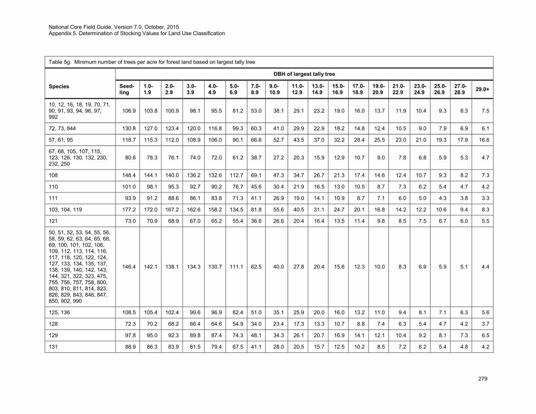
National Core Field Guide, Version 7.0, October, 2015 Appendix 5. Determination of Stocking Values for Land Use Classification
279
Table 5g. Minimum number of trees per acre for forest land based on largest tally tree
Species
DBH of largest tally tree
Seed-ling
1.0-1.9
2.0-2.9
3.0-3.9
4.0-4.9
5.0-6.9
7.0-8.9
9.0-10.9
11.0-12.9
13.0-14.9
15.0-16.9
17.0-18.9
19.0-20.9
21.0-22.9
23.0-24.9
25.0-26.9
27.0-28.9 29.0+
10, 12, 16, 18, 19, 70, 71, 90, 91, 93, 94, 96, 97, 992
106.9 103.8 100.9 98.1 95.5 81.2 53.0 38.1 29.1 23.2 19.0 16.0 13.7 11.9 10.4 9.3 8.3 7.5
72, 73, 844 130.8 127.0 123.4 120.0 116.8 99.3 60.3 41.0 29.9 22.9 18.2 14.8 12.4 10.5 9.0 7.9 6.9 6.1
57, 61, 95 118.7 115.3 112.0 108.9 106.0 90.1 66.6 52.7 43.5 37.0 32.2 28.4 25.5 23.0 21.0 19.3 17.9 16.6
67, 68, 105, 107, 115, 123, 126, 130, 132, 230, 232, 250
80.6 78.3 76.1 74.0 72.0 61.2 38.7 27.2 20.3 15.9 12.9 10.7 9.0 7.8 6.8 5.9 5.3 4.7
108 148.4 144.1 140.0 136.2 132.6 112.7 69.1 47.3 34.7 26.7 21.3 17.4 14.6 12.4 10.7 9.3 8.2 7.3
110 101.0 98.1 95.3 92.7 90.2 76.7 45.6 30.4 21.9 16.5 13.0 10.5 8.7 7.3 6.2 5.4 4.7 4.2
111 93.9 91.2 88.6 86.1 83.8 71.3 41.1 26.9 19.0 14.1 10.9 8.7 7.1 6.0 5.0 4.3 3.8 3.3
103, 104, 119 177.2 172.0 167.2 162.6 158.2 134.5 81.8 55.6 40.5 31.1 24.7 20.1 16.8 14.2 12.2 10.6 9.4 8.3
121 73.0 70.9 68.9 67.0 65.2 55.4 36.6 26.6 20.4 16.4 13.5 11.4 9.8 8.5 7.5 6.7 6.0 5.5
50, 51, 52, 53, 54, 55, 56, 58, 59, 62, 63, 64, 65, 66, 69, 100, 101, 102, 106, 109, 112, 113, 114, 116, 117, 118, 120, 122, 124, 127, 133, 134, 135, 137, 138, 139, 140, 142, 143, 144, 321, 322, 323, 475, 755, 756, 757, 758, 800, 803, 810, 811, 814, 823, 826, 829, 843, 846, 847, 850, 902, 990
146.4 142.1 138.1 134.3 130.7 111.1 62.5 40.0 27.8 20.4 15.6 12.3 10.0 8.3 6.9 5.9 5.1 4.4
125, 136 108.5 105.4 102.4 99.6 96.9 82.4 51.0 35.1 25.9 20.0 16.0 13.2 11.0 9.4 8.1 7.1 6.3 5.6
128 72.3 70.2 68.2 66.4 64.6 54.9 34.0 23.4 17.3 13.3 10.7 8.8 7.4 6.3 5.4 4.7 4.2 3.7
129 97.8 95.0 92.3 89.8 87.4 74.3 48.1 34.3 26.1 20.7 16.9 14.1 12.1 10.4 9.2 8.1 7.3 6.5
131 88.9 86.3 83.9 81.5 79.4 67.5 41.1 28.0 20.5 15.7 12.5 10.2 8.5 7.2 6.2 5.4 4.8 4.2
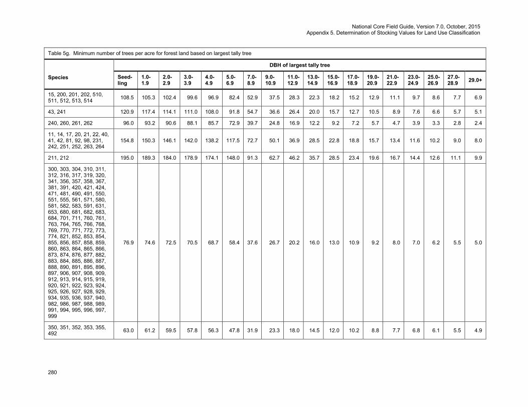
National Core Field Guide, Version 7.0, October, 2015 Appendix 5. Determination of Stocking Values for Land Use Classification
280
Table 5g. Minimum number of trees per acre for forest land based on largest tally tree
Species
DBH of largest tally tree
Seed-ling
1.0-1.9
2.0-2.9
3.0-3.9
4.0-4.9
5.0-6.9
7.0-8.9
9.0-10.9
11.0-12.9
13.0-14.9
15.0-16.9
17.0-18.9
19.0-20.9
21.0-22.9
23.0-24.9
25.0-26.9
27.0-28.9 29.0+
15, 200, 201, 202, 510, 511, 512, 513, 514 108.5 105.3 102.4 99.6 96.9 82.4 52.9 37.5 28.3 22.3 18.2 15.2 12.9 11.1 9.7 8.6 7.7 6.9
43, 241 120.9 117.4 114.1 111.0 108.0 91.8 54.7 36.6 26.4 20.0 15.7 12.7 10.5 8.9 7.6 6.6 5.7 5.1
240, 260, 261, 262 96.0 93.2 90.6 88.1 85.7 72.9 39.7 24.8 16.9 12.2 9.2 7.2 5.7 4.7 3.9 3.3 2.8 2.4
11, 14, 17, 20, 21, 22, 40, 41, 42, 81, 92, 98, 231, 242, 251, 252, 263, 264
154.8 150.3 146.1 142.0 138.2 117.5 72.7 50.1 36.9 28.5 22.8 18.8 15.7 13.4 11.6 10.2 9.0 8.0
211, 212 195.0 189.3 184.0 178.9 174.1 148.0 91.3 62.7 46.2 35.7 28.5 23.4 19.6 16.7 14.4 12.6 11.1 9.9
300, 303, 304, 310, 311, 312, 316, 317, 319, 320, 341, 356, 357, 358, 367, 381, 391, 420, 421, 424, 471, 481, 490, 491, 550, 551, 555, 561, 571, 580, 581, 582, 583, 591, 631, 653, 680, 681, 682, 683, 684, 701, 711, 760, 761, 763, 764, 765, 766, 768, 769, 770, 771, 772, 773, 774, 821, 852, 853, 854, 855, 856, 857, 858, 859, 860, 863, 864, 865, 866, 873, 874, 876, 877, 882, 883, 884, 885, 886, 887, 888, 890, 891, 895, 896, 897, 906, 907, 908, 909, 912, 913, 914, 915, 919, 920, 921, 922, 923, 924, 925, 926, 927, 928, 929, 934, 935, 936, 937, 940, 982, 986, 987, 988, 989, 991, 994, 995, 996, 997, 999
76.9 74.6 72.5 70.5 68.7 58.4 37.6 26.7 20.2 16.0 13.0 10.9 9.2 8.0 7.0 6.2 5.5 5.0
350, 351, 352, 353, 355, 492 63.0 61.2 59.5 57.8 56.3 47.8 31.9 23.3 18.0 14.5 12.0 10.2 8.8 7.7 6.8 6.1 5.5 4.9

National Core Field Guide, Version 7.0, October, 2015 Appendix 5. Determination of Stocking Values for Land Use Classification
281
Table 5g. Minimum number of trees per acre for forest land based on largest tally tree
Species
DBH of largest tally tree
Seed-ling
1.0-1.9
2.0-2.9
3.0-3.9
4.0-4.9
5.0-6.9
7.0-8.9
9.0-10.9
11.0-12.9
13.0-14.9
15.0-16.9
17.0-18.9
19.0-20.9
21.0-22.9
23.0-24.9
25.0-26.9
27.0-28.9 29.0+
314, 315, 318, 330, 331, 332, 333, 334, 336, 337, 370, 371, 372, 377, 450, 451, 452, 531, 552, 712
67.8 65.8 63.9 62.2 60.5 51.4 30.1 19.9 14.2 10.6 8.3 6.7 5.5 4.6 3.9 3.4 2.9 2.6
373, 374, 375, 378, 379 70.2 68.1 66.2 64.4 62.7 53.3 30.9 20.3 14.4 10.7 8.3 6.7 5.5 4.6 3.9 3.3 2.9 2.5
360, 361, 362, 400, 401, 402, 403, 404, 405, 406, 407, 408, 409, 410, 411, 412, 413, 422, 423, 431, 500, 501, 502, 503, 504, 505, 506, 507, 508, 509, 520, 521, 522, 549, 641, 660, 661, 662, 663, 664, 801, 802, 804, 805, 806, 807, 808, 809, 812, 813, 815, 816, 817, 818, 819, 820, 822, 824, 825, 827, 828, 830, 831, 832, 833, 834, 835, 836, 837, 838, 839, 840, 841, 842, 845, 901, 931, 981, 5091, 5092, 5093
63.5 61.6 59.9 58.2 56.7 48.2 30.1 20.9 15.6 12.1 9.7 8.0 6.8 5.8 5.0 4.4 3.9 3.5
600, 601, 602, 603, 604, 605, 606 58.0 56.3 54.7 53.2 51.8 44.0 28.6 20.5 15.6 12.3 10.1 8.5 7.2 6.3 5.5 4.9 4.4 3.9
220, 221, 222, 611, 690, 691, 692, 693, 694 107.7 104.5 101.6 98.8 96.2 81.7 47.7 31.4 22.4 16.8 13.1 10.5 8.6 7.2 6.1 5.3 4.6 4.0
741, 743, 746 67.4 65.4 63.6 61.8 60.2 51.2 33.6 24.3 18.6 14.8 12.2 10.3 8.8 7.7 6.8 6.0 5.4 4.9
540, 541, 542, 543, 545, 546, 547, 548, 621, 650, 651, 652, 654, 655, 657, 658, 720, 721, 722, 762, 993, 7211
79.2 76.9 74.7 72.6 70.7 60.1 43.4 33.7 27.5 23.1 19.8 17.4 15.4 13.8 12.5 11.5 10.5 9.8
950, 951, 952, 953 79.9 77.6 75.4 73.3 71.3 60.6 33.9 21.6 14.9 10.9 8.4 6.6 5.3 4.4 3.7 3.1 2.7 2.3
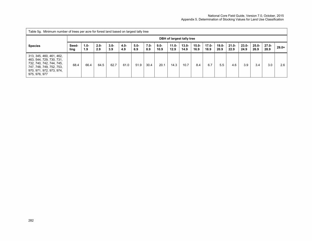
National Core Field Guide, Version 7.0, October, 2015 Appendix 5. Determination of Stocking Values for Land Use Classification
282
Table 5g. Minimum number of trees per acre for forest land based on largest tally tree
Species
DBH of largest tally tree
Seed-ling
1.0-1.9
2.0-2.9
3.0-3.9
4.0-4.9
5.0-6.9
7.0-8.9
9.0-10.9
11.0-12.9
13.0-14.9
15.0-16.9
17.0-18.9
19.0-20.9
21.0-22.9
23.0-24.9
25.0-26.9
27.0-28.9 29.0+
313, 345, 460, 461, 462, 463, 544, 729, 730, 731, 732, 740, 742, 744, 745, 747, 748, 749, 752, 753, 970, 971, 972, 973, 974, 975, 976, 977
68.4 66.4 64.5 62.7 61.0 51.9 30.4 20.1 14.3 10.7 8.4 6.7 5.5 4.6 3.9 3.4 3.0 2.6

National Core Field Guide, Version 7.0, October, 2015 Appendix 6. Glossary
283
Appendix 6. Glossary
Accessible Forest Land – Land that is within the population of interest, is accessible, is on a subplot that
can be occupied at subplot center, can safely be visited, and meets the following criteria:
(a) Forest Land has at least 10 percent canopy cover of live tally tree species of any size or has had at least 10 percent canopy cover of live tally species in the past, based on the presence of stumps, snags, or other evidence. Additionally, the condition is not subject to nonforest use(s) that prevent normal tree regeneration and succession, such as regular mowing, intensive grazing, or recreation activities.
b) In contrast to regular mowing, chaining treatments are recognized as long-term periodic or one-time treatments. Although the intent of chaining may be permanent removal of trees, reoccupation is common in the absence of additional treatments and sometimes the treatment does not remove enough to reduce canopy cover below the threshold of forest land. As a result, only live canopy cover should be considered in areas that have been chained; missing (dead or removed) canopy cover is not considered in the forest land call
c) In the cases of land on which either forest is encroaching on adjacent nonforest land, or the land that was previously under a nonforest land use (e.g., agriculture or mining) is reverting to forest naturally, only the live cover criterion applies.
d) In the case of deliberate afforestation – human-assisted conversion of other land use / land cover to forest land -- there must be at least 150 established trees per acre (all sizes combined) to qualify as forest land. Land that has been afforested at a density of less than 150 trees per acre is not considered forest land (see nonforest land below). If the condition experiences regeneration failure or is otherwise reduced to less than 150 survivors per acre after the time of planting / seeding but prior to achieving 10 percent canopy cover, then the condition should not be classified forest land.
e) To qualify as forest land, the prospective condition must be at least 1.0 acre in size and 120.0 feet wide measured stem-to-stem from the outer-most edge. Forested strips must be 120.0 feet wide for a continuous length of at least 363.0 feet in order to meet the acre threshold. Forested strips that do not meet these requirements are classified as part of the adjacent nonforest land.
ACTUAL LENGTH – For trees with broken or missing tops. The actual length of the tree is recorded to the nearest 1.0 foot from ground level to the highest remaining portion of the tree still present and attached to the bole. If the top is intact, this item may be omitted. Forked trees should be treated the same as unforked trees. Agricultural Land – Land managed for crops, pasture, or other agricultural use. Evidence includes geometric field and road patterns, fencing, and the traces produced by livestock or mechanized equipment. The area must be at least 1.0 acre in size and 120.0 feet wide at the point of occurrence. Annular plot – a circular ring with a beginning radius of 24.0 feet from subplot center and an ending radius of 58.9 feet. ARTIFICIAL REGENERATION SPECIES – Indicates the predominant species that is planted or seeded in an artificially regenerated condition. Blind check – a re-installation of a production plot done by a qualified crew without production crew data on hand. A full re-installation of the plot is recommended for the purpose of obtaining a measure of uncertainty in the data. If a full plot re-installation is not possible, then full subplots will be completed with a minimum of 15 total trees being remeasured. All plot-level information (e.g., boundary and condition information) will be collected on each blind check plot. The two data sets are maintained separately. Discrepancies between the two sets of data are not reconciled. Blind checks are done on production plots only.
National Core Field Guide, Version 7.0, October, 2015 Appendix 6. Glossary
284
Bole – The main stem of a tree, extending from one foot above the ground to the point on the tree where DOB reaches 4 inches. Botched plot – A plot that should not be included in the standard inventory data base due to data collection errors or other problems. Boundary – The intersection of two or more conditions on a subplot or microplot. Each boundary is described by recording the azimuth and horizontal distance from the subplot or microplot center to the left and right points of where the boundary intersects the perimeter of the subplot or microplot. An azimuth and distance to a corner point may also be described, if one exists. If multiple boundaries exist at a subplot, they are recorded in the order of their occurrence on the subplot, starting from north and proceeding around the compass. Census Water – Rivers and streams that are more than 200 feet wide and bodies of water that are greater than 4.5 acres in size. Certification plot – a plot installed by a certification candidate. It may be a training plot or a production plot. The candidate working alone installs the plot. Cold check – An inspection of a production plot done either as part of the training process, periodic review of field crew performance, or as part of the ongoing QA/QC program. Normally the installation crew is not present at the time of inspection. The inspector has the completed data in-hand at the time of inspection. The inspection can include the whole plot or a subset of the plot. Discrepancies between the inspection crew measurements and the production crew measurements are identified, and changes may be made to production data to correct these errors. Cold checks are done on production plots only. CONDITION CLASS – The combination of discrete landscape and forest attributes that identify and define different strata on the plot. Examples of such attributes include condition class status, forest type, stand origin, stand size, owner group, reserve status and stand density. Cropland – Land under cultivation within the past 24 months, including orchards and land in soil improving crops, but excluding land cultivated in developing improved pasture. CROWN CLASS – A classification of trees based on dominance in relation to adjacent trees within the stand as indicated by crown development and the amount of sunlight received from above and sides. Cull – Portions of a tree that are unusable for industrial wood products because of rot, form, or other defect. Diameter at Breast Height (DBH) – The diameter of the bole of a tree at breast height (4.5 feet above the ground), measured outside of the bark. Diameter at Root Collar (DRC) – The diameter of a tree measured at the ground line or stem root collar, measured outside of the bark. Diameter Outside Bark (DOB) – A diameter that may be taken at various points on a tree, or log, outside of the bark. Diameter Outside Bark is often estimated. Federal Information Processing Standard (FIPS) – A unique code identifying U.S. States and counties (or units in Alaska). Forest Industry Land – Land owned by companies or individuals that operate wood-using plants. Forest Trees – Plants having a well-developed, woody stem and usually more than 12 feet in height at maturity.
National Core Field Guide, Version 7.0, October, 2015 Appendix 6. Glossary
285
FOREST TYPE – A classification of forest land based upon the trees or tree communities that constitute the majority of stocking on the site. GPS – Global Positioning System. Information from this system is collected and used to determine the latitude and longitude of each plot. Hardwoods – Dicotyledonous trees, usually broad-leaved and deciduous. Hot check – an inspection normally done as part of the training process. The inspector is present on the plot with the trainee and provides immediate feedback regarding data quality. Data errors are corrected. Hot checks can be done on training plots or production plots. Idle Farmland -- Former cropland or pasture that has not been tended within the last 2 years and that has less than 10 percent stocking with live trees. Improved Pasture -- Land that is currently maintained and used for grazing. Evidence of maintenance, besides the degree of grazing, includes condition of fencing, presence of stock ponds, periodic brush removal, seeding, irrigation, or mowing. Inclusion – An area that would generally would be recognized as a separate condition, except that it is not large enough to qualify. For example, a ½ acre pond within a forested stand. Industrial Wood – All roundwood products, except firewood. Inspection crew – a crew of qualified QC/QA individuals whose primary responsibility is the training, certification and inspection of production crews. Land Area – As defined by the Bureau of the Census: The area of dry land and land temporarily or partially covered by water such as marshes, swamps, and river flood plains (omitting tidal flats below mean tide); streams, sloughs, estuaries and canals less than 200 feet in width, and ponds less than 4.5 acres in area. Macroplot – A circular, fixed area plot with a radius of 58.9 feet. Macroplots may be used for sampling relatively rare events. Maintained Road – Any road, hard topped or other surfaces, that is plowed or graded periodically and capable of use by a large vehicle. Rights-of-way that are cut or treated to limit herbaceous growth are included in this area. Marsh – Low, wet areas characterized by heavy growth of weeds and grasses and an absence of trees. Measurement Quality Objective (MQO) – Describes the acceptable tolerance for each data element. MQOs consist of two parts: a statement of the tolerance and a percentage of time when the collected data are required to be within tolerance. Merchantable Top – The point on the bole of trees above which merchantable material cannot be produced. Merchantable top is 1.5 inches for woodland species and 4.0 inches for all other species. Microplot – A circular, fixed-radius plot with a radius of 6.8 feet that is used to sample trees less than 5.0 inches at DBH, as well as other vegetation. National Forest Land – Federal lands which have been legally designated as National Forests or purchase units, and other lands under the administration of the Forest Service, including experimental areas and Bankhead-Jones Title III lands.

National Core Field Guide, Version 7.0, October, 2015 Appendix 6. Glossary
286
Native American (Indian) Land – Tribal lands held in fee, or trust, by the Federal government but administered for Indian tribal groups and Indian trust allotments. This land is considered “Private Lands”, Owner Group 40. Noncensus Water – Bodies of water from 1 to 4.5 acres in size and water courses from 30 feet to 200 feet in width. Nonforest Land -- Land that does not support, or has never supported, forests, and lands formerly forested where use for timber management is precluded by development for other uses. Includes areas used for crops, improved pasture, residential areas, city parks, improved roads of any width and adjoining rights-of-way, power line clearings of any width, and noncensus water. If intermingled in forest areas, unimproved roads and nonforest strips must be more than 120.0 feet wide, and clearings, etc., more than one acre in size, to qualify as nonforest land. Nonstockable – Areas of forest land that are not capable of supporting trees because of the presence of rock, water, etc. Other Federal Lands – Federal land other than National Forests. These include lands administered by the USDI Bureau of Land Management, USDI National Park Service, USDI Fish and Wildlife Service, Department of Defense, Department of Energy, Army Corps of Engineers, and military bases. OWNER CLASS -- A variable that classifies land into fine categories of ownership. OWNER GROUP – A variable that classifies land into broad categories of ownership; Forest Service, Other Federal Agency, State and Local Government, and Private. Differing categories of Owner Group on a plot require different conditions. Phase 1 (P1) – FIA activities done as part of remote-sensing and/or aerial photography. Phase 2 (P2) – FIA activities done on the network of ground plots formerly known as FIA plots. Phase 3 (P3) – FIA activities done on a subset of Phase 2 plots formerly known as Forest Health Monitoring plots. Additional ecological indicator information is collected from Phase 3 plots. Plot – A cluster of four subplots that samples approximately 1/6 acre. The subplots are established so that subplot 1 is centered within the sample and the centers of subplots 2, 3,and 4 are located 120.0 feet from the center of subplot 1 at azimuths of 360, 120, and 240 degrees, respectively. Each subplot has an associated microplot and macroplot. PRIVATE OWNER INDUSTRIAL STATUS – Indicates whether Private land owners own and operate a wood processing plant. Production crew – a crew containing at least one certified individual. The crew is involved in routine installation of plots. Production plot – A plot measured by a production crew. These plots may also be used for training purposes. Reference plot (off grid) – A plot that is used for crew certification. These plots are NOT included in the ongoing inventory process and data from these plots do not become part of the standard inventory data base. To ensure that these plots do not enter into the inventory data base, they are assigned plot numbers outside the normal range of production plots or other invalid plot identification information such as an invalid STATE code (STATECD). REGENERATION STATUS – A stand descriptor that indicates whether a stand has been naturally or artificially regenerated.
National Core Field Guide, Version 7.0, October, 2015 Appendix 6. Glossary
287
Reserved Land – Land that is withdrawn from timber utilization by a public agency or by law. RESERVE STATUS – An indication of whether the land in a condition has been reserved. Saplings – Live trees 1.0 to 4.9 inches DBH. Seedlings – Conifer seedlings must be at least 6.0 inches in length and less than 1.0 inch at DBH/DRC in order to qualify for tallying. Hardwood seedlings must be at least 12.0 inches in length and less than 1.0 inch at DBH/DRC in order to qualify for tallying. For woodland species, each stem on a single tree must be less than 1.0 inch in DRC. Softwoods – Coniferous trees, usually evergreen having needles or scale-like leaves. STAND AGE – A stand descriptor that indicates the average age of the live trees not overtopped in the predominant stand size-class of a condition. STAND DENSITY – A stand descriptor that indicates the relative tree density of a condition class. The classification is based on the number of stems/unit area, basal area, tree cover, or stocking of all live trees in the condition which are not overtopped, compared to any previously defined condition class tree density. STAND SIZE – A stand descriptor that indicates which size-class of trees that are not overtopped constitutes the majority of stocking in the stand. State, County and Municipal Lands – Lands owned by states, counties, and local public agencies or municipalities, or lands leased to these government units for 50 years or more. Stocking – The relative degree of occupancy land by trees, measured as basal area or the number of trees in a stand by size or age and spacing, compared to the basal area or number of trees required to fully utilize the growth potential of the land; that is, the stocking standard. Subplot – A circular, fixed-area plot with a radius of 24.0 feet. Each subplot represents ¼ of the fixed plot sample unit. TOTAL LENGTH – The total length of the tree, recorded to the nearest 1.0 foot from ground level to the tip of the apical meristem. For trees growing on a slope, measure on the uphill side of the tree. If the tree has a broken or missing top, the total length is estimated to what the length would be if there were no missing or broken top. Forked trees should be treated the same as unforked trees Training (practice) plot – A plot established for training or certification purposes only. It is NOT a plot in the ongoing inventory process and data from these plots do not become part of the standard inventory data base. To ensure that these plots do not enter into the inventory data base, they are assigned plot numbers outside the normal range of production plots or other invalid plot identification information such as an invalid STATE code (STATECD). Transition Zone – An area where a distinct boundary between two or more different conditions cannot be determined.

National Core Field Guide, Version 7.0, October, 2015 Appendix 7. Tolerance / MQO / Value / Units / Field Width / When Collected Table
288
Appendix 7. Tolerance / MQO / Value / Units / Field Width/ When Collected Table Core optional variables are in italics. N/A is not applicable. Variables with both a core and core optional listing are marked with an asterisk. Variable Name Tolerance MQO Values Units Field Width When Collected
General Description New Subplot Location +/- 7 feet At least 95% of the time N/A feet N/A N/A New Microplot Location +/- 1 foot At least 95% of the time N/A feet N/A N/A
Plot Level Data STATE No errors At least 99% of the time Appendix 1 N/A 2 digits All plots COUNTY No errors At least 99% of the time Appendix 1 N/A 3 digits All plots PLOT NUMBER No errors At least 99% of the time 00001 to 99999 N/A 5 digits All plots
PLOT STATUS No errors At least 99% of the time 1 to 3 N/A 1 digit All plots
NONFOREST SAMPLING STATUS No errors At least 99% of the time 0 to 1 N/A 1 digit
All plots
NONFOREST PLOT STATUS No errors At least 99% of the time 1 to 3 N/A 1 digit
When PLOT STATUS = 2 and NONFOREST SAMPLING STATUS = 1
PLOT NONSAMPLED REASON No errors At least 99% of the time 01 to 03 and 05 to 11 N/A 2 digits When PLOT STATUS = 3
NONFOREST PLOT NONSAMPLED REASON No errors At least 99% of the time 02, 03, 08, 09, 10 N/A 2 digits
When PLOT STATUS = 2 and NONFOREST SAMPLING STATUS = 1 and NONFOREST PLOT STATUS = 3
SUBPLOTS EXAMINED No errors At least 90% of the time 1, 4 N/A 1 digit All plots
SAMPLE KIND No errors At least 99% of the time 1 to 3 N/A 1 digit All plots
PREVIOUS PLOT NUMBER No errors At least 99% of the time 00001 to 99999 N/A 5 digits When SAMPLE KIND = 3
FIELD GUIDE VERSION No errors At least 99% of the time 7.0 N/A 2 digits All plots YEAR No errors At least 99% of the time > 2003 year 4 digits All plots MONTH No errors At least 99% of the time Jan – Dec (01 – 12) month 2 digits All plots DAY No errors At least 99% of the time 01 to 31 day 2 digits All plots
DECLINATION No errors At least 99% of the time +/- 50 degrees 5 digits including sign (+xxx.y)
CORE OPTIONAL: All plots
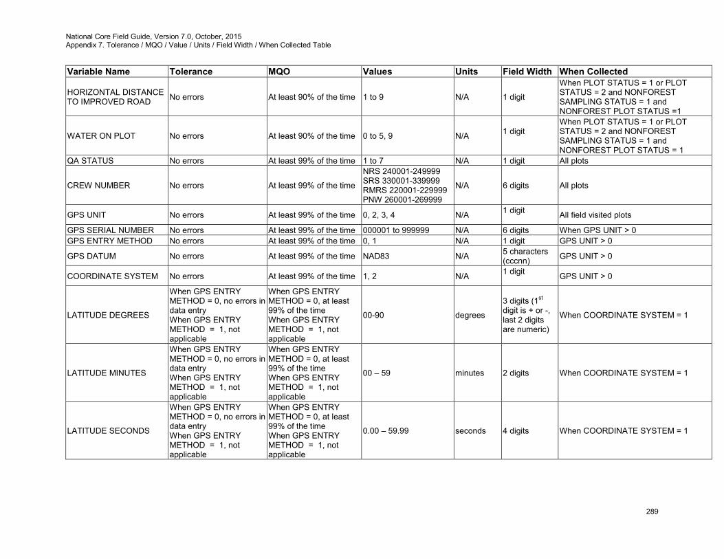
National Core Field Guide, Version 7.0, October, 2015 Appendix 7. Tolerance / MQO / Value / Units / Field Width / When Collected Table
289
Variable Name Tolerance MQO Values Units Field Width When Collected
HORIZONTAL DISTANCE TO IMPROVED ROAD No errors At least 90% of the time 1 to 9 N/A 1 digit
When PLOT STATUS = 1 or PLOT STATUS = 2 and NONFOREST SAMPLING STATUS = 1 and NONFOREST PLOT STATUS =1
WATER ON PLOT No errors At least 90% of the time 0 to 5, 9 N/A 1 digit
When PLOT STATUS = 1 or PLOT STATUS = 2 and NONFOREST SAMPLING STATUS = 1 and NONFOREST PLOT STATUS = 1
QA STATUS No errors At least 99% of the time 1 to 7 N/A 1 digit All plots
CREW NUMBER No errors At least 99% of the time
NRS 240001-249999 SRS 330001-339999 RMRS 220001-229999 PNW 260001-269999
N/A 6 digits All plots
GPS UNIT No errors At least 99% of the time 0, 2, 3, 4 N/A 1 digit All field visited plots
GPS SERIAL NUMBER No errors At least 99% of the time 000001 to 999999 N/A 6 digits When GPS UNIT > 0 GPS ENTRY METHOD No errors At least 99% of the time 0, 1 N/A 1 digit GPS UNIT > 0
GPS DATUM No errors At least 99% of the time NAD83 N/A 5 characters (cccnn) GPS UNIT > 0
COORDINATE SYSTEM No errors At least 99% of the time 1, 2 N/A 1 digit GPS UNIT > 0
LATITUDE DEGREES
When GPS ENTRY METHOD = 0, no errors in data entry When GPS ENTRY METHOD = 1, not applicable
When GPS ENTRY METHOD = 0, at least 99% of the time When GPS ENTRY METHOD = 1, not applicable
00-90 degrees
3 digits (1st digit is + or -, last 2 digits are numeric)
When COORDINATE SYSTEM = 1
LATITUDE MINUTES
When GPS ENTRY METHOD = 0, no errors in data entry When GPS ENTRY METHOD = 1, not applicable
When GPS ENTRY METHOD = 0, at least 99% of the time When GPS ENTRY METHOD = 1, not applicable
00 – 59 minutes 2 digits When COORDINATE SYSTEM = 1
LATITUDE SECONDS
When GPS ENTRY METHOD = 0, no errors in data entry When GPS ENTRY METHOD = 1, not applicable
When GPS ENTRY METHOD = 0, at least 99% of the time When GPS ENTRY METHOD = 1, not applicable
0.00 – 59.99 seconds 4 digits When COORDINATE SYSTEM = 1
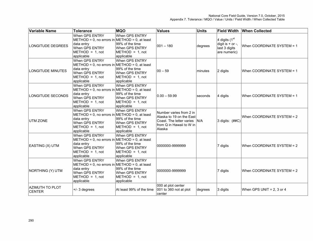
National Core Field Guide, Version 7.0, October, 2015 Appendix 7. Tolerance / MQO / Value / Units / Field Width / When Collected Table
290
Variable Name Tolerance MQO Values Units Field Width When Collected
LONGITUDE DEGREES
When GPS ENTRY METHOD = 0, no errors in data entry When GPS ENTRY METHOD = 1, not applicable
When GPS ENTRY METHOD = 0, at least 99% of the time When GPS ENTRY METHOD = 1, not applicable
001 – 180 degrees
4 digits (1st digit is + or -, last 3 digits are numeric)
When COORDINATE SYSTEM = 1
LONGITUDE MINUTES
When GPS ENTRY METHOD = 0, no errors in data entry When GPS ENTRY METHOD = 1, not applicable
When GPS ENTRY METHOD = 0, at least 99% of the time When GPS ENTRY METHOD = 1, not applicable
00 – 59 minutes 2 digits When COORDINATE SYSTEM = 1
LONGITUDE SECONDS
When GPS ENTRY METHOD = 0, no errors in data entry When GPS ENTRY METHOD = 1, not applicable
When GPS ENTRY METHOD = 0, at least 99% of the time When GPS ENTRY METHOD = 1, not applicable
0.00 – 59.99 seconds 4 digits When COORDINATE SYSTEM = 1
UTM ZONE
When GPS ENTRY METHOD = 0, no errors in data entry When GPS ENTRY METHOD = 1, not applicable
When GPS ENTRY METHOD = 0, at least 99% of the time When GPS ENTRY METHOD = 1, not applicable
Number varies from 2 in Alaska to 19 on the East Coast. The letter varies from Q in Hawaii to W in Alaska
N/A 3 digits: (##C) When COORDINATE SYSTEM = 2
EASTING (X) UTM
When GPS ENTRY METHOD = 0, no errors in data entry When GPS ENTRY METHOD = 1, not applicable
When GPS ENTRY METHOD = 0, at least 99% of the time When GPS ENTRY METHOD = 1, not applicable
0000000-9999999 7 digits When COORDINATE SYSTEM = 2
NORTHING (Y) UTM
When GPS ENTRY METHOD = 0, no errors in data entry When GPS ENTRY METHOD = 1, not applicable
When GPS ENTRY METHOD = 0, at least 99% of the time When GPS ENTRY METHOD = 1, not applicable
0000000-9999999 7 digits When COORDINATE SYSTEM = 2
AZIMUTH TO PLOT CENTER +/- 3 degrees At least 99% of the time
000 at plot center 001 to 360 not at plot center
degrees 3 digits When GPS UNIT = 2, 3 or 4
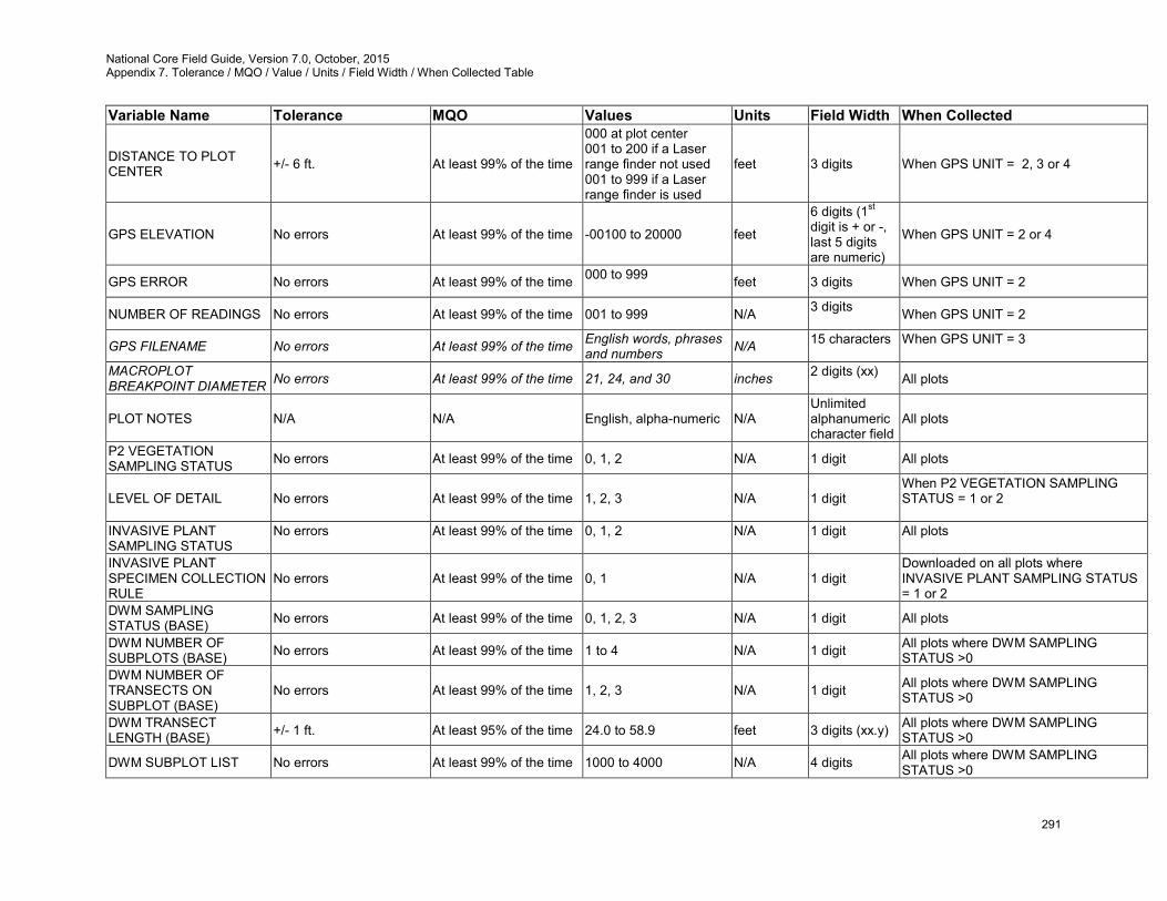
National Core Field Guide, Version 7.0, October, 2015 Appendix 7. Tolerance / MQO / Value / Units / Field Width / When Collected Table
291
Variable Name Tolerance MQO Values Units Field Width When Collected
DISTANCE TO PLOT CENTER +/- 6 ft. At least 99% of the time
000 at plot center 001 to 200 if a Laser range finder not used 001 to 999 if a Laser range finder is used
feet 3 digits When GPS UNIT = 2, 3 or 4
GPS ELEVATION No errors At least 99% of the time -00100 to 20000 feet
6 digits (1st digit is + or -, last 5 digits are numeric)
When GPS UNIT = 2 or 4
GPS ERROR No errors At least 99% of the time 000 to 999 feet 3 digits When GPS UNIT = 2
NUMBER OF READINGS No errors At least 99% of the time 001 to 999 N/A 3 digits When GPS UNIT = 2
GPS FILENAME No errors At least 99% of the time English words, phrases and numbers N/A 15 characters
When GPS UNIT = 3
MACROPLOT BREAKPOINT DIAMETER No errors At least 99% of the time 21, 24, and 30 inches 2 digits (xx)
All plots
PLOT NOTES N/A N/A English, alpha-numeric N/A Unlimited alphanumeric character field
All plots
P2 VEGETATION SAMPLING STATUS No errors At least 99% of the time 0, 1, 2 N/A 1 digit All plots
LEVEL OF DETAIL No errors At least 99% of the time 1, 2, 3 N/A 1 digit When P2 VEGETATION SAMPLING STATUS = 1 or 2
INVASIVE PLANT SAMPLING STATUS
No errors At least 99% of the time 0, 1, 2 N/A 1 digit All plots
INVASIVE PLANT SPECIMEN COLLECTION RULE
No errors At least 99% of the time 0, 1 N/A 1 digit Downloaded on all plots where INVASIVE PLANT SAMPLING STATUS = 1 or 2
DWM SAMPLING STATUS (BASE) No errors At least 99% of the time 0, 1, 2, 3 N/A 1 digit All plots
DWM NUMBER OF SUBPLOTS (BASE) No errors At least 99% of the time 1 to 4 N/A 1 digit All plots where DWM SAMPLING
STATUS >0 DWM NUMBER OF TRANSECTS ON SUBPLOT (BASE)
No errors At least 99% of the time 1, 2, 3 N/A 1 digit All plots where DWM SAMPLING STATUS >0
DWM TRANSECT LENGTH (BASE) +/- 1 ft. At least 95% of the time 24.0 to 58.9 feet 3 digits (xx.y) All plots where DWM SAMPLING
STATUS >0
DWM SUBPLOT LIST No errors At least 99% of the time 1000 to 4000 N/A 4 digits All plots where DWM SAMPLING STATUS >0
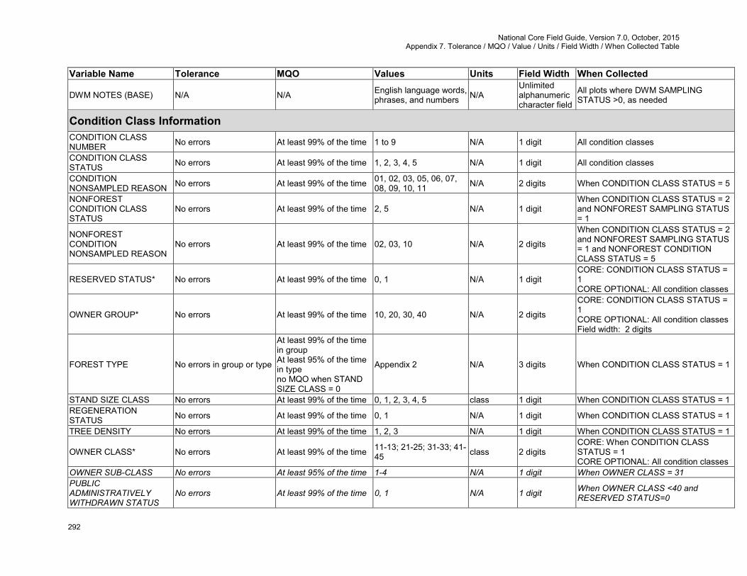
National Core Field Guide, Version 7.0, October, 2015 Appendix 7. Tolerance / MQO / Value / Units / Field Width / When Collected Table
292
Variable Name Tolerance MQO Values Units Field Width When Collected
DWM NOTES (BASE) N/A N/A English language words, phrases, and numbers N/A
Unlimited alphanumeric character field
All plots where DWM SAMPLING STATUS >0, as needed
Condition Class Information CONDITION CLASS NUMBER No errors At least 99% of the time 1 to 9 N/A 1 digit All condition classes
CONDITION CLASS STATUS No errors At least 99% of the time 1, 2, 3, 4, 5 N/A 1 digit All condition classes
CONDITION NONSAMPLED REASON No errors At least 99% of the time 01, 02, 03, 05, 06, 07,
08, 09, 10, 11 N/A 2 digits When CONDITION CLASS STATUS = 5
NONFOREST CONDITION CLASS STATUS
No errors At least 99% of the time 2, 5 N/A 1 digit When CONDITION CLASS STATUS = 2 and NONFOREST SAMPLING STATUS = 1
NONFOREST CONDITION NONSAMPLED REASON
No errors At least 99% of the time 02, 03, 10 N/A 2 digits
When CONDITION CLASS STATUS = 2 and NONFOREST SAMPLING STATUS = 1 and NONFOREST CONDITION CLASS STATUS = 5
RESERVED STATUS* No errors At least 99% of the time 0, 1 N/A 1 digit CORE: CONDITION CLASS STATUS = 1 CORE OPTIONAL: All condition classes
OWNER GROUP* No errors At least 99% of the time 10, 20, 30, 40 N/A 2 digits
CORE: CONDITION CLASS STATUS = 1 CORE OPTIONAL: All condition classes Field width: 2 digits
FOREST TYPE No errors in group or type
At least 99% of the time in group At least 95% of the time in type no MQO when STAND SIZE CLASS = 0
Appendix 2 N/A 3 digits When CONDITION CLASS STATUS = 1
STAND SIZE CLASS No errors At least 99% of the time 0, 1, 2, 3, 4, 5 class 1 digit When CONDITION CLASS STATUS = 1 REGENERATION STATUS No errors At least 99% of the time 0, 1 N/A 1 digit When CONDITION CLASS STATUS = 1
TREE DENSITY No errors At least 99% of the time 1, 2, 3 N/A 1 digit When CONDITION CLASS STATUS = 1
OWNER CLASS* No errors At least 99% of the time 11-13; 21-25; 31-33; 41-45 class 2 digits
CORE: When CONDITION CLASS STATUS = 1 CORE OPTIONAL: All condition classes
OWNER SUB-CLASS No errors At least 95% of the time 1-4 N/A 1 digit When OWNER CLASS = 31 PUBLIC ADMINISTRATIVELY WITHDRAWN STATUS
No errors At least 99% of the time 0, 1 N/A 1 digit When OWNER CLASS <40 and RESERVED STATUS=0
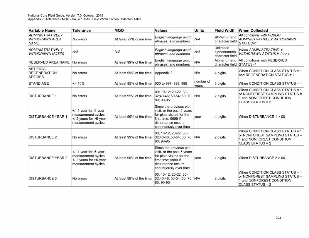
National Core Field Guide, Version 7.0, October, 2015 Appendix 7. Tolerance / MQO / Value / Units / Field Width / When Collected Table
293
Variable Name Tolerance MQO Values Units Field Width When Collected ADMINISTRATIVELY WITHDRAWN AREA NAME
No errors At least 99% of the time English language word, phrases, and numbers N/A Alphanumeric
character field
All conditions with PUBLIC ADMINISTRATIVELY WITHDRAWN STATUS=1
ADMINISTRATIVELY WITHDRAWN NOTES N/A N/A English language word,
phrases, and numbers N/A Unlimited alphanumeric character field
When ADMINISTRATIVELY WITHDRAWN STATUS is 0 or 1
RESERVED AREA NAME No errors At least 99% of the time English language word, phrases, and numbers N/A Alphanumeric
character field All conditions with RESERVED STATUS=1
ARTIFICIAL REGENERATION SPECIES
No errors At least 99% of the time Appendix 3 N/A 4 digits When CONDITION CLASS STATUS = 1 and REGENERATION STATUS = 1
STAND AGE +/- 10% At least 95% of the time 000 to 997, 998, 999 number of years 3 digits When CONDITION CLASS STATUS = 1
DISTURBANCE 1 No errors At least 99% of the time 00; 10-12; 20-22; 30-32;40-46; 50-54; 60; 70; 80; 90-95
N/A 2 digits
When CONDITION CLASS STATUS = 1 or NONFOREST SAMPLING STATUS = 1 and NONFOREST CONDITION CLASS STATUS = 2
DISTURBANCE YEAR 1
+/- 1 year for 5-year measurement cycles +/ 2 years for >5-year measurement cycles
At least 99% of the time
Since the previous plot visit, or the past 5 years for plots visited for the first time; 9999 if disturbance occurs continuously over time
year 4 digits When DISTURBANCE 1 > 00
DISTURBANCE 2 No errors At least 99% of the time 00; 10-12; 20-22; 30-32;40-46; 50-54; 60; 70; 80; 90-95
N/A 2 digits
When CONDITION CLASS STATUS = 1 or NONFOREST SAMPLING STATUS = 1 and NONFOREST CONDITION CLASS STATUS = 2
DISTURBANCE YEAR 2
+/- 1 year for 5-year measurement cycles +/ 2 years for >5-year measurement cycles
At least 99% of the time
Since the previous plot visit, or the past 5 years for plots visited for the first time; 9999 if disturbance occurs continuously over time
year 4 digits When DISTURBANCE 2 > 00
DISTURBANCE 3 No errors At least 99% of the time 00; 10-12; 20-22; 30-32;40-46; 50-54; 60; 70; 80; 90-95
N/A 2 digits
When CONDITION CLASS STATUS = 1 or NONFOREST SAMPLING STATUS = 1 and NONFOREST CONDITION CLASS STATUS = 2

National Core Field Guide, Version 7.0, October, 2015 Appendix 7. Tolerance / MQO / Value / Units / Field Width / When Collected Table
294
Variable Name Tolerance MQO Values Units Field Width When Collected
DISTURBANCE YEAR 3
+/- 1 year for 5-year measurement cycles +/ 2 years for >5-year measurement cycles
At least 99% of the time
Since the previous plot visit, or the past 5 years for plots visited for the first time; 9999 if disturbance occurs continuously over time
year 4 digits When DISTURBANCE 3 > 00
TREATMENT 1 No errors At least 99% of the time 00, 10, 20, 30, 40, 50 N/A 2 digits When CONDITION CLASS STATUS = 1
TREATMENT YEAR 1
+/- 1 year for 5-year measurement cycles +/- 2 years for >5-year measurement cycles
At least 99% of the time
Since the previous plot visit, or the past 5 years for plots visited for the first time
year 4 digits When TREATMENT 1 > 00
TREATMENT 2 No errors At least 99% of the time 00, 10, 20, 30, 40, 50 N/A 2 digits When CONDITION CLASS STATUS = 1
TREATMENT YEAR 2
+/- 1 year for 5-year measurement cycles +/- 2 years for >5-year measurement cycles
At least 99% of the time
Since the previous plot visit, or the past 5 years for plots visited for the first time
year 4 digits When TREATMENT 2 > 00
TREATMENT 3 No errors At least 99% of the time 00, 10, 20, 30, 40, 50 N/A 2 digits When CONDITION CLASS STATUS = 1
TREATMENT YEAR 3
+/- 1 year for 5-year measurement cycles +/- 2 years for >5-year measurement cycles
At least 99% of the time
Since the previous plot visit, or the past 5 years for plots visited for the first time
year 4 digits When TREATMENT 3 > 00
PHYSIOGRAPHIC CLASS No errors At least 80% of the time
xeric: 11, 12, 13, 19 mesic: 21, 22, 23, 24, 25, 29 hydric: 31, 32, 33, 34, 35, 39
N/A 2 digits
When CONDITION CLASS STATUS = 1 or NONFOREST SAMPLING STATUS = 1 and NONFOREST CONDITION CLASS STATUS = 2
LAND COVER CLASS No errors At least 95% of the time 01-10 N/A 2 digits All condition classes PRESENT NONFOREST LAND USE No errors At least 99% of the time 10-17; 20; 30-34; 40,
41, 42, 43, 45 N/A 2 digits CONDITION CLASS STATUS = 2
CANOPY COVER SAMPLE METHOD None At least 90% of the time 1-4 N/A 1 digit CONDITION CLASS STATUS = 1, 2, or
5
LIVE CANOPY COVER
No errors for 0-12% live canopy cover; 10% for 13-20% live canopy cover; 25% for 21-100% live canopy cover
At least 99% of the time 00-99 (where 99 = 99-100) percent 2 digits
CONDITION CLASS STATUS = 1, 2, or 5

National Core Field Guide, Version 7.0, October, 2015 Appendix 7. Tolerance / MQO / Value / Units / Field Width / When Collected Table
295
Variable Name Tolerance MQO Values Units Field Width When Collected
LIVE PLUS MISSING CANOPY COVER
No errors% for 0-12% live plus missing canopy cover; 10% for 13-20% live plus missing canopy cover; 25% for 21-100% live plus missing canopy cover
At least 80% of the time 00-99 (where 99 = 99-100) percent 2 digits
CONDITION CLASS STATUS = 1, 2, or 5
CURRENT AFFORESTATION CODE No errors At least 99% of the time 0, 1 N/A 1 digit CONDITION CLASS STATUS = 1 or 2
PREVIOUS AFFORESTATION CODE No errors At least 99% of the time 0, 1 N/A 1 digit When SAMPLE KIND = 2 and
CONDITION CLASS STATUS = 1 or 2
TOTAL STEMS 10% At least 90% of the time 00000-99999 N/A 5 digits CURRENT AFFORESTATION CODE = 1 or PREVIOUS AFFORESTATION CODE = 1
CHAINING CODE No errors At least 99% of the time 0, 1 N/A 1 digit When CONDITION CLASS STATUS = 1 or 2
CONDITION FUELBED TYPE (OPTIONAL) +/- 1 class within a type At least 80% of the time
GR1, GR2, GR3, GR4, GR5, GR6, GR7, GR8, GR9, GS1, GS2, GS3, GS4, SB1, SB2, SB3, SB4, SH1, SH2, SH3, SH4, SH5, SH6, SH7, SH8, SH9, TL1, TL2, TL3, TL4, TL5, TL6, TL7, TL8, TL9, TU1, TU2, TU3, TU4, TU5, NB1, NB2, NB3, NB8, NB9
N/A 3 alpha-numeric characters
All conditions where DWM SAMPLING STATUS >0
Subplot Information SUBPLOT NUMBER No errors At least 99% of the time 1, 2, 3, 4 N/A 1 digit All subplots SUBPLOT/ MACROPLOT STATUS No errors At least 99% of the time 1, 2, 3, 4 N/A 1 digit All subplots
SUBPLOT NONSAMPLED REASON No errors At least 99% of the time 01, 02, 03, 04, 05, 06,
07, 08, 09, 10, 11 N/A 2 digits When SUBPLOT/MACROPLOT STATUS = 3
NONFOREST SUBPLOT/MACROPLOT STATUS
No errors At least 99% of the time 1, 2, 3 N/A 1 digit When NONFOREST SAMPLING STATUS = 1 and SUBPLOT/MACROPLOT STATUS = 2
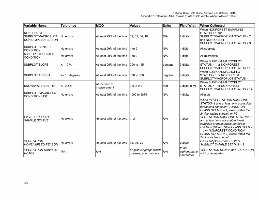
National Core Field Guide, Version 7.0, October, 2015 Appendix 7. Tolerance / MQO / Value / Units / Field Width / When Collected Table
296
Variable Name Tolerance MQO Values Units Field Width When Collected
NONFOREST SUBPLOT/MACROPLOT NONSAMPLED REASON
No errors At least 99% of the time 02, 03, 04, 10 N/A 2 digits
When NONFOREST SAMPLING STATUS = 1 and SUBPLOT/MACROPLOT STATUS = 2 and NONFOREST SUBPLOT/MACROPLOT STATUS = 3
SUBPLOT CENTER CONDITION No errors At least 99% of the time 1 to 9 N/A 1 digit All subplots
MICROPLOT CENTER CONDITION No errors At least 99% of the time 1 to 9 N/A 1 digit All microplots
SUBPLOT SLOPE +/- 10 % At least 90% of the time 000 to 155 percent 3 digits When SUBPLOT/MACROPLOT STATUS = 1 or NONFOREST SUBPLOT/MACROPLOT STATUS = 1
SUBPLOT ASPECT +/- 10 degrees At least 90% of the time 000 to 360 degrees 3 digits When SUBPLOT/MACROPLOT STATUS = 1 or NONFOREST SUBPLOT/MACROPLOT STATUS = 1
SNOW/WATER DEPTH +/- 0.5 ft. At the time of measurement 0.0 to 9.9 feet 2 digits (x.y)
When SUBPLOT/MACROPLOT STATUS = 1 or NONFOREST SUBPLOT/MACROPLOT STATUS = 1)
SUBPLOT/ MACROPLOT CONDITION LIST No errors At least 99% of the time 1000 to 9876 N/A 4 digits All plots
P2 VEG SUBPLOT SAMPLE STATUS No errors At least 99% of the time 1, 2 N/A 1 digit
When P2 VEGETATION SAMPLING STATUS=1 and at least one accessible forest land condition (CONDITION CLASS STATUS = 1) exists within the 24-foot radius subplot, or P2 VEGETATION SAMPLING STATUS=2 and at least one accessible forest condition or measurable nonforest condition (CONDITION CLASS STATUS = 1 or NONFOREST CONDITION CLASS STATUS = 2) exists within the 24-foot radius subplot.
VEGETATION NONSAMPLED REASON No errors At least 99% of the time 04, 05, 10 N/A 2 digits On all subplots where P2 VEG
SUBPLOT SAMPLE STATUS = 2
VEGETATION SUBPLOT NOTES N/A N/A English language words,
phrases, and numbers N/A 2000 alphanumeric characters
VEGETATION NONSAMPLED REASON = 10 or as needed
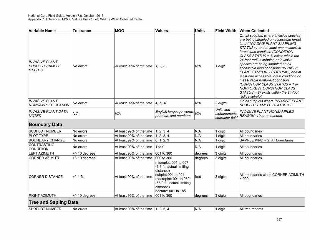
National Core Field Guide, Version 7.0, October, 2015 Appendix 7. Tolerance / MQO / Value / Units / Field Width / When Collected Table
297
Variable Name Tolerance MQO Values Units Field Width When Collected
INVASIVE PLANT SUBPLOT SAMPLE STATUS
No errors At least 99% of the time 1, 2, 3 N/A 1 digit
On all subplots where invasive species are being sampled on accessible forest land (INVASIVE PLANT SAMPLING STATUS=1 and at least one accessible forest land condition (CONDITION CLASS STATUS = 1) exists within the 24-foot radius subplot, or invasive species are being sampled on all accessible land conditions (INVASIVE PLANT SAMPLING STATUS=2) and at least one accessible forest condition or measurable nonforest condition (CONDITION CLASS STATUS = 1 or NONFOREST CONDITION CLASS STATUS = 2) exists within the 24-foot radius subplot
INVASIVE PLANT NONSAMPLED REASON No errors At least 99% of the time 4, 5, 10 N/A 2 digits On all subplots where INVASIVE PLANT
SUBPLOT SAMPLE STATUS = 3
INVASIVE PLANT DATA NOTES N/A N/A English language words,
phrases, and numbers N/A Unlimited alphanumeric character field
INVASIVE PLANT NONSAMPLED REASON=10 or as needed
Boundary Data SUBPLOT NUMBER No errors At least 99% of the time 1, 2, 3 4 N/A 1 digit All boundaries PLOT TYPE No errors At least 99% of the time 1, 2, 3, 4 N/A 1 digit All boundaries BOUNDARY CHANGE No errors At least 99% of the time 0, 1, 2, 3 N/A 1 digit SAMPLE KIND = 2, All boundaries CONTRASTING CONDITION No errors At least 99% of the time 1 to 9 N/A 1 digit All boundaries
LEFT AZIMUTH +/- 10 degrees At least 90% of the time 001 to 360 degrees 3 digits All boundaries CORNER AZIMUTH +/- 10 degrees At least 90% of the time 000 to 360 degrees 3 digits All boundaries
CORNER DISTANCE +/- 1 ft. At least 90% of the time
microplot: 001 to 007 (6.8 ft.. actual limiting distance) subplot:001 to 024 macroplot: 001 to 059 (58.9 ft.. actual limiting distance) hectare: 001 to 185
feet 3 digits All boundaries when CORNER AZIMUTH > 000
RIGHT AZIMUTH +/- 10 degrees At least 90% of the time 001 to 360 degrees 3 digits All boundaries
Tree and Sapling Data SUBPLOT NUMBER No errors At least 99% of the time 1, 2, 3, 4 N/A 1 digit All tree records
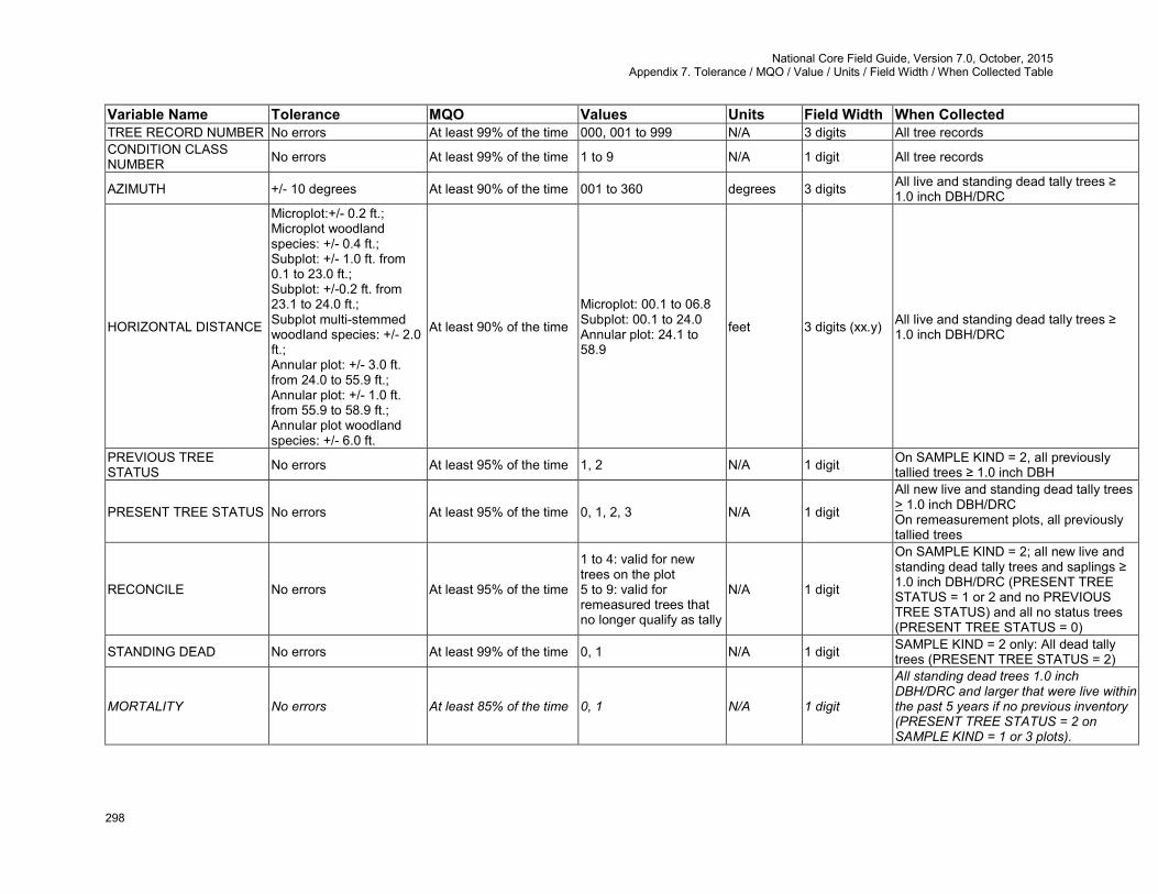
National Core Field Guide, Version 7.0, October, 2015 Appendix 7. Tolerance / MQO / Value / Units / Field Width / When Collected Table
298
Variable Name Tolerance MQO Values Units Field Width When Collected TREE RECORD NUMBER No errors At least 99% of the time 000, 001 to 999 N/A 3 digits All tree records CONDITION CLASS NUMBER No errors At least 99% of the time 1 to 9 N/A 1 digit All tree records
AZIMUTH +/- 10 degrees At least 90% of the time 001 to 360 degrees 3 digits All live and standing dead tally trees ≥ 1.0 inch DBH/DRC
HORIZONTAL DISTANCE
Microplot:+/- 0.2 ft.; Microplot woodland species: +/- 0.4 ft.; Subplot: +/- 1.0 ft. from 0.1 to 23.0 ft.; Subplot: +/-0.2 ft. from 23.1 to 24.0 ft.; Subplot multi-stemmed woodland species: +/- 2.0 ft.; Annular plot: +/- 3.0 ft. from 24.0 to 55.9 ft.; Annular plot: +/- 1.0 ft. from 55.9 to 58.9 ft.; Annular plot woodland species: +/- 6.0 ft.
At least 90% of the time
Microplot: 00.1 to 06.8 Subplot: 00.1 to 24.0 Annular plot: 24.1 to 58.9
feet 3 digits (xx.y) All live and standing dead tally trees ≥ 1.0 inch DBH/DRC
PREVIOUS TREE STATUS No errors At least 95% of the time 1, 2 N/A 1 digit On SAMPLE KIND = 2, all previously
tallied trees ≥ 1.0 inch DBH
PRESENT TREE STATUS No errors At least 95% of the time 0, 1, 2, 3 N/A 1 digit
All new live and standing dead tally trees > 1.0 inch DBH/DRC On remeasurement plots, all previously tallied trees
RECONCILE No errors At least 95% of the time
1 to 4: valid for new trees on the plot 5 to 9: valid for remeasured trees that no longer qualify as tally
N/A 1 digit
On SAMPLE KIND = 2; all new live and standing dead tally trees and saplings ≥ 1.0 inch DBH/DRC (PRESENT TREE STATUS = 1 or 2 and no PREVIOUS TREE STATUS) and all no status trees (PRESENT TREE STATUS = 0)
STANDING DEAD No errors At least 99% of the time 0, 1 N/A 1 digit SAMPLE KIND = 2 only: All dead tally trees (PRESENT TREE STATUS = 2)
MORTALITY No errors At least 85% of the time 0, 1 N/A 1 digit
All standing dead trees 1.0 inch DBH/DRC and larger that were live within the past 5 years if no previous inventory (PRESENT TREE STATUS = 2 on SAMPLE KIND = 1 or 3 plots).
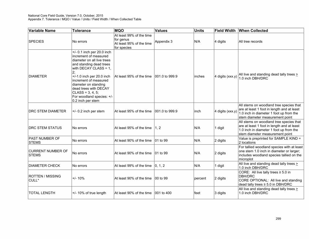
National Core Field Guide, Version 7.0, October, 2015 Appendix 7. Tolerance / MQO / Value / Units / Field Width / When Collected Table
299
Variable Name Tolerance MQO Values Units Field Width When Collected
SPECIES No errors
At least 99% of the time for genus At least 95% of the time for species
Appendix 3 N/A 4 digits All tree records
DIAMETER
+/- 0.1 inch per 20.0 inch increment of measured diameter on all live trees and standing dead trees with DECAY CLASS = 1, 2; +/-1.0 inch per 20.0 inch increment of measured diameter on standing dead trees with DECAY CLASS = 3, 4, 5; For woodland species: +/- 0.2 inch per stem
At least 95% of the time 001.0 to 999.9 inches 4 digits (xxx.y) All live and standing dead tally trees > 1.0 inch DBH/DRC
DRC STEM DIAMETER +/- 0.2 inch per stem At least 95% of the time 001.0 to 999.9 inch 4 digits (xxx.y)
All stems on woodland tree species that are at least 1 foot in length and at least 1.0 inch in diameter 1 foot up from the stem diameter measurement point
DRC STEM STATUS No errors At least 95% of the time 1, 2 N/A 1 digit
All stems on woodland tree species that are at least 1 foot in length and at least 1.0 inch in diameter 1 foot up from the stem diameter measurement point
PAST NUMBER OF STEMS No errors At least 90% of the time 01 to 99 N/A 2 digits Value is preprinted for SAMPLE KIND =
2 locations
CURRENT NUMBER OF STEMS No errors At least 90% of the time 01 to 99 N/A 2 digits
For tallied woodland species with at least one stem 1.0 inch in diameter or larger; includes woodland species tallied on the microplot
DIAMETER CHECK No errors At least 99% of the time 0, 1, 2 N/A 1 digit All live and standing dead tally trees > 1.0 inch DBH/DRC
ROTTEN / MISSING CULL* +/- 10% At least 90% of the time 00 to 99 percent 2 digits
CORE: All live tally trees ≥ 5.0 in DBH/DRC CORE OPTIONAL: All live and standing dead tally trees ≥ 5.0 in DBH/DRC
TOTAL LENGTH +/- 10% of true length At least 90% of the time 001 to 400 feet 3 digits All live and standing dead tally trees > 1.0 inch DBH/DRC
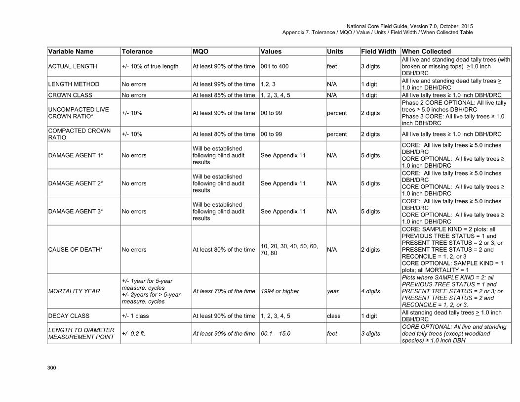
National Core Field Guide, Version 7.0, October, 2015 Appendix 7. Tolerance / MQO / Value / Units / Field Width / When Collected Table
300
Variable Name Tolerance MQO Values Units Field Width When Collected
ACTUAL LENGTH +/- 10% of true length At least 90% of the time 001 to 400 feet 3 digits All live and standing dead tally trees (with broken or missing tops) >1.0 inch DBH/DRC
LENGTH METHOD No errors At least 99% of the time 1,2, 3 N/A 1 digit All live and standing dead tally trees > 1.0 inch DBH/DRC
CROWN CLASS No errors At least 85% of the time 1, 2, 3, 4, 5 N/A 1 digit All live tally trees ≥ 1.0 inch DBH/DRC
UNCOMPACTED LIVE CROWN RATIO* +/- 10% At least 90% of the time 00 to 99 percent 2 digits
Phase 2 CORE OPTIONAL: All live tally trees ≥ 5.0 inches DBH/DRC Phase 3 CORE: All live tally trees ≥ 1.0 inch DBH/DRC
COMPACTED CROWN RATIO +/- 10% At least 80% of the time 00 to 99 percent 2 digits All live tally trees ≥ 1.0 inch DBH/DRC
DAMAGE AGENT 1* No errors Will be established following blind audit results
See Appendix 11 N/A 5 digits
CORE: All live tally trees ≥ 5.0 inches DBH/DRC CORE OPTIONAL: All live tally trees ≥ 1.0 inch DBH/DRC
DAMAGE AGENT 2* No errors Will be established following blind audit results
See Appendix 11 N/A 5 digits
CORE: All live tally trees ≥ 5.0 inches DBH/DRC CORE OPTIONAL: All live tally trees ≥ 1.0 inch DBH/DRC
DAMAGE AGENT 3* No errors Will be established following blind audit results
See Appendix 11 N/A 5 digits
CORE: All live tally trees ≥ 5.0 inches DBH/DRC CORE OPTIONAL: All live tally trees ≥ 1.0 inch DBH/DRC
CAUSE OF DEATH* No errors At least 80% of the time 10, 20, 30, 40, 50, 60, 70, 80 N/A 2 digits
CORE: SAMPLE KIND = 2 plots: all PREVIOUS TREE STATUS = 1 and PRESENT TREE STATUS = 2 or 3; or PRESENT TREE STATUS = 2 and RECONCILE = 1, 2, or 3 CORE OPTIONAL: SAMPLE KIND = 1 plots; all MORTALITY = 1
MORTALITY YEAR
+/- 1year for 5-year measure. cycles +/- 2years for > 5-year measure. cycles
At least 70% of the time 1994 or higher year 4 digits
Plots where SAMPLE KIND = 2: all PREVIOUS TREE STATUS = 1 and PRESENT TREE STATUS = 2 or 3; or PRESENT TREE STATUS = 2 and RECONCILE = 1, 2, or 3.
DECAY CLASS +/- 1 class At least 90% of the time 1, 2, 3, 4, 5 class 1 digit All standing dead tally trees > 1.0 inch DBH/DRC
LENGTH TO DIAMETER MEASUREMENT POINT +/- 0.2 ft. At least 90% of the time 00.1 – 15.0 feet 3 digits
CORE OPTIONAL: All live and standing dead tally trees (except woodland species) ≥ 1.0 inch DBH
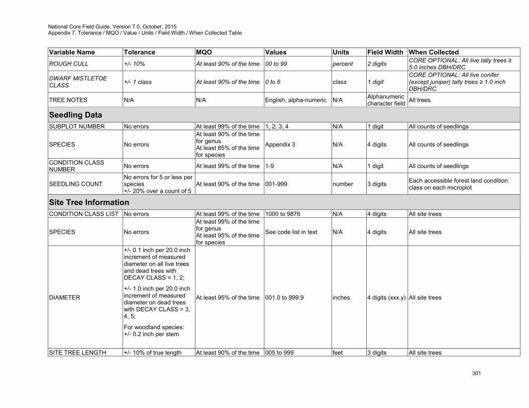
National Core Field Guide, Version 7.0, October, 2015 Appendix 7. Tolerance / MQO / Value / Units / Field Width / When Collected Table
301
Variable Name Tolerance MQO Values Units Field Width When Collected ROUGH CULL +/- 10% At least 90% of the time 00 to 99 percent 2 digits CORE OPTIONAL: All live tally trees ≥
5.0 inches DBH/DRC
DWARF MISTLETOE CLASS +/- 1 class At least 90% of the time 0 to 6 class 1 digit
CORE OPTIONAL: All live conifer (except juniper) tally trees ≥ 1.0 inch DBH/DRC
TREE NOTES N/A N/A English, alpha-numeric N/A Alphanumeric character field All trees
Seedling Data SUBPLOT NUMBER No errors At least 99% of the time 1, 2, 3, 4 N/A 1 digit All counts of seedlings
SPECIES No errors
At least 90% of the time for genus At least 85% of the time for species
Appendix 3 N/A 4 digits All counts of seedlings
CONDITION CLASS NUMBER No errors At least 99% of the time 1-9 N/A 1 digit All counts of seedlings
SEEDLING COUNT No errors for 5 or less per species +/- 20% over a count of 5
At least 90% of the time 001-999 number 3 digits Each accessible forest land condition class on each microplot
Site Tree Information CONDITION CLASS LIST No errors At least 99% of the time 1000 to 9876 N/A 4 digits All site trees
SPECIES No errors
At least 99% of the time for genus At least 95% of the time for species
See code list in text N/A 4 digits All site trees
DIAMETER
+/- 0.1 inch per 20.0 inch increment of measured diameter on all live trees and dead trees with DECAY CLASS = 1, 2;
+/- 1.0 inch per 20.0 inch increment of measured diameter on dead trees with DECAY CLASS = 3, 4, 5;
For woodland species: +/- 0.2 inch per stem
At least 95% of the time 001.0 to 999.9 inches 4 digits (xxx.y) All site trees
SITE TREE LENGTH +/- 10% of true length At least 90% of the time 005 to 999 feet 3 digits All site trees
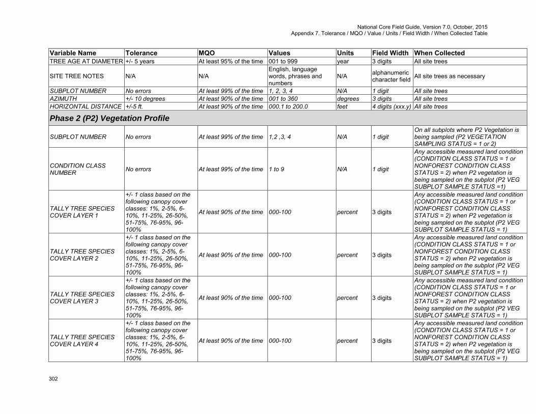
National Core Field Guide, Version 7.0, October, 2015 Appendix 7. Tolerance / MQO / Value / Units / Field Width / When Collected Table
302
Variable Name Tolerance MQO Values Units Field Width When Collected TREE AGE AT DIAMETER +/- 5 years At least 95% of the time 001 to 999 year 3 digits All site trees
SITE TREE NOTES N/A N/A English, language words, phrases and numbers
N/A alphanumeric character field All site trees as necessary
SUBPLOT NUMBER No errors At least 99% of the time 1, 2, 3, 4 N/A 1 digit All site trees AZIMUTH +/- 10 degrees At least 90% of the time 001 to 360 degrees 3 digits All site trees HORIZONTAL DISTANCE +/-5 ft. At least 90% of the time 000.1 to 200.0 feet 4 digits (xxx.y) All site trees
Phase 2 (P2) Vegetation Profile
SUBPLOT NUMBER No errors At least 99% of the time 1,2 ,3, 4 N/A 1 digit On all subplots where P2 Vegetation is being sampled (P2 VEGETATION SAMPLING STATUS = 1 or 2)
CONDITION CLASS NUMBER No errors At least 99% of the time 1 to 9 N/A 1 digit
Any accessible measured land condition (CONDITION CLASS STATUS = 1 or NONFOREST CONDITION CLASS STATUS = 2) when P2 vegetation is being sampled on the subplot (P2 VEG SUBPLOT SAMPLE STATUS =1)
TALLY TREE SPECIES COVER LAYER 1
+/- 1 class based on the following canopy cover classes: 1%, 2-5%, 6-10%, 11-25%, 26-50%, 51-75%, 76-95%, 96-100%
At least 90% of the time 000-100 percent 3 digits
Any accessible measured land condition (CONDITION CLASS STATUS = 1 or NONFOREST CONDITION CLASS STATUS = 2) when P2 vegetation is being sampled on the subplot (P2 VEG SUBPLOT SAMPLE STATUS = 1)
TALLY TREE SPECIES COVER LAYER 2
+/- 1 class based on the following canopy cover classes: 1%, 2-5%, 6-10%, 11-25%, 26-50%, 51-75%, 76-95%, 96-100%
At least 90% of the time 000-100 percent 3 digits
Any accessible measured land condition (CONDITION CLASS STATUS = 1 or NONFOREST CONDITION CLASS STATUS = 2) when P2 vegetation is being sampled on the subplot (P2 VEG SUBPLOT SAMPLE STATUS = 1)
TALLY TREE SPECIES COVER LAYER 3
+/- 1 class based on the following canopy cover classes: 1%, 2-5%, 6-10%, 11-25%, 26-50%, 51-75%, 76-95%, 96-100%
At least 90% of the time 000-100 percent 3 digits
Any accessible measured land condition (CONDITION CLASS STATUS = 1 or NONFOREST CONDITION CLASS STATUS = 2) when P2 vegetation is being sampled on the subplot (P2 VEG SUBPLOT SAMPLE STATUS = 1)
TALLY TREE SPECIES COVER LAYER 4
+/- 1 class based on the following canopy cover classes: 1%, 2-5%, 6-10%, 11-25%, 26-50%, 51-75%, 76-95%, 96-100%
At least 90% of the time 000-100 percent 3 digits
Any accessible measured land condition (CONDITION CLASS STATUS = 1 or NONFOREST CONDITION CLASS STATUS = 2) when P2 vegetation is being sampled on the subplot (P2 VEG SUBPLOT SAMPLE STATUS = 1)
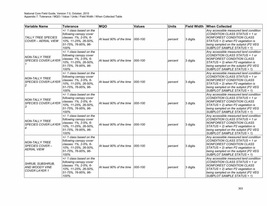
National Core Field Guide, Version 7.0, October, 2015 Appendix 7. Tolerance / MQO / Value / Units / Field Width / When Collected Table
303
Variable Name Tolerance MQO Values Units Field Width When Collected
TALLY TREE SPECIES COVER – AERIAL VIEW
+/- 1 class based on the following canopy cover classes: 1%, 2-5%, 6-10%, 11-25%, 26-50%, 51-75%, 76-95%, 96-100%
At least 90% of the time 000-100 percent 3 digits
Any accessible measured land condition (CONDITION CLASS STATUS = 1 or NONFOREST CONDITION CLASS STATUS = 2) when P2 vegetation is being sampled on the subplot (P2 VEG SUBPLOT SAMPLE STATUS = 1)
NON-TALLY TREE SPECIES COVER LAYER 1
+/- 1 class based on the following canopy cover classes: 1%, 2-5%, 6-10%, 11-25%, 26-50%, 51-75%, 76-95%, 96-100%
At least 90% of the time 000-100 percent 3 digits
Any accessible measured land condition (CONDITION CLASS STATUS = 1 or NONFOREST CONDITION CLASS STATUS = 2) when P2 vegetation is being sampled on the subplot (P2 VEG SUBPLOT SAMPLE STATUS = 1)
NON-TALLY TREE SPECIES COVER LAYER 2
+/- 1 class based on the following canopy cover classes: 1%, 2-5%, 6-10%, 11-25%, 26-50%, 51-75%, 76-95%, 96-100%
At least 90% of the time 000-100 percent 3 digits
Any accessible measured land condition (CONDITION CLASS STATUS = 1 or NONFOREST CONDITION CLASS STATUS = 2) when P2 vegetation is being sampled on the subplot (P2 VEG SUBPLOT SAMPLE STATUS = 1)
NON-TALLY TREE SPECIES COVER LAYER 3
+/- 1 class based on the following canopy cover classes: 1%, 2-5%, 6-10%, 11-25%, 26-50%, 51-75%, 76-95%, 96-100%
At least 90% of the time 000-100 percent 3 digits
Any accessible measured land condition (CONDITION CLASS STATUS = 1 or NONFOREST CONDITION CLASS STATUS = 2) when P2 vegetation is being sampled on the subplot (P2 VEG SUBPLOT SAMPLE STATUS = 1)
NON-TALLY TREE SPECIES COVER LAYER 4
+/- 1 class based on the following canopy cover classes: 1%, 2-5%, 6-10%, 11-25%, 26-50%, 51-75%, 76-95%, 96-100%
At least 90% of the time 000-100 percent 3 digits
Any accessible measured land condition (CONDITION CLASS STATUS = 1 or NONFOREST CONDITION CLASS STATUS = 2) when P2 vegetation is being sampled on the subplot (P2 VEG SUBPLOT SAMPLE STATUS = 1)
NON-TALLY TREE SPECIES COVER – AERIAL VIEW
+/- 1 class based on the following canopy cover classes: 1%, 2-5%, 6-10%, 11-25%, 26-50%, 51-75%, 76-95%, 96-100%
At least 90% of the time 000-100 percent 3 digits
Any accessible measured land condition (CONDITION CLASS STATUS = 1 or NONFOREST CONDITION CLASS STATUS = 2) when P2 vegetation is being sampled on the subplot (P2 VEG SUBPLOT SAMPLE STATUS = 1)
SHRUB, SUBSHRUB, AND WOODY VINE COVER LAYER 1
+/- 1 class based on the following canopy cover classes: 1%, 2-5%, 6-10%, 11-25%, 26-50%, 51-75%, 76-95%, 96-100%
At least 90% of the time 000-100 percent 3 digits
Any accessible measured land condition (CONDITION CLASS STATUS = 1 or NONFOREST CONDITION CLASS STATUS = 2) when P2 vegetation is being sampled on the subplot (P2 VEG SUBPLOT SAMPLE STATUS = 1)
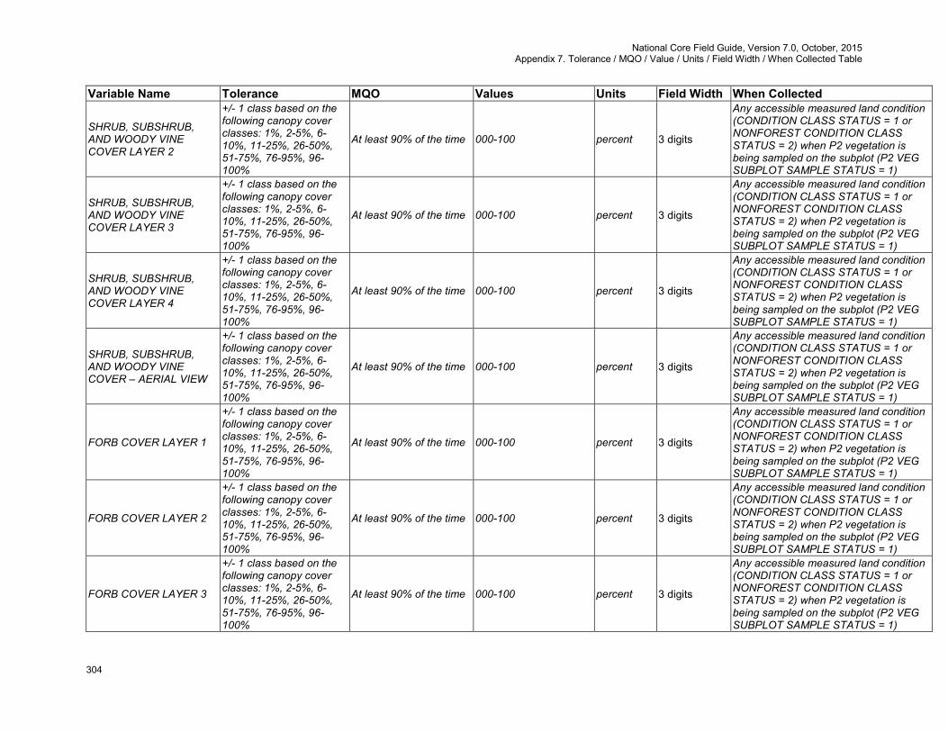
National Core Field Guide, Version 7.0, October, 2015 Appendix 7. Tolerance / MQO / Value / Units / Field Width / When Collected Table
304
Variable Name Tolerance MQO Values Units Field Width When Collected
SHRUB, SUBSHRUB, AND WOODY VINE COVER LAYER 2
+/- 1 class based on the following canopy cover classes: 1%, 2-5%, 6-10%, 11-25%, 26-50%, 51-75%, 76-95%, 96-100%
At least 90% of the time 000-100 percent 3 digits
Any accessible measured land condition (CONDITION CLASS STATUS = 1 or NONFOREST CONDITION CLASS STATUS = 2) when P2 vegetation is being sampled on the subplot (P2 VEG SUBPLOT SAMPLE STATUS = 1)
SHRUB, SUBSHRUB, AND WOODY VINE COVER LAYER 3
+/- 1 class based on the following canopy cover classes: 1%, 2-5%, 6-10%, 11-25%, 26-50%, 51-75%, 76-95%, 96-100%
At least 90% of the time 000-100 percent 3 digits
Any accessible measured land condition (CONDITION CLASS STATUS = 1 or NONFOREST CONDITION CLASS STATUS = 2) when P2 vegetation is being sampled on the subplot (P2 VEG SUBPLOT SAMPLE STATUS = 1)
SHRUB, SUBSHRUB, AND WOODY VINE COVER LAYER 4
+/- 1 class based on the following canopy cover classes: 1%, 2-5%, 6-10%, 11-25%, 26-50%, 51-75%, 76-95%, 96-100%
At least 90% of the time 000-100 percent 3 digits
Any accessible measured land condition (CONDITION CLASS STATUS = 1 or NONFOREST CONDITION CLASS STATUS = 2) when P2 vegetation is being sampled on the subplot (P2 VEG SUBPLOT SAMPLE STATUS = 1)
SHRUB, SUBSHRUB, AND WOODY VINE COVER – AERIAL VIEW
+/- 1 class based on the following canopy cover classes: 1%, 2-5%, 6-10%, 11-25%, 26-50%, 51-75%, 76-95%, 96-100%
At least 90% of the time 000-100 percent 3 digits
Any accessible measured land condition (CONDITION CLASS STATUS = 1 or NONFOREST CONDITION CLASS STATUS = 2) when P2 vegetation is being sampled on the subplot (P2 VEG SUBPLOT SAMPLE STATUS = 1)
FORB COVER LAYER 1
+/- 1 class based on the following canopy cover classes: 1%, 2-5%, 6-10%, 11-25%, 26-50%, 51-75%, 76-95%, 96-100%
At least 90% of the time 000-100 percent 3 digits
Any accessible measured land condition (CONDITION CLASS STATUS = 1 or NONFOREST CONDITION CLASS STATUS = 2) when P2 vegetation is being sampled on the subplot (P2 VEG SUBPLOT SAMPLE STATUS = 1)
FORB COVER LAYER 2
+/- 1 class based on the following canopy cover classes: 1%, 2-5%, 6-10%, 11-25%, 26-50%, 51-75%, 76-95%, 96-100%
At least 90% of the time 000-100 percent 3 digits
Any accessible measured land condition (CONDITION CLASS STATUS = 1 or NONFOREST CONDITION CLASS STATUS = 2) when P2 vegetation is being sampled on the subplot (P2 VEG SUBPLOT SAMPLE STATUS = 1)
FORB COVER LAYER 3
+/- 1 class based on the following canopy cover classes: 1%, 2-5%, 6-10%, 11-25%, 26-50%, 51-75%, 76-95%, 96-100%
At least 90% of the time 000-100 percent 3 digits
Any accessible measured land condition (CONDITION CLASS STATUS = 1 or NONFOREST CONDITION CLASS STATUS = 2) when P2 vegetation is being sampled on the subplot (P2 VEG SUBPLOT SAMPLE STATUS = 1)
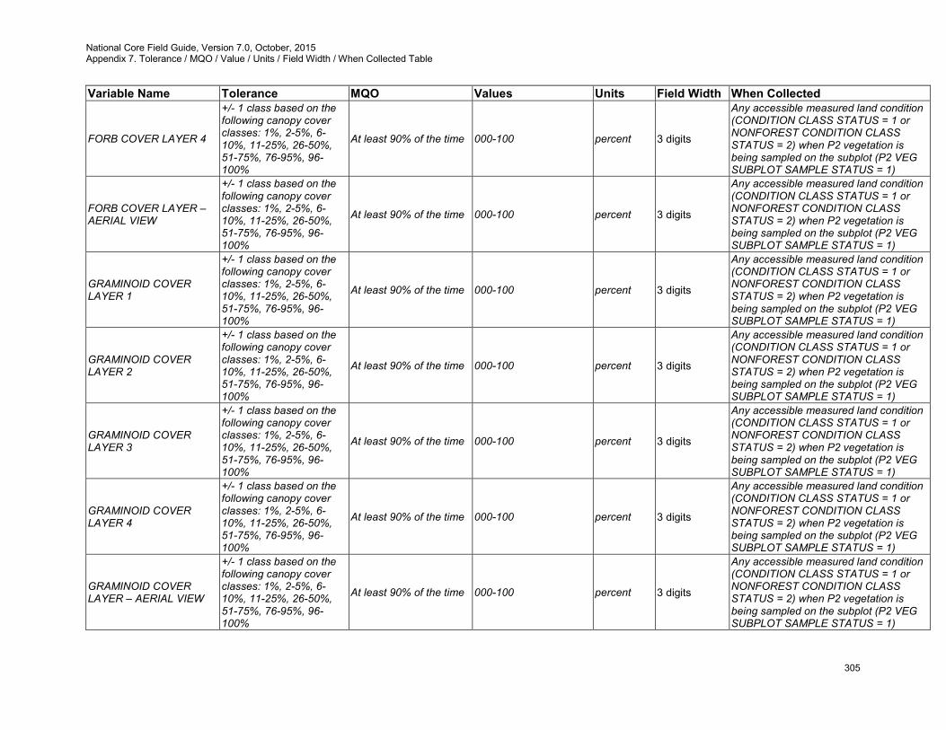
National Core Field Guide, Version 7.0, October, 2015 Appendix 7. Tolerance / MQO / Value / Units / Field Width / When Collected Table
305
Variable Name Tolerance MQO Values Units Field Width When Collected
FORB COVER LAYER 4
+/- 1 class based on the following canopy cover classes: 1%, 2-5%, 6-10%, 11-25%, 26-50%, 51-75%, 76-95%, 96-100%
At least 90% of the time 000-100 percent 3 digits
Any accessible measured land condition (CONDITION CLASS STATUS = 1 or NONFOREST CONDITION CLASS STATUS = 2) when P2 vegetation is being sampled on the subplot (P2 VEG SUBPLOT SAMPLE STATUS = 1)
FORB COVER LAYER – AERIAL VIEW
+/- 1 class based on the following canopy cover classes: 1%, 2-5%, 6-10%, 11-25%, 26-50%, 51-75%, 76-95%, 96-100%
At least 90% of the time 000-100 percent 3 digits
Any accessible measured land condition (CONDITION CLASS STATUS = 1 or NONFOREST CONDITION CLASS STATUS = 2) when P2 vegetation is being sampled on the subplot (P2 VEG SUBPLOT SAMPLE STATUS = 1)
GRAMINOID COVER LAYER 1
+/- 1 class based on the following canopy cover classes: 1%, 2-5%, 6-10%, 11-25%, 26-50%, 51-75%, 76-95%, 96-100%
At least 90% of the time 000-100 percent 3 digits
Any accessible measured land condition (CONDITION CLASS STATUS = 1 or NONFOREST CONDITION CLASS STATUS = 2) when P2 vegetation is being sampled on the subplot (P2 VEG SUBPLOT SAMPLE STATUS = 1)
GRAMINOID COVER LAYER 2
+/- 1 class based on the following canopy cover classes: 1%, 2-5%, 6-10%, 11-25%, 26-50%, 51-75%, 76-95%, 96-100%
At least 90% of the time 000-100 percent 3 digits
Any accessible measured land condition (CONDITION CLASS STATUS = 1 or NONFOREST CONDITION CLASS STATUS = 2) when P2 vegetation is being sampled on the subplot (P2 VEG SUBPLOT SAMPLE STATUS = 1)
GRAMINOID COVER LAYER 3
+/- 1 class based on the following canopy cover classes: 1%, 2-5%, 6-10%, 11-25%, 26-50%, 51-75%, 76-95%, 96-100%
At least 90% of the time 000-100 percent 3 digits
Any accessible measured land condition (CONDITION CLASS STATUS = 1 or NONFOREST CONDITION CLASS STATUS = 2) when P2 vegetation is being sampled on the subplot (P2 VEG SUBPLOT SAMPLE STATUS = 1)
GRAMINOID COVER LAYER 4
+/- 1 class based on the following canopy cover classes: 1%, 2-5%, 6-10%, 11-25%, 26-50%, 51-75%, 76-95%, 96-100%
At least 90% of the time 000-100 percent 3 digits
Any accessible measured land condition (CONDITION CLASS STATUS = 1 or NONFOREST CONDITION CLASS STATUS = 2) when P2 vegetation is being sampled on the subplot (P2 VEG SUBPLOT SAMPLE STATUS = 1)
GRAMINOID COVER LAYER – AERIAL VIEW
+/- 1 class based on the following canopy cover classes: 1%, 2-5%, 6-10%, 11-25%, 26-50%, 51-75%, 76-95%, 96-100%
At least 90% of the time 000-100 percent 3 digits
Any accessible measured land condition (CONDITION CLASS STATUS = 1 or NONFOREST CONDITION CLASS STATUS = 2) when P2 vegetation is being sampled on the subplot (P2 VEG SUBPLOT SAMPLE STATUS = 1)
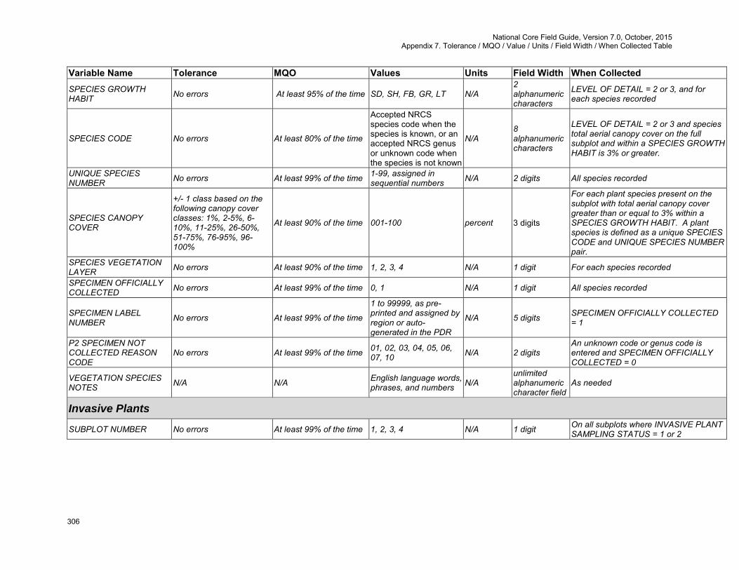
National Core Field Guide, Version 7.0, October, 2015 Appendix 7. Tolerance / MQO / Value / Units / Field Width / When Collected Table
306
Variable Name Tolerance MQO Values Units Field Width When Collected SPECIES GROWTH HABIT No errors At least 95% of the time SD, SH, FB, GR, LT N/A
2 alphanumeric characters
LEVEL OF DETAIL = 2 or 3, and for each species recorded
SPECIES CODE No errors At least 80% of the time
Accepted NRCS species code when the species is known, or an accepted NRCS genus or unknown code when the species is not known
N/A 8 alphanumeric characters
LEVEL OF DETAIL = 2 or 3 and species total aerial canopy cover on the full subplot and within a SPECIES GROWTH HABIT is 3% or greater.
UNIQUE SPECIES NUMBER No errors At least 99% of the time 1-99, assigned in
sequential numbers N/A 2 digits All species recorded
SPECIES CANOPY COVER
+/- 1 class based on the following canopy cover classes: 1%, 2-5%, 6-10%, 11-25%, 26-50%, 51-75%, 76-95%, 96-100%
At least 90% of the time 001-100 percent 3 digits
For each plant species present on the subplot with total aerial canopy cover greater than or equal to 3% within a SPECIES GROWTH HABIT. A plant species is defined as a unique SPECIES CODE and UNIQUE SPECIES NUMBER pair.
SPECIES VEGETATION LAYER No errors At least 90% of the time 1, 2, 3, 4 N/A 1 digit For each species recorded
SPECIMEN OFFICIALLY COLLECTED No errors At least 99% of the time 0, 1 N/A 1 digit All species recorded
SPECIMEN LABEL NUMBER No errors At least 99% of the time
1 to 99999, as pre-printed and assigned by region or auto-generated in the PDR
N/A 5 digits SPECIMEN OFFICIALLY COLLECTED = 1
P2 SPECIMEN NOT COLLECTED REASON CODE
No errors At least 99% of the time 01, 02, 03, 04, 05, 06, 07, 10 N/A 2 digits
An unknown code or genus code is entered and SPECIMEN OFFICIALLY COLLECTED = 0
VEGETATION SPECIES NOTES N/A N/A English language words,
phrases, and numbers N/A unlimited alphanumeric character field
As needed
Invasive Plants
SUBPLOT NUMBER No errors At least 99% of the time 1, 2, 3, 4 N/A 1 digit On all subplots where INVASIVE PLANT SAMPLING STATUS = 1 or 2
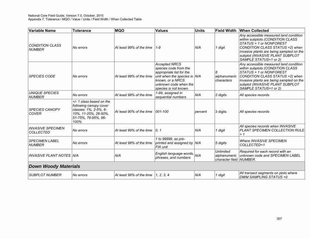
National Core Field Guide, Version 7.0, October, 2015 Appendix 7. Tolerance / MQO / Value / Units / Field Width / When Collected Table
307
Variable Name Tolerance MQO Values Units Field Width When Collected
CONDITION CLASS NUMBER No errors At least 99% of the time 1-9 N/A 1 digit
Any accessible measured land condition within subplots (CONDITION CLASS STATUS = 1 or NONFOREST CONDITION CLASS STATUS =2) when invasive plants are being sampled on the subplot (INVASIVE PLANT SUBPLOT SAMPLE STATUS=1 or 2)
SPECIES CODE No errors At least 99% of the time
Accepted NRCS species code from the appropriate list for the unit when the species is known, or a NRCS unknown code when the species is not known.
N/A 8 alphanumeric characters
Any accessible measured land condition within subplots (CONDITION CLASS STATUS = 1 or NONFOREST CONDITION CLASS STATUS =2) when invasive plants are being sampled on the subplot (INVASIVE PLANT SUBPLOT SAMPLE STATUS=1 or 2)
UNIQUE SPECIES NUMBER No errors At least 99% of the time 1-99, assigned in
sequential numbers N/A 2 digits All species records
SPECIES CANOPY COVER
+/- 1 class based on the following canopy cover classes: 1%, 2-5%, 6-10%, 11-25%, 26-50%, 51-75%, 76-95%, 96-100%
At least 90% of the time 001-100 percent 3 digits All species records
INVASIVE SPECIMEN COLLECTED No errors At least 99% of the time 0, 1 N/A 1 digit
All species records when INVASIVE PLANT SPECIMEN COLLECTION RULE = 1
SPECIMEN LABEL NUMBER No errors At least 99% of the time
1 to 99999, as pre-printed and assigned by FIA unit
N/A 5 digits Where INVASIVE SPECIMEN COLLECTED=1
INVASIVE PLANT NOTES N/A N/A English language words, phrases, and numbers N/A
Unlimited alphanumeric character field
Required for each record with an unknown code and SPECIMEN LABEL NUMBER.
Down Woody Materials
SUBPLOT NUMBER No errors At least 99% of the time 1, 2, 3, 4 N/A 1 digit All transect segments on plots where DWM SAMPLING STATUS >0
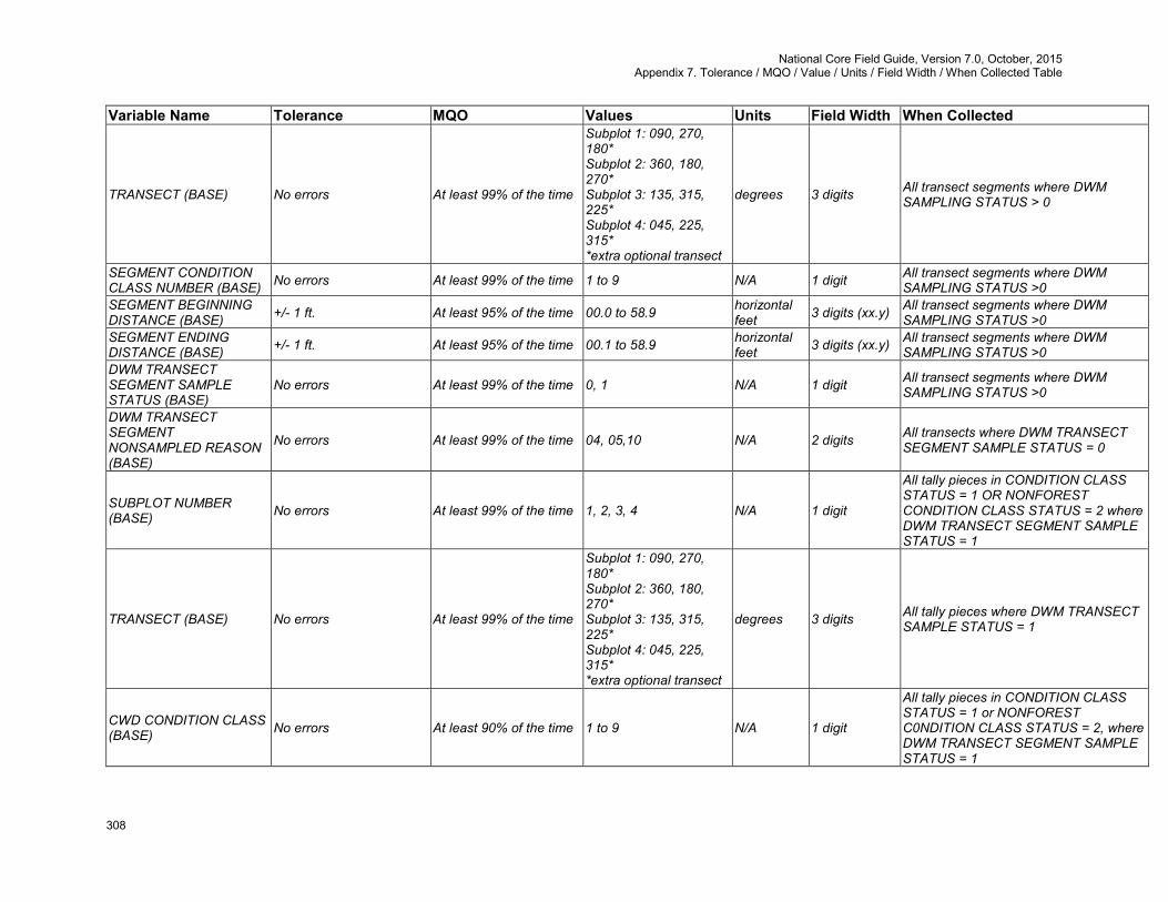
National Core Field Guide, Version 7.0, October, 2015 Appendix 7. Tolerance / MQO / Value / Units / Field Width / When Collected Table
308
Variable Name Tolerance MQO Values Units Field Width When Collected
TRANSECT (BASE) No errors At least 99% of the time
Subplot 1: 090, 270, 180* Subplot 2: 360, 180, 270* Subplot 3: 135, 315, 225* Subplot 4: 045, 225, 315* *extra optional transect
degrees 3 digits All transect segments where DWM SAMPLING STATUS > 0
SEGMENT CONDITION CLASS NUMBER (BASE) No errors At least 99% of the time 1 to 9 N/A 1 digit All transect segments where DWM
SAMPLING STATUS >0 SEGMENT BEGINNING DISTANCE (BASE) +/- 1 ft. At least 95% of the time 00.0 to 58.9 horizontal
feet 3 digits (xx.y) All transect segments where DWM SAMPLING STATUS >0
SEGMENT ENDING DISTANCE (BASE) +/- 1 ft. At least 95% of the time 00.1 to 58.9 horizontal
feet 3 digits (xx.y) All transect segments where DWM SAMPLING STATUS >0
DWM TRANSECT SEGMENT SAMPLE STATUS (BASE)
No errors At least 99% of the time 0, 1 N/A 1 digit All transect segments where DWM SAMPLING STATUS >0
DWM TRANSECT SEGMENT NONSAMPLED REASON (BASE)
No errors At least 99% of the time 04, 05,10 N/A 2 digits All transects where DWM TRANSECT SEGMENT SAMPLE STATUS = 0
SUBPLOT NUMBER (BASE) No errors At least 99% of the time 1, 2, 3, 4 N/A 1 digit
All tally pieces in CONDITION CLASS STATUS = 1 OR NONFOREST CONDITION CLASS STATUS = 2 where DWM TRANSECT SEGMENT SAMPLE STATUS = 1
TRANSECT (BASE) No errors At least 99% of the time
Subplot 1: 090, 270, 180* Subplot 2: 360, 180, 270* Subplot 3: 135, 315, 225* Subplot 4: 045, 225, 315* *extra optional transect
degrees 3 digits All tally pieces where DWM TRANSECT SAMPLE STATUS = 1
CWD CONDITION CLASS (BASE) No errors At least 90% of the time 1 to 9 N/A 1 digit
All tally pieces in CONDITION CLASS STATUS = 1 or NONFOREST C0NDITION CLASS STATUS = 2, where DWM TRANSECT SEGMENT SAMPLE STATUS = 1
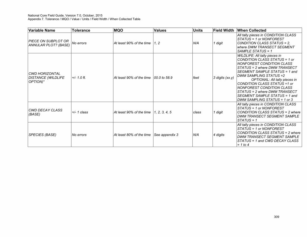
National Core Field Guide, Version 7.0, October, 2015 Appendix 7. Tolerance / MQO / Value / Units / Field Width / When Collected Table
309
Variable Name Tolerance MQO Values Units Field Width When Collected
PIECE ON SUBPLOT OR ANNULAR PLOT? (BASE) No errors At least 90% of the time 1, 2 N/A 1 digit
All tally pieces in CONDITION CLASS STATUS = 1 or NONFOREST C0NDITION CLASS STATUS = 2, where DWM TRANSECT SEGMENT SAMPLE STATUS = 1
CWD HORIZONTAL DISTANCE (WILDLIFE OPTION)*
+/- 1.0 ft. At least 90% of the time 00.0 to 58.9 feet 3 digits (xx.y)
WILDLIFE: All tally pieces in CONDITION CLASS STATUS = 1 or NONFOREST CONDITION CLASS STATUS = 2 where DWM TRANSECT SEGMENT SAMPLE STATUS = 1 and DWM SAMPLING STATUS =2 OPTIONAL: All tally pieces in CONDITION CLASS STATUS =1 or NONFOREST CONDITION CLASS STATUS = 2 where DWM TRANSECT SEGMENT SAMPLE STATUS = 1 and DWM SAMPLING STATUS = 1 or 3
CWD DECAY CLASS (BASE) +/- 1 class At least 90% of the time 1, 2, 3, 4, 5 class 1 digit
All tally pieces in CONDITION CLASS STATUS = 1 or NONFOREST CONDITION CLASS STATUS = 2 where DWM TRANSECT SEGMENT SAMPLE STATUS = 1
SPECIES (BASE) No errors At least 80% of the time See appendix 3 N/A 4 digits
All tally pieces in CONDITION CLASS STATUS = 1 or NONFOREST CONDITION CLASS STATUS = 2 where DWM TRANSECT SEGMENT SAMPLE STATUS = 1 and CWD DECAY CLASS = 1 to 4
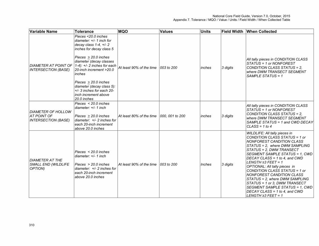
National Core Field Guide, Version 7.0, October, 2015 Appendix 7. Tolerance / MQO / Value / Units / Field Width / When Collected Table
310
Variable Name Tolerance MQO Values Units Field Width When Collected
DIAMETER AT POINT OF INTERSECTION (BASE)
Pieces <20.0 inches diameter: +/- 1 inch for decay class 1-4, +/- 2 inches for decay class 5 Pieces > 20.0 inches diameter (decay classes 1-4): +/- 2 inches for each 20-inch increment >20.0 inches Pieces > 20.0 inches diameter (decay class 5): +/- 3 inches for each 20-inch increment above 20.0 inches
At least 90% of the time 003 to 200 inches 3 digits
All tally pieces in CONDITION CLASS STATUS = 1 or NONFOREST CONDITION CLASS STATUS = 2, where DWM TRANSECT SEGMENT SAMPLE STATUS = 1
DIAMETER OF HOLLOW AT POINT OF INTERSECTION (BASE)
Pieces < 20.0 inches diameter: +/- 1 inch Pieces > 20.0 inches diameter: +/- 2 inches for each 20-inch increment above 20.0 inches
At least 80% of the time 000, 001 to 200 inches 3 digits
All tally pieces in CONDITION CLASS STATUS = 1 or NONFOREST CONDITION CLASS STATUS = 2, where DWM TRANSECT SEGMENT SAMPLE STATUS = 1 and CWD DECAY CLASS = 1 to 4
DIAMETER AT THE SMALL END (WILDLIFE OPTION)
Pieces < 20.0 inches diameter: +/- 1 inch Pieces > 20.0 inches diameter: +/- 2 inches for each 20-inch increment above 20.0 inches
At least 90% of the time 003 to 200 Inches 3 digits
WILDLIFE: All tally pieces in CONDITION CLASS STATUS = 1 or NONFOREST CANDITION CLASS STATUS = 2, where DWM SAMPLING STATUS = 2, DWM TRANSECT SEGMENT SAMPLE STATUS = 1, CWD DECAY CLASS = 1 to 4, and CWD LENGTH ≥3 FEET = 1 OPTIONAL: All tally pieces in CONDITION CLASS STATUS = 1 or NONFOREST CANDITION CLASS STATUS = 2, where DWM SAMPLING STATUS = 1 or 3, DWM TRANSECT SEGMENT SAMPLE STATUS = 1, CWD DECAY CLASS = 1 to 4, and CWD LENGTH ≥3 FEET = 1
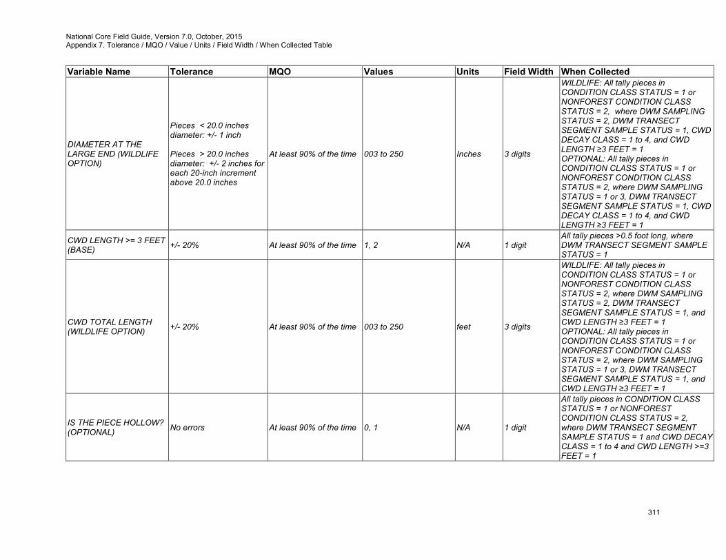
National Core Field Guide, Version 7.0, October, 2015 Appendix 7. Tolerance / MQO / Value / Units / Field Width / When Collected Table
311
Variable Name Tolerance MQO Values Units Field Width When Collected
DIAMETER AT THE LARGE END (WILDLIFE OPTION)
Pieces < 20.0 inches diameter: +/- 1 inch Pieces > 20.0 inches diameter: +/- 2 inches for each 20-inch increment above 20.0 inches
At least 90% of the time 003 to 250 Inches 3 digits
WILDLIFE: All tally pieces in CONDITION CLASS STATUS = 1 or NONFOREST CONDITION CLASS STATUS = 2, where DWM SAMPLING STATUS = 2, DWM TRANSECT SEGMENT SAMPLE STATUS = 1, CWD DECAY CLASS = 1 to 4, and CWD LENGTH ≥3 FEET = 1 OPTIONAL: All tally pieces in CONDITION CLASS STATUS = 1 or NONFOREST CONDITION CLASS STATUS = 2, where DWM SAMPLING STATUS = 1 or 3, DWM TRANSECT SEGMENT SAMPLE STATUS = 1, CWD DECAY CLASS = 1 to 4, and CWD LENGTH ≥3 FEET = 1
CWD LENGTH >= 3 FEET (BASE) +/- 20% At least 90% of the time 1, 2 N/A 1 digit
All tally pieces >0.5 foot long, where DWM TRANSECT SEGMENT SAMPLE STATUS = 1
CWD TOTAL LENGTH (WILDLIFE OPTION) +/- 20% At least 90% of the time 003 to 250 feet 3 digits
WILDLIFE: All tally pieces in CONDITION CLASS STATUS = 1 or NONFOREST CONDITION CLASS STATUS = 2, where DWM SAMPLING STATUS = 2, DWM TRANSECT SEGMENT SAMPLE STATUS = 1, and CWD LENGTH ≥3 FEET = 1 OPTIONAL: All tally pieces in CONDITION CLASS STATUS = 1 or NONFOREST CONDITION CLASS STATUS = 2, where DWM SAMPLING STATUS = 1 or 3, DWM TRANSECT SEGMENT SAMPLE STATUS = 1, and CWD LENGTH ≥3 FEET = 1
IS THE PIECE HOLLOW? (OPTIONAL) No errors At least 90% of the time 0, 1 N/A 1 digit
All tally pieces in CONDITION CLASS STATUS = 1 or NONFOREST CONDITION CLASS STATUS = 2, where DWM TRANSECT SEGMENT SAMPLE STATUS = 1 and CWD DECAY CLASS = 1 to 4 and CWD LENGTH >=3 FEET = 1
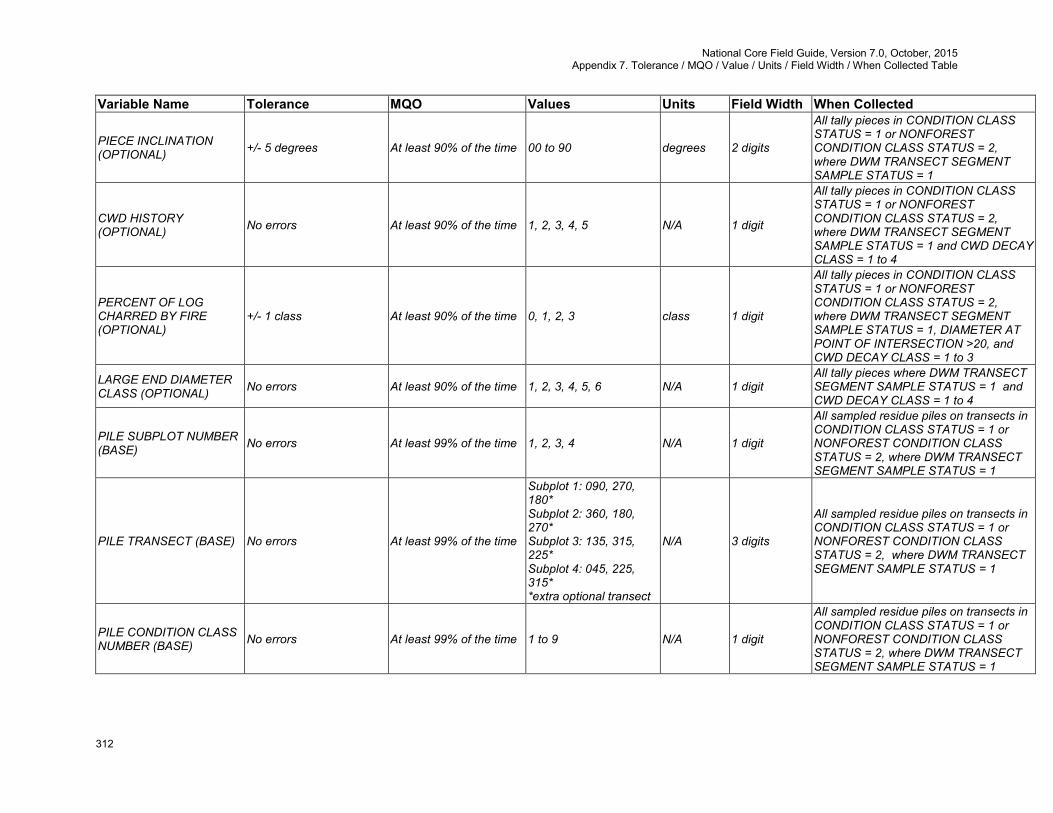
National Core Field Guide, Version 7.0, October, 2015 Appendix 7. Tolerance / MQO / Value / Units / Field Width / When Collected Table
312
Variable Name Tolerance MQO Values Units Field Width When Collected
PIECE INCLINATION (OPTIONAL) +/- 5 degrees At least 90% of the time 00 to 90 degrees 2 digits
All tally pieces in CONDITION CLASS STATUS = 1 or NONFOREST CONDITION CLASS STATUS = 2, where DWM TRANSECT SEGMENT SAMPLE STATUS = 1
CWD HISTORY (OPTIONAL) No errors At least 90% of the time 1, 2, 3, 4, 5 N/A 1 digit
All tally pieces in CONDITION CLASS STATUS = 1 or NONFOREST CONDITION CLASS STATUS = 2, where DWM TRANSECT SEGMENT SAMPLE STATUS = 1 and CWD DECAY CLASS = 1 to 4
PERCENT OF LOG CHARRED BY FIRE (OPTIONAL)
+/- 1 class At least 90% of the time 0, 1, 2, 3 class 1 digit
All tally pieces in CONDITION CLASS STATUS = 1 or NONFOREST CONDITION CLASS STATUS = 2, where DWM TRANSECT SEGMENT SAMPLE STATUS = 1, DIAMETER AT POINT OF INTERSECTION >20, and CWD DECAY CLASS = 1 to 3
LARGE END DIAMETER CLASS (OPTIONAL) No errors At least 90% of the time 1, 2, 3, 4, 5, 6 N/A 1 digit
All tally pieces where DWM TRANSECT SEGMENT SAMPLE STATUS = 1 and CWD DECAY CLASS = 1 to 4
PILE SUBPLOT NUMBER (BASE) No errors At least 99% of the time 1, 2, 3, 4 N/A 1 digit
All sampled residue piles on transects in CONDITION CLASS STATUS = 1 or NONFOREST CONDITION CLASS STATUS = 2, where DWM TRANSECT SEGMENT SAMPLE STATUS = 1
PILE TRANSECT (BASE) No errors At least 99% of the time
Subplot 1: 090, 270, 180* Subplot 2: 360, 180, 270* Subplot 3: 135, 315, 225* Subplot 4: 045, 225, 315* *extra optional transect
N/A 3 digits
All sampled residue piles on transects in CONDITION CLASS STATUS = 1 or NONFOREST CONDITION CLASS STATUS = 2, where DWM TRANSECT SEGMENT SAMPLE STATUS = 1
PILE CONDITION CLASS NUMBER (BASE) No errors At least 99% of the time 1 to 9 N/A 1 digit
All sampled residue piles on transects in CONDITION CLASS STATUS = 1 or NONFOREST CONDITION CLASS STATUS = 2, where DWM TRANSECT SEGMENT SAMPLE STATUS = 1
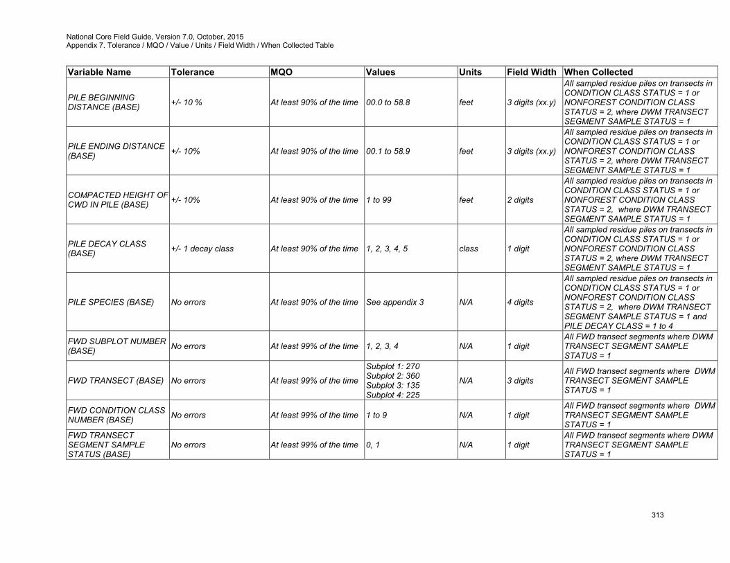
National Core Field Guide, Version 7.0, October, 2015 Appendix 7. Tolerance / MQO / Value / Units / Field Width / When Collected Table
313
Variable Name Tolerance MQO Values Units Field Width When Collected
PILE BEGINNING DISTANCE (BASE) +/- 10 % At least 90% of the time 00.0 to 58.8 feet 3 digits (xx.y)
All sampled residue piles on transects in CONDITION CLASS STATUS = 1 or NONFOREST CONDITION CLASS STATUS = 2, where DWM TRANSECT SEGMENT SAMPLE STATUS = 1
PILE ENDING DISTANCE (BASE) +/- 10% At least 90% of the time 00.1 to 58.9 feet 3 digits (xx.y)
All sampled residue piles on transects in CONDITION CLASS STATUS = 1 or NONFOREST CONDITION CLASS STATUS = 2, where DWM TRANSECT SEGMENT SAMPLE STATUS = 1
COMPACTED HEIGHT OF CWD IN PILE (BASE) +/- 10% At least 90% of the time 1 to 99 feet 2 digits
All sampled residue piles on transects in CONDITION CLASS STATUS = 1 or NONFOREST CONDITION CLASS STATUS = 2, where DWM TRANSECT SEGMENT SAMPLE STATUS = 1
PILE DECAY CLASS (BASE) +/- 1 decay class At least 90% of the time 1, 2, 3, 4, 5 class 1 digit
All sampled residue piles on transects in CONDITION CLASS STATUS = 1 or NONFOREST CONDITION CLASS STATUS = 2, where DWM TRANSECT SEGMENT SAMPLE STATUS = 1
PILE SPECIES (BASE) No errors At least 90% of the time See appendix 3 N/A 4 digits
All sampled residue piles on transects in CONDITION CLASS STATUS = 1 or NONFOREST CONDITION CLASS STATUS = 2, where DWM TRANSECT SEGMENT SAMPLE STATUS = 1 and PILE DECAY CLASS = 1 to 4
FWD SUBPLOT NUMBER (BASE) No errors At least 99% of the time 1, 2, 3, 4 N/A 1 digit
All FWD transect segments where DWM TRANSECT SEGMENT SAMPLE STATUS = 1
FWD TRANSECT (BASE) No errors At least 99% of the time
Subplot 1: 270 Subplot 2: 360 Subplot 3: 135 Subplot 4: 225
N/A 3 digits All FWD transect segments where DWM TRANSECT SEGMENT SAMPLE STATUS = 1
FWD CONDITION CLASS NUMBER (BASE) No errors At least 99% of the time 1 to 9 N/A 1 digit
All FWD transect segments where DWM TRANSECT SEGMENT SAMPLE STATUS = 1
FWD TRANSECT SEGMENT SAMPLE STATUS (BASE)
No errors At least 99% of the time 0, 1 N/A 1 digit All FWD transect segments where DWM TRANSECT SEGMENT SAMPLE STATUS = 1

National Core Field Guide, Version 7.0, October, 2015 Appendix 7. Tolerance / MQO / Value / Units / Field Width / When Collected Table
314
Variable Name Tolerance MQO Values Units Field Width When Collected FWD TRANSECT SEGMENT NONSAMPLED REASON (BASE)
No errors At least 99% of the time 04, 05, 10 N/A 2 digits All FWD transect segments where FWD TRANSECT SEGMENT SAMPLE STATUS = 0
SMALL FWD COUNT (BASE)
0 to 50 = +/- 20% of the total count for the transect 51 to 100 = +/- 25% of the total count for the transect 100 + = +/- 50% of the total count for the transect
At least 90% of the time 000 to 999 pieces 3 digits
All FWD transect segments in CONDITION CLASS STATUS = 1 or NONFOREST CONDITION CLASS STATUS = 2 where FWD TRANSECT SEGMENT SAMPLE STATUS = 1
MEDIUM FWD COUNT (BASE)
+/- 20% of the total count for the transect At least 90% of the time 000 to 999 pieces 3 digits
All FWD transect segments in CONDITION CLASS STATUS = 1 or NONFOREST CONDITION CLASS STATUS = 2 where FWD TRANSECT SEGMENT SAMPLE STATUS = 1
LARGE FWD COUNT (BASE)
+/- 20% of the total count for the transect At least 90% of the time 000 to 500 pieces 3 digits
All FWD transect segments in CONDITION CLASS STATUS = 1 or NONFOREST CONDITION CLASS STATUS = 2 where FWD TRANSECT SEGMENT SAMPLE STATUS = 1
HIGH COUNT REASON (BASE) No errors At least 90% of the time 1, 2, 3, 4, 5 N/A 1 digit
All FWD transect segments in CONDITION CLASS STATUS = 1 or NONFOREST CONDITION CLASS STATUS = 2 where FWD TRANSECT SEGMENT SAMPLE STATUS = 1 and (SMALL FWD COUNT ≥ 100 or MEDIUM FWD COUNT ≥100 or LARGE FWD COUNT ≥100
DUFF/LITTER SUBPLOT NUMBER (BASE) No errors At least 99% of the time 1, 2, 3, 4 N/A 1 digit
All duff/litter transects where DWM TRANSECT SEGMENT SAMPLE STATUS = 1
DUFF/LITTER TRANSECT (BASE) No errors At least 99% of the time
Subplot 1: 090, 270 Subplot 2: 360, 180 Subplot 3: 135, 315 Subplot 4: 045, 225
degrees 3 digits All duff/litter transects where DWM TRANSECT SEGMENT SAMPLE STATUS = 1
DUFF/LITTER CONDITION CLASS NUMBER (BASE)
No errors At least 99% of the time 1 to 9 N/A 1 digit All duff/litter transects where DWM TRANSECT SEGMENT SAMPLE STATUS = 1
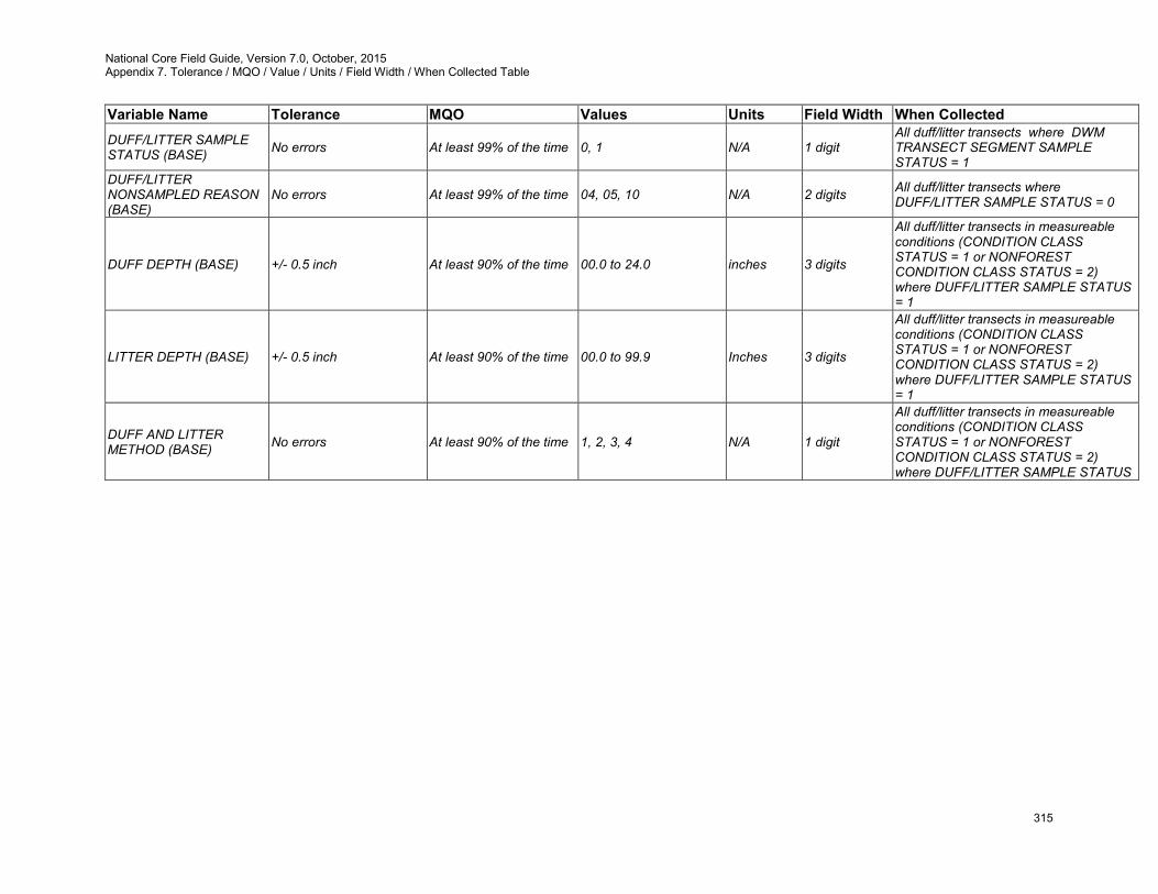
National Core Field Guide, Version 7.0, October, 2015 Appendix 7. Tolerance / MQO / Value / Units / Field Width / When Collected Table
315
Variable Name Tolerance MQO Values Units Field Width When Collected DUFF/LITTER SAMPLE STATUS (BASE) No errors At least 99% of the time 0, 1 N/A 1 digit
All duff/litter transects where DWM TRANSECT SEGMENT SAMPLE STATUS = 1
DUFF/LITTER NONSAMPLED REASON (BASE)
No errors At least 99% of the time 04, 05, 10 N/A 2 digits All duff/litter transects where DUFF/LITTER SAMPLE STATUS = 0
DUFF DEPTH (BASE) +/- 0.5 inch At least 90% of the time 00.0 to 24.0 inches 3 digits
All duff/litter transects in measureable conditions (CONDITION CLASS STATUS = 1 or NONFOREST CONDITION CLASS STATUS = 2) where DUFF/LITTER SAMPLE STATUS = 1
LITTER DEPTH (BASE) +/- 0.5 inch At least 90% of the time 00.0 to 99.9 Inches 3 digits
All duff/litter transects in measureable conditions (CONDITION CLASS STATUS = 1 or NONFOREST CONDITION CLASS STATUS = 2) where DUFF/LITTER SAMPLE STATUS = 1
DUFF AND LITTER METHOD (BASE) No errors At least 90% of the time 1, 2, 3, 4 N/A 1 digit
All duff/litter transects in measureable conditions (CONDITION CLASS STATUS = 1 or NONFOREST CONDITION CLASS STATUS = 2) where DUFF/LITTER SAMPLE STATUS

National Core Field Guide, Version 7.0, October, 2015 Appendix 8. Tree Coding Guide
316
Appendix 8. Tree Coding Guide
Previous Measurement
Present Measurement
PREVIOUS TREE
STATUS
PRESENT TREE
STATUS
RECONCILE
Standing
Dead
CAUSE OF
DEATH
SAMPLE KIND 1 or 3
Live 1.0+ DBH/DRC - 1
Standing dead 1.0+ DBH/DRC - 2
Null – Office
inserts code 1
Core optional
SAMPLE KIND 2 (Remeasure)
Live 5.0+ DBH/DRC Live 5.0+ DBH/DRC 1 1
Live 1.0-4.9 DBH/DRC on microplot
Live 5.0+ DBH/DRC Note: this live tally tree should be referenced with a new distance and azimuth from the subplot center. 1 1
Live 1.0-4.9 DBH/DRC on microplot Live 1.0-4.9 DBH/DRC on microplot 1 1
Live 5.0+ DBH/DRC
Live but shrank < 5.0 and on microplot Note: this live sapling should be referenced with a new distance and azimuth from the microplot center. 1 1
Live 1.0+ Live but land no longer qualifies as forest 1 1
Live 1.0+ DBH/DRC Standing dead 5.0+ DBH/DRC 1 2 1 10-80
Live 5.0+ DBH/DRC Down dead 5.0+ DBH/DRC 1 2 0 10-80
Live 1.0-4.9 DBH/DRC on microplot
Dead 5.0+ DBH/DRC (standing or down) Note: if standing, this dead tally tree should be referenced with a new distance and azimuth from the subplot center. 1 2 0 or 1 10-80
Live 1.0+ DBH/DRC
Cruiser unable to locate tree due to a weather, geologic (such as landslide), or fire event & assume tree is down dead or you can see tree and it is dead and off the plot 1 2 0 30 or 50
Live 1.0+ DBH/DRC Cut and left in the woods 1 2 0 80
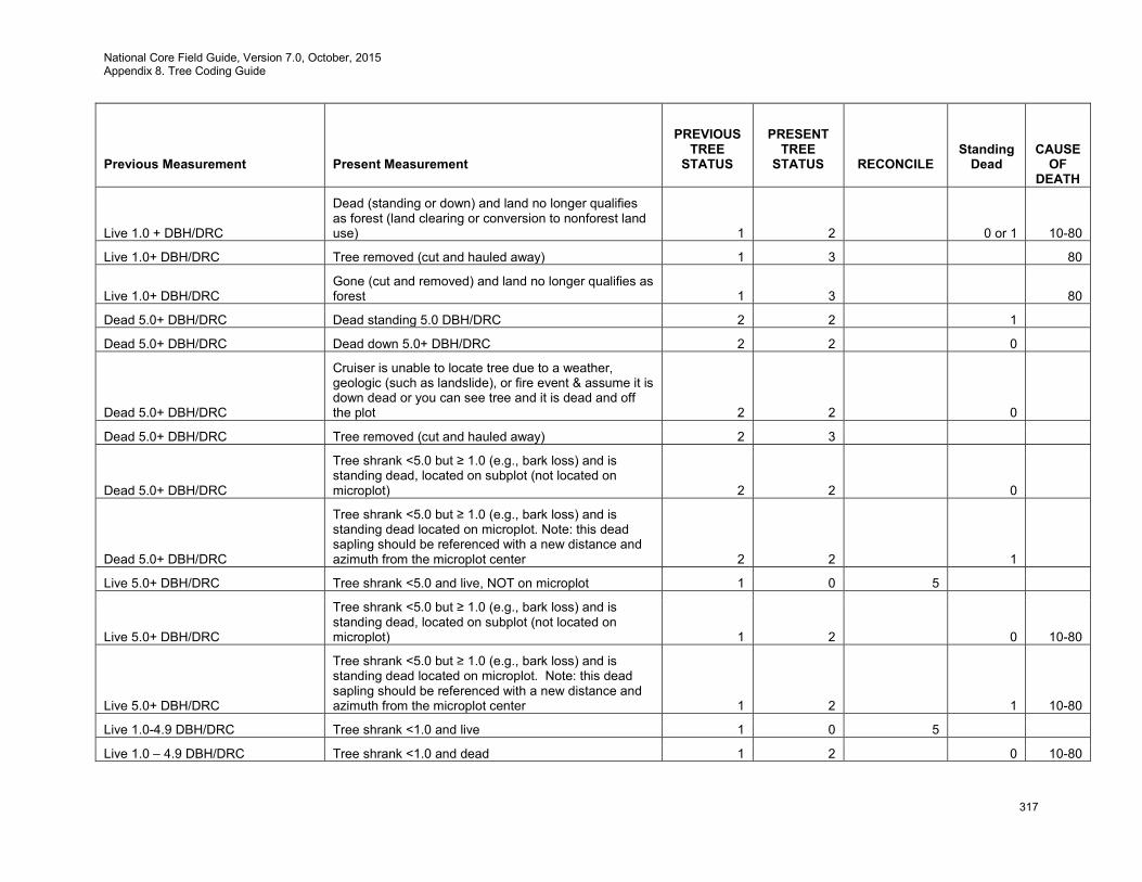
National Core Field Guide, Version 7.0, October, 2015 Appendix 8. Tree Coding Guide
317
Previous Measurement
Present Measurement
PREVIOUS TREE
STATUS
PRESENT TREE
STATUS
RECONCILE
Standing
Dead
CAUSE OF
DEATH
Live 1.0 + DBH/DRC
Dead (standing or down) and land no longer qualifies as forest (land clearing or conversion to nonforest land use) 1 2 0 or 1 10-80
Live 1.0+ DBH/DRC Tree removed (cut and hauled away) 1 3 80
Live 1.0+ DBH/DRC Gone (cut and removed) and land no longer qualifies as forest 1 3 80
Dead 5.0+ DBH/DRC Dead standing 5.0 DBH/DRC 2 2 1
Dead 5.0+ DBH/DRC Dead down 5.0+ DBH/DRC 2 2 0
Dead 5.0+ DBH/DRC
Cruiser is unable to locate tree due to a weather, geologic (such as landslide), or fire event & assume it is down dead or you can see tree and it is dead and off the plot 2 2 0
Dead 5.0+ DBH/DRC Tree removed (cut and hauled away) 2 3
Dead 5.0+ DBH/DRC
Tree shrank <5.0 but ≥ 1.0 (e.g., bark loss) and is standing dead, located on subplot (not located on microplot) 2 2 0
Dead 5.0+ DBH/DRC
Tree shrank <5.0 but ≥ 1.0 (e.g., bark loss) and is standing dead located on microplot. Note: this dead sapling should be referenced with a new distance and azimuth from the microplot center 2 2 1
Live 5.0+ DBH/DRC Tree shrank <5.0 and live, NOT on microplot 1 0 5
Live 5.0+ DBH/DRC
Tree shrank <5.0 but ≥ 1.0 (e.g., bark loss) and is standing dead, located on subplot (not located on microplot) 1 2 0 10-80
Live 5.0+ DBH/DRC
Tree shrank <5.0 but ≥ 1.0 (e.g., bark loss) and is standing dead located on microplot. Note: this dead sapling should be referenced with a new distance and azimuth from the microplot center 1 2 1 10-80
Live 1.0-4.9 DBH/DRC Tree shrank <1.0 and live 1 0 5
Live 1.0 – 4.9 DBH/DRC Tree shrank <1.0 and dead 1 2 0 10-80
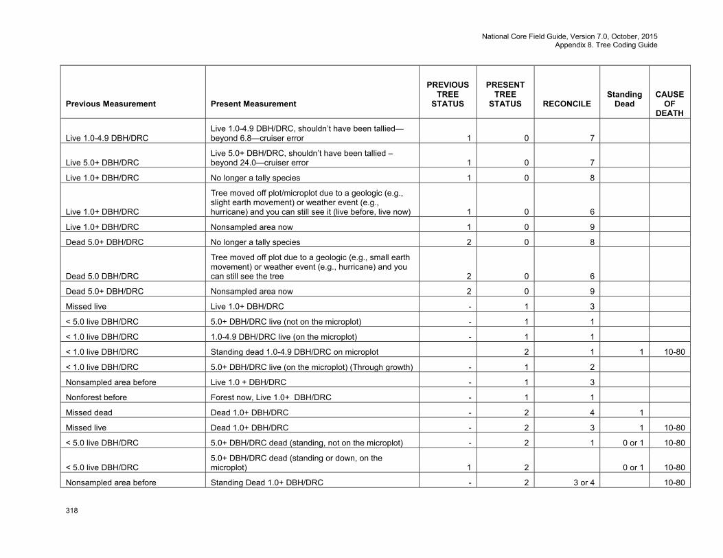
National Core Field Guide, Version 7.0, October, 2015 Appendix 8. Tree Coding Guide
318
Previous Measurement
Present Measurement
PREVIOUS TREE
STATUS
PRESENT TREE
STATUS
RECONCILE
Standing
Dead
CAUSE OF
DEATH
Live 1.0-4.9 DBH/DRC Live 1.0-4.9 DBH/DRC, shouldn’t have been tallied—beyond 6.8—cruiser error 1 0 7
Live 5.0+ DBH/DRC Live 5.0+ DBH/DRC, shouldn’t have been tallied –beyond 24.0—cruiser error 1 0 7
Live 1.0+ DBH/DRC No longer a tally species 1 0 8
Live 1.0+ DBH/DRC
Tree moved off plot/microplot due to a geologic (e.g., slight earth movement) or weather event (e.g., hurricane) and you can still see it (live before, live now) 1 0 6
Live 1.0+ DBH/DRC Nonsampled area now 1 0 9
Dead 5.0+ DBH/DRC No longer a tally species 2 0 8
Dead 5.0 DBH/DRC
Tree moved off plot due to a geologic (e.g., small earth movement) or weather event (e.g., hurricane) and you can still see the tree 2 0 6
Dead 5.0+ DBH/DRC Nonsampled area now 2 0 9
Missed live Live 1.0+ DBH/DRC - 1 3
< 5.0 live DBH/DRC 5.0+ DBH/DRC live (not on the microplot) - 1 1
< 1.0 live DBH/DRC 1.0-4.9 DBH/DRC live (on the microplot) - 1 1
< 1.0 live DBH/DRC Standing dead 1.0-4.9 DBH/DRC on microplot 2 1 1 10-80
< 1.0 live DBH/DRC 5.0+ DBH/DRC live (on the microplot) (Through growth) - 1 2
Nonsampled area before Live 1.0 + DBH/DRC - 1 3
Nonforest before Forest now, Live 1.0+ DBH/DRC - 1 1
Missed dead Dead 1.0+ DBH/DRC - 2 4 1
Missed live Dead 1.0+ DBH/DRC - 2 3 1 10-80
< 5.0 live DBH/DRC 5.0+ DBH/DRC dead (standing, not on the microplot) - 2 1 0 or 1 10-80
< 5.0 live DBH/DRC 5.0+ DBH/DRC dead (standing or down, on the microplot) 1 2 0 or 1 10-80
Nonsampled area before Standing Dead 1.0+ DBH/DRC - 2 3 or 4 10-80
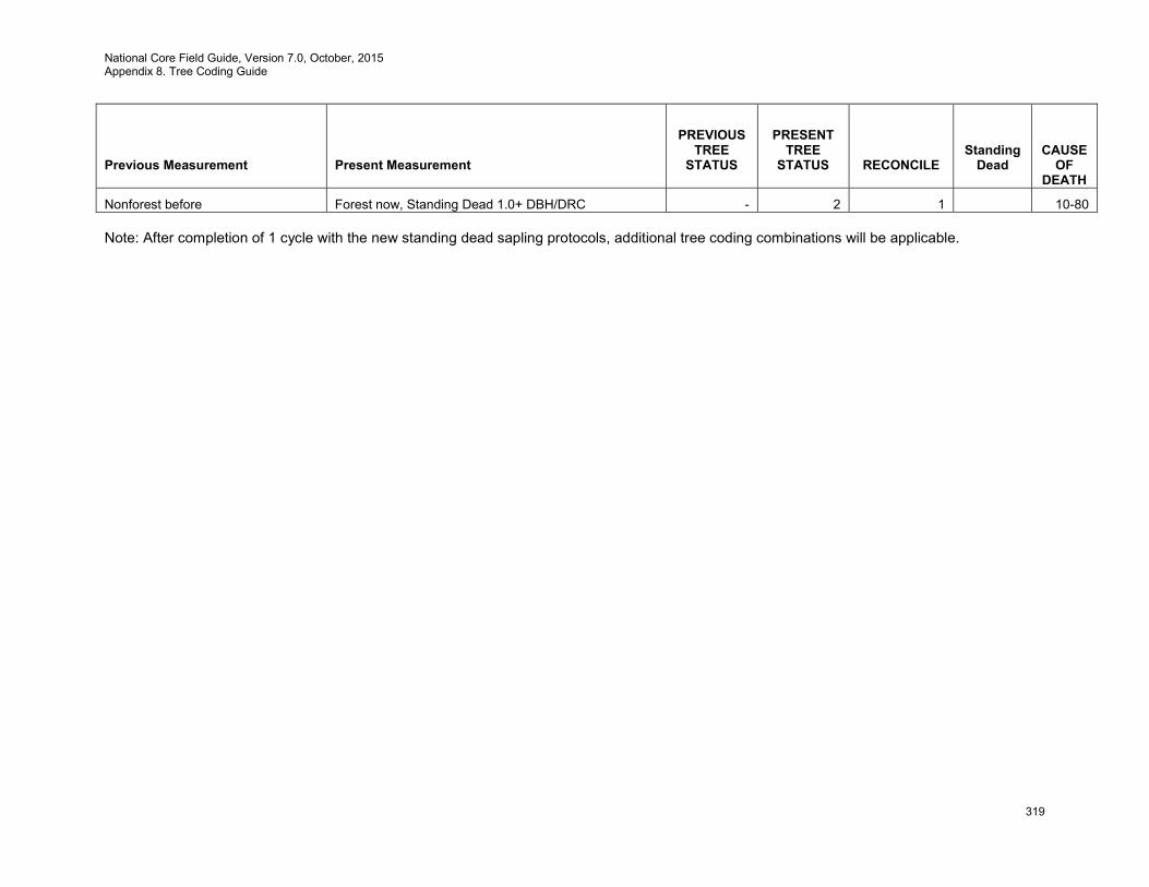
National Core Field Guide, Version 7.0, October, 2015 Appendix 8. Tree Coding Guide
319
Previous Measurement
Present Measurement
PREVIOUS TREE
STATUS
PRESENT TREE
STATUS
RECONCILE
Standing
Dead
CAUSE OF
DEATH
Nonforest before Forest now, Standing Dead 1.0+ DBH/DRC - 2 1 10-80 Note: After completion of 1 cycle with the new standing dead sapling protocols, additional tree coding combinations will be applicable.
National Core Field Guide, Version 7.0, October, 2015 Appendix 9 Invasive Plant List.
320
Appendix 9. Invasive Plant List To obtain a current invasive plant list, contact the local region for the appropriate list.
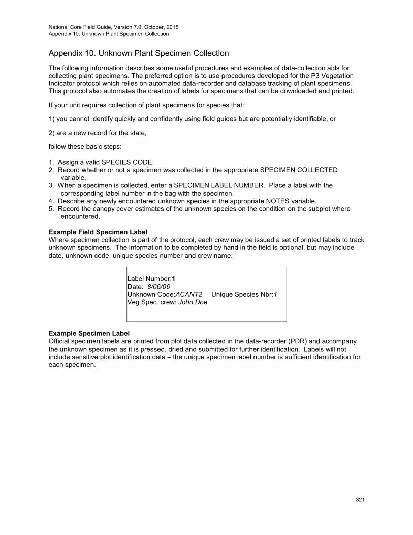
National Core Field Guide, Version 7.0, October, 2015 Appendix 10. Unknown Plant Specimen Collection
321
Appendix 10. Unknown Plant Specimen Collection
The following information describes some useful procedures and examples of data-collection aids for collecting plant specimens. The preferred option is to use procedures developed for the P3 Vegetation Indicator protocol which relies on automated data-recorder and database tracking of plant specimens. This protocol also automates the creation of labels for specimens that can be downloaded and printed.
If your unit requires collection of plant specimens for species that:
1) you cannot identify quickly and confidently using field guides but are potentially identifiable, or
2) are a new record for the state,
follow these basic steps: 1. Assign a valid SPECIES CODE. 2. Record whether or not a specimen was collected in the appropriate SPECIMEN COLLECTED
variable. 3. When a specimen is collected, enter a SPECIMEN LABEL NUMBER. Place a label with the
corresponding label number in the bag with the specimen. 4. Describe any newly encountered unknown species in the appropriate NOTES variable. 5. Record the canopy cover estimates of the unknown species on the condition on the subplot where
encountered.
Example Field Specimen Label Where specimen collection is part of the protocol, each crew may be issued a set of printed labels to track unknown specimens. The information to be completed by hand in the field is optional, but may include date, unknown code, unique species number and crew name.
Label Number:1 Date: 8/06/06 Unknown Code:ACANT2 Unique Species Nbr:1 Veg Spec. crew: John Doe
Example Specimen Label Official specimen labels are printed from plot data collected in the data-recorder (PDR) and accompany the unknown specimen as it is pressed, dried and submitted for further identification. Labels will not include sensitive plot identification data – the unique specimen label number is sufficient identification for each specimen.
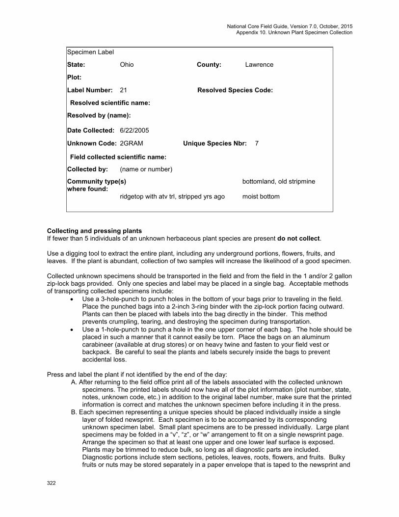
National Core Field Guide, Version 7.0, October, 2015 Appendix 10. Unknown Plant Specimen Collection
322
Specimen Label
State: Ohio County: Lawrence
Plot:
Label Number: 21 Resolved Species Code:
Resolved scientific name:
Resolved by (name):
Date Collected: 6/22/2005
Unknown Code: 2GRAM Unique Species Nbr: 7
Field collected scientific name:
Collected by: (name or number)
Community type(s) bottomland, old stripmine where found: ridgetop with atv trl, stripped yrs ago moist bottom
Collecting and pressing plants If fewer than 5 individuals of an unknown herbaceous plant species are present do not collect. Use a digging tool to extract the entire plant, including any underground portions, flowers, fruits, and leaves. If the plant is abundant, collection of two samples will increase the likelihood of a good specimen. Collected unknown specimens should be transported in the field and from the field in the 1 and/or 2 gallon zip-lock bags provided. Only one species and label may be placed in a single bag. Acceptable methods of transporting collected specimens include:
• Use a 3-hole-punch to punch holes in the bottom of your bags prior to traveling in the field. Place the punched bags into a 2-inch 3-ring binder with the zip-lock portion facing outward. Plants can then be placed with labels into the bag directly in the binder. This method prevents crumpling, tearing, and destroying the specimen during transportation.
• Use a 1-hole-punch to punch a hole in the one upper corner of each bag. The hole should be placed in such a manner that it cannot easily be torn. Place the bags on an aluminum carabineer (available at drug stores) or on heavy twine and fasten to your field vest or backpack. Be careful to seal the plants and labels securely inside the bags to prevent accidental loss.
Press and label the plant if not identified by the end of the day:
A. After returning to the field office print all of the labels associated with the collected unknown specimens. The printed labels should now have all of the plot information (plot number, state, notes, unknown code, etc.) in addition to the original label number, make sure that the printed information is correct and matches the unknown specimen before including it in the press.
B. Each specimen representing a unique species should be placed individually inside a single layer of folded newsprint. Each specimen is to be accompanied by its corresponding unknown specimen label. Small plant specimens are to be pressed individually. Large plant specimens may be folded in a “v”, “z”, or “w” arrangement to fit on a single newsprint page. Arrange the specimen so that at least one upper and one lower leaf surface is exposed. Plants may be trimmed to reduce bulk, so long as all diagnostic parts are included. Diagnostic portions include stem sections, petioles, leaves, roots, flowers, and fruits. Bulky fruits or nuts may be stored separately in a paper envelope that is taped to the newsprint and
National Core Field Guide, Version 7.0, October, 2015 Appendix 10. Unknown Plant Specimen Collection
323
is accompanied by an identical copy of the specimen’s unknown label. Unknown codes can be written on the outside of the folded newspaper to aid sorting as specimens are processed.
C. Stack the specimens in their individual newsprint sleeves between two pieces of cardboard. Bind the cardboard and plants together using a piece of twine or flat cloth ribbon wrapped around the length and width of the cardboard bundle. For mailing numerous specimens, several bundles may be used. Place all bundles inside a cardboard box for shipping.
Package and submit specimens as dictated by your FIA unit or lab. It is suggested that Unknown specimens be packaged and shipped at the end of every work week. Exceptions will be made when extended field excursions prevent the vegetation specialist from reaching a post office. All packaged specimens are to be accompanied by a legible completed label. Unknown Spreadsheets tracking collected unknown plants are generated from the PDR plot file.
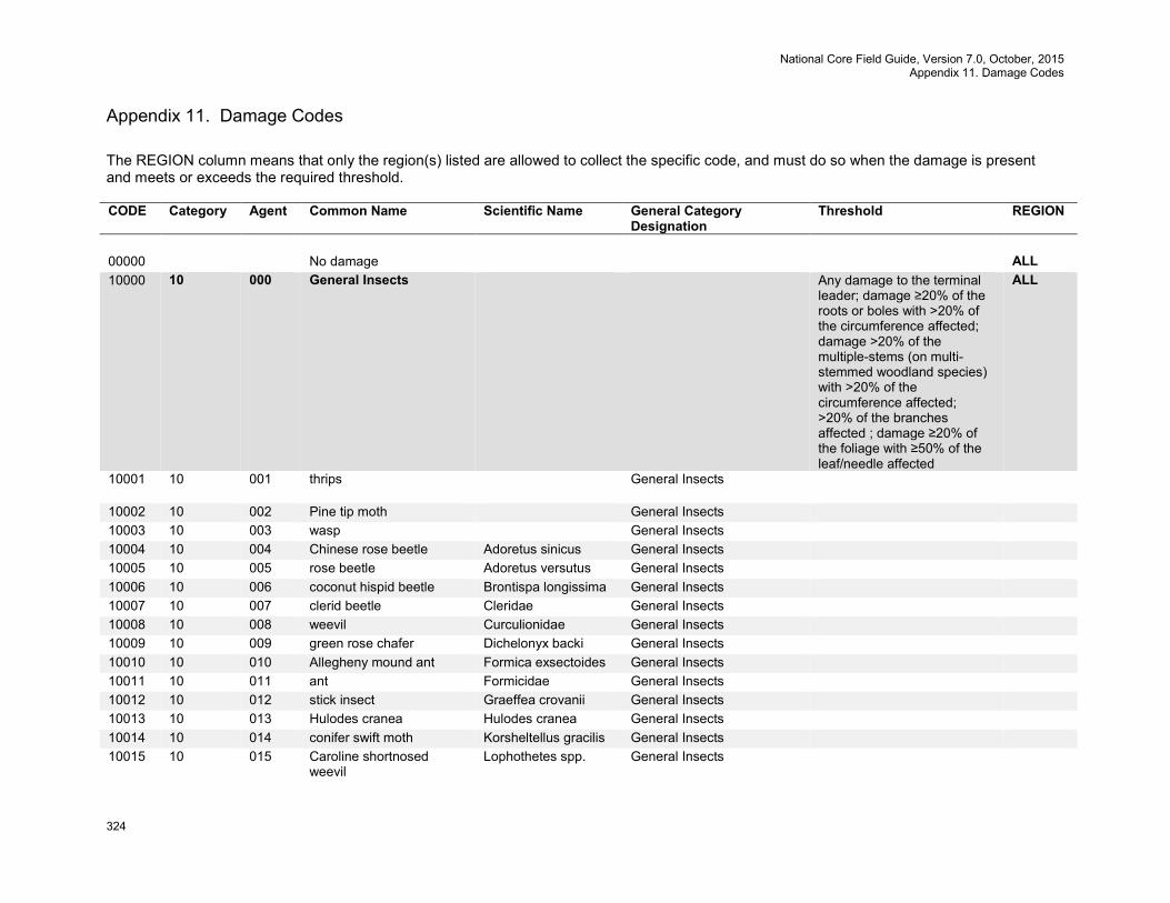
National Core Field Guide, Version 7.0, October, 2015 Appendix 11. Damage Codes
324
Appendix 11. Damage Codes The REGION column means that only the region(s) listed are allowed to collect the specific code, and must do so when the damage is present and meets or exceeds the required threshold. CODE Category Agent Common Name Scientific Name General Category
Designation Threshold REGION
00000 No damage ALL 10000 10 000 General Insects Any damage to the terminal
leader; damage ≥20% of the roots or boles with >20% of the circumference affected; damage >20% of the multiple-stems (on multi-stemmed woodland species) with >20% of the circumference affected; >20% of the branches affected ; damage ≥20% of the foliage with ≥50% of the leaf/needle affected
ALL
10001 10 001 thrips General Insects
10002 10 002 Pine tip moth General Insects 10003 10 003 wasp General Insects 10004 10 004 Chinese rose beetle Adoretus sinicus General Insects 10005 10 005 rose beetle Adoretus versutus General Insects 10006 10 006 coconut hispid beetle Brontispa longissima General Insects 10007 10 007 clerid beetle Cleridae General Insects 10008 10 008 weevil Curculionidae General Insects 10009 10 009 green rose chafer Dichelonyx backi General Insects 10010 10 010 Allegheny mound ant Formica exsectoides General Insects 10011 10 011 ant Formicidae General Insects 10012 10 012 stick insect Graeffea crovanii General Insects 10013 10 013 Hulodes cranea Hulodes cranea General Insects 10014 10 014 conifer swift moth Korsheltellus gracilis General Insects 10015 10 015 Caroline shortnosed
weevil Lophothetes spp. General Insects

National Core Field Guide, Version 7.0, October, 2015 Appendix 11. Damage Codes
325
CODE Category Agent Common Name Scientific Name General Category Designation
Threshold REGION
10016 10 016 coconut rhinoceros beetle Oryctes rhinoceros General Insects Any damage to the terminal leader; damage ≥20% of the roots or boles with >20% of the circumference affected; damage >20% of the multiple-stems (on multi-stemmed woodland species) with >20% of the circumference affected; >20% of the branches affected ; damage ≥20% of the foliage with ≥50% of the leaf/needle affected
PNW
10017 10 017 bagworm moth Psychidae General Insects Any damage to the terminal leader; damage ≥20% of the foliage with ≥50% of the leaf/needle affected
NRS
10018 10 018 coconut palm weevil Rhobdoscelus asperipennis
General Insects
10019 10 019 scarab Scarabaeidae General Insects 10020 10 020 ash white fly Siphoninus phillyreae General Insects 10021 10 021 conifer seedling weevil Steremnius carinatus General Insects 10022 10 022 pyralid moth Thliptoceras
octoquttale General Insects
10023 10 023 wood wasps Siricidae spp. General Insects 11000 11 000 Bark Beetles Any evidence of a successful
attack (successful attacks generally exhibit boring dust, many pitch tubes and/or fading crowns)
ALL
11001 11 001 roundheaded pine beetle Dendroctonus adjunctus
Bark Beetles
11002 11 002 western pine beetle Dendroctonus brevicomis
Bark Beetles
11003 11 003 southern pine beetle Dendroctonus frontalis
Bark Beetles Any occurrence SRS
11004 11 004 Jeffery pine beetle Dendroctonus jeffreyi Bark Beetles
11005 11 005 lodgepole pine beetle Dendroctonus murrayanae
Bark Beetles
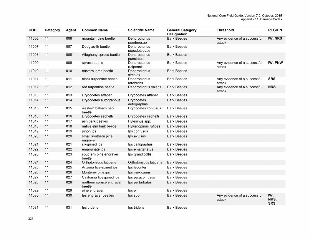
National Core Field Guide, Version 7.0, October, 2015 Appendix 11. Damage Codes
326
CODE Category Agent Common Name Scientific Name General Category Designation
Threshold REGION
11006 11 006 mountain pine beetle Dendroctonus ponderosae
Bark Beetles Any evidence of a successful attack
IW; NRS
11007 11 007 Douglas-fir beetle Dendroctonus pseudotsugae
Bark Beetles
11008 11 008 Allegheny spruce beetle Dendroctonus punctatus
Bark Beetles
11009 11 009 spruce beetle Dendroctonus rufipennis
Bark Beetles Any evidence of a successful attack
IW; PNW
11010 11 010 eastern larch beetle Dendroctonus simplex
Bark Beetles
11011 11 011 black turpentine beetle Dendroctonus terebrans
Bark Beetles Any evidence of a successful attack
SRS
11012 11 012 red turpentine beetle Dendroctonus valens Bark Beetles Any evidence of a successful attack
NRS
11013 11 013 Dryocoetes affaber Dryocoetes affaber Bark Beetles 11014 11 014 Dryocoetes autographus Dryocoetes
autographus Bark Beetles
11015 11 015 western balsam bark beetle
Dryocoetes confusus Bark Beetles
11016 11 016 Dryocoetes sechelti Dryocoetes sechelti Bark Beetles 11017 11 017 ash bark beetles Hylesinus spp. Bark Beetles 11018 11 018 native elm bark beetle Hylurgopinus rufipes Bark Beetles 11019 11 019 pinon ips Ips confusus Bark Beetles 11020 11 020 small southern pine
engraver Ips avulsus Bark Beetles
11021 11 021 sixspined ips Ips calligraphus Bark Beetles 11022 11 022 emarginate ips Ips emarginatus Bark Beetles 11023 11 023 southern pine engraver
beetle Ips grandicollis Bark Beetles
11024 11 024 Orthotomicus latidens Orthotomicus latidens Bark Beetles 11025 11 025 Arizona five-spined ips Ips lecontei Bark Beetles 11026 11 026 Monterey pine ips Ips mexicanus Bark Beetles 11027 11 027 California fivespined ips Ips paraconfusus Bark Beetles 11028 11 028 northern spruce engraver
beetle Ips perturbatus Bark Beetles
11029 11 029 pine engraver Ips pini Bark Beetles 11030 11 030 Ips engraver beetles Ips spp. Bark Beetles Any evidence of a successful
attack IW; NRS; SRS
11031 11 031 Ips tridens Ips tridens Bark Beetles

National Core Field Guide, Version 7.0, October, 2015 Appendix 11. Damage Codes
327
CODE Category Agent Common Name Scientific Name General Category Designation
Threshold REGION
11032 11 032 western ash bark beetle Leperisinus californicus
Bark Beetles
11033 11 033 Oregon ash bark beetle Leperisinus oregonus Bark Beetles 11034 11 034 Orthotomicus caelatus Orthotomicus
caelatus Bark Beetles
11035 11 035 cedar bark beetles Phloeosinus spp. Bark Beetles 11036 11 036 western cedar bark beetle Phloeosinus
punctatus Bark Beetles
11037 11 037 tip beetles Pityogenes spp. Bark Beetles 11038 11 038 Douglas-fir twig beetle Pityophthorus
pseudotsugae Bark Beetles
11039 11 039 twig beetles Pityophthorus spp. Bark Beetles 11040 11 040 foureyed spruce bark
beetle Polygraphus rufipennis
Bark Beetles
11041 11 041 fir root bark beetle Pseudohylesinum granulatus
Bark Beetles
11042 11 042 Pseudohylesinus dispar Pseudohylesinus dispar
Bark Beetles
11043 11 043 Douglas-fir pole beetle Pseudohylesinus nebulosus
Bark Beetles
11044 11 044 silver fir beetle Pseudohylesinus sericeus
Bark Beetles
11045 11 045 small European elm bark beetle
Scolytus multistriatus Bark Beetles
11046 11 046 spruce engraver Scolytus piceae Bark Beetles 11047 11 047 hickory bark beetle Scolytus
quadrispinosus Bark Beetles
11048 11 048 true fir bark beetles Scolytus spp. Bark Beetles 11049 11 049 Douglas-fir engraver Scolytus unispinosus Bark Beetles 11050 11 050 fir engraver Scolytus ventralis Bark Beetles 11051 11 051 striped ambrosia beetle Tryachykele lineatum Bark Beetles 11052 11 052 Sitka spruce engraver
beetle Ips conncinnus Bark Beetles
11053 11 053 four-eyed bark beetle Polygraphus spp. Bark Beetles 11054 11 054 hemlock beetle Pseudohylesinus
tsugae Bark Beetles
11055 11 055 spruce ips Ips pilifrons Bark Beetles 11056 11 056 (smaller) Mexican pine
beetle Dendroctonus mexicanus
Bark Beetles
11057 11 057 banded elm bark beetle Scolytus schevyrewi Bark Beetles
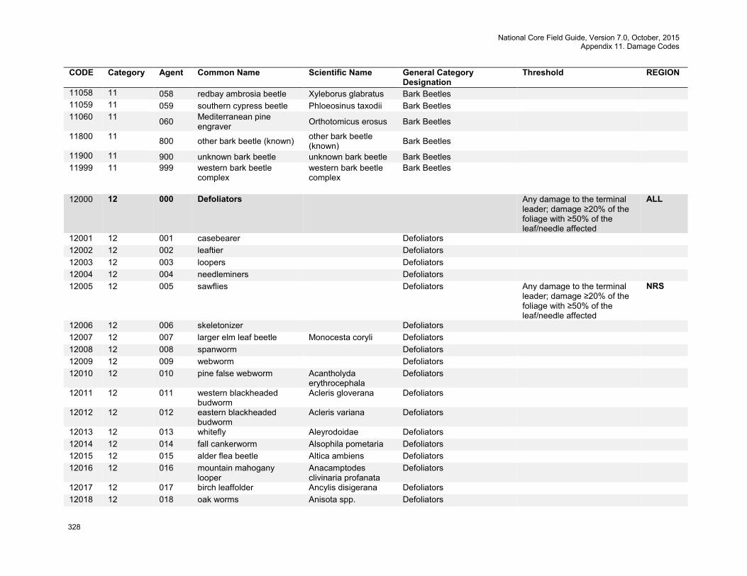
National Core Field Guide, Version 7.0, October, 2015 Appendix 11. Damage Codes
328
CODE Category Agent Common Name Scientific Name General Category Designation
Threshold REGION
11058 11 058 redbay ambrosia beetle Xyleborus glabratus Bark Beetles 11059 11 059 southern cypress beetle Phloeosinus taxodii Bark Beetles 11060 11 060 Mediterranean pine
engraver Orthotomicus erosus Bark Beetles
11800 11 800 other bark beetle (known) other bark beetle (known) Bark Beetles
11900 11 900 unknown bark beetle unknown bark beetle Bark Beetles 11999 11 999 western bark beetle
complex western bark beetle complex
Bark Beetles
12000 12 000 Defoliators Any damage to the terminal
leader; damage ≥20% of the foliage with ≥50% of the leaf/needle affected
ALL
12001 12 001 casebearer Defoliators 12002 12 002 leaftier Defoliators 12003 12 003 loopers Defoliators 12004 12 004 needleminers Defoliators 12005 12 005 sawflies Defoliators Any damage to the terminal
leader; damage ≥20% of the foliage with ≥50% of the leaf/needle affected
NRS
12006 12 006 skeletonizer Defoliators 12007 12 007 larger elm leaf beetle Monocesta coryli Defoliators 12008 12 008 spanworm Defoliators 12009 12 009 webworm Defoliators 12010 12 010 pine false webworm Acantholyda
erythrocephala Defoliators
12011 12 011 western blackheaded budworm
Acleris gloverana Defoliators
12012 12 012 eastern blackheaded budworm
Acleris variana Defoliators
12013 12 013 whitefly Aleyrodoidae Defoliators 12014 12 014 fall cankerworm Alsophila pometaria Defoliators 12015 12 015 alder flea beetle Altica ambiens Defoliators 12016 12 016 mountain mahogany
looper Anacamptodes clivinaria profanata
Defoliators
12017 12 017 birch leaffolder Ancylis disigerana Defoliators 12018 12 018 oak worms Anisota spp. Defoliators
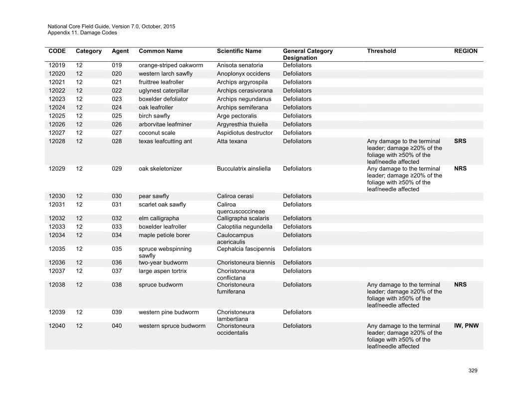
National Core Field Guide, Version 7.0, October, 2015 Appendix 11. Damage Codes
329
CODE Category Agent Common Name Scientific Name General Category Designation
Threshold REGION
12019 12 019 orange-striped oakworm Anisota senatoria Defoliators 12020 12 020 western larch sawfly Anoplonyx occidens Defoliators 12021 12 021 fruittree leafroller Archips argyrospila Defoliators 12022 12 022 uglynest caterpillar Archips cerasivorana Defoliators 12023 12 023 boxelder defoliator Archips negundanus Defoliators 12024 12 024 oak leafroller Archips semiferana Defoliators 12025 12 025 birch sawfly Arge pectoralis Defoliators 12026 12 026 arborvitae leafminer Argyresthia thuiella Defoliators 12027 12 027 coconut scale Aspidiotus destructor Defoliators 12028 12 028 texas leafcutting ant Atta texana Defoliators Any damage to the terminal
leader; damage ≥20% of the foliage with ≥50% of the leaf/needle affected
SRS
12029 12 029 oak skeletonizer Bucculatrix ainsliella Defoliators Any damage to the terminal leader; damage ≥20% of the foliage with ≥50% of the leaf/needle affected
NRS
12030 12 030 pear sawfly Caliroa cerasi Defoliators 12031 12 031 scarlet oak sawfly Caliroa
quercuscoccineae Defoliators
12032 12 032 elm calligrapha Calligrapha scalaris Defoliators 12033 12 033 boxelder leafroller Caloptilia negundella Defoliators 12034 12 034 maple petiole borer Caulocampus
acericaulis Defoliators
12035 12 035 spruce webspinning sawfly
Cephalcia fascipennis Defoliators
12036 12 036 two-year budworm Choristoneura biennis Defoliators 12037 12 037 large aspen tortrix Choristoneura
conflictana Defoliators
12038 12 038 spruce budworm Choristoneura fumiferana
Defoliators Any damage to the terminal leader; damage ≥20% of the foliage with ≥50% of the leaf/needle affected
NRS
12039 12 039 western pine budworm Choristoneura lambertiana
Defoliators
12040 12 040 western spruce budworm Choristoneura occidentalis
Defoliators Any damage to the terminal leader; damage ≥20% of the foliage with ≥50% of the leaf/needle affected
IW, PNW
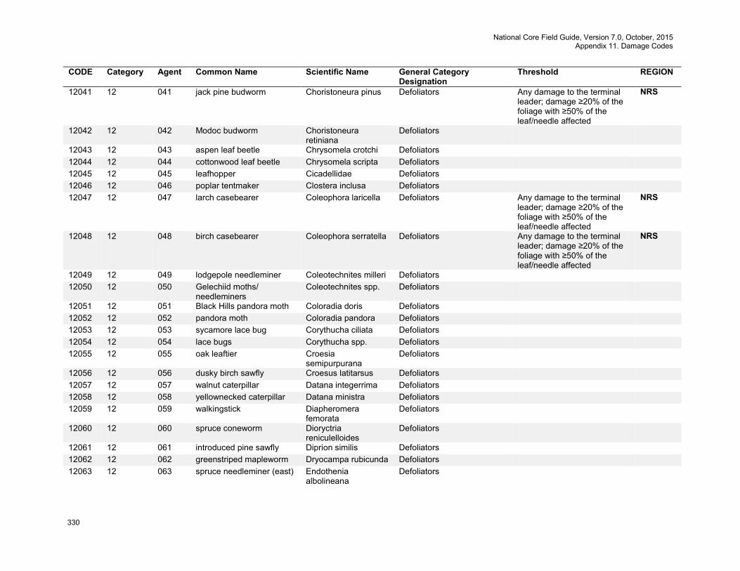
National Core Field Guide, Version 7.0, October, 2015 Appendix 11. Damage Codes
330
CODE Category Agent Common Name Scientific Name General Category Designation
Threshold REGION
12041 12 041 jack pine budworm Choristoneura pinus Defoliators Any damage to the terminal leader; damage ≥20% of the foliage with ≥50% of the leaf/needle affected
NRS
12042 12 042 Modoc budworm Choristoneura retiniana
Defoliators
12043 12 043 aspen leaf beetle Chrysomela crotchi Defoliators 12044 12 044 cottonwood leaf beetle Chrysomela scripta Defoliators 12045 12 045 leafhopper Cicadellidae Defoliators 12046 12 046 poplar tentmaker Clostera inclusa Defoliators 12047 12 047 larch casebearer Coleophora laricella Defoliators Any damage to the terminal
leader; damage ≥20% of the foliage with ≥50% of the leaf/needle affected
NRS
12048 12 048 birch casebearer Coleophora serratella Defoliators Any damage to the terminal leader; damage ≥20% of the foliage with ≥50% of the leaf/needle affected
NRS
12049 12 049 lodgepole needleminer Coleotechnites milleri Defoliators 12050 12 050 Gelechiid moths/
needleminers Coleotechnites spp. Defoliators
12051 12 051 Black Hills pandora moth Coloradia doris Defoliators 12052 12 052 pandora moth Coloradia pandora Defoliators 12053 12 053 sycamore lace bug Corythucha ciliata Defoliators 12054 12 054 lace bugs Corythucha spp. Defoliators 12055 12 055 oak leaftier Croesia
semipurpurana Defoliators
12056 12 056 dusky birch sawfly Croesus latitarsus Defoliators 12057 12 057 walnut caterpillar Datana integerrima Defoliators 12058 12 058 yellownecked caterpillar Datana ministra Defoliators 12059 12 059 walkingstick Diapheromera
femorata Defoliators
12060 12 060 spruce coneworm Dioryctria reniculelloides
Defoliators
12061 12 061 introduced pine sawfly Diprion similis Defoliators 12062 12 062 greenstriped mapleworm Dryocampa rubicunda Defoliators 12063 12 063 spruce needleminer (east) Endothenia
albolineana Defoliators

National Core Field Guide, Version 7.0, October, 2015 Appendix 11. Damage Codes
331
CODE Category Agent Common Name Scientific Name General Category Designation
Threshold REGION
12064 12 064 elm spanworm Ennomos subsignaris Defoliators Any damage to the terminal leader; damage ≥20% of the foliage with ≥50% of the leaf/needle affected
NRS
12065 12 065 maple trumpet skeletonizer
Epinotia aceriella Defoliators
12066 12 066 white fir needleminer Epinotia meritana Defoliators 12067 12 067 linden looper Erannis tiliaria Defoliators 12068 12 068 browntail moth Euproctis
chrysorrhoea Defoliators Any occurrence NRS
12069 12 069 pine needleminer Exoteleia pinifoliella Defoliators 12070 12 070 birch leafminer Fenusa pusilla Defoliators 12071 12 071 elm leafminer Fenusa ulmi Defoliators 12072 12 072 geometrid moth Geometridae Defoliators 12073 12 073 leafblotch miner Gracillariidae Defoliators 12074 12 074 spotted tussock moth Halisidota maculata Defoliators 12075 12 075 pale tussock moth Halysidota tessellaris Defoliators 12076 12 076 hesperiid moth Hasora choromus Defoliators 12077 12 077 brown day moth Hemileuca
eglanterina Defoliators
12078 12 078 buck moth Hemileuca maia Defoliators 12079 12 079 saddled prominent Heterocampa
guttivitta Defoliators
12080 12 080 variable oakleaf caterpillar Heterocampa manteo Defoliators 12081 12 081 cherry scallop shell moth Hydria prunivorata Defoliators Any damage to the terminal
leader; damage ≥20% of the foliage with ≥50% of the leaf/needle affected
NRS
12082 12 082 fall webworm Hyphantria cunea Defoliators Any damage to the terminal leader; damage ≥20% of the foliage with ≥50% of the leaf/needle affected
SRS
12083 12 083 hemlock looper Lambdina fiscellaria Defoliators 12084 12 084 oak looper Lambdina punctat Defoliators 12085 12 085 tent caterpillar moth Lasiocampidae Defoliators 12086 12 086 satin moth Leucoma salicis Defoliators Any damage to the terminal
leader; damage ≥20% of the foliage with ≥50% of the leaf/needle affected
NRS
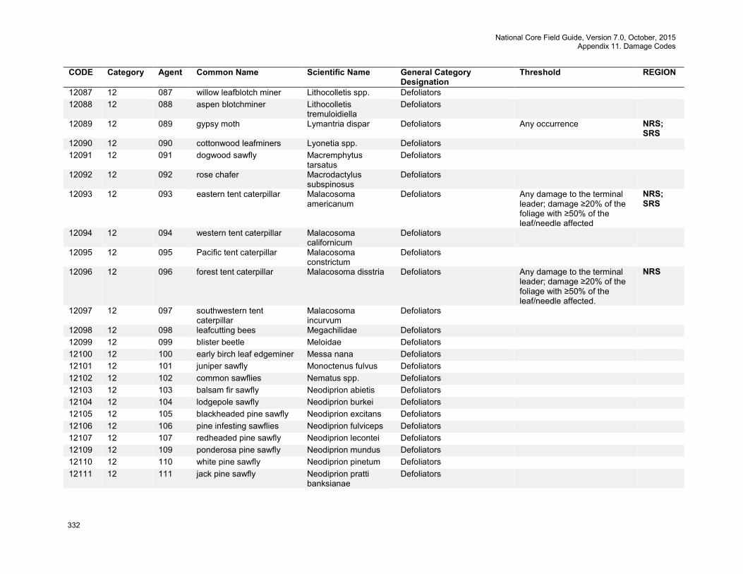
National Core Field Guide, Version 7.0, October, 2015 Appendix 11. Damage Codes
332
CODE Category Agent Common Name Scientific Name General Category Designation
Threshold REGION
12087 12 087 willow leafblotch miner Lithocolletis spp. Defoliators 12088 12 088 aspen blotchminer Lithocolletis
tremuloidiella Defoliators
12089 12 089 gypsy moth Lymantria dispar Defoliators Any occurrence NRS; SRS
12090 12 090 cottonwood leafminers Lyonetia spp. Defoliators 12091 12 091 dogwood sawfly Macremphytus
tarsatus Defoliators
12092 12 092 rose chafer Macrodactylus subspinosus
Defoliators
12093 12 093 eastern tent caterpillar Malacosoma americanum
Defoliators Any damage to the terminal leader; damage ≥20% of the foliage with ≥50% of the leaf/needle affected
NRS; SRS
12094 12 094 western tent caterpillar Malacosoma californicum
Defoliators
12095 12 095 Pacific tent caterpillar Malacosoma constrictum
Defoliators
12096 12 096 forest tent caterpillar Malacosoma disstria Defoliators Any damage to the terminal leader; damage ≥20% of the foliage with ≥50% of the leaf/needle affected.
NRS
12097 12 097 southwestern tent caterpillar
Malacosoma incurvum
Defoliators
12098 12 098 leafcutting bees Megachilidae Defoliators 12099 12 099 blister beetle Meloidae Defoliators 12100 12 100 early birch leaf edgeminer Messa nana Defoliators 12101 12 101 juniper sawfly Monoctenus fulvus Defoliators 12102 12 102 common sawflies Nematus spp. Defoliators 12103 12 103 balsam fir sawfly Neodiprion abietis Defoliators 12104 12 104 lodgepole sawfly Neodiprion burkei Defoliators 12105 12 105 blackheaded pine sawfly Neodiprion excitans Defoliators 12106 12 106 pine infesting sawflies Neodiprion fulviceps Defoliators 12107 12 107 redheaded pine sawfly Neodiprion lecontei Defoliators 12109 12 109 ponderosa pine sawfly Neodiprion mundus Defoliators 12110 12 110 white pine sawfly Neodiprion pinetum Defoliators 12111 12 111 jack pine sawfly Neodiprion pratti
banksianae Defoliators

National Core Field Guide, Version 7.0, October, 2015 Appendix 11. Damage Codes
333
CODE Category Agent Common Name Scientific Name General Category Designation
Threshold REGION
12112 12 112 Virginia pine sawfly Neodiprion pratti pratti
Defoliators
12113 12 113 European pine sawfly Neodiprion sertifer Defoliators 12114 12 114 loblolly pine sawfly Neodiprion taedae
linearis Defoliators
12115 12 115 hemlock sawfly Neodiprion tsugae Defoliators 12116 12 116 pine butterfly Neophasia menapia Defoliators 12117 12 117 false hemlock looper Nepytia canosaria Defoliators 12118 12 118 California tortoiseshell Nymphalis californica Defoliators 12119 12 119 locust leafminer Odontota dorsalis Defoliators 12120 12 120 Bruce spanworm Operophtera bruceata Defoliators 12121 12 121 rusty tussock moth Orgyia antiqua Defoliators 12122 12 122 whitemarked tussock
moth Orgyia leucostigma Defoliators
12123 12 123 Douglas-fir tussock moth Orgyia pseudotsugata Defoliators 12124 12 124 western tussock moth Orgyia vetusta Defoliators 12125 12 125 spring cankerworm Paleacrita vernata Defoliators 12126 12 126 black citrus swallowtail
butterfly Papilio polytes Defoliators
12127 12 127 maple leafcutter Paraclemensia acerifoliella
Defoliators
12128 12 128 pine tussock moth Parorgyia grisefacta Defoliators 12129 12 129 poinciana looper Pericyma cruegeri Defoliators 12130 12 130 half-wing geometer Phigalia titea Defoliators 12131 12 131 Phoberia moth Phoberia atomaris Defoliators 12132 12 132 California oakworm Phryganidia
californica Defoliators
12133 12 133 European snout beetle Phyllobius oblongus Defoliators 12134 12 134 citrus leafminer Phyllocnistis citrella Defoliators 12135 12 135 aspen leafminer Phyllocnistis
populiella Defoliators
12136 12 136 yellowheaded spruce sawfly
Pikonema alaskensis Defoliators Any damage to the terminal leader; damage ≥20% of the foliage with ≥50% of the leaf/needle affected
NRS
12137 12 137 tenlined June beetle Polyphylla decemlineata
Defoliators
12138 12 138 Japanese beetle Popillia japonica Defoliators
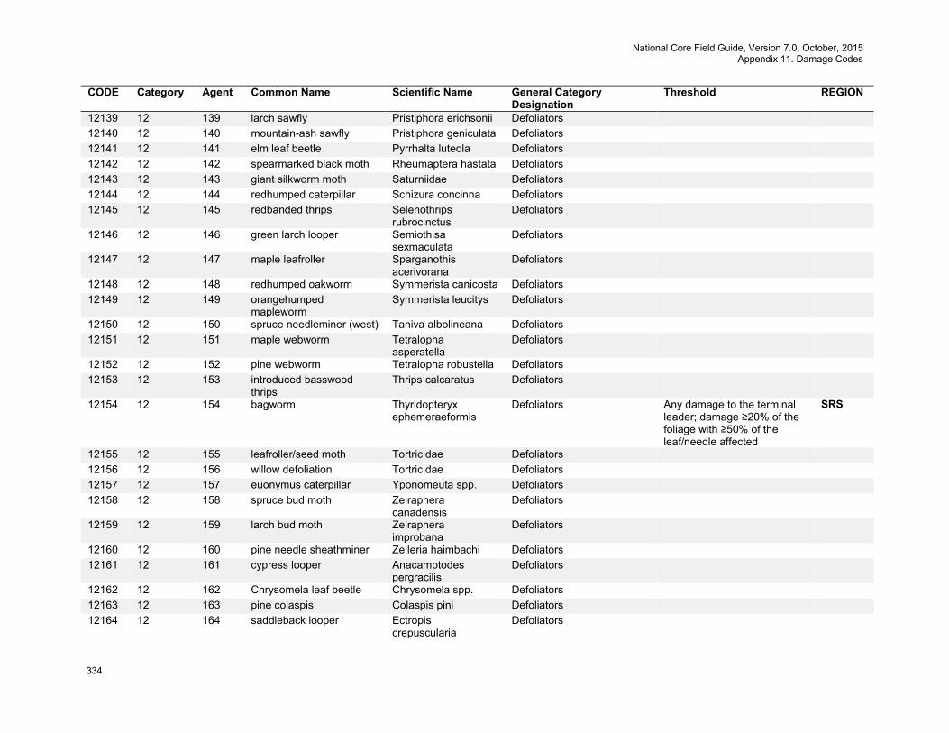
National Core Field Guide, Version 7.0, October, 2015 Appendix 11. Damage Codes
334
CODE Category Agent Common Name Scientific Name General Category Designation
Threshold REGION
12139 12 139 larch sawfly Pristiphora erichsonii Defoliators 12140 12 140 mountain-ash sawfly Pristiphora geniculata Defoliators 12141 12 141 elm leaf beetle Pyrrhalta luteola Defoliators 12142 12 142 spearmarked black moth Rheumaptera hastata Defoliators 12143 12 143 giant silkworm moth Saturniidae Defoliators 12144 12 144 redhumped caterpillar Schizura concinna Defoliators 12145 12 145 redbanded thrips Selenothrips
rubrocinctus Defoliators
12146 12 146 green larch looper Semiothisa sexmaculata
Defoliators
12147 12 147 maple leafroller Sparganothis acerivorana
Defoliators
12148 12 148 redhumped oakworm Symmerista canicosta Defoliators 12149 12 149 orangehumped
mapleworm Symmerista leucitys Defoliators
12150 12 150 spruce needleminer (west) Taniva albolineana Defoliators 12151 12 151 maple webworm Tetralopha
asperatella Defoliators
12152 12 152 pine webworm Tetralopha robustella Defoliators 12153 12 153 introduced basswood
thrips Thrips calcaratus Defoliators
12154 12 154 bagworm Thyridopteryx ephemeraeformis
Defoliators Any damage to the terminal leader; damage ≥20% of the foliage with ≥50% of the leaf/needle affected
SRS
12155 12 155 leafroller/seed moth Tortricidae Defoliators 12156 12 156 willow defoliation Tortricidae Defoliators 12157 12 157 euonymus caterpillar Yponomeuta spp. Defoliators 12158 12 158 spruce bud moth Zeiraphera
canadensis Defoliators
12159 12 159 larch bud moth Zeiraphera improbana
Defoliators
12160 12 160 pine needle sheathminer Zelleria haimbachi Defoliators 12161 12 161 cypress looper Anacamptodes
pergracilis Defoliators
12162 12 162 Chrysomela leaf beetle Chrysomela spp. Defoliators 12163 12 163 pine colaspis Colaspis pini Defoliators 12164 12 164 saddleback looper Ectropis
crepuscularia Defoliators
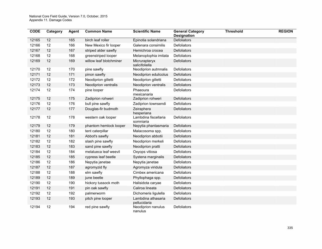
National Core Field Guide, Version 7.0, October, 2015 Appendix 11. Damage Codes
335
CODE Category Agent Common Name Scientific Name General Category Designation
Threshold REGION
12165 12 165 birch leaf roller Epinotia solandriana Defoliators 12166 12 166 New Mexico fir looper Galenara consimilis Defoliators 12167 12 167 striped alder sawfly Hemichroa crocea Defoliators 12168 12 168 greenstriped looper Melanoplophia imitata Defoliators 12169 12 169 willow leaf blotchminer Micrurapteryx
salicifoliella Defoliators
12170 12 170 pine sawfly Neodiprion autmnalis Defoliators 12171 12 171 pinon sawfly Neodiprion edulicolus Defoliators 12172 12 172 Neodiprion gilletti Neodiprion gilletti Defoliators 12173 12 173 Neodiprion ventralis Neodiprion ventralis Defoliators 12174 12 174 pine looper Phaeoura
mexicanaria Defoliators
12175 12 175 Zadiprion rohweri Zadiprion rohweri Defoliators 12176 12 176 bull pine sawfly Zadiprion townsendi Defoliators 12177 12 177 Douglas-fir budmoth Zeiraphera
hesperiana Defoliators
12178 12 178 western oak looper Lambdina fiscellaria somniaria
Defoliators
12179 12 179 phantom hemlock looper Nepytia phantasmaria Defoliators 12180 12 180 tent caterpillar Malacosoma spp. Defoliators 12181 12 181 Abbot's sawfly Neodiprion abbotii Defoliators 12182 12 182 slash pine sawfly Neodiprion merkeli Defoliators 12183 12 183 sand pine sawfly Neodiprion pratti Defoliators 12184 12 184 melalueca leaf weevil Oxyops vitiosa Defoliators 12185 12 185 cypress leaf beetle Systena marginalis Defoliators 12186 12 186 Nepytia janetae Nepytia janetae Defoliators 12187 12 187 agromyzid fly Agromyza viridula Defoliators 12188 12 188 elm sawfly Cimbex americana Defoliators 12189 12 189 june beetle Phyllophaga spp. Defoliators 12190 12 190 hickory tussock moth Halisidota caryae Defoliators 12191 12 191 pin oak sawfly Caliroa lineata Defoliators 12192 12 192 palmerworm Dichomeris ligulella Defoliators 12193 12 193 pitch pine looper Lambdina athasaria
pellucidaria Defoliators
12194 12 194 red pine sawfly Neodiprion nanulus nanulus
Defoliators
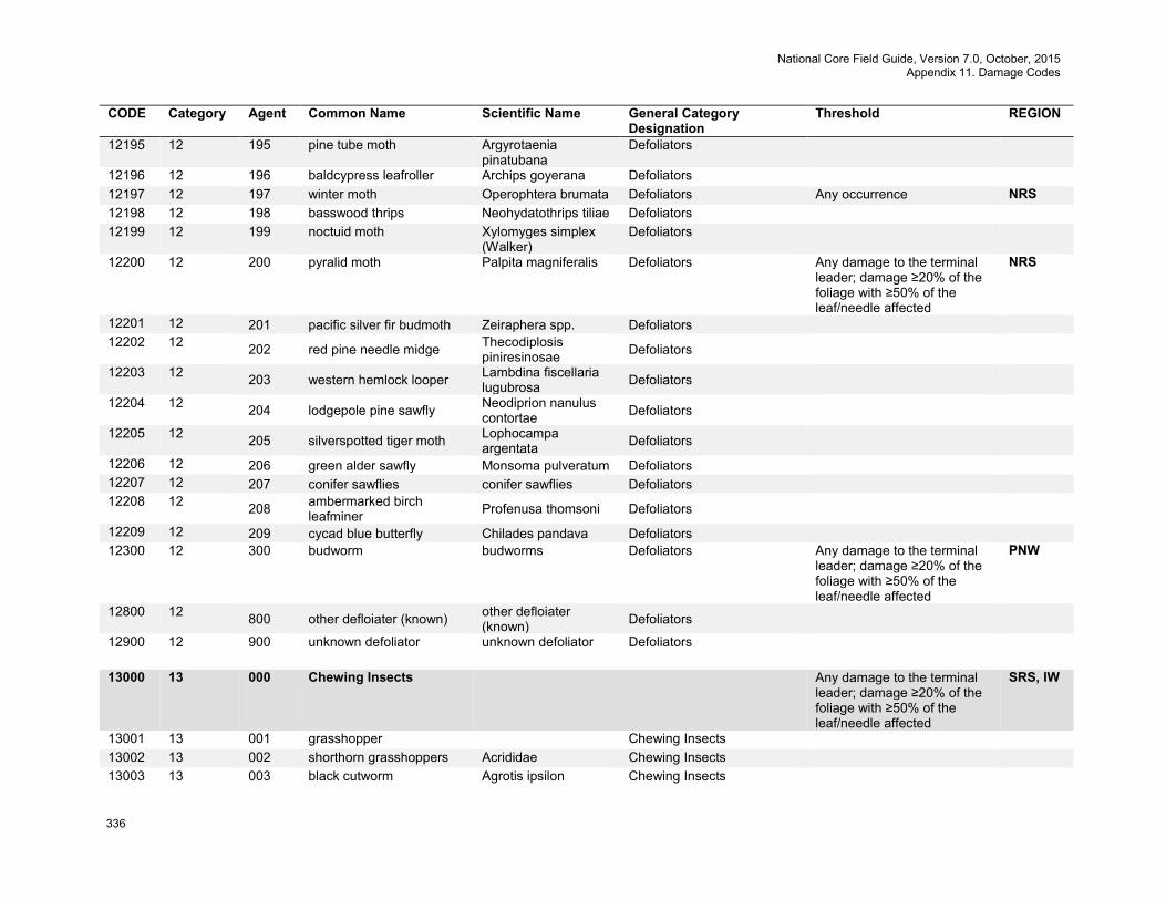
National Core Field Guide, Version 7.0, October, 2015 Appendix 11. Damage Codes
336
CODE Category Agent Common Name Scientific Name General Category Designation
Threshold REGION
12195 12 195 pine tube moth Argyrotaenia pinatubana
Defoliators
12196 12 196 baldcypress leafroller Archips goyerana Defoliators 12197 12 197 winter moth Operophtera brumata Defoliators Any occurrence NRS 12198 12 198 basswood thrips Neohydatothrips tiliae Defoliators 12199 12 199 noctuid moth Xylomyges simplex
(Walker) Defoliators
12200 12 200 pyralid moth Palpita magniferalis Defoliators Any damage to the terminal leader; damage ≥20% of the foliage with ≥50% of the leaf/needle affected
NRS
12201 12 201 pacific silver fir budmoth Zeiraphera spp. Defoliators 12202 12 202 red pine needle midge Thecodiplosis
piniresinosae Defoliators
12203 12 203 western hemlock looper Lambdina fiscellaria lugubrosa Defoliators
12204 12 204 lodgepole pine sawfly Neodiprion nanulus contortae Defoliators
12205 12 205 silverspotted tiger moth Lophocampa argentata Defoliators
12206 12 206 green alder sawfly Monsoma pulveratum Defoliators 12207 12 207 conifer sawflies conifer sawflies Defoliators 12208 12 208 ambermarked birch
leafminer Profenusa thomsoni Defoliators
12209 12 209 cycad blue butterfly Chilades pandava Defoliators 12300 12 300 budworm budworms Defoliators Any damage to the terminal
leader; damage ≥20% of the foliage with ≥50% of the leaf/needle affected
PNW
12800 12 800 other defloiater (known) other defloiater (known) Defoliators
12900 12 900 unknown defoliator unknown defoliator Defoliators
13000 13 000 Chewing Insects Any damage to the terminal leader; damage ≥20% of the foliage with ≥50% of the leaf/needle affected
SRS, IW
13001 13 001 grasshopper Chewing Insects 13002 13 002 shorthorn grasshoppers Acrididae Chewing Insects 13003 13 003 black cutworm Agrotis ipsilon Chewing Insects
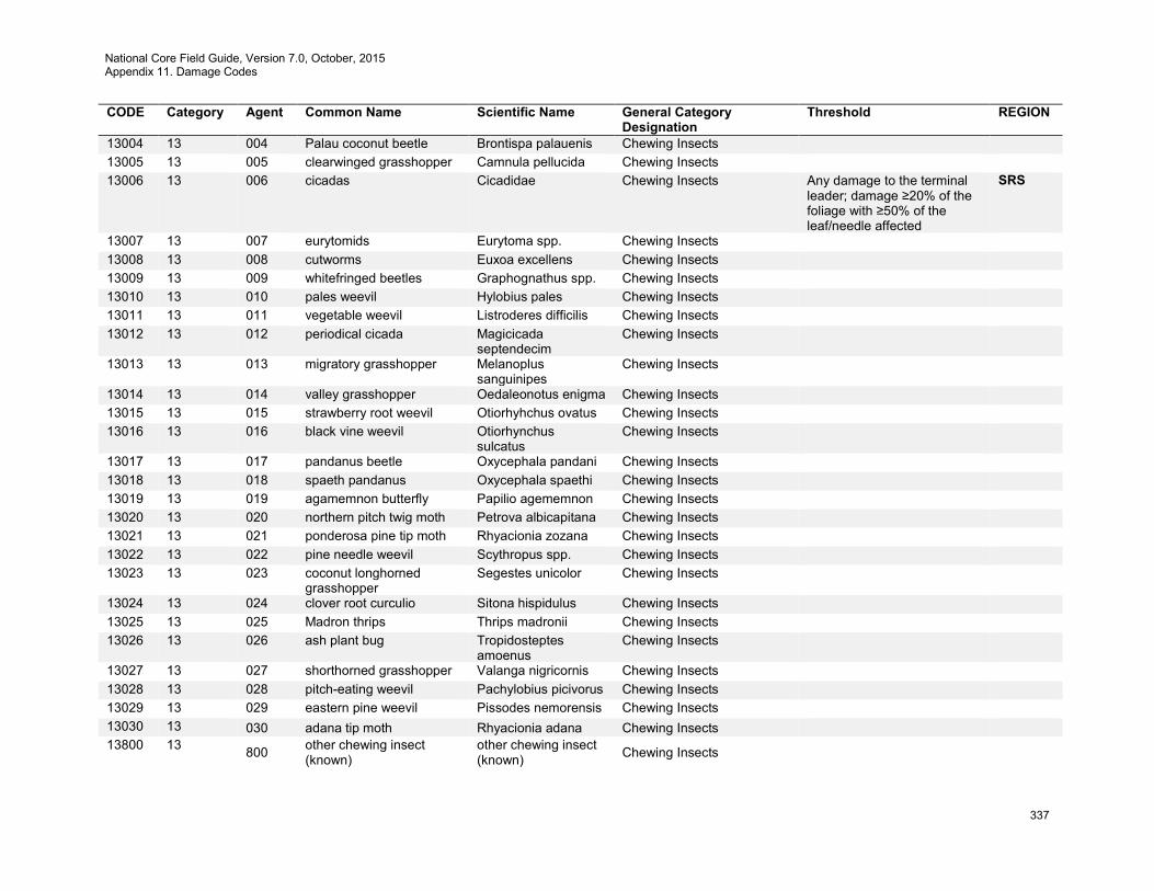
National Core Field Guide, Version 7.0, October, 2015 Appendix 11. Damage Codes
337
CODE Category Agent Common Name Scientific Name General Category Designation
Threshold REGION
13004 13 004 Palau coconut beetle Brontispa palauenis Chewing Insects 13005 13 005 clearwinged grasshopper Camnula pellucida Chewing Insects 13006 13 006 cicadas Cicadidae Chewing Insects Any damage to the terminal
leader; damage ≥20% of the foliage with ≥50% of the leaf/needle affected
SRS
13007 13 007 eurytomids Eurytoma spp. Chewing Insects 13008 13 008 cutworms Euxoa excellens Chewing Insects 13009 13 009 whitefringed beetles Graphognathus spp. Chewing Insects 13010 13 010 pales weevil Hylobius pales Chewing Insects 13011 13 011 vegetable weevil Listroderes difficilis Chewing Insects 13012 13 012 periodical cicada Magicicada
septendecim Chewing Insects
13013 13 013 migratory grasshopper Melanoplus sanguinipes
Chewing Insects
13014 13 014 valley grasshopper Oedaleonotus enigma Chewing Insects 13015 13 015 strawberry root weevil Otiorhyhchus ovatus Chewing Insects 13016 13 016 black vine weevil Otiorhynchus
sulcatus Chewing Insects
13017 13 017 pandanus beetle Oxycephala pandani Chewing Insects 13018 13 018 spaeth pandanus Oxycephala spaethi Chewing Insects 13019 13 019 agamemnon butterfly Papilio agememnon Chewing Insects 13020 13 020 northern pitch twig moth Petrova albicapitana Chewing Insects 13021 13 021 ponderosa pine tip moth Rhyacionia zozana Chewing Insects 13022 13 022 pine needle weevil Scythropus spp. Chewing Insects 13023 13 023 coconut longhorned
grasshopper Segestes unicolor Chewing Insects
13024 13 024 clover root curculio Sitona hispidulus Chewing Insects 13025 13 025 Madron thrips Thrips madronii Chewing Insects 13026 13 026 ash plant bug Tropidosteptes
amoenus Chewing Insects
13027 13 027 shorthorned grasshopper Valanga nigricornis Chewing Insects 13028 13 028 pitch-eating weevil Pachylobius picivorus Chewing Insects 13029 13 029 eastern pine weevil Pissodes nemorensis Chewing Insects 13030 13 030 adana tip moth Rhyacionia adana Chewing Insects 13800 13 800 other chewing insect
(known) other chewing insect (known) Chewing Insects
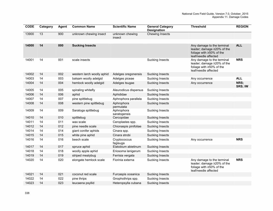
National Core Field Guide, Version 7.0, October, 2015 Appendix 11. Damage Codes
338
CODE Category Agent Common Name Scientific Name General Category Designation
Threshold REGION
13900 13 900 unknown chewing insect unknown chewing insect
Chewing Insects
14000 14 000 Sucking Insects Any damage to the terminal
leader; damage ≥20% of the foliage with ≥50% of the leaf/needle affected
ALL
14001 14 001 scale insects Sucking Insects Any damage to the terminal leader; damage ≥20% of the foliage with ≥50% of the leaf/needle affected
NRS
14002 14 002 western larch woolly aphid Adelges oregonensis Sucking Insects 14003 14 003 balsam woolly adelgid Adelges piceae Sucking Insects Any occurrence ALL 14004 14 004 hemlock woolly adelgid Adelges tsugae Sucking Insects Any occurrence NRS;
SRS; IW 14005 14 005 spiraling whitefly Aleurodicus dispersus Sucking Insects 14006 14 006 aphid Aphididae Sucking Insects 14007 14 007 pine spittlebug Aphrophora parallela Sucking Insects 14008 14 008 western pine spittlebug Aphrophora
permutata Sucking Insects
14009 14 009 Saratoga spittlebug Aphrophora saratogensis
Sucking Insects
14010 14 010 spittlebug Cercopidae Sucking Insects 14011 14 011 wax scale Ceroplastes spp. Sucking Insects 14012 14 012 pine needle scale Chionaspis pinifoliae Sucking Insects 14014 14 014 giant conifer aphids Cinara spp. Sucking Insects 14015 14 015 white pine aphid Cinara strobi Sucking Insects 14016 14 016 beech scale Cryptococcus
fagisuga Sucking Insects Any occurrence NRS
14017 14 017 spruce aphid Elatobium abietinum Sucking Insects 14018 14 018 woolly apple aphid Eriosoma lanigerum Sucking Insects 14019 14 019 striped mealybug Ferrisia vergata Sucking Insects 14020 14 020 elongate hemlock scale Fiorinia externa Sucking Insects Any damage to the terminal
leader; damage ≥20% of the foliage with ≥50% of the leaf/needle affected
NRS
14021 14 021 coconut red scale Furcaspis oceanica Sucking Insects 14022 14 022 pine thrips Gnophothrips spp. Sucking Insects 14023 14 023 leucaena psyllid Heteropsylla cubana Sucking Insects
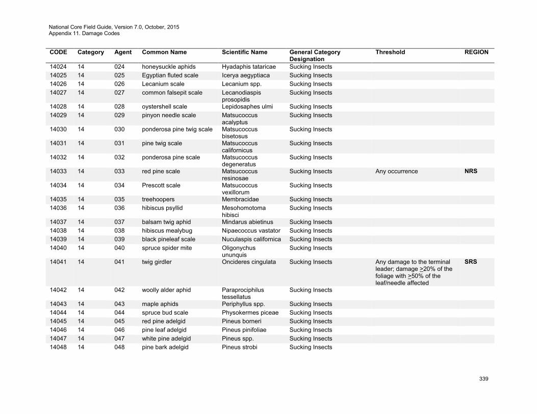
National Core Field Guide, Version 7.0, October, 2015 Appendix 11. Damage Codes
339
CODE Category Agent Common Name Scientific Name General Category Designation
Threshold REGION
14024 14 024 honeysuckle aphids Hyadaphis tataricae Sucking Insects 14025 14 025 Egyptian fluted scale Icerya aegyptiaca Sucking Insects 14026 14 026 Lecanium scale Lecanium spp. Sucking Insects 14027 14 027 common falsepit scale Lecanodiaspis
prosopidis Sucking Insects
14028 14 028 oystershell scale Lepidosaphes ulmi Sucking Insects 14029 14 029 pinyon needle scale Matsucoccus
acalyptus Sucking Insects
14030 14 030 ponderosa pine twig scale Matsucoccus bisetosus
Sucking Insects
14031 14 031 pine twig scale Matsucoccus californicus
Sucking Insects
14032 14 032 ponderosa pine scale Matsucoccus degeneratus
Sucking Insects
14033 14 033 red pine scale Matsucoccus resinosae
Sucking Insects Any occurrence NRS
14034 14 034 Prescott scale Matsucoccus vexillorum
Sucking Insects
14035 14 035 treehoopers Membracidae Sucking Insects 14036 14 036 hibiscus psyllid Mesohomotoma
hibisci Sucking Insects
14037 14 037 balsam twig aphid Mindarus abietinus Sucking Insects 14038 14 038 hibiscus mealybug Nipaecoccus vastator Sucking Insects 14039 14 039 black pineleaf scale Nuculaspis californica Sucking Insects 14040 14 040 spruce spider mite Oligonychus
ununquis Sucking Insects
14041 14 041 twig girdler Oncideres cingulata Sucking Insects Any damage to the terminal leader; damage >20% of the foliage with >50% of the leaf/needle affected
SRS
14042 14 042 woolly alder aphid Paraprociphilus tessellatus
Sucking Insects
14043 14 043 maple aphids Periphyllus spp. Sucking Insects 14044 14 044 spruce bud scale Physokermes piceae Sucking Insects 14045 14 045 red pine adelgid Pineus borneri Sucking Insects 14046 14 046 pine leaf adelgid Pineus pinifoliae Sucking Insects 14047 14 047 white pine adelgid Pineus spp. Sucking Insects 14048 14 048 pine bark adelgid Pineus strobi Sucking Insects
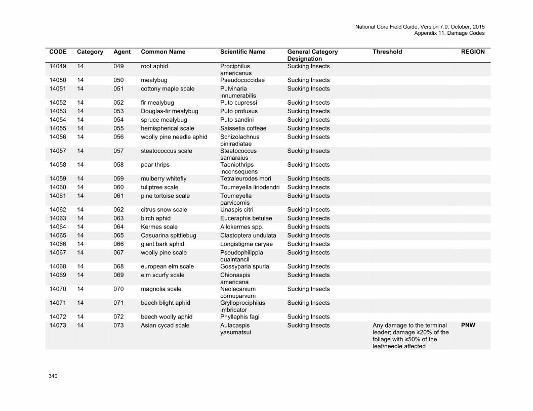
National Core Field Guide, Version 7.0, October, 2015 Appendix 11. Damage Codes
340
CODE Category Agent Common Name Scientific Name General Category Designation
Threshold REGION
14049 14 049 root aphid Prociphilus americanus
Sucking Insects
14050 14 050 mealybug Pseudococcidae Sucking Insects 14051 14 051 cottony maple scale Pulvinaria
innumerabilis Sucking Insects
14052 14 052 fir mealybug Puto cupressi Sucking Insects 14053 14 053 Douglas-fir mealybug Puto profusus Sucking Insects 14054 14 054 spruce mealybug Puto sandini Sucking Insects 14055 14 055 hemispherical scale Saissetia coffeae Sucking Insects 14056 14 056 woolly pine needle aphid Schizolachnus
piniradiatae Sucking Insects
14057 14 057 steatococcus scale Steatococcus samaraius
Sucking Insects
14058 14 058 pear thrips Taeniothrips inconsequens
Sucking Insects
14059 14 059 mulberry whitefly Tetraleurodes mori Sucking Insects 14060 14 060 tuliptree scale Toumeyella liriodendri Sucking Insects 14061 14 061 pine tortoise scale Toumeyella
parvicornis Sucking Insects
14062 14 062 citrus snow scale Unaspis citri Sucking Insects 14063 14 063 birch aphid Euceraphis betulae Sucking Insects 14064 14 064 Kermes scale Allokermes spp. Sucking Insects 14065 14 065 Casuarina spittlebug Clastoptera undulata Sucking Insects 14066 14 066 giant bark aphid Longistigma caryae Sucking Insects 14067 14 067 woolly pine scale Pseudophilippia
quaintancii Sucking Insects
14068 14 068 european elm scale Gossyparia spuria Sucking Insects 14069 14 069 elm scurfy scale Chionaspis
americana Sucking Insects
14070 14 070 magnolia scale Neolecanium cornuparvum
Sucking Insects
14071 14 071 beech blight aphid Grylloprociphilus imbricator
Sucking Insects
14072 14 072 beech woolly aphid Phyllaphis fagi Sucking Insects 14073 14 073 Asian cycad scale Aulacaspis
yasumatsui Sucking Insects Any damage to the terminal
leader; damage ≥20% of the foliage with ≥50% of the leaf/needle affected
PNW
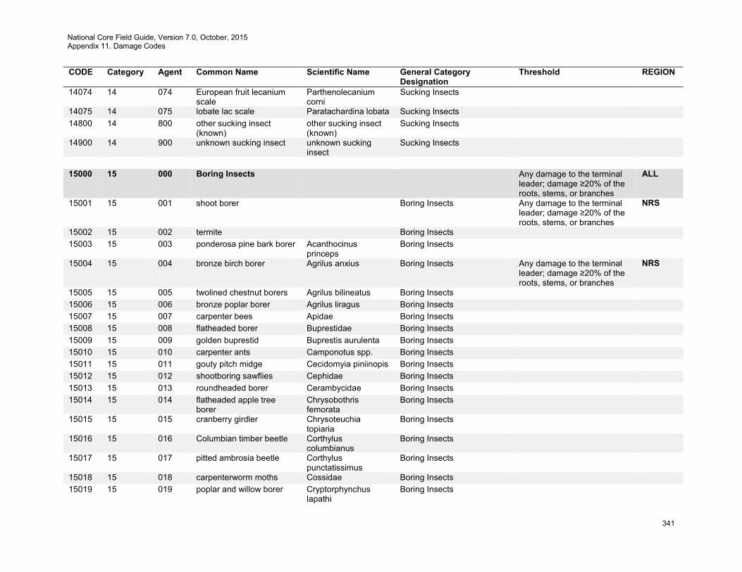
National Core Field Guide, Version 7.0, October, 2015 Appendix 11. Damage Codes
341
CODE Category Agent Common Name Scientific Name General Category Designation
Threshold REGION
14074 14 074 European fruit lecanium scale
Parthenolecanium corni
Sucking Insects
14075 14 075 lobate lac scale Paratachardina lobata Sucking Insects 14800 14 800 other sucking insect
(known) other sucking insect (known)
Sucking Insects
14900 14 900 unknown sucking insect unknown sucking insect
Sucking Insects
15000 15 000 Boring Insects Any damage to the terminal
leader; damage ≥20% of the roots, stems, or branches
ALL
15001 15 001 shoot borer Boring Insects Any damage to the terminal leader; damage ≥20% of the roots, stems, or branches
NRS
15002 15 002 termite Boring Insects 15003 15 003 ponderosa pine bark borer Acanthocinus
princeps Boring Insects
15004 15 004 bronze birch borer Agrilus anxius Boring Insects Any damage to the terminal leader; damage ≥20% of the roots, stems, or branches
NRS
15005 15 005 twolined chestnut borers Agrilus bilineatus Boring Insects 15006 15 006 bronze poplar borer Agrilus liragus Boring Insects 15007 15 007 carpenter bees Apidae Boring Insects 15008 15 008 flatheaded borer Buprestidae Boring Insects 15009 15 009 golden buprestid Buprestis aurulenta Boring Insects 15010 15 010 carpenter ants Camponotus spp. Boring Insects 15011 15 011 gouty pitch midge Cecidomyia piniinopis Boring Insects 15012 15 012 shootboring sawflies Cephidae Boring Insects 15013 15 013 roundheaded borer Cerambycidae Boring Insects 15014 15 014 flatheaded apple tree
borer Chrysobothris femorata
Boring Insects
15015 15 015 cranberry girdler Chrysoteuchia topiaria
Boring Insects
15016 15 016 Columbian timber beetle Corthylus columbianus
Boring Insects
15017 15 017 pitted ambrosia beetle Corthylus punctatissimus
Boring Insects
15018 15 018 carpenterworm moths Cossidae Boring Insects 15019 15 019 poplar and willow borer Cryptorphynchus
lapathi Boring Insects
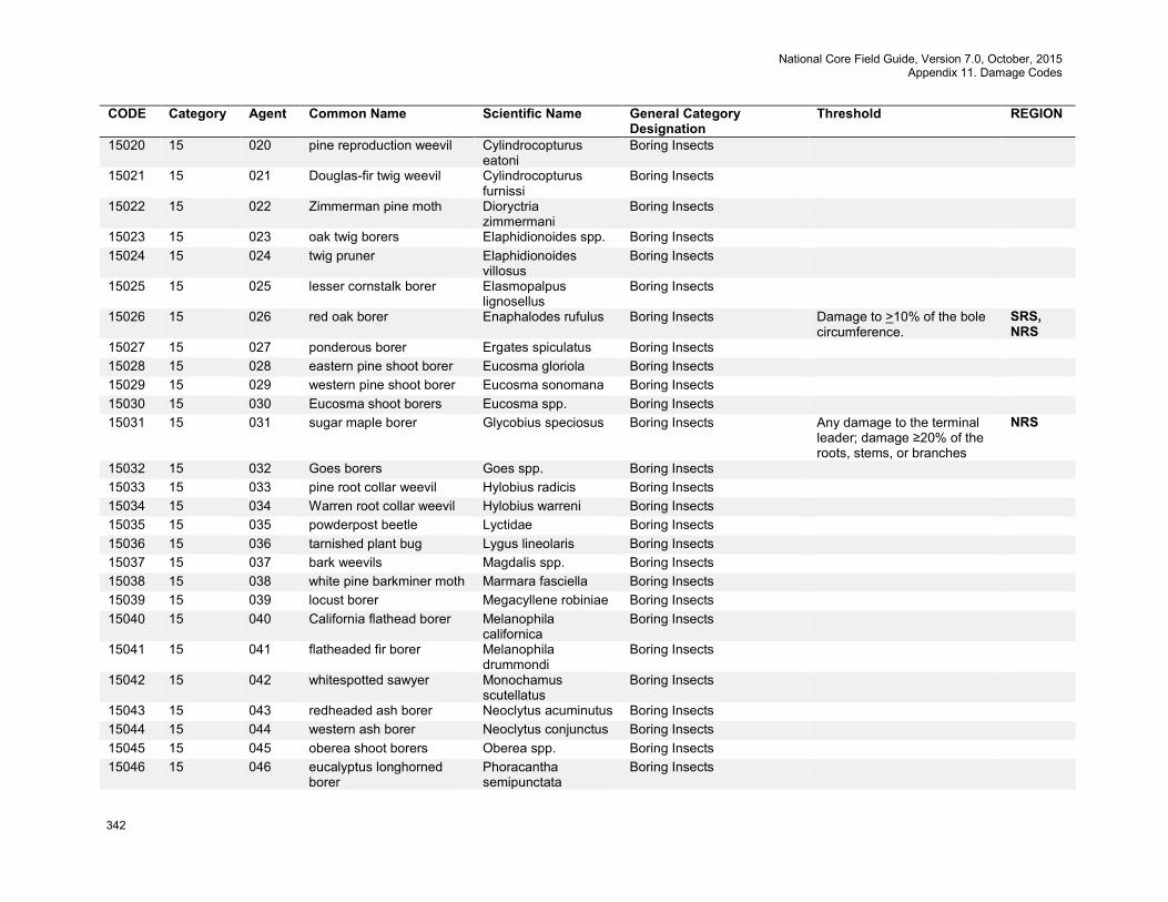
National Core Field Guide, Version 7.0, October, 2015 Appendix 11. Damage Codes
342
CODE Category Agent Common Name Scientific Name General Category Designation
Threshold REGION
15020 15 020 pine reproduction weevil Cylindrocopturus eatoni
Boring Insects
15021 15 021 Douglas-fir twig weevil Cylindrocopturus furnissi
Boring Insects
15022 15 022 Zimmerman pine moth Dioryctria zimmermani
Boring Insects
15023 15 023 oak twig borers Elaphidionoides spp. Boring Insects 15024 15 024 twig pruner Elaphidionoides
villosus Boring Insects
15025 15 025 lesser cornstalk borer Elasmopalpus lignosellus
Boring Insects
15026 15 026 red oak borer Enaphalodes rufulus Boring Insects Damage to >10% of the bole circumference.
SRS, NRS
15027 15 027 ponderous borer Ergates spiculatus Boring Insects 15028 15 028 eastern pine shoot borer Eucosma gloriola Boring Insects 15029 15 029 western pine shoot borer Eucosma sonomana Boring Insects 15030 15 030 Eucosma shoot borers Eucosma spp. Boring Insects 15031 15 031 sugar maple borer Glycobius speciosus Boring Insects Any damage to the terminal
leader; damage ≥20% of the roots, stems, or branches
NRS
15032 15 032 Goes borers Goes spp. Boring Insects 15033 15 033 pine root collar weevil Hylobius radicis Boring Insects 15034 15 034 Warren root collar weevil Hylobius warreni Boring Insects 15035 15 035 powderpost beetle Lyctidae Boring Insects 15036 15 036 tarnished plant bug Lygus lineolaris Boring Insects 15037 15 037 bark weevils Magdalis spp. Boring Insects 15038 15 038 white pine barkminer moth Marmara fasciella Boring Insects 15039 15 039 locust borer Megacyllene robiniae Boring Insects 15040 15 040 California flathead borer Melanophila
californica Boring Insects
15041 15 041 flatheaded fir borer Melanophila drummondi
Boring Insects
15042 15 042 whitespotted sawyer Monochamus scutellatus
Boring Insects
15043 15 043 redheaded ash borer Neoclytus acuminutus Boring Insects 15044 15 044 western ash borer Neoclytus conjunctus Boring Insects 15045 15 045 oberea shoot borers Oberea spp. Boring Insects 15046 15 046 eucalyptus longhorned
borer Phoracantha semipunctata
Boring Insects

National Core Field Guide, Version 7.0, October, 2015 Appendix 11. Damage Codes
343
CODE Category Agent Common Name Scientific Name General Category Designation
Threshold REGION
15047 15 047 northern pine weevil Pissodes approximatus
Boring Insects
15048 15 048 balsam bark weevil Pissodes dubius Boring Insects 15049 15 049 Monterey pine weevil Pissodes radiatae Boring Insects 15050 15 050 Engelmann spruce weevil Pissodes strobi Boring Insects 15051 15 051 lodgepole terminal weevil Pissodes terminalis Boring Insects 15052 15 052 ambrosia beetles Platypus spp. Boring Insects Damage to >10% of the bole
circumference. SRS
15053 15 053 cottonwood borer Plectrodera scalator Boring Insects 15054 15 054 balsam shootboring sawfly Pleroneura
brunneicornis Boring Insects
15055 15 055 pine gall weevil Podapion gallicola Boring Insects 15056 15 056 ash borer Podesesia syringae
fraxini Boring Insects
15057 15 057 lilac borer Podosesia syringae Boring Insects 15058 15 058 carpenterworm Prionoxystus robiniae Boring Insects 15059 15 059 maple shoot borers Proterteras spp. Boring Insects 15060 15 060 western subterranean
termite Reticulitermes hesperus
Boring Insects
15061 15 061 coconut trunk weevil Rhabdoscelus asperipennis
Boring Insects
15062 15 062 New Guinea sugarcane weevil
Rhabdoscelus obscurus
Boring Insects
15063 15 063 European pine shoot moth Rhyacionia buoliana Boring Insects 15064 15 064 western pine tip moth Rhyacionia bushnelli Boring Insects 15065 15 065 Nantucket pine tip moth Rhyacionia frustrana Boring Insects 15066 15 066 lodgepole pine tip moth Rhyacionia montana Boring Insects 15067 15 067 southwestern pine tip
moth Rhyacionia neomexicana
Boring Insects
15068 15 068 poplar borer Saperda calcarata Boring Insects 15069 15 069 roundheaded appletree
borer Saperda candida Boring Insects
15070 15 070 Saperda shoot borer Saperda spp. Boring Insects 15071 15 071 clearwing moths Sesiidae Boring Insects 15072 15 072 dogwood borer Synanthedon scitula Boring Insects 15073 15 073 roundheaded fir borer Tetropium abietis Boring Insects 15074 15 074 western larch borer Tetropium velutinum Boring Insects 15075 15 075 western cedar borer Trachykele blondeli Boring Insects
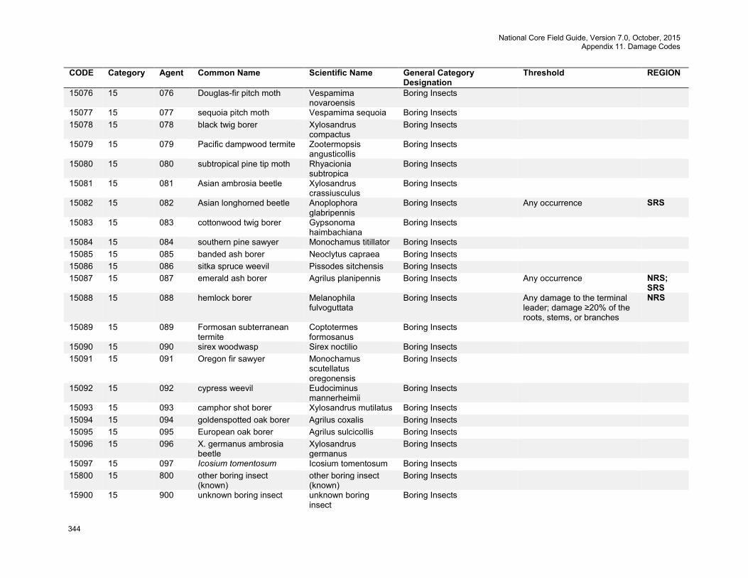
National Core Field Guide, Version 7.0, October, 2015 Appendix 11. Damage Codes
344
CODE Category Agent Common Name Scientific Name General Category Designation
Threshold REGION
15076 15 076 Douglas-fir pitch moth Vespamima novaroensis
Boring Insects
15077 15 077 sequoia pitch moth Vespamima sequoia Boring Insects 15078 15 078 black twig borer Xylosandrus
compactus Boring Insects
15079 15 079 Pacific dampwood termite Zootermopsis angusticollis
Boring Insects
15080 15 080 subtropical pine tip moth Rhyacionia subtropica
Boring Insects
15081 15 081 Asian ambrosia beetle Xylosandrus crassiusculus
Boring Insects
15082 15 082 Asian longhorned beetle Anoplophora glabripennis
Boring Insects Any occurrence SRS
15083 15 083 cottonwood twig borer Gypsonoma haimbachiana
Boring Insects
15084 15 084 southern pine sawyer Monochamus titillator Boring Insects 15085 15 085 banded ash borer Neoclytus capraea Boring Insects 15086 15 086 sitka spruce weevil Pissodes sitchensis Boring Insects 15087 15 087 emerald ash borer Agrilus planipennis Boring Insects Any occurrence NRS;
SRS 15088 15 088 hemlock borer Melanophila
fulvoguttata Boring Insects Any damage to the terminal
leader; damage ≥20% of the roots, stems, or branches
NRS
15089 15 089 Formosan subterranean termite
Coptotermes formosanus
Boring Insects
15090 15 090 sirex woodwasp Sirex noctilio Boring Insects 15091 15 091 Oregon fir sawyer Monochamus
scutellatus oregonensis
Boring Insects
15092 15 092 cypress weevil Eudociminus mannerheimii
Boring Insects
15093 15 093 camphor shot borer Xylosandrus mutilatus Boring Insects 15094 15 094 goldenspotted oak borer Agrilus coxalis Boring Insects 15095 15 095 European oak borer Agrilus sulcicollis Boring Insects 15096 15 096 X. germanus ambrosia
beetle Xylosandrus germanus
Boring Insects
15097 15 097 Icosium tomentosum Icosium tomentosum Boring Insects 15800 15 800 other boring insect
(known) other boring insect (known)
Boring Insects
15900 15 900 unknown boring insect unknown boring insect
Boring Insects
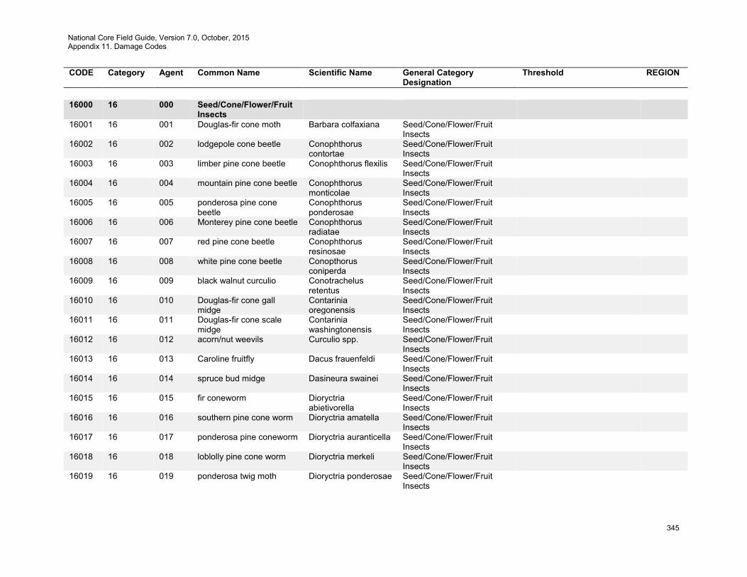
National Core Field Guide, Version 7.0, October, 2015 Appendix 11. Damage Codes
345
CODE Category Agent Common Name Scientific Name General Category Designation
Threshold REGION
16000 16 000 Seed/Cone/Flower/Fruit
Insects
16001 16 001 Douglas-fir cone moth Barbara colfaxiana Seed/Cone/Flower/Fruit Insects
16002 16 002 lodgepole cone beetle Conophthorus contortae
Seed/Cone/Flower/Fruit Insects
16003 16 003 limber pine cone beetle Conophthorus flexilis Seed/Cone/Flower/Fruit Insects
16004 16 004 mountain pine cone beetle Conophthorus monticolae
Seed/Cone/Flower/Fruit Insects
16005 16 005 ponderosa pine cone beetle
Conophthorus ponderosae
Seed/Cone/Flower/Fruit Insects
16006 16 006 Monterey pine cone beetle Conophthorus radiatae
Seed/Cone/Flower/Fruit Insects
16007 16 007 red pine cone beetle Conophthorus resinosae
Seed/Cone/Flower/Fruit Insects
16008 16 008 white pine cone beetle Conopthorus coniperda
Seed/Cone/Flower/Fruit Insects
16009 16 009 black walnut curculio Conotrachelus retentus
Seed/Cone/Flower/Fruit Insects
16010 16 010 Douglas-fir cone gall midge
Contarinia oregonensis
Seed/Cone/Flower/Fruit Insects
16011 16 011 Douglas-fir cone scale midge
Contarinia washingtonensis
Seed/Cone/Flower/Fruit Insects
16012 16 012 acorn/nut weevils Curculio spp. Seed/Cone/Flower/Fruit Insects
16013 16 013 Caroline fruitfly Dacus frauenfeldi Seed/Cone/Flower/Fruit Insects
16014 16 014 spruce bud midge Dasineura swainei Seed/Cone/Flower/Fruit Insects
16015 16 015 fir coneworm Dioryctria abietivorella
Seed/Cone/Flower/Fruit Insects
16016 16 016 southern pine cone worm Dioryctria amatella Seed/Cone/Flower/Fruit Insects
16017 16 017 ponderosa pine coneworm Dioryctria auranticella Seed/Cone/Flower/Fruit Insects
16018 16 018 loblolly pine cone worm Dioryctria merkeli Seed/Cone/Flower/Fruit Insects
16019 16 019 ponderosa twig moth Dioryctria ponderosae Seed/Cone/Flower/Fruit Insects
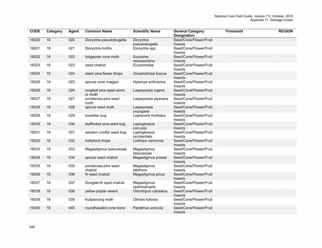
National Core Field Guide, Version 7.0, October, 2015 Appendix 11. Damage Codes
346
CODE Category Agent Common Name Scientific Name General Category Designation
Threshold REGION
16020 16 020 Dioryctria pseudotsugella Dioryctria pseudotsugella
Seed/Cone/Flower/Fruit Insects
16021 16 021 Dioryctria moths Dioryctria spp. Seed/Cone/Flower/Fruit Insects
16022 16 022 lodgepole cone moth Eucosma rescissoriana
Seed/Cone/Flower/Fruit Insects
16023 16 023 seed chalcid Eurytomidae Seed/Cone/Flower/Fruit Insects
16024 16 024 slash pine flower thrips Gnophothrips fuscus Seed/Cone/Flower/Fruit Insects
16025 16 025 spruce cone maggot Hylemya anthracina Seed/Cone/Flower/Fruit Insects
16026 16 026 longleaf pine seed worm or moth
Laspeyresia ingens Seed/Cone/Flower/Fruit Insects
16027 16 027 ponderosa pine seed moth
Laspeyresia piperana Seed/Cone/Flower/Fruit Insects
16028 16 028 spruce seed moth Laspeyresia youngana
Seed/Cone/Flower/Fruit Insects
16029 16 029 boxelder bug Leptocoris trivittatus Seed/Cone/Flower/Fruit Insects
16030 16 030 leaffooted pine seed bug Leptoglossus corculus
Seed/Cone/Flower/Fruit Insects
16031 16 031 western conifer seed bug Leptoglossus occidentalis
Seed/Cone/Flower/Fruit Insects
16032 16 032 hollyhock thrips Liothrips varicornis Seed/Cone/Flower/Fruit Insects
16033 16 033 Magastigmus lasiocarpae Magastigmus lasiocarpae
Seed/Cone/Flower/Fruit Insects
16034 16 034 spruce seed chalcid Magastigmus piceae Seed/Cone/Flower/Fruit Insects
16035 16 035 ponderosa pine seed chalcid
Megastigmus albifrons
Seed/Cone/Flower/Fruit Insects
16036 16 036 fir seed chalcid Megastigmus pinus Seed/Cone/Flower/Fruit Insects
16037 16 037 Douglas-fir seed chalcid Megastigmus spermotrophs
Seed/Cone/Flower/Fruit Insects
16038 16 038 yellow poplar weevil Odontopus calceatus Seed/Cone/Flower/Fruit Insects
16039 16 039 fruitpiercing moth Othreis fullonia Seed/Cone/Flower/Fruit Insects
16040 16 040 roundheaded cone borer Paratimia conicola Seed/Cone/Flower/Fruit Insects
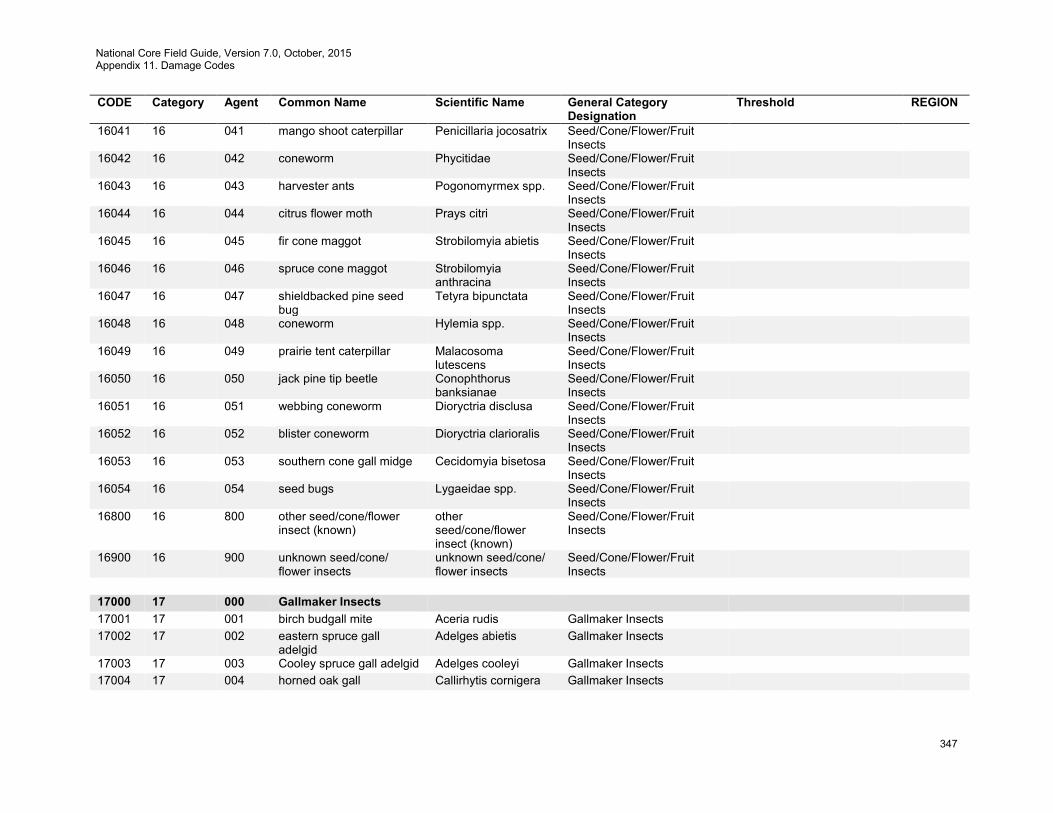
National Core Field Guide, Version 7.0, October, 2015 Appendix 11. Damage Codes
347
CODE Category Agent Common Name Scientific Name General Category Designation
Threshold REGION
16041 16 041 mango shoot caterpillar Penicillaria jocosatrix Seed/Cone/Flower/Fruit Insects
16042 16 042 coneworm Phycitidae Seed/Cone/Flower/Fruit Insects
16043 16 043 harvester ants Pogonomyrmex spp. Seed/Cone/Flower/Fruit Insects
16044 16 044 citrus flower moth Prays citri Seed/Cone/Flower/Fruit Insects
16045 16 045 fir cone maggot Strobilomyia abietis Seed/Cone/Flower/Fruit Insects
16046 16 046 spruce cone maggot Strobilomyia anthracina
Seed/Cone/Flower/Fruit Insects
16047 16 047 shieldbacked pine seed bug
Tetyra bipunctata Seed/Cone/Flower/Fruit Insects
16048 16 048 coneworm Hylemia spp. Seed/Cone/Flower/Fruit Insects
16049 16 049 prairie tent caterpillar Malacosoma lutescens
Seed/Cone/Flower/Fruit Insects
16050 16 050 jack pine tip beetle Conophthorus banksianae
Seed/Cone/Flower/Fruit Insects
16051 16 051 webbing coneworm Dioryctria disclusa Seed/Cone/Flower/Fruit Insects
16052 16 052 blister coneworm Dioryctria clarioralis Seed/Cone/Flower/Fruit Insects
16053 16 053 southern cone gall midge Cecidomyia bisetosa Seed/Cone/Flower/Fruit Insects
16054 16 054 seed bugs Lygaeidae spp. Seed/Cone/Flower/Fruit Insects
16800 16 800 other seed/cone/flower insect (known)
other seed/cone/flower insect (known)
Seed/Cone/Flower/Fruit Insects
16900 16 900 unknown seed/cone/ flower insects
unknown seed/cone/ flower insects
Seed/Cone/Flower/Fruit Insects
17000 17 000 Gallmaker Insects 17001 17 001 birch budgall mite Aceria rudis Gallmaker Insects 17002 17 002 eastern spruce gall
adelgid Adelges abietis Gallmaker Insects
17003 17 003 Cooley spruce gall adelgid Adelges cooleyi Gallmaker Insects 17004 17 004 horned oak gall Callirhytis cornigera Gallmaker Insects
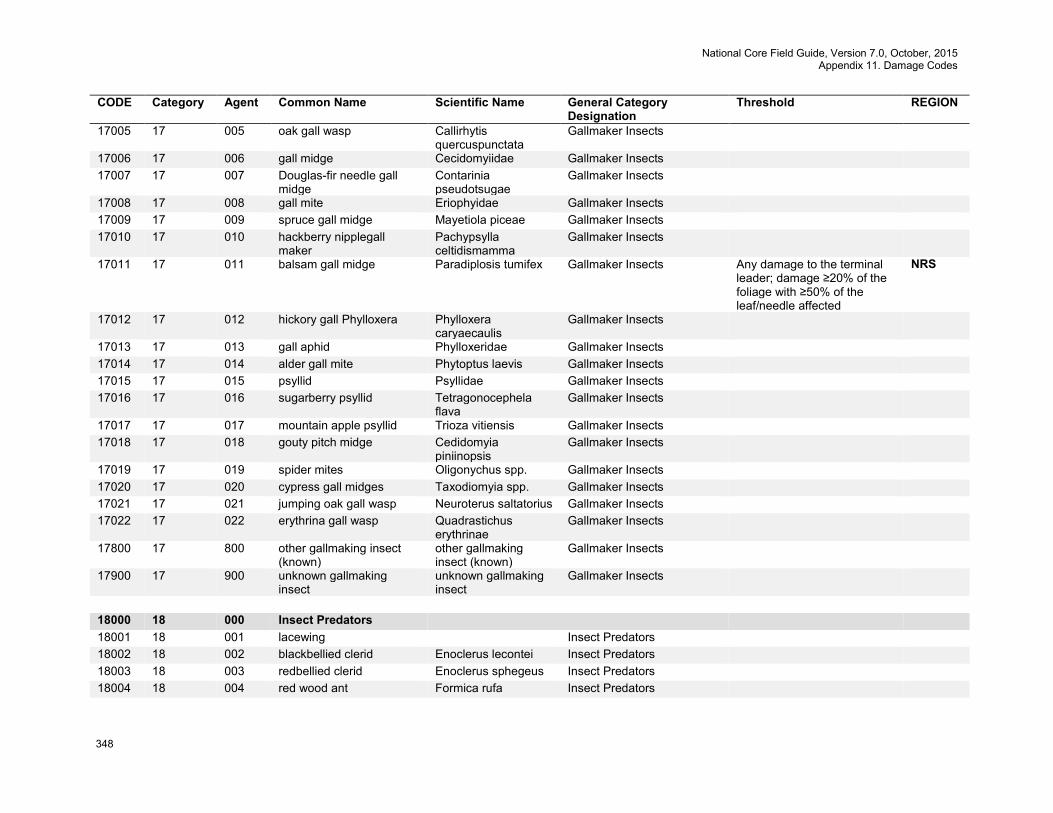
National Core Field Guide, Version 7.0, October, 2015 Appendix 11. Damage Codes
348
CODE Category Agent Common Name Scientific Name General Category Designation
Threshold REGION
17005 17 005 oak gall wasp Callirhytis quercuspunctata
Gallmaker Insects
17006 17 006 gall midge Cecidomyiidae Gallmaker Insects 17007 17 007 Douglas-fir needle gall
midge Contarinia pseudotsugae
Gallmaker Insects
17008 17 008 gall mite Eriophyidae Gallmaker Insects 17009 17 009 spruce gall midge Mayetiola piceae Gallmaker Insects 17010 17 010 hackberry nipplegall
maker Pachypsylla celtidismamma
Gallmaker Insects
17011 17 011 balsam gall midge Paradiplosis tumifex Gallmaker Insects Any damage to the terminal leader; damage ≥20% of the foliage with ≥50% of the leaf/needle affected
NRS
17012 17 012 hickory gall Phylloxera Phylloxera caryaecaulis
Gallmaker Insects
17013 17 013 gall aphid Phylloxeridae Gallmaker Insects 17014 17 014 alder gall mite Phytoptus laevis Gallmaker Insects 17015 17 015 psyllid Psyllidae Gallmaker Insects 17016 17 016 sugarberry psyllid Tetragonocephela
flava Gallmaker Insects
17017 17 017 mountain apple psyllid Trioza vitiensis Gallmaker Insects 17018 17 018 gouty pitch midge Cedidomyia
piniinopsis Gallmaker Insects
17019 17 019 spider mites Oligonychus spp. Gallmaker Insects 17020 17 020 cypress gall midges Taxodiomyia spp. Gallmaker Insects 17021 17 021 jumping oak gall wasp Neuroterus saltatorius Gallmaker Insects 17022 17 022 erythrina gall wasp Quadrastichus
erythrinae Gallmaker Insects
17800 17 800 other gallmaking insect (known)
other gallmaking insect (known)
Gallmaker Insects
17900 17 900 unknown gallmaking insect
unknown gallmaking insect
Gallmaker Insects
18000 18 000 Insect Predators 18001 18 001 lacewing Insect Predators 18002 18 002 blackbellied clerid Enoclerus lecontei Insect Predators 18003 18 003 redbellied clerid Enoclerus sphegeus Insect Predators 18004 18 004 red wood ant Formica rufa Insect Predators
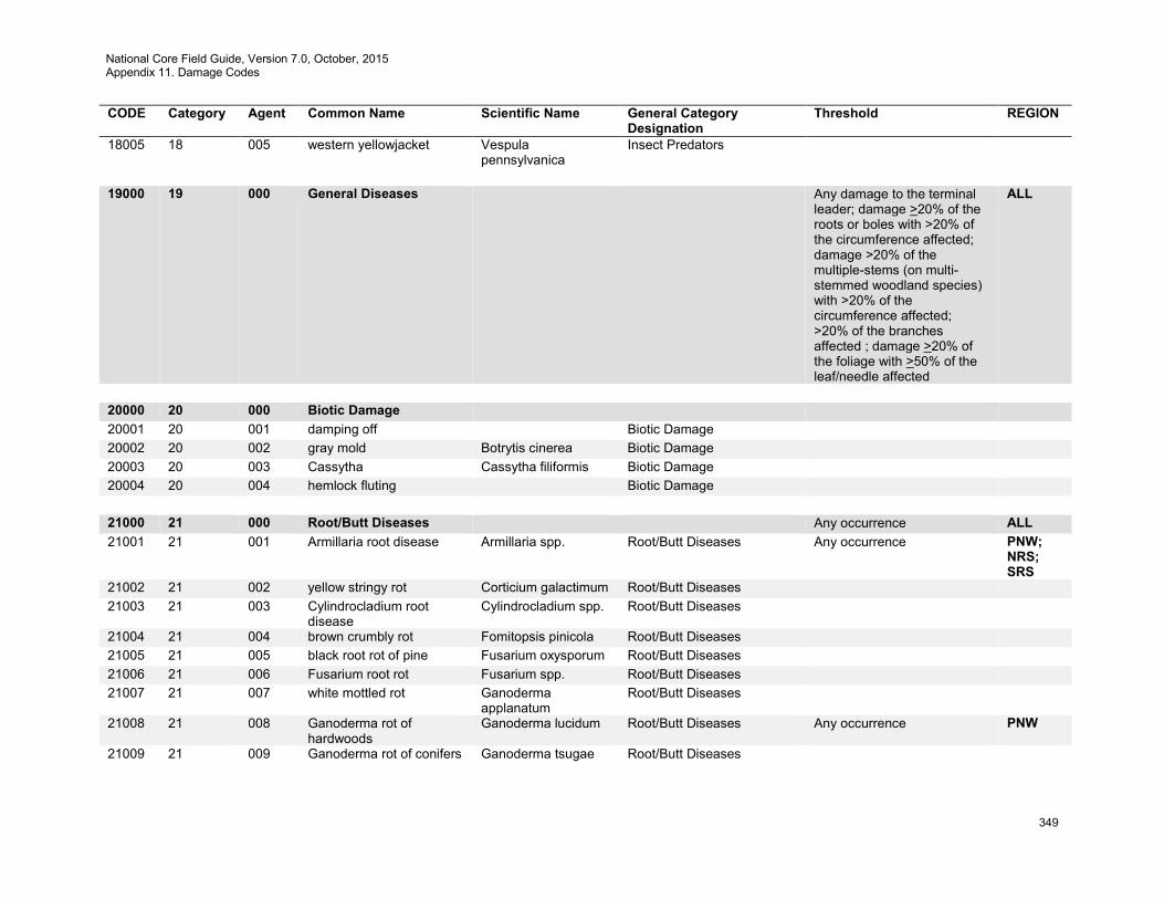
National Core Field Guide, Version 7.0, October, 2015 Appendix 11. Damage Codes
349
CODE Category Agent Common Name Scientific Name General Category Designation
Threshold REGION
18005 18 005 western yellowjacket Vespula pennsylvanica
Insect Predators
19000 19 000 General Diseases Any damage to the terminal
leader; damage >20% of the roots or boles with >20% of the circumference affected; damage >20% of the multiple-stems (on multi-stemmed woodland species) with >20% of the circumference affected; >20% of the branches affected ; damage >20% of the foliage with >50% of the leaf/needle affected
ALL
20000 20 000 Biotic Damage 20001 20 001 damping off Biotic Damage 20002 20 002 gray mold Botrytis cinerea Biotic Damage 20003 20 003 Cassytha Cassytha filiformis Biotic Damage 20004 20 004 hemlock fluting Biotic Damage 21000 21 000 Root/Butt Diseases Any occurrence ALL 21001 21 001 Armillaria root disease Armillaria spp. Root/Butt Diseases Any occurrence PNW;
NRS; SRS
21002 21 002 yellow stringy rot Corticium galactimum Root/Butt Diseases 21003 21 003 Cylindrocladium root
disease Cylindrocladium spp. Root/Butt Diseases
21004 21 004 brown crumbly rot Fomitopsis pinicola Root/Butt Diseases 21005 21 005 black root rot of pine Fusarium oxysporum Root/Butt Diseases 21006 21 006 Fusarium root rot Fusarium spp. Root/Butt Diseases 21007 21 007 white mottled rot Ganoderma
applanatum Root/Butt Diseases
21008 21 008 Ganoderma rot of hardwoods
Ganoderma lucidum Root/Butt Diseases Any occurrence PNW
21009 21 009 Ganoderma rot of conifers Ganoderma tsugae Root/Butt Diseases
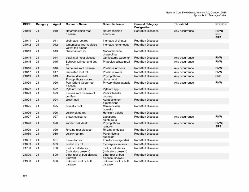
National Core Field Guide, Version 7.0, October, 2015 Appendix 11. Damage Codes
350
CODE Category Agent Common Name Scientific Name General Category Designation
Threshold REGION
21010 21 010 Heterobasidion root disease
Heterobasidion annosum
Root/Butt Diseases Any occurrence PNW; NRS; SRS
21011 21 011 circinatus root rot Inonotus circinatus Root/Butt Diseases 21012 21 012 tomentosus root rot/false
velvet top fungus Inonotus tomentosus Root/Butt Diseases
21013 21 013 charcoal root rot Macrophomina phaseolina
Root/Butt Diseases
21014 21 014 black stain root disease Ophiostoma wageneri Root/Butt Diseases Any occurrence PNW 21015 21 015 Schweinitzii root and butt
rot Phaeolus schweinitzii Root/Butt Diseases Any occurrence PNW
21016 21 016 flame tree root disease Phellinus noxious Root/Butt Diseases Any occurrence PNW 21017 21 017 laminated root rot Phellinus weirii Root/Butt Diseases Any occurrence PNW 21019 21 019 littleleaf disease/
Phytophthora root rot Phytophthora cinnamomi
Root/Butt Diseases Any occurrence SRS
21020 21 020 Port-Orford-Cedar root disease
Phytophthora lateralis Root/Butt Diseases Any occurrence PNW
21022 21 022 Pythium root rot Pythium spp. Root/Butt Diseases 21023 21 023 procera root disease of
conifers Verticicladiella procera
Root/Butt Diseases
21024 21 024 crown gall Agrobacterium tumefaciens
Root/Butt Diseases
21025 21 025 borealis conk Climacocystis borealis
Root/Butt Diseases
21026 21 026 yellow pitted rot Hericium abietis Root/Butt Diseases 21027 21 027 brown cubical rot Laetiporus
sulphureus Root/Butt Diseases Any occurrence PNW
21028 21 028 sudden oak death Phytophthora ramorum
Root/Butt Diseases Any occurrence PNW; SRS
21029 21 029 Rhizina root disease Rhizina undulata Root/Butt Diseases 21030 21 030 yellow root rot Perenniporia
subacida Root/Butt Diseases
21031 21 031 brown top rot Fomitopsis cajanderi Root/Butt Diseases 21033 21 033 pocket dry rot Tyromyces amarus Root/Butt Diseases 21700 21 700 root or butt decay
(indicators present) root or butt decay (indicators present)
Root/Butt Diseases
21800 21 800 other root or butt disease (known)
other root or butt disease (known)
Root/Butt Diseases
21900 21 900 unknown root or butt disease
unknown root or butt disease
Root/Butt Diseases
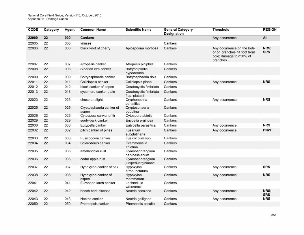
National Core Field Guide, Version 7.0, October, 2015 Appendix 11. Damage Codes
351
CODE Category Agent Common Name Scientific Name General Category Designation
Threshold REGION
22000 22 000 Cankers Any occurrence All 22005 22 005 viruses Cankers 22006 22 006 black knot of cherry Apiosporina morbosa Cankers Any occurrence on the bole
or on branches ≤1 foot from bole; damage to ≥50% of branches
NRS; SRS
22007 22 007 Atropellis canker Atropellis piniphila Cankers 22008 22 008 Siberian elm canker Botryodiplodia
hypodermia Cankers
22009 22 009 Botryosphaeria canker Botryosphaeria ribis Cankers 22011 22 011 Caliciopsis canker Caliciopsis pinea Cankers Any occurrence NRS 22012 22 012 black canker of aspen Ceratocystis fimbriata Cankers 22013 22 013 sycamore canker stain Ceratocystis fimbriata
f.sp. plataini Cankers
22023 22 023 chestnut blight Cryphonectria parasitica
Cankers Any occurrence NRS
22025 22 025 Cryptosphaeria canker of aspen
Cryptosphaeria populina
Cankers
22026 22 026 Cytospora canker of fir Cytospora abietis Cankers 22029 22 029 sooty-bark canker Encoelia pruinosa Cankers 22030 22 030 Eutypella canker Eutypella parasitica Cankers Any occurrence NRS 22032 22 032 pitch canker of pines Fusarium
subglutinans Cankers Any occurrence PNW
22033 22 033 Fusicoccum canker Fusicoccum spp. Cankers 22034 22 034 Scleroderris canker Gremmeniella
abietina Cankers
22035 22 035 amelanchier rust Gymnosporangium harknessianum
Cankers
22036 22 036 cedar apple rust Gymnosporangium juniperi-virginianae
Cankers
22037 22 037 Hypoxylon canker of oak Hypoxylon atropunctatum
Cankers Any occurrence SRS
22038 22 038 Hypoxylon canker of aspen
Hypoxylon mammatum
Cankers Any occurrence NRS
22041 22 041 European larch canker Lachnellula willkommii
Cankers
22042 22 042 beech bark disease Nectria coccinea Cankers Any occurrence NRS; SRS
22043 22 043 Nectria canker Nectria galligena Cankers Any occurrence NRS 22050 22 050 Phomopsis canker Phomopsis occulta Cankers

National Core Field Guide, Version 7.0, October, 2015 Appendix 11. Damage Codes
352
CODE Category Agent Common Name Scientific Name General Category Designation
Threshold REGION
22051 22 051 Phomopsis canker Phomopsis spp. Cankers 22052 22 052 cypress canker Seiridium cardinale Cankers 22053 22 053 butternut canker Sirococcus
clavigignenti-jugl. Cankers Any occurrence NRS
22054 22 054 maple canker Steganosporium spp. Cankers 22055 22 055 Thyronectria canker Thyronectria austro-
americana Cankers
22056 22 056 citrus canker Xanthomonas citri Cankers 22057 22 057 Cytospora canker of
aspen Cytospora chrysosperma
Cankers
22058 22 058 Dothichiza canker Dothichiza populae Cankers 22060 22 060 Leucocytospora canker of
spruce Leucocytospora kunzei
Cankers
22073 22 073 hemlock canker Xenomeris abietis Cankers 22075 22 075 Lachnellula canker Lachnellula
flavovirens Cankers Any occurrence NRS
22076 22 076 strumella canker Strumella coryneoidea
Cankers Any occurrence NRS
22077 22 077 phomopsis blight Phomopsis juniperovora
Cankers
22078 22 078 fusarium canker of yellow poplar
Fusarium solani Cankers
22079 22 079 sterile conk of maple and beech
Inonotus glomeratus Cankers
22080 22 080 canker of spruce Aleurodiscus spp. Cankers 22082 22 082 Discocainia canker Discocainia treleasei Cankers 22083 22 083 red ring rot canker Phellinus pini var.
cancriformans Cankers
22084 22 084 Douglas-fir cankers Douglas-fir cankers Cankers 22085 22 085 Scleroderris canker of
western firs Grovesiella abieticola Cankers
22086 22 086 Thousand cankers disease
Geosmithia morbida Cankers Any occurrence SRS
22087 22 087 nonrust canker unknown Cankers Damage ≥20% of bole circumference (in a running 3-foot section) at point of occurrence
PNW
22300 22 300 other canker disease (known)
other canker disease (known)
Cankers
22400 22 400 unknown canker disease unknown canker disease
Cankers
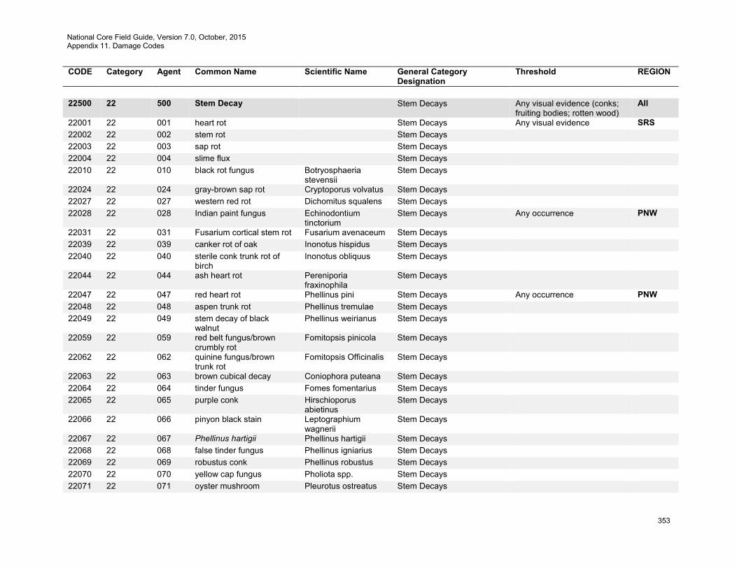
National Core Field Guide, Version 7.0, October, 2015 Appendix 11. Damage Codes
353
CODE Category Agent Common Name Scientific Name General Category Designation
Threshold REGION
22500 22 500 Stem Decay Stem Decays Any visual evidence (conks;
fruiting bodies; rotten wood) All
22001 22 001 heart rot Stem Decays Any visual evidence SRS 22002 22 002 stem rot Stem Decays 22003 22 003 sap rot Stem Decays 22004 22 004 slime flux Stem Decays 22010 22 010 black rot fungus Botryosphaeria
stevensii Stem Decays
22024 22 024 gray-brown sap rot Cryptoporus volvatus Stem Decays 22027 22 027 western red rot Dichomitus squalens Stem Decays 22028 22 028 Indian paint fungus Echinodontium
tinctorium Stem Decays Any occurrence PNW
22031 22 031 Fusarium cortical stem rot Fusarium avenaceum Stem Decays 22039 22 039 canker rot of oak Inonotus hispidus Stem Decays 22040 22 040 sterile conk trunk rot of
birch Inonotus obliquus Stem Decays
22044 22 044 ash heart rot Pereniporia fraxinophila
Stem Decays
22047 22 047 red heart rot Phellinus pini Stem Decays Any occurrence PNW 22048 22 048 aspen trunk rot Phellinus tremulae Stem Decays 22049 22 049 stem decay of black
walnut Phellinus weirianus Stem Decays
22059 22 059 red belt fungus/brown crumbly rot
Fomitopsis pinicola Stem Decays
22062 22 062 quinine fungus/brown trunk rot
Fomitopsis Officinalis Stem Decays
22063 22 063 brown cubical decay Coniophora puteana Stem Decays 22064 22 064 tinder fungus Fomes fomentarius Stem Decays 22065 22 065 purple conk Hirschioporus
abietinus Stem Decays
22066 22 066 pinyon black stain Leptographium wagnerii
Stem Decays
22067 22 067 Phellinus hartigii Phellinus hartigii Stem Decays 22068 22 068 false tinder fungus Phellinus igniarius Stem Decays 22069 22 069 robustus conk Phellinus robustus Stem Decays 22070 22 070 yellow cap fungus Pholiota spp. Stem Decays 22071 22 071 oyster mushroom Pleurotus ostreatus Stem Decays
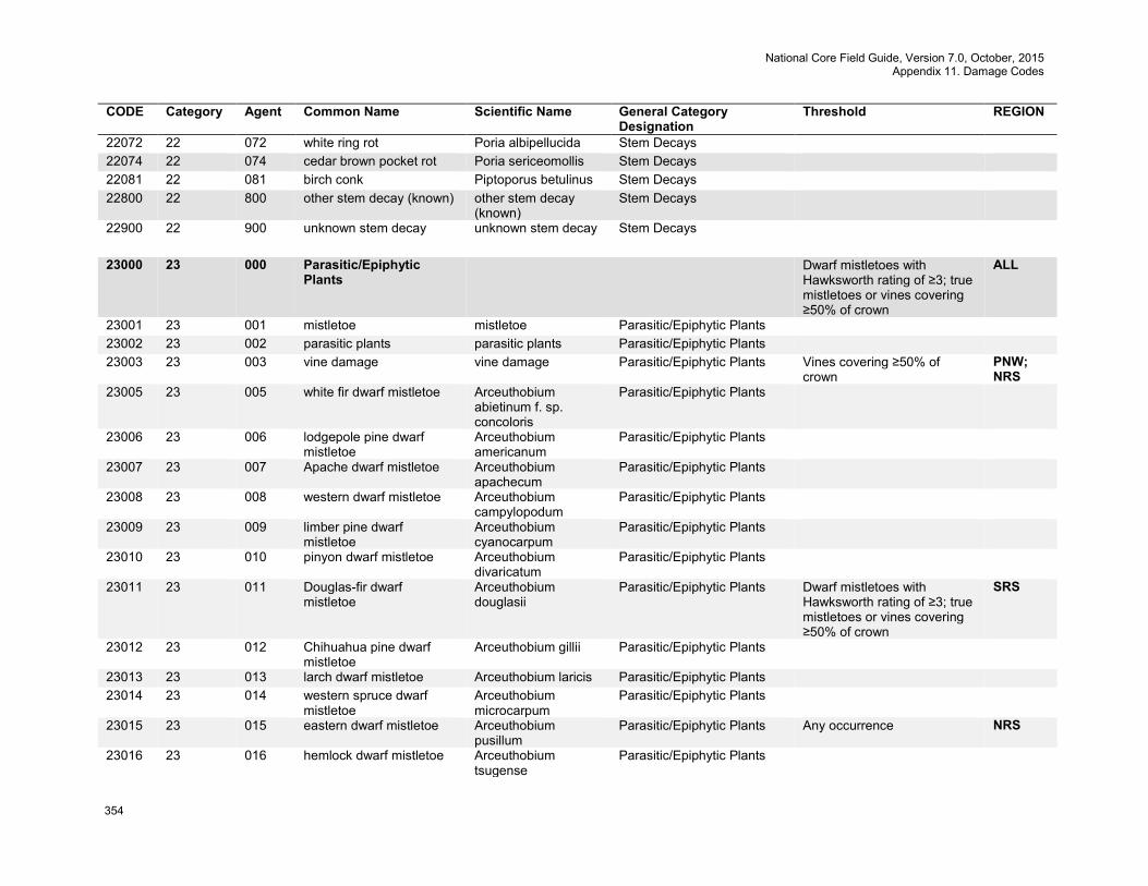
National Core Field Guide, Version 7.0, October, 2015 Appendix 11. Damage Codes
354
CODE Category Agent Common Name Scientific Name General Category Designation
Threshold REGION
22072 22 072 white ring rot Poria albipellucida Stem Decays 22074 22 074 cedar brown pocket rot Poria sericeomollis Stem Decays 22081 22 081 birch conk Piptoporus betulinus Stem Decays 22800 22 800 other stem decay (known) other stem decay
(known) Stem Decays
22900 22 900 unknown stem decay unknown stem decay Stem Decays 23000 23 000 Parasitic/Epiphytic
Plants Dwarf mistletoes with
Hawksworth rating of ≥3; true mistletoes or vines covering ≥50% of crown
ALL
23001 23 001 mistletoe mistletoe Parasitic/Epiphytic Plants 23002 23 002 parasitic plants parasitic plants Parasitic/Epiphytic Plants 23003 23 003 vine damage vine damage Parasitic/Epiphytic Plants Vines covering ≥50% of
crown PNW; NRS
23005 23 005 white fir dwarf mistletoe Arceuthobium abietinum f. sp. concoloris
Parasitic/Epiphytic Plants
23006 23 006 lodgepole pine dwarf mistletoe
Arceuthobium americanum
Parasitic/Epiphytic Plants
23007 23 007 Apache dwarf mistletoe Arceuthobium apachecum
Parasitic/Epiphytic Plants
23008 23 008 western dwarf mistletoe Arceuthobium campylopodum
Parasitic/Epiphytic Plants
23009 23 009 limber pine dwarf mistletoe
Arceuthobium cyanocarpum
Parasitic/Epiphytic Plants
23010 23 010 pinyon dwarf mistletoe Arceuthobium divaricatum
Parasitic/Epiphytic Plants
23011 23 011 Douglas-fir dwarf mistletoe
Arceuthobium douglasii
Parasitic/Epiphytic Plants Dwarf mistletoes with Hawksworth rating of ≥3; true mistletoes or vines covering ≥50% of crown
SRS
23012 23 012 Chihuahua pine dwarf mistletoe
Arceuthobium gillii Parasitic/Epiphytic Plants
23013 23 013 larch dwarf mistletoe Arceuthobium laricis Parasitic/Epiphytic Plants 23014 23 014 western spruce dwarf
mistletoe Arceuthobium microcarpum
Parasitic/Epiphytic Plants
23015 23 015 eastern dwarf mistletoe Arceuthobium pusillum
Parasitic/Epiphytic Plants Any occurrence NRS
23016 23 016 hemlock dwarf mistletoe Arceuthobium tsugense
Parasitic/Epiphytic Plants
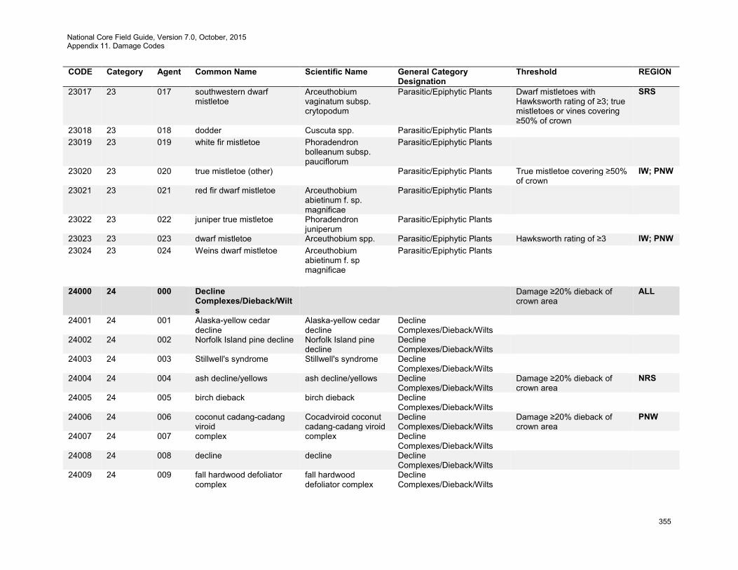
National Core Field Guide, Version 7.0, October, 2015 Appendix 11. Damage Codes
355
CODE Category Agent Common Name Scientific Name General Category Designation
Threshold REGION
23017 23 017 southwestern dwarf mistletoe
Arceuthobium vaginatum subsp. crytopodum
Parasitic/Epiphytic Plants Dwarf mistletoes with Hawksworth rating of ≥3; true mistletoes or vines covering ≥50% of crown
SRS
23018 23 018 dodder Cuscuta spp. Parasitic/Epiphytic Plants 23019 23 019 white fir mistletoe Phoradendron
bolleanum subsp. pauciflorum
Parasitic/Epiphytic Plants
23020 23 020 true mistletoe (other) Parasitic/Epiphytic Plants True mistletoe covering ≥50% of crown
IW; PNW
23021 23 021 red fir dwarf mistletoe Arceuthobium abietinum f. sp. magnificae
Parasitic/Epiphytic Plants
23022 23 022 juniper true mistletoe Phoradendron juniperum
Parasitic/Epiphytic Plants
23023 23 023 dwarf mistletoe Arceuthobium spp. Parasitic/Epiphytic Plants Hawksworth rating of ≥3 IW; PNW 23024 23 024 Weins dwarf mistletoe Arceuthobium
abietinum f. sp magnificae
Parasitic/Epiphytic Plants
24000 24 000 Decline
Complexes/Dieback/Wilts
Damage ≥20% dieback of crown area
ALL
24001 24 001 Alaska-yellow cedar decline
Alaska-yellow cedar decline
Decline Complexes/Dieback/Wilts
24002 24 002 Norfolk Island pine decline Norfolk Island pine decline
Decline Complexes/Dieback/Wilts
24003 24 003 Stillwell's syndrome Stillwell's syndrome Decline Complexes/Dieback/Wilts
24004 24 004 ash decline/yellows ash decline/yellows Decline Complexes/Dieback/Wilts
Damage ≥20% dieback of crown area
NRS
24005 24 005 birch dieback birch dieback Decline Complexes/Dieback/Wilts
24006 24 006 coconut cadang-cadang viroid
Cocadviroid coconut cadang-cadang viroid
Decline Complexes/Dieback/Wilts
Damage ≥20% dieback of crown area
PNW
24007 24 007 complex complex Decline Complexes/Dieback/Wilts
24008 24 008 decline decline Decline Complexes/Dieback/Wilts
24009 24 009 fall hardwood defoliator complex
fall hardwood defoliator complex
Decline Complexes/Dieback/Wilts

National Core Field Guide, Version 7.0, October, 2015 Appendix 11. Damage Codes
356
CODE Category Agent Common Name Scientific Name General Category Designation
Threshold REGION
24010 24 010 joga decline joga decline Decline Complexes/Dieback/Wilts
Damage ≥20% dieback of crown area
PNW
24011 24 011 larch decline larch decline Decline Complexes/Dieback/Wilts
24012 24 012 looper abiotic complex looper abiotic complex
Decline Complexes/Dieback/Wilts
24013 24 013 maple decline maple decline Decline Complexes/Dieback/Wilts
24014 24 014 oak decline Hypoxylon spp. Decline Complexes/Dieback/Wilts
Damage ≥20% dieback of crown area
SRS
24015 24 015 pingelap disease pingelap disease Decline Complexes/Dieback/Wilts
24016 24 016 sprout dieback sprout dieback Decline Complexes/Dieback/Wilts
24017 24 017 true fir pest complex true fir pest complex Decline Complexes/Dieback/Wilts
24018 24 018 western X disease western X disease Decline Complexes/Dieback/Wilts
24019 24 019 pinewood nematode Bursaphelenchus xylophilus
Decline Complexes/Dieback/Wilts
24020 24 020 sapstreak disease of sugar maple
Ceratocystis coerulescens
Decline Complexes/Dieback/Wilts
24021 24 021 oak wilt Ceratocystis fagacearum
Decline Complexes/Dieback/Wilts
Damage ≥20% dieback of crown area
NRS
24022 24 022 Dutch elm disease Ceratocystis ulmi Decline Complexes/Dieback/Wilts
Damage ≥20% dieback of crown area
NRS; SRS
24023 24 023 bacterial wetwood Erwinia nimipressuralis
Decline Complexes/Dieback/Wilts
24024 24 024 mimosa wilt Fusarium oxysporum f. sp. perniciosum
Decline Complexes/Dieback/Wilts
24025 24 025 Verticillium wilt Verticilium albo-atrum Decline Complexes/Dieback/Wilts
24026 24 026 bacterial leaf scorch Xylella fastidiosa Decline Complexes/Dieback/Wilts
24027 24 027 wetwood wetwood Decline Complexes/Dieback/Wilts
24028 24 028 hemlock decline hemlock decline Decline Complexes/Dieback/Wilts
24029 24 029 Pacific madrone decline Pacific madrone decline
Decline Complexes/Dieback/Wilts
24030 24 030 elm phloem necrosis Mycoplasma spp. Decline Complexes/Dieback/Wilts
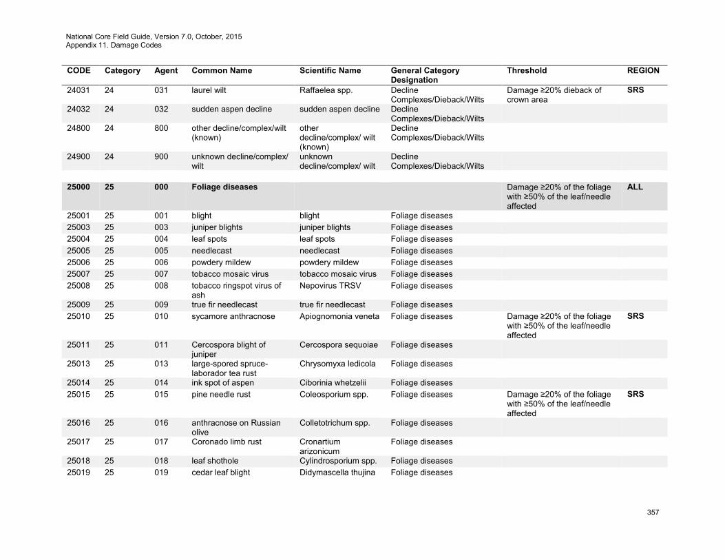
National Core Field Guide, Version 7.0, October, 2015 Appendix 11. Damage Codes
357
CODE Category Agent Common Name Scientific Name General Category Designation
Threshold REGION
24031 24 031 laurel wilt Raffaelea spp. Decline Complexes/Dieback/Wilts
Damage ≥20% dieback of crown area
SRS
24032 24 032 sudden aspen decline sudden aspen decline Decline Complexes/Dieback/Wilts
24800 24 800 other decline/complex/wilt (known)
other decline/complex/ wilt (known)
Decline Complexes/Dieback/Wilts
24900 24 900 unknown decline/complex/ wilt
unknown decline/complex/ wilt
Decline Complexes/Dieback/Wilts
25000 25 000 Foliage diseases Damage ≥20% of the foliage
with ≥50% of the leaf/needle affected
ALL
25001 25 001 blight blight Foliage diseases 25003 25 003 juniper blights juniper blights Foliage diseases 25004 25 004 leaf spots leaf spots Foliage diseases 25005 25 005 needlecast needlecast Foliage diseases 25006 25 006 powdery mildew powdery mildew Foliage diseases 25007 25 007 tobacco mosaic virus tobacco mosaic virus Foliage diseases 25008 25 008 tobacco ringspot virus of
ash Nepovirus TRSV Foliage diseases
25009 25 009 true fir needlecast true fir needlecast Foliage diseases 25010 25 010 sycamore anthracnose Apiognomonia veneta Foliage diseases Damage ≥20% of the foliage
with ≥50% of the leaf/needle affected
SRS
25011 25 011 Cercospora blight of juniper
Cercospora sequoiae Foliage diseases
25013 25 013 large-spored spruce-laborador tea rust
Chrysomyxa ledicola Foliage diseases
25014 25 014 ink spot of aspen Ciborinia whetzelii Foliage diseases 25015 25 015 pine needle rust Coleosporium spp. Foliage diseases Damage ≥20% of the foliage
with ≥50% of the leaf/needle affected
SRS
25016 25 016 anthracnose on Russian olive
Colletotrichum spp. Foliage diseases
25017 25 017 Coronado limb rust Cronartium arizonicum
Foliage diseases
25018 25 018 leaf shothole Cylindrosporium spp. Foliage diseases 25019 25 019 cedar leaf blight Didymascella thujina Foliage diseases
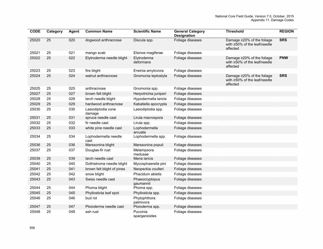
National Core Field Guide, Version 7.0, October, 2015 Appendix 11. Damage Codes
358
CODE Category Agent Common Name Scientific Name General Category Designation
Threshold REGION
25020 25 020 dogwood anthracnose Discula spp. Foliage diseases Damage ≥20% of the foliage with ≥50% of the leaf/needle affected
SRS
25021 25 021 mango scab Elsinoe magiferae Foliage diseases 25022 25 022 Elytroderma needle blight Elytroderma
deformans Foliage diseases Damage ≥20% of the foliage
with ≥50% of the leaf/needle affected
PNW
25023 25 023 fire blight Erwinia amylovora Foliage diseases 25024 25 024 walnut anthracnose Gnomonia leptostyla Foliage diseases Damage ≥20% of the foliage
with ≥50% of the leaf/needle affected
SRS
25025 25 025 anthracnose Gnomonia spp. Foliage diseases 25027 25 027 brown felt blight Herpotrichia juniperi Foliage diseases 25028 25 028 larch needle blight Hypodermella laricis Foliage diseases 25029 25 029 hardwood anthracnose Kabatiella apocrypta Foliage diseases 25030 25 030 Lasiodiplodia cone
damage Lasiodiplodia spp. Foliage diseases
25031 25 031 spruce needle cast Lirula macrospora Foliage diseases 25032 25 032 fir needle cast Lirula spp. Foliage diseases 25033 25 033 white pine needle cast Lophodermella
arcuata Foliage diseases
25034 25 034 Lophodermella needle cast
Lophodermella spp. Foliage diseases
25036 25 036 Marssonina blight Marssonina populi Foliage diseases 25037 25 037 Douglas-fir rust Melampsora
medusae Foliage diseases
25039 25 039 larch needle cast Meria laricis Foliage diseases 25040 25 040 Dothistroma needle blight Mycosphaerella pini Foliage diseases 25041 25 041 brown felt blight of pines Neopeckia coulteri Foliage diseases 25042 25 042 snow blight Phacidum abietis Foliage diseases 25043 25 043 Swiss needle cast Phaeocryptopus
gaumannii Foliage diseases
25044 25 044 Phoma blight Phoma spp. Foliage diseases 25045 25 045 Phyllosticta leaf spot Phyllosticta spp. Foliage diseases 25046 25 046 bud rot Phytophthora
palmivora Foliage diseases
25047 25 047 Ploioderma needle cast Ploioderma spp. Foliage diseases 25048 25 048 ash rust Puccinia
sparganioides Foliage diseases
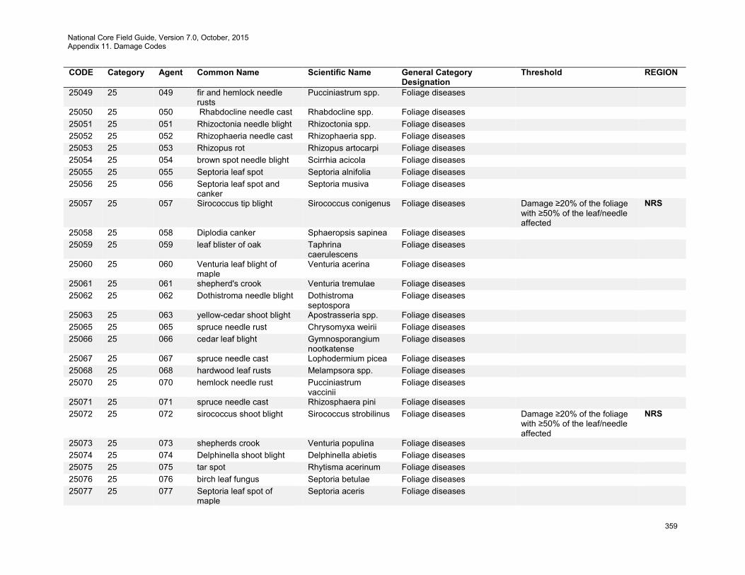
National Core Field Guide, Version 7.0, October, 2015 Appendix 11. Damage Codes
359
CODE Category Agent Common Name Scientific Name General Category Designation
Threshold REGION
25049 25 049 fir and hemlock needle rusts
Pucciniastrum spp. Foliage diseases
25050 25 050 Rhabdocline needle cast Rhabdocline spp. Foliage diseases 25051 25 051 Rhizoctonia needle blight Rhizoctonia spp. Foliage diseases 25052 25 052 Rhizophaeria needle cast Rhizophaeria spp. Foliage diseases 25053 25 053 Rhizopus rot Rhizopus artocarpi Foliage diseases 25054 25 054 brown spot needle blight Scirrhia acicola Foliage diseases 25055 25 055 Septoria leaf spot Septoria alnifolia Foliage diseases 25056 25 056 Septoria leaf spot and
canker Septoria musiva Foliage diseases
25057 25 057 Sirococcus tip blight Sirococcus conigenus Foliage diseases Damage ≥20% of the foliage with ≥50% of the leaf/needle affected
NRS
25058 25 058 Diplodia canker Sphaeropsis sapinea Foliage diseases 25059 25 059 leaf blister of oak Taphrina
caerulescens Foliage diseases
25060 25 060 Venturia leaf blight of maple
Venturia acerina Foliage diseases
25061 25 061 shepherd's crook Venturia tremulae Foliage diseases 25062 25 062 Dothistroma needle blight Dothistroma
septospora Foliage diseases
25063 25 063 yellow-cedar shoot blight Apostrasseria spp. Foliage diseases 25065 25 065 spruce needle rust Chrysomyxa weirii Foliage diseases 25066 25 066 cedar leaf blight Gymnosporangium
nootkatense Foliage diseases
25067 25 067 spruce needle cast Lophodermium picea Foliage diseases 25068 25 068 hardwood leaf rusts Melampsora spp. Foliage diseases 25070 25 070 hemlock needle rust Pucciniastrum
vaccinii Foliage diseases
25071 25 071 spruce needle cast Rhizosphaera pini Foliage diseases 25072 25 072 sirococcus shoot blight Sirococcus strobilinus Foliage diseases Damage ≥20% of the foliage
with ≥50% of the leaf/needle affected
NRS
25073 25 073 shepherds crook Venturia populina Foliage diseases 25074 25 074 Delphinella shoot blight Delphinella abietis Foliage diseases 25075 25 075 tar spot Rhytisma acerinum Foliage diseases 25076 25 076 birch leaf fungus Septoria betulae Foliage diseases 25077 25 077 Septoria leaf spot of
maple Septoria aceris Foliage diseases

National Core Field Guide, Version 7.0, October, 2015 Appendix 11. Damage Codes
360
CODE Category Agent Common Name Scientific Name General Category Designation
Threshold REGION
25800 25 800 other /shoot disease (known)
other /shoot disease (known)
Foliage diseases
25900 25 900 unknown foliage /shoot disease
Unknown foliage /shoot disease
Foliage diseases
26000 26 000 Stem Rusts Any occurrence on the bole
or stems (on multi-stemmed woodland species), or on branches ≤1 foot from boles or stems; damage to ≥20% of branches
ALL
26001 26 001 white pine blister rust Cronartium ribicola Stem Rusts Any occurrence on the bole or stems (on multi-stemmed woodland species), or on branches ≤1 foot from boles or stems; damage to ≥20% of branches
PNW; SRS
26002 26 002 western gall rust Peridermium harknessii
Stem Rusts Any occurrence on the bole or stems (on multi-stemmed woodland species), or on branches ≤1 foot from boles or stems; damage to ≥20% of branches
PNW
26003 26 003 stalactiform blister rust Cronartium coleosporioides
Stem Rusts
26004 26 004 comandra blister rust Cronartium comandrae
Stem Rusts Any occurrence on the bole or stems (on multi-stemmed woodland species), or on branches ≤1 foot from boles or stems; damage to ≥20% of branches
SRS
26005 26 005 pinyon rust Cronartium occidentale
Stem Rusts
26006 26 006 eastern gall rust Cronartium quercuum Stem Rusts Any occurrence on the bole or stems (on multi-stemmed woodland species), or on branches ≤1 foot from boles or stems; damage to ≥20% of branches
SRS
26007 26 007 gall rust of jack pine Cronartium quercuum f. sp. banksignae
Stem Rusts
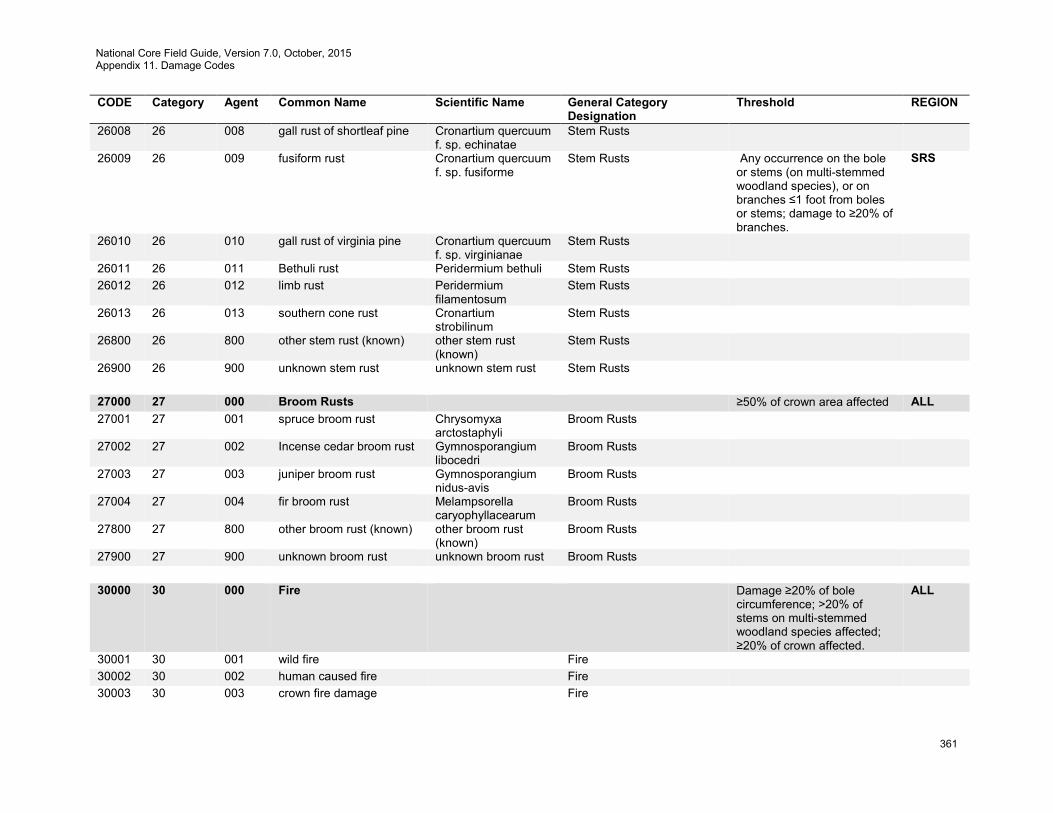
National Core Field Guide, Version 7.0, October, 2015 Appendix 11. Damage Codes
361
CODE Category Agent Common Name Scientific Name General Category Designation
Threshold REGION
26008 26 008 gall rust of shortleaf pine Cronartium quercuum f. sp. echinatae
Stem Rusts
26009 26 009 fusiform rust Cronartium quercuum f. sp. fusiforme
Stem Rusts Any occurrence on the bole or stems (on multi-stemmed woodland species), or on branches ≤1 foot from boles or stems; damage to ≥20% of branches.
SRS
26010 26 010 gall rust of virginia pine Cronartium quercuum f. sp. virginianae
Stem Rusts
26011 26 011 Bethuli rust Peridermium bethuli Stem Rusts 26012 26 012 limb rust Peridermium
filamentosum Stem Rusts
26013 26 013 southern cone rust Cronartium strobilinum
Stem Rusts
26800 26 800 other stem rust (known) other stem rust (known)
Stem Rusts
26900 26 900 unknown stem rust unknown stem rust Stem Rusts 27000 27 000 Broom Rusts ≥50% of crown area affected ALL 27001 27 001 spruce broom rust Chrysomyxa
arctostaphyli Broom Rusts
27002 27 002 Incense cedar broom rust Gymnosporangium libocedri
Broom Rusts
27003 27 003 juniper broom rust Gymnosporangium nidus-avis
Broom Rusts
27004 27 004 fir broom rust Melampsorella caryophyllacearum
Broom Rusts
27800 27 800 other broom rust (known) other broom rust (known)
Broom Rusts
27900 27 900 unknown broom rust unknown broom rust Broom Rusts 30000 30 000 Fire Damage ≥20% of bole
circumference; >20% of stems on multi-stemmed woodland species affected; ≥20% of crown affected.
ALL
30001 30 001 wild fire Fire 30002 30 002 human caused fire Fire 30003 30 003 crown fire damage Fire
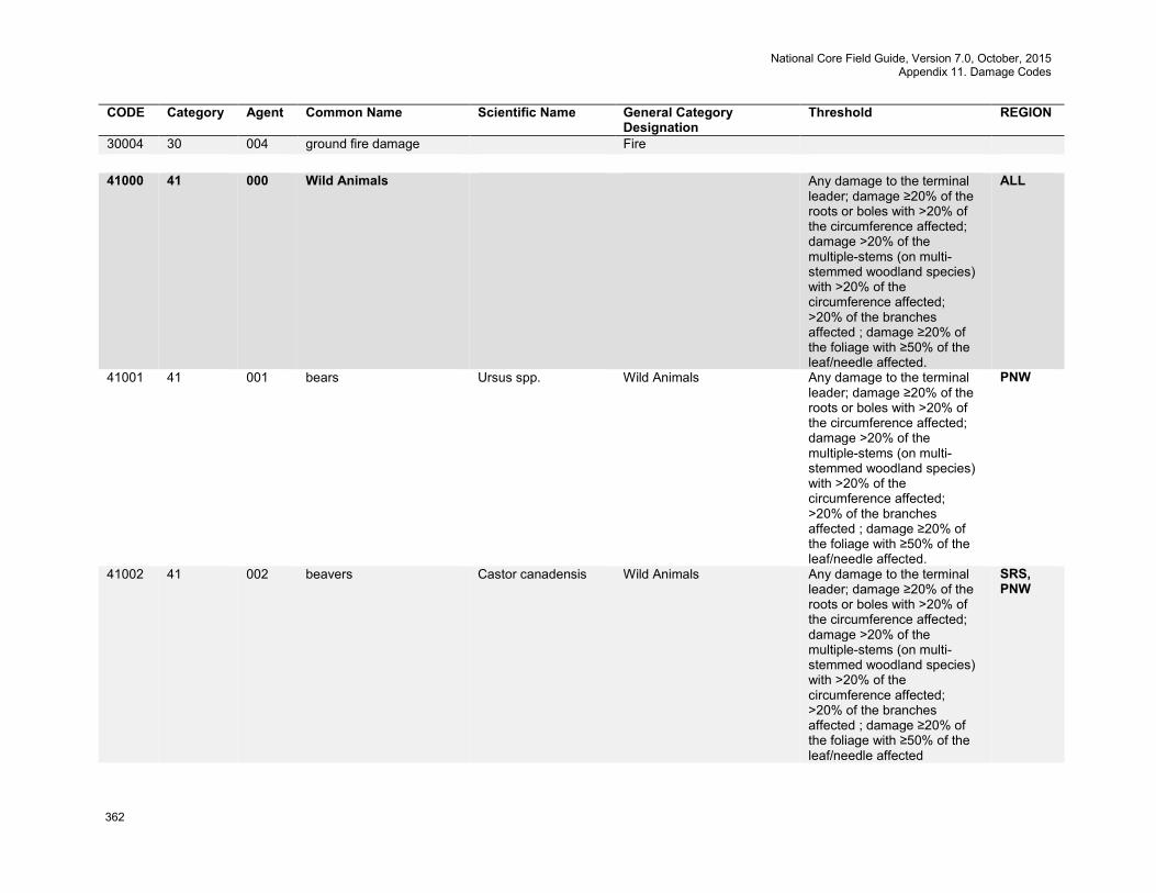
National Core Field Guide, Version 7.0, October, 2015 Appendix 11. Damage Codes
362
CODE Category Agent Common Name Scientific Name General Category Designation
Threshold REGION
30004 30 004 ground fire damage Fire 41000 41 000 Wild Animals Any damage to the terminal
leader; damage ≥20% of the roots or boles with >20% of the circumference affected; damage >20% of the multiple-stems (on multi-stemmed woodland species) with >20% of the circumference affected; >20% of the branches affected ; damage ≥20% of the foliage with ≥50% of the leaf/needle affected.
ALL
41001 41 001 bears Ursus spp. Wild Animals Any damage to the terminal leader; damage ≥20% of the roots or boles with >20% of the circumference affected; damage >20% of the multiple-stems (on multi-stemmed woodland species) with >20% of the circumference affected; >20% of the branches affected ; damage ≥20% of the foliage with ≥50% of the leaf/needle affected.
PNW
41002 41 002 beavers Castor canadensis Wild Animals Any damage to the terminal leader; damage ≥20% of the roots or boles with >20% of the circumference affected; damage >20% of the multiple-stems (on multi-stemmed woodland species) with >20% of the circumference affected; >20% of the branches affected ; damage ≥20% of the foliage with ≥50% of the leaf/needle affected
SRS, PNW
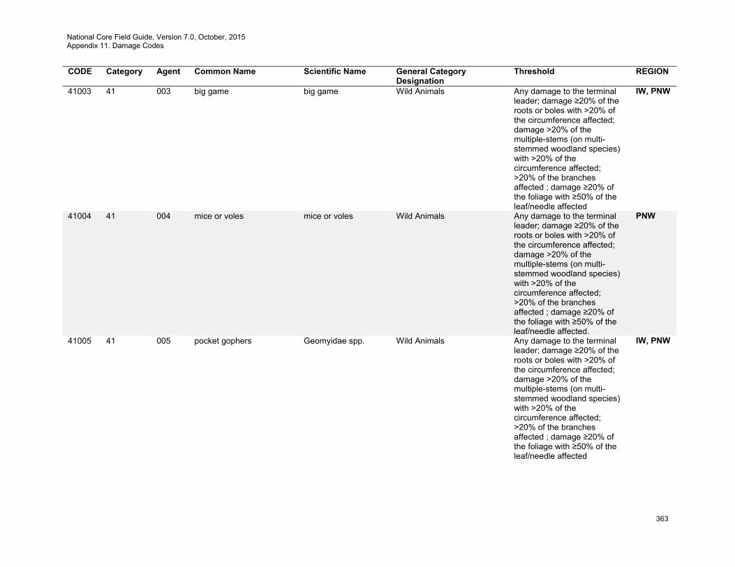
National Core Field Guide, Version 7.0, October, 2015 Appendix 11. Damage Codes
363
CODE Category Agent Common Name Scientific Name General Category Designation
Threshold REGION
41003 41 003 big game big game Wild Animals Any damage to the terminal leader; damage ≥20% of the roots or boles with >20% of the circumference affected; damage >20% of the multiple-stems (on multi-stemmed woodland species) with >20% of the circumference affected; >20% of the branches affected ; damage ≥20% of the foliage with ≥50% of the leaf/needle affected
IW, PNW
41004 41 004 mice or voles mice or voles Wild Animals Any damage to the terminal leader; damage ≥20% of the roots or boles with >20% of the circumference affected; damage >20% of the multiple-stems (on multi-stemmed woodland species) with >20% of the circumference affected; >20% of the branches affected ; damage ≥20% of the foliage with ≥50% of the leaf/needle affected.
PNW
41005 41 005 pocket gophers Geomyidae spp. Wild Animals Any damage to the terminal leader; damage ≥20% of the roots or boles with >20% of the circumference affected; damage >20% of the multiple-stems (on multi-stemmed woodland species) with >20% of the circumference affected; >20% of the branches affected ; damage ≥20% of the foliage with ≥50% of the leaf/needle affected
IW, PNW
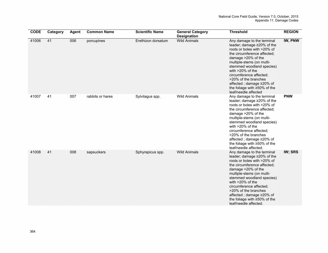
National Core Field Guide, Version 7.0, October, 2015 Appendix 11. Damage Codes
364
CODE Category Agent Common Name Scientific Name General Category Designation
Threshold REGION
41006 41 006 porcupines Erethizon dorsatum Wild Animals Any damage to the terminal leader; damage ≥20% of the roots or boles with >20% of the circumference affected; damage >20% of the multiple-stems (on multi-stemmed woodland species) with >20% of the circumference affected; >20% of the branches affected ; damage ≥20% of the foliage with ≥50% of the leaf/needle affected
IW, PNW
41007 41 007 rabbits or hares Sylvilagus spp. Wild Animals Any damage to the terminal leader; damage ≥20% of the roots or boles with >20% of the circumference affected; damage >20% of the multiple-stems (on multi-stemmed woodland species) with >20% of the circumference affected; >20% of the branches affected ; damage ≥20% of the foliage with ≥50% of the leaf/needle affected.
PNW
41008 41 008 sapsuckers Sphyrapicus spp. Wild Animals Any damage to the terminal leader; damage ≥20% of the roots or boles with >20% of the circumference affected; damage >20% of the multiple-stems (on multi-stemmed woodland species) with >20% of the circumference affected; >20% of the branches affected ; damage ≥20% of the foliage with ≥50% of the leaf/needle affected.
IW; SRS
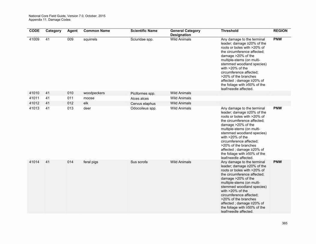
National Core Field Guide, Version 7.0, October, 2015 Appendix 11. Damage Codes
365
CODE Category Agent Common Name Scientific Name General Category Designation
Threshold REGION
41009 41 009 squirrels Sciuridae spp. Wild Animals Any damage to the terminal leader; damage ≥20% of the roots or boles with >20% of the circumference affected; damage >20% of the multiple-stems (on multi-stemmed woodland species) with >20% of the circumference affected; >20% of the branches affected ; damage ≥20% of the foliage with ≥50% of the leaf/needle affected.
PNW
41010 41 010 woodpeckers Piciformes spp. Wild Animals 41011 41 011 moose Alces alces Wild Animals 41012 41 012 elk Cervus elaphus Wild Animals 41013 41 013 deer Odocoileus spp. Wild Animals Any damage to the terminal
leader; damage ≥20% of the roots or boles with >20% of the circumference affected; damage >20% of the multiple-stems (on multi-stemmed woodland species) with >20% of the circumference affected; >20% of the branches affected ; damage ≥20% of the foliage with ≥50% of the leaf/needle affected.
PNW
41014 41 014 feral pigs Sus scrofa Wild Animals Any damage to the terminal leader; damage ≥20% of the roots or boles with >20% of the circumference affected; damage >20% of the multiple-stems (on multi-stemmed woodland species) with >20% of the circumference affected; >20% of the branches affected ; damage ≥20% of the foliage with ≥50% of the leaf/needle affected.
PNW
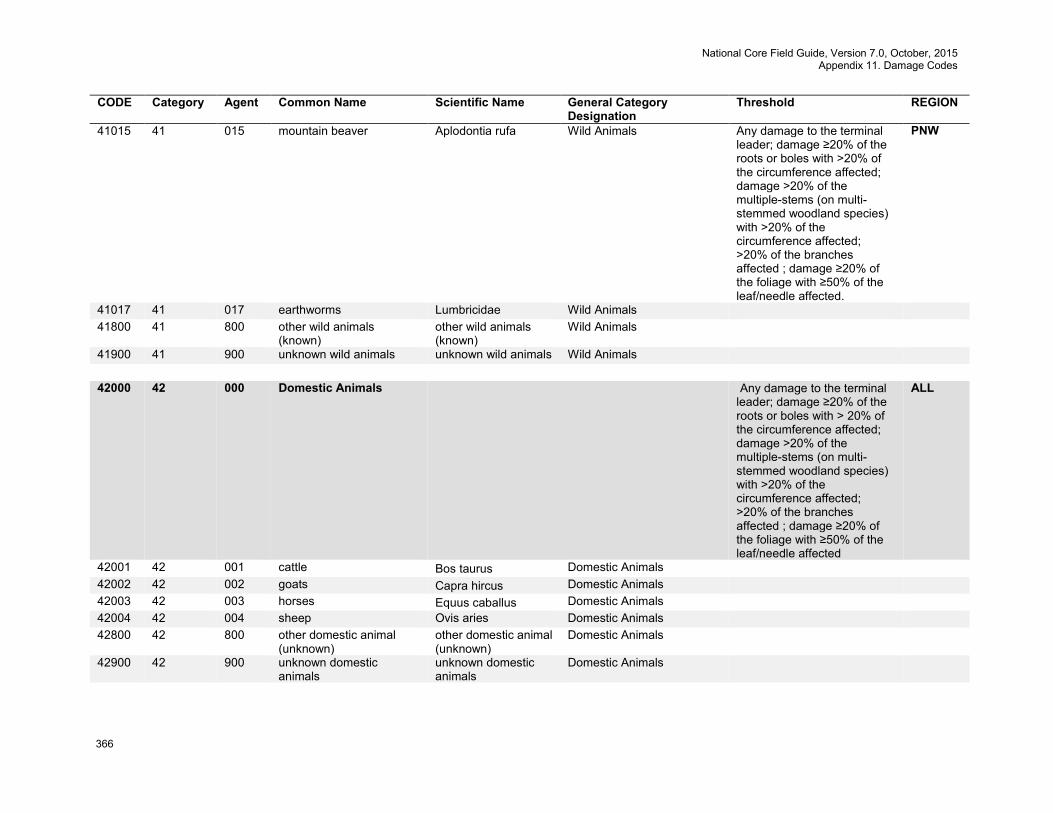
National Core Field Guide, Version 7.0, October, 2015 Appendix 11. Damage Codes
366
CODE Category Agent Common Name Scientific Name General Category Designation
Threshold REGION
41015 41 015 mountain beaver Aplodontia rufa Wild Animals Any damage to the terminal leader; damage ≥20% of the roots or boles with >20% of the circumference affected; damage >20% of the multiple-stems (on multi-stemmed woodland species) with >20% of the circumference affected; >20% of the branches affected ; damage ≥20% of the foliage with ≥50% of the leaf/needle affected.
PNW
41017 41 017 earthworms Lumbricidae Wild Animals 41800 41 800 other wild animals
(known) other wild animals (known)
Wild Animals
41900 41 900 unknown wild animals unknown wild animals Wild Animals 42000 42 000 Domestic Animals Any damage to the terminal
leader; damage ≥20% of the roots or boles with > 20% of the circumference affected; damage >20% of the multiple-stems (on multi-stemmed woodland species) with >20% of the circumference affected; >20% of the branches affected ; damage ≥20% of the foliage with ≥50% of the leaf/needle affected
ALL
42001 42 001 cattle Bos taurus Domestic Animals 42002 42 002 goats Capra hircus Domestic Animals 42003 42 003 horses Equus caballus Domestic Animals 42004 42 004 sheep Ovis aries Domestic Animals 42800 42 800 other domestic animal
(unknown) other domestic animal (unknown)
Domestic Animals
42900 42 900 unknown domestic animals
unknown domestic animals
Domestic Animals
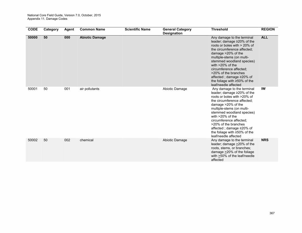
National Core Field Guide, Version 7.0, October, 2015 Appendix 11. Damage Codes
367
CODE Category Agent Common Name Scientific Name General Category Designation
Threshold REGION
50000 50 000 Abiotic Damage Any damage to the terminal leader; damage ≥20% of the roots or boles with > 20% of the circumference affected; damage >20% of the multiple-stems (on multi-stemmed woodland species) with >20% of the circumference affected; >20% of the branches affected ; damage ≥20% of the foliage with ≥50% of the leaf/needle affected
ALL
50001 50 001 air pollutants Abiotic Damage Any damage to the terminal leader; damage ≥20% of the roots or boles with >20% of the circumference affected; damage >20% of the multiple-stems (on multi-stemmed woodland species) with >20% of the circumference affected; >20% of the branches affected ; damage ≥20% of the foliage with ≥50% of the leaf/needle affected
IW
50002 50 002 chemical Abiotic Damage Any damage to the terminal leader; damage >20% of the roots, stems, or branches; damage >20% of the foliage with >50% of the leaf/needle affected
NRS
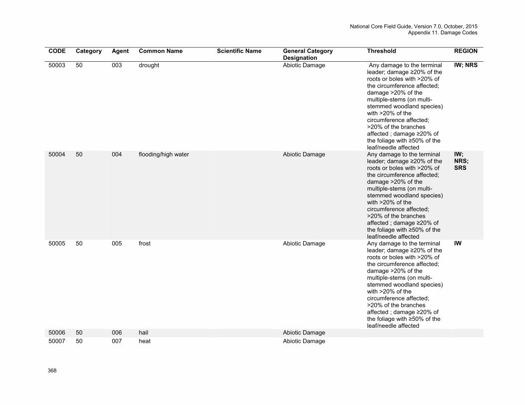
National Core Field Guide, Version 7.0, October, 2015 Appendix 11. Damage Codes
368
CODE Category Agent Common Name Scientific Name General Category Designation
Threshold REGION
50003 50 003 drought Abiotic Damage Any damage to the terminal leader; damage ≥20% of the roots or boles with >20% of the circumference affected; damage >20% of the multiple-stems (on multi-stemmed woodland species) with >20% of the circumference affected; >20% of the branches affected ; damage ≥20% of the foliage with ≥50% of the leaf/needle affected
IW; NRS
50004 50 004 flooding/high water Abiotic Damage Any damage to the terminal leader; damage ≥20% of the roots or boles with >20% of the circumference affected; damage >20% of the multiple-stems (on multi-stemmed woodland species) with >20% of the circumference affected; >20% of the branches affected ; damage ≥20% of the foliage with ≥50% of the leaf/needle affected
IW; NRS; SRS
50005 50 005 frost Abiotic Damage Any damage to the terminal leader; damage ≥20% of the roots or boles with >20% of the circumference affected; damage >20% of the multiple-stems (on multi-stemmed woodland species) with >20% of the circumference affected; >20% of the branches affected ; damage ≥20% of the foliage with ≥50% of the leaf/needle affected
IW
50006 50 006 hail Abiotic Damage 50007 50 007 heat Abiotic Damage
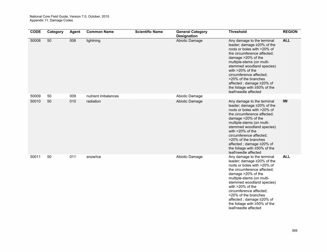
National Core Field Guide, Version 7.0, October, 2015 Appendix 11. Damage Codes
369
CODE Category Agent Common Name Scientific Name General Category Designation
Threshold REGION
50008 50 008 lightning Abiotic Damage Any damage to the terminal leader; damage ≥20% of the roots or boles with >20% of the circumference affected; damage >20% of the multiple-stems (on multi-stemmed woodland species) with >20% of the circumference affected; >20% of the branches affected ; damage ≥20% of the foliage with ≥50% of the leaf/needle affected
ALL
50009 50 009 nutrient imbalances Abiotic Damage 50010 50 010 radiation Abiotic Damage Any damage to the terminal
leader; damage ≥20% of the roots or boles with >20% of the circumference affected; damage >20% of the multiple-stems (on multi-stemmed woodland species) with >20% of the circumference affected; >20% of the branches affected ; damage ≥20% of the foliage with ≥50% of the leaf/needle affected
IW
50011 50 011 snow/ice Abiotic Damage Any damage to the terminal leader; damage ≥20% of the roots or boles with >20% of the circumference affected; damage >20% of the multiple-stems (on multi-stemmed woodland species) with >20% of the circumference affected; >20% of the branches affected ; damage ≥20% of the foliage with ≥50% of the leaf/needle affected
ALL

National Core Field Guide, Version 7.0, October, 2015 Appendix 11. Damage Codes
370
CODE Category Agent Common Name Scientific Name General Category Designation
Threshold REGION
50013 50 013 wind Abiotic Damage Any damage to the terminal leader; damage ≥20% of the roots or boles with >20% of the circumference affected; damage >20% of the multiple-stems (on multi-stemmed woodland species) with >20% of the circumference affected; >20% of the branches affected ; damage ≥ 20% of the foliage with ≥50% of the leaf/needle affected
ALL
50014 50 014 winter injury Abiotic Damage Any damage to the terminal leader; damage ≥20% of the roots or boles with >20% of the circumference affected; damage >20% of the multiple-stems (on multi-stemmed woodland species) with >20% of the circumference affected; >20% of the branches affected ; damage ≥20% of the foliage with ≥50% of the leaf/needle affected
IW
50015 50 015 avalanche Abiotic Damage Any damage to the terminal leader; damage ≥20% of the roots or boles with >20% of the circumference affected; damage >20% of the multiple-stems (on multi-stemmed woodland species) with >20% of the circumference affected; >20% of the branches affected ; damage ≥20% of the foliage with ≥50% of the leaf/needle affected
IW
50016 50 016 mud-land slide Abiotic Damage 50017 50 017 volcano Abiotic Damage 50018 50 018 other geologic event Abiotic Damage

National Core Field Guide, Version 7.0, October, 2015 Appendix 11. Damage Codes
371
CODE Category Agent Common Name Scientific Name General Category Designation
Threshold REGION
50019 50 019 mechanical (non-human caused)
Abiotic Damage
50020 50 020 saltwater injury - flooding/hurricane
Abiotic Damage Any damage to the terminal leader; damage ≥20% of the roots or boles with >20% of the circumference affected; damage >20% of the multiple-stems (on multi-stemmed woodland species) with >20% of the circumference affected; >20% of the branches affected ; damage ≥20% of the foliage with ≥50% of the leaf/needle affected
PNW
50800 50 800 other abiotic damage (known)
other abiotic damage (known)
Abiotic Damage
50900 50 900 unknown abiotic damage unknown abiotic damage
Abiotic Damage
60000 60 000 Competition Overtopped shade intolerant
trees that are not expected to survive for 5 years or saplings not expected to reach tree size (5.0 inches DBH/DRC)
ALL
60001 60 001 Suppression Competition Damage Overtopped shade intolerant trees that are not expected to survive for 5 years or saplings not expected to reach tree size (5.0 inches DBH/DRC)
IW
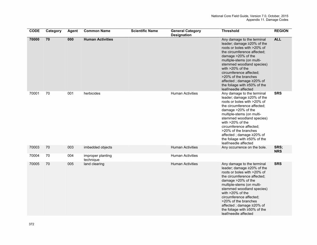
National Core Field Guide, Version 7.0, October, 2015 Appendix 11. Damage Codes
372
CODE Category Agent Common Name Scientific Name General Category Designation
Threshold REGION
70000 70 000 Human Activities Any damage to the terminal leader; damage ≥20% of the roots or boles with >20% of the circumference affected; damage >20% of the multiple-stems (on multi-stemmed woodland species) with >20% of the circumference affected; >20% of the branches affected ; damage ≥20% of the foliage with ≥50% of the leaf/needle affected
ALL
70001 70 001 herbicides Human Activities Any damage to the terminal leader; damage ≥20% of the roots or boles with >20% of the circumference affected; damage >20% of the multiple-stems (on multi-stemmed woodland species) with >20% of the circumference affected; >20% of the branches affected ; damage ≥20% of the foliage with ≥50% of the leaf/needle affected
SRS
70003 70 003 imbedded objects Human Activities Any occurrence on the bole. SRS; NRS
70004 70 004 improper planting technique
Human Activities
70005 70 005 land clearing Human Activities Any damage to the terminal leader; damage ≥20% of the roots or boles with >20% of the circumference affected; damage >20% of the multiple-stems (on multi-stemmed woodland species) with >20% of the circumference affected; >20% of the branches affected ; damage ≥20% of the foliage with ≥50% of the leaf/needle affected
SRS
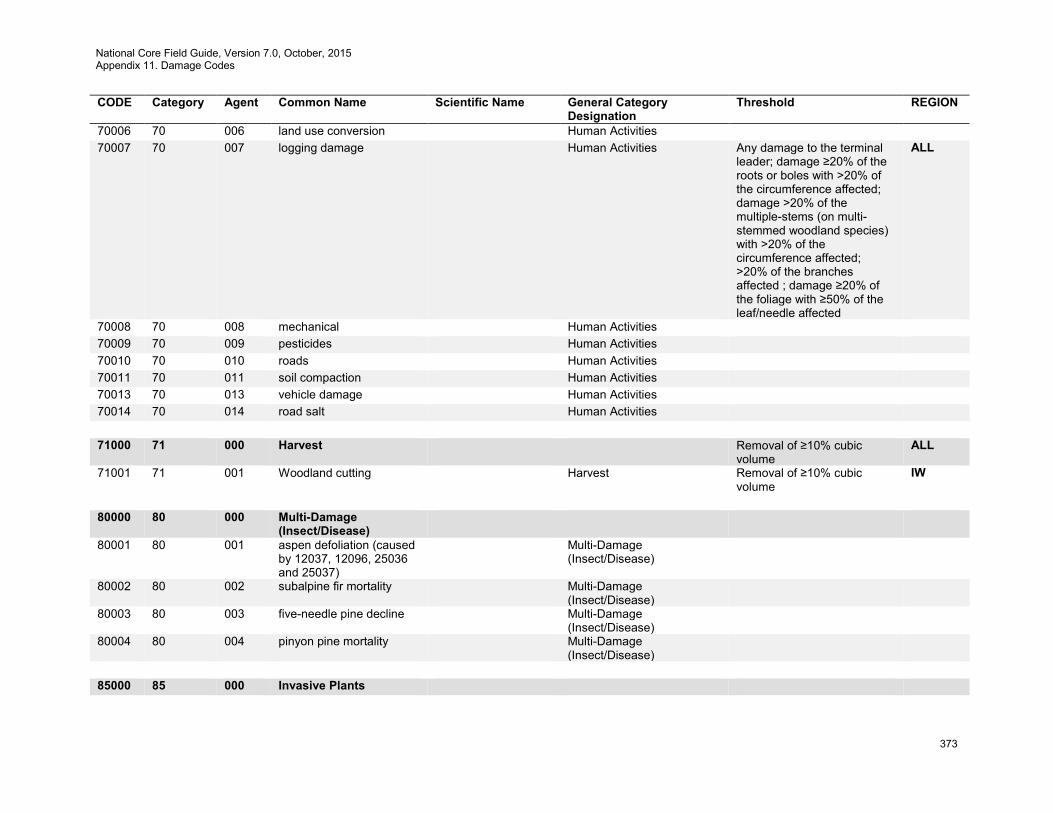
National Core Field Guide, Version 7.0, October, 2015 Appendix 11. Damage Codes
373
CODE Category Agent Common Name Scientific Name General Category Designation
Threshold REGION
70006 70 006 land use conversion Human Activities 70007 70 007 logging damage Human Activities Any damage to the terminal
leader; damage ≥20% of the roots or boles with >20% of the circumference affected; damage >20% of the multiple-stems (on multi-stemmed woodland species) with >20% of the circumference affected; >20% of the branches affected ; damage ≥20% of the foliage with ≥50% of the leaf/needle affected
ALL
70008 70 008 mechanical Human Activities 70009 70 009 pesticides Human Activities 70010 70 010 roads Human Activities 70011 70 011 soil compaction Human Activities 70013 70 013 vehicle damage Human Activities 70014 70 014 road salt Human Activities 71000 71 000 Harvest Removal of ≥10% cubic
volume ALL
71001 71 001 Woodland cutting Harvest Removal of ≥10% cubic volume
IW
80000 80 000 Multi-Damage
(Insect/Disease)
80001 80 001 aspen defoliation (caused by 12037, 12096, 25036 and 25037)
Multi-Damage (Insect/Disease)
80002 80 002 subalpine fir mortality Multi-Damage (Insect/Disease)
80003 80 003 five-needle pine decline Multi-Damage (Insect/Disease)
80004 80 004 pinyon pine mortality Multi-Damage (Insect/Disease)
85000 85 000 Invasive Plants
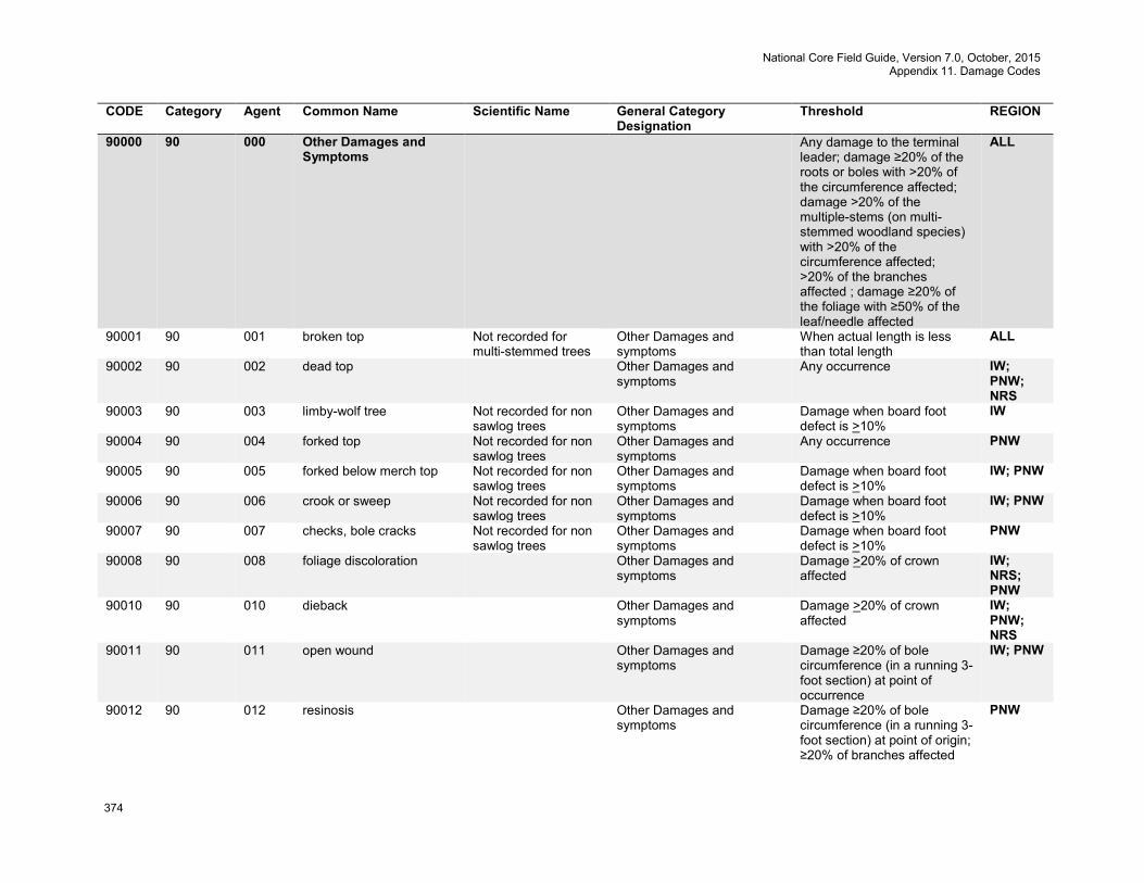
National Core Field Guide, Version 7.0, October, 2015 Appendix 11. Damage Codes
374
CODE Category Agent Common Name Scientific Name General Category Designation
Threshold REGION
90000 90 000 Other Damages and Symptoms
Any damage to the terminal leader; damage ≥20% of the roots or boles with >20% of the circumference affected; damage >20% of the multiple-stems (on multi-stemmed woodland species) with >20% of the circumference affected; >20% of the branches affected ; damage ≥20% of the foliage with ≥50% of the leaf/needle affected
ALL
90001 90 001 broken top Not recorded for multi-stemmed trees
Other Damages and symptoms
When actual length is less than total length
ALL
90002 90 002 dead top Other Damages and symptoms
Any occurrence IW; PNW; NRS
90003 90 003 limby-wolf tree Not recorded for non sawlog trees
Other Damages and symptoms
Damage when board foot defect is >10%
IW
90004 90 004 forked top Not recorded for non sawlog trees
Other Damages and symptoms
Any occurrence PNW
90005 90 005 forked below merch top Not recorded for non sawlog trees
Other Damages and symptoms
Damage when board foot defect is >10%
IW; PNW
90006 90 006 crook or sweep Not recorded for non sawlog trees
Other Damages and symptoms
Damage when board foot defect is >10%
IW; PNW
90007 90 007 checks, bole cracks Not recorded for non sawlog trees
Other Damages and symptoms
Damage when board foot defect is >10%
PNW
90008 90 008 foliage discoloration Other Damages and symptoms
Damage >20% of crown affected
IW; NRS; PNW
90010 90 010 dieback Other Damages and symptoms
Damage >20% of crown affected
IW; PNW; NRS
90011 90 011 open wound Other Damages and symptoms
Damage ≥20% of bole circumference (in a running 3-foot section) at point of occurrence
IW; PNW
90012 90 012 resinosis Other Damages and symptoms
Damage ≥20% of bole circumference (in a running 3-foot section) at point of origin; ≥20% of branches affected
PNW
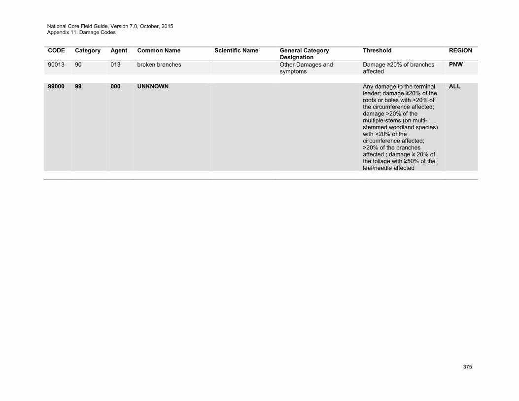
National Core Field Guide, Version 7.0, October, 2015 Appendix 11. Damage Codes
375
CODE Category Agent Common Name Scientific Name General Category Designation
Threshold REGION
90013 90 013 broken branches Other Damages and symptoms
Damage ≥20% of branches affected
PNW
99000 99 000 UNKNOWN Any damage to the terminal
leader; damage ≥20% of the roots or boles with >20% of the circumference affected; damage >20% of the multiple-stems (on multi-stemmed woodland species) with >20% of the circumference affected; >20% of the branches affected ; damage ≥ 20% of the foliage with ≥50% of the leaf/needle affected
ALL
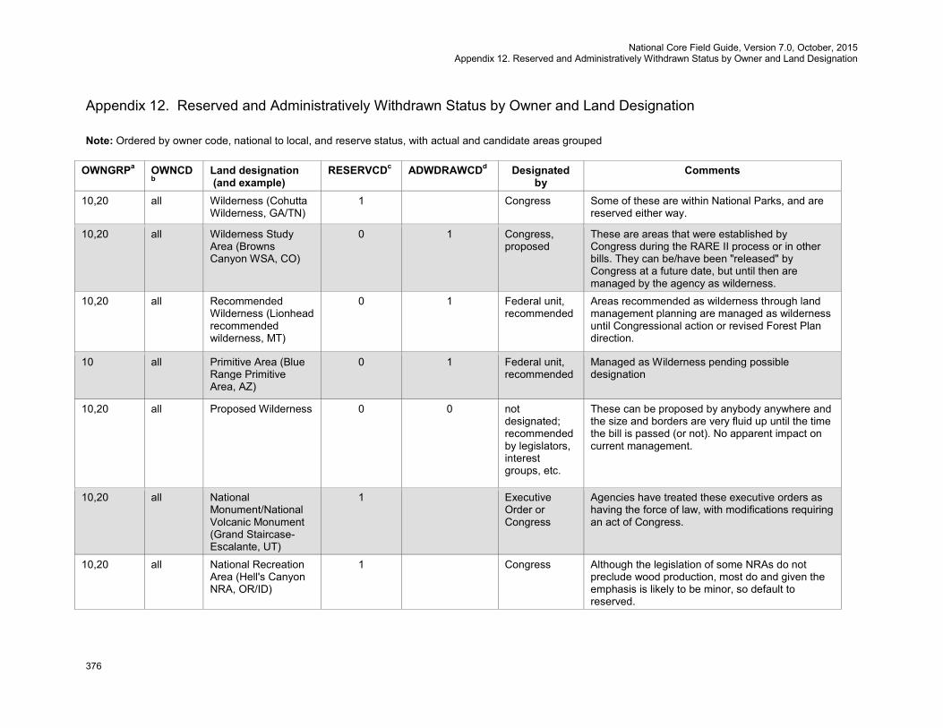
National Core Field Guide, Version 7.0, October, 2015 Appendix 12. Reserved and Administratively Withdrawn Status by Owner and Land Designation
376
Appendix 12. Reserved and Administratively Withdrawn Status by Owner and Land Designation Note: Ordered by owner code, national to local, and reserve status, with actual and candidate areas grouped
OWNGRPa OWNCDb
Land designation (and example)
RESERVCDc ADWDRAWCDd Designated by
Comments
10,20 all Wilderness (Cohutta Wilderness, GA/TN)
1 Congress Some of these are within National Parks, and are reserved either way.
10,20 all Wilderness Study Area (Browns Canyon WSA, CO)
0 1 Congress, proposed
These are areas that were established by Congress during the RARE II process or in other bills. They can be/have been "released" by Congress at a future date, but until then are managed by the agency as wilderness.
10,20 all Recommended Wilderness (Lionhead recommended wilderness, MT)
0 1 Federal unit, recommended
Areas recommended as wilderness through land management planning are managed as wilderness until Congressional action or revised Forest Plan direction.
10 all Primitive Area (Blue Range Primitive Area, AZ)
0 1 Federal unit, recommended
Managed as Wilderness pending possible designation
10,20 all Proposed Wilderness 0 0 not designated; recommended by legislators, interest groups, etc.
These can be proposed by anybody anywhere and the size and borders are very fluid up until the time the bill is passed (or not). No apparent impact on current management.
10,20 all National Monument/National Volcanic Monument (Grand Staircase-Escalante, UT)
1 Executive Order or Congress
Agencies have treated these executive orders as having the force of law, with modifications requiring an act of Congress.
10,20 all National Recreation Area (Hell's Canyon NRA, OR/ID)
1 Congress Although the legislation of some NRAs do not preclude wood production, most do and given the emphasis is likely to be minor, so default to reserved.
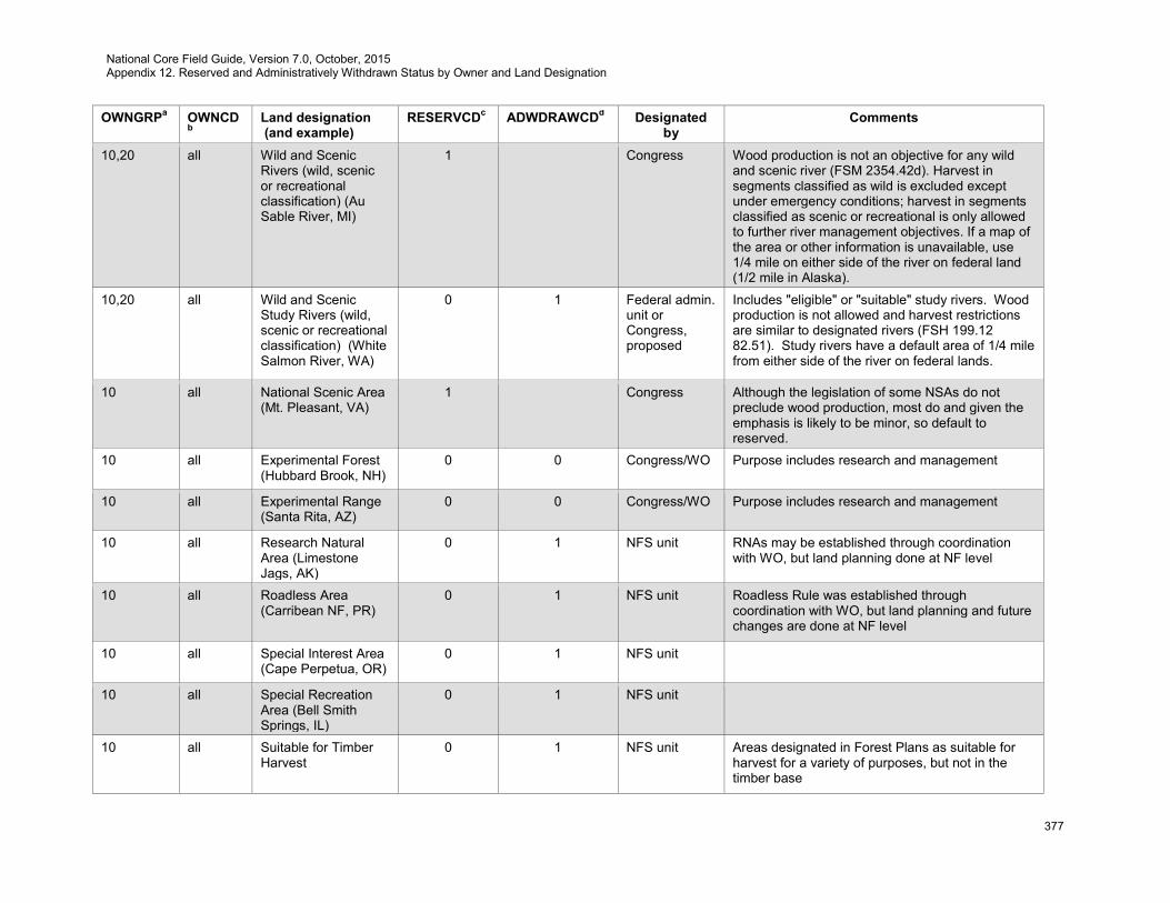
National Core Field Guide, Version 7.0, October, 2015 Appendix 12. Reserved and Administratively Withdrawn Status by Owner and Land Designation
377
OWNGRPa OWNCDb
Land designation (and example)
RESERVCDc ADWDRAWCDd Designated by
Comments
10,20 all Wild and Scenic Rivers (wild, scenic or recreational classification) (Au Sable River, MI)
1 Congress Wood production is not an objective for any wild and scenic river (FSM 2354.42d). Harvest in segments classified as wild is excluded except under emergency conditions; harvest in segments classified as scenic or recreational is only allowed to further river management objectives. If a map of the area or other information is unavailable, use 1/4 mile on either side of the river on federal land (1/2 mile in Alaska).
10,20 all Wild and Scenic Study Rivers (wild, scenic or recreational classification) (White Salmon River, WA)
0 1 Federal admin. unit or Congress, proposed
Includes "eligible" or "suitable" study rivers. Wood production is not allowed and harvest restrictions are similar to designated rivers (FSH 199.12 82.51). Study rivers have a default area of 1/4 mile from either side of the river on federal lands.
10 all National Scenic Area (Mt. Pleasant, VA)
1 Congress Although the legislation of some NSAs do not preclude wood production, most do and given the emphasis is likely to be minor, so default to reserved.
10 all Experimental Forest (Hubbard Brook, NH)
0 0 Congress/WO Purpose includes research and management
10 all Experimental Range (Santa Rita, AZ)
0 0 Congress/WO Purpose includes research and management
10 all Research Natural Area (Limestone Jags, AK)
0 1 NFS unit RNAs may be established through coordination with WO, but land planning done at NF level
10 all Roadless Area (Carribean NF, PR)
0 1 NFS unit Roadless Rule was established through coordination with WO, but land planning and future changes are done at NF level
10 all Special Interest Area (Cape Perpetua, OR)
0 1 NFS unit
10 all Special Recreation Area (Bell Smith Springs, IL)
0 1 NFS unit
10 all Suitable for Timber Harvest
0 1 NFS unit Areas designated in Forest Plans as suitable for harvest for a variety of purposes, but not in the timber base
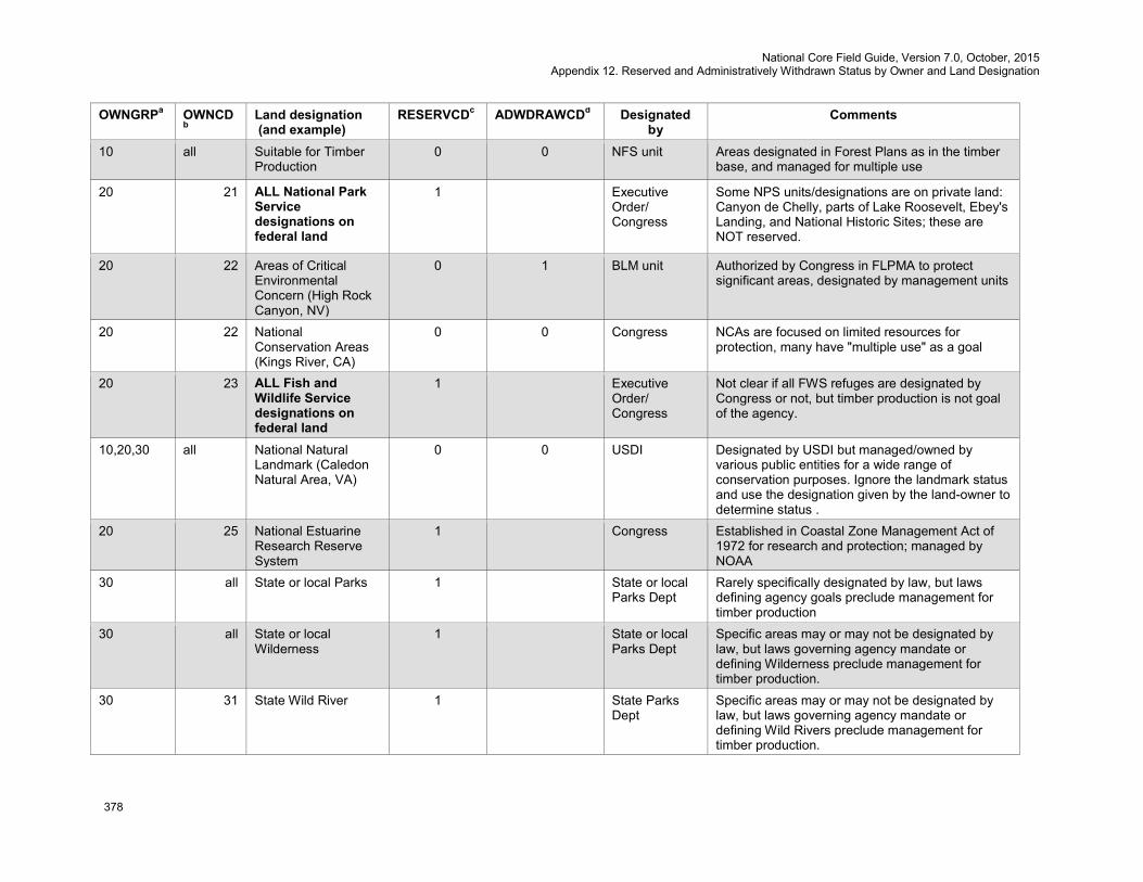
National Core Field Guide, Version 7.0, October, 2015 Appendix 12. Reserved and Administratively Withdrawn Status by Owner and Land Designation
378
OWNGRPa OWNCDb
Land designation (and example)
RESERVCDc ADWDRAWCDd Designated by
Comments
10 all Suitable for Timber Production
0 0 NFS unit Areas designated in Forest Plans as in the timber base, and managed for multiple use
20 21 ALL National Park Service designations on federal land
1 Executive Order/ Congress
Some NPS units/designations are on private land: Canyon de Chelly, parts of Lake Roosevelt, Ebey's Landing, and National Historic Sites; these are NOT reserved.
20 22 Areas of Critical Environmental Concern (High Rock Canyon, NV)
0 1 BLM unit Authorized by Congress in FLPMA to protect significant areas, designated by management units
20 22 National Conservation Areas (Kings River, CA)
0 0 Congress NCAs are focused on limited resources for protection, many have "multiple use" as a goal
20 23 ALL Fish and Wildlife Service designations on federal land
1 Executive Order/ Congress
Not clear if all FWS refuges are designated by Congress or not, but timber production is not goal of the agency.
10,20,30 all National Natural Landmark (Caledon Natural Area, VA)
0 0 USDI Designated by USDI but managed/owned by various public entities for a wide range of conservation purposes. Ignore the landmark status and use the designation given by the land-owner to determine status .
20 25 National Estuarine Research Reserve System
1 Congress Established in Coastal Zone Management Act of 1972 for research and protection; managed by NOAA
30 all State or local Parks 1 State or local Parks Dept
Rarely specifically designated by law, but laws defining agency goals preclude management for timber production
30 all State or local Wilderness
1 State or local Parks Dept
Specific areas may or may not be designated by law, but laws governing agency mandate or defining Wilderness preclude management for timber production.
30 31 State Wild River 1 State Parks Dept
Specific areas may or may not be designated by law, but laws governing agency mandate or defining Wild Rivers preclude management for timber production.
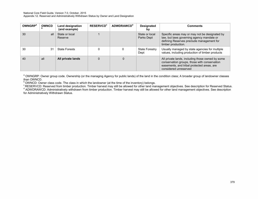
National Core Field Guide, Version 7.0, October, 2015 Appendix 12. Reserved and Administratively Withdrawn Status by Owner and Land Designation
379
OWNGRPa OWNCDb
Land designation (and example)
RESERVCDc ADWDRAWCDd Designated by
Comments
30 all State or local Reserve
1 State or local Parks Dept
Specific areas may or may not be designated by law, but laws governing agency mandate or defining Reserves preclude management for timber production.
30 31 State Forests 0 0 State Forestry Dept
Usually managed by state agencies for multiple values, including production of timber products
40 all All private lands 0 0 All private lands, including those owned by some conservation groups, those with conservation easements, and tribal protected areas, are considered unreserved
a OWNGRP: Owner group code. Ownership (or the managing Agency for public lands) of the land in the condition class; A broader group of landowner classes than OWNCD. b OWNCD: Owner class code. The class in which the landowner (at the time of the inventory) belongs. c RESERVCD: Reserved from timber production. Timber harvest may still be allowed for other land management objectives. See description for Reserved Status. d ADWDRAWCD: Administratively withdrawn from timber production. Timber harvest may still be allowed for other land management objectives. See description for Administratively Withdrawn Status.
National Core Field Guide, Version 7.0, October, 2015 Appendix 13. Ownership Prefield Procedures
380
Appendix 13. Ownership Prefield Procedures
A13.1 Introduction
FIA uses ownership information for multiple purposes. Initially, it is used to identify and contact ownerships and gain access to the land. Ownership variables are important for quantifying what types of ownerships own how much land and among other things, the relative differences among the forests owned by different types of ownerships. FIA’s National Woodland Owner uses name and address information to contact landowners and invite them to participate in the ownership survey. This chapter describes the variables and protocols for data related to land ownership collected prior to measurement of field (i.e., P2) variables. The (core) ownership variables described below are required for the first private, forested condition encountered on a plot. Ownership information is optional for:
• Other ownerships (private or public) on the plot; and • Other ownerships associated with the plot – e.g., other ownerships who may need to be
contacted in order to gain access to the plot. It is often difficult to know if a plot has a forested condition before it is visited, so it is often more efficient to collect the ownership information for all plots that are likely to have one or more forested conditions. For remeasured plots, ownership information should be auto-filled from history files, verified using current sources, and then, where necessary, changed/modified. A look-up table containing the most common ownerships in a State should be utilized to expedite and improve ownership data collection. Rules for entering name and address information:
• As a rule of thumb, enter name and address information as it should appear on a mailing label • Use upper and lower case letters • Avoid unnecessary punctuation • If initials are recorded, leave a space between them (e.g., W W) • Unless part of an official name (e.g., U S Steel), the only acceptable abbreviations are:
o Inc, Co (for company), LLC, LLP, and similar business abbreviations o Mr, Ms, Mrs, … o c/o and attn: o Jr, Sr, II, III, …
• Use numbers for street number, e.g., 3rd Ave not Third Ave • If there is a PO Box and a street address, record the PO Box information in ADDRESS LINE 1
and the street address in ADDRESS LINE 2 and, if necessary, ADDRESS LINE 3. • If there is an apartment or suite number, record it at end of the street address (on the same line).
Examples are included in section A13.57.1. A13.2 STATE
See Core Field Guide variable 1.1.
A13.3 COUNTY
See Core Field Guide variable 1.2.
A13.4 PLOT NUMBER
See Core Field Guide variable 1.3. A13.5 INVYEAR
The year the plot is inventoried.
National Core Field Guide, Version 7.0, October, 2015 Appendix 13. Ownership Prefield Procedures
381
When collected: All owners recorded for a plot Field width: 4 digits Tolerance: No errors MQO: At least 99% of the time Values: ≥ 2012
A13.6 OWNERSHIP TYPE
Record whether the ownership information corresponds to an ownership that (likely) owns part or all of the plot (OWNER TYPE = 1) or the information was collected for access purposes (OWNER TYPE = 2). When collected: All ownerships recorded for a plot Field width: 1 digit Tolerance: No errors MQO: At least 95% of the time Values:
1 Ownership information corresponds to a potential plot ownership 2 Ownership information collected for plot access purposes
A13.6.1 OWNERSHIP CONDITION LIST
Record each condition number that is present on the defined owner. If OWNER TYPE = 2, then enter 0000 to indicate information is for plot access purposes and none of the plot falls on this respective owner. When collected: All OWNER CLASSes on CONDITION CLASS STATUS = 1, 2 and 5 (with the
exception of rights-of-way owned by Federal, State, or Local governments) Field width: 4 digits Tolerance: No errors MQO: At least 95% of the time Values: 0000 to 9876
A13.7 PLOT CENTER OWNER (CORE OPTIONAL)
Record whether the ownership information corresponds to the ownership that most likely owns plot center When collected: All ownerships recorded for a plot Field width: 1 digit Tolerance: No errors MQO: At least 95% of the time Values:
0 The ownership is not the likely owner of plot center 1 The ownership is the likely owner of plot center
A13.8 OWNER SHORT NAME
An alphanumeric code that can be used to quickly enter frequently encountered ownerships. These codes are assigned by regional offices. When collected: All ownerships recorded for a plot Field width: 50 characters Tolerance: No errors MQO: At least 99% of the time

National Core Field Guide, Version 7.0, October, 2015 Appendix 13. Ownership Prefield Procedures
382
Values: Letters and numbers. Null values are permissible A13.9 AGENCY
Record the name of the public agency that owns the forest land as indicated by public tax records or other data sources. “Care of” (e.g., c/o), “attention” (e.g., attn:), and similar information should be recorded in ATTENTION. When collected: CORE: All public plot ownerships (OWNER CLASS = 11, 12, 13, 21, 22, 23,
24, 25, 31, 32, or 33 and OWNER TYPE = 1) CORE OPTIONAL: All public agencies recorded for a plot (OWNER CLASS =
11, 12, 13, 21, 22, 23, 24, 25, 31, 32, or 33 and OWNER TYPE ≥ 1) Field width: 255 characters Tolerance: No errors MQO: At least 95% of the time Values: Letters, numbers, and special characters
A13.10 COMPANY
Record the name of the company or organization that owns the forest land as indicated by public tax records or other data sources. “Care of” (e.g., c/o), “attention” (e.g., attn:), and similar information should be recorded in ATTENTION. When collected: CORE: All corporate and other private organization plot ownerships (OWNER
CLASS = 41, 42, 43, or 44 and OWNER TYPE = 1) CORE OPTIONAL: All corporate and other organization ownerships and public
agencies recorded for a plot (OWNER CLASS = 41, 42, 43, or 44 and OWNER TYPE ≥ 1)
Field width: 255 characters Tolerance: No errors MQO: At least 95% of the time Values: Letters, numbers, and special characters
A13.11 MANAGEMENT UNIT
If available, record the name of the management unit that owns the forest land as indicated by public tax records or other data sources. When collected: CORE: All public and private plot ownerships (OWNER TYPE = 1) CORE OPTIONAL: All public and private ownerships recorded for a plot
(OWNER TYPE ≥ 1) Field width: 255 characters Tolerance: No errors MQO: At least 95% of the time Values: Letters, numbers, and special characters
A13.12 NAME
Record the name of the ownership. All of the information available in the public tax records or other sources should be included. The name should be formatted as if one were addressing an envelope. “Care of” (e.g., c/o), “attention” (e.g., attn:), and similar information should be recorded in ATTENTION. When collected: CORE: All individual and family plot ownerships (OWNER CLASS = 45 and
OWNER TYPE = 1) CORE OPTIONAL: All individual and family ownerships recorded for a plot
(OWNER CLASS = 45 and OWNER TYPE ≥ 1) Field width: 255 characters Tolerance: No errors

National Core Field Guide, Version 7.0, October, 2015 Appendix 13. Ownership Prefield Procedures
383
MQO: At least 95% of the time Values: Letters
A13.13 ATTENTION
If applicable, “care of” (e.g., c/o), “attention” (e.g., attn:), and similar information should be recorded here. If available, job title should be included in this field. When collected: CORE: All private plot ownerships (OWNER CLASS ≥ 41 and OWNER TYPE =
1) CORE OPTIONAL: All ownerships recorded for a plot (OWNER CLASS ≥ 11
and OWNER TYPE ≥ 1) Field width: 255 characters Tolerance: No errors MQO: At least 95% of the time Values: Letters, numbers, and special characters
A13.14 ADDRESS LINE 1
Record the first line of the mailing address for the ownership. If there is a PO Box and a street address, record the PO Box information in ADDRESS LINE 1 and the street address in ADDRESS LINE 2 and ADDRESS LINE 3. If there is an apartment or suite number, record it at end of the street address (on the same line). When collected: CORE: All private plot ownerships (OWNER CLASS ≥ 41 and OWNER TYPE =
1) CORE OPTIONAL: All ownerships recorded for a plot (OWNER CLASS ≥ 11
and OWNER TYPE ≥ 1) Field width: 255 characters Tolerance: No errors MQO: At least 95% of the time Values: Letters, numbers, and special characters
A13.15 ADDRESS LINE 2
Where applicable, record the second line of the mailing address for the ownership.
When collected: CORE: All private plot ownerships (OWNER CLASS ≥ 41 and OWNER TYPE = 1)
CORE OPTIONAL: All ownerships recorded for a plot (OWNER CLASS ≥ 11 and OWNER TYPE ≥ 1)
Field width: 255 characters Tolerance: No errors MQO: At least 95% of the time Values: Letters, numbers, and special characters. Null values are permissible
A13.16 ADDRESS LINE 3
Where applicable, record the third line of the mailing address for the ownership.
When collected: CORE: All private plot ownerships (OWNER CLASS ≥ 41 and OWNER TYPE = 1)
CORE OPTIONAL: All ownerships recorded for a plot (OWNER CLASS ≥ 11 and OWNER TYPE ≥ 1)
Field width: 255 characters Tolerance: No errors MQO: At least 95% of the time Values: Letters, numbers, and special characters. Null values are permissible
National Core Field Guide, Version 7.0, October, 2015 Appendix 13. Ownership Prefield Procedures
384
A13.17 ADDRESS CITY
Record the city of the mailing address for the ownership.
When collected: CORE: All private plot ownerships (OWNER CLASS ≥ 41 and OWNER TYPE = 1)
CORE OPTIONAL: All ownerships recorded for a plot (OWNER CLASS ≥ 11 and OWNER TYPE ≥ 1)
Field width: 100 characters Tolerance: No errors MQO: At least 95% of the time Values: Letters
A13.18 ADDRESS STATE
For ownerships with mailing addresses in the United States (including territories and protectorates), record the state of the mailing address for the ownership.
When collected: CORE: All private plot ownerships with mailing addresses in the United States
(OWNER CLASS ≥ 41 and OWNER TYPE = 1 and ADDRESS COUNTRY = “US”)
CORE OPTIONAL: All ownerships recorded for a plot with mailing addresses in the United States (OWNER CLASS ≥ 11 and OWNER TYPE ≥ 1 and ADDRESS COUNTRY = “US”)
Field width: 2 characters Tolerance: No errors MQO: At least 95% of the time Values: See section A13.57.2
A13.19 ADDRESS PROVINCE
For ownerships with mailing addresses outside of the United States, record the province, state, or other pertinent geographic division of the mailing address of the ownership.
When collected: CORE: All private plot ownerships with mailing addresses outside of the United
States (OWNER CLASS ≥ 41 and OWNER TYPE = 1 and ADDRESS COUNTRY ≠ “US”)
CORE OPTIONAL: All ownerships recorded for a plot with mailing addresses outside of the United States (OWNER CLASS ≥ 11 and OWNER TYPE ≥ 1 and ADDRESS COUNTRY ≠ “US”)
Field width: 50 characters Tolerance: No errors MQO: At least 95% of the time Values: Letters
A13.20 ADDRESS POSTAL CODE
Record the postal code of the mailing address for the ownership. Postal codes for US and foreign addresses should be included here.
When collected: CORE: All private plot ownerships with mailing addresses in the United States
(OWNER CLASS ≥ 41 and OWNER TYPE = 1 and ADDRESS COUNTRY = “US”)
CORE OPTIONAL: All ownerships recorded for a plot with mailing addresses in the United States (OWNER CLASS ≥ 11 and OWNER TYPE ≥ 1 and ADDRESS COUNTRY = “US”)
National Core Field Guide, Version 7.0, October, 2015 Appendix 13. Ownership Prefield Procedures
385
Field width: 10 characters Tolerance: No errors MQO: At least 95% of the time Values: Alphanumeric
A13.21 ADDRESS COUNTRY
Record the two-character code for the country of the mailing address for the ownership. The default value is United States (US).
When collected: CORE: All private plot ownerships (OWNER CLASS ≥ 41 and OWNER TYPE =
1) CORE OPTIONAL: All ownerships recorded for a plot (OWNER CLASS ≥ 11
and OWNER TYPE ≥ 1) Field width: 2 characters Tolerance: No errors MQO: At least 95% of the time Values: See section A13.57.3
A13.22 OWNERSHIP PHONE NUMBER 1 (CORE OPTIONAL)
When available, record the primary phone number for the ownership, including area code. If available, record the extension in OWNER PHONE NUMBER 1 EXTENSION. It should be formatted as numbers separated by dashes (e.g., “123-456-7890”). When collected: All ownerships recorded for a plot (OWNER CLASS ≥ 11 and OWNER TYPE ≥
1) Field width: 12 characters Tolerance: No errors MQO: At least 95% of the time Values: Numbers and the special character ‘-’ (dash). Null values are permissible
A13.23 OWNERSHIP PHONE NUMBER 1 EXTENSION (CORE OPTIONAL)
When available, record the extension associated with the primary phone number for the ownership. When collected: All ownerships recorded for a plot (OWNER CLASS ≥ 11 and OWNER TYPE ≥
1) Field width: 5 digits Tolerance: No errors MQO: At least 95% of the time Values: Numbers. Null values are permissible
A13.24 OWNERSHIP PHONE NUMBER 1 TYPE (CORE OPTIONAL)
When available, record whether the phone number is a work, home, mobile, or other number. When collected: All ownerships recorded for a plot (OWNER CLASS ≥ 11 and OWNER TYPE ≥
1) Field width: 1 digit Tolerance: No errors MQO: At least 95% of the time Values:

National Core Field Guide, Version 7.0, October, 2015 Appendix 13. Ownership Prefield Procedures
386
1 Work 2 Home 3 Mobile 4 Other Null values are permissible
A13.25 OWNERSHIP PHONE NUMBER 2 (CORE OPTIONAL)
When available, record the secondary phone number for the ownership, including area code. If available, record the extension in OWNER PHONE NUMBER 2 EXTENSION. It should be formatted as numbers separated by dashes (e.g., “123-456-7890”). When collected: All ownerships recorded for a plot (OWNER CLASS ≥ 11 and OWNER TYPE ≥
1) Field width: 12 characters Tolerance: No errors MQO: At least 95% of the time Values: Numbers and the special character ‘-‘ (dash). Null values are permissible
A13.26 OWNERSHIP PHONE NUMBER 2 EXTENSION (CORE OPTIONAL)
When available, record the extension associated with the secondary phone number for the ownership. When collected: All ownerships recorded for a plot (OWNER CLASS ≥ 11 and OWNER TYPE ≥
1) Field width: 5 digits Tolerance: No errors MQO: At least 95% of the time Values: Numbers. Null values are permissible
A13.27 OWNERSHIP PHONE NUMBER 2 TYPE (CORE OPTIONAL)
When available, record whether the phone number is a work, home, mobile, or other number. When collected: All ownerships recorded for a plot (OWNER CLASS ≥ 11 and OWNER TYPE ≥
1) Field width: 1 digit Tolerance: No errors MQO: At least 95% of the time Values:
1 Work 2 Home 3 Mobile 4 Other Null values are permissible
A13.28 OWNERSHIP E-MAIL ADDRESS (CORE OPTIONAL)
When available, record the e-mail address for the ownership. When collected: All ownerships recorded for a plot (OWNER CLASS ≥ 11 and OWNER TYPE ≥
1) Field width: 255 characters Tolerance: No errors MQO: At least 95% of the time
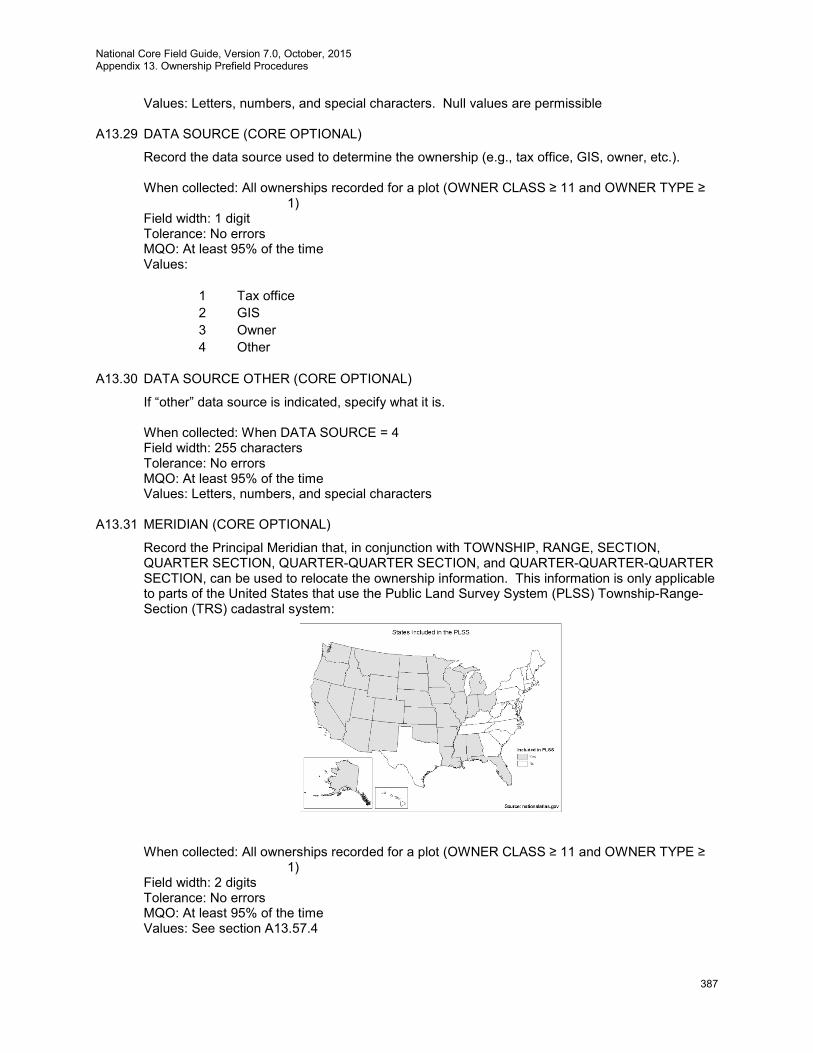
National Core Field Guide, Version 7.0, October, 2015 Appendix 13. Ownership Prefield Procedures
387
Values: Letters, numbers, and special characters. Null values are permissible A13.29 DATA SOURCE (CORE OPTIONAL)
Record the data source used to determine the ownership (e.g., tax office, GIS, owner, etc.).
When collected: All ownerships recorded for a plot (OWNER CLASS ≥ 11 and OWNER TYPE ≥ 1)
Field width: 1 digit Tolerance: No errors MQO: At least 95% of the time Values:
1 Tax office 2 GIS 3 Owner 4 Other
A13.30 DATA SOURCE OTHER (CORE OPTIONAL)
If “other” data source is indicated, specify what it is.
When collected: When DATA SOURCE = 4 Field width: 255 characters Tolerance: No errors MQO: At least 95% of the time Values: Letters, numbers, and special characters
A13.31 MERIDIAN (CORE OPTIONAL)
Record the Principal Meridian that, in conjunction with TOWNSHIP, RANGE, SECTION, QUARTER SECTION, QUARTER-QUARTER SECTION, and QUARTER-QUARTER-QUARTER SECTION, can be used to relocate the ownership information. This information is only applicable to parts of the United States that use the Public Land Survey System (PLSS) Township-Range-Section (TRS) cadastral system:
When collected: All ownerships recorded for a plot (OWNER CLASS ≥ 11 and OWNER TYPE ≥ 1)
Field width: 2 digits Tolerance: No errors MQO: At least 95% of the time Values: See section A13.57.4
National Core Field Guide, Version 7.0, October, 2015 Appendix 13. Ownership Prefield Procedures
388
A13.32 TOWNSHIP (CORE OPTIONAL)
Record the Township that, in conjunction with MERIDIAN, RANGE, SECTION, QUARTER SECTION, QUARTER-QUARTER SECTION, and QUARTER-QUARTER-QUARTER SECTION, can be used to relocate the ownership information. The information should be recorded as the number followed by a cardinal direction (e.g., 4N). This information is only applicable to parts of the United States that use the TRS cadastral system.
When collected: All ownerships recorded for a plot (OWNER CLASS ≥ 11 and OWNER TYPE ≥
1) Field width: 4 characters Tolerance: No errors MQO: At least 95% of the time Values: Letters and numbers
A13.33 RANGE (CORE OPTIONAL)
Record the Range that, in conjunction with MERIDIAN, TOWNSHIP, SECTION, QUARTER SECTION, QUARTER-QUARTER SECTION, and QUARTER-QUARTER-QUARTER SECTION, can be used to relocate the ownership information. The information should be recorded as the number followed by a cardinal direction (e.g., 10W). This information is only applicable to parts of the United States that use the TRS cadastral system.
When collected: All ownerships recorded for a plot (OWNER CLASS ≥ 11 and OWNER TYPE ≥
1) Field width: 4 characters Tolerance: No errors MQO: At least 95% of the time Values: Letters and numbers
A13.34 SECTION (CORE OPTIONAL)
Record the Section that, in conjunction with MERIDIAN, TOWNSHIP, RANGE, QUARTER SECTION, QUARTER-QUARTER SECTION, and QUARTER-QUARTER-QUARTER SECTION, can be used to relocate the ownership information. This information is only applicable to parts of the United States that use the TRS cadastral system.
When collected: All ownerships recorded for a plot (OWNER CLASS ≥ 11 and OWNER TYPE ≥
1) Field width: 2 digits Tolerance: No errors MQO: At least 95% of the time Values: 01 - 36
A13.35 QUARTER SECTION (CORE OPTIONAL)
Record the Quarter Section that, in conjunction with MERIDIAN, TOWNSHIP, RANGE, SECTION, QUARTER-QUARTER SECTION, and QUARTER-QUARTER-QUARTER SECTION, can be used to relocate the ownership information. This information is only applicable to parts of the United States that use the TRS cadastral system.
When collected: All ownerships recorded for a plot (OWNER CLASS ≥ 11 and OWNER TYPE ≥
1) Field width: 1 digit Tolerance: No errors MQO: At least 95% of the time Values:
National Core Field Guide, Version 7.0, October, 2015 Appendix 13. Ownership Prefield Procedures
389
1 NE 2 SE 3 SW 4 NW
A13.36 QUARTER QUARTER SECTION (CORE OPTIONAL)
Record the Section that, in conjunction with MERIDIAN, TOWNSHIP, RANGE, SECTION, QUARTER SECTION, and QUARTER-QUARTER-QUARTER SECTION, can be used to relocate the ownership information. This information is only applicable to parts of the United States that use the TRS cadastral system.
When collected: All ownerships recorded for a plot (OWNER CLASS ≥ 11 and OWNER TYPE ≥
1) Field width: 1 digit Tolerance: No errors MQO: At least 95% of the time Values:
1 NE 2 SE 3 SW 4 NW
A13.37 QUARTER QUARTER QUARTER SECTION (CORE OPTIONAL)
Record the Section that, in conjunction with MERIDIAN, TOWNSHIP, RANGE, SECTION, QUARTER SECTION, and QUARTER-QUARTER SECTION, can be used to relocate the ownership information. This information is only applicable to parts of the United States that use the TRS cadastral system.
When collected: All ownerships recorded for a plot (OWNER CLASS ≥ 11 and OWNER TYPE ≥
1) Field width: 1 digit Tolerance: No errors MQO: At least 95% of the time Values:
1 NE 2 SE 3 SW 4 NW
A13.38 MAP NUMBER (CORE OPTIONAL)
Record the map number that, in conjunction with DATA SOURCE, BLOCK NUMBER, and PARCEL NUMBER, can be used to relocate the ownership information. This is most useful in the parts of the United States that use metes and bounds cadastral systems.
When collected: All ownerships recorded for a plot (OWNER CLASS ≥ 11 and OWNER TYPE ≥
1) Field width: 255 characters Tolerance: No errors MQO: At least 95% of the time Values: Letters, numbers, and special characters
National Core Field Guide, Version 7.0, October, 2015 Appendix 13. Ownership Prefield Procedures
390
A13.39 BLOCK NUMBER (CORE OPTIONAL)
Record the block number that, in conjunction with DATA SOURCE, MAP NUMBER, and PARCEL NUMBER, can be used to relocate the ownership information. This is most useful in the parts of the United States that use metes and bounds cadastral systems.
When collected: All ownerships recorded for a plot (OWNER CLASS ≥ 11 and OWNER TYPE ≥
1) Field width: 255 characters Tolerance: No errors MQO: At least 95% of the time Values: Letters, numbers, and special characters
A13.40 PARCEL NUMBER (CORE OPTIONAL)
Record the parcel number that, in conjunction with DATA SOURCE, MAP NUMBER, and BLOCK NUMBER, can be used to relocate the ownership information. This is most useful in the parts of the United States that use metes and bounds cadastral systems.
When collected: All ownerships recorded for a plot (OWNER CLASS ≥ 11 and OWNER TYPE ≥
1) Field width: 255 characters Tolerance: No errors MQO: At least 95% of the time Values: Letters, numbers, and special characters
A13.41 TRACT SIZE (CORE OPTIONAL)
Record the total size (acres) of the tract/parcel. This information can be obtained from public tax records. Round to the nearest whole number.
When collected: All plot ownerships (OWNER CLASS ≥ 11 and OWNER TYPE = 1) Field width: 7 digits Tolerance: No errors MQO: At least 95% of the time Values: 0000000 to 9999999
A13.42 TRACT PERCENT FOREST COVER (CORE OPTIONAL)
Record the percent of the tract/parcel that is forested. This can be accomplished using GIS software (where ownership boundaries are electronically available) or by visual, dot-count, or other methods involving overlaying the boundaries and aerial photographs. Where only hardcopy paper maps are available, mentally superimposing the boundaries and aerial photographs can be used to approximate this variable. Round to the nearest whole number.
When collected: All plot ownerships (OWNER CLASS ≥ 11 and OWNER TYPE = 1) Field width: 3 digits Tolerance: ±10 MQO: At least 90% of the time Values: 000 - 100
A13.43 OWNER NOTES
Record any notes that should be conveyed about the ownership and/or ownership data.
When collected: All ownerships recorded for a plot (OWNER CLASS ≥ 11 and OWNER TYPE ≥ 1)
Field width: 2000 characters
National Core Field Guide, Version 7.0, October, 2015 Appendix 13. Ownership Prefield Procedures
391
Tolerance: N/A MQO: N/A Values: English language words, phrases and numbers. Null values are permissible
A13.44 OWNERSHIP CONTACT NAME (CORE OPTIONAL)
Record the name of the person spoken to or who otherwise responded. When collected: All ownerships recorded for a plot (OWNER CLASS ≥ 11 and OWNER TYPE ≥
1) Field width: 255 characters Tolerance: N/A MQO: N/A Values: English language words, phrases and numbers
A13.45 OWNERSHIP CONTACT ATTEMPT NUMBER (CORE OPTIONAL)
Record the contact attempt number.
When collected: All ownerships recorded for a plot (OWNER CLASS ≥ 11 and OWNER TYPE ≥ 1)
Field width: 2 digits Tolerance: No errors MQO: At least 95% of the time Values: Attempt number
A13.46 OWNERSHIP CONTACT DATE (CORE OPTIONAL)
Record the date of the attempted ownership contact. Date should be in the form DD-MON-YYYY. When collected: When an ownership contact attempt has been made (OWNERSHIP CONTACT ATTEMPT NUMBER is not null) Field width: 11 characters Tolerance: No errors MQO: At least 95% of the time Values: Date
A13.47 OWNERSHIP CONTACT METHOD (CORE OPTIONAL)
Record the code identifying how the ownership was contacted.
When collected: All ownerships contacted Field width: 1 digit Tolerance: No errors MQO: At least 95% of the time Values:
1 In person 2 Left voice message 3 Spoke to by phone 4 Sent email 5 Sent postal mail 6 Message received on phone 7 Message received via return email 8 Message received via return mail 9 Other (notes required)

National Core Field Guide, Version 7.0, October, 2015 Appendix 13. Ownership Prefield Procedures
392
A13.48 LAND POSTED (CORE OPTIONAL)
Record the code identifying if the land is posted prohibiting trespassing.
When collected: All ownerships recorded for a plot (OWNER CLASS ≥ 11 and OWNER TYPE ≥ 1)
Field width: 1 digit Tolerance: No errors MQO: At least 95% of the time Values:
0 No 1 Yes
A13.49 ACCESS GRANTED (CORE OPTIONAL)
Record the code identifying if a representative of the ownership granted us access to their land. If the ownership allows access under specific arrangements (ACCESS GRANTED = 2), then record the specific arrangements in ACCESS INFORMATION DETAILS.
When collected: All ownerships contacted Field width: 1 digit Tolerance: No errors MQO: At least 95% of the time Values:
0 No 1 Yes 2 Conditional yes (record conditions in access notes)
A13.50 ACCESS GRANTED DATE (CORE OPTIONAL)
Record the date access was granted. Date should be in the form DD-MON-YYYY. When collected: When access has been granted (ACCESS GRANTED = 1 or 2) Field width: 11 characters Tolerance: No errors MQO: At least 95% of the time Values: Date
A13.51 ACCESS GRANTED BY(CORE OPTIONAL)
Record the name of the person from whom access was granted.
When collected: All ownerships recorded for a plot (OWNER CLASS ≥ 11 and OWNER TYPE ≥ 1)
Field width: 255 characters Tolerance: N/A MQO: N/A Values: English language words, phrases and numbers
A13.52 ACCESS NOTES (CORE OPTIONAL)
Record any other information relevant to contacting and accessing the plot.
When collected: All ownerships contacted
National Core Field Guide, Version 7.0, October, 2015 Appendix 13. Ownership Prefield Procedures
393
Field width: 2,000 characters Tolerance: N/A MQO: N/A Values: English language words, phrases and numbers. Null values are permissible
A13.53 OWNERSHIP REQUESTS NOTICE (CORE OPTIONAL)
Record the code identifying if the ownership wants to be notified before we access their land.
When collected: All ownerships contacted Field width: 1 digit Tolerance: No errors MQO: At least 95% of the time Values:
0 No 1 Yes
A13.54 OWNERSHIP REQUESTS INFORMATION (CORE OPTIONAL)
Record the code identifying if the ownership representation wants us to send him or her additional information. If they do (OWNERS REQUESTS INFORMATION = 1), then record what they want in REQUESTS INFORMATION DETAILS.
When collected: All ownerships contacted Field width: 1 digit Tolerance: No errors MQO: At least 95% of the time Values:
0 No 1 Yes
A13.55 INFORMATION REQUEST DETAILS (CORE OPTIONAL)
Record any other information relevant to contacting and accessing the plot.
When collected: All ownerships requesting additional information (OWNERS REQUESTS INFORMATION = 1)
Field width: 2,000 characters Tolerance: N/A MQO: N/A Values: English language words, phrases and numbers. Null values are permissible
A13.56 INFORMATION REQUEST FULFILLED (CORE OPTIONAL)
Record if the information request has been fulfilled and not further action is required.
When collected: All ownerships contacted Field width: 1 digit Tolerance: No errors MQO: At least 95% of the time Values:
0 Information request has NOT been fulfilled 1 Information request has been fulfilled
National Core Field Guide, Version 7.0, October, 2015 Appendix 13. Ownership Prefield Procedures
394
A13.57 Supplemental Information for Ownership Prefield Procedures
A13.57.1 FIA Ownership Data Recording Examples
Example 1 – U.S. Forest Service
AGENCY: USDA Forest Service COMPANY: MANAGEMENT UNIT: Siuslaw National Forest, Hebo Ranger District NAME: ATTENTION: ADDRESS LINE 1: P.O. Box 235 ADDRESS LINE 2: 31525 Hwy 22 ADDRESS LINE 3: ADDRESS CITY: Hebo ADDRESS STATE: OR ADDRESS PROVINCE: ADDRESS POSTAL CODE: 97122 ADDRESS COUNTRY:
Example 2 – State Forestry Agency AGENCY: Pennsylvania Department of Conservation and Natural Resources COMPANY: MANAGEMENT UNIT: William Penn State Forest NAME: ATTENTION: ADDRESS LINE 1: 845 Park Rd ADDRESS LINE 2: ADDRESS LINE 3: ADDRESS CITY: Elverson ADDRESS STATE: PA ADDRESS PROVINCE: ADDRESS POSTAL CODE: 19520 ADDRESS COUNTRY:
Example 3 – Company with c/o
AGENCY: COMPANY: Generic Tree Company MANAGEMENT UNIT: NAME: ATTENTION: c/o Jane Doe, Chief Forester ADDRESS LINE 1: PO Box 456 ADDRESS LINE 2: 123 S Main St ADDRESS LINE 3: ADDRESS CITY: Somewhere ADDRESS STATE: AL ADDRESS PROVINCE: ADDRESS POSTAL CODE: 12345-1234 ADDRESS COUNTRY:
Example 4 – Company with foreign address AGENCY: COMPANY: Trees R Us MANAGEMENT UNIT: NAME:
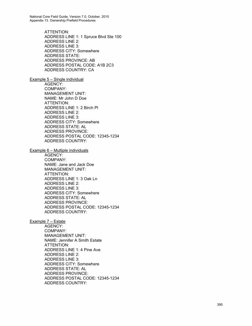
National Core Field Guide, Version 7.0, October, 2015 Appendix 13. Ownership Prefield Procedures
395
ATTENTION: ADDRESS LINE 1: 1 Spruce Blvd Ste 100 ADDRESS LINE 2: ADDRESS LINE 3: ADDRESS CITY: Somewhere ADDRESS STATE: ADDRESS PROVINCE: AB ADDRESS POSTAL CODE: A1B 2C3 ADDRESS COUNTRY: CA
Example 5 – Single individual
AGENCY: COMPANY: MANAGEMENT UNIT: NAME: Mr John D Doe ATTENTION: ADDRESS LINE 1: 2 Birch Pl ADDRESS LINE 2: ADDRESS LINE 3: ADDRESS CITY: Somewhere ADDRESS STATE: AL ADDRESS PROVINCE: ADDRESS POSTAL CODE: 12345-1234 ADDRESS COUNTRY:
Example 6 – Multiple individuals
AGENCY: COMPANY: NAME: Jane and Jack Doe MANAGEMENT UNIT: ATTENTION: ADDRESS LINE 1: 3 Oak Ln ADDRESS LINE 2: ADDRESS LINE 3: ADDRESS CITY: Somewhere ADDRESS STATE: AL ADDRESS PROVINCE: ADDRESS POSTAL CODE: 12345-1234 ADDRESS COUNTRY:
Example 7 – Estate
AGENCY: COMPANY: MANAGEMENT UNIT: NAME: Jennifer A Smith Estate ATTENTION: ADDRESS LINE 1: 4 Pine Ave ADDRESS LINE 2: ADDRESS LINE 3: ADDRESS CITY: Somewhere ADDRESS STATE: AL ADDRESS PROVINCE: ADDRESS POSTAL CODE: 12345-1234 ADDRESS COUNTRY:
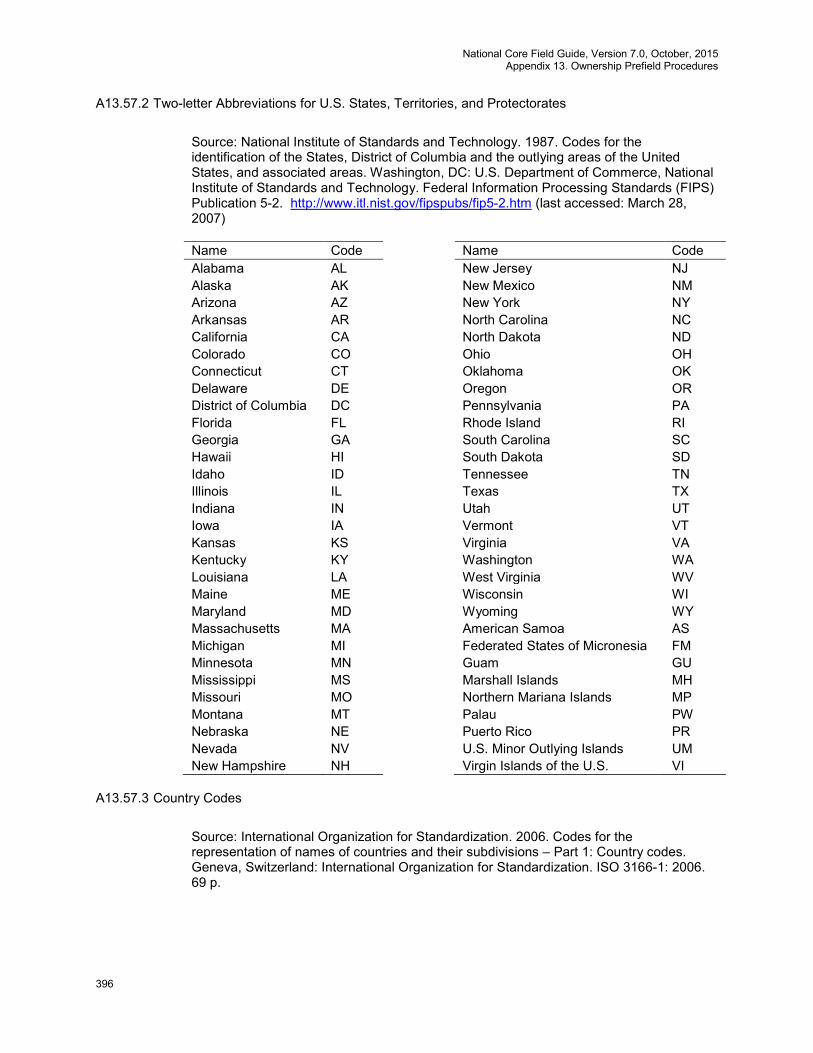
National Core Field Guide, Version 7.0, October, 2015 Appendix 13. Ownership Prefield Procedures
396
A13.57.2 Two-letter Abbreviations for U.S. States, Territories, and Protectorates
Source: National Institute of Standards and Technology. 1987. Codes for the identification of the States, District of Columbia and the outlying areas of the United States, and associated areas. Washington, DC: U.S. Department of Commerce, National Institute of Standards and Technology. Federal Information Processing Standards (FIPS) Publication 5-2. http://www.itl.nist.gov/fipspubs/fip5-2.htm (last accessed: March 28, 2007) Name Code Name Code Alabama AL New Jersey NJ Alaska AK New Mexico NM Arizona AZ New York NY Arkansas AR North Carolina NC California CA North Dakota ND Colorado CO Ohio OH Connecticut CT Oklahoma OK Delaware DE Oregon OR District of Columbia DC Pennsylvania PA Florida FL Rhode Island RI Georgia GA South Carolina SC Hawaii HI South Dakota SD Idaho ID Tennessee TN Illinois IL Texas TX Indiana IN Utah UT Iowa IA Vermont VT Kansas KS Virginia VA Kentucky KY Washington WA Louisiana LA West Virginia WV Maine ME Wisconsin WI Maryland MD Wyoming WY Massachusetts MA American Samoa AS Michigan MI Federated States of Micronesia FM Minnesota MN Guam GU Mississippi MS Marshall Islands MH Missouri MO Northern Mariana Islands MP Montana MT Palau PW Nebraska NE Puerto Rico PR Nevada NV U.S. Minor Outlying Islands UM New Hampshire NH Virgin Islands of the U.S. VI
A13.57.3 Country Codes
Source: International Organization for Standardization. 2006. Codes for the representation of names of countries and their subdivisions – Part 1: Country codes. Geneva, Switzerland: International Organization for Standardization. ISO 3166-1: 2006. 69 p.

National Core Field Guide, Version 7.0, October, 2015 Appendix 13. Ownership Prefield Procedures
397
Country Code Afghanistan AF Åland Islands AX Albania AL Algeria DZ American Samoa AS Andorra AD Angola AO Anguilla AI Antarctica AQ Antigua and Barbuda AG Argentina AR Armenia AM Aruba AW Australia AU Austria AT Azerbaijan AZ Bahamas BS Bahrain BH Bangladesh BD Barbados BB Belarus BY Belgium BE Belize BZ Benin BJ Bermuda BM Bhutan BT Bolivia BO Bosnia and Herzegovina
BA
Botswana BW Bouvet Island BV Brazil BR British Indian Ocean Territory
IO
Brunei Darussalam BN Bulgaria BG Burkina Faso BF Burundi BI Cambodia KH Cameroon CM Canada CA Cape Verde CV Cayman Islands KY Central African Republic
CF
Chad TD Chile CL China CN Christmas Island CX Cocos (Keeling) Islands
CC
Colombia CO Comoros KM Congo CG Congo, The CD
Country Code Democratic Republic of The Cook Islands CK Costa Rica CR Côte D'Ivoire CI Croatia HR Cuba CU Cyprus CY Czech Republic CZ Denmark DK Djibouti DJ Dominica DM Dominican Republic DO Ecuador EC Egypt EG El Salvador SV Equatorial Guinea GQ Eritrea ER Estonia EE Ethiopia ET Falkland Islands (Malvinas)
FK
Faroe Islands FO Fiji FJ Finland FI France FR French Guiana GF French Polynesia PF French Southern Territories
TF
Gabon GA Gambia GM Georgia GE Germany DE Ghana GH Gibraltar GI Greece GR Greenland GL Grenada GD Guadeloupe GP Guam GU Guatemala GT Guernsey GG Guinea GN Guinea-Bissau GW Guyana GY Haiti HT Heard Island and Mcdonald Islands
HM
Holy See (Vatican City State)
VA
Honduras HN Hong Kong HK Hungary HU Iceland IS
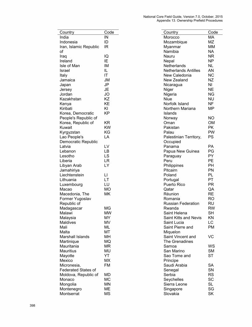
National Core Field Guide, Version 7.0, October, 2015 Appendix 13. Ownership Prefield Procedures
398
Country Code India IN Indonesia ID Iran, Islamic Republic of
IR
Iraq IQ Ireland IE Isle of Man IM Israel IL Italy IT Jamaica JM Japan JP Jersey JE Jordan JO Kazakhstan KZ Kenya KE Kiribati KI Korea, Democratic People's Republic of
KP
Korea, Republic of KR Kuwait KW Kyrgyzstan KG Lao People's Democratic Republic
LA
Latvia LV Lebanon LB Lesotho LS Liberia LR Libyan Arab Jamahiriya
LY
Liechtenstein LI Lithuania LT Luxembourg LU Macao MO Macedonia, The Former Yugoslav Republic of
MK
Madagascar MG Malawi MW Malaysia MY Maldives MV Mali ML Malta MT Marshall Islands MH Martinique MQ Mauritania MR Mauritius MU Mayotte YT Mexico MX Micronesia, Federated States of
FM
Moldova, Republic of MD Monaco MC Mongolia MN Montenegro ME Montserrat MS
Country Code Morocco MA Mozambique MZ Myanmar MM Namibia NA Nauru NR Nepal NP Netherlands NL Netherlands Antilles AN New Caledonia NC New Zealand NZ Nicaragua NI Niger NE Nigeria NG Niue NU Norfolk Island NF Northern Mariana Islands
MP
Norway NO Oman OM Pakistan PK Palau PW Palestinian Territory, Occupied
PS
Panama PA Papua New Guinea PG Paraguay PY Peru PE Philippines PH Pitcairn PN Poland PL Portugal PT Puerto Rico PR Qatar QA Réunion RE Romania RO Russian Federation RU Rwanda RW Saint Helena SH Saint Kitts and Nevis KN Saint Lucia LC Saint Pierre and Miquelon
PM
Saint Vincent and The Grenadines
VC
Samoa WS San Marino SM Sao Tome and Principe
ST
Saudi Arabia SA Senegal SN Serbia RS Seychelles SC Sierra Leone SL Singapore SG Slovakia SK

National Core Field Guide, Version 7.0, October, 2015 Appendix 13. Ownership Prefield Procedures
399
Country Code Slovenia SI Solomon Islands SB Somalia SO South Africa ZA South Georgia and The South Sandwich Islands
GS
Spain ES Sri Lanka LK Sudan SD Suriname SR Svalbard and Jan Mayen
SJ
Swaziland SZ Sweden SE Switzerland CH Syrian Arab Republic SY Taiwan, Province of China
TW
Tajikistan TJ Tanzania, United Republic of
TZ
Thailand TH Timor-Leste TL Togo TG Tokelau TK Tonga TO Trinidad and Tobago TT Tunisia TN Turkey TR Turkmenistan TM Turks and Caicos Islands
TC
Tuvalu TV Uganda UG Ukraine UA United Arab Emirates AE United Kingdom GB United States US United States Minor Outlying Islands
UM
Uruguay UY Uzbekistan UZ Vanuatu VU Vatican City State See Holy See
Venezuela VE Viet Nam VN Virgin Islands, British VG Virgin Islands, U.S. VI Wallis and Futuna WF Western Sahara EH Yemen YE Zaire See Congo, The Democratic
Country Code Republic of The Zambia ZM Zimbabwe ZW
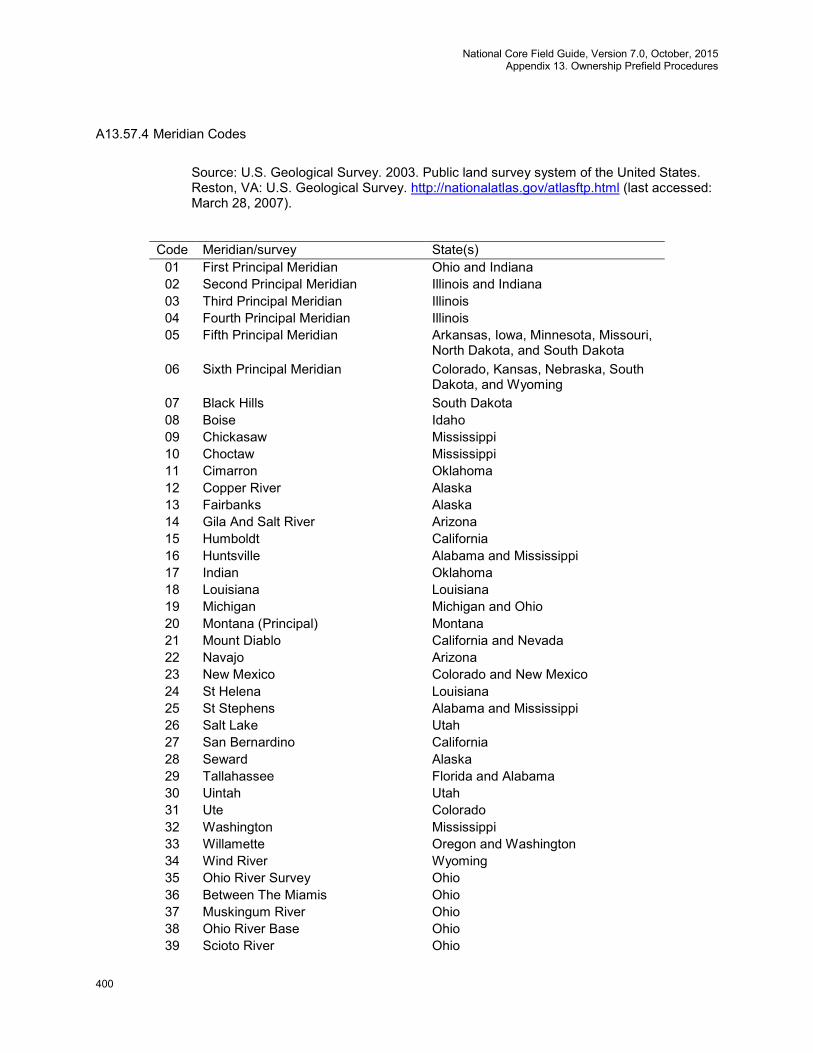
National Core Field Guide, Version 7.0, October, 2015 Appendix 13. Ownership Prefield Procedures
400
A13.57.4 Meridian Codes
Source: U.S. Geological Survey. 2003. Public land survey system of the United States. Reston, VA: U.S. Geological Survey. http://nationalatlas.gov/atlasftp.html (last accessed: March 28, 2007).
Code Meridian/survey State(s) 01 First Principal Meridian Ohio and Indiana 02 Second Principal Meridian Illinois and Indiana 03 Third Principal Meridian Illinois 04 Fourth Principal Meridian Illinois 05 Fifth Principal Meridian Arkansas, Iowa, Minnesota, Missouri,
North Dakota, and South Dakota 06 Sixth Principal Meridian Colorado, Kansas, Nebraska, South
Dakota, and Wyoming 07 Black Hills South Dakota 08 Boise Idaho 09 Chickasaw Mississippi 10 Choctaw Mississippi 11 Cimarron Oklahoma 12 Copper River Alaska 13 Fairbanks Alaska 14 Gila And Salt River Arizona 15 Humboldt California 16 Huntsville Alabama and Mississippi 17 Indian Oklahoma 18 Louisiana Louisiana 19 Michigan Michigan and Ohio 20 Montana (Principal) Montana 21 Mount Diablo California and Nevada 22 Navajo Arizona 23 New Mexico Colorado and New Mexico 24 St Helena Louisiana 25 St Stephens Alabama and Mississippi 26 Salt Lake Utah 27 San Bernardino California 28 Seward Alaska 29 Tallahassee Florida and Alabama 30 Uintah Utah 31 Ute Colorado 32 Washington Mississippi 33 Willamette Oregon and Washington 34 Wind River Wyoming 35 Ohio River Survey Ohio 36 Between The Miamis Ohio 37 Muskingum River Ohio 38 Ohio River Base Ohio 39 Scioto River Ohio
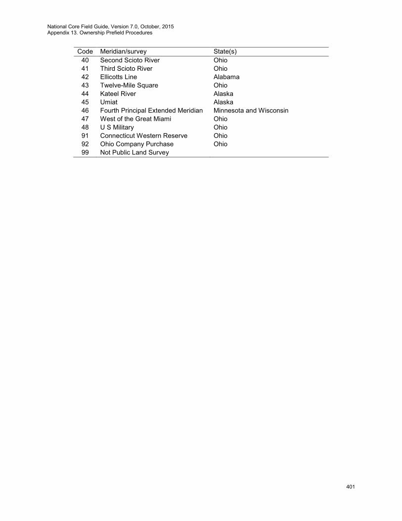
National Core Field Guide, Version 7.0, October, 2015 Appendix 13. Ownership Prefield Procedures
401
Code Meridian/survey State(s) 40 Second Scioto River Ohio 41 Third Scioto River Ohio 42 Ellicotts Line Alabama 43 Twelve-Mile Square Ohio 44 Kateel River Alaska 45 Umiat Alaska 46 Fourth Principal Extended Meridian Minnesota and Wisconsin 47 West of the Great Miami Ohio 48 U S Military Ohio 91 Connecticut Western Reserve Ohio 92 Ohio Company Purchase Ohio 99 Not Public Land Survey
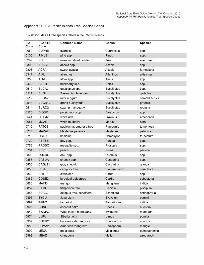
National Core Field Guide, Version 7.0, October, 2015 Appendix 14. FIA Pacific Islands Tree Species Codes
402
Appendix 14. FIA Pacific Islands Tree Species Codes
This list includes all tree species tallied in the Pacific Islands. FIA Code
PLANTS Code
Common Name Genus Species
0050 CUPRE cypress Cupressus spp. 0100 PINUS pine spp. Pinus spp. 0299 2TE unknown dead conifer Tree evergreen 0300 ACACI acacia spp. Acacia spp. 0303 ACFA sweet acacia Acacia farnesiana 0341 AIAL ailanthus Ailanthus altissima 0350 ALNUS alder spp. Alnus spp. 0460 CELTI hackberry spp. Celtis spp. 0510 EUCAL eucalyptus spp. Eucalyptus spp. 0511 EUGL Tasmanian bluegum Eucalyptus globulus 0512 EUCA2 river redgum Eucalyptus camaldulensis 0513 EUGR12 grand eucalyptus Eucalyptus grandis 0514 EURO2 swamp mahogany Eucalyptus robusta 0520 DIOSP persimmon spp. Diospyros spp. 0541 FRAM2 white ash Fraxinus americana 0681 MOAL white mulberry Morus alba 0712 PATO2 paulownia, empress-tree Paulownia tomentosa 0715 MAPA28 Maytenus palauica Maytenus palauica 0718 OSTR kesiamel Osmoxylon truncatum 0720 PERSE bay spp. Persea spp. 0755 PROSO mesquite spp. Prosopis spp. 0764 PRPE3 peach Pruns persica 0800 QUERC oak spp. Quercus spp. 0855 CASUA sheoak spp. Casuarina spp. 0856 CAGL11 gray sheoak Casuarina glauca 0858 CICA camphor tree Cinnamomum camphora 0860 CITRU2 citrus spp Citrus spp. 0865 COSE2 largeleaf geigertree Cordia sebestena 0885 MAIN3 mango Mangifera indica 0887 PIPI3 fishpoison tree Piscidia piscipula 0888 SCAC2 octopus tree, schefflera Schefflera actinophylla 0896 SYCU Java plum Syzygium cumini 0897 TAIN2 tamarind Tamarindus indica 0908 CONU coconut palm Cocos nucifera 0940 SWMA2 West Indian mahogany Swietenia mahagoni 0974 ULPU Siberian elm Ulmus pumila 0987 COER2 buttonwood-mangrove Conocarpus erectus 0989 RHMA2 American mangrove Rhizophora mangle 0992 MEQU melaleuca Melaleuca quinquenervia 0993 MEAZ chinaberry Melia azedarach
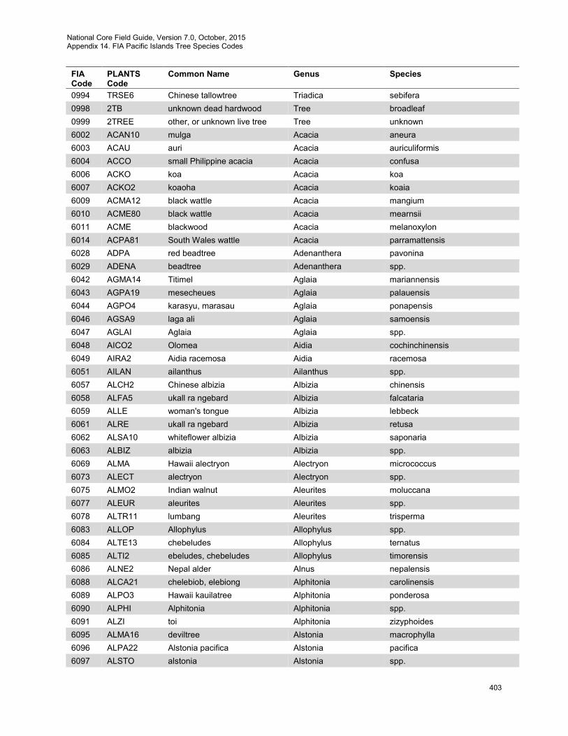
National Core Field Guide, Version 7.0, October, 2015 Appendix 14. FIA Pacific Islands Tree Species Codes
403
FIA Code
PLANTS Code
Common Name Genus Species
0994 TRSE6 Chinese tallowtree Triadica sebifera 0998 2TB unknown dead hardwood Tree broadleaf 0999 2TREE other, or unknown live tree Tree unknown 6002 ACAN10 mulga Acacia aneura 6003 ACAU auri Acacia auriculiformis 6004 ACCO small Philippine acacia Acacia confusa 6006 ACKO koa Acacia koa 6007 ACKO2 koaoha Acacia koaia 6009 ACMA12 black wattle Acacia mangium 6010 ACME80 black wattle Acacia mearnsii 6011 ACME blackwood Acacia melanoxylon 6014 ACPA81 South Wales wattle Acacia parramattensis 6028 ADPA red beadtree Adenanthera pavonina 6029 ADENA beadtree Adenanthera spp. 6042 AGMA14 Titimel Aglaia mariannensis 6043 AGPA19 mesecheues Aglaia palauensis 6044 AGPO4 karasyu, marasau Aglaia ponapensis 6046 AGSA9 laga ali Aglaia samoensis 6047 AGLAI Aglaia Aglaia spp. 6048 AICO2 Olomea Aidia cochinchinensis 6049 AIRA2 Aidia racemosa Aidia racemosa 6051 AILAN ailanthus Ailanthus spp. 6057 ALCH2 Chinese albizia Albizia chinensis 6058 ALFA5 ukall ra ngebard Albizia falcataria 6059 ALLE woman's tongue Albizia lebbeck 6061 ALRE ukall ra ngebard Albizia retusa 6062 ALSA10 whiteflower albizia Albizia saponaria 6063 ALBIZ albizia Albizia spp. 6069 ALMA Hawaii alectryon Alectryon micrococcus 6073 ALECT alectryon Alectryon spp. 6075 ALMO2 Indian walnut Aleurites moluccana 6077 ALEUR aleurites Aleurites spp. 6078 ALTR11 lumbang Aleurites trisperma 6083 ALLOP Allophylus Allophylus spp. 6084 ALTE13 chebeludes Allophylus ternatus 6085 ALTI2 ebeludes, chebeludes Allophylus timorensis 6086 ALNE2 Nepal alder Alnus nepalensis 6088 ALCA21 chelebiob, elebiong Alphitonia carolinensis 6089 ALPO3 Hawaii kauilatree Alphitonia ponderosa 6090 ALPHI Alphitonia Alphitonia spp. 6091 ALZI toi Alphitonia zizyphoides 6095 ALMA16 deviltree Alstonia macrophylla 6096 ALPA22 Alstonia pacifica Alstonia pacifica 6097 ALSTO alstonia Alstonia spp.
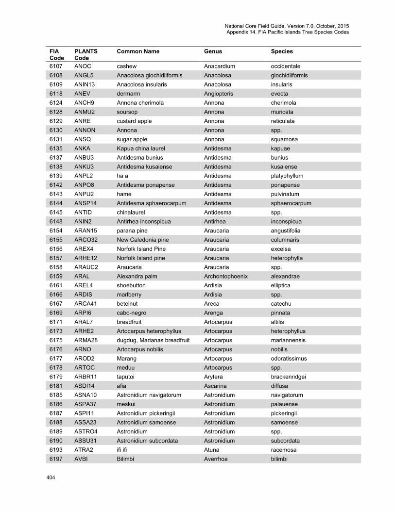
National Core Field Guide, Version 7.0, October, 2015 Appendix 14. FIA Pacific Islands Tree Species Codes
404
FIA Code
PLANTS Code
Common Name Genus Species
6107 ANOC cashew Anacardium occidentale 6108 ANGL5 Anacolosa glochidiiformis Anacolosa glochidiiformis 6109 ANIN13 Anacolosa insularis Anacolosa insularis 6118 ANEV dermarm Angiopteris evecta 6124 ANCH9 Annona cherimola Annona cherimola 6128 ANMU2 soursop Annona muricata 6129 ANRE custard apple Annona reticulata 6130 ANNON Annona Annona spp. 6131 ANSQ sugar apple Annona squamosa 6135 ANKA Kapua china laurel Antidesma kapuae 6137 ANBU3 Antidesma bunius Antidesma bunius 6138 ANKU3 Antidesma kusaiense Antidesma kusaiense 6139 ANPL2 ha a Antidesma platyphyllum 6142 ANPO8 Antidesma ponapense Antidesma ponapense 6143 ANPU2 hame Antidesma pulvinatum 6144 ANSP14 Antidesma sphaerocarpum Antidesma sphaerocarpum 6145 ANTID chinalaurel Antidesma spp. 6148 ANIN2 Antirhea inconspicua Antirhea inconspicua 6154 ARAN15 parana pine Araucaria angustifolia 6155 ARCO32 New Caledonia pine Araucaria columnaris 6156 AREX4 Norfolk Island Pine Araucaria excelsa 6157 ARHE12 Norfolk Island pine Araucaria heterophylla 6158 ARAUC2 Araucaria Araucaria spp. 6159 ARAL Alexandra palm Archontophoenix alexandrae 6161 AREL4 shoebutton Ardisia elliptica 6166 ARDIS marlberry Ardisia spp. 6167 ARCA41 betelnut Areca catechu 6169 ARPI6 cabo-negro Arenga pinnata 6171 ARAL7 breadfruit Artocarpus altilis 6173 ARHE2 Artocarpus heterophyllus Artocarpus heterophyllus 6175 ARMA28 dugdug, Marianas breadfruit Artocarpus mariannensis 6176 ARNO Artocarpus nobilis Artocarpus nobilis 6177 AROD2 Marang Artocarpus odoratissimus 6178 ARTOC meduu Artocarpus spp. 6179 ARBR11 taputoi Arytera brackenridgei 6181 ASDI14 afia Ascarina diffusa 6185 ASNA10 Astronidium navigatorum Astronidium navigatorum 6186 ASPA37 meskui Astronidium palauense 6187 ASPI11 Astronidium pickeringii Astronidium pickeringii 6188 ASSA23 Astronidium samoense Astronidium samoense 6189 ASTRO4 Astronidium Astronidium spp. 6190 ASSU31 Astronidium subcordata Astronidium subcordata 6193 ATRA2 ifi ifi Atuna racemosa 6197 AVBI Bilimbi Averrhoa bilimbi
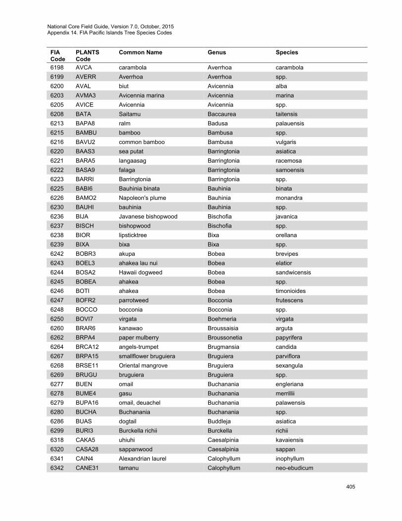
National Core Field Guide, Version 7.0, October, 2015 Appendix 14. FIA Pacific Islands Tree Species Codes
405
FIA Code
PLANTS Code
Common Name Genus Species
6198 AVCA carambola Averrhoa carambola 6199 AVERR Averrhoa Averrhoa spp. 6200 AVAL biut Avicennia alba 6203 AVMA3 Avicennia marina Avicennia marina 6205 AVICE Avicennia Avicennia spp. 6208 BATA Saitamu Baccaurea taitensis 6213 BAPA8 ralm Badusa palauensis 6215 BAMBU bamboo Bambusa spp. 6216 BAVU2 common bamboo Bambusa vulgaris 6220 BAAS3 sea putat Barringtonia asiatica 6221 BARA5 langaasag Barringtonia racemosa 6222 BASA9 falaga Barringtonia samoensis 6223 BARRI Barringtonia Barringtonia spp. 6225 BABI6 Bauhinia binata Bauhinia binata 6226 BAMO2 Napoleon's plume Bauhinia monandra 6230 BAUHI bauhinia Bauhinia spp. 6236 BIJA Javanese bishopwood Bischofia javanica 6237 BISCH bishopwood Bischofia spp. 6238 BIOR lipsticktree Bixa orellana 6239 BIXA bixa Bixa spp. 6242 BOBR3 akupa Bobea brevipes 6243 BOEL3 ahakea lau nui Bobea elatior 6244 BOSA2 Hawaii dogweed Bobea sandwicensis 6245 BOBEA ahakea Bobea spp. 6246 BOTI ahakea Bobea timonioides 6247 BOFR2 parrotweed Bocconia frutescens 6248 BOCCO bocconia Bocconia spp. 6250 BOVI7 virgata Boehmeria virgata 6260 BRAR6 kanawao Broussaisia arguta 6262 BRPA4 paper mulberry Broussonetia papyrifera 6264 BRCA12 angels-trumpet Brugmansia candida 6267 BRPA15 smallflower bruguiera Bruguiera parviflora 6268 BRSE11 Oriental mangrove Bruguiera sexangula 6269 BRUGU bruguiera Bruguiera spp. 6277 BUEN omail Buchanania engleriana 6278 BUME4 gasu Buchanania merrillii 6279 BUPA16 omail, deuachel Buchanania palawensis 6280 BUCHA Buchanania Buchanania spp. 6286 BUAS dogtail Buddleja asiatica 6299 BURI3 Burckella richii Burckella richii 6318 CAKA5 uhiuhi Caesalpinia kavaiensis 6320 CASA28 sappanwood Caesalpinia sappan 6341 CAIN4 Alexandrian laurel Calophyllum inophyllum 6342 CANE31 tamanu Calophyllum neo-ebudicum
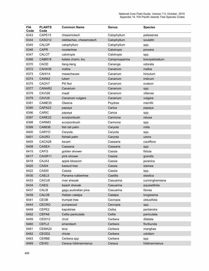
National Core Field Guide, Version 7.0, October, 2015 Appendix 14. FIA Pacific Islands Tree Species Codes
406
FIA Code
PLANTS Code
Common Name Genus Species
6343 CAPE15 chesemolech Calophyllum pelewense 6344 CASO12 olebtaches, chesemolech Calophyllum soulattri 6345 CALOP calophyllum Calophyllum spp. 6346 CAPR roostertree Calotropis procera 6347 CALOT calotropis Calotropis spp. 6366 CABR18 kelela charm, kiu Campnosperma brevipetiolatum 6370 CAOD ilang-ilang Cananga odorata 6372 CAHA39 mafoa Canarium mafoa 6373 CAHI14 mesecheues Canarium hirsutum 6374 CAIN42 lukerr Canarium indicum 6375 CAOV7 Pili Nut Canarium ovatum 6377 CANAR2 Canarium Canarium spp. 6378 CAVI26 maali Canarium vitiense 6379 CAVU9 Canarium vulgare Canarium vulgare 6381 CAME35 Olasina Psydrax merrillii 6395 CAPA23 papaya Carica papaya 6396 CARIC papaya Carica spp. 6397 CARE22 scorpionbush Carmona retusa 6398 CARMO scorpionbush Carmona spp. 6399 CAMI36 fish tail palm Caryota mitis 6400 CARYO Caryota Caryota spp. 6401 CAUR3 fishtail palm Caryota urens 6405 CACA28 keuert Casearia cauliflora 6408 CASEA Casearia Casearia spp. 6415 CAFI3 golden shower Cassia fistula 6417 CAGR11 pink shower Cassia grandis 6418 CAJA3 apple blossom Cassia javanica 6420 CASI4 kassod tree Cassia siamea 6422 CASSI Cassia Cassia spp. 6430 CAEL5 Panama rubbertree Castilla elastica 6433 CACU8 river sheoak Casuarina cunninghamiana 6434 CAEQ beach sheoak Casuarina equisetifolia 6437 CALI8 gagu,australian pine Casuarina litorea 6439 CALO8 Haitian catalpa Catalpa longissima 6441 CEOB trumpet tree Cecropia obtusifolia 6444 CECRO pumpwood Cecropia spp. 6449 CEPE2 kapoktree Ceiba pentandra 6452 CEPA6 Celtis paniculata Celtis paniculata 6459 CEDI12 chuti Cerbera dilatata 6460 CEFL2 emeridech Cerbera floribunda 6461 CEMA20 leva Cerbera manghas 6462 CEOD2 chiute Cerbera odollam 6463 CERBE Cerbera spp Cerbera spp 6469 CEHI3 Cereus hildmannianus Cereus hildmannianus
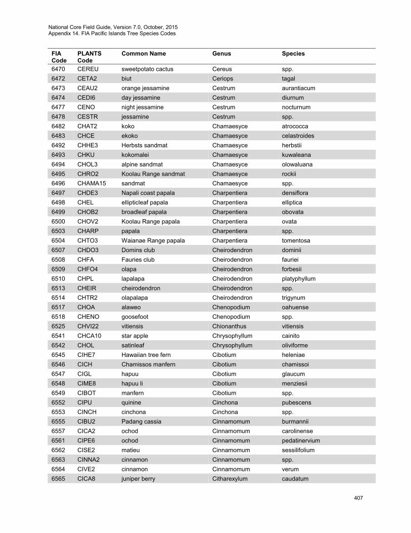
National Core Field Guide, Version 7.0, October, 2015 Appendix 14. FIA Pacific Islands Tree Species Codes
407
FIA Code
PLANTS Code
Common Name Genus Species
6470 CEREU sweetpotato cactus Cereus spp. 6472 CETA2 biut Ceriops tagal 6473 CEAU2 orange jessamine Cestrum aurantiacum 6474 CEDI6 day jessamine Cestrum diurnum 6477 CENO night jessamine Cestrum nocturnum 6478 CESTR jessamine Cestrum spp. 6482 CHAT2 koko Chamaesyce atrococca 6483 CHCE ekoko Chamaesyce celastroides 6492 CHHE3 Herbsts sandmat Chamaesyce herbstii 6493 CHKU kokomalei Chamaesyce kuwaleana 6494 CHOL3 alpine sandmat Chamaesyce olowaluana 6495 CHRO2 Koolau Range sandmat Chamaesyce rockii 6496 CHAMA15 sandmat Chamaesyce spp. 6497 CHDE3 Napali coast papala Charpentiera densiflora 6498 CHEL ellipticleaf papala Charpentiera elliptica 6499 CHOB2 broadleaf papala Charpentiera obovata 6500 CHOV2 Koolau Range papala Charpentiera ovata 6503 CHARP papala Charpentiera spp. 6504 CHTO3 Waianae Range papala Charpentiera tomentosa 6507 CHDO3 Domins club Cheirodendron dominii 6508 CHFA Fauries club Cheirodendron fauriei 6509 CHFO4 olapa Cheirodendron forbesii 6510 CHPL lapalapa Cheirodendron platyphyllum 6513 CHEIR cheirodendron Cheirodendron spp. 6514 CHTR2 olapalapa Cheirodendron trigynum 6517 CHOA alaweo Chenopodium oahuense 6518 CHENO goosefoot Chenopodium spp. 6525 CHVI22 vitiensis Chionanthus vitiensis 6541 CHCA10 star apple Chrysophyllum cainito 6542 CHOL satinleaf Chrysophyllum oliviforme 6545 CIHE7 Hawaiian tree fern Cibotium heleniae 6546 CICH Chamissos manfern Cibotium chamissoi 6547 CIGL hapuu Cibotium glaucum 6548 CIME8 hapuu li Cibotium menziesii 6549 CIBOT manfern Cibotium spp. 6552 CIPU quinine Cinchona pubescens 6553 CINCH cinchona Cinchona spp. 6555 CIBU2 Padang cassia Cinnamomum burmannii 6557 CICA2 ochod Cinnamomum carolinense 6561 CIPE6 ochod Cinnamomum pedatinervium 6562 CISE2 matieu Cinnamomum sessilifolium 6563 CINNA2 cinnamon Cinnamomum spp. 6564 CIVE2 cinnamon Cinnamomum verum 6565 CICA8 juniper berry Citharexylum caudatum
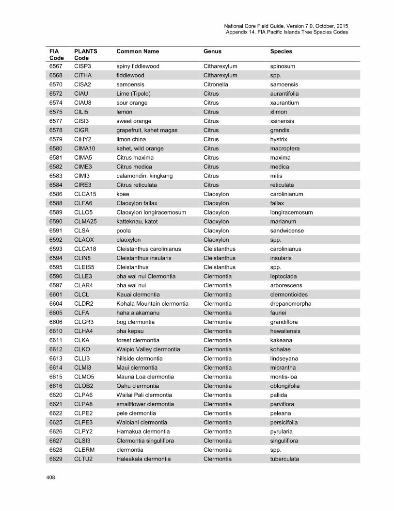
National Core Field Guide, Version 7.0, October, 2015 Appendix 14. FIA Pacific Islands Tree Species Codes
408
FIA Code
PLANTS Code
Common Name Genus Species
6567 CISP3 spiny fiddlewood Citharexylum spinosum 6568 CITHA fiddlewood Citharexylum spp. 6570 CISA2 samoensis Citronella samoensis 6572 CIAU Lime (Tipolo) Citrus aurantifolia 6574 CIAU8 sour orange Citrus xaurantium 6575 CILI5 lemon Citrus xlimon 6577 CISI3 sweet orange Citrus xsinensis 6578 CIGR grapefruit, kahet magas Citrus grandis 6579 CIHY2 limon china Citrus hystrix 6580 CIMA10 kahet, wild orange Citrus macroptera 6581 CIMA5 Citrus maxima Citrus maxima 6582 CIME3 Citrus medica Citrus medica 6583 CIMI3 calamondin, kingkang Citrus mitis 6584 CIRE3 Citrus reticulata Citrus reticulata 6586 CLCA15 koee Claoxylon carolinianum 6588 CLFA6 Claoxylon fallax Claoxylon fallax 6589 CLLO5 Claoxylon longiracemosum Claoxylon longiracemosum 6590 CLMA25 katteknau, katot Claoxylon marianum 6591 CLSA poola Claoxylon sandwicense 6592 CLAOX claoxylon Claoxylon spp. 6593 CLCA18 Cleistanthus carolinianus Cleistanthus carolinianus 6594 CLIN8 Cleistanthus insularis Cleistanthus insularis 6595 CLEIS5 Cleistanthus Cleistanthus spp. 6596 CLLE3 oha wai nui Clermontia Clermontia leptoclada 6597 CLAR4 oha wai nui Clermontia arborescens 6601 CLCL Kauai clermontia Clermontia clermontioides 6604 CLDR2 Kohala Mountain clermontia Clermontia drepanomorpha 6605 CLFA haha aiakamanu Clermontia fauriei 6606 CLGR3 bog clermontia Clermontia grandiflora 6610 CLHA4 oha kepau Clermontia hawaiiensis 6611 CLKA forest clermontia Clermontia kakeana 6612 CLKO Waipio Valley clermontia Clermontia kohalae 6613 CLLI3 hillside clermontia Clermontia lindseyana 6614 CLMI3 Maui clermontia Clermontia micrantha 6615 CLMO5 Mauna Loa clermontia Clermontia montis-loa 6616 CLOB2 Oahu clermontia Clermontia oblongifolia 6620 CLPA6 Wailai Pali clermontia Clermontia pallida 6621 CLPA8 smallflower clermontia Clermontia parviflora 6622 CLPE2 pele clermontia Clermontia peleana 6625 CLPE3 Waioiani clermontia Clermontia persicifolia 6626 CLPY2 Hamakua clermontia Clermontia pyrularia 6627 CLSI3 Clermontia singuliflora Clermontia singuliflora 6628 CLERM clermontia Clermontia spp. 6629 CLTU2 Haleakala clermontia Clermontia tuberculata
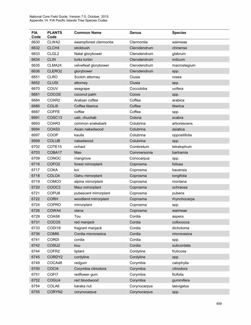
National Core Field Guide, Version 7.0, October, 2015 Appendix 14. FIA Pacific Islands Tree Species Codes
409
FIA Code
PLANTS Code
Common Name Genus Species
6630 CLWA2 swampforest clermontia Clermontia waimeae 6632 CLCH4 stickbush Clerodendrum chinense 6633 CLGL2 Natal glorybower Clerodendrum glabrum 6634 CLIN turks turbin Clerodendrum indicum 6635 CLMA24 velvetleaf glorybower Clerodendrum macrostegium 6636 CLERO2 glorybower Clerodendrum spp. 6651 CLRO Scotch attorney Clusia rosea 6652 CLUSI attorney Clusia spp. 6670 COUV seagrape Coccoloba uvifera 6681 COCOS coconut palm Cocos spp. 6684 COAR2 Arabian coffee Coffea arabica 6686 COLI8 Coffea liberica Coffea liberica 6687 COFFE coffee Coffea spp. 6691 COSC13 uab, chuchab Colona scabra 6693 COAR3 common snakebark Colubrina arborescens 6694 COAS3 Asian nakedwood Colubrina asiatica 6697 COOP kauila Colubrina oppositifolia 6699 COLUB nakedwood Colubrina spp. 6702 COTE15 ochaol Combretum tetralophum 6703 COBA17 Mao Commersonia bartramia 6709 CONOC mangrove Conocarpus spp. 6716 COFO2 forest mirrorplant Coprosma foliosa 6717 COKA koi Coprosma kauensis 6718 COLO4 Oahu mirrorplant Coprosma longifolia 6719 COMO3 alpine mirrorplant Coprosma montana 6720 COOC3 Maui mirrorplant Coprosma ochracea 6721 COPU8 pubescent mirrorplant Coprosma pubens 6722 CORH woodland mirrorplant Coprosma rhynchocarpa 6724 COPRO mirrorplant Coprosma spp. 6726 COWA4 olena Coprosma waimeae 6729 COAS6 Tou Cordia aspera 6731 COCO5 red manjack Cordia collococca 6733 CODI18 fragrant manjack Cordia dichotoma 6736 COMI6 Cordia micronesica Cordia micronesica 6741 CORDI cordia Cordia spp. 6742 COSU2 kou Cordia subcordata 6744 COFR2 tiplant Cordyline fruticosa 6745 CORDY2 cordyline Cordyline spp. 6749 COCA48 redgum Corymbia calophylla 6750 COCI4 Corymbia citriodora Corymbia citriodora 6751 COFI7 redflower gum Corymbia ficifolia 6752 COGU4 red bloodwood Corymbia gummifera 6754 COLA6 karaka nut Corynocarpus laevigatus 6755 CORYN2 corynocarpus Corynocarpus spp.

National Core Field Guide, Version 7.0, October, 2015 Appendix 14. FIA Pacific Islands Tree Species Codes
410
FIA Code
PLANTS Code
Common Name Genus Species
6756 COGU3 cannonball tree Couroupita guianensis 6758 CRRE12 sacred garlic pear Crateva religiosa 6760 CRAL11 houka, calabash Crescentia alata 6769 CRBI9 Saitamu Crossostylis biflora 6771 CRLO3 longbeak rattlebox Crotalaria longirostrata 6778 CROR5 Cryptocarya oreophila Cryptocarya oreophila 6779 CREL8 laulilii Cryptocarya elegans 6781 CRMA8 holio Cryptocarya mannii 6783 CRYPT2 cryptocarya Cryptocarya spp. 6784 CRTU4 laulilii Cryptocarya turbinata 6786 CRJA3 Japanese cedar Cryptomeria japonica 6787 CRYPT4 Japanese cedar Cryptomeria spp. 6795 CULU2 cedar-of-Goa Cupressus lusitanica 6796 CUSE2 Italian cypress Cupressus sempervirens 6800 CYAC4 Haleakala cyanea Cyanea aculeatiflora 6801 CYAR10 palmtree cyanea Cyanea arborea 6802 CYFI6 Kauai cyanea Cyanea fissa 6805 CYFL4 Degeners cyanea Cyanea floribunda 6806 CYGI5 Kilauea Mauna cyanea Cyanea giffardii 6807 CYHA6 wetforest cyanea Cyanea hamatiflora 6810 CYHA7 Oahu cyanea Cyanea hardyi 6811 CYHO6 prickly cyanea Cyanea horrida 6812 CYKU3 Limahuli Valley cyanea Cyanea kuhihewa 6813 CYKU Kunths cyanea Cyanea kunthiana 6814 CYLE5 giant kokee cyanea Cyanea leptostegia 6815 CYMA10 purple cyanea Cyanea macrostegia 6818 CYMA14 Marks cyanea Cyanea marksii 6819 CYPI4 hairy cyanea Cyanea pilosa 6822 CYPO5 pohaku cyanea Cyanea pohaku 6823 CYPR8 Molokai cyanea Cyanea procera 6824 CYPY manyfruit cyanea Cyanea pycnocarpa 6825 CYQU oakleaf cyanea Cyanea quercifolia 6826 CYRI4 plateau delissea Cyanea rivularis 6827 CYSO2 pua kala Cyanea solenocalyx 6828 CYANE cyanea Cyanea spp. 6829 CYST5 Kaiholena cyanea Cyanea stictophylla 6830 CYSU8 Mt. Kaala cyanea Cyanea superba 6833 CYTR6 aku aku Cyanea tritomantha 6837 CYCO18 Coopers cyathea Cyathea cooperi 6838 CYDE16 olioli Cyathea decurrens 6840 CYLU5 olioli Cyathea lunulata 6841 CYME12 olioli Cyathea medullaris 6842 CYNI7 kattar Cyathea nigricans 6844 CYPO11 kattar Cyathea ponapeana
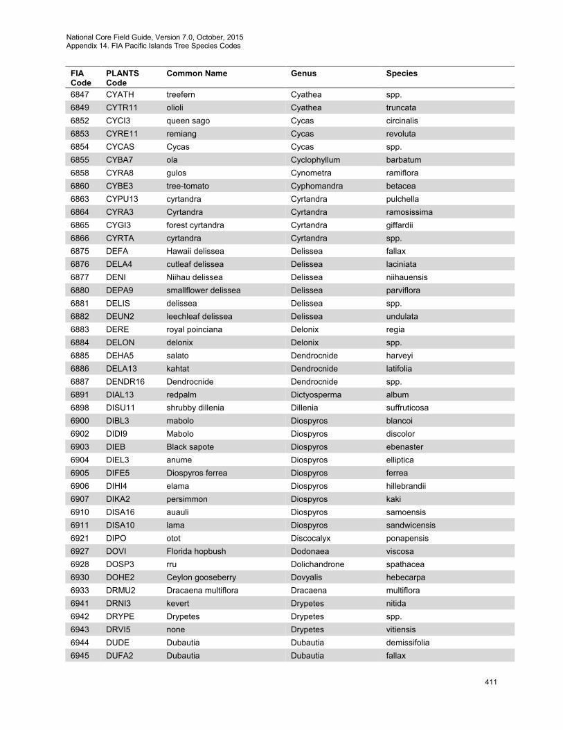
National Core Field Guide, Version 7.0, October, 2015 Appendix 14. FIA Pacific Islands Tree Species Codes
411
FIA Code
PLANTS Code
Common Name Genus Species
6847 CYATH treefern Cyathea spp. 6849 CYTR11 olioli Cyathea truncata 6852 CYCI3 queen sago Cycas circinalis 6853 CYRE11 remiang Cycas revoluta 6854 CYCAS Cycas Cycas spp. 6855 CYBA7 ola Cyclophyllum barbatum 6858 CYRA8 gulos Cynometra ramiflora 6860 CYBE3 tree-tomato Cyphomandra betacea 6863 CYPU13 cyrtandra Cyrtandra pulchella 6864 CYRA3 Cyrtandra Cyrtandra ramosissima 6865 CYGI3 forest cyrtandra Cyrtandra giffardii 6866 CYRTA cyrtandra Cyrtandra spp. 6875 DEFA Hawaii delissea Delissea fallax 6876 DELA4 cutleaf delissea Delissea laciniata 6877 DENI Niihau delissea Delissea niihauensis 6880 DEPA9 smallflower delissea Delissea parviflora 6881 DELIS delissea Delissea spp. 6882 DEUN2 leechleaf delissea Delissea undulata 6883 DERE royal poinciana Delonix regia 6884 DELON delonix Delonix spp. 6885 DEHA5 salato Dendrocnide harveyi 6886 DELA13 kahtat Dendrocnide latifolia 6887 DENDR16 Dendrocnide Dendrocnide spp. 6891 DIAL13 redpalm Dictyosperma album 6898 DISU11 shrubby dillenia Dillenia suffruticosa 6900 DIBL3 mabolo Diospyros blancoi 6902 DIDI9 Mabolo Diospyros discolor 6903 DIEB Black sapote Diospyros ebenaster 6904 DIEL3 anume Diospyros elliptica 6905 DIFE5 Diospyros ferrea Diospyros ferrea 6906 DIHI4 elama Diospyros hillebrandii 6907 DIKA2 persimmon Diospyros kaki 6910 DISA16 auauli Diospyros samoensis 6911 DISA10 lama Diospyros sandwicensis 6921 DIPO otot Discocalyx ponapensis 6927 DOVI Florida hopbush Dodonaea viscosa 6928 DOSP3 rru Dolichandrone spathacea 6930 DOHE2 Ceylon gooseberry Dovyalis hebecarpa 6933 DRMU2 Dracaena multiflora Dracaena multiflora 6941 DRNI3 kevert Drypetes nitida 6942 DRYPE Drypetes Drypetes spp. 6943 DRVI5 none Drypetes vitiensis 6944 DUDE Dubautia Dubautia demissifolia 6945 DUFA2 Dubautia Dubautia fallax
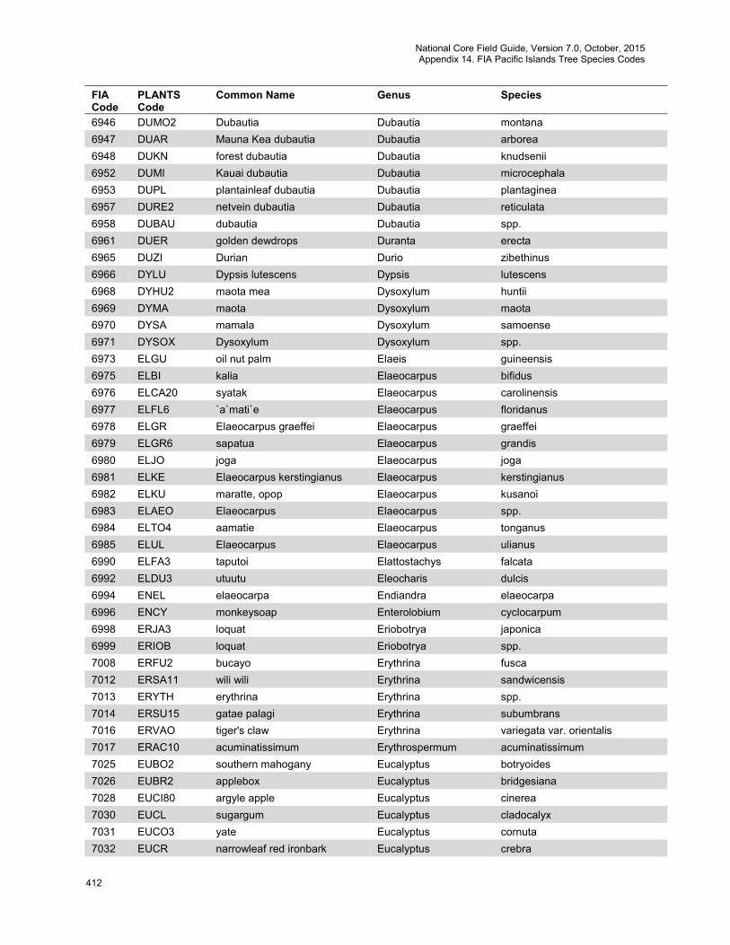
National Core Field Guide, Version 7.0, October, 2015 Appendix 14. FIA Pacific Islands Tree Species Codes
412
FIA Code
PLANTS Code
Common Name Genus Species
6946 DUMO2 Dubautia Dubautia montana 6947 DUAR Mauna Kea dubautia Dubautia arborea 6948 DUKN forest dubautia Dubautia knudsenii 6952 DUMI Kauai dubautia Dubautia microcephala 6953 DUPL plantainleaf dubautia Dubautia plantaginea 6957 DURE2 netvein dubautia Dubautia reticulata 6958 DUBAU dubautia Dubautia spp. 6961 DUER golden dewdrops Duranta erecta 6965 DUZI Durian Durio zibethinus 6966 DYLU Dypsis lutescens Dypsis lutescens 6968 DYHU2 maota mea Dysoxylum huntii 6969 DYMA maota Dysoxylum maota 6970 DYSA mamala Dysoxylum samoense 6971 DYSOX Dysoxylum Dysoxylum spp. 6973 ELGU oil nut palm Elaeis guineensis 6975 ELBI kalia Elaeocarpus bifidus 6976 ELCA20 syatak Elaeocarpus carolinensis 6977 ELFL6 `a`mati`e Elaeocarpus floridanus 6978 ELGR Elaeocarpus graeffei Elaeocarpus graeffei 6979 ELGR6 sapatua Elaeocarpus grandis 6980 ELJO joga Elaeocarpus joga 6981 ELKE Elaeocarpus kerstingianus Elaeocarpus kerstingianus 6982 ELKU maratte, opop Elaeocarpus kusanoi 6983 ELAEO Elaeocarpus Elaeocarpus spp. 6984 ELTO4 aamatie Elaeocarpus tonganus 6985 ELUL Elaeocarpus Elaeocarpus ulianus 6990 ELFA3 taputoi Elattostachys falcata 6992 ELDU3 utuutu Eleocharis dulcis 6994 ENEL elaeocarpa Endiandra elaeocarpa 6996 ENCY monkeysoap Enterolobium cyclocarpum 6998 ERJA3 loquat Eriobotrya japonica 6999 ERIOB loquat Eriobotrya spp. 7008 ERFU2 bucayo Erythrina fusca 7012 ERSA11 wili wili Erythrina sandwicensis 7013 ERYTH erythrina Erythrina spp. 7014 ERSU15 gatae palagi Erythrina subumbrans 7016 ERVAO tiger's claw Erythrina variegata var. orientalis 7017 ERAC10 acuminatissimum Erythrospermum acuminatissimum 7025 EUBO2 southern mahogany Eucalyptus botryoides 7026 EUBR2 applebox Eucalyptus bridgesiana 7028 EUCI80 argyle apple Eucalyptus cinerea 7030 EUCL sugargum Eucalyptus cladocalyx 7031 EUCO3 yate Eucalyptus cornuta 7032 EUCR narrowleaf red ironbark Eucalyptus crebra
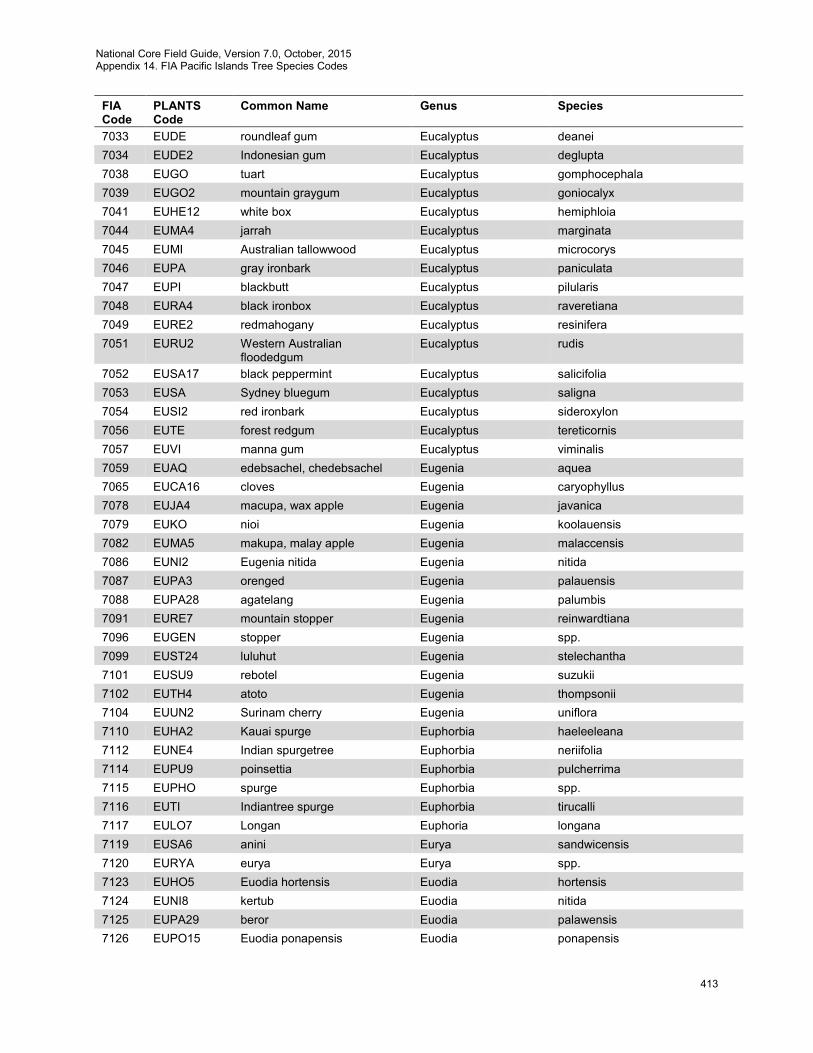
National Core Field Guide, Version 7.0, October, 2015 Appendix 14. FIA Pacific Islands Tree Species Codes
413
FIA Code
PLANTS Code
Common Name Genus Species
7033 EUDE roundleaf gum Eucalyptus deanei 7034 EUDE2 Indonesian gum Eucalyptus deglupta 7038 EUGO tuart Eucalyptus gomphocephala 7039 EUGO2 mountain graygum Eucalyptus goniocalyx 7041 EUHE12 white box Eucalyptus hemiphloia 7044 EUMA4 jarrah Eucalyptus marginata 7045 EUMI Australian tallowwood Eucalyptus microcorys 7046 EUPA gray ironbark Eucalyptus paniculata 7047 EUPI blackbutt Eucalyptus pilularis 7048 EURA4 black ironbox Eucalyptus raveretiana 7049 EURE2 redmahogany Eucalyptus resinifera 7051 EURU2 Western Australian
floodedgum Eucalyptus rudis
7052 EUSA17 black peppermint Eucalyptus salicifolia 7053 EUSA Sydney bluegum Eucalyptus saligna 7054 EUSI2 red ironbark Eucalyptus sideroxylon 7056 EUTE forest redgum Eucalyptus tereticornis 7057 EUVI manna gum Eucalyptus viminalis 7059 EUAQ edebsachel, chedebsachel Eugenia aquea 7065 EUCA16 cloves Eugenia caryophyllus 7078 EUJA4 macupa, wax apple Eugenia javanica 7079 EUKO nioi Eugenia koolauensis 7082 EUMA5 makupa, malay apple Eugenia malaccensis 7086 EUNI2 Eugenia nitida Eugenia nitida 7087 EUPA3 orenged Eugenia palauensis 7088 EUPA28 agatelang Eugenia palumbis 7091 EURE7 mountain stopper Eugenia reinwardtiana 7096 EUGEN stopper Eugenia spp. 7099 EUST24 luluhut Eugenia stelechantha 7101 EUSU9 rebotel Eugenia suzukii 7102 EUTH4 atoto Eugenia thompsonii 7104 EUUN2 Surinam cherry Eugenia uniflora 7110 EUHA2 Kauai spurge Euphorbia haeleeleana 7112 EUNE4 Indian spurgetree Euphorbia neriifolia 7114 EUPU9 poinsettia Euphorbia pulcherrima 7115 EUPHO spurge Euphorbia spp. 7116 EUTI Indiantree spurge Euphorbia tirucalli 7117 EULO7 Longan Euphoria longana 7119 EUSA6 anini Eurya sandwicensis 7120 EURYA eurya Eurya spp. 7123 EUHO5 Euodia hortensis Euodia hortensis 7124 EUNI8 kertub Euodia nitida 7125 EUPA29 beror Euodia palawensis 7126 EUPO15 Euodia ponapensis Euodia ponapensis
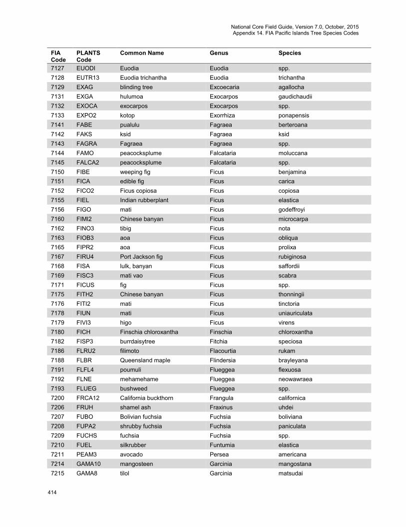
National Core Field Guide, Version 7.0, October, 2015 Appendix 14. FIA Pacific Islands Tree Species Codes
414
FIA Code
PLANTS Code
Common Name Genus Species
7127 EUODI Euodia Euodia spp. 7128 EUTR13 Euodia trichantha Euodia trichantha 7129 EXAG blinding tree Excoecaria agallocha 7131 EXGA hulumoa Exocarpos gaudichaudii 7132 EXOCA exocarpos Exocarpos spp. 7133 EXPO2 kotop Exorrhiza ponapensis 7141 FABE pualulu Fagraea berteroana 7142 FAKS ksid Fagraea ksid 7143 FAGRA Fagraea Fagraea spp. 7144 FAMO peacocksplume Falcataria moluccana 7145 FALCA2 peacocksplume Falcataria spp. 7150 FIBE weeping fig Ficus benjamina 7151 FICA edible fig Ficus carica 7152 FICO2 Ficus copiosa Ficus copiosa 7155 FIEL Indian rubberplant Ficus elastica 7156 FIGO mati Ficus godeffroyi 7160 FIMI2 Chinese banyan Ficus microcarpa 7162 FINO3 tibig Ficus nota 7163 FIOB3 aoa Ficus obliqua 7165 FIPR2 aoa Ficus prolixa 7167 FIRU4 Port Jackson fig Ficus rubiginosa 7168 FISA lulk, banyan Ficus saffordii 7169 FISC3 mati vao Ficus scabra 7171 FICUS fig Ficus spp. 7175 FITH2 Chinese banyan Ficus thonningii 7176 FITI2 mati Ficus tinctoria 7178 FIUN mati Ficus uniauriculata 7179 FIVI3 higo Ficus virens 7180 FICH Finschia chloroxantha Finschia chloroxantha 7182 FISP3 burrdaisytree Fitchia speciosa 7186 FLRU2 filimoto Flacourtia rukam 7188 FLBR Queensland maple Flindersia brayleyana 7191 FLFL4 poumuli Flueggea flexuosa 7192 FLNE mehamehame Flueggea neowawraea 7193 FLUEG bushweed Flueggea spp. 7200 FRCA12 California buckthorn Frangula californica 7206 FRUH shamel ash Fraxinus uhdei 7207 FUBO Bolivian fuchsia Fuchsia boliviana 7208 FUPA2 shrubby fuchsia Fuchsia paniculata 7209 FUCHS fuchsia Fuchsia spp. 7210 FUEL silkrubber Funtumia elastica 7211 PEAM3 avocado Persea americana 7214 GAMA10 mangosteen Garcinia mangostana 7215 GAMA8 tilol Garcinia matsudai
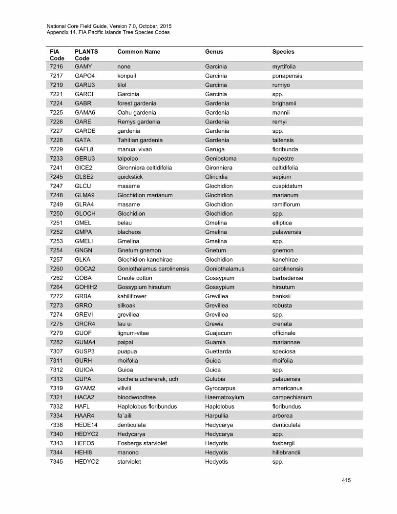
National Core Field Guide, Version 7.0, October, 2015 Appendix 14. FIA Pacific Islands Tree Species Codes
415
FIA Code
PLANTS Code
Common Name Genus Species
7216 GAMY none Garcinia myrtifolia 7217 GAPO4 konpuil Garcinia ponapensis 7219 GARU3 tilol Garcinia rumiyo 7221 GARCI Garcinia Garcinia spp. 7224 GABR forest gardenia Gardenia brighamii 7225 GAMA6 Oahu gardenia Gardenia mannii 7226 GARE Remys gardenia Gardenia remyi 7227 GARDE gardenia Gardenia spp. 7228 GATA Tahitian gardenia Gardenia taitensis 7229 GAFL8 manuai vivao Garuga floribunda 7233 GERU3 taipoipo Geniostoma rupestre 7241 GICE2 Gironniera celtidifolia Gironniera celtidifolia 7245 GLSE2 quickstick Gliricidia sepium 7247 GLCU masame Glochidion cuspidatum 7248 GLMA9 Glochidion marianum Glochidion marianum 7249 GLRA4 masame Glochidion ramiflorum 7250 GLOCH Glochidion Glochidion spp. 7251 GMEL belau Gmelina elliptica 7252 GMPA blacheos Gmelina palawensis 7253 GMELI Gmelina Gmelina spp. 7254 GNGN Gnetum gnemon Gnetum gnemon 7257 GLKA Glochidion kanehirae Glochidion kanehirae 7260 GOCA2 Goniothalamus carolinensis Goniothalamus carolinensis 7262 GOBA Creole cotton Gossypium barbadense 7264 GOHIH2 Gossypium hirsutum Gossypium hirsutum 7272 GRBA kahiliflower Grevillea banksii 7273 GRRO silkoak Grevillea robusta 7274 GREVI grevillea Grevillea spp. 7275 GRCR4 fau ui Grewia crenata 7279 GUOF lignum-vitae Guajacum officinale 7282 GUMA4 paipai Guamia mariannae 7307 GUSP3 puapua Guettarda speciosa 7311 GURH rhoifolia Guioa rhoifolia 7312 GUIOA Guioa Guioa spp. 7313 GUPA bochela uchererak, uch Gulubia palauensis 7319 GYAM2 vilivili Gyrocarpus americanus 7321 HACA2 bloodwoodtree Haematoxylum campechianum 7332 HAFL Haplolobus floribundus Haplolobus floribundus 7334 HAAR4 fa`aili Harpullia arborea 7338 HEDE14 denticulata Hedycarya denticulata 7340 HEDYC2 Hedycarya Hedycarya spp. 7343 HEFO5 Fosbergs starviolet Hedyotis fosbergii 7344 HEHI8 manono Hedyotis hillebrandii 7345 HEDYO2 starviolet Hedyotis spp.
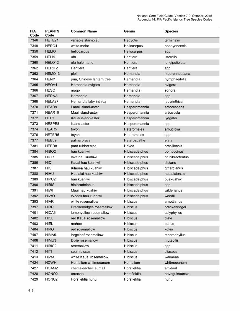
National Core Field Guide, Version 7.0, October, 2015 Appendix 14. FIA Pacific Islands Tree Species Codes
416
FIA Code
PLANTS Code
Common Name Genus Species
7346 HETE21 variable starviolet Hedyotis terminalis 7349 HEPO4 white moho Heliocarpus popayanensis 7350 HELIO heliocarpus Heliocarpus spp. 7359 HELI9 ufa Heritiera littoralis 7360 HELO12 ufa halemtano Heritiera longipetiolata 7362 HERIT2 Heritiera Heritiera spp. 7363 HEMO13 pipi Hernandia moerenhoutiana 7364 HENY pua, Chinese lantern tree Hernandia nymphaeifolia 7365 HEOV4 Hernandia ovigera Hernandia ovigera 7366 HESO mago Hernandia sonora 7367 HERNA Hernandia Hernandia spp. 7368 HELA27 Hernandia labyrinthica Hernandia labyrinthica 7370 HEAR9 Lanai island-aster Hesperomannia arborescens 7371 HEAR10 Maui island-aster Hesperomannia arbuscula 7372 HELY Kauai island-aster Hesperomannia lydgatei 7373 HESPE8 island-aster Hesperomannia spp. 7374 HEAR5 toyon Heteromeles arbutifolia 7376 HETER5 toyon Heteromeles spp. 7377 HEEL9 palma brava Heterospathe elata 7381 HEBR8 para rubber tree Hevea brasiliensis 7384 HIBO2 hau kuahiwi Hibiscadelphus bombycinus 7385 HICR lava hau kuahiwi Hibiscadelphus crucibracteatus 7386 HIDI Kauai hau kuahiwi Hibiscadelphus distans 7387 HIGI Kilauea hau kuahiwi Hibiscadelphus giffardianus 7388 HIHU Hualalai hau kuahiwi Hibiscadelphus hualalaiensis 7389 HIPU2 hau kuahiwi Hibiscadelphus puakuahiwi 7390 HIBIS hibiscadelphus Hibiscadelphus spp. 7391 HIWI Maui hau kuahiwi Hibiscadelphus wilderianus 7392 HIWO Woods hau kuahiwi Hibiscadelphus woodii 7393 HIAR white rosemallow Hibiscus arnottianus 7397 HIBR Brackenridges rosemallow Hibiscus brackenridgei 7401 HICA6 lemonyellow rosemallow Hibiscus calyphyllus 7402 HICL red Kauai rosemallow Hibiscus clayi 7403 HIEL mahoe Hibiscus elatus 7404 HIKO red rosemallow Hibiscus kokio 7407 HIMA5 largeleaf rosemallow Hibiscus macrophyllus 7408 HIMU3 Dixie rosemallow Hibiscus mutabilis 7411 HIBIS2 rosemallow Hibiscus spp. 7412 HITI sea hibiscus Hibiscus tiliaceus 7413 HIWA white Kauai rosemallow Hibiscus waimeae 7424 HOWH Homalium whitmeeanum Homalium whitmeeanum 7427 HOAM2 chemeklachel, eumail Horsfieldia amklaal 7428 HONO2 ersachel Horsfieldia novoguineensis 7429 HONU2 Horsfieldia nunu Horsfieldia nunu
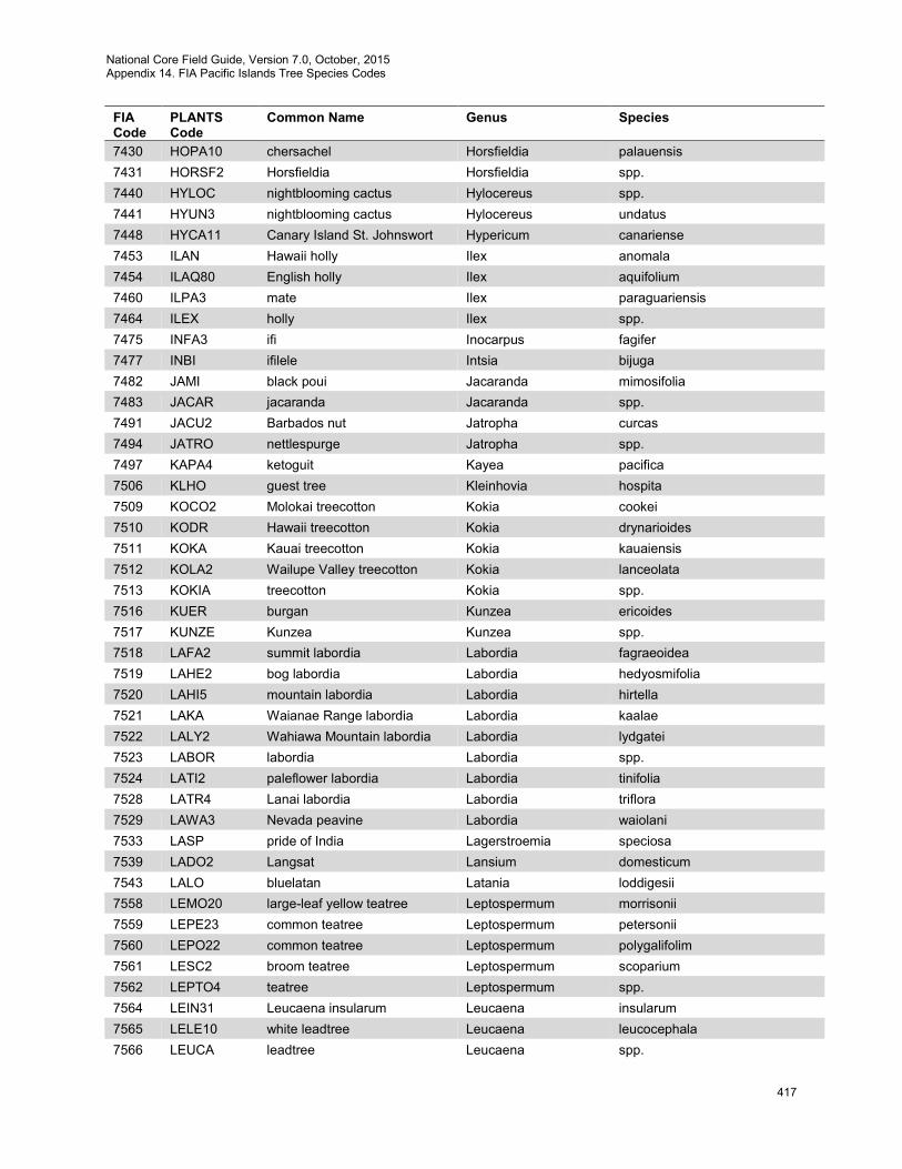
National Core Field Guide, Version 7.0, October, 2015 Appendix 14. FIA Pacific Islands Tree Species Codes
417
FIA Code
PLANTS Code
Common Name Genus Species
7430 HOPA10 chersachel Horsfieldia palauensis 7431 HORSF2 Horsfieldia Horsfieldia spp. 7440 HYLOC nightblooming cactus Hylocereus spp. 7441 HYUN3 nightblooming cactus Hylocereus undatus 7448 HYCA11 Canary Island St. Johnswort Hypericum canariense 7453 ILAN Hawaii holly Ilex anomala 7454 ILAQ80 English holly Ilex aquifolium 7460 ILPA3 mate Ilex paraguariensis 7464 ILEX holly Ilex spp. 7475 INFA3 ifi Inocarpus fagifer 7477 INBI ifilele Intsia bijuga 7482 JAMI black poui Jacaranda mimosifolia 7483 JACAR jacaranda Jacaranda spp. 7491 JACU2 Barbados nut Jatropha curcas 7494 JATRO nettlespurge Jatropha spp. 7497 KAPA4 ketoguit Kayea pacifica 7506 KLHO guest tree Kleinhovia hospita 7509 KOCO2 Molokai treecotton Kokia cookei 7510 KODR Hawaii treecotton Kokia drynarioides 7511 KOKA Kauai treecotton Kokia kauaiensis 7512 KOLA2 Wailupe Valley treecotton Kokia lanceolata 7513 KOKIA treecotton Kokia spp. 7516 KUER burgan Kunzea ericoides 7517 KUNZE Kunzea Kunzea spp. 7518 LAFA2 summit labordia Labordia fagraeoidea 7519 LAHE2 bog labordia Labordia hedyosmifolia 7520 LAHI5 mountain labordia Labordia hirtella 7521 LAKA Waianae Range labordia Labordia kaalae 7522 LALY2 Wahiawa Mountain labordia Labordia lydgatei 7523 LABOR labordia Labordia spp. 7524 LATI2 paleflower labordia Labordia tinifolia 7528 LATR4 Lanai labordia Labordia triflora 7529 LAWA3 Nevada peavine Labordia waiolani 7533 LASP pride of India Lagerstroemia speciosa 7539 LADO2 Langsat Lansium domesticum 7543 LALO bluelatan Latania loddigesii 7558 LEMO20 large-leaf yellow teatree Leptospermum morrisonii 7559 LEPE23 common teatree Leptospermum petersonii 7560 LEPO22 common teatree Leptospermum polygalifolim 7561 LESC2 broom teatree Leptospermum scoparium 7562 LEPTO4 teatree Leptospermum spp. 7564 LEIN31 Leucaena insularum Leucaena insularum 7565 LELE10 white leadtree Leucaena leucocephala 7566 LEUCA leadtree Leucaena spp.
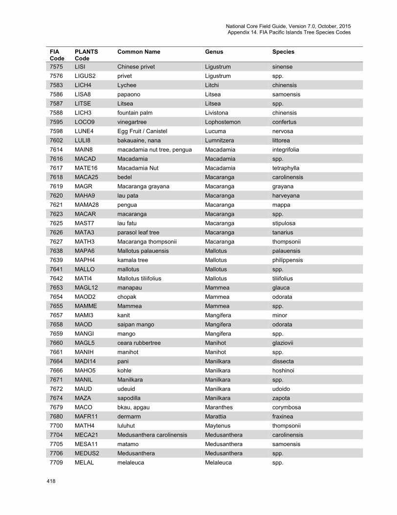
National Core Field Guide, Version 7.0, October, 2015 Appendix 14. FIA Pacific Islands Tree Species Codes
418
FIA Code
PLANTS Code
Common Name Genus Species
7575 LISI Chinese privet Ligustrum sinense 7576 LIGUS2 privet Ligustrum spp. 7583 LICH4 Lychee Litchi chinensis 7586 LISA8 papaono Litsea samoensis 7587 LITSE Litsea Litsea spp. 7588 LICH3 fountain palm Livistona chinensis 7595 LOCO9 vinegartree Lophostemon confertus 7598 LUNE4 Egg Fruit / Canistel Lucuma nervosa 7602 LULI8 bakauaine, nana Lumnitzera littorea 7614 MAIN8 macadamia nut tree, pengua Macadamia integrifolia 7616 MACAD Macadamia Macadamia spp. 7617 MATE16 Macadamia Nut Macadamia tetraphylla 7618 MACA25 bedel Macaranga carolinensis 7619 MAGR Macaranga grayana Macaranga grayana 7620 MAHA9 lau pata Macaranga harveyana 7621 MAMA28 pengua Macaranga mappa 7623 MACAR macaranga Macaranga spp. 7625 MAST7 lau fatu Macaranga stipulosa 7626 MATA3 parasol leaf tree Macaranga tanarius 7627 MATH3 Macaranga thompsonii Macaranga thompsonii 7638 MAPA6 Mallotus palauensis Mallotus palauensis 7639 MAPH4 kamala tree Mallotus philippensis 7641 MALLO mallotus Mallotus spp. 7642 MATI4 Mallotus tiliifolius Mallotus tiliifolius 7653 MAGL12 manapau Mammea glauca 7654 MAOD2 chopak Mammea odorata 7655 MAMME Mammea Mammea spp. 7657 MAMI3 kanit Mangifera minor 7658 MAOD saipan mango Mangifera odorata 7659 MANGI mango Mangifera spp. 7660 MAGL5 ceara rubbertree Manihot glaziovii 7661 MANIH manihot Manihot spp. 7664 MADI14 pani Manilkara dissecta 7666 MAHO5 kohle Manilkara hoshinoi 7671 MANIL Manilkara Manilkara spp. 7672 MAUD udeuid Manilkara udoido 7674 MAZA sapodilla Manilkara zapota 7679 MACO bkau, apgau Maranthes corymbosa 7680 MAFR11 dermarm Marattia fraxinea 7700 MATH4 luluhut Maytenus thompsonii 7704 MECA21 Medusanthera carolinensis Medusanthera carolinensis 7705 MESA11 matamo Medusanthera samoensis 7706 MEDUS2 Medusanthera Medusanthera spp. 7709 MELAL melaleuca Melaleuca spp.
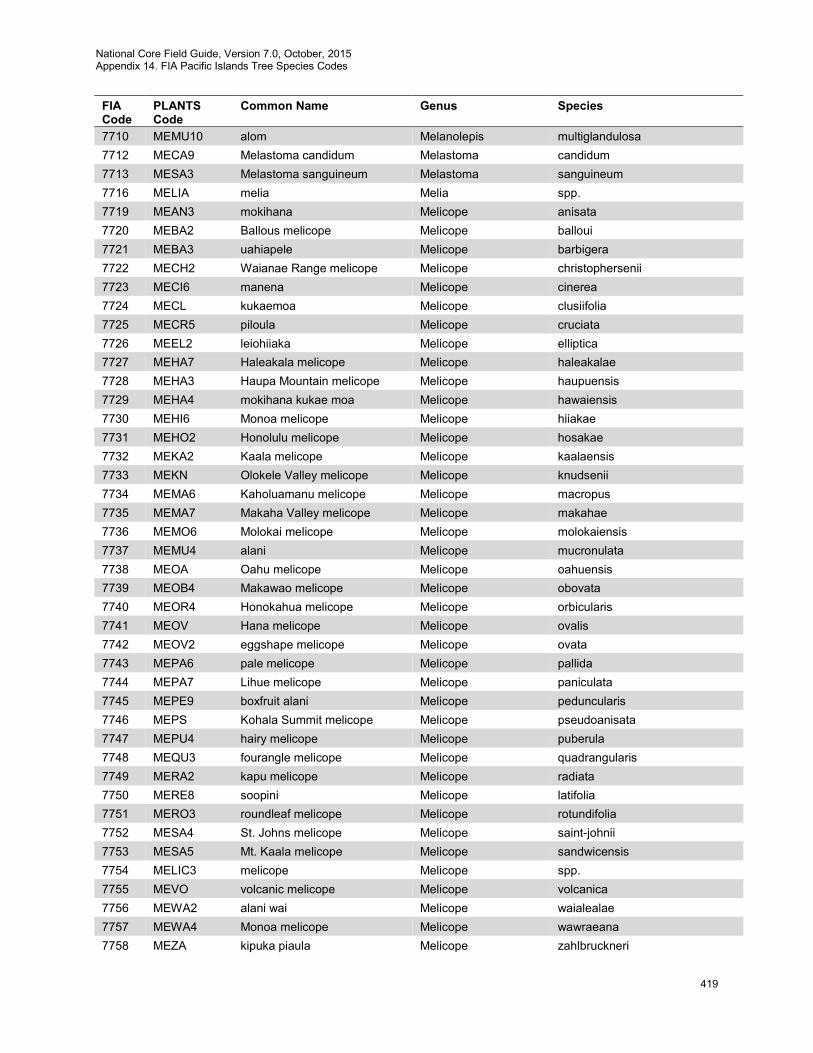
National Core Field Guide, Version 7.0, October, 2015 Appendix 14. FIA Pacific Islands Tree Species Codes
419
FIA Code
PLANTS Code
Common Name Genus Species
7710 MEMU10 alom Melanolepis multiglandulosa 7712 MECA9 Melastoma candidum Melastoma candidum 7713 MESA3 Melastoma sanguineum Melastoma sanguineum 7716 MELIA melia Melia spp. 7719 MEAN3 mokihana Melicope anisata 7720 MEBA2 Ballous melicope Melicope balloui 7721 MEBA3 uahiapele Melicope barbigera 7722 MECH2 Waianae Range melicope Melicope christophersenii 7723 MECI6 manena Melicope cinerea 7724 MECL kukaemoa Melicope clusiifolia 7725 MECR5 piloula Melicope cruciata 7726 MEEL2 leiohiiaka Melicope elliptica 7727 MEHA7 Haleakala melicope Melicope haleakalae 7728 MEHA3 Haupa Mountain melicope Melicope haupuensis 7729 MEHA4 mokihana kukae moa Melicope hawaiensis 7730 MEHI6 Monoa melicope Melicope hiiakae 7731 MEHO2 Honolulu melicope Melicope hosakae 7732 MEKA2 Kaala melicope Melicope kaalaensis 7733 MEKN Olokele Valley melicope Melicope knudsenii 7734 MEMA6 Kaholuamanu melicope Melicope macropus 7735 MEMA7 Makaha Valley melicope Melicope makahae 7736 MEMO6 Molokai melicope Melicope molokaiensis 7737 MEMU4 alani Melicope mucronulata 7738 MEOA Oahu melicope Melicope oahuensis 7739 MEOB4 Makawao melicope Melicope obovata 7740 MEOR4 Honokahua melicope Melicope orbicularis 7741 MEOV Hana melicope Melicope ovalis 7742 MEOV2 eggshape melicope Melicope ovata 7743 MEPA6 pale melicope Melicope pallida 7744 MEPA7 Lihue melicope Melicope paniculata 7745 MEPE9 boxfruit alani Melicope peduncularis 7746 MEPS Kohala Summit melicope Melicope pseudoanisata 7747 MEPU4 hairy melicope Melicope puberula 7748 MEQU3 fourangle melicope Melicope quadrangularis 7749 MERA2 kapu melicope Melicope radiata 7750 MERE8 soopini Melicope latifolia 7751 MERO3 roundleaf melicope Melicope rotundifolia 7752 MESA4 St. Johns melicope Melicope saint-johnii 7753 MESA5 Mt. Kaala melicope Melicope sandwicensis 7754 MELIC3 melicope Melicope spp. 7755 MEVO volcanic melicope Melicope volcanica 7756 MEWA2 alani wai Melicope waialealae 7757 MEWA4 Monoa melicope Melicope wawraeana 7758 MEZA kipuka piaula Melicope zahlbruckneri
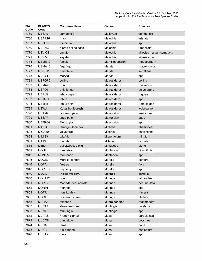
National Core Field Guide, Version 7.0, October, 2015 Appendix 14. FIA Pacific Islands Tree Species Codes
420
FIA Code
PLANTS Code
Common Name Genus Species
7759 MESA9 samoensis Melicytus samoensis 7766 MEAR16 mao Melochia aristata 7767 MELOC melochia Melochia spp. 7769 MEUM3 hierba del soldado Melochia umbellata 7770 MEVIC4 sayafe Melochia villosissima var. compacta 7771 MEVIV sayafe Melochia villosissima 7774 MEME12 faniok Merrilliodendron megacarpum 7776 MEMA16 fagufagu Meryta macrophylla 7777 MESE11 omechidel Meryta senfftiana 7778 MERYT Meryta Meryta spp. 7781 MEPOP2 collina Metrosideros collina 7782 MEMA4 ohia Metrosideros macropus 7783 MEPO5 ohia lehua Metrosideros polymorpha 7792 MERU2 lehua papa Metrosideros rugosa 7793 METRO lehua Metrosideros spp. 7794 METR5 lehua ahihi Metrosideros tremuloides 7795 MEWA Kauai bottlebrush Metrosideros waialealae 7798 MEAM4 ivory-nut palm Metroxylon amicarum 7799 MESA7 sago palm Metroxylon sagu 7800 METRO2 Metroxylon Metroxylon spp. 7801 MICH4 Orange Champak Michelia champaca 7805 MICA20 velvet tree Miconia calvescens 7824 MIMI23 talafulu Micromelum minutum 7831 MIPI9 pinnata Millettia pinnata 7835 MIEL4 bulletwood, elengi Mimusops elengi 7841 MOHI treedaisy Montanoa hibiscifolia 7842 MONTA montanoa Montanoa spp. 7845 MOCE2 Morella cerifera Morella cerifera 7846 MOFA firetree Morella faya 7848 MOREL2 bayberry Morella spp. 7849 MOCI3 Indian mulberry Morinda citrifolia 7850 MOLA12 ngel Morinda latibractea 7851 MOPE2 Morinda pedunculata Morinda pedunculata 7852 MORIN morinda Morinda spp. 7853 MOTR noni kuahiwi Morinda trimera 7855 MOOL horseradishtree Moringa oleifera 7865 MURA3 falseohe Munroidendron racemosum 7867 MUCA4 strawberrytree Muntingia calabura 7868 MUNTI muntingia Muntingia spp. 7872 MUPA3 French plantain Musa paradisiaca 7873 MUCO8 bungeltuu Musa coccinea 7874 MUNA tama Musa nana 7875 MUSA tuu banana Musa sapientum 7876 MUSA2 meia Musa spp.

National Core Field Guide, Version 7.0, October, 2015 Appendix 14. FIA Pacific Islands Tree Species Codes
421
FIA Code
PLANTS Code
Common Name Genus Species
7877 MUTE6 blantalos Musa textilis 7878 MUTI tikap Musa tikap 7879 MUTR2 fei banana Musa troglodytarum 7880 MUFR3 Mussaenda frondosa Mussaenda frondosa 7881 MURA5 aloalo vao Mussaenda raiateensis 7882 MUSSA Mussaenda Mussaenda spp. 7883 MYSA naio Myoporum sandwicense 7884 MYOPO myoporum Myoporum spp. 7892 MYRCI rodwood Myrcia spp. 7899 MYRU3 yamamomo, strawberry tree Myrica rubra 7900 MYRIC sweetgale Myrica spp. 7902 MYHY2 atoneulu Myristica hypargyraea 7903 MYIN3 adepurot Myristica insularis 7904 MYRIS Myristica Myristica spp. 7906 MYIN4 Myristica inutilis Myristica inutilis 7910 MYAL4 forest colicwood Myrsine alyxifolia 7913 MYDE2 summit colicwood Myrsine degeneri 7914 MYEM mountain colicwood Myrsine emarginata 7915 MYFE streambank colicwood Myrsine fernseei 7916 MYFO Koolau Range colicwood Myrsine fosbergii 7918 MYHE3 Wahiawa Bog colicwood Myrsine helleri 7919 MYKA Kauai colicwood Myrsine kauaiensis 7920 MYKN Kokee colicwood Myrsine knudsenii 7921 MYLA3 Lanai colicwood Myrsine lanaiensis 7922 MYLE2 kolea lau nui Myrsine lessertiana 7923 MYME2 Hanapepe River colicwood Myrsine mezii 7924 MYPE3 swamp colicwood Myrsine petiolata 7925 MYPU2 Molokai colicwood Myrsine pukooensis 7926 MYSA2 kokea lau lii Myrsine sandwicensis 7927 MYRSI colicwood Myrsine spp. 7928 MYWA Mt. Kahili colicwood Myrsine wawraea 7929 MYPA7 Myrsine palauensis Myrsine palauensis 7942 NEOP fao Neisosperma oppositifolia 7948 NEFO2 afa Neonauclea forsteri 7952 NELA7 Rambutan Nephelium lappaceum 7954 NEME5 maaloa Neraudia melastomifolia 7958 NEPO keahi Nesoluma polynesicum 7960 NESA2 Hawaii olive Nestegis sandwicensis 7961 NESTE nestegis Nestegis spp. 7962 NECE kalm, aralm Neuburgia celebica 7964 NIGL tree tobacco Nicotiana glauca 7965 NICOT tobacco Nicotiana spp. 7966 NOBR2 smallflower aiea Nothocestrum breviflorum 7967 NOLA broadleaf aiea Nothocestrum latifolium

National Core Field Guide, Version 7.0, October, 2015 Appendix 14. FIA Pacific Islands Tree Species Codes
422
FIA Code
PLANTS Code
Common Name Genus Species
7968 NOLO longleaf aiea Nothocestrum longifolium 7969 NOPE Oahu aiea Nothocestrum peltatum 7970 NOTHO3 aiea Nothocestrum spp. 7971 NOHU kaala rockwort Nototrichium humile 7972 NOSA Hawaii rockwort Nototrichium sandwicense 7974 NYFR2 toechel, teuechel Nypa fruticans 7977 OCHNA ochna Ochna spp. 7978 OCTH Thomas birds-eye bush Ochna thomasiana 7980 OCPY Ochroma pyramidale Ochroma pyramidale 7982 OCCO holei Ochrosia compta 7983 OCHA island yellowwood Ochrosia haleakalae 7984 OCKA Kauai yellowwood Ochrosia kauaiensis 7985 OCKI Hawaii yellowwood Ochrosia kilaueaensis 7986 OCHRO2 yellowwood Ochrosia spp. 7987 OCMA2 langiti Ochrosia mariannensis 8000 OLNE oleandra fern Oleandra neriiformis 8004 OLEU olive Olea europaea 8007 OLEA olive Olea spp. 8008 HOAC4 fanuamamala Homalanthus acuminatus 8009 HONU3 fanuamamala Homalanthus nutans 8010 HOMAL6 Homalanthus Homalanthus spp. 8011 OPPA4 Ophiorrhiza palauensis Ophiorrhiza palauensis 8013 OPCO4 cochineal nopal cactus Opuntia cochenillifera 8014 OPFI tuna cactus Opuntia ficus-indica 8015 OPMO5 common pricklypear Opuntia monacantha 8018 OPUNT pricklypear Opuntia spp. 8019 ORCA12 amansis, edebsungelked,
necklace bead tree Ormosia calavensis
8022 OSOL kesiamel Osmoxylon oliveri 8023 OSPA kesiamel Osmoxylon pachyphyllum 8024 OSMOX Osmoxylon Osmoxylon spp. 8036 PAAQ2 miich era ngebard, guiana
chestnut Pachira aquatica
8044 PAST24 gasu Palaquium stehlinii 8054 PAAI chertochet Pandanus aimiriikensis 8055 PACO51 matal Pandanus cominsii 8056 PACO3 ongor Pandanus compressus 8057 PACY10 silaue Pandanus cylindricus 8058 PADI2 kienpel Pandanus dilatatus 8059 PADI29 ongor Pandanus divergens 8060 PADU3 pahong Pandanus dubius 8061 PADU4 ongor Pandanus duriocarpus 8062 PAEN moak Pandanus enchabiensis 8063 PAFI hara Pandanus fischerianus
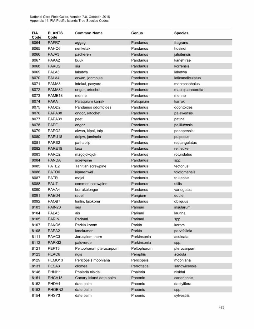
National Core Field Guide, Version 7.0, October, 2015 Appendix 14. FIA Pacific Islands Tree Species Codes
423
FIA Code
PLANTS Code
Common Name Genus Species
8064 PAFR7 aggag Pandanus fragrans 8065 PAHO6 nenketak Pandanus hosinoi 8066 PAJA3 pacheren Pandanus jaluitensis 8067 PAKA2 buuk Pandanus kanehirae 8068 PAKO2 siu Pandanus korrensis 8069 PALA3 lakatwa Pandanus lakatwa 8070 PALA4 erwan, jonmouia Pandanus laticanaliculatus 8071 PAMA3 intekul, pasyure Pandanus macrocephalus 8072 PAMA32 ongor, ertochet Pandanus macrojeanneretia 8073 PAME18 menne Pandanus menne 8074 PAKA Palaquium karrak Palaquium karrak 8075 PAOD2 Pandanus odontoides Pandanus odontoides 8076 PAPA38 ongor, ertochet Pandanus palawensis 8077 PAPA39 peet Pandanus patina 8078 PAPE ongor Pandanus peliliuensis 8079 PAPO2 alwan, kipal, taip Pandanus ponapensis 8080 PAPU18 deipw, jomineia Pandanus pulposus 8081 PARE2 pathaplip Pandanus rectangulatus 8082 PARE19 fasa Pandanus reineckei 8083 PARO2 magojokojok Pandanus rotundatus 8084 PANDA screwpine Pandanus spp. 8085 PATE2 Tahitian screwpine Pandanus tectorius 8086 PATO6 kiparenwel Pandanus tolotomensis 8087 PATR mojel Pandanus trukensis 8088 PAUT common screwpine Pandanus utilis 8090 PAVA4 berrakelongor Pandanus variegatus 8091 PAED4 rauel Pangium edule 8092 PAOB7 lonlin, lajokorer Pandanus obliquus 8103 PAIN20 sea Parinari insularum 8104 PALA5 ais Parinari laurina 8105 PARIN Parinari Parinari spp. 8107 PAKO5 Parkia korom Parkia korom 8108 PAPA2 kmekumer Parkia parvifoliola 8111 PAAC3 Jerusalem thorn Parkinsonia aculeata 8112 PARKI2 paloverde Parkinsonia spp. 8121 PEPT3 Peltophorum pterocarpum Peltophorum pterocarpum 8123 PEAC6 ngis Pemphis acidula 8129 PEMO13 Pericopsis mooniana Pericopsis mooniana 8131 PESA3 olomea Perrottetia sandwicensis 8146 PHNI11 Phaleria nisidai Phaleria nisidai 8151 PHCA13 Canary Island date palm Phoenix canariensis 8152 PHDA4 date palm Phoenix dactylifera 8153 PHOEN2 date palm Phoenix spp. 8154 PHSY3 date palm Phoenix sylvestris
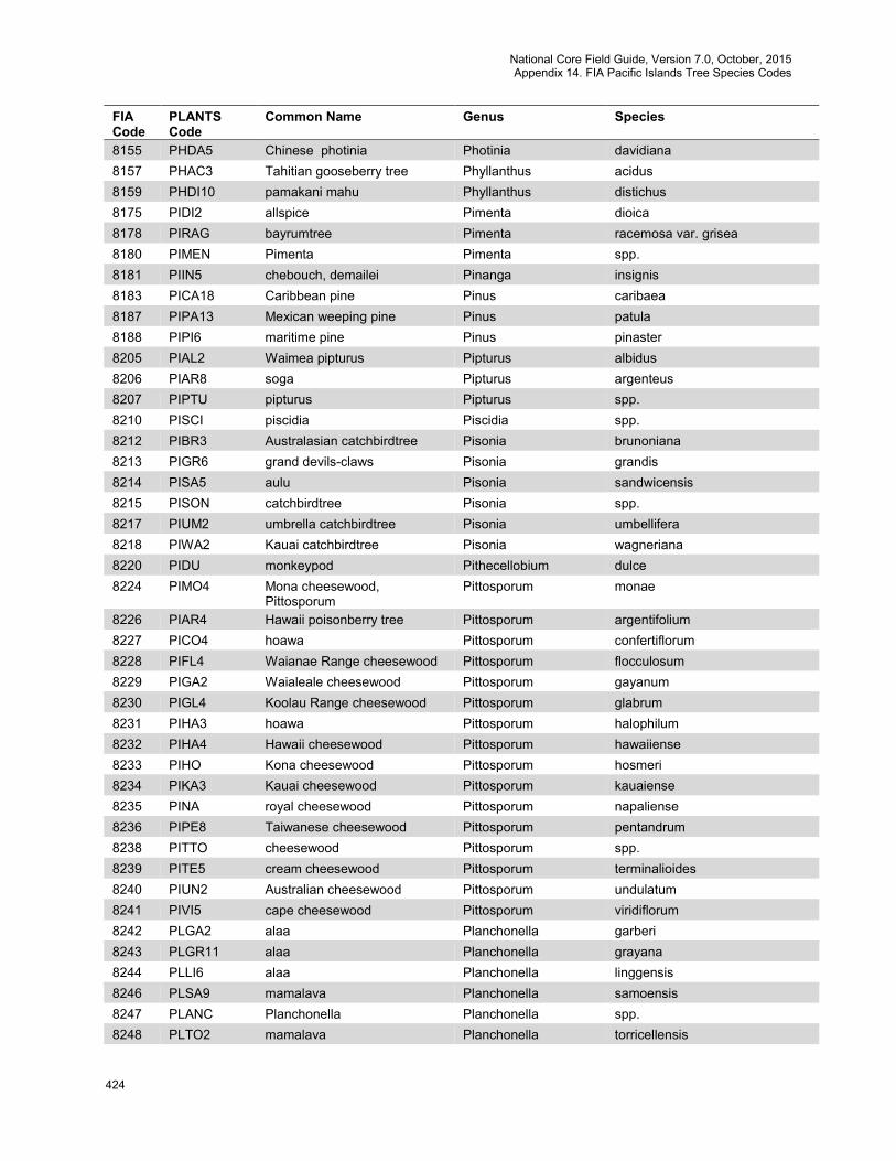
National Core Field Guide, Version 7.0, October, 2015 Appendix 14. FIA Pacific Islands Tree Species Codes
424
FIA Code
PLANTS Code
Common Name Genus Species
8155 PHDA5 Chinese photinia Photinia davidiana 8157 PHAC3 Tahitian gooseberry tree Phyllanthus acidus 8159 PHDI10 pamakani mahu Phyllanthus distichus 8175 PIDI2 allspice Pimenta dioica 8178 PIRAG bayrumtree Pimenta racemosa var. grisea 8180 PIMEN Pimenta Pimenta spp. 8181 PIIN5 chebouch, demailei Pinanga insignis 8183 PICA18 Caribbean pine Pinus caribaea 8187 PIPA13 Mexican weeping pine Pinus patula 8188 PIPI6 maritime pine Pinus pinaster 8205 PIAL2 Waimea pipturus Pipturus albidus 8206 PIAR8 soga Pipturus argenteus 8207 PIPTU pipturus Pipturus spp. 8210 PISCI piscidia Piscidia spp. 8212 PIBR3 Australasian catchbirdtree Pisonia brunoniana 8213 PIGR6 grand devils-claws Pisonia grandis 8214 PISA5 aulu Pisonia sandwicensis 8215 PISON catchbirdtree Pisonia spp. 8217 PIUM2 umbrella catchbirdtree Pisonia umbellifera 8218 PIWA2 Kauai catchbirdtree Pisonia wagneriana 8220 PIDU monkeypod Pithecellobium dulce 8224 PIMO4 Mona cheesewood,
Pittosporum Pittosporum monae
8226 PIAR4 Hawaii poisonberry tree Pittosporum argentifolium 8227 PICO4 hoawa Pittosporum confertiflorum 8228 PIFL4 Waianae Range cheesewood Pittosporum flocculosum 8229 PIGA2 Waialeale cheesewood Pittosporum gayanum 8230 PIGL4 Koolau Range cheesewood Pittosporum glabrum 8231 PIHA3 hoawa Pittosporum halophilum 8232 PIHA4 Hawaii cheesewood Pittosporum hawaiiense 8233 PIHO Kona cheesewood Pittosporum hosmeri 8234 PIKA3 Kauai cheesewood Pittosporum kauaiense 8235 PINA royal cheesewood Pittosporum napaliense 8236 PIPE8 Taiwanese cheesewood Pittosporum pentandrum 8238 PITTO cheesewood Pittosporum spp. 8239 PITE5 cream cheesewood Pittosporum terminalioides 8240 PIUN2 Australian cheesewood Pittosporum undulatum 8241 PIVI5 cape cheesewood Pittosporum viridiflorum 8242 PLGA2 alaa Planchonella garberi 8243 PLGR11 alaa Planchonella grayana 8244 PLLI6 alaa Planchonella linggensis 8246 PLSA9 mamalava Planchonella samoensis 8247 PLANC Planchonella Planchonella spp. 8248 PLTO2 mamalava Planchonella torricellensis

National Core Field Guide, Version 7.0, October, 2015 Appendix 14. FIA Pacific Islands Tree Species Codes
425
FIA Code
PLANTS Code
Common Name Genus Species
8250 PLRE4 Hawaii pilo kea Platydesma remyi 8251 PLSP3 Maui pilo kea Platydesma spathulata 8252 PLATY platydesma Platydesma spp. 8257 PLAU2 golden hala pepe Pleomele aurea 8258 PLAU5 Maui hala pepe Pleomele auwahiensis 8259 PLFE Lanai hala pepe Pleomele fernaldii 8260 PLFO2 Waianae Range hala pepe Pleomele forbesii 8261 PLHA3 royal hala pepe Pleomele halapepe 8262 PLHA4 Hawaii hala pepe Pleomele hawaiiensis 8263 PLEOM hala pepe Pleomele spp. 8269 PLOBO Plumeria obtusa Plumeria obtuse var. obtusa 8271 PLRU2 templetree Plumeria rubra 8272 PLUME Plumeria Plumeria spp. 8283 POGR28 bungaruau Polyscias granifolia 8285 POMA Polyscias macgillivrayi Polyscias macgillivrayi 8286 PONO10 bngei Polyscias nodosa 8287 POSA27 tagitagi Polyscias samoensis 8288 POSC10 shield aralia Polyscias scutellaria 8289 POLYS4 Polyscias Polyscias spp. 8290 POPI12 tava Pometia pinnata 8292 POHO kattai Ponapea hosinoi 8293 POLE21 Ponapea ledermanniana Ponapea ledermanniana 8294 PONAP Ponapea Ponapea spp. 8295 POPI4 kisaks Pongamia pinnata 8297 POCA43 Abiu Pouteria caimito 8298 POCA6 elangel, chelangel Pouteria calcarea 8299 POCA23 eggfruit Pouteria campechiana 8303 POOB8 lalahag Pouteria obovata 8304 POSA11 alaa Pouteria sandwicensis 8305 POSA13 mammee sapote Pouteria sapota 8306 POUTE pouteria Pouteria spp. 8307 PROB ahgao Premna obtusifolia 8308 PRPU5 Premna pubescens Premna pubescens 8309 PRSE6 aloalo Premna serratifolia 8310 PREMN Premna Premna spp. 8315 PRAF Hawaii pritchardia Pritchardia affinis 8316 PRAR2 Maui pritchardia Pritchardia arecina 8317 PRBE Kilauea pritchardia Pritchardia beccariana 8318 PRFO Mt. Eke pritchardia Pritchardia forbesiana 8319 PRHA2 Makaleha pritchardia Pritchardia hardyi 8320 PRHI loulu lelo Pritchardia hillebrandii 8321 PRKA Waianae Range pritchardia Pritchardia kaalae 8322 PRLA3 Lanai pritchardia Pritchardia lanaiensis 8323 PRLA4 loulu Pritchardia lanigera
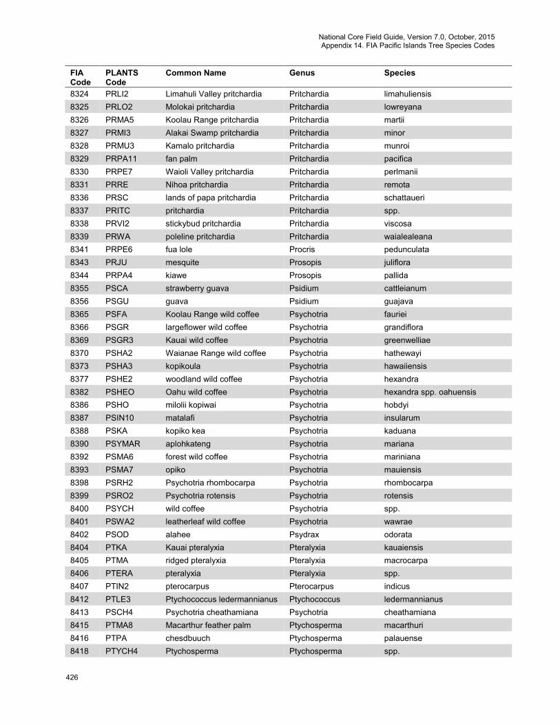
National Core Field Guide, Version 7.0, October, 2015 Appendix 14. FIA Pacific Islands Tree Species Codes
426
FIA Code
PLANTS Code
Common Name Genus Species
8324 PRLI2 Limahuli Valley pritchardia Pritchardia limahuliensis 8325 PRLO2 Molokai pritchardia Pritchardia lowreyana 8326 PRMA5 Koolau Range pritchardia Pritchardia martii 8327 PRMI3 Alakai Swamp pritchardia Pritchardia minor 8328 PRMU3 Kamalo pritchardia Pritchardia munroi 8329 PRPA11 fan palm Pritchardia pacifica 8330 PRPE7 Waioli Valley pritchardia Pritchardia perlmanii 8331 PRRE Nihoa pritchardia Pritchardia remota 8336 PRSC lands of papa pritchardia Pritchardia schattaueri 8337 PRITC pritchardia Pritchardia spp. 8338 PRVI2 stickybud pritchardia Pritchardia viscosa 8339 PRWA poleline pritchardia Pritchardia waialealeana 8341 PRPE6 fua lole Procris pedunculata 8343 PRJU mesquite Prosopis juliflora 8344 PRPA4 kiawe Prosopis pallida 8355 PSCA strawberry guava Psidium cattleianum 8356 PSGU guava Psidium guajava 8365 PSFA Koolau Range wild coffee Psychotria fauriei 8366 PSGR largeflower wild coffee Psychotria grandiflora 8369 PSGR3 Kauai wild coffee Psychotria greenwelliae 8370 PSHA2 Waianae Range wild coffee Psychotria hathewayi 8373 PSHA3 kopikoula Psychotria hawaiiensis 8377 PSHE2 woodland wild coffee Psychotria hexandra 8382 PSHEO Oahu wild coffee Psychotria hexandra spp. oahuensis 8386 PSHO milolii kopiwai Psychotria hobdyi 8387 PSIN10 matalafi Psychotria insularum 8388 PSKA kopiko kea Psychotria kaduana 8390 PSYMAR aplohkateng Psychotria mariana 8392 PSMA6 forest wild coffee Psychotria mariniana 8393 PSMA7 opiko Psychotria mauiensis 8398 PSRH2 Psychotria rhombocarpa Psychotria rhombocarpa 8399 PSRO2 Psychotria rotensis Psychotria rotensis 8400 PSYCH wild coffee Psychotria spp. 8401 PSWA2 leatherleaf wild coffee Psychotria wawrae 8402 PSOD alahee Psydrax odorata 8404 PTKA Kauai pteralyxia Pteralyxia kauaiensis 8405 PTMA ridged pteralyxia Pteralyxia macrocarpa 8406 PTERA pteralyxia Pteralyxia spp. 8407 PTIN2 pterocarpus Pterocarpus indicus 8412 PTLE3 Ptychococcus ledermannianus Ptychococcus ledermannianus 8413 PSCH4 Psychotria cheathamiana Psychotria cheathamiana 8415 PTMA8 Macarthur feather palm Ptychosperma macarthuri 8416 PTPA chesdbuuch Ptychosperma palauense 8418 PTYCH4 Ptychosperma Ptychosperma spp.
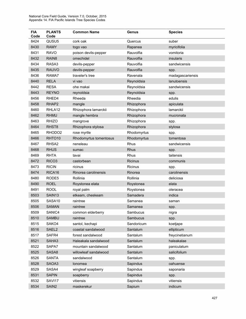
National Core Field Guide, Version 7.0, October, 2015 Appendix 14. FIA Pacific Islands Tree Species Codes
427
FIA Code
PLANTS Code
Common Name Genus Species
8424 QUSU5 cork oak Quercus suber 8430 RAMY togo vao Rapanea myricifolia 8431 RAVO poison devils-pepper Rauvolfia vomitoria 8432 RAIN8 omechidel Rauvolfia insularis 8434 RASA3 devils-pepper Rauvolfia sandwicensis 8435 RAUVO devils-pepper Rauvolfia spp. 8436 RAMA7 traveler's tree Ravenala madagascariensis 8440 RELA vi vao Reynoldsia lanutoensis 8442 RESA ohe makai Reynoldsia sandwicensis 8443 REYNO reynoldsia Reynoldsia spp. 8456 RHED4 Rheeda Rheedia edulis 8458 RHAP2 mangle Rhizophora apiculata 8460 RHLA12 Rhizophora lamarckii Rhizophora lamarckii 8462 RHMU mangle hembra Rhizophora mucronata 8463 RHIZO mangrove Rhizophora spp. 8464 RHST8 Rhizophora stylosa Rhizophora stylosa 8465 RHODO2 rose myrtle Rhodomyrtus spp. 8466 RHTO10 Rhodomyrtus tomentosus Rhodomyrtus tomentosa 8467 RHSA2 neneleau Rhus sandwicensis 8468 RHUS sumac Rhus spp. 8469 RHTA tavai Rhus taitensis 8472 RICO3 castorbean Ricinus communis 8473 RICIN ricinus Ricinus spp. 8474 RICA16 Rinorea carolinensis Rinorea carolinensis 8480 RODE5 Rollinia Rollinia deliciosa 8490 ROEL Roystonea elata Roystonea elata 8491 ROOL royal palm Roystonea oleracea 8503 SAIN13 etkeam, cheskeam Samadera indica 8505 SASA10 raintree Samanea saman 8506 SAMAN raintree Samanea spp. 8509 SANIC4 common elderberry Sambucus nigra 8510 SAMBU raintree Sambucus spp. 8515 SAKO4 santol, kechapi Sandoricum koetjape 8516 SAEL2 coastal sandalwood Santalum ellipticum 8517 SAFR4 forest sandalwood Santalum freycinetianum 8521 SAHA3 Haleakala sandalwood Santalum haleakalae 8522 SAPA7 mountain sandalwood Santalum paniculatum 8525 SASA8 willowleaf sandalwood Santalum salicifolium 8526 SANTA sandalwood Santalum spp. 8528 SAOA3 lonomea Sapindus oahuense 8529 SASA4 wingleaf soapberry Sapindus saponaria 8531 SAPIN soapberry Sapindus spp. 8532 SAVI17 vitiensis Sapindus vitiensis 8534 SAIN2 maskerekur Sapium indicum
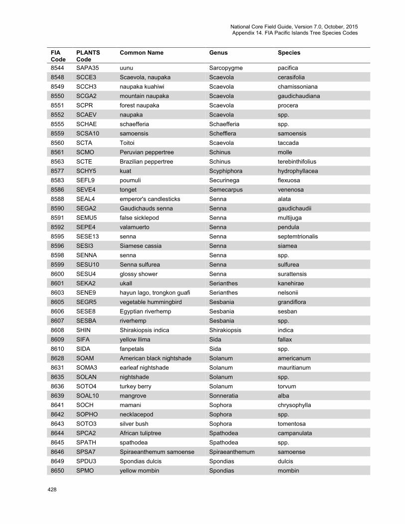
National Core Field Guide, Version 7.0, October, 2015 Appendix 14. FIA Pacific Islands Tree Species Codes
428
FIA Code
PLANTS Code
Common Name Genus Species
8544 SAPA35 uunu Sarcopygme pacifica 8548 SCCE3 Scaevola, naupaka Scaevola cerasifolia 8549 SCCH3 naupaka kuahiwi Scaevola chamissoniana 8550 SCGA2 mountain naupaka Scaevola gaudichaudiana 8551 SCPR forest naupaka Scaevola procera 8552 SCAEV naupaka Scaevola spp. 8555 SCHAE schaefferia Schaefferia spp. 8559 SCSA10 samoensis Schefflera samoensis 8560 SCTA Toitoi Scaevola taccada 8561 SCMO Peruvian peppertree Schinus molle 8563 SCTE Brazilian peppertree Schinus terebinthifolius 8577 SCHY5 kuat Scyphiphora hydrophyllacea 8583 SEFL9 poumuli Securinega flexuosa 8586 SEVE4 tonget Semecarpus venenosa 8588 SEAL4 emperor's candlesticks Senna alata 8590 SEGA2 Gaudichauds senna Senna gaudichaudii 8591 SEMU5 false sicklepod Senna multijuga 8592 SEPE4 valamuerto Senna pendula 8595 SESE13 senna Senna septemtrionalis 8596 SESI3 Siamese cassia Senna siamea 8598 SENNA senna Senna spp. 8599 SESU10 Senna sulfurea Senna sulfurea 8600 SESU4 glossy shower Senna surattensis 8601 SEKA2 ukall Serianthes kanehirae 8603 SENE9 hayun lago, trongkon guafi Serianthes nelsonii 8605 SEGR5 vegetable hummingbird Sesbania grandiflora 8606 SESE8 Egyptian riverhemp Sesbania sesban 8607 SESBA riverhemp Sesbania spp. 8608 SHIN Shirakiopsis indica Shirakiopsis indica 8609 SIFA yellow llima Sida fallax 8610 SIDA fanpetals Sida spp. 8628 SOAM American black nightshade Solanum americanum 8631 SOMA3 earleaf nightshade Solanum mauritianum 8635 SOLAN nightshade Solanum spp. 8636 SOTO4 turkey berry Solanum torvum 8639 SOAL10 mangrove Sonneratia alba 8641 SOCH mamani Sophora chrysophylla 8642 SOPHO necklacepod Sophora spp. 8643 SOTO3 silver bush Sophora tomentosa 8644 SPCA2 African tuliptree Spathodea campanulata 8645 SPATH spathodea Spathodea spp. 8646 SPSA7 Spiraeanthemum samoense Spiraeanthemum samoense 8649 SPDU3 Spondias dulcis Spondias dulcis 8650 SPMO yellow mombin Spondias mombin
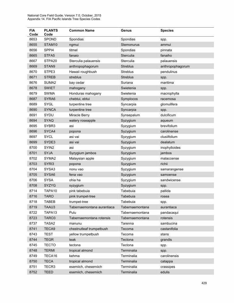
National Core Field Guide, Version 7.0, October, 2015 Appendix 14. FIA Pacific Islands Tree Species Codes
429
FIA Code
PLANTS Code
Common Name Genus Species
8653 SPOND Spondias Spondias spp. 8655 STAM10 ngmui Stemonurus ammui 8656 SPPI4 titmel Spondias pinnata 8665 STFA5 fanaio Sterculia fanaiho 8667 STPA20 Sterculia palauensis Sterculia palauensis 8669 STAN9 anthropophagorum Streblus anthropophagorum 8670 STPE3 Hawaii roughbush Streblus pendulinus 8671 STREB streblus Streblus spp. 8676 SUMA2 bay cedar Suriana maritima 8678 SWIET mahogany Swietenia spp. 8679 SWMA Honduras mahogany Swietenia macrophylla 8687 SYRA6 chebtui, ebtui Symplocos racemosa 8689 SYGL turpentine tree Syncarpia glomulifera 8690 SYNCA turpentine tree Syncarpia spp. 8691 SYDU Miracle Berry Synsepalum dulcificum 8694 SYAQ watery roseapple Syzygium aqueum 8695 SYBR3 asi Syzygium brevifolium 8696 SYCA4 popona Syzygium carolinense 8697 SYCL asi vai Syzygium clusiifolium 8699 SYDE3 asi vai Syzygium dealatum 8700 SYIN2 asi Syzygium inophylloides 8701 SYJA Syzygium jambos Syzygium jambos 8702 SYMA2 Malaysian apple Syzygium malaccense 8703 SYRI3 popona Syzygium richii 8704 SYSA3 nonu vao Syzygium samarangense 8705 SYSA6 fena vao Syzygium samoense 8706 SYSA ohia ha Syzygium sandwicense 8708 SYZYG syzygium Syzygium spp. 8714 TAPA10 pink tabebuia Tabebuia pallida 8716 TARO pink trumpet-tree Tabebuia rosea 8718 TABEB trumpet-tree Tabebuia spp. 8719 TAAU3 Tabernaemontana aurantiaca Tabernaemontana aurantiaca 8722 TAPA13 Pulu Tabernaemontana pandacaqui 8723 TARO3 Tabernaemontana rotensis Tabernaemontana rotensis 8737 TASA2 manunu Tarenna sambucina 8741 TECA9 chestnutleaf trumpetbush Tecoma castanifolia 8743 TEST yellow trumpetbush Tecoma stans 8744 TEGR teak Tectona grandis 8745 TECTO tectona Tectona spp. 8748 TERMI tropical almond Terminalia spp. 8749 TECA16 kehma Terminalia carolinensis 8750 TECA tropical almond Terminalia catappa 8751 TECR3 esemiich, chesemiich Terminalia crassipes 8752 TEED esemiich, chesemiich Terminalia edulis
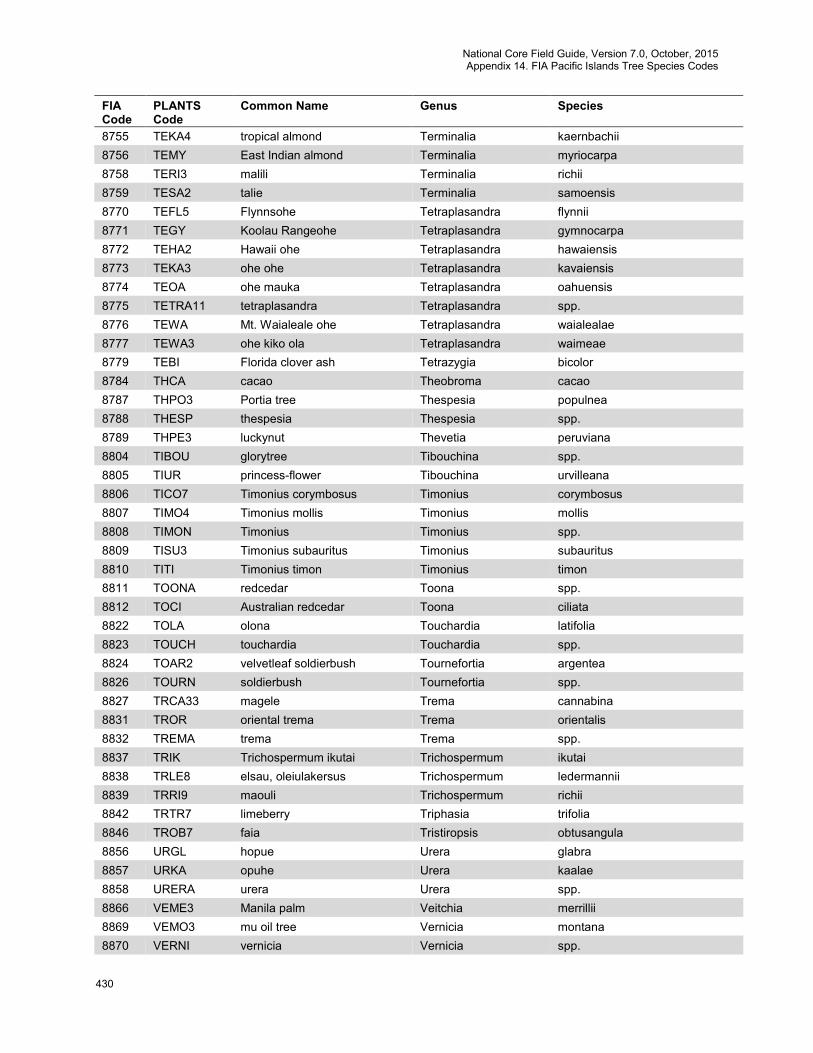
National Core Field Guide, Version 7.0, October, 2015 Appendix 14. FIA Pacific Islands Tree Species Codes
430
FIA Code
PLANTS Code
Common Name Genus Species
8755 TEKA4 tropical almond Terminalia kaernbachii 8756 TEMY East Indian almond Terminalia myriocarpa 8758 TERI3 malili Terminalia richii 8759 TESA2 talie Terminalia samoensis 8770 TEFL5 Flynnsohe Tetraplasandra flynnii 8771 TEGY Koolau Rangeohe Tetraplasandra gymnocarpa 8772 TEHA2 Hawaii ohe Tetraplasandra hawaiensis 8773 TEKA3 ohe ohe Tetraplasandra kavaiensis 8774 TEOA ohe mauka Tetraplasandra oahuensis 8775 TETRA11 tetraplasandra Tetraplasandra spp. 8776 TEWA Mt. Waialeale ohe Tetraplasandra waialealae 8777 TEWA3 ohe kiko ola Tetraplasandra waimeae 8779 TEBI Florida clover ash Tetrazygia bicolor 8784 THCA cacao Theobroma cacao 8787 THPO3 Portia tree Thespesia populnea 8788 THESP thespesia Thespesia spp. 8789 THPE3 luckynut Thevetia peruviana 8804 TIBOU glorytree Tibouchina spp. 8805 TIUR princess-flower Tibouchina urvilleana 8806 TICO7 Timonius corymbosus Timonius corymbosus 8807 TIMO4 Timonius mollis Timonius mollis 8808 TIMON Timonius Timonius spp. 8809 TISU3 Timonius subauritus Timonius subauritus 8810 TITI Timonius timon Timonius timon 8811 TOONA redcedar Toona spp. 8812 TOCI Australian redcedar Toona ciliata 8822 TOLA olona Touchardia latifolia 8823 TOUCH touchardia Touchardia spp. 8824 TOAR2 velvetleaf soldierbush Tournefortia argentea 8826 TOURN soldierbush Tournefortia spp. 8827 TRCA33 magele Trema cannabina 8831 TROR oriental trema Trema orientalis 8832 TREMA trema Trema spp. 8837 TRIK Trichospermum ikutai Trichospermum ikutai 8838 TRLE8 elsau, oleiulakersus Trichospermum ledermannii 8839 TRRI9 maouli Trichospermum richii 8842 TRTR7 limeberry Triphasia trifolia 8846 TROB7 faia Tristiropsis obtusangula 8856 URGL hopue Urera glabra 8857 URKA opuhe Urera kaalae 8858 URERA urera Urera spp. 8866 VEME3 Manila palm Veitchia merrillii 8869 VEMO3 mu oil tree Vernicia montana 8870 VERNI vernicia Vernicia spp.
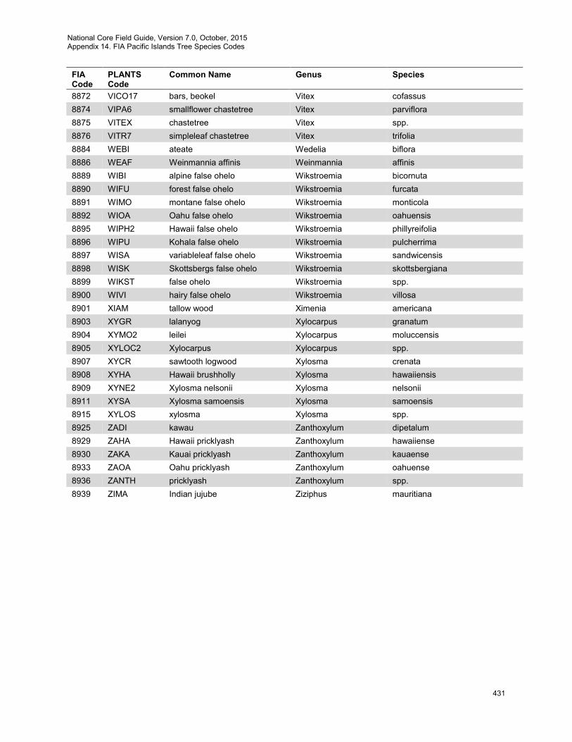
National Core Field Guide, Version 7.0, October, 2015 Appendix 14. FIA Pacific Islands Tree Species Codes
431
FIA Code
PLANTS Code
Common Name Genus Species
8872 VICO17 bars, beokel Vitex cofassus 8874 VIPA6 smallflower chastetree Vitex parviflora 8875 VITEX chastetree Vitex spp. 8876 VITR7 simpleleaf chastetree Vitex trifolia 8884 WEBI ateate Wedelia biflora 8886 WEAF Weinmannia affinis Weinmannia affinis 8889 WIBI alpine false ohelo Wikstroemia bicornuta 8890 WIFU forest false ohelo Wikstroemia furcata 8891 WIMO montane false ohelo Wikstroemia monticola 8892 WIOA Oahu false ohelo Wikstroemia oahuensis 8895 WIPH2 Hawaii false ohelo Wikstroemia phillyreifolia 8896 WIPU Kohala false ohelo Wikstroemia pulcherrima 8897 WISA variableleaf false ohelo Wikstroemia sandwicensis 8898 WISK Skottsbergs false ohelo Wikstroemia skottsbergiana 8899 WIKST false ohelo Wikstroemia spp. 8900 WIVI hairy false ohelo Wikstroemia villosa 8901 XIAM tallow wood Ximenia americana 8903 XYGR lalanyog Xylocarpus granatum 8904 XYMO2 leilei Xylocarpus moluccensis 8905 XYLOC2 Xylocarpus Xylocarpus spp. 8907 XYCR sawtooth logwood Xylosma crenata 8908 XYHA Hawaii brushholly Xylosma hawaiiensis 8909 XYNE2 Xylosma nelsonii Xylosma nelsonii 8911 XYSA Xylosma samoensis Xylosma samoensis 8915 XYLOS xylosma Xylosma spp. 8925 ZADI kawau Zanthoxylum dipetalum 8929 ZAHA Hawaii pricklyash Zanthoxylum hawaiiense 8930 ZAKA Kauai pricklyash Zanthoxylum kauaense 8933 ZAOA Oahu pricklyash Zanthoxylum oahuense 8936 ZANTH pricklyash Zanthoxylum spp. 8939 ZIMA Indian jujube Ziziphus mauritiana