Embed Size (px)
Citation preview

Forest of Soignes
Project realized by Belgian Graphic Interface (BGI)
for the Brussels Institute of Environment Management (IBGE)

Plan• Context
• The GeoEngineering MicroStation Solution
• The work composition
• Results
• Conclusion
• What were the needs ?
• What were the available data ?

Context
• Environmental project
• BGI : a company offering products and services in the field of GIS/CAD technology
designed by
• IBGE : local governmental
for

Location

Needs
The IBGE asked BGI
• to create a data set about the Forest of Soignes
- geology
- soil
- ecology
- alphanumeric database
• to realize a thematic map about :
- the slopes ( > and < to 20 %)- their aspects (north and south)

From
Environmental data on paper
Geological maps on paper
Soil maps on paper
A raster copy of contour lines
Data provider : Belgian National Geographical Institute (NGI)

The work
1 To digitize or vectorize all the data available and especially to entry the elevation of the 3D data
2 To clean, validate and create the polygons of the areas vectorized
4 To create a DTM from the 3D data andto drape the 2D data
5 To analyze the 3D data
3 To register the new polygons with the data coming from the NGI

To accomplish this project we used the GeoEngineering MicroStation
Environment
MicroStation
MicroStation Descartes
MicroStation GeoGraphics
Geopak GeoTerrain

Vectorisation with Descartes
Soil map
Geological maps

Vectorisation with Descartes

Vectorisation with Descartes

Vectorisation with Descartes

VECTORISATION
MICROSTATION DESCARTES
Georeferencing
Vectorisation and elevation entry
Color filters
TOOLS
TASKS

Cleanup
DANGLESGAPS
SIMILARgeologie.dgn

Cleanup
geologie.dgn
DANGLES
SIMILAR

Cleanup
geologie.dgn SIMILAR

Cleanup
geologie.dgn

POLYGON GENERATION
MICROSTATION GEOGRAPHICS
Correction
Validation and creation of polygons (over 101 vertices)
Generation of areas with holes
TOOLS
TASKS

First results

Georefenrencing- Register

Georefenrencing- Register
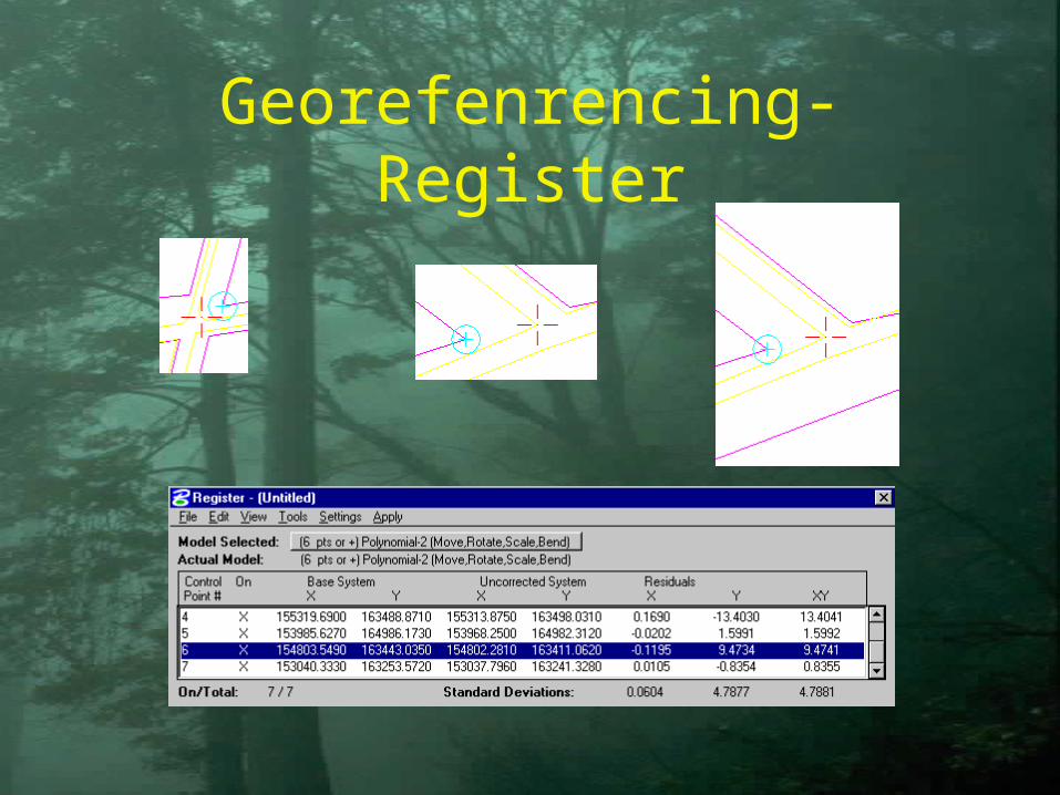
Georefenrencing- Register

DTM generation
Contour lines in DGN
Front view

DTM generation
TIN generated from the DGN 3D file

DTM generation
Contour lines regenerated from the TIN

DTM GENERATION
MICROSTATION GEOTERRAIN
Creation of the DTM TOOLS
TASKS Draping
Isohypse & isohypse label generation

DTM generation
Slope analysis
Slopes < 20 %
Slopes > 20 %
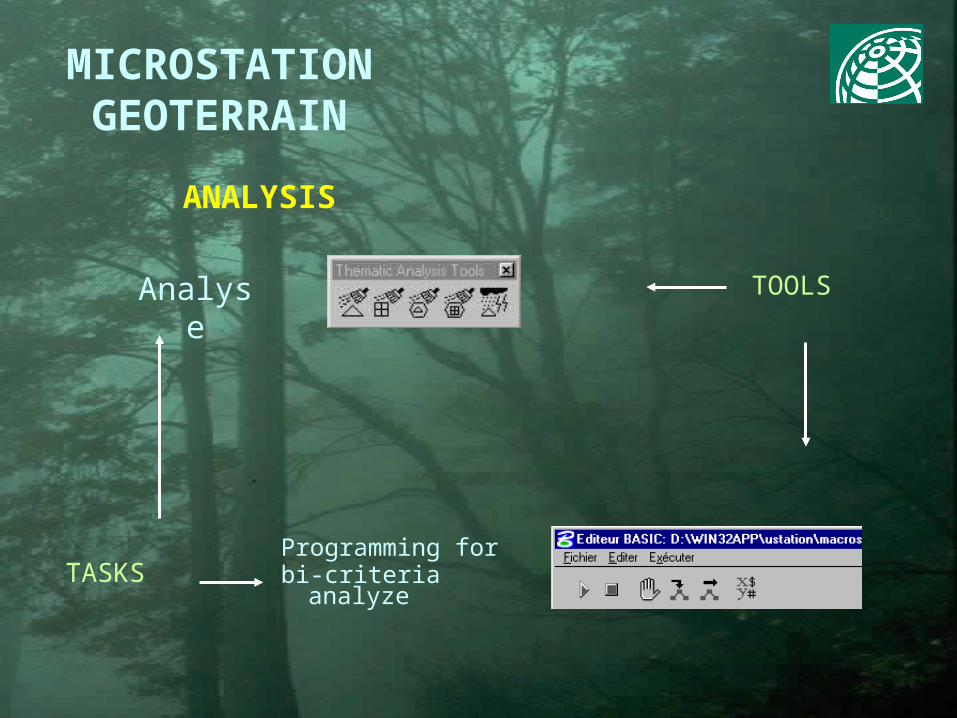
ANALYSIS
MICROSTATION GEOTERRAIN
TOOLS
TASKS
Analyse
Programming for bi-criteria analyze

MicroStation Environment
MicroStation Descartes
MicroStation GeoGraphics
Geopak GeoTerrain
DATA WORKFLOW
Photo draping, raster update
Data acquisition Area generation DTM creation Analyse

Results

Ecology
Soil
Geology
Relief
Soignes data set

N
S
200 m
2 km
Slopes < 20 %Slopes > 20 % and south aspectSlopes > 20 % and north aspect
Forest of Soignes : Ecological areas

Conclusion
• The complete interoperability between these four applications allowed us to profit of the efficient tools of each working configuration.
• The customizable tools (MDL, MicroStation Basic and now JAVA) allowed us to exactly fulfil the client needs.

BGI : www.bgi-sa.com
Bentley Systems : www.bentley.com
For more information : please contact
![Data Sheet Universal Force / Torque Gauge Model BGI · 2020. 7. 21. · Model BGI. BGI Specifications. Dimensions. in [mm] Ordering Information. The BGI and all sensors are supplied](https://img.pdfslide.net/doc/110x75/60c0a6b66b69f75b48415e42/data-sheet-universal-force-torque-gauge-model-bgi-2020-7-21-model-bgi-bgi.jpg)