Embed Size (px)
Citation preview

University of Arkansas, Fayetteville University of Arkansas, Fayetteville
ScholarWorks@UARK ScholarWorks@UARK
Theses and Dissertations
12-2020
Framework Grain Composition and Texture of the Wedington Framework Grain Composition and Texture of the Wedington
Sandstone Member, Fayetteville Shale, as a Provenance and Sandstone Member, Fayetteville Shale, as a Provenance and
Sediment Dispersal Indicator for Clastic Depositional Systems Sediment Dispersal Indicator for Clastic Depositional Systems
Across the Northern Arkansas Structural Platform During the Late Across the Northern Arkansas Structural Platform During the Late
Mississippian Mississippian
Tanner Wayne Corbin University of Arkansas, Fayetteville
Follow this and additional works at: https://scholarworks.uark.edu/etd
Part of the Geology Commons, Mineral Physics Commons, and the Sedimentology Commons
Citation Citation Corbin, T. W. (2020). Framework Grain Composition and Texture of the Wedington Sandstone Member, Fayetteville Shale, as a Provenance and Sediment Dispersal Indicator for Clastic Depositional Systems Across the Northern Arkansas Structural Platform During the Late Mississippian. Theses and Dissertations Retrieved from https://scholarworks.uark.edu/etd/3920
This Thesis is brought to you for free and open access by ScholarWorks@UARK. It has been accepted for inclusion in Theses and Dissertations by an authorized administrator of ScholarWorks@UARK. For more information, please contact [email protected].
Framework Grain Composition and Texture of the Wedington Sandstone Member, Fayetteville
Shale, as a Provenance and Sediment Dispersal Indicator for Clastic Depositional Systems
Across the Northern Arkansas Structural Platform During the Late Mississippian
A thesis submitted in partial fulfillment
of the requirements for the degree of
Master of Science in Geology
by
Tanner Wayne Corbin
Arkansas Tech University
Bachelor of Science in Geology, 2015
Arkansas Tech University
Master of Education in Instructional Design and Technology, 2017
December 2020
University of Arkansas
This thesis is approved for recommendation to the Graduate Council.
____________________________
T.A. “Mac” McGilvery, Ph.D.
Thesis Director
____________________________ _______________________________
Walter L. Manger, Ph.D. Glenn R. Sharman, Ph.D.
Committee Member Committee Member
_____________________________
Jacob F. Grosskopf, Ph.D.
Committee Member (Ex Officio)
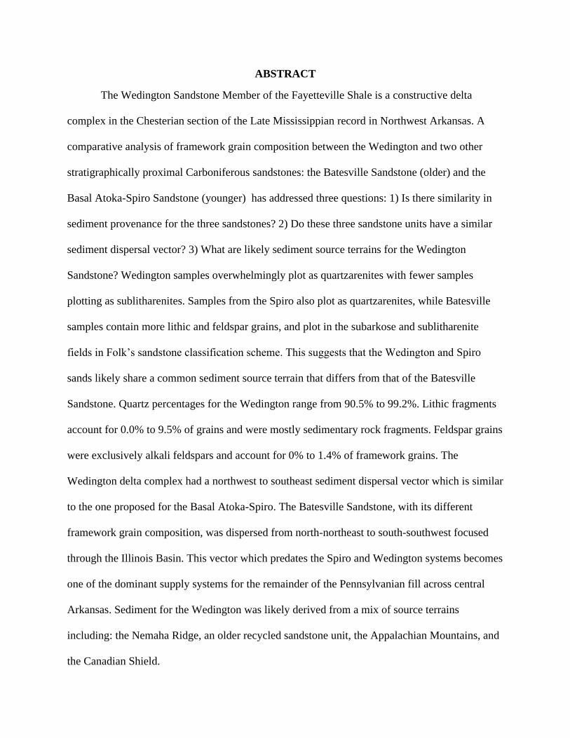
ABSTRACT
The Wedington Sandstone Member of the Fayetteville Shale is a constructive delta
complex in the Chesterian section of the Late Mississippian record in Northwest Arkansas. A
comparative analysis of framework grain composition between the Wedington and two other
stratigraphically proximal Carboniferous sandstones: the Batesville Sandstone (older) and the
Basal Atoka-Spiro Sandstone (younger) has addressed three questions: 1) Is there similarity in
sediment provenance for the three sandstones? 2) Do these three sandstone units have a similar
sediment dispersal vector? 3) What are likely sediment source terrains for the Wedington
Sandstone? Wedington samples overwhelmingly plot as quartzarenites with fewer samples
plotting as sublitharenites. Samples from the Spiro also plot as quartzarenites, while Batesville
samples contain more lithic and feldspar grains, and plot in the subarkose and sublitharenite
fields in Folk’s sandstone classification scheme. This suggests that the Wedington and Spiro
sands likely share a common sediment source terrain that differs from that of the Batesville
Sandstone. Quartz percentages for the Wedington range from 90.5% to 99.2%. Lithic fragments
account for 0.0% to 9.5% of grains and were mostly sedimentary rock fragments. Feldspar grains
were exclusively alkali feldspars and account for 0% to 1.4% of framework grains. The
Wedington delta complex had a northwest to southeast sediment dispersal vector which is similar
to the one proposed for the Basal Atoka-Spiro. The Batesville Sandstone, with its different
framework grain composition, was dispersed from north-northeast to south-southwest focused
through the Illinois Basin. This vector which predates the Spiro and Wedington systems becomes
one of the dominant supply systems for the remainder of the Pennsylvanian fill across central
Arkansas. Sediment for the Wedington was likely derived from a mix of source terrains
including: the Nemaha Ridge, an older recycled sandstone unit, the Appalachian Mountains, and
the Canadian Shield.

ACKNOWLEDGMENTS
I would like to thank my mentors at the University of Arkansas for their advice,
comments, and all assistance in pushing me as I finished this thesis. Dr. T.A. ‘Mac’ McGilvery
provided me with constant encouragement and aid while finishing this thesis. He was also
gracious enough to take the lead position on the project. Dr. Walter Manger, thank you for
getting me started on the project, aiding in field work, and having my thin sections made. The
project would not have been possible without your support. Thanks to Dr. Glenn Sharman,
whose comments and ideas helped me to think of ways to attack the problem, even if not all were
able to be used, due to COVID-19 complications. Thank you to Dr. Gregory Dumond for taking
time out of his schedule to help me capture photomicrographs for this thesis. Other Geosciences
professors, whose guidance was most helpful include: Dr. Tom Paradise, Ms. Jamie Woolsey,
Dr. Doy Zachry, and Dr. Chris Liner. Many thanks to Dr. Burt Bluhm, in Plant Pathology, who
always had an open ear when a long day needed to be talked through.
None of my success in geology would be possible without my advisors and friends in the
Arkansas Tech University Geology Program. Dr. Cathy Baker instilled in me a passion for the
science and gave me a huge “leg-up” with all of her support. Dr. Jason Patton, thank you for all
the chats about research ideas, woes of academia, and supporting me for my first job teaching
geology. A big thanks is also due to the two faculty members that started at ATU when I was a
graduate student in Education. Dr. Michael Davis and Dr. Jacob Grosskopf were both integral to
my success by allowing me into their classrooms and helping me hone my skills teaching upper-
division classes. Their friendship and mentorship helped me arrive where I am today. Jacob, that
you, again, for being willing to serve on my committee and provide constructive criticism and
encouragement. I also want to thank the Emeritus faculty at ATU, Dr. Richard Cohoon and Dr.
Vic Vere, who took their time to share their experiences and were never afraid to ask us “the
hard questions”. Another thanks to Ms. Brenda Lauffart. Brenda, thank you for offering me my
first job as a teaching assistant and helping me to solidify that I wanted to teach science to young
people, even if it is not always the easiest job. I think teaching Survey of Chemistry Lab together
really broke me into being stern but having a good time in the laboratory.
Another thank you is due to my parents, Mark and Lisa Corbin. They have supported me
in all that I have attempted and always push me to be my best. I could not ask for better parents
in this journey. In addition to my parents a word of thanks to my siblings, Bailey and Grayson,
who have been subjected to many a roadside lecture. Thank you to my grandmothers, Joyce
Corbin and Carol George. I know many prayers were said on my behalf as I worked towards this
goal. I wish that my grandfather, Don Corbin, would have been able to see me finish this
challenge, as he was always one of my biggest supporters.
Lastly, I want to thank my friends and peers in the M.S. program that helped me
complete this thesis. Michael Foust was always willing to go with me in the field, as I needed to
re-look at an outcrop or take an additional photograph. His mapping skills were beyond helpful
in creating some of the figures seen in this thesis. Thank you, as well, to my D&D group (Amy,
Emily, Beth, Asher, and Wade), who allowed me a retreat from the real world. Cheers to my
friends and family at Sideways (Lexi, Robert, Chris, Tim, Sam, Cody, and Jeff) and Ryleigh’s
(Chailey, Julie, Sarah, Mitch, J., Nate, Jake, and Sam) for giving me a place to go and relax after
a long day’s work.
TABLE OF CONTENTS
Section Page Number
I. Introduction to the Problem .........................................................................................................1
II. Tectonic History .........................................................................................................................9
III. Literature Review .................................................................................................................... 16
IV. Data ......................................................................................................................................... 30
V. Methods .................................................................................................................................... 31
VI. Observations ........................................................................................................................... 33
VII. Interpretations ........................................................................................................................ 43
VIII. Conclusions .......................................................................................................................... 53
IX. Future Work ............................................................................................................................ 54
References ..................................................................................................................................... 56
Appendices .................................................................................................................................... 60
1
I. Introduction to the Problem
A. Geologic Background and Setting
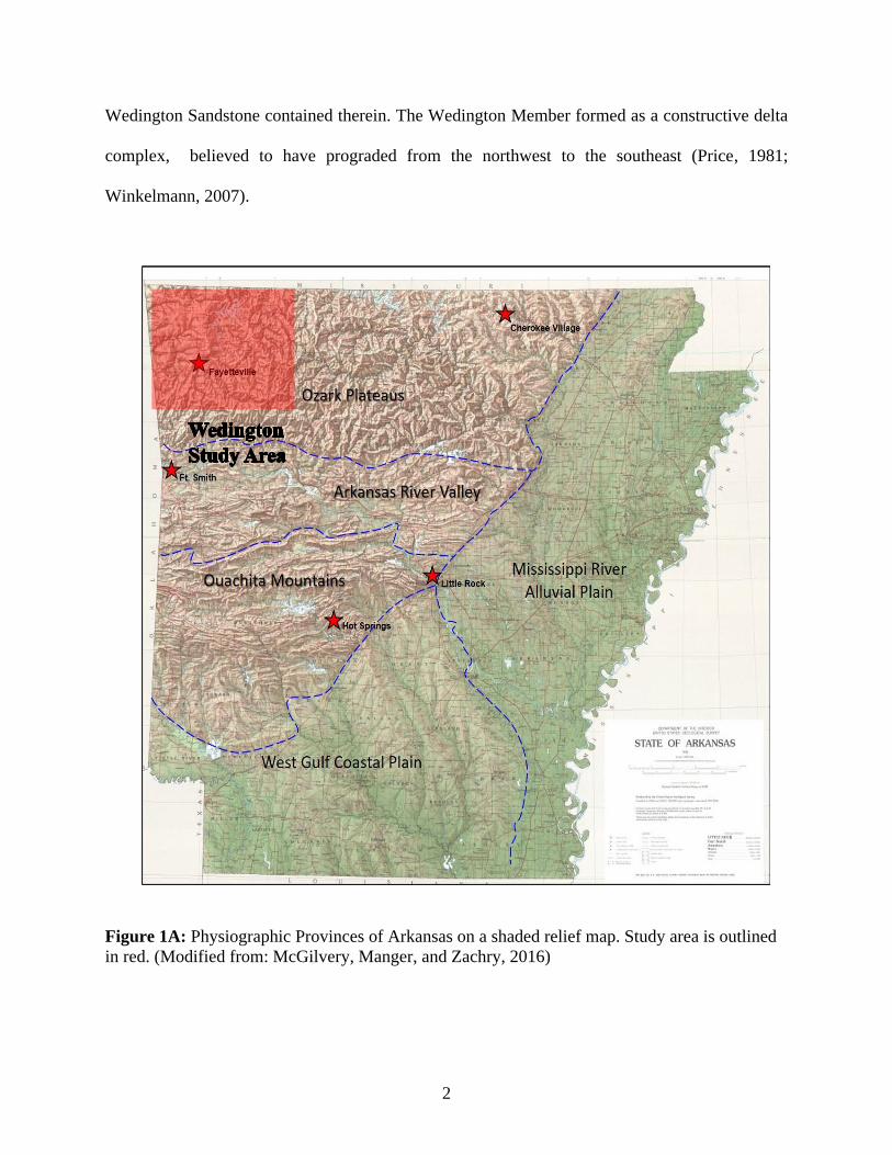
The state of Arkansas is divided into five major physiographic provinces: the Ozark
Plateau, Arkansas River Valley, Ouachita Mountains, the West Gulf Coastal Plain, and the
Mississippi Embayment (Figure 1A). The West Gulf Coastal Plain and the Mississippi Embayment
are comprised of Mesozoic and Cenozoic sedimentary rocks and sediments. In contrast, the Ozark
Plateau, the Arkansas River Valley and Ouachita Mountains consist of Paleozoic sedimentary
rocks with varying degrees of deformation. The rocks of the Ozark Plateau exhibit very little
tectonic deformation (Moyer and Manger, 2006). The western flank of the Ozark Dome is
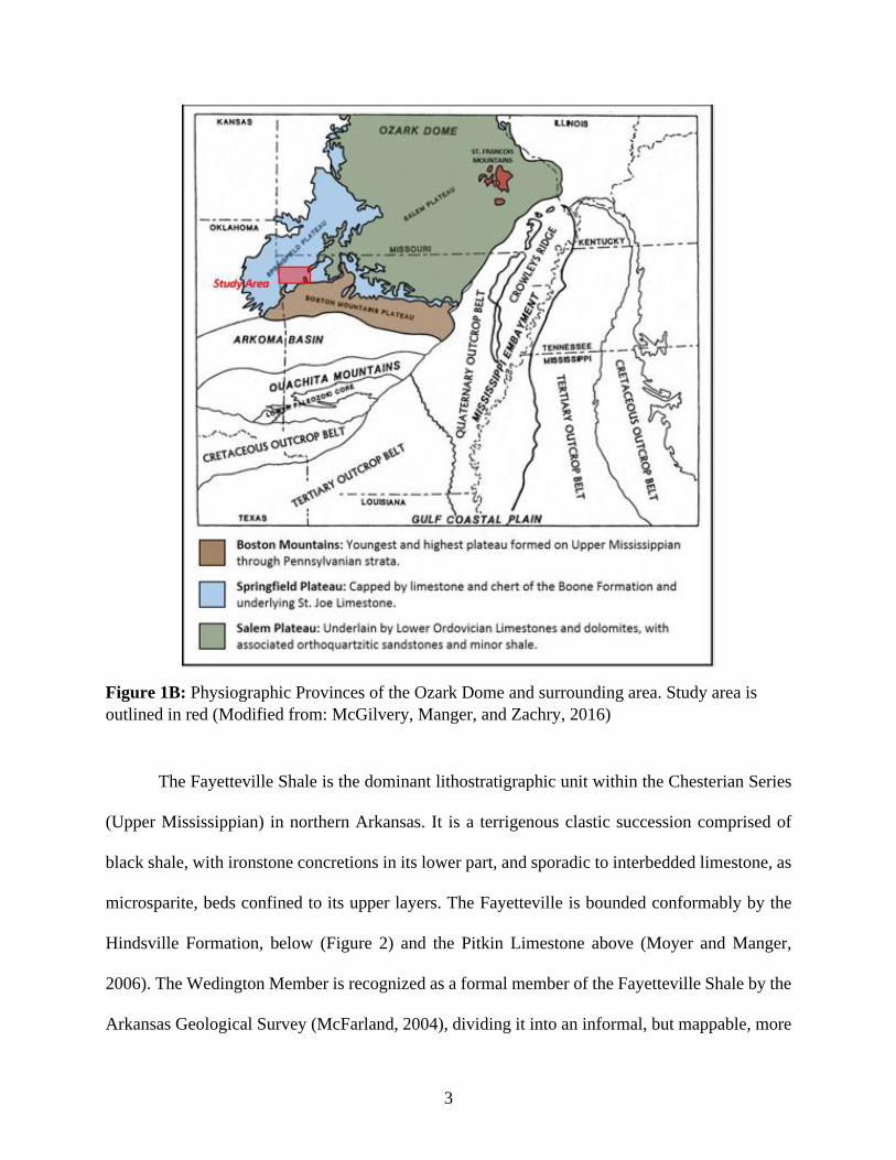
subdivided into the Salem Plateau, the Springfield Plateau, and the Boston Mountains (Figure 1B).
Precambrian basement rock is exposed in the St. Francois Mountains in the core of the Ozark
Dome of southeast Missouri. The north-central portion of the Dome is designated as the Salem
Plateau, that is capped by Ordovician dolostones. This region is flanked by the Springfield Plateau
to the south and west that are capped by Lower Mississippian carbonates that overly Ordovician
dolostones (Cains, 2013; Moyer and Manger, 2006; McGilvery, Manger, and Zachry, 2016). The
Boston Mountains expose primarily Pennsylvanian clastics, dominated by the Atoka Formation.
The Mississippian Wedington Sandstone Member of the Fayetteville Shale is located within
northwest Arkansas in the Ozark Dome physiographic province, Springfield Plateau sub-province.
What is now Arkansas was located on the southern margin of the continent of Laurentia during the
Late Mississippian. This region is designated as the Northern Arkansas Structural Platform (Chinn
and Konig, 1973), and was covered by epicontinental seas, dominated by carbonate deposition
during that time. However, during the Chesterian (Upper Mississippian), there was an influx of
terrigenous clastics, depositing the Fayetteville Shale (Xie, Cains, and Manger, 2016) and the
2
Wedington Sandstone contained therein. The Wedington Member formed as a constructive delta
complex, believed to have prograded from the northwest to the southeast (Price, 1981;
Winkelmann, 2007).
Figure 1A: Physiographic Provinces of Arkansas on a shaded relief map. Study area is outlined
in red. (Modified from: McGilvery, Manger, and Zachry, 2016)
3
Figure 1B: Physiographic Provinces of the Ozark Dome and surrounding area. Study area is
outlined in red (Modified from: McGilvery, Manger, and Zachry, 2016)
The Fayetteville Shale is the dominant lithostratigraphic unit within the Chesterian Series
(Upper Mississippian) in northern Arkansas. It is a terrigenous clastic succession comprised of
black shale, with ironstone concretions in its lower part, and sporadic to interbedded limestone, as
microsparite, beds confined to its upper layers. The Fayetteville is bounded conformably by the
Hindsville Formation, below (Figure 2) and the Pitkin Limestone above (Moyer and Manger,
2006). The Wedington Member is recognized as a formal member of the Fayetteville Shale by the
Arkansas Geological Survey (McFarland, 2004), dividing it into an informal, but mappable, more
4
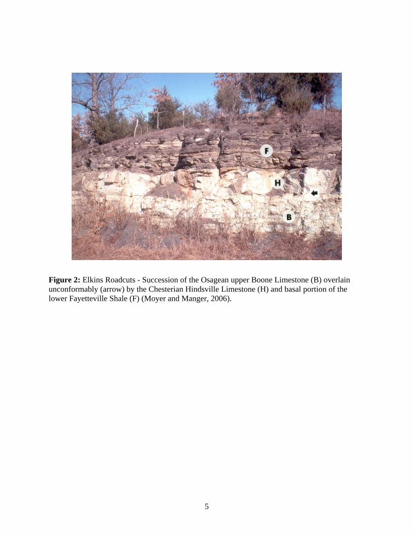
organic-rich, lower unit, and a less organic-rich, upper unit (Price, 1981) (Figure 3). The deposition
of the Fayetteville is evidence for the suppression of the carbonate factory across Laurentia by
terrigenous sediments during the Chesterian (Cains, 2013).
The Wedington has been described, in hand samples, as a fine- to medium-grained,
subrounded to rounded sandstone, characterized by moderate sorting (Price, 1981). Petrographic
analysis of the sandstone assigns it to a sublitharenite to quartzarenite category based on a
standard QFL plot classification (Folk, 1974; Allen, 2010; Bello, 2017).
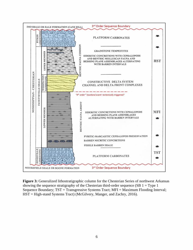
The Wedington Member depositional environment is interpreted as a bird-foot shaped
delta (Winkelmann, 2007). The delta consists of a number of mapped channel and delta lobe
systems that define elongate, northwest to southeast depositional accretion (Price, 1981) (Figure
4). Previous studies, discussed in the Previous Investigations section, have only examined the
Wedington holistically, and generalized sourcing to a few possible areas of provenance to the
west-northwest of its formation (Price, 1981; Allen, 2010). This sediment dispersal direction is in
contrast to that of the younger (Pennsylvanian) sandstone units that developed across northern
and central Arkansas (Houseknecht, 1986). Correlation and provenance studies have proved
difficult for the Wedington due to the lack of up dip equivalents preserved in the record. Detrital
zircon analysis of the Wedington indicates provenance sourcing from all major North American
provinces, at least in some part (Xie, Cains, and Manger, 2016). However, the sediment largely
represents that from the Grenville (900-1350 Ma) province and the Middle-Paleozoic (500-350
Ma) province (Xie, Cains, and Manger, 2016). The Xie, et al. (2016) study helps constrain the
sediment provenance of the quartz clastic material during the Late Mississippian (Xie, Cains, and
Manger, 2016).
5
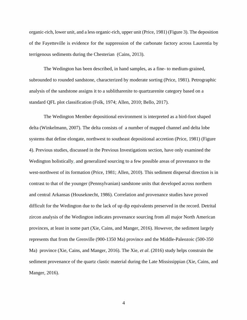
Figure 2: Elkins Roadcuts - Succession of the Osagean upper Boone Limestone (B) overlain
unconformably (arrow) by the Chesterian Hindsville Limestone (H) and basal portion of the
lower Fayetteville Shale (F) (Moyer and Manger, 2006).
6
Figure 3: Generalized lithostratigraphic column for the Chesterian Series of northwest Arkansas
showing the sequence stratigraphy of the Chesterian third-order sequence (SB 1 = Type 1
Sequence Boundary; TST = Transgressive Systems Tract; MFI = Maximum Flooding Interval;
HST = High-stand Systems Tract) (McGilvery, Manger, and Zachry, 2016).
7
Figure 4: Sand isolith map of the Wedington Sandstone, showing the inferred distribution of
delta channels. The green dot is the outcrop seen in Figure 16 (McGilvery, Manger, and Zachry;
2016).
B. The Problem Statement
A comparison between the Wedington Sandstone with two other Carboniferous
sandstones, the Batesville Sandstone (older) and the Basal Atoka-Spiro Sandstone (younger),
helps define the possible provenance for northwest to southeast depositional delivery during the
8
late Paleozoic. This study compares the framework grain compositions of the three units to gain
a better understanding of a possible source similarity between these sandstones.
Can framework grain composition give insight to the provenance, sediment dispersal
vector, and similarity/contrast between Wedington and Batesville Sandstone and Basal Atoka-
Spiro Sandstone? The problem addressed by this study is the quantification of the framework
grain composition and its attributed provenance that subsequently determined the sediment
dispersal pattern for the Wedington Sandstone. Pre-Arkoma Basin fill sandstones (lower Atokan
and older) deposited on the Northwest Arkansas Structural Platform are characterized as
quartzarenites, while the younger clastic succession that filled the Arkoma Foreland Basin are
classified as feldspathic litharenites. These litharenites are interpreted as being derived from the
Appalachian Overthrust with an east-west and/or northeast-southwest sediment dispersal vector
(Houseknecht and McGilvery, 1990). The Wedington Sandstone is a pre-Arkoma Basin fill,
clastic unit with a northwest to southeast sediment dispersal system, based on its mapped
distribution (Price, 1981; Winkelmann, 2007). This provenance study, based on framework grain
composition, aims to test the hypothesis that the Wedington Sandstone has a distinct sediment
source and general sediment supply vector when compared to the clastics of the Arkoma
Foreland Basin.
The framework grain composition, provenance, and sediment dispersal vectors for the
Wedington Sandstone derived in this study are compared to published data regarding two other
pre-Arkoma Basin fill clastic units. These are the underlying Batesville Sandstone in Arkansas
and the overlying Basal Atoka-Spiro Sandstone of Oklahoma. Integration of these data with that
of the Wedington Sandstone will better characterize the composition and provenance of the
clastic depositional systems that existed on the stable platform along the southern margin of
9
Laurasia prior to the tectonic evolution of the region into a rapidly subsiding foreland basin
being filled by orogenically derived, clastic sediments from the east.
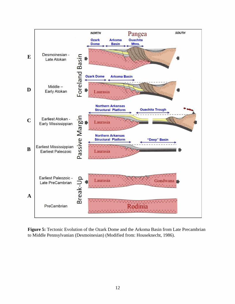
II. Tectonic History
The Ozark Plateaus and the Arkoma Basin evolved as a consequence of the opening, and
later, closing of a Paleozoic ocean basin. There have been numerous models that depict this
marine sediment sink that have led to the currently accepted model of continental divergence
followed by deconstructive consumption of oceanic lithosphere during continental collision
(Houseknecht and Kacena, 1983). The tectonic evolution of the Northern Arkansas Structural
Platform from the Precambrian through the Early Pennsylvanian, including, the formation, fill,
and subsequent deformation of the Arkoma Foreland Basin is illustrated by a series of cross
section views in Figure 5. During the late Proterozoic to early Paleozoic, a major rifting event
resulted in the breakup of Rodinia into two smaller supercontinents: Laurasia and Gondwana
(Houseknecht, 1986). This split allowed for the opening of an ocean basin, where thousands of
feet of sediments were deposited in shallow to deep marine settings (Figure 5A) (Houseknecht,
1986; McGilvery, Manger, Zachry, 2016). The southern portion of Laurasia (modern North
America) was a tectonically stable passive margin throughout much of the middle Paleozoic
consisting of the Northwest Arkansas Structural Platform, with an adjacent deep ocean basin, the
Ouachita Trough (Figure 5B) (Houseknecht, 1986). The deep ocean basin began to close near the
end of the Devonian to the earliest Mississippian, as Laurasia and Gondwana began to converge
(Houseknecht, 1986). This convergence ultimately lead to the formation of the supercontinent
Pangea in the late Paleozoic, including formation of the Ouachita Mountains as an overthrust belt
that was welded onto the southern margin of Laurasia, driven by the subduction of oceanic crust
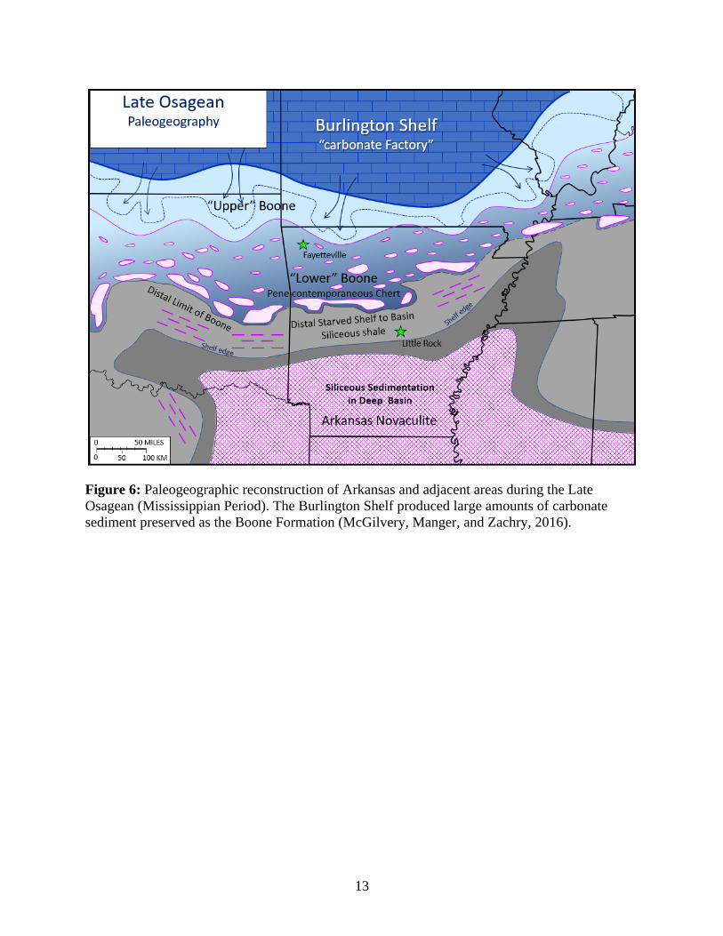
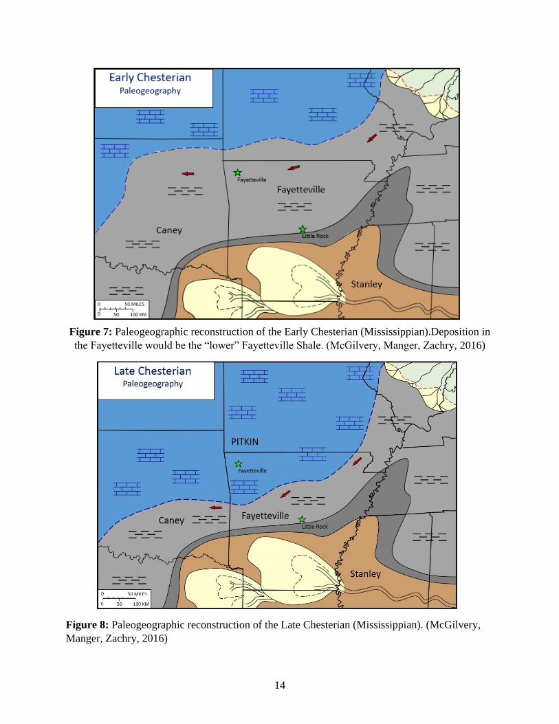
beneath the southern landmass, Llanoria (Figure 5C-E) (Houseknecht, 1986). Figure 6 presents
10
paleogeographic reconstruction of Arkansas during the Osagean series (Late Mississippian),
prior to the deposition of the Fayetteville Shale during the Chesterian. Deposition during the
Osagean of northern Arkansas was dominated by carbonates derived from the Burlington Shelf
(McGilvery, Manger, and Zachry, 2016). The carbonate supply from the Burlington Shelf was
suppressed during the Early Chesterian (Figure 7) as clastic sediments filled the basin until the
Late Chesterian, when the Pitkin Limestone was deposited (Figure 8) (McGilvery, Manger, and
Zachry, 2016). The ocean basin was eventually closed by subduction as the two landmasses
collided, abducting much of the deep basin sediment onto the continental margin during the
middle Atokan, Pennsylvanian (Figure 5D&E) (Houseknecht, 1986). The Northern Arkansas
Structural Platform deformed into the Arkoma Foreland Basin during this time (Houseknecht,
1986). The foreland basin was characterized by an elevated clastic sediment supply derived from
the Appalachian-Ouachita orogenic province to the east-northeast that was delivered to the
rapidly subsiding basin (McGilvery, Manger, and Zachry, 2016). This resulted in the deposition
of ~35,000 feet of sedimentary rocks (at its maximum) in the deepest portion of the basin (Moyer
and Manger, 2006).
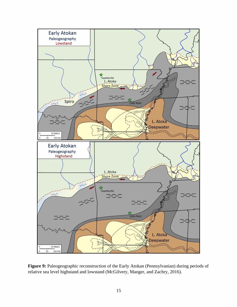
Paleogeographic reconstructions of the Early Atokan, in both highstand and lowstand
conditions illustrates the clastic and mixed carbonate-clastic depositional systems across the
Northern Arkansas Structural Platform just before its transition into the rapidly subsiding
Arkoma Basin (Figure 9) (McGilvery, Manger, Zachry, 2016). Sediment input from the east-
northeast built the Lower Atoka axial deep-water submarine fan systems across central Arkansas
into eastern Oklahoma (Houseknecht, 1986; McGilvery, Manger, and Zachry, 2016). The Basal
Atoka-Spiro sandstone along the northern margin was derived from the northwest as a
11
continuation of the north-northwest to south-southeast vector of the Wedington Sandstone,
Fayetteville Shale (Figure 4) (Houseknecht and McGilvery, 1990).
12
Figure 5: Tectonic Evolution of the Ozark Dome and the Arkoma Basin from Late Precambrian
to Middle Pennsylvanian (Desmoinesian) (Modified from: Houseknecht, 1986).
A
B
C
D
E
13
Figure 6: Paleogeographic reconstruction of Arkansas and adjacent areas during the Late
Osagean (Mississippian Period). The Burlington Shelf produced large amounts of carbonate
sediment preserved as the Boone Formation (McGilvery, Manger, and Zachry, 2016).
14
Figure 7: Paleogeographic reconstruction of the Early Chesterian (Mississippian).Deposition in
the Fayetteville would be the “lower” Fayetteville Shale. (McGilvery, Manger, Zachry, 2016)
Figure 8: Paleogeographic reconstruction of the Late Chesterian (Mississippian). (McGilvery,
Manger, Zachry, 2016)
15
Figure 9: Paleogeographic reconstruction of the Early Atokan (Pennsylvanian) during periods of
relative sea level highstand and lowstand (McGilvery, Manger, and Zachry, 2016).
16
III. Literature Review
A. Previous Investigations
The Fayetteville Shale is Upper Mississippian, Chesterian, in age and comprises most of
the bedrock in the Fayetteville area. The first formal naming of these Chesterian strata in the
region was published in 1891 by Branner for the Arkansas Geological Survey (Branner, in
Simmonds, 1891). Branner miscorrelated the Wedington Sandstone, overlying the lower
Fayetteville Shale as the Batesville Sandstone, which in fact overlies the Boone Limestone or
Moorefield Shale. This lapse was remedied in 1904 when Adams, et al. (1904) established the
name Wedington for this sandstone unit for the outcrops located near the Wedington Mountains,
Washington County. Note that the spelling of Wedington only has one “D”, while the town of
Weddington has two.
The first major study of the Wedington by a student at the University of Arkansas was
completed by McNully (1966). McNully performed a detailed grain size analysis of the
Wedington Member based on petrographic work. He reported lateral variation in grain size with
finest sands in the southeast, coarsening towards the northwest. The median grain size ranges
from 90-150 microns. In addition, McNully stated that the Wedington was deposited as a delta
with a paleoshoreline occupying 70°-80° (ENE/WSW) relative to present day north (McNully,
1966).
C.R. Price (1981) mapped the delta geometry in the Wedington Sandstone for his M.S.
thesis. These geometries were mapped based on measured sections of surface exposures
(outcrop) as well as subsurface data from the correlation of several well logs. Five distinct delta
facies were identified based on outcrop observations: channel, interdistributary bay, costal sands,
offshore, and transitional facies. Paleocurrent analysis showed that the delta prograded from
northwest to southeast. This is consistent with the vector suggested by McNully (1966). No
17
quantified petrography was completed as part of Price’s thesis, but it was noted that the unit
consisted of mostly quartz sand and the conclusion was drawn that this sand was likely recycled
from a cratonic source based on outcrop analyses (Price, 1981).
A rigorous petrographic study of the Batesville Sandstone (which the Wedington was
originally misidentified as (Branner, 1891)) was conducted by T.L. Cochran in 1989. Cochran
was interested in comparing the Batesville to other Chesterian sandstones located in the Illinois
Basin and considered to have been derived from the east-northeast. Transport and delivery
mechanisms from the Michigan River delta was his proposed delivery system for the Batesville
Sandstone from the northeast. He noted a petrologic similarity between the Batesville and the
Wedington and suggested they may have a common provenance (Cochran, 1989). It is important
to note the lack of feldspar in the Wedington indicated by Price (1981) in contrast to the
Batesville, which includes feldspar as common framework grains. This distinction in framework
grain composition tends to contradict Cochran’s postulation that the Wedington and Batesville
share a similar sediment source and is addressed further in the current study. The presence of
significant feldspar in the framework grain composition of the Carboniferous sandstones
overlying the Wedington in Arkansas, particularly the Atokan and Desmoinesian series, is
attributed to an orogenic source derived from the evolving Appalachian Mountains that were
located to the east-northeast at that time. The Batesville Sandstone may be an early indicator of
this eastern orogenic source that predates the Wedington Sandstone and ultimately dominates
sediment dispersal throughout the overlying Pennsylvanian succession (McGilvery, Manger, and
Zachry, 2016).
There is a gap in studies of the Wedington Sandstone, from an academic perspective,
until D.E. Allen returned to the subject in his 2010 Master’s Thesis. Allen performed a
18
petrographic analysis of three Chesterian sandstones located in northern Arkansas: the Batesville
Sandstone, the Wyman Sandstone, and the Wedington Sandstone. He used thin section analysis
and Folk’s Sandstone Classification Scheme (1974) (Figure 10) to compare these three sandstone
units. His description of the Wedington was that it ranged from a lithic wacke to quartzarenite;
with quartzarenites being the dominant classification. Allen proposed that a metamorphic terrain
was required to supply the few metamorphic rock fragments (MRFs), the Boone Limestone
(Lower Mississippian) to supply chert fragments, and a third terrain (possibly the granitic
Nemaha Ridge) to supply monocrystalline quartz and minor feldspar (Allen, 2010).
For his 2013 thesis, W. Cains performed a detrital zircon analysis of the Wedington
Sandstone to refine a possible source terrain for the unit. Uranium-Lead (U-Pb) geochronology
of these detrital zircons were analyzed from six samples, yielding over 550 concordant analyses
used in the interpretation. Major age peaks occurred in six age ranges between 350 and2500 Ma.
The highest percentage of zircons pointed to the Acadian, Taconic, and Grenville Provinces and
allowed Cains to show a likely Appalachian source for Chesterian sediments (Xie, Cains,
Manger, 2016). Secondarily, the Yavapai-Mazatzal and Midcontinent Granite-Rhyolite terrains
were supplying a significant amount of sediment during the late Mississippian. This means that
sediment was likely being supplied from both east and west of the North Arkansas Structural
Platform, and combined to form the small constructive delta complex, now known as the
Wedington (Cains, 2013; Xie, Cains, and Manger, 2016). This thesis was eventually published
by Xie, Cains, and Manger in 2016.
The Fayetteville Shale that contains the Wedington Sandstone conformably overlies the
Hindsville Limestone or Batesville Sandstone (early Chesterian). These two units record the
initial flooding and deposition on the top Osagean unconformity surface (Figure 3). The

19
Batesville Sandstone represents the first significant sandstone unit developed within the
Mississippian stratal succession that is dominated by limestones and black shales. This is an
important first step, along with the Wedington Sandstone, as a “precursor” sand-rich depositional
system prior to the clastics dominated basin fill of the subsequent Arkoma Foreland Basin.
Figure 10: Folk’s Sandstone Classification Scheme with constituent categories of Quartz (Q),
Feldspar (F), and Lithic Fragments (L) (After Folk, 1974).
The Batesville Sandstone was studied by H.F. Garner (1967) as a potential exploration
target within the Chesterian strata. He studied the Moorefield, Batesville, and Hindsville
Formations and concluded that the units “comprised a complex interstratified, intertounged,
carbonate reef-terrigenous clastic deposit” that was controlled by the topography of the erosional
surface of the Boone Formation (Garner, 1967).
Grayson (1980) assessed the Hindsville Formation in terms of lithostratigraphy and
biostratigraphy. At the time, the Hindsville was considered a member of the Batesville
Formation and often he referred to “tongues” of sandstone in the measured sections of the
20
Hindsville. He argued for an update to the Hindsville’s status and that it be recognized as its own
formation, which became the preferred nomenclature by many authors there after (Figure 12)
(Grayson, 1980; Allen, 2010). Arguments regarding nomenclature were also made by D.E.
Ogren (1961) in his dissertation and in which he discusses the Chesterian of northern Arkansas
(Ogren, 1961). He was also in favor of the Hindsville and the Batesville being two distinct
formations (Ogren, 1968). The interfingering between the Hindsville and the Batesville is
attributed to the topography caused by the erosion of the underlying Boone Formation. Grayson
also suggests that the western limit of the Batesville may also be a result dwindling supply of
terrigenous clastics from its eastern source (Grayson, 1980). The Batesville Sandstone is
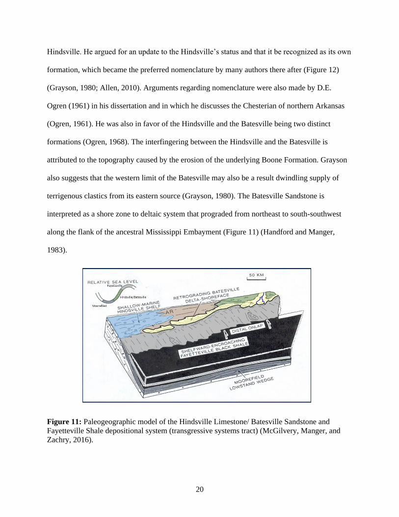
interpreted as a shore zone to deltaic system that prograded from northeast to south-southwest
along the flank of the ancestral Mississippi Embayment (Figure 11) (Handford and Manger,
1983).
Figure 11: Paleogeographic model of the Hindsville Limestone/ Batesville Sandstone and
Fayetteville Shale depositional system (transgressive systems tract) (McGilvery, Manger, and
Zachry, 2016).
21
Based on petrographic analysis, the Batesville was found to have very few metamorphic
rock fragments, and mostly comprised of monocrystalline quartz with feldspar being a common
framework constituent (Bello, 2017; Allen, 2010, Cochran, 1989). The Batesville is moderately
to well sorted and rounded. The Batesville ranges in classification from a quartzarenite to a
subarkose (Cochran, 1989). Cochran suggests that the Batesville was likely deposited as an
active beach environment due to high textural maturity and bedforms (crossbeds, parallel-
laminations, cross-trough stratification) (Cochran, 1989).
The Spiro Sandstone, also known as the Basal Atoka-Spiro, is a unit within the Atoka
Formation developed across Eastern Oklahoma and Western Arkansas (Lumsden, Pittman, and
Buchanan, 1971). The Basal Atoka-Spiro records the initial sandstone deposition on the top of
the Morrowan unconformity surface (Lower Pennsylvanian) and represents the onset and final
transition to clastic dominated deposition across the southern margin of Laurasia prior to its
evolution to the Arkoma Foreland Basin. The Basal Atoka-Spiro postdates deposition of the
Wedington Sandstone but is included in this study due to its well-developed northwest to
southeast sediment dispersal vector and framework grain composition that are both comparable
to the Wedington (Houseknecht and McGilvery; 1990).
The original framework for the stratigraphy of the region and the nomenclature was
completed by Owen (1858), Simonds (1891), and Adams, et al. (1904) in Arkansas, with Moore
(1947) and Blythe (1959) completing similar work in Oklahoma. Blythe identified potential
source areas for the Atokan series sediment supply. The Sprio was formally named for outcrops
near the town of Spiro, Oklahoma (Maravich, 1955), although, the name was first used by
Wilson (1935) to describe the first (basal) sand unit in the Atoka formation (in the subsurface).

22
The Basal Atoka-Spiro Sandstone ranges from 20 to 200 feet in thickness and from
medium to fine grained sandstone in textures (Lumsden, Pittman, and Buchanan, 1971;
Houseknecht and McGilvery, 1990). The Spiro can be divided into eight facies, including end
members: limestone, shale, and quartz sandstone (Lumsden, Pittman, and Buchanan, 1971).
23
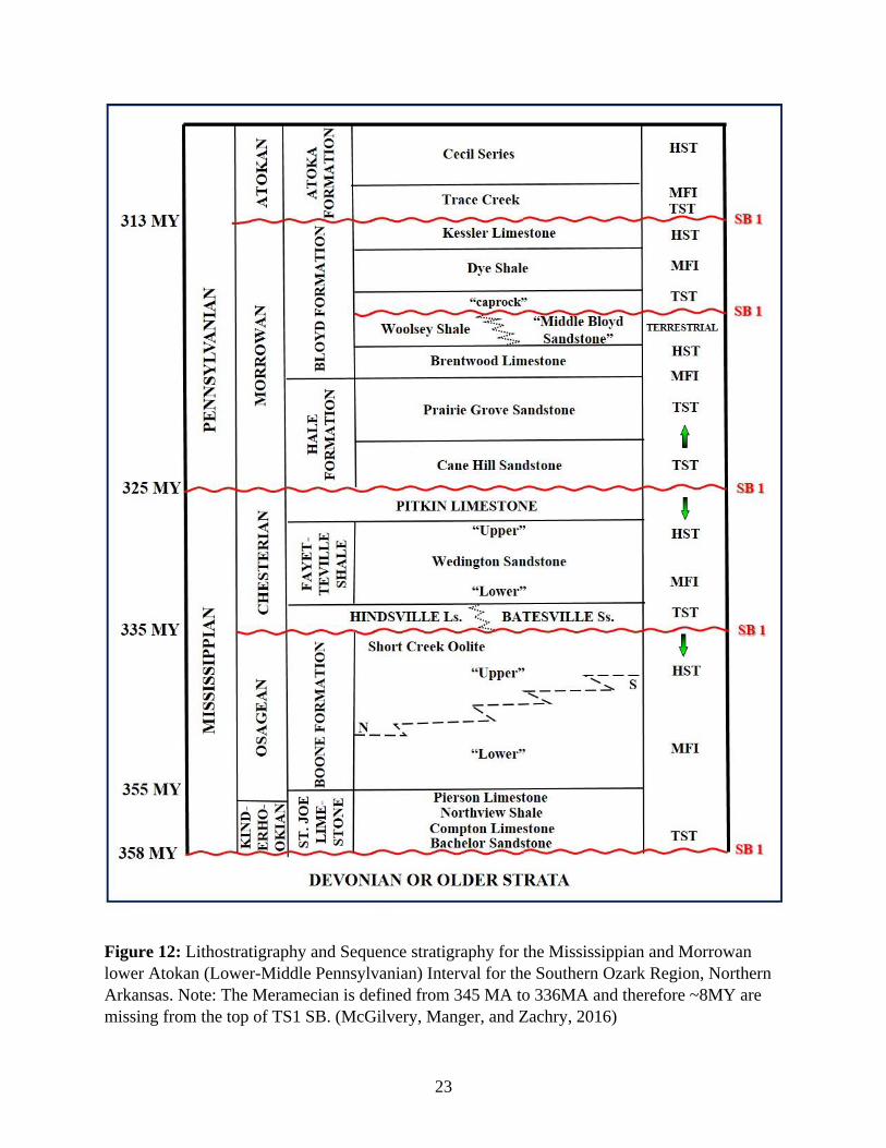
Figure 12: Lithostratigraphy and Sequence stratigraphy for the Mississippian and Morrowan
lower Atokan (Lower-Middle Pennsylvanian) Interval for the Southern Ozark Region, Northern
Arkansas. Note: The Meramecian is defined from 345 MA to 336MA and therefore ~8MY are
missing from the top of TS1 SB. (McGilvery, Manger, and Zachry, 2016)
24
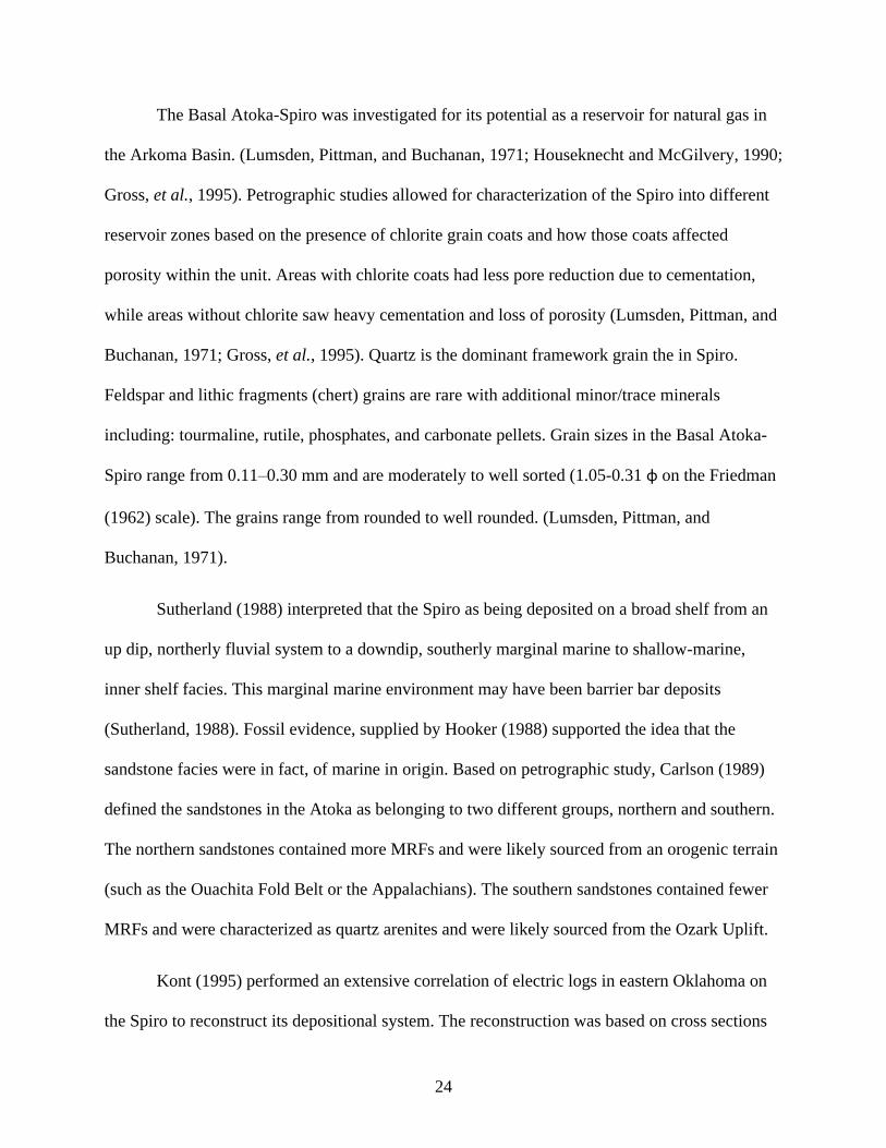
The Basal Atoka-Spiro was investigated for its potential as a reservoir for natural gas in
the Arkoma Basin. (Lumsden, Pittman, and Buchanan, 1971; Houseknecht and McGilvery, 1990;
Gross, et al., 1995). Petrographic studies allowed for characterization of the Spiro into different
reservoir zones based on the presence of chlorite grain coats and how those coats affected
porosity within the unit. Areas with chlorite coats had less pore reduction due to cementation,
while areas without chlorite saw heavy cementation and loss of porosity (Lumsden, Pittman, and
Buchanan, 1971; Gross, et al., 1995). Quartz is the dominant framework grain the in Spiro.
Feldspar and lithic fragments (chert) grains are rare with additional minor/trace minerals
including: tourmaline, rutile, phosphates, and carbonate pellets. Grain sizes in the Basal Atoka-
Spiro range from 0.11–0.30 mm and are moderately to well sorted (1.05-0.31 φ on the Friedman
(1962) scale). The grains range from rounded to well rounded. (Lumsden, Pittman, and
Buchanan, 1971).
Sutherland (1988) interpreted that the Spiro as being deposited on a broad shelf from an
up dip, northerly fluvial system to a downdip, southerly marginal marine to shallow-marine,
inner shelf facies. This marginal marine environment may have been barrier bar deposits
(Sutherland, 1988). Fossil evidence, supplied by Hooker (1988) supported the idea that the
sandstone facies were in fact, of marine in origin. Based on petrographic study, Carlson (1989)
defined the sandstones in the Atoka as belonging to two different groups, northern and southern.
The northern sandstones contained more MRFs and were likely sourced from an orogenic terrain
(such as the Ouachita Fold Belt or the Appalachians). The southern sandstones contained fewer
MRFs and were characterized as quartz arenites and were likely sourced from the Ozark Uplift.
Kont (1995) performed an extensive correlation of electric logs in eastern Oklahoma on
the Spiro to reconstruct its depositional system. The reconstruction was based on cross sections
25
and isopach maps produced from well data. That study concluded that that the Spiro was
deposited in a highly destructive, wave dominated delta system (Kont, 1995).
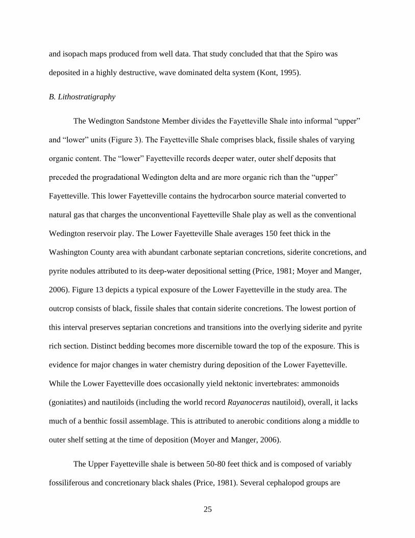
B. Lithostratigraphy
The Wedington Sandstone Member divides the Fayetteville Shale into informal “upper”
and “lower” units (Figure 3). The Fayetteville Shale comprises black, fissile shales of varying
organic content. The “lower” Fayetteville records deeper water, outer shelf deposits that
preceded the progradational Wedington delta and are more organic rich than the “upper”
Fayetteville. This lower Fayetteville contains the hydrocarbon source material converted to
natural gas that charges the unconventional Fayetteville Shale play as well as the conventional
Wedington reservoir play. The Lower Fayetteville Shale averages 150 feet thick in the
Washington County area with abundant carbonate septarian concretions, siderite concretions, and
pyrite nodules attributed to its deep-water depositional setting (Price, 1981; Moyer and Manger,
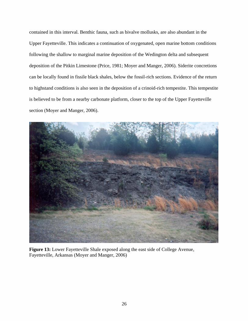
2006). Figure 13 depicts a typical exposure of the Lower Fayetteville in the study area. The
outcrop consists of black, fissile shales that contain siderite concretions. The lowest portion of
this interval preserves septarian concretions and transitions into the overlying siderite and pyrite
rich section. Distinct bedding becomes more discernible toward the top of the exposure. This is
evidence for major changes in water chemistry during deposition of the Lower Fayetteville.
While the Lower Fayetteville does occasionally yield nektonic invertebrates: ammonoids
(goniatites) and nautiloids (including the world record Rayanoceras nautiloid), overall, it lacks
much of a benthic fossil assemblage. This is attributed to anerobic conditions along a middle to
outer shelf setting at the time of deposition (Moyer and Manger, 2006).
The Upper Fayetteville shale is between 50-80 feet thick and is composed of variably
fossiliferous and concretionary black shales (Price, 1981). Several cephalopod groups are
26
contained in this interval. Benthic fauna, such as bivalve mollusks, are also abundant in the
Upper Fayetteville. This indicates a continuation of oxygenated, open marine bottom conditions
following the shallow to marginal marine deposition of the Wedington delta and subsequent
deposition of the Pitkin Limestone (Price, 1981; Moyer and Manger, 2006). Siderite concretions
can be locally found in fissile black shales, below the fossil-rich sections. Evidence of the return
to highstand conditions is also seen in the deposition of a crinoid-rich tempestite. This tempestite
is believed to be from a nearby carbonate platform, closer to the top of the Upper Fayetteville
section (Moyer and Manger, 2006).
Figure 13: Lower Fayetteville Shale exposed along the east side of College Avenue,
Fayetteville, Arkansas (Moyer and Manger, 2006)
27
The Wedington is generally described as a medium to fine grained, well sorted, quartz
arenite with minor fragments of feldspar and lithics (Price, 1981; Bello, 2017). This study
further quantifies this characterization. Interbedded, discontinuous limestones and silty shales are
also present within the Wedington interval. Planar lamination, as well as large, trough-cross
stratification and ripple marks are noted in outcrop (Price, 1981). The Wedington is also known
to yield a small amount of fossil plant material (White, 1936).
The Wedington exposures range in thickness from 2 to 108 feet thick. However, the
sandstone is usually less than 30 feet thick (Price, 1981). The Fayetteville is succeeded by
carbonate deposition of the Pitkin Limestone at the end of the Chesterian series. While there are
no formal type sections for the Fayetteville Shale or its Wedington Sandstone Member, there are
locations identified as “typical exposures” (Figure 14) (Saunders, Manger, and Gordon, 1977;
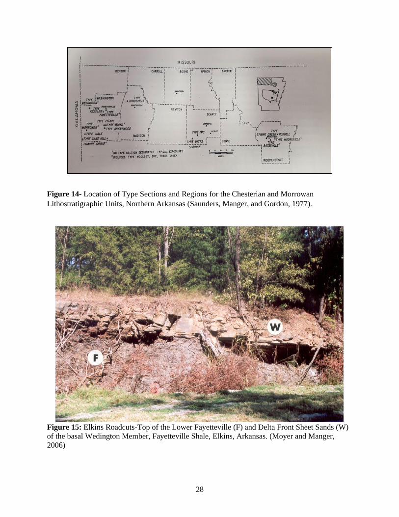
McFarland, 2004). A particularly well exposed section of the Wedington is located in north-west
Washington County, Arkansas. Figure 15 illustrates an exposure of delta front sheet sands of the
Wedington Sandstone lying in sharp contact with the lower Fayetteville. There is a noticeable
lack of transitional, mud-rich, delta platform and thin interbedded sandstones and shales typical
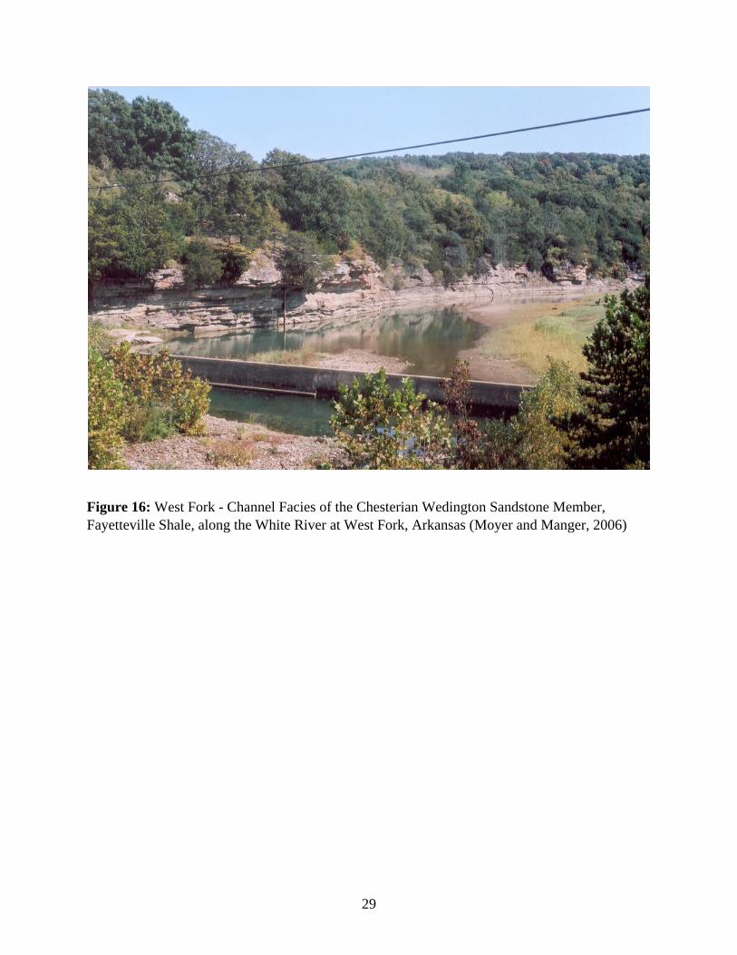
of distal delta front deposits. Figure 16 provides a more typical view of the Wedington
exhibiting an upward thickening, upward coarsening interval recording a more systematic,
progradational succession. There are a number of such sections of the Fayetteville
Shale/Wedington Sandstone in north-central Washington County.
28
Figure 14- Location of Type Sections and Regions for the Chesterian and Morrowan
Lithostratigraphic Units, Northern Arkansas (Saunders, Manger, and Gordon, 1977).
Figure 15: Elkins Roadcuts-Top of the Lower Fayetteville (F) and Delta Front Sheet Sands (W)
of the basal Wedington Member, Fayetteville Shale, Elkins, Arkansas. (Moyer and Manger,
2006)
29
Figure 16: West Fork - Channel Facies of the Chesterian Wedington Sandstone Member,
Fayetteville Shale, along the White River at West Fork, Arkansas (Moyer and Manger, 2006)
30
IV. Data
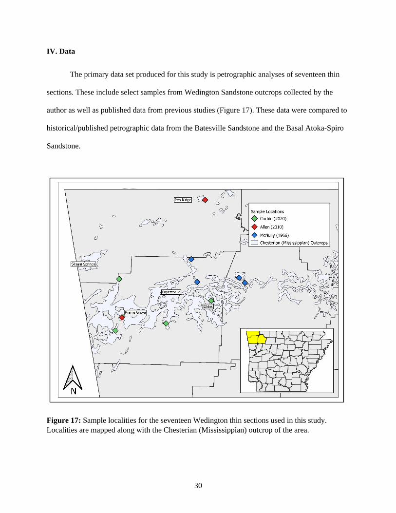
The primary data set produced for this study is petrographic analyses of seventeen thin
sections. These include select samples from Wedington Sandstone outcrops collected by the
author as well as published data from previous studies (Figure 17). These data were compared to
historical/published petrographic data from the Batesville Sandstone and the Basal Atoka-Spiro
Sandstone.
Figure 17: Sample localities for the seventeen Wedington thin sections used in this study.
Localities are mapped along with the Chesterian (Mississippian) outcrop of the area.
31
A representative number of samples of the Wedington Sandstone were collected, both in
lateral and vertical stratigraphic distribution for analysis. Eleven samples were collected from
five localities with one to three samples collected from each section depending on thickness and
access. Six thin sections from McNully (1966) and Allen (2010) were used in addition to the new
sections. Additional point count data from Allen (2010) and Cochran (1989) were used to
generate twenty-five data points for characterization of the Batesville Sandstone. These slides
were stained for feldspars. Fifty-three data points were plotted from Carlson (1989) for the
comparison with the Basal Atoka-Spiro Sandstone. Detailed point count data from this study as
well as that from published reports are included as Appendix A and B.
V. Methods
Oversized billets (2”x3”) were cut from the eleven samples, maintaining facing direction
of each billet. The samples were sent to National Petrographic Inc.
(www.nationalpetrographic.com), Houston, Texas, for thin sections. The sections were stained
for plagioclase and alkali (potassium) feldspars and impregnated with blue epoxy to highlight
pore space. National Petrographic Inc. neglected to mark the thin sections with up facing
indicators and stratigraphic “up” was lost on the slides.
Petrographic analysis of thin sections was completed using a Leica (DM 2500P)
polarizing petrographic microscope with a mechanical stage. Two hundred and fifty point total
counts were identified for each thin section. The point count stage was moved in increments of
five clicks in the x-axis (1.25 mm) and four clicks in the y-axis (1.0 mm) between rows.
Photomicrographs were taken using a Leica (DMC 5400) camera with manufacturer’s software
to digitally impose scale.
32
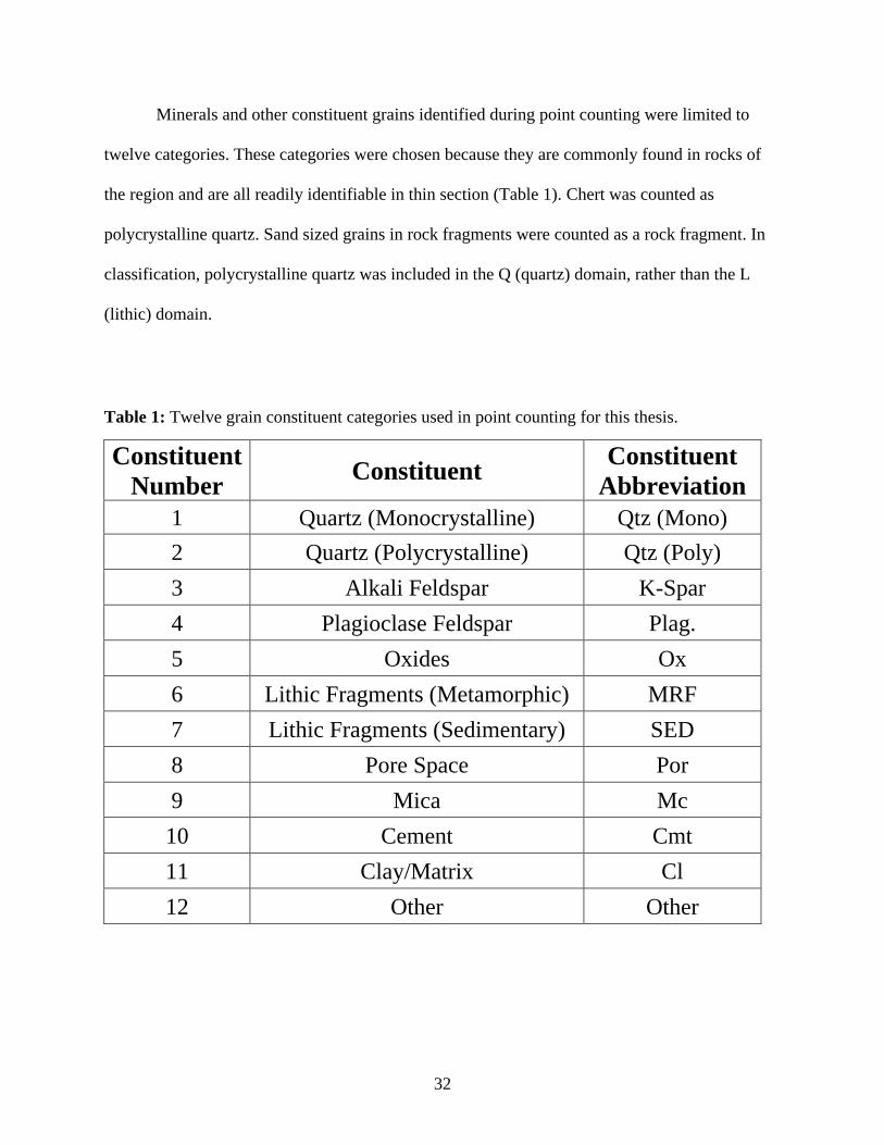
Minerals and other constituent grains identified during point counting were limited to
twelve categories. These categories were chosen because they are commonly found in rocks of
the region and are all readily identifiable in thin section (Table 1). Chert was counted as
polycrystalline quartz. Sand sized grains in rock fragments were counted as a rock fragment. In
classification, polycrystalline quartz was included in the Q (quartz) domain, rather than the L
(lithic) domain.
Table 1: Twelve grain constituent categories used in point counting for this thesis.
Constituent
Number Constituent
Constituent
Abbreviation
1 Quartz (Monocrystalline) Qtz (Mono)
2 Quartz (Polycrystalline) Qtz (Poly)
3 Alkali Feldspar K-Spar
4 Plagioclase Feldspar Plag.
5 Oxides Ox
6 Lithic Fragments (Metamorphic) MRF
7 Lithic Fragments (Sedimentary) SED
8 Pore Space Por
9 Mica Mc
10 Cement Cmt
11 Clay/Matrix Cl
12 Other Other
33
VI. Observations
A. General
The Wedington Sandstone has an aerial extent of 230.5 km2 (89 mi2). An estimated 0.079
km3 of sediment is held within the Wedington Delta complex based on the isopach map
produced by Winkelmann (2007). This observation compares in size to the present-day Trinity
River delta that extends into the Trinity Bay portion of Galveston Bay, with an aerial extent of
~259 km2 (100 mi2). The Trinity River drains an area around 15,800 km2 (Badalini, et al., 2000).
This suggests a comparable drainage area and could have fed the Wedington delta, producing a
depositional body of similar length.
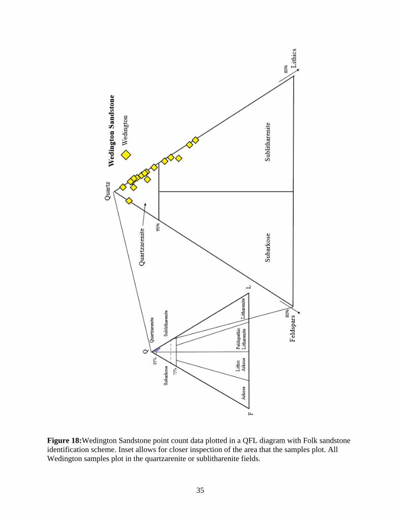
Framework grain percentages for each sample are presented in Table 2. Of the seventeen
samples that were point counted for this thesis, twelve plot as quartzarenites and 5 plot as
sublitharenites based on the Folk (1974)sandstone classification scheme (Figure 18). The
Wedington samples range in grain size from very fine to coarse grained. Samples from the East
Elkins locality are finer grained than those from other localities in the study (Figure 19). Samples
from the Prairie Grove-West and Lake Wedington localities were coarser grained than other
localities. There was no trend in framework grain variation, when comparing the samples by
locality or stratigraphic position.
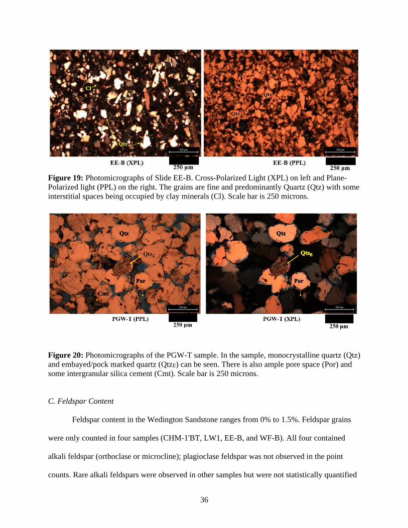
B. Quartz Content
Wedington samples were predominantly comprised of grains of quartz which ranged
from 90.5% to 99.2% in abundance. All samples were overwhelmingly composed of
monocrystalline quartz grains with small percentages of clay/matrix, pore space, and oxide point
counts. Some quartz grains showed significant cracking. Samples also contained minor
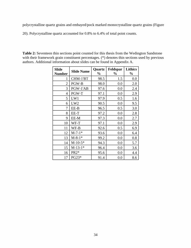
34
polycrystalline quartz grains and embayed/pock marked monocrystalline quartz grains (Figure
20). Polycrystalline quartz accounted for 0.8% to 6.4% of total point counts.
Table 2: Seventeen thin sections point counted for this thesis from the Wedington Sandstone
with their framework grain constituent percentages. (*) denotes thin sections used by previous
authors. Additional information about slides can be found in Appendix A.
Slide
Number Slide Name
Quartz
%
Feldspar
%
Lithics
%
1 CHM-1'BT 98.5 1.5 0.0
2 PGW-B 98.0 0.0 2.0
3 PGW-1'AB 97.6 0.0 2.4
4 PGW-T 97.1 0.0 2.9
5 LW1 97.9 0.5 1.6
6 LW2 90.5 0.0 9.5
7 EE-B 96.5 0.5 3.0
8 EE-T 97.2 0.0 2.8
9 EE-M 97.3 0.0 2.7
10 WF-T 97.1 0.0 2.9
11 WF-B 92.6 0.5 6.9
12 M-7-1* 93.6 0.0 6.4
13 M-8-1* 99.2 0.0 0.8
14 M-10-5* 94.3 0.0 5.7
15 M-13-1* 96.4 0.0 3.6
16 PR2* 95.6 0.0 4.4
17 PG23* 91.4 0.0 8.6
35
Figure 18:Wedington Sandstone point count data plotted in a QFL diagram with Folk sandstone
identification scheme. Inset allows for closer inspection of the area that the samples plot. All
Wedington samples plot in the quartzarenite or sublitharenite fields.
36
Figure 19: Photomicrographs of Slide EE-B. Cross-Polarized Light (XPL) on left and Plane-
Polarized light (PPL) on the right. The grains are fine and predominantly Quartz (Qtz) with some
interstitial spaces being occupied by clay minerals (Cl). Scale bar is 250 microns.
Figure 20: Photomicrographs of the PGW-T sample. In the sample, monocrystalline quartz (Qtz)
and embayed/pock marked quartz (QtzE) can be seen. There is also ample pore space (Por) and
some intergranular silica cement (Cmt). Scale bar is 250 microns.
C. Feldspar Content
Feldspar content in the Wedington Sandstone ranges from 0% to 1.5%. Feldspar grains
were only counted in four samples (CHM-1'BT, LW1, EE-B, and WF-B). All four contained
alkali feldspar (orthoclase or microcline); plagioclase feldspar was not observed in the point
counts. Rare alkali feldspars were observed in other samples but were not statistically quantified
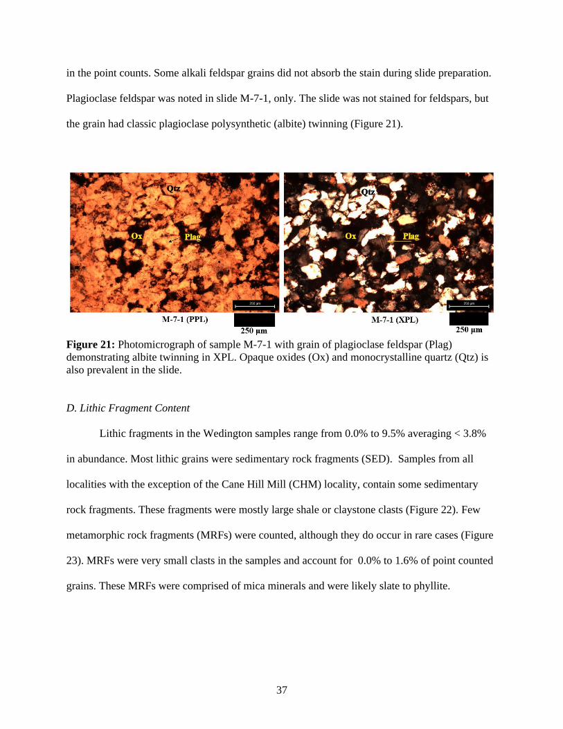
37
in the point counts. Some alkali feldspar grains did not absorb the stain during slide preparation.
Plagioclase feldspar was noted in slide M-7-1, only. The slide was not stained for feldspars, but
the grain had classic plagioclase polysynthetic (albite) twinning (Figure 21).
Figure 21: Photomicrograph of sample M-7-1 with grain of plagioclase feldspar (Plag)
demonstrating albite twinning in XPL. Opaque oxides (Ox) and monocrystalline quartz (Qtz) is
also prevalent in the slide.
D. Lithic Fragment Content
Lithic fragments in the Wedington samples range from 0.0% to 9.5% averaging < 3.8%
in abundance. Most lithic grains were sedimentary rock fragments (SED). Samples from all
localities with the exception of the Cane Hill Mill (CHM) locality, contain some sedimentary
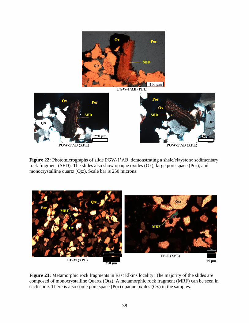
rock fragments. These fragments were mostly large shale or claystone clasts (Figure 22). Few
metamorphic rock fragments (MRFs) were counted, although they do occur in rare cases (Figure
23). MRFs were very small clasts in the samples and account for 0.0% to 1.6% of point counted
grains. These MRFs were comprised of mica minerals and were likely slate to phyllite.
38
Figure 22: Photomicrographs of slide PGW-1’AB, demonstrating a shale/claystone sedimentary
rock fragment (SED). The slides also show opaque oxides (Ox), large pore space (Por), and
monocrystalline quartz (Qtz). Scale bar is 250 microns.
Figure 23: Metamorphic rock fragments in East Elkins locality. The majority of the slides are
composed of monocrystalline Quartz (Qtz). A metamorphic rock fragment (MRF) can be seen in
each slide. There is also some pore space (Por) opaque oxides (Ox) in the samples.
39
E. Other Framework Grains, Sorting, and Porosity
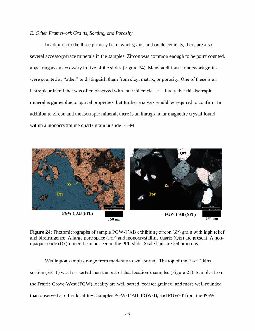
In addition to the three primary framework grains and oxide cements, there are also
several accessory/trace minerals in the samples. Zircon was common enough to be point counted,
appearing as an accessory in five of the slides (Figure 24). Many additional framework grains
were counted as “other” to distinguish them from clay, matrix, or porosity. One of these is an
isotropic mineral that was often observed with internal cracks. It is likely that this isotropic
mineral is garnet due to optical properties, but further analysis would be required to confirm. In
addition to zircon and the isotropic mineral, there is an intragranular magnetite crystal found
within a monocrystalline quartz grain in slide EE-M.
Figure 24: Photomicrographs of sample PGW-1’AB exhibiting zircon (Zr) grain with high relief
and birefringence. A large pore space (Por) and monocrystalline quartz (Qtz) are present. A non-
opaque oxide (Ox) mineral can be seen in the PPL slide. Scale bars are 250 microns.
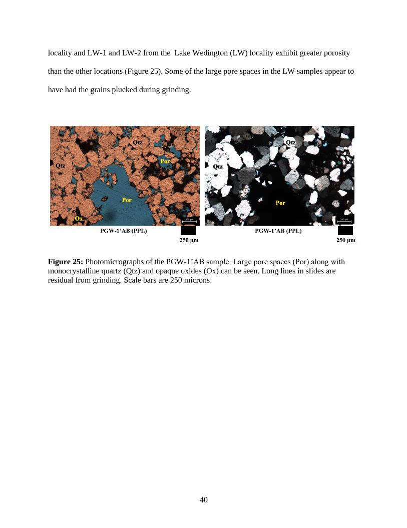
Wedington samples range from moderate to well sorted. The top of the East Elkins
section (EE-T) was less sorted than the rest of that location’s samples (Figure 21). Samples from
the Prairie Grove-West (PGW) locality are well sorted, coarser grained, and more well-rounded
than observed at other localities. Samples PGW-1’AB, PGW-B, and PGW-T from the PGW
40
locality and LW-1 and LW-2 from the Lake Wedington (LW) locality exhibit greater porosity
than the other locations (Figure 25). Some of the large pore spaces in the LW samples appear to
have had the grains plucked during grinding.
Figure 25: Photomicrographs of the PGW-1’AB sample. Large pore spaces (Por) along with
monocrystalline quartz (Qtz) and opaque oxides (Ox) can be seen. Long lines in slides are
residual from grinding. Scale bars are 250 microns.
41
F. Batesville Sandstone
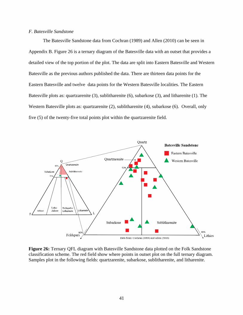
The Batesville Sandstone data from Cochran (1989) and Allen (2010) can be seen in
Appendix B. Figure 26 is a ternary diagram of the Batesville data with an outset that provides a
detailed view of the top portion of the plot. The data are split into Eastern Batesville and Western
Batesville as the previous authors published the data. There are thirteen data points for the
Eastern Batesville and twelve data points for the Western Batesville localities. The Eastern
Batesville plots as: quartzarenite (3), sublitharenite (6), subarkose (3), and litharenite (1). The
Western Batesville plots as: quartzarenite (2), sublitharenite (4), subarkose (6). Overall, only
five (5) of the twenty-five total points plot within the quartzarenite field.
Figure 26: Ternary QFL diagram with Batesville Sandstone data plotted on the Folk Sandstone
classification scheme. The red field show where points in outset plot on the full ternary diagram.
Samples plot in the following fields: quartzarenite, subarkose, sublitharenite, and litharenite.
42
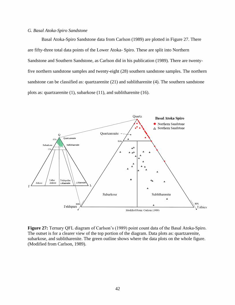
G. Basal Atoka-Spiro Sandstone
Basal Atoka-Spiro Sandstone data from Carlson (1989) are plotted in Figure 27. There
are fifty-three total data points of the Lower Atoka- Spiro. These are split into Northern
Sandstone and Southern Sandstone, as Carlson did in his publication (1989). There are twenty-
five northern sandstone samples and twenty-eight (28) southern sandstone samples. The northern
sandstone can be classified as: quartzarenite (21) and sublitharenite (4). The southern sandstone
plots as: quartzarenite (1), subarkose (11), and sublitharenite (16).
Figure 27: Ternary QFL diagram of Carlson’s (1989) point count data of the Basal Atoka-Spiro.
The outset is for a clearer view of the top portion of the diagram. Data plots as: quartzarenite,
subarkose, and sublitharenite. The green outline shows where the data plots on the whole figure.
(Modified from Carlson, 1989).
43
VII. Interpretations
The Wedington Sandstone is limited in its range of framework grain composition, being
classified mainly as a quartzarenite dominantly composed of monocrystalline quartz. The
scarcity of metamorphic rock fragments (MRFs) and feldspars detracts from the hypothesis that
Wedington sediment was derived from the same orogenic sediment source and dispersal system
as the Batesville Sandstone. The similarity in composition between the northern Basal Atoka-
Spiro Sandstone and the Wedington Sandstone does suggest a common sediment source terrain.
Price (1981) suggested that the Wedington was supplied and constructed from the northwest to
southeast. Houseknecht and McGilvery (1990) showed the same vector as a best explanation for
the sediment dispersal of the Spiro Sandstone (Figure 28). The comparison between these two
studies (Price, 1981; Houseknecht and McGilvery, 1990), and the data collected for this thesis
suggests that the Wedington Sandstone was a part of a depositional system, supplied from the
north-northeast. This vector is in contrast to the north to south, or northeast to southwest,
sediment dispersal vector for the underlying Batesville, and that which dominated the later
depositional history of the Northern Arkansas Structural Platform and the subsequent Arkoma
Foreland Basin. Given the relatively small areal extent, thickness, and gross sediment volume;
deposition of the Wedington delta did not require a major regional uplift and extended sediment
delivery system such as the cratonic interior, to provide the appropriate sediment volume.
Instead, a “local” uplift, such as the Nemaha Ridge, could have been the source terrain discussed
in more detail later in this section. The “local source” as opposed to a regional cratonic source is
suggested by the composition, modest size, and presumably short delivery system for the
Wedington.
44
Much of the Wedington is cemented by either silica or iron oxide, with minor amounts of
clay matrix in some samples. Corroded grain boundaries on many quartz grains suggest that
there was once some early carbonate (likely calcite) cementation in the Wedington that was later
dissolved during its paragenetic evolution. This scenario was documented in the evolution of
porosity within the Spiro Sandstone (Houseknecht and McGilvery, 1990). The dissolution of
carbonate could have been penecontemporaneous to the migration of hydrocarbons into the
Wedington from the lower Fayetteville source rock.
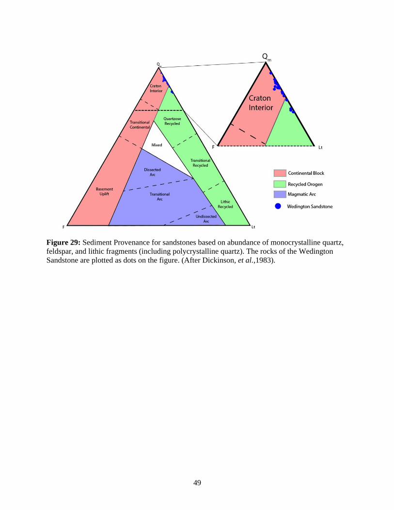
The point count data from this study is compared to the sandstone provenance diagram
from Dickinson, et al. (1983) to obtain a general provenance setting for the sediment that makes
up the Wedington Sandstone (Figure 29). The framework grain composition of the Wedington
was likely sourced from either the craton interior or quartzose recycled orogen. The majority of
Wedington samples fall into the Craton Interior (Continental Block) field on the diagram. The
classification scheme shown in Figure 29 includes polycrystalline quartz as a lithic fragment (Lt)
rather than in the quartz category that only includes monocrystalline quartz in the Qm category.
The scarcity in abundance of MRFs and feldspars, and lack of volcanic fragments, can be
attributed to a reworked, recycled origin of the Wedington sediment.
There are numerous zircons in the Wedington Sandstone, observed in point counts and in
detrital zircon analysis. While zircon chronology data points to multiple provinces including the
Yavapai-Mazatzal and Grenville terrains. Zircons from the Appalachian terrain could have been
deposited in another sandstone unit and then recycled into the Wedington delta complex (Xie,
Cains, and Manger, 2016). Sediment from different provinces may vary both spatially and
temporally in the Wedington Sandstone (Xie, Cains, and Manger, 2016). Cains (2013)
demonstrated with detrital zircon chronology that the Wedington Sandstone contained sediment
45
from multiple cratonic sediment provinces, including the Appalachian Mountains and the
Nemaha Ridge. Cains (2013) also suggested that the St. Peter Sandstone (Middle Ordovician) as
a possible source for recycled quartz grains. However, the exposed extent of the St. Peter is
likely too small to provide the required sediment for this hypothesis.
Sediment supply for the Wedington Sandstone may have included contributions from as
many as four possible locations:
• The Nemaha Ridge of Oklahoma and Kansas
• Unknown recycled sandstone unit to the Northwest; possibly near the Nemaha Ridge
• The Canadian Shield by way of the Illinois Basin
• The Appalachian Mountains by way of the Illinois Basin
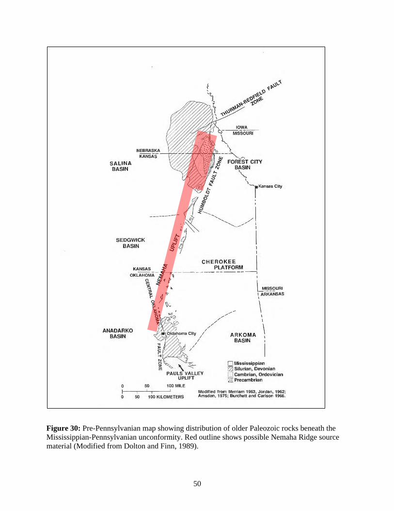
The Nemaha Ridge is the closest northwestern terrain that could have supplied sediment
for the construction of the Wedington delta. The Nemaha exposed granitic Precambrian
basement materials as part of an uplift event in the central Midcontinent that has an aerial extent
(today) of over seven hundred (700) square miles (Abanumay, 2018). This ridge was exposed
prior to the Mississippian, at a time similar to the northern Appalachian orogeny. The Nemaha
Ridge would have been of sufficient size to supply the Wedington sediment as well as the
younger Basal Atoka-Spiro Sandstone. The proximal location of the Nemaha Ridge (Figure 30)
relative to the northern Appalachians does not require a lengthy or complex sediment delivery
system. The Forest City Basin, between the Nemaha Ridge and the Wedington, could have posed
a barrier to sediment being transported to the study area. However, there are no Chesterian aged
rocks documented in the Forest City Basin (Cains, 2013). Consequently, sediment could have
easily bypassed the basin at that time. It is also a possibility that sands deposited in the Forest
46
City Basin prior to the Chesterian were being eroded and transported to the Wedington area as
recycled sediments. This suggests the possibility of the Nemaha Ridge area providing the
sediment for the Wedington Sandstone and supports two of the possible source terrain
suggestions listed above.
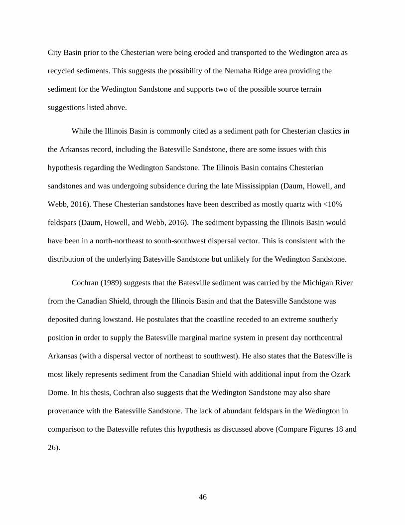
While the Illinois Basin is commonly cited as a sediment path for Chesterian clastics in
the Arkansas record, including the Batesville Sandstone, there are some issues with this
hypothesis regarding the Wedington Sandstone. The Illinois Basin contains Chesterian
sandstones and was undergoing subsidence during the late Mississippian (Daum, Howell, and
Webb, 2016). These Chesterian sandstones have been described as mostly quartz with <10%
feldspars (Daum, Howell, and Webb, 2016). The sediment bypassing the Illinois Basin would
have been in a north-northeast to south-southwest dispersal vector. This is consistent with the
distribution of the underlying Batesville Sandstone but unlikely for the Wedington Sandstone.
Cochran (1989) suggests that the Batesville sediment was carried by the Michigan River
from the Canadian Shield, through the Illinois Basin and that the Batesville Sandstone was
deposited during lowstand. He postulates that the coastline receded to an extreme southerly
position in order to supply the Batesville marginal marine system in present day northcentral
Arkansas (with a dispersal vector of northeast to southwest). He also states that the Batesville is
most likely represents sediment from the Canadian Shield with additional input from the Ozark
Dome. In his thesis, Cochran also suggests that the Wedington Sandstone may also share
provenance with the Batesville Sandstone. The lack of abundant feldspars in the Wedington in
comparison to the Batesville refutes this hypothesis as discussed above (Compare Figures 18 and
26).
47
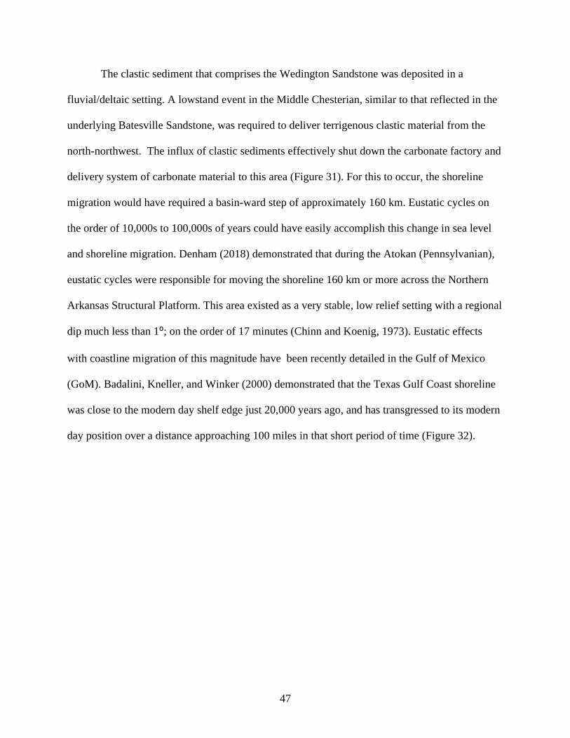
The clastic sediment that comprises the Wedington Sandstone was deposited in a
fluvial/deltaic setting. A lowstand event in the Middle Chesterian, similar to that reflected in the
underlying Batesville Sandstone, was required to deliver terrigenous clastic material from the
north-northwest. The influx of clastic sediments effectively shut down the carbonate factory and
delivery system of carbonate material to this area (Figure 31). For this to occur, the shoreline
migration would have required a basin-ward step of approximately 160 km. Eustatic cycles on
the order of 10,000s to 100,000s of years could have easily accomplish this change in sea level
and shoreline migration. Denham (2018) demonstrated that during the Atokan (Pennsylvanian),
eustatic cycles were responsible for moving the shoreline 160 km or more across the Northern
Arkansas Structural Platform. This area existed as a very stable, low relief setting with a regional
dip much less than 1⁰; on the order of 17 minutes (Chinn and Koenig, 1973). Eustatic effects
with coastline migration of this magnitude have been recently detailed in the Gulf of Mexico
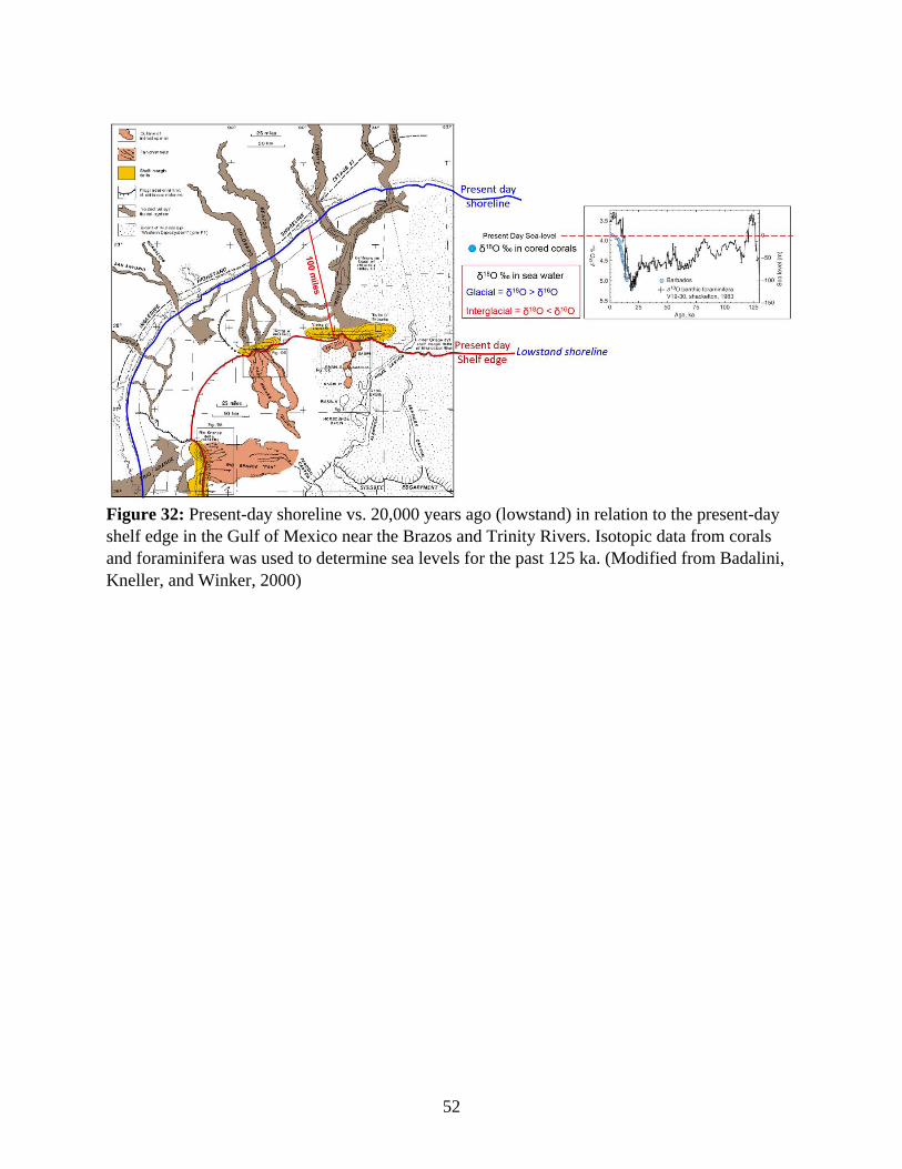
(GoM). Badalini, Kneller, and Winker (2000) demonstrated that the Texas Gulf Coast shoreline
was close to the modern day shelf edge just 20,000 years ago, and has transgressed to its modern
day position over a distance approaching 100 miles in that short period of time (Figure 32).

48
Figure 28: Depositional reconstruction of the Basal Atoka-Spiro, demonstrating a northwest to
southeast sediment dispersal vector based on channel facies and porosity trends. (McGilvery,
2020, pers. com.).
49
Figure 29: Sediment Provenance for sandstones based on abundance of monocrystalline quartz,
feldspar, and lithic fragments (including polycrystalline quartz). The rocks of the Wedington
Sandstone are plotted as dots on the figure. (After Dickinson, et al.,1983).
50
Figure 30: Pre-Pennsylvanian map showing distribution of older Paleozoic rocks beneath the
Mississippian-Pennsylvanian unconformity. Red outline shows possible Nemaha Ridge source
material (Modified from Dolton and Finn, 1989).

51
Figure 31: Paleogeographic reconstruction of the Middle Chesterian (Mississippian). Figure
shows possible sediment dispersal vector and source location for the sediment in the Wedington
Sandstone.
52
Figure 32: Present-day shoreline vs. 20,000 years ago (lowstand) in relation to the present-day
shelf edge in the Gulf of Mexico near the Brazos and Trinity Rivers. Isotopic data from corals
and foraminifera was used to determine sea levels for the past 125 ka. (Modified from Badalini,
Kneller, and Winker, 2000)
53
VIII. Conclusions
1. Based on framework grain composition, the Wedington Sandstone and the Basal Atoka,
Spiro Sandstone share a common sediment source. A cratonic to recycled orogenic
provenance are most likely.
2. The Basal Atoka-Spiro and the Wedington Sandstone have similar northwest to southeast
sediment dispersal vectors, likely derived from the area of the Nemaha Ridge.
3. The Wedington Sandstone and the Batesville Sandstone do not share a source locality or
sediment dispersal vector. The Batesville composition and distribution are consistent with
a northeast to southwest dispersal system focused through or around the Illinois Basin.
4. The sediment source for the Wedington is not likely to be a single source provenance, but
a combination of sediments from multiple terrains, based on inclusion of MRFs and
zircon data from Xie, Cains, and Manger (2016).
54
IX. Future Work
There are a number of possible avenues for additional study of the Wedington Sandstone.
The suggested studies would lead to a better understanding of the Wedington Sandstone and its
place in the Mississippian, as well as a better understanding of sediment dynamics of the
Carboniferous in the southern United States. Below is a partial list of recommended studies.
• Mapping of porosity trends within the Wedington Sandstone would help to
contextualize depositional elements in the unit such as internal channel systems. A
study of this type would aid in producing similar maps to those in Figure 28 for the
Wedington. Advanced depositional dynamics would also help to aid study in
comparisons between Carboniferous and modern delta systems.
• Additional high-resolution detrital zircon chronology expanding on the work of Cains
(2013) and Xie, Cains, and Manger (2016) would aid in giving a context to sediment
provenance in the Wedington Sandstone. High resolution sampling of selected
outcrops would help to explain sediment source dynamics in the Wedington delta at
different times during its construction. This study may allow for higher refinement
between spatial and temporal changes in the Wedington Sandstone.
• A magnetic susceptibility study for high resolution correlation. Magnetic
susceptibility is a recent tool for high resolution correlation between the subsurface
(cores) and surface (outcrops). The addition of this type of data could lead to
correlations between the Wedington Sandstone and portions of the Fayetteville Shale
that do not contain any evidence of Wedington deposition. This study could help to
constrain the maximum size of the delta at maximum flooding. This work could also
55
potentially be used to correlate the Wedington to Chesterian sandstones in other
basins (i.e. the Illinois Basin).
• A heavy mineral analysis was originally planned as part of this thesis. Due to
constraints added by the COVID-19 global pandemic, the work was not completed.
These data were going to be used as a potential proxy for similarity or difference in
sediment source for different lobes of the Wedington delta complex.
56
References
Abanumay, F., 2018, Exploring the Relationship between the Nemaha Uplift and the Mid-
Continent Rift using 3D Mapping Visual Analysis [Master of Science]: Ft. Hays State
University.
Adams, G.I., Purdue, A.H., and Burchard, E.F., 1904, Zinc and Lead Deposits of Northern
Arkansas: United States Geological Survey Professional Paper 24.
Allen, D.E., 2010, A comparative petrographic study of three upper Mississippian (Chesterian)
sandstones in Northern Arkansas [Master of Science]: University of Arkansas.
Badalini, G., Kneller, B., and Winker, C.D., 2000, Architecture and processes in the late
Pleistocene Brazos-Trinity turbidite system, Gulf of Mexico continental slope, in Deep-
Water Reservoirs of the World, SEPM- Gulf Coast Section, p. 16–34.
Bello, E.C., 2017, Paleozoic Sandstones in the Tri-State Region, Southern Ozarks: Tectono-
Stratigraphic Sequence Development and Compositional Evolution, the Source and
Delivery Conundrum, and the Regional Tectonic History [Doctoral Dissertation]:
University of Arkansas.
Blythe, J.G., 1959, Atoka Formation on the North Side of the McAlester Basin: Oklahoma
Geological Survey Circular 47.
Cains, W., 2013, Sedimentary provenance of the Wedington Member, Fayetteville Shale, from
age relations of detrital zircons [Master of Science]: University of Arkansas.
Carlson, M.C., 1989, A Petrologic Analysis of Surface and Subsurface Atoka Formation (Lower
Pennsylvanian) Sandstone, Western Margin of the Arkoma Basin, Oklahoma: The Shale
Shaker Digest XII, v. 36–39, p. 256–272.
Chinn, A.A., and Konig, R.H., 1973, Stress Inferred from Calcite Twin Lamellae in Relation to
Regional Structure of Northwestern Arkansas: Geological Society of America Bulletin, v.
84, p. 3731–3736.
Cochran, T.L., 1989, Petrology of the Batesville Sandstone (Mississippian), Northern Arkansas
[Master of Science]: University of Arkansas.
Daum, J.M., 2016, Petrography of the Chesterian (Upper Mississippian) Cypress Sandstone in
the Illinois Basin:
Denham, W.S., 2018, Subsurface Stratigraphic Interpretation of the Lower Atoka Formation,
Northern Arkoma Basin, Arkansas [Master of Science]: University of Arkansas.
Dickinson, W.R., Beard, L.S., Brakenridge, G.R., Erjavec, J.L., Fergusun, R.C., Inman, K.F.,
Knepp, R.A., Lindburg, F.A., and Ryberg, P.T., 1983, Provenance of North American
Phanerozoic sandstones in relation to tectonic setting: Geological Society of America
Bulletin, v. 94, p. 222–235.
57
Dolton, G.L., and Finn, T.M., 1989, Petroleum Geology of the Nemaha Uplift, Central Mid-
Continent: United States Geological Survey Open File Report 88-450D.
Folk, R.L., 1974, Petrography of Sedimentary Rocks: Austin, Texas, Hemphill Publishing
Company.
Friedman, G.M., 1962, On sorting, sorting coefficients, and the lognormality of the grain-size
distribution of sandstones: The Journal of Geology, v. 70, p. 737–753.
Garner, H.F., 1967, Morefield-Batesville Stratigraphy and Sedimentation in Arkansas:
Geological Society of America Bulletin, v. 79, p. 1233–1246.
Grayson, R.C., 1980, The Stratigraphy of the Wapanucka Formation (Lower Pennsylvanian)
Along the Frontal Margin of the Ouachita Mountains, Oklahoma [Doctoral Dissertation]:
University of Oklahoma.
Gross, J.S., Thompson, S.A., Claxton, B.L., and Carr, M.B., 1995, Reservoir Distribution and
Exploration Potential of the Spiro Sandstone in the Choctaw Trend, Arkoma Basin,
Oklahoma and Arkansas: American Association of Petroleum Geologists Bulletin, v. 79,
p. 19–085.
Handford, C.R., and Manger, W.L., 1993, Sequence Stratigraphy of a Mississippian Carbonate
Ramp, Northern Arkansas and Southwestern Missouri, in New Orleans Geological
Society Guidebook, New Orleans Geological Society.
Hooker, E.O., 1988, The Distribution and Despositional Environment of the Spiro Sandstone,
Arkoma Basin, Haskell, Latimer, and Pittsburg Counties, Oklahoma [Master of Science]:
Oklahoma State University.
Houseknecht, D.W., 1986, Evolution from Passive Margin to Foreland Basin: The Atoka
Formation of the Arkoma Basin, South-Central U.S.A, in Special Publications 8,
International Association of Sedimentologists, p. 327–345.
Houseknecht, D.W., and Kacena, J.A., 1983, Tectonic and sedimentary evolution of the Arkoma
Basin, in Tectonic-sedimentary evolution of the Arkoma Basin and guidebook to deltaic
facies, Hartshorne Sandstone, SEPM- Midcontinent Section, v. 1, p. 3–33.
Houseknecht, D.W., and McGilvery, T.A., 1990, Red Oak Field, in Beaumont, E.A. and Foster,
N.H. eds., Structural Traps II-Traps associated with tectonic faulting, American
Association of Petroleum Geologists, Treatises of Petroleum Geology, Atlas of Oil and
Gas Fields, p. 201–225.
J.C. Branner, 1891, The Geology of Washington County, in Arkansas Geological Survey Annual
Report.
Kont, M., 1995, Distribution and Depositional System of Spiro Sandstone in Arkoma Basin of
Eastern Oklahoma: (LeFlore, Sequoyah, Latimer, Haskel, Muskogee) [Master of
Science]: Oklahoma State University.
58
Lumsden, D.N., Pittman, E.D., and Buchanan, R.S., 1971, Sedimentation and Petrology of Spiro
and Foster Sands (Pennsylvanian), McAlester Basin, Oklahoma: American Association
of Petroleum Geologists Bulletin, v. 55, p. 254–266.
Maravich, M.D., 1955, Developments in Oklahoma in 1954: Bulletin of the American
Association of Petroleum Geologists, v. 39, p. 891–902.
McFarland, J.D., 2004, Information Circular 36: Stratigraphic Summary of Arkansas:Arkansas
Geological Survey, Little Rock, Arkansas.
McGilvery, T.A., 2020, Personal Communication:
McGilvery, T.A., Manger, W.L., and Zachry, D.L., 2016, Summary and Guidebook to the
Depositional and Tectonic History of the Carboniferous Succession Northwest Arkansas,
in Fayetteville, Arkansas.
McNully, C.V., 1966, Grain Size Studies of the Wedington Sandstone of the Fayetteville
Formation [Master of Science]: University of Arkansas.
Moore, C.A., 1947, The Morrow series of Northeastern Oklahoma: Oklahoma Geological Survey
Bulletin, v. 66, p. 1–51.
Moyer, C., and Manger, W.L., 2006, Fayetteville Shale (Upper Mississippian-Chesterian) and
adjacent formations, Northern Arkansas: Desoto and Southwestern Energy.
Ogren, D.E., 1961, Stratigraphy of the upper Mississippian rocks of northern Arkansas [Doctoral
Dissertation]: Northwestern University.
Ogren, D.E., 1968, Stratigraphy of Upper Mississippian Rocks of Northern Arkansas: American
Association of Petroleum Geologists Bulletin, v. 52, p. 282–294.
Owen, D.D., 1858, Report of Geological Reconnaissance of the Northern Counties of Arkansas:
Geological Reconnaissance 1987.
Price, C.R., 1981, Transportational and depositional history of the Wedington Sandstone
(Mississippian), Northwest Arkansas [Master of Science]: University of Arkansas.
Saunders, W.B., Manger, W.L., and Gordon, M., 1977, Upper Mississippian and Lower and
Middle Pennsylvanian ammonoid biostratigraphy of northern Arkansas, in Sutherland,
P.K. and Manger, W.L. eds., Upper Chesterian-Morrowan Stratigraphy and the
Mississippian Pennsylvanian Boundary in Northeastern Oklahoma and Northwestern
Arkansas, Oklahoma City, Oklahoma, Oklahoma Geological Survey, Guidebook 18.
Simonds, F.W., 1891, The Geology of Washington County: Arkansas Geological Survey Annual
Report 1888.
59
Sutherland, P.K., 1988, Late Mississippian and Pennsylvanian depositional history in the
Arkoma Basin Area, Oklahoma and Arkansas: Geological Society of America Bulletin, v.
100, p. 1787–1802.
White, D., 1936, Fossil flora of the Wedington Sandstone Member of the Fayetteville Shale:
United States Geological Survey Professional Paper 186-B.
Wilson, C.W., 1935, Age and Correlation of Pennsylvanian Surface Formations, and of Oil and
Gas: American Association of Petroleum Geologists Bulletin, v. 19, p. 508.
Winkelmann, W., 2007, Wedington Isopachous Map: Unpublished- Southwestern Energy.
Xie, X., Cains, W., and Manger, W.L., 2016, U-Pb detrital zircon evidence of transcontinental
sediment dispersal: provenance of Late Mississippian Wedington Sandstone member,
NW Arkansas: International Geology Review, v. 58, p. 1951–1966,
doi:10.1080/00206814.216.1193775.

60
Appendices
Appendix A:Thin Section Point Count Data for this Study

61
Slide Name: CHM-1'BT
Location: Cane Hill Mill Latitude: 35.8984
Outcrop Position: 1 foot below top Longitude: -94.4021
Item Points Percentage
Number Name Folk Classification
1 Qtz (Mono) 187 74.80% Quartzarenite
2 Qtz (Poly) 14 5.60%
3 K-Spar 3 1.20% Framework Grains
4 Plag. 0 0.00% Quartz 98.53
5 Oxides 14 5.60% Feldspar 1.47
6 Lithics (MRFs) 0 0.00% Lithics 0
7 Lithics (Sed) 0 0.00%
8 Pore 25 10.00%
9 Mica 0 0.00%
10 Cement 0 0.00%
11 Clay/Matrix 7 2.80%
12 Other 0 0.00%
Total 250 100.00%
Comments: Coarse grained. Grains are much more angular than in other slides. Some
of the larger pore spaces appear to be “plucked” grains from slide.
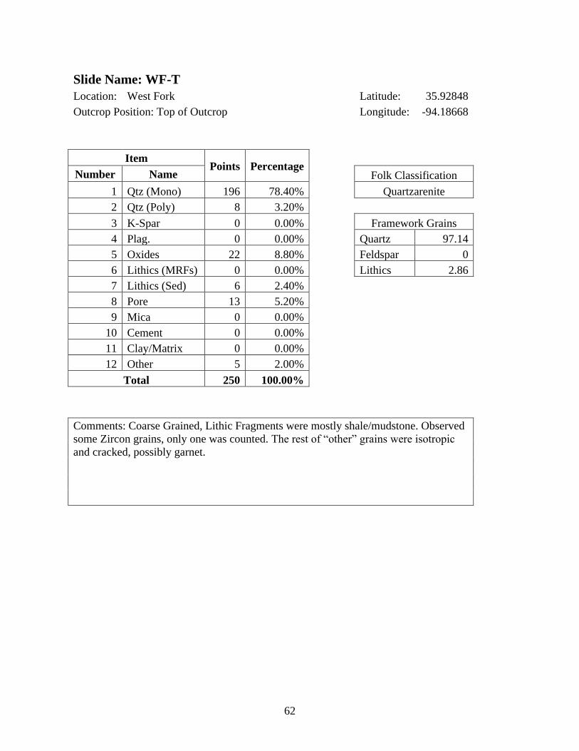
62
Slide Name: WF-T
Location: West Fork Latitude: 35.92848
Outcrop Position: Top of Outcrop Longitude: -94.18668
Item Points Percentage
Number Name Folk Classification
1 Qtz (Mono) 196 78.40% Quartzarenite
2 Qtz (Poly) 8 3.20%
3 K-Spar 0 0.00% Framework Grains
4 Plag. 0 0.00% Quartz 97.14
5 Oxides 22 8.80% Feldspar 0
6 Lithics (MRFs) 0 0.00% Lithics 2.86
7 Lithics (Sed) 6 2.40%
8 Pore 13 5.20%
9 Mica 0 0.00%
10 Cement 0 0.00%
11 Clay/Matrix 0 0.00%
12 Other 5 2.00%
Total 250 100.00%
Comments: Coarse Grained, Lithic Fragments were mostly shale/mudstone. Observed
some Zircon grains, only one was counted. The rest of “other” grains were isotropic
and cracked, possibly garnet.
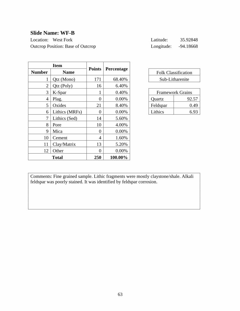
63
Slide Name: WF-B
Location: West Fork Latitude: 35.92848
Outcrop Position: Base of Outcrop Longitude: -94.18668
Item Points Percentage
Number Name Folk Classification
1 Qtz (Mono) 171 68.40% Sub-Litharenite
2 Qtz (Poly) 16 6.40%
3 K-Spar 1 0.40% Framework Grains
4 Plag. 0 0.00% Quartz 92.57
5 Oxides 21 8.40% Feldspar 0.49
6 Lithics (MRFs) 0 0.00% Lithics 6.93
7 Lithics (Sed) 14 5.60%
8 Pore 10 4.00%
9 Mica 0 0.00%
10 Cement 4 1.60%
11 Clay/Matrix 13 5.20%
12 Other 0 0.00%
Total 250 100.00%
Comments: Fine grained sample. Lithic fragments were mostly claystone/shale. Alkali
feldspar was poorly stained. It was identified by feldspar corrosion.

64
Slide Name: PGW-62B
Location: Prairie Grove West- Highway 62 Latitude: 35.95689
Outcrop Position: Base of Outcrop Longitude: -94.37215
Item Points Percentage
Number Name Folk Classification
1 Qtz (Mono) 192 76.80% Quartzarenite
2 Qtz (Poly) 8 3.20%
3 K-Spar 0 0.00% Framework Grains
4 Plag. 0 0.00% Quartz 98.04
5 Oxides 23 9.20% Feldspar 0
6 Lithics (MRFs) 1 0.40% Lithics 1.96
7 Lithics (Sed) 3 1.20%
8 Pore 19 7.60%
9 Mica 0 0.00%
10 Cement 0 0.00%
11 Clay/Matrix 2 0.80%
12 Other 2 0.80%
Total 250 100.00%
Comments: Coarse grained sample. “Other” grains were isotropic. Lithic fragments
were shale fragments.

65
Slide Name: PGW-621'AB
Location: Prairie Grove West- Highway 62 Latitude: 35.95689
Outcrop Position: 1 foot above base of outcrop Longitude: -94.37215
Item Points Percentage
Number Name Folk Classification
1 Qtz (Mono) 193 77.20% Quartzarenite
2 Qtz (Poly) 11 4.40%
3 K-Spar 0 0.00% Framework Grains
4 Plag. 0 0.00% Quartz 97.61
5 Oxides 11 4.40% Feldspar 0
6 Lithics (MRFs) 1 0.40% Lithics 2.39
7 Lithics (Sed) 4 1.60%
8 Pore 23 9.20%
9 Mica 0 0.00%
10 Cement 0 0.00%
11 Clay/Matrix 3 1.20%
12 Other 4 1.60%
Total 250 100.00%
Comments: Coarse grained sample. There is obvious grain “plucking” from the epoxy,
this gives a large number of false pores.
Some zircons were observed, one (1) counted.
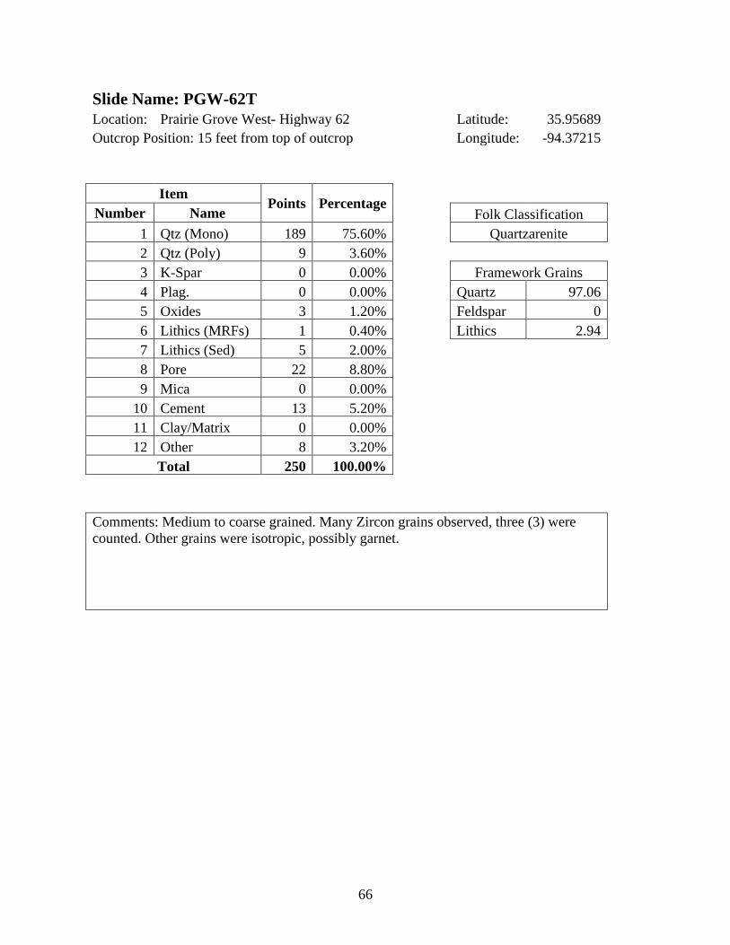
66
Slide Name: PGW-62T
Location: Prairie Grove West- Highway 62 Latitude: 35.95689
Outcrop Position: 15 feet from top of outcrop Longitude: -94.37215
Item Points Percentage
Number Name Folk Classification
1 Qtz (Mono) 189 75.60% Quartzarenite
2 Qtz (Poly) 9 3.60%
3 K-Spar 0 0.00% Framework Grains
4 Plag. 0 0.00% Quartz 97.06
5 Oxides 3 1.20% Feldspar 0
6 Lithics (MRFs) 1 0.40% Lithics 2.94
7 Lithics (Sed) 5 2.00%
8 Pore 22 8.80%
9 Mica 0 0.00%
10 Cement 13 5.20%
11 Clay/Matrix 0 0.00%
12 Other 8 3.20%
Total 250 100.00%
Comments: Medium to coarse grained. Many Zircon grains observed, three (3) were
counted. Other grains were isotropic, possibly garnet.
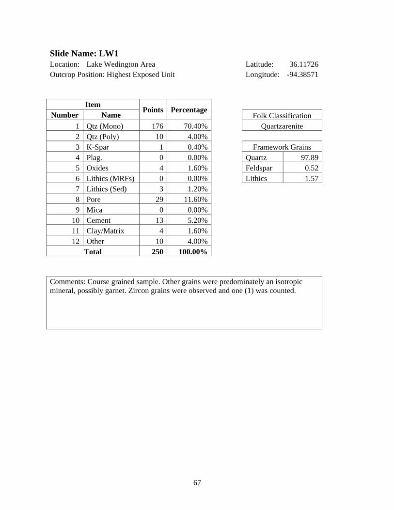
67
Slide Name: LW1
Location: Lake Wedington Area Latitude: 36.11726
Outcrop Position: Highest Exposed Unit Longitude: -94.38571
Item Points Percentage
Number Name Folk Classification
1 Qtz (Mono) 176 70.40% Quartzarenite
2 Qtz (Poly) 10 4.00%
3 K-Spar 1 0.40% Framework Grains
4 Plag. 0 0.00% Quartz 97.89
5 Oxides 4 1.60% Feldspar 0.52
6 Lithics (MRFs) 0 0.00% Lithics 1.57
7 Lithics (Sed) 3 1.20%
8 Pore 29 11.60%
9 Mica 0 0.00%
10 Cement 13 5.20%
11 Clay/Matrix 4 1.60%
12 Other 10 4.00%
Total 250 100.00%
Comments: Course grained sample. Other grains were predominately an isotropic
mineral, possibly garnet. Zircon grains were observed and one (1) was counted.
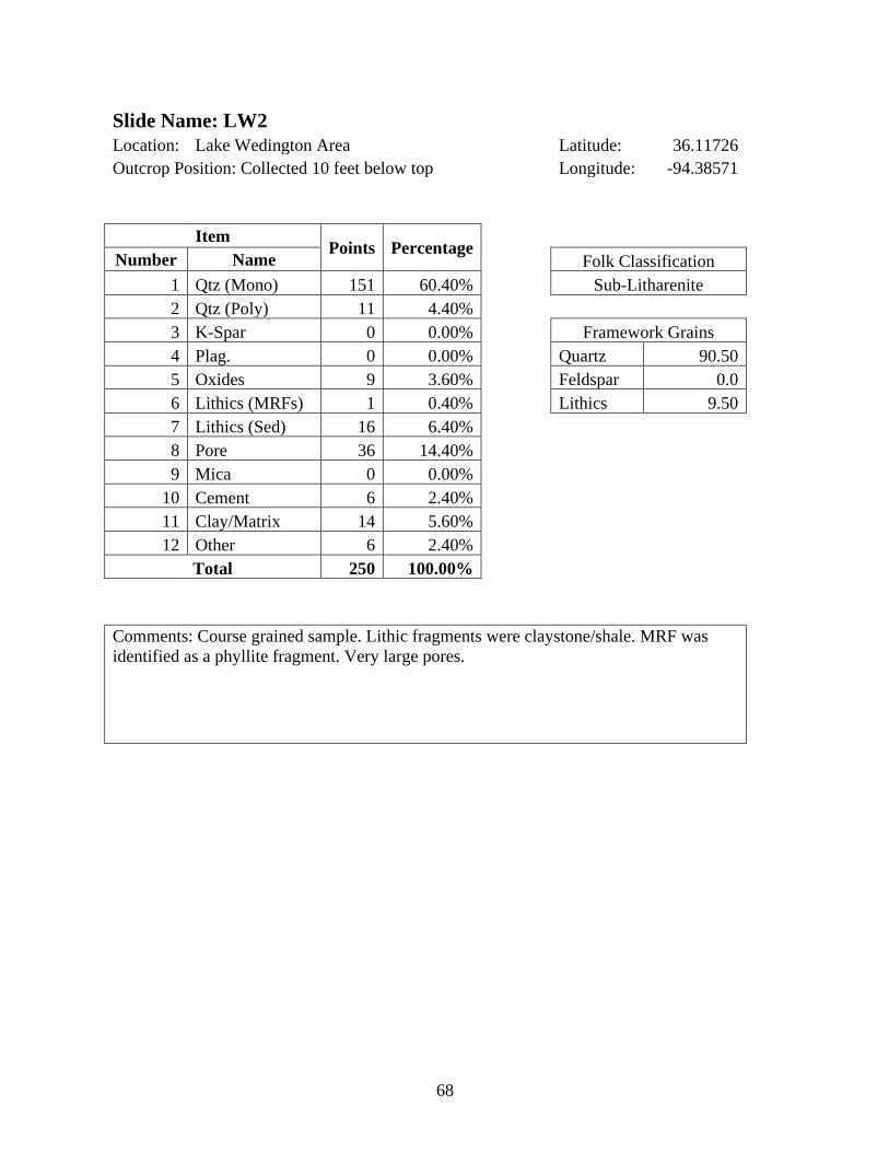
68
Slide Name: LW2
Location: Lake Wedington Area Latitude: 36.11726
Outcrop Position: Collected 10 feet below top Longitude: -94.38571
Item Points Percentage
Number Name Folk Classification
1 Qtz (Mono) 151 60.40% Sub-Litharenite
2 Qtz (Poly) 11 4.40%
3 K-Spar 0 0.00% Framework Grains
4 Plag. 0 0.00% Quartz 90.50
5 Oxides 9 3.60% Feldspar 0.0
6 Lithics (MRFs) 1 0.40% Lithics 9.50
7 Lithics (Sed) 16 6.40%
8 Pore 36 14.40%
9 Mica 0 0.00%
10 Cement 6 2.40%
11 Clay/Matrix 14 5.60%
12 Other 6 2.40%
Total 250 100.00%
Comments: Course grained sample. Lithic fragments were claystone/shale. MRF was
identified as a phyllite fragment. Very large pores.
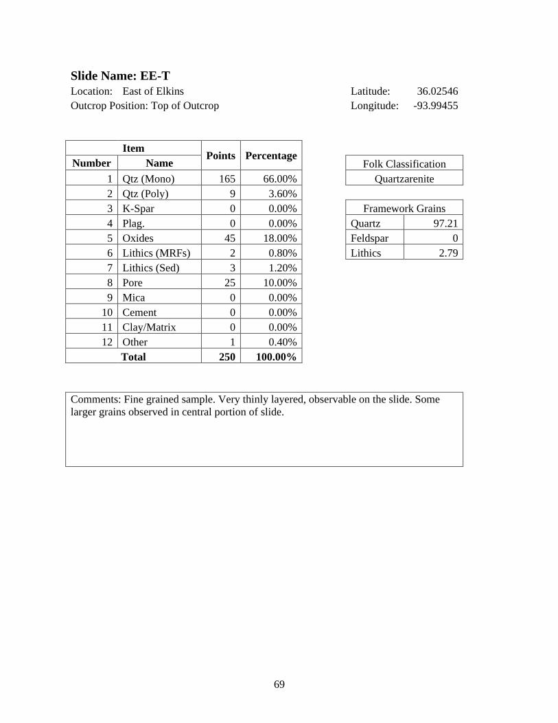
69
Slide Name: EE-T
Location: East of Elkins Latitude: 36.02546
Outcrop Position: Top of Outcrop Longitude: -93.99455
Item Points Percentage
Number Name Folk Classification
1 Qtz (Mono) 165 66.00% Quartzarenite
2 Qtz (Poly) 9 3.60%
3 K-Spar 0 0.00% Framework Grains
4 Plag. 0 0.00% Quartz 97.21
5 Oxides 45 18.00% Feldspar 0
6 Lithics (MRFs) 2 0.80% Lithics 2.79
7 Lithics (Sed) 3 1.20%
8 Pore 25 10.00%
9 Mica 0 0.00%
10 Cement 0 0.00%
11 Clay/Matrix 0 0.00%
12 Other 1 0.40%
Total 250 100.00%
Comments: Fine grained sample. Very thinly layered, observable on the slide. Some
larger grains observed in central portion of slide.
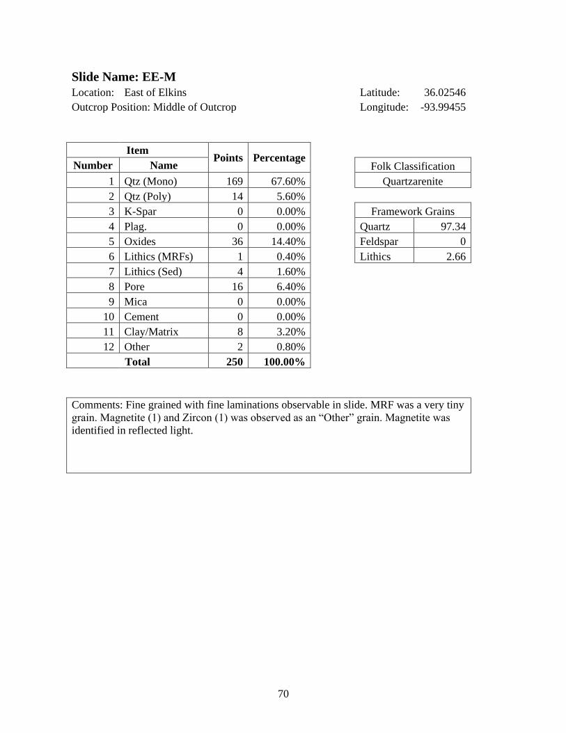
70
Slide Name: EE-M
Location: East of Elkins Latitude: 36.02546
Outcrop Position: Middle of Outcrop Longitude: -93.99455
Item Points Percentage
Number Name Folk Classification
1 Qtz (Mono) 169 67.60% Quartzarenite
2 Qtz (Poly) 14 5.60%
3 K-Spar 0 0.00% Framework Grains
4 Plag. 0 0.00% Quartz 97.34
5 Oxides 36 14.40% Feldspar 0
6 Lithics (MRFs) 1 0.40% Lithics 2.66
7 Lithics (Sed) 4 1.60%
8 Pore 16 6.40%
9 Mica 0 0.00%
10 Cement 0 0.00%
11 Clay/Matrix 8 3.20%
12 Other 2 0.80%
Total 250 100.00%
Comments: Fine grained with fine laminations observable in slide. MRF was a very tiny
grain. Magnetite (1) and Zircon (1) was observed as an “Other” grain. Magnetite was
identified in reflected light.

71
Slide Name: EE-B
Location: East of Elkins Latitude: 36.02546
Outcrop Position: Base of Outcrop Longitude: -93.99455
Item Points Percentage
Number Name Folk Classification
1 Qtz (Mono) 187 74.80% Quartzarenite
2 Qtz (Poly) 8 3.20%
3 K-Spar 1 0.40% Framework Grains
4 Plag. 0 0.00% Quartz 96.53
5 Oxides 13 5.20% Feldspar 0.5
6 Lithics (MRFs) 4 1.60% Lithics 2.97
7 Lithics (Sed) 2 0.80%
8 Pore 0 0.00%
9 Mica 0 0.00%
10 Cement 6 2.40%
11 Clay/Matrix 24 9.60%
12 Other 5 2.00%
Total 250 100.00%
Comments: Very fine-grained sample. Slide was ground poorly; many grains were not
the correct thickness (30 microns).
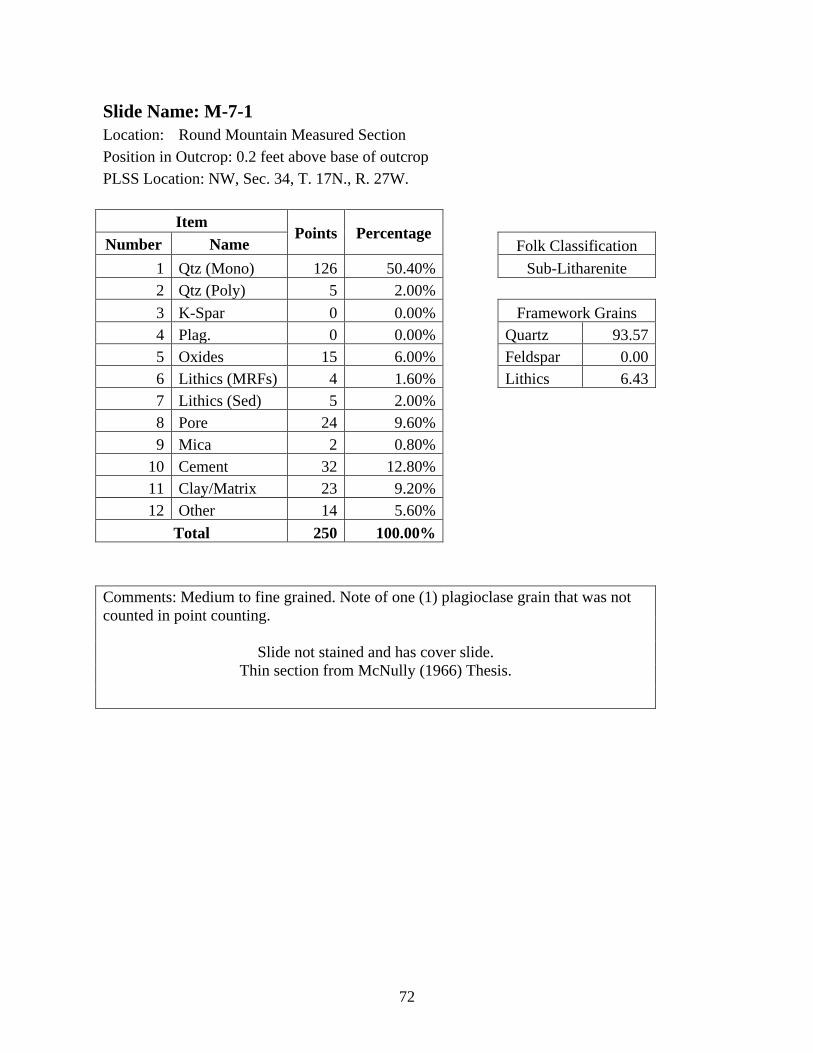
72
Slide Name: M-7-1
Location: Round Mountain Measured Section
Position in Outcrop: 0.2 feet above base of outcrop
PLSS Location: NW, Sec. 34, T. 17N., R. 27W.
Item Points Percentage
Number Name Folk Classification
1 Qtz (Mono) 126 50.40% Sub-Litharenite
2 Qtz (Poly) 5 2.00%
3 K-Spar 0 0.00% Framework Grains
4 Plag. 0 0.00% Quartz 93.57
5 Oxides 15 6.00% Feldspar 0.00
6 Lithics (MRFs) 4 1.60% Lithics 6.43
7 Lithics (Sed) 5 2.00%
8 Pore 24 9.60%
9 Mica 2 0.80%
10 Cement 32 12.80%
11 Clay/Matrix 23 9.20%
12 Other 14 5.60%
Total 250 100.00%
Comments: Medium to fine grained. Note of one (1) plagioclase grain that was not
counted in point counting.
Slide not stained and has cover slide.
Thin section from McNully (1966) Thesis.
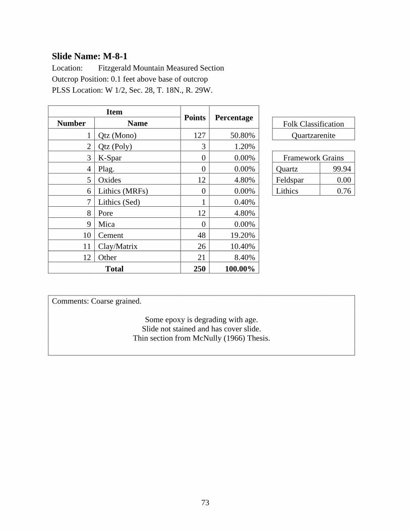
73
Slide Name: M-8-1
Location: Fitzgerald Mountain Measured Section
Outcrop Position: 0.1 feet above base of outcrop
PLSS Location: W 1/2, Sec. 28, T. 18N., R. 29W.
Item Points Percentage
Number Name Folk Classification
1 Qtz (Mono) 127 50.80% Quartzarenite
2 Qtz (Poly) 3 1.20%
3 K-Spar 0 0.00% Framework Grains
4 Plag. 0 0.00% Quartz 99.94
5 Oxides 12 4.80% Feldspar 0.00
6 Lithics (MRFs) 0 0.00% Lithics 0.76
7 Lithics (Sed) 1 0.40%
8 Pore 12 4.80%
9 Mica 0 0.00%
10 Cement 48 19.20%
11 Clay/Matrix 26 10.40%
12 Other 21 8.40%
Total 250 100.00%
Comments: Coarse grained.
Some epoxy is degrading with age.
Slide not stained and has cover slide.
Thin section from McNully (1966) Thesis.

74
Slide Name: M-10-5
Location: Keefer Mountain Measured Section
Outcrop Position: 8.7 feet above base of outcrop
PLSS Location: SE, Sec. 20, T. 17N., R. 27W.
Item Points Percentage
Number Name Folk Classification
1 Qtz (Mono) 131 52.40% Sub-Litharenite
2 Qtz (Poly) 2 0.80%
3 K-Spar 0 0.00% Framework Grains
4 Plag. 0 0.00% Quartz 94.33
5 Oxides 3 1.20% Feldspar 0
6 Lithics (MRFs) 4 1.60% Lithics 5.67
7 Lithics (Sed) 4 1.60%
8 Pore 15 6.00%
9 Mica 0 0.00%
10 Cement 25 10.00%
11 Clay/Matrix 48 19.20%
12 Other 18 7.20%
Total 250 100.00%
Comments: Fine grained. Pore space is irregularly spaced (possible missing grains or
porosity trends in rock).
Slide not stained and has cover slide.
Thin section from McNully (1966) Thesis.
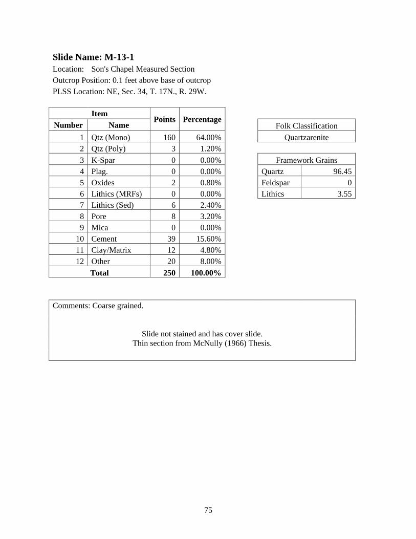
75
Slide Name: M-13-1
Location: Son's Chapel Measured Section
Outcrop Position: 0.1 feet above base of outcrop
PLSS Location: NE, Sec. 34, T. 17N., R. 29W.
Item Points Percentage
Number Name Folk Classification
1 Qtz (Mono) 160 64.00% Quartzarenite
2 Qtz (Poly) 3 1.20%
3 K-Spar 0 0.00% Framework Grains
4 Plag. 0 0.00% Quartz 96.45
5 Oxides 2 0.80% Feldspar 0
6 Lithics (MRFs) 0 0.00% Lithics 3.55
7 Lithics (Sed) 6 2.40%
8 Pore 8 3.20%
9 Mica 0 0.00%
10 Cement 39 15.60%
11 Clay/Matrix 12 4.80%
12 Other 20 8.00%
Total 250 100.00%
Comments: Coarse grained.
Slide not stained and has cover slide.
Thin section from McNully (1966) Thesis.
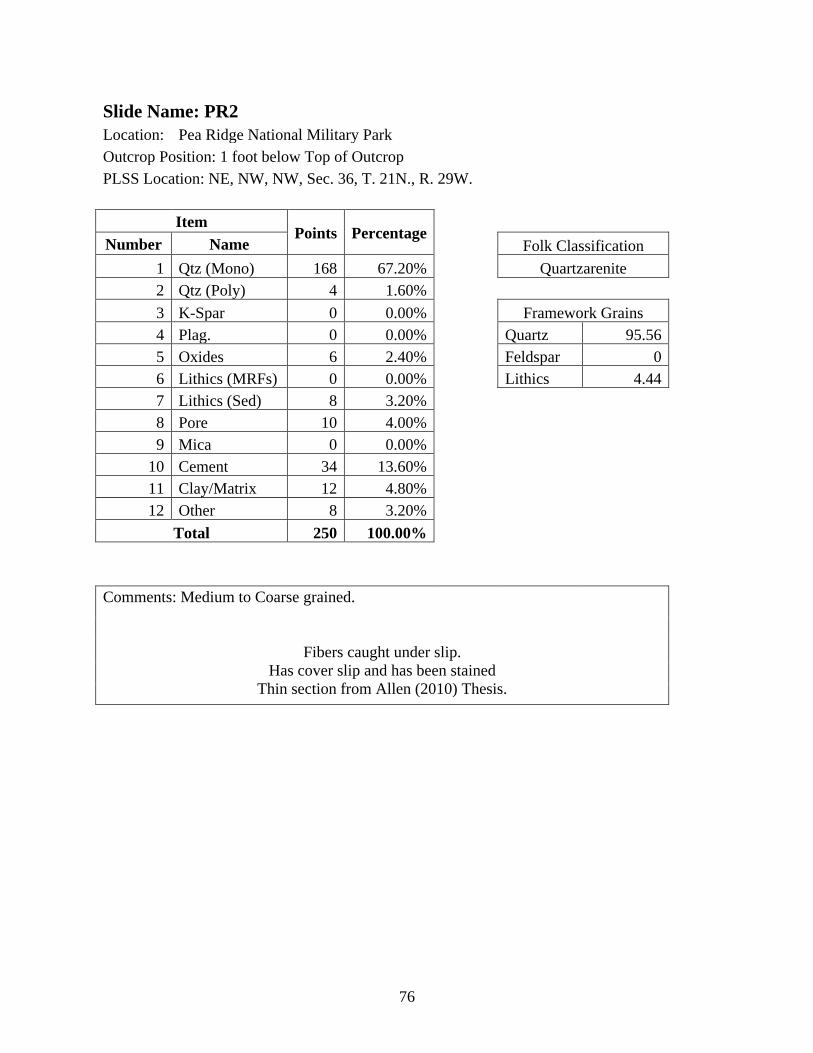
76
Slide Name: PR2
Location: Pea Ridge National Military Park
Outcrop Position: 1 foot below Top of Outcrop
PLSS Location: NE, NW, NW, Sec. 36, T. 21N., R. 29W.
Item Points Percentage
Number Name Folk Classification
1 Qtz (Mono) 168 67.20% Quartzarenite
2 Qtz (Poly) 4 1.60%
3 K-Spar 0 0.00% Framework Grains
4 Plag. 0 0.00% Quartz 95.56
5 Oxides 6 2.40% Feldspar 0
6 Lithics (MRFs) 0 0.00% Lithics 4.44
7 Lithics (Sed) 8 3.20%
8 Pore 10 4.00%
9 Mica 0 0.00%
10 Cement 34 13.60%
11 Clay/Matrix 12 4.80%
12 Other 8 3.20%
Total 250 100.00%
Comments: Medium to Coarse grained.
Fibers caught under slip.
Has cover slip and has been stained
Thin section from Allen (2010) Thesis.
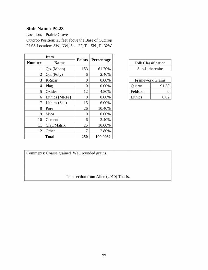
77
Slide Name: PG23
Location: Prairie Grove
Outcrop Position: 23 feet above the Base of Outcrop
PLSS Location: SW, NW, Sec. 27, T. 15N., R. 32W.
Item Points Percentage
Number Name Folk Classification
1 Qtz (Mono) 153 61.20% Sub-Litharenite
2 Qtz (Poly) 6 2.40%
3 K-Spar 0 0.00% Framework Grains
4 Plag. 0 0.00% Quartz 91.38
5 Oxides 12 4.80% Feldspar 0
6 Lithics (MRFs) 0 0.00% Lithics 8.62
7 Lithics (Sed) 15 6.00%
8 Pore 26 10.40%
9 Mica 0 0.00%
10 Cement 6 2.40%
11 Clay/Matrix 25 10.00%
12 Other 7 2.80%
Total 250 100.00%
Comments: Coarse grained. Well rounded grains.
Thin section from Allen (2010) Thesis.
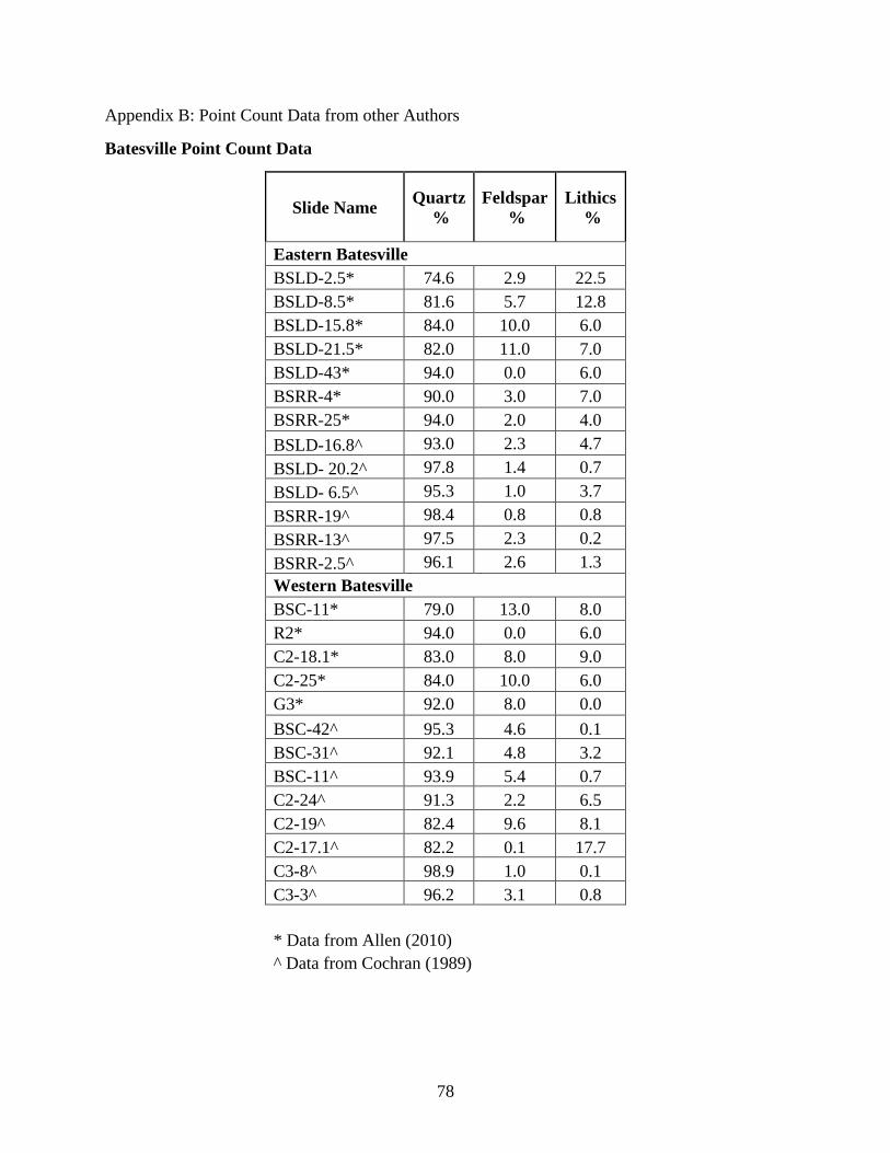
78
Appendix B: Point Count Data from other Authors
Batesville Point Count Data
Slide Name Quartz
%
Feldspar
%
Lithics
%
Eastern Batesville
BSLD-2.5* 74.6 2.9 22.5
BSLD-8.5* 81.6 5.7 12.8
BSLD-15.8* 84.0 10.0 6.0
BSLD-21.5* 82.0 11.0 7.0
BSLD-43* 94.0 0.0 6.0
BSRR-4* 90.0 3.0 7.0
BSRR-25* 94.0 2.0 4.0
BSLD-16.8^ 93.0 2.3 4.7
BSLD- 20.2^ 97.8 1.4 0.7
BSLD- 6.5^ 95.3 1.0 3.7
BSRR-19^ 98.4 0.8 0.8
BSRR-13^ 97.5 2.3 0.2
BSRR-2.5^ 96.1 2.6 1.3
Western Batesville
BSC-11* 79.0 13.0 8.0
R2* 94.0 0.0 6.0
C2-18.1* 83.0 8.0 9.0
C2-25* 84.0 10.0 6.0
G3* 92.0 8.0 0.0
BSC-42^ 95.3 4.6 0.1
BSC-31^ 92.1 4.8 3.2
BSC-11^ 93.9 5.4 0.7
C2-24^ 91.3 2.2 6.5
C2-19^ 82.4 9.6 8.1
C2-17.1^ 82.2 0.1 17.7
C3-8^ 98.9 1.0 0.1
C3-3^ 96.2 3.1 0.8
* Data from Allen (2010)
^ Data from Cochran (1989)
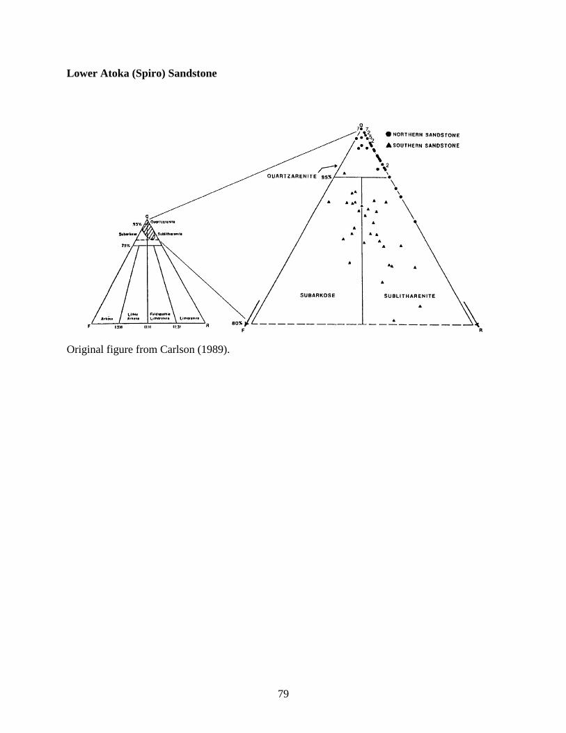
79
Lower Atoka (Spiro) Sandstone
Original figure from Carlson (1989).
80
Appendix C: Additional Photomicrographs
Appendix Explanation
The following photomicrographs were captured from the slides used for this thesis, but
not used as figures in the main text. Most of the slides have not been annotated but are included
for future reference and so that future authors have additional images to refer to if needed
regarding the texture and grain composition of the Wedington Sandstone. Each figure is a set of
photomicrographs captured in the same position, one in Plane-Polarized Light (PPL) and one in
Cross-Polarized Light (XPL). There are two exceptions, one figure from LW1 has two XPL
photomicrographs to show isotropic grains. There is not a PPL image to accompany the
photomicrograph of slide M-13-1.
Please refer to notes in Appendix A on presence of stain, slide covers, and epoxy
character. The additional photomicrographs are from the following thin section slides, the
numbers indicate how many photo sets are from each slide: CHM-1’BT (2); LW1 (2), LW2 (1);
M-8-1 (1); M-10-5 (1);M-13-1 (1); PR2 (1); and PG23 (1).
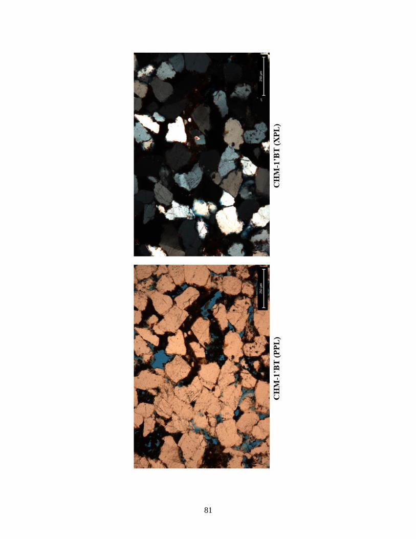
81
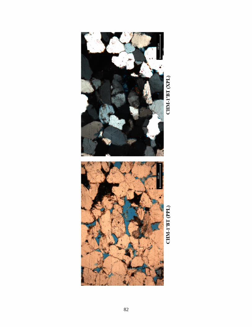
82
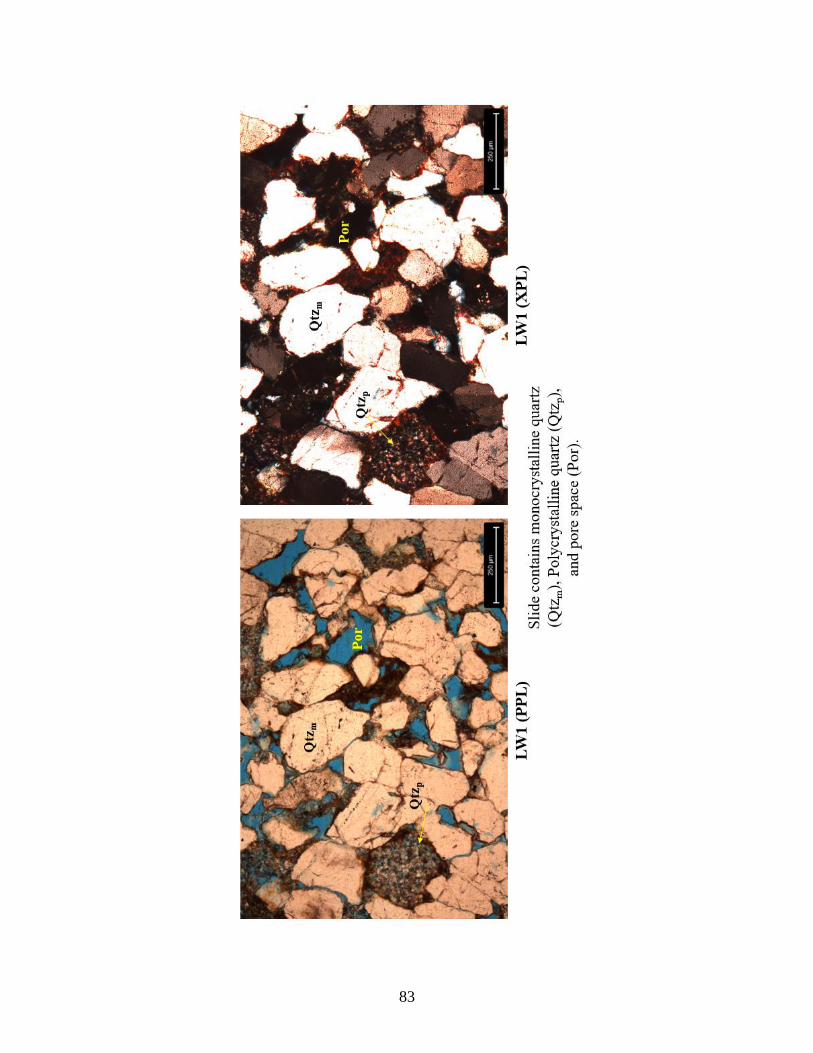
83
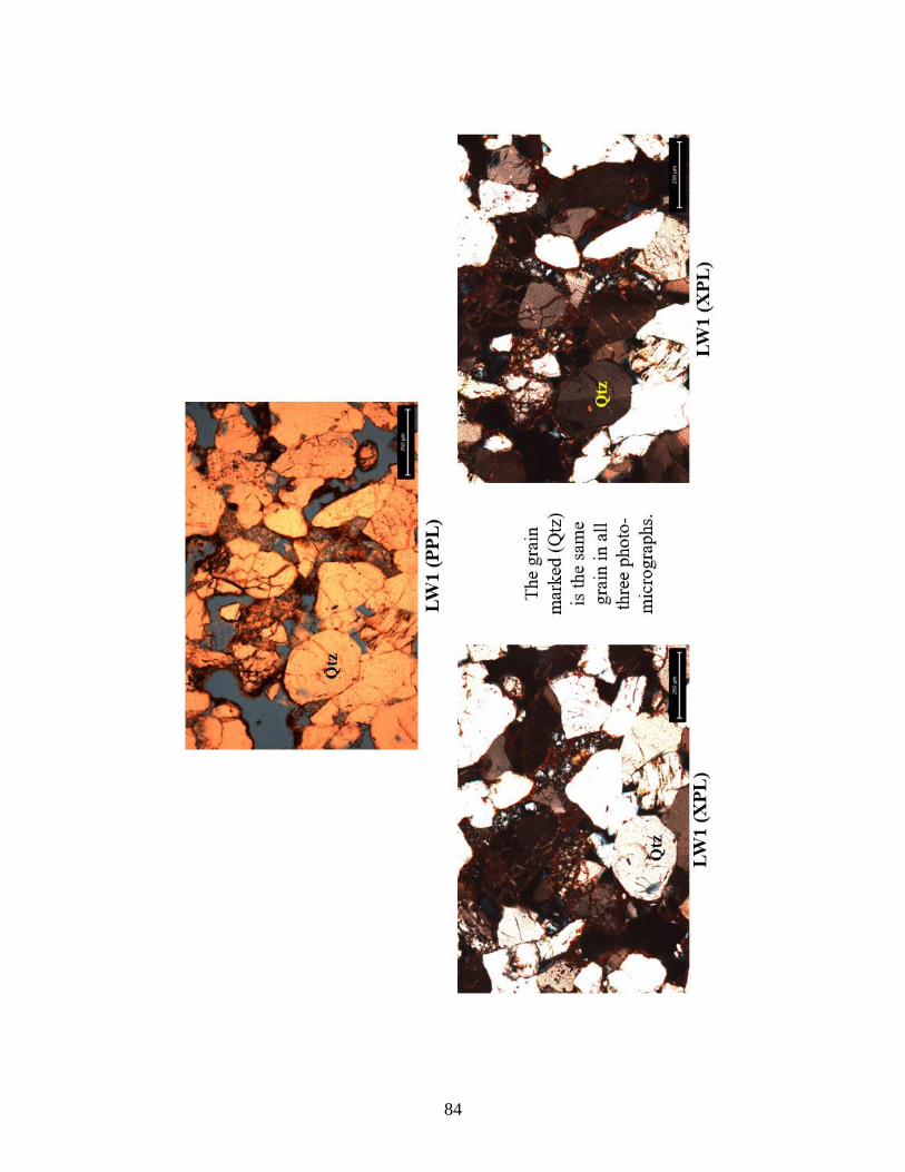
84

85
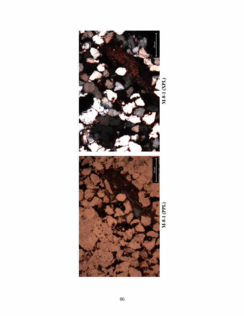
86
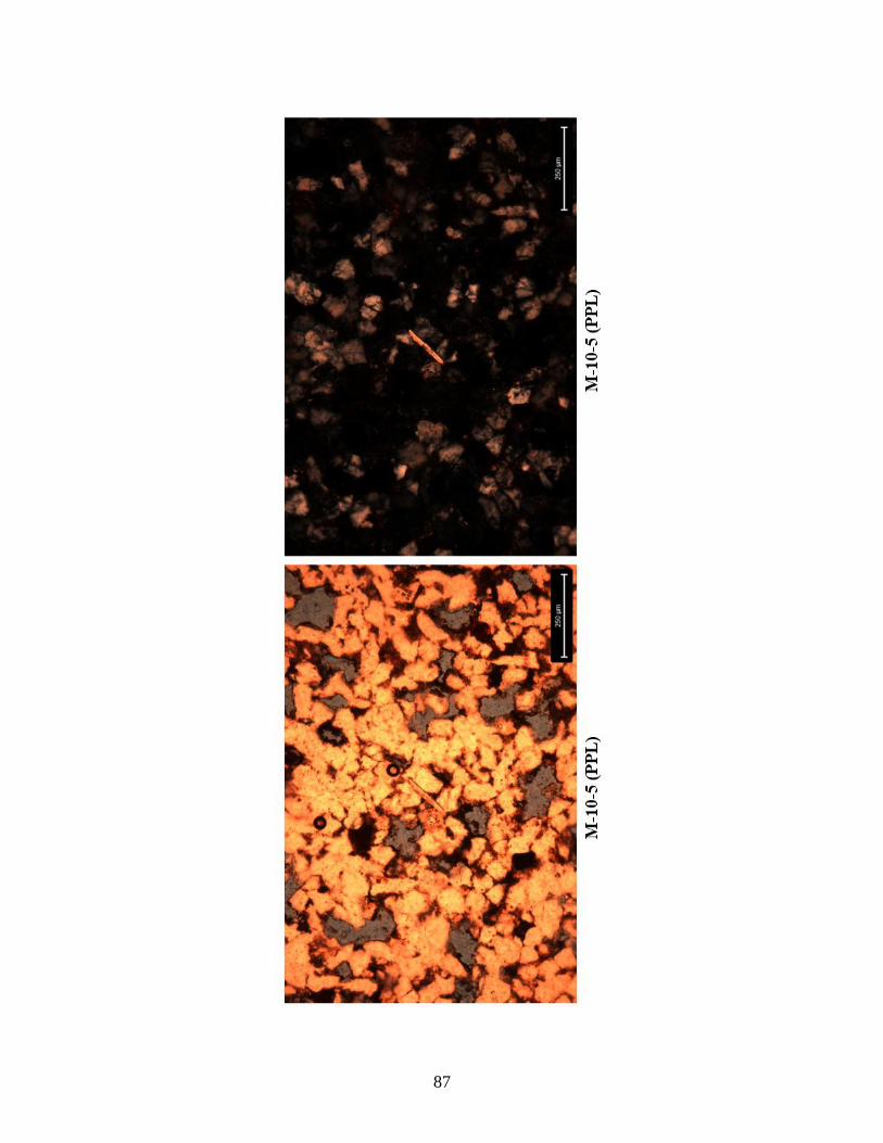
87
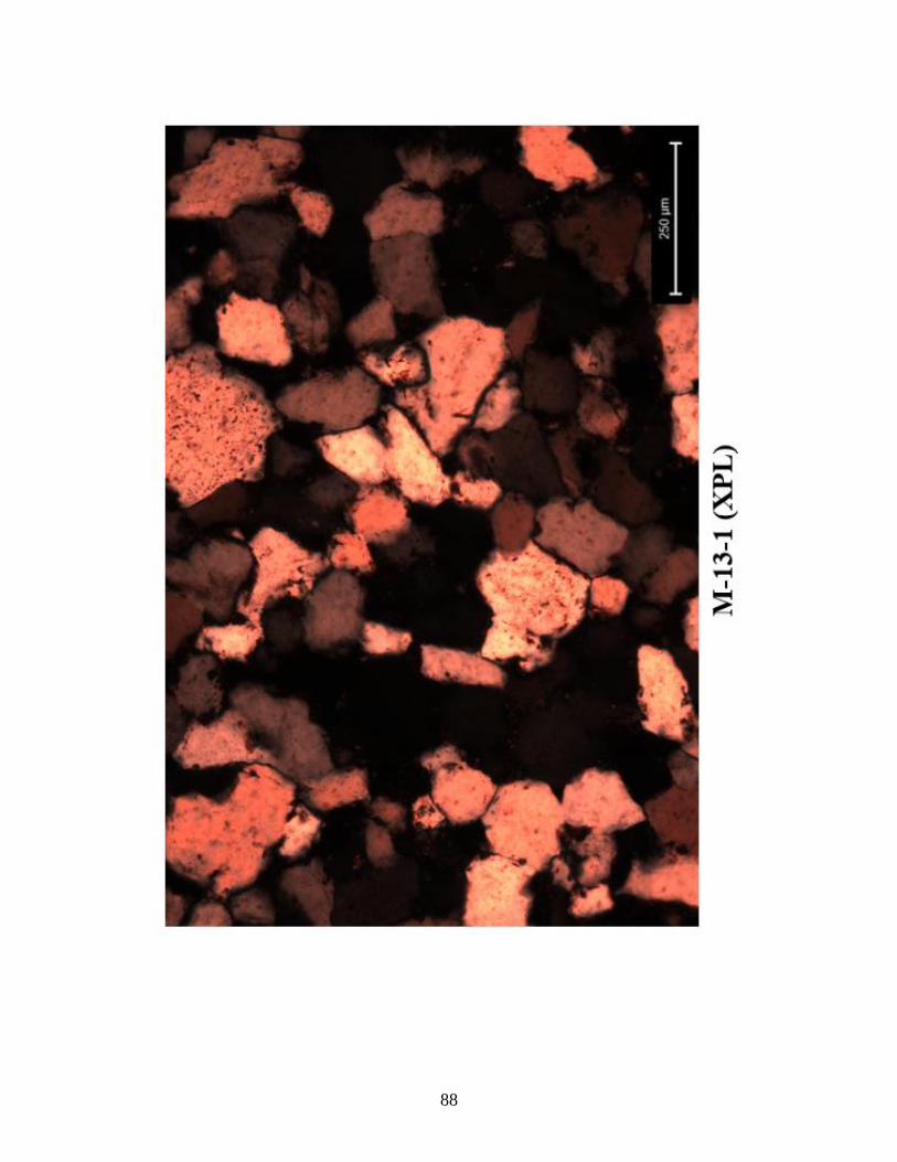
88
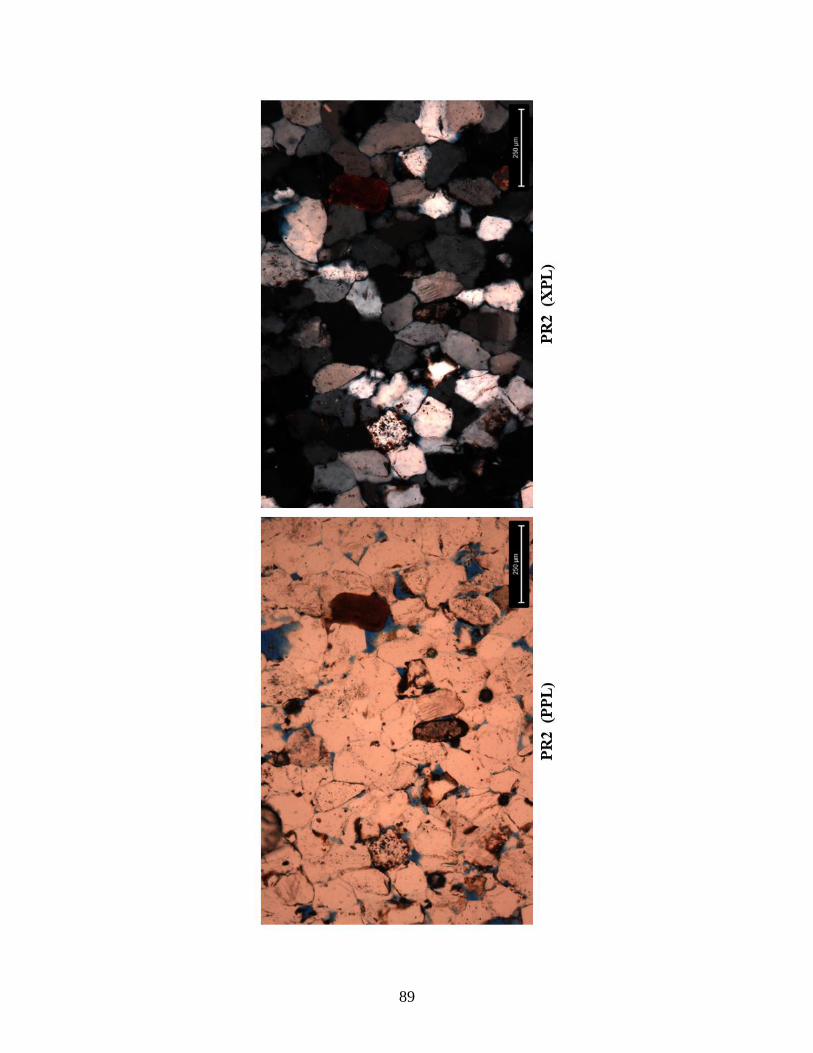
89
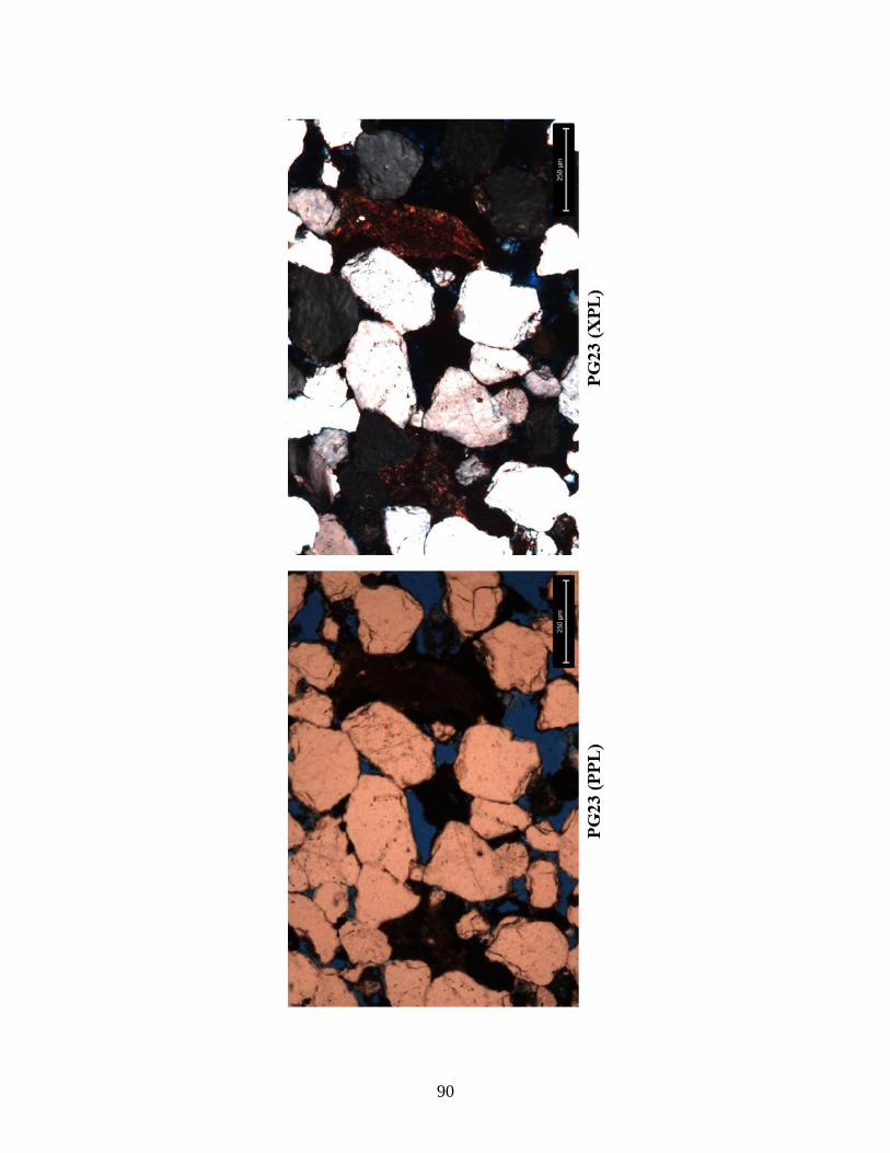
90