Embed Size (px)
Citation preview
June 2005 4.8-1 Sound Transit Regional Transit Long-Range Plan Final SEIS 4.8 Visual Quality and Aesthetic Resources
4.8 VISUAL QUALITY AND AESTHETIC RESOURCES
This section was updated from the 1993 Final EIS based on review of current policies and plans and project-level environmental documents for Sound Transit light rail, commuter rail, and regional express bus projects. It examines the affected environment, analyzes impacts to visual quality and aesthetic resources, and describes potential mitigation measures.
The No Action Alternative and Plan Alternative and Options could affect existing visual resources at several levels. First, they could add, alter, or remove some of the visible features that compose the basic visual resources of the landscape. These features include landforms, waterbodies, vegetation, and urban structures (including existing transportation facilit ies). Second, they could change the visual character of existing resources. By assessing the existing visual character of an area, it is possible to identify the extent to which the visual character of a project would contrast with the landscape or, alternatively, be visually compatible with the landscape.
Existing visual resources and elements that define visual character include the following:
• Landforms—types, gradients, and scale
• Vegetation—types, size and maturity, and continuity
• Land uses—size, scale (apparent size in relation to actual size), and character of associated buildings and ancillary site uses
• Transportation facilities—types, sizes, scale, and directional orientation
• Overhead structures, utilities, and lighting—types, sizes, and scale
• Open space—types (including parks, reserves or greenbelts, and undeveloped land), extent, and continuity
• Viewpoints and views to visual resources —water features, hills and mountains, natural areas, farm landscapes, historic structures, and dramatic downtown skylines
• Apparent grain or texture of visual resources composing the landscape unit
• Apparent upkeep and maintenance
4.8.1 Affected Environment
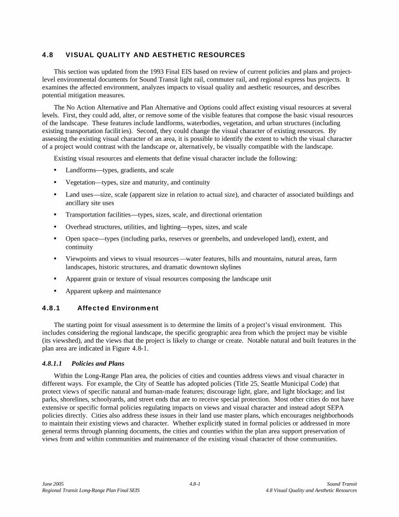
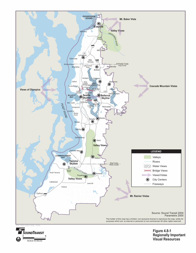
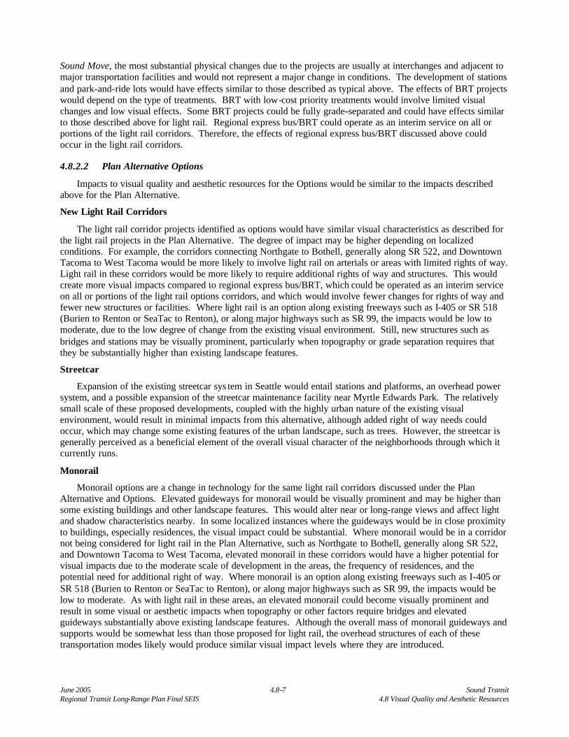
The starting point for visual assessment is to determine the limits of a project’s visual environment. This includes considering the regional landscape, the specific geographic area from which the project may be visible (its viewshed), and the views that the project is likely to change or create. Notable natural and built features in the plan area are indicated in Figure 4.8-1.
4.8.1.1 Policies and Plans
Within the Long-Range Plan area, the policies of cities and counties address views and visual character in different ways. For example, the City of Seattle has adopted policies (Title 25, Seattle Municipal Code) that protect views of specific natural and human-made features; discourage light, glare, and light blockage; and list parks, shorelines, schoolyards, and street ends that are to receive special protection. Most other cities do not have extensive or specific formal policies regulating impacts on views and visual character and instead adopt SEPA policies directly. Cities also address these issues in their land use master plans, which encourages neighborhoods to maintain their existing views and character. Whether explicitly stated in formal policies or addressed in more general terms through planning documents, the cities and counties within the plan area support preservation of views from and within communities and maintenance of the existing visual character of those communities.
Sound Transit 4.8-2 June 2005 4.8 Visual Quality and Aesthetic Resources Regional Transit Long-Range Plan Final SEIS
4.8.1.2 Regional Visual Characteristics
The area covered by the Long-Range Plan consists of rolling plateaus that trend north-south, bordered by parallel valleys occupied by the waters of Puget Sound, Elliott Bay, Commencement Bay, Possession Sound, Lake Union, Lake Sammamish, and Lake Washington. Flat-bottomed river valleys lead to Puget Sound in Tacoma, Seattle, and Everett. Throughout the plan area, plateaus generally rise 100 to 300 feet above the valley floors. Most of the valley walls are moderately steep and many remain undeveloped. The Cascade and Olympic Mountains are visible throughout the area. These views are especially valued, as are views of Mt. Rainier, Mt. Baker, lakes, and Puget Sound.
Land use patterns and associated structures relate to the underlying terrain. The plateaus and gentler valley walls are largely occupied by residential, institutional, and commercial uses that are small to moderate in scale. The buildings associated with these uses typically range from one to four stories high. Major valley bottoms support commercial, industrial, and transportation uses that are moderate to large in scale. Aside from high-rise structures in the plan area’s urban areas, building heights in the valley bottoms typically range from two to six stories, but many buildings have large horizontal dimensions. Many of the steeper valley walls support dense greenbelts of primarily native trees. These linear greenbelts are visually distinctive features in the otherwise densely developed urban region.
The valley walls have also channeled major existing transportation facilities and high-voltage transmission lines into north-south corridors. Their visible features include support structures such as bridges, viaducts, retaining walls, and noise barriers; overhead structures such as towers and conductors; and right of way developments such as park-and-ride lots, parks, trails, public art installations, and mature landscape plantings.
4.8.1.3 Natural Features
The rolling topography in the plan area allows for numerous scenic views. Plateaus, river valleys (e.g., the Green River Valley), islands, wooded areas, and environmentally sensitive areas are other notable parts of the area’s visual character.
Scenic views of Puget Sound, Bainbridge Island, the Kitsap Peninsula, and Vashon Island are available in the western part of the project area, and Lake Washington is a valuable visual resource in the eastern part of the project area. Waterfront land uses such as pleasure boating, commercial fishing, and shipping provide further visual interest. Other bodies of water that are locally and/or regionally important due to their size, visibility, or scenic land uses include Lake Sammamish, Green Lake, Lake Union, Lake Stevens, the Lake Washington Ship Canal, and the Puyallup, Duwamish, Green, White, Cedar, Sammamish, and Snohomish Rivers.
In suburban areas throughout the plan area, undeveloped wooded areas, wetlands, and creek and river corridors and floodplains—located between areas of development and at the suburban fringe—are valuable visual resources that give portions of these areas a natural appearance.
4.8.1.4 Built Environment
Urban Environments
The built environment of urban centers in the plan area is extremely diverse in scale, bulk, height, and overall character. Struc tures such as the Space Needle, sports stadiums, and bridges are prominent visual features. The high-rise buildings of downtown Seattle, Tacoma, and Bellevue create scenic skyline views in outlying areas. Additionally, these structures may serve as landmarks that orient viewers. Plantings in these areas are limited to street trees in some areas, and small-scale urban parks.
Industrial land uses such as shipping, manufacturing, and warehouses are located along parts of the waterfronts of Seattle, Tacoma, and to a lesser extent, Everett. These areas are typified by filled shorelines, low-rise industrial buildings, mid-rise commercial buildings, and large shipping equipment. Large expanses of paving are required in these areas to accommodate parking, handling and storage of equipment and material, and container cargo processing and storage. Additionally, railway lines and rail yards that serve industrial areas are notable components of the view in these areas.
�����������
��������������� ����������������������
��������������������������
�
� �
���� �!��"!� �
�#��#�$����%��#� ���&�#� ���$�����'������$� �(��$��� �������&�������#����&'� �$�$)�%��&��&� � �*#��#�������+������$����&�� ��$,�-+������������$.��$$���#�����/#� ��� ��(�.
�
00
���
0�
���
�
1���(�$$�
2���
! �3��#
��
4��#�$$
5��6$�
"�6�$���
2�����6*�$�
5��
��-��
4����
7����$�1�)
�������)�$$�&
��6�*��
8����
"�$6.�������
"�����! .
8� �"���
��6��7��� ����6
"�$$�����6
����#�������
�#���$��
��*�� �$�
�)*��
������
��������
�
������8���
�������4��/�
�#�&���$4��/�
����4��/�
!�0��4��/�
Sound Transit 4.8-4 June 2005 4.8 Visual Quality and Aesthetic Resources Regional Transit Long-Range Plan Final SEIS
(This page intentionally left blank)

June 2005 4.8-5 Sound Transit Regional Transit Long-Range Plan Final SEIS 4.8 Visual Quality and Aesthetic Resources
Numerous urban neighborhoods are located outside the commercial core of urban areas. Dense single-family development—much of it established in the late 19th and early to mid 20th centuries—is located on or near ridge tops, while multi-family development is more typically located on slopes. Moderate-scale commercial centers associated with these neighborhoods are found along arterials. Plantings in these neighborhoods range from diverse residential landscapes, to native trees and shrubs in greenbelts, to landscaped parks and public open spaces, to street trees along arterials, boulevards, and residential streets.
Parks, public open spaces, and semi-public open spaces are found throughout urban areas. In business cores, parks tend to be small-scale, with some large linear parks located along shorelines. Larger urban parks tend to be located outside the business core, near urban neighborhoods or at the outskirts of urban areas. Campuses of several colleges and universities are open for use by the public.
Utilities and transportation infrastructure are visible through most urban areas. Light standards and overhead utilities and transmission lines are common visual elements. Transportation signage can be seen near freeways and state highways, and commercial signage can be viewed in commercial cores and industrial areas. Roads, on-ramps, retaining walls, parking lots, and parking garages are all very prominent aspects of views and visual character of urban centers.
Suburban Environments
Smaller cities such as Edmonds, Kirkland, Des Moines, Kent, and Puyallup are located throughout the plan area. They were typically founded around a historic city center with a relatively small street grid, small- to moderate-scale buildings, and a pedestrian-friendly environment. More recent development and land use in and around these cities varies; however, reliance on the automobile for transportation has led to an extensive system of arterial roads and highways, and automobile-oriented commercial/business development such as medium- to large-scale retail malls, small- to medium-scale commercial and retail strip development, and office parks. The Kent Valley is notable for the large number of warehouses located there. The height of these structures may be equivalent to that of a typical three- or four-story building, and their horizontal scale tends to be large to very large. Single-family neighborhoods in suburban areas are typically located on or near ridge tops and desirable natural features, while multi-family development tends to be located closer to arterials, highways, and commercial centers. As with urban neighborhoods, plantings are diverse, including residential landscapes, broad and mostly open landscapes typical of business parks, landscaped public parks, nature reserves, and street trees.
Light standards, electric utilities, and communications lines are located mostly along transportation corridors, with the exception of high-voltage transmission lines and towers, which utilize rights of way that were established before much of the suburban areas were developed. Transportation signage can be seen near freeways and state highways, and commercial signage is a major visual element in areas with strip development. Roads required for automobile-oriented development and parking lots that serve commercial/office development, business parks, and multi-family development are dominant aspects of views and the visual character of the suburban environment.
Agricultural Environments
Agricultural areas (e.g., Green, Puyallup, and Snohomish River valleys) are typified by their openness, very low density of development, rural architecture, and occasional historic structures. They are oriented to the rectangular township/range/section pattern, interrupted by irregular natural features such as topography, water bodies, and wooded areas. The combination of these generally pleasing visual elements provides for many scenic views in agricultural areas.
4.8.2 Long-Term Impacts
4.8.2.1 Regional Transit Long-Range Plan Alternative
Long-term impacts would vary depending on the nature of existing development, the proximity of proposed transit improvements to sensitive viewers, and the incorporation of potential measures to avoid or mitigate potential impacts to visual resources. The sensitivity of land uses would vary greatly. For example, neighborhoods with single-family homes, parks, cemeteries, and schools and hospitals with open space campuses would tend to be more sensitive to bulk, height, increase of scale, and visual change than mixed-use areas with larger multistory residential buildings and commercial or industrial land uses. Overall, proposed transit
Sound Transit 4.8-6 June 2005 4.8 Visual Quality and Aesthetic Resources Regional Transit Long-Range Plan Final SEIS
improvements on arterial streets would affect views and visual character more than high-capacity transit routes along freeways, due to closer proximity to land uses in adjacent neighborhoods.
Transit centers and stations, along with associated platforms, canopies, and related facilities, would affect the views and visual character of some residential neighborhoods, natural areas, and open spaces. However, impact levels would generally be reduced where stations are located along freeways and arterials, at existing park-and-ride lots, in activity centers, and in other aesthetically compatible locations. Impacts related to stations and transit centers would be mitigated by designing them to match their surroundings. In town centers, large commercial areas, office parks, or mixed-use areas, transit centers could be designed to enhance the existing visual character. Designs could also encourage visually compatible infill development and pedestrian-friendly development.
Park-and-ride lots and parking garages would require large expanses of pavement, which may also contrast with the views and visual character of adjacent land uses. Increased intensity of use at existing park-and-ride lots would generate additional visual impacts. Additional lighting in parking facilities would result in higher levels of light and glare around both expanded and proposed park-and-ride lots.
Additional rights of way may be required for many of the transit improvements, and may include widening of arterials or highways or other public rights of way. Without mitigation, this would increase the visual impact from the roadway or other transportation facility and reduce visual buffers between roadways and adjacent uses. In cases where new rights of way may be required in areas that are either currently undeveloped or where other urban development exists, the introduction of transportation facilities would remove or alter existing features, which may affect visual character and affect views, depending on the location. Added structures, overhead power sources, vent shafts, and operations and maintenance facilities would obstruct or clutter views, cast shadows, and result in substantial changes to existing visual character. In some cases, the introduction of transportation facilities themselves may also be perceived as a visual impact; however, areas in which visual resources are currently affected by moderate to high levels of development, other transportation facilities, and traffic would be less likely to experience a notable change to the visual environment.
Light Rail
Light rail is proposed to connect a number of urban areas throughout the region. Although the specific route alignments have not yet been determined, the corridors generally follow major transportation facilities that already feature high levels of activity, such as I-5, I-90, I-405, and SR 99. Where light rail is along arterials, the degree of change may be higher, particularly where residential uses occur. However, there is also the potential for light rail to improve street aesthetics by reducing clutter and improving sidewalks, landscaping, and lighting. With light rail, there would be the introduction of overhead power lines and the potential for structures for at-grade or elevated alignments. Elevated guideways would have a higher potential to be visually prominent, compared to at-grade sections. Elevated sections would have the potential to be higher than some existing buildings and other landscape features, altering near or long-range views and potentially affecting light and shadow characteristics nearby. In some localized instances where the guideway facility is in close proximity to buildings, especially residences, the visual impact could be substantial.
Impacts of regional express bus/BRT as an interim technology in light rail corridors are discussed below under the Regional Express Bus/Bus Rapid Transit section.
Commuter Rail
Under the Plan Alternative, commuter rail facilities and services would generally be along established rail corridors, and the introduction of commuter rail service and facilities would not represent a substantial change in existing conditions. In some locations, commuter rail would require improvements to the rail right of way, and additional right of way or added structures could be required; this may require removing or altering adjacent landscape features such as trees, vegetation, or structures. Stations and other facilities would have effects similar to those described as typical above.
Regional Express Bus/Bus Rapid Transit
Regional express bus services would have a low potential for visual impact. New capital facilities, including new transit stations, ramps, and other improvements, could alter localized conditions and have a higher potential for impact, depending on their design and siting. As with the regional express bus projects developed under
June 2005 4.8-7 Sound Transit Regional Transit Long-Range Plan Final SEIS 4.8 Visual Quality and Aesthetic Resources
Sound Move, the most substantial physical changes due to the projects are usually at interchanges and adjacent to major transportation facilities and would not represent a major change in conditions. The development of stations and park-and-ride lots would have effects similar to those described as typical above. The effects of BRT projects would depend on the type of treatments. BRT with low-cost priority treatments would involve limited visual changes and low visual effects. Some BRT projects could be fully grade-separated and could have effects similar to those described above for light rail. Regional express bus/BRT could operate as an interim service on all or portions of the light rail corridors. Therefore, the effects of regional express bus/BRT discussed above could occur in the light rail corridors.
4.8.2.2 Plan Alternative Options
Impacts to visual quality and aesthetic resources for the Options would be similar to the impacts described above for the Plan Alternative.
New Light Rail Corridors
The light rail corridor projects identified as options would have similar visual characteristics as described for the light rail projects in the Plan Alternative. The degree of impact may be higher depending on localized conditions. For example, the corridors connecting Northgate to Bothell, generally along SR 522, and Downtown Tacoma to West Tacoma would be more likely to involve light rail on arterials or areas with limited rights of way. Light rail in these corridors would be more likely to require additional rights of way and structures. This would create more visual impacts compared to regional express bus/BRT, which could be operated as an interim service on all or portions of the light rail options corridors, and which would involve fewer changes for rights of way and fewer new structures or facilities. Where light rail is an option along existing freeways such as I-405 or SR 518 (Burien to Renton or SeaTac to Renton), or along major highways such as SR 99, the impacts would be low to moderate, due to the low degree of change from the existing visual environment. Still, new structures such as bridges and stations may be visually prominent, particularly when topography or grade separation requires that they be substantially higher than existing landscape features.
Streetcar
Expansion of the existing streetcar sys tem in Seattle would entail stations and platforms, an overhead power system, and a possible expansion of the streetcar maintenance facility near Myrtle Edwards Park. The relatively small scale of these proposed developments, coupled with the highly urban nature of the existing visual environment, would result in minimal impacts from this alternative, although added right of way needs could occur, which may change some existing features of the urban landscape, such as trees. However, the streetcar is generally perceived as a beneficial element of the overall visual character of the neighborhoods through which it currently runs.
Monorail
Monorail options are a change in technology for the same light rail corridors discussed under the Plan Alternative and Options. Elevated guideways for monorail would be visually prominent and may be higher than some existing buildings and other landscape features. This would alter near or long-range views and affect light and shadow characteristics nearby. In some localized instances where the guideways would be in close proximity to buildings, especially residences, the visual impact could be substantial. Where monorail would be in a corridor not being considered for light rail in the Plan Alternative, such as Northgate to Bothell, generally along SR 522, and Downtown Tacoma to West Tacoma, elevated monorail in these corridors would have a higher potential for visual impacts due to the moderate scale of development in the areas, the frequency of residences, and the potential need for additional right of way. Where monorail is an option along existing freeways such as I-405 or SR 518 (Burien to Renton or SeaTac to Renton), or along major highways such as SR 99, the impacts would be low to moderate. As with light rail in these areas, an elevated monorail could become visually prominent and result in some visual or aesthetic impacts when topography or other factors require bridges and elevated guideways substantially above existing landscape features. Although the overall mass of monorail guideways and supports would be somewhat less than those proposed for light rail, the overhead structures of each of these transportation modes likely would produce similar visual impact levels where they are introduced.
Sound Transit 4.8-8 June 2005 4.8 Visual Quality and Aesthetic Resources Regional Transit Long-Range Plan Final SEIS
Commuter Rail
Commuter rail options that involve new or expanded tracks, stations, or other facilities along existing rail corridors would generally not represent a substantial change in existing conditions. However, if historic buildings or other valued visual resources are nearby, siting or context-sensitive design may be needed to minimize impacts. Extension of commuter rail from Tacoma to Frederickson or Sumner to Orting would involve commuter rail in corridors that are not currently as heavily used or developed as the BNSF line currently used for the existing Sounder commuter rail services. Additional rights of way or added structures could be required, and this may require removing or altering adjacent landscape features such as trees, vegetation, or structures. Stations and other facilities would have effects similar to those described as typical above.
Regional Express Bus/Bus Rapid Transit
Regional express bus/BRT in the corridors identified as optional could have similar visual impacts as those described for light rail for the Plan Alternative and under new light rail corridors above.
4.8.2.3 No Action Alternative
The No Action Alternative would have less direct local impact on aesthetic resources because fewer projects would be implemented. However, similar impacts would be expected for projects yet to be built. This would include changes to views and visual resources, resulting in the loss or degradation of views and visual character.
4.8.3 Construction Impacts
4.8.3.1 Regional Transit Long-Range Plan Alternative
Construction of alignments, stations, and other facilities would cause visual impacts by removing or altering existing visual resources that contribute to the quality of the visual environment. Examples include clearing vegetation, grading, and demolishing structures.
Temporary visual impacts would include the presence of construction equipment, materials, signage, and staging areas in the construction zone, which would reduce the visual quality of the immediate area during the construction period. These impacts would be greatest for at-grade or elevated light rail or BRT route alternatives, belowground station and portal locations, and cut-and-cover tunnel construction. Bored tunnel sections for light rail would be subject to very few visual impacts during construction. Impacts from commuter rail construction would be relatively low in station areas.
Temporary lighting may be necessary for nighttime construction of certain project elements or at certain locations. Examples may include nighttime construction activity in existing road or highway rights of way (to minimize disruption of daytime traffic). This temporary lighting could impose impacts on residential areas by exposing residents to uncomfortable glare from unshielded light sources or by increasing ambient nighttime light levels.
The visual impact of HOV lane construction should be minor, although where streets and highways are widened or ramps and overpasses are reconstructed, some views could be blocked and localized visual character would be impacted. Any other temporary visual impacts that would be imposed only during the construction period are not expected to be substantial.
4.8.3.2 Plan Alternative Options
Construction impacts for the Options would be similar to those describe for the Plan Alternative.
4.8.3.3 No Action Alternative
Construction impacts under the No Action Alternative would be similar to but less than under the Plan Alternative because the intensity and scale of development would be less.
June 2005 4.8-9 Sound Transit Regional Transit Long-Range Plan Final SEIS 4.8 Visual Quality and Aesthetic Resources
4.8.4 Potential Mitigation Measures
Mitigation measures to reduce or minimize adverse impacts on visual quality and aesthetic resources could include the following.
• Select and/or modify routes to avoid or reduce the need to acquire and clear new right of way.
• Use interdisciplinary design teams to incorporate aesthetic considerations in the design of project elements.
• Integrate facilities with area redevelopment plans, particularly at stations.
• Minimize the elevation or height of elevated guideways—generally to the extent allowed by required vertical clearances—to limit their visibility.
• Minimize clearing for construction, construction staging, stockpiling, and storage.
• Minimize the extent of parking areas associated with the project.
• Minimize impacts to viewpoints, parks, view corridors, and scenic routes.
• Plant appropriate vegetation in and adjoining the project right of way to replace existing street trees and greenbelts and to provide screening for sensitive visual resources and viewers.
• Replant remainder parcels with grass or simple plantings; maintain them; and pursue their redevelopment for land uses that prove feasible and consistent with neighborhood plans, such as residential, commercial, or open space uses.
• Use source shielding in exterior lighting at stations and ancillary facilities, such as maintenance bases and park-and-ride lots, to ensure that light sources (such as bulbs) are not directly visible from residential areas, streets, and highways and to limit spillover light and glare in residential areas.
• Reduce temporary construction light and glare impacts by aiming and shielding light sources.
• Screen views of construction equipment and materials.
• Minimize construction-related dust.
• Restore landscapes disturbed by construction-related activities to pre-construction condition as soon as possible after completion of work.
In addition to the preceding actions, the following measures may help to mitigate visual impacts in locations where it is feasible:
• Consolidate, where appropriate, the project with existing electrical transmission and distribution systems, other overhead utilities, and street and highway lighting.
• Avoid visual impacts by tunneling where possible. Tunneling, however, could be considered impractical in most of the project corridors in the plan area.
4.8.5 Significant Unavoidable Adverse Impacts
Some significant unavoidable adverse impacts to visual quality and aesthetic resources could occur under the No Action Alternative and Plan Alternative and Options for projects during construction and operation where views are obstructed or where the transit project is out of character and scale with the area. Any elevated rail alignments associated with the No Action Alternative or the Plan Alternative and Options would have potential for significant unavoidable adverse impacts.
Sound Transit 4.8-10 June 2005 4.8 Visual Quality and Aesthetic Resources Regional Transit Long-Range Plan Final SEIS
(This page intentionally left blank )