Embed Size (px)
Citation preview
February 15, 2005
Fronteer Development Group Inc.
R.D. Hall, Ph.D., P. Eng.
CENTRAL MINERAL BELT PROJECT, LABRADOR
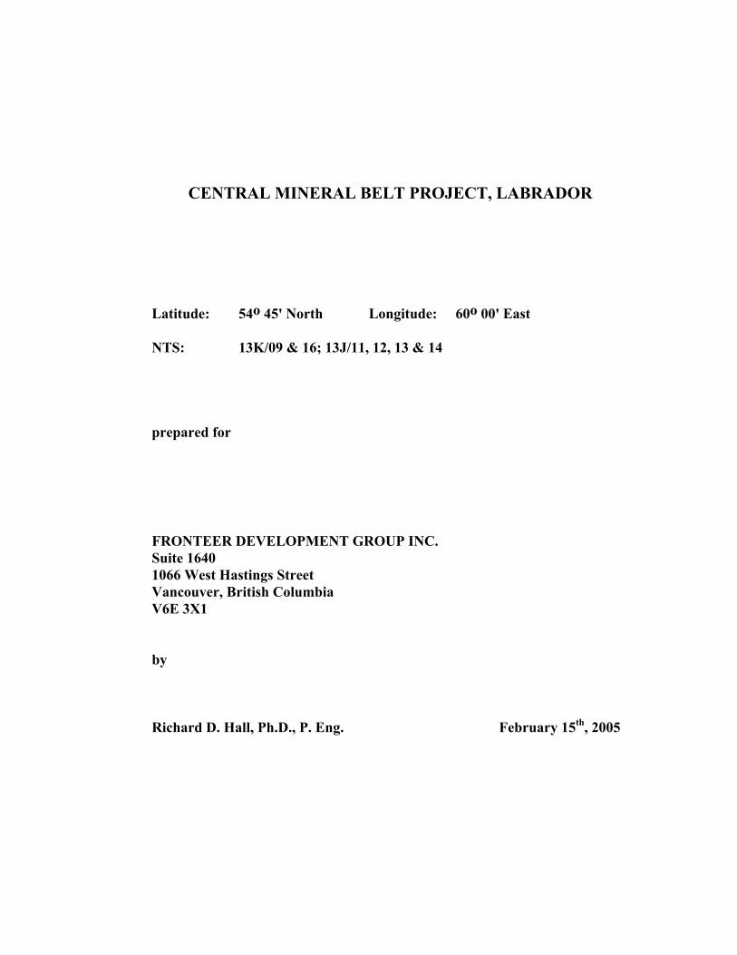
CENTRAL MINERAL BELT PROJECT, LABRADOR
Latitude: 54o 45' North Longitude: 60o 00' East
NTS: 13K/09 & 16; 13J/11, 12, 13 & 14
prepared for
FRONTEER DEVELOPMENT GROUP INC. Suite 1640 1066 West Hastings Street Vancouver, British Columbia V6E 3X1
by
Richard D. Hall, Ph.D., P. Eng. February 15th, 2005
2.0 TABLE OF CONTENTS
Section Title Page
1.0 Title Page 2.0 Table of Contents 3.0 Summary 1 4.0 Introduction and Terms of Reference 3 5.0 Disclaimer 3 6.0 Property Description and Location 3 7.0 Accessibility, Climate, Local Resources, Infrastructure and Physiography 6 8.0 History of the Kitts – Michelin Uranium District 7 9.0 Geological Setting 8 9.1 Regional Geology 9.2 District Geology 10.0 Deposit Types 9 11.0 Mineralisation 13 11.1 Introduction 11.2 Prospects of the Post Hill Group 11.3 Prospects of the Aillik Group 12.0 Exploration by Fronteer Development Group Inc. 1613.0 Surface Diamond Drilling Programs 2214.0 Sampling Method and Approach 22 15.0 Sample Preparation, Analyses and Security 26 16.0 Data Verification 27 17.0 Adjacent Properties 27 18.0 Mineral Processing and Metallurgical Testing 27 19.0 Mineral Resource and Mineral Reserve Estimates 27 20.0 Other Relevant Data and Information 28 21.0 Interpretation and Conclusions 29 22.0 Recommendations 31 23.0 References 32
LIST OF TABLES
PageTable 1 Mineral Tenure Post Hill – Michelin Area, Labrador;
Altius-Fronteer Alliance 4
Table 2 2004 Exploration Highlights Post Hill – Michelin Area, Labrador 22
Table 3 Historical Resource Estimates for Uranium Deposits in the Kitts-Michelin area, Labrador 28
Table 4 Preliminary Budget, 2005Central Mineral Belt Project, Labrador; Altius-Fronteer Alliance 30
LIST OF FIGURES
PageFigure 1 Central Mineral Belt Project - Location Plan 2 Figure 2 Central Mineral Belt Project - Mineral Tenure 5 Figure 3 Regional Geology of Labrador 9 Figure 4 Geology of the Post Hill – Michelin Area 10 Figure 4b Table of Formations 11 Figure 5 Michelin Deposit 17 Figure 6 Melody Hill 18 Figure 7 2004 Airborne U/Th Radiometric Survey 19 Figure 8 Relative Amplitude of Radiometric Anomalies 20 Figure 9 Jacque’s Lake Anomaly 23 Figure 10 Otter Lake U/Th Anomaly 24 Figure 11 Michelin U/Th Anomaly 25
LIST OF APPENDICES
Appendix I Certification form
Central Mineral Belt Project, Labrador by R.D. Hall; February 15, 2005.
3.0 SUMMARY
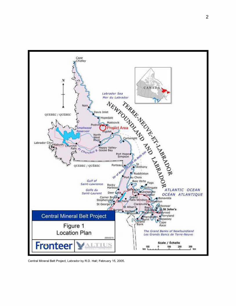
The Central Mineral Belt project of Fronteer Development Group Inc. and Altius Minerals Corporation is located near the coast of Labrador and in proximity to the community of Postville on Kaipokok Bay. Postville is approximately 250 kilometers north by northeast of the community of Happy Valley-Goose Bay, Labrador.
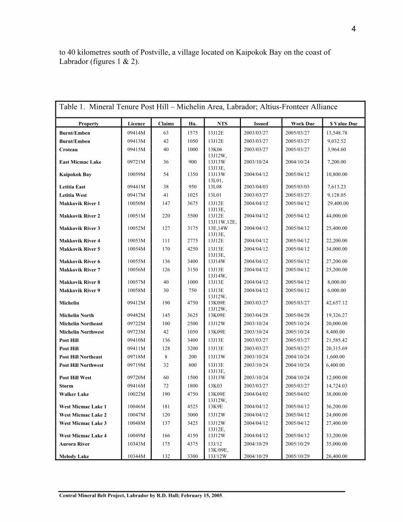
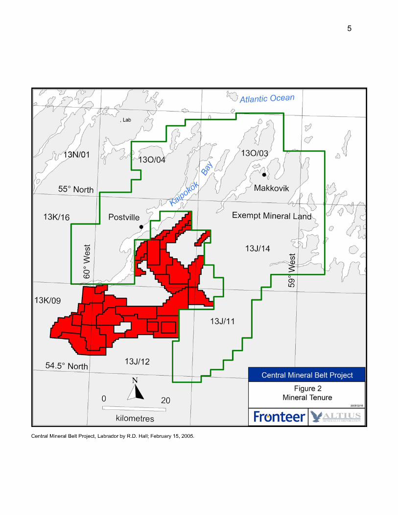
The property consists of 85,875 hectares comprising 3,435 mineral claims in 33 licences acquired during the period 2003 to 2005. Most of the groups of claims are contiguous and cover much of the historical Kitts-Michelin uranium district in the eastern part of the Central Mineral Belt. The property is flanked to the northeast by Exempt Mineral Lands (EML) which includes the communities of Postville and Makkovik as well as the Kitts uranium deposit. Some claims which make up the Croteau, Storm, Letitia East and Letitia West properties are located further west in the central interior of Labrador. At the end of 2004 the Altius-Fronteer Alliance had invested $1.06 million in the Central Mineral Belt Project.
Gneiss of the Paleoproterozoic Post Hill and Aillik groups host approximately forty uranium showings including seven uranium deposits and prospects (Michelin, Kitts, Rainbow, Burnt Lake, Inda, Gear and Nash) with historical resource estimates. The uranium occurrences were discovered by the British Newfoundland Exploration Company Limited (Brinex) and joint venture partners during the early 1950’s to mid 1980’s. Brinex completed a plan to develop the Michelin and Kitts uranium deposits as a combined mining operation but the project was compromised by the collapse in the price of uranium in the early 1980’s.
An airborne magnetometer and gamma ray spectrometer survey flown by Fugro Airborne Surveys Corporation on behalf of the Altius-Fronteer Alliance in 2004 highlighted some very large radiometric anomalies and provided high resolution data useful for reinterpreting the geology and mineralization of the Kitts–Michelin uranium district.
The main exploration potential of the property is the discovery of sources of uranium mineralization in association with large U/Th radiometric anomalies at Jacque’s Lake and Otter Lake neither of which have been previously tested by drilling. The source of high-grade (ranging up to 20.4% U3O8 in sample 3086) uranium mineralization in float at Melody Lake is an intriguing exploration riddle with a potentially significant reward.Interpretation of data in the Michelin area indicates that strata hosting the Michelin and Rainbow deposits are part of the same fold structure with very favourable exploration potential along strike. Good potential also exists for finding additional uranium mineralisation on a deposit scale by step out drilling adjacent to known deposits.
Following evaluation of airborne anomalies in the field during September of 2004, the Post Hill, Jacque’s Lake, Otter Lake–White Bear Lake, Michelin, and Melody Hill areas were identified as project areas with high potential for bulk tonnage uranium mineralization. Discovery of a near surface uranium deposit about 300 metres in
1
2
Central Mineral Belt Project, Labrador by R.D. Hall; February 15, 2005.
diameter and consisting of 10 million tonnes grading 0.3% U3O8 is a rational objective for current mineral tenure. The proposed budget for exploration of project areas in 2005 is five million dollars.
Uranium mineralization observed on the properties is fracture controlled and associated with alteration assemblages found with epigenetic iron-oxide-(Cu, Au) deposits in other Paleoproterozoic terrains.
4.0 INTRODUCTION AND TERMS OF REFERENCE
The purpose of this report is to provide supporting technical documentation for a material change in the affairs of Fronteer Development Group Inc. as disclosed in the Fronteer Development Group Inc. News Release 05-02: Fronteer Announces $10.5 Million Financing, dated January 24, 2005. Some of the proposed financing referred to in this release was based on the perceived potential of mineral tenure in Labrador.
The author is a qualified person but not an independent person with respect to the business activities of Fronteer Development Group Inc. The author is currently employed by Fronteer Development Group Inc. as a project geologist assigned to the Central Mineral Belt Project in Labrador. During September of 2004, the author participated in field work done in Labrador as documented in this report.
5.0 DISCLAIMER
Some of the information presented here is based on historical exploration records of Brinex and others written twenty to fifty years ago. Although these records are an invaluable practical resource for current exploration, some interpretations of some prospects may not reflect best practice as viewed at the present time. All resource estimates of this period are referred to in this report as historical resource estimates regardless of the quality of these estimates.
6.0 PROPERTY DESCRIPTION AND LOCATION
In March 2003, Fronteer Development Group Inc. (FRG-TSX; FRR-FSE; FTDGF-OTC) entered into a 50-50 joint-venture partnership with Altius Minerals Corporation (ALS-TSXV) of St. John’s, Newfoundland to explore for iron oxide-copper-gold mineralisation in the Central Mineral Belt of Labrador. The basis for this alliance was a letter of agreement dated February 5th, 2003 regarding an Area of Interest made up of eighteen 1:50,000 scale, NTS map sheets.
Currently the property consists of 85,875 hectares comprising 3,435 mineral claims in 33 licences (Table 1) acquired during the period 2003 to 2005 and registered in the name of Altius Minerals Corporation. Most of the groups of claims are contiguous and located 5
3
Central Mineral Belt Project, Labrador by R.D. Hall; February 15, 2005.
to 40 kilometres south of Postville, a village located on Kaipokok Bay on the coast of Labrador (figures 1 & 2).
Table 1. Mineral Tenure Post Hill – Michelin Area, Labrador; Altius-Fronteer Alliance
Property Licence Claims Ha. NTS Issued Work Due $ Value Due
Burnt/Emben 09414M 63 1575 13J12E 2003/03/27 2005/03/27 13,548.78 Burnt/Emben 09413M 42 1050 13J12E 2003/03/27 2005/03/27 9,032.52 Croteau 09415M 40 1000 13K06 2003/03/27 2005/03/27 3,964.60
East Micmac Lake 09721M 36 900 13J12W, 13J13W 2003/10/24 2004/10/24 7,200.00
Kaipokok Bay 10059M 54 1350 13J13E, 13J13W 2004/04/12 2005/04/12 10,800.00
Letitia East 09441M 38 950 13L01, 13L08 2003/04/03 2005/03/03 7,613.23
Letitia West 09417M 41 1025 13L01 2003/03/27 2005/03/27 9,128.05 Makkovik River 1 10050M 147 3675 13J12E 2004/04/12 2005/04/12 29,400.00
Makkovik River 2 10051M 220 5500 13J13E, 13J12E 2004/04/12 2005/04/12 44,000.00
Makkovik River 3 10052M 127 3175 13J11W,12E,13E,14W 2004/04/12 2005/04/12 25,400.00
Makkovik River 4 10053M 111 2775 13J13E, 13J12E 2004/04/12 2005/04/12 22,200.00
Makkovik River 5 10054M 170 4250 13J13E 2004/04/12 2005/04/12 34,000.00
Makkovik River 6 10055M 136 3400 13J13E, 13J14W 2004/04/12 2005/04/12 27,200.00
Makkovik River 7 10056M 126 3150 13J13E 2004/04/12 2005/04/12 25,200.00
Makkovik River 8 10057M 40 1000 13J14W, 13J13E 2004/04/12 2005/04/12 8,000.00
Makkovik River 9 10058M 30 750 13J13E 2004/04/12 2005/04/12 6,000.00
Michelin 09412M 190 4750 13J12W, 13K09E 2003/03/27 2005/03/27 42,657.12
Michelin North 09482M 145 3625 13J12W, 13K09E 2003/04/28 2005/04/28 19,326.27
Michelin Northeast 09722M 100 2500 13J12W 2003/10/24 2005/10/24 20,000.00 Michelin Northwest 09723M 42 1050 13K09E 2003/10/24 2005/10/24 8,400.00 Post Hill 09410M 136 3400 13J13E 2003/03/27 2005/03/27 21,585.42 Post Hill 09411M 128 3200 13J13E 2003/03/27 2005/03/27 20,315.69 Post Hill Northeast 09718M 8 200 13J13W 2003/10/24 2004/10/24 1,600.00 Post Hill Northwest 09719M 32 800 13J13E 2003/10/24 2004/10/24 6,400.00
Post Hill West 09720M 60 1500 13J13E, 13J13W 2003/10/24 2004/10/24 12,000.00
Storm 09416M 72 1800 13K03 2003/03/27 2005/03/27 14,724.03 Walker Lake 10022M 190 4750 13K09E 2004/04/02 2005/04/02 38,000.00
West Micmac Lake 1 10046M 181 4525 13J12W, 13K9E 2004/04/12 2005/04/12 36,200.00
West Micmac Lake 2 10047M 120 3000 13J12W 2004/04/12 2005/04/12 24,000.00 West Micmac Lake 3 10048M 137 3425 13J12W 2004/04/12 2005/04/12 27,400.00
West Micmac Lake 4 10049M 166 4150 13J12E, 13J12W 2004/04/12 2005/04/12 33,200.00
Aurora River 10343M 175 4375 13J/12 2004/10/29 2005/10/29 35,000.00
Melody Lake 10344M 132 3300 13K/09E,13J/12W 2004/10/29 2005/10/29 26,400.00
4
5
Central Mineral Belt Project, Labrador by R.D. Hall; February 15, 2005.
Some groups of claims which make up the Croteau, Storm, Letitia East and Letitia West properties are located further west in the Central Mineral Belt and the interior of Labrador. Recently in 2005, application was made to reduce the Storm property to 16 claims.
Groups of mineral claims in the Post Hill - Michelin area are flanked to the north and west by Exempt Mineral Lands (EML) or areas exempted from staking to protect local interests during final negotiation of the Labrador Inuit land claim. Federal ratification legislation for the Labrador Inuit Land Claims Agreement is being prepared for introduction to Parliament in 2005.
Within 6 months of the effective date of enactment, all EML on the Labrador Inuit Settlement Area (LISA) must be extinguished. However, all EML on Labrador Inuit Land (LIL) will remain until a Land Use Plan is completed by the Nunatsiavut government. This process may take up to a maximum of three years but may be addressed sooner by the Nunatsiavut government.
Obligations of mineral tenure for anniversary dates in 2005 are in the amount of $669,895.74. Documentation of 2004 expenditures for the purpose of assessment is due February 22nd, 2005. Deposits on account with the Government of Newfoundland and Labrador and related to mineral tenure listed in Table 1 are $125,079.20.
7.0 ACCESSIBILITY, CLIMATE, LOCAL RESOURCES, INFRASTRUCTURE AND PHYSIOGRAPHY
Labrador has a sub arctic climate with short, cool summers and long, cold winters. The duration of snow cover is six to eight months. The properties are located in rugged wilderness areas of generally moderate relief ranging to about 700 metres.
Locally abundant outcrop, numerous lakes, and sparse coniferous forest cover consisting of black spruce, balsam fir and tamarack are most typical of this part of the northeastern Canadian Shield. Bedrock is exposed as northeasterly trending ridges with intervening marsh. Areas of outcrop are flanked by glacial till, and in turn by minor amounts of glacial outwash in major drainages. Most terrain is covered by sheets of glacial boulders.Extensive areas of burned forest show up as pink coloured areas on landsat images.
Local infrastructure is limited to facilities of the coastal communities of Postville and Makkovik which include commercial airline service from Goose Bay and commercial ferry service from St. John’s, Newfoundland. The community of Postville is a clean and progressive village with rental space suitable for establishing an exploration base.Prudent exploration practice in coastal Labrador includes the use of service contractors who have established partnerships with the Labrador Inuit Association. Following the
6
Central Mineral Belt Project, Labrador by R.D. Hall; February 15, 2005.
experiences of Voisey’s Bay, the people of Labrador have acquired a good understanding of the exploration business.
Helicopter is the most efficient means of access to the properties. Float plane and boat access may also be suitable for certain properties where camps have been established to support major drilling programs. Various snow machines provide for efficient travel during winter.
8.0 HISTORY OF THE KITTS-MICHELIN DISTRICT
British Newfoundland Exploration Limited (Brinex), a subsidiary of British Newfoundland Corporation Limited (Brinco), obtained an exploration lease in the Makkovik-Kaipokok Bay area in 1955 following location of encouraging signs of copper, molybdenum and uranium mineralization by prospectors. The first significant uranium showing was found by Walter Kitts in 1956. A program of drilling and underground development by means of adit was started on the Kitts deposit in 1957. However, the project was suspended in 1958 as development was too late to qualify for supply contracts with the Atomic Energy Commission of Canada.
No further exploration was carried out until 1966 when Brinex and Metallgesellschaft A.G. made a joint venture agreement on part A of the lease area containing the Kitts deposit. Metallgesellschaft A.G. subsequently transferred its interest to Urangesellshaft Canada Limited. Exploration under this agreement resulted in the discovery of the Michelin deposit by prospector Leslie Michelin in 1968 as well as the Gear, Inda and Nash prospects between 1968 and 1969. All of these were made by ground follow-up of radioactivity detected by airborne gamma-ray spectrometer surveys flown by Barringer Research in 1967. A summary report on the geology and reserves of prospects in the Kitts-Michelin area was completed on behalf of Brinex by Derry, Michener and Booth Consultants Ltd. (Booth, Leigh and Archer, 1979).
Additional joint venture agreements were made with Urangesellshaft Canada Limited to included part B of a Statutory Agreement obtained by Brinex in 1970. In addition to property scale exploration of the Kitts and Michelin deposits, extensive exploration of other radiometric anomalies was carried out during the 1970’s. A good summary of the uranium prospects worked by Brinex in the Kitts-Michelin area was done by A.J. Willy (1983). Some of these prospects are discussed in Section 11.0 Mineralisation.
Brinex completed a plan to develop the Michelin and Kitts uranium deposits as a combined mining operation but the project was compromised by the collapse in the price of uranium in the early 1980’s. Brinex ceded rights to area B in 1980 and to area A in 1985. Some remediation of the Kitts and Michelin mine sites has been completed.
7
Central Mineral Belt Project, Labrador by R.D. Hall; February 15, 2005.
9.0 GEOLOGICAL SETTING
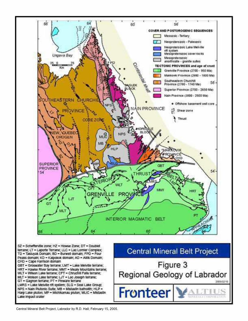
9.1 Regional Geology The Central Mineral Belt (CMB) refers to an area of Archean to Mesoproterozoic crust which is located in Eastern Labrador and is part of the northeastern Laurentian Shield.The CMB forms part of the Nain, Makkovik and Churchill tectonic provinces and has been overprinted in the south by the Exterior Thrust Belt of the Grenville Province (Figure 3). The CMB comprises a series of six Proterozoic supracrustal sequences, intrusive suites of various ages and adjacent Archean rocks. These rocks record to varying degree events associated with Makkovikian (~ 1.8 Ga), Labradorian (~ 1.6 Ga) and Grenvillian (~ 0.1 Ga) deformation. Mineral tenure of present interest is located within the Aillik domain of the Makkovik Province. The Makkovikian orogen is correlated with Ketilidian, Penokean and Svecofennian orogens which formed part of a Paleoproterozoic active margin along the southern margin of Laurentia-Baltica (Gower et. al., 1990).
9.2 District Geology The Makkovik Province consists of the Kaipokok, Aillik and Cape Harrison tectonic domains. The Kaipokok shear zone which defines the boundary between the Kaipokok and Aillik domains also marks the southern limit of Archean crust in the Makkovik Province. The Cape Harrison domain has been interpreted as a magmatic arc developed near the Makkovikian continental margin.
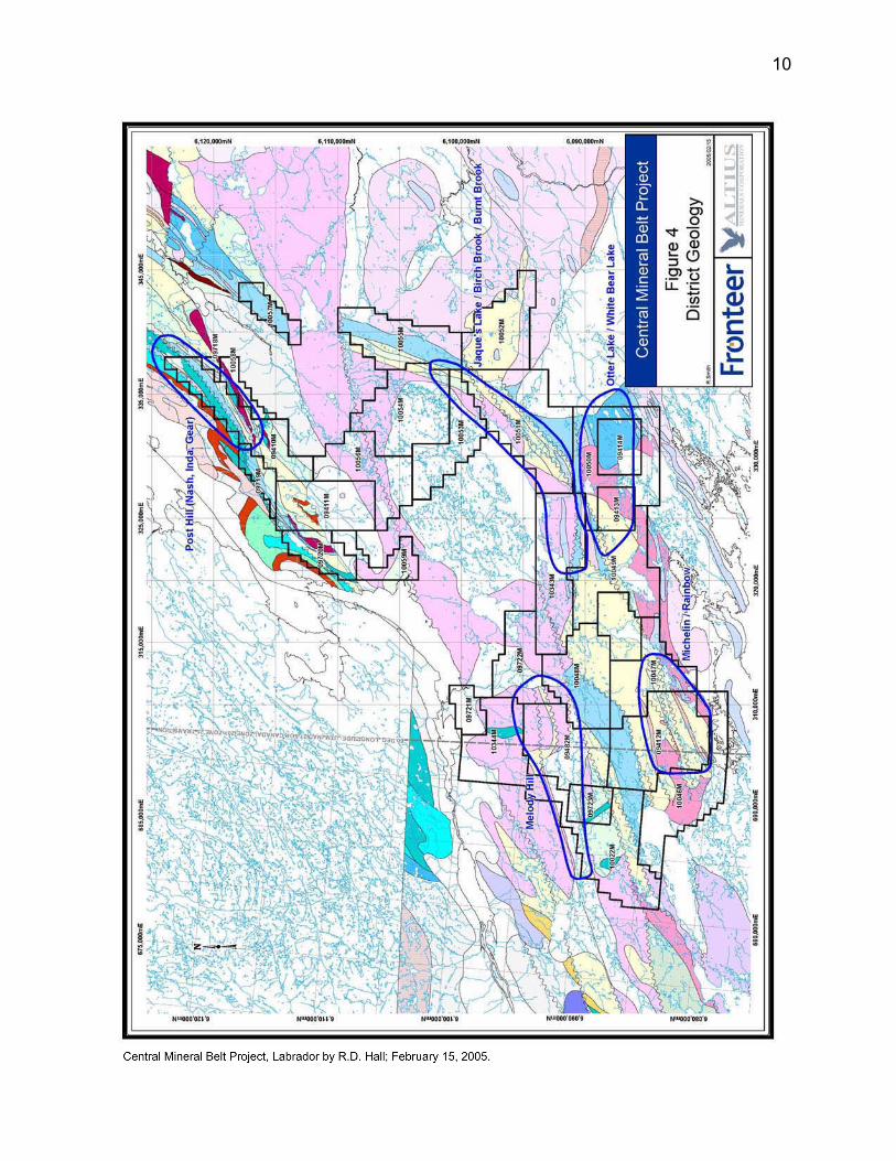
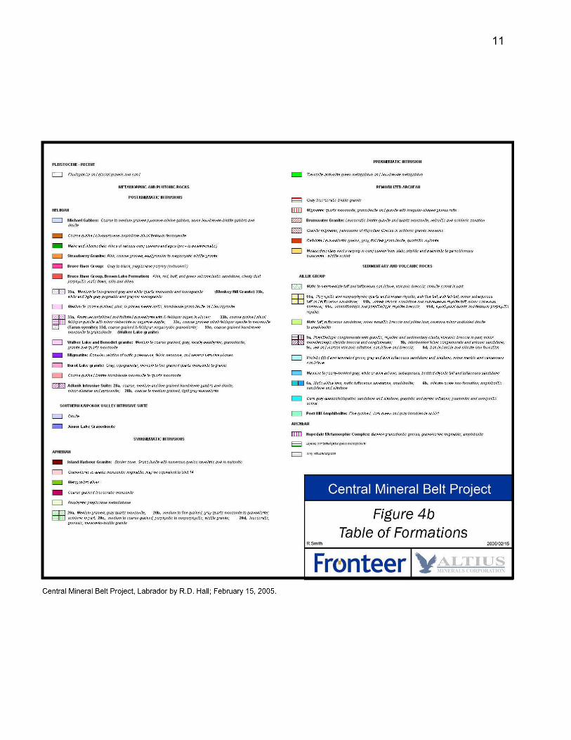
The Aillik domain is underlain by strata of the Paleoproterozoic Post Hill (2178-2013 Ma) and Aillik (1860-1810 Ma) groups as well as extensive granitoid terrain comprised of several intrusive suites including 1815-1790 Ma syntectonic and post tectonic Makkovikian plutons, 1740-1700 Ma post tectonic, A-type plutons and 1650 Ma plutons of the Trans-Labrador batholith (Figure 4). Deformation, amphibolite facies regional metamorphism, regional metasomatism and uraniferous mineralization of the Post Hill and Aillik groups have been attributed to Makkovikian Orogeny (1.9 to 1.7 Ga). The stratigraphy of the Post Hill and Aillik groups and the distribution of intrusive suites within the Aillik domain are not well defined. A number of uranium occurrences are located along the Nakit Slide (a strand of the Kaipokok shear zone) which is a tectonic contact between lithologies of the Post Hill Group to the northwest and the Aillik Group to the southeast.
The Post Hill Group consists of abut 2700 metres of metamorphosed siliceous clastic metasedimentary strata and mafic metavolcanic rocks found in tectonic contact with Archean gneiss. The Post Hill Group occurs as highly strained, amphibolite and gneiss in thrust sheets near Kaipokok Bay. A rifted, continental margin setting has been interpreted for deposition of the Post Hill Group.
The Aillik Group is made up of about 5000 metres of metasedimentary rocks, bimodal metavolcanic rocks, subvolcanic intrusives and diabase dykes (Bailey, 1979). A lower dominantly metasedimentary section and upper dominantly fragmental, felsic volcanic
8
10
11
Central Mineral Belt Project, Labrador by R.D. Hall; February 15, 2005.
section have been recognised. Deposition in back-arc basin and in a shallow marine to subaerial environment has been inferred for the Aillik Group (Ketchum et al., 2002). The Aillik Group is noted as a host for numerous and varied Cu, Pb, Zn, Mo, and U occurrences. Within the project area, rocks of the Aillik Group are commonly represented by laminated magnetite-feldspar-quartz gneiss.
10.0 DEPOSIT TYPES
Uranium mineralization hosted by lithologies of the Post Hill Group has been referred to as epigenetic by early workers while that within the Aillik Group has been called volcanic-hosted, stratabound and possibly syngenetic in origin (Gower et al., 1982; Gandhi, 1986). Pb-Pb ages in the range 1895 to 1697 Ma for uranium mineralization in the Post Hill Group (2178-2013 Ma) support an epigenetic origin for these occurrences (Wilton, 1966). An epigenetic emplacement of the uranium mineralization within the Aillik Group is also indicated by uraniferous fracture filling and breccias.
Extensive areas of hematite + albite and quartz + epidote + actinolite + chlorite alteration in the Kitts - Michelin area are similar to alteration assemblages developed in iron-oxide-copper-gold (IOCG) districts of Paleoproterozoic age (Hitzman et al., 1992; Haynes, 2000). In some of these districts a peripheral enrichment in uranium has been exploited as an exploration tool to locate copper-gold mineralization. Consequently, fracture controlled uraninite + magnetite mineralization found in the Kitts - Michelin area may represent part of a uranium-rich end member of the iron-oxide class of epigenetic deposits.
The Olympic Dam IOCG deposit is:
• The largest uranium deposit in the world with a – measured resource of 650 M tonnes of 500g/T U3O8 (approx. 425 ppm
U), 1.5% Cu, 0.5 g/T Au and– total resource of 3.8 B tonnes of 400 g/T U3O8 (approx 339 ppm U), 1.1%
Cu, 0.5 g/T Au).
• The lowest cost, major uranium producer in the world.
In Greenland, the Kvanefjeld uranium deposit (56 million tonnes of 0.043 wt% U3O8)occurs in the Ketelidian Batholith Zone which is broadly correlated with the Cape Harrison domains of the Makkovik Province in Labrador. The deposit is associated with the differentiated Ilimaussaq peralkaline intrusive complex of Mesoproterozoic age.
12
Central Mineral Belt Project, Labrador by R.D. Hall; February 15, 2005.
11.0 MINERALISATION
11.1 Introduction The Central Mineral Belt of Labrador is one of the more prolific areas of uranium mineralization in Eastern Canada. Approximately 100 metal occurrences are known in the neighbourhood of mineral tenure held by the Altius-Fronteer Alliance within 1:50,000 scale NTS map sheets 13J/11-14 and 13K/09 & 16. About 70% of these are called uranium occurrences and about 20% are called copper occurrences, although most of the copper occurrences are associated with uranium mineralization (see Geological Survey of Newfoundland and Labrador Mineral Occurrence Data Base; MODS).
Radioactivity is associated with hydrothermal breccias marked by well oxidised wall rocks and dark hornblende-rich fracture filling. Commonly radioactivity is proportional to the amount of dark coloured matrix component but in some cases salmon-red, crackle brecciated lithologies are also highly radioactive. The matrix of radioactive breccia includes the assemblage:
hornblende + sphene + calcite (grey or pink) + magnetite ± biotite, garnet, (Fe, Cu, Pb, Zn, Mo)-sulphides, fluorite, uraninite
Selvages and halos of iron oxide are frequently developed whereas malachite and uranophane staining occur more locally. Net-vein, folded and segmented fabrics are observed in radioactive breccias. Locally, initial fracturing preceded the formation of a late subvertical cleavage and breccias were rotated into the plane of this cleavage to produce thinly banded gneiss with discontinuous mafic layers.
11.2 Uranium Prospects of the Post Hill GroupKittsThe Kitts deposit (Beaven, 1958) is located in the EML and is not part of mineral tenure held by the Altius-Fronteer Alliance. The deposit is associated with a U/Th radiometric anomaly about 0.8 kilometres in diameter although this is probably due in part to surface disturbance. The Kitts deposit is and aggregate of several discontinuous, en echelon zones along a strike length of 400 metres. The deepest intercept is in the B-Central zone approximately 160 metres below surface. The mineralization is associated with black, carbonaceous argillite interbedded with greywacke and garnetiferous tuffs (Booth et. al., 1979). Strata strike 320º and dip northeast. Gabbro occurs in the footwall and pillowed basalt forms the hanging to the mineralised section. Historical resource estimates for the Kitts deposit are based on intercepts from 94 surface drill holes totalling 9,313 metres of drilling, data from 974 metres of underground development and data from 1,598 metres (124 holes) of underground drilling (Booth et al., 1979).
GearUranium mineralization discovered at Gear Lake in 1968 is associated with a spherical U/Th radiometric anomaly 0.35 kilometres in diameter. The mineralization occurs within sheared metasedimentary rocks for a strike length of 120 metres. An average grade of
13
Central Mineral Belt Project, Labrador by R.D. Hall; February 15, 2005.
0.165% U3O8 was obtained for one zone of mineralization 30 metres long by 4.9 metres wide as outlined to a depth of 70 metres in 23 diamond drill holes.
IndaUranium mineralization discovered at Inda Lake in 1968 is associated with a prominent spherical U/Th radiometric anomaly 0.35 kilometres in diameter. The mineralization occurs on the upper, southeastern limb of a northeasterly trending anticline which is overturned to the northwest. The mineralization occurs as a footwall lens and three hanging wall lenses along a strike length of 1.1 kilometres between Inda and Knife lakes. The 1976 historical resource estimate for the Inda Lake deposit was based on results from 23 holes. Seventy five percent of the tonnage was in the main or footwall wall lens as defined over an average width of 2.44 metres and strike length of 640 metres. The grade of mineralization attributable to tonnage in the hanging wall lenses was 0.19% U3O8.
NashUranium mineralization discovered at Nash Lake in 1967 is associated with an oval-shaped U/Th radiometric anomaly 0.7 by 0.3 kilometres in diameter. Drilling during the late 1960’s located three zones of mineralization within a shear zone called the Naskit Slide. The1970 historical resource estimate for the main zone was for defined over a strike length of 365 metres and vertical extent of 140 metres. A dip of 60 degrees east and average width of 1.85 metres were reported for the zone. Some potential for resource development may exist in the east and west extension zones. For example diamond drill hole NW77-6 in the west extension zone hit 0.072% U3O8 over 3.4 metres from 13.4 to 16.8 metres.
11.3 Uranium Prospects of the Aillik Group McLeanThe McLean occurrence near Jacques Lake was found in 1956 by prospector J. McLean as described by E. R. Morrison (1957) on behalf of Brinex. Mineralisation occurs in felsic and intermediate gneiss of the Aillik Group. In 1967, four trenches were cut along a strike length of 165 metres on the side hill at an elevation of about 235 metres. Results of sampling of these trenches included 0.06% U3O8 across 0.9 metres from trench #2 and 0.04% U3O8 across 2.1 metres from trench #3. Working on behalf of the Urangellschaft/Brinex Joint Venture in 1978, prospector A. Andrews identified a dispersal train of twelve radioactive boulders with an average content of 0.32% U3O8 nearthe base of the ridge (McClintock, 1978). Exploration in 1980 was focussed on this low ground.
Burnt BrookUranium mineralization in the Burnt Brook area south of Jacque’s Lake was discovered by L. Michelin in 1979. About 110 metres of trenching in 14 trenches were documented. The North, South and Dianne zones are hosted by folded metasedimentary and metavolcanic rocks of the Aillik Group. 1980 results included 0.069% U3O8 over 6 metres in trench #1 on a zone of intermittent radioactivity 125 metres in length and 75 metres in width, as constrained by trenching, named the North zone. A result of 0.155%
14
Central Mineral Belt Project, Labrador by R.D. Hall; February 15, 2005.
U3O8 over 4.8 metres was obtained from metapelite in trench #5 on the South zone of intermittent radioactivity defined by four trenches along a strike length of 250 metres.
EmbenSeveral occurrences of uranium mineralization with significant base metal and silver values have been documented within the Aillik Group on the east side of the Burnt granite intrusive since the initial discoveries in 1969. One selective grab sample in 1969 from a radioactive boulder assayed 8.49% U3O8. Encouraging results by Brinex in 1981 included 0.423% U3O8 over 3.0 metres in trench #5 across a zone 100 metres in strike length called the Emben south zone.
Burnt LakeThe south and north Burnt Lake showings were discovered in 1956 and 1967, respectively. Mineralisation occurs intermittently over a strike length of three kilometres within felsic metavolcanic rocks of the Aillik Group on the north side of the Burnt Lake granite intrusive. Historical trenching and drilling of the Burnt Lake North occurrence in 1977 located a small amount of near surface uranium mineralization grading about 0.08% U3O8.
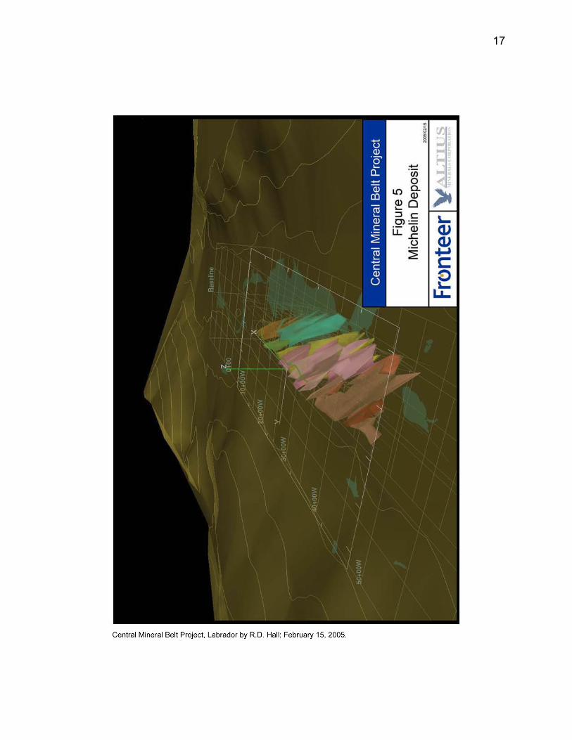
MichelinThe deposit is associated with a U/Th radiometric anomaly about 900 by 500 metres in size although this is includes the effects of surface disturbance. This zone of radioactivity is associated with quartz gneiss of the Aillik Group and flanked by intrusive phases of the 1650 Ma Burnt Lake granite. Historical resources estimates for the Michelin deposit are based on intercepts from 159 surface drill holes totaling 25,014 metres of drilling, data from 662 metres of underground development and data from 1,774 metres (56 holes) of underground drilling (Booth et al., 1979). The deepest drill intersection was in the B-Central zone approximately 160 metres below surface. The Michelin deposit consists of several sub-parallel groups of mineralised zones along a strike length of 1200 metres (Figure 5). Host rocks are feldspar-quartz gneiss which varies in texture from non-porphyritic to coarsely porphyritic with feldspar. Strata strikes 060º and dips about 55º southeast. The bulk of the mineralization is hosted by coarsely feldspar porphyritic quartz-gneiss.
RainbowThe Rainbow zone of mineralization occurs as a stratiform lens within feldspathic tuff and tuff breccia of the Aillik Group. Mineralisation with an average grade of 0.15%o U3O8 occurs over a strike length of 290 metres and widths up to 15 metres. The main lens as inferred by drilling was 140 metres long by 2 to 15 metres wide by 79 metres deep.
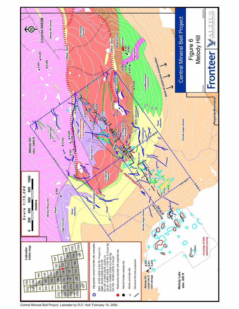
Melody HillA northeasterly trending zone of weak radioactivity, eight by one kilometres in size, straddles Melody Lake. This is associated with a dispersal train of radioactive boulders on the southern slope of Melody Hill about 1.4 kilometres northeast of Melody Lake. Historical results for one mineralized dispersal train included 10 granitoid boulders
15
Central Mineral Belt Project, Labrador by R.D. Hall; February 15, 2005.
containing with 2.25 to 18.08 wt. % U3O8 distributed along a strike length of 1.2 kilometres. Anomalous uranium content in excess of 100 ppm in lake sediments and an intercept of 0.14% U3O8 from 26.0 to 32.0 metres in drill hole 80-44 (235°/-55°) on the shoreline suggest a possible source area below Melody Lake (Figure 6).
12.0 EXPLORATION BY FRONTEER DEVELOPMENT GROUP INC.
The Altius-Fronteer Alliance carried out field work in the project area during August of 2003 and in September of 2004 following completion of an airborne geophysical survey. By the end of 2004, approximately $1.06 million had been invested in the project.
During 2003, Fronteer and Altius evaluated the potential for iron oxide-copper-gold mineralization in the eastern part of the Central Mineral Belt. This evaluation primarily included examination and sampling of historical metal occurrences on and adjacent to mineral tenure. On the basis of widespread hematite alteration and chlorite + epidote + actinolite alteration, additional mineral tenure required to blanket the Aillik and Post Hill groups was acquired.
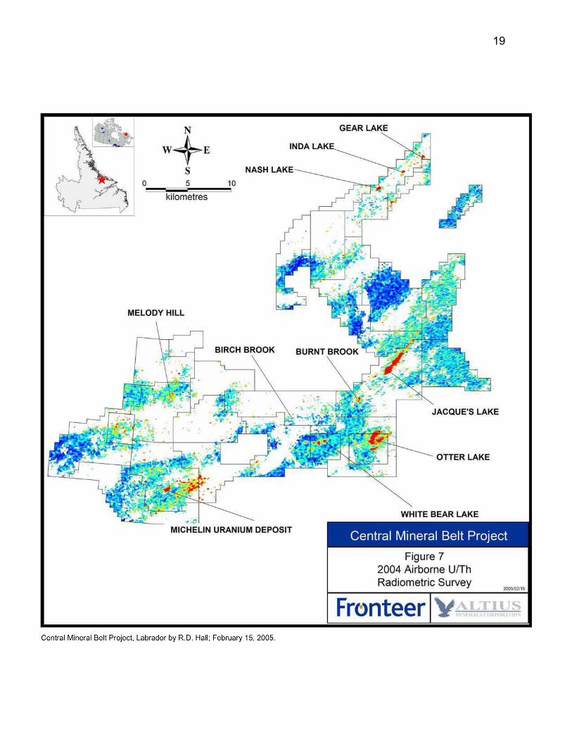
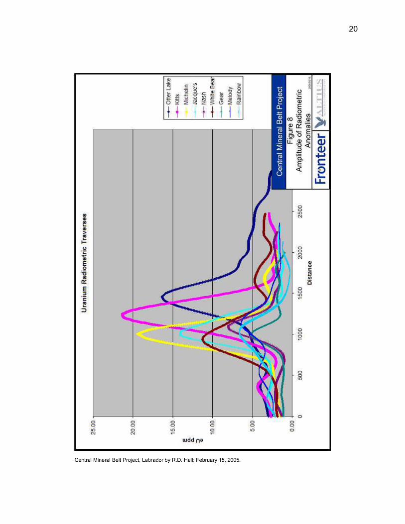
A 12,800 line-kilometre airborne magnetometer and gamma-ray spectrometer survey was completed by Fugro Airborne Surveys Corporation on behalf of the Alliance during the summer of 2004. The block of ground surveyed was approximately 70 by 20 kilometres in size and covered the entire Kitts-Michelin uranium district. Fixed wing and helicopter components to the survey were flown on a line spacing of 200 metres. Anomalies generated by the survey (figures 7 & 8) were prospected, evaluated and ranked in the field during September. The Post Hill, Jacque’s Lake, Otter Lake–White Bear Lake, Michelin, and Melody Hill areas were identified as project areas with potential for bulk tonnage uranium mineralization.
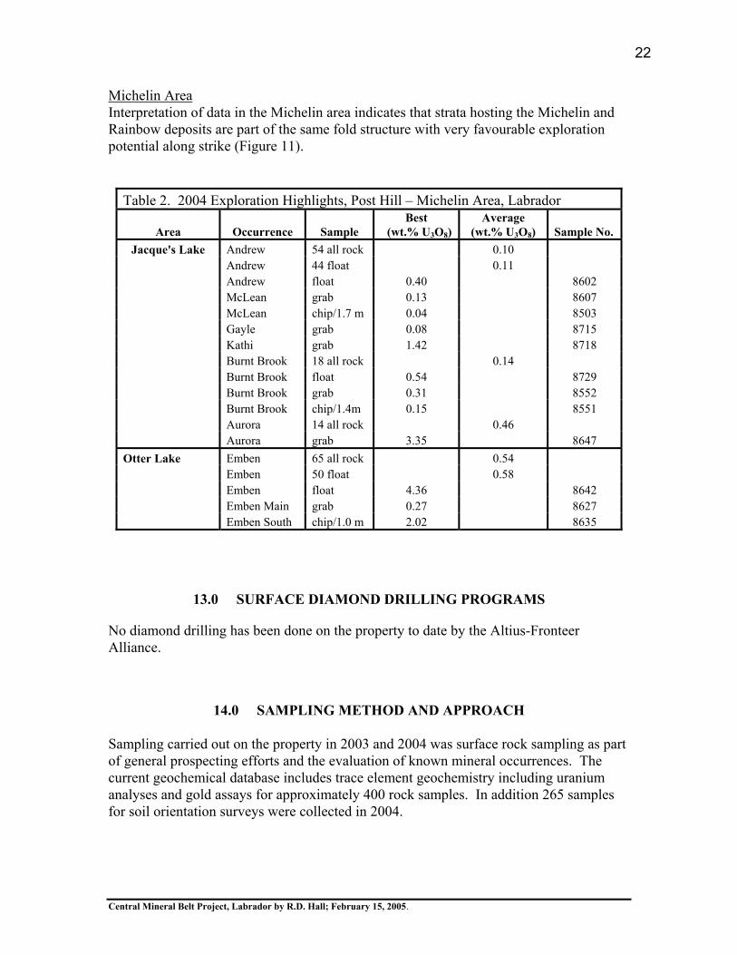
Field work carried out in 2004 confirmed widespread surface uranium mineralization, in association with radiometric anomalies identified from the airborne survey. A total of 350 rock samples were collected in 2004 and provide an initial geochemical database for studying the mineralization. Uranium content in rocks is best correlated with lead content which is presumably radiogenic in origin. Results for areas worked in 2004 are shown in Table 2 and summarized below.
16
17
19
20
Central Mineral Belt Project, Labrador by R.D. Hall; February 15, 2005.
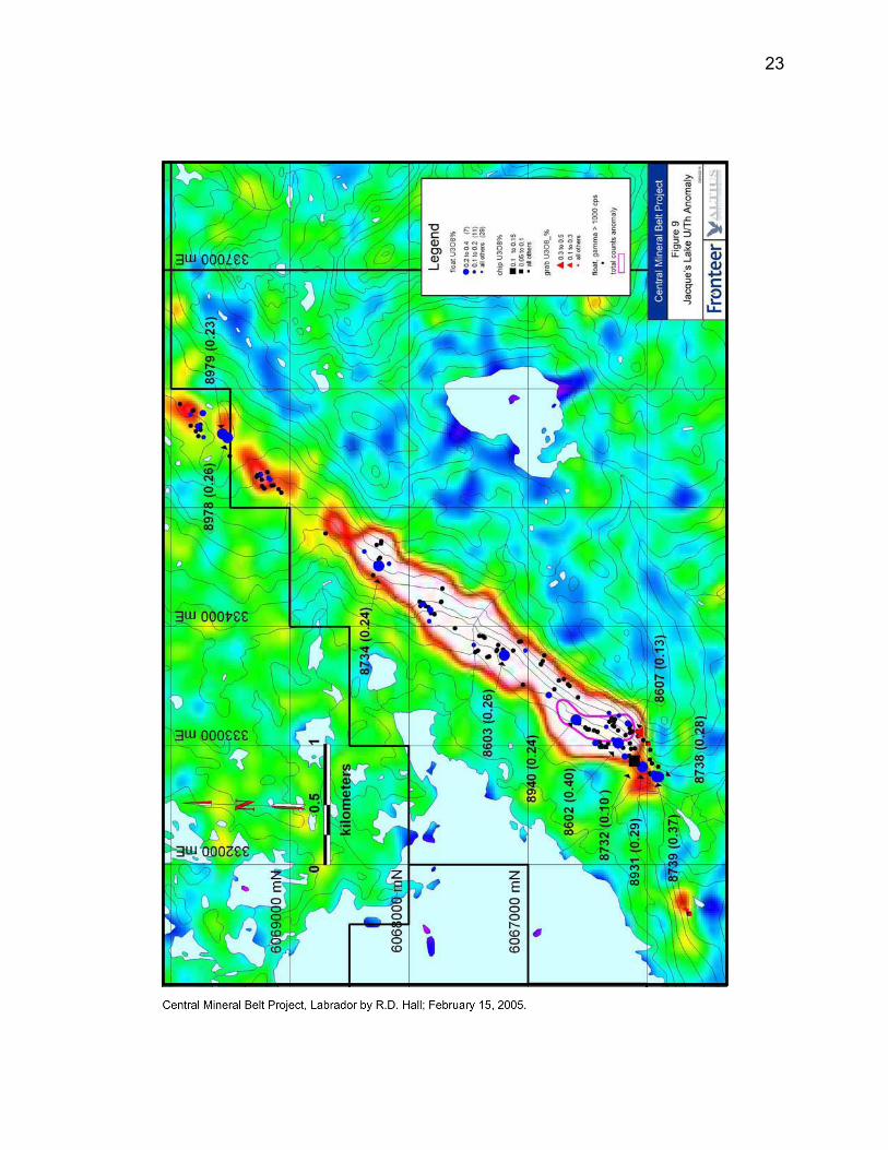
Jacque’s LakeA strong, finger-shaped airborne U/Th radiometric anomaly approximately 500 metres in width and trending northeasterly for a distance of three kilometres was outlined at the east end of Jacque’s Lake (Figure 9).
a dispersal train of 170 boulders with radioactivity in the range 1000 to 15,000 counts per second was mapped along a strike length of five kilometres 0.11% U3O8 was the average grade of 44 radioactive boulders sampled a result of 0.039 % U3O8 across 1.7 metres (sample 8503) was the best result of 4 chip samples from historical trenches 0.133% U3O8 (sample 8607) was the best result of 5 grab samples of mineralization in bedrock0.40% U3O8 from a sample of float was the maximum value returned
Burnt BrookA U/Th radiometric anomaly 500 metres in diameter is located at Burnt Brook approximately 4.5 kilometres southwest of the Jacque’s Lake anomaly.
a grab sample result of 0.308 % U3O8 (sample 8552) for mineralization in outcrop was obtained in the southern part of the anomaly in association with results including 0.542 % U3O8 (sample 8729) in float 0.154 % U3O8 over 1.4 metres (sample 8511) was the best result obtained out of 11 chip samples in historical trenches located in the northern part of the anomaly although uranium results for a 75 sample soil geochemical orientation survey were flat, contours of lead and copper content in soils follow zones of radioactivity.
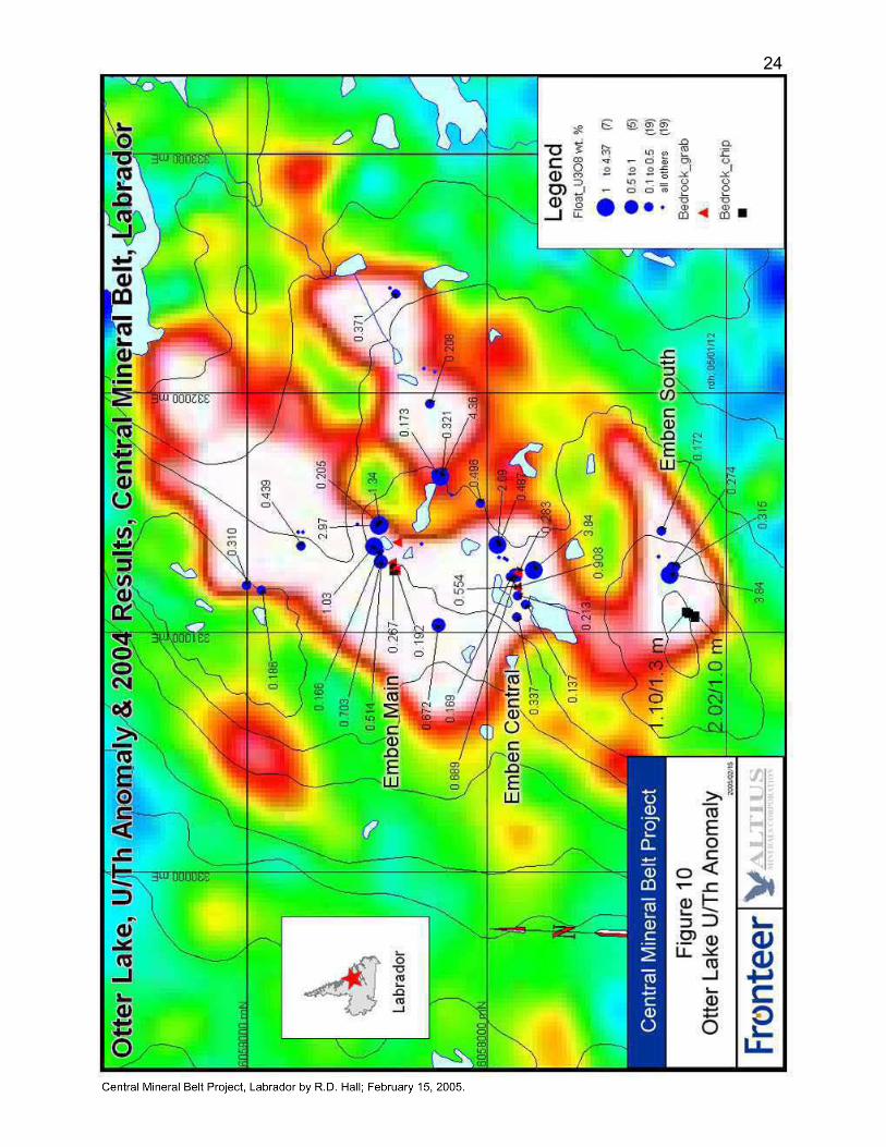
Otter LakeA strong, ovoid-shaped U/Th radiometric anomaly two kilometers in diameter was outlined southwest of Otter Lake (Figure 10).
an average grade of 0.58 % U3O8 was obtained for 50 boulders sampled from dispersal trains of radioactive boulders a result of 2.02 % U3O8 over 1.0 metre (sample 8635) from the Emben South zone was the best result of 8 chip samples of mineralization in outcrop results for 14 grab samples of mineralization in outcrop and subcrop included 0.91 % U3O8 (sample 8631) in the Emben Main zone
White Bear LakeA strong, easterly trending U/Th radiometric anomaly approximately 2.0 by 0.5 kilometres in size was located north of White Bear Lake. Discoveries of uranium mineralization were made in this area in 1956 and 1976.
0.20 % U3O8 was obtained in a grab sample (8582) from a trench on the Burnt Lake South zone0.19 % U3O8 was obtained in a grab sample (6237) from the Burnt Lake North zone
21
Central Mineral Belt Project, Labrador by R.D. Hall; February 15, 2005.
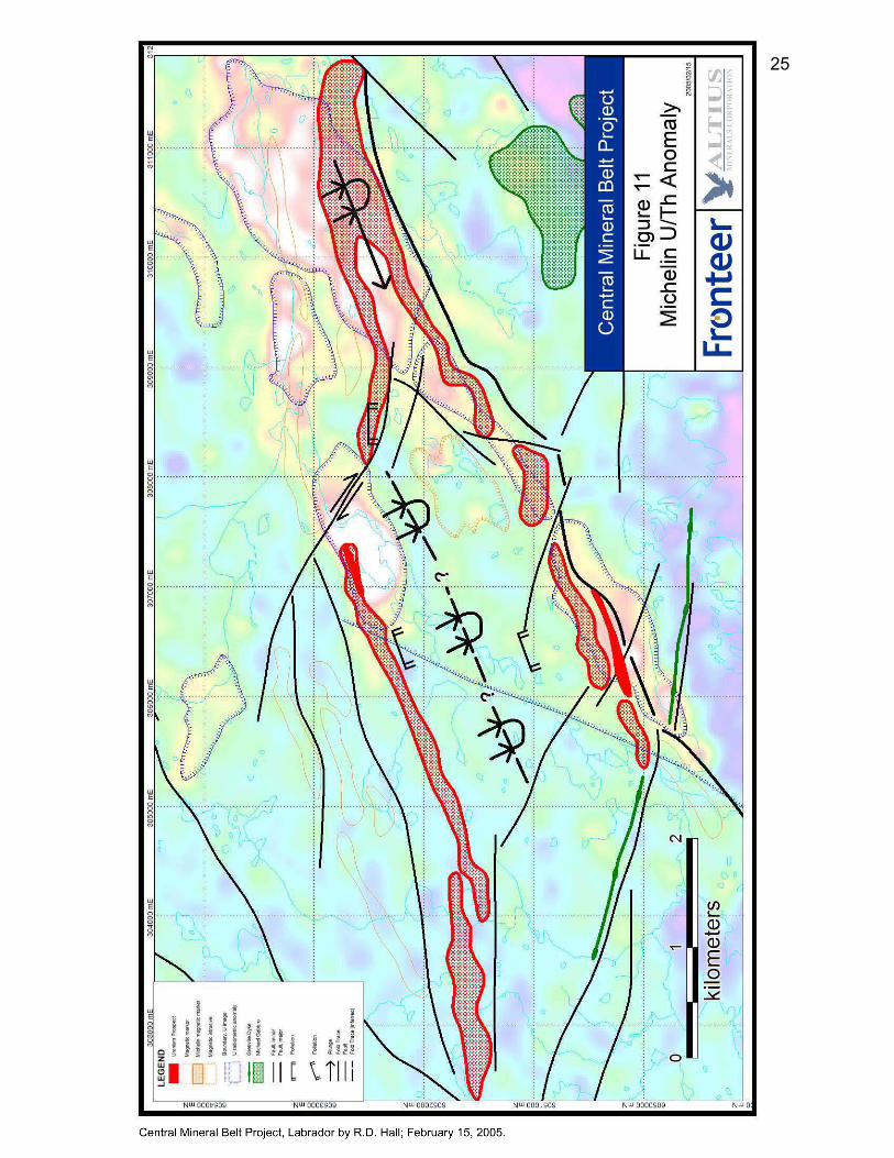
Michelin AreaInterpretation of data in the Michelin area indicates that strata hosting the Michelin and Rainbow deposits are part of the same fold structure with very favourable exploration potential along strike (Figure 11).
Table 2. 2004 Exploration Highlights, Post Hill – Michelin Area, Labrador
Area Occurrence Sample Best
(wt.% U3O8)Average
(wt.% U3O8) Sample No. Jacque's Lake Andrew 54 all rock 0.10
Andrew 44 float 0.11 Andrew float 0.40 8602 McLean grab 0.13 8607 McLean chip/1.7 m 0.04 8503 Gayle grab 0.08 8715 Kathi grab 1.42 8718 Burnt Brook 18 all rock 0.14 Burnt Brook float 0.54 8729 Burnt Brook grab 0.31 8552 Burnt Brook chip/1.4m 0.15 8551 Aurora 14 all rock 0.46 Aurora grab 3.35 8647 Otter Lake Emben 65 all rock 0.54 Emben 50 float 0.58 Emben float 4.36 8642 Emben Main grab 0.27 8627 Emben South chip/1.0 m 2.02 8635
13.0 SURFACE DIAMOND DRILLING PROGRAMS
No diamond drilling has been done on the property to date by the Altius-Fronteer Alliance.
14.0 SAMPLING METHOD AND APPROACH
Sampling carried out on the property in 2003 and 2004 was surface rock sampling as part of general prospecting efforts and the evaluation of known mineral occurrences. The current geochemical database includes trace element geochemistry including uranium analyses and gold assays for approximately 400 rock samples. In addition 265 samples for soil orientation surveys were collected in 2004.
22
23
24
25
Central Mineral Belt Project, Labrador by R.D. Hall; February 15, 2005.
Rock samples include selective grab samples of radioactive material, composite chip samples of radioactive boulders and continuous chip samples across measured intervals of radioactivity. The magnetic susceptibility and radioactivity (measured using scintillometer and gamma-ray spectrometer) of rock samples were measured prior to shipping. Samples with measured radioactivity greater than 1000 cps were separated to provide for alternative shipping arrangements.
Soil samples at 25 metre stations were collected below the till using an auger and collected in craft paper bags for drying and subsequent shipment to the laboratory. Sample stations were located using a gps.
15.0 SAMPLE PREPARATION, ANALYSES AND SECURITY
Sample preparation of rock samples with measured sample radioactivity less than 1000 cps was done by Eastern Analytical Limited of Springdale, Newfoundland. Eastern Analytical Limited assayed samples for gold using the conventional fire assay method with an atomic absorption finish (FA-AA) on one assay ton pulps. Eastern Analytical Limited forwarded pulps of rock samples to ALS Chemex in Vancouver, British Columbia for multi-element analyses as discussed below.
Rock samples with measured sample radioactivity less than 1000 cps were analysed by the ICPEAS method (inductively coupled plasma with atomic emission spectroscopy) by ALS Chemex in Vancouver. TheME-ICP41 analytical package of 34 elements based on an aqua regia digestion of a 0.5 gram, >85%, minus 200 mesh pulp was completed. Using this method, digestion of the elements Al, B, Ba, Be, Ca, Cr, Ga, K, La, Mg, Na, Sc, Sr, Ti, Tl and W were partial and therefore the reported content for these can be qualitative.
Multi-element analyses for about 10% of the rock samples, all with measured sample radioactivity greater than 1000 cps, was completed by SRC Geoanalytical Laboratories in Saskatoon, Saskatchewan. This work included standard FA-ICP assay for Au, Pt and Pd using 30 gram pulps; 17 element analyses of partially digested 0.5 gram pulps (ICP6.3R partial digestion method) and 46 element analyses of totally digested 0.125 gram pulps (ICP6.3 total digestion method). Due to partial digestion of samples, the results for the elements As, Bi, Ge, Hg, Sb, Se and Te are qualitative.
Soil samples were analysed by the ICPEAS method (inductively coupled plasma with atomic emission spectroscopy) by ALS Chemex in Vancouver. The ME-ICP41 analytical package of 34 elements was completed on 0.5 gram, -80 mesh pulps. As noted above, the reported content of Al, B, Ba, Be, Ca, Cr, Ga, K, La, Mg, Na, Sc, Sr, Ti, Tl and W can be qualitative.
Rejects for most of the rock samples collected during 2004 are in storage in Newfoundland. Rejects for 36 rock samples are in storage at SRC Geoanalytical
26
Central Mineral Belt Project, Labrador by R.D. Hall; February 15, 2005.
Laboratories in Saskatoon. Pulps are in storage at the location of respective laboratories.ALS Chemex has achieved ISO9001:2000 registration. SRC Analytical Laboratories has achieved ISO/IEC 17025 accreditation and is certified and accredited by both the Canadian Association for Environmental Analytical Laboratories (CAEAL) and the Standards Council of Canada (SCC). Eastern Analytical Limited is a competent laboratory which is not registered with a standards association.
16.0 DATA VERIFICATION
Private standards were submitted with surface samples collected during 2003 and 2004. Results of check analyses for 25 rock samples from the 2004 program submitted to both SRC Geoanalytical Laboratories and ALS Chemex are unavailable at the present time.
17.0 ADJACENT PROPERTIES
No information concerning adjacent properties is presented in this report.
18.0 MINERAL PROCESSING AND METALLURGICAL TESTING
Application of the conventional acid leach-solvent extraction process for uranium to produce yellowcake was part of the mining proposal for the Kitts-Michelin deposits made by Brinex in the late 1970’s. Recoveries of 95% or better were indicated for sulphuric acid leach tests done on 65-75%, minus 200 mesh material for a duration of 48 hours at a pH of 1.5 (Lakefield Research, 1976).
19.0 MINERAL RESOURCE AND MINERAL RESERVE ESTIMATES
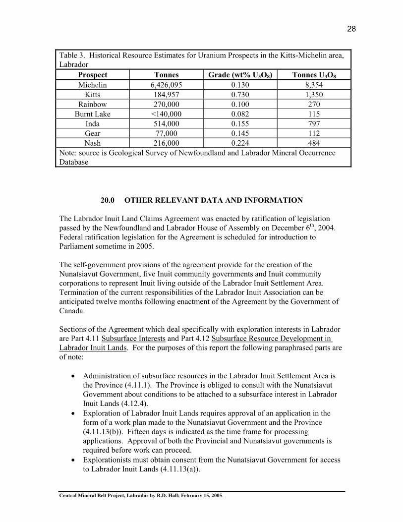
Calculations of mineral resources are not presented as part of this report. However, historical resource estimates for prospects in the Kitts-Michelin area of the Central Mineral Belt as documented in the Geological Survey Mineral Occurrence Database are shown in Table 3.
27
Central Mineral Belt Project, Labrador by R.D. Hall; February 15, 2005.
20.0 OTHER RELEVANT DATA AND INFORMATION
The Labrador Inuit Land Claims Agreement was enacted by ratification of legislation passed by the Newfoundland and Labrador House of Assembly on December 6th, 2004.Federal ratification legislation for the Agreement is scheduled for introduction to Parliament sometime in 2005.
The self-government provisions of the agreement provide for the creation of the Nunatsiavut Government, five Inuit community governments and Inuit community corporations to represent Inuit living outside of the Labrador Inuit Settlement Area. Termination of the current responsibilities of the Labrador Inuit Association can be anticipated twelve months following enactment of the Agreement by the Government of Canada.
Sections of the Agreement which deal specifically with exploration interests in Labrador are Part 4.11 Subsurface Interests and Part 4.12 Subsurface Resource Development in Labrador Inuit Lands. For the purposes of this report the following paraphrased parts are of note:
Administration of subsurface resources in the Labrador Inuit Settlement Area is the Province (4.11.1). The Province is obliged to consult with the Nunatsiavut Government about conditions to be attached to a subsurface interest in Labrador Inuit Lands (4.12.4).Exploration of Labrador Inuit Lands requires approval of an application in the form of a work plan made to the Nunatsiavut Government and the Province (4.11.13(b)). Fifteen days is indicated as the time frame for processing applications. Approval of both the Provincial and Nunatsiavut governments is required before work can proceed. Explorationists must obtain consent from the Nunatsiavut Government for access to Labrador Inuit Lands (4.11.13(a)).
Table 3. Historical Resource Estimates for Uranium Prospects in the Kitts-Michelin area, Labrador
Prospect Tonnes Grade (wt% U3O8) Tonnes U3O8
Michelin 6,426,095 0.130 8,354 Kitts 184,957 0.730 1,350
Rainbow 270,000 0.100 270 Burnt Lake <140,000 0.082 115
Inda 514,000 0.155 797 Gear 77,000 0.145 112 Nash 216,000 0.224 484
Note: source is Geological Survey of Newfoundland and Labrador Mineral OccurrenceDatabase
28
Central Mineral Belt Project, Labrador by R.D. Hall; February 15, 2005.
Development of a subsurface resource in Labrador Inuit Lands requires an Inuit Impacts and Benefits Agreement with the Nunatsiavut Government (4.12.1).
21.0 INTERPRETATION AND CONCLUSIONS
A high resolution, airborne magnetometer and gamma-ray spectrometer completed on behalf of the Altius-Fronteer Alliance during 2004 located a dozen discreet ovoid-shaped U/Th radiometric anomalies within the Kitts-Michelin uranium district of Labrador. Many of these anomalies pinpoint the location of uranium occurrences with historical resource estimates such as the Gear, Nash, Inda, Rainbow and Michelin deposits discovered by Brinex during the late 1960’s. Other anomalies of large area and amplitude comparable to that of the Michelin deposit were outlined at Jacque’s Lake and Otter Lake where mineralization has not been previously drilled. The Jacque’s Lake and Otter Lake anomalies are the best opportunity for discovery of a uranium resource. Individual project areas, selected on the basis of high potential for bulk tonnage uranium mineralization, include Post Hill, Jacque’s Lake, Otter Lake–White Bear Lake, Michelin, and Melody Hill.
Uranium mineralization throughout the district is contained in hydrothermal breccia associated with more regionally distributed hematite-albite alteration and most frequently developed in gneiss of the Paleoproterozoic Post Hill and Aillik groups. Radioactivity found on an outcrop scale typically consists of multiple intervals with uranium content of about 0.1 weight % U3O8 (or radioactivity of several thousand counts per second) over widths of one to two metres but these intervals are usually discontinuous along strike. The spherical shape of the airborne radiometric anomalies suggests local thickening of mineralization along more extensive planar zones of discontinuous radioactivity. Structural controls to account for local thickening of zones of mineralisation and for the steep southwest plunge of the mineralisation are inferred.
Mineralisation found in dispersal trains of float commonly exceeds that located in bedrock by an order of magnitude. The exploration record for the Kitts – Michelin area has demonstrated that mineralised float is commonly locally derived. Consequently, discovery of the source of better quality mineralization found in float is the challenge for current exploration programs.
Trace element geochemistry of uranium mineralization indicates a strong positive correlation with lead content presumably as the result of the accumulation of radiogenic lead. Although assemblages containing pyrrhotite, pyrite, chalcopyrite, galena, sphalerite or molybdenite have been reported in association with uranium mineralization throughout the district, the content of Cu, Zn and Mo are poorly correlated with uranium content in rock samples. Possibly, uraniferous mineralization is the product of a separate hydrothermal event.
29
Central Mineral Belt Project, Labrador by R.D. Hall; February 15, 2005.
30
Central Mineral Belt Project, Labrador by R.D. Hall; February 15, 2005.
22.0 RECOMMENDATIONS
Exploration proposed in 2005 consists primarily of detailed work on large, airborne U/Th radiometric anomalies outlined in the Jacque’s Lake, Otter Lake and Michelin areas. Summer mapping, geochemical and geophysical programs with ground control followed by drilling during the fall are recommended for these project areas. Initial work proposed in the Post Hill and Melody Hill project areas includes relocating historical drill holes, trenches and grids.
The 2005 work program proposed by the Altius-Fronteer Alliance includes the following components:
Compilation of Brinex field data in digital form Digital modeling of prospects with historical resource estimates Continuing consultation process with coastal communities A baseline environmental study prior to drilling Registration of field personnel with National Dosimetry Services of Health CanadaTraining of personnel in the handling of naturally occurring radioactive materials Construction of a drill core facility for handling radioactive rock Acquisition of imagery for ground control Infill airborne geophysics at 50 metre line spacing for individual project areas Geological, alteration and structural mapping of project areas 10,000 metres of diamond drilling program to test targets
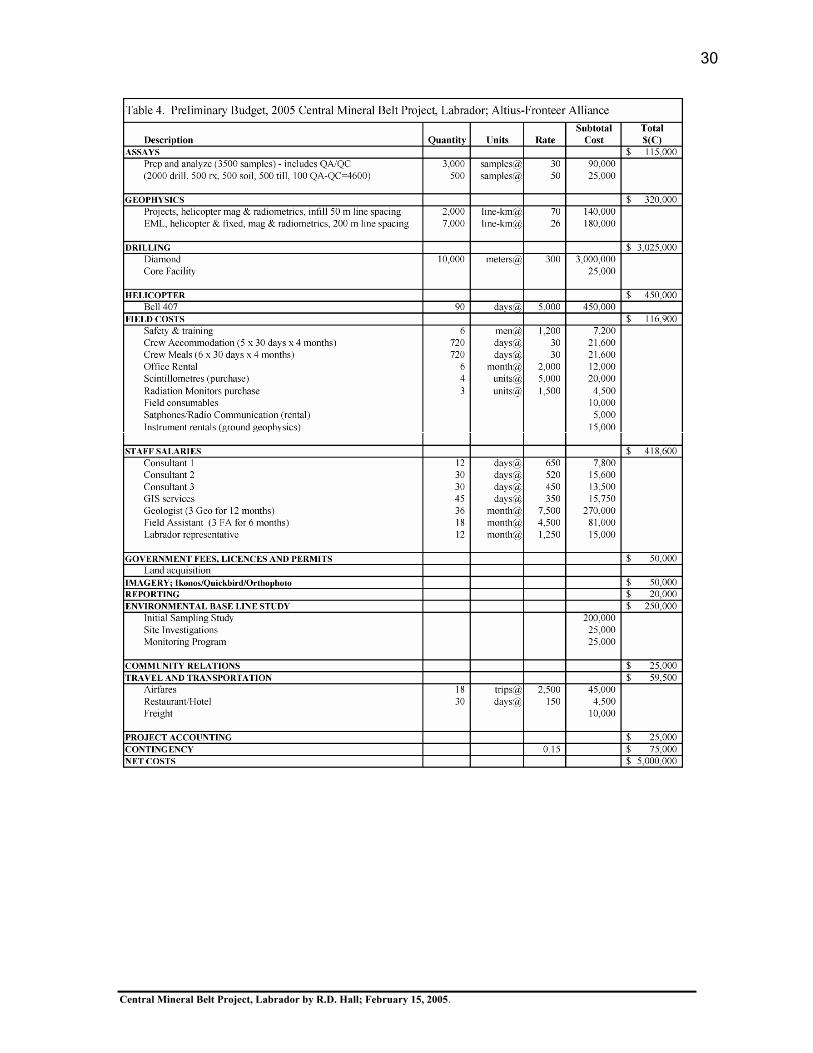
A budget of 5 million dollars for the Central Mineral Belt Project in 2005 is presented in Table 4. About seventy percent of proposed expenditures is related to drilling as contracts of this size are probably required to secure drills in Labrador.
Respectfully submitted, ‘Richard D. Hall’Richard D. Hall, Ph.D., P. Eng. February 15, 2005
31
Central Mineral Belt Project, Labrador by R.D. Hall; February 15, 2005.
23.0 REFERENCES
Bailey, D.G., 1979: Geology of the Walker-MacLean Lake Area, 13K/9E, 13J/12, Central Mineral
Belt, Labrador; Government of Newfoundland and Labrador, Department of Mines and Energy, Mineral Development Division, Report 78-3, 17 pages.
Beaven, A.P., 1958: The Labrador uranium area; Proceeding of the Geological Association of
Canada, Volume 10, pages 137-145.
Brinex Ltd., February, 1979: Kitts-Michelin Project – Information Summary; 32 pages.
Booth, J.K.V., Leigh, O.E., and Archer, D.J., January, 1979: Brinex Ltd., Michelin/Kitts Project, Volume I - Report on Geology and
Reserves, Volume II - Michelin Deposit Plans and Sections; 227 pages.
Gandhi, S.S., 1986: Uranium in early Proterozoic Aillik Group, Labrador; In Uranium Deposits of
Canada, Canadian Institute of Mining and Metallurgy, Special Volume 33, pages 70-82.
Government of Newfoundland and Labrador, August 29, 2003: Labrador Inuit Land Claims Agreement; 404 pages.
Gower, C.F., Ryan, A.B. and Rivers, T., 1990: Mid-Proterozoic Laurentia-Baltica: An overview of its geological evolution and a
summary of the contributions made by this volume; In Gower, C.F., Rivers, T. and Ryan, A.B. (eds.) Mid-Proterozoic Laurentia-Baltica; Geological Association of Canada, Special Paper 38, pages 1-20.
Gower, C.F., Flanagan, M.J., Kerr, A. and Bailey, D.G., 1982: Geology of the Kaipokok Bay – Big River area, Central Mineral Belt, Labrador;
Newfoundland and Labrador Department of Mines and Energy, Mineral Development Division, Report 82-7, 77 pages.
Haynes, D.W., 2000: Iron oxide copper (-gold) deposits: Their position in the ore deposit spectrum and
modes of origin; In Porter, T.M. (ed.) Hydrothermal Iron Oxide Copper-Gold & Related Deposits: A Global Perspective, Volume 1, PGC Publishing, Adelaide, pages 71-90.
32
Central Mineral Belt Project, Labrador by R.D. Hall; February 15, 2005.
Hitzman, M. W., Oreskes, N., and Einaudi, M. T., 1992: Geological Characteristics and tectonic setting of Proterozoic iron-oxide (Cu-U-
Au-REE) deposits; Precambrian Research, V. 58, pages 241-287.
Ketchum, J.W.F., Culshaw, N.G. and Barr, S.M., 2002: Anatomy and orogenic history of a Paleoproterozoic accretionary belt: The
Makkovik Province, Labrador, Canada; Canadian Journal of Earth Sciences, V. 39, pages 711-730.
Lakefield Research of Canada Ltd., 1976: The Recovery of Uranium from Michelin Samples – Project Report No. 3;
Ryan, A.B., 1984. Regional geology of the central part of the Central Mineral Belt, Labrador;
Government of Newfoundland and Labrador, Department of Mines and Energy, Mineral Development Division, Memoir 3, 185 pages.
Willy, A.J., February 7, 1983: Evaluation of Occurrences and Prospects in Kitts Michelin Uranium Area,
Labrador; 29 pages, 1 figure.
Wilton, D.H.C, 1996. Metallogeny of the Central Mineral Belt and adjacent Archean Basement,
Labrador; Newfoundland Department of Mines and Energy, Geological Survey,Mineral Resource Report 8.
33
APPENDIX I
Suite 1640 – 1066 West Hastings St., Vancouver V6E 3X1 Tel: 604-632-4677; Fax: 604-632-4678
CERTIFICATE of AUTHOR
I, Richard D. Hall, Ph.D., P. Eng. do hereby certify that:
1. I am a project geologist employed by:
Fronteer Development Group Inc. 1640-1066 West Hastings Street, Vancouver, British Columbia, Canada, V6E 3X1
2. I graduated with a degree in Geological Engineering from Queen’s University in 1972. In addition, I obtained a Doctor of Philosophy in Geology from The University of Western Ontario in 1980.
3. I am a member # 16077 of the Association of Professional Engineers and Geoscientists of British Columbia.
4. I have worked as a geologist for a total of 32 years since my graduation from university.
5. I have read the definition of “qualified person” set out in National Instrument 43-101 (“NI 43-101”) and certify that by reason of my education, affiliation with a professional association (as defined in NI 43-101) and past relevant work experience, I fulfill the requirements to be a “qualified person” for the purposes of NI 43-101.
6. I am responsible for the preparation of all sections of the technical report titled Central Mineral Belt Project, Labrador and dated February 15th, 2005 relating to the Post Hill, Jacque’s Lake, Otter Lake, Melody Hill and Michelin properties. I participated in field exploration in the Kitts-Michelin uranium district during the period August 31 to October 4th, 2004.
7. I have not had prior involvement with the properties that are the subject of this Technical Report.
8. I am not aware of any material fact or material change with respect to the subject matter of the Technical Report that is not reflected in the Technical Report, the omission to disclose which makes the Technical Report misleading.
9. I am not independent of the issuer applying all of the tests in section 1.5 of National Instrument 43-101 as I am an employee of the issuer.
10. I have read National Instrument 43-101 and Form 43-101F1, and the Technical Report has been prepared in compliance with that instrument and form.
11.1
I consent to the filing of the Technical Report with any stock exchange and other regulatory authority and any publication by them for regulatory purposes, including electronic publication in the public company files on their websites accessible by the public, of the Technical Report.
Dated this 15th Day of February, 2005.
(as signed and sealed)
‘Richard D. Hall’
Richard D. Hall, Ph.D., P. Eng.