Embed Size (px)
Citation preview
European Red List of Habitats - Forests Habitat Group
G3.8 Pinus canariensis woodland
SummaryThis pine woodland dominated by the Canarian endemic Pinus canariensis, forms the natural vegetation inthe high mountains of the central and western Canary Islands, occurring on slopes in dry sunny conditionsabove the cloud layer (caused by the trade winds) and, locally, at lower elevations on rocky outcrops andrecent lava deposits. The tree cover varies in density is depending on the soil and slope conditionsand usually has an understory of woody subshrubs. Stands have been extensively logged in the past dueto their timber value. The pine is a fire-adapted tree, with a thick bark that resists fire and having thecapacity to resprout. Mismanagement of fires and invasion of non-native species are the main threats.
SynthesisThe habitat type is assessed as Least Concern on the basis of its stable trends in quantity and quality, andthe fact that there are no known plausible threats that may induce collapse in the near future to thehabitat. However, it has a very restricted distribution and it is recommended that the threats and trendsare periodically monitored.
Overall Category & CriteriaEU 28 EU 28+
Red List Category Red List Criteria Red List Category Red List CriteriaLeast Concern - Least Concern -
Sub-habitat types that may require further examinationNo sub-habitats need to be distinguished for further analysis.
Habitat TypeCode and nameG3.8 Pinus canariensis woodland
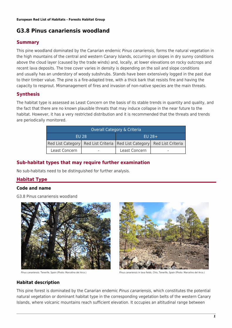
Pinus canariensis. Tenerife, Spain (Photo: Marcelino del Arco.) Pinus canariensis in lava fields. Chio, Tenerife, Spain (Photo: Marcelino del Arco.)
Habitat descriptionThis pine forest is dominated by the Canarian endemic Pinus canariensis, which constitutes the potentialnatural vegetation or dominant habitat type in the corresponding vegetation belts of the western CanaryIslands, where volcanic mountains reach sufficient elevation. It occupies an altitudinal range between
1
1,250 and 2,000-2,300 m on northern slopes, above the cloud layer (mar de nubes) caused by the tradewinds. There it occurs above the lauroid forest belt (monteverde), while on southern slopes it is in contactwith the xerophytic lowland Canarian habitats with junipers. Locally, on rocky outcrops, it can extend downto 500 m and it is also a colonizer of lava depositions (malpaíses). These woodlands vary from open todense depending on the soil and slope conditions, and consist of pine stands in most places, having anunderstory of woody legumes (Adenocarpus viscosus, Chamaecytisus proliferus), Lamiaceae (Bystropogonoriganifolius, Sideritis soluta) and Cistaceae (Cistus symphytifolius). They are out of the mist influence ofthe cloud layer and subsist under dry sunny conditions.
This habitat is the remnant of an ancient forest which was widespread in the western Mediterranean basinin the late Tertiary period (remnants have also been found in southern France and mainland Spain), butit is now only restricted to the Canary Islands, hosting lineages of a genuine Mediterranean flora. Standshave been extensively logged in the past due to their timber value and they continue to be exploited as animportant resource, particularly in artificial plantations located on deep soils and in the moister areasnaturally occupied by the lauroid forest. The Canary Pine (Pinus canariensis) is a fire-adapted tree, with athick bark that resists fire and the capacity to resprout.
Characteristic species:
Vascular plants: Pinus canariensis, Adenocarpus viscosus, Bystropogon origanifolius s. l.,Chamaecytisusproliferus s. l., Cistus symphytifolius s. l., Juniperus cedrus, Lotus campylocladus, Lotus hillebrandii, Lotusspartioides, Micromeria benthamii, Micromeria lanata, Micromeria pineolens, Micromeria varia meridialis,Sideritis oroteneriffae, Sideritis soluta, Teline stenopetala spachiana, Tinguarra montana, Isoplexisisabelliana*
Birds: Fringilla teydea, Dendrocopos major canariensis*, Dendrocopos major thanneri*
*Priority species included in the Annexes of the Birds and Habitats Directive
Indicators of quality:
Little or no signs of exploitation signs, such as logging.●
No signs of heavy grazing.●
No signs of invasive alien species (i.e. Escholtzia californica, Pennisetum setaceum, Ailanthus altissima,●
etc. start to be relatively abundant in certain areas).Structural diversity/ complexity with (semi)natural age structure or completeness of layers.●
Presence of old trees and a variety of dead wood (lying or standing) and the associated flora, fauna and●
fungi.
ClassificationThis habitat may be equivalent to, or broader than, or narrower than the habitats or ecosystems in thefollowing typologies.
EUNIS: Canary Island Pinus canariensis woodland
EuroVegChecklist alliances: Cisto symphytifolii-Pinion canariensis Rivas Goday et Esteve ex Esteve 1969
Annex 1: 9550 Canary Island endemic pine forests
Emerald:G3.8 Canary Island Pinus canariensis woodland
MAES-2:
2
Terrestrial woodland and forest
IUCN:1.5. Subtropical/Tropical Dry Forests
European Forest Types:FT 10.3 Canarian pine forest
Does the habitat type present an outstanding example of typical characteristics of oneor more biogeographic regions?Yes
RegionsMacaronesian
JustificationThe distribution of this habitat is restricted to central and western Canary Islands, particularly in theislands of Tenerife, La Palma, Gran Canaria, El Hierro and (punctually) La Gomera.
Geographic occurrence and trends
EU 28 Present or PresenceUncertain
Current area ofhabitat
Recent trend in quantity(last 50 yrs)
Recent trend inquality (last 50 yrs)
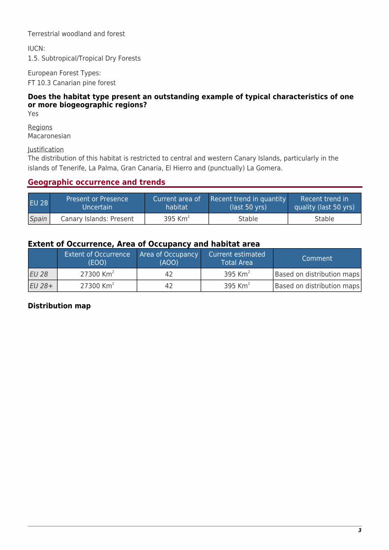
Spain Canary Islands: Present 395 Km2 Stable Stable
Extent of Occurrence, Area of Occupancy and habitat area Extent of Occurrence
(EOO)Area of Occupancy
(AOO)Current estimated
Total Area Comment
EU 28 27300 Km2 42 395 Km2 Based on distribution mapsEU 28+ 27300 Km2 42 395 Km2 Based on distribution maps
Distribution map
3
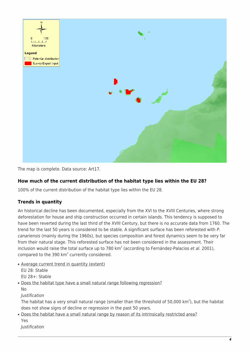
The map is complete. Data source: Art17.
How much of the current distribution of the habitat type lies within the EU 28?100% of the current distribution of the habitat type lies within the EU 28.
Trends in quantityAn historical decline has been documented, especially from the XVI to the XVIII Centuries, where strongdeforestation for house and ship construction occurred in certain islands. This tendency is supposed tohave been reverted during the last third of the XVIII Century, but there is no accurate data from 1760. Thetrend for the last 50 years is considered to be stable. A significant surface has been reforested with P.canariensis (mainly during the 1960s), but species composition and forest dynamics seem to be very farfrom their natural stage. This reforested surface has not been considered in the assessment. Theirinclusion would raise the total surface up to 780 km2 (according to Fernández-Palacios et al. 2001),compared to the 390 km2 currently considered.
Average current trend in quantity (extent)●
EU 28: StableEU 28+: StableDoes the habitat type have a small natural range following regression?●
NoJustificationThe habitat has a very small natural range (smaller than the threshold of 50,000 km2), but the habitatdoes not show signs of decline or regression in the past 50 years.Does the habitat have a small natural range by reason of its intrinsically restricted area?●
YesJustification
4
The Canary Pine is particularly adapted to the volcanic conditions of the Canary Islands, and its range islimited to the central and western Canary Islands.
Trends in qualityThere is no sufficient evidence to assess the historical trends of quality. The data from the territorial datasheet, and from the Habitats Directive reporting for the type 9550 shows agreement on a the current trendof quality to be considered stable. This is partially due to the fact that the Canary Pine forest is currentlyprotected under the Habitats Directive and most of its area is located inside protected areas.
Average current trend in quality●
EU 28: StableEU 28+: Stable
Pressures and threats
There are no plausible threats that may cause significant decline leading to the collapse of the habitat inthe near future. Likely threats causing habitat degradation have been identified, such as invasivealien species that are starting to become relatively abundant in certain areas (Escholtzia californica,Pennisetum setaceum, Ailanthus altissima, etc.), and mismanagement of forest fires. The CanaryPine forest is well adapted to fire, thus the intensity and frequency of forest fires should be carefullymonitored.
List of pressures and threatsInvasive, other problematic species and genes
Invasive non-native species
Natural System modificationsFire and fire suppression
Conservation and management
Significant areas or natural Pinus canariensis forest are under protection, which is leading to relativelygood conservation status. It is recommended to continue with this protection policy. Additionally, urgentmanagement actions are suggested to address common problems in reforested areas (high density,regular spatial distribution, lack of dead wood). Measures suggested include tackling the issue of invasivealien species and the inclusion of disturbances (including fire) to reduce density to 300-600 trees/ha (moresimilar to natural forest). Repeated fire occurrences and disturbances may favor other characteristicspecies, like the Great spotted woodpecker (Dendrocopos major), which needs standing dead trees tobreed. This species is currently absent in reforested areas.
List of conservation and management needsMeasures related to forests and wooded habitats
Restoring/Improving forest habitatsAdapt forest management
Measures related to spatial planningEstablish protected areas/sitesLegal protection of habitats and species
5
Measures related to hunting, taking and fishing and species managementOther species management measures
Conservation statusAnnex 1:
9550 MAC FV
When severely damaged, does the habitat retain the capacity to recover its typicalcharacter and functionality?The habitat recovers very well naturally after disturbances. Some of them, like forest fires, occur naturallyin the system. However, other severe damages like logging or heavy goat grazing disable naturalregeneration, thus threatening the capacity of the habitat to recover naturally.
Effort required50+ years 200+ years
Through intervention Through intervention
Red List Assessment
Criterion A: Reduction in quantityCriterion A A1 A2a A2b A3
EU 28 0 % Unknown % Unknown % Unknown %EU 28+ 0 % Unknown % Unknown % Unknown %
The surface of this habitat is estimated to be stable for the last 50 years, and therefore the habitat isassessed as Least Concern under Criterion A1. A stable and historical trend is also likely to apply, but thereis no specific data to confirm these trends.
Criterion B: Restricted geographic distribution
Criterion BB1 B2
B3EOO a b c AOO a b c
EU 28 27300 Km2 No No No 42 No No No NoEU 28+ 27300 Km2 No No No 42 No No No No
There is no continuing decline neither in the EOO or the AOO of this habitat type, neither a threateningprocess foreseen in the next 20 years. There is no evidence of plausible threats that could cause thecollapse of this habitat type, and for this reason locations are not calculated. Therefore, the habitat type isassessed as Least Concern under Criterion B. However, threats should be closely monitored since its re-evaluation may cause the habitat type to be threatened in the future.
Criterion C and D: Reduction in abiotic and/or biotic quality
CriteriaC/D
C/D1 C/D2 C/D3Extent
affectedRelativeseverity Extent affected Relative
severity Extent affected Relativeseverity
EU 28 0 % 0 % Unknown % Unknown % Unknown % Unknown %EU 28+ 0 % 0 % Unknown % Unknown % Unknown % Unknown %
6
Criterion CC1 C2 C3
Extentaffected
Relativeseverity Extent affected Relative
severity Extent affected Relativeseverity
EU 28 0 % 0 % Unknown % Unknown % Unknown % Unknown %EU 28+ 0 % 0 % Unknown % Unknown % Unknown % Unknown %
Criterion DD1 D2 D3
Extentaffected
Relativeseverity Extent affected Relative severity Extent affected Relative severity
EU 28 0 % 0% Unknown % Unknown% Unknown % Unknown%EU 28+ 0 % 0% Unknown % Unknown% Unknown % Unknown%
The trend in quality during the last 50 years is considered to be stable. This is partially due to the fact thatthe majority of the Canary Pine forests stands are currently inside protected areas, and all the habitat isunder European protection (it is included in the Annex I of the Habitats Directive). Therefore this habitat isassessed as Least Concern under Criterion C/D, C1 and D1. There is no data supporting historic or futuretrends.
Criterion E: Quantitative analysis to evaluate risk of habitat collapseCriterion E Probability of collapse
EU 28 UnknownEU 28+ Unknown
There is no information available to assess the habitat type under Criterion E. Therefore this habitat isassessed as Data Deficient under Criterion E.
Overall assessment "Balance sheet" for EU 28 and EU 28+ A1 A2a A2b A3 B1 B2 B3 C/D1 C/D2 C/D3 C1 C2 C3 D1 D2 D3 E
EU28 LC DD DD DD LC LC LC LC DD DD LC DD DD LC DD DD DDEU28+ LC DD DD DD LC LC LC LC DD DD LC DD DD LC DD DD DD
Overall Category & CriteriaEU 28 EU 28+
Red List Category Red List Criteria Red List Category Red List CriteriaLeast Concern - Least Concern -
Confidence in the assessmentHigh (mainly based on quantitative data sources and/or scientific literature)
AssessorsM. Valderrabano
ContributorsHabitat description: J. Loidi
Territorial data: J. Loidi
Working Group Forests: F. Attore, R-J. Bijlsma, M. Chytrý, P. Dimopoulos, B. Renaux, A. Ssymank, T. Tonteri,M. Valderrabano
7
ReviewersM. García Criado
Date of assessment24/08/2015
Date of review12/01/2016
References
Arévalo, J. R. and Fernández-Palacios, J. M. 2009. 9550 Pinares endémicos canarios. En: VV.AA., Basesecológicas preliminares para la conservación de los tipos de hábitat de interés comunitario en España.Madrid: Dirección General de Medio Natural y Política Forestal, Ministerio de Medio Ambiente, Medio Ruraly Marino. 74 p.
Bohn, U., Gollub, G. Hettwer, C., Neuhauslova, Z., Rause, T., Schlüter, H. and Weber, H. 2004. Map of theNatural Vegetation of Europe. Bonn: Bundesamt für Naturschutz.
Council of Europe. 2010. Interpretation Manual of the Emerald Habitats. Strasbourg: Council of Europe.
Davies, C.E., Moss, D. and Hill, M.O. 2004. EUNIS Habitat Classification, revised. Report to the EuropeanTopic Centre, European Environment Agency.
Del Arco, M. (ed). 2006. Mapa de vegetación de Canarias. Mapas y memoria general. Grafcan Eds.
Del Arco, M. et al. 2010. Actual and potential natural vegetation on the Canary Islands and its conservationstatus. Biodivers Conserv 19:3089-3140
European Commission DG Environment. 2007. Interpretation Manual of European Union Habitats.Strasbourg: European Commission DG Environment.
European Environment Agency. 2006. European Forest Types, EEA Technical report No 9/2006,Copenhagen: European Environment Agency.
Farjon, A. 2013. Pinus canariensis. The IUCN Red List of Threatened Species 2013: e.T39603A2930093.http://dx.doi.org/10.2305/IUCN.UK.2013-1.RLTS.T39603A2930093.en. Downloaded on 29 August 2015.
Gonzalez, M. L. 2004. La Evolución histórica de los paisajes forestales de la vertiente norte de Tenerife.
Rivas-Martínez, S., Widpret, W., del Arco, M., Rodríguez, O., Pérez de Paz, P.L., García-Gallo, A., Acebes,J.R., Díaz, T.E. and Fernández-González, F. 1993. Las comunidades vegetales de la isla de Tenerife (IslasCanarias). Itinera Geobot 7: 169-374.
Schamineé, J.H.J., Chytrý, M., Hennekens, S., Jiménez-Alfaro, B., Mucina, L. and Rodwell, J.S. 2013. Reviewof EUNIS forest habitat classification, Report EEA/NSV/13/005. Copenhagen: European EnvironmentAgency.
8


![I carichi critici: attività e criticità identificate dal ... · normative europee (Habitat e Uccelli) e nazionali (Parchi) CL (massimo, minimo e media) ... [Pinus sylvestris] woodland](https://img.pdfslide.net/doc/110x75/5c66e18d09d3f2e4308ce6c8/i-carichi-critici-attivita-e-criticita-identificate-dal-normative-europee.jpg)