Embed Size (px)
Citation preview

© 2016. Fawole, O. A., Ojetade, J. O., Muda, S. A. & Amusan, A. A. This is a research/review paper, distributed under the terms of the Creative Commons Attribution-Noncommercial 3.0 Unported License http://creativecommons.org/licenses/by-nc/3.0/), permitting all non commercial use, distribution, and reproduction in any medium, provided the original work is properly cited.
Global Journal of Science Frontier Research: D Agriculture and Veterinary Volume 16 Issue 7 Version 1.0 Year 2016 Type : Double Blind Peer Reviewed International Research Journal Publisher: Global Journals Inc. (USA) Online ISSN: 2249-4626 & Print ISSN: 0975-5896
Genesis and Classification of Soils on a Toposequence Underlain by Mica Schist in Ife Area, Southwestern Nigeria
By Fawole, O. A., Ojetade, J. O., Muda, S. A. & Amusan, A. A. Obafemi Awolowo University
Abstract- The study was conducted to establish the morphological, physical and chemical properties of soils on a toposequence underlain by mica schist in Ife Area, identify the pedogenic processes that produced the soils and establish the taxonomic and fertility capability classes of the soils. The toposequence was delineated into five physiographic units and soil profile pits were established, described and sampled at each unit. The soil samples collected from each of the genetic horizon were subjected to routine analyses following the procedures in methods of soil analysis. Taxonomic and fertility capability classification of the soils were carried out.
Keywords: genesis, classification, toposequence, mica schist.
GJSFR-D Classification : FOR Code: 050399
GenesisandClassificationofSoilsonaToposequenceUnderlainbyMicaSchistinIfeAreaSouthwesternNigeria
Strictly as per the compliance and regulations of :

Genesis and Classification of Soils on a Toposequence Underlain by Mica Schist in Ife
Area, Southwestern Nigeria Fawole, O. A. α, Ojetade, J. O. σ, Muda, S. A. ρ & Amusan, A. A. Ѡ
Abstract-
The study was conducted to establish the morphological, physical and chemical properties of soils on a toposequence underlain by mica schist in Ife Area, identify the pedogenic processes that produced the soils and establish the taxonomic and fertility capability classes of the soils. The toposequence was delineated into five physiographic units and soil profile pits were established, described and sampled at each unit. The soil samples collected from each of the genetic horizon were subjected to routine analyses following the procedures in methods of soil analysis. Taxonomic and fertility capability classification of the soils were carried out.
The colour and texture of the soils change in response to changes in slope position and drainage condition along the toposequence
The soil’s colour ranged from reddish brown to dusky red (5YR 3/2- 2.5YR 3/2) in the surface and yellowish red (5YR 4/8) to reddish yellow (7.5YR 6/6) in the subsoil at the higher position of the toposequence while it range from dark brown (7.5YR 4/2) to dusky red (2.5YR 3/2) in the surface and red (2.5YR 4/ 6) to reddish yellow (7.5YR 6/6) in the subsoil at the lower position. Texturally, the soils varied from sandy clay loam in the surface to sandy clay in the subsoil all through the pedons sampled. The soils were moderately acidic to neutral (pH 5.2 – 6.7) at the surface and strongly acidic to moderately acidic (pH 4.4 - 5.7) in the subsurface. They were characterized by low exchangeable bases which were in the order Ca> Mg> K> Na irrespective of slope position with low to moderate organic matter content. The soils were classified as Typic Kanhaplustults and Aquic Haplustults (USDA soil taxonomy) Plinthic Luvisols, Gleyic Luvisols and Eutric Luvisols (FAO-UNESCO). The agronomic constraints of the soils were acidic reactions, low nutrient reserve and gleying, hence dominant FCC unit of soils in the study area was SC keh.
The soils studied were highly-weathered, low in inherent fertility and with acidic solum. Therefore, sustainable use of the
soils requires careful management to prevent rapid physical and chemical degradation.
Keywords: genesis, classification, toposequence, mica schist.
I.
Introduction
igerian agriculture and indeed African agriculture has not succeeded in meeting the continuously changing needs of the citizenry (Chukwu et al.,
2013). Persistent food insecurity and failure of agriculture to supply adequate quantities of raw materials to industries are stark realities. These are attributed to many factors, among which is soil resource illiteracy (Wang et al., 2001).
Researchers have identified poor knowledge of soil as a major problem hindering agricultural development in some parts of Nigeria (Chukwu et al., 2013). This is not a surprise as similar observations had been made in most parts of Africa (Ololade et al., 2010). Some of the reasons for this situation are related to lack of soil survey reports of most rural communities and Local Government Areas (LGAs) where food and fibre production take place. Further, the scales of most national soil surveys are so coarse (at reconnaissance level) that pedological information about rural communities where majority of the agricultural produce are coming from is virtually non-existent (Lawal et al., 2010).
Soils vary considerably in their physical, chemical and mineralogical characteristics which are related to their geological history. The continued lack of required knowledge on the nutrient management as related to available pedological information of nutrient depleted soils are not only exacerbating soil degradation, but also jeopardizing agricultural sustainability in these regions (Ayoub, 1999; Sheldrick et al., 2002). Similarly, in these communities, soils where most agricultural research and production take place are not characterized. All these reasons and perhaps more contribute to the widespread problems of soil resource illiteracy which in turn hinders effective agricultural development between areas with similar and/or different soils (Chukwu et al., 2013).
Soil is a product of interaction between climate, parent material, relief and organisms over a period of time. While climate (Maynard et al., 2004) and organisms (Quideau et al., 2001) actively influence soil formation, topography indirectly affects the rate of pedogenesis and distribution of soils (Wang et al., 2001). The effect of topography on soil genesis had long been recognized (Pregitzer et al., 2000). It had been established that soils vary in vertical and lateral directions and that such variations follow systematic changes (Wilding and Dress, 1983). Graham et al. (1990) proposed a conceptual model relating slope
N
1
Globa
lJo
urna
lof
Scienc
eFr
ontie
rResea
rch
V
olum
eXVI
Iss ue
er
sion
IV
VII
Yea
r20
16
31
( D)
© 2016 Global Journals Inc. (US)
Author α: Department of Crop Production Technology, Federal College of Forestry, Jericho, Ibadan. e-mail: [email protected] σ ρ Ѡ : Department of Soil Science and Land Resources Management, Obafemi Awolowo University, Ile-Ife.

processes to pedogenesis in which transported parent material interrupts the orderly progression of soil development in residual parent material. It was then suggested that genesis and distribution of soils are best understood when studied in landscape context rather than at the level of individual pedons or classification units (Graham et al., 1990). Nye (1966), Smyth and Montgomery (1962), Murdoch and Ojo-Atere (1976) and Ojanuga (1979) had earlier noted that the study of soil distribution along slope was the corner stone of most soil classification in the basement complex area of SW Nigeria.
However, most pedological soil studies in Ife Area had been restricted to the granite gneiss bedrock areas while studies on the pedogenesis in mica schist predominant zones have not received the desired research attention. Yet, the two rock types cover well above 70% of the basement complex area in Ife Area. Therefore, characterization and classification of soils in the land forms of mica schist bedrock are necessary to generate baseline data on the soils with particular reference to Ife area of SW Nigeria. The specific objectives of this study were to establish the morphological, physical and chemical properties of soils on a toposequence underlain by mica schist in Ife area and establish the taxonomic and fertility capability classes of the various soil types along the toposequence.
II. Materials and Method
a) The study area The study area is located approximately
between latitudes 7o 32´N and 7o 33´N and longitudes 4o 39´E and 4o 40´E, which is about 2.5 km away from Kajola village, a suburb of the Obafemi Awolowo University (O.A.U.) Teaching and Research Farm (T&R-F) Ile-Ife and is located within the schist belt of southwestern Nigeria (Rahaman, 1988).
b) Climate Kajola area is in the same ecological zone
(tropical rainforest) as Ile-Ife with hot, humid tropical climate having distinct dry and bimodal rainy seasons. The mean annual rainfall is about 1,527mm and the mean monthly air temperature is approximately 31oC. The wet season starts from mid-March to late October, and the bimodal rainfall pattern has peak periods in June/July and September/October. The dry season runs from early November to early March. The influence of the north-east trade wind, which loses all its moisture as it passes over the Sahara desert towards the equator, is felt in the study area as ‘harmattan’ (cold dry wind) between late December and early January (FMANR, 1990).
Atmospheric temperature is moderately high throughout the year, with a low range between the monthly mean minimum and maximum temperatures.
The peak of the maximum is usually between February and March (34.3- 33.8oC) just before the onset of rains while the lowest minimum temperatures are between July and August (27.1 - 27.9oC) during the peak periods of rainfall. The area also records the following average monthly data: humidity 73.8%, and sunshine 6.6 hours. The wind speed was 114.6 km d-1 while potential evaporation is 4.36 mm d-1 (Meterological data bank, T&R-F, O.A.U., Ile-Ife, 2010). The mean monthly soil temperature at 50 cm depth in Ile-Ife, for June, July and August is 27.7oC and for December, January and February is 29.4oC. Since these differ by less than 5oC, the soil temperature regime in the study area is isohyperthermic (Soil Survey Staff, 2006).
c) Vegetation and land use The native vegetation of the study area was
originally rainforest characterized by very tall, big trees and thick shrubs. However, as a result of human interferences, the vegetation now consists of admixture of bush regrowth, arable crop farms and tree crop plantations. The crest (summit) and the shoulder are presently being used for arable crop cultivation (cassava (Manihot spp); yam (Discorea spp); maize (Zea mays) and scattered banana/ plantain (Musa spp.). The upper slope area was cultivated to cocoa (Theobroma cacao), but was unkept and gradually transforming into secondary forest. The mid slope area was under bush fallow with mostly Chromolaena odorata and scattered oil palm (Elaeis guinensis). The lower slope supported cocoa plantation inter-planted with cassava (Manihot spp.) and banana/plantain (Musa spp.), while plantain/banana (Musa spp.) and cocoa (Theobroma cacao) were grown in the valley bottom area.
d) Field study Guided by the geological map of the study area
produced by the Department of Geology, O.A.U. Ile-Ife, a toposequence underlain by mica schist was selected for the study. The toposequence is slightly undulating with relatively flat top and is approximately 2.5 km southeast of Kajola village. The toposequence is approximately 500 m long from the valley bottom to the crest with an elevation of 295.9 m above mean sea level (amsl) at the crest and 268.6 m amsl at the valley bottom. The other physiographic positions were clearly identified and the upper slope, sedentary and hill-wash areas were 293.6 m, 283.5 m and 276.9 m amsl respectively.
Five soil profile pits were established along the toposequence at different physiographic positions. All the pedons were described following the procedures in the guidelines for soil profile description (FAO. 2001) and horizon designations of the Soil Survey Staff (2006). Soil samples were collected from each of the identified genetic horizons for physical and chemical analyses in the laboratory. Undisturbed core soil samples were collected and used for bulk density determination.
Genesis and Classification of Soils on a Toposequence Underlain by Mica Schist in Ife Area, Southwestern Nigeria
© 2016 Global Journals Inc. (US)
32
Globa
lJo
urna
lof
Scienc
eFr
ontie
rResea
rch
V
olum
eYea
r20
16XVI
Iss u
e er
sion
IV
VII
( D)

e) Laboratory analyses The soil samples were air dried, gently crushed
in ceramic mortal with pestle and passed through 2mm sieve to separate materials that were greater than 2mm. The fraction that was less than 2mm was used for the laboratory analyses other than the bulk density determination.
f) Physical analyses The bulk density was determined by the core
method. The particle size distribution was evaluated by the modified Bouyoucos hydrometer method (Bouyoucos, 1951) using 5% w/v sodium hexameta- phosphate (calgon) as the dispersing agent. Particle fractionation into very coarse sand (VCS), coarse sand (CS), medium sand (MS), fine sand (FS) and very fine sand (VFS) was carried out with the use of a set of sieves (1.0, 0.5, 0.25, 0.100 and 0.05 mm) representing 1000, 500, 250, 100 and 50 µm respectively arranged in decreasing order of sieve sizes as listed (Buol et al., 1997). Each of the sand fractions was weighed and preserved.
g) Chemical analyses The soil pH was determined both in distilled
water and 1.0 M KCl (1:1 soil: solution ratio) using glass electrode pH meter (Kent model 720) (Thomas, 1982) and was also carried out in duplicate. Delta pH computed is defined as the difference between pH in KCl and H2O. The exchangeable bases (Ca, Mg, K and Na) were extracted with 1.0 M ammonium acetate (NH40AC) solution at pH 7.0 (Thomas and Throp, 1985). Calcium, Ca2+, sodium, Na+, and potassium, K+ ions in the extract were determined with the use of flame photometer (Gallenkamp Model FH 500), while magnesium (Mg2+) ion in the extract was determined by titration which was carried out by extracting the soil with neutral ammonium acetate solution (Soil Survey Staff, 2006).
The exchangeable acidity was determined by extraction with 1.0 M KCl solution and titrated with NaOH and HCl solutions to measure total acidity (Al3+ and H+) concentrations respectively (McLean, 1965). Effective cation exchange capacity (ECEC) was computed as the summation of NH4OAC extractable bases (Ca2+, Mg2+, Na+ and K+) and KCl extractable aluminium (Al3+) (Soil Survey Staff, 2006). The organic carbon was determined by the Walkley Black method (Allison, 1965), and the available phosphorous by Bray No. 1 method.
h) Fertility capability classification (FCC) The results of the laboratory analyses and field
morphological properties of the pedons identified in the study area were used for fertility capability classification. The conversion data used in evaluating the soils are as outlined by Sanchez (2002), which consists of three categorical levels, ‘type’ (texture of plough layer or top
20 cm), ‘substrata type’ (texture of sub soils), and ‘modifiers’ (soil properties or conditions which act as constraints to crop performance). Class designations from the three categorical levels were combined to form FCC unit. Thus the soils were classified according to whether a characteristic was present or not.
i)
Statistical analyses
Correlation coefficients and simple regression
analysis between the selected soil properties
were calculated. All statistical analyses were carried out using SAS 9.1 version (2002-2004) software programme.
III.
Results and Discussion
a)
Soil morphology and landform relationship
Locational map showing the topographical
sequence of the soil series identified in the study area is presented in Figure 1 and the summary of the important morphological characteristics of the soil types identified on the landscape positions on the toposequence is presented in Table 1. The soils along the toposequence are derived from fined-grained biotite gneisses and schist and are very extensive in southwestern Nigeria, the parent rocks are very easily weathered and give rise to very deep soils. The colour and texture of the soils change in response to changes in slope position and drainage condition down to the valley bottom. The bright yellowish and dark brown to red colours of soils in the higher topographical sites was an indication of good drainage (Periaswamy and Ashaye, 1982).
b)
Physical properties of the soils
Table 2 shows the particle size distribution and
bulk density data of the soils along the toposequence under study. The gravel content varied from 8 to 68 ± 17.38%, with Pedons
from the summit, upper and middle slopes having relatively high values of 22 to 68 ± 14.94% while the lower slope and valley bottom Pedons have lower values, 8 to 32 ±7.26%. The gravel content generally increased from the A-horizon to B-horizon and then decreased significantly from B to C-horizon, except at the lithologic break. However, in pedons at the lower slope position, there were no particular patterns of gravel distribution. This gravel accumulation had been found to be a characteristic property of
soils formed in the upland portion of the landscapes derived from granitic gneiss metamorphic rock complex of central western Nigeria (Smyth and Montgomery, 1962; Okusami and Oyediran, 1985). These have not constituted an obstacle to root proliferation since roots are found beyond the gravel horizons.
Genesis and Classification of Soils on a Toposequence Underlain by Mica Schist in Ife Area, Southwestern Nigeria
1
Globa
lJo
urna
lof
Scienc
eFr
ontie
rResea
rch
V
olum
eXVI
Iss ue
er
sion
IV
VII
Yea
r20
16
33
( D)
© 2016 Global Journals Inc. (US)

Fig. 1 : Topographical Sequence of soil Series in the Study Area (After Smyth and Montgomery, 1962)
Genesis and Classification of Soils on a Toposequence Underlain by Mica Schist in Ife Area, Southwestern Nigeria
© 2016 Global Journals Inc. (US)
34
Globa
lJo
urna
lof
Scienc
eFr
ontie
rResea
rch
V
olum
eYea
r20
16XVI
Iss u
e er
sion
IV
VII
( D)

Genesis and Classification of Soils on a Toposequence Underlain by Mica Schist in Ife Area, Southwestern Nigeria
1
Globa
lJo
urna
lof
Scienc
eFr
ontie
rResea
rch
V
olum
eXVI
Iss ue
er
sion
IV
VII
Yea
r20
16
35
( D)
© 2016 Global Journals Inc. (US)
Hor
izon
Dep
th(c
m)
Col
our
Moi
stTe
xtur
etSt
ruct
urex
Con
sist
ence
yC
oncr
etio
nsb
Bou
ndar
yzN
otes
P rof
il e 0
1Egb
eda
serie
sA
p0-
185Y
R 3
/2SL
2mcs
bkN
stnp
lvfr
cfrg
rcs
Abu
ndan
t ver
y fin
e, fi
ne, a
nd fe
w m
ediu
m ro
ots
AB
18-2
410
YR
4/4
SCL
2msb
kN
plfr
nst
cfrs
tgr
csA
bund
ant f
ine
and
med
ium
root
sB
24-5
12.
5YR
4/4
SC2m
sbk
Sstfr
spl
cfrs
tgr
gwFe
w fi
ne a
nd m
ediu
m ro
ots
BC
51-7
05Y
R 4
/8SC
3psb
kSs
tspl
frcf
rstg
rcs
Ver
y fe
w fi
ne ro
ots
Prof
ile 0
2 O
loru
nda
serie
sA
p0-
185Y
R 3
/3SC
Lcm
sbk
Ssts
plfr
vfgr
csA
bund
ant f
ine,
med
ium
to c
oars
e ro
ots
AB
18-2
82.
5YR
4/4
SCL
2mcr
Ssts
plfr
vfrg
rvfs
tds
Com
mon
fine
and
ver
y fin
e an
d fe
w m
ediu
m ro
ots
B21
28-7
22.
5YR
4/8
SC1m
sbk
Nst
nplfr
vfgr
sFr
eque
nt fi
nero
ots
B22
72-1
322.
5YR
4/4
SC2m
sbk
Ssts
plvf
rgrf
stcs
Few
gra
vels
BC
113
2-18
55Y
R 4
/6SC
3csb
kFm
stpl
-ds
Thic
k cu
tans
of c
lay
and
iron
oxid
es o
n pe
dB
C2
185-
210
5YR
6/6
SC3m
sbk
Vfr
--
Few
mot
tles,
freq
uent
pie
ces o
f wea
ther
ed ro
ck, d
evoi
d of
root
s.Pr
ofile
03M
akun
serie
sA
p0-
185Y
R 4
/2SC
L2m
sbk
Nst
nplfr
-cs
Com
mon
coa
rse
fine
to m
ediu
m ro
ots
BA
18-3
32.
5YR
4/2
, (5
YR
5/6
)C
L2m
1sbk
Ssts
pl-
dsA
bund
ant v
ery
fine
and
few
coa
rse
and
med
ium
root
s
B21
33-6
52.
5YR
4/6
(5
YR
5/6
)SC
2msb
kFr
stpl
frgr
Ds
Com
mon
med
ium
and
coa
rse
root
s
B22
65-1
202.
55Y
R 4
/6SC
2msb
kSs
tspl
frvf
grrd
Ds
Med
ium
to fi
ne p
rom
inen
t mot
tles,
Wea
ther
ed q
uartz
ston
es
with
few
pat
chy
cuta
nsB
C12
0-20
05Y
R 4
/6SC
2msb
kSs
tspl
frvf
grrd
-Fr
eque
nt q
uartz
mat
eria
ls. D
evoi
d of
root
sPr
ofile
04
Oba
serie
sA
p0-
207.
5YR
4/2
SCL
2fcr
Vfr
nstn
pl-
csC
omm
on m
ediu
m fr
eque
nt fi
ne a
nd fe
w c
oars
e ro
ots
BA
20-4
05Y
R 4
/6SC
L2m
sbk
Frss
tspl
fst
csFe
w m
ediu
m, c
omm
on fi
ne a
nd fe
w v
ery
fine
root
sB
140
-71
2.5Y
R 4
/6SC
2msb
kFr
ssts
plV
fgrv
fst
dsFe
w p
atch
y cu
tans
, com
mon
fine
and
med
ium
root
s2B
tC1
71-1
152.
5YR
4/8
SC2m
sbk
Vst
spl
vfgf
stgs
Few
pat
chy
cuta
ns w
ith st
onel
ines
, few
med
ium
to fi
ne ro
ots
2BC
211
5-17
05Y
R 5
/8SC
2msb
kFr
stpl
vfrg
fst
-Fe
w ro
ots w
ith fr
eque
nt b
lack
hard
con
cret
ions
pre
sent
.Pr
ofile
05
Jago
serie
sA
p0-
182.
5YR
3/2
SCL
2mcr
Sstn
p-
gwC
omm
on m
ediu
m fr
eque
nt fi
ne ro
ots
AB
18-4
02.
5YR
4/4
, (5
YR
6/1
)SC
2msb
kSs
tspl
fgr
gwC
omm
on m
ediu
m fr
eque
nt fi
ne ro
ots
B40
-60
2.5Y
R 4
/6(5
YR
6/1
)SC
1msb
kFm
stpl
fgr
gwFr
eque
nt m
ediu
m a
nd fe
w fi
ne ro
ots
Btg
60-7
57.
5YR
6/6
SC2f
Fmvs
tvpl
nd-
Com
mon
med
ium
root
s mer
ging
into
a w
ater
satu
rate
d la
yers
Text
ure:
SC
= Sa
ndy
Cla
y, S
L= S
andy
Loa
m, S
CL=
Sand
y C
lay
Loam
, L=
Loam
y, L
S= L
oam
y Sa
nd, C
=cla
y, C
L= C
lay
Loam
; X
Stru
ctur
e: 1
= w
eak,
2 =
mod
erat
e, 3
= st
rong
, cr =
cru
mb,
sbk
= su
bang
ular
blo
cky,
abk
= a
ngul
ar b
lock
y, p
= pl
aty,
vf =
ver
y fin
e, f
= fin
e, m
= m
ediu
m, c
= c
oars
e;
YC
onsi
sten
ce: m
= m
oist
, w =
wet
, vfr
= v
ery
fria
ble,
fr =
fria
ble,
fm =
firm
, vfm
= v
ery
firm
, nst
= n
on st
icky
, sst
= sl
ight
ly st
icky
, vst
= v
ery
stic
ky, s
t =
Tabl
e 2
:Fie
ld m
orph
olog
ical
dis
crip
tion
of th
e so
ils s
tudi
ed

Table 2 :
Physical properties of the soils along the toposequence
Genesis and Classification of Soils on a Toposequence Underlain by Mica Schist in Ife Area, Southwestern Nigeria
© 2016 Global Journals Inc. (US)
36
Globa
lJo
urna
lof
Scienc
eFr
ontie
rResea
rch
V
olum
eYea
r20
16XVI
Iss u
e er
sion
IV
VII
( D)
The soil texture varied from sandy loam to sandy clay loam for surface horizons except in Pedon 05 which has clay texture. The B and C-horizons have clay loam texture except in Pedons 03 and 04 that were more clayey in the B and BC horizons. The sand content ranged from 29 to 67 ±12.83% and decreased with increasing depth except at certain depths where the BC-horizon contained more of sand as in Pedons 03 and 04. An outstanding feature of these soils irrespective of their location on the topography is their low to moderate silt content at the surface. The silt content ranged from 11 to 25 ±3.31%, although the value fluctuated within all the pedons with increasing depth. Generally, the silt content is low, a characteristic which the soils shared with most Nigerian soils (Ojanuga et al., 1981).
The clay values ranged from 18 to 59 ±13.98% in the Bt horizons. The clay content increased generally
with increasing depth to a maximum (probably due to illuviation/ eluviation interplay or possibly clay migration) and then decreased in the BC horizons. Similar trend was observed by Ojanuga (1978) in soils of Ife and Ondo areas of southwestern Nigeria. Generally, soils in the middle and lower slope positions have higher clay content than those of the valley bottom position. For Pedons 02, 03, and 04, the particle size distribution of the sub-soil horizon of the soils suggests that the B-horizons were influenced more by eluviation – illuviation processes. The high clay content in the deeper horizons of some of the soils coupled with some morphological properties such as the colour, texture, consistence and plasticity in the profile description formed the basis for the recognition of argillic horizons in some of the soils (Fasina et al., 2005).
Horizon Depth (cm)
>2000mm(% of the
whole soil)
Very coarse sand (1000-
2000µm)
coarsesand(500-1000µm)
MediumSand (250-
500µm)
Fine Sand (50-100µm)
Very fine sand(0.05-0.50 µm)
Totalsand
Silt Clay Bulk density g/cm3
Textural
%
Profile 01 Egbeda seriesAp 0-18 35 10 13 10 9 7 49 21 30 1.06 Sandy loamAB 18-24 61 10 12 10 8 7 47 25 28 1.54 Sandy clay loamB 24-51 68 7 8 7 5 4 31 11 58 1.62 Sandy clay
BC 51-70 50 7 7 6 5 4 29 13 58 1.59 Sandy clayProfile 02 Olorunda series
Ap 0-18 41 10 13 12 10 10 55 17 28 1.01 Sandy clay loamAB 18-28 68 10 12 11 10 8 51 11 38 1.57 Sandy clay loamB21 28-72 64 10 8 7 7 6 39 13 48 1.63 sandy clay B22 72-132 56 11 4 7 7 5 33 13 54 1.68 sandy clayBC1 132-185 33 9 7 7 7 6 35 17 48 1.73 Sandy clayBC2 185-210 22 9 9 9 8 8 43 15 42 1.48 Sandy clay
Profile 03 Makun seriesAp 0-18 43 12 13 11 11 9 55 17 28 1.34 Sandy clay loamBA 18-33 42 11 12 10 10 8 51 15 34 1.42 Clay loamB21 33-65 39 12 8 7 4 3 34 13 53 1.45 Sandy clayB22 65-120 47 12 6 6 4 2 30 11 59 1.65 Sandy clayBC 120-200 23 11 8 10 5 5 39 15 46 1.40 Sandy clay
Profile 04 Oba seriesAp 0-20 8 11 15 13 11 8 57 15 28 1.54 Sandy clay loamBA 20-40 32 10 12 7 7 2 39 13 48 1.48 Sandy clay loamB1 40-71 25 8 11 5 5 3 31 11 58 1.30 Sandy Clay
2BtC1 71-115 27 8 11 4 5 3 31 13 56 1.71 Sandy Clay2BC2 115-170 15 10 13 7 7 2 39 13 48 1.40 Sandy clay
Profile 05 Jago seriesAp 0-18 26 16 15 14 13 10 67 15 18 0.74AB 18-40 19 14 13 13 13 12 65 13 22 1.21 Sandy clayB 40-60 18 14 17 15 12 10 67 11 22 1.31 Sandy clay
Btg 60-75 24 13 14 13 13 12 65 15 20 1.13 Sandy clay
class

down the soil profile. Exchangeable acidity values ranged from 0.3
to 1.0 cmol (+) kg-1
soil (Table 3). All the pedons examined showed little variation in the exchangeable acidity (Al3+
and H+) and the values were
almost uniform with soil depth. Exchangeable Al3+
accounted for a greater percentage (54.14%) of the total acidity. Effective cations exchange capacity (ECEC) was generally low with values ranging from 3.73 to 14.26 cmol (+) kg-1
soil. There were higher values in the
surface horizons of all the soils examined than in the sub-soil, probably due to the influence of organic carbon on the exchange sites of the soils. However, in those profiles where higher values were noticed in the sub-soil as in Pedons 02 (B22) and 03 (BC) with more of clay content (Table 2), this could be due to the process of pedoturbation either by fauna or flora.
Genesis and Classification of Soils on a Toposequence Underlain by Mica Schist in Ife Area, Southwestern Nigeria
1
Globa
lJo
urna
lof
Scienc
eFr
ontie
rResea
rch
V
olum
eXVI
Iss ue
er
sion
IV
VII
Yea
r20
16
37
( D)
© 2016 Global Journals Inc. (US)
Generally, there was higher accumulation of bases in the surface horizons 6.59 - 12.57 cmol(+)kg-1
of the soil, and the total exchangeable bases decreased with soil depth except in some cases owing to nutrient biocycling (Ajiboye and Ogunwale, 2010), and could also be due to differential weathering that had taken place or as a result of plant uptake and leaching losses. Like in most tropical soils, the exchangeable sites of the soils studied were dominated by exchangeable calcium and magnesium. Exchangeable sodium (Na+) andpotassium (K+) are low (Table 3) with values ranging from 0.08 to 0.26 cmol(+)kg-1 and 0.15 to 0.30 cmol(+)kg-1 soil for Na+ and K+ respectively. These low values indicated that the soils under investigation developed from materials that are either low in K+ andNa+ content or have been exhausted by plant uptake or leaching due to their mobility within the soil. The higher values obtained at the surface horizon of the pedons could be attributed to higher organic matter content
(Ano, 1991). However, the values fluctuated irregularly
observed at the soil surface horizons according to Fasina et al. (2005) might be due to liming effect of bush burning and bio cycling of nutrients. The pH in 1M KCl was lower than the pH in water (H20), thus the difference in soil pH values between the pH in KCl and H20 (asexpressed by ∆pH = pH (KCl) – pH (H20)) were all negative ranging from -0.9 to -1.5. This suggests the dominance of silicate clay minerals over oxides (Van Raij and Michael, 1972).
c) Chemical properties of the soilsTables 3 show the chemical properties of the
pedons studied. The soils studied fall within the neutral to very strongly acid class (Ojanuga, 1978; Landon,1991; Soil Survey Staff, 2003), with pH (H2O) values ranging from 5.6 to 7.0. The pH decreased with soil depth except in Pedon 03. The pH (1M KCl) ranged from 4.4 to 5.7. The value also decreased with soil depth except in Pedon 03 where no definite pattern was observed. Generally, the surface horizons of the pedons were medium to slightly acid (pH 5.2 - 5.7), while B and C-horizon were strong to very strong acid with pH values ranging from 4.4 - 5.7. The acid nature of the soil can be ascribed to high rate of leaching of bases which is prevalent in the humid tropics, and the acidic nature of the parent rock (granite-gneiss). The higher pH values
The bulk density ranged from 0.74 g cm-3 in theAp horizons to 1.7 g cm-3 in the Bt horizons. Generally, the bulk density value increased with increasing depth to a maximum and then decline with increasing soil depth. The exception to this trend was observed in Pedon 04 with their values fluctuating. However the higher values at depth have not created any hindrance to plant root penetration as evidenced by deep rooting of plants into greater depth in Pedon 02. A positive correlation exists between bulk density and clay that indicated the contribution of clay to soil bulk density with increasing depth.

Tabl
e 3
:
Che
mic
al
prop
ertie
s of
the
soils
Genesis and Classification of Soils on a Toposequence Underlain by Mica Schist in Ife Area, Southwestern Nigeria
© 2016 Global Journals Inc. (US)
38
Globa
lJo
urna
lof
Scienc
eFr
ontie
rResea
rch
V
olum
eYea
r20
16XVI
Iss u
e er
sion
IV
VII
( D)
Hor
izon
Dep
th(c
m)
pH (H20
)pH KC
l∆pH
Exc
h ang
eabl
e B
ases
Exc
hang
eabl
e A
cidi
tyS
um o
f B
ases
EC
EC
Bas
e sa
tura
tion
(%)
Alu
min
ium
Sat
. (%
)O
MP
Ca2+
Mg2+
Na+
K+
Al3+
H+
%P
pmP
rofil
e 01
Egb
eda
serie
sA
p0-
186.
96.
0-0
.92.
5511
.27.
24.
860.
210.
300.
40.
212
.57
12.9
797
3A
B18
-24
6.8
5.4
-1.4
1.61
7.4
6.6
4.86
0.26
0.26
0.2
0.3
11.9
812
.18
982
B24
-51
6.5
5.0
-1.5
1.21
3.4
6.7
4.10
0.25
0.30
0.3
0.3
11.3
011
.60
973
BC
51-7
06.
04.
6-1
.41.
073.
25.
83.
200.
200.
240.
70.
39.
4410
.10
937
Pro
file
02 O
loru
nda
serie
sA
p0-
186.
55.
3-1
.21.
686.
35.
34.
860.
190.
240.
40.
210
.58
10.9
896
4A
B18
-28
6.4
5.0
-1.4
1.14
8.2
4.9
4.05
0.19
0.22
0.4
0.3
9.35
9.75
964
B21
28-7
26.
25.
0-1
.20.
87
4.1
5.5
1.62
0.21
0.28
0.1
0.4
7.69
7.79
991
B22
72-1
326.
15.
0-1
.10.
673.
35.
35.
670.
190.
260.
40.
311
.42
11.8
297
3B
C1
132-
185
5.9
4.9
-1.0
0.60
3.0
5.3
4.05
0.20
0.26
0.1
0.3
9.81
9.91
991
BC
218
5-21
05.
64.
8-0
.80.
072.
65.
04.
860.
170.
260.
20.
210
.29
10.4
998
2P
rofil
e 03
Mak
un s
erie
sA
p0-
186.
85.
6-1
.21.
548.
44.
07.
290.
140.
220.
40.
311
.64
12.0
497
3B
A18
-33
6.7
5.5
-1.2
0.94
10.5
4.9
4.05
0.19
0.24
0.3
0.3
9.38
9.68
973
B21
33-6
56.
65.
5-1
.10.
947.
05.
31.
620.
210.
300.
20.
27.
447.
6497
3B
2265
-120
6.4
5.5
-0.9
0.87
5.8
4.1
6.48
0.14
0.20
0.2
0.3
10.9
111
.11
982
BC
120-
200
6.7
5.7
-1.0
0.40
3.2
3.1
10.5
30.
110.
220.
30.
213
.96
14.2
695
2P
rofil
e 04
Oba
ser
ies
Ap
0-20
6.4
5.2
-1.2
1.74
7.7
4.7
4.05
0.23
0.24
0.2
9.22
0.9
9.92
937
BA
20-4
06.
24.
8-1
.40.
938.
43.
25.
670.
120.
220.
29.
210.
39.
3199
1B
C1
40-7
16.
04.
8-1
.20.
675.
82.
25.
670.
080.
240.
28.
190.
38.
2999
12B
tC1
71-1
155.
84.
6-1
.20.
606.
22.
14.
050.
100.
240.
36.
490.
46.
5999
22B
C2
115-
170
5.6
4.4
-1.2
0.40
4.5
2.8
3.24
0.16
0.26
0.2
6.46
0.3
6.56
992
Pro
file
05 J
ago
serie
sA
p0-
187.
06.
7-1
.31.
746.
91.
54.
860.
080.
150.
26.
590.
66.
9994
6A
B18
-40
6.6
5.2
-1.4
0.74
8.9
1.9
4.86
0.08
0.24
0.3
7.08
0.6
7.38
964
B40
-60
6.5
5.0
-1.5
0.40
5.4
0.6
2.43
0.08
0.22
0.2
3.33
0.6
3.73
8911
Btg
60-7
56.
35.
0-1
.30.
135.
21.
52.
430.
080.
210.
24.
220.
64.
6291
9

The organic matter content of the surface horizons of the pedons ranged from 1.54 to 2.55% (Table 3) and decreased with soil depth. The sub-surface horizons were generally lower in organic matter than the surface horizons of all the pedons examined. The reasons for this may be due to the fact that the surface horizons are the points where decomposition and humification of organic materials take place. The organic matter content of the entire soils studied was generally low, mostly less than 2% except in the surface horizon of Pedon 01. The low organic matter obtained may be partly due to the effect of high temperature and relative humidity which favour rapid mineralization of organic matter (Fashina et al., 2005). It might also not be unconnected with the degradative effect of cultivation and other land use and management activities. Available phosphorous content of the soils varied from 2.6 to 11.2 ppm in all the horizons in the profiles with the highest values at the surface horizons. The relatively high concentration of the available P and organic carbon in the surface horizons may imply significant organic or biocycled P in the soils and also an indication that organic matter contributes significantly to the available phosphorus in these soils. The available P values are considered low at some horizons as they were below or only slightly above the 10 ppm critical limit recommended for most commonly cultivated crops in the area (Uponi and Adeoye, 2000; Aduayi et al., 2002; Obigbesan, 2009). The values generally decreased with depth, though the pattern is irregular in all the pedons examined. The low value of available P might be due to the fixation of phosphorus by iron and aluminum sesquioxides under well drained and acidic conditions of the soils (Onyekwere et al., 2001). Further, Jubrin et al. (2000) noted that deficiency of P may occur in soils due to its strong adsorption by the soil colloids. Pedons 04 and 05 exhibit an unusually high concentration of available P in the sub surface horizons 8.4 and 8.9 ppm respectively (Table 3). This could probably be due to the effect of farming activities especially decomposed cocoa pod residue because the pedons are located within a cocoa farm or deposition of P in the valley bottom soils of the toposequence through erosion.
d) Classification of the soils studied i. Local system
The following factors were taken into considerations in the classification of the soils under examination; nature of the bedrock, the form of parent material, physiographic position, soil colour, presence or absence of mottles, soil texture and general profile morphology. Pedon 01 of the toposequence is confined to the hill top and is formed over hard rock material. The pedon is dark reddish brown to yellowish red in colour with clayey texture, frequent ironstone concretions. The fine texture contains appreciable number of rounded
edge gravels with sub angular blocky structure. They were therefore, classified as Egbeda series. Pedon 02 is confined to the upper slope position of the toposequence. The soils were dark reddish brown to reddish yellow in colour with gravelly clay texture. They contain variable content of iron stones and fragments of iron pan in some horizon together with few continuous thick cutans probably of clay and iron oxides on peds. It was therefore, classified as Olorunda series.
Pedon 03 occupied the middle slope at intermediate to low levels in the topography. The soils are dark reddish grey to yellowish red in colour and have a sandy clayey texture close to the soil surface and mostly structureless. They are majorly devoid of mottles and consist of few gravel size iron concretions at some points within the profile. In view of its position on the toposequence, they were classified as Makun series (Smyth and Montgomery, 1962).
Pedon 04 occupied gently sloping section of the lower slope area of the toposequence. The soils were dark brown to yellowish red in colour and clayey textured close to the surface with almost uniform morphology. The profile is well drained with evidence of lithologic break at a portion in the pit. This suggests that colluvial materials were washed from higher sites. They are essentially devoid of stones and gravels to a certain depth. The residual materials are gravelly clay in texture with moderate medium subangular blocky structure. The colour ranges from (2.5YR 4/8 moist) red to yellowish red (5YR 5/8 moist). They were therefore, classified as Oba series (Smyth and Montgomery, 1962). Pedon 05 was at the valley bottom of the toposequence, the soils are poorly drained with gravelly clay loam texture and dusky red to reddish yellow colour. The profile was saturated at 75-cm from the soil surface. The pedon contained gley mottles and were therefore classified as Jago series.
ii. Taxonomic classification
All the pedons observed showed increasing trend in clay content with soil depth to a certain level, a kind of trend that was indicative of argillic horizon. Low level of fertility as observed from the organic matter content and other soil mineral composition to the extent that they cannot be used to grow crops economically unless fertilizers are used to supply nutrients (Soil Survey Staff, 2003). These are the two most important differentiating characteristics of the Ultisols. The pedons studied are mineral soils with ochric epipedon, low in organic matter, high in colour values and chromas. The soils are dry for more than 90 cumulative days but less than 180 (Table 1). The upland soils of southwestern Nigeria is primarily under ustic moisture regime (Periaswamy and Ashaye, 1982), therefore, the soils are in Ustults suborder. Pedon 05 qualifies as Aqults because of the hydromorphic properties right from the soil surface and the gleyed subsurface horizons. The
Genesis and Classification of Soils on a Toposequence Underlain by Mica Schist in Ife Area, Southwestern Nigeria
1
Globa
lJo
urna
lof
Scienc
eFr
ontie
rResea
rch
V
olum
eXVI
Iss ue
er
sion
IV
VII
Yea
r20
16
39
( D)
© 2016 Global Journals Inc. (US)
presence of Kandic horizons are established in most pedons because they meet the following requirements: coarse textured surface horizon over vertically continuous sub-surface horizons; ECEC values within the sub-surface B-horizons that are less than 12cmol(+)/kgclay (Table 3); a regular decrease in organic carbon contents with increasing soil depth (Table 3) (Soil Survey Staff, 2003).
Soils of Pedons 01, 02, 03 and 04 have no evidence of hydromorphic properties within 150 cm of the mineral soil surface but have clay distribution such that the percentage clay decreased from its maximum by 20% or more within 150 cm of the mineral soil surface. These soils therefore, classify as Typic Kanhaplustults, they have ECEC of less than 12 cmol/kg soil. Soils of pedon 05 show evidence of redox depletion within 75 cm of the mineral soil surface and therefore, qualify as Aquic Haplustults. In the FAO-UNESCO soil legend, all the pedons under consideration qualify as Luvisols because of the presence of argillic horizon and humus surface horizon that is separated from the mineral horizon (Bruand et al., 2004), a horizon eluviated of clay minerals and a horizon of at least 5 cm thick with
illuvial clays (Bruand et al., 2004). The soils of pedon 03 and 04 classify as Plinthic Luvisols because of the presence of indurated coherent plinthite within 100 cm of the soil mineral surface. Soil of pedon 05 classifies as Gleyic Luvisols because of evidence of gleyic properties within 100 cm of the soil surface. The soils of pedon 01 and 02 classify as Eutric Luvisols because of the high base saturation (IUSS, 2006).
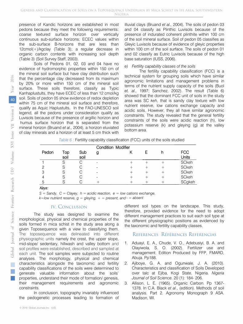
e) Fertility capability classes of the soils The fertility capability classification (FCC) is a
technical system for grouping soils which have similar agronomic limitations and management problems in terms of the nutrient supply capacity of the soils (Buol et. al., 1997; Sanchez, 2002). The result (Table 6) showed that the dominant FCC unit of soils in the study area was SC keh, that is sandy clay texture with low nutrient reserve, low cations exchange capacity and acidic soils. However, they all have similar agronomic constraints. The study revealed that the general fertility constraints of the soils were acidic reaction (h), low potassium reserve (k) and gleying (g) at the valley bottom area.
Table 6 : Fertility capability classification (FCC) units of the soils studied
Condition Modifier Pedon Top
soil Sub soil
g K E h FCC Units
1 S C - + + + SCkeh 2 S C - + + + SCkeh 3 S C - + + + SCkeh 4 S C - + + + SCkeh 5 S C + + + + SCgkeh
Keys: S = Sandy, C = Clayey, h = acidic reaction, e = low cations exchange,
- = absent
IV. Conclusion
The study was designed to examine the morphological, physical and chemical properties of the soils formed in mica schist in the study area along a given Toposequence with a view to classifying them. The toposequence was delineated into different physiographic units namely the crest, the upper slope, mid-slope/ sedentary, hillwash and valley bottom and soil profiles were established, described and sampled at each unit. The soil samples were subjected to routine analyses. The morphology, physical and chemical characteristics alongside the taxonomic and fertility capability classifications of the soils were determined to generate valuable information about the soils’ properties, understand their mode of formation/ genesis, their management requirements and agronomic constraints.
In conclusion, topography invariably influenced the pedogenetic processes leading to formation of
different soil types on the landscape.
This study, therefore, provided evidence for the need to adopt different management practices to suit each soil type at the different physiographic positions as evidenced by the taxonomic and fertility capability classes.
References Références Referencias
1.
Aduayi, E. A., Chude, V. O., Adebusiyi, B. A. and Olayiwola, S. O. (2002). Fertilizer use and management. Edition Produced by FFP, FMARD, Abuja. Pp188.
2.
Ajiboye, G. A. and Ogunwale, J. A. (2010). Characteristics and classification of Soils Developed over talc at Ejiba, Kogi State, Nigeria. Nigeria Journal of Soil Science.
20 (1): 184- 206.
3.
Allison, L. E. (1965). Organic Carbon. Pp 1367-1378. In C.A. Black et al., (edition). Methods of soil analysis. Part 2. Agronomy Monograph 9 ASA. Madison, WI.
Genesis and Classification of Soils on a Toposequence Underlain by Mica Schist in Ife Area, Southwestern Nigeria
© 2016 Global Journals Inc. (US)
40
Globa
lJo
urna
lof
Scienc
eFr
ontie
rResea
rch
V
olum
eYea
r20
16XVI
Iss u
e er
sion
IV
VII
( D)
k=low nutrient reserve, g = gleying, + = present, and
4. Ano, A. A. (1991). Potassium status of the Nigerian coastal plain sands. Journal of potassium Research 7 (4): 247-254.
5. Ayoub, A. T. (1999). Fertilizers and the environment. Nutrient Cycling in Agroecosystems 55:117-121.
6. Bouyoucos, G. H. (1951). A decalibration of hydrometer for making mechanical analysis of soil. Agronomic Journal 43: 434 – 438.
7. Bruand, A. C., Hartmann, S., P. Sindtusen, R. Poss, and M. Hardy, (2004). Composition, fabric and porosity of an Arenic Haplustalf of Northeast Thailand in Relation to penetration resistance. Soil Science Society of America Journal 48: 185-193.
8. Buol, S. W., F. D. Hole, R. J. Mc Cracken and Southard, R. J. (1997). Soil genesis and classification. 4th Edition, Iowa State University Press, Ames.
9. Chukwu, O. G., Tessy, U. M., Emilia, C. C. and Nkoli, H. A. (2013). Pedologists’ approach to agro-technology transfer: Case study of Ikwuano, Abia State, Nigeria. African Journal of Agricultural Research Vol. 8(2), pp. 148-152.
10. FMANR (Federal Ministry of Agriculture and Natural Resources) (1990). Literature review on soil fertility investigations in Nigeria.5 2:92-95; 5:252-261.
11. FAO, (2001). Lecture notes on the major soils of the world. World Soil Resources Reports, 94. Rome. Pp 334.
12. Fasina, A. S., J. O., Aruleba, F. O., Omolayo, S. O., Omotoso, O. S. Shittu and Okusami, T. A. (2005). Properties and classification of five soils formed on Granitic Parent material of humid southwest Nigeria. Nigeria Journal of Soil Science
Vol. 15 Pp 21-29.
13. Graham, R. C., Daniel, R. B. and Boul, S. W. (1990). Soil Geomorphic Relations on the Blue Ridge Front: l Regolith Types and Slope Processes. Soil Science Society of America Journal Vol. 54 Pp 1362-1367.
14. IUSS Working Group WRB, (2006). World Reference Base for Soil Resources 2006, 2nd edition. World Soil Resources Report 103, FAO, Rome. E.U. 145 pp. ISBN: 9251055114.
15. Jubrin, J. M., Chude, V. O., Host, W. J. and I. Y. Amagu, (2000). The response of 10 leguminous cover crop and mage native and applied phosphate. Proceedings of the 26th
Annual
Conference of Soil Science. Society of Nigeria.
Nigeria.
16. Landon, J. R. (1991). Booker Tropical Soil Manual. A handbook for soil survey and agricultural land evaluation in the tropics and subtropics. Longman Scientific & Technical Publishers, Essex. Pp 474.
17. Lawal, O. I., G. O. Adeoye, R. Asiedu and S. O. Ojeniyi, (2010). Organo- mineral fertilizer effect on yield and nutrient uptake of white yam (Dioscorea rotundata poir). In Ibadan southwestern nigeria. Nigeria Journal of Soil Science
20 (2): 35-46.
18. Mclean, E. O. (1965). Aluminum. In : Methods of soil analysis. C. A. Black (ed). Agronomy No 9. American Society of Agronomy. Pp 978- 998.
19. Murdoch, G. and J. Ojo-Atere, {1976}. Soils of the Western State Savanna in Nigeria. Vol. 1: The Environment. Land Resource Study No. 23. (+ maps) Land Resources Division, Ministry of Overseas Development Tolworth Tower, Surbiton, Surrey, England.
20. Nye, P. (1966). African experiencc of the use of fertilizers in the production of basic food crops. Proceedings of Soil and Crop Society Journal. Vol. (26) Pp 306-313.
21. Obigbesan, G. O. (2009). Impact of Liebig’s Research on the development of Agriculture in Africa. A paper presented at the 33nd Conference. of the Soil Science.Society. of Nigeria at Ado-Ekiti. Pp51.
22. Ojanuga, A. G.(1978). Genesis of soils in the metamorphic forest & region of southwestern Nigeria Pedolomorphic pedologie xxviii. 1: 105-117.
23. Ojanuga, A. G. (1979). Clay mineralogy of soils in the Nigerian tropical savanna regions. Soil Science Society of America Journal,. 43, 1237–1242.
24. Ojanuga, A. G., G. Lekwa and F. O. R. Akamigbo, (1981) “Survey, Classification and Genesis of Acid Sands, Acid sands of Southeastern Nigeria,” Soil Science Society of Nigeria, No. 1, pp. 1-7.
25. Okusami, T. A. and Oyediran, G. O. (1985). Slope-Soil relationship on an Aberrant Toposequence in Ife area of southwestern Nigeria; Variabilities in soils properties. Ife Journal of Agriculture. University of Ife, Nigeria 7 (1&2) 1-15.
26. Ololade, I. A., Ajayi, I. R., Gbadamosi, A. E., Mohammed, O. Z. and Sunday, A. G. (2010). A Study on Effects of Soil Physico-Chemical Properties on Cocoa Production in Ondo State, Journal of Modern Applied Science Vol. 4, pp 35- 43.
27. Onyekwere, I. N., Akpan Idiok, A. U., Amalu, U. C., Asawalam, D. O. and Eze, P. C. (2001). Constraints and opportunities in Agricultural utilization of some wetland soils in Akwa Ibom State. In: management of wetland soils for sustainable agriculture and environment. Proceedings of the 27th Annual Conference of Soil Society of Nigeria (SSSN) pp 139-149. S.O. Ojeniyi, I.E. Esu, U.C. Amalu, F.O.R. Akamigboi, I.J. Ibagan and B.A Ragi (eds).
28. Periaswamy, S. P. and Ashaye, T. I. (1982). Updated classification of some southwestern Nigeria soils. Ife Journal of Agriculture 4: 25-41.
29. Pregitzer, K. S., King. J. S., Burton, A. J. and Brown, S. E. (2000). Responses of tree fine roots to temperature. New Phytologist 147, 105–115.
30. Quideau, S. A., O. A. Chadwick, R. C. Graham, S. E. Trumbire, J. L. Johnson- Maynard and M. A. Anderson. (2001). vegetation control on soil organic matter dynamics. Org. Geochem; 32: 247-252.
Genesis and Classification of Soils on a Toposequence Underlain by Mica Schist in Ife Area, Southwestern Nigeria
1
Globa
lJo
urna
lof
Scienc
eFr
ontie
rResea
rch
V
olum
eXVI
Iss ue
er
sion
IV
VII
Yea
r20
16
41
( D)
© 2016 Global Journals Inc. (US)

31. Rahaman, M. A (1988). Recent advances in the study of the basement complex of Nigeria. In: Geological Survey of Nigeria (Ed)Precambrian Geol Nigeria, 11–43 pp.
32. Sanchez, P. A. (2002). Soil fertility and hunger in Africa. Science 295, 2019–2020.
33. Sheldrick, W. F., J. K. Syers and J. Lingard, (2002). A conceptual model for conducting nutrient audits at national, regional and global scales. Nutrient Cycling in Agroecosystems 62:61-72.
34. Soil Survey Staff, (2003). Keys to taxonomy, Ninth Edition USDA/NRCS, Washington D.C. Pp.332.
35. Soil Survey Division Staff, (2006). Soil Survey Manual. USDA Handbook No. 18. Govt. printing office, Washington D.C. Pp 279.
36. Smyth, A. J. and Montogomery, R. F. (1962). Soils and land use in central western Nigeria. Western Nigeria Government, Ibadan Pp 265.
37. Thomas, G. W. (1982). Exchangeable cations. Pp. 159–165. In A.L. Page et al., (ed.) Methods of soil analysis. Part 2. 2nd ed. Agron.Monogr.1 9. ASA and SSSA, Madison, WI.
38. Thomas, M. F. and Throp, M. B. (1985). Environmental Change and Episodic Ectoplantation in the Humid Tropics of Sierra Leone: The Koidu Etchplain: In Douglas, and Spencer, T. (ed.) Environmental Change and Tropical Geomorpho- logy. George Allen and Unwin, London, pp.239-267.
39. Uponi, J. I. and Adeoye, G. O. (2000). Soil Testing and Plant Analysis: an overview. Agronomy in Nigeria pp.177.
40. Van Raij Bernardo, and Michael Peech, (1972). Electrochemical properties of some oxisols and alfisols of the tropics. Soil Science Society of Nigeria Journal. Vol. 36: 587-593.
41. Wang, Jung, Projietu, Vaug Quil and Liding Chen (2001), Soil nutrients in relation to land use and landscape position in the semi-arid small catchment on the loess plateu in China- Journal of Arid. Environment Vol. 48: 537-550.
42. Wilding, L. P and L. R. Dress, (1983). Spatial Variability in Pedology, pp 83-113.
Genesis and Classification of Soils on a Toposequence Underlain by Mica Schist in Ife Area, Southwestern Nigeria
© 2016 Global Journals Inc. (US)
42
Globa
lJo
urna
lof
Scienc
eFr
ontie
rResea
rch
V
olum
eYea
r20
16XVI
Iss u
e er
sion
IV
VII
( D)