Embed Size (px)
Citation preview

W O R L D M E T E O R O L O G I C A L O R G A N I Z A T I O N ==============================================================
RARS IMPLEMENTATION GROUP (RARSIG) AND
IGDDS IMPLEMENTATION GROUP (IGDDSIG)
JOINT 4 th MEETING
GENEVA, SWITZERLAND
2224 March 2010
FINAL REPORT

EXECUTIVE SUMMARY
The fourth sessions of the Regional ATOVS Retransmission Service (RARS) Implementation Group and of the Integrated Global Data Dissemination Service (IGDDS) Implementation Group were held as a joint meeting on 22 to 24 March 2010 at the WMO Headquarters in Geneva, Switzerland.
Significant progress was recorded in the implementation of the RARS network, as summarized in the table below which indicates the number of operational stations providing data over the GTS, and the resulting coverage as a percentage of the globe’s surface. A particular achievement highlighted by the meeting was that since June 2009 all RARS data were transmitted in GTS bulletins in accordance with the agreed coding convention. New stations in Chile (Santiago), France/Indian Ocean (Saint Denis de la Reunion), Oman (Muscat), Russian Federation (Moscow) and the USA (Miami and Hawaii) had contributed to significantly extend the coverage as summarized below.
RARS Network
Stations in January 2009
(% coverage)
Stations in January 2010
(% coverage)
Stations end of March 2010
(% coverage)
Planned at end of 2010
(% coverage)
Planned at end of 2011
(% coverage)
Potential stations
(% coverage)
EARS 10 stations 23%
13 stations 31%
15 stations 35%
17 stations 41%
19 stations 44%
21 stations 49%
Asia Pacific
14 stations 28%
15 stations 28%
15 stations 28%
16 stations 30%
17 stations 33%
20 stations 35%
South America
5 stations 10%
6 stations 11%
6 stations 11%
9 stations 15 %
14 stations 16%
16 stations 19%
Overall network
29 stations 61%
34 stations 70%
36 stations 73%
42 stations 78%
50 stations 85%
57 stations 92%
Table 1: Global RARS network implementation indicators.
The meeting reviewed the Project Plan for the Extension of the RARS Network to Include Advanced Sounders. It identified a network of potential Xband stations and took action towards defining the processing architecture for hyperspectral sounding data.
The meeting reviewed the progress of IGDDS DVBS dissemination components including EUMETCast, FENGYUNCast, MITRA. It was also informed on GEONETCast and its American component, GEONETCast Americas as well as ISCS and NOAAPORT. It commended EUMETSAT for the Earth Observation Portal, which provides a convenient user interface to the EUMETSAT catalogue in accordance with relevant WIS standards. An update was provided on Direct Broadcast capabilities of NOAA actual and future systems and of the COMS satellite to be launched shortly, and on the approach to Internet distribution of HImawari8 data.
The meeting was also informed of the satellite data requirements gathering performed in RA III and RA IV, and the ongoing actions to address these requirements. It encouraged similar actions that are under consideration for RA I and RA V.
An open discussion was held on the strategic goals of the IGDDS initiative and the related priorities, taking into account the outcome of ETSUP5. Actions were taken to review the IGDDS Implementation Plan accordingly with a view to better delineate recommended strategic guidelines, on one hand, and implementation priorities, on the other hand.

RARSIGDDSIG4, FINAL REPORT, p. 1
MEETING REPORT
1. INTRODUCTION
Ms Barbara Ryan, Director of the WMO Space Programme, opened the fourth meeting of the RARS and IGDDS Implementation Groups and welcomed the participants (See Annex I). She pointed out that ETSUP5, which had met the preceding week, had stressed the importance of improving accessibility of satellite data and products worldwide. She also recalled that theWMO Integrated Observing Systems (WIGOS) and WMO Information Systems (WIS) provided a clear guidance towards increased interoperability through standardization of data management and distribution practices. Finally, she invited the Implementation Groups to focus on improving the service to the users in a simple and pragmatic way.
The Secretariat invited the participants to nominate a Chairperson for this meeting. Richard Francis, United Kingdom, was unanimously nominated Chairperson.
2. STATUS OF THE GLOBAL RARS NETWORK
2.1 Status of EARS
Anders Soerensen presented an update on the EUMETSAT Advanced Retransmission System (EARS) which includes not only ATOVS data retransmission but also AVHRR and ASCAT data retransmission from a subset of stations. EUMETSAT has registered more than 700 users for EARS/ATOVS, more than 900 for EARS/AVHRR, and more than 300 for EARS/ASCAT.
The ATOVS service involves 15 HRPT stations: eight of them are complying with the 30 mn timeliness requirement, four are between 30 and 45 mn, one is above 45 mn and two are still in test mode. The EARS ATOVS product suite includes ATOVS Level 1a in AAPP format, ATOVS Level 1c in BUFR, and AVHRR Level 1d on HIRS grid in BUFR. In order to optimize the overall EARS operation a set of core stations are following a planned acquisition schedule, while the other stations are following agreed priorities as far as possible depending on their availability. Details of participating stations are in Annex III.
The AVHRR service involves six stations. Thanks to a centralized data selection based on data quality and “on the fly” oneminute segments retransmission, AVHRR Level 1 data are delivered within 15 minutes from acquisition.
The ASCAT service currently relies on Fast Dump Extract Service data acquired in Svalbard only. Data are processed to Level 1b in Darmstadt then to Level 2 at KNMI, in order to deliver Ocean Surface Winds in BUFR format.
Anders Soerensen also reported on ongoing developments for retransmission of IASI data, and on mitigation activities for the MetopA Direct Broadcast, which can only be activated over a portion of the globe for technical reasons. The future Antarctic Data Acquisition station, with the use of data segmentation, should enable retransmission with 15 minutes timeliness. MetopB, to be launched in 2012, should have full HRPT service.
Action RARSIG4.01: RARSIG values the contribution of stations in Miami, St Denis and Ewa Beach that provide significant addition to the global RARS coverage, and encourages the involved parties to seek technical ways to further improve the timeliness towards the goal of 30 minutes. EUMETSAT to report at the next meeting. (Due date: RARSIG5)
2.2 Status of the AsiaPacific RARS
Anthony Rea reported on the status of the AsiaPacific RARS (APRARS) on behalf of the AP RARS partners. The APRARS involves 15 HRPT stations from Australia; China; Hong Kong, China; Japan; New Zealand; Republic of Korea and Singapore, with two processing and distribution centres:

RARSIGDDSIG4, FINAL REPORT, p. 2
Tokyo and Melbourne. APRARS data are used by a number of NWP centres including ECMWF, UKMO, JMA and Bureau of Meteorology. Details of participating stations are in Annex III.
JMA is performing timeliness monitoring for all APRARS sites. his information used to be available on the JMA website and its status will be investigated. The quality monitoring is performed globally by the EUMETSAT NWPSAF (See 2.4). An APRARS website is now available: http://www.bom.gov.au/weather/satellite/RARS/index.shtml
A new HRPT station implemented in Fiji is expected to join the APRARS at some stage, but no firm plan is agreed yet with Fiji Meteorological Service (FMS). The potential contribution of HRPT stations operated by the USA in Marshall Islands and Guam is also under consideration, but no reply was received yet from the USA on this issue.
A. Rea also reported on the upgrade of Australian sites (Darwin, Melbourne, Perth, Townsville) with XBand reception for NPP and NPOESS, following a Pilot Project with Aqua/Terra AIRS data.
Action RARSIG4.02:WMO SP to contact the Fiji Met Service in order to investigate issues and possible way forward to integrate Fiji in the AsiaPacific RARS. (Due date: May 2010)
JaeDong Jang provided further details on the new receiving station located at the National Meteorological Satellite Centre (NSMC) of KMA in Jincheon, Korea, which replaces the Seoul station in the APRARS. It was noted that Seoul is still operated and serves as a backup.
2.3 Status of the South American RARS
Ms Gloria Pujol reported on the component of the South American RARS supported by Argentina, which currently involves three stations. Córdoba and Marambio (Antarctica) stations have been contributing to the RARS since 2008. Santiago, Chile has joined the RARS in January 2010. The next planned extension is Cotopaxi, Ecuador. A station in Punta Arenas is under consideration but faces telecommunication bandwidth limitations. It was indicated that Córdoba, Santiago and Cotopaxi had X Band receiving capability. The Implementation Group noted the excellent reliability figures of the three current stations. Data are sent via FTP by CONAE to the RTH Buenos Aires and forwarded to RTH Washington for onward distribution over the GTS.
In order to alleviate bandwidth limitations, the meeting discussed the possibility to extract ATOVS data without AVHRR information, and to process the data remotely, e.g. in Córdoba instead of Marambio. It was clarified that in order to run AAPP without AVHRR data, the corresponding data should be formally included but set to zero. In case of telecommunication limitations, a tradeoff should be made between timeliness and comprehensiveness of the information (declouding information).There is a need to confirm users’ requirements in this respect.
Action RARSIG4.03:WMO SP and EUMETSAT to seek feedback from the NWP community at ITSC17 to have better knowledge of, e.g. who the users are, and whether data is still valuable in case the cloud information is not available. (Due date: April 2010)
Sergio Pereira reported on the Brazil component of the South American RARS, which involved three operational stations located in Cachoeira Paulista, Cuiabà and Brasilia, with plans to add Natal and Fortaleza in the course of 2010, and Manaus and Boa Vista later on. Data are processed centrally, in Cachoeira Paulista, to Level 1c BUFR files and delivered within 30 minutes in at least 95% of the cases. Since October 2008, RARS files are sent by INMET to the RTH Washington for onward distribution over the GTS. The addition of the CDPI station in Caracas, Venezuela is under consideration.
Action RARSIG4.04: WMO SP to contact Venezuela about possible inclusion of the CDPI Caracas station (Responsible: Freddy Flores) in South AmericaRARS. (Due date: May 2010)
2.4 RARS Operations Monitoring and Software Issues
RARSIGDDSIG4, FINAL REPORT, p. 3
Richard Francis summarized the changes in the operational monitoring of RARS data since RARSIG3, and the developments of the AAPP software package completed in this period. These two functions are performed by the UK Met Office in its role as the lead partner of the EUMETSAT Satellite Application Facility (SAF) for Numerical Weather Prediction (NWP).
It was reported that all RARS stations are now using BUFR edition 4 and all have successfully adopted the agreed numbering of data categories and subcategories. In addition, all stations are using the correct subcentre IDs, bulletin headers and file names. This represents significant progress since RARS IG3 and was noted by the group with satisfaction.
A summary of the current status of the contributing polar orbiting satellites (NOAA15 through 19 and MetopA) was then presented. Almost all have suffered some instrument degradation or other anomalous behavior since RARSIG3 to a greater or lesser extent. Nevertheless many RARS stations are tracking them and successfully generating RARS data from them all. A notable exception, at least for the APRARS and SARARS, is MetopA for which the HRPT Direct Broadcast is still only available for some of the stations of the EARSATOVS network. EUMETSAT have discussed with their Member States the possibility of increasing the area within which HRPT is switched on but this would depend on the continued availability of other satellites in the morning orbit (most notably NOAA17) and on assessment of the increased risk of a total HRPT failure that this would represent.
Four new stations have been added since RARSIG3: Casey, Antarctica (APRARS, added in June 2009); St Denis, La Reunion (EARS, Sept 2008); Santiago, Chile (SARARS, Jan 2010) and most recently Moscow, Russian Federation (EARS, Feb 2010).
The AAPP software package has undergone four updates since RARSIG3, the latest of which, version 6.12, was released on 25 Feb 2010 and represents a major advance. This latest version will support the upcoming EARSIASI service pilot phase, including the selection and processing of a subset of spectral channels (366 channels) along with 290 Principle Component scores. This important advance is fundamental to the introduction of a first inclusion of advanced sounder data in a RARS network.
Finally, future planned changes were briefly described, including development of a monitoring capability for the EARSIASI service pilot phase and the development of version 7 of AAPP, to include the preprocessing of ATMS and CrIS data from NPP.
The NWP SAF RARS monitoring page URL is: http://research.metoffice.gov.uk/research/interproj/nwpsaf/ears_report/monitor.html.
The Implementation Group acknowledged the role of the NWP SAF in support of the RARS network, and, in particular the very helpful assistance of Nigel Atkinson on AAPP issues.
3. OVERALL RARS GEOGRAPHICAL COVERAGE
Jérôme Lafeuille presented the updated coverage figures of the RARS network (Table 1).
RARS Network
Stations in January 2009
(% coverage)
Stations in January 2010
(% coverage)
Stations end of March 2010
(% coverage)
Planned at end of 2010
(% coverage)
Planned at end of 2011
(% coverage)
Potential stations
(% coverage)
EARS 10 stations 23%
13 stations 31%
15 stations 35%
17 stations 41%
19 stations 44%
21 stations 49%
Asia Pacific
14 stations 28%
15 stations 28%
15 stations 28%
16 stations 30%
17 stations 33%
20 stations 35%
South America
5 stations 10%
6 stations 11%
6 stations 11%
9 stations 15 %
14 stations 16%
16 stations 19%
RARSIGDDSIG4, FINAL REPORT, p. 4
Overall network
29 stations 61%
34 stations 70%
36 stations 73%
42 stations 78%
50 stations 85%
57 stations 92%
Table 1: Global RARS network implementation indicators.
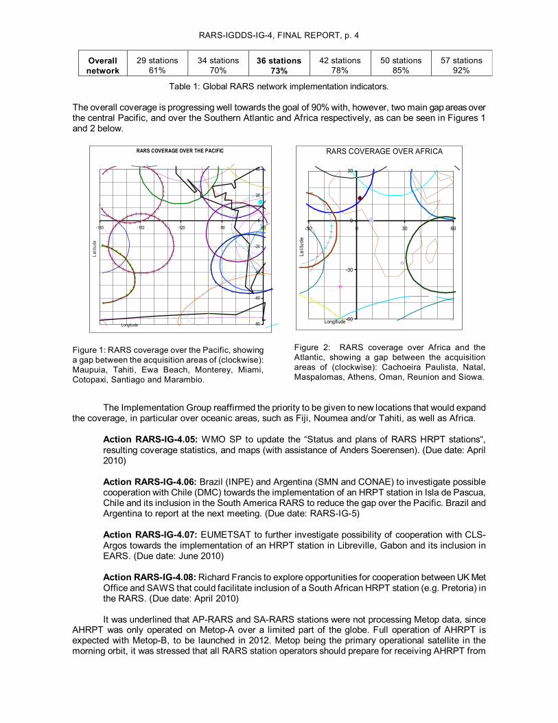
The overall coverage is progressing well towards the goal of 90% with, however, two main gap areas over the central Pacific, and over the Southern Atlantic and Africa respectively, as can be seen in Figures 1 and 2 below.
RARS COVERAGE OVER THE PACIFIC
80
60
40
20
0
20
40
180 150 120 90 60
Longitude
Latitud
e
Figure 1: RARS coverage over the Pacific, showing a gap between the acquisition areas of (clockwise): Maupuia, Tahiti, Ewa Beach, Monterey, Miami, Cotopaxi, Santiago and Marambio.
60
30
0
30
30 0 30 60
Longitude
Latitud
e
RARS COVERAGE OVER AFRICA
Figure 2: RARS coverage over Africa and the Atlantic, showing a gap between the acquisition areas of (clockwise): Cachoeira Paulista, Natal, Maspalomas, Athens, Oman, Reunion and Siowa.
The Implementation Group reaffirmed the priority to be given to new locations that would expand the coverage, in particular over oceanic areas, such as Fiji, Noumea and/or Tahiti, as well as Africa.
Action RARSIG4.05: WMO SP to update the “Status and plans of RARS HRPT stations“, resulting coverage statistics, and maps (with assistance of Anders Soerensen). (Due date: April 2010)
Action RARSIG4.06: Brazil (INPE) and Argentina (SMN and CONAE) to investigate possible cooperation with Chile (DMC) towards the implementation of an HRPT station in Isla de Pascua, Chile and its inclusion in the South America RARS to reduce the gap over the Pacific. Brazil and Argentina to report at the next meeting. (Due date: RARSIG5)
Action RARSIG4.07: EUMETSAT to further investigate possibility of cooperation with CLS Argos towards the implementation of an HRPT station in Libreville, Gabon and its inclusion in EARS. (Due date: June 2010)
Action RARSIG4.08:Richard Francis to explore opportunities for cooperation between UK Met Office and SAWS that could facilitate inclusion of a South African HRPT station (e.g. Pretoria) in the RARS. (Due date: April 2010)
It was underlined that APRARS and SARARS stations were not processing Metop data, since AHRPT was only operated on MetopA over a limited part of the globe. Full operation of AHRPT is expected with MetopB, to be launched in 2012. Metop being the primary operational satellite in the morning orbit, it was stressed that all RARS station operators should prepare for receiving AHRPT from
RARSIGDDSIG4, FINAL REPORT, p. 2
MetopB. It was noted that the four Australian stations as well as Kiyose, Jincheon, Cachoeira Paulista, Cuiabà, and Córdoba, were designed to receive Metop AHRPT but this had to be tested. Some test campaign could be envisaged with MetopA.
Action RARSIG4.09: Operators of RARS stations which are not currently equipped for acquisition of Metop data (for instance Santiago, Marambio, Beijing, Urumqi, Guangzhou, …) are encouraged to take steps to be ready for MetopB, to be launched early 2012. (Due date: RARS IG5)
Action RARSIG4.10: EUMETSAT to consider a test activation campaign of MetopA AHRPT over an extended area including the AsiaPacific, allowing current Metop receiving capabilities to be tested in advance of MetopB. EUMETSAT to report at the next meeting. (Due date: RARSIG 5)
4. RARS DATA DISSEMINATION ISSUES
4.1 Update on RARS Data Representation and Coding
The Implementation Group was glad to note that all operational RARS stations had successfully implemented the agreed coding convention, as described on the RARS website: ftp://ftp.wmo.int/Documents/PublicWeb/sat/Projects/RARSCodingsummary.xls
4.2 RARS Data Dissemination via GTS and Other Means
It was clarified that the “CCCC” code in GTS Bulletin headers was related to the “originating centre” injecting the data on the GTS. Thus the future data from Cotopaxi, Ecuador would be labeled “SABM” like Santiago, Chile since they are handled by Buenos Aires.
5. RARS EXTENSION TO ADVANCED SOUNDING MISSIONS
Richard Francis introduced the subject by firstly recalling the discussions at RARSIG3 and the subsequent drafting of a Project Plan for the Extension of the RARS Network to Advanced Sounders ( http://www.wmo.int/pages/prog/sat/documents/RARSXprojectplan.pdf). This plan focused on the ATMS and CrIS instruments planned for NPP and later for NPOESS. R. Francis highlightednew uncertainties on the schedule and precise definition of these future satellites because of the restructuring of the NPOESS Program, which is now split into a Joint Polar Satellite System (JPSS) on the afternoon orbit and a defense weather satellite system on an early morning orbit. While it is expected that the JPSS will be NPP followon, there is still no indication on the payload and Direct Broadcast data access possibilities of the early morning orbit component, under the responsibility of DoD. Nevertheless, the project to extend the RARS to NPP and its successors should proceed in accordance with the plan until and unless substantive changes to the assumed baseline were announced.
The Project Plan foresees a number of activities that are necessary before an extended RARS can be implemented, including:
• An interaction with users to make them aware of the new service concept and a discussion with them to agree their requirements;
• The upgrade to reception stations (those that are not NPPready); • An upgrade to communication link capabilities as necessary; • An optimizing of the data processing and data collection architecture; • The development of appropriate instrument data processing software packages; • An update to the RARS Operator Standards.
In mid2009 the NWP SAF was asked to contact European NWP centres and request their inputs to the requirement gathering process. Responses were received from the UK Met Office, ECMWF, SMHI, DMI, Met Norway and Meteo France. The responses included the following stated preference:
RARSIGDDSIG4, FINAL REPORT, p. 3
• All centres would prefer data sets encoded using BUFR; • They would prefer radiance data assigned to an instrument grid (equivalent to Level 1c); • All centres would prefer to receive native sampling for ATMS data (they would do their own
preprocessing (e.g. spatial averaging, remapping) if necessary); • They would prefer CrIS data at full spatial resolution and, if full spectral resolution would not
be possible (as is almost certain), they would accept a channel subset (perhaps with PC scores as currently envisaged for the EARSIASI service).
Several other inputs that might have a bearing on the project planning were then described. These included the following:
• BOM and INPE have started pilot studies using AIRS data and so any relevant experiences from these initiatives should be considered;
• Level 1 processing for NPP Direct Broadcast users (Xband reception systems) will be using the NASA International Polar Orbiting Processing Package (IPOPP), an early release of which is undergoing testing at several establishments;
• The definition of a version of the BUFR tables for ATMS and CrIS data has been developed by NOAA based on a channel subset of CrIS data (although not incorporating PC scores as yet);
• Experience gained from the EARSIASI service pilot phase will be important to take account of for extending RARS;
• The inclusion of FY3 data could already be considered for RARS (a preprocessing software package is available from CMA) and, in the future when the FY3 sounder capability is enhanced (probably from FY3D onwards), then this satellite could be a useful contributor to the extended RARS.
Finally, the next steps as described in the Project Plan were outlined, including:
• Consideration of an initial set of potential participating stations (taking account of what is already known of their Xband reception capability);
• Consideration of an initial definition of the data processing architecture; • Consideration of the communication needs (which to some extent is dependent on decisions
of the chosen architecture).
Anders Soerensen informed the meeting that EUMETSAT was developing a EARS/IASI service and was investigating options for extending EARS to supporting future satellites including NPP, NPOESS, FY3.
The meeting emphasized that there was a rapidly changing environment both on the space segment and the ground segment, and that the project should be focused on delivering outcomeswith the most clearly assessed benefit. For NWP, the impact of improving timeliness depends on the cutoff for either the main run or the later update. Some impact studies have been made by NWP centres (BOM, KMA, probably others).
As concerns receiving sites, the Implementation Group agreed that the project should rely as far as possible on existing resources and reviewed the list of RARS sites currently equipped, or planned to be equipped, with XBand receiving capability in 7.8 GHz (Annex A.2 of the Project Plan). The updated list includes: Lannion, Moscow, Khabarovsk, Novosibirsk, Oman, Gander (TBC), Edmonton (TBC), Cachoeira Paulista, Cuiabá, Córdoba, Santiago, Melbourne, Darwin, Perth, Casey (with communication limitation), Townsville, Kiyose, Jincheon, Bejing, Guangzhou, Urumqi, Maupuia, Singapore. (See Annex IV).
As concerns the processing architecture, the Implementation Group considered that the baseline for RARSNPP should be onsite processing using IPOPP. The use of “Simulcast” was thought to be inadequate because it is not optimized for timeliness and relays all the data without selection. There is a need for active optimization of acquisition and data transfer, as is the case in the EUMETSAT EARS
RARSIGDDSIG4, FINAL REPORT, p. 4
AVHRR service; in order to make such a coordinated approach applicable in different computer environments, it was suggested to use the concept of “Virtual Machines”. The Implementation Group agreed that pilot activities on AIRS and IASI should be evaluated before adopting any particular strategy. The following actions were agreed:
Action RARSIG4.11: EUMETSAT, in cooperation with NWP SAF, to demonstrate the possibility to deliver an AAPP package to “virtual machines”. (Due date: June 2010)
Action RARSIG4.12: EUMETSAT, in cooperation with EARSIASI partners, to demonstrate the removing of overlap among EARSIASI data from adjacent EARS stations, as a possible model for the extension of RARS to advanced sounders. (Due date: February 2011)
6. RARS USER INFORMATION
6.1 User Interaction and Outreach Issues
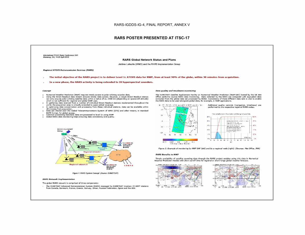
Jérôme Lafeuille recalled the previous decision to give visibility to the RARS project through the International TOVS Study Conferences (ITSC) and informed the meeting that a poster on RARS would be presented on behalf of the RARS Implementation Group at the 17 th ITSC (ITSC17, Monterey, CA, USA, 1420 April 2010). The outline of the Poster had been circulated for review. The final version of the poster is attached as Annex V.
6.2 WMO RARS Website
The WMO RARS web pages are available at: http://www.wmo.int/pages/prog/sat/RARS.html. Diagrams will be updated in accordance with the latest RARS network status. It was suggested to illustrate the RARS coding conventions by practical examples.
6.3 Individual RARS Websites
The individual RARS websites were recalled:
• EARS: http://www.eumetsat.int/Home/Main/Satellites/GroundNetwork/EARSSystem/index.htm?l=en
• AsiaPacific RARS (BOM): http://www.bom.gov.au/weather/satellite/RARS/index.shtml • AsiaPacific RARS (JMA): http://mscweb.kishou.go.jp/rars/index.htm • NWPSAF:
http://research.metoffice.gov.uk/research/interproj/nwpsaf/ears_report/monitor.html
It was noted that access to the NWPSAF monitoring pages is no longer subject to registration.
7. SUMMARY OF RARSRELATED ACTIONS
7.1 Status of RARS actions from previous meetings
One action was outstanding from the first meeting: “Action RARSIG1.3 part b): For files that only contain RARS data, to start implementing the WMO Core Profile of the ISO Metadata standard (version 1.0 adopted by CBS Ext.(06)), and to contribute to the further development of these standards, in particular through the InterProgramme Expert Team on Metadata Implementation.”
EUMETSAT confirms that the product navigator is the source of metadata. It describes all EUM data resources, compatible with ISO 19115/19139 standards and the EU INSPIRE directive http://www.eumetsat.int/Home/Main/Access_to_Data/ProductNavigator/index.htm; INPE has also implemented these changes. BOM and Argentina have planned to do so.
RARSIGDDSIG4, FINAL REPORT, p. 5
The action seems on a good track but its full implementation should be checked, when the first Data Collection or Production Centres (DCPC) and Global Information System Centres (GISC) will be implemented on a pilot basis in the context of the WMO Information System (WIS). This could be done by Argentina (SMN and CONAE), Australia (BOM, also acting for New Zealand, Singapore, Hong Kong), Brazil (INPE in collaboration with INMET), China (CMA), Japan (JMA) and Korea (KMA) for their respective products. The action is therefore CLOSED, and replaced by a new action:
Action RARSIG4.13: The RARS operators and regional or subregional RARS network coordinators to check that the RARS products are listed and described with proper metadata in the relevant WIS DCPC and GISC catalogues. (Due date: RARSIG5)
One action was outstanding from the second meeting: “Action RARSIG2.11: BOM to review their proposed website for compliance with the RARS Operator Standards, EARS andWMO websites, and to propose an update for propagation to other RARS operators. Due date: endJuly 2008.”The website developed by BOM largely complies. There is no plan for propagation at present, but this is not seen as a priority. The action is therefore closed.
All actions from the third meeting have been completed and can be closed, noting the following comments:
• Regarding Action RARSIG3.1, a letter was sent by WMO on 29 September 2009 to the Permanent Representative of the USA about the potential inclusion of HRPT stations in Guam and the Marshall Islands within the RARS network, but no response was received so far.
• Regarding Action RARSIG3.3, the two HRPT stations located in Edmonton are physically closed and serving as backup to each other; they will share the same identifiers.
The Chairman expressed his appreciation of the good progress made as all previous actions had been successfully completed and closed.
7.2 Summary of outstanding and new actions
The actions discussed under item 1 to 7.1 above were reviewed and agreed. The consolidated list of RARS related actions is contained in Annex VIII.
This concluded the first part of the meeting, dedicated to RARS. The second part of the meeting was dedicated to IGDDS issues.
8. IGDDS DVBS SERVICES AND GEONETCAST
8.1 IGDDS Standards for DVBS Dissemination Services
Jérôme Lafeuille firstly clarified that there had been an evolution along the years in the concept of the Integrated Global Data Dissemination Service (IGDDS). The initial scope of IGDDS was to respond to the request of ECLVI “to consider an IGDDS that builds on the “”Alternative Dissemination Methods”” concept and is central to the vision of an integrated spacebased component of the GOS”. In the context of the WIS, the scope of IGDDS was then widened to ensure that spacebased observation data and products would be handled in an integrated manner with the other (nonspace) data. Furthermore the so called “ADM” (i.e. the use of DVBS services) should not exclude other means such as Direct Broadcast or Internet. In summary, IGDDS is now addressing the whole circulation scheme of satellite data and products within the WIS, in compliance with WIS standards, with an overarching goal to enhance data access by WMO Members. Achieving the dissemination of satellite data and products worldwide by DVBS services remains a core objective of IGDDS, without being limitative.
Jérôme Lafeuille then recalled the DVBS Operator standards, adopted in April 2009, which are addressing the following topics:

RARSIGDDSIG4, FINAL REPORT, p. 6
• Architecture; • Functionalities, redundancy/robustness; • Format, file naming and metadata (WIS conventions); • User consultation, requirements gathering; • Reception terminals, software; • Publication of service information; • User Support; • Maintenance; • Reporting.
Each DVBS operator had therefore been invited to report on its service with reference to these topics. It was agreed to develop a table summarizing the characteristics of current and planned DVBS services of relevance to the IGDDS, based on the information shared at the meeting. This table is provided asAnnex VI of the present report.
8.2 EUMETCast Status and Plans
Lothar Wolf reported on EUMETCast status and plans. He indicated that EUMETCast was part of a wider dissemination system comprising also RMDCN (pointtopoint GTS network in Europe), Internet and DANTE (for bilateral non operational data exchange) links. He highlighted the dramatic increase of dissemination data rates resulting in new missions: MTP (0.166 Mbps), MSG (3 Mbps), EPS (8 Mbps), Sentinel 3 (~30 Mbps), MTG (~ 80Mbps), EPS 2G (~90Mbps), which requires highly efficient and flexible dissemination technologies.
EUMETCast includes three services: a KuBand service covering Europe; a CBand service covering Africa, Caribbean region and western Asia; and a CBand service covering the Americas. The EUMETCast system level availability is around 99.99% (99.5% guaranteed) with mission related timeliness. The data contents include a number of EUMETSAT mission data and products and thirdparty meteorological and environmental data (recent inclusion of the French RETIM service). More than 3500 EUMETCAST stations are registered. Meteosat, NOAA and Metop imagery represents the most popular product category with between 1000 and 2000 users registered for each of these products. User consultation is performed on a regular basis through representatives of the EUMETSAT Member States. Another user consultation mechanism is being implemented with the African community. EUMETSAT is planning to migrate to the DVBS2 standard within two years, which will allow a dynamic increase of the actual data rate, and would imply the use of larger antenna dishes.
8.3 FENGYUNCast Status and Plans
Lui Jian reported on the plans for the new FENGYUNCast 1 that will merge the two DVBS dissemination systems of CMA: the current FENGYUNCast for satellite data, operated so far by the National Meteorological Satellite Centre (NSNC), and the system used to disseminate meteorological observations and forecast, operated so far by the National Meteorological Information Centre (NMIC). The new service will use an entire 36 MHz bandwidth transponder in CBand, allowing up to 70 Mbps effective data rate in DVBS2 standard. The new FENGYUNCast 1 will be operated by CMA/NMIC, the uplink will be at the Beijing ground station of NSMC, and will use the Asiasat4 satellite.
Receiving will be possible with ontheshelf equipment together with a USB key containing the decryption software, with prior registration and authorization. Migration to the new FENGYUNCast 1 is planned for the end of 2010.
In terms of satellite data, the system is expected to broadcast data from FY2, FY3, Aqua/Modis and Meteosat. The data contents may be reviewed depending on data policy arrangements and user requirements.
1 The official name of the new FENGYUNCast service is now ”CMACast”.

RARSIGDDSIG4, FINAL REPORT, p. 7
8.4 MITRA Status and Plans
A brief report on MITRA was presented by the WMO Secretariat on behalf of Dzhalil Akhtyamov. The meeting noted that MITRA is a DVBS dissemination service in CBand (3.675 MHz). It involves three satellites (Express AM1, Express AM33, Express AM3) located at 40°E, 96.5°E and 104°E respectively in order to cover the whole Russian Federation and the Community of Independent States. Special attention is paid to robustness through: (i) Redundant transmission among the three spacecraft; (ii) Forward Error Correction (FEC) coding; (iii) Peertopeer recovery of missing data. MITRA has more than 300 registered users across theRussian Federation and neighbouring countries. A permanent technical support service is available in the Russian language.
MITRA has developed a “hot folder” approach allowing specific user groups to become a virtual broadcaster and to submit products via FTP to the MITRA operator for dissemination to the members of the group.
The report raised the attention of the IGDDS Implementation Group to the issue of interference with Broadband Wireless Access (BWA) systems, including the WiMAX technology. While CBand is not subject to meteorological conditions, it is increasingly affected by interference with e.g. radar or BWA systems, which requires specific mitigation measures such as narrowband filters.
8.5 NOAAPORT and ISCS Status and Plans
Paul Seymour reported on the NOAAPORT, also known as the Satellite Broadcast Network (SBN) of NOAA, which is the primary vehicle by which hydrometeorological products are provided to the field offices of the National Weather Service (NWS) and their “AWIPS” systems. NOAAPORT is a DVBS system operated in CBand, which delivers approximately 10 Mbps of products in a number of formats including GRIB, BUFR, GINI, Radar Level 3, text etc. The system relies on SESAmericom located at 101°W, with a coverage area corresponding to North and Central America. NOAA is considering to expand the bandwidth in 20112013 and to migrate to DVBS2 standard.
The meeting noted that NOAAPORT could be considered as an IGDDS component. It was clarified that a vast majority of NOAAPORT products were freely available to external partners; however NOAAPORT is to be used with AWIPS workstations, which is not a lowcost solution since it includes extensive processing capabilities.
Paul Seymour also reported on the International Satellite Communications System (ISCS) service, which is a VSAT dissemination service for meteorological and aeronautical operations in RA IV. Its current data rate is 128 kbps. Initially a twoway service, it will be limited to oneway dissemination as of April 2010 and until June 2012. NOAA is investigating different technical options for delivering a similar service beyond 2012.
The meeting pointed out the potential interest, for the users, of merging this service with other broadcast services operated in the same geographical area.
8.6 GEONETCastAmerica Status and Plans
Paul Seymour furthermore reported on GEONETCastAmericas (GNCA), an environmental data dissemination system implemented by NOAA as a contribution to the Global Earth ObservationSystem of Systems (GEOSS) of the Group on Earth Observations (GEO). GNCA is a Cband DVBS dissemination service with 2 Mbps bandwidth (with options to increase to 10 Mbps). It relies on Intelsat9 spacecraft located at 58°W and covers North, Central and South America as well as the Caribbean region. GNCA is offering a relatively lowcost access to environmental data produced by NOAA or other partners within the region (e.g. INPE, CONAE, SERVIR, etc). GNCA is the NOAA component of the overall GEONETCast network described below.
The meeting noted that the system had a high flexibility allowing a number of regional partners to contribute in providing data or products, and was open to respond to regional requirements. A number of
RARSIGDDSIG4, FINAL REPORT, p. 8
actions were undertaken to engage users and providers in Central and South America. An alert channel is available, which could be very useful for some hazard warning applications.
8.7 GEONETCast Status and Plans
Paul Seymour introduced the global GEONETCast system on behalf of the GEONETCast Implementation Group including CMA, EUMETSAT, NOAA and WMO. He explained that GEONETCast is a nearglobal distribution system currently supported by three operators:
• CMA with its FENGYUNCast service covering Asia and part of the Pacific; • EUMETSAT with its three EUMETCast services covering Europe, Africa, and the Americas
and Caribbean region; • NOAA with its GEONETCastAmerica service covering the Americas and Caribbean region.
He recalled the guiding principles of GEONETCast, which largely respond to the IGDDS principles (DVBS dissemination to be received by offtheshelf, relatively lowcost equipment, integrating data from multiple sources and formats, interregional data exchange, data discovery and subscription capability, user requirement consultation mechanism), however with the aim to serve not only WMO needs but virtually any GEOSS application requiring lowcost, timely and reliable data distribution. The meeting noted the recent inclusion of a training channel and an alert channel.
The meeting recommended that the IGDDS Implementation Group evaluate GEONETCast with respect to the IGDDS requirements in order to be able to advise both the GEONETCast Implementation Group and the WMO Members.
Action IGDDSIG4.1: WMO Space Programme to include on the agenda of IGDDSIG5 an evaluation of GEONETCast with respect to IGDDS requirements.
9. STATUS OF OTHER IGDDS DISSEMINATION CAPABILITIES
9.1 Evolution of Direct Broadcast
It was stated that, although DVBS services are recommended as a costefficient way to integrate data from multiple sources into a single data stream, Direct Broadcast services have their own merits in particular for realtime acquiring data from nongeostationary spacecraft.
JaeDong Jang (KMA) introduced the dissemination plan of the new Communication, Ocean and Meteorological Satellite (COMS) of Korea, which is ready for a launch in June 2010. The Meteorological Imager (MI) will scan the whole disc every three hours, Asia every 15 minutes, and the Korean peninsula every eight minutes. Data will be disseminated in HRIT (3 Mbps) and LRIT (256 kbps TBC) in accordance with CGMS standards, within 15 minutes after acquisition. The meeting welcomed this information and congratulated KMA for this new contribution to the spacebased observing system.
Paul Seymour presented NOAA’s current and planned Direct Broadcast services for GOES and POES satellites. GOES currently supports GVAR, LRIT, and additional services such as DCS retransmission, Emergency Manager Weather Information Network (EMWIN), and Search and Rescue. There will be a change of GVAR format starting with GOES14. The new generation starting with GOES R in 2015 will provide a considerably enhanced dissemination capability, still at 1.7 GHz, with the “GVAR to GOES Rebroadcast” (GRB) service (31 Mbps) in addition to eGVAR (2.11 Mbps) ensuring continuity with current GVAR, and LRIT (increased to 400 kbps, including the EMWIN dataflow). POES satellites currently support HRPT and APT (analog, 137 MHz), in addition to DCS and Search and Rescue. As concerns the new generation following POES, the NPOESS baseline included HRD (20 Mbps, XBand) and LRD (4 Mbps, LBand) for both the afternoon and the early morning orbit; this baseline may be reviewed as part of the NPOESS programme restructuring. P. Seymour provided details on the Emergency Manager Weather Information Network (EMWIN), which is rebroadcasting products via GOES satellite transponders. The EMWIN is planned to migrate to a new generation in the middle of 2010, with a change of modulation and frequency and a doubled data rate.
RARSIGDDSIG4, FINAL REPORT, p. 9
Jérôme Lafeuille presented a synthesis of current and planned Direct Broadcast services (frequency and data rate), which was reviewed and updated by the meeting, as contained inAnnex VII. He recalled that the Coordination Group for Meteorological Satellites (CGMS) has defined the HRIT/LRIT and AHRPT/LRPT dissemination standards for Direct Broadcast based on recommendations of the Consultative Committee on Space Data Systems (CCSDS). With the exception of APT on POES and MPT on FY3, all Direct Broadcast services from operational satellites (HRIT, LRIT, AHRPT, LRPT, WEFAX, GVAR, SVISSR…) are operated in LBand, at 1.7 GHz. It was pointed out that future generations of geostationary and polarorbiting meteorological satellites tend to use Xband, at 7.8 GHz, for high data rate dissemination services. These current or planned XBand services are not supported by any CGMS agreed standard. The question is raised of the need and possibility of proposing a standard for these high data rate services. If relevant, an action should be initiated towards preparing a discussion at the next CGMS meeting.
Another candidate for harmonization is the inclusion of an EMWIN type of information in the low rate dissemination of future missions. EMWIN is the Emergency Manager Weather Information Network, a lowcost information service dedicated to emergency managers and implemented in the current LRIT and future HRIT dissemination of GOES satellite series. Based on the successful experience of the USA in this respect, the possibility, cost and advantages could be investigated of implementing a similar service on other geostationary satellites under the coordination of CGMS.
9.2 Internetbased Dissemination
Toshiuki Kurino reported on JMA’s dissemination services for MTSAT and followon spacecraft. He informed that HRIT and LRIT will continue to be operated via MTSAT1R after the switchover of acquisition to MTSAT2 in July 2010. In addition, JMA will continue to provide JMA Data Dissemination System (JDDS) relying on landlines. The JDDS currently uses FTP over Internet and will evolve, in the context of WIS, to a Virtual Private Network (VPN). He indicated that the JDDS contains image data in JPEG and SATAID products particularly adapted to the needs of NMHSS in Pacific islands. JMA is determined to establish, maintain and update the imagery dissemination services to NMHSs via Internet with userfriendly satellite products for Nowcasting, training and other activities. JMA is also willing to make available additional image sectors depending on user requirements.
For the next generation Himawari 8/9, JMA is planning to downlink data to two ground stations and ensure dissemination via a Wide Area Network (WAN). The Internet dissemination system will be upgraded beforehand to secure a smooth transition. The data will include 16channel image data every 10 minutes in different forms:
• Level 1 data in standard format, e.g. netCDF; • Reduced data (1km/4km, 10 bits) compatible with current MTSAT HRIT, in transition period; • Reduced data (5 km, 8 bits) compatible with current MTSAT LRIT, in transition period; • JPEG image sectors for users with limited bandwidth.
10. INTEGRATION AND STANDARDIZATION ISSUES
10.1 Data Discovery, Access and Retrieval: Metadata and Product Navigator
Lother Wolf introduced the EUMETSAT EO Portal which provides EUMETSAT users with a single point of online access to all EUMETSAT data and dissemination services. It allows users to discover, search, order and subscribe to operational services of EUMETSAT, using international standards. By the end of 2010 it will also include services of partner agencies. The EO portal includes on one hand a Product Navigator for search and discovery, compliant with ISO metadata profile 19115/19119, ISO 19139, and OGC catalogue services CSW 2.0.2, and, on the other hand a user management interface and webmap service. The EO Portal is fully compliant with WIS and GEOSS standards and the EU INSPIRE directive.
10.2 Task Force on Codes

RARSIGDDSIG4, FINAL REPORT, p. 10
Jérôme Lafeuille gave a brief update on the Task Force on Codes, which had one facetoface meeting and one virtual meeting. The initial work has been focused on updating Common Code Tables:
• C11 and C12 tables of centres and subcentres (for RARS); • C5 (satellites), C8 (instruments) in preparation for future missions; • C13 (data categories and subcategories).
On the latter issue the Task Force proposed a new categorization of data, which is currently in “demonstration” status, whereby the categories are linked to the variables rather than to specific instruments. Feedback from satellite operators is needed on the practicality of this approach.
Satellite operators are encouraged to support the efforts of the Task Force, whose role is to advise the CBS Expert Team on Data Representation and Codes and the CGMS.
10.3 DCPC Designation Process (verbal update)
The meeting was informed of the ongoing process of designation of WIS Data Collection or Production Centres (DCPC) and Global Information System Centres (GISC) for the WMO Information System (WIS). It was emphasized that every satellite operator was potentially a DCPC and was encouraged to apply as such.
Action IGDDSIG4.2: Each IGDDS satellite operator to include in his report to the Implementation Group a status with respect to the DCPC designation. (Due date: IGDDSIG5)
11. REGIONAL REQUIREMENTS FOR DATA ACCESS
11.1 Satellite Data Requirements Workshop for RA III/RA IV
The inventory of data and product requirements is one of the important steps foreseen in the IGDDS Implementation Plan, and is furthermore requested in the context of the WIS. This process has to be conducted at the regional level, since it has to take into account specific regional context for example in terms of meteorological applications, communications infrastructure, or available data sources and processing capabilities.
Sergio Pereira and Jérôme Lafeuille reported that this had been addressed for RA III and RA IV, with the support of a Satellite Data Requirements Task Team established in June 2009 by the WMO SecretaryGeneral and led by the RA III Rapporteur on the Space Programme. A template for identifying requirements was defined, and requirements were developed by the Task Team. A Satellite Data Requirements Workshop was then held on 13 February 2010 at INPE in Sao Jose dos Campos, Brazil to review the outcome of this requirements gathering exercise with the Task Team members (from nine South and Central American countries), the president of CBS, representatives of NOAA and EUMETSAT, and the WMO Secretariat. Among its major outcomes, the workshop enabled:
(a) Better understanding of the technical and operational context of WMO Members in the area; (b) Better understanding of the capabilities of existing and planned data dissemination means; (c) Review and update of the data requirements; (d) Demonstration of a process for requirements gathering and subsequent dialogue among data
users and providers; (e) Definition of a number of precise actions, aiming to respond to the highest priority needs in
the shortterm; (f) Recommendations to prepare a sustainable response to regional needs in the longer term.
The meeting appreciated that a formal dialogue had been established among users and providers, with the understanding that requirements had to be evaluated before possible adoption. It is suggested to
RARSIGDDSIG4, FINAL REPORT, p. 11
inform the CBS in order to formalize the process, ensure its sustainability and to encourage similar initiatives in other Regions.
It was pointed out that the NMHSs are encouraged to represent the needs of their whole country but in most cases this can only be achieved if they also involve other organizations (e.g. disaster management, etc).
11.2 Dissemination Requirements for the Pacific region
The meeting discussed the possible extension of this approach to the Pacific area (RA V). It was highlighted that NMHSs of Pacific islands were highly dependent on satellite information, in particular for tropical cyclone monitoring, but had in many cases a very limited capability to acquire satellite data either directly or via Internet. It was noted that the Pacific area represented a large gap between the areas covered by FENGYUNCast and GEONETCast respectively. An additional DVBS dissemination service, such as an extension to the Pacific area of an existing system, could be a very helpful complement to current services. It was emphasized that a potential advantage of such service is that it could easily combine data from different contributors (e.g. MTSAT and GOESW data and valueadded products) thus providing the users with a single access to multiple data flows with a limited infrastructure investment, while enabling the providers to share the telecommunication cost. Without fully duplicating the other dissemination means it could, for example, contain a minimum set of information providing some redundancy and robustness for the case of unavailability of the Internet access and/or the Direct Readout equipment. The WMO Secretariat confirmed that this would well respond to the Executive Council recommendation to “consider an IGDDS that builds on the ADM concept.”
The meeting strongly encouraged WMO and the relevant satellite data providers to facilitate a regional initiative to collect satellite data requirements for Pacific island countries. It was pleased to note the willingness of the BOM, JMA, and NOAA representatives to support this process and to investigate possibilities to support a new dissemination initiative in response to such requirements.
11.3 RA I EUMETCast Products and Dissemination Expert Group
The meeting was informed that EUMETSAT and WMO were preparing the establishment of an Expert Group to review the requirements for data and products dissemination over EUMETCast in RA I (Africa). A first meeting of this group is expected to be convened either during the forthcoming African Ministerial Conference or during the 9 th EUMETSAT User Forum in September 2010.
Finally, the meeting recalled the initiatives taken by APSDEU to consider additional requirements for FENGYUNCast, the new Pilot Project in RA II to develop information on data access and to review requirements, and the ROSHYDROMET action to identify requirements of NMHSs of CIS.
12. USER INFORMATION ON DATA AND PRODUCT ACCESSIBILITY
Jérôme Lafeuille reported recommendations of the fifth session of the Expert Team on Satellite Utilization and Products (ETSUP5) held in Geneva from 15 to 19 March 2010 on improving data accessibility.
Among other points, he recalled that the lack of information on what data and products are available, and on how to access them in practice, was often quoted as a limiting factor for the wide use of satellite data and their benefit to society. The meeting was reminded that the Space Programme Office maintains web pages indicating the status and plans of all missions contributing to the GOS ( http://www.wmo.int/pages/prog/sat/GOSgeo.html, http://www.wmo.int/pages/prog/sat/GOSleo.html, http://www.wmo.int/pages/prog/sat/GOSresearch.html ), with hyperlinks to the information on data accessibility. All satellite operators were encouraged to review, complete and update this information as appropriate.
13. IGDDS IMPLEMENTATION PLAN REVIEW AND UPDATE
RARSIGDDSIG4, FINAL REPORT, p. 12
Jérôme Lafeuille recalled earlier discussions of the IGDDSIG on the IGDDS Implementation Plan. It was suggested to better highlight on one hand the strategy, and on the other hand the actions. The purpose of the Implementation Plan is to facilitate evolution along the recommended strategy. It should identify priorities for implementing the strategy and list the corresponding actions focussingon critical and timelimited actions without trying to be exhaustive since it should remain highlevel.
The meeting agreed on the following priorities:
• Organizing the formulation of data requirements (both from a regional approach and a thematic approach) and the dialogue between data users and providers;
• Implementing regional DVBS dissemination systems in every region to offer a costefficient and integrated access to most satellite data sources;
• Demonstrating the inclusion of all relevant data types in the broadcast services, including interregional data exchange;
• Support harmonization of future Direct Broadcast systems as well;
• Support the implementation of complementary data access and distribution via the Internet;
• Implementing WIS data standards and conventions, satellite operators becoming Data Collection or Production Centres (DCPC) within the WIS framework;
• Permanent information resources through adequate portals, and active user information including links to appropriate software tools;
• Monitoring the progress and seeking feedback.
It was clarified that current ongoing actions were fully consistent with such a revision of the Implementation Plan. The meeting considered that the progress and achievements should be recorded and acknowledged. The meeting also stressed the need for the IGDDS Implementation Plan to describe a clear articulation with the overall WIS. It was also recommended to emphasize the prospective dimension, anticipating the evolution of technology, user communities and needs, which can provide useful guidance to WMO Members. The following actions were agreed:
Action IGDDSIG4.3: WMO SP Secretariat to draft an outline of a new strategy document and implementation plan that would replace the current IGDDS Implementation Plan (v2), for review and inputs by IGDDSIG members. (Due date: End 2010)
Action IGDDSIG4.4: IGDDSIG members to review and provide and inputs to the draft strategy and implementation documents. (Due date: IGDDSIG5)
Action IGDDSIG4.5: IGDDS Implementation Group members to inform the IG of relevant strategic or planning activities that could be of relevance to the refinement of the strategy and implementation plan. (Due date: IGDDSIG5)
14. INFORMATION ON RELEVANT ONGOING ACTIVITIES
No additional point was raised under this item.
15. SUMMARY OF IGDDSRELATED ACTIONS
15.1 Status of IGDDS actions from previous meetings

RARSIGDDSIG4, FINAL REPORT, p. 13
In reviewing the outstanding actions from previous meetings, the Implementation Group noted the progress made. It also noted that several actions were still ongoing but should be reformulated. It was agreed that all previous actions would beclosed, and replaced by the following new actions:
Action IGDDSIG4.6: ROSHYDROMET to report at IGDDSIG5 on the progress in establishing subregional requirements. (Due date: IGDDSIG5)
Action IGDDSIG4.7: IGDDS Implementation Group members participating in APSDEU and the North America and Europe Data Exchange meetings to report back to IGDDSIG5 on latest status of the requirements gathering activity of these groups. (Due date: IGDDSIG5)
Action IGDDSIG4.8: JMA, BOM and KMA to express their requirements for proposed additions to the FENGYUNCast dissemination schedule in coordination with WMO SP, to enhance the regional operational value of FENGYUNCast, with a view to obtaining a consolidated regional proposal to be formally communicated to CMA. (Due date: End July 2010)
Action IGDDSIG4.9: CMA to investigate the feasibility of adding the requested products to the FENGYUNCast dissemination schedule and to provide a timetable for their introduction. (Due date: End of 2010)
Action IGDDSIG4.10: EUMETSAT to inform the IGDDS Implementation Group members of the impact on the users of migrating to DVBS2. (Due date: End 2010)
15.2 Summary of outstanding and new actions
A summary of the IGDDS actions is provided in Annex IX.
16. ANY OTHER BUSINESS
An update was given on the DCP data circulation scheme with implications on the responsibilities for quality control, coding and injection to the GTS. It was concluded that the Expert Team on Operational Implementation of the GTS was the best qualified to advise the IGDDS Implementation Groupmembers on these issues.
17. CONCLUSION
The participants agreed that such a joint RARSIGDDS meeting was very helpful to keep track on these two important projects. While webmeetings are encouraged to draw intermediate status of actions, a facetoface meeting once a year was felt necessary. It was suggested to investigate options for collocating the meeting with either the APSDEU and/or NAEDEX meeting (noting that APSDEU and NAEDEX are considering to hold a joint meeting in Boulder, USA in March 2011), or the NOAA Direct Readout Conference, to be held in Miami in April 2011.
The Chairman thanked all participants for their contribution and closed the meeting on 24 March 2009 at 16h00.
____________________
RARSIGDDSIG4, FINAL REPORT, ANNEX I, p. 1
LIST OF PARTICIPANTS
Argentina
Ms Gloria Cristina Pujol Remote Sensing Division Servicio Meteorological Nacional (SMN) 25 de Mayo 658 Cap. Fed BUENOS AIRES Argentina Tel: +54 (11) 4317 6000 ext. 18103 Fax: +54 (11) 5167 6711 Email: [email protected]
Australia
Dr Anthony Rea Superintendent Composite Operations Observations and Engineering Branch Australian Bureau of Meteorology GPO Box 1289 MELBOURNE 3001 Australia Tel: +61 (3) 9669 4498 Fax: +61 (3) 9669 4168 Email: [email protected]
Brazil
Mr Sergio de Paula Pereira National Institute for Space Research (INPE) Environmental Satellite Systems Division DSA/CPTEC Km 040 Rodovia Presidente Dutra CACHOEIRA PAULISTA (SP) 12630000 Brazil Tel: +55 (12) 3186 9275 Fax: +55 (12) 3186 9395 Email: [email protected]
China
Dr Liu Jian National Satellite Meteorological Center China Meteorological Administration 46, Zhongguancun Nandajie BEIJING 100081 China Tel: +86 (10) 6840 6046 Fax: +86 (10) 6217 2724 Email: [email protected]
Ms Yao Yan
National Meteorological Information Centre China Meteorological Administration 46, Zhongguancun Nandajie BEIJING 100081 China Tel: +86 (10) 6840 7234 Fax: +86 (10) 6218 6241 Email: [email protected]
EUMETSAT
Mr Anders Soerensen EUMETSAT EumetsatAllee 1 D64295 DARMSTADT Germany Email: [email protected]
Mr Lothar Wolf EUMETSAT EumetsatAllee 1 D64295 DARMSTADT Germany Tel: +49 (6151) 807405 Email: [email protected]
Japan
Mr Toshiyuki Kurino Senior Coordinator for Meteorological Satellite Systems Satellite Program Division Observations Department Japan Meteorological Agency(JMA) 134 Otemachi Chiyodaku Tokyo 1008122, Japan Tel: +81 (3) 3212 8677 Fax: +81 (3) 3217 1036 Email: [email protected]
Republic of Korea
Dr JaeDong Jang Assistant Director KMA/NMSC 63610 Gwanghaewonmyun (ri) Jincheongun Chungcheongbukdo JINCHEON Republic of Korea Tel: +82 (43) 717 0243 Fax: +82 (43) 717 0240 Email: [email protected]
Mr ByungIl Lee
RARSIGDDSIG4, FINAL REPORT, ANNEX I, p. 2
KMA/NSMC Research Scientist 63610 Gwanghaewonmyun (ri) Jincheongun Chungcheongbukdo JINCHEON Republic of Korea Tel: +82 (43) 717 0253 Fax: +82 (43) 717 0240 Email: [email protected]
United Kingdom
Mr Richard Francis Head, Satellite Data Processing Systems Group Met Office FitzRoy Road EX1 3PB EXETER United Kingdom Tel: +44 (1392) 886067 Fax: +44 (1392) 885681 Email: [email protected]
United States of America
Mr Paul Seymour Manager, Direct Broadcast Program NOAA – National Environmental Satellite Data and Information Service National Satellite Operations Facility, Rm1654 Suitland Federal Center 4231 Suitland Road Suitland Maryland (MD) 20746 United States of America Tel: +1 (301) 817 4521 Fax: +1 (301) 817 3904 Email: [email protected]
WMO Secretariat
Ms Barbara Ryan Director, WMO Space Programme World Meteorological Organization 7bis, avenue de la Paix P.O. Box 2300 CH1211 GENEVA 2 Switzerland Tel: + 41 (22) 730 82 85 Fax: + 41 (22) 730 80 21 Email: [email protected]
Mr Jérôme Lafeuille Chief, Spacebased Observing Division WMO Space Programme World Meteorological Organization 7bis, avenue de la Paix P.O. Box 2300 CH1211 GENEVA 2 Switzerland Tel: +41 (22) 730 82 28 Fax: + 41 (22) 730 80 21 Email: [email protected]
Mr Atsushi Shimazaki DRMM Division OBS/WIS Branch World Meteorological Organization 7bis, avenue de la Paix P.O. Box 2300 CH1211 GENEVA 2 Switzerland Tel: +41 (22) 730 83 13 Fax: +41 (22) 730 80 21 Email: [email protected]
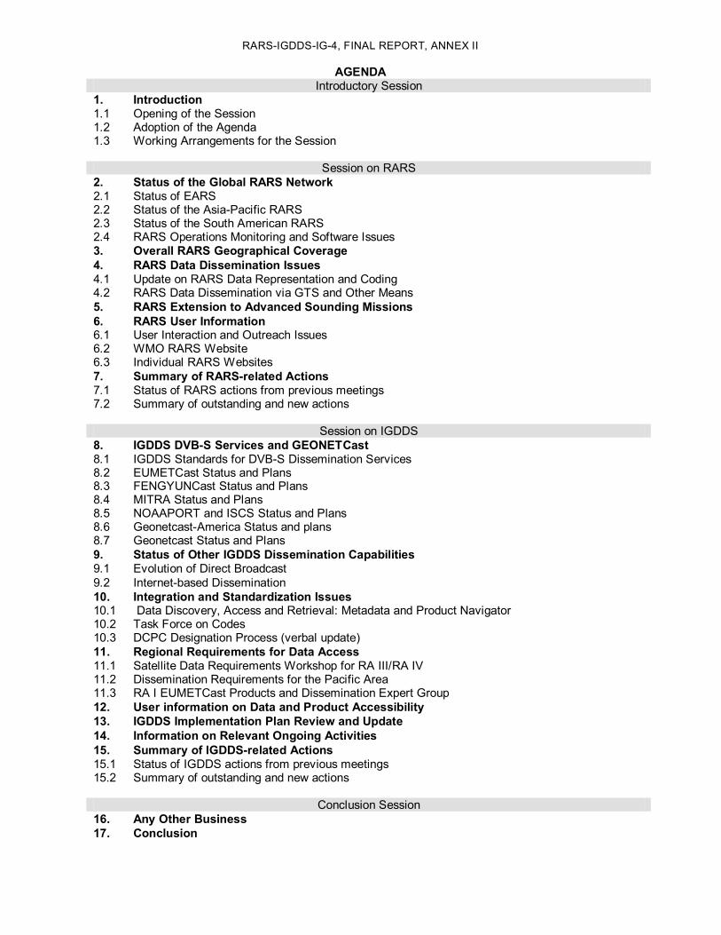
RARSIGDDSIG4, FINAL REPORT, ANNEX II
AGENDA Introductory Session
1. Introduction 1.1 Opening of the Session 1.2 Adoption of the Agenda 1.3 Working Arrangements for the Session
Session on RARS 2. Status of the Global RARS Network 2.1 Status of EARS 2.2 Status of the AsiaPacific RARS 2.3 Status of the South American RARS 2.4 RARS Operations Monitoring and Software Issues 3. Overall RARS Geographical Coverage 4. RARS Data Dissemination Issues 4.1 Update on RARS Data Representation and Coding 4.2 RARS Data Dissemination via GTS and Other Means 5. RARS Extension to Advanced Sounding Missions 6. RARS User Information 6.1 User Interaction and Outreach Issues 6.2 WMO RARS Website 6.3 Individual RARS Websites 7. Summary of RARSrelated Actions 7.1 Status of RARS actions from previous meetings 7.2 Summary of outstanding and new actions
Session on IGDDS 8. IGDDS DVBS Services and GEONETCast 8.1 IGDDS Standards for DVBS Dissemination Services 8.2 EUMETCast Status and Plans 8.3 FENGYUNCast Status and Plans 8.4 MITRA Status and Plans 8.5 NOAAPORT and ISCS Status and Plans 8.6 GeonetcastAmerica Status and plans 8.7 Geonetcast Status and Plans 9. Status of Other IGDDS Dissemination Capabilities 9.1 Evolution of Direct Broadcast 9.2 Internetbased Dissemination 10. Integration and Standardization Issues 10.1 Data Discovery, Access and Retrieval: Metadata and Product Navigator 10.2 Task Force on Codes 10.3 DCPC Designation Process (verbal update) 11. Regional Requirements for Data Access 11.1 Satellite Data Requirements Workshop for RA III/RA IV 11.2 Dissemination Requirements for the Pacific Area 11.3 RA I EUMETCast Products and Dissemination Expert Group 12. User information on Data and Product Accessibility 13. IGDDS Implementation Plan Review and Update 14. Information on Relevant Ongoing Activities 15. Summary of IGDDSrelated Actions 15.1 Status of IGDDS actions from previous meetings 15.2 Summary of outstanding and new actions
Conclusion Session 16. Any Other Business 17. Conclusion


RARSIGDDSIG4, FINAL REPORT, ANNEX III
RARS HRPT STATION STATUS AND ANTICIPATED EVOLUTION (as of 22 March 2010)
(In the tables below, stations are ranked by regional RARS centre, then by processing centre, then by subcentre identifier)
Area
Reg
iona
l RARS
Cen
tre HRPT Station
Name Latitude Longitude Operator
RARS Station Identifier (alphabetic)
Processing centre ID Originating Centre
(Code Tables C1 and C11)
Sub centre ID Originating Subcentre (Code Table
C12)
Location Indicator in GTS Bulletin (CCCC)
Status or planned
implementation (+Metop compatibility)
Syowa 69° S 39.58° E NIPR syo 34 207 RJTD Operational
Kiyose 35.77° N 139.53° E JMA kiy 34 240 RJTD Operational Metop ready
Beijing 39.93° N 118.28° E CMA pek 39 225 BAWX Operational
Guangzhou 23.13° N 113.3° E CMA pek 39 226 BAWX
Urumqi 43.78° N 87.6° E CMA pek 39 228 BAWX Operational
Data merged with Beijing
Seoul 37.48° N 126.92° E KMA seo 40 243 RKSL Replaced by Jincheon
Jincheon 36.99° N 127.43 °E KMA jin 40 245 RKSL Operational Metop ready
Hong Kong 22.3° N 114° E HKO hkg 110 229 VHHH Operational
AsiaPa
cific
Tokyo (JMA)
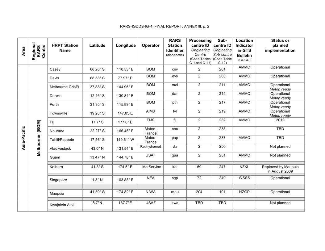
RARSIGDDSIG4, FINAL REPORT, ANNEX III, p. 2 Area
Reg
iona
l RARS
Cen
tre HRPT Station
Name Latitude Longitude Operator
RARS Station Identifier (alphabetic)
Processing centre ID Originating Centre
(Code Tables C1 and C11)
Sub centre ID Originating Subcentre (Code Table
C12)
Location Indicator in GTS Bulletin (CCCC)
Status or planned
implementation
Casey 66.26° S 110.53° E BOM csy 2 201 AMMC Operational
Davis 68.58° S 77.97° E BOM dvs 2 203 AMMC Operational
Melbourne CribPt 37.88° S 144.96° E BOM mel 2 211 AMMC Operational Metop ready
Darwin 12.46° S 130.84° E BOM dar 2 214 AMMC Operational Metop ready
Perth 31.95° S 115.89° E BOM pth 2 217 AMMC Operational Metop ready
Townsville 19.28° S 147.05 E AIMS tvl 2 219 AMMC Operational Metop ready
Fiji 17.7° S 177.6° E FMS fij 2 232 AMMC 2010
Noumea 22.27° S 166.45° E Meteo France
nou 2 235 TBD
Tahiti/Papeete 17.56° S 149.61° W Meteo France
pap 2 237 AMMC TBD
Vladivostock 43.0° N 131.54° E Roshydromet vla 2 250 Not planned
Guam 13.47° N 144.78° E USAF gua 2 251 AMMC Not planned
Kelburn 41.3° S 174.5° E MetService kel 69 247 NZKL Replaced by Maupuia in August 2009
Singapore 1.3° N 103.83° E NEA sgp 72 249 WSSS Operational
Maupuia 41.30° S 174.82° E NIWA mau 204 101 NZGP Operational
Kwajalein Atoll 8.7°N 167.7°E USAF kwa TBD TBD Not planned
AsiaPa
cific
Melbo
urne
(BOM)
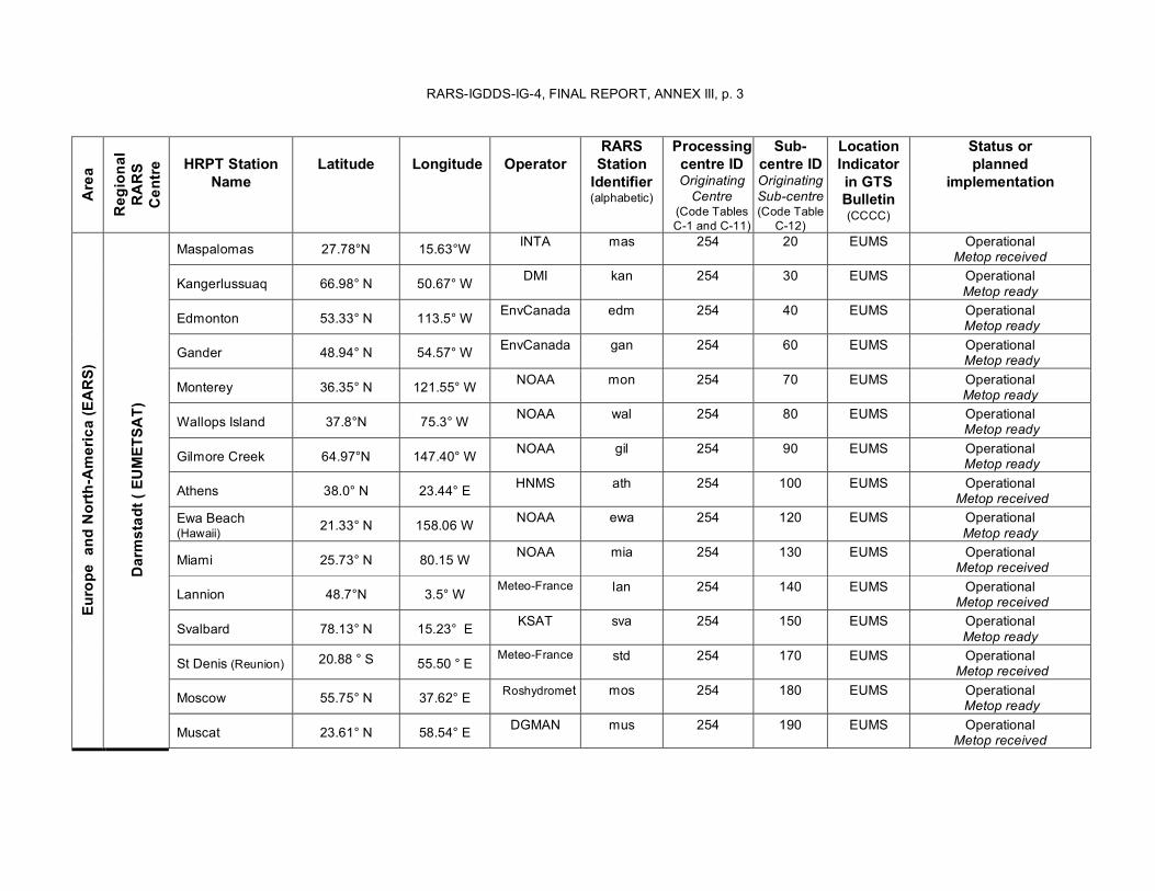
RARSIGDDSIG4, FINAL REPORT, ANNEX III, p. 3 Area
Reg
iona
l RARS
Cen
tre HRPT Station
Name Latitude Longitude Operator
RARS Station Identifier (alphabetic)
Processing centre ID Originating Centre
(Code Tables C1 and C11)
Sub centre ID Originating Subcentre (Code Table
C12)
Location Indicator in GTS Bulletin (CCCC)
Status or planned
implementation
Maspalomas 27.78°N 15.63°W INTA mas 254 20 EUMS Operational Metop received
Kangerlussuaq 66.98° N 50.67° W DMI kan 254 30 EUMS Operational Metop ready
Edmonton 53.33° N 113.5° W EnvCanada edm 254 40 EUMS Operational Metop ready
Gander 48.94° N 54.57° W EnvCanada gan 254 60 EUMS Operational Metop ready
Monterey 36.35° N 121.55° W NOAA mon 254 70 EUMS Operational Metop ready
Wallops Island 37.8°N 75.3° W NOAA wal 254 80 EUMS Operational Metop ready
Gilmore Creek 64.97°N 147.40° W NOAA gil 254 90 EUMS Operational Metop ready
Athens 38.0° N 23.44° E HNMS ath 254 100 EUMS Operational Metop received
Ewa Beach (Hawaii) 21.33° N 158.06 W NOAA ewa 254 120 EUMS Operational
Metop ready
Miami 25.73° N 80.15 W NOAA mia 254 130 EUMS Operational Metop received
Lannion 48.7°N 3.5° W MeteoFrance lan 254 140 EUMS Operational
Metop received
Svalbard 78.13° N 15.23° E KSAT sva 254 150 EUMS Operational Metop ready
St Denis (Reunion) 20.88 ° S 55.50 ° E MeteoFrance std 254 170 EUMS Operational
Metop received
Moscow 55.75° N 37.62° E Roshydromet mos 254 180 EUMS Operational Metop ready
Europe
and
NorthAmerica (EARS)
Darmstad
t ( EUMET
SAT)
Muscat 23.61° N 58.54° E DGMAN mus 254 190 EUMS Operational Metop received

RARSIGDDSIG4, FINAL REPORT, ANNEX III, p. 4 Area
Reg
iona
l RARS
Cen
tre HRPT Station
Name Latitude Longitude Operator
RARS Station Identifier (alphabetic)
Processing centre ID Originating Centre
(Code Tables C1 and C11)
Sub centre ID Originating Subcentre (Code Table
C12)
Location Indicator in GTS Bulletin (CCCC)
Status or planned
implementation
Khabarovsk 48.47° N 135.35° E Roshydromet kha 254 200 EUMS Planned for 2010 Metop ready
Novosibirsk 54.8° N 83.13° E Roshydromet nov 254 210 EUMS Planned for 2010
Resolute Bay 74.71° N 94.97°W Env. Canada res 254 Potential, not planned
Libreville 0.27° N 9.25° E CLS lib 254 Potential, not planned
Pretoria 25.9 S 28.2 E SAWS pre 254 Potential, not planned

RARSIGDDSIG4, FINAL REPORT, ANNEX III, p. 5 Area
Reg
iona
l RARS
Cen
tre HRPT Station
Name Latitude Longitude Operator
RARS Station Identifier (alphabetic)
Processing centre ID Originating Centre
(Code Tables C1 and C11)
Sub centre ID Originating Subcentre (Code Table
C12)
Location Indicator in GTS Bulletin (CCCC)
Status or planned
implementation
Cachoeira Paulista 22.33° S 45° W INPE cpt 46 10 SBBR Operational
Metop ready
Cuiaba 15.55° S 56.7° W INPE cba 46 11 SBBR Operational Metop ready
Brasilia 15.78° S 47.92° W INMET inm 46 12 SBBR Operational
Fortaleza 3.73° S 38.56° W FUNCEME fcm 46 13 SBBR Operational in September 2010
Natal/Navy 5.785° S 35.22° 'W CHM chm 46 14 SBBR Not planned
Manaus 03.02 o S 60.05° W SIVAM svm 46 15 SBBR 2011
Natal/INPE 5.836° S 35.21° 'W INPE nat 46 16 SBBR Planned for end of 2010
Boa Vista 02.75 o N 60.75° W INPE bvs 46 17 SBBR 2011
Caracas 10.5° N 66.94° W CDPI 46 Potential station
South America
Cacho
eira Pau
lista (INPE
)
Euzebio 03.88° S 38.45° W INPE euz 46 Not planned
Córdoba 31.52° S 64.45° W CONAE etc 147 10 SABM Operational Metop ready
Ushuaia (or Rio Grande) 54.80° S 68.33 W CONAE etu 147 15 SABM 2011 (TBC)
Marambio 64.23° S 58.63° W CONAE ebm 147 20 SABM Operational
Santiago de Chile 33.25° S 70.41° W DGAC ets 147 30 SABM Operational
Punta Arenas 53.02° S 70.51° W DGAC epa 147 40 SABM 2011 (TBC)
Base Presid. Frei 62.2° S 58.93° W DGAC epf 147 50 SABM 2011 (TBC)
Cotopaxi 0.61° S 78.58 W CLIRSEN cpe 147 60 SABM End of 2010
South America
Córdo
ba (C
ONAE)
Isla de Pascua 27.12 S 109.4 W DGAC idp Not planned

RARSIGDDSIG4, FINAL REPORT, ANNEX IV
LIST OF POTENTIAL XBAND RECEPTION STATIONS (March 2010)
The following table lists the reception stations that RARS Operators have indicated having technical capability to participate in the project.
EARS South American RARS AsiaPacific RARS Lannion Cachoeira Paulista Melbourne Moscow Cuiabá Darwin Khabarovsk Córdoba Perth Novosibirsk Santiago Casey (Communication limitation) Oman Townsville Gander (TBC) Kiyose Edmonton (TBC) Jincheon
Bejing Guangzhou Urumqi Maupuia Singapore
RARSIGDDSIG4, FINAL REPORT, ANNEX V
RARS POSTER PRESENTED AT ITSC17

RARSIGDDSIG4, ANNEX V, p.2
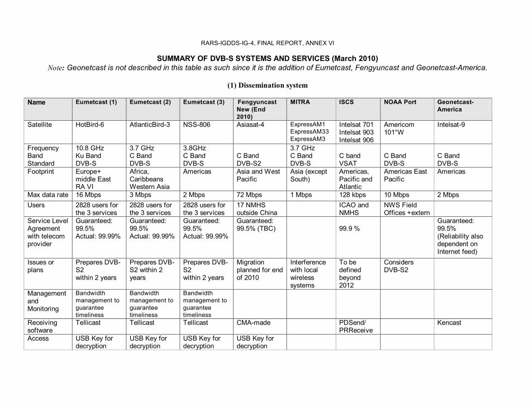
RARSIGDDSIG4, FINAL REPORT, ANNEX VI
SUMMARY OF DVBS SYSTEMS AND SERVICES (March 2010) Note: Geonetcast is not described in this table as such since it is the addition of Eumetcast, Fengyuncast and GeonetcastAmerica.
(1) Dissemination system
Name Eumetcast (1) Eumetcast (2) Eumetcast (3) Fengyuncast New (End 2010)
MITRA ISCS NOAA Port Geonetcast America
Satellite HotBird6 AtlanticBird3 NSS806 Asiasat4 ExpressAM1 ExpressAM33 ExpressAM3
Intelsat 701 Intelsat 903 Intelsat 906
Americom 101°W
Intelsat9
Frequency Band Standard
10.8 GHz Ku Band DVBS
3.7 GHz C Band DVBS
3.8GHz C Band DVBS
C Band DVBS2
3.7 GHz C Band DVBS
C band VSAT
C Band DVBS
C Band DVBS
Footprint Europe+ middle East RA VI
Africa, Caribbeans Western Asia
Americas Asia and West Pacific
Asia (except South)
Americas, Pacific and Atlantic
Americas East Pacific
Americas
Max data rate 16 Mbps 3 Mbps 2 Mbps 72 Mbps 1 Mbps 128 kbps 10 Mbps 2 Mbps Users 2828 users for
the 3 services 2828 users for the 3 services
2828 users for the 3 services
17 NMHS outside China
ICAO and NMHS
NWS Field Offices +extern
Service Level Agreement with telecom provider
Guaranteed: 99.5% Actual: 99.99%
Guaranteed: 99.5% Actual: 99.99%
Guaranteed: 99.5% Actual: 99.99%
Guaranteed: 99.5% (TBC) 99.9 %
Guaranteed: 99.5% (Reliability also dependent on Internet feed)
Issues or plans
Prepares DVB S2 within 2 years
Prepares DVB S2 within 2 years
Prepares DVB S2 within 2 years
Migration planned for end of 2010
Interference with local wireless systems
To be defined beyond 2012
Considers DVBS2
Management and Monitoring
Bandwidth management to guarantee timeliness
Bandwidth management to guarantee timeliness
Bandwidth management to guarantee timeliness
Receiving software
Tellicast Tellicast Tellicast CMAmade PDSend/ PRReceive
Kencast
Access USB Key for decryption
USB Key for decryption
USB Key for decryption
USB Key for decryption

RARSIGDDSIG4, FINAL REPORT, ANNEX VI, p. 2
(2) User management, data management, and data contents
Name Eumetcast (1) Eumetcast (2) Eumetcast (3) Fengyuncast New
MITRA ISCS NOAA Port Geonetcast America
Data and User management standard
EO Portal ISO 19115 ISO 19119 ISO19139 CSW 2.02
EO Portal ISO 19115 ISO 19119 ISO19139 CSW 2.02
EO Portal ISO 19115 ISO 19119 ISO19139 CSW 2.02
US FISMA EO Portal ISO 19115 ISO 19119 ISO19139 CSW 2.02
User Requirements basis
Delegate Bodies+ User Forum+ enquiries
User Forum+ enquiries
+enquiries CIS RAIV GTS and WAFS (ICAO)
Geonetcast coordination group
Meteorological satellite data
All GEOs NOAA Metop And derived products
FY2 FY1 FY3 Aqua/Modis Terra/Modis
Meteosat9, 7 NOAA GOES MTSAT1R
GOES POES
GOES and POES derived products
Environmental satellites Surface observations and forecasts
Other (MDD) Other (MDD) Contents from NMIC
GTS data WAFS data Cyclone, and volcano warnings RMTCN Radars
NCEP models Radars Other
Other SBAs than Weather and Climate
Cyclone, tsunami, warnings
Specific services
Training Alert
Training Alert
Training Alert
User support
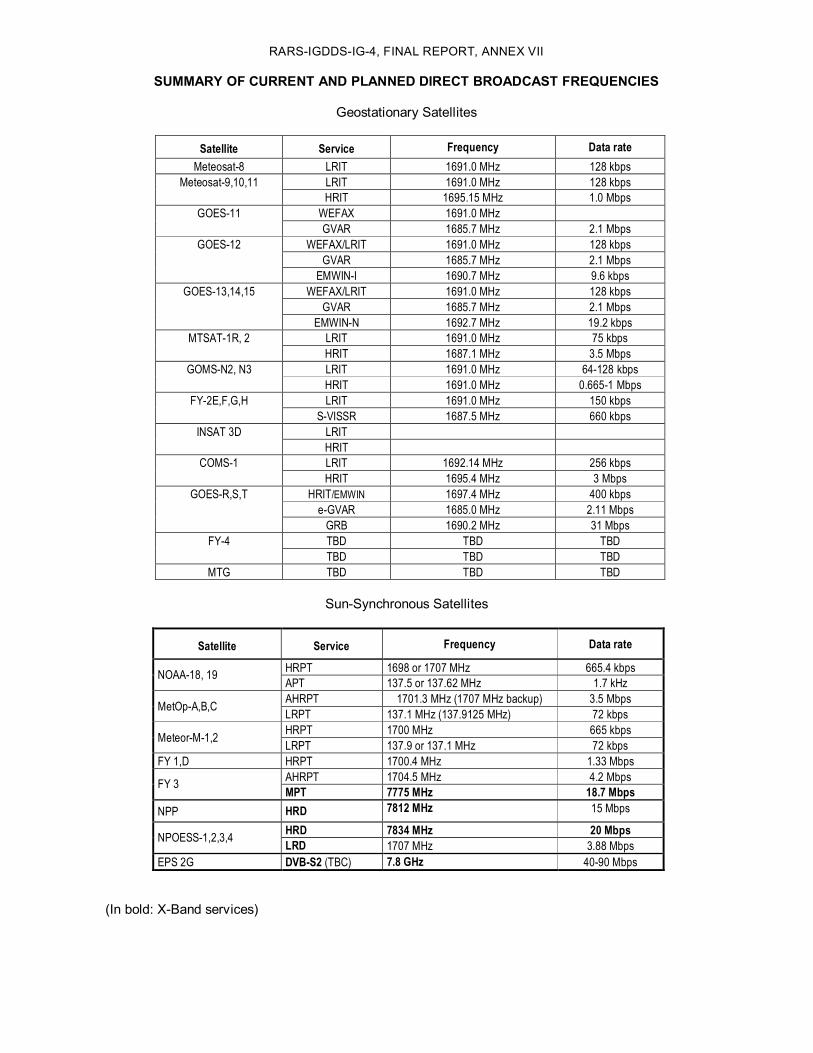
RARSIGDDSIG4, FINAL REPORT, ANNEX VII
SUMMARY OF CURRENT AND PLANNED DIRECT BROADCAST FREQUENCIES
Geostationary Satellites
Satellite Service Frequency Data rate Meteosat8 LRIT 1691.0 MHz 128 kbps
LRIT 1691.0 MHz 128 kbps Meteosat9,10,11 HRIT 1695.15 MHz 1.0 Mbps
WEFAX 1691.0 MHz GOES11 GVAR 1685.7 MHz 2.1 Mbps
WEFAX/LRIT 1691.0 MHz 128 kbps GVAR 1685.7 MHz 2.1 Mbps
GOES12
EMWINI 1690.7 MHz 9.6 kbps WEFAX/LRIT 1691.0 MHz 128 kbps
GVAR 1685.7 MHz 2.1 Mbps GOES13,14,15
EMWINN 1692.7 MHz 19.2 kbps LRIT 1691.0 MHz 75 kbps MTSAT1R, 2 HRIT 1687.1 MHz 3.5 Mbps LRIT 1691.0 MHz 64128 kbps GOMSN2, N3 HRIT 1691.0 MHz 0.6651 Mbps LRIT 1691.0 MHz 150 kbps FY2E,F,G,H
SVISSR 1687.5 MHz 660 kbps LRIT INSAT 3D HRIT LRIT 1692.14 MHz 256 kbps COMS1 HRIT 1695.4 MHz 3 Mbps
HRIT/EMWIN 1697.4 MHz 400 kbps eGVAR 1685.0 MHz 2.11 Mbps
GOESR,S,T
GRB 1690.2 MHz 31 Mbps TBD TBD TBD FY4 TBD TBD TBD
MTG TBD TBD TBD
SunSynchronous Satellites
Satellite Service Frequency Data rate
HRPT 1698 or 1707 MHz 665.4 kbps NOAA18, 19 APT 137.5 or 137.62 MHz 1.7 kHz AHRPT 1701.3 MHz (1707 MHz backup) 3.5 Mbps MetOpA,B,C LRPT 137.1 MHz (137.9125 MHz) 72 kbps HRPT 1700 MHz 665 kbps MeteorM1,2 LRPT 137.9 or 137.1 MHz 72 kbps
FY 1,D HRPT 1700.4 MHz 1.33 Mbps AHRPT 1704.5 MHz 4.2 Mbps FY 3 MPT 7775 MHz 18.7 Mbps
NPP HRD 7812 MHz 15 Mbps
HRD 7834 MHz 20 Mbps NPOESS1,2,3,4 LRD 1707 MHz 3.88 Mbps EPS 2G DVBS2 (TBC) 7.8 GHz 4090 Mbps
(In bold: XBand services)


RARSIGDDSIG4, FINAL REPORT, ANNEX VIII
LIST OF RARSIG4 ACTIONS
Action RARSIG4.01: RARSIG values the contribution of stations in Miami, St Denis and Ewa Beach that provide significant addition to the global RARS coverage. It encourages the involved parties to seek technical ways to further improve the timeliness towards the goal of 30 minutes. EUMETSAT to report at the next meeting (Due date: RARSIG5)
Action RARSIG4.02: WMO SP to contact the Fiji Met Service in order to investigate issues and possible way forward to integrate Fiji in the AsiaPacific RARS. (Due date: May 2010)
Action RARSIG4.03:WMO SP and EUMETSAT to seek feedback from the NWP community at ITSC 17 to have better knowledge of, e.g. who the users are, and whether data is still valuable in case the cloud information is not available. (Due date: April 2010)
Action RARSIG4.04: WMO SP to contact Venezuela about possible inclusion of the CDPI Caracas station (Responsible: Freddy Flores) in South AmericaRARS. (Due date: May 2010)
Action RARSIG4.05: WMO SP to update the “Status and plans of RARS HRPT stations“, resulting coverage statistics, and maps (with assistance of Anders Soerensen). (Due date: April 2010)
Action RARSIG4.06: Brazil (INPE) and Argentina (SMN and CONAE) to investigate possible cooperation with Chile (DMC) towards the implementation of an HRPT station in Isla de Pascua, Chile and its inclusion in the South America RARS to reduce the gap over the Pacific. Brazil and Argentina to report at the next meeting. (Due date: RARSIG5)
Action RARSIG4.07: EUMETSAT to further investigate possibility of cooperation with CLSArgos towards the implementation of an HRPT station in Libreville, Gabon and its inclusion in EARS. (Due date: June 2010)
Action RARSIG4.08: Richard Francis to explore opportunities for cooperation between UK Met Office and SAWS that could facilitate inclusion of a South African HRPT station (e.g. Pretoria) in the RARS. (Due date: April 2010)
Action RARSIG4.09: Operators of RARS stations which are not currently equipped for acquisition of Metop data (for instance Marambio, Santiago, Beijing, Urumqi, Guangzhou, …) are encouraged to take steps to be ready for MetopB, to be launched early 2012. (Due date: RARSIG5)
Action RARSIG4.10: EUMETSAT to consider a test activation campaign of MetopA AHRPT over an extended area including the AsiaPacific, allowing current Metop receiving capabilities to be tested in advance of MetopB. EUMETSAT to report at the next meeting. (Due date: RARSIG5)
Action RARSIG4.11: EUMETSAT, in cooperation with NWP SAF, to demonstrate the possibility to deliver an AAPP package to “virtual machines”. (Due date: June 2010)
Action RARSIG4.12: EUMETSAT, in cooperation with EARSIASI partners, to demonstrate the removing of overlap among EARSIASI data from adjacent EARS stations, as a possible model for the extension of RARS to advanced sounders. (Due date: February 2011)
Action RARSIG4.13: The RARS operators and regional or subregional network coordinators to check that the RARS products are listed and described with proper metadata in the relevant WIS DCPC and GISC catalogues. (Due date: RARSIG5)

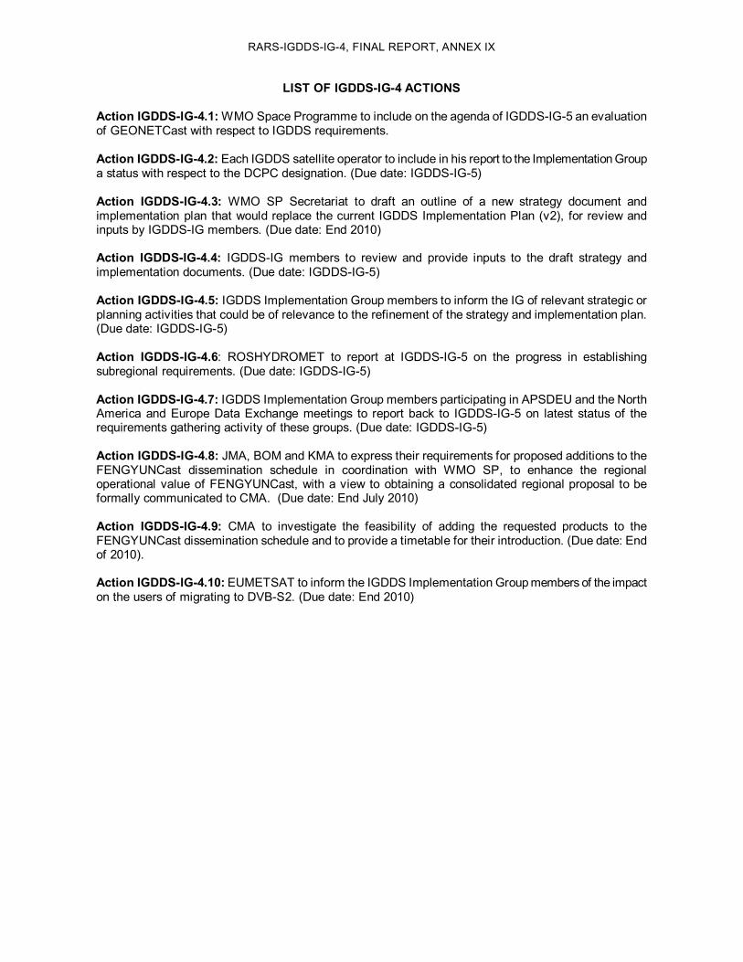
RARSIGDDSIG4, FINAL REPORT, ANNEX IX
LIST OF IGDDSIG4 ACTIONS
Action IGDDSIG4.1:WMO Space Programme to include on the agenda of IGDDSIG5 an evaluation of GEONETCast with respect to IGDDS requirements.
Action IGDDSIG4.2: Each IGDDS satellite operator to include in his report to the Implementation Group a status with respect to the DCPC designation. (Due date: IGDDSIG5)
Action IGDDSIG4.3: WMO SP Secretariat to draft an outline of a new strategy document and implementation plan that would replace the current IGDDS Implementation Plan (v2), for review and inputs by IGDDSIG members. (Due date: End 2010)
Action IGDDSIG4.4: IGDDSIG members to review and provide inputs to the draft strategy and implementation documents. (Due date: IGDDSIG5)
Action IGDDSIG4.5: IGDDS Implementation Group members to inform the IG of relevant strategic or planning activities that could be of relevance to the refinement of the strategy and implementation plan. (Due date: IGDDSIG5)
Action IGDDSIG4.6: ROSHYDROMET to report at IGDDSIG5 on the progress in establishing subregional requirements. (Due date: IGDDSIG5)
Action IGDDSIG4.7: IGDDS Implementation Group members participating in APSDEU and the North America and Europe Data Exchange meetings to report back to IGDDSIG5 on latest status of the requirements gathering activity of these groups. (Due date: IGDDSIG5)
Action IGDDSIG4.8: JMA, BOM and KMA to express their requirements for proposed additions to the FENGYUNCast dissemination schedule in coordination with WMO SP, to enhance the regional operational value of FENGYUNCast, with a view to obtaining a consolidated regional proposal to be formally communicated to CMA. (Due date: End July 2010)
Action IGDDSIG4.9: CMA to investigate the feasibility of adding the requested products to the FENGYUNCast dissemination schedule and to provide a timetable for their introduction. (Due date: End of 2010).
Action IGDDSIG4.10: EUMETSAT to inform the IGDDS Implementation Group members of the impact on the users of migrating to DVBS2. (Due date: End 2010)