Embed Size (px)
Citation preview
1
GEO Field Trip Columbia River Gorge and Mt. St. Helens
Name: ____________________________________________ Date: ________________
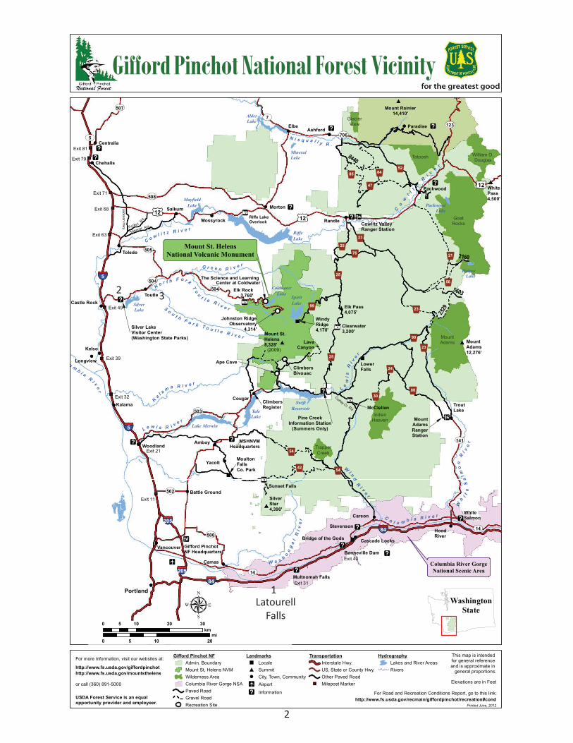
Stop 1: Latourell Falls http://en.wikipedia.org/wiki/Latourell_Falls
Take the lower trail to the Latourell Falls. Make a drawing of the bedrock outcrop that the falls are flowing over. Focus mostly on the rock and the water, don’t get too distracted by the vegetation. After you make your sketch, go up to the rock and see if you can tell what kind of rock it is.
Draw your sketch here:
Think about the different parts of a flood basalt (we reviewed these in class and saw some of them at Elephant Rock). Label these different parts of the flood basalt flow on your drawing above.
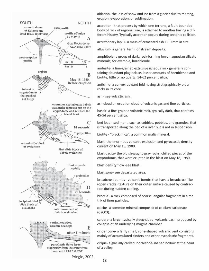
Stop 2: Mt. St. Helens Visitor Center
Watch the documentary and take a look at the display.
What was the activity of the volcano in the preceding few months before the May 18, 1980 eruption?
2
§̈¦205§̈¦84
§̈¦84
§̈¦84
§̈¦5
§̈¦205
§̈¦5
§̈¦5
§̈¦5
ST508
ST502
ST121
ST500
ST14
ST14
ST5
ST503
ST706
ST505
ST123ST7
ST141
ST142
ST507
ST504
ST504
ST12
£¤12
£¤12£¤12
Tucke r Rd.
Spencer R d.
921
925
954
925
954
930
999923
990
988
924
976925
923
923
942
952
947
985 984
8440
2160
956
5603
2329
SilverLake
AlderLake
SpiritLake
YaleLake
Lake Merwin
MayfieldLake
RiffeLake
SilverLake
SwiftReservoir
PackwoodLake
WalputLake
ColdwaterLake
MineralLake
25 miles fromCentralia toOlympia
71 miles from Elbe to Seattle
52 milesfromWhite Passto Yakima
HoodRiver
Portland
Bonneville Dam
Bridge of the Gods Cascade Locks
Multnomah Falls
Centralia
Chehalis
Camas
Carson
Toledo
WhiteSalmon
Woodland
MountAdams12,276'
Amboy
Ashford
Cougar
Elbe
Elk Pass4,075'
Elk Rock3,760'
LowerFalls
Morton
Mossyrock
Packwood
Randle
Salkum
SilverStar4,390'
TroutLake
Yacolt
WindyRidge4,170'
Pine CreekInformation Station
(Summers Only)
MountAdamsRangerStation
MoultonFalls Co. Park
MSHNVMHeadquarters
LavaCanyon
Battle Ground
Vancouver
Paradise !]!]
!]
Cowlitz ValleyRanger Station
!]
WhitePass4,500'
Toutle
!\
Clearwater3,200'!\
!]
!\McClellan
!@
!]
!]
!@
!]
Mount Rainier14,410'
!]
!]
!]
Riffe LakeOverlook
!\
Kalama
Longview
Kelso
Castle Rock
Exit 32
Mount St.Helens8,328'
(2009)
!]
Silver LakeVisitor Center(Washington State Parks)
!]
!]
!@Gifford PinchotNF Headquarters
Mount RainierNational Park
Jackson Hw
y.
Curley Cr. Rd
ClimbersBivouac
Ape Cave
ClimbersRegister
!]!]
Stevenson
Co
wl i t z
Ri v
er
N i s q u a l l y R .
C o w l i t z R i v e r
C o l u m b i aR i v e
r
K
a l a m a R i v e r
G r e e n R i v e r
N o r t h F o r k
To
u
t l e R i v e rS o u t h F o r k T o u t l e R i v e r
L e w i s R i v e r
L ew
isR
i ve
r
W
i nd
R
i v e
r
W a s h ou
ga
lR
i ve
r C o l u m b i a R i v e r
W
h
i te
Sa
lmo
nR
i ve
r
Johnston RidgeObservatory
4,314'
Sunset Falls!\
The Science and Learning Center at Coldwater
Exit 11
Exit 21
Exit 39
Exit 49
Exit 63
Exit 68
Exit 71
Exit 79
Exit 81
Exit 31
Exit 40
Mount St. HelensNational Volcanic Monument
Columbia River GorgeNational Scenic Area
IndianHeaven
Tatoosh
MountAdams
GoatRocks
William O.Douglas
TrapperCreek
GlacierView
0 10 205mi
0 10 20 305km
WashingtonState
For more information, visit our websites at:
http://www.fs.usda.gov/giffordpinchot
or call (360) 891-5000
Gifford Pinchot National Forest Vicinity
Gifford Pinchot NFAdmin. BoundaryMount St, Helens NVMWilderness AreaColumbia River Gorge NSAPaved RoadGravel RoadRecreation Site
Landmarks" Locale# Summit! City, Town, Community
!Ä Airport
!] Information
TransportationInterstate Hwy.US, State or County Hwy.Other Paved Road
"/ Milepost Marker
HydrographyLakes and River AreasRivers
http://www.fs.usda.gov/mountsthelens
USDA Forest Service is an equalopportunity provider and employeer.
µ
For Road and Recreation Conditions Report, go to this link:http://www.fs.usda.gov/recmain/giffordpinchot/recreation#cond
Printed June, 2012
This map is intended for general reference and is approximate in
general proportions.
Elevations are in Feet
1Latourell
Falls
2 3
3
#*
#*
#*
#*
#*
#*
!!
!!
!!
!!
!!
!!
!!!!
!! !!
!!
!!!!
!!!!!!
!!
!!
!!
!!
!!
!!
!!
!!
!!!!
!!!! !! !!
!!
!!
!!
!!
!!
!!
!!
!!
!!
!!!!
!!
!!
!!
!!
!!
!!
!!
!!
!!
!!
!!!!
!!
Green RiverHorse Camp
WakepishTrailer Drop
Castle LakeViewpoint
Hummocks
SouthColdwater
Elk Pass4075'
LoowitViewpoint
Donnybrook
ClearwaterViewpoint
Lower SmithCreek
June LakeMuddy River
Big CreekFalls Curly Creek Falls
Eagle Cliff
Elk RockViewpoint
3760'
Iron CreekFalls
McClellanViewpoint
Merrill Lake
Pine CreekInformation Station
Ryan Lake
SwiftYale Park Cougar Camp
Beaver Bay
F
F
Blast Edge
!F
!5!_
!F
!F
!F
!F
!F
!5
!F
!9!_!5!²
!_!5
!F!_!G
!³
!]
!9
Red RockPass!F
!F ApeCanyon
Lahar Viewpoint
!f!_
Woods CreekWatchable Wildlife
Bear MeadowNorway
Pass
Miner's Car
Meta Lake
Independence PassHarmony
Smith CreekWindy Ridge
4170'
Lava Canyon
Lower FallsRecreation
AreaClimber's
Bivouac
3750'
Marble MountainSno-ParkCougar
Sno-Park
Ape Cave
2077'
Trail of TwoForests
Cascade Peaks
!F!_!²
5
!5!_!F
!_!F!f
!f!Ö!b
!F!_!²
!f!_!]!F
!F
!_!F!f !_
!_
!F!_!b!f!9
!F!f!_ !b!_!F
!_!f!]
!f!b!5!Ö!_
Blue Lake!F!Ë
!¬
!¬
!¬
!¬
!_
!F!Ë
Coldwater LakeRecreation Area
Johnston RidgeObservatory
4314'
!f!b!]!¬
!5!b!F!_!¬
The Science andLearning Center
at Coldwater
Cl e
ar
wa
terC
r ee
k
ColdwaterPeak
VansonPeak
MarbleMountain
MountSt. Helens
8,363'
SpencerButte
Mt. Margaret
925
926
981
99039
98322
925
976
999
925
990
993
981
983
92612
983
Single LaneWith Turnouts
Single LaneWith Turnouts
TORANDLE£¤12
993
Q830
98123
930
Curley Creek Rd.
TO TROUTLAKE
TO CARSONHWY 14
!
925
ST503TO WOODLAND§̈¦5
SwoffordPond
DeadmansLake
MerrillLake
RiffeLake
Saint HelensLake
ElkLake
LakeMerwin
LakeScanewa
Castle Lake
YaleLake
Swift Reservoir
Spiri
t Lak
e
Coldwater Lake
Co
wl i t z
R i v e r
N o r t hF o r k T o u t l e R i v e r
S o u t h F o r kT o u t l e R i v e r
Mu d d
yR
iv
er
Pi n
eC
r e ek
K a l am
aR i v
er
L e wi s
Ri v
er
G r e e n R i v e r
225
237
31
216G
220
240
216F
217
211C
240
211
216A
218
229
216B
1H
1
216E
184
221
1E
231
230A
234
216
216D
24
213
227
30
213A
207
238
230
205
227A
224
216C
238
213
217
218
213
1
220
1
1
1
11
1
211
230
211
227
216
216
30
28A
237
238
216
216
Stay On TrailsNo Bicycles, Pets or Stock
Day Use Only
Climbing PermitsRequired
Mt. MargaretBackcountry
(camping permit required)
!f!¬!9!³!_!́!̧
COUGAR
Climber's Register !S
!9
!9!5!_
Iron Creek!F!9!b!5
!9!F
KalamaHorse Camp!Ë
2
3
1
3
0 1 2 3 40.5Miles
0 4 8 122Kilometers
µ
Know the Rules
Restricted Area #1Closed to ALL public entry.
Restricted Area #2Climbing permit required above 4,800 feet.
!
!
Restricted Area #3Day use ONLY.!
!
!
!
Disturbing or removing natural features is prohibitedin all areas.
!
Off trail travel is prohibited.
Pets, bicycles and horses are prohibited. (Bikes OKon 230A to 230, east to 1, north and east to NorwayPass Trailhead only.)
Camping and fires are prohibited.
!b
!9
!f
!] InformationPasses Sold
Barrier Free
Campground
!F Trail Access
!¬ Telephone
!5 Picnic Area
!Ö Interpretive Trail
!_ Restrooms
!² Water
!́ Food
!̧ Fuel
!!< Gift Shop
General Store!³
!Ë Horse Area !¬ Emergency Call Box
Mount St. HelensNational Volcanic Monument
Giffore Pinchot NFAdmin BoundaryMount St. Helens NVMRestricted Area
!! No Fees Required!! Recreation Day Pass Required!! Monument Pass Required!! Campground with Fee
TransportationPaved RoadsGravel RoadsDirt RoadsTrails
HydrographyMajor RiversMajor Waterbodies
Recreation This map is intended for general reference and is approximate in
general proportions.
Prinited June 2012
For Road and Recreation Conditions Report, go to this link:
Elevations are in feet
http://www.fs.usda.gov/recmain/giffordpinchot/recreation#cond
4 5 6
4Pringle, 2002
5 Pringle, 2002
65
4
32
Cast
le
Lake
Gard
ner
Coun
tyPa
rk
6
GEO Field Trip Columbia River Gorge and Mt. St. Helens
How did geologists interact with the local authorities?
How did the Silver Lake form?
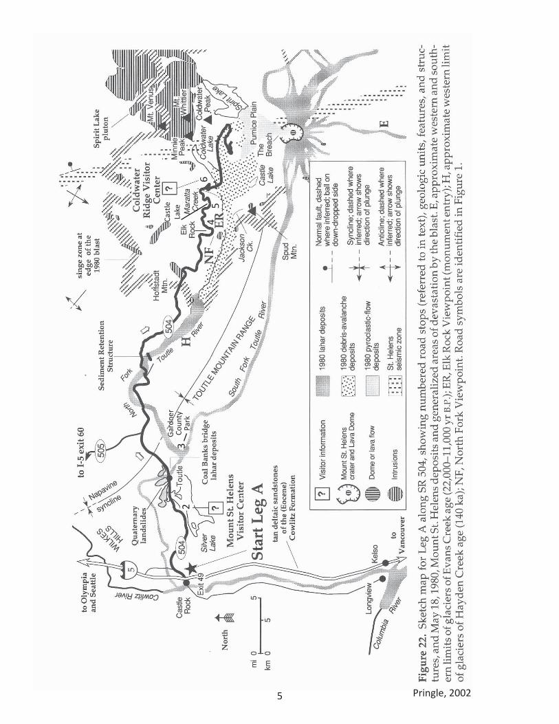
Stop 3: Harry Gardner County Park
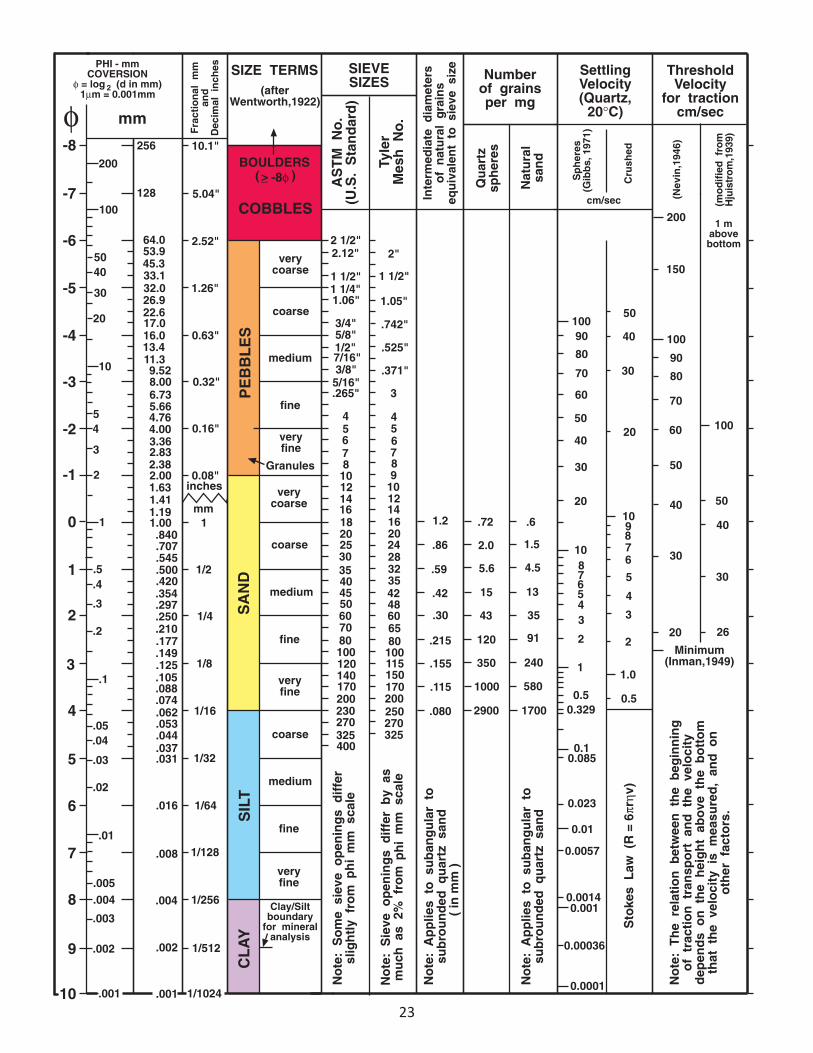
While parked at the north side of the HWY, near the restroom, exit the bus and head down to the river bank immediately downstream of the bridge embankment. We will take a look at the sediment stratigraphy exposed in the river bank. Locate the Wentworth Grain Size Classification Chart in your guidebook. For your geologic descriptions below, use information like color, mineralogy, particle size, crystal size, clast size, etc. What grain sizes do you see? Poorly sorted or well sorted? What types of rocks do you see? What is the percentage of angular vs. rounded rocks in the deposits? Your observations in the field are the same observations geologists use to map geologic deposits, make geologic maps, and formulate hypotheses about the geologic history of a region. How many layers did we identify in the river bank? __
Describe the upper sedimentary unit:
Describe the lower sedimentary unit:
7
GEO Field Trip Columbia River Gorge and Mt. St. Helens
Walk to the north of the parking lot at the northern most area of the park. Head towards the river and take a look at the small (10‐20 ft high) cliff on the east side of the river. There are trees growing in the upper surface of the cliff and some dead trees that are mid slope down the cliff. In your drawing, try to show if there are any different sedimentary units exposed in the cliff. Poke around in the sediments to help you make a better drawing below. Draw a sketch of the cliff here:
How might the dead trees relate to the different sedimentary units exposed in the cliff? When do you think those trees might have died? What tests might you conduct to test your hypothesis?
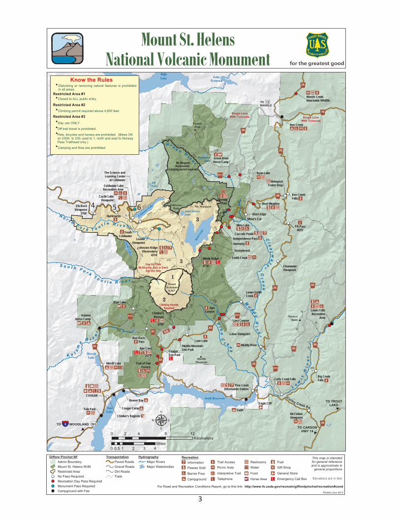
Stop 4: Elk Rock Viewpoint Spirit Lake Hwy
“The dark fine‐grained rocks here are hornfels formed by the heat of intrusions that formed the dikes of the site. This rock slope failed during the winter of 1991/92 on a low angle discontinuity located near the base of the cut. Most of the rock debris was removed back to an area in which rock bolting could occur. About 600 linear meters of post tensioned rock bolts were installed to stabilize the slope. Rock bolting was used at seven other sites on SR 504. The large rock mass in the lower portion of the cut is supported by a concrete buttress. The oversteepened colluvial slope to the east of the cut was covered by wire mesh to prevent rock‐fall. The highest rock cut here was re‐sloped because of extensive zones of hydrothermal alteration and previously undetected discontinuities.” Burns, Scott (Portland State University Geologist)
8Pringle, 2002
9
GEO Field Trip Columbia River Gorge and Mt. St. Helens
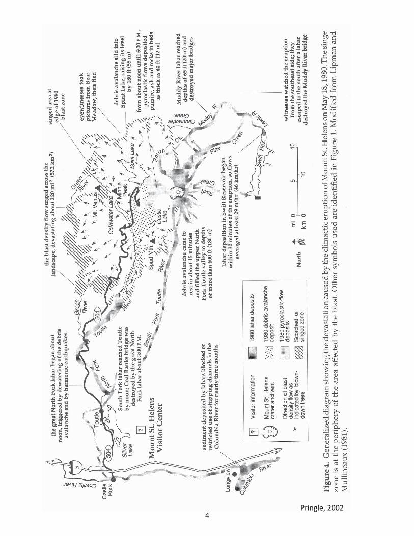
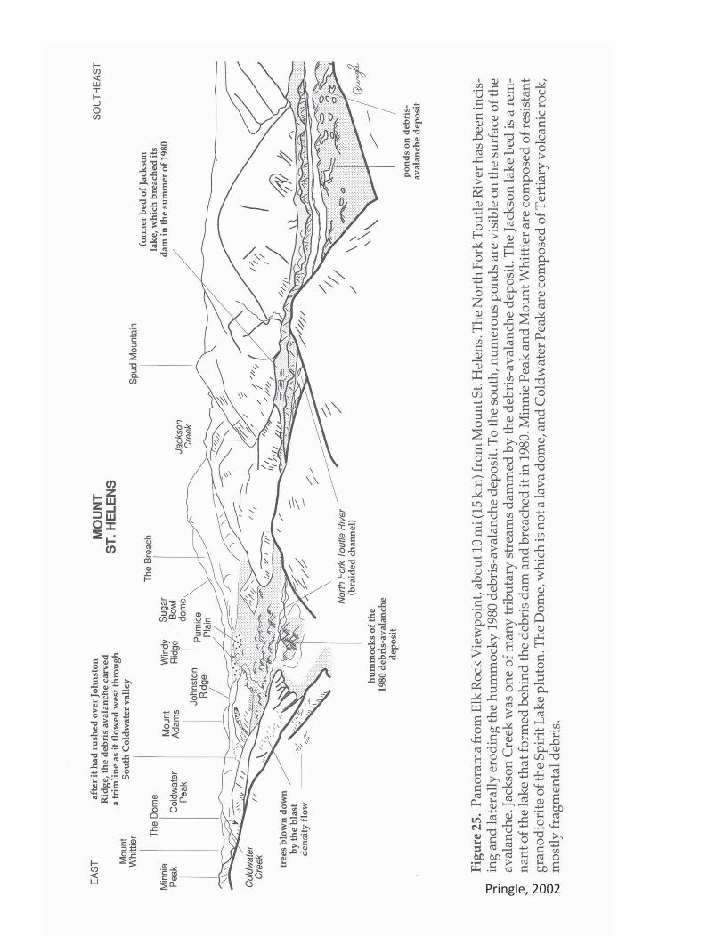
“Jackson Creek, the stream that drains Spud Mountain into the North Fork Toutle River valley, was temporarily dammed by the 1980 debris avalanche, forming Jackson Lake. The basin behind the blockage filled and breached its dam during the summer of 1980. The flat, swampy areas between the debris avalanche levee and the valley wall is what remains of the lake. The levee is a longitudinal ridge of material deposited at the edge of the debris avalanche as it flowed down valley adjacent to the valley wall.” Pringle (2002)
Sketch Castle Lake and its relation to the Toutle River. Use the figures in this guidebook to help you determine the names of the different landforms, rivers, and lakes. Label your drawing of the landscape. Note any blown down trees. What is the origin of water for Castle Lake? __________________________
Sketch your drawing here:
10
GEO Field Trip Columbia River Gorge and Mt. St. Helens
Stop 5: Castle Lake Viewpoint Spirit Lake Hwy, no restrooms
“This stop provides a spectacular overview of the volcano and the debris‐avalanche deposit, as well as the structure of the neighboring bedrock valleys. To the east is Coldwater falls where Coldwater Lake has cut its outlet down through the debris‐avalanche dam to bedrock. The lake level was stabilized by the U.S. Army Corps of Engineers in 1981. Numerous erosional terraces are visible along the North Fork Toutle River and expose debris‐avalanche, lahar, and fluvial deposits. Directly to the east, the North Fork Toutle River has eroded fluvial deposits. Directly to the east, the North Fork Toutle River has eroded debris‐avalanche deposits as it has shifted back and forth across the broad area of the valley floor.
“Across the valley to the south is Castle Lake, which was born when its valley was dammed by the south levee of the debris avalanche. Engineers cut an outlet to keep the lake at a safe level. Wells drilled into the debris‐avalanche blockage are monitored for changed in the ground‐water flow or other factors that could signal reduced stability of the debris dam. Pringle (2002)
What is the relation of Castle Lake to the deposits in the Toutle river valley?
Draw a sketch of your view here:
11Pringle, 2002
12
GEO Field Trip Columbia River Gorge and Mt. St. Helens
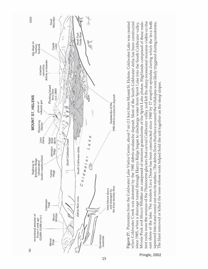
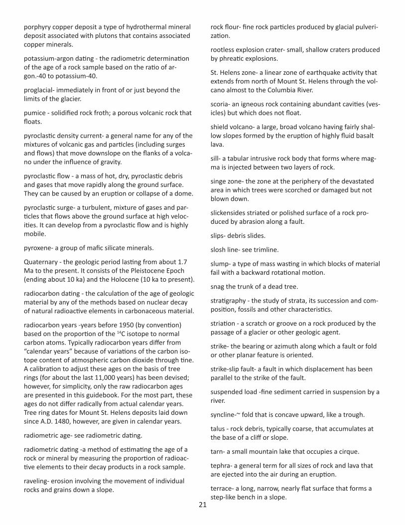
Stop 6: Coldwater Ridge Visitor Center Spirit Lake Hwy
“The Coldwater Lake area is one of the best places to get views of the hummocky 1980 debris‐avalanche deposit. The spectacular valley that extends to the north was carved by Pleistocene valley glaciers originating in the granitic highlands to the north.
“The 1980 debris avalanche left a deposit typified by irregular topography. Hummocks and depressions, some containing ponds, create a surface with as much as 200ft (60 m) of relief. Some hummocks poke out of the south end of Coldwater Lake as islands. The lake was created when the debris avalanche dammed the creek's valley. Pringle 2002
“The debris avalanche is 2.5 km wide here and over 50 m thick. Note the beautiful lateral moraine on the northeast side of Coldwater Lake. It is of Evans Creek Age (22,000‐ 11,000 years B.P.) We are located in the Mt. St. Helens Seismic Zone which stretches for 140 km to the NW and SE. The zone shows right lateral strike slip and is capable of producing at magnitude of 6.8, with a near source ground acceleration approaching .5g. All bridges and buildings here have been constructed to withstand this potential shaking. Landslide scars can be seen on the valley walls where unstable glacial deposits have been modified. Robert Burns, Portland State University Geologist.
Excerpt from Doukas (1990): The view from the Coldwater exit affords an excellent view of the debris‐avalanche deposit and its diverse parts. The following description comes from reports by Glicken (1986) and Meyer (1986 a, b).
The eruption on May 18, 1980, was initiated by a magnitude 5.1 earthquake, which triggered a large landslide off the volcano; the landslide was quickly hidden by the advancing cloud of steam and hot rocks of the lateral "blast." Beneath this maelstrom came the 2.7‐km3 (0.7 mi3)‐volume debris avalanche.
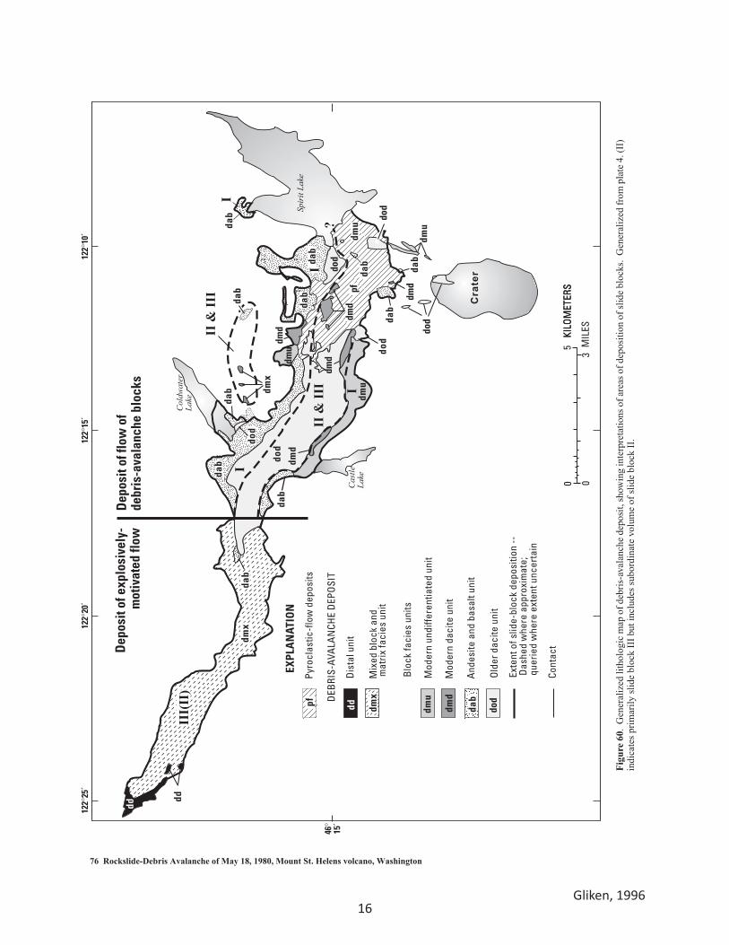
The failure of the avalanche took place as huge slices or slide blocks (Glicken, 1986). Slide block I consisted of the north face of Mount St. Helens, mostly young rocks less than 2,500 years old (dacite, andesite, and basalt). The block remained relatively intact, depositing material on and adjacent to Johnston Ridge as it passed over the ridge; part of it went into Spirit Lake, and part of it flowed down‐valley to form the material on the margins of the debris‐avalanche deposit. Slide block I unroofed the magma chamber (cryptodome) that had been growing inside the mountain for 6 weeks. The explosions that resulted from depressurization of the cryptodome burst through slide block II and created a pyroclastic density current (the "blast") that devastated 212 mi2 (550 km2) of the surrounding landscape.
Most of the volume of slide block II, as well as all of slide block III, made a 90° turn to the west at Harrys Ridge and Johnston Ridge and became a flowing‐debris avalanche. Slide block II contained fragments of ancestral dacite from the core of the volcano; slide block III contained fragments of ancestral dacite and "blast" dacite of the cryptodome.
The debris avalanche moved in part as a flow of blocks that traveled 10 mi (16 km). Much of slide block III moved as an explosively motivated flow that traveled over the debris‐avalanche blocks of slide block II and moved 17.6 mi (28 km) from the crater. The avalanche reached its present length in 3 to 10 minutes.
13
GEO Field Trip Columbia River Gorge and Mt. St. Helens
Water contained within and under the avalanche and from melted ice was squeezed up through the debris and coalesced into a lahar that moved down the valley of the North Fork Toutle River.
The debris‐avalanche deposit is characterized by extremely irregular topography. Hummocks of many shapes and sizes are interspersed with irregular and circular depressions, creating a surface with as much as 246ft (75 m) of relief. Surface expression on the debris‐ avalanche deposits results from (1) lateral spreading during primary deposition; (2) differential compaction of the deposit after deposition; (3) phreatic explosions resulting from hot debris coming in contact with water (ice melt or preexisting streams); (4) post‐lahar bank failures; and (5) melting of buried ice.
One of the most striking features of the post‐1980 geomorphology of the North Fork Toutle River debris‐avalanche deposit is the development of major stream channels. Here, near the Coldwater Creek blockage area, the channels are those of Coldwater Creek and the upper North Fork Toutle River (figs. 38, 39). Coldwater Creek, downstream from Coldwater Lake, formed during the controlled release of Coldwater Lake July 1981. In May 1985, outflow from Spirit Lake was diverted into the South Fork Coldwater Creek through a tunnel under Harrys Ridge. In response to the additional flow, the channel widened 65 ft (20 m) and incised about 13 ft (4 m).
The upper North Fork Toutle River developed along a 2‐mi (3 km)‐long, aligned group of closed depressions. Individual depressions had 20 to 100 ft ( 6‐30 m) of local relief. Some lahars formed in this area on May 18, 1980, but the through‐flowing channel was created by the November 7, 1980, breaching of Carbonate Lake, a temporary lake on the debris avalanche. Subsequent channel modification has resulted from (1) breakout of small lakes on the surface of the debris‐avalanche deposit; (2) storm flow; (3) lahars, primarily those of March 19, 1982, and May 14, 1984; and (4) pumping from Spirit Lake during 1982‐84.
Across the outlet channel to the south are hummocks that consist of semi‐coherent blocks of volcanic rock (fig. 39). The closer ones, within the deposits of slide block I, are chiefly composed of andesite and basalt. Beyond the sharp escarpment, which marks a marginal avalanche levee, are deposits mainly of block II, composed of dacite from ancestral domes within the volcano. The marginal levees can be found throughout the middle part of the debris‐avalanche deposit; they formed along valley walls or across the mouths of tributary valleys, as the debris‐avalanche flowed down valley. Coldwater, Castle, and Jackson Lakes and numerous unnamed ponds were impounded by this facies of the debris‐avalanche deposit (Voight and others, 1981). To the south, east of Castle Lake, the surface of the debris‐avalanche deposit is mantled with blast deposit, creating a relatively flat surface (fig. 38). Along the north margin of the flat, landslide scarps mark the left bank of the North Fork Toutle River. This bank is highly unstable because of a high water table and ground‐water outflow. Brown "bathtub rings" from the May 18, 1980, lahar are present throughout most low‐lying areas of the Coldwater Creek blockage. The lahar was formed on the surface of the debris‐avalanche deposit by slumping and flowing of water‐saturated debris, and by dewatering of the deposit through numerous springs (Meyer, 1986 a).
References Doukas, M. P., 1990. Road guide to volcanic deposits of Mount St. Helens and vicinity, Washington: U.S. Geological Survey, Open File Report
1859, 64 p. Glicken, Harry, 1986, Rockslide‐debris avalanche of May 18, 1980, Mount St. Helens Volcano: Santa Barbara, University of California, Ph.D.
thesis, 303 p. Meyer, D.F., 1986 a, Channel formation and modification under various water and sediment discharges, South Fork Coldwater Creek,
Washington, in Iverson, R.M., and Martinson, H.A., eds., Mount St. Helens; American Geomorphological Field Group, Field Trip Guidebook and Abstracts, 178 p.

14
GEO Field Trip Columbia River Gorge and Mt. St. Helens Meyer, D.F., 1986 b, Surficial processes and deposits at the Coldwater Drainage, in Iverson, R.M. and Martinson, H.A., eds., Mount St. Helens:
American Geomorphological Field Group field trip guidebook and abstracts, 178 p. Pringle, P.T., 2002. Roadside Geology of Mount Saint Helens National Volcanic Monument and Vicinity: Washington Department of Natural
Resources, Division of Geology and Earth Resources Information Circular 88, 1993 (Revised Edition 2002). Voight, Barry, Glicken, Harry, Janda, R.J., and Douglass, P.M., 1981, Catastrophic rockslide avalanche of May 18, in Lipman, P.W., and
Mullineaux, D.R., eds., The 1980 eruptions of Mount St. Helens, Washington: U.S. Geological Survey Professional Paper 1250, p. 347‐377.
Draw a sketch of the view from this stop. Label the parts of the landscape that you can identify.
15Pringle, 2002
16
Figu
re 6
0. G
ener
aliz
ed li
thol
ogic
map
of d
ebris
-ava
lanc
he d
epos
it, sh
owin
g in
terp
reta
tions
of a
reas
of d
epos
ition
of s
lide
bloc
ks.
Gen
eral
ized
from
pla
te 4
. (II
) in
dica
tes p
rimar
ily sl
ide
bloc
k II
I but
incl
udes
subo
rdin
ate
volu
me
of sl
ide
bloc
k II
.
76 Rockslide-Debris Avalanche of May 18, 1980, Mount St. Helens volcano, Washington
Spir
it La
ke
Cas
tleLa
ke
Col
dwat
erLa
ke
EXPL
AN
ATIO
N
DEB
RIS-
AVA
LAN
CHE
DEP
OSI
T
Blo
ck fa
cies
uni
ts
Pyro
clas
tic-f
low
dep
osits
Dis
tal u
nit
Mix
ed b
lock
and
� m
atrix
faci
es u
nit
Exte
nt o
f slid
e-bl
ock
depo
sitio
n --
� D
ashe
d w
here
app
roxi
mat
e;�
que
ried
whe
re e
xten
t unc
erta
in
Cont
act
Dep
osit
of fl
ow o
f�de
bris
-ava
lanc
he b
lock
sD
epos
it of
exp
losi
vely
-�m
otiv
ated
flow
III(
II)
dd
dd
dd
dmx
dab
dmu
dmx
dab Cra
ter
KILO
MET
ERS
dmx
122°
20´
122°
25´
46°�
15´
122°
15´
122°
10´
pf
And
esite
and
bas
alt u
nit
Mod
ern
daci
te u
nit
Mod
ern
undi
ffere
ntia
ted
unit
Old
er d
acite
uni
t
dmu
dod
dab
I
dmuda
b
pf
dod
dod
dmd
dmd
II &
III
II &
III
I
I
?
dab
dab
dab
dmd
dmu
dab
dab
dab
dmu
dod
dmd
dmd
dod
dod
dod
dabda
bI
05
30
KILO
MET
ERS
MIL
ES
Gliken, 1996
17
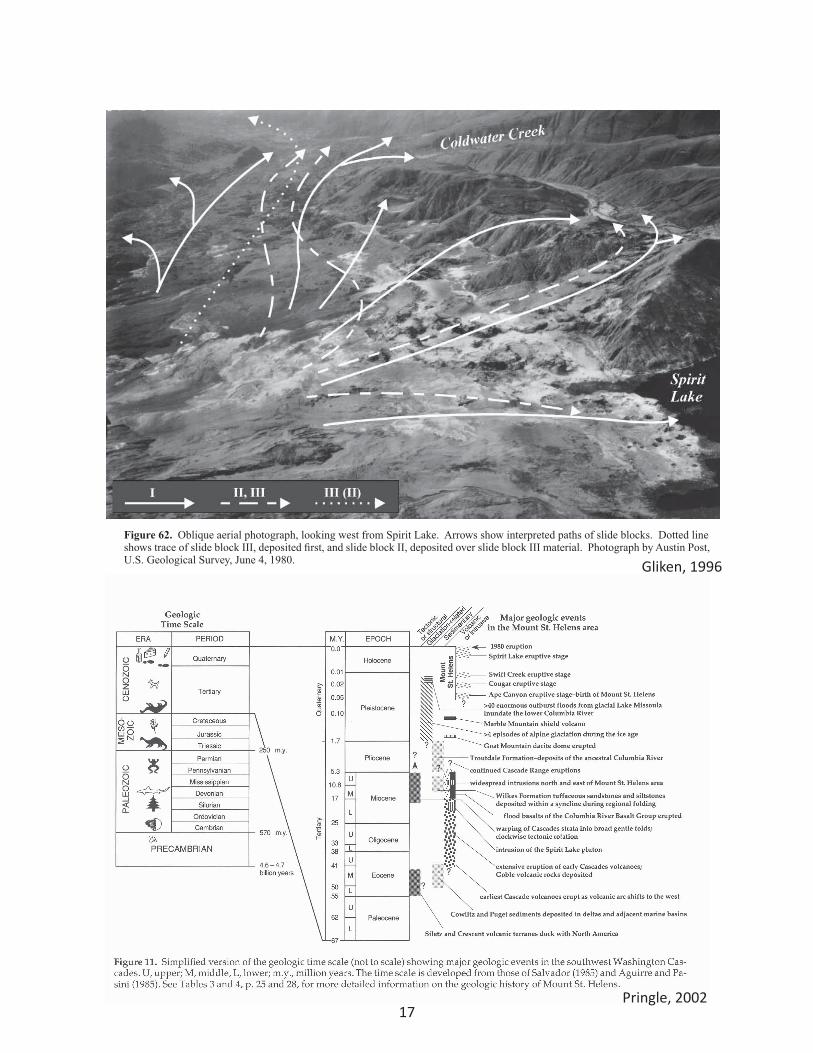
photographs after this time. Moore and Rice (1984) statethat a major collapse of the south crater rim occurred at8:33.4 a.m., but their inference is based only on a changein the morphology of the eruption cloud observed on avideotape (S.G. Malone, University of Washington, writ-ten commun., 1984). However, explosions resulting fromthe depressurization of parts of the cryptodome wereobserved to continue, possibly as new parts of thecryptodome were exposed by continuing mass move-ments.
These continuing mass movements are collectivelycalled slide block III. Slide block III consisted of manydiscrete failures; it is likely that the blocks of materialfrom these failures were, at least in part, transported bypyroclastic currents that were generated from the con-tinuing blast explosions.
After the explosively generated pyroclastic currentsand debris-avalanche blocks of slide block III moved outof the crater and down the north flank, they were stronglydeflected by topography, resulting in velocities that wereless than sonic (Kieffer, 1981) and were considerablyslower than the initial blast surge. Depressurization of
the cryptodome continued, but the change in character ofthe pyroclastic current generated from the depressuriza-tion suggests that material was erupted at a slower veloc-ity and at a lower rate than at the start of the blastexplosions.
Some of the slide block III material may have movedinto Spirit Lake to become part of the 0.43 km3 of mate-rial filling Spirit Lake, and some may have moved overpasses on Johnston Ridge (Fisher and others, 1987),depositing as the 0.06 km3 of mixed block and matrixfacies unit ("avalanche II" of Fisher and others, 1987) inSouth Coldwater Creek, but most of the 1.3-km3 slideblock flowed down the valley of the North Fork ToutleRiver. Some of the debris-avalanche blocks were depos-ited as lithologic units of the block facies that are mappedeast of the break-in-slope west of Maratta Creek, andsome of the pyroclastic currents were deposited as matrixfacies (which contains juvenile material) east of thebreak-in-slope. The balance of the material from slideblock III was deposited as the mixed block and matrixfacies unit west of the break-in-slope near Maratta Creek.
Figure 62. Oblique aerial photograph, looking west from Spirit Lake. Arrows show interpreted paths of slide blocks. Dotted line shows trace of slide block III, deposited first, and slide block II, deposited over slide block III material. Photograph by Austin Post, U.S. Geological Survey, June 4, 1980.
78 Rockslide-Debris Avalanche of May 18, 1980, Mount St. Helens volcano, Washington
Pringle, 2002
Gliken, 1996
18
ablation- the loss of snow and ice from a glacier due to melting, erosion, evaporation, or sublimation.
accretion - that process by which one terrane, a fault-bounded body of rock of regional size, is attached to another having a dif-ferent history. Typically accretion occurs during tectonic collision.
accretionary lapilli- a mass of cemented ash 1-10 mm in size.
alluvium- a general term for stream deposits.
amphibole- a group of dark, rock-forming ferromagnesian silicate minerals; for example, hornblende.
andesite- a fine-grained extrusive igneous rock generally con-taining abundant plagioclase, lesser amounts of hornblende and biotite, little or no quartz; 54-62 percent silica.
anticline- a convex-upward fold having stratigraphically older rocks in its core.
ash - see volca1ic ash.
ash cloud an eruption cloud of volcanic gas and fine particles.
basalt- a fine-grained volcanic rock, typically dark, that contains 45-54 percent silica.
bed load - sediment, such as cobbles, pebbles, and granules, that is transported along the bed of a river but is not in suspension.
biotite - “black mica”; a common mafic mineral.
blast- the enormous volcanic explosion and pyroclastic density current on May 18, 1980.
blast dacite- the bluish-gray to gray rocks, chilled pieces of the cryptodome, that were erupted in the blast on May 18, 1980.
blast density flow -see blast.
blast zone- see devastated area.
breadcrust bombs - volcanic bombs that have a breadcrust-like (open cracks) texture on their outer surface caused by contrac-tion during sudden cooling.
breccia - a rock composed of coarse, angular fragments in a ma-trix of finer particles.
calcite- a common mineral composed of calcium carbonate (CaC03).
caldera- a large, typically steep-sided, volcanic basin produced by collapse of an underlying magma chamber.
cinder cone- a fairly small, cone-shaped volcanic vent consisting mainly of accumulated cinders and other pyroclastic fragments.
cirque- a glacially carved, horseshoe-shaped hollow at the head of a valley.
Pringle, 2002
19
clast - general term for any fragment or individual piece of rock.
coal - a black, combustible sedimentary rock formed by compaction of plant matter.
cohesive lahar- a volcanic debris flow or mudflow that contains more than 4 percent clay minerals in its matrix.
composite volcano- a steep-sided volcano consisting of alternating layers of lava and pyroclastic debris. A strato-volcano.
conglomerate- a coarse-grained sedimentary rock consist-ing of rounded rocks cemented together in a finer matrix.
contact metamorphism - a type of recrystallization or change in rocks that takes place adjacent to a magma body; also known as “thermal metamorphism”.
creep - slow downhill movement of surficial materials (such as soil).
crevasse- a deep fissure in the surface of a glacier.
cross dating- a method of matching tree rings that uses the known patterns or characteristics of tree rings in an area to precisely date wood or trees such as those buried in volcanic deposits or injured by volcanic activity.
cryptodome- the near-surface intrusion of magma that produced the pre-May 18, 1980, bulge in the north flank of Mount St. Helens.
dacite- a fine-grained extrusive igneous rock typically having 62-69 percent silica.
debris avalanche- a granular flow of unsorted rock debris that typically moves at high velocity.
debris flow - a moving mass of debris, typically saturated.
debris slide- a shallow mass movement of the soil layer or other geologic material.
dendrochronology - the scientific study of tree rings.
devastated area- the area of downed and singed vegeta-tion created by the volcanic events at Mount St. Helens on May 18, 1980.
dike - a tabular intrusive rock body that forms where magma cuts across the bedding planes of other rock bodies.
diorite- a coarse-grained intrusive igneous rock having roughly the same chemical composition as andesite (54-62 percent silica).
discharge- the rate of stream flow at a given time in units of volume per unit of time (ft3 / s or m3/s).
dome- see volcanic dome.
drift- a general term for any glacial deposit.
earthflow- a type of mass movement that typically takes place along well-defined failure planes and may involve more than one failure process, such as slumping and plastic flow.
faceted spur- the end of a ridge that has been ground down by the action of ice or water.
fault- a fracture along which a rock mass has been dis-placed.
feldspar- a common rock-forming mineral group con-sisting of silicates of aluminum, sodium, potassium, and calcium.
ferromagnesian minerals- silicate minerals such as olivine, pyroxenes, and amphiboles, that contain considerable amounts of iron and magnesium.
firn- a material that is transitional between snow and glacier ice.
fission-track dating - a method of determining the age of a rock based on the number of tracks recording emission of subatomic particles during radioactive deterioration.
flood basalt - plateau basalt; the lava produced by enor-mous fissure eruptions, such as the Columbia River basalt flows.
flow breccia -a deposit of angular rock fragments, some of which are welded together, that is produced in associa-tion with a lava flow.
fold -a bend in a rock stratum or layer.
fumarole- a volcanic vent that emits gases.
gabbro - a coarse-grained intrusive igneous rock consist-ing mainly of calcium-bearing plagioclase and pyroxene minerals and having roughly the same chemical composi-tion as basalt (45-54 percent silica).
glacier - a mass of ice, mainly recrystallized snow, that is heavy enough to move under its own weight.
granite- a coarse-grained intrusive igneous rock com-posed of potassium feldspar, plagioclase, quartz, and some mafic minerals; more than 69 percent silica.
granodiorite- a coarse-grained intrusive rock, similar to a granite, in which plagioclase minerals are more common than potassium feldspar; 62-69 percent silica.
groundmass - the fine-grained matrix of a porphyritic igneous rock.

20
half-life- the time required for half of the atoms in a sam-ple of a radioactive isotope to decay.
heavy mineral - slang for ferromagnesian or mafic miner-als.
hornblende- a mafic mineral of the amphibole group.
hornfels- a fine-grained metamorphic rock formed by recrystallization.
hydrothermal activity - the migration of hot, typically mineral-rich fluids produced by magma or by reactions of magma with adjacent rocks and (or) ground water.
hydrothermal alteration- the alteration of rocks or miner-als owing to contact with hydrothermal waters.
igneous rock - a rock formed by the cooling of magma.
intrusive rock- an igneous rock that solidifies under the surface of the Earth.
isotope - one of two or more forms of an element having different atomic weights.
joint a fracture in a rock along which movement has not occurred.
juvenile material- volcanic rocks derived directly from magma that has reached the surface.
K-Ar dating- see Potassium-Argon dating.
lahar- general term for a volcanic debris flow, a moving mixture of pyroclastic material and water that originates at a volcano.
lahar runout - the muddy flood caused by dilution of a lahar as it mixes with stream water. The deposits are typically very sandy and have fewer large rocks than lahar deposits.
lapilli- volcanic particles in the range of 2-64mm.
lateral blast - see blast.
lateral moraine- an accumulation of till along the sides of a glacier where it meets the valley wall.
lava- magma that reaches the Earth’s surface.
levee - an area of deposits marginal to a flow that roughly records the maximum height of the flow.
lithic pyroclastic flow - a pyroclastic flow that contains a significant percentage of previously formed rock frag-ments mixed in with the juvenile rocks.
lithification - the process by which sediment is converted into solid rock.
mafic rock- a rock that contains more than 50 percent ferromagnesian minerals.
magma - molten rock; can contain liquids, gases, and crystals.
magmatism - the formation and movement of magma.
magnitude- a scale for measuring the energy released by an earthquake.
mass movement- the movement of geologic materials downslope under the influence of gravity.
mass wasting- see mass movement.
metamorphic rock- a rock whose composition and (or) texture has changed because of heat and (or) pressure.
mineral- a naturally formed solid chemical substance having a fixed crystal structure and range of chemical com positions.
moraine - a landform composed of till or drift.
mudline - the maximum level of inundation by a lahar or flood based on the height of mud marks on trees or rocks.
normal fault- a steeply dipping fault in which the hanging wall has moved downward relative to the footwall.
outburst floods- jokuhlhaups; sudden releases of water stored in or adjacent to a glacier or in a glacial lake.
outcrop- an exposure of rock or a deposit.
outwash- stratified deposits produced by glacial meltwa-ter.
pahoehoe- [pa·hoy’·hoy] a Hawaiian term for basaltic lava flows having a smooth or ropy surface.
phenocryst - a large individual crystal in a porphyritic igneous rock.
phreatic explosion or eruption- an explosive mixture of steam and fine rock debris produced when water con-tacts hot rock.
plastic flow- change in shape of a solid that takes place without rupture.
Plinian column - a strong, turbulent, and sustained verti-cal eruption column.
pluton - the cooled body of a large intrusive igneous rock mass.
porphyritic- a texture of igneous rock in which coarse mineral crystals are scattered among finer grains and (or) glass.
21
porphyry copper deposit a type of hydrothermal mineral deposit associated with plutons that contains associated copper minerals.
potassium-argon dating - the radiometric determination of the age of a rock sample based on the ratio of ar-gon.-40 to potassium-40.
proglacial- immediately in front of or just beyond the limits of the glacier.
pumice - solidified rock froth; a porous volcanic rock that floats.
pyroclastic density current- a general name for any of the mixtures of volcanic gas and particles (including surges and flows) that move downslope on the flanks of a volca-no under the influence of gravity.
pyroclastic flow - a mass of hot, dry, pyroclastic debris and gases that move rapidly along the ground surface. They can be caused by an eruption or collapse of a dome.
pyroclastic surge- a turbulent, mixture of gases and par-ticles that flows above the ground surface at high veloc-ities. It can develop from a pyroclastic flow and is highly mobile.
pyroxene- a group of mafic silicate minerals.
Quaternary - the geologic period lasting from about 1.7 Ma to the present. It consists of the Pleistocene Epoch (ending about 10 ka) and the Holocene (10 ka to present).
radiocarbon dating - the calculation of the age of geologic material by any of the methods based on nuclear decay of natural radioactive elements in carbonaceous material.
radiocarbon years -years before 1950 (by convention) based on the proportion of the 14C isotope to normal carbon atoms. Typically radiocarbon years differ from “calendar years” because of variations of the carbon iso-tope content of atmospheric carbon dioxide through tine. A calibration to adjust these ages on the basis of tree rings (for about the last 11,000 years) has been devised; however, for simplicity, only the raw radiocarbon ages are presented in this guidebook. For the most part, these ages do not differ radically from actual calendar years. Tree ring dates for Mount St. Helens deposits laid down since A.D. 1480, however, are given in calendar years.
radiometric age- see radiometric dating.
radiometric dating -a method of estimating the age of a rock or mineral by measuring the proportion of radioac-tive elements to their decay products in a rock sample.
raveling- erosion involving the movement of individual rocks and grains down a slope.
rock flour- fine rock particles produced by glacial pulveri-zation.
rootless explosion crater- small, shallow craters produced by phreatic explosions.
St. Helens zone- a linear zone of earthquake activity that extends from north of Mount St. Helens through the vol-cano almost to the Columbia River.
scoria- an igneous rock containing abundant cavities (ves-icles) but which does not float.
shield volcano- a large, broad volcano having fairly shal-low slopes formed by the eruption of highly fluid basalt lava.
sill- a tabular intrusive rock body that forms where mag-ma is injected between two layers of rock.
singe zone- the zone at the periphery of the devastated area in which trees were scorched or damaged but not blown down.
slickensides striated or polished surface of a rock pro-duced by abrasion along a fault.
slips- debris slides.
slosh line- see trimline.
slump- a type of mass wasting in which blocks of material fail with a backward rotational motion.
snag the trunk of a dead tree.
stratigraphy - the study of strata, its succession and com-position, fossils and other characteristics.
striation - a scratch or groove on a rock produced by the passage of a glacier or other geologic agent.
strike- the bearing or azimuth along which a fault or fold or other planar feature is oriented.
strike-slip fault- a fault in which displacement has been parallel to the strike of the fault.
suspended load -fine sediment carried in suspension by a river.
syncline-~ fold that is concave upward, like a trough.
talus - rock debris, typically coarse, that accumulates at the base of a cliff or slope.
tarn- a small mountain lake that occupies a cirque.
tephra- a general term for all sizes of rock and lava that are ejected into the air during an eruption.
terrace- a long, narrow, nearly flat surface that forms a step-like bench in a slope.
22
terrane- a large block of the Earth’s crust, bounded by faults, that can be distinguished from other blocks by its geologic character.
Tertiary - the geologic period lasting from about 65 Ma to 1.8 Ma.
thrust fault- low-angle fault (less than 45°) in which the hanging wall has moved upward relative to the footwall; typically caused by horizontal compression.
till- an unsorted glacial deposit produced directly under, within, or on top of a glacier.
transform fault- strike-slip faults that separate major geo-logic plates or plate segments.
trimline- boundary between the area affected by scour or scrape and undisturbed terrain that denotes the max-imum height of run-up or inundation by an avalanche, debris flow, flood, wave, or glacier.
tuff- a fine-grained rock composed mostly of volcanic ash.
valley glacier- a glacier that heads at a cirque or cirques and then flows into, and is confined by, a valley; an alpine glacier.
viscosity - resistance to internal flow.
volcanic arc- a curved belt of volcanoes and volcanic rocks associated with a subduction zone.
volcanic ash fine-grained pyroclastic particles (less than 2 mm in diameter).
volcanic dome a steep-sided bulbous mass of lava, such as the Lava Dome, that is commonly
formed by eruptions of highly viscous dacite or rhyolite lava.
volcanic earthquakes- the sudden release of strain energy under or in a volcano as magma or volcanic gas pushes its way to the surface.
volcaniclastics- a general name for all fragmental material produced by a volcano.
vug a cavity in a vein or rock. Some vugs are lined with crystals.
Pringle, 2002
23
-8
-7
-6
-5
-4
-3
-2
-1
0
1
2
3
4
5
6
7
8
9
10
256
128
200
100
5040
30
20
10
54
3
2
1
.5
.4
.3
.2
.1
.05
.04
.03
.02
.01
.005
.004
.003
.002
.001
64.053.945.333.132.026.922.617.016.013.411.39.528.006.735.664.764.003.362.832.382.001.631.411.191.00.840.707.545.500.420.354.297.250.210.177.149.125.105.088.074.062.053.044.037.031
.016
.004
.008
.002
.001
10.1"
5.04"
2.52"
1.26"
0.63"
0.32"
0.16"
0.08"inches
mm1
1/2
1/4
1/8
1/16
1/32
1/64
1/128
1/256
1/512
1/1024
2 1/2"2.12"
1 1/2"1 1/4"1.06"
3/4"
3/8"5/16".265"
5/8"
45678
101214161820253035404550607080100120140170200230270325400
2"
1 1/2"
1.05"
.742"
.525"
.371"
3
456789
1012141620242832354248606580100115150170200250270325
1.2
.59
.86
.42
.30
.215
.155
.115
.080 2900
1000
350
120
43
15
5.6
2.0
.72 .6
1.5
4.5
13
35
91
240
580
1700
10050
4090
80
70 30
60
5020
40
30
20109876
108765
5
4
3
2
43
2
11.0
0.50.50.329
0.10.085
0.023
0.01
0.0057
0.00140.001
0.00036
0.0001
200
150
100
90
80
70
60
50
40
30
20 26
30
40
50
100
PE
BB
LE
S
COBBLES
SA
ND
SIL
TC
LA
Y
BOULDERS
verycoarse
coarse
medium
fine
verycoarse
coarse
medium
fine
veryfine
coarse
medium
fine
veryfine
No
te:
Ap
plie
s t
o s
ub
ang
ula
r t
osu
bro
un
ded
qu
artz
san
d
No
te:
Ap
plie
s t
o s
ub
ang
ula
r t
osu
bro
un
ded
qu
artz
san
d
No
te:
Sie
ve o
pen
ing
s d
iffe
r b
y a
sm
uch
as
2%
fro
m
mm
sca
le
No
te:
So
me
sie
ve o
pen
ing
s d
iffe
rsl
igh
tly
fro
m
mm
sca
le
No
te:
Th
e r
elat
ion
bet
wee
n t
he
beg
inn
ing
of
tra
ctio
n t
ran
spo
rt a
nd
th
e v
elo
city
dep
end
s o
n t
he
hei
gh
t a
bo
ve t
he
bo
tto
mth
at t
he
vel
oci
ty i
s m
easu
red
, an
d o
no
ther
fac
tors
.
SIEVESIZES
SIZE TERMS
Fra
ctio
nal
mm
and
Dec
imal
in
ches
Tyle
rM
esh
No
.
AS
TM
No
.(U
.S.
Sta
nd
ard
)
Numberof grainsper mg
Qu
artz
sph
eres
Nat
ura
lsa
nd
SettlingVelocity(Quartz,
20°C)
Sp
her
es(G
ibb
s, 1
971)
Cru
shed
cm/sec
ThresholdVelocity
for tractioncm/secφ
Minimum(Inman,1949)
(Nev
in,1
946)
(mo
dif
ied
fro
mH
juis
trom
,193
9)
Sto
kes
Law
(R
= 6
πrηv
)
ph
i ph
i
1/2"7/16"
(afterWentworth,1922)
Clay/Siltboundary
for mineralanalysis
PHI - mmCOVERSION
φ = log (d in mm)21µm = 0.001mm
Inte
rmed
iate
dia
met
ers
of
nat
ura
l g
rain
seq
uiv
alen
t t
o s
ieve
siz
e
1 mabovebottom
( in
mm
)
> -8φ_
mm
( )
veryfine
Granules