Embed Size (px)
Citation preview
4th ICA Mountain Cartography Workshop, Vall de Núria, Catalonia, Spain 30 September – 2 October 2004
GEODETIC MEASUREMENTS ON GLACIERS AND ROCK GLACIERS
IN THE HOHE TAUERN NATIONAL PARK (AUSTRIA)
Gerhard KIENAST1, Viktor KAUFMANN2
Graz University of Technology, Austria 1Institute of Navigation and Satellite Geodesy
[email protected] 2Institute of Remote Sensing and Photogrammetry
KEY WORDS: Glacier and rock glacier monitoring, geodetic measurements, Pasterze Glacier, Doesen Rock Glacier, Hinteres Langtalkar Rock Glacier, Weissenkar Rock Glacier, Goessnitzkees.
ABSTRACT The Hohe Tauern National Park was founded in 1986 and encloses an area of about 1800 km2. This high mountain environment comprises many glaciers and also rock glaciers. Thus it is an ideal region for research in the field of glaciology and permafrost. Geodetic measurements have been carried out on selected glaciers and rock glaciers in this National Park by the former Institute of Geodesy (now divided into the Institute of Navigation and Satellite Positioning and the Institute of Remote Sensing and Photogrammetry) of Graz University of Technology from 1995 until the present (2004). This work has been done by co-workers and students of both institutes within the framework of projects and several diploma theses. Most of the work has been carried out in cooperation with the Institute of Geography and Regional Science of the University of Graz. This paper presents a condensed report on the measurements carried out, measuring methods used and results achieved for glaciers, i.e. Pasterze Glacier and Goessnitzkees, and rock glaciers, i.e. Doesen Rock Glacier, Hinteres Langtalkar Rock Glacier, and Weissenkar Rock Glacier.
1 PASTERZE GLACIER
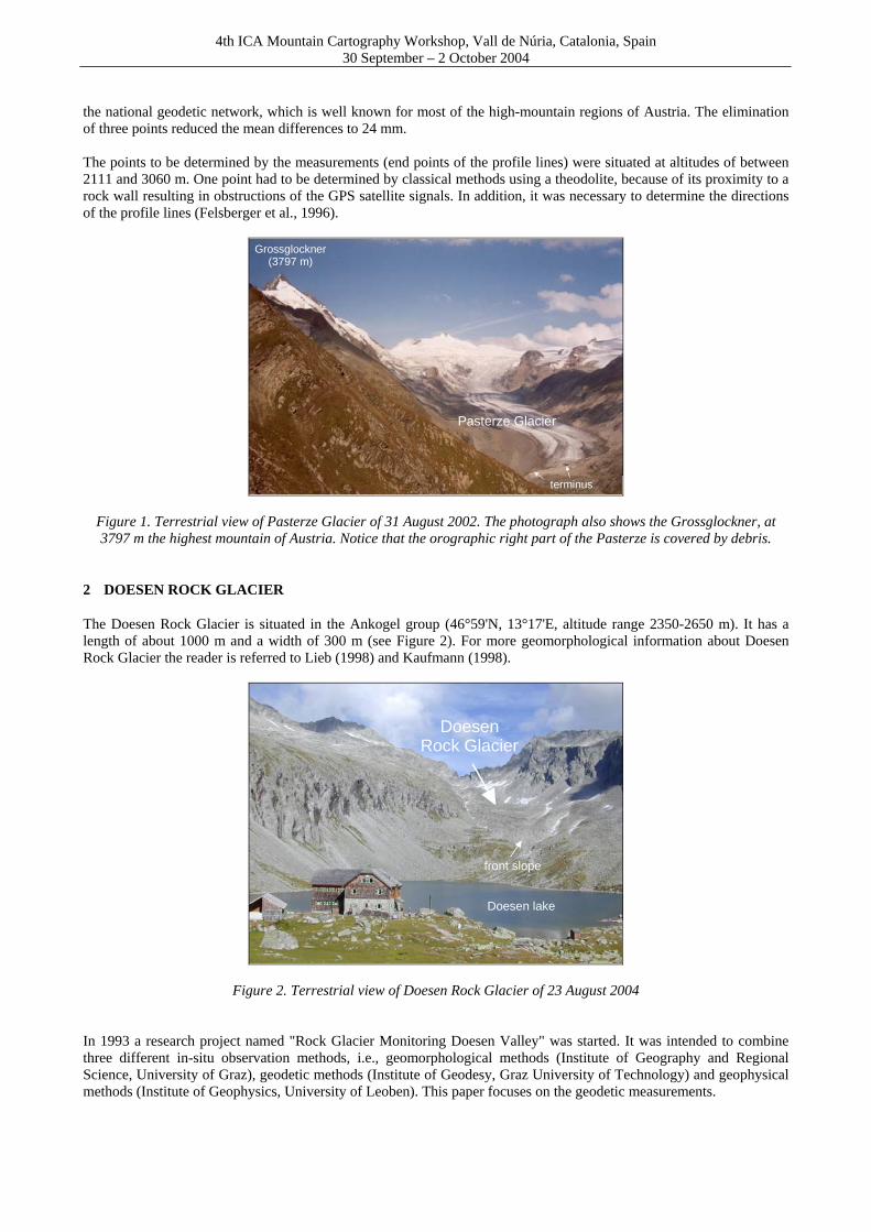
Pasterze Glacier (47°05'N, 12°44'E, altitude range 2100-3400 m) is situated in the Glockner group, which is the highest mountain range of the Austrian Alps with a maximum elevation of 3797 m (Grossglockner), see Figure 1. Pasterze is the biggest glacier in the Eastern Alps. Since 1878 measurements have been carried out to determine the position of the glacier front (terminus) by the simplest means using measuring tapes. From 1928 onwards 5 transversal profile lines across the glacier were used. For this purpose, one point was fixed on the north-eastern border of the glacier, and a target point was marked with color on the opposite rock wall. Then stones were laid in a line between the two points and measured in a local coordinate system. In subsequent years these stones were again observed and measured (normally most of the stones will be found one year later). These measurements have been performed by the Institute of Geography and Regional Science of the University of Graz (Lieb, 2004) since 1958. Because of the continuous retreat of the glacier (in 1850: area 26.5 km2, length 11.4 km, end of glacier at an altitude of 2000 m; in 1985: area 20.0 km2, length 9.0 km, end of glacier at an altitude of 2100 m) the lowest transversal profile no longer covered the glacier. A new profile line was thus established in 1994. All these measurements were done in local systems with no connection between the various observation lines. From such local measurements one can compute the horizontal and vertical movement of the glacier, but not the change of the ice masses, because the distances between the profile lines are not known. In order to compute volumetric changes, all profile lines must be in a uniform coordinate system and all data must be available in electronic form. The work required was done in 1996 in the context of a diploma thesis (Felsberger et al., 1996). The profile lines were measured by GPS using eight connection points to the national geodetic network. These eight points were located in an altitude range between 1940 and 3025 m. The results obtained showed differences up to 176 mm between the GPS derived coordinates and the national coordinates. This can be explained by the reduced quality of
4th ICA Mountain Cartography Workshop, Vall de Núria, Catalonia, Spain 30 September – 2 October 2004
the national geodetic network, which is well known for most of the high-mountain regions of Austria. The elimination of three points reduced the mean differences to 24 mm. The points to be determined by the measurements (end points of the profile lines) were situated at altitudes of between 2111 and 3060 m. One point had to be determined by classical methods using a theodolite, because of its proximity to a rock wall resulting in obstructions of the GPS satellite signals. In addition, it was necessary to determine the directions of the profile lines (Felsberger et al., 1996).
Pasterze Glacier
Grossglockner(3797 m)
terminus
Figure 1. Terrestrial view of Pasterze Glacier of 31 August 2002. The photograph also shows the Grossglockner, at 3797 m the highest mountain of Austria. Notice that the orographic right part of the Pasterze is covered by debris.
2 DOESEN ROCK GLACIER
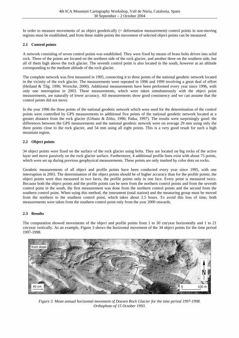
The Doesen Rock Glacier is situated in the Ankogel group (46°59'N, 13°17'E, altitude range 2350-2650 m). It has a length of about 1000 m and a width of 300 m (see Figure 2). For more geomorphological information about Doesen Rock Glacier the reader is referred to Lieb (1998) and Kaufmann (1998).
DoesenRock Glacier
front slope
Doesen lake
Figure 2. Terrestrial view of Doesen Rock Glacier of 23 August 2004 In 1993 a research project named "Rock Glacier Monitoring Doesen Valley" was started. It was intended to combine three different in-situ observation methods, i.e., geomorphological methods (Institute of Geography and Regional Science, University of Graz), geodetic methods (Institute of Geodesy, Graz University of Technology) and geophysical methods (Institute of Geophysics, University of Leoben). This paper focuses on the geodetic measurements.
4th ICA Mountain Cartography Workshop, Vall de Núria, Catalonia, Spain 30 September – 2 October 2004
In order to measure movements of an object geodetically (= deformation measurement) control points in non-moving regions must be established, and from these stable points the movement of selected object points can be measured. 2.1 Control points
A network consisting of seven control points was established. They were fixed by means of brass bolts driven into solid rock. Three of the points are located on the northern side of the rock glacier, and another three on the southern side, but all of them high above the rock glacier. The seventh control point is also located in the south, however at an altitude corresponding to the medium altitude of the rock glacier. The complete network was first measured in 1995, connecting it to three points of the national geodetic network located in the vicinity of the rock glacier. The measurements were repeated in 1996 and 1999 involving a great deal of effort (Heiland & Tilg, 1996; Worsche, 2000). Additional measurements have been performed every year since 1996, with only one interruption in 2003. These measurements, which were taken simultaneously with the object point measurements, are naturally of lower accuracy. All measurements show good consistency and we can assume that the control points did not move. In the year 1996 the three points of the national geodetic network which were used for the determination of the control points were controlled by GPS measurements to additional five points of the national geodetic network located at a greater distance from the rock glacier (Urbanz & Zölss, 1996; Patka, 1997). The results were surprisingly good: the differences between the GPS measurements and the national geodetic network were on average 29 mm using only the three points close to the rock glacier, and 54 mm using all eight points. This is a very good result for such a high mountain region. 2.2 Object points
34 object points were fixed on the surface of the rock glacier using bolts. They are located on big rocks of the active layer and move passively on the rock glacier surface. Furthermore, 4 additional profile lines exist with about 75 points, which were set up during previous geophysical measurements. These points are only marked by color dots on rocks. Geodetic measurements of all object and profile points have been conducted every year since 1995, with one interruption in 2003. The determination of the object points should be of higher accuracy than for the profile points; the object points were thus measured in two faces, the profile points only in one face. Every point is measured twice. Because both the object points and the profile points can be seen from the northern control points and from the seventh control point in the south, the first measurement was done from the northern control points and the second from the southern control point. When using this method, the instrument (total station) and the measuring group must be moved from the northern to the southern control point, which takes about 2.5 hours. To avoid this loss of time, both measurements were taken from the southern control point only from the year 2000 onwards.
2.3 Results
The computation showed movements of the object and profile points from 1 to 30 cm/year horizontally and 1 to 21 cm/year vertically. As an example, Figure 3 shows the horizontal movement of the 34 object points for the time period 1997-1998.
0 100 m40 cm
front slope
Figure 3. Mean annual horizontal movement of Doesen Rock Glacier for the time period 1997-1998. Orthophoto of 15 October 1993.
4th ICA Mountain Cartography Workshop, Vall de Núria, Catalonia, Spain 30 September – 2 October 2004
3 HINTERES LANGTALKAR ROCK GLACIER
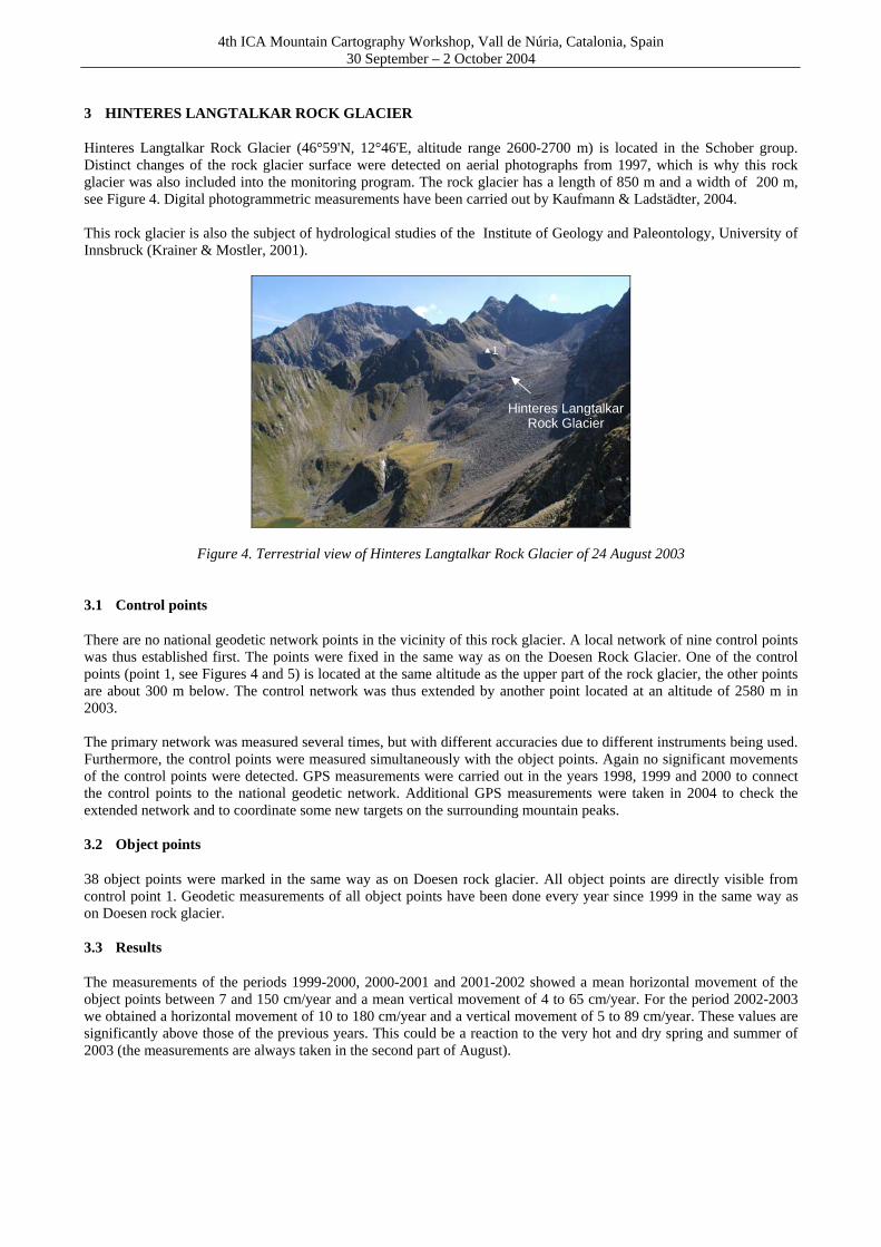
Hinteres Langtalkar Rock Glacier (46°59'N, 12°46'E, altitude range 2600-2700 m) is located in the Schober group. Distinct changes of the rock glacier surface were detected on aerial photographs from 1997, which is why this rock glacier was also included into the monitoring program. The rock glacier has a length of 850 m and a width of 200 m, see Figure 4. Digital photogrammetric measurements have been carried out by Kaufmann & Ladstädter, 2004. This rock glacier is also the subject of hydrological studies of the Institute of Geology and Paleontology, University of Innsbruck (Krainer & Mostler, 2001).
Hinteres LangtalkarRock Glacier
1
Figure 4. Terrestrial view of Hinteres Langtalkar Rock Glacier of 24 August 2003 3.1 Control points
There are no national geodetic network points in the vicinity of this rock glacier. A local network of nine control points was thus established first. The points were fixed in the same way as on the Doesen Rock Glacier. One of the control points (point 1, see Figures 4 and 5) is located at the same altitude as the upper part of the rock glacier, the other points are about 300 m below. The control network was thus extended by another point located at an altitude of 2580 m in 2003. The primary network was measured several times, but with different accuracies due to different instruments being used. Furthermore, the control points were measured simultaneously with the object points. Again no significant movements of the control points were detected. GPS measurements were carried out in the years 1998, 1999 and 2000 to connect the control points to the national geodetic network. Additional GPS measurements were taken in 2004 to check the extended network and to coordinate some new targets on the surrounding mountain peaks. 3.2 Object points
38 object points were marked in the same way as on Doesen rock glacier. All object points are directly visible from control point 1. Geodetic measurements of all object points have been done every year since 1999 in the same way as on Doesen rock glacier. 3.3 Results
The measurements of the periods 1999-2000, 2000-2001 and 2001-2002 showed a mean horizontal movement of the object points between 7 and 150 cm/year and a mean vertical movement of 4 to 65 cm/year. For the period 2002-2003 we obtained a horizontal movement of 10 to 180 cm/year and a vertical movement of 5 to 89 cm/year. These values are significantly above those of the previous years. This could be a reaction to the very hot and dry spring and summer of 2003 (the measurements are always taken in the second part of August).

4th ICA Mountain Cartography Workshop, Vall de Núria, Catalonia, Spain 30 September – 2 October 2004
1
150 cm/year0 100 m
Figure 5. Horizontal movement of Hinteres Langtalkar Rock Glacier for the time period 1999-2000.
Orthophoto of 12 September 1999.
4 WEISSENKAR ROCK GLACIER
The Weissenkar Rock Glacier (46°57'N, 12°45'E, altitude range 2650-2700 m) is also located in the Schober group, about 4 km south-west of Hinteres Langtalkar Rock Glacier. It has a length of 700 m and a width of 300 m, see Figure 6.
WeissenkarRock Glacier
front slope
Figure 6. Terrestrial view of Weissenkar Rock Glacier of 4 September 2004 4.1 Control points
There are no national geodetic network points in the vicinity of this rock glacier. Because of its comparatively small size the control network was limited to two points. Most of the rock glacier surface is visible from both points. The
4th ICA Mountain Cartography Workshop, Vall de Núria, Catalonia, Spain 30 September – 2 October 2004
points were fixed in the same way as on the other two rock glaciers. The stability of the two points can only be proved by the distance and direction between them. The connection to the national geodetic network was done with GPS in the same campaign as for Hinteres Langtalkar Rock Glacier and Goessnitzkees (see next chapter). 4.2 Object points
18 object points were fixed in the same way as described for the other two rock glaciers. Geodetic measurements have been carried out every year since 1997, with one interruption in 2002. 4.3 Results
Weissenkar Rock Glacier moves an average of 2 to 12 cm/year horizontally and 1 to 9 cm/year vertically.
5 GOESSNITZKEES
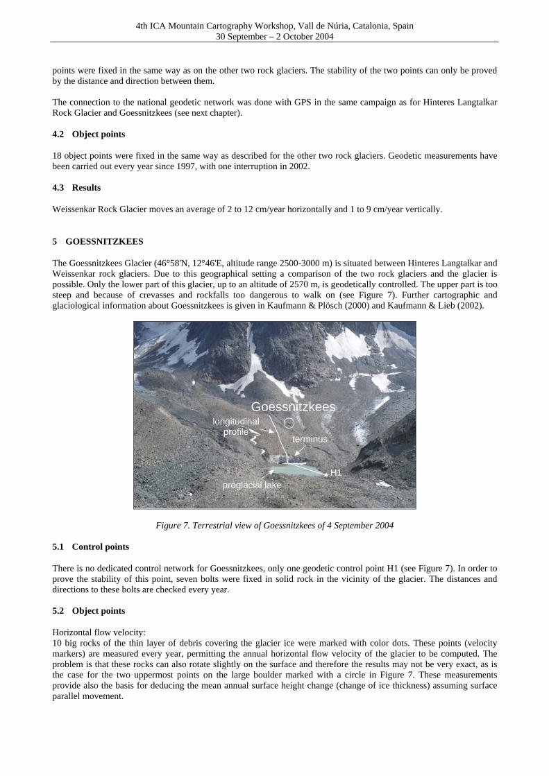
The Goessnitzkees Glacier (46°58'N, 12°46'E, altitude range 2500-3000 m) is situated between Hinteres Langtalkar and Weissenkar rock glaciers. Due to this geographical setting a comparison of the two rock glaciers and the glacier is possible. Only the lower part of this glacier, up to an altitude of 2570 m, is geodetically controlled. The upper part is too steep and because of crevasses and rockfalls too dangerous to walk on (see Figure 7). Further cartographic and glaciological information about Goessnitzkees is given in Kaufmann & Plösch (2000) and Kaufmann & Lieb (2002).
Goessnitzkees
terminus
proglacial lakeH1
longitudinalprofile
Figure 7. Terrestrial view of Goessnitzkees of 4 September 2004 5.1 Control points
There is no dedicated control network for Goessnitzkees, only one geodetic control point H1 (see Figure 7). In order to prove the stability of this point, seven bolts were fixed in solid rock in the vicinity of the glacier. The distances and directions to these bolts are checked every year. 5.2 Object points
Horizontal flow velocity: 10 big rocks of the thin layer of debris covering the glacier ice were marked with color dots. These points (velocity markers) are measured every year, permitting the annual horizontal flow velocity of the glacier to be computed. The problem is that these rocks can also rotate slightly on the surface and therefore the results may not be very exact, as is the case for the two uppermost points on the large boulder marked with a circle in Figure 7. These measurements provide also the basis for deducing the mean annual surface height change (change of ice thickness) assuming surface parallel movement.

4th ICA Mountain Cartography Workshop, Vall de Núria, Catalonia, Spain 30 September – 2 October 2004
Surface height change: In order to obtain additional information about glacier change, a longitudinal profile (see Figure 7) is measured in the lower part of the glacier in a fixed direction. The loss of ice can be deduced from the comparison of different years. Additionally the front of the glacier (until 2001 with a big cave in it) is measured as well as the shore of the proglacial lake, which is visible in Figure 7. These measurements clearly show the continuous retreat of the Goessnitzkees. 5.3 Results
A mean horizontal flow velocity in the order of 20-40 cm/year can be deduced from the measurements. The maximum velocity was calculated at 1-2 m/year, which was probably related to some sliding between rock and ice. A mean surface lowering of the glacier of 1.76 m/year was calculated for the time period 1996-2004, the current rate for the period 2003-2004 being 1.19 m/year.
100 m 150 m 200 m 250 m 300 m 350 m 400 m 450 m 500 mdistance from reference point H1
2500 m
2510 m
2520 m
2530 m
2540 m
2550 m
2560 m
2570 m
2580 m
elev
atio
n(v
ertic
al e
xagg
erat
ion
2.5)
longitudinal profiles1996-2004
Goessnitzkees
terrain (proglacial lake)
1996
1997
1998
1999
2000
2001
2002
2003
2004
glac
ier f
ront
Goessnitzkees (glacier)
Figure 8. Graphical representation of the glacier retreat of Goessnitzkees shown for the longitudinal profile
6 CONCLUSIONS
Most systematic studies of glacier length change in Austria are carried out in a quite simple manner. Our geodetic measurements of selected points on the glacier surface provide detailed and accurate three-dimensional information on flow velocity and mass change. Furthermore, our monitoring program was extended to include the surface kinematics of rock glaciers. This allows more detailed conclusions to be drawn on the behavior of the glaciers and rock glaciers studied, especially if long-term data series exist. Measurement data over a time span of nearly 10 years are now available for our study areas in the Hohe Tauern National Park. It is planned to continue these measurements on an annual basis, since they are of great importance to climate researchers analyzing the impact of climatic change on our environment.
ACKNOWLEDGMENTS
The authors are grateful to the staff and students of the Institute of Navigation and Satellite Geodesy and the Institute of Photogrammetry and Remote Sensing of the Graz University of Technology. Without their enthusiasm the work could not have been carried out. The support provided by volunteers of the Hohe Tauern National Park during field work has been indispensable and is gratefully acknowledged. The financial support of the Hohe Tauern National Park and the Austrian Science Fund (FWF) is kindly acknowledged.
REFERENCES
Felsberger, H., Moser, G., Schukoff, B., 1996. Einmessung, Berechnung und Verwaltung von Profillinien zur Überwachung der Pasterze. Unpublished diploma thesis, in German, Graz University of Technology, 345 p.
4th ICA Mountain Cartography Workshop, Vall de Núria, Catalonia, Spain 30 September – 2 October 2004
Heiland, R. & Tilg, H.P., 1996. Blockgletscher Monitoring – Neubestimmung des Kontrollnetzes am Dösener Blockgletscher und erste Bewegungsanalyse. Unpublished diploma thesis, in German, Graz University of Technology. Kaufmann, V., 1998. Deformation analysis of the Doesen rock glacier (Austria). In: Proceedings of the 7th International Conference on Permafrost, Yellowknife, Canada, pp. 551-556. Kaufmann, V. & Plösch, R., 2000. Mapping and visualization of the retreat of two cirque glaciers in the Austrian Hohe Tauern National Park. International Archives of Photogrammetry and Remote Sensing, Vol. XXXIII, Part B4, pp. 446-453. Kaufmann, V. & Lieb, G.K., 2002. Investigations on the retreat of two small cirque glaciers (Goessnitzkees and Hornkees) in the Austrian Alps, Europe. In: Proceedings of the 5th International Symposium of the Use of Remote Sensing Data in Mountain Cartography, Karlstad University Studies, 2002:27, pp. 75-82. Kaufmann, V. & Ladstädter, R., 2004. Documentation of the Movement of the Hinteres Langtalkar Rock Glacier. International Archives of Photogrammetry and Remote Sensing, Vol. XXXV, Part B7, pp. 893-898. Krainer, K. & Mostler, W., 2001. Der aktive Blockgletscher im Hinteren Langtal Kar, Gößnitztal (Schobergruppe, Nationalpark Hohe Tauern, Österreich. In: Wissenschaftliche Mitteilungen aus dem Nationalpark Hohe Tauern, 6, in German, pp. 139-168. Lieb, G.K., 1998. High-mountain permafrost in the Austrian Alps. In: Proceedings of the 7th International Conference on Permafrost, Yellowknife, Canada, pp. 663-668. Lieb, G.K., 2004. Die Pasterze – 125 Jahre Gletschermessungen und ein neuer Führer zum Gletscherweg. In: Grazer Mitteilungen der Geographie und Raumforschung, 34, in german, Institute of Geography and Regional Science, University of Graz, pp. 3-5. Patka, G., 1997. Blockgletscher Monitoring im Dösener Tal – Einmessung der Kontrollpunkte mittels GPS und Vergleich mit der konventionellen Methode. Unpublished diploma thesis, in German, Graz University of Technology. Urbanz, R. & Zölss, R., 1996. Blockgletscher Monitoring – Überprüfung des Festpunktfeldes im Gebiet des Dösener Sees und Bestimmung des Stützpunktnetzes mittels GPS. Unpublished diploma thesis, in German, Graz University of Technology. Worsche, G., 2000. Bewegungsmessungen am Dösener Blockgletscher 1999. Unpublished diploma thesis, in German, Graz University of Technology. Corresponding author: Gerhard Kienast Institute of Navigation and Satellite Geodesy Graz University of Technology Steyrergasse 30, A-8010 Austria Tel.: +43 316 873-6835 Fax: +43 316 873-8888 E-mail: [email protected] Homepage: http://www.inas.tugraz.at/