Embed Size (px)
Citation preview

Geographic Information System Technician Skill Standards
1

Critical Work Function
Key Activity Key Activity Key Activity Key Activity Key Activity Key Activity Key Activity
1. Create and/orAcquire GIS Data
1.1 Define the data requirements, research sources of available data, and purchase data from reputable source.
1.2 Develop (and document with metadata) database(s) including: defining geometry, attributes, relationships, topology rules, feature behaviors such as types and domains, incorporating data schema models.
1.3 Determine data compatibility (projection), perform data conversion, populate feature attributes.
1.4 Perform both tablet, COGO, and on-screen digitization with attribution.
1.5 Collect field attribute and location data via GPS (Tablet PC/PDA).
1.6 Geocode data.
1.7 Perform quality control (QC) and quality assurance (QA) of GIS databases.
2. Create ImageData
2.1 Scan hard copy images into digital format.
2.2 Geo-reference digital imagery.
2.3 Rectify images to meet data standards.
2.4 Perform image analysis (classification).
3. Maintain GISData
3.1 Develop procedures and schedules for data maintenance.
3.2 Maintain data QA/QC through update operations: (add/delete/change).
3.3 Perform data layer updates and update metadata (imagery/themes).
3.4 Convert data between formats.
3.5 Perform database performance tuning through compression, indexing, etc.
4. ConductSpatial/Non-Spatial Analysis
4.1 Create analysis models through flowcharts and processes.
4.2 Create scripts 4.3 Preprocess geographic data (generalize, subset).
4.4 Perform geo-processing through clipping, buffering, overlay, etc.
4.5 Generate descriptive and spatial statistics.
4.6 Perform quality control and assurance.
4.7 Interpret data results.
5. Generate GISProducts 5.1 Create maps 5.2 Create analysis
report 5.3 Create tables 5.4 Create charts 5.5 Generate mailing labels, logos, posters, etc.
5.6 Distribute digital and hard copy products
6. DevelopSoftware Applications
6.1 Define user software needs and determine application design format (hardware platform and programming language).
6.2 Create customized software application solution
6.3 Create map templates
6.4 Perform quality control and assurance for applications, such as beta testing.
6.5 Create help files and support documentation.
7. Manage GISData
7.1 Establish data custodianship and distribute and assign database permissions according to organizational policies.
7.2 Organize file structure (e.g. create directories, perform data and directory housekeeping)
7.3 Perform data maintenance through archival functions.
8. ProvideTechnical Support
8.1 Resolve user technical problems
8.2 Install and maintain software including service packs.
8.3 Assist in writing technical guides for GIS applications
8.4 Provide technical training for end-users
2
GEOGRAPHIC INFORMATION SYSTEM TECHNICIAN SKILL STANDARDS

Critical Work Function
Key Activity Key Activity Key Activity Key Activity Key Activity Key Activity Key Activity
9. PerformAdministrative Tasks
9.1 Create formal and informal communications using email, phone, listservs and written reports.
9.2 Coordinate GIS projects including cost estimates, timelines, and budgets.
9.3 Prepare and maintain contracts. Maintain equipment and office supplies
9.4 Provide internship supervision for students and new workers.
9.5 Participate in GIS awareness events such as presentations, conferences and user groups.
10. PursueProfessional Development
10.1 Participate in professional conferences using both oral and written communications
10.2 Continue professional education through credit and/or noncredit courses, technical training and informal education, such as online courses.
3
GEOGRAPHIC INFORMATION SYSTEM TECHNICIAN SKILL STANDARDS
Occupational Title: GIS Technician Critical Work Function 1: Create and/or Acquire GIS Data Occupational Skills, Knowledge & Conditions
Key Activity
Performance Criteria How do we know when the key activity is performed well or performed successfully?
Occupational Skills & Knowledge
What should the technician know and what skills should the technician have in order to do the activity?
Conditions What tools must the technician use in order to do the activity?
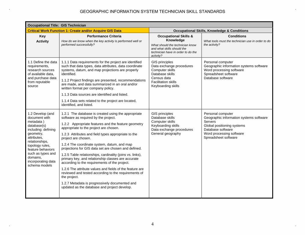
1.1 Define the data requirements, research sources of available data, and purchase data from reputable source
1.1.1 Data requirements for the project are identified such that data types, data attributes, data coordinate systems, datum, and map projections are properly identified.
1.1.2 Project findings are presented, recommendations are made, and data summarized in an oral and/or written format per company policy.
1.1.3 Data sources are identified and listed.
1.1.4 Data sets related to the project are located, identified, and listed.
GIS principles Data exchange procedures Computer skills Database skills Census data Facilitation skills Keyboarding skills
Personal computer Geographic information systems software Word processing software Spreadsheet software Database software
1.2 Develop (and document with metadata ) database(s) including: defining geometry, attributes, relationships, topology rules, feature behaviors such as types and domains, incorporating data schema models
1.2.1 The database is created using the appropriate software as required by the project.
1.2.2 Appropriate features and the feature geometry appropriate to the project are chosen.
1.2.3 Attributes and field types appropriate to the project are chosen.
1.2.4 The coordinate system, datum, and map projections for GIS data set are chosen and defined.
1.2.5 Table relationships, cardinality (joins vs. links), primary key, and relationship classes are accurate according to the requirements of the project.
1.2.6 The attribute values and fields of the feature are reviewed and tested according to the requirements of the project.
1.2.7 Metadata is progressively documented and updated as the database and project develop.
GIS principles Database skills Computer skills Keyboarding skills Data exchange procedures General geography
Personal computer Geographic information systems software Servers Global positioning systems Database software Word processing software Spreadsheet software
4
GEOGRAPHIC INFORMATION SYSTEM TECHNICIAN SKILL STANDARDS

Occupational Title: GIS Technician Critical Work Function 1: Create and/or Acquire GIS Data Occupational Skills, Knowledge & Conditions
Key Activity
Performance Criteria How do we know when the key activity is performed well or performed successfully?
Occupational Skills & Knowledge
What should the technician know and what skills should the technician have in order to do the activity?
Conditions What tools must the technician use in order to do the activity?
1.3 Determine data compatibility (projection), perform data conversion, populate feature attributes
1.3.1 Data is classified and listed by data formats.
1.3.2 All the coordinate systems, datum, and map projections in the data set are identified and listed.
1.3.3 Any incompatible fields between data sets are identified and listed.
1.3.4 The compatibility of the file types, coordinate systems, datum, and map projections, and field attributes between data sets are summarized.
1.3.5 Compatibility of available data to project requirements is compared and contrasted.
1.3.6 Appropriate projection for data and for the project is identified and defined.
1.3.7 Data for a project uses appropriate scale, is complete, and current.
1.3.8 Method for data conversion from one datum or projection or coordinate system is validated.
GIS principles Cartographic principles Photogrammetry Database skills General geography Cartographic design skills Computer skills Keyboarding skills
Personal Computer Geographic information systems software Database software Spreadsheet software
1.4 Perform both tablet, COGO, and on-screen digitization with attribution
1.4.1 Data is created and conforms to digitizing and topology rules set forth during the creation of the database, such as rules of topology for the project
GIS principles Land surveying Reading engineering-grade plans Database skills General geography Computer skills Keyboarding skills
Scanners Personal Computer Global positioning systems Geographic information systems software Auto CAD Vector-based drawing programs Database software Image display and manipulation software
5
GEOGRAPHIC INFORMATION SYSTEM TECHNICIAN SKILL STANDARDS
Occupational Title: GIS Technician Critical Work Function 1: Create and/or Acquire GIS Data Occupational Skills, Knowledge & Conditions
Key Activity
Performance Criteria How do we know when the key activity is performed well or performed successfully?
Occupational Skills & Knowledge
What should the technician know and what skills should the technician have in order to do the activity?
Conditions What tools must the technician use in order to do the activity?
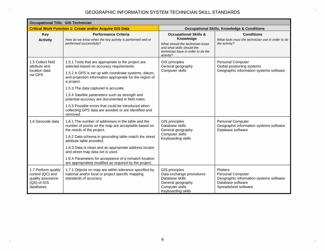
1.5 Collect field attribute and location data via GPS
1.5.1 Tools that are appropriate to the project are selected based on accuracy requirements.
1.5.2 A GPS is set up with coordinate systems, datum, and projection information appropriate for the region of a project.
1.5.3 The data captured is accurate.
1.5.4 Satellite parameters such as strength and potential accuracy are documented in field notes.
1.5.5 Possible errors that could be introduced when collecting GPS data are avoided or are identified and removed.
GIS principles General geography Computer skills
Personal Computer Global positioning systems Geographic information systems software
1.6 Geocode data 1.6.1 The number of addresses in the table and the number of points on the map are acceptable based on the needs of the project.
1.6.2 Data schema in geocoding table match the street attribute table provided.
1.6.3 Data is clean and an appropriate address locator and street map data set is used.
1.6.4 Parameters for acceptance of a rematch location are appropriately modified as required by the project.
GIS principles Database skills General geography Computer skills Keyboarding skills
Personal Computer Geographic information systems software Database software
1.7 Perform quality control (QC) and quality assurance (QA) of GIS databases
1.7.1 Objects on map are within tolerance specified by national and/or local or project specific mapping standards of accuracy.
GIS principles Data exchange procedures Database skills General geography Computer skills Keyboarding skills
Plotters Personal Computer Geographic information systems software Database software Spreadsheet software
6
GEOGRAPHIC INFORMATION SYSTEM TECHNICIAN SKILL STANDARDS

Academic and Employability Knowledge and Skill Matrix for Critical Work Function 1
On a scale of 1 (lowest) to 5 (highest), identify the level of complexity required in each of these skills for the worker to perform the critical work function. Keep in mind that this scale is not for rating an individual’s proficiency. It is intended only for rating the level of complexity required to do the work.
Occupational Title: GIS Technician CWF 1 Create and/or Acquire GIS Data Listening Speaking Using
Information and Communication Technology
Gathering and analyzing Information
Analyzing and Solving Problems
Making Decisions and Judgments
Organizing and Planning
Using Social Skills
Adaptability Working in Teams
Leading Others
Building Consensus
Self and Career Development
Writing Reading Mathematics Science
3 4 4 4 3 3 3 3 3 3 3 3 4 3 3 4 3
A. Written Tests could include: 1. Multiple choice and/or essay questions that demonstrate an understanding of relational database design and implementation.2. Produce graphic representation of database design, such as Entity-Relationship Diagrams (ERD), etc.
B. Hands-on exercises or simulations to demonstrate acquisition of knowledge, skills, and attitude that could: 1. Demonstrate ability to assess end-user data requirements through interviews, email, or other communication methods.2. Ability to create database planning documents such E/R diagrams, Object-Role Modeling (ORM), or Unified Modeling Language (UML).3. Demonstrate ability to locate alternate geo-data sources using the Internet, FTP and online GIS databases.4. Ability to create ArcCatalog entries for new geodatabases.5. Demonstrate ability to new Shapefile in ArcCatalog.6. Create new Shapefile features using the editing tools.7. Create a cartographically correct map using the new features and other map layers.8. Demonstrate ability to locate existing address information for geocoding.9. Ability to geocode location information into a new or existing geodatabase.10. Ability to classify and list data by data formats11. Identify and list all the coordinate systems, datum, and map projections in the data set12. Demonstrate ability to compare and contrast compatibility of available data.13. Import CAD file to GIS feature class14. Convert between shapefile and geodatabases15. Demonstrate quality assurance and quality control by compare and contrast the new edited data with the project's requirements, attributes with data
requirements, and spatial geometry with data requirements.16. Ability to describe the metadata requirements for a project, research any missing metadata fields, and update the metadata.17. Demonstrate correct GPS setup according to instructions, including coordinate system.18. Ability to record GPS satellite strength and positional accuracy from GPS units and download into ArcMap.
7
GEOGRAPHIC INFORMATION SYSTEM TECHNICIAN SKILL STANDARDS
Occupational Title: GIS Technician Critical Work Function 2: Create Image Data Occupational Skills, Knowledge & Conditions
Key Activity
Performance Criteria How do we know when the key activity is performed well or performed successfully?
Occupational Skills & Knowledge What should the technician know and what skills should the technician have in order to do the activity?
Conditions What tools must the technician use in order to do the activity?
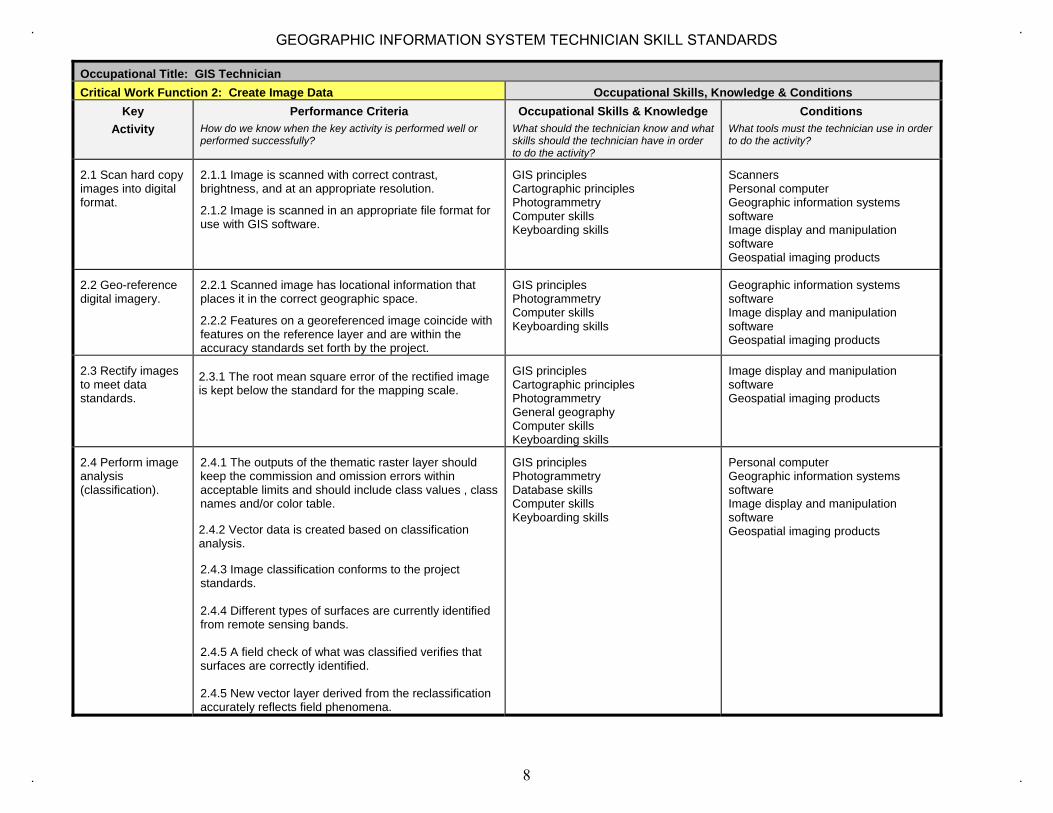
2.1 Scan hard copy images into digital format.
2.1.1 Image is scanned with correct contrast, brightness, and at an appropriate resolution.
2.1.2 Image is scanned in an appropriate file format for use with GIS software.
GIS principles Cartographic principles Photogrammetry Computer skills Keyboarding skills
Scanners Personal computer Geographic information systems software Image display and manipulation software Geospatial imaging products
2.2 Geo-reference digital imagery.
2.2.1 Scanned image has locational information that places it in the correct geographic space.
2.2.2 Features on a georeferenced image coincide with features on the reference layer and are within the accuracy standards set forth by the project.
GIS principles Photogrammetry Computer skills Keyboarding skills
Geographic information systems software Image display and manipulation software Geospatial imaging products
2.3 Rectify images to meet data standards.
2.3.1 The root mean square error of the rectified image is kept below the standard for the mapping scale.
GIS principles Cartographic principles Photogrammetry General geography Computer skills Keyboarding skills
Image display and manipulation software Geospatial imaging products
2.4 Perform image analysis (classification).
2.4.1 The outputs of the thematic raster layer should keep the commission and omission errors within acceptable limits and should include class values , class names and/or color table.
2.4.2 Vector data is created based on classification analysis.
2.4.3 Image classification conforms to the project standards.
2.4.4 Different types of surfaces are currently identified from remote sensing bands.
2.4.5 A field check of what was classified verifies that surfaces are correctly identified.
2.4.5 New vector layer derived from the reclassification accurately reflects field phenomena.
GIS principles Photogrammetry Database skills Computer skills Keyboarding skills
Personal computer Geographic information systems software Image display and manipulation software Geospatial imaging products
8
GEOGRAPHIC INFORMATION SYSTEM TECHNICIAN SKILL STANDARDS

Academic and Employability Knowledge and Skill Matrix for Critical Work Function 2
On a scale of 1 (lowest) to 5 (highest), identify the level of complexity required in each of these skills for the worker to perform the critical work function. Keep in mind that this scale is not for rating an individual’s proficiency. It is intended only for rating the level of complexity required to do the work.
Occupational Title: GIS Technician CWF 2 Create Image Data Listening Speaking Using
Information and Communication Technology
Gathering and analyzing Information
Analyzing and Solving Problems
Making Decisions and Judgments
Organizing and Planning
Using Social Skills
Adaptability Working in Teams
Leading Others
Building Consensus
Self and Career Development
Writing Reading Mathematics Science
3 3 3 4 4 3 4 3 3 3 3 3 4 3 3 3 3
Statement of Assessment for Critical Work Function 2
A. Written Tests could include:
1. Multiple choice and/or essay questions that demonstrate an understanding of image acquisition and implementation.
B. Hands-on exercises or simulations to demonstrate acquisition of knowledge, skills, and attitude that could:
1. Describe the types of Scanners (drum, flat bed, back-lit) and their purposes.2. Demonstrate proper control of scanner including choosing an appropriate resolution (scale and accuracy), adjust contrast, brightness,
gamma correction.3. Ability to operate the scanner to acquire image and save it to an appropriate .TIFF or .JPG image file.4. Demonstrate ability to geo-reference image using a minimum of 3-4 recognizable features.5. Create a cartographically correct map using the new image file and additional layers.6. Ability to rectify images to meet data standards.7. Perform image analysis using classification.
9
GEOGRAPHIC INFORMATION SYSTEM TECHNICIAN SKILL STANDARDS

Occupational Title: GIS Technician Critical Work Function 3 Maintain GIS Data Occupational Skills, Knowledge & Conditions
Key Activity
Performance Criteria How do we know when the key activity is performed well or performed successfully?
Occupational Skills & Knowledge
What should the technician know and what skills should the technician have in order to do the activity?
Conditions What tools must the technician use in order to do the activity?
3.1 Develop procedures and schedules for data maintenance.
3.1.1 A calendar that articulates the repetition of scheduled maintenance events or identification of periodic and non-periodic maintenance events is produced.
3.1.2 A procedure for data maintenance is documented.
GIS principles Database skills Computer skills Keyboarding skills
Personal computer Geographic information systems software Database software Word processing software Spreadsheet software
3.2 Maintain data QA/QC through update operations: (add/delete/change).
3.2.1 Update operations are scheduled and procedures documented.
3.2.2 A temporal report generated from the data set that shows history of data changes is produced.
3.2.3 An updated metadata report is produced.
GIS principles Data exchange procedures Database skills General geography Computer skills Keyboarding skills
Personal computer Geographic information systems software Database software Spreadsheet software
3.3 Perform data layer updates and update metadata (imagery/themes).
3.3.1 A new version of data set is produced
3.3.2 A backup is created
3.3.3 The prior set data set will be the most current data set.
3.3.4 Attribute feature count and descriptive report is generated from attribute table.
3.3.5 Updated map showing updates to database is produced.
3.3.6 Outline of metadata requirements for project is provided.
GIS principles Cartographic principles Data exchange procedures Database skills General geography Computer skills Keyboarding skills
Personal computer Geographic information systems software Database software Spreadsheet software Image display and manipulation software Geospatial imaging products
3.4 Convert data between formats.
3.4.1 Data is converted with a minimum of conversion errors
3.4.2 A report of conversion errors is produced.
GIS principles Data exchange procedures Database skills Computer skills Keyboarding skills
Personal computer Geographic information systems software Database software
10
GEOGRAPHIC INFORMATION SYSTEM TECHNICIAN SKILL STANDARDS

Occupational Title: GIS Technician Critical Work Function 3 Maintain GIS Data Occupational Skills, Knowledge & Conditions
Key Activity
Performance Criteria How do we know when the key activity is performed well or performed successfully?
Occupational Skills & Knowledge
What should the technician know and what skills should the technician have in order to do the activity?
Conditions What tools must the technician use in order to do the activity?
3.5 Perform database performance tuning through compression, indexing, etc.
3.5.1 Original response time is benchmarked and response time after modifications of tuning parameters is documented.
3.5.2 A report of all project data sets relative to embedded map projections of that data set is created.
3.5.3 Appropriate methodologies (compression, pyramids, spatial and tabular joins, catalogues) to enhance database performance and GIS analysis are used.
GIS principles Data exchange procedures Database skills Computer skills Keyboarding skills
Personal computer Geographic information systems software Database software
11
GEOGRAPHIC INFORMATION SYSTEM TECHNICIAN SKILL STANDARDS

Academic and Employability Knowledge and Skill Matrix for Critical Work Function 3
On a scale of 1 (lowest) to 5 (highest), identify the level of complexity required in each of these skills for the worker to perform the critical work function. Keep in mind that this scale is not for rating an individual’s proficiency. It is intended only for rating the level of complexity required to do the work.
Occupational Title: GIS Technician CWF 3: Maintain GIS Data Listening Speaking Using
Information and Communication Technology
Gathering and analyzing Information
Analyzing and Solving Problems
Making Decisions and Judgments
Organizing and Planning
Using Social Skills
Adaptability Working in Teams
Leading Others
Building Consensus
Self and Career Development
Writing Reading Mathematics Science
3 3 4 4 4 3 3 3 3 3 3 3 3 3 3 3 3
Statement of Assessment for Critical Work Function 3
The statements of assessment can do any of several things: • Define tools or strategies that industry could use to assess the level of competency a worker has attained in a particular critical work function.• Define for trainers and educators how to assess the level of competency a student has attained relevant to the critical work function.• Define the level of mastery of the critical work function that indicates that a worker or student has achieved an entry-, intermediate-, or
advanced level of mastery of a critical work function.
A. Written Tests could include: 1. Multiple choice and/or essay questions that demonstrate the ability to maintain geodatabase through update operations, maintaining
attribute data and data layers.
B. Hands-on exercises or simulations to demonstrate acquisition of knowledge, skills, and attitude that could: 1. Ability to add, update and delete spatial data (shapefiles, geodatabases, spatial topology).2. Demonstrate editing attribute data (shapefiles, geodatabases, domains, subtypes).3. Ability to compare database schema between original and new data and identify differences.4. Demonstrate quality control and assurance by refreshing and/or replacing data layers.5. Ability to list conversion issues and methodologies for each conversion of data from one type to another.
12
GEOGRAPHIC INFORMATION SYSTEM TECHNICIAN SKILL STANDARDS

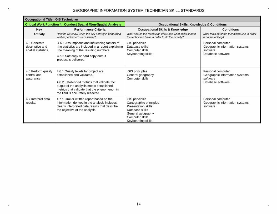
Occupational Title: GIS Technician Critical Work Function 4. Conduct Spatial /Non-Spatial Analysis Occupational Skills, Knowledge & Conditions
Key Activity
Performance Criteria How do we know when the key activity is performed well or performed successfully?
Occupational Skills & Knowledge What should the technician know and what skills should the technician have in order to do the activity?
Conditions What tools must the technician use in order to do the activity?
4.1 Create analysis models through flowcharts and processes.
4.1.1 A model flowchart for a GIS analysis including data inputs, types of analytic tools used, processes carried out, and the results of data output from the model is produced.
GIS principles Data exchange procedures Database skills Computer skills Keyboarding skills
Personal computer Geographic information systems software Database software Word processing software Spreadsheet software
4.2 Create scripts 4.2.1 A script has been executed and the expected results derived.
4.2.2 An indication that the script is more efficient than manually carrying out the GIS analysis, saving time and reducing cost, and producing more reliable data.
GIS principles Programming languages Computer skills Keyboarding skills
Personal computer Geographic information systems software Database software
4.3 Preprocess geographic data (generalize, subset).
4.3.1 The input and output of the generalized process and an indication of file size and preprocessing time are documented.
GIS principles Data exchange procedures Database skills Computer skills Keyboarding skills
Personal computer Geographic information systems software Database software
4.4 Perform geo-processing through clipping, buffering, overlay, etc.
4.4.1 A subset of data from an existing set of data is derived and can provide more decision support than the unanalyzed data provided.
4.4.2 A metadata report showing that the input layers of a geoprocessing operation are in the same coordinate system, datum, and map projection is produced.
GIS principles General geography Computer skills Keyboarding skills
Personal computer Geographic information systems software
13
GEOGRAPHIC INFORMATION SYSTEM TECHNICIAN SKILL STANDARDS
Occupational Title: GIS Technician Critical Work Function 4. Conduct Spatial /Non-Spatial Analysis Occupational Skills, Knowledge & Conditions
Key Activity
Performance Criteria How do we know when the key activity is performed well or performed successfully?
Occupational Skills & Knowledge What should the technician know and what skills should the technician have in order to do the activity?
Conditions What tools must the technician use in order to do the activity?
4.5 Generate descriptive and spatial statistics.
4.5.1 Assumptions and influencing factors of the statistics are included in a report explaining the meaning of the resulting numbers
4.5.2 Soft copy or hard copy output product is delivered.
GIS principles Database skills Computer skills Keyboarding skills
Personal computer Geographic information systems software Database software
4.6 Perform quality control and assurance.
4.6.1 Quality levels for project are established and validated.
4.6.2 Established metrics that validate the output of the analysis meets established metrics that validate that the phenomenon in the field is accurately reflected.
GIS principles General geography Computer skills
Personal computer Geographic information systems software Database software
4.7 Interpret data results.
4.7.1 Oral or written report based on the information derived in the analysis includes clearly interpreted data results that describe the objective of the analysis.
GIS principles Cartographic principles Presentation skills Database skills General geography Computer skills Keyboarding skills
Personal computer Geographic information systems software
14
GEOGRAPHIC INFORMATION SYSTEM TECHNICIAN SKILL STANDARDS

Academic and Employability Knowledge and Skill Matrix for Critical Work Function 4
On a scale of 1 (lowest) to 5 (highest), identify the level of complexity required in each of these skills for the worker to perform the critical work function. Keep in mind that this scale is not for rating an individual’s proficiency. It is intended only for rating the level of complexity required to do the work.
Occupational Title: GIS Technician CWF 4: Conduct Spatial/Nonspatial Analysis Listening Speaking Using
Information and Communication Technology
Gathering and analyzing Information
Analyzing and Solving Problems
Making Decisions and Judgments
Organizing and Planning
Using Social Skills
Adaptability Working in Teams
Leading Others
Building Consensus
Self and Career Development
Writing Reading Mathematics Science
4 3 4 4 4 4 4 3 4 3 3 4 4 4 3 4 3
Statement of Assessment for Critical Work Function 4
A. Written Tests could include:1. Multiple choice and/or essay questions that demonstrate an understanding of special and non-spatial analysis including maps and tables.
B. Hands-on exercises or simulations to demonstrate acquisition of knowledge, skills, and attitude that could:1. Provide examples of descriptive and spatial statistics.2. Ability to perform attribute computations.3. Demonstrate ability to review and summarize maps and tables resulting from analyses and statistics calculations.4. Ability to analyze and draw conclusions/make projections based on summary results
15
GEOGRAPHIC INFORMATION SYSTEM TECHNICIAN SKILL STANDARDS

Occupational Title: GIS Technician Critical Work Function 5: Generate GIS Products Occupational Skills, Knowledge & Conditions
Key Activity
Performance Criteria How do we know when the key activity is performed well or performed successfully?
Occupational Skills & Knowledge
Conditions What tools must the technician use in order to do the activity?
5.1 Create maps. 5.1.1 Existing industry standards and additionally project standards are met and all needed map elements are included such as: map body legend, scale, title, projection, direction, date, data source.
GIS principles Cartographic principles Presentation skills General geography Cartographic design skills Computer skills
Plotters Printers Personal computer Geographic information systems software Image display and manipulation software
5.2 Create analysis report.
5.2.1 Report accurately describing the results of analysis, thus supporting the purpose of the map, is developed and delivered as required.
GIS principles Database skills Computer skills Keyboarding skills
Personal computer Printers Geographic information systems software Database software Word processing software Spreadsheet software
5.3 Create tables 5.3.1 Existing industry standards and additional relevant project requirements are met and all needed table elements are included.
GIS principles Database skills Computer skills Keyboarding skills
Personal computer Geographic information systems software Database software Word processing software Spreadsheet software
5.4 Create charts. 5.4.1 Existing industry standards and additional relevant project requirements are met and all needed chart elements are included.
GIS principles Cartographic principles Presentation skills Database skills Facilitation skills Computer skills Keyboarding skills
Personal computer Geographic information systems software Word processing software Spreadsheet software
5.5 Generate mailing labels, logos, posters, etc.
5.5.1 Tabular data for the purpose of mailing label generation/other is prepared, as required.
5.5.2 Mailing labels, logos, posters are generated as required.
GIS principles Computer skills Keyboarding skills
Printers Personal computer Geographic information systems software Word processing software
5.6 Distribute digital and hard copy products.
5.6.1 Products are distributed as required in required format.
Cartographic principles Data exchange procedures Presentation skills Database skills General geography Cartographic design skills Computer skills Keyboarding skills
Plotters Printers Personal computer Geographic information systems software
16
GEOGRAPHIC INFORMATION SYSTEM TECHNICIAN SKILL STANDARDS
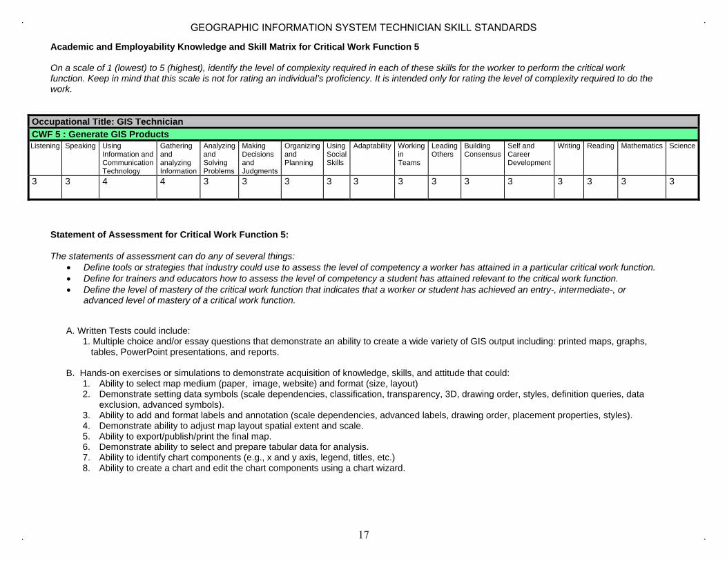
Academic and Employability Knowledge and Skill Matrix for Critical Work Function 5
On a scale of 1 (lowest) to 5 (highest), identify the level of complexity required in each of these skills for the worker to perform the critical work function. Keep in mind that this scale is not for rating an individual’s proficiency. It is intended only for rating the level of complexity required to do the work.
Occupational Title: GIS Technician CWF 5 : Generate GIS Products Listening Speaking Using
Information and Communication Technology
Gathering and analyzing Information
Analyzing and Solving Problems
Making Decisions and Judgments
Organizing and Planning
Using Social Skills
Adaptability Working in Teams
Leading Others
Building Consensus
Self and Career Development
Writing Reading Mathematics Science
3 3 4 4 3 3 3 3 3 3 3 3 3 3 3 3 3
Statement of Assessment for Critical Work Function 5:
The statements of assessment can do any of several things: • Define tools or strategies that industry could use to assess the level of competency a worker has attained in a particular critical work function.• Define for trainers and educators how to assess the level of competency a student has attained relevant to the critical work function.• Define the level of mastery of the critical work function that indicates that a worker or student has achieved an entry-, intermediate-, or
advanced level of mastery of a critical work function.
A. Written Tests could include:1. Multiple choice and/or essay questions that demonstrate an ability to create a wide variety of GIS output including: printed maps, graphs,
tables, PowerPoint presentations, and reports.
B. Hands-on exercises or simulations to demonstrate acquisition of knowledge, skills, and attitude that could:1. Ability to select map medium (paper, image, website) and format (size, layout)2. Demonstrate setting data symbols (scale dependencies, classification, transparency, 3D, drawing order, styles, definition queries, data
exclusion, advanced symbols).3. Ability to add and format labels and annotation (scale dependencies, advanced labels, drawing order, placement properties, styles).4. Demonstrate ability to adjust map layout spatial extent and scale.5. Ability to export/publish/print the final map.6. Demonstrate ability to select and prepare tabular data for analysis.7. Ability to identify chart components (e.g., x and y axis, legend, titles, etc.)8. Ability to create a chart and edit the chart components using a chart wizard.
17
GEOGRAPHIC INFORMATION SYSTEM TECHNICIAN SKILL STANDARDS
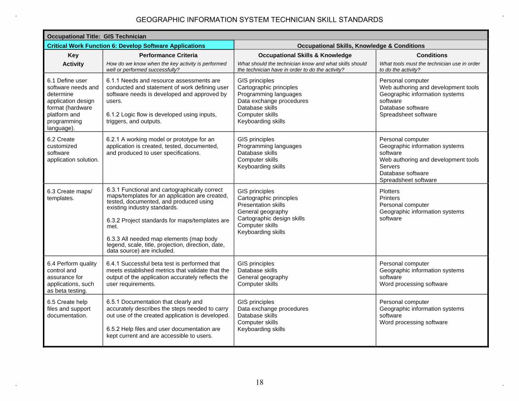
Occupational Title: GIS Technician Critical Work Function 6: Develop Software Applications Occupational Skills, Knowledge & Conditions
Key Activity
Performance Criteria How do we know when the key activity is performed well or performed successfully?
Occupational Skills & Knowledge What should the technician know and what skills should the technician have in order to do the activity?
Conditions What tools must the technician use in order to do the activity?
6.1 Define user software needs and determine application design format (hardware platform and programming language).
6.1.1 Needs and resource assessments are conducted and statement of work defining user software needs is developed and approved by users.
6.1.2 Logic flow is developed using inputs, triggers, and outputs.
GIS principles Cartographic principles Programming languages Data exchange procedures Database skills Computer skills Keyboarding skills
Personal computer Web authoring and development tools Geographic information systems software Database software Spreadsheet software
6.2 Create customized software application solution.
6.2.1 A working model or prototype for an application is created, tested, documented, and produced to user specifications.
GIS principles Programming languages Database skills Computer skills Keyboarding skills
Personal computer Geographic information systems software Web authoring and development tools Servers Database software Spreadsheet software
6.3 Create maps/ templates.
6.3.1 Functional and cartographically correct maps/templates for an application are created, tested, documented, and produced using existing industry standards.
6.3.2 Project standards for maps/templates are met.
6.3.3 All needed map elements (map body legend, scale, title, projection, direction, date, data source) are included.
GIS principles Cartographic principles Presentation skills General geography Cartographic design skills Computer skills Keyboarding skills
Plotters Printers Personal computer Geographic information systems software
6.4 Perform quality control and assurance for applications, such as beta testing.
6.4.1 Successful beta test is performed that meets established metrics that validate that the output of the application accurately reflects the user requirements.
GIS principles Database skills General geography Computer skills
Personal computer Geographic information systems software Word processing software
6.5 Create help files and support documentation.
6.5.1 Documentation that clearly and accurately describes the steps needed to carry out use of the created application is developed.
6.5.2 Help files and user documentation are kept current and are accessible to users.
GIS principles Data exchange procedures Database skills Computer skills Keyboarding skills
Personal computer Geographic information systems software Word processing software
18
GEOGRAPHIC INFORMATION SYSTEM TECHNICIAN SKILL STANDARDS

Academic and Employability Knowledge and Skill Matrix for Critical Work Function 6
On a scale of 1 (lowest) to 5 (highest), identify the level of complexity required in each of these skills for the worker to perform the critical work function. Keep in mind that this scale is not for rating an individual’s proficiency. It is intended only for rating the level of complexity required to do the work.
Occupational Title: GIS Technician CWF 6 : Develop Software Applications Listening Speaking Using
Information and Communication Technology
Gathering and analyzing Information
Analyzing and Solving Problems
Making Decisions and Judgments
Organizing and Planning
Using Social Skills
Adaptability Working in Teams
Leading Others
Building Consensus
Self and Career Development
Writing Reading Mathematics Science
3 4 4 4 4 3 4 3 4 4 3 3 4 4 4 4 2
Statement of Assessment for Critical Work Function 6
The statements of assessment can do any of several things: • Define tools or strategies that industry could use to assess the level of competency a worker has attained in a particular critical work function.• Define for trainers and educators how to assess the level of competency a student has attained relevant to the critical work function.• Define the level of mastery of the critical work function that indicates that a worker or student has achieved an entry-, intermediate-, or
advanced level of mastery of a critical work function.
A. Written Tests could include: 1. Multiple choice and/or essay questions that demonstrate an ability to modify existing GIS software through customization and develop new
GIS applications using languages like C++, SQL, and Python
B. Hands-on exercises or simulations to demonstrate acquisition of knowledge, skills, and attitude that could: 1. Ability to select appropriate language and hardware platform for software application.2. Demonstrate ability to create customized GIS applications based on end-user specifications.3. Ability to create, save and use a map template.4. Demonstrate ability to perform quality control & assurance using beta testing methodologies.5. Ability to develop help files and end-user support documentation.
19
GEOGRAPHIC INFORMATION SYSTEM TECHNICIAN SKILL STANDARDS

Occupational Title: GIS Technician Critical Work Function 7: Manage GIS Data Occupational Skills, Knowledge & Conditions
Key Activity
Performance Criteria Occupational Skills & Knowledge Conditions
7.1 Establish data custodianship and distribute and assign database permissions according to organizational policies.
7.1.1 A memorandum of understanding is produced that states the ownership of the data and outlines access, creation, and update permissions, and indicates that the data has been accepted/validated by the owner(s).
GIS principles Data exchange procedures Database skills Computer skills Keyboarding skills
Personal computer Geographic information systems software Database software Word processing software Spreadsheet software
7.2 Organize file structure (e.g. create directories, perform data and directory housekeeping)
7.2.1 Data is stored as required by application, functionality, or organizational structure or standards in appropriate directories (folders, subfolders, etc).
7.2.2 A diagram or hierarchy of data folder structure is created and documented to facilitate efficient access to data.
GIS principles Data exchange procedures Database skills Computer skills Keyboarding skills
Personal computer Geographic information systems software Word processing software Spreadsheet software
7.3 Perform data maintenance through archival functions.
7.3.1 Document showing how and when files have been replaced, updated, posted, reconciled, and archived, including a log of all events is produced.
7.3.2 Performance of data maintenance should meet organization’s existing disaster recovery plan requirements for data storage and backup.
GIS principles Data exchange procedures Database skills Computer skills Network configuration skills
Personal computer Geographic information systems software Servers Database software Spreadsheet software
20
GEOGRAPHIC INFORMATION SYSTEM TECHNICIAN SKILL STANDARDS
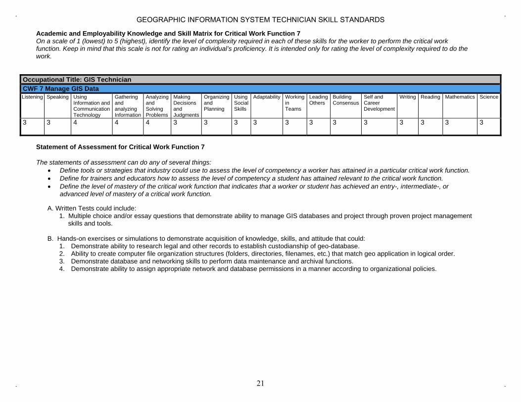
Academic and Employability Knowledge and Skill Matrix for Critical Work Function 7 On a scale of 1 (lowest) to 5 (highest), identify the level of complexity required in each of these skills for the worker to perform the critical work function. Keep in mind that this scale is not for rating an individual’s proficiency. It is intended only for rating the level of complexity required to do the work.
Occupational Title: GIS Technician CWF 7 Manage GIS Data Listening Speaking Using
Information and Communication Technology
Gathering and analyzing Information
Analyzing and Solving Problems
Making Decisions and Judgments
Organizing and Planning
Using Social Skills
Adaptability Working in Teams
Leading Others
Building Consensus
Self and Career Development
Writing Reading Mathematics Science
3 3 4 4 4 3 3 3 3 3 3 3 3 3 3 3 3
Statement of Assessment for Critical Work Function 7
The statements of assessment can do any of several things: • Define tools or strategies that industry could use to assess the level of competency a worker has attained in a particular critical work function.• Define for trainers and educators how to assess the level of competency a student has attained relevant to the critical work function.• Define the level of mastery of the critical work function that indicates that a worker or student has achieved an entry-, intermediate-, or
advanced level of mastery of a critical work function.
A. Written Tests could include: 1. Multiple choice and/or essay questions that demonstrate ability to manage GIS databases and project through proven project management
skills and tools.
B. Hands-on exercises or simulations to demonstrate acquisition of knowledge, skills, and attitude that could: 1. Demonstrate ability to research legal and other records to establish custodianship of geo-database.2. Ability to create computer file organization structures (folders, directories, filenames, etc.) that match geo application in logical order.3. Demonstrate database and networking skills to perform data maintenance and archival functions.4. Demonstrate ability to assign appropriate network and database permissions in a manner according to organizational policies.
21
GEOGRAPHIC INFORMATION SYSTEM TECHNICIAN SKILL STANDARDS

Occupational Title: GIS Technician Critical Work Function 8: Provide Technical Support Occupational Skills, Knowledge & Conditions
Key Activity
Performance Criteria Occupational Skills & Knowledge Conditions
8.1 Resolve user technical problems
8.1.1 Technical problems are identified, logged, tracked, and resolved according to organizational policy with respect to timeliness and level of user satisfaction.
8.1.2 List of available support resources of various formats (internet, listserve, user groups, or direct assistance) is provided to end users.
GIS principles Data exchange procedures Presentation skill Database skills General geograpy Computer skills
Personal computer Geographic information systems software Database software Word processing software Spreadsheet software
8.2 Install and maintain software including service packs.
8.2.1 Software installation requests, including service packs, are logged, tracked, and completed according to organizational policy and in compliance with license agreements.
8.2.2 Schedule for software updates including patches and virus protection is established and implemented.
GIS principles Database skills Computer skills Network configuration skills
Personal computer Servers Geographic information systems software Database software
8.3 Assist in writing technical guides for GIS applications.
8.3.1 Technical guides describing the steps needed to carry out the use of the GIS application in the organization are developed as required based on organizational policy.
GIS principles Cartographic principles Presentation skills Database skills Computer skills Keyboarding skills
Personal computer Geographic information systems software Database software Word processing software Spreadsheet software
8.4 Provide technical training for end-users.
8.4.1 List of available training resources of various formats (classroom, online, workbooks, or exercises) is provided to end users.
8.4.2 Seminars or hands-on workshops scheduled and attendance of users is documented.
8.4.3 Training modules for custom GIS applications are produced and delivered.
8.4.4 Evaluations of training events conducted by the technician are collected and documented.
GIS principles Cartographic principles Presentation skill Database skills General geography Facilitation skills Computer skills Keyboarding skills
Personal computer Geographic information systems software Database software Word processing software Spreadsheet software
22
GEOGRAPHIC INFORMATION SYSTEM TECHNICIAN SKILL STANDARDS

Academic and Employability Knowledge and Skill Matrix for Critical Work Function 8 On a scale of 1 (lowest) to 5 (highest), identify the level of complexity required in each of these skills for the worker to perform the critical work function. Keep in mind that this scale is not for rating an individual’s proficiency. It is intended only for rating the level of complexity required to do the work.
Occupational Title: GIS Technician CWF 8: Provide Technical Support Listening Speaking Using
Information and Communication Technology
Gathering and analyzing Information
Analyzing and Solving Problems
Making Decisions and Judgments
Organizing and Planning
Using Social Skills
Adaptability Working in Teams
Leading Others
Building Consensus
Self and Career Development
Writing Reading Mathematics Science
3 4 4 4 4 3 3 3 4 3 3 3 4 4 3 3 3
Statement of Assessment for Critical Work Function 8
A. Written Tests could include: 1. Multiple choice and/or essay questions that demonstrate an ability to provide technical support and customer service.
B. Hands-on exercises or simulations to demonstrate acquisition of knowledge, skills, and attitude that could: 1. Demonstrate ability to resolve user’s technical problems utilizing facilitation, computer, and networking skills.2. Ability to install and maintain software service packs for both operating system and GIS application software.3. Demonstrate oral and written communication skills in assisting end-users.
23
GEOGRAPHIC INFORMATION SYSTEM TECHNICIAN SKILL STANDARDS

Occupational Title: GIS Technician Critical Work Function 9: Perform Administrative Tasks Occupational Skills, Knowledge & Conditions
Key Activity
Performance Criteria Occupational Skills & Knowledge Conditions
9.1 Create formal and informal communications using email, phone, listservs and written reports.
9.1.1 Forms of communication occur In compliance with an existing communication plan or accepted lines of communication.
9.1.2 Clear concise effective communication is used via email, phone, or written correspondence.
9.1.3 Listserve protocols created and use of listserve documented.
Presentation skills General geography Computer skills Keyboarding skills
Personal computer Word processing software
9.2 Coordinate GIS projects including cost estimates, timelines, and budgets.
9.2.1 Project budget tracking successfully constrains project costs by indicating areas of cost excesses.
9.2.2 Project budget is not exceeded.
9.2.3 Project is completed within established time constraints.
9.2.4 Project outcome falls within the scope defined in the project plan.
GIS principles Data exchange procedures Presentation skills Database skills Facilitation skills Computer skills Keyboarding skills
Personal computer Geographic information systems software Database software Word processing software Spreadsheet software
9.3 Prepare and maintain contracts. Maintain equipment and office supplies.
9.3.1 Licensing and maintenance contracts for hardware, software, equipment, and supplies, are kept current.
9.3.2 Contracts for client deliverables are drafted and approved.
Facilitation skills Printers Personal computer
9.4 Provide internship supervision for students and new workers.
9.4.1 Meaningful GIS tasks which allow interns to gain workplace experience are delegated.
9.4.2 Interns are trained to the expectation of their oversight organization.
GIS principles General geography Facilitation skills Computer skills
Personal computer Geographic information systems software
24
GEOGRAPHIC INFORMATION SYSTEM TECHNICIAN SKILL STANDARDS

Occupational Title: GIS Technician Critical Work Function 9: Perform Administrative Tasks Occupational Skills, Knowledge & Conditions
Key Activity
Performance Criteria Occupational Skills & Knowledge Conditions
9.5 Participate in GIS awareness events such as presentations, conferences and user groups.
9.5.1 The results of GIS analysis are presented using presentation media and appropriate visualizations (maps, charts, tables, images) and language.
9.5.2 Attendance at and participation in appropriate conferences and user groups specific to the area of GIS expertise is documented.
GIS principles Presentation skills Facilitation skills
Geographic information systems software
25
GEOGRAPHIC INFORMATION SYSTEM TECHNICIAN SKILL STANDARDS

Academic and Employability Knowledge and Skill Matrix for Critical Work Function 9
On a scale of 1 (lowest) to 5 (highest), identify the level of complexity required in each of these skills for the worker to perform the critical work function. Keep in mind that this scale is not for rating an individual’s proficiency. It is intended only for rating the level of complexity required to do the work.
Occupational Title: GIS Technician CWF 9 Perform Administrative Tasks Listening Speaking Using
Information and Communication Technology
Gathering and analyzing Information
Analyzing and Solving Problems
Making Decisions and Judgments
Organizing and Planning
Using Social Skills
Adaptability Working in Teams
Leading Others
Building Consensus
Self and Career Development
Writing Reading Mathematics Science
3 3 3 3 3 3 3 3 3 3 3 3 3 3 3 3 2
Statement of Assessment for Critical Work Function 9
A. Written Tests could include: 1. Multiple choice and/or essay questions that demonstrate the ability to supervise and manage GIS personnel, such as interns, and projects.
B. Hands-on exercises or simulations to demonstrate acquisition of knowledge, skills, and attitude that could: 1. Demonstrate ability to use both formal and informal communications via email, phone, and written reports.2. Demonstrate office management skills including preparing cost estimates, preparing contracts, timelines, budgets, etc.3. Ability to supervise interns and student workers.4. Demonstrate ability to provide public awareness activities such as PowerPoint presentations, speaking at career fairs, provide hands-on
demonstrations to groups.
26
GEOGRAPHIC INFORMATION SYSTEM TECHNICIAN SKILL STANDARDS
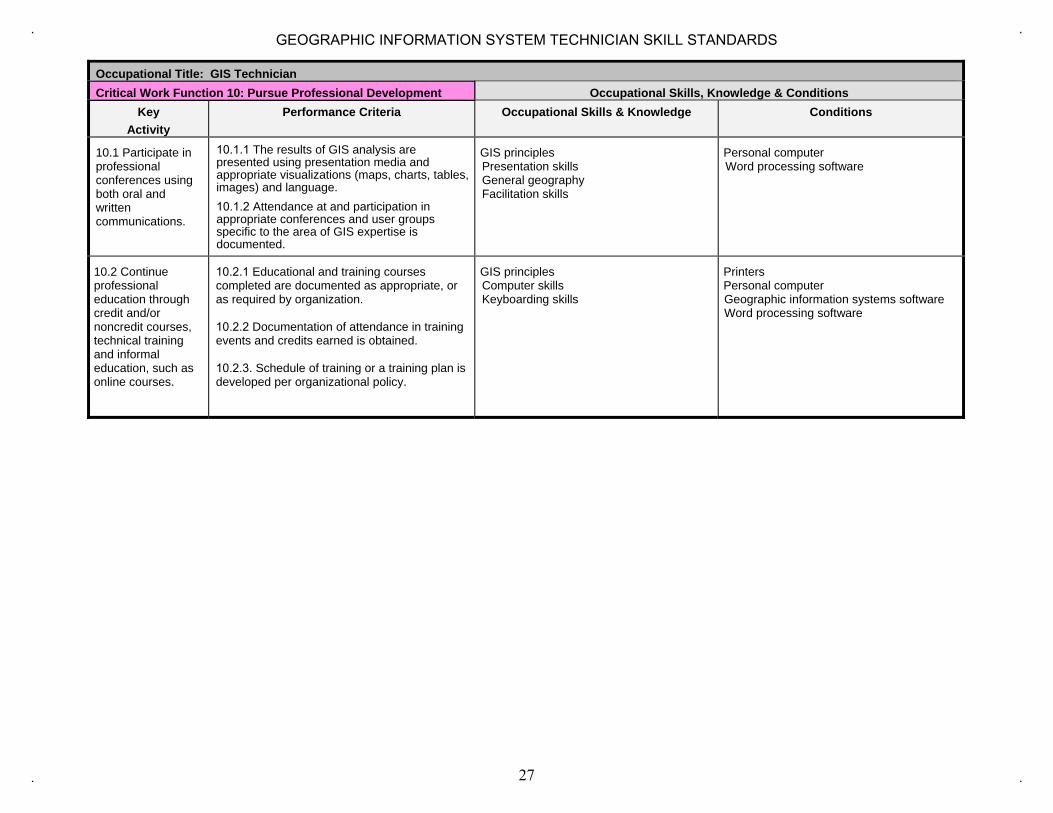
Occupational Title: GIS Technician Critical Work Function 10: Pursue Professional Development Occupational Skills, Knowledge & Conditions
Key Activity
Performance Criteria Occupational Skills & Knowledge Conditions
10.1 Participate in professional conferences using both oral and written communications.
10.1.1 The results of GIS analysis are presented using presentation media and appropriate visualizations (maps, charts, tables, images) and language. 10.1.2 Attendance at and participation in appropriate conferences and user groups specific to the area of GIS expertise is documented.
GIS principles Presentation skills General geography Facilitation skills
Personal computer Word processing software
10.2 Continue professional education through credit and/or noncredit courses, technical training and informal education, such as online courses.
10.2.1 Educational and training courses completed are documented as appropriate, or as required by organization.
10.2.2 Documentation of attendance in training events and credits earned is obtained.
10.2.3. Schedule of training or a training plan is developed per organizational policy.
GIS principles Computer skills Keyboarding skills
Printers Personal computer Geographic information systems software Word processing software
27
GEOGRAPHIC INFORMATION SYSTEM TECHNICIAN SKILL STANDARDS

Academic and Employability Knowledge and Skill Matrix for Critical Work Function 10
On a scale of 1 (lowest) to 5 (highest), identify the level of complexity required in each of these skills for the worker to perform the critical work function. Keep in mind that this scale is not for rating an individual’s proficiency. It is intended only for rating the level of complexity required to do the work.
Occupational Title: GIS Technician CWF 10 : Pursue Professional Development Listening Speaking Using
Information and Communication Technology
Gathering and analyzing Information
Analyzing and Solving Problems
Making Decisions and Judgments
Organizing and Planning
Using Social Skills
Adaptability Working in Teams
Leading Others
Building Consensus
Self and Career Development
Writing Reading Mathematics Science
4 3 4 3 3 3 3 3 3 3 3 3 4 4 4 3 3
Statement of Assessment for Critical Work Function 10
A. Written Tests could include: 1. Multiple choice and/or essay questions that demonstrate understanding of continuous professional development opportunities and
obligations.
B. Hands-on exercises or simulations to demonstrate acquisition of knowledge, skills, and attitude that could: 1. Demonstrate ability to participate in professional development conferences, workshops, and training.2. Ability to work independently to pursue continuing training through noncredit and informal education.
28
GEOGRAPHIC INFORMATION SYSTEM TECHNICIAN SKILL STANDARDS