Embed Size (px)
Citation preview
1
INTRODUCTION
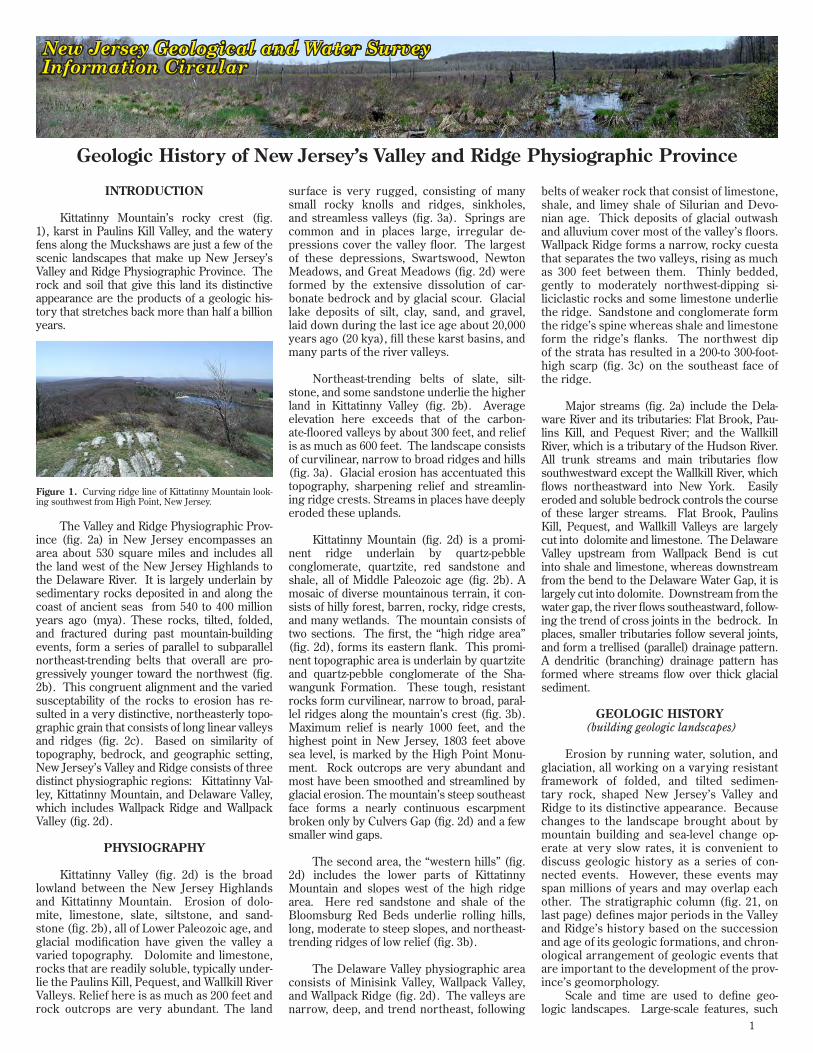
Kittatinny Mountain’s rocky crest (fig. 1), karst in Paulins Kill Valley, and the watery fens along the Muckshaws are just a few of the scenic landscapes that make up New Jersey’s Valley and Ridge Physiographic Province. The rock and soil that give this land its distinctive appearance are the products of a geologic his-tory that stretches back more than half a billion years.
The Valley and Ridge Physiographic Prov-ince (fig. 2a) in New Jersey encompasses an area about 530 square miles and includes all the land west of the New Jersey Highlands to the Delaware River. It is largely underlain by sedimentary rocks deposited in and along the coast of ancient seas from 540 to 400 million years ago (mya). These rocks, tilted, folded, and fractured during past mountain-building events, form a series of parallel to subparallel northeast-trending belts that overall are pro-gressively younger toward the northwest (fig. 2b). This congruent alignment and the varied susceptability of the rocks to erosion has re-sulted in a very distinctive, northeasterly topo-graphic grain that consists of long linear valleys and ridges (fig. 2c). Based on similarity of topography, bedrock, and geographic setting, New Jersey’s Valley and Ridge consists of three distinct physiographic regions: Kittatinny Val-ley, Kittatinny Mountain, and Delaware Valley, which includes Wallpack Ridge and Wallpack Valley (fig. 2d).
PHYSIOGRAPHY
Kittatinny Valley (fig. 2d) is the broad lowland between the New Jersey Highlands and Kittatinny Mountain. Erosion of dolo-mite, limestone, slate, siltstone, and sand-stone (fig. 2b), all of Lower Paleozoic age, and glacial modification have given the valley a varied topography. Dolomite and limestone, rocks that are readily soluble, typically under-lie the Paulins Kill, Pequest, and Wallkill River Valleys. Relief here is as much as 200 feet and rock outcrops are very abundant. The land
surface is very rugged, consisting of many small rocky knolls and ridges, sinkholes, and streamless valleys (fig. 3a). Springs are common and in places large, irregular de-pressions cover the valley floor. The largest of these depressions, Swartswood, Newton Meadows, and Great Meadows (fig. 2d) were formed by the extensive dissolution of car-bonate bedrock and by glacial scour. Glacial lake deposits of silt, clay, sand, and gravel, laid down during the last ice age about 20,000 years ago (20 kya), fill these karst basins, and many parts of the river valleys.
Northeast-trending belts of slate, silt-stone, and some sandstone underlie the higher land in Kittatinny Valley (fig. 2b). Average elevation here exceeds that of the carbon-ate-floored valleys by about 300 feet, and relief is as much as 600 feet. The landscape consists of curvilinear, narrow to broad ridges and hills (fig. 3a). Glacial erosion has accentuated this topography, sharpening relief and streamlin-ing ridge crests. Streams in places have deeply eroded these uplands.
Kittatinny Mountain (fig. 2d) is a promi-nent ridge underlain by quartz-pebble conglomer ate, quartzite, red sandstone and shale, all of Middle Paleozoic age (fig. 2b). A mosaic of diverse mountainous terrain, it con-sists of hilly forest, barren, rocky, ridge crests, and many wetlands. The mountain consists of two sections. The first, the “high ridge area” (fig. 2d), forms its eastern flank. This promi-nent topographic area is underlain by quartzite and quartz-pebble conglomerate of the Sha-wangunk Formation. These tough, resistant rocks form curvilinear, narrow to broad, paral-lel ridges along the mountain’s crest (fig. 3b). Maximum relief is nearly 1000 feet, and the highest point in New Jersey, 1803 feet above sea level, is marked by the High Point Monu-ment. Rock outcrops are very abundant and most have been smoothed and streamlined by glacial erosion. The mountain’s steep southeast face forms a nearly continuous escarpment broken only by Culvers Gap (fig. 2d) and a few smaller wind gaps.
The second area, the “western hills” (fig. 2d) includes the lower parts of Kittatinny Mountain and slopes west of the high ridge area. Here red sandstone and shale of the Bloomsburg Red Beds underlie rolling hills, long, moderate to steep slopes, and northeast-trending ridges of low relief (fig. 3b).
The Delaware Valley physiographic area consists of Minisink Valley, Wallpack Valley, and Wallpack Ridge (fig. 2d). The valleys are narrow, deep, and trend northeast, following
belts of weaker rock that consist of limestone, shale, and limey shale of Silurian and Devo-nian age. Thick deposits of glacial outwash and alluvium cover most of the valley’s floors. Wallpack Ridge forms a narrow, rocky cuesta that separates the two valleys, rising as much as 300 feet between them. Thinly bedded, gently to moderately northwest-dipping si-liciclastic rocks and some limestone underlie the ridge. Sandstone and conglomerate form the ridge’s spine whereas shale and limestone form the ridge’s flanks. The northwest dip of the strata has resulted in a 200-to 300-foot-high scarp (fig. 3c) on the southeast face of the ridge.
Major streams (fig. 2a) include the Dela-ware River and its tributaries: Flat Brook, Pau-lins Kill, and Pequest River; and the Wallkill River, which is a tributary of the Hudson River. All trunk streams and main tributaries flow southwestward except the Wallkill River, which flows northeastward into New York. Easily eroded and soluble bedrock controls the course of these larger streams. Flat Brook, Paulins Kill, Pequest, and Wallkill Valleys are largely cut into dolomite and limestone. The Delaware Valley upstream from Wallpack Bend is cut into shale and limestone, whereas downstream from the bend to the Delaware Water Gap, it is largely cut into dolomite. Downstream from the water gap, the river flows southeastward, follow-ing the trend of cross joints in the bedrock. In places, smaller tributaries follow several joints, and form a trellised (parallel) drainage pattern. A dendritic (branching) drainage pattern has formed where streams flow over thick glacial sediment.
GEOLOGIC HISTORY (building geologic landscapes)
Erosion by running water, solution, and glaciation, all working on a varying resistant framework of folded, and tilted sedimen-tary rock, shaped New Jersey’s Valley and Ridge to its distinctive appearance. Because changes to the landscape brought about by mountain building and sea-level change op-erate at very slow rates, it is convenient to discuss geologic history as a series of con-nected events. However, these events may span millions of years and may overlap each other. The stratigraphic column (fig. 21, on last page) defines major periods in the Valley and Ridge’s history based on the succession and age of its geologic formations, and chron-ological arrangement of geologic events that are important to the development of the prov-ince’s geomorphology.
Scale and time are used to define geo-logic landscapes. Large-scale features, such
Geologic History of New Jersey’s Valley and Ridge Physiographic Province
New Jersey Geological and Water SurveyInformation Circular
Figure 1. Curving ridge line of Kittatinny Mountain look-ing southwest from High Point, New Jersey.

2
Highlands
Piedmont
Valley & Ridge
Coastal P
lain
Pequest River
Paulins Kill
Wallkill River
Clove Brook
Flat Brook
Delaware River
Valley and Ridge
New Jersey Highlands
Explanation
0 10 miles 5
Figure 2a - New Jersey’s Valley and Ridge Physiographic Province
Figure 2c - Color-shaded Relief Figure 2d - Geomorphology
Figure 2b - Bedrock Geology
0 10 miles5
Elevation above mean sea level
High : 1810 feet
Low : 120 feet
Explanation
New Jersey Highlands
Kittatinny Mountain (high-ridge area)
Kittatinny Mountain (western hills)
Valleys in the New Jersey Highlands
Kittatinny Valley (intermediate elevation)
Upper Delaware and Wallpack Valleys
Kittatinny Valley (lowlands)
Wallpack Ridge
Explanation
Culvers Gap
Delaware Water Gap
0 10 miles5
0 10 miles 5
Precambrian gneiss & granite
Helderberg Group, Decker, Rondout, Bossard-ville, Poxono Island (limestone, limey shale)
Schohaire, Esopus, Oriskany, and Port EwenFormations (sandstone & shale)
Precambrian marble
Shawangunk Formation (quartzite & quartz-pebble conglomerate)
Martinsburg Formation(slate and siltstone)
Onondaga Limestone
Marcellus Shale
Bloomsburg Red Beds(red shale & sandstone)
nepheline syenite
Old
er
Y
ou
ng
er
Karst basins: S-Swartswood, N-NewtonMeadows, G-Great Meadows
S
N
G
Jacksonburg, Beekmantown, Allentown, and Leithsville Formations (dolomite and lime-stone), and the Hardyston Quartzite
Sussex
HighPoint
Newton
Belvidere
Blairstown
3
as orogens (mountain belts), cover expansive areas, consist of many landforms, and require millions of years to take shape. Small-scale features such glacial lake deltas cover small ar-eas, typically consist of a single landform, and require only tens to hundreds of years to form. Most of the regional geomorphic elements of the Valley and Ridge, those that are easily seen on a small-scale color-shaded relief map (fig. 2c) require hundreds of thousands to millions of years to develop. Features that form over shorter periods (i.e. flood plains, end moraine, drumlins) are also seen on the small-scale map, but because of their lesser size, they typically overprint but do not obscure the regional to-pography.
Bedrock forms a shell that resists erosion by water, wind, ice and chemical weathering. In New Jersey’s Valley and Ridge, elevation cor-relates strongly with rock type so that higher land is underlain by rocks that are more resis-tant to erosion (fig. 2b). Bedrock in the Valley and Ridge is chiefly sedimentary, consisting
of siliciclastic and carbonate rock. Siliciclastic rocks consist of conglomerate, sandstone, silt-stone, and shale and their metamorphic equiva-lents, quartzite and slate. All these rocks ex-cept shale are quartz-rich, and quartz strongly resists erosion. The mineral’s abundance is a general indicator of resistance to erosion. Quartzites and conglomerates in the Valley and Ridge contain the most quartz, lesser amounts are in sandstone, followed by siltstone, shale and slate. The latter typically contain a mix-ture of quartz and less resistant minerals such as feldspar, clay, and rock fragments. Carbon-ate bedrock (dolomite and limestone), is very susceptible to erosion by chemical weather-ing. Quartz-rich rock forms the higher areas, carbonate rock and some shale the lowest, and sandstone, siltstone, and slate, areas of interme-diate elevation. Comparison of a shaded relief map and bedrock map of the Valley and Ridge shows a strong correlation between rock type and elevation (figs. 2b and 2c). Thus, the loca-tion, size and spacing of ridges and valleys are largely due to rock composition and its distribu-tion. For example, the Shawangunk Formation consists largely of quartzite and quartz-pebble conglomerate. Its outcrop belt largely coin-cides with the high ridge section of Kittatinny Mountain.
The tightness or consolidation of a rock’s grains also controls a rock’s resistance ero-sion. In sedimentary rocks, individual grains are typically cemented together by silica or calcium carbonate. Silica-cemented rock re-sists erosion to a much greater extent than rock cemented by calcium carbonate. The quartzite and quartz-pebble conglomerate that underlie Kittatinny Mountain (fig. 4) are much more resistant to weathering and ero-sion than the calcium-carbonate-cemented sandstones in Kittatinny Valley.
Faults, joints, and cleavage create zones of weakness (fig. 5) in rock. These partings act as conduits for agents of mechanical and chemical weathering, which greatly enhances erosion. The discordant alignment of several smaller streams in Kittatinny Valley and the many gaps that cut through ridges of resistant rock suggest that these features preferentially developed in highly jointed rock.
BEDROCK FORMATIONS
Cambrian and Ordovician (542 to 443 mya)
The Hardyston Quartzite is Lower Cam-brian in age. It may be as much as 200 feet thick, but typically is much thinner and rests unconformably on the Precambrian rocks of the Highlands. The formation is largely quartz-ite with lesser amounts of sandstone. Locally, it is conglomeratic at its base. The Hardys-ton sediments were derived from weathered Precambrian rocks during the waning stages of an erosional cycle that started in Late Pre-cambrian time. They are river and beach de-posits laid down on an ancient coastal plain. The formation lies along the eastern edge of Kittatinny Valley where Paleozoic rocks are in contact with Precambrian Rocks of the High-lands. The formation is generally very thin, and is not a major landscape-forming unit. A few small areas of Precambrian rock also occur in Kittatinny Valley, but because of their lim-ited extent they are not discussed here.
The Kittatinny Supergroup consists of the Leithsville Formation, Allentown Dolomite (fig. 6), and Beekmantown Group. Collectively, these formations are about 4300 feet thick. They consist largely of dolomite and subordi-nate limestone, chert, and minor quartz sand-stone, siltstone and shale. These deposits were laid down in warm, shallow seas in near-shore, tidal, and lagoonal environments. The top of the Beekmantown Group is marked by a ma-jor unconformity that represents an extended
1 mile 0 1/2
sh
d
a
ss
1 mile 0 1/2
sh
qc b
0 0.5 miles
ss
sc
l
l
sh
d ss
sh
c
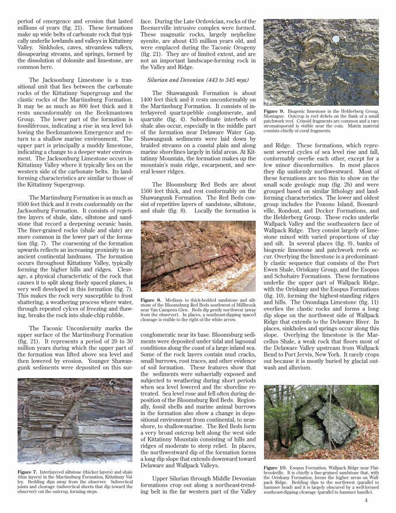
Figure 3. Topography and geology of areas in (a) Kittatin-ny Valley, (b) Kittatinny Mountain, and (c) Wallpack Ridge (c). Parallel alignment of topography is strongly controlled by the southwest trend of rock formations and their resis-tance to erosion. Key to rocks: d-dolomite, l-limestone, sh-siltstone and shale, qc-quartzite and conglomerate, ss-sand-stone, sc-sandstone and conglomerate. Contour interval is 20 feet.
Figure 4. Shawangunk Formation on the east shore of Crater Lake, Kittatinny Mountain. This rock consists of thin layers of quartzite and quartz-pebble conglomerate. Bedding dips to the left. Because of its very high quartz content and because the sand grains and larger clasts are tightly cemented together by silica, this formation is highly resistant to weathering.
Figure 5. Well-developed joints (dark vertical fractures) and cleavage (subvertical platy sheets forming fine lines) in the Esopus Formation, Wallpack Ridge. Bedding dips away from the observer.
Figure 6. Allentown Dolomite southwest of Balesville, Kittatinny Valley. This rock consists of a gray, weathering tan, magnesium-calcium carbonate that was deposited in a warm shallow sea about 500 million years ago. It is suscep-tible to weathering by dissolution. Bedding dips gently to the left.
4
period of emergence and erosion that lasted millions of years (fig. 21). These formations make up wide belts of carbonate rock that typi-cally underlie lowlands and valleys in Kittatinny Valley. Sinkholes, caves, streamless valleys, dissapearing streams, and springs, formed by the dissolution of dolomite and limestone, are common here.
The Jacksonburg Limestone is a tran-
sitional unit that lies between the carbonate rocks of the Kittatinny Supergroup and the clastic rocks of the Martinsburg Formation. It may be as much as 800 feet thick and it rests unconformably on the Beekmantown Group. The lower part of the formation is fossiliferous, indicating a rise in sea level fol-lowing the Beekmantown Emergence and re-turn to a shallow marine environment. The upper part is principally a muddy limestone, indicating a change to a deeper water environ-ment. The Jacksonburg Limestone occurs in Kittatinny Valley where it typically lies on the western side of the carbonate belts. Its land-forming characteristics are similar to those of the Kittatinny Supergroup.
The Martinsburg Formation is as much as 9500 feet thick and it rests conformably on the Jacksonburg Formation. It consists of repeti-tive layers of shale, slate, siltstone and sand-stone that record a deepening oceanic basin. The finer-grained rocks (shale and slate) are more common in the lower part of the forma-tion (fig. 7). The coarsening of the formation upwards reflects an increasing proximity to an ancient continental landmass. The formation occurs throughout Kittatinny Valley, typically forming the higher hills and ridges. Cleav-age, a physical characteristic of the rock that causes it to split along finely spaced planes, is very well developed in this formation (fig. 7). This makes the rock very susceptible to frost shattering, a weathering process where water, through repeated cylces of freezing and thaw-ing, breaks the rock into shale-chip rubble.
The Taconic Unconformity marks the upper surface of the Martinsburg Formation (fig. 21). It represents a period of 20 to 30 million years during which the upper part of the formation was lifted above sea level and then lowered by erosion. Younger Shawan-gunk sediments were deposited on this sur-
face. During the Late Ordovician, rocks of the Beemerville intrusive complex were formed. These magmatic rocks, largely nepheline syenite, are about 435 million years old, and were emplaced during the Taconic Orogeny (fig. 21). They are of limited extent, and are not an important landscape-forming rock in the Valley and Ridge.
Silurian and Devonian (443 to 345 mya)
The Shawangunk Formation is about 1400 feet thick and it rests unconformably on the Martinsburg Formation. It consists of in-terlayered quartz-pebble conglomerate, and quartzite (fig. 4). Subordinate interbeds of shale also occur, especially in the middle part of the formation near Delaware Water Gap. Shawangunk sediments were laid down by braided streams on a coastal plain and along marine shorelines largely in tidal areas. At Kit-tatinny Mountain, the formation makes up the mountain’s main ridge, escarpment, and sev-eral lesser ridges.
The Bloomsburg Red Beds are about 1500 feet thick, and rest conformably on the Shawangunk Formation. The Red Beds con-sist of repetitive layers of sandstone, siltstone, and shale (fig. 8). Locally the formation is
conglomeratic near its base. Bloomsburg sedi-ments were deposited under tidal and lagoonal conditions along the coast of a large inland sea. Some of the rock layers contain mud cracks, small burrows, root traces, and other evidence of soil formation. These features show that the sediments were subaerially exposed and subjected to weathering during short periods when sea level lowered and the shoreline re-treated. Sea level rose and fell often during de-position of the Bloomsburg Red Beds. Region-ally, fossil shells and marine animal burrows in the formation also show a change in depo-sitional environment from continental, to near-shore, to shallow-marine. The Red Beds form a very broad outcrop belt along the west side of Kittatinny Mountain consisting of hills and ridges of moderate to steep relief. In places, the northwestward dip of the formation forms a long dip slope that extends downward toward Delaware and Wallpack Valleys.
Upper Silurian through Middle Devonian formations crop out along a northeast-trend-ing belt in the far western part of the Valley
and Ridge. These formations, which repre-sent several cycles of sea level rise and fall, conformably overlie each other, except for a few minor disconformities. In most places they dip uniformly northwestward. Most of these formations are too thin to show on the small scale geologic map (fig. 2b) and were grouped based on similar lithology and land-forming characteristics. The lower and oldest group includes the Poxono Island, Bossard-ville, Rondout, and Decker Formations, and the Helderberg Group. These rocks underlie Wallpack Valley and the southeastern face of Wallpack Ridge. They consist largely of lime-stone mixed with varied proportions of clay and silt. In several places (fig. 9), banks of biogenic limestone and patchwork reefs oc-cur. Overlying the limestone is a predominant-ly clastic sequence that consists of the Port Ewen Shale, Oriskany Group, and the Esopus and Schohaire Formations. These formations underlie the upper part of Wallpack Ridge, with the Oriskany and the Esopus Formations (fig. 10), forming the highest-standing ridges and hills. The Onondaga Limestone (fig. 11) overlies the clastic rocks and forms a long dip slope on the northwest side of Wallpack Ridge that extends to the Delaware River. In places, sinkholes and springs occur along this slope. Overlying the limestone is the Mar-cellus Shale, a weak rock that floors most of the Delaware Valley upstream from Wallpack Bend to Port Jervis, New York. It rarely crops out because it is mostly buried by glacial out-wash and alluvium.
Figure 7. Interlayered siltstone (thicker layers) and shale (thin layers) in the Martinsburg Formation, Kittatinny Val-ley. Bedding dips away from the observer. Subvertical joints and cleavage (subvertical sheets that dip toward the observer) cut the outcrop, forming steps.
Figure 8. Medium- to thick-bedded sandstone and silt-stone of the Bloomsburg Red Beds southwest of Millbrook near Van Campens Glen. Beds dip gently northwest (away from the observer). In places, a southeast-dipping spaced cleavage is visible to the right of the white arrow.
Figure 9. Biogenic limestone in the Helderberg Group, Montague. Outcrop is reef debris on the flank of a small patchwork reef. Crinoid fragments are common and a rare stromatoporoid is visible near the coin. Matrix material consists chiefly of coral fragments.
Figure 10. Esopus Formation, Wallpack Ridge near Flat-brookville. It is chiefly a fine-grained sandstone that, with the Oriskany Formation, forms the higher areas on Wall-pack Ridge. Bedding dips to the northwest (parallel to hammer head) and it is largely obscured by a well-formed southeast-dipping cleavage (parallel to hammer handle).

5
YOUNGER ROCKS (What happened to them?)
The Valley and Ridge’s geologic record (fig. 21) reveals a substantial gap in time from about 390 mya to 23 mya. Because geo-logic formations of these missing ages oc-cur elsewhere in New Jersey and adjoining states, it is assumed that some of the miss-ing formations has been removed by erosion during the many millions of years since they were deposited. Also, because parts of the Valley and Ridge were uplifted and exposed during several tectonic movements, some of the formations were not deposited in these areas.
TECTONIC HISTORY
Rock structure has also played an impor-tant role in the development of the Valley and Ridge’s topography. Major fold axes and faults trend northeast to southwest, coinciding with the province’s topographic grain. These folds and faults formed during several major moun-tain-building events that occurred when the North American plate collided with other tec-tonic plates that now make up parts of North America, Europe and Western Africa. These deformational events, called the Taconic and Alleghenian Orogenies (fig. 21), lasted mil-lions of years and were followed by longer peri-ods of quiescence.
Joints (fig. 12) are fractures with little or no offset resulting from tectonic compression
or extension. They play a significant role in the development of geologic landscapes. Many joints in the Valley and Ridge cut across the lo-cal topographic grain. Some stream reaches conform with these cross-joints, suggesting a relationship between stream course and zones of structural weakness. Joints also provide access for weathering agents, enhancing ero-sional rates.
In addition to major mountain-building
events, uplift along the continental margin also occurred during several lesser tectonic events during the Cenozoic Era. Uplift may also be attributed to the warping of the Earth’s crust due to the tremendous amount of sediment de-posited offshore.
PATHWAY TO THE PRESENT-DAY LANDSCAPE
No single point in time denotes the birth of New Jersey’s Valley and Ridge. Although its rocks are as much as 535 million years old, the topography that defines it developed at a much younger time. Because streams are the dominant sculptors of the Valley and Ridge, a good way to discuss its geomorphic history is to trace the origin of its streams.
About 306 million years ago (fig. 21), North America collided with Gondwana (the combined continents of Europe and Africa) forming part of the supercontinent Pangea. The collision, named the Alleghenian Orog-eny, formed the Appalachian Mountains. This massive mountain range, whose roots lie east of New Jersey, reached its maximum size dur-ing the Permian Period. About 200 mya, dur-ing Jurrassic time (fig. 21), Pangea broke apart when the North American and African conti-nents pulled away from each other, resulting in the opening of the Atlantic Ocean. By Late Cretaceous time (99 to 65 mya), the Atlantic Ocean and New Jersey’s Coastal Plain were well formed. The Cretaceous formations of New Jersey record streams draining to the At-lantic Ocean. Previously, streams had flowed west toward the continental interior to a large inland sea.
Following the Alleghenian Orogeny, New Jersey’s Valley and Ridge was an uplifted land-mass subject to erosion. New streams associ-ated with the opening of the Atlantic Ocean eventually cut back into the Valley and Ridge and sculpted the land into its present form. Sediment eroded from inland areas was trans-ported to the Atlantic Ocean where it formed New Jersey’s Coastal Plain and continental shelf.
The period between 65 and 20 mya was a time of relative tectonic inactivity in the Valley and Ridge. Streams slowly expanded their drainage networks inland and relief lessened as ridge tops and hills were worn down. Topography was also much more muted than it is today because the land was covered by a thick mantle of weathered rock called regolith.
Renewed Period of Erosion and Incision
About 23 mya, global sea level started to fall due to the growth of the Antarctic ice sheet (fig. 21). The Coastal Plain formations of New Jersey were strongly affected because they consist of unconsolidated sediments that are easily eroded and because they lie next to the falling sea. Farther inland the Val-ley and Ridge Province also felt the effects of the changing seas. In response to lowering sea level, streams cut down into the bedrock. Correspondingly, slope retreat accelerated, erosional rates increased, and topographic relief became greater. Geologists estimate that as much as 3000 vertical feet of land has been eroded here since the Middle Miocene (16 to 11 mya). If so, the present topography of the Valley and Ridge is of a youthful geo-logic age.
Relict Landforms
Wind gaps are notches where rivers formerly flowed. Cut through ridges of re-sistant rock, these enigmatic landforms offer a glimpse of geologic history. Culvers Gap (figs. 2d and 13) is the lowest wind gap along
Kittatinny Mountain and it represents the last great change in drainage in New Jersey’s Val-ley and Ridge. Formerly the Culvers Gap Riv-er was a tributary of the ancient Raritan River. Before its abandonment of Culvers Gap, the river followed a course through Kittatinny Val-ley and crossed the New Jersey Highlands to the Raritan lowland (fig. 14). The demise of the Culvers Gap River resulted from stream capture by the Delaware River or one of its tributaries during the Late Miocene or Early Pliocene (8 to 3 mya). Apparently, the nar-row width and structural weakness of resis-tant rocks along the Delaware River where it crossed the New Jersey Highlands, gave it an advantage over the Culvers Gap River and its more northerly course through the Highlands. Sea level lowering caused by the growth of the Antarctic ice sheet during the Miocene may have also accelerated fluvial erosion.
The hypothetical course area of the Cul-vers Gap River across Kittatinny Valley is now the drainage divide between the Hudson and Delaware Rivers. This is the result of drain-age shifting southwestward to the present course of the Delaware River and the subse-quent headward erosion of streams (Paulins Kill and Pequest) chiefly along belts of car-bonate rock.
Figure 11. Highly jointed, thin-to-medium-bedded nodu-lar limestone of the Onondaga Limestone, Delaware Valley.
Figure 12. Highly jointed Allentown Dolomite in Kittatin-ny Valley near Newton. Bedding dips to the left whereas closely-spaced joints dip in the opposite direction. Joints typically exhibit preferred orientations and many are or-thogonal to bedding. Joints, fractures, and faults formed during the Taconic and Alleghenian Orogenies when the Lower Paleozoic Formations were tectonically compressed.
Figure 13. Culvers Gap viewed from Smith Hill, Kittatinny Valley.

6
GLACIAL HISTORY(The Ice Age)
During the past 2.6 million years, conti-nental glaciers originating in the subarctic re-gions of Canada, reached the Valley and Ridge Province at least three times (fig. 15). From oldest to youngest these are the pre-Illinoian (≥ 850 kya), Ilinoian (150 kya), and late Wis-consinan (22 kya). During each glaciation, bedrock ridges, hills and slopes were worn down by moving glacial ice, and valley floors were deeply scoured. Older glacial deposits were largely eroded by younger glaciations and periglacial weathering. Eroded rock debris and soil entrained by the massive ice sheet s was largely deposited as till (fig. 16), an unsorted mixture of clay- to boulder-sized material. This material was laid down from the glacier on bedrock in sheets, in streamlined hills called drumlins, and in ridges along the former edge of the ice sheet called moraines. Stratified sediment (fig. 17) consisting of sorted and layered gravel, sand, and silt was deposited by glacial meltwater streams in val-leys that drained away from the glacier and in glacial lakes that formed where the streamflow had become blocked by glacial drift or ice.
The most recent ice sheet reached New Jersey during the late Wisconsinan glacia-
CLG
PGOG
GG
A
BC
E
FX
Z
RG
Ancient Raritan River
Ancient Delaware River
Raritan Lowland
Quartzite, quartz-pebble conglomerate and sandstone.
Gneiss and granite.
Basalt and diabase.
Passaic RiverWindGap
DelawareWaterGap
CulversGap
Uplands and secondary ridges northwest of Kittatinny Mtn.
(750 feet)
(910 feet)
MG
5 0 5 miles
Areas of resistant rock
Culvers GapRiver
Kittatin
ny Vall
ey
Z
Delaware River
tion about 22 kya. Its deposits provide the clearest record of glacia tion. The far thest advance of the late Wisconsinan ice sheet in most places is marked by a terminal moraine (fig. 18). In the Delaware and Pequest Valleys till and ice-contact glacial outwash show that the terminus of the ice sheet extended about one-half mile south of the moraine. The termi-nal moraine was deposited during an interval of about 1000 to 1500 years. It represents a time when the ice sheet’s margin remained in a constant position, neither retreating or mov-ing forward, except within the narrow zone marked by the moraine. During deglaciation, the outer part of the ice sheet thinned and its flow became much more constrained by the northeast-to-southwest orientation of the large valleys. This resulted in regional ice flow turn-ing to the south west, a direction more in line with the topographic grain of the province. Accordingly, deglaciation was characterized by the systematic northeastward retreat of the Kittatinny Valley and Minisink Valley ice lobes (fig. 18). This interpretation is based on the distribution of ice-marginal meltwater depos-its and moraines, and correlative relationships between elevations of delta topset-foreset contacts, former glacial-lake-water plains, and lake spillways. During glacial retreat, melt-water sediment was chiefly laid down in gla-cial lakes (fig. 18) that occupied valleys now drained by the Pequest River, Paulins Kill, and Wallkill River, and to a lesser extent in small upland basins and valleys. These former lake basins had been dammed by stratified drift, moraine, and stagnant blocks of ice, or by the glacier’s margin.
Sussex Passaic
Bergen Morris Warren
Essex
Hudson Union
Hunterdon Somerset
Middlesex
Mercer Monmouth
area of detail
Perth Amboy
Belvidere
0 5 10 15 miles
lW
I
pI
Valley and Ridge
Figure 14. Reconstruction of the late course of the Culvers Gap River, and several scenarios for its capture by the ancient Delaware River. Key to gap names abbreviated in figure: PG - Pequest Gap, OG - Oxford Gap, GG - Glen Gardner Gap, MG - Marble Mountain Gap, RG - Riegelsville Gaps, CLG - Cranberry Lake Gap. Pre-capture course of the Culvers Gap River: A-B Andover-Ledgewood course, A-C Andover-Musconetcong Valley course, E-F Pequest Valley course. Location of capture: X - Pequest Gap capture, Y - Paulins Kill Valley capture, Z - Minisink Valley capture. Modern Delaware River shown on inset map.
Figure 15. Southern limits of glaciations in New Jersey. The trace of the late Wisconsinan limit generally marks the position of the terminal moraine. Key: lW - late Wiscon-sinan, I - Illinoian, pI - pre-Illinoian.
Figure 16. Compact sandy-silty till, Kittatinny Valley. Chiefly derived from local dolomite, shale, and sandstone. Divisions on scale equal one foot.
Figure 17. Stratified, planar-to-cross-bedded gravel and sand deposited by a glacial meltwater stream during the last ice age about 20,000 years ago (near Foul Rift, Delaware Valley). Divisions on scale equal one foot.

7
Glaciers change or modify surface drain-age by erosion and deposition of sediment. Con-tinental ice sheets deeply scoured and widened valleys that were oriented along lines of glacial flow. In places the bedrock floor of the Dela-ware Valley lies as much as 200 feet beneath the Delaware River. Glacial meltwater streams and glacial-lake drainage carved and rerouted stream channels in preglacial valleys and also eroded new channels in bedrock and surficial materials. Also, some preglacial valleys were buried by glacial lake deposits and till. These buried valleys have been discovered only by mapping the elevation of the rock surface us-ing records of wells, exploratory borings, and remote sensing methods. Meltwater deposits and end moraines laid down in stream valleys may also modify surface drainage by damming and reversing stream flows, especially in the upper parts or heads of drainage basins. The barbed drainage pattern of Clove Brook in the northwestern part of Sussex County, (fig. 2a)suggests that at one time it flowed southwest-ward to the Paulins Kill. Today it flows to the Wallkill River, its change in course due to the drainage modifications caused by glacial drift deposited in the upper part of the Paulins Kill Valley during the last ice age.
POSTGLACIAL HISTORY
Since the last glacier receded from New Jersey about 17 kya the climate has become increasingly warmer. In many places, swamps and bogs have formed where shallow lakes and ponds have become filled with decayed vegetation and detritus. Rock outcrops have been fractured by the effects of frost riving, their dislodged pieces forming aprons of rocky debris at their bases. Postglacial streams have cut down farther in glacial valley-fill materi-als, widening their valley floors and depositing flood plains.
Initially, cold and wet conditions, and ab-sent-to-sparse vegetative cover enhanced ero-sion of slope material by solifluction, soil creep, and slope wash. Mechanical disintegration of rock outcrops and boulders by frost riving also provided additional sediment. Some of this ma-terial forms extensive aprons of talus at the base of cliffs on Kittatinny Mountain (fig. 19). A few small boulder fields were formed where boul-ders, transported downslope by creep, had ac-cumulated at the base of slopes and in the heads of drainage basins. These fields and other boul-der concentrations formed by glacial transport
and meltwater erosion, were further modified by frost action; their stones reoriented to form crudely-shaped stone circles. Gradually as the climate warmed, vegetation spread and was suc-ceeded by types that further limited erosion.
The many swamps (fig. 20) and poorly drained areas in the Valley and Ridge are typical of glaciated landscapes. Upon deglaciation, sur-face water, which had in preglacial time flowed in a well defined network of streams, became trapped in the many depressions, glacial lakes and ponds, and poorly-drained areas that made up this landscape. Between 14 and 11 kya, rela-tively barren lake and pond sediments, which largely consisted of weathered rock and soil washed in from surrounding higher ground, be-came enriched with organic material. This tran-sition represents a warming of the climate, mak-ing it possible for aquatic vegetation to thrive. Throughout the Holocene (10 kya to present) the many shallow lakes and ponds left over from the ice age slowly filled with de cayed veg-etation, eventually forming bogs and swamps. These organic-rich deposits principally consist of peat, muck, and minor rock and mineral frag-ments. Ponds in areas of karst may also have become filled with a lime-rich mud called marl.
Swamps and bogs contain sedimentary and organic deposits that may be used to re-construct past climatic conditions. Because these materials were laid down layer upon lay-er, they may preserve a climatic record from the time of deglaciation to the present. Pollen analysis and radiocarbon dating of plant and animal material retrieved from swamps by cor-ing provide stratigraphic control on regional and local changes in vegetation, which can be used to ascertain climatic change. Several studies on bogs and swamps in northwestern New Jersey and northeastern Pennsylvania
Catskill Mountains
Highlan
ds
Huds
on-W
allkil
lLo
wla
nd
Pocon
o Plat
eau
NYPa
Ma
Ct
NJ
Piedmont
Coastal P
lain
Kittatinny
Mountain
NY
0 25 miles
Ice margin
Valley-outwash deposit
Glacial lake basin
Uplands
Glacial lake drainage
EXPLANATION
0 1 2 3 4miles
ICE-MARGIN POSITIONS1. Terminal moraine 6. Plymouth Ponds-Sparta2. Minisink Hills 7. Dingmans Ferry-Ogdensburg-3. Zion Church Culvers Gap Moraine4. Sand Hill Church-Franklin Grove 8. Montague-Augusta Moraine Moraine-Andover Ponds 9. Millville5. Fairview Lake 10. Sussex
Lake Millbrook
8
9
4
75
5 6
Lake Sparta
Lake Stillwater
Lake Newton
Lake Owassa
Lake Wallkill
Kittatinny
Valley
Kittatinny
Mountain
Minisink Valley
Wal
lpac
k Ri
dge
4
7
6
33
Francis Lake
Culvers Lake
2
2
P o c o n o
P a l t e
a u
1
1
Lake Oxford
Lake Pequest
Belvidere
89
Augusta Spillway
Lake Beaver Run
10
10
Del
aware
R
iv er
Lake Hamburg
Lake North Church
Lake Swartswood
Lake Big Springs
Pennsylvan
ia
Poch
uck
M
ount
ain
Jenn
y Jum
p Mou
ntain
Kittatinny Valley
New York
New Jersey Highlands
Figure 18. Late Wisconsinan ice margins of the Kittatinny and Minisink Valley ice lobes, location of large glacial lakes, and extensive valley-outwash deposits.
Figure 19. Talus apron on the southeast facing flank of Kittatinny Mountain, Kittatinny Valley. Talus here consists of quartzite and conglomerate joint blocks that were dis-lodged from Shawangunk outcrops located upslope.
Figure 20. “Our Swamp”, High Point State Park, Kittatin-ny Mountain.

8
have established a dated pollen stratigraphy that goes back nearly to the onset of deglaciation. These show a transition from tundra, with sparse vegetal cover, to open parkland of sedge and grass, with scattered arboreal stands that largely consisted of spruce. From about 14 to 11 kya the regional pollen record shows a transition to a dense, closed, boreal forest that consisted of spruce and fir blan-keting uplands. From 11 to 9.7 kya pine became the dominant for-est component. These changes in vegetation record the continued warming during the latter part of the Pleistocene and the transition to a temperate climate. About 9.4 kya oak became the dominant tree, displacing the conifers and marking the transition from a boreal for-est to a mixed-hardwoods temperate forest. From about 9 to 5 kya, during the early to middle part of the Holocene, temperatures in New Jersey were slightly warmer than at present. A slight cooling trend 5 to 2 kya was followed by an overall increase in temperature during the past 2000 years.
SOURCES OF INFORMATION
Drake, A. A., Jr., Volkert. R. A., Monteverde, D. H., Herman, G. C., Houghton, H. H., Parker, R. A., and Dalton, R. F., 1996, Bedrock geologic map of northern New Jersey: U.S. Geological Survey Misc. Geol. Inv. Map I-2540-A. Scale 1:100,000.
Monteverde, D.H., Witte, R.W., and Epstein, J.B., Stop 6. High Point: Overlook of Bedrock Geology, Geomorphology, and the Cul-vers Gap River, in, Inners, J.D., and Fleeger, G.M. (eds.), 2001: A Delaware River Odyssey: Guidebook for the Annual Field Confer-ence of Pennsylvania Geologists, v. 66, p. 198-212.
Salisbury, R. D., 1902, The glacial geology of New Jersey: N.J. Geological Survey Final Report, v. 5, 802 p.
Stone, B. D., Stanford, S. D., and Witte, R. W., 2002, Surficial geologic map of northern New Jersey: U.S. Geological Survey Misc. Geol. Inv. Map I-2540-C. Scale 1;100,000.
Witte, R. W., 1997, Late Wisconsinan glacial history of the up-per part of Kittatinny Valley, Sussex and Warren Counties, New Jer-sey: Northeastern Geology and Environmental Sciences, v. 19, no. 3, p. 155-169.
Witte, R. W., and Stanford, S. D., 1994, Surficial geology and earth material resources of Warren County, New Jersey: N.J. Geo-logical Survey Open File Map OFM 15C, scale 1:48,000, 3 pl.
Missing geologic record - Rocks deposited during this interval were removed by erosion. During later time, the land that is now the Valley and Ridge was mostly above sea level, exposed to erosion.
PALE
OZO
IC
CA
MB
RIA
N
OR
DO
VIC
IAN
S
ILU
RIA
N
DE
VO
NIA
N
Mid
dle
Low
er
Upp
er
Mid
dle
Low
er
Uppe
r M
idd
le
Lo
we
r M
iddl
e Lo
wer
U
pper
Hardyston Quartzite
Leithsville Formation
Allentown Dolomite
Beekmantown Group
Jacksonburg Limestone
Martinsburg Formation
Shawangunk Formation
Bloomsburg Red Beds
Poxono Island Formation
Helderberg Group Port Ewen Shale
Oriskany Group Esopus Formation
Schoharie Formation Onondaga Limestone
Marcellus Shale
Bossardville Formation Rondout-Decker Formations
200
1000
1900
1400
800
9500
1400
1500
600
100 125 250 150 200 300 175 235
900
CE
NO
ZOIC
Q
UAT
ER
NA
RY
Ple
isto
cene
H
oloc
ene Alluvium, colluvium,
swamp and bog deposits
late Wisconsinan glacial deposits, postglacial alluvium,
colluvium, wind-blown sand and lake deposits
542 mya
~ 560 mya
443 mya
416 mya
2.6 mya
10 kya
125 kya
21 kya
TER
TIA
RY
Plio
cene
M
ioce
ne
Illinoian glacial deposits
Beemersville Intrusives
488 mya
23 mya
Age
Beekmantown Emergence - uplift and erosion over a period of 24 my
Taconic Orogeny - 480 to 440 mya (low grade metamorphism, extensive folding and faulting)
Erosion of the land to low relief and opening of the Iapetus Ocean (Ancestral Atlantic)
< 250
< 50
< 80
Thickness (feet)
v v v v
390 mya
Arcadian Orogeny (416 to 360 mya) - Northern Appalachian tectonic event that did not affect rocks in New Jersey’s Valley and Ridge. Provided sediment for Upper Devonian, Mississippian, and Pennsylvanian formations that were largely laid down in a shallow epicontinental sea. These younger rocks have been removed by erosion.
Abandonment of Culvers Gap, capture by the Delaware River.
Growth of the Antarctic ice sheet, global fall in sea level. Renewed time of incision and erosion.
Sangamon Interglacial
Allegheny Orogeny (350 to 300 mya) - Uplift and erosion, minor faulting and folding, overall tilting of Silurian and Devonian strata northwestward. Formation of the supercontinent Pangea.
Breakup of Pangea and opening of the Atlantic Ocean during Early Jurassic (200 to 175 mya). By Cretaceous time (145 mya) the Atlantic Ocean and streams draining New Jersey’s inland parts are well established. Eroded sediments from the Valley and Ridge, Highlands, and Piedmont physiograhic provinces are deposited along New Jersey’s coastline forming a new coastal plain.
Onset of cyclic glaciation in the northern hemisphere (at least three glaciations reach New Jersey; evidence of the last two preserved in Valley and Ridge).
5 mya
Figure 21. Stratigraphic column of New Jersey’s Valley and Ridge Physiographic Province.
STATE OF NEW JERSEYChris Christie, Governor
Kim Guadagno, Lieutenant GovernorDepartment of Environmental Protection
Bob Martin, CommissionerMichele Siekerka, Assistant CommissionerNew Jersey Geological and Water Survey
Karl Muessig, State Geologist
by Ron W. Witte and Don H. Monteverde 2012
Comments or requests for information are welcome. Write: New Jersey Geological and Water Survey,
P.O. Box 420, Mail Code 29-01, Trenton, NJ 08625Phone: 609-292-2576, Fax: 609-633-1004
Visit the NJGWS web site @ www.njgeology.orgThis information circular is available upon written request or by
downloading a copy from the NJGWS web site.
NJDEP
NE
EW
JR
ESY G
EOLOGICALSU
VR
EY
18 3 5