Embed Size (px)
Citation preview

Hart Peak Map Revised after BWTR edit January 28, 1999
1
GEOLOGIC MAP OF THE HART PEAK QUADRANGLE, CALIFORNIA AND NEVADA
by Jane E. Nielson and Ryan D. Turner
INTRODUCTION
The Hart Peak 1:24,000-scale quadrangle is located about 12 km southwest of Searchlight,
Nevada, comprehending the eastern part of the Castle Peaks, California, and most of the Castle
Mountains and the northwestern part of the Piute Range, in California and Nevada (appendix 1,
figs. 1, 2). The Castle Peaks area constitutes the northeasternmost part of the northeast-trending
New York Mountains. The Castle Mountains straddle the California-Nevada State line between
the Castle Peaks and north-trending Piute Range (appendix 1, fig. 1). The southern part of the
Piute Range, near Civil War-era Fort Piute, adjoins Homer Mountain (appendix 1, fig. 2) mapped
by Spencer and Turner (1985). Adjacent and nearby 1:24,000-scale quadrangles include Castle
Peaks, East of Grotto Hills, Homer Mountain, and Signal Hill, Calif.; also Tenmile Well and West
of Juniper Mine, Calif. and Nev. (appendix 1, fig. 2).
The oldest rocks in the Hart Peak quadrangle are Early Proterozoic gneiss and foliated granite
that crop out in the northern part of the quadrangle on the eastern flank of the Castle Peaks and in
the central Castle Mountains (Wooden and Miller, 1990). Paleozoic rocks are uncommon and
Mesozoic granitic rocks are not found in the map area. The older rocks are overlain
nonconformably by several km of Miocene volcanic deposits, which accumulated in local basins.
Local dikes and domes are sources of most Miocene eruptive units; younger Miocene intrusions
cut all the older rocks. Upper Miocene to Quaternary gravel deposits interfinger with the
uppermost volcanic flows; the contact between volcanic rocks and the gravel deposits is
unconformable locally. Canyons and intermontane valleys contain dissected Quaternary alluvial-
fan deposits that are mantled by active drainage and alluvial fan detritus.
PREVIOUS WORK
The earliest maps and descriptions of the Castle Mountains and Castle Peaks include regional
geologic mapping by Hewett (1956) and theses by Medall (1964) and Balkwill (1964). New

Hart Peak Map Revised after BWTR edit January 28, 1999
2
geologic mapping in the Castle Mountains and Piute Range, undertaken by the U.S. Geological
Survey between 1984 and 1991, produced preliminary stratigraphic summaries by Nielson and
others (1987, 1993), and Nielson and Nakata (1993). Turner (1985) defined the Miocene section
of the northern Castle Mountains: following the example of Bingler and Bonham (1973), he
applied nomenclature of Longwell (1963) to parts of these stratigraphic sequences; we refer to
these names but do not use them. Mapping of Thompson (1990) in the Castle Peaks area used the
nomenclature of Miller and others (1986), which we also employ. Capps and Moore (1991) have
proposed a nomenclature for Castle Mountains rocks that is unrelated to any previous usage, and
therefore we do not use those unit names.
GEOLOGIC SETTING
The Hart Peak quadrangle straddles the boundary between the northern and southern parts of
the Basin and Range Province, west of the Colorado River valley. In the adjacent Castle Peaks
quadrangle (appendix 1, fig. 2), Early Proterozoic gneiss units record episodes of tectonism,
metamorphism, and plutonism extending from 2300 Ma to about 1640 Ma (Wooden and Miller,
1990). Paleozoic rocks in the northern part of the New York Mountains (appendix 1, fig. 1) are
steeply tilted and cut by myriad faults with north to northwest strikes (Burchfiel and Davis, 1977;
Miller and others, 1986). Mesozoic (Cretaceous?) granite plutons invaded the older rocks
(Beckerman and others, 1982; Miller and others, 1986).
Miocene continental extension produced the volcanism and structural trends of Miocene rocks
and faults in the Hart Peak quadrangle. Regional-scale detachment faults are exposed to the west
in the Kingston Range (appendix 1, fig. 1; Reynolds, 1993), and detachment faults may underlie
the Black Mountains of Arizona to the east of the map area (Faulds and others, 1990; Faulds,
1993). No low-angle normal (detachment) faults of regional scale crop out in the region depicted
by figure 2, but local low-angle normal faults cut both the Miocene volcanic rocks and underlying
gneiss in the northern part of the map area.

Hart Peak Map Revised after BWTR edit January 28, 1999
3
High-angle normal faults in the map area were also caused by Miocene extension; these faults
are oriented northwest, northeast, and east-northeast. Some of the Tertiary faults parallel the
Mesozoic faults, therefore. The high-angle faults locally exhibit dip-slip offsets that generally are
on the order of tens of meters. Geometric relations indicate that offsets on some faults may be as
great as 300 m to 1 km; for example, the contact of Early Proterozoic rocks and overlying Tertiary
rocks in the Hart Peak quadrangle crops out at elevations 300 to 500 m higher than exposures of
the basal contact of Tertiary rocks on the east side of the Piute Range (Homer Mountain, West of
Juniper Mine, and Tenmile Well quadrangles). This offset of the basal nonconformity over a
lateral distance of 5 km likely is due to a high-angle normal fault, or zone of faults, with strikes
parallel to the west side of the Piute Range; one such fault crops out in the Hart Peak quadrangle.
Steep faults that offset basement rocks at the boundary between the Castle Mountains and
Piute Range probably produce the steep gravity and magnetic gradients observed in this part of
the quadrangle (U.S. Geological Survey, 1983; Mariano and others, 1986). The relation of
exposed high-angle faults to hypothetical Miocene low-angle normal faults at depth, or to regional
strike-slip faults such as the Las Vegas shear zone, remains unclear (Faulds and others, 1990).
PRE-TERTIARY ROCKS
Pre-Tertiary rocks in the Hart Peak quadrangle include Early Proterozoic leucocratic granite
and granitic gneiss (Xlg) in the Castle Peaks and migmatitic gneiss (Xmg) in the central part of
the Castle Mountains. The leucocratic gneiss represents granitic plutons that were intruded at
about 1680 Ma, after the Ivanpah orogeny at about 1710 Ma (Wooden and Miller, 1990). The
migmatitic gneiss may be equivalent to exposures of multiply metamorphosed older Early
Proterozoic rocks in the nearby New York and Ivanpah Mountains (appendix 1, fig. 1; Wooden
and Miller, 1990). One small outcrop of Paleozoic limestone (Pzl) is known in the Hart Peak
quadrangle, in apparent fault contact with gneiss (Capps and Moore, 1991).

Hart Peak Map Revised after BWTR edit January 28, 1999
4
OLDER TERTIARY ROCKS
Regional Units
The lowermost Tertiary (Oligocene? and Miocene) unit exposed in the Castle Peaks and Piute
Range is locally derived arkosic sandstone and conglomerate. In the Hart Peak quadrangle the
stratigraphically lowest Tertiary volcanic unit (Tps) is a sanidine-rich, sphene-bearing, ash-flow
tuff of alkalic rhyolite composition (appendix 1, fig. 3, appendix 2, tables 1 and 2). In the Castle
Peaks and Piute Range this tuff overlies the arkosic sandstone and conglomerate unit, whereas in
the Castle Mountains, the unit overlies pre-Tertiary plutonic rocks. Turner and Glazner (1990)
reported conventional K-Ar ages of 18.5±0.5 Ma (biotite) and 17.5±0.4 Ma (sanidine) from this
ash-flow tuff unit (location 2, fig. 2); another sample (location 3, fig. 2) produced an age of
18.79±0.04 Ma by the single-crystal 40Ar/39Ar laser fusion technique (B.D. Turrin, oral commun.,
1991; reported by Nielson and others, 1993). This relatively high precision laser-fusion age is
indistinguishable from the 18.5±0.2-Ma age of the regionally widespread Peach Springs Tuff
(Tps) of Young and Brennan (1974), which is also a sanidine-rich, sphene-bearing ash-flow tuff
of alkalic rhyolite composition (Nielson and others, 1990).
The regional correlation of isolated tuff outcrops with the Peach Springs Tuff is supported by
its unusual paleomagnetic direction for rocks of Miocene age (Young and Brennan, 1974; Wells
and Hillhouse, 1989). A sample of the lower tuff unit collected in the adjacent Castle Peaks
quadrangle yielded this unusual Miocene paleomagnetic direction (Wells and Hillhouse, 1989),
confirming that the Peach Springs Tuff is present locally.
Two conventional K-Ar mineral ages of about 22 Ma were reported for a sample from the
basal ash-flow tuff (location 3, fig. 2) by Capps and Moore (1991; their "Castle Mountains Tuff
(member) of the Castle Mountains Volcanic rocks"). These ages are explained by incremental
heating 40Ar/39Ar experiments (Nielson and others, 1990), which demonstrated that the Peach
Springs Tuff may produce spuriously old ages due to contamination by xenocrysts from surface
regolith that the ash-flow tuff incorporated during its deposition. In both the Hart Peak and Castle
Hart Peak Map Revised after BWTR edit January 28, 1999
5
Peaks quadrangles, the lowermost part of this basal ash-flow tuff contains granite and gneiss
xenoliths, and on this basis we propose that the conflicting results of conventional K-Ar and laser-
fusion techniques demonstrate xenocrystal contamination of the Capps and Moore (1991) sample.
We therefore conclude that the basal ash-flow tuff in the Hart Peak quadrangle is the Peach
Springs Tuff.
Local Units
Volcanic and sedimentary rocks that overlie either the arkosic sandstone and conglomerate
unit and (or) the Peach Springs Tuff in the Hart Peak quadrangle are locally erupted mafic to
silicic, alkalic to subalkaline flows, tuff, and breccia of early and middle Miocene age, which are
interbedded with volcaniclastic and minor epiclastic sedimentary rocks. The volcanic rocks of the
Castle Peaks and Piute Range are predominantly of mafic and intermediate compositions
(appendix 1, fig. 3). The Castle Mountains volcanic sequence includes a significant volume of
rhyolite that is underlain by mafic and intermediate rocks resembling the Castle Peaks sequence,
and which underlies and interfingers with mafic and intermediate flows characteristic of the Piute
Range. Interfingering relations between the Castle Peaks and Castle Mountains volcanic rocks
are not exposed, and relations elsewhere suggest that the sequences may be juxtaposed by a
buried regional-scale fault (D.M. Miller, oral commun., 1995; queried on cross sections). The
total thickness of the Castle Peaks volcanic sequence is 350 m, that of the Piute Range is as much
as 600 m, and that of the Castle Mountains volcanic sequence may be 1 to 1.5 km.
Castle Peaks Volcanic Rocks
The lowest locally erupted unit of the Castle Peaks volcanic sequence is light-colored volcanic
breccia (Tbr), consisting of monolithologic eruptive breccia and megabreccia. This breccia unit is
locally rhyolitic and contains mafic dikes and interbedded finer grained heterolithologic
volcaniclastic eruptive rocks. Stream channels that developed on the surface of the breccia unit
are filled by gravel deposits, consisting of volcanic, granitic, and gneissic clasts, and very little
matrix. White lithic tuff (Tcp) generally overlies the breccia unit, but locally the base of the lithic
Hart Peak Map Revised after BWTR edit January 28, 1999
6
tuff is interbedded with the upper part of the breccia unit. Massive to brecciated pyroxene-
bearing andesitic flows (Tap) cap the sequence (Thompson, 1990). Many dikes in the breccia unit
are feeders for these capping flows, as well as for zones with andesitic composition within the
breccia unit.
Reliable isotopic ages have not yet been produced from samples of the Castle Peaks volcanic
sequence. A clast from the volcanic breccia, sampled in the Castle Peaks quadrangle to the west,
produced a K-Ar age of 14.7±0.4 Ma (biotite) and a highly imprecise 40Ar/39Ar total fusion age of
17.5±10.4 (sanidine; table 4). A sample of the Castle Peaks Tuff produced a relatively imprecise
40Ar/39Ar total fusion age of 21.4±1.6 (sanidine; table 4). The actual minimum age of the Castle
Peaks volcanic sequence may be indicated by a silicic welded ash-flow tuff that we call the tuff of
Barnwell, which is part of the capping andesite flow unit. The tuff of Barnwell contains an oxide-
rich suite of heavy minerals (Gusa and others, 1987), and may be laterally equivalent to a subunit
of the Wild Horse Mesa Tuff of McCurry (1988). High-resolution 40Ar/39Ar techniques have
produced ages of 17.7 to 17.8 Ma for the Wild Horse Mesa Tuff (McCurry and others, 1995).
Castle Mountains Volcanic Rocks
The lowest locally erupted volcanic unit in the Castle Mountains (volcanic flows and breccia
of the Castle Mountains, Tcm) is composed mostly of trachyandesite to trachybasalt flows and
breccia and interbedded sedimentary rocks derived principally from mafic volcanic sources. In
the north-central part of the Hart Peak quadrangle, the unit is conformably overlain by
varicolored, upwardly fining, predominantly lacustrine, sedimentary strata composed of
volcaniclastic and arkosic detritus (Tlss). The lacustrine sedimentary rocks are overlain by the
tuff of Jacks Well (Tjw), a 16-Ma partly welded ash-flow tuff (tables 1, 3; Turner and Glazner,
1990), which underlies a thick unit of massive to layered, white, pink, and lavender rhyolite
flows, tuff, and breccia (Tr). Most of this unit constitutes overlapping aprons of ejecta that
erupted from vents now represented by northeast-alined rhyolite domes and dikes (Tir). A unit of
layered tuff and sedimentary material (Tts) is mapped wherever it is distinguishable from the

Hart Peak Map Revised after BWTR edit January 28, 1999
7
rhyolite flows, tuff, and breccia unit. Thick rhyolite flows (Trf), reworked volcaniclastic
sandstone (Tvss), and lahar (Tvl) all are local units present either within or between thick local
deposits of rhyolitic ejecta.
Basalt flows (Tb) and sills (Tib) are interbedded with or overlie the rhyolite eruptive units. In
the northern part of the quadrangle, the tuff of Juan (Tj) is a gently tilted welded ash-flow tuff
deposit dated at 14.4±0.2 Ma (tables 1, 3) that overlies both the basalt flows and rhyolite units. In
the southern part of the quadrangle, a major latite dike (Til) with K-Ar ages of 14.6 (plagioclase)
and 14.3±0.4 and 14.1±0.4 Ma (biotite; table 3) intruded the rhyolite and related units (Capps and
Moore, 1991). Thin basalt dikes (Tib) intruded the Miocene and older rocks. Capps and Moore
(1991) reported K-Ar ages of 14.5 and 15.1 Ma for the latite dike, and ages between 16.5 and 14.9
Ma for rhyolite domes and dikes. An apparently untilted rhyolite dome (Tir), with steep,
symmetrical flow-banding, produced an age of 12.8±0.2 Ma (table 1, 3).
The rhyolite units (Tr, Tts) are thickest in the western part of the Castle Mountains, where
domes are most abundant. The greatest thickness (about 1 km) is found 2 km north of Hart town
site (SW 1/4 sec. 13, T. 14 N., R. 17 E.). Less than 2 km to the east (NE 1/4 sec. 18, T. 14 N., R.
18 E.), the Castle Mountains rhyolite sequence is represented by a thin (0.1 km) rhyolite tuff unit
(Tts) that overlies Early Proterozoic gneiss and is overlapped in turn by basaltic lava of the Piute
Range. The main exposures of the rhyolite unit (Tr) in the east part of the map area are eruptive
and intrusive breccia that form the marginal carapace of a dome; for example, near Lewis Holes,
Nevada (sec. 15, T. 30 S., R. 62 E.). Related dikes trend northeast, parallel to both a major fault
zone and to the trend of domes on the west side of the Castle Mountains.
Abundant zones of alteration, including silicified and gold-bearing veinlets, are present in tuff
and breccia of the rhyolite and related units near Hart, which supported gold mining in the early
20th century. Pits in altered tuff (NW 1/4, SW 1/4 sec. 24, T. 14 N., R. 17 E.) have yielded china
clay (kaolinite) since World War II. The Viceroy Gold Corporation began development of a
major heap-leach gold mine south of the kaolinite pits (N 1/2 sec. 25, T. 14 N., R. 17 E.), in 1991.

Hart Peak Map Revised after BWTR edit January 28, 1999
8
Piute Range Volcanic Rocks
The Piute Range volcanic sequence in the Hart Peak quadrangle is composed predominantly
of a unit of stubby andesite and trachyandesite flows and flow breccia (Ta); this unit is interleaved
with and locally overlain by basalt, trachybasalt, and basaltic andesite flows and flow breccia
(Tb). Both units include sparse dacite and rhyolite flows, as well as gravel-filled channels (Tg).
Both units may be interbedded with a horizon of white air-fall tuff (Tpr). The predominantly
andesitic flows (Ta) contain dikes and domes of the same lithology (Tia); the largest dome in the
quadrangle, about 300 m in diameter, is hornblende trachyandesite in composition. Samples of
units Ta and Tb obtained from all parts of the Piute Range (appendix 1, fig. 2, appendix 2, tables
3, 4) have produced substantial age ranges: Ta, 19.8 to 8 Ma; Tb, 12.2 to 10.7 Ma. A rhyolitic
flow within unit Tb yielded an age of 13.3 Ma. Including the silicic types, most rocks of the Piute
Range are generally dark colored, markedly in contrast with coeval leucocratic rhyolite units
exposed in the Castle Mountains.
YOUNGER TERTIARY SEDIMENTARY ROCKS
Silicified rhyolite breccia of the rhyolite tuff, flows, and intrusive rocks unit (Tr) grades
upward into a horizon of bentonitic clay in the area of Hightower Well (sec. 14, T. 14 N., R. 17
E.) in the western Castle Mountains. This probable paleosol (R.E. Reynolds, oral commun.,
1994) is overlain by crystal-rich sandstone that contains lenses of coarse gravel. The sandstone
coarsens upsection to predominantly gravel with pebble- and cobble-size clasts and very little
matrix (Tg); this gravel unit can be mapped continuously from the area of Hightower Well
westward into the Castle Peaks quadrangle, where basalt lava flows and a silicified rhyolite tuff
are interbedded in the basal part of the gravel unit. Clasts of the gravel unit are mostly Early
Proterozoic gneiss and granite, Paleozoic limestone and marble, and Mesozoic granite. The
gravel unit generally contains a low proportion of volcanic clasts, although horizons composed
entirely of clasts derived from the Castle Peaks volcanic sequence are found locally. Similar
deposits of the gravel unit fill channels developed on or within flows in the Piute Range. A

Hart Peak Map Revised after BWTR edit January 28, 1999
9
younger gravel unit (QTg) of similar description, conformable with and locally indistinguishable
from the Tertiary gravel unit, is also mapped in the area between the Castle Peaks and Castle
Mountains in the Hart Peak quadrangle.
QUATERNARY ALLUVIAL AND PLAYA DEPOSITS
Several generations of unsorted alluvial-fan and stream-channel deposits are found throughout
the ranges and intervening valleys. Older fan deposits (Qoa) are highly dissected and have
surfaces that have been stripped of soil, exposing calcified zones. Alluvium of intermediate age
can be distinguished morphologically, either as fan (Qia1) or channel deposits (Qia2). In the
Piute Range (but not in Hart Peak quadrangle) the an older and younger generation of each
intermediate unit can be distinguished by truncation and surface erosion. The intermediate age
unit is less eroded than the older fan unit and has featureless surfaces and thick but poorly
defined soil profiles. The intermediate-age channel deposits have bar-and-swale surfaces, but also
may show significant soil development. The older fan and channel deposits are overlain by
alluvium of present-day active channels (Qya).
STRUCTURE
DIPS AND UNCONFORMITIES
Exposures of lower and middle Miocene volcanic and sedimentary rocks in the northwest
corner of the map area (easternmost Castle Peaks), dip gently southeast toward the Castle
Mountains, whereas the thick sequence of Miocene volcanic units of the northwestern Castle
Mountains generally dip 30° to 40° W. toward the Castle Peaks. Miocene flows of the Piute
Range mostly dip W. 15° or less in the Hart Peak quadrangle.
East of Hart town site in the southern part of the Castle Mountains (NW 1/4 sec. 19, T. 14 N.,
R. 18 E.), the Peach Springs Tuff and a lower unit of mafic flows and breccia (Tcm) have
measured dips as much as 65° W; farther to the north, the Peach Springs Tuff dips around 40° W.
In both the southern and northern parts of the Castle Mountains, the overlying rhyolite units (Tjw,

Hart Peak Map Revised after BWTR edit January 28, 1999
10
Tr, Tts, Tj) generally dip more moderately (between 45° and 25° W.). Injection of domes locally
steepened or reversed dips of intruded strata and also deflected the strike of units (for example,
units Tlss and Tjw exposed north of small dome in the middle of cross section A–A').
South and west of Quail Spring (SW 1/4 sec. 4, T. 14 N., R. 18 E.), mafic flows of the volcanic
flows and breccia of the Castle Mountains (Tcm) unit dip gently southward. In this part of the
map area, the variations of dip and strike in this unit resemble the nose of an anticlinal fold with
northeast-trending hinge line and southwest plunge (Turner and Glazner, 1990).
No unconformities of greater than local scale can be distinguished within any of the Miocene
volcanic sequences in the Hart Peak or nearby quadrangles. However, local buttress and angular
unconformities between domes and eruptive units are common within the rhyolite tuff, flows, and
intrusive rocks (Tr) unit in the Castle Mountains and basalt and andesite units (Tb, Ta) in the
Piute Range.
FAULTS
The Castle Mountains are divided into north and south parts by faults in the central part of the
quadrangle (sec. 8, T. 14 N., R. 18 E.) with steep dips and west- to northwest-strikes. These faults
cut the lower volcanic section and exposures of underlying migmatitic gneiss. Most other faults
in the Castle Mountains strike north-northeast and west-northwest and dip steeply to the east,
although low-angle normal faults in the lower part of the Castle Mountains volcanic sequence (for
example, near Jacks Well, sec. 4, T. 30 S., R. 62 E.) have moderately low dips to the east. High-
angle faults generally cut low-angle faults, although one major high-angle, oblique-slip fault north
and northeast of Jacks Well turns into a low-angle fault as the strike changes from east to north
(Turner, 1985). Faults within Piute Range rocks generally trend north and northeast, and all
apparently have steep dips.
Steep northeast-striking normal faults that crop out in the Castle Peaks, west of the
quadrangle, drop basement gneiss units and overlying Miocene rocks down to the northwest
(Miller and others, 1986; Thompson, 1990). The relation between those faults and faults that cut

Hart Peak Map Revised after BWTR edit January 28, 1999
11
Castle Peaks rocks in the northwest corner of the quadrangle is unknown. Reconstruction of
Cretaceous granite plutons and faults south of the New York Mountains (fig. 1) suggests about 10
km of strike slip offset on the northeast-striking Cedar Canyon fault (D.M. Miller, oral commun.,
1995), which also shows dip slip displacement of early Miocene volcanic units down to the
southeast (Miller, 1995a).
If the inferred magnitude of strike slip offset on the Cedar Canyon fault is correct and of
Miocene age, projected traces of related faults within early Miocene deposits and underlying
rocks in the area of the Hart Peak quadrangle may also have strike-slip offsets. We therefore have
tentatively inferred a fault (unmapped; represented on cross sections), now covered by middle
Miocene and younger deposits, to explain the differences between the Castle Peaks and Castle
Mountains, both of exposed Early Proterozoic rocks and of the lower Miocene volcanic units.
This inferred fault would be found in the area where the oppositely-directed dips of the Castle
Peaks and Castle Mountains (see above) must intersect.
A zone of alteration and severe brecciation in the area of Hightower Well (sec. 14, T. 14 N.,
R. 17 E.) may represent shearing by normal faults that formed during Miocene extensional
tectonism and associated volcanism (Capps and Moore, 1991). These faults define crustal blocks
in the Castle Mountains area that were dropped down to the southwest, thus creating a subsiding
half-graben basin which ponded drainages—as indicated by the unit of lacustrine deposits—and
collected eruptive materials. Faults on the west side of the Piute Range may also have a large
local displacements. Other fault displacements appear relatively small, however, and the map
area appears less extended than the neighboring Eldorado and Black Mountains of the Lake Mead
region (Anderson, 1971; Anderson and others, 1972; Bohannon, 1979; Faulds and others, 1990).
INTERPRETATION
STRATIGRAPHIC RELATIONS BETWEEN MIOCENE SEQUENCES
The locally erupted volcanic sequences in the Hart Peak quadrangle all formed after
deposition of the Peach Springs Tuff at about 18.5 Ma. All Miocene deposits older than 12.8 Ma

Hart Peak Map Revised after BWTR edit January 28, 1999
12
are tilted (Turner and Glazner, 1990). The timing of volcanic activity and deformation coincides
with major episodes of extensional faulting in the nearby Black and El Dorado Mountains of
Nevada (fig. 1; Faulds and others, 1994). Both volcanic vents for the Castle Mountains flows and
ejecta and feeder dikes of the Piute Range flows are abundant in the quadrangle. Feeder dikes for
capping andesitic flows (Tap) in the Castle Peaks also are common but feeders for the underlying
units are less conspicuous; the coarse clast sizes of the Castle Peaks’ volcanic breccia (Tbr)
deposit indicate that the sources must have been local intrusive and eruptive domes.
The volcanic sequences of the Castle Mountains and Piute Range formed coevally, for the
most part, in close proximity on an irregular topography. The relation between the Castle Peaks
and Castle Mountains volcanic sequences is less clear. Ages determined on volcanic units from
all parts of the Piute Range bracket those of the Castle Mountains volcanic sequence, but mafic
and intermediate-composition eruptive rocks of the Piute Range in the Hart Peak quadrangle are
age equivalents of only the upper volcanic and intrusive units (Tts, Tr, Tb, Til, Tir) of the Castle
Mountains. The tentative correlation of the tuff of Barnwell, a part of the capping andesite flow
(Tap) unit in the Castle Peaks, with the 17.8-Ma tuff of Wild Horse Mesa at the west side of
Lanfair Valley (fig. 1), suggests that the entire Castle Peaks volcanic sequence may be coeval
with Castle Mountains units Tcm and Tlss, both of which are older than 16 Ma.
MIOCENE DEPOSITIONAL ENVIRONMENTS
Castle Mountains Deposits
The total thickness of major rhyolite units (Tts, Tr) changes from about 1 km near Hart town
site to less than 100 m near Quail Spring, about 6.5 km to the northeast. In the area of Quail
Spring the lowermost Miocene units, principally the Peach Springs Tuff and basal volcanic flows
and breccia (Tcm), have tilts of as much as 65°, whereas overlying units have uniformly moderate
dips (30° to 40°). The abrupt variation in thickness, as well as the lower proportion of rhyolitic
rocks in the Castle Peaks area, west of the Castle Mountains, indicate that the rhyolite units
accumulated in a half-graben basin that shoaled to the east. In addition, the steeper dips of the

Hart Peak Map Revised after BWTR edit January 28, 1999
13
older units (Tps, Tcm) show that they underwent a greater amount of tilting than the overlying
voluminous rhyolite eruptive units, substantiating the inference that the younger units were
deposited as the basin subsided and deepened.
We agree with interpretations of Capps and Moore (1991), that the southern part of the Castle
Mountains is a volcano-tectonic depression created by the eruption of rhyolite and tuff units
equivalent to units Tr and Tts. We also agree with Capps and Moore (1991) who located the
western edge of this depression at the zone of sheared and silicified volcanic rocks near
Hightower Well. We do not concur with Capps and Moore’s (1991) interpretation that the
volcano-tectonic depression is limited to the southern part of the Castle Mountains, however. The
basis for this disagreement is: 1) the volume of rhyolite eruptive units (Tts, Tr) in the northern
part of the quadrangle is about equivalent to that in the area near Hart and Hightower Well, 2)
domes (Tir) are nearly as abundant north of Hightower Well, although not as large or as
concentrated as farther south, and 3) the generally north trending alignment of latite and rhyolite
intrusions shows no measurable change from the southern to the northern Castle Mountains. The
zone of shearing and silicification does not crop out in the northern part of the Castle Mountains,
however, possibly due to a lower volatile content of late intrusions. The west- and northwest-
striking faults in the central Castle Mountains likely define an intrabasinal boundary.
Piute Range Deposits
The change in elevation of the contact of basal Miocene rocks on Early Proterozoic rocks in
the Hart Peak and adjacent quadrangles, shows that faults must offset pre-Miocene basement
rocks 300 m to 500 m down to the east. Geophysical data also support the interpretation that
Piute Range faults with north to northeast strikes and apparently steep dips in the east part of the
Hart Peak quadrangle have displacements that are down to the east. These faults likely are
members of a fault system that formed the western boundary of an eastern volcano-tectonic half-
graben basin. In the eastern basin, Piute Range lavas accumulated coeval with eruption of Castle
Mountains rhyolite ejecta and domes in the western basin.

Hart Peak Map Revised after BWTR edit January 28, 1999
14
The presence of adjacent, coeval volcano-tectonic basins is shown in aeromagnetic data (fig.
4; U.S. Geological Survey, 1983). A positive magnetic anomaly with northeast trend in the
northeastern part of the quadrangle is generated by exposed and near-surface gneiss of the Castle
Mountains. South of Hart town site, a negative magnetic anomaly trends east, and trends
northeast over the westernmost outcrops of Piute Range flows (fig. 4). Immediately east of Quail
Spring, the steep magnetic gradient between these positive and negative anomalies trends
northeast; this gradient probably corresponds to a steep contact between the migmatitic gneiss
(Xmg) unit, including intrusive rhyolite domes and dikes (Tir) on the northwest side, and
relatively less magnetic volcanic rocks of the Piute Range, which must thicken abruptly on the
southeast side. That abrupt thickening most likely is due to the fault or faults that dropped the
basement rocks down to the east while the Piute Range volcanic units were erupted. Gravity
measurements (Mariano and others, 1986) similarly support offset of the basement rocks down to
the east by a fault (or faults) that strikes parallel to the west side of the Piute Range.
The apparent buttress contact between the migmatitic gneiss (Xmg) unit and the volcanic
flows and breccia of the Castle Mountains (Tcm) unit (cross section B–B') suggests that the Piute
Range basin began forming toward the end of eruption of unit Tcm in the Castle Mountains. This
supposition is supported by the abundance and continuity of rhyolite dikes and domes that
intruded that contact, and which crop out from south of Quail Spring to north of Lewis Holes.
Most of the intrusions appear to postdate fault movements, except for one in the area southwest of
Quail Spring in the central Castle Mountains (E 1/2, NW 1/4 and W 1/2, NE 1/4, sec. 8, T. 14 N.,
R. 18 E.) that is pervasively sheared by northwest-striking faults.
Fault-Basin Origin of the So-Called Castle Mountains Anticline
The outcrop pattern that has been interpreted as an anticline in the Castle Mountains (Bingler
and Bonham, 1973; Turner and Glazner, 1990) probably is not due to compressional folding, but
more likely is an artifact of differential subsidence during volcanic eruptions that was driven by
regional extensional faulting in the nearby Eldorado Mountains (Faulds and others, 1990, 1994).

Hart Peak Map Revised after BWTR edit January 28, 1999
15
As noted above, formation of the volcano-tectonic basin of the Castle Mountains produced the
westerly dips of Miocene rocks, and most dips of rocks in the Piute Range are also to the
southwest.
Very low southerly and easterly dips (toward the Piute Range) are measured on volcanic flows
and breccia of the Castle Mountains (Tcm) unit of the lower part of the Castle Mountains volcanic
sequence, in a belt that extends from southwest of Quail Spring to Lewis Holes. Units Tcm, Tts,
and Tvl at the south end of this belt (NE 1/4 sec. 18, T. 14 N., R. 18 E.) are very thin and directly
overlie migmatitic gneiss; the unit and basal contact dip very gently to the southeast beneath
olivine-bearing basaltic flows (Tb). The section is truncated to the east by a north-striking fault.
This attenuated section of gently south- or east-dipping units probably does not constitute an east-
dipping fold limb, but more likely is the remnant of a thinner accumulation of volcanic units on a
ridge of pre-Tertiary basement rocks. The basement ridge separated the western and eastern
volcano-tectonic depressions of the Castle Mountains and Piute Range, respectively (Nielson and
others, 1993).
POST-VOLCANIC DEPOSITS
Upper Miocene sandstone and gravel deposits (Tg) overlie volcanic rocks of the Castle Peaks
and Castle Mountains on a distinct angular unconformity. The basal part of the gravel deposits
unit generally is derived from gneiss and granite of the basement complex. Thus, in Miocene
time, as today, high elevations at the heads of drainages provided detritus composed mostly of
pre-Tertiary rocks. The local concentrations of volcanic clasts from the uppermost part of the
Castle Peaks volcanic sequence indicate that some of the Castle Peaks andesite flows (Tap) also
occupied high topographic positions and that erosion of the unit began in late Miocene time.
Depositional and structural relations of the gravel deposits unit (Tg), exposed in the Hart Peak
and adjacent quadrangles, support continued episodes of faulting in Pliocene or latest Miocene
time. Clasts of gray, chert-bearing Paleozoic limestone are present in the gravel deposits near
Hightower Well and southeast of Hart town site, in association with Mesozoic granitic rocks.

Hart Peak Map Revised after BWTR edit January 28, 1999
16
These clasts probably were derived from the area of the Mescal Range and Ivanpah Mountains,
although clasts of some Mesozoic granite types may have come from sources in the southern New
York Mountains.
Possible drainage routes between the Mescal Range and Ivanpah Mountains and Castle Peaks-
Castle Mountains area are presently obstructed by the topographic barrier of the New York
Mountains. Also, present-day drainages emerging from the southern New York Mountains are
deflected by the western flank of the Castle Mountains and flow southeast, opposite to the
direction required for transport of clasts into areas where the Tertiary gravel unit is exposed in the
Castle Peaks and Castle Mountains (Nielson, 1995).
These relations all show that the topographic barriers must postdate deposition of the Miocene
gravel unit (Miller, 1995b; Nielson, 1995); thus, the earliest time that the topographic barriers
could have formed is late Miocene. The topographic barriers probably were created by late
Tertiary faulting episodes that caused relative uplift of the mountain ridges or relative subsidence
of the valleys. Later faulting events may have continued, providing wide exposure of basement
rocks and generating sources of detritus that was shed into the drainage systems. Those surficial
deposits are represented by the undeformed younger gravel unit (QTg), which is conformable
with and locally indistinguishable from, the older Quaternary alluvium (Qoa).
Another topographic barrier was formed by the linear western boundary of Piute Range flows,
which blocked Lanfair Valley drainages after the cessation of volcanism in the late Miocene. By
early Pleistocene, thick playa deposits accumulated at this buttress (Nielson, 1995).
Subsequently, cross-cutting drainages—for example, the east-trending canyon leading to the end
of Old Homestead Road (secs. 4–16. T. 14 N., R. 18 E.; fig. 2)—were superimposed on the Piute
Range. Immediately south of the Hart Peak quadrangle, some streams of the western Piute Range
form the headwaters of Piute Gorge, an east-trending superimposed canyon of the southern Piute
Range. These streams are prevented from merging with the major south-flowing washes of
eastern Lanfair Valley by a low terrace of intermediate alluvium (Qia1) units. The terrace was
Hart Peak Map Revised after BWTR edit January 28, 1999
17
formed by incision of the intermediate alluvium unit, which could another indication of continued
faulting, and relative offset of valleys and mountain ridges, after Miocene time (Nielson, 1995).

Hart Peak Map Revised after BWTR edit January 28, 1999
18
DESCRIPTION OF MAP UNITS
SURFICIAL DEPOSITS
Qya Younger alluvium (Holocene)—Clay, sand, pebbly sand, and cobble- to pebble-size
gravel. Close to mountain fronts and in canyons, matrix is clay-rich and
clasts are mostly volcanic rock. Elsewhere, matrix predominantly sand and
clasts are about equal proportions of granite, gneiss, and volcanic rock.
Forms in active stream channels and flanking bar-and-swale zones.
Estimated thickness 2 m or less
Intermediate alluvium (Holocene and Pleistocene)—Sand, pebbly sand, and
gravel deposits. Consists of:
Unit 2 (Holocene and Pleistocene)—Divided into:Qia2b Younger deposits (Holocene)—Sandy overbank deposits in broad alluvial
valleys. Matrix predominantly sand; where inventoried, clasts are composed
of granite, gneiss, and volcanic rocks in about equal proportions. Grades
laterally into active stream deposits (Qya) or low terrace deposits (Qia2a,
mapped in East of Grotto Hills quadrangle to the south). Limited bar-and-
swale morphology with weak surface imbrication formed by network of thin
stream-channel deposits containing pebble- to cobble-size clasts. Exposed
thickness to 2 m
Qia1 Unit 1 (Holocene? and Pleistocene)—Reddish, predominantly unsorted sand
interspersed with clast-supported horizons of pebble- and cobble-size angular
to subangular clasts composed of about equal amounts of granite, gneiss, and
volcanic rock. Locally well developed soil at least 50 cm thick, sandy in
upper 10 cm but clay-rich and vesicular below 20 cm; contains patchy
calcareous zones. Forms terraces 2 to 4 m above deposits of active washes
Hart Peak Map Revised after BWTR edit January 28, 1999
19
(Qya). Deposits overlap and, in places, partly bury dissected ridges of older
alluvium (Qoa). Terraces in the broad valleys merge laterally into deposits of
intermediate alluvium (Qia2a, Qia2b). Surfaces have no or poorly preserved
bar-and-swale morphology. Surface pavements poorly developed and
unvarnished, in part due to high proportion of granitic clasts and in part to
mechanical erosion by range cattle. Exposed thickness to 4 m
Qoa Older alluvium (Pleistocene)—Clast- and matrix-supported gravel deposits.
Consists of clay-rich matrix containing coarse sand grains and septa of
calcium carbonate, as well as cobbles of angular to subangular granite or
gneiss; common local concentrations of volcanic rocks; uncommon pebbly
zones and large boulders. Soils thin or absent in most places. Surfaces light-
colored due to litter of fragments from petrocalcic horizon at shallow depth
(10 to 12 cm maximum depth), as shown by concentrations of small pebbles
around ant hills. Forms steep-sided spurs at mountain fronts and wide
alluvial ridges 5 to 6 m above active deposits of stream channels (Qya).
Surfaces display no depositional morphology; local clast concentrations
interpreted as lag deposits. In general, varnish is observed on only 10 percent
of surfaces; side slopes may have better pavement development and higher
proportion (60 percent) of varnished clasts. Exposed thickness to 6 m
QTg Gravel deposits (Pleistocene and Pliocene?)—Light-colored sandstone, siltstone,
and rounded to angular pebble- and cobble-size clasts. Unit poorly exposed;
matrix composition and texture poorly known. Forms low rolling hills that
are difficult to distinguish from, and probably depositionally continuous
with, older alluvium (Qoa). Unit mapped on the basis of hill slope
concentrations of rounded to subrounded cobbles. Exposed thickness to 5 m

Hart Peak Map Revised after BWTR edit January 28, 1999
20
VOLCANIC AND SEDIMENTARY ROCKS
[Compositions of selected volcanic units are listed in table 1]
Castle Peaks
Tg Gravel deposits (Miocene)—Subangular to rounded pebble- to cobble-size clasts of
granite, gneiss, and volcanic and sedimentary rocks, in matrix of immature
coarse- to medium-grained crystal-lithic sand; deposit clast-supported in
most exposures. Grades locally into poorly consolidated sandstone and
siltstone with gravel-filled channels. Granite clasts include foliated and
unfoliated types; foliated garnetiferous cobbles probably derived from
Proterozoic terranes; undeformed leucocratic clasts from Cretaceous sources.
Local concentrations of clasts derived from underlying pyroxene andesite
porphyry (Tap). Sedimentary-rock clasts include cobbles of gray Paleozoic
limestone with stringers of brown chert. Matrix crystals are predominantly
quartz, biotite, feldspar, and rarely pyroxene grains. Overlies pyroxene
andesite porphyry (Tap) unit and underlies Pleistocene and Holocene
deposits. Exposed thickness 10 to 30 m
Tap Pyroxene andesite porphyry (Miocene)—Vesicular, red-brown, blue-gray, or
greenish-black, andesite porphyry flows and volcanic breccia. Flows are
blocky in outcrop, commonly brecciated. Intruded by mafic or andesitic
dikes. Contains 20 to 30 percent phenocrysts of plagioclase and square,
deep-green clinopyroxene crystals (5 mm to 10 mm avg. dimension), in a
microcrystalline matrix of plagioclase laths ± hornblende (Thompson, 1990).
Blue-gray or purplish dikes locally are plagioclase rich and can be traced into
flows; upward, massive-textured feeder dikes grade into eruptive breccia.
Although rocks are plagioclase-phyric, compositions are trachyandesite,
transitional to andesite; elevated alkali contents may be due to alteration (fig.

Hart Peak Map Revised after BWTR edit January 28, 1999
21
3; Thompson, 1990). Generally overlies volcanic breccia (Tbr) unit, locally
overlies tuff of Castle Peaks (Tcp). Caps softer underlying tuff and breccia.
Erodes as cliffs or steep slopes. Thickness <1 to 90 m
Tcp Tuff of Castle Peaks (Miocene)—Bedded to massive, white to tan, pumice-rich
rhyolite tuff of ash-flow origin (fig. 3); crops out locally as a single 1-m-thick
air-fall tuff related to eruption of the ash-flow deposit. Contains sanidine,
plagioclase, and sparse biotite crystals (Thompson, 1990). Highly imprecise
total fusion 40Ar/39Ar age on bulk sanidine of 21.4 ±1.6 Ma (table 4),
suggests tuff is contaminated, perhaps by surface detritus during deposition.
Overlies and locally interbedded with uppermost part of volcanic breccia
(Tbr) unit; underlies andesite porphyry flows (Tap) wherever both units are
exposed. Air-fall component of the tuff probably preserved rarely due to
depositional disturbance by local eruption of either volcanic breccia unit or
pyroxene andesite porphyry (Tap) unit. Erodes easily; preserved in slopes
only where protected by overlying units. Thickness <1 to 5 m
Tbr Volcanic breccia (Miocene)—Gray to dark-bluish-gray monolithologic to hetero-
lithologic volcanic breccia and megabreccia composed of seriate clasts of
glassy to holocrystalline, vesicular to massive, rhyolite and trachyandesite.
Monolithologic and volcaniclastic, whitish-tan to pink, matrix-supported,
chaotic breccia composed of sand-size matrix of comminuted volcanic rocks,
crystals, pumice, and volcanic ash that contains pebble-size pumice lumps,
cobble-size volcanic bombs, and blocky clasts. Blocks and matrix
composition are biotite-phyric rhyolite and dacite; locally contains zones of
darker hornblende+biotite (±pyroxene) trachyandesite. Average size of
blocks, 30 to 50 cm; may be as large as 10 m diameter. Bombs have
breadcrust rinds and radial joints; blocks generally equant shapes and display

Hart Peak Map Revised after BWTR edit January 28, 1999
22
chatter marks, radial internal cooling joints, internal flow-banding, and fluted
joint surfaces. Divergent ages produced from a blocky clast collected in the
Castle Peaks quadrangle, by two isotopic techniques (table 4): conventional
K-Ar age of 14.7±0.4 on biotite probably too young due to alteration;
extremely imprecise total fusion 40Ar/39Ar age on bulk sanidine of 17.5±10.4
Ma suggests contamination of magma prior to eruption. Overlies Proterozoic
gneiss (Xlg); contact has 150 m of relief. Always underlies pyroxene
andesite porphyry (Tap) unit; generally underlies, but may be locally
interbedded with, tuff of Castle Peaks (Tcp). Forms steep-sided ridges and
buttes. Thickness 30 to 100 m
Castle Mountains
Tg Gravel deposits (Miocene)—Subangular to rounded pebble- to cobble-size clasts of
granite, gneiss, and volcanic and sedimentary rocks, in matrix of immature
coarse- to medium-grained crystal-lithic sand. Basal part of unit is poorly
consolidated crystal-lithic sandstone and siltstone with gravel-filled channels.
Crystals in basal sandstone and matrix are predominantly quartz, biotite,
feldspar, and rarely pyroxene. Clast types include foliated and unfoliated
gneiss and granite, gray Paleozoic limestone with stringers of brown chert,
and greenish metavolcanic rocks. Foliated garnetiferous granite probably
derived from Proterozoic terranes, and undeformed leucocratic granite clasts
and metavolcanic rocks from Mesozoic sources. Proportions of volcanic and
sedimentary clasts generally low, increasing in upper part of unit. Near
Hightower Well the basal interval of sandstone and siltstone overlies
bentonitic paleosol at top of rhyolite tuff, flows, and intrusive rocks unit (Tr)
(sec. 14, T. 14 N., R. 17 E.). Underlies late Tertiary(?) and Quaternary gravel

Hart Peak Map Revised after BWTR edit January 28, 1999
23
and fluvial deposits (QTg, Qya). Gently dipping, forms rolling hills.
Exposed thickness 5 to 100 m
Tj Tuff of Juan (Miocene)—Welded rhyolite tuff. Lower part of unit contains black
vitrophyre 10 m thick, with well-developed color-banding parallel to
subhorizontal flow planes; contains biotite and potassium feldspar in gray-
brown glassy matrix of volcanic ash. Upper part contains sanidine and
plagioclase feldspar, biotite, and hornblende crystals in light- to medium-
gray, loosely indurated matrix. K-Ar age is 14.4±0.2 Ma (location 5, table
3). Overlies tuff, volcanic breccia, and sedimentary deposits (Tts), basalt
flows (Tb), or rhyolite tuff, flows, and intrusive rocks (Tr) units. Forms
cliffs. Thickness to 40 m
Tb Basalt flows (Miocene)—Vesicular and scoriaceous, porphyritic to aphyric, fine-
grained to glassy dark gray to black flows, locally reddened by oxidation.
Unit mostly consists of basalt and basaltic andesite, locally includes andesite
and trachyandesite; rarely contains flow breccia, cinders, and scoria.
Porphyritic flows normally contain 10 to 15 percent phenocrysts. Basaltic
andesite may contain only plagioclase phenocrysts; basalt also contains
sparse olivine and rare pyroxene. Individual flows 3 to 4 m thick commonly
have massive cores and well-defined 1- to 2-m thick breccia zones at upper
and lower margins. Overlies and interbedded with rhyolite tuff, flows, and
intrusive rocks (Tr); tuff, volcanic breccia, and sedimentary deposits (Tts);
and gravel (Tg) units, and underlies tuff of Juan (Tj). Forms steep cliffs or
steep-sided ridges. Thickness 3 to 50 m
Tbts Basalt flows, rhyolite tuff, and sedimentary rocks (Miocene)—Thin basaltic
flows interbedded with air-fall tuff, tuff breccia, ash-flow deposits, rhyolite
flows, and fluvial sedimentary rocks; unit also includes feeder dikes of basalt

Hart Peak Map Revised after BWTR edit January 28, 1999
24
flows. Unit mapped wherever silicic tuff and breccia ejecta and tuffaceous
sedimentary rocks (Tts) too few to separate from interbedded basalt flows
(Tb); also present southwest of Hart Peak where gravel of unit Tg is
interbedded with basalt and air-fall tuff. Generally forms gentler slopes than
those underlain by units Tts and Tb. Thickness 5 to 50 m
Tr Rhyolite tuff, flows, and intrusive rocks (Miocene)—Rhyolite ejecta of white,
pink, and red rhyolite tuff and breccia: includes airfall and ash-flow tuff
(welded and unwelded), extrusive tuff breccia, and pumice breccia; locally
includes intervals of bedded tuff and sedimentary deposits. Also includes
rhyolitic flows and flow breccia fed by local intrusions. Contains 10 to 25
percent phenocrysts, mostly of biotite, sanidine, and quartz. Lithologically
equivalent thick intervals of bedded tuff and sedimentary rocks mapped
separately as unit Tts; thick rhyolite flows mapped separately as unit Trf.
Laterally continuous bedded deposits grade into local eruptive breccia zones
forming marginal carapaces of intrusive domes and larger dikes. Flows and
smaller intrusions have well-defined 1- to 3-m-thick glassy chilled margins.
In southern part of Castle Mountains, domes (Tir) are largest and most
abundant, and mineralization, silicification, and alteration of tuff and breccia
deposits to kaolinite is most intense. Uppermost breccia interval near
Hightower Well (sec. 14, T. 14 N., R. 17 E.) marked by development of
bentonitic paleosol. Unit ages (reported by Capps and Moore, 1991):
rhyolite flow near Hart Peak, 16.3±0.5 Ma; tuff subunits near Hart town site,
14.7±0.3 Ma, 14.9±0.3 Ma, 15.7±0.6 Ma; rhyolite breccia east of Hart,
14.2±0.3 Ma; rhyolite breccia near Hightower Well, 14.9±0.3 Ma. Overlies
the volcanic flows and breccia of the Castle Mountains unit (Tcm), tuff of
Jacks Well (Tjw), or lahar (Tvl). Locally underlies basalt flows (Tb) or
basalt flows, rhyolite tuff, and sedimentary rocks (Tbts) units. Forms steep

Hart Peak Map Revised after BWTR edit January 28, 1999
25
slopes, locally cliffs. Apparent thickness is 10 to 250 m in northern part of
Castle Mountains, perhaps as much as 1 km in southern part. True
thicknesses difficult to estimate because internal faults are poorly-exposed
Tts Tuff, volcanic breccia, and sedimentary rocks (Miocene)—Well-bedded silicic
air-fall tuff and tuff breccia, pumice breccia, ash-flow tuff and flow breccia,
as well as minor volcaniclastic sedimentary rocks, tuffaceous sedimentary
materials, and volcanic conglomerate. In the northern part of the Castle
Mountains, sedimentary rocks more common in lower part of unit and
eruptive rocks more common in upper part. Sedimentary rocks are: siltstone;
fine- to medium-grained, buff-colored sandstone; pebble to cobble
conglomerate with abundant cobble-size and larger white pumice clasts
grading upward to light-yellow-tan tuffaceous sandstone and siltstone,
volcanic conglomerate, and ash-flow tuff. Eruptive rocks consist of orange-
tan, thinly stratified air-fall tuff; welded lithic tuff; black, glassy, perlitic,
vitrophyre flows; and fine-grained air fall tuff that locally contains black
glassy bombs. Ages reported for tuff and tuff breccia (Capps and Moore,
1991) range from 14.2±0.3 to 15.7±0.6 Ma. Overlies volcanic flows and
breccia of the Castle Mountains (Tcm) unit; in northern part of Castle
Mountains, underlies and interbedded with basalt flows (Tb) unit. Forms
steep to moderately steep slopes. Thickness 3 to 100 m
Trf Rhyolite flows (Miocene)—Pink and lavender, biotite- and sanidine-bearing, thick,
stubby, aphanitic and vitrophyric rhyolite flows related to adjacent domes;
rarely thick enough to be mapped separately from rhyolite tuff, flows, and
intrusive rocks (Tr) unit. Forms steep slopes mantled with talus. Individual
flows as much as 60 m thick
Tvl Lahar of volcanic origin (Miocene)—Chaotic volcaniclastic breccia (lahar). Varies

Hart Peak Map Revised after BWTR edit January 28, 1999
26
from clast-supported, having volcanic blocks as much as 1.5 m in maximum
dimension, to matrix-supported structure with clast sizes ranging from 5 to
50 cm. Largest clasts concentrated in uppermost part of unit; many have
fluted or breadcrust surfaces and radial cooling joints. Purplish granulated
matrix of sand-size andesite, and white volcanic ash containing feldspar,
pyroxene, and biotite crystals. In outcrops east of Hart, angular clasts include
leucocratic rhyolite, white pumice, and oxidized andesitic scoria; subrounded
clasts of gneiss and granite also present. In northeastern part of quadrangle
(NW 1/4 sec. 2 and NE 1/4 sec. 3, T. 30 S., R. 62 E.), angular clasts of dark
hornblende trachyandesite more abundant than rhyolitic clasts. Generally
preserved where interbedded with resistant rhyolite tuff, flows, and intrusive
rocks (Tr) unit, or capped by basalt flows of unit Tb. Forms gentle slopes.
Thickness 5 to 50 m
Tvss Volcaniclastic sandstone and conglomerate (Miocene)—Red, tan, or pinkish
bedded sandstone and pebbly sandstone. Matrix is pumice, ash, and rounded
quartz grains; spherical concretions developed locally. Clasts are subrounded
volcanic pebbles and cobbles; maximum diameter, 9 cm. Beds are lensoid,
normally graded, and cross bedded. Overlies tuff of Jacks Well (Tjw); forms
locally thick interbeds in basal part of rhyolite tuff, flows and intrusive rocks
(Tr) unit. Resistant beds form prominent ridges. Thickness 10 to 300 m
Tjw Tuff of Jacks Well (Miocene)—Light-gray to grayish-pink, nonwelded, crystal-lithic,
ash-flow tuff. Contains sanidine, biotite, quartz, sphene, and minor pumice
fragments in homogeneous ashy matrix. Sanidine age of 16.1±0.4 by K-Ar
technique (location 4, table 3; Turner and Glazner, 1990); age of 16.8±0.5
Ma reported by Capps and Moore (1991). Unit could be derived either from
local eruption or from source outside Castle Mountains. Unit correlated by

Hart Peak Map Revised after BWTR edit January 28, 1999
27
Bingler and Bonham (1973) with the Tuff of Bridge Spring, dated at
15.9±0.4 Ma (Faulds and others, 1990), which crops out to the north and east,
mostly in Nevada. Overlies lacustrine and fluvial sedimentary rocks (Tlss)
unit in the north- central part of the quadrangle. Underlies volcaniclastic
sandstone and conglomerate (Tvss) unit and underlies tuff, volcanic breccia,
and sedimentary deposits (Tts) unit, or rhyolite tuff, flows and intrusive rocks
(Tr) unit. Forms classic hogback ridges of low relief that are locally intruded
by rhyolitic domes (Tir), which affect dip and strike of unit. Thickness 3 to
25 m
Tlss Lacustrine and fluvial sedimentary rocks (Miocene)—Grayish-yellow, light-gray,
pale-greenish-yellow, and light-red; fine-grained; clastic; lacustrine siltstone
grading upward into medium-grained fluvial deposits. The gray and pale-
yellow basal lake deposits consist chiefly of silt and mudstone interbedded
with minor limestone, arkosic sandstone, and water-laid tuff. Upper part of
unit is interbedded fine-grained sandstone and granule to cobble
conglomerate, having both parallel stratification and tabular and trough
cross-stratification. Clast lithologies include scoriaceous basalt, nonvesicular
basaltic andesite, and minor fragments of gneiss and granite. Overlies
volcanic flows and breccia of the Castle Mountains (Tcm) unit, and underlies
tuff of Jacks Well (Tjw) in northern part of Castle Mountains; overlain at
southernmost exposure by rhyolite tuff, flows, and intrusive rocks (Tr) unit.
Easily eroded, forms gentle slopes or badlands topography. Thickness 2.5 to
350 m
Tcm Volcanic flows and breccia of the Castle Mountains (Miocene)—Black, gray, or
dark-purplish trachyandesite porphyry, with less common trachybasalt and
dacite flows, flow breccia, and pyroclastic breccia. Upper part of unit

Hart Peak Map Revised after BWTR edit January 28, 1999
28
includes poorly sorted but well-bedded sedimentary intervals containing both
high-grade metamorphic and volcanic clasts. Individual bedding horizons
show both parallel and trough cross-stratification; subrounded to subangular
clasts vary in size from very coarse sandstone to open-framework boulder
conglomerate. Flows are 2 to 5 m thick and commonly have massive cores
grading into oxidized flow breccia tops and bases. Compositions are
trachyandesite with minor dacite (table 1, fig. 3): trachyandesite contains
olivine altered to red clay, plagioclase feldspar, and green pyroxene in
aphanitic, light- to dark-green-gray matrix; dacite contains sanidine, biotite,
and pyroxene. Unit probably equivalent in age, but is not directly correlative,
to the Patsy Mine Volcanics (Longwell, 1963) mapped elsewhere in Nevada,
contrary to interpretation of Bingler and Bonham (1973). Overlies either
erosional surface developed on Early Proterozoic migmatitic gneiss (Xmg)
unit or outcrops of the Peach Springs Tuff (Tps). Generally underlies
rhyolitic ejecta (Tts, Tr), but in the northern Castle Mountains underlies
either lacustrine and fluvial sandstone and conglomerate (Tlss) or volcanic
lahar (Tvl) units. Contains ubiquitous rhyolite intrusions (Tir) related to
eruption of unit Tr, and basalt dikes (Tib) related to eruption of unit Tb.
Forms low rolling hills and steep sided valleys. Thickness 2.5 to 110 m
Tps Peach Springs Tuff of Young and Brennan (1974) (Miocene)—Welded ash-flow
tuff of alkali rhyolite composition with dominant adularescent sanidine and
essential accessory sphene. Regionally extensive unit may also contain
plagioclase, hornblende, biotite, and allanite. Age determined on sanidine
from pumice sampled at Kingman, Arizona, is 18.5±0.2 Ma (Nielson and
others, 1990). Ages determined on samples from the Castle Mountains
include conventional K-Ar ages of 18.5±0.5 Ma (biotite) and 17.5±0.4 Ma
(sanidine) (location 2, table 3; Turner and Glazner, 1990), and a single-

Hart Peak Map Revised after BWTR edit January 28, 1999
29
crystal 40Ar/39Ar laser fusion age of 18.79±0.04 Ma (location 3, table 3;
Nielson and others, 1993). Nonconformably overlies Early Proterozoic
granite and gneiss (Xlg, Xmg); basal part commonly contains xenolithic
fragments of gneiss and granite regolith. Also underlies basal units in the
Castle Peaks and Piute Range (units Tbr and Ta; see below). Highly faulted
and brecciated; forms thin resistant ledges in area east of Hart town site,
where dips are as much as 65°. Thickness 15 to 50 m
Pzl Limestone (Paleozoic)—Gray, dolomitic, chert-bearing limestone that contains
microscopic algal and possible echinoderm fragments. Isolated, fractured
and altered outcrop of about 3 m by 10 m exposed in gully north of Nevada-
California State line (sec. 16, T. 30 S., R. 62 E). Structural relations are
obscure. If not part of a reworked deposit, limestone may be in fault contact
with Early Proterozoic gneiss (Xmg) as proposed by Capps and Moore
(1991).
Piute Range
Tg Gravel deposits (Miocene)—Pebble- and cobble-size granite, gneiss, volcanic,
and sedimentary clasts in matrix of immature coarse- to medium-grained
crystal-lithic sand. Prominent clast types include foliated and unfoliated
gneiss and granite, gray Paleozoic limestone with stringers of brown chert,
garnetiferous granite, undeformed leucocratic granite clasts, vein quartz,
granite, and minor scoria and basalt. Proportions of volcanic and
sedimentary rocks generally small. Fills channels eroded into andesite and
basalt flows (Ta, Tb). Thickness 5 to 100 m
Tb Basalt flows (Miocene)—Vesicular and scoriaceous, highly to moderately
porphyritic, dark gray to black, fine-grained to glassy flows and flow breccia,
cinders, and scoria, locally reddened by oxidation. Unit consists dominantly

Hart Peak Map Revised after BWTR edit January 28, 1999
30
of basalt and basaltic andesite or trachyandesite compositions but locally
includes few rhyolite flows. Basalt flows contain 10 to 15 percent
phenocrysts, predominantly plagioclase, with sparse olivine and rare
pyroxene. Dispersed basaltic andesite and trachyandesite flows and breccia
generally are plagioclase-rich and contain hornblende phenocrysts; rhyolite
flows also contain biotite. Dikes have steeply dipping or vertical flow-
banding and high proportions of flow-aligned plagioclase crystals. Ages of
samples from unit listed in tables 3 and 4 (see also Nielson and Nakata,
1993). Thickness as much as 410 m
Tbts Basalt flows, rhyolite tuff, and sedimentary rocks (Miocene)—Rhyolite
flows, air-fall and ash-flow tuff and tuff breccia, and sedimentary rocks
interbedded with thin basalt or andesite flows and dikes. Unit mapped
wherever silicic tuff and breccia ejecta and tuffaceous sedimentary rocks
(Tts) too few to separate from interbedded basalt flows (Tb) unit. Generally
forms gentler slopes than unit Tb. Thickness 30 to 150 m
Tpr Tuff of the Piute Range (Miocene)—White biotite tuff composed of pebble-size
biotite-bearing pumice in biotite-rich matrix of rhyolite ash. Poorly sorted
tuff rarely contains large (30 cm across), lithic and pumice clasts. Where
reworked, displays normal grading and crossbedding. Biotite-rich tuffaceous
sandstone typically composes upper part of unit. Locally contains augen
gneiss, dacite and andesite blocks, commonly underlain by soft-sediment sag
features. Overlain and underlain by andesitic flows, breccia, and sedimentary
rocks (Ta) unit. Forms steep slopes beneath cliffs. Thickness 3 to 10 m
Ta Andesitic flows, breccia, and sedimentary rocks (Miocene)—Dark- to light-gray,
generally fine-grained to porphyritic andesite, trachyandesite, and dacite
flows and flow breccia. Andesite and trachyandesite flows have fine-grained

Hart Peak Map Revised after BWTR edit January 28, 1999
31
matrix with approximately 10 percent phenocrysts, mostly composed of
plagioclase (grain size as much as 3 mm across), with less common pyroxene
(avg. 0.2 mm across) and rarer olivine. Flow bases commonly brecciated,
locally pillowed, with granular glassy margins. Ages of samples from unit
listed in tables 3 and 4 (see also, Nielson and Nakata, 1993). Interleaved
with lenses of gravel and sandstone interbeds too small to map as separate
gravel unit (Tg); gravel consists of Paleozoic limestone, gneiss (including
garnetiferous types), vein quartz, granite, and minor scoria and basalt.
Coarsest deposits found in channels within flows; locally, flows also filled
stream channels. May be interleaved with either basalt flows (Tb), basaltic
flows, rhyolite tuff and sedimentary rocks (Tbts), and gravel deposits (Tg)
units, and overlain locally by basalt flows (Tb) and older alluvium (Qoa)
units. Forms steep cliffs with 50 to 350 m of relief. Dips are gentle; relief
generally corresponds to thickness, not accounting for paleotopographic
variations of underlying units or fault repetition of indistinguishable flows
Tps Peach Springs Tuff of Young and Brennan (1974) (Miocene)—Welded ash-flow
tuff of alkali rhyolite composition with dominant adularescent sanidine and
essential accessory sphene; locally may contain plagioclase, hornblende,
biotite, and allanite. Highly faulted and locally brecciated; basal volcanic
unit underlying Piute Range lava deposits in West of Juniper Mine
quadrangle, east of the map area. Crops out in southeastern part of Hart Peak
quadrangle as low cliffs within andesite flows and flow breccia (Ta),
indicating the presence of multiple, otherwise undetectable, faults. Thickness
15 to 50 m
INTRUSIVE IGNEOUS ROCKS
Tib Basalt sills and dikes (Miocene)—Aphanitic basalt and basaltic andesite dikes and

Hart Peak Map Revised after BWTR edit January 28, 1999
32
rare holocrystalline sills intruded into both gneiss and overlying volcanic
rocks. Dikes, generally less than 3 m wide, form resistant ridges and spines.
In northern part of map area, a dark-gray, homogeneous, fine- to medium-
grained holocrystalline sill intrudes tuff, volcanic breccia, and sedimentary
deposits (Tts) unit. Sill is locally coarse grained and contains hornblende and
plagioclase feldspar; forms steep slope, thickness as much as 50 m
Tia Andesitic intrusive rocks (Miocene)—Black, gray, or purplish domes, as well as
sills of hornblende- and (or) biotite-plagioclase andesite, trachyandesite, and
oxidized intrusive breccia. Domes have carapaces of hard, silicified breccia,
locally composed of angular black and bright-red fragments in dark-gray
matrix. A steep-sided dome 300 m across, located in northern Piute Range
on the north side of major east-west canyon, forms a promontory within
basaltic and andesitic flows and breccia (Tb, Ta).
Tir Rhyolite domes and dikes (Miocene)—White to light-pink or lavender, intrusive
domes and dikes of biotite rhyolite. Interiors of thicker domes are strongly
flow-banded: margins grade into zones of intrusive breccia consisting of
platy fragments of flow-banded rhyolite; flow banding dips steeply.
Compositions listed in table 1 (see also, Turner and Glazner, 1990). Capps
and Moore (1991) reported ages of 14.9±0.4 Ma to 16.5±0.7 Ma for rhyolite
dikes and domes in southern part of Castle Mountains and near Hart Peak;
conventional K-Ar age of 12.8 ±0.2 Ma determined on small, apparently
untilted, dome with symmetrical radial dips in northern Castle Mountains
(location 7, table 3) establishes upper age limit of local deformation.
Intrudes rhyolite flows, tuff, and sedimentary rocks (Tr, Tts, Tvss) units.
Smaller dikes and sills present in volcanic flows and breccia of the Castle
Mountains (Tcm) and underlying migmatitic gneiss (Xmg) units. Domes

Hart Peak Map Revised after BWTR edit January 28, 1999
33
form steep-sided prominences and peaks of the Castle Mountains; most
prominent are Hart Peak (sec. 31, T. 15 N., R. 18 E.) and a broad unnamed
peak (NW 1/4 sec. 6, T. 14 N., R. 18 E.). Southern part of Castle Mountains
contains densest concentration of dikes and domes
Til Latite dike (Miocene)—Lead-gray vitrophyric porphyry dike discontinuously
exposed for more than 4 km in southwest part of quadrangle; main
continuous exposure 2.8 km long. Dark aphanitic matrix contains 10 to 20
percent phenocrysts; locally concentrated; composed of plagioclase,
hornblende, biotite, and quartz. K-Ar ages (14, 15, table 3) of 14.3±0.4 and
14.1±0.4 Ma (biotite), and 14.6±0.5 Ma (plagioclase) compare favorably
with those reported by Capps and Moore (1991: 14.5±0.5 and 15.1±0.4 Ma
on biotite). Forms steep-sided ridges or spines within host unit of rhyolite
tuff, flows, and intrusive rocks (Tr); contains banded chill zone at contact
with oxidized tuff. Dike segments strike north-northeast; dips near vertical;
width varies from 10 to 150 m. North of northwest-striking fault zone, dike
forms thin, discontinuous, parallel ridges ranging from 20 to 50 m in width.
METAMORPHIC ROCKS
Castle Peaks
Xlg Leucocratic granite and granitic gneiss (Early Proterozoic)—Porphyroclastic
to megaporphyroclastic biotite-rich augen gneiss, locally banded and intruded
by foliated to unfoliated garnet-bearing leucogranite. Granitic assemblage
consists of leucogranite, hornblende-biotite granite, biotite quartz monzonite
and granodiorite. Aplite dikes, as much as 3 m wide, intrude medium-
grained hornblende-biotite granite

Hart Peak Map Revised after BWTR edit January 28, 1999
34
Castle Mountains
Xmg Migmatitic gneiss (Early Proterozoic)—Varicolored foliated and compositionally
layered metamorphic rocks of amphibolite to granulite facies. Includes tan,
medium-grained quartzofeldspathic gneiss; dark-gray to black, medium- to
coarse-grained amphibolite; gray to brown quartz-mica schist and gneiss; and
leucocratic garnet-mica gneiss and biotite-sillimanite gneiss
REFERENCES CITED
Anderson, R.E., 1971, Thin skin distension in Tertiary rocks of southeastern Nevada: Geological
Society of America Bulletin, v. 82, no. 1, p. 43–58.
Anderson, R.E., Longwell, C.R., Armstrong, R.L., and Marvin, R.F., 1972, Significance of K-Ar
ages of Tertiary rocks from the Lake Mead region, Nevada-Arizona: Geological Society
of America Bulletin, v. 83, no. 2, p. 273–288.
Balkwill, H.R., 1964, Geology of the central New York Mountains, California: Los Angeles,
University of Southern California, M.S. thesis, 93 p.
Beckerman, G.M., Robinson, J.P., and Anderson, J.L., 1982, The Teutonia batholith: a large
intrusive complex of Jurassic and Cretaceous age in the eastern Mojave Desert,
California, in Frost, E.G., and Martin, D.L., eds., Mesozoic-Cenozoic tectonic evolution
of the Colorado River region, California, Arizona, and Nevada: San Diego, California,
Cordilleran Publishers, p. 205–221.
Bingler, E.C., and Bonham, H.F., 1973, Reconnaissance geologic map of the McCullough Range
and adjacent areas, Clark County, Nevada: Nevada Bureau of Mines and Geology Map
45, scale 1:125,000.
Bohannon, R.G., 1979, Strike-slip faults of the Lake Mead region of southern Nevada, in
Armentrout, J.M., Cole, M.R., and Terbest, Harry, Jr., eds., Cenozoic paleogeography of
the western United States: Pacific Section, Society of Economic Paleontologists and
Mineralogists, Pacific Coast Paleogeography Symposium 3, p. 129–140.

Hart Peak Map Revised after BWTR edit January 28, 1999
35
Burchfiel, B.C., and Davis, G.A., 1977, Geology of the Sagamore Canyon-Slaughterhouse Spring
area, New York Mountains, California: Geological Society of America Bulletin, v. 88, p.
1623–1640.
Capps, R.C., and Moore, J.A., 1991, Geologic setting of mid-Miocene gold deposits in the Castle
Mountains, San Bernardino County, California and Clark County, Nevada, in Raines,
G.L., Lisle, R.E., Shafer, R.W., and Wilkinson, W.H., eds., Geology and ore deposits of
the Great Basin: Geological Society of Nevada, Symposium Proceedings, v. 2, p. 1195–
1219.
Cox, K.G., Bell, J.D., and Pankhurst, R.J., 1979, The interpretation of igneous rocks: London,
George Allen and Unwin, 450 p.
Faulds, J.E., 1993, Miocene stratigraphy of the central Black Mountains, northwestern Ariz.:
variations across a major accommodation zone, in Sherrod, D.R., and Nielson, J.E., eds.,
Tertiary stratigraphy of highly extended terranes, California, Arizona, and Nevada: U.S.
Geological Survey Bulletin 2053, p. 37–43..
Faulds, J.E., Gans, P.B., and Smith, E.I., 1994, Spatial and temporal patterns of extension in the
northern Colorado River extensional corridor, northwestern Arizona and southern
Nevada [abs.]: Geological Society of America Abstracts with Programs, v. 26, no. 2, p.
51.
Faulds, J.E., Geissman, J.W., and Mawer, C.K., 1990, Structural development of a major
extensional accommodation zone in the Basin and Range province, northwestern
Arizona and southern Nevada: implications for kinematic models of continental
extension, in Wernicke, B.W., ed., Basin and Range extensional tectonics near the
latitude of Las Vegas, Nevada: Geological Society of America Memoir 176, p. 37–76.
Glazner, A.F., Nielson, J.E., Howard, K.A., and Miller, D.M., 1986, Correlation of the Peach
Springs Tuff, a large-volume Miocene ignimbrite sheet in California and Arizona:
Geology, v. 14, no. 10, p. 840–843.

Hart Peak Map Revised after BWTR edit January 28, 1999
36
Gusa, Sharon, Nielson, J.E., and Howard, K.A., 1987, Heavy mineral suites confirm the wide
distribution of the Peach Springs Tuff in California and Arizona, USA: Journal of
Volcanology and Geothermal Research, v. 32, no. 4, p. 343–336.
Hewett, D.F., 1956, Geology and mineral resources of the Ivanpah quadrangle, California and
Nevada: U.S. Geological Survey Professional Paper 275, 172 p.
Longwell, C.R., 1963, Reconnaissance geology between Lake Mead and Davis Dam, Arizona-
Nevada: U.S. Geological Survey Professional Paper 374–E, 51 p.
Mariano, John, Helferty, M.G., and Gage, T.B., 1986, Bouguer and isostatic residual gravity maps
of the Colorado River region, including the Kingman, Needles, Salton Sea, and El
Centro quadrangles: U.S. Geological Survey Open-File Report 86–347, 7 sheets, scale
1:250,000.
McCurry, Michael, 1988, Geology and petrology of the Woods Mountains volcanic center,
southeastern California: implications for the genesis of peralkaline rhyolite ash flow
tuffs: Journal of Geophysical Research, v. 93, no. B12, p. 14,385–14,855.
McCurry, Michael, Lux, D.R., and Mickus, K.L, 1995, Neogene structural evolution of the
Woods Mountains volcanic center, East Mojave National Scenic Area, in Reynolds,
R.E., and Reynolds, Jennifer, eds., Ancient surfaces of the east Mojave Desert: San
Bernardino County Museum Association Quarterly, v. 42 no. 3, p. 75–80.
Medall, S.E., 1964, Geology of the Castle Mountains, California: Los Angeles, University of
Southern California, M.S. thesis, 107 p.
Miller, D.M., 1995a, Characteristics, age, and tectonic implications of the Mid Hills pediment, in
Reynolds, R.E., and Reynolds, Jennifer, eds., Ancient surfaces of the east Mojave
Desert: San Bernardino County Museum Association Quarterly, v. 42 no. 3, p. 69–74.
Miller, D.M., 1995b, Tectonic implications of a middle Miocene paleovalley, northeastern New
York Mountains, California, in Reynolds, R.E., and Reynolds, Jennifer, eds., Ancient
surfaces of the east Mojave Desert: San Bernardino County Museum Association
Quarterly, v. 42 no. 3, p. 155–159.

Hart Peak Map Revised after BWTR edit January 28, 1999
37
Miller, D.M., Frisken, J.G., Jachens, R.C., and Gese, D.D., 1986, Mineral resources of the Castle
Peaks Wilderness Study Area, San Bernardino County, California: U.S. Geological
Survey Bulletin 1713-A, 17 p.
Nielson, J.E., 1995, Cenozoic geologic framework and evidence for late Cenozoic uplift of the
Castle Mountains, Castle Peaks, and Piute Range, California, in Reynolds, R.E., and
Reynolds, Jennifer, eds., Ancient surfaces of the east Mojave Desert: San Bernardino
County Museum Association Quarterly, v. 42 no. 3, p. 149–153.
Nielson, J.E., Frisken, J.G., Jachens, R.C., and McDonnell, J.R., Jr., 1987, Mineral resources of
the Fort Piute Wilderness Study Area, San Bernardino County, California: U.S.
Geological Survey Bulletin 1713–C, 12 p.
Nielson, J.E., Lux, D.R., Dalrymple, G.B., and Glazner, A.F., 1990, Age of the Peach Springs
Tuff, southeastern California and western Arizona: Journal of Geophysical Research, v.
95, no. B1, p. 571–580.
Nielson, J.E., and Nakata, J.K., 1993, Tertiary stratigraphy and structure of the Piute Range, Calif.
and Nev., in Sherrod, D.R., and Nielson, J.E., eds., Tertiary stratigraphy of highly
extended terranes, California, Arizona, and Nevada: U.S. Geological Survey Bulletin
2053, p. 51–53.
Nielson, J.E., Turner, R.D., and Glazner, A.F., 1993, Tertiary stratigraphy and structure of the
Castle Mountains and Castle Peaks, Calif. and Nev., in Sherrod, D.R., and Nielson, J.E.,
eds., Tertiary stratigraphy of highly extended terranes, California, Arizona, and Nevada:
U.S. Geological Survey Bulletin 2053, p. 45–49.
Reynolds, R.E., 1993, Erosion, deposition, and detachment: the Halloran Hills area, Calif., in
Sherrod, D.R., and Nielson, J.E., eds., Tertiary stratigraphy of highly extended terranes,
California, Arizona, and Nevada: U.S. Geological Survey Bulletin 2053, p. 21–24.
Spencer, J.E., and Turner, R.D., 1985, Geologic map of Homer Mountain and the southern Piute
Range, southeastern California: U.S. Geological Survey Miscellaneous Field Studies
Map MF–1709, scale 1:24,000.

Hart Peak Map Revised after BWTR edit January 28, 1999
38
Thompson, S.M., 1990, Miocene volcanic rocks of the Castle Peaks area, New York Mountains,
eastern San Bernardino County, California: Los Angeles, California State University,
Los Angeles, M.S. thesis, scale 1:24,000, 71 p.
Turner, R.D., 1985, Miocene folding and faulting of an evolving volcanic center in the Castle
Mountains, southeastern California and southern Nevada: Chapel Hill, University of
North Carolina, M.S. thesis, 56 p.
Turner, R.D., and Glazner, A.F., 1990, Miocene volcanism, folding, and faulting in the Castle
Mountains, southern Nevada and eastern California, in Wernicke, B.P., ed., Basin and
Range extensional tectonics near the latitude of Las Vegas, Nevada: Geological Society
of America Memoir 176, p. 23–35.
U.S. Geological Survey, 1983, Aeromagnetic map of the Kingman-Trona area, California: U.S.
Geological Survey Open-File Report 83–663, 2 sheets, scale 1:250,000.
Wells, R.E., and Hillhouse, J.W., 1989, Paleomagnetism and tectonic rotation of the lower
Miocene Peach Springs Tuff: Colorado Plateau, Arizona to Barstow, California:
Geological Society of America Bulletin, v. 101, no. 6, p. 846–863.
Wooden, J.L., and Miller, D.M., 1990, Chronologic and isotopic framework for Early Proterozoic
crustal evolution in the eastern Mojave Desert region, SE California: Journal of
Geophysical Research, v. 95, no. B12, p. 20,133–20,146.
Young, R.A., and Brennan, W.J., 1974, Peach Springs Tuff: its bearing on structural evolution of
the Colorado Plateau and development of Cenozoic drainage in Mohave County,
Arizona: Geological Society of America Bulletin, v. 85, no. 1, p. 83–90.
Map credit: Geology mapped by Jane E. Nielson, 1983–92; and Ryan D. Turner, 1982–84;assisted by Jay S. Noller, 1984–86; Jacqueline Huntoon, 1982; and Cynthia A. Ardito, 1983.

Hart Peak Figs Revised January 28, 1999
39
APPENDIX 1 FIGURES
Searchlight
NEW
BERRY
MTS
LakeM
ohave
PIUTE
RANGE
BL
AC
KM
TS
McC
UL
LO
UG
H R
AN
GE
NEVADA
CALIFORNIA
Colorado
EL
DO
RA
DO
M
TS
NE
VA
DA
AR
IZO
NA
HalloranHills
15
Mid Hills
PRO
VID
EN
CE
MT
S
KINGSTON RANGE
HOMERMTN
40
Signal Hill
River
Area of Figure 1
115°
35°
35°15'
115°30'
L
as
Veg
as
NEW
Y
ORK
M
TS
0
KILOMETERS
SACRAMENTO
PIUT
E
MT
S
MTS
Figure 1. Index map showing location of Hart Peak quadrangle (box) and selected regional features.
DE
AD
MT
S
116° 114°30'
California
NevadaUtah
Arizona
35°30' CASTLEMTS
Castle Peaks
VALLEY
LANFAIR
VALLEY
IVANPAH
IVA
NPA
H M
TSMESCALRANGE
Barnwell
Woods Mts
Cedar Canyon fault
20
������
����������
������������
����������
������
�
����
Figure 2. Map showing generalized geology and 7.5-minute quadrangles in the Castle Peaks, Castle Mountains, and Piute Range area, California and Nevada. Numbers indicate locations of dated samples (also see tables 4 and 5).
Old Ho mestead Road
������������
������
����
����
���
HOMER MTN
East of Grotto Hills
Fort Piute
Signal Hill Homer Mtn
Piute Spring
R A
N G
E
NEVADA
CALIFORNIA
1
Hart PeakCastle Peaks
MOUNTAINS
NEW YORK
31415
CASTLE
P I U T
E
45 716
2 11
912MTS
Tenmile Well
Castle
VALLEY
LANFAIR
Peaks
6
8
10
17
West of Juniper Mine
13
Signal Hill
EXPLANATION
Metamorphic rocks (Proterozoic)
�Surficial deposits (Tertiary)—Middle andupper Miocene strata
Surficial deposits (Quaternary)
Mostly volcanic rocks (Tertiary)—Lower and middle Miocene deposits
����Igneous rocks (Mesozoic)
Dated sample location
��Playa deposits (Tertiary and Quaternary?)
0 5 10
KILOMETERS
115°07'30"115°15'
35° 15'
35° 22' 30"
35° 07' 30"
35°
115° 114°52'30''

Hart Peak Figs Revised January 28, 1999
40
rhyolites
dacites
andesites
basalts
basaltic andesites
trachyandesites
trachybasalts
✕✶
◆
✧ ✧
✶✶
16
2
4
6
8
10
12
14
40 50 60 70 80
✶ Peach Springs Tuff (Tps) of Young and Brennan (1974)
Volcanic breccia of the Castle Peaks (Tbr)
▲ Pyroxene andesite porphyry flows capping Castle Peaks (Tap), also volcanic flows and breccia of the Castle Mountains (Tcm)
✕ Tuff of Castle Peaks (Tcp)
◆ Tuff of Jack's Well (Tjw)
■ Rhyolite tuff, breccia, flows, and intrusions (Tts, Tr)
✧ Tuff of Juan (Tj)
Mafic, intermediate-composition, and silicic rocks of Piute Range and Castle Mountains (includes Ta, Tia, Tb, and Tid in table 2)
Rhyolite plugs and domes (Tir)
Basaltic dikes and sills
EXPLANATION
Con
tent
of N
a 2O
+ K
2O, i
n w
eigh
t per
cent
SiO2 content, in weight percent
Figure 3. Compositions of volcanic rocks of the Castle Peaks, Castle Mts, and Piute Range, plotted on diagram of Cox and others (1979). Data listed in tables 1-3; includes units not found in the Hart Peak quadrangle (table 2). Samples that plot outside the fields probably show alteration effects (silicification).
0
250
0
0
0
0
0
0
115°
NEVADA
CALIFORNIA
Magnetic Contours:
Increasing value
Decreasing value
KILOMETERS
0 5
Figure 4. Aeromagnetic survey of Hart Peak quadrangle and adjacent quadrangles. Magnetic values in gammas; contour interval 50 gammas. Light shading depicts outcrops of Tertiary and older rocks; darker shading shows outcrops of Early Proterozoic migmatitic gneiss (Xmg) unit in Hart Peak quadrangle. Symbols: ,Hart; , Quail Spring. Data from U.S. Geological Survey (1983).
35° 07' 30"
35°15'
35°22' 30"
115°07'30" Hart PeakCastle Peaks
E. of Grotto Hills
Tenmile Well
W. of Juniper Mine

Hart Peak map tables Revised January 28, 1999
41
APPENDIX 2. TABULAR DATA
Table 1. Major-element whole-rock compositions of volcanic units in Castle Mountains, in Hart Peak quadrangle[All analyses by U.S. Geological Survey except 351T and 353T. X-ray spectroscopic analysts: J. Ardith, J. Baker, A. Bartel, J. Bartel, R.V. Mendes, K. Stewart, J.E.Taggart, and J.S. Wahlberg. Gravimetric analysts: L.L. Jackson, P. Klock, S. MacPherson, G. Mason, S. Neil, H. Neiman, J. Ryder, and W. Updegrove]
Sample No. 178T§ 8H† 19H† 11T† 351T† 353T† 62T§† 141aT 143aT 143bT 159TMajor-element oxide (wt. percent)
SiO2 74.6 61.2 52.7 52.8 65.4 58.9 70.4 73.6 73.8 76.5 78.0
Al2O3 12.7 15.3 16 15.8 16.7 17.3 13.9 12.1 11.7 10.3 11.2
Fe2O3* 1.27 4.01 6.53 6.22 ** ** 1.41 .49 .41 .42 .50
FeO *** .09 .36 .75 4.27 4.37 .25 .20 *** .13 .16
MgO .22 2.31 3.50 4.13 1.07 .48 .53 .10 .28 .37 .33
CaO .43 4.54 6.35 6.99 4.22 5.28 1.12 .56 1.61 1.65 .57
Na2O 2.66 3.70 3.92 3.61 4.15 4.29 3.44 2.44 1.97 .19 .44
K2O 5.27 2.68 3.87 4.30 3.70 4.06 6.56 5.86 6.47 6.33 5.28
TiO2 .24 .65 1.15 1.15 .81 .88 .31 .07 .06 .05 .06
P2O5 .05 .32 1.08 1.06 .26 .27 .10 .05 .05 .05 .05
MnO .05 .04 .06 .07 .06 .08 .04 .04 .13 .02 .02
H2O+ .89 2.48 1.27 .49 0 0 .68 3.59 .79 1.15 1.51
H2O- .27 1.78 1.47 .55 0 0 .01 .30 .47 .61 .98
CO2 .29 .27 1.26 .10 0 0 .19 .24 1.06 1.06 .48
Total 98.94 99.37 99.52 98.02 100.64 95.91 98.94 99.64 98.8 98.83 99.58
K2O+Na2O 7.93 6.38 7.79 7.91 7.85 8.35 10.00 8.3 8.44 6.52 5.72
Unit Tps Tcm Tcm Tcm Tcm Tcm Tjw Tts+Tr Tts+Tr Tts+Tr Tts+Tr
Sample type Tuff Lava flow Lava flow Lava flow Lava flow Flow/Sill Tuff Tuff Tuff Tuff Tuff
Sample No. 122T† 40T† 139T† 126T 151bT† 137T§† 140T† 24H† 71T† 183T† 68TMajor-element oxide (wt. percent)
SiO2 48.7 52.1 47.5 61.1 61.8 71.9 68.1 74.9 74.9 77.2 54.2
Al2O3 16.1 16.6 16.8 14.6 16.3 14.2 14.7 11.8 12.7 11.9 16.6
Fe2O3* 4.62 6.02 3.58 2.82 4.08 1.56 1.22 0 .82 .71 4.55
FeO 4.53 1.82 5.96 1.63 .81 .20 .74 .89 .07 .10 1.36
MgO 8.31 5.23 7.31 3.46 1.33 .45 .58 .16 .16 .10 3.32
CaO 9.06 8.24 10.40 4.45 4.46 1.21 1.60 .86 .73 .58 6.63
Na2O 3.50 3.38 3.19 3.15 3.71 3.84 3.98 3.53 3.66 3.49 3.70
K2O 1.16 1.72 .65 3.06 3.84 4.92 4.68 4.66 4.94 4.56 2.37
TiO2 1.44 1.23 1.64 .69 1.02 .30 .37 .11 .09 .08 1.76
P2O5 .56 .31 .26 .25 .42 .08 .10 .05 .05 .05 .53
MnO .14 .13 .16 .07 .04 .05 .05 .03 .04 .03 .06
H2O+ .96 1.17 1.97 2.15 .90 .43 2.36 .33 .32 .35 1.64
H2O- .41 .82 .61 1.77 .75 .33 .64 .54 .16 .19 2.75
CO2 .20 .02 .18 .27 .13 .24 .16 .01 .04 .31 .26
Total 99.69 98.79 100.21 99.47 99.59 99.71 99.28 97.87 98.68 99.65 99.73
K2O+Na2O 4.66 5.1 3.84 6.21 7.55 8.76 8.66 8.19 8.6 8.05 6.07
Unit Tbts Tib Tib Tb Tb Tj (basal ) Tj (upper) Tir Tir Tir Tib
Sample type Lava flow Sill Sill Lava flow Lava flow Tuff Tuff Dome Dome Dome Dike
§ Dated sample; age given in table 4.† Analyses previously published by Turner and Glazner (1990).
* Fe2O3 calculated from FeO determined gravimetrically, and total Fe reported as Fe2O3.
** Total Fe reported as FeO.*** FeO below gravimetric detection level (< 0.05 percent).

Hart Peak map tables Revised January 28, 1999
42
Table 2. Major-element whole-rock compositions of Piute Range volcanic units fromquadrangles other than Hart Peak quadrangle
[Analyses by U.S. Geological Survey. X-ray spectroscopic analysts: J. Ardith, J. Bartel, R.V. Mendes, K. Stewart, andJ.E.Taggart. Gravimetric analysts: P. Klock, S. MacPherson, and W. Updegrove]
Sample No. J8510 J8491 J8493 J8496 J833 J8318 C84107 C8470 J84134Major-element oxide (wt.. percent)
SiO2 73.8 63.6 57.2 68.8 49.8 67.8 59.7 59.4 65.8
Al2O3 11.0 15.7 15.2 14.0 16.4 15.2 16.1 16.2 15.4
Fe2O3* .98 1.49 2.47 .90 4.14 2.53 1.67 1.35 1.71
FeO .10 1.80 3.47 .76 4.07 .27 3.47 3.90 1.27
MgO .60 1.56 4.68 .58 6.88 .71 3.68 4.43 1.23
CaO 1.79 4.01 7.87 2.28 9.17 2.56 5.37 5.62 2.94
Na2O 3.08 3.72 3.09 2.96 3.85 4.02 3.52 3.67 3.30
K2O 4.63 3.69 2.85 4.99 1.34 4.07 3.12 2.67 4.32
TiO2 .21 .64 .92 .27 1.53 .47 .97 .96 .53
P2O5 .1 .26 .55 .13 .46 .16 .36 .34 .17
MnO .05 .07 .11 .04 .13 .07 .09 .09 .05
H2O+ .61 1.53 .43 2.64 1.20 .33 .67 .80 2.45
H2O- .68 .39 .27 .28 .48 .62 .23 .18 .30
CO2 1.34 .85 .32 .31 .13 .14 .23 .11 .11
Total 98.97 99.31 99.43 98.94 99.58 98.95 99.18 99.72 99.58
K2O+Na2O 7.71 7.41 5.94 7.95 5.19 8.09 6.64 6.34 7.62
Unit (quad)† Tps (TW) Tb (EG) Tb (EG) Tb (EG) Tb (H) Tb (H) Tb (WJ) Ta (EG) Ta (H)
Sample type Tuff Lavaflow
Lavaflow
Lavaflow
Breccia Lavaflow
Lavaflow
Lavaflow
Lavaflow
Sample No. J866 J857 J861 J862 J863 C84101 J8527 J84123b J84124Major-element oxide (wt.. percent)
SiO2 56.2 61.9 65.6 56.7 53.3 58.3 58.7 56.3 67.7
Al2O3 17.2 15.5 14.2 15.6 16.6 16.2 16.1 17.6 15.0
Fe2O3* 2.31 2.59 1.35 5.25 3.34 1.97 1.30 5.77 2.60
FeO 4.24 1.52 .18 1.56 3.99 3.57 4.16 .61 .10
MgO 4.01 2.62 1.32 2.78 5.08 4.75 4.27 3.82 .72
CaO 7.21 4.27 1.57 4.76 8.00 5.83 6.03 7.36 2.44
Na2O 3.96 3.50 3.14 3.08 3.65 3.60 3.38 3.65 3.84
K2O 2.31 3.82 3.41 4.61 2.27 2.44 2.73 2.04 4.03
TiO2 1.24 .61 .17 .92 1.32 .99 1.02 1.05 .46
P2O5 .43 .35 .06 .16 .60 .36 .35 .38 .16
MnO .11 .06 .09 .16 .13 .10 .09 .10 .06
H2O+ .25 1.46 4.42 1.97 .72 .88 .82 .48 .33
H2O- .12 .57 3.64 .47 .28 .25 .23 .52 1.14
CO2 .19 .09 .12 1.72 .71 .11 .35 .21 .39
Total 99.78 98.86 99.27 99.74 99.99 99.35 99.53 99.89 98.97
K2O+Na2O 6.27 7.32 6.55 7.69 5.92 6.04 6.11 5.69 7.87
Unit (quad)† Ta (H) Ta (TW) Ta (TW) Ta (TW) Ta (TW) Ta (WJ) Ta (WJ) Tia (H) Tid (WJ)
Sample type Lavaflow
Breccia Tuff Breccia Lavaflow
Lavaflow
Lavaflow
Dome Dome
* Fe2O3 calculated from FeO determined gravimetrically and total Fe reported as Fe2O3.
† Quadrangle abbreviations: EG, East of Grotto Hills; H, Homer Mtn.; TW, Tenmile Well; WJ, West of Juniper Mine.Unit symbol: Tid, dacite intrusion (not mapped in Hart Peak quadrangle).
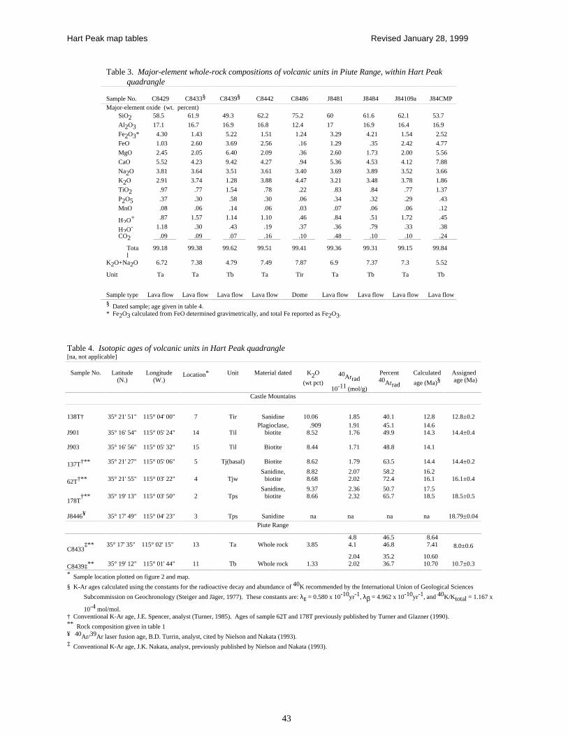
Hart Peak map tables Revised January 28, 1999
43
Table 4. Isotopic ages of volcanic units in Hart Peak quadrangle[na, not applicable]
Sample No. Latitude(N.)
Longitude(W.)
Location* Unit Material dated K2O
(wt pct)40Arrad
10-11 (mol/g)
Percent40Arrad
Calculated
age (Ma)§Assigned age (Ma)
Castle Mountains
138T† 35° 21' 51" 115° 04' 00" 7 Tir Sanidine 10.06 1.85 40.1 12.8 12.8±0.2
J901 35° 16' 54" 115° 05' 24" 14 TilPlagioclase,
biotite.909
8.521.911.76
45.149.9
14.614.3 14.4±0.4
J903 35° 16' 56" 115° 05' 32" 15 Til Biotite 8.44 1.71 48.8 14.1
137T†** 35° 21' 27" 115° 05' 06" 5 Tj(basal) Biotite 8.62 1.79 63.5 14.4 14.4±0.2
62T†** 35° 21' 55" 115° 03' 22" 4 TjwSanidine,
biotite8.828.68
2.072.02
58.272.4
16.216.1 16.1±0.4
178T†** 35° 19' 13" 115° 03' 50" 2 Tps
Sanidine,biotite
9.378.66
2.362.32
50.765.7
17.518.5 18.5±0.5
J8446¥ 35° 17' 49" 115° 04' 23" 3 Tps Sanidine na na na na 18.79±0.04Piute Range
C8433‡** 35° 17' 35" 115° 02' 15" 13 Ta Whole rock 3.85
4.84.1
46.546.8
8.647.41 8.0±0.6
C8439‡** 35° 19' 12" 115° 01' 44" 11 Tb Whole rock 1.332.042.02
35.236.7
10.6010.70 10.7±0.3
* Sample location plotted on figure 2 and map.
§ K-Ar ages calculated using the constants for the radioactive decay and abundance of 40K recommended by the International Union of Geological Sciences
Subcommission on Geochronology (Steiger and Jäger, 1977). These constants are: λε = 0.580 x 10⁻¹⁰yr-1, λβ = 4.962 x 10⁻¹⁰yr-1, and 40K/Ktotal = 1.167 x
10-4 mol/mol.†
Conventional K-Ar age, J.E. Spencer, analyst (Turner, 1985). Ages of sample 62T and 178T previously published by Turner and Glazner (1990).** Rock composition given in table 1¥ 40Ar/39Ar laser fusion age, B.D. Turrin, analyst, cited by Nielson and Nakata (1993).‡ Conventional K-Ar age, J.K. Nakata, analyst, previously published by Nielson and Nakata (1993).
Table 3. Major-element whole-rock compositions of volcanic units in Piute Range, within Hart Peakquadrangle
Sample No. C8429 C8433§ C8439§ C8442 C8486 J8481 J8484 J84109a J84CMPMajor-element oxide (wt. percent)
SiO2 58.5 61.9 49.3 62.2 75.2 60 61.6 62.1 53.7
Al2O3 17.1 16.7 16.9 16.8 12.4 17 16.9 16.4 16.9
Fe2O3* 4.30 1.43 5.22 1.51 1.24 3.29 4.21 1.54 2.52
FeO 1.03 2.60 3.69 2.56 .16 1.29 .35 2.42 4.77
MgO 2.45 2.05 6.40 2.09 .36 2.60 1.73 2.00 5.56
CaO 5.52 4.23 9.42 4.27 .94 5.36 4.53 4.12 7.88
Na2O 3.81 3.64 3.51 3.61 3.40 3.69 3.89 3.52 3.66
K2O 2.91 3.74 1.28 3.88 4.47 3.21 3.48 3.78 1.86
TiO2 .97 .77 1.54 .78 .22 .83 .84 .77 1.37
P2O5 .37 .30 .58 .30 .06 .34 .32 .29 .43
MnO .08 .06 .14 .06 .03 .07 .06 .06 .12
H2O+ .87 1.57 1.14 1.10 .46 .84 .51 1.72 .45
H2O- 1.18 .30 .43 .19 .37 .36 .79 .33 .38
CO2 .09 .09 .07 .16 .10 .48 .10 .10 .24
Total
99.18 99.38 99.62 99.51 99.41 99.36 99.31 99.15 99.84
K2O+Na2O 6.72 7.38 4.79 7.49 7.87 6.9 7.37 7.3 5.52
Unit Ta Ta Tb Ta Tir Ta Tb Ta Tb
Sample type Lava flow Lava flow Lava flow Lava flow Dome Lava flow Lava flow Lava flow Lava flow§ Dated sample; age given in table 4.* Fe2O3 calculated from FeO determined gravimetrically, and total Fe reported as Fe2O3.
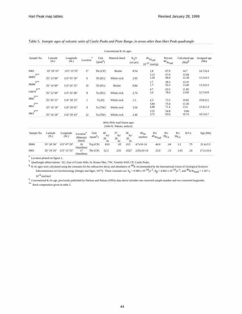
Hart Peak map tables Revised January 28, 1999
44
Table 5. Isotopic ages of volcanic units of Castle Peaks and Piute Range, in areas other than Hart Peak quadrangle
Conventional K-Ar ages
Sample No. Latitude(N.)
Longitude(W.) Location
* Unit
(quad†)
Material dated K2O
(wt pct)
40Arrad
10-11 (mol/g)
Percent40Arrad
Calculated age
(Ma)§Assigned age
(Ma)
S901 35° 19' 33" 115° 13' 55" 17 Tbr (CP) Biotite 8.54 1.8 67.9 14.7 14.7±0.4
J8493‡**
35° 13' 00" 115° 01' 50" 6 Tb (EG) Whole rock 2.955.135.28
67.068.0
12.0412.38 12.2±0.3
J8496‡**
35° 14' 00" 115° 01' 35" 10 Tb (EG) Biotite 8.841.71.7
38.355.5
13.3113.40 13.3±0.3
C8470‡**
35° 12' 00" 115° 01' 06" 8 Ta (EG) Whole rock 2.744.75.4
63.578.4
11.8513.60 12.7±0.8
J866‡**
35° 05' 31" 114° 58' 23" 1 Ta (H) Whole rock 1.5 4.3 75.5 19.82 19.8±0.5
J862‡**
35° 16' 18" 114° 59' 02" 9 Ta (TW) Whole rock 3.565.846.88
73.471.4
11.3613.4 12.4±1.4
J863‡**
35° 16' 18" 114° 59' 43" 12 Ta (TW) Whole rock 2.403.353.72
56.863.6
9.6610.74 10.2±0.7
40Ar/39Ar total fusion ages[John K. Nakata, analyst]
Sample No. Latitude(N.)
Longitude(W.)
Location*
(Materialdated)
Unit
(quad†)
40Ar/
39Ar
37Ar/
39Ar
36Ar/
39Ar
40Ar(moles)
Pct 40Arrad
Pct 39Ca
Pct 36Ca
K/Ca Age (Ma)
J9081 35° 20' 56" 115° 07' 29" 16(Sanidine)
Tcp (CP) 8.01 .65 .015 4.7x10⁻¹⁴ 46.0 .04 1.2 .75 21.4±5.5
S901 35° 19' 33" 115° 13' 55" 17(Sanidine)
Tbr (CP) 12.3 2.01 .0327 2.05x10⁻¹⁴ 23.0 .13 1.65 .24 17.5±10.4
* Location plotted on figure 2.† Quadrangle abbreviations: EG, East of Grotto Hills; H, Homer Mtn.; TW, Tenmile Well; CP, Castle Peaks.§ K-Ar ages were calculated using the constants for the radioactive decay and abundance of 40K recommended by the International Union of Geological Sciences
Subcommission on Geochronology (Steiger and Jäger, 1977). These constants are: λε = 0.580 x 10⁻¹⁰yr-1, λβ = 4.962 x 10⁻¹⁰yr-1, and 40K/Ktotal = 1.167 x
10-4 mol/mol‡ Conventional K-Ar age, previously published by Nielson and Nakata (1993); data above includes one corrected sample number and two corrected longitudes.** Rock composition given in table 2.