Embed Size (px)
Citation preview
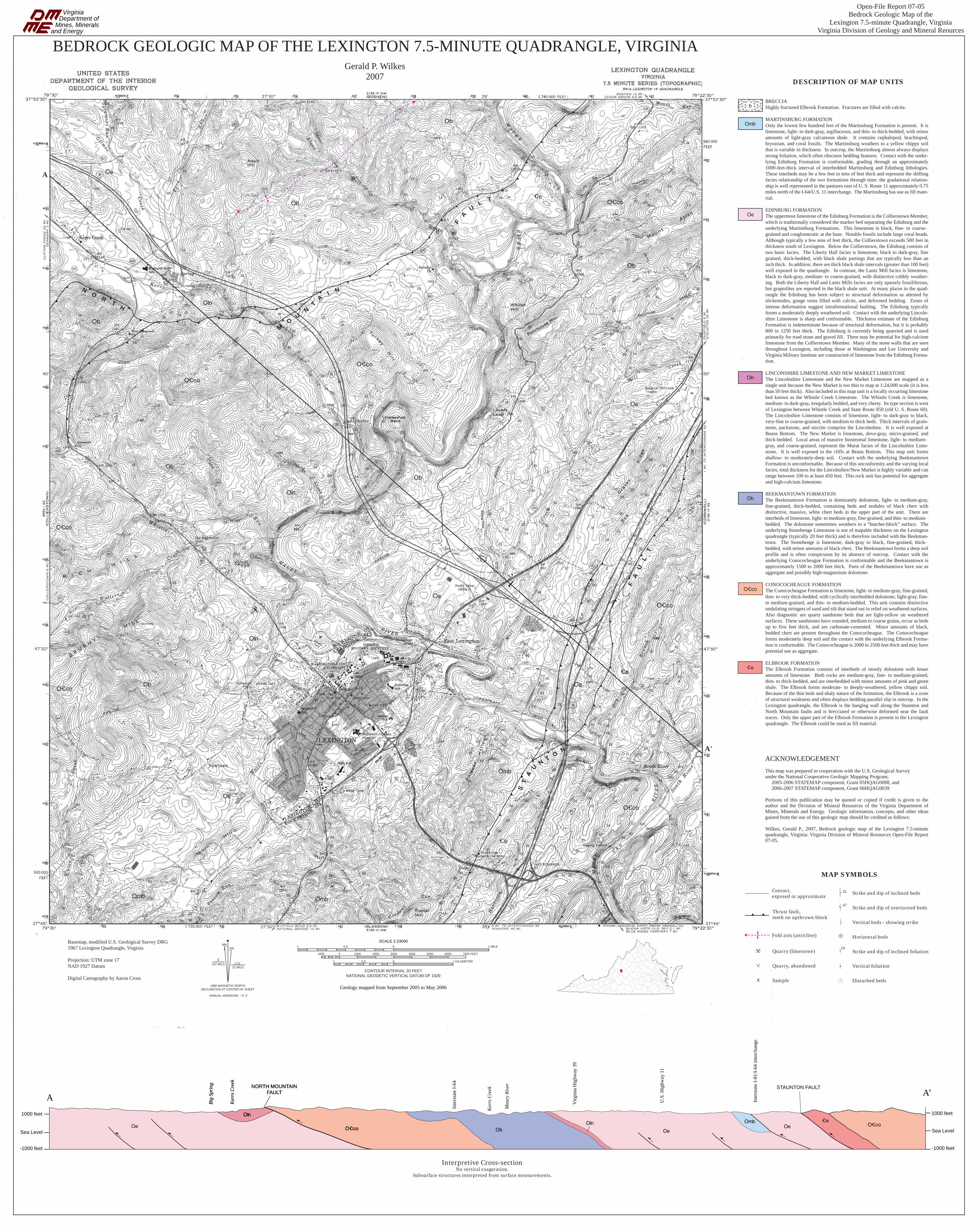
Basemap, modified U.S. Geological Survey DRG 1967 Lexington Quadrangle, Virginia
Projection: UTM zone 17NAD 1927 Datum
Digital Cartography by Aaron Cross
MNGN
61 11
o
o '107 MILS21 MILS
1980 MAGNETIC NORTHDECLINATION AT CENTER OF SHEET Geology mapped from September 2005 to May 2006
SCALE 1:240001
1 0.5 0 1 KILOMETER
1000 1000 2000 3000 4000 5000 6000 7000 FEET0
00.5 1 MILE
CONTOUR INTERVAL 20 FEETNATIONAL GEODETIC VERTICAL DATUM OF 1929
ANNUAL VARIATION - 0° 2’
VirginiaDepartment of
Mines, Mineralsand Energy
BEDROCK GEOLOGIC MAP OF THE LEXINGTON 7.5-MINUTE QUADRANGLE, VIRGINIAGerald P. Wilkes
2007
Open-File Report 07-05Bedrock Geologic Map of the
Lexington 7.5-minute Quadrangle, VirginiaVirginia Division of Geology and Mineral Reources
Oe
Ob
Ob
Oln
O|co
O|co
O|co
Ob
Ob
Ob
Oln
Oln
O|co
Oe
Oe
Oe
Oe
O|co
O|co
O|co
|e
|e
|e
Ob
Ob
b
Omb Omb
Omb
s
s
s
o o
o
o
o
o
o
o
o
o o
oo
oo
oo
o
o
o
oo
o
o
oo
o
oo o
o
o oo
oo
oo
o
o
o
oo
o
o
o o
o
o o o
o
o
o
o
ooo
ooo
ooo
o
o
oo
o
o
o
o
oo
o
o
o
o
oo
o
o
oo
oo
oo
oo
o
o
o
oo
o
o
ooo
oo
o
oo
o
o
oo
o o
oo
o
o
o
o
o
o
oÆo
ooo
o
oo
oo
o
o
o
o
o
oo
o
o o
o o
o
o
oov
o
oo
oo o
o
oo
v
o
v
oo
oo
o
o
o
¹ o
o
o
¹
v½
o
ooo
o
ooo
!Æoo
o
o
v
o o o
o
o
oo
o
o
o
o
oo
o
oo
oo
ov o
oo
o
o
o
o
oo
vo
B
o o o
o
o
o oo o o
o
oo
oo
oo
oooo
oo
o
oo
oo
o
o oo
o
o
o
o
o
o
o
oo
o
oooo
o oo
o
o o o
oo
o
o
oo
o
o o
o o
o
o B
ooo
o
o
o
ooo
ooooo
o
oo
oo
o
o
o
o
oo
o
o
o
o
o
o
o¹
o
o
oo
B
oo
o
o
o
¹
oo
o
o o
o
oo
o
o B
o
v
o ¹o
oo
v
o
o
o
o
v v
B
o
B
v
o
o
B
o
o v
o
o
oo
ooo
o
o
o
Æ o
v
o
BBBB
o
oo
oo
vo
o
v
o
o
oÆ
o
ov
oo
ovoo o
oov
o
oov
o
o
oo
o
o
oo
oo
o
o
oe o
o
o
oo
ooo
v oo
o
o
o
o
e
e
e
o
o
B
o
o
o
o o
o
o
o
e
e
e
e
Æ
o
o
o
o
oo
o e
o
o
o
o o
oo
o
e
e
e
e
eoooo
e
oo
o
oo
o
o o o
o
v
o
oooo
oo
e
o
o
oo
o
o
o
o
oo
o
o
oo
oo
o
o
o
o
oooo
oo
ov
ooo
oo
o
oo
o
oo
o
o
oo
oo
o
o
o
o
oo
ooo
o
o
e e
ooo
o o
e
ß
o
o
o
o
o
o
o
o
ooo
o
oo o
oo
o
o
o
oo
o
o o
o
e
B
85
72
36
81
72
34
85
24
6
1327
36
24 14
16
32
20
4127
1920
23 18
14
1610
15
22
26
22
7
19
7
34
3112
22 2627
10
9
23 22
32
318
43
24
20
20
3063
1630
37
7
3920
20 20
366
6130
49 47 40
6113
6146 61
4730
33
20
27
32
25 1414
2334
30
3031
30 26
32
26
31
21
30
31
26
31
3011
14
20
27
24
30216
59
6760
20
125
23 11 1617
55
5
165
30
16
25
5
27
31
50
20
59
5
14
20
2111
14
5
6
76
15
5
16
15
5
6055
15
7
8
1010
8
17
7
29
20
40
4550
54
25
12
44
30 60
72
25
64
30 5
76 83
8580 83 7270
66
20
70
40
60
40 74
73
76
76
1540
47
80
61
73
6782
7630
56
7263
55 62
64
58
80
82
35
80
75
45
76
44
62
6840
7261
81
7080
21
7772
80
4732
78
68
46
6141
68 75
82
64
39
47
45
39
42
3864
4634
31
37
27
36
51
40
39
36
30
26 32 3834 39
41 46
61
64
74
63
35 73
41
78
4945
40
5127
30
35 14
63
47
5450
523427
3435
3534
2532 32 42
52
31 38
42
31
65
68
57
41
34
313036
36
27
37
37
33
34
3732
42
3742
43
20
28
3942
3540
41
38
4242
4567
74
59
3241
4030
41
62
70
73
70
75
72
60
58
80
3530
3053
5441
30
35
30
20
60
1040
80
80
808481
60
8188
59
60
85 74
65
6057
60
7084
3086
70
70
8070
57
60
80 8030
40
58
438055
55
60
8080
65
70
27
3222
24
29
23
22 41
3627
22
61
12
46
15
3224
3432
66 54
30
25
30
30
40
35
40
34
20
21
3033
2456
31
30
26
11
30
5631
39
3126
39
27
2436
30
31
21
28
26
33
26
20
22
22
46
2032
17
20
15
14
17
16
22
21
26
19
12
7
1124
26
33 16
2652
51 48 37
3432
54
21
32
29
14
39313010
521
39 14
26
17
20
6
4
20 19
15
14
2141
2960
342030
5114
7
12
26
23
19
12
10
20
2216
20
20
2020
1516
24
71
10
20
26
70
37
2269
Æ
Æ
A
A'
(
(
(
(
(
(
(
(
(
(
(
(
(
(
(
(
(
(
((
(
(
((
(
(
(
(
(
(
((
(
(
(
(
(
(
(
(
(
(
(
(
((
((
((
((
(((
(
(
(
(((
((
((
(
((
(( ((
(
(( (((
((
((
((
(
(
(
(
(
(
(
(
(
(
NO R
T
H
N
U
NT O
ST
A
T
AI N
MO
UN
FA
UL T
FA
UL
T
F
DESCRIPTION OF MAP UNITS
BRECCIAHighly fractured Elbrook Formation. Fractures are filled with calcite.
MARTINSBURG FORMATIONOnly the lowest few hundred feet of the Martinsburg Formation is present. It is limestone, light- to dark-gray, argillaceous, and thin- to thick-bedded, with minor amounts of light-gray calcareous shale. It contains cephalopod, brachiopod, bryozoan, and coral fossils. The Martinsburg weathers to a yellow chippy soil that is variable in thickness. In outcrop, the Martinsburg almost always displays strong foliation, which often obscures bedding features. Contact with the under-lying Edinburg Formation is conformable, grading through an approximately 1000-feet-thick interval of interbedded Martinsburg and Edinburg lithologies. These interbeds may be a few feet to tens of feet thick and represent the shifting facies relationship of the two formations through time: the gradational relation-ship is well represented in the pastures east of U. S. Route 11 approximately 0.75 miles north of the I-64/U.S. 11 interchange. The Martinsburg has use as fill mate-rial.
EDINBURG FORMATIONThe uppermost limestone of the Edinburg Formation is the Collierstown Member, which is traditionally considered the marker bed separating the Edinburg and the underlying Martinsburg Formations. This limestone is black, fine- to coarse-grained and conglomeratic at the base. Notable fossils include large coral heads. Although typically a few tens of feet thick, the Collierstown exceeds 500 feet in thickness south of Lexington. Below the Collierstown, the Edinburg consists of two basic facies. The Liberty Hall facies is limestone, black to dark-gray, fine grained, thick-bedded, with black shale partings that are typically less than an inch thick. In addition, there are thick black shale intervals (greater than 100 feet) well exposed in the quadrangle. In contrast, the Lantz Mill facies is limestone, black to dark-gray, medium- to coarse-grained, with distinctive cobbly weather-ing. Both the Liberty Hall and Lantz Mills facies are only sparsely fossiliferous, but graptolites are reported in the black shale unit. At many places in the quad-rangle the Edinburg has been subject to structural deformation as attested by slickensides, gouge veins filled with calcite, and deformed bedding. Zones of intense deformation suggest intraformational faulting. The Edinburg typically forms a moderately deeply weathered soil. Contact with the underlying Lincoln-shire Limestone is sharp and conformable. Thickness estimate of the Edinburg Formation is indeterminate because of structural deformation, but it is probably 800 to 1250 feet thick. The Edinburg is currently being quarried and is used primarily for road stone and gravel fill. There may be potential for high-calcium limestone from the Collierstown Member. Many of the stone walls that are seen throughout Lexington, including those at Washington and Lee University and Virginia Military Institute are constructed of limestone from the Edinburg Forma-tion.
LINCONSHIRE LIMESTONE AND NEW MARKET LIMESTONEThe Lincolnshire Limestone and the New Market Limestone are mapped as a single unit because the New Market is too thin to map at 1:24,000 scale (it is less than 50 feet thick). Also included in this map unit is a locally occurring limestone bed known as the Whistle Creek Limestone. The Whistle Creek is limestone, medium- to dark-gray, irregularly bedded, and very cherty. Its type section is west of Lexington between Whistle Creek and State Route 850 (old U. S. Route 60). The Lincolnshire Limestone consists of limestone, light- to dark-gray to black, very-fine to coarse-grained, with medium to thick beds. Thick intervals of grain-stone, packstone, and micrite comprise the Lincolnshire. It is well exposed at Beans Bottom. The New Market is limestone, dove-gray, micro-grained, and thick-bedded. Local areas of massive biostromal limestone, light- to medium-gray, and coarse-grained, represent the Murat facies of the Lincolnshire Lime-stone. It is well exposed in the cliffs at Beans Bottom. This map unit forms shallow- to moderately-deep soil. Contact with the underlying Beekmantown Formation is unconformable. Because of this unconformity and the varying local facies, total thickness for the Lincolnshire/New Market is highly variable and can range between 100 to at least 450 feet. This rock unit has potential for aggregate and high-calcium limestone.
BEEKMANTOWN FORMATIONThe Beekmantown Formation is dominantly dolostone, light- to medium-gray, fine-grained, thick-bedded, containing beds and nodules of black chert with distinctive, massive, white chert beds in the upper part of the unit. There are interbeds of limestone, light- to medium-gray, fine-grained, and thin- to medium-bedded. The dolostone sometimes weathers to a “butcher-block” surface. The underlying Stonehenge Limestone is not of mapable thickness on the Lexington quadrangle (typically 20 feet thick) and is therefore included with the Beekman-town. The Stonehenge is limestone, dark-gray to black, fine-grained, thick-bedded, with minor amounts of black chert. The Beekmantown forms a deep soil profile and is often conspicuous by its absence of outcrop. Contact with the underlying Conococheague Formation is conformable and the Beekmantown is approximately 1500 to 2000 feet thick. Parts of the Beekmantown have use as aggregate and possibly high-magnesium dolostone.
CONOCOCHEAGUE FORMATIONThe Conococheague Formation is limestone, light- to medium-gray, fine-grained, thin- to very thick-bedded, with cyclically interbedded dolostone, light-gray, fine- to medium-grained, and thin- to medium-bedded. This unit contains distinctive undulating stringers of sand and silt that stand out in relief on weathered surfaces. Also diagnostic are quartz sandstone beds that are light-yellow on weathered surfaces. These sandstones have rounded, medium to coarse grains, occur as beds up to five feet thick, and are carbonate-cemented. Minor amounts of black, bedded chert are present throughout the Conococheague. The Conococheague forms moderately deep soil and the contact with the underlying Elbrook Forma-tion is conformable. The Conococheague is 2000 to 2500 feet thick and may have potential use as aggregate.
ELBROOK FORMATIONThe Elbrook Formation consists of interbeds of mostly dolostone with lesser amounts of limestone. Both rocks are medium-gray, fine- to medium-grained, thin- to thick-bedded, and are interbedded with minor amounts of pink and green shale. The Elbrook forms moderate- to deeply-weathered, yellow chippy soil. Because of the thin beds and shaly nature of the formation, the Elbrook is a zone of structural weakness and often displays bedding-parallel slip in outcrop. In the Lexington quadrangle, the Elbrook is the hanging wall along the Staunton and North Mountain faults and is brecciated or otherwise deformed near the fault traces. Only the upper part of the Elbrook Formation is present in the Lexington quadrangle. The Elbrook could be used as fill material.
ACKNOWLEDGEMENT
This map was prepared in cooperation with the U.S. Geological Surveyunder the National Cooperative Geologic Mapping Program; 2005-2006 STATEMAP component, Grant 05HQAG0088, and 2006-2007 STATEMAP component, Grant 06HQAG0039
Portions of this publication may be quoted or copied if credit is given to the author and the Division of Mineral Resources of the Virginia Department of Mines, Minerals and Energy. Geologic information, concepts, and other ideas gained from the use of this geologic map should be credited as follows:
Wilkes, Gerald P., 2007, Bedrock geologic map of the Lexington 7.5-minute quadrangle, Virginia: Virginia Division of Mineral Resources Open-File Report 07-05.
Thrust fault, teeth on upthrown block
MAP SYMBOLS
b
Omb
Oe
Oln
O|co
Ob
|e
Contact, exposed or approximate
(((
F Fold axis (anticline)
o Strike and dip of inclined beds
s
Strike and dip of overturned beds
v Vertical beds - showing strike
e Horizontal beds
¹
Strike and dip of inclined foliation
½ Vertical foliation
B Disturbed beds
14
47
31
ß Quarry (limestone)
Æ Quarry, abandoned
! Sample
A’ANORTH MOUNTAIN
FAULTSTAUNTON FAULT
1000 feet
Sea Level
-1000 feet
1000 feet
Sea Level
-1000 feet
O|co|e
OeOmb
Oe
OlnObO|co
Oln
Oe
Inte
rsta
te I-
64
Mau
ry R
iver
Virg
inia
Hig
hway
39
U.S
. Hig
hway
11
Inte
rsta
te I-
81/I-
64 in
terc
hang
e
Big
Spri
ng
Ker
rs C
reek
Ker
rs C
reekNORTH MOUNTAIN
FAULT
O|co
Oln
Big
Spri
ng
Ker
rs C
reek
Interpretive Cross-sectionNo vertical exageration.
Subsurface structures interpreted from surface measurements.