Embed Size (px)
Citation preview
Paper 2008-1
Ministry of Energy, Minesand Petroleum Resources
GEOLOGICAL FIELDWORK 2007A Summary of Field Activities and Current Research
GEOLOGICAL FIELDWORK 2007A Summary of Field Activities and Current Research
The Best Place on Earth


GEOLOGICAL FIELDWORK 2007A Summary of Field Activities and Current Research
Ministry of Energy, Minesand Petroleum Resources
British Columbia Geological Survey
Paper 2008-1

ii British Columbia Geological Survey
British Columbia Cataloguing in Publication Data
Main entry under title:
Geological Fieldwork: - 1974 -
Annual.
Issuing body varies
Vols. For 1978-1996 issued in series: Paper / British Columbia. Minis-
try of Energy, Mines and Petroleum Resources; vols for 1997- 1998, Paper /
British Columbia. Ministry of Employment and Investment; vols for 1999-
2004, Paper / British Columbia Ministry of Energy and Mines; vols for
2005- , Paper / British Columbia Ministry of Energy, Mines and Petroleum
Resources.
Includes Bibliographical references.
ISSN 0381-243X=Geological Fieldwork
1. Geology - British Columbia - Periodicals. 2. Mines and mineral re-
sources - British Columbia - Periodicals. 3. Geology - Fieldwork - Periodi-
cals. 4. Geology, Economic - British Columbia - Periodicals. 5. British Co-
lumbia. Geological Survey Branch - Periodicals. I. British Columbia.
Geological Division. II. British Columbia. Geological Survey Branch. III.
British Columbia. Geological Survey Branch. IV. British Columbia. Dept.
of Mines and Petroleum Resources. V. British Columbia. Ministry of En-
ergy, Mines and Petroleum Resources. VI. British Columbia. Ministry of
Employment and Investment. VII. British Columbia Ministry of Energy and
Mines. VIII. Series: Paper (British Columbia. Ministry of Energy, Mines
and Petroleum Resources). IX. Series: Paper (British Columbia. Ministry of
Employment and Investment). X. Series: Paper (British Columbia Ministry
of Energy and Mines). XI. Series: Paper (British Columbia Ministry of En-
ergy, Mines and Petroleum Resources).
Ministry of Energy, Mines and Petroleum ResourcesMining and Minerals DivisionBritish Columbia Geological Survey
Parts of this publication may be quoted or reproduced if source and authorship is acknowledged.The following is the recommended format for referencing individual works contained in this publication:
Diakow, L.J. (2008): Spences Bridge Bedrock Mapping Project: preliminary results from the Merritt region, south-central British Colum-bia (parts of NTS 092H/14, 15; 092I/02); in Geological Fieldwork 2007, BC Ministry of Energy Mines and Petroleum Resources,Paper 2008-1, pages 1–4.
This publication is also available, free of charge, as colour digital files, in Adobe Acrobat PDF format, from the BC Ministry of Energy,Mines and Petroleum Resources internet website at:
http://www.em.gov.bc.ca/Mining/Geolsurv/Publications/catalog/cat_fldwk.htm
VICTORIABRITISH COLUMBIA
CANADA
JANUARY 2008
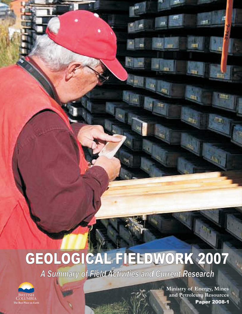
COVER PHOTO: Brian Grant examines core from the Lac La Hache property of GWR Resources Inc during a fieldtripvisiting alkaline porphyry occurrences. Mineralization at the property displays many of the character-istics of the alkalic copper-gold porphyry deposits, which are an important source of copper withinBritish Columbia. Brian was Director of Geosciences Initiatives, BC Geological Survey, before he re-tired from public service in January, 2008.

Geological Fieldwork 2007
The British Columbia Geological Survey (BCGS)presents the results of 2007 geoscience surveys and studiesin this thirty-third edition of Geological Fieldwork. Most ofthe articles within this volume are contributions from Sur-vey staff who have worked extensively throughout theprovince on its geology, geochemistry and mineral depos-its. Many BCGS projects include important contributionsfrom researchers and contractors from other organizations.As well, the Survey includes quality submissions in thispublication from any professional geoscientist which mayadd to the province’s geoscience database.
The results of the 2007 field surveys and the provisionof new geoscience data will lead to tenure acquisition andincreased mineral exploration expenditures as it has in pre-vious years. These activities are the first steps towards thedevelopment of new mines, which benefit BritishColumbians, particularly those living in regionalcommunities.
BC Geological Survey Successes
� Survey staff have made significant new mineral dis-coveries or redefined the mineral potential duringtheir mapping programs in the Chezacut, Merritt,northern Vancouver Island and Terrace areas whichshould attract mineral tenure acquisition and high-light the under-explored mineral potential of theseareas.
� More than 28 300 industry assessment reports havenow been published as PDF files to the Surveywebsite, improving access to this critical explora-tion database. This is part of the Survey’s ongoingresponsibility to be the custodian for the province’smineral and coal geoscience data.
� Survey staff have created a Drainage GeochemicalAtlas for British Columbia which incorporates datacollected over 25 years. The Atlas presents a leveleddataset which will be invaluable for regional studiesacross the Province.
� MapPlace is used by the exploration communityaround the world and continues to attract explora-tion investment to the province. The British Colum-bia Geological Survey geological database andMapPlace have been ranked as a top geoscience da-tabase globally by the Fraser Institute Survey for2006-07.
� Mapping in the Interior Plateau shows that Quater-nary volcanic cover rocks are thinner and less exten-sive than previously shown on geological maps,which encourages more exploration in the region.
� Survey staff, including those based in the Vancou-ver and Ministry regional offices, contributed theirexpertise to assist in government decisions, respondto client inquiries in confidence, and report on in-dustry activity in the province.
� The Survey was funded by government to start athree year Cooperative Geological Student Map-ping Program to train and mentor geology studentsas they prepare for their careers. In 2006-07 the Sur-vey hired more than 35 geoscience assistants andprovided training and guidance to undergraduateand graduate research projects.
� Field trips led by Survey staff in 2007 included aPorphyry Deposits Tour to Northwestern BritishColumbia and a visit to the Myra Falls mine.
2007 BCGS Field Surveys, DatabaseActivities and Publications
Articles in this volume include reports on British Co-lumbia Geological Survey programs in the Boundary dis-trict, Chilcotin, Merritt, northern Vancouver Island, PeaceRiver coalfield, Quesnel, Terrace and 100 Mile House ar-eas. Three articles highlight some of the many opportuni-ties for economic development related to the province’s in-dustrial minerals. New geochemical data from the QuesnelTrough and the Drainage Geochemical Atlas are alsodiscussed in the volume.
The Survey has recognized the impact of the MountainPine Beetle infestation in the central interior of the provinceby expanding its 2006 and 2007 programs in this region.Despite excellent mineral potential, the central interior hasbeen under-explored due to widespread glacial till blanketsand young volcanic cover rocks. The objective is to diver-sify local economies by attracting mineral explorationwhich could lead to the discovery of new mines. In otherparts of the province both mineral exploration and miningcontribute to local jobs and taxes and support regionalinfrastructure.
Many BCGS programs involved cooperative partner-ships with universities, other government agencies,Geoscience BC, First Nations, communities and industry.The Survey continued its tradition of working with theGeological Survey of Canada on British Columbia projectsproviding technical and financial assistance to the TargetedGeoscience Initiative in southern and central BritishColumbia.
All geoscience publications are routinely posted to theBC Ministry of Energy, Mines and Petroleum Resourceswebsite. MapPlace, one of the world’s premier geoscienceinternet-map systems, continues to improve with the addi-tion of more data layers and improved tools. Clients cannow freely access 100% of the company mineral assess-ment reports from the ARIS database over the web. Surveystaff played active roles as presenters and organizers at nu-merous conferences and events to market British Colum-bia’s mineral potential, including a trade mission to Asia,international conferences in Toronto and Vancouver, andnumerous meetings and workshops around the province.
Over the past year the BCGS published GeologicalFieldwork 2006, 10 Open File maps and reports, 1Geoscience Map, 11 GeoFile maps, reports and data filesand 5 Information Circulars. In addition to these traditionalpublications, Survey geologists provided expertise tocompanys carrying out exploration and mine development
Geological Fieldwork 2007, Paper 2008-1 iii
FOREWORD
work in the Province. As well, the Survey processed about550 assessment reports submitted for tenure maintenance.
Working with the regional geologists as key authors,the Survey also published Exploration and Mining in Brit-ish Columbia 2006 and British Columbia Mines and Min-eral Exploration Overview 2006 and coordinated the sub-mission of articles on provincial industry activitiespublished by the Canadian Institute of Mining, in the Min-eral Exploration magazine by AMEBC and NorthernMiner.
This Fieldwork volume is made possible by the hardwork and expertise of numerous authors who have contrib-uted their insight to improve our understanding of BritishColumbia’s geology and mineral deposits. The articleshave been improved by peer and supervisor review andTania Demchuk’s steady hand in coordinating the articles
and providing feedback to the authors. The quality servicesof RnD Technical are acknowledged for helping to put thevolume together. Brian Grant, the editor, deserves specialcommendation for being the key person in so many ways inproducing Geological Fieldwork. This is his 20th, and lastyear, at the helm as he is returning to the private sector.
D.V. LefebureChief Geologist
British Columbia Geological Survey
www.empr.gov.bc.ca/Geology
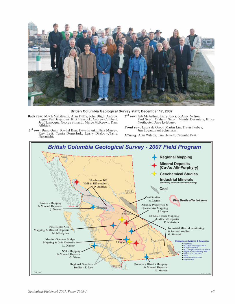
(see following pages for a photo of BC Geological Sur-vey staff and a location map of 2007 field projects.)
iv British Columbia Geological Survey
Geoscience BC Reports
Geoscience BC’s project reports for 2007 are available in their volume, Geoscience BC Summaryof Activities 2007, Geoscience BC Report 2008-1. This report is available in hardcopy or as adownload from Geoscience BC’s website, www.geosciencebc.com.
Previous Geoscience BC project reports were included in Geological Fieldwork 2005 and 2006.
Diakow, L.J.: Spences Bridge Bedrock Mapping Project: pre-liminary results from the Merritt region, south-centralBritish Columbia . . . . . . . . . . . . . . . . . . . . . . . . . . . . . . . 1
Enkin, R.J., Vidal, B.S., Baker, J. and Struyk, N.M.: Physi-cal properties and paleomagnetic database for south-cen-tral British Columbia. . . . . . . . . . . . . . . . . . . . . . . . . . . . 5
Hartlaub, R.P. and Paradis, S.: Evaluation of the geologyand stratabound base metal potential of the middle andupper Purcell Supergroup, southeastern British Columbia. . . . . . . . . . . . . . . . . . . . . . . . . . . . . . . . . . . . . . . . . . . . 9
Hora, Z.D., Langrová, A., and Pivec, E.: Eaglet property re-visited: fluorite-molybdenite porphyry-like hydrothermalsystem, east-central British Columbia . . . . . . . . . . . . . 17
Hora, Z.D.: Diatomite resource assessment in the Quesnelarea, central British Columbia . . . . . . . . . . . . . . . . . . . 31
Legun, A.S.: Thickness trends of J seam, and its split at theFalher D shoreline, Wolverine River area, Peace Rivercoalfield, northeastern British Columbia. . . . . . . . . . . . 39
Lett, R.E. and Sandwith, Z.: Geochemical orientation sur-veys in the Quesnel Terrane between Quesnel and Wil-liams Lake, central British Columbia . . . . . . . . . . . . . . 49
Lett, R.E., Man, E.C. and Mihalynuk, M.G.: Towards adrainage geochemical atlas for British Columbia . . . . . 61
Logan, J.: Geology and mineral occurrences of the QuesnelTerrane, Cottonwood map sheet, central British Columbia. . . . . . . . . . . . . . . . . . . . . . . . . . . . . . . . . . . . . . . . . . . 69
Massey, N.W.D. and Duffy, A.: Boundary Project: McKinneyCreek and Beaverdell areas, south-central British Colum-bia . . . . . . . . . . . . . . . . . . . . . . . . . . . . . . . . . . . . . . . . . 87
McKeown, M., Nelson, J. and Friedman, R.: Newly discov-ered volcanic-hosted massive sulphide potential within
Paleozoic volcanic rocks of the Stikine assemblage, Ter-race area, northwestern British Columbia . . . . . . . . . . 103
Mihalynuk, M.G., Peat, C.R., Terhune, K. and Orovan,E.A.: Regional geology and resource potential of theChezacut map area, central British Columbia . . . . . . . 117
Mihalynuk, M.G., Friedman, R.M. and Ullrich, T.D.: Geo-chronological results from reconnaissance investigationsin the Beetle Infested Zone, south-central British Colum-bia . . . . . . . . . . . . . . . . . . . . . . . . . . . . . . . . . . . . . . . . 135
Moynihan, D.P. and Pattison, D.R.M.: Origin of theKootenay Lake metamorphic high, southeastern BritishColumbia . . . . . . . . . . . . . . . . . . . . . . . . . . . . . . . . . . . 147
Nelson, J., Kyba, J., McKeown, M. and Angen, J.: TerraceRegional Mapping Project, year 3: contributions to strati-graphic, structural and exploration concepts, ZymoetzRiver to Kitimat River, east-central British Columbia 159
Nixon, G.T., Larocque, J., Pals, A., Styan, J., Greene, A.R.and Scoates, J.S.: High-Mg lavas in the Karmutsen floodbasalts, northern Vancouver Island: stratigraphic settingand metallogenic significance . . . . . . . . . . . . . . . . . . . 175
Schiarizza, P. and Bligh, J.S.: Geology and mineral occur-rences of the Timothy Lake area, south-central British Co-lumbia . . . . . . . . . . . . . . . . . . . . . . . . . . . . . . . . . . . . 191
Simandl, G.J.: Newly recognized white talc-carbonate fillerpotential of the Greenwood – Bridesville area, British Co-lumbia and brief talc market review . . . . . . . . . . . . . . 213
Wojdak, P.J.: Fireside deposit: diagenetic barite in strata ofthe Kechika Group, and vein barite related to rifting ofthe Kechika Trough, northwestern British Columbia . 219
Geological Fieldwork 2007, Paper 2008-1 v
CONTENTS

vi British Columbia Geological Survey
Geological Fieldwork 2007, Paper 2008-1 vii
British Columbia Geological Survey staff; December 17, 2007
Back row: Mitch Mihalynuk, Alan Duffy, John Bligh, AndrewLegun, Pat Desjardins, Kirk Hancock, Andrew Cuthbert,Jeoff Larocque, George Simandl, Margo McKeown, DaniAlldrick;
3rd
row: Brian Grant, Rachel Kerr, Dave Frankl, Nick Massey,Ray Lett , Tania Demchuk, Larry Diakow,TairaNakanishi;
2nd
row: Gib McArthur, Larry Jones, JoAnne Nelson,Paul Scott, Graham Nixon, Mandy Desautels, BruceNorthcote, Dave Lefebure;
Front row: Laura de Groot, Martin Lin, Travis Ferbey,Jim Logan, Paul Schiarizza;
Missing: Alan Wilcox, Tim Hewett, Caoimhe Peat.
Lillooet
AlkQuITHERS
PRINCE
GEORGE
Pine BPine Beetle affected zone
British Columbia Geological Survey - 2007 Field Program
BG - Dec 27, 2007
Regional Mapping
Geochemical Studies
Pine Beetle AreaMapping & Mineral Deposits
M. Mihalynuk
Mineral Deposits(Cu-Au Porphyry)Alk-
Dec 2007
MapPlaceBC Digital Geological MapBCAge databaseBC Lithogeochemical databaseRegional Geochemistry dataMINFILE / COALFILEARISMineral Potential dataProperty File
�
�
�
�
�
�
�
�
�
Geoscience Systems & DatabasesLillooet
STEWART
Northwest BCVMS & Rift studies
D. Alldrick
SMITHERSRS
STEWART
PRINCE
GEORGE
Coal
Industrial Minerals( )including province-wide monitoring
Northwest BCVMS & Rift studies
D. Alldrick
Terrace - Mapping& Mineral Deposits
J. Nelson
Boundary District Mapping& Mineral Deposits
N. Massey
Coal StudiesA. Legun
Merritt - Spences BridgeMapping & Gold Deposits
L. Diakow
NVI - Mapping& Mineral Deposits
G. Nixon
Alkaline Porphyries &Quesnel Arc Mapping
J. Logan
100 Mile House Mapping& Mineral Deposits
P. Schiarizza
Regional GeochemStudies - R. Lett
Industrial Mineral& focused studiesG. Simandl
monitoring
FORT
ST JOHN
SMITHERS
ATLIN
PRINCE
GEORGE
VANCOUVER
CRANBROOKNELSON
REVELSTOKE
VICTORIA

viii British Columbia Geological Survey