Embed Size (px)
Citation preview

[email protected], http://www.sciencepub.net Nature and Science, 2009 7(6) ISSN 1545-0740
Geological Significance of Bouguer Anomalies in Harir Plain, Northwest Zagros Folds-Thrust Belt (Iraqi Kurdistan Region)
Fadhil A. Ghaib*, Abdulwahhab M. Al-Dawoody*, and Hemin A. Koyi**
*Department of Geology, Salahaddin University, Erbil, Iraq
e-mail: [email protected] [email protected]
**Department of Earth Sciences, Uppsala University, Uppsala, Sweden [email protected]
_____________________________________________________________________________________
Abstract: Gravity measurements of about 500 points were made along the paved and some unpaved roads of Harir plain in the northwestern part of the Zagros Fold-Thrust Belt (ZFTB). Necessary corrections were carried out and a complete Bouguer map was constructed. The Bouguer anomaly map shows regular patterns, which was compatible with the surface geological structures. Regional, residual and second vertical derivative maps were also constructed to give better qualitative interpretations. Considerable density contrast of 0.3gm/cm3 was observed between the Cretaceous and Tertiary rocks which thought to be the marker contact for most of the gravity anomalies, as calculated by samples collected from outcrops. This density contrast was used to carry out two-dimensional modeling along seven NE-SW profiles and one NW-SE profile in order to show the topography of the top of Cretaceous rocks. The model shows that there is a good correlation between the folds (± thrusts) at the Tertiary-Cretaceous boundary and the surface structures (Harir, Safin and Shakrok anticlines). However, this correlation is not one-to-one since Harir plain is underlain by an unexposed anticline in the Tertiary-Cretaceous contacts. [Nature and Science. 2009; 7(6):43-51]. (ISSN: 1545-0740). Key words: Harir-Kurdistan-Gravity Prospecting
Introduction
Harir plain, which covers an area about 300km2 is located some 40km east of the city of Erbil, in the northwestern most part of the Zagros fold-thrust belt of Iraqi Kurdistan Region (Fig. 1). The studied area is represented by a hummocky plain bounded from northeast and southwest by the Harir and Mirawa Anticlines respectively (Fig. 1 and 2). Some local and limited-length gravity traverses were carried out [1, 2, and 3]. Those studies did not describe the geophysical signature of the area. The data of the first author was re-interpreted later by [4 and 5] and yet did not give a detailed picture of the subsurface. The present work is therefore a necessary step towards understanding the structural pattern in this part of the High-Folded Zone of Iraq using gravity data. In this study, gravity anomaly data is used to investigate the subsurface structural features of the Harir area and compare them to the surface data in order to outline the geometric configuration of the structures at depth and if they have or not any relationship with the basement.
General Geologic setting
Harir area is located within the Zagros High-Folded Zone (Fig. 1), which is characterized by relatively long and high-amplitude anticlines. These anticlines, most of which are asymmetrical, are associated with thrust/reverse faults along their southern or southwestern limbs and could be either fault-propagation or fault-bend folds. They also represent the last NW-SE trending structures in the Zagros Fold-Thrust Belt before the belt changes trend to E-W. The High-Folded Zone affected by transversal faults system which reactivated from late Jurassic time onward resulting in the formation of transversal blocks. Some faults of this system underwent sinstral strike slip movement in Quaternary time along Ana-Qalat-Dizah fault. Many anticlines are segmented into separate domes and their fold axis is bent at the intersection with these transversal faults [6].
43
[email protected], http://www.sciencepub.net Nature and Science, 2009 7(6) ISSN 1545-0740
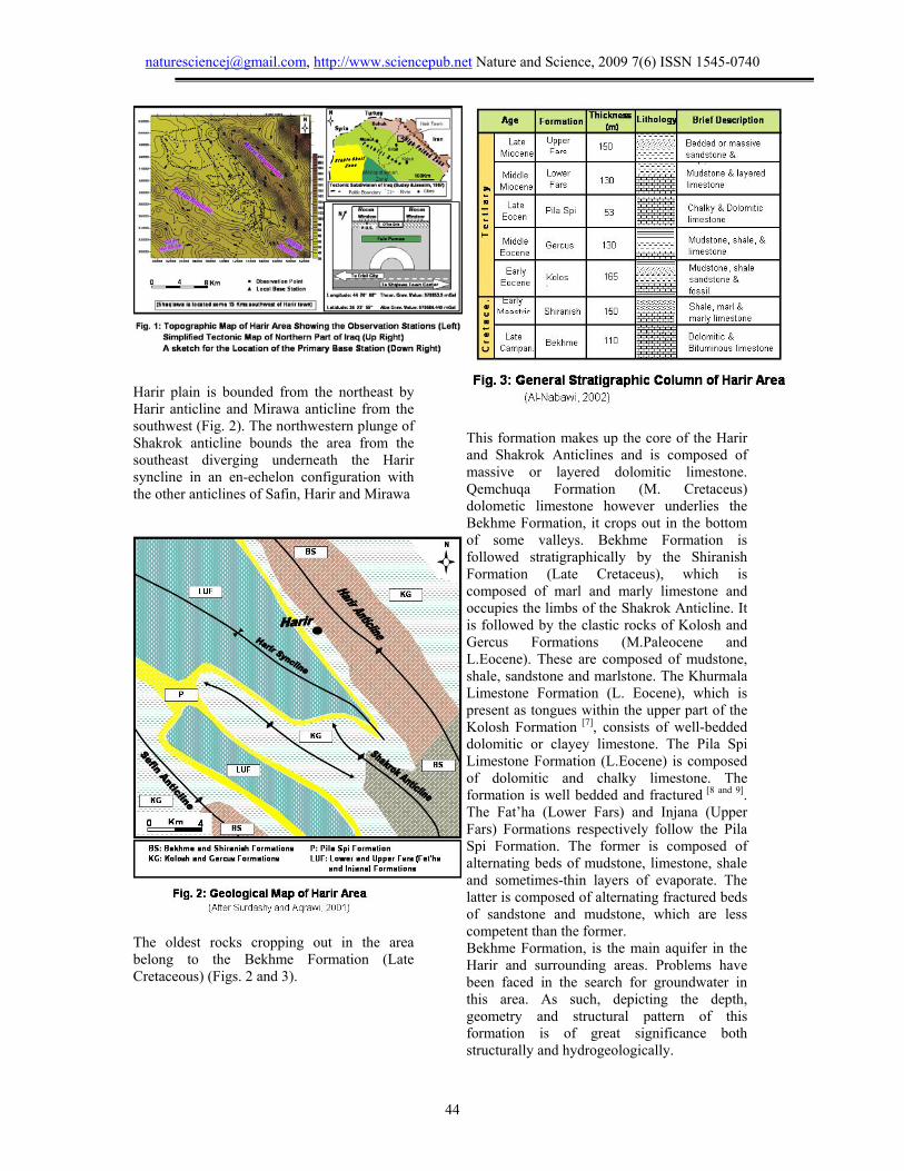
Harir plain is bounded from the northeast by Harir anticline and Mirawa anticline from the southwest (Fig. 2). The northwestern plunge of Shakrok anticline bounds the area from the southeast diverging underneath the Harir syncline in an en-echelon configuration with the other anticlines of Safin, Harir and Mirawa
The oldest rocks cropping out in the area belong to the Bekhme Formation (Late Cretaceous) (Figs. 2 and 3).
This formation makes up the core of the Harir and Shakrok Anticlines and is composed of massive or layered dolomitic limestone. Qemchuqa Formation (M. Cretaceus) dolometic limestone however underlies the Bekhme Formation, it crops out in the bottom of some valleys. Bekhme Formation is followed stratigraphically by the Shiranish Formation (Late Cretaceus), which is composed of marl and marly limestone and occupies the limbs of the Shakrok Anticline. It is followed by the clastic rocks of Kolosh and Gercus Formations (M.Paleocene and L.Eocene). These are composed of mudstone, shale, sandstone and marlstone. The Khurmala Limestone Formation (L. Eocene), which is present as tongues within the upper part of the Kolosh Formation [7], consists of well-bedded dolomitic or clayey limestone. The Pila Spi Limestone Formation (L.Eocene) is composed of dolomitic and chalky limestone. The formation is well bedded and fractured [8 and 9]. The Fat’ha (Lower Fars) and Injana (Upper Fars) Formations respectively follow the Pila Spi Formation. The former is composed of alternating beds of mudstone, limestone, shale and sometimes-thin layers of evaporate. The latter is composed of alternating fractured beds of sandstone and mudstone, which are less competent than the former. Bekhme Formation, is the main aquifer in the Harir and surrounding areas. Problems have been faced in the search for groundwater in this area. As such, depicting the depth, geometry and structural pattern of this formation is of great significance both structurally and hydrogeologically.
44

[email protected], http://www.sciencepub.net Nature and Science, 2009 7(6) ISSN 1545-0740
45
Data Collection and Reductions:
The standard formula for the calculation of simple gravity anomalies assumes a flat earth surface at the observation point. Gravity stations should be sited on a flat area with at least 200m clearance from sharp changes in ground elevation. Moreover, surveys designated to solve geological problems should contain profiles of variable station spacing [10]. These two concepts were taken in mind when 499 gravity measurements (Fig.1), spaced in average about 300m, were conducted in the Harir plain along the paved and accessible unpaved roads. Locations and elevations were determined using a Global Positioning System (GPS) since a differential GPS unit was not present at the time of surveying and spirit level techniques were so expensive. Gravity data were collected using LaCoste and Romberg gravity meter model G. All data were tied to a gravity base station established at a central part of the study area [11] (Fig. 1). This station has an absolute value of 979655.48 mGal based on tying to a primary base station in the nearby Shaqlawa town (about 15 km SW of Harir), which in turn has an absolute gravity value of 979586.449mGal [3] (Fig. 1). Gravity data were reduced using the International Association Geodesy formula (IAG), which reduces the actual gravity values at sea level within 0.1mGal [12]. Bouguer, Free
air and Terrain corrections were carried out relative to sea level. Thirty-five Cretaceous and Tertiary rock samples were collected for density measurements (Table 1). The manner of calculating the density contrast between Tertiary and Cretaceous rocks are shown in Table (1). A contrast of 0.34gm/cm3 was estimated and used in our interpretation of the data. Densities were weighed relative to the thickness of each formation and an average surface density was calculated to be 2.4gm/cm3. This value was used in both Bouguer and Terrain corrections.
Qualitative Interpretation of gravity maps The total uncertainty in the final Bouguer value based on uncertainties in observed gravity, horizontal position, elevation and terrain correction was estimated to be about 0.35 mGal. The reduced gravity data were plotted to construct the Bouguer anomaly map (Fig. 4I). This map is characterized by the presence of several two-dimensional positive and negative anomalies. The majority of them are trending in NW-SE direction, which is the main trend of the structures in this area. Most of positive and negative anomalies are consistent with the surface structures. Main gravity gradients are towards northeast and southwest across the main trend of the Zagros Fold-Thrust Belt.
Table 1: Calculation of density contrast between Tertiary and Cretaceous rocks.
Formation Name
Mean density (d) (g/cm3)
Mean thickness (T) (m)
T *d
Age
Group Density (g/cm3)
Injana (U.Fars) 2.25 150 337.5
Fat'ha (L.Fars) 2.28 130 296.4 Pila Spi 2.55 52 132.6 Gercus 2.23 130 289.9 Kolosh 2.41 165 397.7
Tertiary 2.32
=627 =1454 Shiranish 2.58 150 387 Bekhma 2.67 110 293.7 Cretaceous 2.62
=260 =680.7 Contrast = 0.3 g/cm3

[email protected], http://www.sciencepub.net Nature and Science, 2009 7(6) ISSN 1545-0740
The maximum gradient value is observed on the southwestern limb of the Harir anticline and reaches about 5mGal/km. This steep gradient, which is represented by densely spaced linear contour lines to the east of Harir town, may indicate the steep southwestern limb of the Harir anticline. The crestal areas of the Harir anticline are represented by a longitudinal positive anomaly having a maximum value of –70 mGal. The central part of the studied area is occupied by a main negative anomaly with a minimum value of -82mGal. The presence of several irregularities within this anomaly exhibited by contour patterns, particularly in the form of plunging patterns give impressions that the gravity field in the speculated synclinal area has been influenced by relatively shallow anomalous masses within the trough. This central part of the studied area could easily be outlined by the dense contour lines bounding it from northeast, southwest and southeast. The northwestern plunge of Shakrok Anticline is shown as a positive anomaly in the southeastern corner of the area. The dense contour nose trending towards southeast is actually representing the narrow plunge of the syncline between Harir and Shakrok Anticlines diminishing towards southeast. A major shallow subsurface reverse fault was detected at this region [13] using resistivity method. The southwestern corner of the area on the other hand is represented by a positive anomaly that plunges northwestward. This anomaly represents the northwestern plunge of Safin anticline, southwest of the area (See Fig. 2). Trials with different grid spacing were made to compute and construct regional-, residual- and second vertical derivative maps. Among many,
the radius 3s√5 was found to be most suitable (where s is the grid space). Griffin's [14] and Elkins's [15] methods were applied to calculate the transformed gravity values. The general view of the regional anomaly map (Fig. 4II) shows quite regular anomalies trending in the NW-SE direction reflecting the main structural units of the area. An average gradient of about 0.4mGal/km was observed towards northeast. The residual anomaly map (Fig. 5I) is of special interest since it reflects the presence of many relatively near surface anomalous masses represented by detailed gravity lows and highs. The central part of the studied area is not as simple as expected. Many positive anomalies are present within the main gravity low. The
most conspicuous one is the longitudinal NW-SE positive anomaly located southwest of Harir town possibly representing a local positive structure within the synclinal area. Moreover, plunges of both Shakrok and Safin Anticlines as well as Mirawa Anticline have their imprints. The inspection of the second vertical derivative map (Fig. 5II) shows that the major and minor anomalies shown on the residual anomaly map are emphasized clearly and the zero contours of both maps coincide. Since these second vertical derivative anomalies are proportional with the residual anomalies, noises, which are often amplified by the second vertical derivative, are nearly absent and most anomalies should be of geological significance
[16]. Bouguer and residual anomaly maps were used to infer many faults of major and minor
46

[email protected], http://www.sciencepub.net Nature and Science, 2009 7(6) ISSN 1545-0740
characters. The northeastern set is following the southwestern limb of Harir anticline. According to some structural models, the NW-SE trending faults, which are displacing the southwestern overturned limb of Harir Anticline, are most likely thrusts that have formed during the folding of the layers [17]. It is not possible at this stage to conclude whether the anticlines are fault propagating folds or detachment folds. Some faults of this set and the southwest-Harir Anticline set (dashed lines in figure 6A) were also detected by resistivity data [18 and 13]. On the other hand, many other faults were detected from the residual anomaly map (Fig. 6A).
The majority of these faults trend in the NW-SE direction, parallel to the main trend of the Zagros belt structures, while some of them trend in the NE-SW direction (i.e. transversal faults). These faults are possibly related with the rejuvenation of the main Zab fault which its trace is located some 12km to the north of Harir area trending NE-SW and following the Greater Zab River. This major fault is the boundary between the Mosul basement block in the north and Kirkuk basement block in the south [24]. Harir area is located within the second block. This rejuvenation was possibly occured occurred due to the second phase of the Alpine Orogeny during Tertiary. Axes of longitudinal positive and negative anomalies have been traced from the residual anomaly map (Fig. 6B). Most of these axes coincided well with anticlinal and synclinal axes on the geological map (Fig. 2). A minor positive gravity axis interpreted as an anticlinal signature (number 3 in Fig. 6B) is observed in the northern central part of the area. This structure within the Harir syncline has no
surface indications other than a slight ground elevation.
Quantitative Interpretations by Modeling The following two aspects make the interpretation of the data difficult. The first is that the gravity value at a certain point is the summation of the gravitational attraction of all subsurface sources detected by the instrument. The second reason is the lack of unique solution for a certain gravity anomaly [19 and 20]. The modeling procedure involves the use of suitable residual gravity anomaly and density contrast between the body of interest and surrounding rocks. The modeling approach in relatively rugged terrain is well stated by [21 and 22]. There points were carefully taken into account in constructing the final shapes of the geological models in Harir plain depending upon the formula of Talwani et. al [23] . Geophysical and geological models for profiles AA' through HH' (Fig. 4I) are given in Figures (7 and 8).
47

[email protected], http://www.sciencepub.net Nature and Science, 2009 7(6) ISSN 1545-0740
Surface outcrops of Cretaceous rocks were of great importance as controls for constructing the models since one of the targets is defining the contact between Tertiary formations collectively with Cretaceous rocks. A considerable density contrast of 0.3gm/cm3 was observed between the Cretaceous and Tertiary rocks (Table 1). In our geophysical approach we have assumed that there is no lateral variation of the lithologies in these two groups of formations and hence the densities used are generally applicable throughout the area. Two negative and two positive features characterize profiles AA' and BB' (Fig. 7). From the northeast they represent Harir Anticline, Harir syncline, Shakrok Anticline and Mirawa syncline. The plunge of the Shakrok Anticline does not appear in profile CC’ through GG’ (Fig. 7). In profile CC’ the Mirawa Anticline effect is present instead of Shakrok plunge. The effect of Harir Syncline on the other hand shows progressive widening towards northwest as shown in profile DD', EE' and FF' and tightening again in profile GG’. In profiles EE’, FF’ and GG’ a small positive structure is coming to be existing with a small syncline between it and the Harir Anticline (“U” in Figure 7). In all these models, one or two sets of faults parallel with structural trends are suggested. Numan and Al-Azzawi [17] suggested normal faults bounding most of the northeastern limbs of the Iraqi anticlines beside the thrust faults in their southwestern limbs. Figure 8 (profile HH’), shows how the geophysical models were constructed for the purpose of geological modeling along all profiles. It is the only profile which was taken along the structural trend (NW-SE direction). It suggests that the Tertiary-Cretaceous boundary dips towards northwest. This change in the depth could be structurally induced. However, we do not have enough subsurface data to verify the reason for the depth change. This map shows that depth of the Cretaceous rocks increases generally towards northwest. It is elevated about 800m above sea level in the area around Shakrok and on the limbs of Harir anticline while it is about 800m below sea level (i.e. about 1200m below ground surface) in the northwestern parts of the area. This map could serve as a base for improving the hydrogeologic framework of Harir area since a lot of problems face geologists in drilling water wells in the plain. No chance is present
in the plain to drain water from the Bekhme Formation (the main aquifer in the region) because of the great depth.
Using the geological models estimated in Figures (7 and 8) a map for the top of Cretaceous rocks relative to sea level has been constructed (Figs. 9).
48
[email protected], http://www.sciencepub.net Nature and Science, 2009 7(6) ISSN 1545-0740
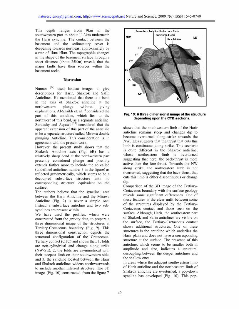
This depth ranges from 9km in the southwestern part to about 11.3km underneath the Harir syncline. The contact between the basement and the sedimentary cover is deepening towards northeast approximately by a rate of 1km/15km. The topographic changes in the shape of the basement surface through a short distance (about 25Km) reveals that the major faults have their sources within the basement rocks.
Discussion
Numan [24] used landsat images to give descriptions for Harir, Shakrok and Safin Anticlines. He mentioned that there is a bend in the axis of Shakrok anticline at the northwestern plunge without giving explanations. Al-Shaikh et. al.[1] considered the part of this anticline, which lies to the northwest of this bend, as a separate anticline. Surdashy and Aqrawi [25] considered that the apparent extension of this part of the anticline to be a separate structure called Mirawa double plunging Anticline. This consideration is in agreement with the present work. However, the present study shows that the Shakrok Anticline axis (Fig. 6B) has a relatively sharp bend at the northwestern part presently considered plunge and possibly extends farther more to include the so called (undefined anticline, number 3 in the figure) as reflected gravimetrically, which seems to be a decoupled subsurface structure with no corresponding structural equivalent on the surface. The authors believe that the synclinal area between the Harir Anticline and the Mirawa Anticline (Fig. 2) is never a simple one. Instead a subsurface anticline and two sub-synclines are present within. We have used the profiles, which were constructed from the gravity data, to prepare a three dimensional image of the structures at Tertiary-Cretaceous boundary (Fig. 9). This three dimensional construction depicts the structural configuration of the Cretaceous-Tertiary contact (CTC) and shows that; 1, folds are non-cylindrical and change along strike (NW-SE), 2, the folds are asymmetrical with their steepest limb on their southwestern side, and 3, the syncline located between the Harir and Shakrok anticlines widens northwestwards to include another inferred structure. The 3D image (Fig. 10) constructed from the figure 7
shows that the southwestern limb of the Harir anticline remains steep and changes dip to become overturned along strike towards the NW. This suggests that the thrust that cuts this limb is continuous along strike. This scenario is quite different in the Shakrok anticline, whose northeastern limb is overturned suggesting that here; the back-thrust is more active than the fore-thrust. Towards the NW along strike, the northeastern limb is not overturned, suggesting that the back-thrust that cuts this limb is either discontinuous or change dip. Comparison of the 3D image of the Tertiary-Cretaceous boundary with the surface geology reveals some significant differences. One of these features is the clear unfit between some of the structures displayed by the Tertiary-Cretaceous contact and those seen on the surface. Although, Harir, the southeastern part of Shakrok and Safin anticlines are visible on the surface, the Tertiary-Cretaceous contact shows additional structures. One of these structures is the anticline which underlies the Harir plain and does not have a corresponding structure at the surface. The presence of this anticline, which seems to be smaller both in amplitude and size, indicates a structural decoupling between the deeper anticlines and the shallow ones. In areas where the adjacent southwestern limb of Harir anticline and the northeastern limb of Shakrok anticline are overturned, a pop-down syncline has developed (Fig. 10). This pop-
49

[email protected], http://www.sciencepub.net Nature and Science, 2009 7(6) ISSN 1545-0740
down syncline is bounded on either side by thrust faults. Normally, in this area, a narrow syncline is formed. In order to roughly estimate the amount of shortening in this area, the geological sections of figure 7 were restored by bed-length balancing assuming area conservation (Fig. 11). The restored sections show that the area has shortened by 14-29.5 % by folding and thrusting, during the Zagros Orogeny. Since it is not possible to deduce the amount of displacement along the thrusts from the gravity data, it is not possible to distinguish the amount of shortening by thrusting from the shortening by folding. In addition, it is not possible to estimate the amount of shortening by penetrative strain, i.e., tectonic compaction
[26]. As such, the calculated value (14-29.5 %) is a lower estimate. However, the value provided here fits well with estimates produced for other parts of Zagros [27-30].
Hydrogeologists face problems when drilling water wells in the Harir plain. These problems according to this study may stem from two reasons; the first is that the most important aquifer yielding good amounts of water, which is the aim of the drillings, is being the karstified Bekhme Formation. This study shows that this formation is too deep to be reached for that purpose in addition to its rough and sharply undulated surface. The second reason is the presence of at least two
sets of minor relatively shallow faults. These faults, if leaking, may destroy some of the present aquifers in the area. However, even though these faults may render some of the aquifers obsolete, the anticlinal crests, which take the Bakhme formation to shallower level, may still act as aquifers and host significant amount of water. This is of course of great significance for petroleum exploration in the area as well. Correspondence to: Hemin A. Koyi Department of Earth Sciences Uppsala University, Uppsala, Sweden [email protected] -------------------------------------------------------
References 1-Al-Shaikh, Z.D., Saleh, S.A. and Abdu H.F., 1975. Contribution to the geology of Shaqlawa-Hareer area, Iraqi Geol. Soc. (Special issue): 55-67. 2- Sayyab, A. and Valek, R., 1968. Pattern and general properties of the gravity field of Iraq, 23rd international Geol. Cong. Czechoslovakia, 5: 129-142. 3- Ghaib, F.A., 2001. Geophysical study of Erbil and Aqra plains and their geological inplications, Unp. Ph.D. thesis, Salahaddin University, Erbil, Iraq. 185p. 4- Hamid, H.I., 1995. Reconnaissance gravity traverse between Mosul and Hareer plain (N-Iraq), Unp. M.Sc. thesis, Mosul University, Iraq, 115p. 5- Al-Shaikh, Z.D. and Mohammed, Z.S., 1997. An interpretation of gravity anomalies over the Tertiary basins of Shaqlawa-Hareer area using variable density-depth function, Iraqi Geol. Soc., 30 (2): 77-84. 6- Jassim, S.Z. and Goff, J.C., 2006. Geology of Iraq, First Edition, Prague and Moravian, Zelny trh 6, Brno, Czeck Republiq, 345P. 7- Sissakian, V. and Youkhanna, R., 1978. Report on regional geological mapping of Erbil-Shaqlawa- Quwaisanjaq-Raidar area, Unp. Rep. No. 975, D.G. of Geol. Sur. And Mineral Investigation library, Baghdad, Iraq, 13p. 8- Jassim, S.Z. and Sissakian, V., 1978. Field guide to the geology of Salahaddin-Shaqlawa area, NE-Iraq, Geol. Soc. Iraq, 5th Geol. Cong., Baghdad: 25-33.
50

[email protected], http://www.sciencepub.net Nature and Science, 2009 7(6) ISSN 1545-0740
51
9- Dosky, J.A.H., 2002. Structural study along selected sections across Safin Anticline, Unp. M.Sc. thesis, Salahaddin University, Erbil, Iraq, 155p. 10- Murray, A.S. and Tracey, R.M., 2003. Basic practice in gravity surveying, Australian Geological Survey Organization (AGSO), (htpp://www.agso.gov.au/) 11-Al-Dawoody, A.N., 2004. Gravity study in the Harir area/ Iraqi Kurdistan Region, Unp. M.Sc. thesis/ Salahaddin University, Erbil, Iraq, 90p. 12-Parasnis, D.S., 1997. Principles of applied geophysics, Chapman and Hall, Fifth ed., 429p. 13-Ghaib, F. A., 2005. Resistivity survey in Shakrok Syncline/ East of Erbil City (Iraqo Kurdistan Region), 1st int. Scien. Con. for Environment. South Valley University (Egypt): 62-75. 14- Griffin, W.R., 1949. Residual gravity in theory and practice, Geophysics, 14: 39-56. 15- Elkins, T.A., 1951. The second derivative method of gravity interpretation, Geophysics, 16: 29-50 16- Reynolds, J.M., 1997. An introduction to geophysical and invironmental geophysics, John Wiley and sons, 796p. 17- Numan, N.M.S. and Al-Azzawi, N.K.B., 1993. Structural and geotectonic interpretation of vergence directions of Anticlines in the Foreland Folds of Iraq, Abhath-Yarmouk, Jordin, 2(2): 57-73. 18- Ghaib, F. A., 2004. Geo-electrical investigation in Harir plain northeast of Erbil City, Iraqi Journal of Earth Sciences, 4(2), 31-43, Mosul University (Iraq). 19- Dobrin, M.B. (1976): Introduction to geophysical prospecting, McGraw Hill book company, 630p. 20- Nettelton, L.L., 1983. Elementary gravity and magnetics for geologists and seismologists, Soc. Expl. Geophysics, Monographs, Tusla, USA. 121p. 21- Sleep, N.H. and Fujitta, K., 1997. Principles of geophysics,Blackwell Sc. Massachuesetts, USA, 586p. 22- Geoffery, A., Phelps, E.B., Jewel, V.E., Langenheim and .Jachens R..C., 2000. Principal
facts for gravity stations in the vicinity of Coyote Spring Valley, Nevada, with initial gravity modeling results, US Department of the Interior, US Geological Survey, Open-File Report 01-375, 15p. 23- Talwani, M., Worzel, J.L. and Landsman, K., 1959. Rapid gravity computation for two dimensional bodies with application to the Mendacino submarine fracture zone, Geoph. Research 64: 49-59. 24- Numan, N.M.S., 2002. Tectonic investigation in Northern Iraq; Internal report, FAO, Erbil, Iraq, 65p. 25- Surdashy A. and Aqrawi A., 2001. Geology of Harir and Shqlawa areas, Internal Report, FAO (GWU) (Northern Iraq Office), 89p 26- Koyi, H. A., 2000. Towards dynamic restoration of geologic profiles; some lessons from analogue models. In; Geology and Geophysics of continental margins 27- Blanc. E. J., Allen, M.B. and Hassani, H., 2003. Structural styles in the Zagros Simple Folded Zone, Iran Journal of the Geological Society, 160(3): 401-412. 28- Bahroudi, A. and Koyi H.A., 2003. Effect of spatial distribution of Hormuz salt on deformatikon style in the Zagros fold-thrust belt, Journal of the Geological Society of London, 160: 719-733. 29- Hatzfeld,D., Tatar, M. Priestley, K. and Ashtiany, M., 2003. Seismological constraints on the crustal structure beneath the Zagros Mountain belt (Iran), Geophysical-Journal-International, 155(2): 403-410 30- Hessami, K., Koyi, H. A., Talbot, C.J., Tabasi, T. and Shabanian, E., 2001. New timing of the Zagros orogeny in the Simply Folded Zone. Journal of the Geological Society of London, 158: 969-981. 4/7/2009 .