Embed Size (px)
Citation preview
GEOLOGY
VOL. 34, NO. 4
CONTENTS
Say hello to TAGIC .................................................................................. 1The Birdsboro basin................................................................................. 2Pennsylvania’s Master Well Owner Network ............................................... 12Announcement—Geologic publications on sale ....................................... 14Earth science teachers’ corner—The Pennsylvania Rock Hound Kit ....... 15
ON THE COVER
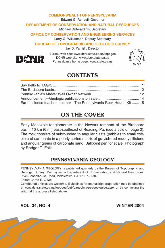
Early Mesozoic fanglomerate in the Newark remnant of the Birdsborobasin, 10 km (6 mi) east-southeast of Reading, Pa. (see article on page 2).The rock consists of subrounded to angular clasts (pebbles to small cob-bles) of carbonate in a poorly sorted matrix of grayish-red muddy siltstoneand angular grains of carbonate sand. Ballpoint pen for scale. Photographby Rodger T. Faill.
PENNSYLVANIA GEOLOGY
PENNSYLVANIA GEOLOGY is published quarterly by the Bureau of Topographic andGeologic Survey, Pennsylvania Department of Conservation and Natural Resources,3240 Schoolhouse Road, Middletown, PA 17057–3534.Editor: Caron E. O’Neil.Contributed articles are welcome. Guidelines for manuscript preparation may be obtainedat www.dcnr.state.pa.us/topogeo/pub/pageolmag/pageolguide.aspx or by contacting theeditor at the address listed above.
VOL. 34, NO. 4 WINTER 2004
DEPARTMENT OF CONSERVATION AND NATURAL RESOURCESBUREAU OF TOPOGRAPHIC AND GEOLOGIC SURVEY
IN COOPERATION WITH THE U.S. GEOLOGICAL SURVEYTOPOGRAPHIC MAPPING
GROUNDWATER-RESOURCE MAPPING
Main Headquarters3240 Schoolhouse RoadMiddletown, PA 17057–3534717–702–2017FAX: 717–702–2065
Pittsburgh Office500 Waterfront DrivePittsburgh, PA 15222–4745412–442–4235FAX: 412–442–4298
BUREAU STAFF AND TELEPHONE NUMBERSDirector and State GeologistJay B. Parrish, P.G. 717–702–2053
Assistant DirectorSamuel W. Berkheiser,
Jr., P.G. 717–702–2055
Administrative ServicesLynn M. Goodling 717–702–2054Elizabeth C. Lyon 717–702–2063
Library ServicesRichard C. Keen 717–702–2020Lewis L. Butts, Jr. 717–702–2018
Publication ServicesJody R. Zipperer
(General Inquiries) 717–702–2073Christine E. Miles, P.G. 717–702–2044Caron E. O’Neil, P.G. 717–702–2042Anne B. Lutz, P.G. 717–702–2043
Local Government Outreach ServicesKristen L. Hand (East) 717–702–2047Jaime Kostelnik (West) 412–442–5828
Database ServicesCheryl L. Cozart 412–442–4234Janice Hayden 412–442–4287Joseph E. Kunz 412–442–4235Lynn J. Levino 412–442–4299Karen L. McCoy (Oil and
Gas GIS Services) 412–442–5826
GIS ServicesMichael E. Moore, P.G. 717–702–2024John H. Barnes, P.G. 717–702–2025
GIS Services (continued)Thomas G. Whitfield, P.G. 717–702–2023Stuart O. Reese, P.G. 717–702–2028
Water Well ServicesSharon E. Fesus 717–702–2074Jody R. Zipperer 717–702–2073
Groundwater ServicesGary M. Fleeger, P.G. 717–702–2045Thomas A. McElroy, P.G. 717–702–2046
Geologic Mapping ServicesGale C. Blackmer, P.G. 717–702–2032Helen L. Delano, P.G. 717–702–2031Clifford H. Dodge, P.G. 717–702–2036William E. Kochanov, P.G. 717–702–2033James R. Shaulis, P.G. 717–702–2037Viktoras W. Skema, P.G. 717–702–2035
Laboratory and Geochemical ServicesRobert C. Smith, II, P.G. 717–702–2021
Coal-Bed Methane ServicesAntonette K. Markowski,
P.G. 717–702–2038
Coal Quality and Availability ServicesRodger T. Faill, P.G. 717–702–2041Leonard J. Lentz, P.G. 717–702–2040John C. Neubaum 717–702–2039
Oil, Gas, and Subsurface GeologicalServicesJohn A. Harper, P.G. 412–442–4230Christopher D. Laughrey 412–442–4232Joseph R. Tedeski 412–442–4295Kristin M. Carter, P.G. 412–442–4233
COMMONWEALTH OF PENNSYLVANIAEdward G. Rendell, Governor
DEPARTMENT OF CONSERVATION AND NATURAL RESOURCESMichael DiBerardinis, Secretary
OFFICE OF CONSERVATION AND ENGINEERING SERVICESLarry G. Williamson, Deputy Secretary
BUREAU OF TOPOGRAPHIC AND GEOLOGIC SURVEYJay B. Parrish, Director
Bureau web site: www.dcnr.state.pa.us/topogeoDCNR web site: www.dcnr.state.pa.us
Pennsylvania home page: www.state.pa.us
STATE GEOLOGIST’S EDITORIAL
Say Hello to TAGIC
As our name implies, we map both the geology and the topog-raphy of the commonwealth. I have been pushing the topographicmapping aspect of our mission for the first three years of my tenure.As a result, we have a PAMAP program in place, which has been gen-erously supported by DCNR as well as many other state agencies.This year we have plans to fly 28 of our state’s 67 counties. Thismeans that we will soon have more than half the state done. On asimilar note, we have worked with the U.S. Department of Agricultureto upgrade their annual flight of color infrared orthoimagery. The DCNRBureau of Forestry supplied most of the funding for this upgrade. Soas of today, we have a “snapshot” of the commonwealth. This is par-ticularly useful for monitoring land-use change over time.
So, you may say, enough on the air photos already. Well, I haveto agree. What are we going to do about mapping those rocks? Onestep we are taking is to implement a revision of a program startedmany years ago. The idea is to collect geologic information that isephemeral, such as from road cuts, before they get grown over, orfrom open mines, before they are reclaimed.
The Temporarily Available Geologic Information Collection (TAGIC)program will encourage our staff to document sinkholes, road cuts,landslides, and other transient geologic sites and enter the informa-tion into our newly emerging, comprehensive database. The results
should be that more of our staff will be doinggeologic mapping and that fewer items ofgeologic interest will slip by undocumented.TAGIC should help us do for geology whatis in progress for topography. And since wecannot be everywhere, please assist us bybringing these temporary phenomena to ourattention.
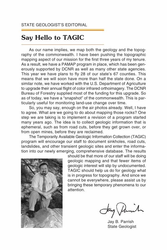
Jay B. ParrishState Geologist
2
The Birdsboro Basin
by Rodger T. FaillBureau of Topographic and Geologic Survey
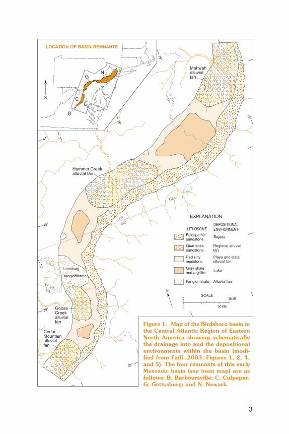
INTRODUCTION. A swath of predominantly red rocks crosses south-eastern Pennsylvania, weathering into a distinctive red soil. This swath,commonly called the Triassic basin, is part of a long, sinuous belt thatreaches from southern New York, across New Jersey, Pennsylvania,and Maryland, and into Virginia. This belt is what remains of a 200-million-year-old sedimentary trough, the Birdsboro basin (Figure 1),which formed prior to the opening of the Atlantic Ocean. The Birdsborobasin (Faill, 2003) began forming approximately 225 million years ago(Ma) at the beginning of the Late Triassic Period, and it gradually en-larged and filled for some 35 million years before being tilted, faulted,and folded in the latter part of the Early Jurassic Period (approximately180 Ma). Subsequent erosion has left us with four basin remnants:the Newark (New York to Pennsylvania), Gettysburg (Pennsylvaniaand Maryland), Culpeper (Virginia), and Barboursville (Virginia) rem-nants (Figure 1, inset map).
The four deformed and eroded basin remnants we see today arequite different from the early Mesozoic Birdsboro basin from whichthey came. The Birdsboro basin was a single continuous trough. Depo-sitionally, this sinuous, elongate basin was complex. Sediment input byfluvial processes from both sides produced large, near-margin alluvialfans; yet the differences in provenance and stream geometry producedmarkedly different sediment bodies. In addition, the finer grained frac-tions of sediment (the muds) were winnowed from these high-energyenvironments and carried by axial currents to quieter parts of the basin.This pattern pervades all four remnants.
ORIGIN OF THE BIRDSBORO BASIN. About 225 Ma, the Appala-chian Mountain system created by the Alleghany orogeny some 25 to30 million years earlier was still an impressive mountain chain, albeitreduced through erosion from its initial Himalayan-like dimensions. Themountain core, passing just southeast of Pennsylvania, across NewJersey and eastern Maryland, is now largely covered by the AtlanticCoastal Plain sediments. But at the beginning of the Late Triassic, themountain core still stood exposed some 2 to 4 km (1 to 3 mi) in ele-
3
Figure 1. Map of the Birdsboro basin inthe Central Atlantic Region of EasternNorth America showing schematicallythe drainage into and the depositionalenvironments within the basin (modi-fied from Faill, 2003, Figures 1, 2, 4,and 5). The four remnants of this earlyMesozoic basin (see inset map) are asfollows: B, Barboursville; C, Culpeper;G, Gettysburg; and N, Newark.
4
vation, and the streams and rivers on it flowed northwestward acrossNew Jersey, Pennsylvania, Maryland, and Virginia.
At that time, the crust under the Appalachian Mountains began toextend in a northwest-southeast direction, causing the mountain sys-tem to slowly descend. But the descent was not even. Unknown crustalinhomogenieties caused accelerated subsidence along a northeast-southwest-trending belt on the northwest side of the mountain core,resulting in a trough at the surface. This trough was the beginning ofthe Birdsboro basin.
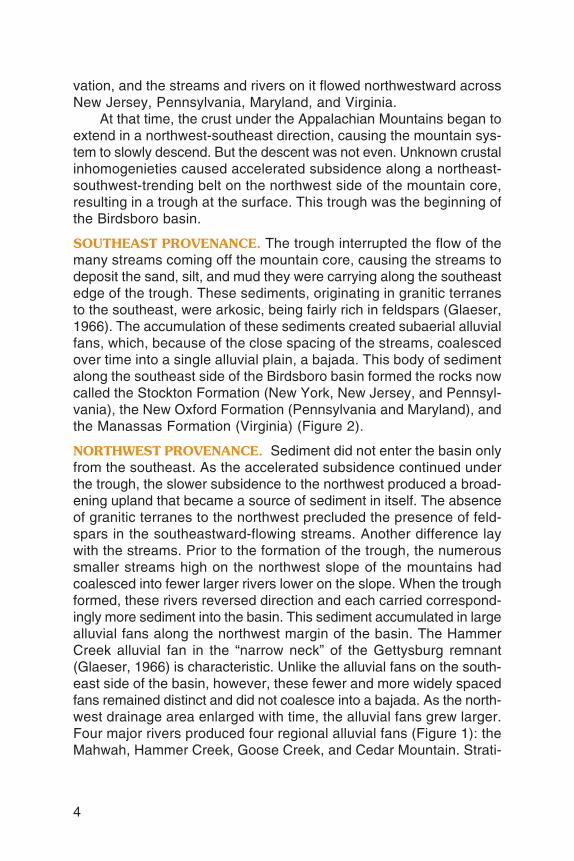
SOUTHEAST PROVENANCE. The trough interrupted the flow of themany streams coming off the mountain core, causing the streams todeposit the sand, silt, and mud they were carrying along the southeastedge of the trough. These sediments, originating in granitic terranesto the southeast, were arkosic, being fairly rich in feldspars (Glaeser,1966). The accumulation of these sediments created subaerial alluvialfans, which, because of the close spacing of the streams, coalescedover time into a single alluvial plain, a bajada. This body of sedimentalong the southeast side of the Birdsboro basin formed the rocks nowcalled the Stockton Formation (New York, New Jersey, and Pennsyl-vania), the New Oxford Formation (Pennsylvania and Maryland), andthe Manassas Formation (Virginia) (Figure 2).
NORTHWEST PROVENANCE. Sediment did not enter the basin onlyfrom the southeast. As the accelerated subsidence continued underthe trough, the slower subsidence to the northwest produced a broad-ening upland that became a source of sediment in itself. The absenceof granitic terranes to the northwest precluded the presence of feld-spars in the southeastward-flowing streams. Another difference laywith the streams. Prior to the formation of the trough, the numeroussmaller streams high on the northwest slope of the mountains hadcoalesced into fewer larger rivers lower on the slope. When the troughformed, these rivers reversed direction and each carried correspond-ingly more sediment into the basin. This sediment accumulated in largealluvial fans along the northwest margin of the basin. The HammerCreek alluvial fan in the “narrow neck” of the Gettysburg remnant(Glaeser, 1966) is characteristic. Unlike the alluvial fans on the south-east side of the basin, however, these fewer and more widely spacedfans remained distinct and did not coalesce into a bajada. As the north-west drainage area enlarged with time, the alluvial fans grew larger.Four major rivers produced four regional alluvial fans (Figure 1): theMahwah, Hammer Creek, Goose Creek, and Cedar Mountain. Strati-
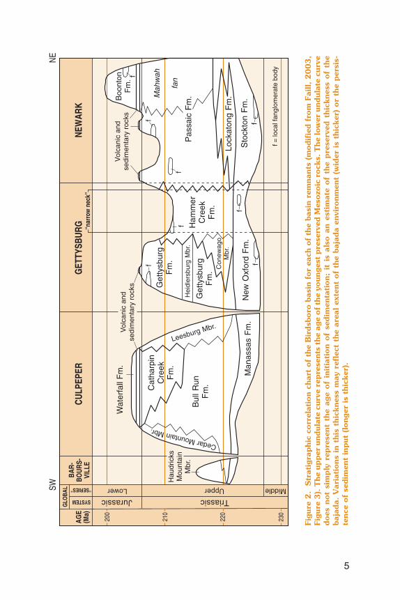
5
Figu
re 2
.S
trat
igra
ph
ic c
orr
elat
ion
ch
art
of
the
Bir
dsb
oro
bas
in f
or
each
of
the
basi
n r
emn
ants
(m
od
ifie
d f
rom
Fai
ll,
20
03
,Fi
gure
3).
Th
e up
per
un
dul
ate
curv
e re
pre
sen
ts t
he
age
of
the
youn
gest
pre
serv
ed M
eso
zoic
ro
cks.
Th
e lo
wer
un
dul
ate
curv
ed
oes
no
t si
mp
ly r
epre
sen
t th
e ag
e o
f in
itia
tio
n o
f se
dim
enta
tio
n;
it i
s al
so a
n e
stim
ate
of
the
pre
serv
ed t
hic
knes
s o
f th
eba
jad
a. V
aria
tio
ns
in t
his
th
ickn
ess
may
ref
lect
th
e ar
eal
exte
nt
of
the
baja
da
envi
ron
men
t (w
ider
is
thic
ker)
or
the
per
sis-
ten
ce o
f se
dim
ent
inp
ut (
lon
ger
is t
hic
ker)
.
6
graphically, these fans correlate respectively with the northeast sideof the Passaic Formation in New Jersey, the Hammer Creek Forma-tion in Pennsylvania, the Catharpin Creek Formation in northern Vir-ginia, and the Haudricks Mountain and Cedar Mountain Members ofthe Bull Run Formation in central Virginia (Faill, 2003; Figure 2).
QUIETER ENVIRONMENTS WITHIN THE BASIN. The coarse- tomedium-grained fluvial sediments (sands and silts) that entered theelongate Birdsboro basin from both sides accumulated in the alluvialfans and the alluvial plain. The finer grained sediments (muds) werewinnowed and carried by axial currents from these high-energy environ-ments to low-energy areas. The low-energy areas, dominated by lakeand playa environments, lay between the alluvial fans and extended forsome distance from the bajada along the southeast margin (Figure 1).The bodies of fine-grained sediments formed rocks found in the present-day Lockatong Formation (New Jersey and Pennsylvania), PassaicFormation (New York, New Jersey, and Pennsylvania), Gettysburg For-mation (Pennsylvania and Maryland), and Bull Run Formation (Mary-land and Virginia) (Figure 2).
The gray and red shales, mudstones, and argillites that fill the quietareas exhibit remarkable features. An extensive interlayering exists be-tween the coarser grained rocks of the alluvial fans and bajada and thefine-grained rocks of the playas and lakes. The gradual decrease ingrain size in general is a function of distance from input area, but the in-terlayering reflects climatic changes (predominantly moisture) as wellas fluctuation in the volume and content of the incoming sediment. Theclimatic influence appears to be the more dominant factor because apervasive cyclicity persists through most of the rocks in the quieterareas (Van Houten, 1964; Olsen, 1986; Smoot, 1991), a cyclicity con-trolled by the astronomical Milankovitch cycles (Van Houten, 1969;Olsen, Kent, and others, 1996). In the wetter parts of the cycles, thelakes expanded onto the distal margins of the alluvial fans; during thedrier periods, the lakes shrank, leaving behind playa conditions.
There are two remarkable aspects of the climatic cycles: (1) thecyclicity persisted for more than 25 million years, and (2) many of thecycles can be traced for over 100 km (60 mi), from one alluvial fanto the next. These two aspects strongly imply that the basin was tec-tonically quiescent for most, if not all, of its history.
But this seems at odds with the prevailing view of these early Meso-zoic basins—they are generally considered to be rift basins formed byactive, syndepositional faulting at the down-dip margins (the marginstoward which the bedding dips). The primary features used to support
7
this view are the coarse-grained, poorly sorted fanglomerates foundalong the basin margins.
THE FANGLOMERATES. The fanglomerates are one of the more in-teresting deposits in the Birdsboro basin. They are small, rarely extend-ing more than 2 or 3 km (1 or 2 mi) from the basin margin. They arecommonly no more than 200 to 300 m (600 to 1,000 ft) thick. Theycontain numerous pebbles and cobbles (rarely more than 10 cm [4 in.]in size) floating in a matrix of (generally) red mud and silt (see frontcover). This texture is very different from those of the fluvial depositsfound throughout the basin. The large clasts and poor sorting sug-gest that these deposits formed as debris flows rather than by fluvialprocesses. These debris flows probably originated in flash-flood run-offs from occasional cloudbursts, runoffs that entrained any colluvialor alluvial material that had accumulated just outside the basin. Theseslurries of cobbles, pebbles, silt, and mud rushed into the basin, butonly for a short distance; the flash floods could not sustain the waterflow and energy necessary to spread the larger clasts any farther.
The Birdsboro fanglomerates are of two principal varieties—quartz-ose and carbonate. The clasts in the quartzose fanglomerates consistprimarily of vein quartz, quartzites, and felsic gneisses. The clasts tendto be well rounded, indicating that they have probably traveled a con-siderable distance (tens of kilometers). In addition, many of the gneissesare not represented in nearby outcrops, further indicating a distantsource. In contrast, many of the limestone and dolomite clasts of thecarbonate fanglomerates are subrounded to angular, suggesting amore proximal source. Given the arid to semiarid climate of that time,carbonate terranes outside the basin would have been hilly. They wouldhave weathered mechanically, shedding angular fragments that accu-mulated at the foot of slopes as colluvial deposits and were availablefor entrainment in the occasional flash floods.
The Leesburg fanglomerate, which is represented today by theLeesburg Member of the Bull Run Formation in Virginia (Figure 2),was an exceptionally large fanglomerate, extending for 55 km (35mi) along the basin margin and 30 km (20 mi) across the basin (Fig-ure 1). The clasts in this fanglomerate are angular carbonate peb-bles, cobbles, and even a few small boulders. It probably originatedin a large carbonate terrain away from the major rivers.
IMPLICATIONS FOR BASIN TECTONICS. The fanglomerates did notcontribute much sediment to the Birdsboro basin, but their presencesheds light on the development of the basin. Most geologists acceptthe presumption that the presence of fanglomerates indicates syn-
depositional faulting at the margin of a basin—that fanglomerates formonly at the foot of a rising fault scarp (e.g., Russell, 1892, p. 83; Barrell,1915; and Kay, 1951). However, the fanglomerates are present on bothsides of the Birdsboro basin, on the updip, nonfaulted southeast sideas well as on the downdip northwest side. Clearly, fanglomerates canbe produced by some mechanism other than faulting, such as the geo-morphic process described at the end of the previous paragraph.
Several other aspects indicate that faulting did not occur duringbasin filling. First, seismic and drilling data indicate that the basin floornear the northwest margin dips 25 degrees to the southeast, not a steepdip to the northwest as would be expected in a half graben. Second,faults are present along some parts of the northwest margin, but else-where the sinuous trace of the margin suggests an overlap relation.Third, the basin floor is exposed next to the northwest margin—in a halfgraben, the basin floor would be at 5 to 7 km (3 to 4 mi) depth. Fourth,the faults that are present offset and truncate Jurassic rocks and ter-minate downsection—nowhere can Triassic movement be confirmed.And fifth, the tectonic quiescence implicit from the subtle Milankovitchcyclicity is not consistent with episodic fault movements. These aspectsindicate that the Birdsboro basin developed as a nonfaulted troughthrough simple crustal downwarping (Figure 3A).
JURASSIC IGNEOUS EPISODE AND SEDIMENTATION. The Birds-boro basin experienced an episode of igneous activity just after thebeginning of the Jurassic Period (note the volcanic layer in Figure 2).The activity was fairly short-lived, lasting for approximately 600,000years (Olsen, Schlische, and Fedosh, 1996). The igneous rocks wereemplaced in three forms: as volcanic rocks on the surface of the basin,as intrusive sills (thick, subhorizontal sheets), and as subvertical dikes(Smith and others, 1975). Igneous rocks are present in one or moreof these forms throughout the Newark, Gettysburg, and Culpeperbasin remnants, and as dikes through much of the surrounding pre-Mesozoic terranes. The igneous rocks are tholeiitic basalts, similar incomposition to coeval igneous rocks to the northeast and southwestalong the Central Atlantic margin.
Sedimentation continued in the basin during the igneous episodeand thereafter. Coarse-grained sediment entered predominantly fromthe northwest. Lacustrine conditions persisted throughout much of thebasin (the Jurassic climatic cycles are markedly thicker), and fanglom-erates accumulated near the basin’s northwest margin. The Jurassicfanglomerates contain basaltic fragments, which suggests that the
8
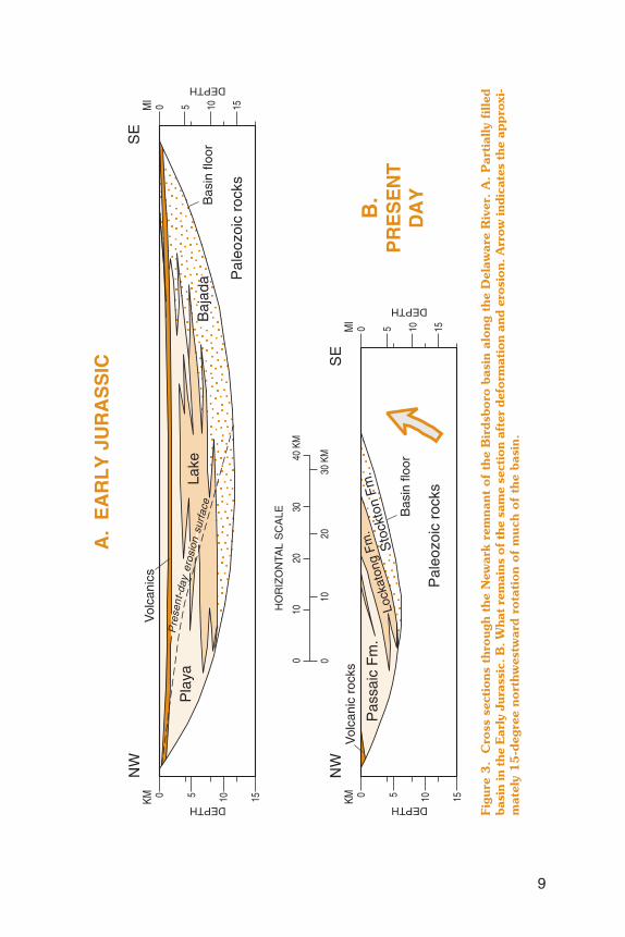
9
Figu
re 3
.C
ross
sec
tio
ns
thro
ugh
th
e N
ewar
k re
mn
ant
of
the
Bir
dsb
oro
bas
in a
lon
g th
e D
elaw
are
Riv
er.
A.
Par
tial
ly f
illed
basi
n in
the
Ear
ly J
uras
sic.
B.
Wha
t re
mai
ns o
f th
e sa
me
sect
ion
afte
r de
form
atio
n an
d er
osio
n. A
rrow
indi
cate
s th
e ap
pro
xi-
mat
ely
15
-deg
ree
no
rth
wes
twar
d r
ota
tio
n o
f m
uch
of
the
basi
n.
volcanic flows had spread some distance beyond the basin marginand correspondingly that the topographic relief must have been lowthere. The youngest sediments of the Birdsboro basin, present only inthe Newark remnant (Figure 2), are of Sinemurian age (approximately200 Ma) within the Early Jurassic. The Birdsboro basin may have con-tinued to fill past this time, but no direct evidence of such sedimentsare preserved.
POSTDEPOSITIONAL BASIN DEFORMATION. The four present ba-sin remnants are quite different from the simple downwarp that con-tained the Birdsboro basin. Clearly, some tectonic activity occurredpostdepositionally. The most prominent, widespread structure is themonoclinal tilt of bedding—in each remnant, bedding dips generallyto the northwest (Figure 3B). The amount of dip varies between andwithin each remnant, from as low as 5 or 10 degrees to as much as60 degrees. Across some parts of the remnants, the dip is constant,from the oldest beds on the southeast margin to the youngest on thenorthwest. The unconformity along all the southeast margins and theabsence of any faulting (excepting a few small cross faults) indicatesthat the crust under the basin remnants was tilted as well. So the rem-nant rotation (tilt) reflects a fairly widespread crustal tectonism.
Faults are quite common within the remnants. Some lie along thenorthwest margin, some cross one or the other margin, and some areintrabasinal. The faults are predominantly of the normal type, althoughstrike-slip and even a few small thrust faults are present. Displace-ments range from a few meters to more than 3 km (2 mi). Althoughfaults offset the oldest as well as the youngest rocks in the basin, theywere not active during sedimentation—the movements were all post-depositional. In addition to the faults, open folds (some with axial-planecleavage) occur along the northwest margin in the Newark remnant.These folds encompass the youngest preserved rocks.
It is quite evident that all the deformation of the Birdsboro basinwas postdepositional, occurring sometime after the early Sinemurian(Faill and Smith, 2003). When one looks for a crustal event that couldhave caused the tilting, faulting, and folding, the only significant post-Sinemurian event is the opening of the Atlantic Ocean late in the EarlyJurassic. It appears that the separation of North America from Africareleased the attenuating crustal stresses, producing a crustal reboundthat deformed the Birdsboro basin. Erosion since that time (mainlythrough the remainder of the Jurassic, the Cretaceous, and the Ter-tiary) has removed a large volume of the original basin, leaving uswith the deformed remnants we see today.
10
SUMMARY. The Birdsboro basin formed as a sinuous, linear troughon the northwest side of the Appalachian orogen through simple down-warping in the Late Triassic. Sediment entered the basin from boththe northwest and southeast, creating large alluvial fans and a bajada.The finer grained sediment passed through these higher energy environ-ments and settled in quieter lakes and playas. Late in the Early Juras-sic, in conjunction with the opening of the Atlantic Ocean farther to theeast, the basin was tilted and deformed by faults and folds. Erosion sincethat time has left us with the four basin remnants that we see today.
REFERENCES
Barrell, J., 1915, Central Connecticut in the geologic past: Connecticut Geological andNatural History Survey Bulletin 23, 44 p.
Faill, R. T., 2003, The early Mesozoic Birdsboro Central Atlantic margin basin in theMid-Atlantic Region, Eastern United States: Geological Society of America Bulletin,v. 115, p. 406–421.
Faill, R. T., and Smith, R. C., II, 2003, Middle Jurassic deformation of the BirdsboroCAM basin, Mid-Atlantic Region, Eastern U.S.A. [abs.]: Geological Society of AmericaAbstracts with Programs, v. 35, no. 3, p. 16.
Glaeser, J. D., 1966, Provenance, dispersal, and depositional environments of Trias-sic sediments in the Newark-Gettysburg basin: Pennsylvania Geological Survey,4th ser., General Geology Report 43, 168 p.
Kay, Marshall, 1951, North American geosynclines: Geological Society of AmericaMemoir 48, 143 p.
Olsen, P. E., 1986, A 40-million-year lake record of early Mesozoic orbital climaticforcing: Science, v. 234, p. 842–848.
Olsen, P. E., Kent, D. V., Cornet, Bruce, and others, 1996, High-resolution stratigraphyof the Newark rift basin (early Mesozoic, Eastern North America): Geological So-ciety of America Bulletin, v. 108, p. 40–77.
Olsen, P. E., Schlische, R. W., and Fedosh, M. S., 1996, 600 ky duration of the EarlyJurassic flood basalt event in Eastern North America estimated using Milankovitchcyclostratigraphy, in Morales, M., ed., The continental Jurassic: Museum of North-ern Arizona Bulletin, v. 60, p. 11–22.
Russell, I. C., 1892, The Newark System: U.S. Geological Survey Bulletin 85, 344 p. Smith, R. C., II, Rose, A. W., and Lanning, R. M., 1975, Geology and geochemistry
of Triassic diabase in Pennsylvania: Geological Society of America Bulletin, v. 86,p. 943–955.
Smoot, J. P., 1991, Sedimentary facies and depositional environments of early Meso-zoic Newark Supergroup basins, Eastern North America: Palaeogeography, Palaeo-climatology, Palaeoecology, v. 84, p. 369–423.
Van Houten, F. B., 1964, Cyclic lacustrine sedimentation, Upper Triassic LockatongFormation, central New Jersey and adjacent Pennsylvania: in Merriam, D. F., ed.,Symposium on cyclic sedimentation: Kansas Geological Survey Bulletin 169, v. 2,p. 497–531.
_______ 1969, Late Triassic Newark Group, north central New Jersey and adjacentPennsylvania and New York, in Subitzky, Seymour, ed., Geology of selected areasin New Jersey and eastern Pennsylvania and guidebook of excursions: New Bruns-wick, N. J., Rutgers University Press, p. 314–347.
11
Pennsylvania’sMaster Well Owner Network
by Jay B. Parrish and Kristin M. CarterBureau of Topographic and Geologic Survey
Think about this: there are approximately 3.5 million residentsthroughout Pennsylvania with private water systems,1 and a majorityof these systems fail at least one drinking water standard.
In August 2004, Kristin Carter, a Bureau staff member, took aneight-hour training course offered by the Penn State CooperativeExtension to become a certified Master Well Owner in the state ofPennsylvania. Kristin owns a home in suburban Washington Countywhere no public water supply is available. As a private well owner witha growing family, she was concerned about the quality, condition, andongoing operation and maintenance of her well.
The training courses offered by the Penn State Cooperative Ex-tension are associated with a program known as the Master WellOwner Network (MWON). This grassroots network was created totrain individuals like Kristin, who in turn volunteer their time to edu-cate the public about private water systems. They do this throughvarious means, including work, social, and volunteer connections.The goal of each Master Well Owner is to personally interact with 100people over a two-year certification period. Your local Master Well Ownercan help you sort through the technical aspects of siting, constructing,and maintaining a private water system, answer questions about test-ing the quality of your water, and offer water conservation tips, amongother things.
The MWON is sponsored by the Penn State Institutes of the En-vironment and is currently funded by the U.S. Department of Agricul-ture, Cooperative State Research, Education and Extension Service.Project partners include the Pennsylvania Groundwater Association,Pennsylvania Department of Environmental Protection, U.S. Environ-mental Protection Agency, and Pennsylvania Rural Water Association.
Given current funding, the MWON program can train up to 240Master Well Owners statewide. Solicitation of new MWON participants
12
1Private water systems include wells, springs, and cisterns.
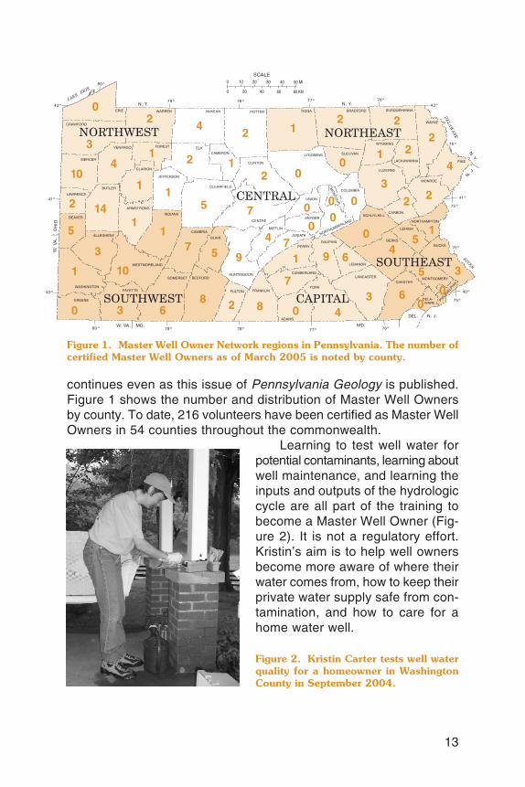
continues even as this issue of Pennsylvania Geology is published.Figure 1 shows the number and distribution of Master Well Ownersby county. To date, 216 volunteers have been certified as Master WellOwners in 54 counties throughout the commonwealth.
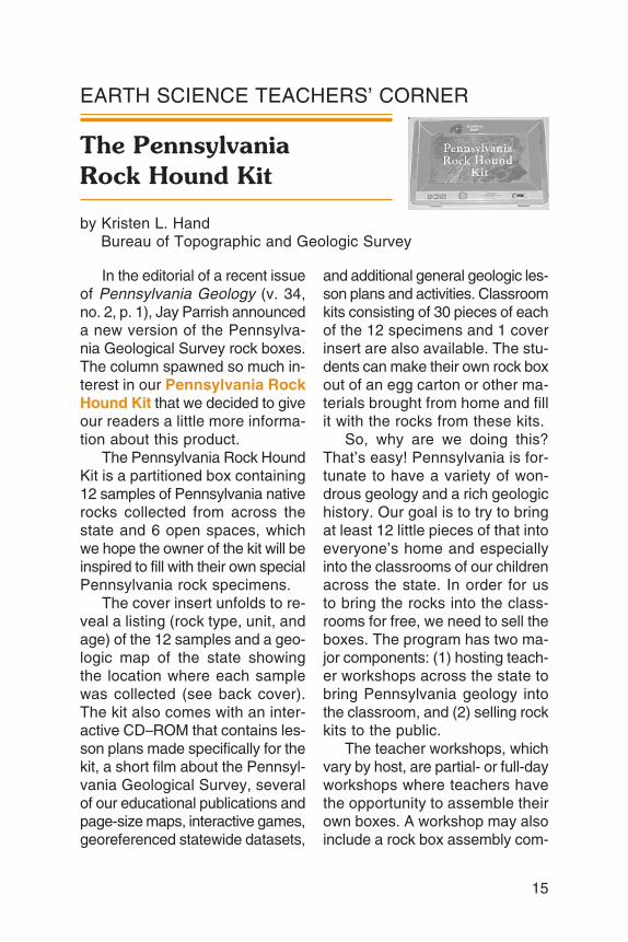
Learning to test well water forpotential contaminants, learning aboutwell maintenance, and learning theinputs and outputs of the hydrologiccycle are all part of the training tobecome a Master Well Owner (Fig-ure 2). It is not a regulatory effort.Kristin’s aim is to help well ownersbecome more aware of where theirwater comes from, how to keep theirprivate water supply safe from con-tamination, and how to care for ahome water well.
13
Figure 2. Kristin Carter tests well waterquality for a homeowner in WashingtonCounty in September 2004.
Figure 1. Master Well Owner Network regions in Pennsylvania. The number ofcertified Master Well Owners as of March 2005 is noted by county.

So think about the source of your drinking water and seek out aMaster Well Owner in your area. Visit the Master Well Owner Net-work’s home on the web at http://mwon.cas.psu.edu/ for additionalinformation.
14
ANNOUNCEMENT
Geologic Publications on SaleRock-Bottom Prices—Limited Time Only!
A warehouse inventory reduc-tion sale on selected publicationsof the Pennsylvania GeologicalSurvey is currently in progress. Fora limited time, dozens of publica-tions will be drastically reducedin price prior to moving our stockto a new warehouse. A list of saletitles and prices is posted on theBureau’s web site at www.dcnr.state.pa.us/topogeo/pub/sale.aspx. The site also contains ad-ditional details about the publica-tions, information on ordering, anda special order form that may beused by customers for the periodof the sale. All publications aresold through the State Bookstore,Commonwealth Keystone Build-ing, 400 North Street, Harrisburg,PA 17120–0053, telephone 717–787–5109. The Bookstore acceptsorders either over the counter orby mail.
The publications vary widely intopic, technical content, geographicarea covered, number of pages or
maps, and year of publication. Forexample, the list includes Atlas144cd, Geology and Mineral Re-sources of the Allenwood and Mil-ton Quadrangles, Union and North-umberland Counties, Pennsylva-nia, printed in 1997 (list price$24.00, sale price $4.00), Environ-mental Geology Report 5, Build-ing Stones of Pennsylvania’s Capi-tal Area, printed in 1977 (list price$1.50, sale price $0.45), and Wa-ter Resource Report 67, Ground-water Resources of Cambria Coun-ty, Pennsylvania, printed in 1998(list price $11.50, sale price $2.35).
To find the publications that areof interest to you, visit our web site.Keep in mind that the list will bechanging. Some titles that are al-ready in low supply will go out ofprint, and others will be removedfrom the sale list as they reach theirtargeted inventory. SO HURRY!Take advantage of these rock-bottom prices and order your pub-lications now!
15
EARTH SCIENCE TEACHERS’ CORNER
The PennsylvaniaRock Hound Kit
by Kristen L. HandBureau of Topographic and Geologic Survey
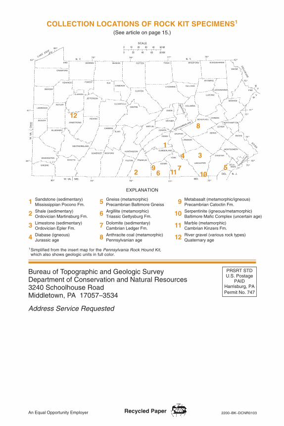
In the editorial of a recent issueof Pennsylvania Geology (v. 34,no. 2, p. 1), Jay Parrish announceda new version of the Pennsylva-nia Geological Survey rock boxes.The column spawned so much in-terest in our Pennsylvania RockHound Kit that we decided to giveour readers a little more informa-tion about this product.
The Pennsylvania Rock HoundKit is a partitioned box containing12 samples of Pennsylvania nativerocks collected from across thestate and 6 open spaces, whichwe hope the owner of the kit will beinspired to fill with their own specialPennsylvania rock specimens.
The cover insert unfolds to re-veal a listing (rock type, unit, andage) of the 12 samples and a geo-logic map of the state showingthe location where each samplewas collected (see back cover).The kit also comes with an inter-active CD–ROM that contains les-son plans made specifically for thekit, a short film about the Pennsyl-vania Geological Survey, severalof our educational publications andpage-size maps, interactive games,georeferenced statewide datasets,
and additional general geologic les-son plans and activities. Classroomkits consisting of 30 pieces of eachof the 12 specimens and 1 coverinsert are also available. The stu-dents can make their own rock boxout of an egg carton or other ma-terials brought from home and fillit with the rocks from these kits.
So, why are we doing this?That’s easy! Pennsylvania is for-tunate to have a variety of won-drous geology and a rich geologichistory. Our goal is to try to bringat least 12 little pieces of that intoeveryone’s home and especiallyinto the classrooms of our childrenacross the state. In order for usto bring the rocks into the class-rooms for free, we need to sell theboxes. The program has two ma-jor components: (1) hosting teach-er workshops across the state tobring Pennsylvania geology intothe classroom, and (2) selling rockkits to the public.
The teacher workshops, whichvary by host, are partial- or full-dayworkshops where teachers havethe opportunity to assemble theirown boxes. A workshop may alsoinclude a rock box assembly com-

16
petition, a geology field trip, anda review of the lesson plans thatwere developed specifically for thekits. On the field trip, participantslearn about local geology—howto bring the geology that is underthe grass in their own backyardinto their curriculum. Lunch is pro-vided for full-day workshops, anddepending on the host, Act 48credits may be offered. Teachersreceive three rock hound kits andone classroom kit. There is nor-mally a small charge to pay forlunch and other related fees. Work-shops will be announced on theBureau’s web site (www.dcnr.state.pa.us/topogeo) as they are offered.
This project was undertakenwith the cooperation of the FieldConference of Pennsylvania Ge-ologists, Pennsylvania Depart-ment of Education, and Pennsyl-vania Aggregates and ConcreteAssociation. None of this wouldhave been possible without theassistance and cooperation of allof our partners.
As was mentioned above, weneed to sell boxes in order to make
the classroom component of theprogram possible. The proceedsof every individual box sold is di-rectly reinvested into producingmore kits to put into classroomsacross the commonwealth. Pur-chasing your new PennsylvaniaRock Hound Kit is simple. You canstop by either one of the two Bu-reau offices (see inside back coverfor addresses) and pick one up for$15. For teachers not attending aworkshop, classroom kits are alsoavailable for $30. Another optionis to order individual or classroomkits and have them mailed to you;just add an additional $4.95 forshipping and handling for each itemordered. Send a check or moneyorder payable to Field Conferenceof Pennsylvania Geologists andyour name, shipping address (noP.O. Box), and items you wish toorder to Kristen Hand, Bureau ofTopographic and Geologic Survey,3240 Schoolhouse Road, Middle-town, PA 17057. For your conve-nience, an order form is availablethrough the classroom link on ourweb site. I am sorry, but we do notaccept credit or debit cards. If youhave any questions, feel free tocontact me at 717–702–2047.
Please join us in our endeavorto bring geology into the homesand classrooms across our geo-logically rich commonwealth andto help everyone to get to knowthe geology of the state by lookingunder the grass in their own back-yards. Buy your Pennsylvania RockHound Kit today!
The Pennsylvania Rock Hound Kit con-tains 12 rock specimens.
CONTENTS
Say hello to TAGIC .................................................................................. 1The Birdsboro basin................................................................................. 2Pennsylvania’s Master Well Owner Network ............................................... 12Pennsylvania Geological Survey holds inventory reduction sale.............. 14Earth science teachers’ corner—The Pennsylvania Rock Hound Kit ....... 15
ON THE COVER
Early Mesozoic fanglomerate in the Newark remnant of the Birdsborobasin, 10 km (6 mi) east-southeast of Reading, Pa. (see article on page 2).The rock consists of subrounded to angular clasts (pebbles to small cob-bles) of carbonate in a poorly sorted matrix of grayish-red muddy siltstoneand angular grains of carbonate sand. Ballpoint pen for scale. Photographby Rodger T. Faill.
PENNSYLVANIA GEOLOGY
PENNSYLVANIA GEOLOGY is published quarterly by the Bureau of Topographic andGeologic Survey, Pennsylvania Department of Conservation and Natural Resources,3240 Schoolhouse Road, Middletown, PA 17057–3534.Editor: Caron E. O’Neil.Contributed articles are welcome. Guidelines for manuscript preparation may be obtainedat www.dcnr.state.pa.us/topogeo/pub/pageolmag/pageolguide.aspx or by contacting theeditor at the address listed above.
VOL. 34, NO. 4 WINTER 2004
DEPARTMENT OF CONSERVATION AND NATURAL RESOURCESBUREAU OF TOPOGRAPHIC AND GEOLOGIC SURVEY
IN COOPERATION WITH THE U.S. GEOLOGICAL SURVEYTOPOGRAPHIC MAPPING
GROUNDWATER-RESOURCE MAPPING
Main Headquarters3240 Schoolhouse RoadMiddletown, PA 17057–3534717–702–2017FAX: 717–702–2065
Pittsburgh Office500 Waterfront DrivePittsburgh, PA 15222–4745412–442–4235FAX: 412–442–4298
BUREAU STAFF AND TELEPHONE NUMBERSDirector and State GeologistJay B. Parrish, P.G. 717–702–2053
Assistant DirectorSamuel W. Berkheiser,
Jr., P.G. 717–702–2055
Administrative ServicesLynn M. Goodling 717–702–2054Elizabeth C. Lyon 717–702–2063
Library ServicesRichard C. Keen 717–702–2020Lewis L. Butts, Jr. 717–702–2018
Publication ServicesJody R. Zipperer
(General Inquiries) 717–702–2073Christine E. Miles, P.G. 717–702–2044Caron E. O’Neil, P.G. 717–702–2042Anne B. Lutz, P.G. 717–702–2043
Local Government Outreach ServicesKristen L. Hand (East) 717–702–2047Jaime Kostelnik (West) 412–442–5828
Database ServicesCheryl L. Cozart 412–442–4234Janice Hayden 412–442–4287Joseph E. Kunz 412–442–4235Lynn J. Levino 412–442–4299Karen L. McCoy (Oil and
Gas GIS Services) 412–442–5826
GIS ServicesMichael E. Moore, P.G. 717–702–2024John H. Barnes, P.G. 717–702–2025
GIS Services (continued)Thomas G. Whitfield, P.G. 717–702–2023Stuart O. Reese, P.G. 717–702–2028
Water Well ServicesSharon E. Fesus 717–702–2074Jody R. Zipperer 717–702–2073
Groundwater ServicesGary M. Fleeger, P.G. 717–702–2045Thomas A. McElroy, P.G. 717–702–2046
Geologic Mapping ServicesGale C. Blackmer, P.G. 717–702–2032Helen L. Delano, P.G. 717–702–2031Clifford H. Dodge, P.G. 717–702–2036William E. Kochanov, P.G. 717–702–2033James R. Shaulis, P.G. 717–702–2037Viktoras W. Skema, P.G. 717–702–2035
Laboratory and Geochemical ServicesRobert C. Smith, II, P.G. 717–702–2021
Coal-Bed Methane ServicesAntonette K. Markowski,
P.G. 717–702–2038
Coal Quality and Availability ServicesRodger T. Faill, P.G. 717–702–2041Leonard J. Lentz, P.G. 717–702–2040John C. Neubaum 717–702–2039
Oil, Gas, and Subsurface GeologicalServicesJohn A. Harper, P.G. 412–442–4230Christopher D. Laughrey 412–442–4232Joseph R. Tedeski 412–442–4295Kristin M. Carter, P.G. 412–442–4233
COMMONWEALTH OF PENNSYLVANIAEdward G. Rendell, Governor
DEPARTMENT OF CONSERVATION AND NATURAL RESOURCESMichael DiBerardinis, Secretary
OFFICE OF CONSERVATION AND ENGINEERING SERVICESLarry G. Williamson, Deputy Secretary
BUREAU OF TOPOGRAPHIC AND GEOLOGIC SURVEYJay B. Parrish, Director
Bureau web site: www.dcnr.state.pa.us/topogeoDCNR web site: www.dcnr.state.pa.us
Pennsylvania home page: www.state.pa.us
Bureau of Topographic and Geologic SurveyDepartment of Conservation and Natural Resources3240 Schoolhouse RoadMiddletown, PA 17057–3534
Address Service Requested
An Equal Opportunity Employer 2200–BK–DCNR0103Recycled Paper
COLLECTION LOCATIONS OF ROCK KIT SPECIMENS1
(See article on page 15.)
1Simplified from the insert map for the Pennsylvania Rock Hound Kit,which also shows geologic units in full color.
EXPLANATION
Sandstone (sedimentary)Mississippian Pocono Fm.
Shale (sedimentary)Ordovician Martinsburg Fm.
Limestone (sedimentary)Ordovician Epler Fm.
Diabase (igneous)Jurassic age
1
2
3
4
Gneiss (metamorphic)Precambrian Baltimore Gneiss
Argillite (metamorphic)Triassic Gettysburg Fm.
Dolomite (sedimentary)Cambrian Ledger Fm.
Anthracite coal (metamorphic)Pennsylvanian age
5
6
7
8
Metabasalt (metamorphic/igneous)Precambrian Catoctin Fm.
Serpentinite (igneous/metamorphic)Baltimore Mafic Complex (uncertain age)
Marble (metamorphic)Cambrian Kinzers Fm.
River gravel (various rock types)Quaternary age
9
10
11
12
PRSRT STDU.S. Postage
PAIDHarrisburg, PAPermit No. 747