Embed Size (px)
Citation preview

IC 26
GEORGIA
STATE DIVISION OF CONSERVATION
DEPARTMENT OF MINES, MINING AND GEOLOGY
GARLAND PEYTON, Director
THE GEOLOGICAL SURVEY Information Circular 26
GEOLOGY AND GROUND-WATER
RESOURCES OF
DADE COUNTY, GEORGIA
By
M. G. Croft U.S. Geological Survey
Prepared in cooperation with the U.S. Geological Survey
ATLANTA 1964

CONTENTS
Page
A bs tract ------------------------------------------- _____________________________________________________________________________________ ----------------------------------- 3
Introduction _____________ _____________________ ____________________ ___ ________________________________ __ _____ ___ ------------------------------------------------ 3
Location _________________________________________________________________________________________________________________________ -------------------------------- 3
C I i mate __ ___ ________ ___ _ ___ ______ ___ ______ _ ________ ____ _ ______ _ __ __ ___ __ _______ _ _ _ ____ ________ _ _ __ __ _ _ _ __ _ _ ___ ___ _ _ _ _ _ _ _ __ _______ _ _ _ _ __ __ __ _ __ __ ___ __ ____ __ __ _____ _ 3
To po gr a p hy _____________________________________________________________________________________________________ --------------------------_____________________ 5
G eo morpho I o gy ________________ . ____________________________________________________________________________ ---------------------------_________________ __ 5
Streams __ -------------------------------------------- ______________ ------------------------------------------------------------------------------------ _____________ 5
Purpose and scope of investigation _______________________________________________________ ---------------------------------------------- 5
Acknow Iedgm en ts ------------------------------------------------------ ______________________________________________ -------------------------------- _ 6
Geo I o gy _____________________________ --------------------------------------- _ --------- ___ -------------------- _________________ -------------------------------------------- 6
Introduction -------------------------------------------------------------------------------------------- ____ ------------------------------------------------- 6
Previous geologic work __________________________________________________________ --------------------------------------------------------------- 6
Cambrian s y stern ___________________________________________________ -----------------------------------------------------------------------________________ 6
Cam brian and Ordovician sys terns ______________________ _________________ __________ ____________ ___________________________ ___________________ 6
Knox dolomite ___ _ _____________________________________________________________ ------------------------------------------------------------ 6
Ordovician system _ ------------------------------------------------------------- -------------------------- ---------------------------------------------- 8
Chickamauga limestone _____________ ------------------------------------- -. ___________ - ________ --------------------------------------- 8
Sequatchie formation ________ --------------------------------------.-------------- _______ ------------------------------------------------- 8
Silurian system __ -... ------------------------------------------------- 9 Red Mountain formation _____________________________________________ _ ---- ---- ------------------------------------------------ 9
Devonian and Mississippian systems
Chattanooga shale ________ _
Carboniferous rocks - Mississippian system __
Fort Payne chert _ _______ _ __ _ _______ _
St. Louis limestone ____ _ _ ___ _
Ste. Genevieve limestone
Gasper formation ____ _
Golconda formation and Hartselle sandstone __
Bangor limestone ___ _
Pennington shale ____________________ _
Carboniferous rocks- Pennsylvanian system ______ ----
Gizzard member of Lookout sandstone ____________ _
Sewanee member of Lookout sandstone _________ _ Whitwell shale _ _ ___________________________________ _
Bonair sandstone ____ ---------------------------------------------- --Vandever shale _____ _ ___ _ __ __________ _ ______ -- --- __ --- -- _
----- -- --- ------------------------------------------- 9
--------- ------ -- --- ---------------------------------------------- 9
----------------- . - ------- - ----- ---------------------------- 9
- ----------------------------- 9
--------------------- - 10
--- ------ --------------------- 10
------------- ------------ --- 10
10
10
-- -- -------- ------ ------ --------------------------------------- 11
------------------------------------ --------·------ 11
---- - ------ ------------------------------------------- 11
11
-- 11 11
12 Rock castle sandstone _ _ __ ______ ___ __________________________ __ __ ________ ________ _____ __ _ _______ 12
Lower sandstone member ---------------------------------------- ____________ ______________ _ _________ ________ __ ______ 12
Middle shale member -------------------------------------------------------- _____________________________ ------------------------------ 12
Upper sandstone member _____ _ ___________ ·------------------------------------------------------------ ---------------------------- 12
1

CONTENTS-Continued
Geology - continued Page
Qua ternary s ys tern .. ____ ---------------------------------------------------- ------------------------------------------------------------------- 12 All u vi urn _____ ____ ------------------------------------------- __________ ------------------------------------ __________________ __________________ __________ 12
Structure ______________________ . ______________________________ -------------------------------- _______ __ ____________ ___ ___ __ _ ______ _ ___ _________________________ __ 12
F o Ids __ _ __ ___ __ __ _ ____ ___ _ _______ ----------------------------------------------------------------------------- -----·· ___________ ------------------------ __ __ 12
Faults ____ _ ____ ------------------------------------------------------- ______________ ---------------·-------------------------------------- 13 Ground water ____ _ _____________________________________________________________________ ---------------------------------------------- 13
Use of ground water in Dade County ______________ _ _ __________________ _ _______________ ------------------------------------- 13
Hydro I o gy _ _ _ _ _ _______ ________ _ ____________________ --------------------------------------___________ ----------------------------------------- _________ 13
General statement _______________________________________________________________ ----------------------------------------------- __________ 13
Limestone and dolomite aquifers _________ __ _ _________ ______ _ ________ -------------------------------------------------------- 14
Sandstone and shale aquifers __ ------------------------------------------ -------------------- ---------------------------------------------- 15
Springs _______________________________________ ----------------------------------------------------------------------------------------------------------- 15
Chemical quality of water _ _ _ _ ------------------------------------------------------- _________ ---------------------------------------------- 15
Future development of ground water ___ _ _ ________________________________________ ----------------------------------------------------- 17
Selected references --------------------------------------------------------------------------------------------------------------------------------------------- 17
ILLUSTRATIONS- LONG LIST
Page
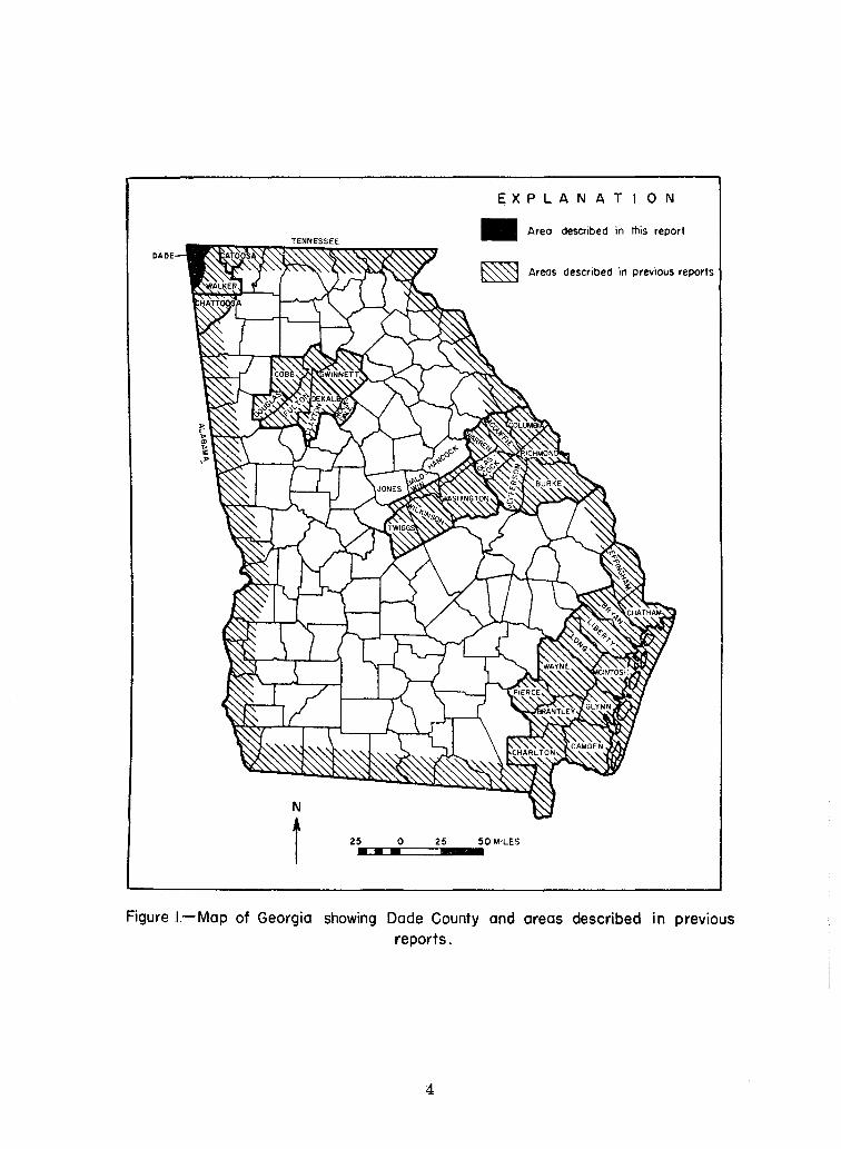
Figure 1. Map of Georgia showing Dade County and areas described in previous reports . 4
2. Monthly mean temperature at Chattanooga, Tenn. 5
3. Average monthly precipitation at Rising Fawn, Ga. -- .. - -- --------------------- ------------ 5
4. Topographic features of Dade County, Ga. 5
5. Map showing geology, and well and spring locations, Dade County, Ga.____ __ _ _______ Pocket
6. Diagram showing the occurrence of ground water in solution channels in a limestone area 14
TABLES
Page
Table 1. Geologic formations in Dade County, Ga. 7
2. Correlation of equivalent Pennsylvanian formations of the Cumberland Plateau of Georgia and Tennessee _ ___ _ ____________________ ______ ____________________ ______________ 11
S. Chemical analyses of ground water, Dade County, Ga._ ·- -- ------------------------------------------- 16
2

GEOLOGY AND GROUND-WATER RESOURCES
OF DADE COUNTY, GEORGIA
By Mack G. Croft
ABSTRACT
Dade County is in an area of Paleozoic rocks in the mountainous northwest corner of Georgia. The county, which is at the edge of the Cumberland Plateau, includes 165 square miles. Landsurface altitude ranges from 700 to 2,000 feet above sea level. The area receives about 53 inches of precipitation annually, the greater part of which occurs during the winter and spring months. Agriculture is the principal industry.
The Knox dolomite of Cambrian and Ordovician age is the oldest formation that crops out in the county. Rocks older than the Knox have not been penetrated by wells. The Ordovician system also includes the Chickamauga limestone and the Sequatchie formation (limestone, siltstone, sandstone, and shale). The Red Mountain formation of Silurian age consists of limestone, siltstone, shale, and sandstone; it is overlain by the Chattanooga shale of Devonian and Mississippian age. Rocks of the Mississippian system consist of the Fort Payne chert, St. Louis limestone, Ste. Genevieve limestone, Gasper formation, Golconda formation, Hartselle sandstone, Bangor limestone, and Pennington shale. The Pennsylvanian system consists of the Gizzard and Sewanee members of the Lookout sandstone, the Whitwell shale, the Bonair sandstone, the Vandever shale, and the Rockcastle sandstone.
Throughout all but the northwestern part of the county the rocks are broadly folded into the Lookout Valley and Wills Creek anticlines and the Lookout Mountain syncline. The east flank of the Lookout Valley anticline is thrust faulted.
Ground water has been developed primarily for domestic and farm use. Wells of highest yield are in the carbonate rocks such as the Knox, Chickamauga, and Fort Payne formations. Extensive solution channels occur along bedding planes, fractures, and other openings in these rocks. The water from the carbonate rocks is generally hard, but ground water from the Fort Payne chert is of excellent chemical quality and is soft to moderately hard. Water from the Fort Payne chert is suitable for municipal and industrial use.
INTRODUCTION
Location Dade County is in an area underlain by Paleo
zoic rocks in the northwest corner of Georgia. Tennessee borders Dade County on the north, Alabama borders it on the west, and Walker County,
3
Ga. borders it on the south and east (fig. 1). Dade County, which is triangular-shaped, is about 25 miles long, and about 13¥2 miles wide at the Georgia-Tennessee line. It includes 165 square miles which lie within the Cedar Grove, Durham, Fort Oglethorpe, Hooker, Shellmound, Sulphur Springs and Trenton topographic quadrangles of the Geological Survey. Trenton, the county seat and largest town, is in the central part of the county.
Dade County is traversed from north to south by U.S. Highway 11, a connecting route between Chattanooga, Tenn., and Birmingham, Ala. The Southern Railroad roughly parallels U.S. Highway 11. Georgia Highway 143, a scenic route over Sand and Lookout Mountains, traverses the county in an easterly direction.
Timber and agriculture are the chief industries in the county although coal mining formerly was relatively important.
Climate The climate of Dade County is relatively mild
and humid; summers are long and warm and winters are short and cool. The average annual precipitation recorded by the U. S. Weather Bureau at Rising Fawn for the period 1947-58 is 53.1 inches. This amount is probably general throughout the county. Most of the precipitation occurs as rain, although snow is common in the winter months. According to Thomson and Carter (1955, p. 8) the average surface runoff is about 20 to 25 inches. The annual mean temperature recorded by the U.S. Weather Bureau at nearby Chattanooga, Tenn. in 1957 was 61 °F. The temperature of springs closely approximated this mean. Figure 2 shows the monthly mean temperature recorded at Chattanooga in 1957. The average growing season in Dade County is about 200 days.
The greatest precipitation occurs during the winter and spring and the least during the summer and fall. Figure 3 shows the seasonal distribution of precipitation for the 11-year period (1946-58). The average for January through March, the months of greatest precipitation, was between 5.5 and 6.0 inches each month. From April through June the precipitation averaged 3.5 to 4.6 inches. During July, a month of heavy summer showers, the precipitation averaged 5.1 inches. The lowest average of about 2.5 to 3.9 inches was during August through October. The precipitation for November and December averaged about 4.8 to 4.9 inches.
EXPLANATION
• Areo described in this report
DADE
~ Areas described in previous reports
N
t 25 0 25 50 MILES
• • •
Figure I.-Map of Georgia showing Dade County and areas described in previous reports.
4
·o; 7or-----.s::: c ~ .c. ~
"' "' "' :;. 601-----.. "0
.: i " E ~ 50 1---FFt= E ., 1-
40
1957
Figure 2.- Monthly mean temperature at Chattanooga, Tenn.
1946-58
Figure 3. -Average monthly precipitation at Rising Fawn, Go.
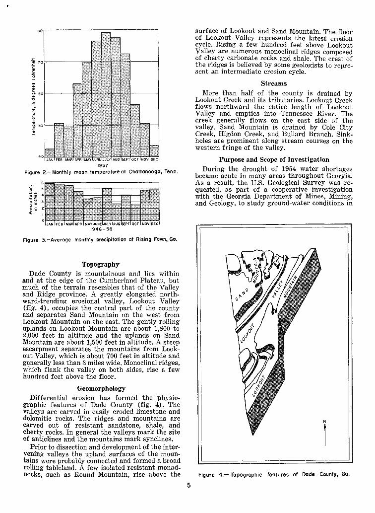
Topography Dade County is mountainous and lies within
and at the edge of the Cumberland Plateau, but much of the terrain resembles that of the Valley and Ridge province. A greatly elongated northward-trending erosional valley, Lookout Valley (fig. 4), occupies the central part of the county and separates Sand Mountain on the west from Lookout Mountain on the east. The gently rolling uplands on Lookout Mountain are about 1,800 to 2,000 feet in altitude and the uplands on Sand Mountain are about 1,500 feet in altitude. A steep escarpment separates the mountains from Lookout Valley, which is about 700 feet in altitude and generally less than 3 miles wide. Monoclinal ridges, which flank the valley on both sides, rise a few hundred feet above the floor.
Geomorphology Differential erosion has formed the physio
graphic features of Dade County (fig. 4). The valleys are carved in easily eroded limestone and dolomitic rocks. The ridges and mountains are carved out of resistant sandstone, shale, and cherty rocks. In general the valleys mark the site of anticlines and the mountains mark synclines.
Prior to dissection and development of the intervening valleys the upland surfaces of the mountains were probably connected and formed a broad rolling tableland. A few isolated resistant monadnocks, such as Round Mountain, rise above the
5
surface of Lookout and Sand Mountain. The floor of Lookout Valley represents the latest erosion cycle. Rising a few hundred feet above Lookout Valley are numerous monoclinal ridges composed of cherty carbonate rocks and shale. The crest of the ridges is believed by some geologists to represent an intermediate erosion cycle.
Streams More than half of the county is drained by
Lookout Creek and its tributaries. Lookout Creek flows northward the entire length of Lookout Valley and empties into Tennessee River. The creek generally flows on the east side of the valley. Sand Mountain is drained by Cole City Creek, Higdon Creek, and Bullard Branch. Sinkholes are prominent along stream courses on the western fringe of the valley.
Purpose and Scope of Investigation During the drought of 1954 water shortages
became acute in many areas throughout Georgia. As a result, the U.S. Geological Survey was requested, as part of a cooperative investigation with the Georgia Department of Mines, Mining, and Geology, to study ground-water conditions in
N
1
Figure 4.- Topographic features of Dade County, Ga.

Dade County. The investigation is part of a more extensive study of the Paleozoic area of Georgia begun in 1957. Fieldwork for this report was begun in October 1958 to determine the location, extent, and thickness of the aquifers, and the chemical quality of ground water in Dade County. Field and office work, which was completed in July 1959, included collection and compilation of water-level records and well and spring data, construction of a geologic map, and collection of water samples for chemical analyses.
This investigation was under the immediate supervision of J. T. Callahan, former district geologist, and P. E. LaMoreaux, former chief of the Ground Water Branch of the Geological Survey; the State Cooperator was Garland Peyton, Director, Georgia Department of Mines, Mining, and Geology.
Acknowledgments Acknowledgment is made to the citizens of
Dade County who were most helpful in supplying information on ground-water withdrawals and records of wells.
GEOLOGY Introduction
The consolidated rocks exposed at the surface in Dade County range in age from Cambrian to Pennsylvanian. Rocks of Cambrian and Ordovician age occur along the crests of anticlines which closely parallel the axis of Lookout Valley. The Silurian, Devonian, and Lower Mississippian rocks generally occur in ridges which flank the center of Lookout Valley. Upper Mississippian rocks occur on the sides of Lookout and Sand Mountains. The rims and surfaces of the mountains are capped by Pennsylvanian rocks, which mark synclines. The geologic map (fig. 5) shows the distribution of the mapped formations and the axes of the anticlines and synclines. The dip and strike of the rocks on the flanks of the folds were measured in a few places. In general the single measurement shown on the map represents the prevailing dip for the area. Several formations were mapped as one unit, although described separately in the text, because of the thinness of the formation or the lack of beds which could be easily identified or traced.
Previous Geologic Work C. W. Hayes, of the U.S. Geological Survey,
made the first geological studies of the area. His analysis of the structure and geology were published in the Ringgold and Stevenson folios (Hayes, 1894, 1895). As the region was explored for its natural resources, stratigraphic terms were applied in greater detail and extended to northwestern Georgia from Alabama and Tennessee. The Ordovician, Silurian, Devonian, and Mississippian rocks were delineated in Alabama by Charles Butts (1926) and later in the Paleozoic area of Georgia (Butts and Gildersleeve, 1948). Terms used by Butts are still generally applicable and his descriptions of the formations are accurate.
6
Johnson (1946) made a preliminary study of the coal deposits and the Pennsylvanian rocks on Sand and Lookout Mountains. He differentiated Hayes' original Lookout and Walden formations. Wilson, Jewell, and Luther (1956) extended terminology for the Pennsylvanian rocks of Tennessee and Kentucky from the Cumberland Plateau in Tennessee to the Sand and Lookout Mountain area of Georgia. Their studies included detailed and reconnaissance mapping of the Pannsylvanian rocks. Some excellent exposures of the Pennsylvanian rocks which occur in Cloudland Canyon State Park have been described and mapped by Croft (1959).
Other reports by Rodgers (1953), and Allen and Lester (1957) are excellent source material and guides to the stratigraphy and economic geology of the area.
Cambrian System
The Weisner, Shady, Rome, and Conasauga formations of Cambrian age, which underlie the Knox dolomite, are not exposed in Dade County. These formations probably occur at depth, as they have been mapped in areas adjoining the county, but they have not been penetrated in deep wells. Table 1 lists the geologic formations in Dade County and summarizes their stratigraphy and water-bearing properties.
Cambrian and Ordovician Systems
Knox Dolomite The Knox dolomite crops out in the southern
part of Dade County, extending northward from the Alabama line along the axis of the northeastward plunging Wills Creek anticline. Unweathered exposures of the Knox dolomite are rare, but may be seen three-quarters of a mile south of Cloverdale Church. There the Knox dolomite consists of light- to dark-gray, fine- to coarsegrained, cherty limestone and dolomite. Also at this locality several large trochoid gastropods were observed in the rocks. The limestone and dolomite generally weathers to a deep, slightly reddish, cherty soil from which most of the carbonate material has been leached. The Knox dolomite is about 4,000 to 4,500 feet thick but only about 200 feet of the upper part is exposed in Dade County.
In adjacent states the Knox dolomite forms a group, which is subdivided into Copper Ridge dolomite, Chepultepec dolomite, and Longview limestone. These formations have been recognized also in Georgia (Butts and Gildersleeve, 1948, p. 17-18). However, the greater part of the Knox dolomite exposed in Dade County is believed to be equivalent to the Longview limestone.
The Knox dolomite yields sufficient water for domestic and farm use to the relatively few wells in Dade County that penetrate it. Water is stored in joints, bedding planes, and in solution cavities in the rock. The formation probably is an excellent aquifer and properly developed wells might prove to have high yields.

Table 1. Geologic formations in Dade County, Ga. ~-~ -
Thickness System Stratigraphic unit (ft.) Character of rocks Water-bearing properties
-- -Unconsolidated boulders, Undeveloped; material is
gravel, sand silt, and clay; permeable and should yield Quaternary Alluvium 0-50 (?) fanlike deposits in Lookout moderate supplies of water,
Valley. low in mineral content. ----. -~ ~ ---------~---~ ---
! I
I Sandstone; fine- to coarse- Undeveloped; not important
! Upper sandstone 20-40 grained, thick-bedded. as potential aquifer owing Q)
~ member Caps top of Round
I to small area of outcrop 0 .., I Mountain at Durham . and topographic position. Ul I "' ~ I Shale; gray- to black,
I Undeveloped; probably oS
I I Ul Middle I contains a sandstone unit capable of furnishing Q) shale 270-310 I about 20 to 30 feet thick. I sufficient quantities of :;J I Ul member Shale below sandstone is water for domestic and oS
I t) highly fossiliferous. farm use. ~ t)
I 0 Lower sandstone Sandstone; thick- to thin- Yields small quantities of ~ member 150 bedded, fine- to coarse- water, generally high in
I
grained. iron. -- ~- ------------- - --~-1 -----! Shale; light- to dark-gray, Yields small quantities of
Vandever 200 interbedded with siltstone water, generally high in ~ shale
I and fine-grained iron.
oS sandstone. ·a ---- ! oS I Sandstone; cross bedded, Yields small to moderate ~ I
Bonair
I I
white to pale reddish- qautities of water suffi-Ul sandstone 200± brown. i cient for domestic and farm ~ I ~
'
I
use. Water generally high Q) j_ 12-35
p.. _j in iron. ----
Shale; light- to gray-black, Relatively impermeable. Whitwell shale fissile; and contains silt-
stone and sandstone. ---· -
Sandstone; thick-bedded, Yields small quantities of Q) Sewanee white to pale reddish- water sufficient for farm ~ member ~0 brown. Contains beds of and domestic use. Water 0
I
.., orthoquartzite and con- generally high in iron . Ul "' "' glomeratic sandstone. ::s ~ ' 0 oS ----------
I "' Ul Shale; yellowish to gray, Yields small quantities of Q) ..... .., I ·s ::s I
I fissile; interbedded with water sufficient for farm
0 0 Gizzard 200-353 siltstone, coal, and fine-I
and domestic use. of ~
0 member grained sandstone. Developed only on Sand 0 oS H
I Mountain. Water generally 0 high in iron.
-----
I
Pennington Shale; green and red, fissile, Relatively impermeable; shale 100-200 highly fossiliferous. yields little or no water
to wells or springs.
Limestone; gray, oolitic
I
Undeveloped but capable of Bangor and fine- to coarse- yielding at least moderate
limestone 480 grained, fossiliferous. supplies from numerous Interbedded with shale in
I intersecting joints and
upper part. solution cavities.
Shale; green, fissile. Contain Yields little or no water to Hartselle sandstone I thin-bedded, gray, fossili- wells or springs.
~ and
I
15-20 ferous limestone. Sand-oS Golconda formation stone of the Hartselle is ·s. rarely exposed. ~ I ·;; ! Limestone; gray, oolitic, Penetrated by few wells Ul
: ·;; non-cherty, thick bedded I because the formation Ul
~ Gasper i to massive. !
generally crops out on formation I 150
I steep slopes. However,
I
I would yield moderate
I
quantities of water from solution channels.
Ste. Genevieve
I Limestone; gray, rarely Similar to Gasper. Springs
limestone 245 cherty, oolitic and fine- i issue from solution grained, thick bedded. channels.
I
Limestone; gray, thin- to Penetrated by few wells; St. Louis 120 thick-bedded and very
i believed capable of
limestone cherty. yielding large quantities
I of water.
7

Table 1. Geologic formations in Dade County, Ga.- continued
Thickness System Stratigraphic unit (ft.) Character of rocks Water-bearing properties
Ul 1=1 Limestone; gray, highly An excellent aquifer, highly ::; c:\l 0 ·a cherty, and fossiliferous. jointed, yields moderate to "" Ql .e- Fort Payne 160 Weathers to a reddish- large quantities of water 'H ·s "' chert brown cherty soil. to wells that intersect 0 -~ solution cavities. Water of -e "' "' excellent quality. c:\l ~ 0
Mississippian an Chattanooga Shale; black, fissile, I Relatively impermeable; Devonian shale 15-25 carbonaceous. I yields water of poor
I quality.
Limestone; gray, thin- Yields small quantities of Red Mountain bedded; shale; fissile, water for domestic and
Silurian formation 150-200 greenish, interbedded with farm use. Not developed siltstone, sandstone, and because of geographic oolitic hematite. location.
Limestone; gray, fossili- Yields moderate quantities Sequatchie ferous; interbedded with of water to wells that formation 75-80 siltstone, shale, and penetrate solution cavities
sandstone. in the limestone. Water Ordovician probably of good quality.
Limestone; gray, fossili- Yields large quantities of Chickamauga ferous, cherty, thin- to water to wells that inter-
limestone 1,000+ thick-bedded. A few beds sect solution cavities. of dolomite occur in lower Water commonly sulfurous part of formation. and hard.
Limestone and dolomite, Relatively undeveloped, the Cambro- Knox 4,000- gray, fine- to coarse- few wells obtain water
Ordovician dolomite 4,500 grained, medium- to thick- sufficient for farm and bedded, cherty. domestic use. Rock is
jointed and cavernous.
Weisner!, Shady, Rome These formations occur at Data not available. Cambrian and 10,000± great depth and have not
Conasauga formations been penetrated by wells in Dade County.
1Numerous reports by other geologists are listed in references in which detailed descriptions of the Weisner, Shady, Rome and Conasauga formations can be found.
Ordovician System
Chickamauga Limestone The Chickamauga limestone crops out in Look
out Valley and along the Wills Creek anticline (fig. 5). The formation is exposed along U.S. Highway 11 between Wildwood and Trenton and a well exposed section overlies the Knox dolomite west of U.S. Highway 11 about 0.2 mile north of the Alabama line. The Chickamauga limestone is more than 1,000 feet thick in Lookout Valley where it is composed of light- to dark-gray, cherty, and fossiliferous limestone. In the lower part of the Chickamauga limestone there are a few beds of dolomite.
Butts and Gildersleeve (1948, p. 18-33) and Allen and Lester (1957) recognized units within the Chickamauga limestone that have been mapped as formations elsewhere, but in this report the Chickamauga limestone is used to include the rocks that unconformably overlie the Knox dolomite and underlie the Sequatchie formation. The Chickamauga limestone is subdivided into an upper limestone member and a lower limestone and dolomite member at a thin zone of green chert and bentonite, which is about 20 feet thick
8
(fig. 5). This green chert may be traced easily and divides the formation roughly into two equal parts. The green chert zone corresponds to the "zero" zone of Allen and Lester (1957, p. 63-67) and is well exposed 0.4 mile west of Trenton on Georgia Highway 143.
The Chickamauga limestone is a highly productive aquifer and has been extensively developed for domestic and farm supplies by several hundred shallow drilled wells in Lookout Valley. Water occurs in the rock in numerous intersecting fractures, joints, bedding planes, and solution cavities and a few wells yield large quantities. Many wells probably are capable of yielding 200 gpm (gallons per minute) or more. Water from the Chickamauga limestone commonly has a sulfurous taste and characteristically is hard.
Sequatchie Formation The Sequatchie formation, which is exposed as
a thin band on the flanks of Lookout Valley, was mapped with the Red Mountain formation of Silurian age because the two formations are similar lithologically. Johnson (1946) also included the Sequatchie in Lookout Valley with the Red Mountain formation on his map. The Sequatchie

formation consists of thick bedded to massive, gray, fossiliferous limestone interbedded with calcareous sandstone, siltstone, and shale. A thin bed of oolitic hematite occurs generally near the base. Where deeply weathered the limestone has been completely dissolved and the weathered material is characteristically reddish-brown sandy soil. A thick-bedded fossiliferous limestone that is predominant in the upper part of the formation distinguishes it from the overlying Silurian Red Mountain formation. The Sequatchie is about 75 to 80 feet thick. The Sequatchie formation underlies the Red Mountain formation and overlies the Chickamauga limestone with which it is in sharp contact.
The Sequatchie formation yields adequate supplies of water to a large number of domestic wells, 50 to 130 feet deep, that tap the nearly flat-lying beds between the town of Wildwood and the Tennessee State line. However, probably most of the wells also penetrate the underlying Chickamauga limestone. Water is stored in the aquifer in joints, bedding planes, and solution cavities in the limestone. Wells that penetrate the underlying Chickamauga limestone or encounter large solution cavities in the Sequatchie formation yields as much aR 200 gpm.
Silurian System
Red Mountain Formation The Red Mountain formation occurs in resistant
ridges flanking Lookout Valley. The ridges are capped by the overlying Fort Payne chert. The incompetent beds of the Red Mountain formation consist of thin-bedded, gray limestone, fissile greenish shale, claystone, siltstone, and finegrained sandstone. Thin beds of oolitic hematite occur sporadically but rarely are more than a foot thick. The formation is 150 to 200 feet thick. According to Butts and Gildersleeve (1948, p. 36), a hiatus within the formation separates it into two divisions.
The Red Mountain formation has not been extensively explored for water. The few wells that penetrate the aquifer obtain adequate supplies for domestic and farm purposes and are generally located near houses perched atop ridges. The wells are generally about 150 feet in depth. Water is stored in the formation in joints, bedding planes, and other fractures. The formation may be considered only as a moderately productive aquifer as the yield is probably less than 25 gpm from most wells.
Devonian and Mississippian Systems
Chattanooga Shale The Chattanooga shale is exposed near the crest
of the ridges that flank Lookout Valley. In Dade County it is about 15 to 25 feet thick and consists of black, fissile, carbonaceous shale, overlain by several feet of greenish-gray shale. According to Butts and Gildersleeve (1948, p. 40), the greenishgray shale corresponds to the Maury green shale
9
of middle Tennessee. Because of its thinness the Chattanooga shale was mapped with the Fort Payne chert and the St. Louis limestone in figure 5. The Chattanooga shale is an excellent stratigraphic marker, separating the underlying Red Mountain formation and the overlying Fort Payne chert.
The Chattanooga is a poor aquifer because the shale is generally impermeable and transmits little water. Wells that penetrate it commonly obtain some water having a high iron content.
Carboniferous Rocks-Mississippian System
Fort Payne Chert The Fort Payne chert crops out as a wide band
capping the ridges that flank Lookout Valley. In Dade County it consists of thick bedded, gray, cherty limestone. The chert is highly fractured and occurs as nodules and stringers commonly more than 1 foot thick. In the lower part of the formation chert forms the greater part of the unit. The Fort Payne is very fossiliferous and contains abundant crinoid stem plates up to 1 inch in diameter and several large forms of the genus Spirifer. The upper part of the formation is generally deeply weathered and forms a characteristic reddish soil containing blocky, fossiliferous fragments of chert. Because the upper part of the formation weathers similarly to the overlying St. Louis limestone, the two formations were not differentiated on the geologic map (fig. 5). The Fort Payne chert is 157 feet thick at Trenton. Above this section is 20 feet of deeply weathered rock which may be either Fort Payne chert or St. Louis limestone.
The Fort Payne chert is an excellent aquifer although in Dade County it has been developed only for domestic and farm use. Its water is generally soft and of excellent quality. Many springs flow more than 100 gpm from the formation and wells generally have large yields. Water occurs in many intersecting joints, bedding planes, and solution cavities.
St. Louis Limestone
The dark-gray, cherty, fine-grained limestone of the St. Louis limestone overlies the thickbedded cherty limestone of the Fort Payne chert. The St. Louis limestone is exposed as a thin band at the base of Sand and Lookout Mountains and is best exposed in gullies on the lower flanks of Sand Mountain. The formation was mapped as Fort Payne chert by Johnson (1946). The limestone is generally thick-bedded and contains many large nodules and stringers of chert which are most abundant in the upper part. The St. Louis limestone contains several colonial corals. Well preserved and weathered-out specimens of Lithostrotionella hemisphaerica were collected in stream debris in a branch of Crawfish Creek near Byrds Chapel, and Dorlodotia sp. and Syringopora sp. were noted in the upper part of the formation just below the old farmhouse about 1.4 miles due east

of the road junction at New England. At several localities several inches of greenish shale were observed in the lower part of the formation. In the valley areas the St. Louis limestone weathers to a reddish cherty soil and is difficult to distinguish from the Fort Payne chert. The formation is about 120 feet thick.
The St. Louis limestone is an excellent aquifer. The rocks are highly jointed and contain extensive solution cavities. The water is generally of good quality.
Ste. Genevieve Limestone The Ste. Genevieve, Gasper, Golconda, Hartselle,
and Bangor formations are lithologically similar and difficult to map separately. Therefore, although each is discussed separately, they have not been differentiated in figure 5. In many previous reports these formations have been mapped as the Bangor limestone. The Ste. Genevieve limestone is composed of about 245 feet of light- to dark-gray, oolitic, fine- to coarse-grained limestone. The limestone contains a few nodules and stringers of gray chert, which generally has an oolitic texture. The rocks are thick bedded to massive and commonly contain numerous solitary corals and other fossils. At Rising Fawn the Ste. Genevieve limestone is deeply weathered to a reddish soil which contains large fragments of chert.
A few wells penetrate the formation in Slygo Cove where the formation crops out in the valley. Elsewhere it yields little water to wells as it generally crops out on the flanks of Lookout or Sand Mountains. Wells in Slygo Cove yield adequate water for domestic and farm use from joints and solution cavities in the rock.
Gasper Formation The Gasper formation crops out on the flanks
of Lookout and Sand Mountains above the Ste. Genevieve limestone. It is a non-cherty, oolitic, and fossiliferous limestone and is distinguished by the compound coral tentatively identified by Helen Duncan of the U.S. Geological Survey as Campophyllum gasperense. The coral occurs about 35 feet above the probable base of the formation and forms a 1- to 2-foot bed, which is generally easy to locate and trace. Samples were collected in Slygo Cove about 1.3 miles northeast of Bethlehem Church and in a small gully about 1 mile southwest of Bethlehem Church. However, two species of Palastraea, also identified by Helen Duncan, occur in the same zone. Palastraea sp. was considered by Butts and Gildersleeve (1948, p. 47) to be restricted to the Golconda formation. Palastraea cf. P. mcfarlani was collected about 100 feet west of Bethlehem Church. Palastraea cf. P. compressa was collected about 1.4 miles southwest of Hooker, and about 1.3 miles west of Trenton. Both Palastraea cf. P. compressa and Campophyllum gasperense were collected about 150 yards south of Bethlehem Church. All collections were believed to be from one coral zone along the strike of the beds and about 122 feet below the Golconda formation. Additional stratigraphic and
10
paleontological studies are needed to define the upper and lower contacts of the Gasper formation. It is about 150 feet thick in Dade County.
The Gasper formation is a potentially productive aquifer as the rock is readily soluble and contains solution channels and cavities along the bedding and joint planes. However, the formation yields little water to wells because of its general occurrence on steep mountain slopes.
Golconda Formation and Hartselle Sandstone
Rocks tentatively identified as the Golconda formation and the overlying Hartselle sandstone crop out at least as far south as Trenton in Dade County. They are well exposed west of Trenton on Georgia Highway 143 where the highway bends to the south to ascend Sand Mountain. In Slygo Cove the shale crops out about 0.4 mile northeast of Bethlehem Church. The Golconda formation consists of thin-bedded fossiliferous limestone and greenish shale and in most localities is difficult to locate or trace. The Hartselle sandstone consists of calcareous sandstone but is poorly exposed. The two formations together are about 15 to 20 feet thick. The beds are stratigraphically and lithologically similar to the rocks described by Butts and Gildersleeve (1948, p. 47-48) at the north end of Lookout Mountain in Tennessee.
Because they are thin and occur only on steep mountain slopes, the Golconda formation and Hartselle sandstone have not been explored for domestic water supplies.
Bangor Limestone
The Bangor limestone occurs on the flanks of Lookout and Sand Mountains. The rock consists of light- to dark-gray thin- to thick-bedded, fineto coarse-grained limestone. It contains a few beds of oolitic limestone. In the upper part, limestone is interbedded with shale. Blocky black chert nodules and forms of Pentremites and Archimedes occur commonly throughout the limestone and aid in distinguishing it from the Ste. Genevieve limestone and the Gasper formation. A coral similar to Campophyllum gasperense was observed in the Bangor limestone on Georgia Highway 143 on the west rim of Lookout Mountain west of Cloudland Canyon. The Bangor is about 480 feet thick.
The Bangor limestone, because it is soluble, is cut by many intersecting solution channels along joints and bedding planes. Springs emerge on the sides of the mountains where solution channels intersect the surface and where shale prevents the downward movement of water. The only wells that penetrate the Bangor limestone are west of Hooker, where the yield is sufficient for farm and domestic use. Elsewhere the Bangor crops out on steep slopes. On Sand Mountain, wells of high yields probably could be developed from this aquifer at depths of 600 to 700 feet. On Lookout Mountain the Bangor limestone is more than 1,000 feet below the surface.

Pennington Shale The Pennington shale, which consists of red and
green fissile shale interbedded with sandstone and limestone, crops out on the sides of Lookout and Sand Mountains. An exposure may be seen on Georgia Highway 143 on Sand Mountain west of Trenton. The shale contains an abundant marine fauna of bryozoans and brachiopods. The Pennington generally is obscured by talus from the overlying Pennsylvanian rocks and its thickness cannot be determined accurately. For this reason it was included with the overlying Gizzard member of Lookout sandstone on figure 5. The thickness of the Pennington shale probably ranges from 100 to 200 feet. Wells have not been drilled in the Pennington shale because of its relative inaccessibility, but it probably would yield only a little water because its permeability is low.
Carboniferous Rocks-Pennsylvanian System Recent detailed and reconnaissance mapping in
the Cumberland Plateau of Tennessee has resulted in a revision by Wilson, Jewell, and Luther (1956) of Pennsylvanian stratigraphy. Rocks which they mapped as Gizzard and Crab Orchard Mountain groups can be traced throughout the Sand and Lookout Mountains area and coal seams in many of the formations are also correlative. Table 2 shows the equivalent rock units of Johnson (1946) whose terminology is followed in this report. Butts (1926, p. 204-208) believes that the Pennsylvanian rocks unconformably overlie the Mississippian rocks.
Gizzard Member of Lookout Sandstone The Gizzard member crops out on the flanks of
Lookout Mountain and on the sides and in deep swales and gullies on Sand Mountain. It generally forms a steep talus-covered slope beneath the ledges of the Sewanee member of the Lookout sandstone. For this reason exposures are generally seen only in road cuts, as on Georgia Highway 143 just below the east and west rims of Lookout
Table 2. Correlation of equivalent Pennsylvanian formations of the Cumberland Plateau of
Ge.orgia and Tennessee --
Johnson (1946)
Upper shale unit of Rockcastle sandstone
Lower sandstone unit of Rockcastle sandstone
Vandever shale
Bonair sandstone
Whitwell shale Q) .., ,:::: Sewanee member
5.s .!I:"' 1--------. g] Gizzard member ..:los
"'
-~------------~~-~--~--- --
Wilson, Jewell, and Luther (1956)
----~ --
Rockcastle ! conglomerate I
Vandever formation
Newton sandstone
Whitwell shale
Sewanee conglomerate : -
Signal Point shale Po ::I 0 I
Warren Pomt bD sandstone ~
'"' 01 Raccoon Mountain ~
formation 6 ~--~----~------
11
Mountain. The member is composed of yellowish to gray fissile shale intercalated with thin-bedded siltstone, coal, and fine-grained sandstone. The Gizzard member is 353 feet thick in the Shellmound quadrangle about 3 miles north of New Hope Church in Tennessee (Wilson, Jewell, and Luther, 1956, p. 19). The member appears to thin to the southeast from this area. The Gizzard member is the lower unit of Lookout sandstone which is equivalent to the Raccoon Mountain for~ mation of Wilson, Jewell, and Luther (1956).
The Gizzard member is tapped by wells only on Sand Mountain where the formation crops out in deep swales and ravines. Water is obtained from fractures, joints, and bedding planes by shallow drilled wells. The yield is adequate for domestic and farm use.
Sewanee Member of Lookout Sandstone The Sewanee member crops out extensively in
Dade County and forms the rimrock and mesa-like surface of Sand Mountain and forms much of the rimrock on Lookout Mountain. The Sewanee the upper unit of Lookout sandstone, is compos~d of massive, cliff-forming, crossbedded, conglomeratic sandstone and orthoquartzite. The sandstone is fine to coarse grained, and white to pale reddish brown. In Cloudland Canyon State Park the member is 240 feet thick. The Sewanee member is equivalent to the Warren Point sandstone (table 2) of Grundy County, Tenn., where it is 65 feet thick (Wilson, Jewell, and Luther, 1956, p. 4). The member thickens southward.
Wells that penetrate the Sewanee member of the Lookout sandstone obtain water from fractures, bedding planes, and joint planes. The sandstone is well cemented with silica and calcite and is not highly permeable. Shallow drilled wells which rarely exceed 150 feet, yield adequate sup~ plies for farm and domestic use. The maximum yield from the wells is probably less than 30 gpm except from highly fractured zones. '
Whitwell Shale The Whitwell shale was observed only on Look
out Mountain where it is generally poorly exposed except in road cuts although it is well exposed in Cloudland Canyon. Because of its thinness the Whitwell shale was mapped with the Bonair sandstone. It consists of thin-bedded, black to lightgray shale, siltstone and fine-grained, thin-bedded sandstone. On Signal Mountain in Tennessee the Whitwell is 52 feet thick but is only about 12 feet thick on the western rim of Lookout Mountain. It appears to be about 35 feet thick on the eastern rim.
The formation is not an important aquifer.
Bonair Sandstone The Bonair sandstone crops out extensively on
Lookout Mountain where it consists of thin, wellcemented, white to pale reddish-brown, finegrained, crossbedded sandstone. The sandstone commonly contains pebble conglomerates. The Bonair sandstone is about 200 feet thick in Cloud-
land Canyon, and in some localities forms a second line of cliffs above the Sewanee member of the Lookout sandstone.
Ground water is stored in fractures, joints, and bedding planes in the rock. Numerous wells, which are generally less than 100 feet deep, yield sufficient water for domestic and farm use. The yield is similar to that of the Sewanee member of the Lookout sandstone.
Vandever Shale The Vandever shale crops out on Lookout Moun
tain north of Johnson Creek and it is well exposed along Georgia Highway 157, 1.9 miles north of the Junction with Georgia Highway 143. The formation consists of light to dark-gray, thin, fissile shale intercalated with grayish-orange siltstone and fine-grained sandstone. The Vandever shale is about 200 feet thick. The formation yields ground water from fractures and bedding and joint planes in the rock. Shallow drilled wells, generally less than 75 feet in depth, are capable of furnishing water for farm and domestic use but generally yield less than 25 gpm.
Rockcastle Sandstone The Rock castle sandstone as described by John
son (1946) consists of two distinct lithologic u_nits, a lower unit of sandstone and an upper umt of interbedded shale and sandstone. The upper unit is further subdivided in this report into the middle shale and upper sandstone members which are equivalent to the Vandever and Rockcastle formations of Wilson, Jewell, and Luther (1956). The lower member is equivalent to their Newton sandstone.
Lower sandstone member.- The lower sandstone member crops out extensively near Cloudland Canyon and near Durham in Walker County. Several small outliers also occur along Lookout Mountain northeast of Cloudland Canyon. The lower member is about 150 feet thick and consists of resistant thick to thin crossbedded sandstone. It forms a prominent bench above the Vandever shale.
The sandstone yields an adequate supply of water for domestic use to a relatively few shallow drilled wells along Georgia Highway 157. Ground water occurs principally in fractures and bedding and joint planes in the indurated sandstone. Yields to wells are small, generally less than 30 gpm.
Middle shale member.-The middle shale member of the Rockcastle consists of three distinct lithologic units which crop out on Lookout Mountain east of Georgia Highway 157 and south of Georgia Highway 170. The lower part, about 50 to 80 feet thick, is composed of gray to black carbonaceous and buff shale. The shale contains an abundant fossil flora. The middle part of the shale member, composed of fine- to coarse-grained well-indurated sandstone, is generally thick bedded and forms a low but prominent bench. The middle sandstone of the shale member is about 20 to 30 feet thick and occurs several feet below
12
the "A" or No. 1 coal seam. It may be seen near Durham about 0.8 mile east of the junction of Georgia Highways 170 and 157. The upper part of the middle shale member forms the abrupt horseshoe-shaped ridge known as Round Mountain. It is composed of about 200 feet of interbedded gray to black carbonaceous and buff sandy siltstone and shale.
The tripartite character of this member is distinctive of the Vandever formation in the Cumberland Plateau of Tennessee (Wilson, Jewell, and Luther, 1956, p. 4). The middle sandstone unit of the shale member of the Rockcastle sandstone may be correlative with the middle unit of their Vandever which also is a thick sandstone.
The middle shale member of the Rockcastle sandstone has not been explored for water in Dade County, owing partly to the rugged relief and partly to its small extent. Wells capable of yielding domestic and farm supplies probably could be developed in the formation.
Upper sandstone member.-The upper sandstone member of the Rockcastle, which caps the horseshoe-shaped ridge east of the junction of Georgia Highways 157 and 170, is believed to be a remnant equivalent of the Rockcastle sandstone of Wilson, Jewell, and Luther (1956). The rock consists of fine- to coarse-grained sandstone and is generally thick bedded. About 20 to 40 feet of the member is present. This member was not differentiated by Johnson (1946).
Because of its topographic position the sandstone is not a significant source of water in Dade County.
Quaternary System
Alluvium Fairly thick deposits of alluvium are present at
scattered localities in Dade County. The alluvium consists of poorly sorted boulders, gravel, sand, and clay. Most of the material appears to have been derived from the Bonair sandstone and Sewanee member of the Lookout sandstone, as fragments and boulders containing the characteristic pebbles and conglomerate of those units are predominant.
The thickest and most extensive deposits are at the mouths of deep canyons where the material has been deposited as alluvial fans in the valleys. Good examples are the deposits on the south side of the large amphitheatre known as Johnson Crook, and the deposits at the mouths of Richmond Hollow and Cloudland Canyon. Their thickness is not known but is probably less than 50 feet.
The alluvial deposits have not been developed as a source of water supply. However, they appear to be permeable, have considerable areal extent and thickness, and are continually being recharged by streams flowing from the canyons.
Structure
Folds The most prominent structural features of Dade
County are the northeast-trending anticlines and
synclines in the southern and eastern part of the county (fig. 5). They include the Lookout Valley anticline, the Wills Creek anticline, and the Lookout Mountain syncline. The rocks in the northwestern part of the county are generally flat lying.
The Lookout Valley anticline is an asymmetrical fold; dips on the east flank are about 12°-59°, and are generally steeper than dips on the west flank which are about 2 o -21 o. The rocks on the west flank flatten out and form the plateau of Sand Mountain. To the southwest the anticline terminates several miles south of the Georgia line in Alabama; it extends northeast about 20 miles into Tennessee. The outcrop pattern of the green chert in the lower member of the Chickamauga limestone suggests that the crest of the anticline is near the north edge of the town of Trenton. There is a marked sag in the anticline just north of Wildwood.
The Wills Creek anticline, a prominent structural feature of Alabama, extends into Georgia and passes through Johnson Crook. Dips of 26° and 65 o were measured on the east limb and dips of 13 ° to 44 o were measured on the west limb of the fold. The Knox dolomite, the oldest formation exposed in Dade County, forms the core of the structure.
The rocks of Lookout Mountain in the north part of Dade County are folded into the broad Lookout Mountain syncline. Dips along the western rim of the mountain are about 13 o to 21 o and flatten out along the axis. The structure extends northward into Walker County, Ga., where the axis roughly parallels the Dade-Walker line. Southward the structure terminates near Fox Mountain.
Faults Rodgers (1953, p. 130) states that the east limb
of the Lookout Valley anticline is cut by a southeast-dipping thrust fault which extends into Georgia. The trace of this fault closely parallels Lookout Creek and was mapped from the Tennessee state line southwest to Sitton Gulch. The Fort Payne chert is thrust over the Ste. Genevieve limestone. The fault may extend southwestward beyond Sitton Gulch but limited examination did not disclose it.
The Sequatchie Valley fault, which is exposed about 10 miles west of Dade County in Tennessee and Alabama, is believed to be horizontal and probably underlies Lookout Valley, and Sand and Lookout Mountains at relatively shallow depth. The rocks exposed in Dade County are on the upper plate of the fault. Rodgers (1953, p. 127-128) suggests this is the attitude of the Sequatchie Valley fault north of Dade County and that it underlies Walden Ridge in Tennessee. As evidence, Rodgers cites areas of Ordovician and Silurian rocks in Roane and Rhea Counties, Tenn., Which he interprets as windows showing through this fault. A similar window involving rocks of comparable age was mapped by Butts and Gildersleeve (1948, p. 61) east of Lookout Mountain, Walker County. However, Butts did not interpret it as a window.
13
According to Wilson and Stearns (1958, p. 1290-1293), Pennsylvanian rocks in the southern part of the Cumberland Plateau of Tennessee and Georgia were involved in a flat, bedding-plane thrust. Movement may have occurred along bedding planes within the Pennsylvanian rocks in Dade County, although no evidence of this was found.
GROUND WATER
Use of Ground Water in Dade County An estimated 800,000 gallons of ground water
is used daily in Dade County, primarily for domestic and farm supplies. About 800 shallow drilled and dug wells, most of which are less than 150 feet deep, have been developed throughout the valley and mountain areas of Dade County for local water supplies. About 90 to 95 percent of the wells were drilled. Dug wells generally are inadequate even for domestic supplies owing to the thinness of the residuum. Records of wells and springs that were inventoried may be examined in the district office of the U.S. Geological Survey, Ground Water Branch, Atlanta, Ga. Locations of the wells and springs are shown on figure 5 and are numbered by quadrangles.
Two communities in Dade County, Trenton and Rising Fawn, obtain municipal supplies from springs. Trenton has developed three springs on the east face of Sand Mountain. The combined flow from two of the springs was about 80 gpm in October 1958. About half of this flow was used. The flow from the other springs was fully used and could not be determined. Poplar Spring, which furnishes the water supply for Rising Fawn, flowed about 35 gpm in December 1958 and is fully used. Private wells and springs are being developed to supplement the public supply in newly developed residential districts adjoining Trenton and Rising Fawn. Throughout the county many springs and seeps with flows of one to several hundred gpm have been developed for farm and domestic use.
The only industrial well in the county is at a lumberyard at New England where about 10,000 gpd (gallons per day) is used in a boiler. The Wildwood Sanitarium, about 1 mile north of Wildwood, uses about 18,000 gpd for irrigation and domestic purposes.
Hydrology
General Statement Two principal types of aquifers occur in Dade
County; limestone and dolomite (carbonate rocks) aquifers which crop out in the valley areas and on the mountain slopes, and sandstone and shale (clastic rocks) aquifers which crop out in the mountain area. The limestones commonly are highly permeable because they contain widespread well-developed solution channels; the sandstone and shale units generally are not highly permeable. The geologic formations and their physical character and water-bearing properties are described in table 1.

Limestone and Dolomite Aquifers The carbonate rocks of the valley areas gen
erally are excellent aquifers as the solution channels act as conduits for ground water. The formations of primary importance for water supplies for domestic, industrial, and municipal supplies in the area are the Fort Payne chert and the St. Louis limestone. Water from these formations is generally of good quality. The Knox dolomite, the Chickamauga limestone, the Sequatchie formation and the Ste. Genevieve limestone will yield sufficient water of good quality for domestic and agricultural supplies.
The primary source of ground water in Dade County is precipitation on the land surface. The rocks contain openings along joints, bedding planes and other fractures which permit the water to infiltrate to the ground water. In percolating through the soil, water generally becomes charged with carbon dioxide and organic acids. Thus, the charged water readily dissolves the limestone and dolomite enlarging both vertical and lateral openings (fig. 6). Solution of carbonate rocks is believed to be generally most active near the water table where descending water is more highly charged with carbon dioxide and acid. Where an extensive subterranean drainage system becomes developed in carbonate rocks, it is in many re-
EXPLANATION
F/O:l Soil
~ Water
@ Limestone
spects comparable to a surface drainage system. Subterranean drainage systems adjust themselves to a base level, which in Dade County would be Lookout Creek and other large streams.
Many wells in Lookout Valley penetrate waterfilled solution cavities in limestone. Fortunately these openings are so extensive that wells 150 feet deep may encounter several and at few places is it necessary to drill deeper. Most of the deeper wells, generally less than 270 feet deep, are on top of hills. Should a well fail to encounter solution channels of sufficient size to furnish an adequate quantity of water above 250 feet, or if the well is dry, it is generally the custom to select a new site. However, wells that yield no water are rare in Dade County.
Wells at Huntsville, Ala., that tap the Fort Payne chert (Malmberg and Downing, 1957, p. 31-39), generally are capable of yields of 250 gpm, and exceptional wells are capable of yields of 1,000 gpm or more. The wells having the highest yields are located in synclinal troughs or basins. Accurate data are not available on the yield from the Fort Payne chert and St. Louis limestone in Dade County but wells of comparable yields probably could be drilled in the Fort Payne chert in the Lookout Mountain syncline near Rising Fawn and on the flanks of the Lookout Valley anticline.
Figure 6.- Diagram showing the occurrence of ground water in solution channels in a limestone area.
14

Additional studies of the stratigraphy, waterbearing characteristics, and chemical quality of water of these aquifers should be made because of their importance to the potential economic development of the area. Adjoining areas also would benefit by the information obtained.
Sandstone and Shale Aquifers Until recently there has been little demand for
ground water from the sandstone and shale rocks of the mountainous area of Dade County, which is sparsely settled. However, recent highway improvements have resulted in a steady increase of population in those areas and a greater demand for water. The aquifers of these areas, the Sewanee member of the Lookout sandstone, the Bonair sandstone, the Vandever shale, and the Rockcastle sandstone, generally yield less water to wells than the carbonate rocks. However, yields from shallow domestic wells are adequate; they range from less than 1 gpm to not more than 30 gpm. A few of the shallow wells can be pumped dry by the small pumps which are installed to supply household water. This situation could be alleviated by drilling deeper wells so that they would tap more water-filled fractures in the rock. Sufficient water for industrial and municipal supplies probably could be obtained from largediameter wells as much as 400 feet deep. Ground water in the mountainous areas might also be obtained by drilling through the sandstone and shale of Pennsylvanian age into the underlying Bangor limestone of Mississippian age.
Springs Springs occur where there is a discharge of
ground water at land surface. In Dade County the more important and larger springs occur in Mississippian carbonate rocks and may be classified as tubular or fracture springs. The openings are generally large fractures or caves which extend for considerable distances into the rock. Forester Spring (SP-1) and Skyuka Spring (SP-4) in the Cedar Grove quadrangle, and 0. R. Haswell Spring (SP-2) in the Hooker quadrangle, probably flow from fractures, but the openings are covered by alluvium (fig. 5). Many small springs in the county may be classified as contact, fracture, or seepage spring.
Chemical Quality of Water Rain and occasional snowfall are the primary
source of ground water in Dade County. Rain and snow contain only minute quantities of dissolved matter, but upon contact with the soil and rock, the water begins to dissolve minerals and organic substances. The quantity and type of dissolved solids in ground water is dependent upon the composition of the rocks through which it flows, the organic material present, and the length of time that the water is in contact with them. The salts of sodium, calcium, magnesium, iron, and aluminum are the most common dissolved constituents.
A high content of dissolved constituents in ground water may limit its use for various pur-
15
poses. According to the U.S. Public Health Service (1946), municipal and domestic supplies generally should not contain more than 500 ppm (parts per million) of dissolved solids, 250 ppm of chloride, 250 ppm of sulfate, and 125 ppm of magnesium or more than 0.3 ppm of iron; to prevent mottling of teeth, fluoride should not exceed 1.5 ppm. Water with a hardness greater than 150 ppm tends to cause excessive use of soap. Chemical analyses of water from wells and springs made as part of this investigation are listed in table 3.
For certain industrial uses of water additional restrictions may be placed on the dissolved constituents (California State Water Pollution Control Board, 1952). Hardness and silica are of primary importance because of boiler scale and soap consumption. To meet certain industrial requirements, water should not contain dissolved oxygen, carbon dioxide, free acid or suspended matter. The temperature of ground water is of importance to some industries because of cooling requirements.
The results of analyses from two well waters in the Knox dolomite had a total hardness of 165 and 223 ppm as CaC03 , dissolved solids of 194 and 241 ppm, and bicarbonate of 162 and 253 ppm.
Data from three analyses of water from the Chickamauga limestone and Red Mountain formation show similar chemical quality. The hardness ranged from 210 to 446 ppm and the dissolved solids ranged from 260 to 510 ppm. Bicarbonate varied from 224 to 475 ppm. One sample of water from the Chickamauga limestone reported by the Georgia Department of Mines, Mining, and Geology contained 1,390 ppm of chloride and 3,050 ppm of total dissolved solids. Water of this quality is rare and the salinity suggests that it may be dilute marine water which became entrapped during deposition of the sediments. Water from many wells in the Chickamauga limestone has a sulfurous taste.
One water sample from the Sequatchie formation contained 163 ppm dissolved solids and a hardness of 150 ppm. The water contained 0.12 ppm of iron and 181 ppm of bicarbonate.
Ground water from the Fort Payne chert is of excellent chemical quality. Hardness of water in three samples ranged from 17 to 134 ppm and the iron content ranged from 0.05 to 0.1 ppm. The water contained 0.4 to 13 ppm of nitrate and the bicarbonate content ranged from 24 to 150 ppm. Chloride ranged from 1.0 to 6.8 ppm and fluoride from 0.0 to 0.1 ppm. Data from four analyses of water from the Pennsylvanian rocks, including samples from the Sewanee member of the Lookout sandstone, Bonair sandstone, Vandever shale, and the lower member of the Rockcastle sandstone, indicate that all yield water of similar chemical quality. Iron ranged from 0.4 to 2.2 ppm and the total hardness as CaC03 ranged from 6 to 54 ppm. Bicarbonate ranged from 24 to 66 ppm. The pH ranged from 6.0 to 7.5 units.
Water from Forester Spring (SP-1) in the Cedar Grove quadrangle is of excellent chemical quality. An analysis of the water showed a hard-

Table 8. Chemical analyses of ground water, Dade County, Ga.
Well or
spring no.
Well
1
4
17
27
28•
35
19
39
7
11
26
3
11
12
Spring
2
Quadrangle
Hooker
do
do
do
do
do
Trenton
do
Durham
do
do
do
Sulphur Springs
do
Hooker
1 Cedar Grove
7• Trenton
2, 3' do
Aquifer
Red Mountain formation
Fort Payne chert
Sequatchie formation
Fort Payne chert, St. Louis limestone
Chickamauga limestone
do
do
Sewanee member of Lookout sandstone
Lower member of Rockcastle sandstone
Bonair sandstone
Vandever shale
Alluvium, Fort Payne chert
Knox dolomite
do
Contact of St. Genevieve limestone; St. Louis
limestone
Alluvium
Bangor limestone
2-Fort Payne chert; 3-St. Louis limestone
Date of collection
Owner
12-29-58 J. E. Tittle
12-29-58 L. L. Bridgeman
12-29-58 W. R. Fuller
12-29-58 W. H. Kimsey
10-27-11 L. F. Shelton
12-29-58 D. T. Brown Lumber Co.
12-29-58 0. Reeves
12-29-58 L. C. Adams
12-30-58 J. 0. Veazey
12-30-58 L. R. Moore
12-30-58 L. Gray
12-29-58 W. W. Tinker
12-29-58 B. Forrester
12-29-58 H. G. Hawkins
12-29-58 0. R. Haswell
13
7.6
11
8.9
0.22
.05
.12
.10
§ '<l iii u
85
4
54
43
32 1.4 8
7.9 .08 74
13
12
13
11
15
5.5
8.0
8.6
.00 118
1.3 3.0
2.2 5
.4
1.3
.09
.01
.03
19
2
21
38
63
59 8.7 .04 42
12-29-58 P. Forester 49 4.5 .04 6 (Forester Spring)
8-22-52 M. Cureton 80 11 .00 48 (Poplar Spring)
6- 3-59 City of Trenton 60 7.8 .02 45
a Analysis by Georgia Department of Mines, Mining, and Geology. bcarbonate (COa) of 82ppm. cCom.bined flow of both sprinas.
21
1.6
3.8
6.4
23
1.0
1.7
1.4
Parts per million
5.0 352
.1 24
.6 181
.3 150
52
.6
4.8
.5
3.1 .660 476b 277
6.2 6.0 2.7 224 31
37
2.1
2.9
1.6
1.3
2.8
17
16
7.5
1.3
1.8
1.4
2.2
1
3.2
1.8
5.1 1.0
.5 .6
4.7 .4
1.6 475
.8 24
.2 26
.2 66
.2 28
.4 74
.8 162
.2 253
.1 142
.5 18
150
.5 157
28
3.4
9.6
3.7
1.5
4.7
6.8
3.4
5.6
3.6
3.0
4.6
0 z
7.5 0.2 1.2 370 298 7.4
6.8
1.5
3.0
.0
.2
.1 13
.4 37 17 6.8
.0 163 150 7.7
142 134 7.7
1,394 .4
8.5 .1 2.4 260 210 7.2
36
1.8
.2
1.0
.8
1.0
7.0
5.5
.1
.1
2 510 446 7.3
.2 39 16 6.0
.1 .0 48 24 6.3
.1 .5
.0 .0
.1 .4
.1 22
.1 11
60 54 7.1
32 10 7.5
76 64 7.7
194 165 7.9
241 223 7.6
1.5 .1 2.5 132 126 7.6
1.2 .o .1 26 18 6.8
2.0 .o .0 165 105 7.7
1.5 .o .5 143 132 7.4

ness of 18 ppm, 26 ppm of dissolved solids, 0.04 ppm of iron, and 18 ppm of bicarbonate. Chemical analyses of the combined flow of water from the two springs supplying Trenton show that water from those springs is of good quality. Water from the 0. R. Haswell Spring and Poplar Spring, which supplies water for Rising Fawn, is also satisfactory.
Future Development of Ground Water The population of Dade County may be ex
pected to grow and additional sources of water will be needed in the future. The development of ground-water resources offers an economical and practical means of obtaining future supplies. Abundant ground-water supplies of good chemical quality and adequate for both municipal and industrial uses can be obtained easily throughout many parts of the county. Large supplies of ground water of good chemical quality can be obtained economically from wells of shallow depth that penetrate the Fort Payne chert and the St. Louis limestone. Municipal and industrial supplies can be obtained from these formations at Hooker and Rising Fawn as these communities are in areas where these formations are found at shallow depth. These two formations crop out in the vicinity of the springs that now furnish the water at Trenton and in Back Valley. The Chattanooga shale, which underlies the Fort Payne chert, yields water of poor quality. Water in sufficient quantities for irrigation can be obtained in many parts of the county that are underlain by carbonate rocks.
Springs offer an economical means of obtaining water of generally good quality. Only a few of the springs have been developed. Several springs in the county, such as Forester Spring, have flows of more than 100 gpm which are not used.
SELECTED REFERENCES
Allen, Arthur T., and Lester, James G., 1957, Zonation of the Middle and Upper Ordovician strata in northwestern Georgia: Georgia Geol. Survey Bull. 66, 110 p.
Butts, Charles, 1926, Geology of Alabama, the Paleozoic rocks: Alabama Geol. Survey, Spec. Rept. 14, p. 41-230.
Butts, Charles, and Gildersleeve, Benjamin, 1948, Geology and mineral resources of the Paleozoic area in northwest Georgia: Georgia Geol. Survey Bull. 54, 176 p.
California State Water Pollution Control Board, 1952, Water-quality criteria: California State Water Pollution Control Board pub. 3.
17
Callahan, J. T., 1958, Large springs in northwestern Georgia: Georgia Geol. Survey Mineral Newsletter, v. 11, no. 3, p. 80-86.
---1958, Ground water in Floyd County, Georgia: Georgia Geol. Survey Mineral Newsletter, v. 11, no. 1, p. 16-18.
Croft, M. G., 1959, The geology of Cloudland Canyon State Park, Dade County, Georgia: Georgia Geol. Survey Mineral Newsletter, v. 12, no. 3, p. 84-90.
Hayes, C. W., 1891, The overthrust faults of the southern Appalachians: Geol. Soc. America Bull., v. 2, p. 141-154.
---1894, Description of the Ringgold quadrangle [Georgia-Tennessee]: U.S. Geol. Survey Geol. Atlas, Folio 2.
Hayes, C. W., 1895, Description of the Stevenson quadrangle [Alabama-Georgia-Tennessee]: U. S. Geol. Survey Geol. Atlas, Folio 19.
Johnson, Vard H., 1946, Coal deposits on Sand and Lookout Mountains, Dade and Walker Counties, Georgia: U.S. Geol. Survey, prelim. map.
LaMoreaux, P. E., and Swindel, G. W., Jr., 1950, Groundwater resources of the Huntsville area, Alabama: Alabama Geol. Survey Bull. 62, 82 p.
Malmberg, Glenn T., and Downing, H. T., 1957, Geology and ground-water resources of Madison County, Alabama: Alabama Geol. Survey, County Rept. 3, 225 p.
McCallie, S. W., 1904, Coal deposits of Georgia: Georgia Geol. Survey Bull. 12.
---1913, Mineral springs of Georgia: Georgia Geol. Survey Bull. 20.
---1910, Mineral resources of Georgia: Georgia Geol. Survey Bull. 23.
Meinzer, 0. E., 1927, Large springs in the United States: U.S. Geol. Survey Water-Supply Paper 557.
Rodgers, John, 1953, Geologic map of east Tennessee with explanatory text: Tennessee Div. of Geol. Bull. 58, pt. 2, 168 p.
Teas, L. P., 1921, Preliminary report on the sand and gravel deposits of Georgia: Georgia Geol. Survey Bull. 37.
Thomson, M. T., and Carter, R. F., 1955, Surface-water resources of Georgia during the drought of 1954: Georgia Geol. Survey Inf. Circ. 17.
Thomson, M. T., Herrick, S. M., and Brown, Eugene, 1956, The availability and use of water in Georgia: Georgia Geol. Survey Bull. 65, 329 p.
Troxell, John R., 1946, Exploration of Lookout Mountain and Sand Mountain coal deposits, Dade and Walker Counties, Georgia: U.S. Bureau of Mines Rept. Inv. 3960.
U.S. Public Health Service, 1946, Drinking water standards: Public Health Rept., v. 61, no. 11, p. 371-384.
Wilson, Charles W., Jr., Jewell, John W., and Luther, Edward T., 1956, Pennsylvanian geology of the Cumberland Plateau, Tennessee: Tennessee Div. of Geology, Folio, 21 p.
Wilson, Charles W., Jr., and Stearns, Richard G., 1958, Structure of the Cumberland Plateau, Tennessee: Geol. Soc. America Bull., v. 69, no. 10, p. 1283-1296.