Embed Size (px)
Citation preview

Geology andGround-Water Resources ofRichardson County, Nebraska
GEOLOGICAL SURVEY WATER-SUPPLY PAPER 1779-W
Prepared in cooperation with the Conservation and Survey Division of the University of Nebraska
Geology andGround-Water Resources ofRichardson County, NebraskaBy PHILIP A. EMERY
CONTRIBUTIONS TO THE HYDROLOGY OF THE UNITEE STATES
GEOLOGICAL SURVEY WATER-SUPPLY PAPER 1779-W
Prepared in cooperation with the Conservation and Survey Division of the University of Nebraska
UNITED STATES GOVERNMENT PRINTING OFFICE, WASHINGTON : 1964
UNITED STATES DEPARTMENT OF THE INTERIOR
STEWART L. UDALL, Secretary
GEOLOGICAL SURVEY
Thomas B. Nolan, Director
The U.S. Geological Survey Library catalog card for this publication appears after page W29.
For sale by the Superintendent of Documents, U.S. Government Printing Office Washington, D.C. 20402

CONTENTS
Page Abstract_______________._._____._________..._.__ WlIntroduction _________________-_____________---_-_--__-__-.-______-_ 1
Purpose and scope of the investigation___________________________ 1Location and extent of the area__ _______________________________ 2Previous investigations________________________________________ 3Methods of investigation-__-_--_-_-_-____--_-_-___-.----_-___-__ 3Well-numbering system________________________________________ 3Personnel and acknowledgments____-_---__-__-_---_-_-----_- __ 3
Geography_________-________-_-__-_-_---__-----_-_____..-_-_--_-_ 4Topography and drainage.__ ________-_--__---_-_-_____---___-__ 4Climate ______________________________________________________ 5Population _ _________________________________________________ 7Transportation--______________________________________________ 7Agriculture and soils__-____--_-_-__--_-_-_-___-_-_-__-__-_-___- 7Mineral resources______________________________________________ 8
Geology in relation to ground water________________________________ 8Paleozoic rocks_-___________-_-_---_-_---_____-_-_____-__--__ 9Quaternary deposits. __--__-__-_-___-_-_---_---_____---_-_-___- 11
Pleistocene Series-________-__-__-_-_--_--_---------_-_---__ 11Nebraskan drift-___-_-__-____-_-_-----_---_---_----__- 11Aftonian (?) inter glacial deposits __-_-___-______-__-_--__- 12Kansan drift._________________________________________ 13Illinoian and Wisconsin loess__________________________ 14Terrace deposits and valley alluvium of post-Kansan age___ 14
Recent Series-____-__-___-_____________-_-_-____-----_-_-_ 15Configuration of the bedrock surface__-_____-_____-_-_--_--_--_-_ 15
Occurrence of ground water_________________________________________ 17Depth to water______________________________________________ 19Potential ground-water yields ___________________________________ 20
Chemical quality and use of ground water_______________-_-_-_-_---__ 20Domestic use_________________________________________________ 20Agricultural use_______________________________________________ 23Industrial use ________________-_____-_-_-_____-_-_-__--_-_-__-- 23
Summary and conclusions_____-_________-_______-____-__-.--_-_--__- 23Selected references.--______________________________________________ 24
HI

IV CONTENTS
ILLUSTRATIONS
[Plates are in pocket]
PLATE 1. Map showing bedrock geology and configuration of the bedrock sur face, Richardson County, Nebr.
2. Geologic sections across Richardson County.3. Map showing measured depths to water and potential y:eld of ground
water to wells.Pag*
FIGURE 1. Index map of Richardson County showing well-numberingsystem__ _____________________________________________ W2
2. Graph showing annual precipitation and cumulative departurefrom average precipitation at Falls City, 1930-61________ 6
3. Map of Richardson County showing thickness of Pleistocenedeposits ______________________________________________ 18
TABLES
TABLE 1. Chemical analyses of ground water in Richardson County____ W21 2. Records of wells in Richardson County___________________ 26
CONTRIBUTIONS TO THE HYDROLOGY OF THE UNITED STATES
GEOLOGY AND GROUND-WATER RESOURCES OF RICHARDSON COUNTY, NEBRASKA
By PHILIP A. EMERY
ABSTRACT
Richardson County is in the extreme southeast corner of Nebraska. It has an area of 545 square miles, and in 1960 it had a population of 13,903. The county is in the physiographic region referred to as the Dissected Loess-covered Till Prairies. Major drainage consists of the Big Nemaha River, including it.T North and South Forks, and Muddy Creek. These streams flow southeastward and empty into the Missouri River, which forms the eastern boundary of the county.
The climate of Richardson County is subhumid; the normal annual precipita tion is about 35 inches. Agriculture is the chief industry, and corn is the principal crop.
Pleistocene glacial drift, loess, and alluvial deposits mantle the bedrock except in the southern and southwestern parts of the county where the bedrock is at the surface. Ground water is obtained from glacial till, fluvioglacial material, terrace deposits, and coarse alluvial deposits all of Pleistocene age ard some is obtained from bedrock aquifers of Pennsylvanian and Permian age.
Adequate supplies of ground water are in many places difficult to locate be cause the water-bearing sands and gravels of Pleistocene age vary in composition and lack lateral persistence. Perched water tables are common in the upland areas and provide limited amounts of water to many of the shallow wellr, Very few wells in bedrock yield adequate supplies, as the permeability of the rock is low and water that is more than a few tens of feet below the bedrock surface is highly mineralized.
Recharge is primarily from local precipitation, and water levels in mary wells respond rapidly to increased or decreased precipitation.
The quality of the ground water is generally satisfactory for most rses, al though all the water is hard, and iron and manganese concentrations, in some areas, are relatively high. Ground water is used mainly for domestic ard stock purposes.
INTRODUCTION
PURPOSE AND SCOPE OF THE INVESTIGATION
This report is based on one of a series of detailed areal studies of the geology and ground-water resources of Nebraska. These studies are being made by the U.S. Geological Survey in cooperation with the
w:
W2 CONTRIBUTIONS TO THE HYDROLOGY OF THE UNITED STATES
Conservation and Survey Division of the University of Nebraska. The report describes Richardson County, an area where ground-water supplies are difficult to obtain and, in general, are relatively small in quantity compared to those obtainable in most areas of Nebraska. The purpose of the study has been to acquire information regarding the occurrence, availability, use, source, movement, destination, and chem ical quality of the ground water. The report is designed to provide factual and inferential data that will have immediate application to existing ground-water problems in the area and also to serve as a basis for the solution of special problems that may arise in the future.
LOCATION AND EXTENT OP THE ABEA
Richardson County is in the extreme southeast corner of Nebraska (fig. 1). Its eastern boundary is the southeast-trending Missouri River, which forms the Nebraska-Missouri State Line; an d its south border is the 40th parallel, which is the Nebraska-Kansas State Line. Pawnee County borders Richardson County on the west, and Nemaha County borders it on the north. The county is 18 miles wide in the north-south direction; its north boundary is slightly mc^e than 24 miles long, and its south boundary is about 37 miles long. The area of Richardson County is 545 square miles, or 348,800 acres.
R. 13 E. R. 14 E. | R. 15 E. R.16E. R.17E. NEMAHA COUNTY BROWN COUNTY
'KANSAS
DONIPHAN COUNTY
FIGURE 1. Index map of Richardson County, Nebr., showing well-numl ering system.
GEOLOGY, GROUND WATER, RICHARDSON COUNTY, NEBR. W3
PREVIOUS INVESTIGATIONS
Very few data on the ground-water resources of Richardson County have been published previously. However, unpublished geologic and hydrologic data have been and are available in the open files of the Conservation and Survey Division of the University of Nebraska. Also, the results of extensive test drilling in Richardson County by the Conservation and Survey Division in cooperation with the U.S. Geo logical Survey have been described by Schreurs and Keech (1953).
METHODS OF INVESTIGATION
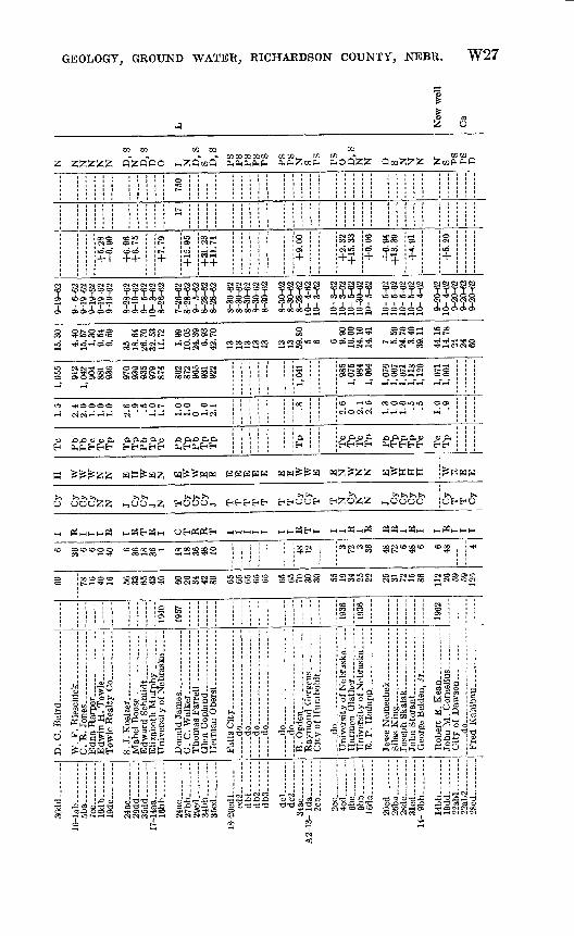
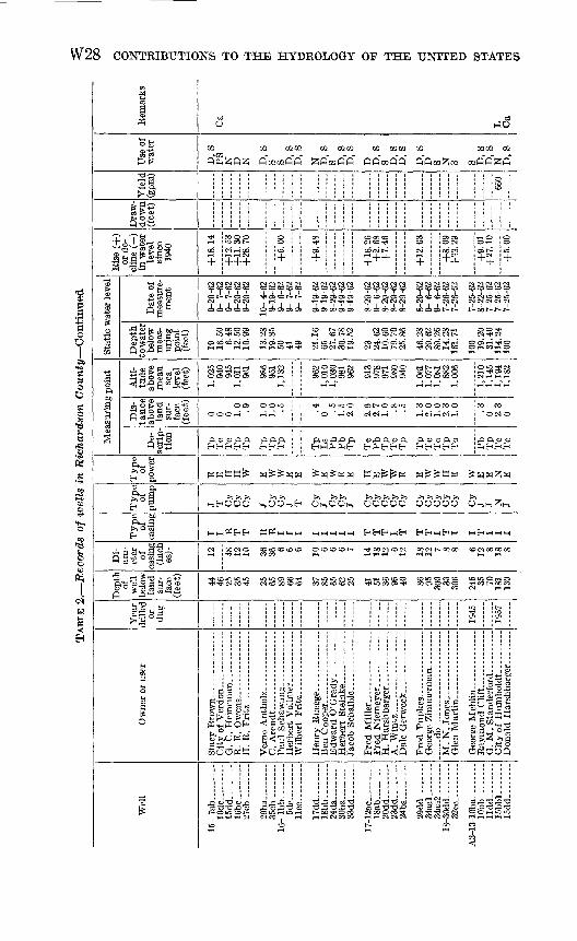
Some of the geologic and hydrologic data on which this report is based were collected in 1940 by the late R. C. Cady of the U.P. Geo logical Survey. Cady's detailed geologic field notes were freely drawn upon by the writer of this report. During the summer and r.utumn of 1962, the writer made additional geologic observations in the county and obtained information regarding 126 wells (see table 2). Many wells that had been inventoried in 1940 were visited again in 1962 to obtain a comparison of water levels. Industrial and municipal sup plies derived from wells and springs in the county were included in the 1962 inventory.
WELL-NUMBERING SYSTEM
The well and test-hole numbers used in this report give the location of wells according to the system of land subdivision of the U.S. Bureau of Land Management. The capital letter "A" which precedes the first numeral shows that the well is east of the sixth principal meridian. The first numeral in the number indicates the township, the second the range, and the third the section. The first lowercased letter denotes the quarter section, or 160-acre tract; and the second lowercased letter denotes the quarter-quarter section, or 40-acre tract. The quarter sec tions and the quarter-quarter sections are designated a, b, c, or d in a counterclockwise direction starting in the northeast corner. If two or more wells are within a 40-acre tract, the wells are numbered serially according to the order in which they were drilled or inven toried. Figure 1 illustrates this well-numbering system.
PERSONNEL AND ACKNOWLEDGMENTS
While working in Richardson County, Mr. Cady was assirted by L. P. Murphy, Howard Haworth, H. H. Penneker, and Orvill Q. Han- sen, all from the Conservation and Survey Division of the University of Nebraska.
This report was completed under the supervision of C. F. Keech, district engineer in charge of ground-water studies in Nebraska. Ac-
W4 CONTRIBUTIONS TO THE HYDROLOGY OF THE UNITED STATES
knowledgment is due E. C. Reed, V. H. Dreeszen, and R. R. Burchett, all from the Conservation and Survey Division, for their help and advice in the preparation of this report.
Appreciation is also expressed to the many farmers in Richardson County for their help and assistance in the collection of field data. Mr. A. D. Kuhl of the U.S. Soil Conservation Service at Falls City, Nebr., provided information on soils and geology in various parts of the county.
GEOGRAPHY
TOPOGRAPHY AND DRAINAGE
Richardson County is in the physiographic region of the United States referred to as the Dissected Loess-covered Till Prairies of the Central Lowland Province (Raisz, 1957). This name is appropriate because loess and till mantle most of the bedrock in the county, and much of the area has been greatly dissected by erosion. The upland remnants are highest in the southwestern, northwestern, and north eastern parts of the county. In the southwestern part, some of the remnants stand at altitudes of more than 1,300 feet above sea level; in the northwestern and northeastern parts, some remnants stand at altitudes above 1,200 feet; but in the north-central, central, and south eastern parts of the county, the altitude of the upland surface scarcely exceeds 1,100 feet. The upland divides are smooth and gently sloping except along the valley of the Big Nemaha and Missouri Rivers, where deep steep-walled valleys are very numerous and close together.
The North Fork and South Fork of the Big Nemaha Piver enter the county from the west, flow eastward across the west-central and southwestern parts of the county, and join in the south-central part of the county near Salem. From Salem the Big Nemaha flows east ward and empties into the Missouri in the southeastern part of the county. At this confluence, which is the lowest point in the county, the altitude is about 855 feet. The valleys of the North and South Forks are 150-200 feet below the adjacent parts of the upland plain, and they range in width from less than 1 mile to about 1.5 miles. Below the junction of the two forks, the Big Nemaha River valley is 1-2 miles wide and becomes slightly wider near its mouth. The valley cut by the Missouri River is 6-8 miles wide and is about 250 feet below the highest points on the adjacent upland. The largest tributary of the Big Nemaha River is Muddy Creek, which enters the north- central part of Richardson County, flows southeastward, and empties into the Big Nemaha about 4 miles east of Falls City. Smaller streams, tributary to the Missouri and Big Nemaha Rivers and to
GEOLOGY, GROUND WATER, RICHARDSON COUNTY, NEBR. W5
Muddy Creek, are very numerous; most of them are ephemeral or intermittent. The Big Nemaha River, including the North and South Forks, and Muddy Creek have been straightened and deepened to facilitate runoff and lessen the occurrence of floods. Some of the smaller streams also have been straightened.
CLIMATE
The climate of Richardson County is typically continental that is, it is characterized by rather hot summers, cold winters, and sudden temperature changes. The precipitation comes largely during the warm months in the form of local convection showers, which usually attend the approach of a cold front. In winter the precipitation is likely to be sparse; the light snow soon is blown from unprotected places and sublimated by the wind and sun. Winter precipitation is almost entirely general, as opposed to the summer precipitation of local type. Winds are strong and blow chiefly from the south in summer and from the west and northwest in winter.
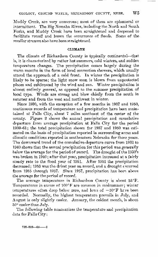
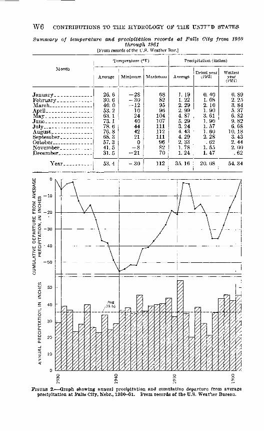
Since 1930, with the exception of a few months in 1937 and 1950, continuous records of temperature and precipitation have been main tained at Falls City, about 7 miles southeast of the center of the county. Figure 2 shows the annual precipitation and cumulative departure from average precipitation at Falls City for the period 1930-61; the total precipitation shown for 1937 and 1950 was esti mated on the basis of precipitation reported in surrounding areas and climatic conditions reported in southeastern Nebraska for those years. The downward trend of the cumulative-departure curve from 1932 to 1940 shows that the annual precipitation for this period was generally below the average for the period of record. The drought of the 1930's was broken in 1940; after that year, precipitation increased at a fairly steady rate to the flood year of 1951. After 1951 the precipitation decreased; 1953 was the driest year on record, and a drought c ccurred from 1955 through 1957. Since 1957, precipitation has been above the average for the period of record.
The average temperature in Richardson County is about 53°F. Temperatures in excess of 100°F are common in midsummer; winter temperatures often drop below zero, and lows of 30°F hs.ve been recorded. Normally, the highest temperature prevails in July, and August is only slightly cooler. January, the coldest month, is about 50° cooler than July.
The following table summarizes the temperature and precipitation data for Falls City:
735-992 64-
W6 CONTRIBUTIONS TO THE HYDROLOGY OF THE UNITED STATES
Summary of temperature and precipitation records at Falls City frotn 1930through 1961
[From records of the U.S. Weather Bur.]
Month
January. ____________
March __ _______ __
May______-__---__-_
July_____-_--_____-August __ _____ ___September. __ _______October ___ _________
December _ _ _ _______
Year______.___
Temperature (°F)
Average
26.6 30.6 40.0 53.2 63. 1 73. 1 78.6 76.8 68.3 57.3 41.5 31. 5
53.4
Minimum
-28 -30 -12
10 24 40 44 42 21
0 -8
-21
-30
Maximum
68 82 95 96
104 107 111 112 111 96 82 70
112
Precipitation (inches)
Average
1. 19 1.22 2. 29 2. 99 4.87 5.29 3.24 4.43 4.29 2. 33 1.78 1.24
35. 16
Driest year (1963)
0.40 1. 08 2. 10 1.90 3.61 1.90 1.57 1.60 2.28 .62
1.55 1.47
20.08
Wettest vear
(1951)
0.89 2.25 3.84 5.37 6.82 9.82 6.68
10. 18 3.43 2.44 2. 00 .62
54.34
FIGURE 2. Graph showing annual precipitation and cumulative departure from average precipitation at Falls City, Nebr., 1930-61. From records of the U.S. Weather Bureau.
GEOLOGY, GROUND WATER, RICHARDSON COUNTY, NEBR. W7
POPULATION
The total population of Richardson County in 1960 was 13,903; nearly 63 percent of the inhabitants lived in urban communities, and the rest lived in rural areas. Between 1940 and 1960 there was a 23.5 percent decrease in the county's total population. The rural popu lation suffered two-thirds of this loss and the urban communities the other third. Falls City, the county seat, is the largest community in the county; it had a population of 5,598 in 1960. Humboldt, the next largest community, had a population of 1,322. Of the other communities in the county, only Rulo 412 inhabitants had a population greater than 300. The smaller communities, listed in order of descending population figures, are Verdon, Dawson, Stella, Salem, Shubert, Preston, and Barada. The total population of these smaller communities was 1,408.
TRANSPORTATION
Richardson County is traversed by the Missouri Pacific and the Chicago, Burlington & Quincy Railroads. The Missouri Pacifc enters Falls City from the south and proceeds northwestward through the valley of Muddy Creek. The Chicago, Burlington & Quincy enters the county at Rulo, where it crosses the Missouri River, goes westward to Falls City, thence northwestward through the valley of the Big Nemaha and the North Fork of the Big Nemaha, through Humboldt, and into Pawnee County.
Two national highways, 73 and 75, cross the county from north to south. They are combined from the northern boundary to a point near Dawson, where they separate. U.S. Highway 75 goes directly south to Sabetha, Kans., and U.S. Highway 73 goes eastward from Dawson for about 12 miles, turns southward through Falls City, and from there passes into Kansas. State Highways 4, 8, 62, 67, and 105 connect various communities throughout the county. With the exception of Highway 4, parts of these highways are unpaved. In addition, roads are laid out 011 most section lines, and some of these roads are graded and gravelled.
AGRICULTURE AND SOILS
Agriculture is the most important economic pursuit in the county. The farm units are smaller than those farther west in the State. Corn, winter wheat, oats, sorghums, and soybeans are the chief crops. Cattle and swine are raised on a small scale and generally are fed on locally grown crops.
The soils of Richardson County, to some extent, are indications of the geologic units on which they are developed. The soils on the

W8 CONTRIBUTIONS TO THE HYDROLOGY OF THE UNITED STATES
upland areas north of the Big Nemaha River include the Wymore, Sharpsburg, and Marshall silty-clay loams and the Monona silt loam. These soils are developed on Peorian Loess. Geary silty-clay loam soils are found on some slopes in the central part of the county and are developed on the Loveland Loess. Other slope soils include the Pawnee, Shelby, and Morrill clay loams which are developed on till. Sogn, Summit, and Labette silty-clay loams are developed on shale slopes in the southwestern part of the county.
The soils on the Missouri River flood plain are called Litton, Alba- ton, Onawa, Haynie, Sarpy, Cass, and Carr. The first four have a fine to moderately fine texture; the last three are sandy.
The Wabash soils include the dark-colored fine-textured alluvial soils that occur along the Big Nemaha River and Muddy Creek. The medium to moderately fine textured soils in these valleys are called Colo, Kennebec, and McPaul.
More information about these soils can be obtained from the Richardson County Soil Conservation District, the County Agricul tural Agent, or the University of Nebraska.
MINERAL RESOURCES
The first oil field discovered in Nebraska was in Richardson County. Total oil production in the county between 139 and 1961 was 9,032,256 barrels. In recent years, oil production in the county has been decreas ing. Most of the oil is produced from Upper Devonian rocks; in addition, some oil is produced from rocks equivalent to the Viola Limestone and St. Peter Sandstone of Middle and Late Ordovician age.
In the past, some coal was produced from Upper Pennsylvanian rocks by drift mining near the town of Rulo.
Lower Permian limestone is quarried and processed for agricultural purposes at a site 2 miles east of Humboldt.
Sand and gravel for road surfacing is obtained from numerous pits and quarries in Quaternary deposits throughout the county.
GEOLOGY IN RELATION TO GROUND WATER
Two widely different types of rock material underlie Richardson County; one is the unconsolidated deposits of Pleistocene age that immediately underlie the land surface in much of the area, and the other is the older consolidated rocks of Paleozoic age on which the unconsolidated deposits rest! In some localities, especially the south western part of the county, rocks of Paleozoic age are exposed at the surface.
GEOLOGY, GROUND WATER, RICHARDSON COUNTY, NEBR. W9
PALEOZOIC ROCKS
The Paleozoic rocks consist of a succession of beds of shale, siltstone, limestone, dolomite, sandstone, and coal. The uppermost rocks are of Permian age and are underlain successively by rocks of Pennsyl- vanian, Mississippian, Devonian, Silurian, Ordovician, and Cambrian age. The total average thickness of these rocks above the Precam- brian basement is approximately 2,800 feet. Of this thickness of rocks, less than 900 feet is exposed in Richardson County.
The rocks beneath all but the western part of Kichardson County occupy a deep depositional basin called the Forest City basin. They rest on the eroded surface of the Precambrian rocks and have a gentle northwestward dip that is interrupted locally by low domelike and shallow troughlike structures.
About 3 miles east of the west boundary of the county is th°s Hum- boldt fault, which marks the western extremity of the Forest City basin. (See pi. 1.) Although arcuate in plain view, the Hum'boldt fault nearly bisects Tps. 1, 2, and 3 N., R. 13 E. Immediately west of the fault, all rocks older than Pennsylvanian either were never deposited or were eroded away before the Pennsylvanian rocks were laid down. The absence of these rocks indicates that the Humboldt fault was active in pre-Pennsylvanian time. After the deposition of the Pennsylvanian and Permian rocks, renewed vertical movement caused a relative downward displacement of the beds east of the fault. The amount of vertical displacement, or throw, is several hun dred feet. Subsequent erosion has exposed rocks west of tiH fault that are older than those at the surface immediately east of the fault.
The Paleozoic rocks, which would be exposed if the glacial deposits were stripped off Richardson County, belong to the Virgil Series of the Pennsylvanian System and the Lower Permian Series of the the Permian System. The chief subdivisions, and their approximate thicknesses are as follows:Permian. System
Lower Permian Series Chase Group, 7 feet Council Grove Group, 300 feet Admire Group, 115 feet
Pennsylvanian System Virgil Series
Wabaunsee Group, 400 feet Shawnee Group, thickness not known
With the exception of the Shawnee Group, all the above units are exposed at various localities throughout the county. The generalized areal distribution of these rock units is shown on plate 1.
W10 CONTRIBUTIONS TO THE HYDROLOGY OF THE UNITED STATES
The oldest bedrock exposed in the county belonging to the lower part of the Wabaunsee Group lies in the valleys of the North and South Forks of the Big Nemaha Eiver west of the Humboldt fault and in the extreme southeast corner of the county along tre Missouri Kiver.
Younger rock units of the Wabaunsee Group crop out along the Missouri Kiver bluffs to the north of the town of Kulo, along the Big Nemaha Kiver valley east of Falls City, and on upland and valley slopes west of the Humboldt fault.
Rocks of the Admire, Council Grove, and Chase Groups crop out on the upland and valley slopes in the central, west-central and southwestern parts of the county.
In general, the Paleozoic rocks exposed in Kichardson County and those rocks that underlie the outcropping formations are poor sources of potable water. Locally, however, the rocks that are not too deeply buried and that lie within the zone of saturation may yield small supplies of fairly good water to wells and springs. On the uplands in the west-central and southwestern parts of the county, Pleistocene deposits are not thick, and the Beattie and Grenola Limestones of the Council Grove Group are sources of ground-water supply. A large spring, which furnishes part of the municipal water supply for the city of Humboldt, issues from one of these limestones. The White Cloud Shale Member of the Scranton Shale of the Wabaunsee Group is composed largely of fine-grained sandstone that doubtless would yield small supplies of potable ground water where it is satu rated but not deeply buried. Other limestone beds not described in this report are thin, but locally they may yield small water supplies.
In areas where the bedrock is not mantled by water-bearing surficial material, the following rule is often helpful in locating grc^md-water supplies in the bedrock: If the uppermost bedrock is limestone, the chances for obtaining ground-water supplies are much better than if it is shale. The reason this usually holds true is that the bedrock was exposed prior to the deposition of the surficial material, and weather ing tended to produce voids and fractures in the limestone which may now conduct and hold ground water; the weathering of shale does not produce suitable voids or fractures for containing ground T^ater.
The conditions are moderately favorable for obtaining water sup plies from the Paleozoic rocks in the southern and southwestern parts of the county, south of the North Fork of the Big Nemahr, Kiver; in the area immediately adjacent to the Humboldt fault; and in the southeastern part of the county, south of the Big Nemaha Kiver.
Water-bearing bedrock formations that are near the land surface in one part of the county probably should not be considered as sources
GEOLOGY, GROUND WATER, RICHARDSON COUNTY, NEBR. Wll
of water supply in other areas where they lie at depths of 100 feet or more below the land surface because the water in them is very likely to be highly mineralized. Thus, the inhabitants of the greater part of the county must rely on ground-water supplies in the unconsoli- dated material which overlies the bedrock.
QUATEBNABY DEPOSITS
PIiEISTOCENE SERIES
Most of the ground-water supplies in Richardson County are derived from the unconsolidated sediments of Pleistocene age that mantle the surface of the older rocks previously described. The age and spatial relationships of these deposits are not completely clear, and no attempt has been made to differentiate these deposits for the purpose of geologic mapping or the construction of geologic sec tions. More extensive test drilling, particularly in upland areas, would enable more adequate description of the Pleistocene deposits. They are believed to consist of two deposits of glacial drift, ar inter vening interglacial deposit, and deposits of loess that are younger than the drift. In addition, alluvial deposits underlie the floors and make up terraces along the flanks of the river and stream valleys.
NEBRASKAN DRIFT
Two till sheets, the lower of which is regarded as the Nebraskan and the upper as the Kansan, have been reported in southeastern Nebraska by Lugn (1935), in southwestern Iowa by Kay and Apfel (1928), and in northeastern Kansas by Schoewe (1938) and Frye (1941).
Till, believed to be Nebraskan in age, is well exposed in only one place in Richardson County. This outcrop is near the bottom of the railway cut on the west side of the town of Rulo. Near the top of the exposure, the till is yellowish brown, but the lower part probably the unweathered portion is uniformly dark gray. The till contains only a moderate scattering of pebbles and cobbles of granite or granitelike rock, limestone, and sandstone. Pebbles of the Sioux Quartzite, such as are common in Kansan till, are either rare or not present.
The upper surface of the Nebraskan till at this exposure is eharply undulating. At one point the till is about 25 feet thick, but a few feet away the surface of the till descends below the level of the railroad track. This exposure of Nebraskan till is overlain successively by Aftonian(?) interglacial deposits, Kansan drift, and younge1" loess.
Postdepositional erosion of the Nebraskan drift removed it from much of the county. It was preserved only in areas that were topo graphically low.
W12 CONTRIBUTIONS TO THE HYDROLOGY OF THE UNITFD STATES
Although the Nebraskan drift probably contains less stratified sand or gravel than does the Kansan drift, it is very likely that the Nebras kan drift contains at least some. To the extent that such material does exist, ground water can be stored within the Nebraskan drift and can be released to wells drilled into it. The scanty evidence of the water bearing capacity of the Nebraskan drift indicates that i4: is a poor source of ground-water supply.
AFTONIAN(?) INTEK.GLACIAL DEPOSITS
The Nebraskan drift was largely removed by erosion after the reces sion of the Nebraskan ice sheet, and the drift that remained was dis sected. This stage of erosion was followed by deposition of sediments that are distinctive and easily identifiable. These sediments overlie the Nebraskan drift and extend beyond its limits; in many places they rest on bedrock. They are overlain by Kansan drift, which has a still greater areal distribution.
The precise age of these deposits and the conditions under which they were laid down are uncertain. The definite evidence that a period of erosion followed the melting of the Nebraskan ice sheet minimizes the likelihood that these deposits are related to the Nebras kan Glaciation. Instead, their age is more probably either Af tonian or early Kansan. Because these deposits are fine grained and of uni form texture whereas the fluvial deposits related to the P"ansan till are coarse and heterogeneous, it seems probable that th 0- deposits, were laid down during a tune of uniform climatic conditions such as probably prevailed during the Af tonian Interglaciation. Hence, these sediments are referred to as Af tonian (?) interglacial deposits.
The Af tonian (?) interglacial deposits consist of two distinct types of sediments a massive slate-gray clayey silt and an overling lami nated light-gray to light-yellow fine-grained sand. Wher^ these two types of sediment occur together, as they do in most exposures, the fine sand rests unconformably 011 the clayey silt. The composition and structure of the silt suggest deposition by wind wherers the com position and lamination of the sand suggest deposition in ponds or lakes.
Except in the southern and southwestern parts of the county where the bedrock surface is high, the Aftonian( ?) interglacial deposits are rather widely distributed. Because these deposits are generally below the water table, they are of some economic importance as a source of ground water.
A problem often met in obtaining a water supply from the Afton- ian (?) interglacial deposits is the presence of large amounts of fine sand. This fine sand, often referred to by drillers as "quick sand"

GEOLOGY, GROUND WATER, RICHARDSON COUNTY, NEBR. W13
or "sugar sand," causes the wells to fill in and also abrades and wears out pump mechanisms. The use of fine screens or slots in well casings or the packing of wells with coarse sand would enable well drillers to obtain a more successful well in these deposits.
KANSAN DRIFT
The Kansan drift in Richardson County consists of till and associ ated fluvialglacial deposits. It is not certain that the Kansan deposits always can be distinguished from the Nebraskan; but it is believed that the Kansan till is stonier than the Nebraskan till, has more pebbles of Sioux Quartzite, and is associated with more fluvioglacial rraterial than is the Nebraskan.
The Kansan drift is well exposed in many places in the county except in the valley lowlands or on graded slopes, where it is covered with loess which it superficially resembles. The best exposures are found in roadcuts, gravel pits, and eroded stream banks.
Kansan outwash consisting mainly of coarse-grained sand and gravel seems to be most abundant along a line bisecting the county from northwest to southeast (see fig. 3). However, this generalization must be modified to the extent that the Kansan drift may be somewhat sandy and gravelly in other parts of the county. The abundance of outwash along this line seems to indicate that as the glacier approached this line, a vigorous stream flowed along the face of the glacier. The coarseness of the deposits and the crossbedding indicate swift currents and probably large volumes of water. Since till overlies the cutwash in most exposures, it is evident that the glacier overrode the cutwash as it advanced southward into Kansas.
In certain localities the Kansan drift is a fairly satisfactory source of ground-water supply. It contains beds and lenses of medium- and coarse-grained sand, local pockets of gravel, and sandy till that can contribute water to a well. In the northwestern part of the county, north of Humboldt, outcrops and test holes suggest that a deposit of gravel and sand as much as 30-50 feet thick underlies a consider able area. The exact distribution and areal extent of these deposits are not known, but the area outlined on plate 3 as a moderate and large supply area shows the possible areal extent of these deposits Well A3-13-15bbl yielded 660 gpm (gallon per minute) in a pumping test, and it is possible that other wells of high yield could be developed in the same general area. Several springs issue from hillside? where the Kansan drift is present but masked by loess.
Although yields are somewhat unpredictable in the Kansan drift in most parts of the county except the southern and southwestern parts, it is a fairly good source of ground-water supply.
735-992 64 3
W14 CONTRIBUTIONS TO THE HYDROLOGY OF THE UNITED STATES
ILLINOIAN AND WISCONSIN LOESS
Most of the Kansan drift, the older Pleistocene deposits, and the bed rock formations are covered with loess. The large valleys and many of the small valleys were once partly filled with loess although the loess has since been removed except along the valley Trails. The loess is a wind-deposited sediment of the grain size of clay, silt, and fine sand. Both the Loveland and the Peorian Loesses sre present. The Loveland Loess is thought to have been deposited during late Illinoian time and the Peorian Loess to have been deposited during a time when the climate was influenced by the Wisconsin Glaciation. As it is not easy to disinguish between the two loess deposits in Richardson County, they are discussed together.
The thickness of the loess can be determined only by tert drilling. Because the loess mantles the hillsides, the apparent thickness ob served by starting at the bottom of a valley and measuring the visible loess to the top of the divide obviously results in a wrong v^.lue. The test holes drilled on the upland divides of Richardson County indi cate that the loess is from 15 to 40 feet thick and averages about 30 feet in thickness on uplands where erosion has been least active.
Although the color of the loess is predominantly buff, the Peorian Loess is light yellowish gray and the Lovelend Loess is reddish brown in some exposures. However, the distinctive coloration that char acterizes the two loess deposits in the central and south-ceitral parts of the State is not so evident in Richardson County.
Most of the loess is so fine grained that its capacity for transmit ting ground water is very small. However, wells drilled or dug on the upland divides do receive small amounts of water from the loess. In some places the colluvial (slope) phase of the Loveland contains some sand and gravel that is capable of furnishing adequate supplies for stock and domestic uses. Water cannot everywhere ba- obtained from the colluvial phase of the Loveland because in places tH material has been drained by gullies and streams.
The colluvial phase of the Loveland is of relatively small worth as a source of water supply, but it may be regarded as a possible source in the central, northern, and northwestern parts of the courtry. It is less promising as a source of water supply in the areas of high bed rock in the southern and southwestern parts of the county.
TERRACE DEPOSITS AND VALLEY ALLUVIUM OF POST-KANSAN AGE
Since the end of the Kansan Glaciation many cycles of valley cut ting and alluviation have taken place and have produced a series of terrace deposits. These deposits are in, or adjacent to, the present stream valleys.

GEOLOGY, GROUND WATER, RICHARDSON COUNTY, NEBR. W15
The value of the terrace deposits as a source of ground-water supply differs from place to place. These deposits are primarily fine grained, but a few thin beds and lenses of sand and gravel do exist in them. Hence, if the terrace fills are considered in a terrain that is otherwise barren of ground water, they may be the principal water-bearing beds. In the southern and southwestern parts of the county, most of the wells are in the valleys of small streams where they tap the coarse beds in the terrace deposits. In other parts of the county mo^t wells obtain water from glacial till or associated interglacial deports and are not necessarily in the stream valleys.
Test holes indicate the presence of coarse alluvium in the valleys of the Big Nemaha River and Muddy Creek. The alluvium appears to have been derived from older terrace deposits as well as from glacial till and outwash, and it probably was deposited in middle or late Wisconsin time.
Except, possibly, for the alluvium beneath the flood plair of the Missouri River, the best water-bearing material in the county is the coarse alluvium of the Big Nemaha River and Muddy Creek. Much of the deposit is well-sorted coarse-grained sand and gravel.
In most places within the inner valleys of the Big Neman** River and Muddy Creek, it is possible to obtain ground-water pipplies ample for domestic and stock purposes. However, the place^ where supplies sufficient for large industrial or public-supply use can be developed are not numerous.
RECENT SERIES
Because the deposits of late Pleistocene age grade imperceptibly into those of Recent age, it is not possible to define the contact between the two. Some of the colluvial material as well as topsoil, wind- deposited clay, silt, and sand, and much of the alluvium of the stream valleys constitute the deposits of Recent age. The Recent deposits on the uplands and valley slopes are probably only a few inches thick, but the Recent alluvium in the major stream valleys may be as much as 6 feet thick.
CONFIGURATION OF THE BEDROCK SURFACE
Rock outcrops and the logs of test holes provide control for the contour lines which show the configuration of the bedrock surface, shown on plate 1. The contour lines are generalized and do not show local features that doubtless exist, but they show the main features of the bedrock surface and provide a clue to favorable localities where ground-water supplies may be obtained from the Pleistocene deposits.
The configuration of the bedrock surface in Richardson County
W16 CONTRIBUTIONS TO THE HYDROLOGY OF THE UNITED STATES
is the result of a complex series of physical events. Where the bed rock is covered by the Nebraskan drift, it has essentially the surface that existed prior to glaciation. At various times during the Pleisto cene Epoch, other parts of the bedrock surface were changed by erosion and later covered by loess, till, or glacial outwash. Where the bedrock is exposed, weathering and erosion are slowly and constantly modifying its configuration.
At some time in the interval between the end of the Kansan Glacia tion and the deposition of the Loveland Loess, the Big Nemaha River and Muddy Creek valleys were cut. That the erosion of the valleys took place after the retreat of the Kansan glacier is indicated, first, by the absence of till in the inner valleys and, second, by the manner in which the Kansan till crops out on the Big Nemaha River valley walls. The Loveland Loess, which was deposited after the Big Nemaha River valley and many of its tributary valleys were cut, is believed to be of late Illinoian age. Considerable effort has been made previously in studies of the geology of Nebraska to determine more definitely the time when most of the larger valleys in the State were cut. The conclusions that have been reached are still specula tive; certain inferences and analogies, however, lead to the tentative conclusion that the main valley cutting in Nebraska took place during some part of late Kansan and Illinoian time. This valley cutting probably was contemporaneous with cutting of other valleys in the State namely, the North Platte, Niobrara, Republican, and Nemaha River valleys, their chief tributary valleys, and presumpbly many other valleys in the Great Plains region.
The relation of the modern Big Nemaha River valley to the Mis souri River valley suggests that the Missouri River adopted its present course at the same time as the Big Nemaha River cut its vrlley. Ex posures of Pleistocene deposits indicate that the Kansan till was de posited over the area now occupied by the Missouri River valley at a much higher altitude than that of the floor of the valley, and the sur face of the Kansan till does not indicate the presence of a large valley in the vicinity of the present Missouri River valley. However, the Loveland Loess mantles the walls of the Missouri River valley, and it is thus concluded that the present valley adjacent to Eichardson County was cut at the same time as the Big Nemaha River valley.
Todd (1914) and Greene and Trowbridge (1935) have presented evidence that in earliest Pleistocene time the Missouri River had not yet come into existence and Nebraska streams crossed the eastern boundary of the State and flowed into distant master streams to the east. According to this theory, the preglacial streams that crossed Richardson County may have been tributaries to a preglacial stream

GEOLOGY, GROUND WATER, RICHARDSON COUNTY, NEBR. W17
that flowed southeastward across southwestern Iowa and northwestern Missouri.
It is reasonable to assume that as the first glaciers advanced over the Richardson County area, they filled the preglacial stream valleys with till and glacial outwash, perhaps even to the level of adjoining up lands. Although subsequent erosion had modified these deposits, the thickest deposits can be assumed to mark the trend of preglacial streams. Figure 3 shows the thickness of Pleistocene deposits in Richardson County. The maps showing the configuration of the bed rock and the thickness of Pleistocene deposits give clues as to the loca tion of both preglacial and post-Kansan stream channels. In some areas, the present drainage probably follows the same courses as pre glacial and late Pleistocene drainage. However, even where tiH pres ent streams closely follow the late Pleistocene drainage, the location of the present channels in some places has shifted laterally as much as 1 mile.
Determining the location of both post-Kansan and preglaciaJ stream channels is significant because the old stream channels contain some of the thickest deposits of water-bearing materials. As can be seen by examining the geologic sections on plate 2, the old channels are often some distance from the present stream channels. A knowledge of their location can often mean the difference between obtaining ade quate or inadequate ground-water supplies.
OCCURRENCE OF GROUND WATER
The ground water in Richardson County occurs in open spaces, called voids or interstices, in the rocks and not, as popularly supposed, in underground veins, streams, or pools. There are no such under ground sources of ground water in Richardson Comity. Although many well sites in the county have been, and still are, selected by "witching" or "dowsing," the writer believes that any success in. locat ing ground water in this manner either is purely concidental or is due to the reliance of the "witch" or "dowser," whether he realizes it or not, on practical knowledge; success is not due to his forked stick or other mystic device.
At some depth below the land surface is the water table, or upper surface of what is termed "the zone of saturation." Water in the zone of saturation is called ground water and is the source of water for wells and springs. Above the water table is the zone of aeration through which water percolates downward to the zone of saturation. Saturated rock capable of supplying water to wells or springs in suffi cient quantities to be useful is referred to as an aquifer.
Some of the most successful shallow wells in the county are in the level upland areas some distance from the valleys. These wells, and

R. 1
3'E
R. 1
7 E.
EX
PL
AN
AT
ION
Thi
ckne
ss o
f P
leis
toce
ne
depo
sits
, in
fee
t
Lin
e al
ong
whi
ch t
hick
K
ansa
n ou
twas
h oc
curs
NE
MA
HA
CO
UN
TY
Map
.bas
ed o
n in
form
atio
n p
rovi
ded
by t
heC
onse
rvat
ion
and
Sur
vey
Div
isio
n,
Univ
ers
ity o
f N
ebra
ska
KA
NS
AS
2 1
01
,1,1
6 M
ILE
S
oo o
p w I I w
FIG
UR
E 3
. M
ap
of
Ric
hard
son
Cou
nty,
N
ebr.
, sh
owin
g th
ick
nes
s of
Ple
isto
cen
e d
epos
its.
co
GEOLOGY, GROUND WATER, RICHARDSON COUNTY, NEBR. W19
also some springs, probably owe their existence to what are termed "perched aquifers." In some places, the infiltration of precipitation through the zone of aeration is slowed by the existence of an almost impermeable layer of rock; thus, a ground-water body is supported above the regional water table by unsaturated rock. As a general rule, only small amounts of water man be obtained from perched aquifers.
Nearly all the ground water in Richardson County is derived from the precipitation that falls in the county. Although some water reaches the zone of saturation by seepage from streams or ponded water, most water added to the ground-water reservoir inf Itrates through the soil. That the ground-water supply is closely regulated by local precipitation is substantiated in that many shallow wells go dry during periods of low precipitation.
Ground-water discharge takes place in many ways. Where the water table is near the surface, much ground water is taken into the roots of plants and discharged from the plants by transpiration. Ground water is discharged by springs and by diffused seepage into streams, where it runs off. Much ground water along the streams that have been straightened and deepened has probably drained off owing to the fact that the streambed was lowered below the water table.
Ground water is discharged through the many wells in the county. However, the amount of water discharged by these wells is small com pared to the discharge by natural means.
DEPTH TO WATEE
The depth to water beneath the land surface of Richardson County ranges considerably. In some stream valleys the water table is almost at the surface. In upland regions of the northwestern and east-central parts of the county, the water table is in places more than 100 feet be low the land surface. Plate 3 shows the depth to water at numerous points throughout the county.
The depth to water is an important factor to consider when planning to obtain a supply of ground water; the type of well, casing, and pump, as well as the cost of drilling and pumping, are affected by th Q. depth to water.
The depth to water fluctuates from season to season and from year to year. Many wells that were measured in 1940 were measured again in 1962, and a comparison of the water levels shows that over 90 per cent of these wells had a higher water level in 1962. This rise in water levels is especially pronounced because the 1940 measurements were made soon after the great drought of the 1930's and the 1962 measure ments were made after a 4-year period of greater-than-normal precipitation.
W20 CONTRIBUTIONS TO THE HYDROLOGY OF THE UNITED STATES
POTENTIAL GROUND-WATER YIELDS
Plate 3 shows the areas in Richardson County where it is known or believed from available evidence that small, moderate, or large ground- water supplies can be obtained.
The bedrock-configuration and Pleistocene thickness maps (pi. 1, fig. 3), plus well logs and data on farm and municipal wells, were used in delineating the areas of potential yield of the water-bearing rocks. The map (pi. 3) should be regarded as a guide, not as a final authority, because moderate or large supplies could very possibly be obtained locally in regions designated as small-supply areas; and it is also true that moderate or large supplies may not be available at every point in the areas so designated. However, the map should be useful in locating sources of ground-water supplies.
CHEMICAL QUALITY AND USE OF GROUND WATER
The ground-water supplies in Richardson County are used almost exclusively for domestic and stock purposes. In 1962, oily one well in the conuty had been installed and used specifically for irrigation. There are two principal reasons why the amount of irrigation in the county is small: one, normally precipitation is sufficient f c ~ crop pro duction without irrigation; and two, with the exception of a few rather limited areas, supplies adequate for irrigation are urobtainable.
The ground water of Richardson County is, in general, of good quality. Some treatment is necessary, however, if the water is to be used for certain specific purposes. The following discussion of the quality and use of the ground water pertains mainly to itf suitability for domestic, stock, and industrial uses.
DOMESTIC USE
Water used for domestic purposes should not contain excessive amounts of substances harmful to health. In addition, it should be free from objectionable taste and odor and from any elements that will stain plumbing fixtures and laundry. The U.S. Public Health Service (1962) has established standards for drinking ari culinary water used by public carriers in interstate traffic. The stariards that pertain to chemical constituents are, in part, as follows:
Allowable limits, in parts per million, for potable water Iron ______________________ ___________________ 0. 3Manganese __ . 05 Chloride ______________________________________ 250. 0 Nitrate _______________________________________ 45. 0 Sulfate _______________________________________ 250. 0 Fluoride ______________________________________ J 0. 8-1. 7
Total dissolved solids (good quality)________________ 500.0 Total dissolved solids (if better water is not available)___ 1,000.0
1 Depends on annual average of maximum daily air temperature.

GEOLOGY,, GROUND WATER, RICHARDSON COUNTY, NEBR. W21
The results of chemical analyses of 14 ground-water samples col lected in Richardson County are given in table 1. A comparison of the results with the above allowable limits shows that only 7 of the 14 samples from Richardson County meet, in every respect, the standards for good-quality water. It should be stated, however, that people in many areas of the world have used substandard water for their entire lifetime with no apparent ill effects.
With few exceptions, the principal dissolved constituent in the, water samples was calcium bicarbonate. The sulfate concentration was relatively high in the water from well Al-13-25aa. Sulfates in the water in excess of 250 ppm (parts per million) can cause an unde sirable laxative effect in persons who are not accustomed to drinking such water. Chloride was the predominant ion in the sample from well A2-14-22ab2. Iron and manganese seems to be the most trouble some constituents in the ground water of Richardson County because they stain fabrics, plumbing fixtures, and other articles.
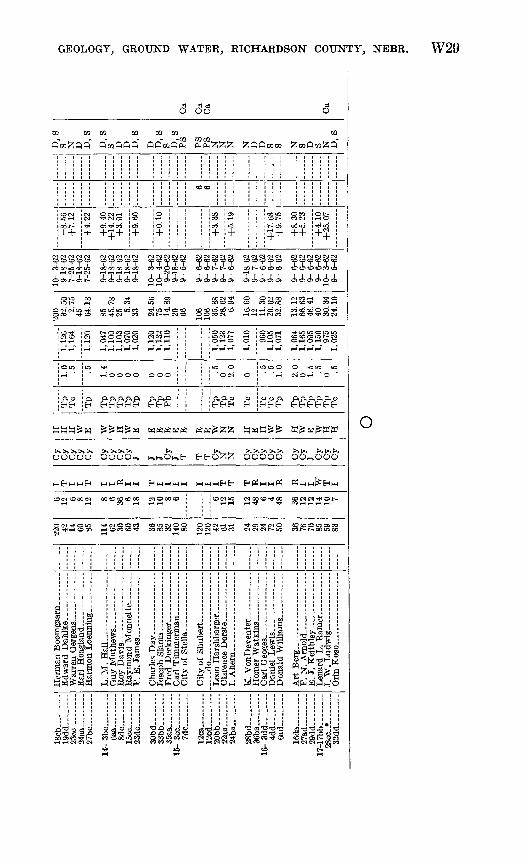
TABLE 1. Chemical analyses of ground water in Richardson County[Use of water: D, domestic; N, none; PS, public supply; S, stock. Results in parts per million except as
indicated]
Location
Al-13-12dc...
14-14dd 15-10ab--
lOba A2-13-10ba.-_
14-22ab2_.15-lOdc...
A3-13-15dd 36cb-_.
15- 7dc-_- 12ca.._12cd.-_
17-28CC-...
Location
Al-13-12dc.._ 25aa__-
14-14dd-__ 15-10ab_--
10ba-__ A2-13-10ba__-
14-22ab2__ 15-10dc_._
A3-13-15dd._- 36cb__-
15- 7dc... 12ca... 12cd_._
17-28cc_
Date of collection
10-25-40 ...do.....-.do.....
9-10-62
8- 1-62
do ..10-25-40 8- 1-62
10-25-40
8- 1-62 10-25-40
Chlo ride (01)
10 127 21 65 43 16
251 41 1.4
10 6.0 6.0
16 8
Depth of well (feet)
71.5 100 30 60 60
59 46
130 Spring
80 120 120 59.4
Fluo- ride (F)
~"46~
.28
.77
.26
.29
!l .1 .31
Silica (Si02 )
11
25 32
Ni trate (NO.)
45 0.3
22 <44 <44 <44
25 <44
4 <44
4.9 6.2
<44 .6
Manga nese (Mn)
0.9 2.3 .01
2.0 .40
.01
.35
Dis solved solids (resi
due at 103° C)
U23 i 2, 450
1480 724 720 338 830 562
1474 346
8263 3252
386 1525
Iron (Fe)
0.32
2.82 1.32
>2.0
!oe.05 .47
Hardness as CaCOs
Cal cium, mag ne
sium
3471,740
365 488 528 284 520 292 368 332 163 175 208 411
Non- car- bon- ate
26 1,470
12 124 112
0 344 112 60 40
0 0
16 0
Cal cium (Ca)
101 508 95
171 178 86
146 86 93 74 47 47 61
107
Per cent so
dium
13 1020
8 11 18 18 19 17 14 27 20 18 20
Mag nesium (Mg)
23 114 31 15 21 17 34 19 33 36 11 14 14 35
So- dium- adsorp-
tion ratio
0.6 .9
1.0 .4 .5 .8
1.0 .8 .8 .6
1.0 .7 .7
1.0
Sodium (Na)
2 90
4 21 29 30 52 32
3 26 28 20 22
4
PH
7^6 7.1 6.5 7.4
~7~2~
Potas sium (K)
t 4.8
3 4 2 5 6 6
4 6 2 1.7 4
g
Use of
water
S N D PS PS PS PS PS D PS PS PS PS N
Bicsr-bonate (HCOs)
334 430 414 517 351 215 219 375 3)6 259 231 234 533
Sul- fate
(S04)
27 1,430
56 64 64 16
118 90
124 24 5.9
18 20 64
Municipality
Salem. Nebr.* Dos
Humbo'dt, Nebr.2 Dawson, Nebr.2 Verdon, Nebr. 2
Humbo'dt, Nebr.2 Stella, Nebr. Shubert, Nebr.
Do.*
1 Calculated.2 Analyses by Nebr. Board of Health; some data converted to U.S. Geological Survey standards. « Residue at 180° C.

W22 CONTRIBUTIONS TO THE HYDROLOGY OF THE UNITED STATES
Hardness is a term which usually represents the soap-consuming capacity of water. Water is said to be hard if large quantities of soap are needed to produce a lather or if incrustations are formed when the water is heated or evaporated. Most of the observed effect with soap results from the presence of calcium and magnesium bicarbon- ates. The hardness caused mainly by these two compourds is called carbonate or "temporary" hardness and can be removec1 by simply boiling the water. The noncarbonate or "permanent" hardness, usually caused by chlorides or sulf ates of calcium and magnesium, can be removed only by the use of water softeners which form precipitates with these compounds. Specific limits for water hardness have not been set, but the following gradations are generally recognized:
Hardness as CaCOt (ppm)
Gradations for water hardness
Eating Suitability
0-60. .___ Soft- __-_____-___-__ Suitable for many uses without furthersoftening.
61-120-_____ Moderately hard-____ Usable except in some industrial ap plications.
121-180----- Hard____-_-_-__--__ Softening required by laundries andsome other industries.
181+ ___-___ Very hard____-__-___ Requires softening for many uses.
The water from 11 of the wells sampled in Richardson County can be classified as very hard, and the water from the others is hard.
Ground water is the source of all the municipal water-supply sys tems in Richardson County. Data on the municipal water supplies are given in the following table:
Municipal water systems in Richardson County, 1962
Town
Shubert-- Stella.-.. _ ........
Falls City. __ ....
Number of
wells
2 22 2 1 1
7
Reservoir
Capacity(gallons)
40,000 / 90,000 I 160,000
50,000 50,000 40,000 40,000
f 1,000,000 { 100,000 I 1,000,000
Type
Standpipe __ ---_ Underground
do.- . .do.. . .do. _ ..do.. Underground- -.-.
Treatment
JGhlorination.- -
do.- .do.--.. ... . -do.. . .
} Filtration and chlorination.-.--
Distribution
Number of
hydrants
40 40
8 24 11 11
120
Number of
taps
140 5009085
11285
2,250
GEOLOGY, GROUND WATER, RICHARDSON COUNTY, NEBR. W23
Chemical analyses of water from some of the municipal wells, as well as a spring used by Humboldt, are given in table 1.
AGRICULTURAL USE
Water used by livestock is subject to some quality limitations, but most farm animals seem to be able to use water considerably poorer in quality than that considered safe for human beings. All the ground water sampled in Richardson County is satisfactory for stock uses.
The sodium-adsorption ratio (SAR) and percent sodium, as well as the concentration of dissolved solids, are used to predict tH suit ability of water for irrigation. These values indicate that riost of the ground water is suitable for irrigation, at least from the star dpoint of chemical quality. The problem associated with development of ground water for irrigation in the county is not one of quality, but one of quantity.
INDUSTRIAL USE
The industrial demand for ground water in Richardson County is small, and nearly all water used in industrial plants is obtained from treated municipal supplies. Most of the water sampled in the county requires treatment to decrease the hardness or the iron and marganese concentrations before it can be used for most industrial purposes.
SUMMARY AND CONCLUSIONS
Ground water in usable amounts is obtained from the Paleozoic rocks; the Nebraskan drift, the Aftoman (?) interglacial deposits; the Kansan drift; the coarse alluvium of the Big Nemaha River, Missouri River, and Muddy Creek valleys; and the terrace deposits in the smaller valleys of the county. No one of these is a significant source of supply throughout the county, but each is a major source in at least some part of the county.
The bedrock is a source of water supply in the southern part of the county, particularly in the southwestern part. It is reported that bedrock wells are more successful along the Humboldt fault thrn any where else in the county. No wells drilled into the bedrock are known to have obtained more than a few gallons of water a minute from the fresh-water zones. Any attempt to develop a large supply by drilling through a great thickness of bedrock is almost certainly des tined to fail because below a depth of a few tens of feet, or s.t most about 100 feet, the water becomes too highly mineralizBd for most uses.

W24 CONTRIBUTIONS TO THE HYDROLOGY OF THE UNITED STATES
The Nebraskan drift, the Aftonian (?) interglacial deposits, and the Kansan drift and associated fluvioglacial deposits may be regarded as a unit. In most parts of the east-central, central, and northwest ern parts of the county, wells drilled through these deposits yield some ground water of satisfactory chemical quality. Preventing fine sand from entering wells seems to be the greatest problem. This is a technical problem that generally can be solved by the use of fine well screens or by packing wells with medium or coarse-grained sand.
The coarse alluvium of the Big Nemaha River and Muddy Creek valleys is the greatest source of ground-water supply in the county; although to be successful, wells in the alluvium must H properly located and developed. The thickness of the sand and gravel decreases westward from a maximum near the mouth of the Big Nemaha River. In the western part of the county, apparently few places have much more than 10 feet of saturated, coarse, water-bearing alluvium.
The results of test drilling in the northwest corner of the county indi cate the existence of a considerable thickness of saturated sand and gravel believed to be Kansan in age.
In the southern and southwestern parts of the county, veils drilled near the axis of small valleys are likely to tap a limited supply of water in the beds and lenses of sand and coarse gravel within the terrace deposits. Water cannot be found in the bedrock in every locality in these parts of the county, and the relative significance of the terrace deposits is attested by the fact that most wells are in the valleys of small streams.
Perched water tables are common, especially in the upland areas, and they provide water to many of the shallow wells.
The chemical quality of the ground water is in general satisfactory, but there are areas where high concentrations of iron and manganese occur.
SELECTED REFERENCES
Cady, R. C., and Scherer, O. J., 1946, Geology and ground-water resources ofBox Butte County, Nebr.: U.S. Geol. Survey Water-Supply P^per 969, 102p. [1947].
Condra, G. E., and Busby, E. E., 1933, The Grenola formation: Nebraska Geol. Survey Paper 1, 31 p.
Condra, G. E., and Reed, E. C., 1937, Correlation of the members of the Shawneegroup in southeastern Nebraska and adjacent areas of Iowa, Missouri, andKansas : Nebraska Geol. Survey Bull. 11,2d ser., 64 p.
1959, The geological section of Nebraska: Nebraska Geol. Survey Bull.14A, 82 p.
Condra, G. E., and Upp, J. E., 1931, Correlation of the Big Blue series inNebraska: Nebraska Geol. Survey Bull. 6, 2d ser., 74 p.
Condra, G. E., Reed, E. C., and Gordon, E. D., 1950, Correlation of the Pleistocene deposits of Nebraska : Nebraska Geol. Survey Bull. ISA, 74 p.
GEOLOGY, GROUND WATER, RICHARDSON COUNTY, NEBR. W25
Frye, John C., 1941, Reconnaissance of ground-water resources in AtchisonCounty, Kansas: Kansas Geol. Survey Bull. 38, p. 246-252.
Frye, J. C., and Leonard, A. B., 1952, Pleistocene geology of Kansas: KansasGeol. Survey Bull. 99,230 p.
Greene, F. C., 1921, Preliminary sketch of the history of the lower Missouri:Geol. Soc. America Bull., vol. 32, p. 83-86.
Greene, F. C., and Trowbridge, R. M., 1935, Preglacial drainage pattern ofnorthwest Missouri: Missouri Geol. Survey 58th Bienn. Rept., app. 7, 7 p.
Hem, J. D., 1959, Study and interpretation of the chemical characteristics ofnatural water: U.S. Geol. Survey Water-Supply Paper 1473, 269 p
Kay, G. F., and Apfel, E. T., 1928, The pre-Illinoian Pleistocene geology of Iowa :Iowa Geol. Survey Ann. Rept., v. 43, p. 1-304.
Lugn, A. L., 1935, The Pleistocene geology of Nebraska: Nebraska Geol. SurveyBull. 10, 2d ser., 223 p.
Lugn, A. L., and Wenzel, L. K., 1938, Geology and ground-water resources ofsouth-central Nebraska, with special reference to the Platte River valleybetween Chapman and Gothenburg: U.S. Geol. Survey Water-Supply Paper779, 242 p.
Meinzer, O. E., 1923, The occurrence of ground water in the United States, witha discussion of principles: U.S. Geol. Survey Water-Supply Paper 489,321 p.
1923, Outline of ground-water hydrology, with definitions: U.F Geol.Survey Water-Supply Paper 494, 71 p.
Rainwater, F. H., 1960, Methods of collection and analysis of water samples:U.S. Geol. Survey Water-Supply Paper 1454, 301 p.
Raisz, Erwin, 1957, Landforms of the United States: Map, 6th rev. ed.. Wash ington, D.C., M. S. Ginn & Co.
Schoewe, W. H., 1938, West Atchison glacial section (abs.) : Kansas Acad. Sci.Trans., v. 41, p. 227.
Schreurs, R. L., and Keech, C. F., 1953, Logs of test holes, Richardson County,Nebraska: Nebraska Univ. Conserv. and Survey Div. and U.S. Geol. Surveyopen-file rept, 67 p.
Todd, J. E., 1914, The Pleistocene history of the Missouri River: Science, newser., v. 39, p. 263-274.
U.S. Public Health Service, 1962, Drinking water standards, 1962 : Public HealthService Pub. 956,61 p.
Wenzel, L. K., Cady, R. C., and Waite, H. A,, 1946, Geology and ground-waterresources of Scotts Bluff County, Nebr.: U.S. Geol. Survey Water-SupplyPaper 943,150 p.

W26 CONTRIBUTIONS TO THE HYDROLOGY OF THE UNITED STATES
measur ublic su le.
ft^
Depth to water below measuring point: Reported distance given in fee
distance given in feet and hundredths of a foot.
Use of water: D, domestic; I, irrigation; N, none; O, observation well; PS,
ply; S, stock.
Remarks: Ca, complete chemical analysis (see table 1); L, log of well availa
w i| i i Tp,
.1 g Is-s l«i<l°1|a ^!?^ g>2afef^"i«lalP^-ftg^ij» fl.s ^^^l!§§ «-
2 S « - 3-!33^3
S^-fe"' si ^^ «b'.2§ If-i^a§S|SSl^'il S^l@g| sGrli S 3 o tJi5
J u aao a 'o "o "o '§ "o
Si
1«*~l
si
IIse?M o,®
Ifm& |l§ta 9
iia * w
® , kq
CQ
0 <3
EH a
Is!5il=f|i5 a ** "U .' a) *^a*?? ^3 ,2 d 3 ° *
!j|*l
3
S
o
S
a a O O
CO
33 <S 3!o 90
CQ CQ . - t»CQ Z&02 QfiZ^CO CQ^f^f^CQ COP^fl
^
2S5||
Kiii i](O OOOfl !O 1O
i-HOQOOO 0i-H i i o r- o* co I i-H O O i-H i-H
00 «Ooo to1*
£?oo 2; ot^f* ^J* O
o' co o* c4 +-f 1 1
I*! ilili i^ii-H OO *O ^ W? t^ »O OO lOKlTt' ?O cOOTj* COC$
III siiis §§
oo gs^fiooCO OCOC<I
as it< Tj<-4< os
OS 1-4 tO t^O*
o SoSS
i-H O CO i-H
tt,a a, a, o Q«
O O OS O O <IN *O
01 CO * O O ' ̂ I-H* I-H O
a, a a c ^£E? ^
OC<IOO
o c4 " »-! o«
E? E^EH^EH^
**HHH *,*,* HH**H UK,*,,* ««£«
UUO^U UO^UO H,UUOO UO6-<CHO U^On,
««««M «M««« «« MM« ««MM« M« M M
OO 7^ 5O OO ?O to to CO SO C-l CD CO Tj< ?O 00 OCO
Sc^SiMa c<iScoi-irH e* co f oo 53 coc^tra
Hiram Hoffman __ ____ Awin Blecha __ ___ ....
S. A. Kanel...... ........
Oliver J. Stauffer ___
Gerald Schmid .. ___ ..Ronald Wittwer.. ..........
« a =3^2 53 at^ 03X3 o 03 C3 ^
rt r-< r-< O> (M He'-
07
T
I
i C' ^ C3 -t
'2 c.) ^ » O w O a
««tj PH fl -j-s
^'hn'^ 0
03! J C "g^ C3-0 C
a
|||| S|jSU^ o Jfflo c
g««S 3^^
O'OP'O p n
^OSfM^I OUOC I * .H C^ CO »Ot-»l-<.H
to cooo^jitoCO ^*
IO ti. OO ^ *^3
A. D. Sargent _ __ .. ...... Charles Dettmann.. ..... Ben Stalder .................
Mae Wittwer. ___ - .. ....Ben Ranne beck-. -....- __
in
16-l
ab. -
... --
5ba_--
_
16
db
_ -
29
dd
.. ...
35dd..
16bb.._... -
34bb
__
cd2
_-_
dbl.
......
db2
. ....
db3.-
-
del-
--
--dc
2___
_._-
A2-
13- Id
a-..
-
9cb
4cd_.. _
6b
c _ .
....
9bb.
_
20
cd
..
26
ba._
31
cd
14-
9bb..
-
14
bb
--.
1
9d
d....
22ab
2__.
_ ...
28
cd_
-
D.C
. B
air
d .... - -
W.
F.
Rie
schic
k....- _
_ ..
.C
. R
. Jo
nes.
__ _
_____
Edna
Har
per _
_______
Tow
le R
ealt
y C
o ______
Eli
zabet
h M
urph
y .........
Uni
vers
ity
of N
eb
rask
a..
.
Don
ald
Jam
es _
___ _
__
Q.
C.W
alker
. __
....
....
Tho
mas
Far
rell
______
Fal
ls C
ity -
. .d
o ..................
..... d
o...... ... . ..
..
---.
do
..
..-
......-
... -do ....... ..- ..
- d
o..
.. ..
..... . ........
doB
. O
gd
en-.
.. ......
__-_
do . ....
Uni
ver
sit y
o f
Ne
bras
ka --
---
Sila
s K
in
g .
.d
o
----
-
1940
1957 1936
1936
1962
60 78
16 40 16 56 33 65 43 40 60 26 34 42 80 65 65 65 65 65 65 65 70 30 30 55 19 34 25 22 25 31 72 15 86 112 26 59 59 125
6 36 6 6 10 40 6 36 18 36 1 18 18 36 48 10 48 12 3 72 3 36 48 72 6 48 6 6 48 4
I R I T T R T R T R T 0 T R R T T r r T i T T R T T T T R T R R R T R T T R T T T
Cy Cy
Cy
Cy
N N J Cy
Cy
J N T Cy
Cy Cy
J T T T T T T T Cy Cy T T N Cy
N N J Cy
Cy
Cy gy T Cy
II W W W N N E H W E N E W W E E E E E E E E E W W E E N W N N E W H H H W E E
Tc
Pb
Pb
Tc
Tc
Tp
Tp
Tp
Pb
Tp
Tc
Pb
Tp
Pb
Tp
Tp
Tp
Tc
Tp
Tc
TP
Pb
Tp
Tp
Tp
Tc
Tc
Tp
1.5
2.4
2.0 1.0
1.0
1.0
2.6 .9 .5 1.0
1.7
1.0
1.0
0 1.0
2.1 .8 2.6
0 2.1
2.5 1.3
1.0
1.0 .5 .5 1.0 .9
1,05
5
912
1,04
290
488
193
6
970
939
935
979
874
862
872
965
931
922
1,04
1
985
1,07
598
41,
064
1,07
61,
007
1,07
11,
118
1,12
0
1,07
11,
001
15.3
0
4.40
15.5
71.
309.
549.
59
35 18.6
426
.70
32.5
311
.72
1.99
10.0
524
.39
6.93
42.7
0
13 13 13 13 13 13 13 59.8
05 6 6 9.
9016
.00
24.1
014
.41
7 5.59
24.7
03.
4039
.11
44.1
514
.78
24 24 60
9-19
-62
9- 6
-62
9-19
-62
9-19
-62
9-19
-62
9-19
-62
8-28
-62
9-19
-62
9- 5
-62
10-3
-62
8-26
-62
7-26
-62
8-28
-62
9- 5
-62
8-28
-62
8-28
-62
8-30
-62
8-30
-62
8-30
-62
8-30
-62
8-30
-62
8-30
-62
8-30
-62
8-28
-62
10-
4-62
10-
3-62
10-3
-62
10-
3-62
10-
5-62
10-3
0-62
10-
5-62
10-
5-62
10-
5-62
10-
5-62
10-
5-62
10-
4-62
9-20
-62
10-
4-62
0-20
-62
9-20
-62
9-20
-62
+5.
28-0
.90
+6
.96
+6
.75
+7
.79
+15
.95
+31
.23
+11
.71
+9
.00
+2.3
2+
15. 3
3
+0
.06
+0.
94+
13. 3
9
+4.
91
+5.
20
1775
0
N N N N N N D,
SN D
, S
D 0 I N D,
SS D
, S
PS
PS
PS
PS
PS
PS
PS N S PS
PS
0 D,S
N N D S N N N N S PS
PS
D
New
wel
l
Ca
O
W28 CONTRIBUTIONS TO THE HYDROLOGY OF THE UNITED STATES
<BM
Si
11
^ °<2'TN '"7V *-i
1 ~^Tfe T^Z
& * ~*«-^
1O l-i
Is !CD ClO
>>0'5r5
sil*fliHi! ill
lf*I
Owner or user
*
c3 c3 O r5O
02 OJ OJOJ 02 02W O2 0202 02 0202 02
O CO CD
* COOO O 00
TH TH TH CM 1 I
CM CM (M CN) CN) <N CS <N (N CM
O OOOOS 00^5 IO -^ »o OS CM 00
as cd cd CM d co ci o TH os
ilisJg lisOOS OO>0
OOOTH
CO 00 CO C*i CO ^
<N<N(N<N<N (NtNCS
OSOSOOOSOS OOCAOO
O OCM OTH O
CDCD SSScC 1 SISCO t~00<N (NOOCO OOMCOOOTH OO-* TH COt^iO COCOt^OO CNCOtNCNt'- (N^CN
cl COCSCOT-
TH"TH"
5 CNCNS S s ssss CO OTH COTH O
4 COOOrHOO rHt~£o <N § O>0_PC-»
^ »o id O OSt^OOOiO COOOCOO CO CO
THTH O THCSI (NCMrH >H (MTHCM
£££££ £££ £3£££ £££££ 5-^1
1-1 O<N O
, C.1 ,O D, O O
**H»E* H^^HH ^«^« «^^ «^W^ ^««^
H,E-iOOO H,ODh,E-i Ui-sOUi-s OOOOO OOOOO OHSI-S^HI-S
HM«^ «« MMM MMMMM MM ^^ M..MMM
CN CX)C^O COCOCOCOCO TH -^ TH TH COCO
---«
t ^> a ^
TH T-t »-l
10
«l <N CDOOCDCO
Verne Antholz... ... C. Arendt.___._ ........ Paul Schawang... _. Herbert Vollnier. ...-.-
Wilbert Fritz. -.
ONCO^
OCOtOCDt^ ^00<MCO(M OOCNt^OOOC CDCMGOOOOO
t^ IO »O (M IO THrHCOCC COOOCOCOCN -^ »O CO CS
Henry Ruegge...
Ben Cooper.
Edward O'Grady.- _ - Herbert Steinke. --.-
'O ,0 03 C3 r
THTH CSI COO
|||
T'gjl
I|I1
£ £ <
tTS CO <N
O COW5OCOCC »OU3OTHO
CO CC CM TH TH
Dale Gerweck _ ..
Fred Pupkes __ ..
George Zinmierman. ......
. .do _- - -
M KT .Tnnns
CM CM CO CO C*
X FH
^ I »cOS 1 OS
Glen Martin..
George Mehlin . - .. Raymond Clift _ ._ _ ...
G. M. Standerford ____ ... City of Fumboldt.. _ Donald Ilarslibarger. _ .....
CO
i
5J
IScb
..,
- -
19dd-_
__ .
23cc
27bc
___-
_ .
14-
3bc
8dc
23dC
-__ _
__
30bd..__ .
33
bb
... _
-O
KQ
Q
7Hp
12ca
. __ ..
.12
cd _
__
_20
bb_.
__ -
OO
oo
24
ba......
28bd
.. _
_ -
36ba
... _
...
16- 3
dd
..
4dd
16
da.
..
O7ar
l
29dd..
. __
17-1
7bb... -
2Scc
*
32
dd
.__
-
L. M
. H
all
City
of S
tell
a..
. ......
E. J
. K
eitb
ley
, -~
~
J. W
. L
ud
wlg
220 42 14 Rn 85 114 62 30 Rn 36 85 32 an 120
120 42 61 31 24 29 24 72 50 36 76 70 85 59 83
6 12 6 8 12 8 6 36 6IB 12 10 8 6 6 12 15 12 48 6 4 48 36 12 12 14 10 7
I T I I T I I R I I T I I I I I I I T T T R I I R R I I W T I
£y
Cy
Sy Cy Cy
Cy
C*\T
& I7
J J 0,
T T T Cy N N Cy
Cy
Cy
Cy
Cy
Cv
Cy
Cv
Cy
Cy
II H H W E W W H W E E E E E E E W N N H E H W W H W E W H H
Tp
Tc
Tp
Tp
Tp
Tp
Tp
Pb
Tp
Tp
Tc
Tc
Tc
Tc
Tp
Tp
Tp
Tp
Tp
Tc
1.0 .5 .5 1.4
0 0 0 0 0 0 0 .5 0 2.0
0 .5 1.0
2.0
0 1.5 .5 0 .5
1.12
61,
164
1,12
0
1,04
71,
100
1,10
31,
070
1,12
01,
132
1,11
0
1,05
01,
123
1,07
7
1,01
0
960
1,10
51,
071
1,06
41,
165
1,09
51,
150
975
1,02
5
200 32. 5
02.
7545 64
.18
85 45.7
825 5.
3433 24
.56
75 14.8
920 66 10
610
6 35.8
826
.62
6.94
16.6
012 11
.30
20.6
232
.88
13.1
266
.63
46.4
140 30
.34
24.1
0
10-
3-62
9-18
-62
7-25
-62
9-18
-62
7-25
-62
9-18
-62
9-18
-62
9-18
-62
9-18
-62
Q
1 O
fi
O
10-
3-62
10-
4-62
9-20
-62
9-18
-62
9- 5
-62
9- 6
-62
9- 6
-62
9- 7
-62
9- 7
-62
9- 6
-62
9-18
-62
9- 7
-62
9- 6
-62
9- 6
-62
9- 6
-62
9- 6
-62
9- 6
-62
9- 6
-62
9- 6
-62
10-
3-62
9- 5
-62
-8.5
6+
7.12
44.2
2
+9.
40+
14. 2
2+
3.91
+9
60
+0
.10
+3.
38
+5.
19
+17
.68
+9.
75
+8
.30
+5.
23
+4
.10
+25
. 07
6 6
D,
SS N D D
, S
D,S
S D D D,S
D D,S
S D,
SP
S
PS
PS
N N N N D D S S N S D S N D,
S
Ca
Ca
Ca Ca
o
W § 5 » o CO § o o
The U.S. Geological Survey Library has cataloged this publication as follows:
Emery, Philip A 1934-Geology and ground-water resources of Richardsc n Coun
ty, Nebraska. Washington, U.S. Govt. Print. Off., 1964.
iv, 29 p. maps (1 col.) diagrs., tables. 24 cm. (U.S. Geological Survey. Water-Supply Paper 1779-W)
Contributions to the hydrology of the United States.Part of illustrative matter fold, in pocket.Prepared in cooperation with the Conservation and Survey Division
of the University of Nebraska.Bibliography: p. 28-29.
(Continued on next card)
Emery, Philip A 1934- Geology and ground- water resources of Richardson County, Nebraska. 1964. (Card 2)
1. Geology Nebraska Richardson Co. 2. Water-Supply Nebras ka Richardson Co. 3. Water, Underground Nebraska Richardson Co. I. Nebraska. University. Conservation and Survey Division.(Series)
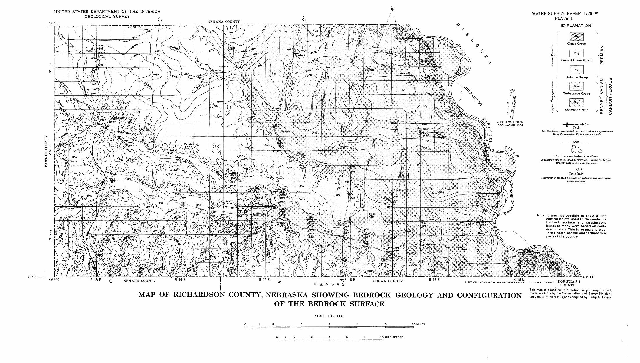
UNITED STATES DEPARTMENT OF THE INTERIORGEOLOGICAL SURVEY
O96°00'
WATER-SUPPLY PAPER 1779-W PLATE 1
EXPLANATION
Shawnee Group
FaultDotted where concealed; queried where approximate.
U, upthrown side; D, downthrown side
900-
40° 00'
rr^R.16 E KANSAS
INTERIOR GEOLOGICAL SURVEY, WASHINGTON, D. C. 1964 W64O58 |
Contours on bedrock surfaceHachures indicate closed depression. Contour interval
50 feet; datum is mean sea level
08t2 Test hole
Number indicates altitude of bedrock surface above mean sea level
Note: It was not possible to show all the control points used to delineate the bedrock surface and stratigraphy because many were based on confi dential data. This is especially true in the north-central and northeastern parts of the country
40° 00'
COUNTY
MAP OF RICHARDSON COUNTY, NEBRASKA SHOWING BEDROCK GEOLOGY AND CONFIGURATIONOF THE BEDROCK SURFACE
This map is based on information, in part unpublished, made available by the Conservation and Survey Division, University of Nebraska,and compiled by Philip A. Emery
SCALE 1:125000
1 0l I t=
10 MILES
2 1 10 KILOMETERS

UNITED STATES DEPARTMENT OF THE INTERIOR GEOLOGICAL SURVEY
WATER-SUPPLY PAPER 1779-W PLATE 2
EXPLANATION
Wabaunsee GroupLimestone, shale, sandstone
and sf'ltstone
Water ta. leVertical exaggeration approximately X 50
See geologic map for location of sections
800SOUTH NORTH
Geology by Philip A. Emery
800'
GEOLOGIC SECTIONS ACROSS RICHARDSON COUNTY, NEBRASKASCALE 1: 125000
2 4 6 MILES
H I I6 KILOMETERS
DATUM IS MEAN SEA LEVEL
735-992 O - 64 (In pocket]
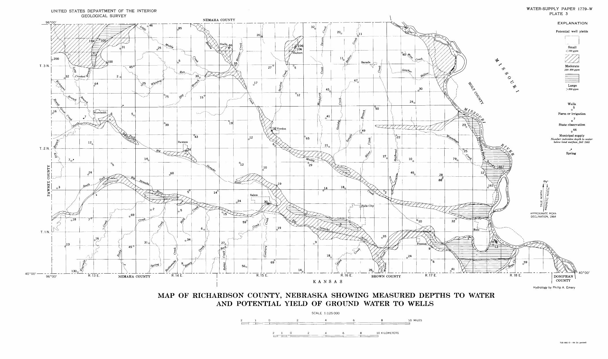
UNITED STATES DEPARTMENT OF THE INTERIOR GEOLOGICAL SURVEY
96°00' NEMAHA COUNTY
WATER-SUPPLY PAPER 1779-W PLATE 3
EXPLANATION
Potential well yields
T. 3 N.100-300gpm
*+Large
>300gpm
Wells5
o
Farm or irrigation
7e
State observation
@ 66
Municipal supplyNumber indicates depth to water
below land surface, fall 1962
40°00'
APPROXIMATE MEAN DECLINATION, 1964
T. 2 N. r
Spring
T. 1 N
96° 00' R.13 E. NEMAHA COUNTY R.14 E. R.15 E. R.16 E.
KANSASCOUNTY R.17 E. R.18 E.
40°00'
I DONIPHAN \ | COUNTY
Hydrology by Philip A. Emery
MAP OF RICHARDSON COUNTY, NEBRASKA SHOWING MEASURED DEPTHS TO WATERAND POTENTIAL YIELD OF GROUND WATER TO WELLS
SCALE 1:125000
4 10 MILES
2 1 0 10 KILOMETERS=3
735-992 O - 64 (In pocket)