Embed Size (px)
Citation preview

October 2009 6.15-1 GEOLOGY, PALEONTOLOGY & MINERALS
GEOLOGY, PALEONTOLOGY AND MINERALS Prepared by Patrick A. Pilling, Ph.D., P.E., G.E., D.GE.
SUMMARY OF CONCLUSIONS
The proposed Ivanpah Solar Electric Generating System (ISEGS) is located in a moderately active geologic area on the west side of Ivanpah Valley, east of the Clark Mountain Range in the eastern Mojave Desert of Southern California. The main geologic hazards at this site include ground shaking; liquefaction; settlement due to compressible soils, subsidence associated with shrinkage of clay soils, hydrocompaction, or dynamic compaction; and the presence of expansive clay soils. These potential hazards can be effectively mitigated through facility design by incorporating recommendations contained in a design-level geotechnical report as required by the California Building Code (2007) and Condition of Certification GEO-1. Conditions of Certification GEN-1, GEN-5, and CIVIL-1 in the Facility Design section, should also mitigate these impacts to a less than significant level. The proposed project is currently not used for mineral production, nor is it under claim, lease, or permit for the production of locatable, leasable, or salable minerals. Sand and gravel resources are present at the site and could potentially be a source of salable resources; however, such materials are present throughout the regional area such that the ISEGS should not have a significant NEPA or CEQA impact on the availability of such resources. Paleontological resources have been documented within 45 miles of the project, but no significant fossils were found during field explorations on the solar plant sites or near the sub-station and ancillary facilities; however, pack rat middens with plant remains were found in the carbonate bedrock outcrop west of Ivanpah 3. If encountered, potential impacts to paleontological resources contained in these materials due to construction activities will be mitigated through worker training and monitoring by qualified paleontologists, as required by Conditions of Certification PAL-1 through PAL-7. BLM and Energy Commission staff (hereafter jointly referred to as staff) believe that the potential for significant adverse cumulative impacts to the project from geologic hazards during its design life and to potential geologic, mineralogical, and paleontological resources from the construction, operation, and closure of the proposed project, is not significant with respect to CEQA or NEPA. It is staff’s opinion that the ISEGS can be designed and constructed in accordance with all applicable laws, ordinances, regulations, and standards (LORS), and in a manner that both protects environmental quality and assures public safety, to the extent practical. Conditions of Certification referred to herein serve the purpose of both the Energy Commission’s Conditions of Certification for purposes of the California Environmental Quality Act (CEQA) and BLM’s Mitigation Measures for purposes of the National Environmental Policy Act (NEPA).
INTRODUCTION
This Final Staff Assessment/Draft Environmental Impact Statement (FSA/DEIS) discusses the potential impacts of geologic hazards on the proposed ISEGS as well as

GEOLOGY, PALEONTOLOGY & MINERALS 6.15-2 October 2009
geologic, mineralogical, and paleontological resources. Staff’s objective is to ensure that there will be no consequential adverse impacts to geological, mineralogical, and paleontological resources during the project construction, operation, and closure and that operation of the plant will not expose occupants to high-probability geologic hazards. Brief geological, mineralogical, and paleontological overviews are provided. The section concludes with staff’s proposed monitoring and mitigation measures for geologic hazards and geologic, mineralogical, and paleontological resources, with the proposed conditions of certification.
LAWS, ORDINANCES, REGULATIONS AND STANDARDS (LORS)
Applicable LORS are listed in the application for certification (AFC) (CH2M Hill, 2007). The following briefly describes the current LORS for both geologic hazards and resources and mineralogical and paleontological resources.
Geology, Paleontology and Minerals Table 1 Laws, Ordinances, Regulations, and Standards (LORS)
Applicable Law Description Federal Federal Land Policy and Management Act (FLPMA) of 1976
Provides for the immediate and future protection and administration of public lands in the California desert within the framework of a program of multiple use and sustained yield, and the maintenance of environmental quality. This Statute requires the Secretary of the Interior to retain and maintain public lands in a manner that will protect the quality of Scientific, scenic, historical, ecological, environmental, air and atmospheric, water resources and archeological values.
General Mining Law of 1872
Declared all valuable mineral deposits in lands belonging to the United States to be free and open to exploration and purchase. This law remains the method for disposal of minerals in Federal lands that are not specifically provided for in later mineral leasing and sales laws.
Materials Act of July 31, 1947
Authorizes the sale of certain materials, including sand, stone, gravel, and common clay from public lands, if not otherwise expressly authorized or prohibited by law.
Surface Resources Act of 1955
Defined common varieties of sand, stone, gravel, and other materials and authorized the Government to manage and dispose of any land and surface resources that are not incident to mining on unpatented mining claims.
Mining Claims Rights Restoration Act of August 11, 1955
Permits the mining, development, and utilization of mineral resources on all public lands withdrawn or reserved for power development.
Classification and Multiple Use Act of 1964
Authorized the Secretary of the Interior to classify and Manage Bureau of Land Management land for retention or disposal, and for multiple use, including specification of dominate uses and preclusion of inconsistent uses in an area.

October 2009 6.15-3 GEOLOGY, PALEONTOLOGY & MINERALS
Applicable Law Description Mining and Mineral Policy Act of 1970
Declared that the Federal Government policy is to encourage private enterprise in the development of a sound and stable domestic mineral industry, domestic mineral deposits, minerals research, and methods for reclamation in the minerals industry.
California Desert Conservation Area (CDCA) Plan
Defines multiple-use classes for BLM-managed lands in the CDCA, which includes the land area encompassing the proposed project location.
Northern and Eastern Mojave Desert Management Plan (NEMO) Amendment
The purpose of this amendment to the CDCA Plan was to evaluate land use changes necessary to protect threatened and endangered species.
Antiquities Act of 1906 (16 United States Code [USC], 431-433
The proposed ISEGS is located entirely on federal (Bureau of Land Management) land. Although there is no specific mention of natural or paleontological resources in the Act itself, or in the Act’s uniform rules and regulations (Title 43 Part 3, Code of Federal Regulations [43 CFR Part 3], ‘objects of antiquity’ has been interpreted to include fossils by the National Park Service (NPS), the Bureau of Land Management (BLM), the Forest Service (USFS), and other Federal agencies. All design will also need to adhere to any applicable BLM design standards.
Omnibus Bill (HR 554) and Paleontological Resources Preservation Act, of March 30, 2009
Provides for the protection and preservation of Paleontological Resources.
Title 43 Code of Federal Regulations
Regulate the management of Public Lands.
State California Building Code (2007)
The CBC (2007) includes a series of standards that are used in project investigation, design, and construction (including grading and erosion control). The CBC has adopted provisions in the International Building Code (IBC).
Alquist-Priolo Earthquake Fault Zoning Act, Public Resources Code (PRC), Section 2621–2630
Mitigates against surface fault rupture of known active faults beneath occupied structures. Requires disclosure to potential buyers of existing real estate and a 50-foot setback for new occupied buildings. The site is not located within a designated Alquist-Priolo Fault Zone.
The Seismic Hazards Mapping Act, PRC Section 2690–2699
Areas are identified that are subject to the effects of strong ground shaking, such as liquefaction, landslides, tsunamis, and seiches.

GEOLOGY, PALEONTOLOGY & MINERALS 6.15-4 October 2009
Applicable Law Description PRC, Chapter 1.7, Sections 5097.5, 5097.9 and 30244
Regulates removal of paleontological resources from state lands, defines unauthorized removal of fossil resources as a misdemeanor, and requires mitigation of disturbed sites.
Warren-Alquist Act, PRC, Sections 25527 and 25550.5(i)
The Warren-Alquist Act requires the Energy Commission to “give the greatest consideration to the need for protecting areas of critical environmental concern, including, but not limited to, unique and irreplaceable scientific, scenic, and educational wildlife habitats; unique historical, archaeological, and cultural sites…” With respect to paleontological resources, the Energy Commission relies on guidelines from the Society for Vertebrate Paleontology (SVP), indicated below.
California Environmental Quality Act (CEQA), PRC Sections 15000 et seq., Appendix G
Mandates that public and private entities identify the potential impacts on the environment during proposed activities. Appendix G outlines the requirements for compliance with CEQA and provides a definition of significant impacts on a fossil site.
Society for Vertebrate Paleontology (SVP), 1995
The “Measures for Assessment and Mitigation of Adverse Impacts to Non-Renewable Paleontological Resources: Standard Procedures” is a set of procedures and standards for assessing and mitigating impacts to vertebrate paleontological resources. The measures were adopted in October 1995 by the SVP, a national organization of professional scientists.
California Surface Mining and Reclamation Act (SMARA)
Requires local governments with California to regulate mining operations, and to develop planning policies that balance mineral production with maintenance of environmental quality.
Local San Bernardino County General Plan
Mandates compliance with a number of development standards, including safety requirements. The county also incorporates standards and provisions established by the CBC (2007).
San Bernardino County 2007 Development Code, Chapter 82.20
Defines criteria for site evaluation for paleontological and cultural resources in the county, including preliminary field surveys, monitoring during construction, and specimen recovery; also defines qualifications for professional paleontologists.
California Surface Mining and Reclamation Act (SMARA)
San Bernardino County is the lead agency for SMARA within the County, and issues permits and regulates salable mineral operations.
PROJECT DESCRIPTION
The proposed ISEGS will be constructed in three phases on a total of approximately 4,072.5 acres (6.4 square miles) located approximately 4.5 miles southwest of the California/Nevada border and Primm, Nevada, and 1 to 3.5 miles west of Interstate Highway 15 in San Bernardino County, California. The proposed project is located

October 2009 6.15-5 GEOLOGY, PALEONTOLOGY & MINERALS
entirely on federal land administered by the Bureau of Land Management (BLM), and is roughly 1.6 miles west of Ivanpah Lake, a predominantly dry playa lakebed. The power plants will be capable of generating a total 400 megawatts (MW) of electricity from the three separate electrical generating sites. Ivanpah 1, 2 and 3 will occupy the southern, central and northern portions of the overall site, respectively. Ivanpah 1 and 2 will consist of one heliostat (mirror) array that will focus sunlight onto one solar power tower receiver, and Ivanpah 3 will consist of five heliostat arrays focusing sunlight onto one solar power tower in the center of each of the five arrays. Steam produced by solar boilers will be fed to a single Rankine-cycle reheat steam turbine adjacent to each power tower. A natural gas-fired boiler will used for start-up and during periods of temporary cloud cover, but use will not exceed 4 hours on any given day. A new 115/220-kilovolt (kV) substation will be constructed between Ivanpah 1 and 2 by Southern California Edison (SCE) adjacent to existing transmission lines. New 115 kV transmission lines will connect each power plant to the SCE grid at the new Ivanpah Substation. Auxiliary components include air-cooled condensers, water storage tanks, deaerators, back-up generators, and switchyards. Ancillary facilities include two water wells, a water treatment system, a septic system for disposal of sanitary wastewater, and an administration/maintenance/control building. A total of approximately 6 miles of 4- to 6-inch diameter natural-gas pipeline, most of which will be installed within the project boundaries, will connect to an existing Kern River Gas Transmission line located approximately 0.5 mile north of Phase 3. A total of approximately 8 miles of optic cable line will be installed both overhead on the existing Nipton 33-kV or 12-kV distribution line poles and through new underground conduits in two segments: between the Ivanpah substation and the Mountain Pass substation and from Mountain Pass substation to a designated local telecommunication carrier interface point approximately 1.5 miles away.
REGIONAL GEOLOGICAL SETTING The ISEGS site is located at the east end of the Mojave Desert in Southern California. The region is part of the Mojave Desert geomorphic province (Norris and Webb, 1990), and the solar plant site is in the northeast corner near the boundary with the Basin and Range geomorphic province. Mountain ranges in the Mojave Desert are composed of complexly faulted and folded crystalline, metamorphic, volcanic, and carbonate basement rocks that range in age from pre-Cambrian to Mesozoic. Volcanic and sedimentary rocks deposited in the Cenozoic are common as well. Younger faulting in the eastern half of the Mojave Desert geomorphic province is characterized by generally north- to northwest-trending normal faults associated with regional extension in the Great Basin. Detachment faults, which are large-scale normal listric faults that flatten at depth, are common in the eastern Mojave Desert of California and Southern Nevada. Thick, nearly flat-lying breccia zones that juxtapose rocks on a regional scale have been identified as the deep portions of these detachment faults, and attest to the depth of erosion in the region. Localized right-lateral strike-slip movement associated with the normal faulting is common in the eastern Mojave Desert. Extensional tectonics is predominant in the Great Basin geomorphic province to the north, although some northwest-striking right-lateral strike-slip faulting, which may or may not be associated with normal faulting, is present. Rapid subsidence has occurred

GEOLOGY, PALEONTOLOGY & MINERALS 6.15-6 October 2009
in pull-apart basins, such as the Death Valley depression, in response to strike-slip faulting (Norris and Webb, 1990; Wright and others, 1999). Strike-slip tectonics may also be partially responsible for the development of Shadow Valley, located southwest of the Clark Mountain Range, during the Miocene (Prave and McMackin, 1999). Geology in the Clark Mountain Range, located west of the ISEGS site, is characteristic of both the Mojave Desert and Great Basin geomorphic provinces. A major thrust fault, the Keystone Thrust, which was active in the late Jurassic to early Cretaceous, has juxtaposed Paleozoic marine carbonate sediments over rocks typical of a continental setting (USGS 2006). The carbonates were deposited in a miogeoclinal environment, which, along with the Mesozoic age (Cordilleran orogeny) thrust fault relationship, is characteristic of the Basin and Range geomorphic province (USGS 2006; Norris and Webb, 1990). The southernmost occurrence of these miogeoclinal basin fill sediments that is in thrust fault contact over continental rocks occurs in the Clark Mountain Range. Mesozoic granitic, metamorphic, volcanic and sedimentary rocks in the Mojave Desert to the southwest are more typical of a magmatic arc tectonic setting. The Clark Mountain Range, which reaches an elevation of 7,930 feet, is bounded on the west side by the Halloran Hills Detachment Fault (Fowler and Calzia, 1999). The core of the range has remained unaffected by regional extension. The Kingston Range to the west and the McCullogh Mountains to the east, however, have been affected by extension and detachment faulting that has been dated as Miocene age between 16.5 and 11.0 million years (Ma) (USGS 2006). The Clark Mountain Range appears to be a high-standing, partially detachment fault-bounded, undeformed zone that remained after major east- and west-directed detachment faulting occurred. The adjacent Ivanpah Valley, with a lakebed elevation of 2,602 feet could be primarily a product of the same relatively recent regional extension and normal listric faulting. Speculation that Shadow Valley, located on the opposite side of the Clark Mountain Range from Ivanpah Valley, is a Miocene basin that developed in partial response to strike-slip faulting (Prave and McMackin, 1999) complicates the picture. The Pahrump Valley Fault Zone and the Stateline Fault, which are interpreted to have a strike-slip sense of motion, border the east side of Ivanpah Valley. Strike-slip faulting, therefore, could be partly responsible for the formation of Ivanpah Valley, although extensional tectonics remains the primary factor. The Cima Volcanic Field is located southwest of the ISEGS site beyond the Clark Mountain Range. The nearest cinder cone is approximately 15.5 miles away. Basaltic eruptions within the volcanic field have occurred about 330 to 480 years before present (CDMG 1994).
GEOLOGICAL DESCRIPTION OF THE PROJECT SITE The power plant site is located on a broad alluvial bajada deposited on the eastern flank of the Clark Mountain Range. The site is situated on the west side of Ivanpah Valley, which extends northward into Las Vegas Valley. Clasts of alluvial and fluvial origin are predominantly composed of pre-Cambrian to Mesozoic granitic, metamorphic and carbonate rocks derived from sources located roughly 1 to 2.5 miles to the west and north (CDMG 1961; CDMG 1967; USGS 2006). The Quaternary sediments overlie rocks of similar age and composition to the source rocks in the Clark Mountain Range.

October 2009 6.15-7 GEOLOGY, PALEONTOLOGY & MINERALS
Outcrops of carbonate and metamorphic rocks to the west of Ivanpah 3 and northeast of Ivanpah 2, respectively, indicate that alluvial fan thickness is relatively thin in the area. However, boreholes in Ivanpah 2, which were advanced to depths up to 80 feet, did not encounter bedrock (Terracon 2007). Subsurface information is not available in the immediate vicinity of Ivanpah 1 and 3. The Quaternary alluvium mapped across all power plants of the proposed solar plant can be grouped into two major categories based on composition of the sand and gravel clasts. Sediments composed of fine sand to boulders derived from multiple sources, including granitic, metamorphic and carbonate rocks, are present at the surface in the northern half of Ivanpah 1 and the northwest half of Ivanpah 3 (USGS 2006). All other areas are mapped as alluvium that contains coarse sand to fine gravel of predominantly granitic composition (grus). Young alluvium of both types is late Pleistocene to Holocene in age and characterized by poorly cemented and consolidated sediments with poorly developed soil horizons and desert pavement. Older young alluvium (latest Pleistocene to early Holocene) is slightly more weathered than young alluvium and contains localized weak soil and desert varnish development. Intermediate alluvial fan deposits occur only in the northwest corner of Ivanpah 3, and are middle to late Pleistocene in age. The sediments are composed of silt, sand, gravel, cobbles and boulders, and are moderately to strongly weathered with a dark brown surface clayey horizon. Desert pavement is moderately to well developed, and desert varnish is moderate to strong (USGS 2006). Two exploratory borings were drilled within the limits of Ivanpah 2 to depths of 80 feet (Terracon 2007). Medium dense to very dense granular soils, including silty sand with gravel and silty gravel with sand, were the predominant materials encountered. Clayey sand occurred only locally, in boring B-1 (7 to 15 feet) and boring B-2 (3 to 4 feet). All soils are typical alluvial fan sediments. No fine-grained or clay soils typical of deposition in a lacustrine environment were observed. The lowest blowcount recorded was 21 blows/foot, and all but four blowcounts were above 30 blows/foot, indicative of generally dense granular soils. Sieve analyses yielded 8.4 to 16.4 percent non-plastic fines and 3.8 to 20.3 percent gravel in silty sands. Groundwater was not encountered in either boring. Two small bedrock hills are located adjacent to Ivanpah 2 and 3. All literature sources agree that the small ridge of carbonate rocks to the west of Ivanpah 3 is Paleozoic in age, and the hills composed of metamorphic rocks to the northeast of Ivanpah 2 are early pre-Cambrian to Cambrian in age (CDMG 1961; CDMG 1967; CH2M Hill, 2007). Jennings (CDMG 1961) maps the carbonate rocks as undivided marine limestone and dolomite of either the Riggs Formation, which occurs only in the Silurian Hills to the northwest beyond the Clark Mountain Range, or the early Cambrian to Devonian Goodsprings Dolomite. Exposures of the Goodsprings Dolomite, which is described as a dark gray, fine-grained, thick-bedded and locally mottled dolomite (CDMG 1961; CDMG 1967), are abundant in the Clark Mountain Range several miles north of the project site (CDMG 1967). The unit generally lacks fossils, except for echinoderm plates. The Geologic Hazards section of the AFC (CH2M Hill, 2007) also refers to the carbonate bedrock adjacent to Ivanpah 3 as Goodsprings Dolomite. However, the Paleontological Resources section interprets the rocks to be part of the Bonanza King Formation, which is similarly fine-grained, thick-bedded and devoid of fossils, based on

GEOLOGY, PALEONTOLOGY & MINERALS 6.15-8 October 2009
field examination of the outcrops (CH2M Hill, 2007). The Cambrian Bonanza King Formation does occupy the same relative stratigraphic position as the Goodsprings Dolomite (CDMG 1967; Miller and Walker, 2002). McCleod (2007) speculates that the carbonate bedrock belongs to the Mississippian age Monte Cristo Limestone or Pennsylvanian age Bird Spring Formation. Both units are mapped in the Clark Mountain Range to the north (CDMG 1961; CDMG 1967). The basal portions of the Bird Spring Formation and certain members of the Monte Cristo Limestone contain abundant marine fossils. The lack of fossils in the outcrop near the project site makes positive determination of the age and formation of the rocks difficult. The east half of the Clark Mountain Range is mapped as much older pegmatite dikes and gneisses of granitic composition that could be Archean in age (CDMG 1961; CDMG 1967). The hills northeast of Ivanpah 2 are composed of gray quartzites and other metamorphic rocks that are undifferentiated in most literature sources. The rocks are tentatively assigned to the lower Cambrian Zabriskie Quartzite in the Paleontological Resources section of the AFC (CH2M Hill, 2007) based on field observations. Although the unit is not mapped in the Clark Mountain Range in the vicinity of the project, the Tapeats Sandstone is a red quartzite of Cambrian age mapped north of the nearby Mesquite Pass (CDMG 1967). The Tapeats Sandstone occupies the same stratigraphic position as the Zabriskie Quartzite (CDMG 1967; Miller and Walker, 2002). REGIONAL TECTONTIC SETTING Several active and potentially active faults related to regional strike-slip faulting to the west and north, as well as to extensional tectonics in the Great Basin and eastern Mojave Desert, are present within 100 miles of the ISEGS project area. EQFAULT™ Version 3.00, a computer program for the deterministic estimation of peak site acceleration using three-dimensional articulated planar elements (faults), was used to model seismogenic sources (Blake, 2006a). The site latitude and longitude inputs were 35.5588 degrees and -115.4672 degrees, respectively, which is centrally located in Ivanpah 2. The search radius was 100 miles. The attenuation relationship used was that recommended by Boore, et al. (1997) for Site Class D. The various faults are listed in Geology, Paleontology and Minerals Table 2, along with the distance from the project site and maximum earthquake magnitude. The peak acceleration and estimated intensity the site would experience during a maximum magnitude earthquake on each fault is also given. The fault locations can be found on the Fault Activity Map of California (CDMG 1994).

October 2009 6.15-9 GEOLOGY, PALEONTOLOGY & MINERALS
Geology, Paleontology and Minerals Table 2 Active Faults in the Project Area
Fault Name, Zone or System
Approximate Distance (mi [km])
Estimated Maximum Earthquake Event
Maximum Earthquake
Magnitude (Mw)
Peak Site Surface
Acceleration (g)
Estimated Site Intensity (Modified
Mercali Scale) Death Valley (South) 51.3 (82.5) 7.1 0.080 VII Garlock (East) 51.3 (82.6) 7.5 0.098 VII Owl Lake 67.0 (107.9) 6.5 0.047 VI Pisgah-Bullion Mountain – Mesquite Lake 76.8 (123.6) 7.3 0.065 VI
Death Valley (Graben) 79.6 (128.1) 7.1 0.069 VI
Fault Name, Zone or System
Approximate Distance (mi [km])
Estimated Maximum Earthquake Event
Maximum Earthquake
Magnitude (Mw)
Peak Site Surface
Acceleration (g)
Estimated Site Intensity (Modified
Mercali Scale) Panamint Valley 80.9 (130.2) 7.4 0.065 VI Calico – Hidalgo 84.1 (135.4) 7.3 0.060 VI Landers 92.3 (148.6) 7.3 0.056 VI Emerson South – Copper Mountain 93.3 (150.1) 7.0 0.047 VI
Gravel Hills – Harper Lake 94.4 (151.9) 7.1 0.050 VI Blackwater 94.6 (152.3) 7.1 0.049 VI Johnson Valley (Northern) 97.9 (157.6) 6.7 0.039 V Tank Canyon 98.7 (158.9) 6.4 0.040 V Lenwood-Lockhart-Old Woman Springs 99.2 (159.6) 7.5 0.059 VI
Geology, Paleontology and Minerals Table 2 presents only the active faults with Holocene age (less than 10,000 years) activity. One northwest-striking fault, the Stateline Fault, has had movement in the early to middle Pleistocene (700,000 to 1,600,000 years) (CDMG 1994). The fault is located approximately 4.5 miles to the northeast, and closely follows the California-Nevada border. The Stateline Fault is the southern segment of the Pahrump Valley Fault Zone, which has been interpreted to be a right-lateral strike-slip structure with some vertical movement (USGS 2006). The fault borders the east side of Ivanpah Valley, and crosses the valley north of the solar plant site. No other fault with Pleistocene activity is present within 35 miles of the proposed solar plant. Numerous older bedrock faults are mapped in all mountain ranges, including the Clark Mountain Range, in the eastern Mojave Desert, but are not considered to be active. The Ivanpah Fault, which is shown by the CDMG (1961 and 1994) to be concealed beneath Quaternary sediments of Ivanpah Valley, is located roughly 4,500 to 5,500 feet southwest of the site. The fault separates predominantly pre-cambrian granitic and metaporphic rocks in the western portion of the Clark Mountain Range from Paleozoic carbonates in the eastern half (CDMG 1961; CDMG 1967). Several bedrock faults have also mapped on the small metamorphic rock outcrop just northeast of Ivanpah 2 (CDMG 1961). As discussed in Section 14 Soil and Water, groundwater depth on the ISEGS site is not precisely known. The only local information available indicates that groundwater does

GEOLOGY, PALEONTOLOGY & MINERALS 6.15-10 October 2009
not occur within 80 feet of the existing ground surface at two boring sites within the limits of Ivanpah 2 (Terracon 2007). It is recommended that the areas of the project that lack subsurface information be investigated to establish depths to groundwater and bedrock, as well as other geologic conditions, per CBC (2007) requirements and proposed Condition of Certification GEO-1. Data from wells within Ivanpah Valley, which was obtained from the California Department of Water Resources (CDWR 2004), show high historic groundwater levels at 367, 90, 24 and 85 feet in the south central, central, western margin and north central parts of the basin, respectively. Levels have fluctuated between 6 and 8.5 feet since about 1916-1917. Local subsidence in the form of sinkholes has been observed at the site and along the northern edge of Ivanpah Dry Lake. While its potential cause can sometimes be attributed to groundwater withdrawal as well as other causes, in this case, the cause is believed to be from dehydration of clays between the soil surface and the water table that can result in a major loss of volume, and thus the collapse of overlying soils (Broadbent 2009). The potential for such shrinkage to affect structural components will need to be mitigated through facility design.
ASSESSMENT OF IMPACTS AND DISCUSSION OF MITIGATION
This section considers two types of impacts. The first is geologic hazards, which could impact the proper functioning of the proposed facility and create life/safety concerns. The second is the potential impacts the proposed facility could have on existing geologic, mineralogical, and paleontological resources in the area.
METHOD AND THRESHOLD FOR DETERMINING SIGNIFICANCE Federal agencies are required to review major federal actions such as the ISEGS project under the National Environmental Policy Act (NEPA). This document has been prepared in consultation and coordination with the Bureau of Land Management (BLM) to also address federal environmental issues. The BLM and CEC have conducted a joint environmental review of the project in a single NEPA/California Environmental Quality Act (CEQA) process. The Federal Land Policy and Management Act of 1976 (FLPMA) establishes the agency’s multiple-use mandate to serve present and future generations. The California Environmental Quality Act (CEQA) guidelines, Appendix G, provide a checklist of questions that lead agencies typically address. Section (V) (c) includes guidelines that determine if a project will either directly or
indirectly destroy a unique paleontological resource or site, or a unique geological feature.
Sections (VI) (a), (b), (c), (d), and (e) focus on whether or not the project would expose persons or structures to geologic hazards.
Sections (X) (a) and (b) concern the project’s effects on mineral resources.
The California Building Standards Code (CBSC) and CBC (2007) provide geotechnical and geological investigation and design guidelines, which engineers must follow when designing a facility. As a result, the criteria used to assess the significance of a geologic

October 2009 6.15-11 GEOLOGY, PALEONTOLOGY & MINERALS
hazard include evaluating each hazard’s potential impact on the design and construction of the proposed facility. Geologic hazards include faulting and seismicity, liquefaction, dynamic compaction, hydrocompaction, subsidence, expansive soils, landslides, tsunamis, and seiches. Staff has reviewed geologic and mineral resource maps for the surrounding area, as well as site-specific information provided by the applicant, to determine if geologic and mineral resources exist in the area. Staff also reviewed the operating procedures of the proposed facility, in particular groundwater extraction and mass grading, to determine if those operations could adversely affect geologic and mineralogical resources. To evaluate whether the proposed project and alternatives would generate a potentially significant impact as defined by CEQA on mineral resources, the staff evaluated them against checklist questions posed in the 2006 CEQA Guidelines, Appendix G, Environmental Checklist established for Mineral Resources. These questions are: A. Would the project result in the loss of availability of a known mineral resource that
would be of value to the region and residents of the state? B. Would the project result in the loss of availability of a locally-important mineral
resource recovery site delineated on a local general plan, specific plan, or other land use plan?
Under NEPA, the impact of the proposed project and alternatives on mineral resources would be considered significant if they would directly or indirectly interfere with active mining claims or operations, or would result in reducing or eliminating the availability of important mineral resources. The staff’s evaluation of the significance of the impact of the proposed project on mineral resources includes an assessment of the context and intensity of the impacts, as defined in the NEPA implementing regulations 40 CFR Part 1508.27. The Antiquities Act of 1906 (16 United States Code [USC]) requires that objects of antiquity be taken into consideration for federal projects and the California Environmental Quality Act, Appendix G, also requires the consideration of paleontological resources. The Paleontological Resources Preservation Act of 2009 requires the Secretaries of the United States Department of the Interior and Agriculture to manage and protect paleontological resources on Federal land using scientific principles and expertise. The potential for discovery of paleontological resources or the impact of surface disturbing activities to such resources is assessed using the Potential Fossil Yield Classification (PYFC) system. This system includes three conditions (Condition 1 [areas known to contain vertebrate fossils]; Condition 2 [areas with exposures of geological units or settings that have high potential to contain vertebrate fossils]; and Condition 3 [areas that are very unlikely to produce vertebrate fossils]). The PYFC class ranges from Class 5 (very high) for Condition 1 to Class 1 (very low) for Condition 3. The proposed conditions of certification allow BLM’s Authorized Officer, the Energy Commission’s compliance project manager (CPM) and the applicant to adopt a

GEOLOGY, PALEONTOLOGY & MINERALS 6.15-12 October 2009
compliance monitoring scheme ensuring compliance with LORS applicable to geologic hazards and the protection of geologic, mineralogical, and paleontological resources. Based on the information below, it is staff’s opinion that the potential for significant adverse impacts to the project from geologic hazards, and to potential geologic, mineralogical, and paleontological resources from the proposed project, is low.
DIRECT/INDIRECT IMPACTS AND MITIGATION
Proposed Project – Geologic Hazards The main geologic hazards at this site include ground shaking; liquefaction; settlement due to compressible soils, subsidence associated with shrinkage of clay soils, hydrocompaction, or dynamic compaction; and the possible presence of expansive clay soils. The potential hazards can be effectively mitigated through facility design as required by the California Building Code (2007) and proposed Condition of Certification GEO-1. Proposed Conditions of Certification GEN-1, GEN-5, and CIVIL-1 in the Facility Design section are also intended to mitigate these impacts to a less than significant level. The AFC (CH2M Hill, 2007) provides documentation of potential geologic hazards at the ISEGS plant site, although no site-specific subsurface information was available for Ivanpah 1 and 3 at the time the AFC was submitted. Review of the AFC, coupled with staff’s independent research, indicates that the possibility of geologic hazards affecting the operation of the plant site during its practical design life is low. However, geologic hazards, such as strong ground shaking during seismic events; liquefaction; settlement due to compressible soils, subsidence associated with shrinkage of clay soils, hydrocompaction, or dynamic compaction; and expansive clay soils must be addressed in a project geotechnical report per CBC (2007) requirements and proposed Condition of Certification GEO-1. Staff’s independent research included the review of available geologic maps, reports, and related data of the ISEGS plant site. Geological information was available from the California Geological Survey (CGS), (CDMG), and other governmental organizations.
Faulting and Seismicity Staff reviewed the CDMG publication Fault Activity Map of California and Adjacent Areas with Locations and Ages of Recent Volcanic Eruptions (1994) and Alquist-Priolo Special Studies Zone mapping and reports (CDMG 2003; CGS 2002; and Hart and Bryant, 1999). No active faults are shown on published maps as crossing the boundary of new construction on the proposed ISEGS site or in the vicinity of the proposed gas pipeline. The closest mapped active faults to the plant site are the Death Valley Fault Zone and Garlock Fault located approximately 51 miles to the west. Movement on the north-northwest-striking Death Valley Fault is normal, related to extensional tectonics in the Great Basin, coupled with right-lateral strike-slip, related to San Andreas-style transform faulting. The Garlock Fault is a major east-west-striking, left-lateral strike-slip fault, also associated with regional transform faulting to the west. One northwest-striking fault, the Stateline Fault, has had movement in the early to middle Pleistocene (700,000

October 2009 6.15-13 GEOLOGY, PALEONTOLOGY & MINERALS
to 1,600,000 years) (CDMG 1994). The fault is located approximately 4.5 miles to the northeast, and closely follows the California-Nevada border.
Geology, Paleontology and Minerals Table 2, page 9, lists all Holocene age faults within 100 miles of the solar plant site. The majority, including the Pisgah-Bullion Mountain-Mesquite Lake, Calico-Hidalgo, Landers, Emerson-Copper Mountain, Gravel Hills-Harper Lake, Blackwater, Johnson Valley, and Lenwood-Lockhart-Old Woman Springs Faults, are right-lateral strike-slip faults similar in style and orientation to the San Andreas Fault. These structures are located in the western Mojave Desert. The Panamint Valley Fault is located east of the Death Valley Fault Zone, and sense-of-movement and orientation are similar. The Owl Lake Fault, which strikes northeast, and the Tank Canyon Fault, which is a north-striking reverse fault, appear to be associated with the regional left-lateral Garlock Fault.
The Garlock Fault is the only structure designated as a Type A fault (CDMG 1994; ICBO 1998). All others listed in Table 2 are Type B. Type A faults have slip-rates of >5 mm/yr and are capable of producing an earthquake of magnitude 7.0 or greater. Type B faults have slip-rates of 2 to 5 mm/yr and are capable of producing an earthquake of magnitude 6.5 to 7.0.
The Alquist-Priolo Act of 1973 and subsequent California state law (California Code of Regulations, 2001) require that all occupied structures be set back 50 feet or more from the surface trace of an active fault. Since no active faults have been documented within the ISEGS power plant site, setbacks for occupied structures will not be required. Estimates of potential seismic ground motion generated using the Seismic Hazard Curves, Response Parameters and Design Parameters software found at the United States Geological Survey website (http://eartquake.usgs.gov/research/hazmaps/design) indicate that the peak bedrock ground acceleration is expected to be 0.15g at the site. The resulting deterministic peak surface accelerations on the site for each fault are summarized in Geology, Paleontology and Minerals Table 3.
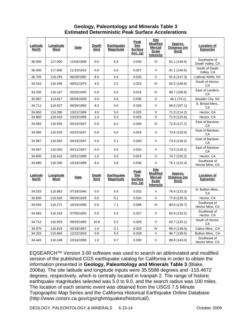
GEOLOGY, PALEONTOLOGY & MINERALS 6.15-14 October 2009
Geology, Paleontology and Minerals Table 3 Estimated Deterministic Peak Surface Accelerations
Latitude North
Longitude West Date Depth
(km) Earthquake Magnitude
Peak Site
Surface Acc. (g)
Site Modified Mercali Scale
Intensity
Approx. Distance (mi
[km]) Location of Epicenter
36.000 117.000 11/04/1908 0.0 6.5 0.045 VI 91.1 (146.6) Southwest of Death Valley, CA
36.000 117.000 11/10/1916 0.0 5.5 0.027 V 91.1 (146.6) South of Death Valley, CA
36.705 116.293 06/29/1992 8.0 5.4 0.025 V 91.6 (147.3) Lathrop Wells, NV
34.516 116.495 06/01/1975 4.5 5.2 0.023 IV 92.5 (148.9) South of Hector, CA
34.250 116.167 03/20/1945 0.0 5.0 0.019 IV 98.7 (158.8) East of Landers, CA
35.967 114.817 05/04/1939 0.0 5.0 0.035 V 46.1 (74.1) Boulder City, NV
34.711 116.027 09/26/1965 8.3 5.0 0.026 V 66.5 (107.1) S. Bristol Mtns., CA
34.860 116.390 10/21/1999 4.0 5.0 0.025 V 71.0 (114.2) Hector, CA 34.860 116.410 10/22/1999 1.0 5.0 0.025 V 71.8 (115.6) Hector, CA
34.983 116.550 04/10/1947 0.0 6.2 0.046 VI 72.8 (117.2) East of Barstow, CA
34.950 116.533 04/10/1947 0.0 5.0 0.024 V 73.6 (118.0) East of Barstow, CA
34.967 116.550 04/10/1947 0.0 5.1 0.026 V 73.5 (118.2) East of Barstow, CA
34.967 116.550 04/11/1947 0.0 5.0 0.024 V 73.5 (118.2) East of Barstow, CA
34.800 116.410 10/21/1999 1.0 5.0 0.024 V 74.7 (120.2) Hector, CA
34.680 116.280 10/16/1999 8.0 5.8 0.036 V 76.1 (122.4) Southeast of Hector Mine, CA
Latitude North
Longitude West Date Depth
(km) Earthquake Magnitude
Peak Site
Surface Acc. (g)
Site Modified Mercali Scale
Intensity
Approx. Distance (mi
[km]) Location of Epicenter
34.533 115.983 07/18/1946 0.0 5.6 0.032 V 76.6 (123.3) N. Bullion Mtns., CA
34.830 116.520 09/26/1929 0.0 5.1 0.024 V 77.8 (125.3) Hector, CA
34.594 116.271 10/16/1999 0.0 7.1 0.068 VI 80.6 (129.7) Southeast of Hector Mine, CA
34.583 116.319 07/05/1992 0.0 5.4 0.027 V 82.8 (133.2) Southeast of Hector, CA
34.712 116.503 09/25/1965 10.6 5.2 0.025 V 82.7 (133.1) South of Hector, CA
34.970 116.819 03/18/1997 1.0 5.1 0.023 IV 86.4 (139.0) Calico Mtns., CA 34.333 115.800 12/22/1943 0.0 5.5 0.028 V 86.7 (139.5) Bullion Mtns., CA
34.442 116.248 10/16/1999 1.0 5.7 0.030 V 88.9 (143.0) Southeast of Hector Mine, CA
EQSEARCH™ Version 3.00 software was used to search an abbreviated and modified version of the published CGS earthquake catalog for California in order to obtain the information presented in Geology, Paleontology and Minerals Table 3 (Blake, 2006a). The site latitude and longitude inputs were 35.5588 degrees and -115.4672 degrees, respectively, which is centrally located in Ivanpah 2. The range of historic earthquake magnitudes selected was 5.0 to 9.0, and the search radius was 100 miles. The location of each seismic event was obtained from the USGS 7.5 Minute Topographic Map Series and the California Historical Earthquake Online Database (http://www.consrv.ca.gov/cgs/rghm/quakes/historical/).

October 2009 6.15-15 GEOLOGY, PALEONTOLOGY & MINERALS
Twenty-three historic earthquakes of Magnitude 5.0 (M5.0) or greater have occurred on active faults between 51 and 100 miles of the site (CGS 2007). Only three of these, with epicenters located near the Hector Mine (M7.1), southwest of Death Valley (M6.5) and east of Barstow (M6.2), were of Magnitude 6.0 or greater. Nearly all of the faults are predominantly associated with strike-slip faulting. The earthquakes in the Death Valley region resulted from a combination of extensional and strike-slip faulting. The earthquake at Lathrop Wells, Nevada occurred in the vicinity of an east-west-striking left-lateral strike-slip fault within the poorly understood Southern Nevada Seismic Zone that extends eastward across Nevada from the Death Valley area (NBMG1998).
The appropriate soil profile for Ivanpah 2 is Type D based on information contained in the project geotechnical report (Terracon 2007). Depth to bedrock is expected to vary across the site, so the soil profile is also assumed to be Type D for Ivanpah 1 and 3. A design-level geotechnical report, as required by GEO-1, is needed to confirm the soil profile and provide appropriate seismic design parameters.
The estimated peak horizontal bedrock acceleration for the power plant is 0.084 times the acceleration of gravity (0.084g) based on a 10 percent probability of exceedence in 50 years, while the estimated peak horizontal bedrock acceleration is 0.152 times the acceleration of gravity (0.152g) based on a 2 percent probability of exceedence in 50 years (CBC 2007).
The potential of surface rupture on a fault at the energy facility footprint is considered to be very low, since no faults are known to have ruptured the ground surface of the proposed energy facility location.
Liquefaction Liquefaction is a condition where in a cohesionless soil may lose shear strength because of sudden increase in pore water pressure caused by an earthquake. Medium dense to very dense sandy and gravelly soils encountered in borings in Ivanpah 2, coupled with a groundwater table that is below 80 feet, would indicate no potential for liquefaction; however, no subsurface information was presented in the AFC for Ivanpah 1 and 3 of the ISEGS site such that liquefaction potential for these areas of the project should be addressed in a project-specific geotechnical report as required by the CBC (2007) and proposed Condition of Certification GEO-1.
Dynamic Compaction Dynamic compaction of soils results when relatively unconsolidated granular materials experience vibration associated with seismic events. The vibration causes a decrease in soil volume, as the soil grains tend to rearrange into a more dense state (an increase is soil density). The decrease in volume can result in settlement of overlying structural improvements. Medium dense to very dense granular soils encountered in borings in Ivanpah 2 are not likely to be susceptible to dynamic compaction during an earthquake. It is not possible to assess the potential for dynamic compaction in Ivanpah 1 and 3 without site-specific geotechnical exploration. The potential for and mitigation of the effects of dynamic compaction of site soils during an earthquake should be addressed in a project-specific geotechnical report as required by the CBC (2007) and proposed Condition of Certification GEO-1. Common mitigation methods include deep foundations

GEOLOGY, PALEONTOLOGY & MINERALS 6.15-16 October 2009
(driven piles; drilled shafts) for severe conditions, geogrid reinforced fill pads for moderate severity and over-excavation and replacement for areas of minimal hazard.
Hydrocompaction Hydrocompaction (also known as hydro-collapse) is generally limited to young soils that were deposited rapidly in a saturated state, most commonly by a flash flood. The soils dry quickly, leaving an unconsolidated, low density deposit with a high percentage of voids. Foundations built on these types of compressible materials can settle excessively, particularly when landscaping irrigation dissolves the weak cementation that is preventing the immediate collapse of the soil structure. Medium dense to very dense sands and gravels present in borings in Ivanpah 2 are not generally susceptible to hydrocompaction. It is not possible to assess the potential for hydrocompaction in Ivanpah 1 and 3 without site-specific geotechnical exploration. The potential for and mitigation of the effects of hydrocompaction of site soils should be addressed in a project-specific geotechnical report as required by the CBC (2007) and proposed Condition of Certification GEO-1. Typical mitigation measures would include over-excavation/replacement, mat foundations or deep foundations, depending on severity and foundation loads.
Subsidence Consolidation settlement may occur when areas containing compressible soils are subjected to surcharge loads. Although consolidation testing was not performed on soil samples from borings in Ivanpah 2, the coarse-grained soils encountered are not considered highly sensitive to surcharge loading. It is not possible to assess the potential for consolidation settlement in Ivanpah 1 and 3 without site-specific geotechnical exploration. The potential for and mitigation of the effects of consolidation settlement at the site should be addressed in a project-specific geotechnical report as required by the CBC (2007) and proposed Condition of Certification GEO-1. Mitigation is normally accomplished by over-excavation and replacement of the surifical materials, or by incorporating deep foundations for deeper deposits. Regional ground subsidence is typically caused by petroleum or groundwater withdrawal that increases the effective unit weight of the soil profile, which in turn increases the effective stress on the deeper soils. This results in consolidation or settlement of the soils. No known petroleum or gas fields are located within hundreds of miles of the project site (CDC 2001) such that subsidence due to petroleum withdrawal is not anticipated. However, regional subsidence associated with shrinkage of clay soils may be occurring (Broadbent 2009), and possible evidence of subsidence has been found on the playa surface to the east of the project site in the form of sinkholes and possible degradation of a portion of the Interstate Highway 15 road base. Subsidence associated with shrinkage of clay soils will need to be addressed in the design-level geotechnical report required by proposed Condition of Certification GEO-1 and mitigated through facility design. Groundwater pumping can also contribute to regional subsidence. Staff’s assessment as noted in the Cumulative Impacts and Mitigation analysis of the Soil and Water section also concludes that groundwater withdrawal is not causing a local lowering of the water table, and thus would not contribute to subsidence.

October 2009 6.15-17 GEOLOGY, PALEONTOLOGY & MINERALS
Expansive Soils Soil expansion occurs when clay-rich soils with an affinity for water exist in-place at a moisture content below their plastic limit. The addition of moisture from irrigation, capillary tension, water line breaks, etc. causes the clay soils to collect water molecules in their structure, which in turn causes an increase in the overall volume of the soil. This increase in volume can correspond to movement of overlying structural improvements. Although expansion testing was not performed on soil samples from borings in Ivanpah 2, the coarse-grained, generally non-plastic soils encountered are not considered to be expansive. It is not possible to assess the potential for expansive soils in Ivanpah 1 and 3 without site-specific geotechnical exploration. The potential for and mitigation of the effects of expansive soils on the site should be addressed in a project-specific geotechnical report as required by the CBC (2007) and proposed Condition of Certification GEO-1. Mitigation is normally accomplished by over-excavation and replacement of the expansive soils. For deep-seated conditions, deep foundations are commonly used. Lime-treatment (chemical modification) is often used to mitigate expansive clays in pavement areas.
Landslides Landslide potential at the ISEGS site is negligible since the proposed energy facility is located on a broad, gently east-sloping alluvial fan.
Flooding The Federal Emergency Management Agency (FEMA) has identified the ISEGS site and gas pipeline route as lying in a Zone D, which is an area in which flood hazards are undetermined (FEMA 1997). Flooding potential is further addressed in the Soil and Water section.
Tsunamis and Seiches The proposed ISEGS power plant site is not located near a large body of water that could be inundated by a tsunami or seiche, such as a lake or open ocean. As a result, there is no potential for a tsunami or seiche to affect the facility.
Proposed Project – Mineral Resources Staff has reviewed applicable geologic maps and reports for this area (CDC 2001; CDMG 1961; CDMG 1967; CDMG 1987; CDMG 1990; CDMG 1998; CDMG 1999; CH2M Hill, 2007; McCleod, 2007; Scott, 2007; Terracon 2007; and UCMP 2007). The ISEGS site is mapped as Mineral Resource Zone 4 (CDMG 1987). MRZ-4 refers to “areas where geologic information does not rule out either the presence or absence of industrial mineral resources”. The carbonate bedrock outcrop just west of Ivanpah 3 is designated as MRZ-3a, which is an “area underlain by geologic terranes within which undiscovered industrial mineral resources similar to known deposits in the same producing district or region may reasonably expected to exist (hypothetical resources). Such areas may include prospects of undetermined significance”. These carbonate rocks could be encountered at shallow depths in Ivanpah 3.
There are a variety of active mining operations in the general area near the proposed project location, but no active operations occur within the proposed project boundaries.

GEOLOGY, PALEONTOLOGY & MINERALS 6.15-18 October 2009
The closest current mining operation is the Chevron Mining, Inc. Rare Earth facility (formerly Molycorp) located in at Mountain Pass, approximately 8 miles to the west of the proposed project location. Other mining operations that have occurred in the local area in the past include the Colosseum Mine, which produced gold at a location approximately 5 miles west of the proposed project location from 1988 to 1993. Regionally, mineral production includes gold, silver, barite, boron, hectorite, bentonite, gypsum, tungsten, talc, zeolites, sodium, limestone, sand, gravel, stone, and turquoise. The nearest prospects and historic workings are located approximately 8,000 feet northwest of Ivanpah 3 and 12,500 feet southwest of Ivanpah 2 and 3 (CDMG 1987; CDMG 1998). Base metal and limestone prospects are also located roughly 6,000 feet northwest of the northern end of the proposed gas pipeline. A pit is located 7,500 feet east of Ivanpah 1, and is the closest known source of borrow material (USGS 1985). The proposed project location is located on alluvial fan materials. The general area is potentially leasable, and there has been limited exploration for oil and gas. However, there has been no production, and the area is considered to have low potential for leasable minerals. The nearest oil and gas fields are located at least 75 miles west and southwest of Barstow, California, which is roughly 100 miles to the southwest of the project site (CDC 2001). Some dry lake beds in California are sources of brine and salt production, but Ivanpah Dry Lake is not expected to be a potential resource for these materials. The presence of alluvial fan materials on the proposed project location means that the property could potentially be accessed a source for of salable sand and gravel resources. During construction, the applicant may need or desire to move sand and gravel either offsite, or between the different units of the facility. Should this occur, the applicant would be required to comply with BLM regulations in at 43 CFR Part 3600, which regulates the production and use of sand and gravel from public lands. Use of sand and gravel or other mineral materials within the boundaries of an authorized Right-of-way (ROW) is permitted, however, removal of these materials from an authorized ROW would require payment to the US of the fair market value of those materials. Adjacent to the western boundary of the proposed project location is an outcrop feature known as Limestone Hill. Limestone Hill is the location of two active locatable minerals claims, including a lode claim and a placer claim. These claims are identified as Numbers CAMC234026 and CAMC237293. Underground exploration is being conducted sporadically, however, commercial economic production is not apparent from either claim. The extent of the underground workings is not known. Although active mining claims exist on Limestone Hill directly adjacent to the proposed property boundary, there are no indications that these would become active economic commercial operations. If they become active economic operations, the existence of the proposed facility is not expected to interfere with the ability of the claimant to access those minerals. The only potential conflict would occur if the claimant or another person locates a new claim for locatable minerals located underneath the proposed project, within the project boundaries. This could potentially occur, as the proposed project location has not been withdrawn from mineral entry. The potential for this scenario is expected to be low. If it did occur, conflicts between the surface use of the land for solar

October 2009 6.15-19 GEOLOGY, PALEONTOLOGY & MINERALS
energy production and access to the subsurface minerals would be addressed in accordance with appropriate regulations. The proposed project site is currently not used for mineral production, nor is it under claim, lease, or permit for the production of locatable, leasable, or salable minerals. Sand and gravel resources are present at the site; however, such materials are present throughout the regional area such that the ISEGS should not have a significant impact on the availability of such resources. In addition, the potential resource would become available again following decommissioning of the project. In addition, only limited exploration for oil and gas resources has been performed in the area, and no active oil or gas operations are located in the immediate vicinity of the project. As a result, the ISEGS project would not impact any current or reasonably foreseeable development of geologic or mineral resources.
Proposed Project – Paleontologic Resources Staff has reviewed the paleontological resources assessment in Section 5.8 of the AFC (CH2M Hill, 2007) and the paleontological records search attached in Appendix 5.8A (Scott, 2007). Staff has also reviewed the paleontological literature and records search conducted by the Natural History Museum of Los Angeles County (McCleod, 2007), as well as the online records database maintained by the University of California, Museum of Paleontology (UCMP 2007). Site-specific information generated by the applicant for the ISEGS was also reviewed. All research was conducted in accordance with accepted assessment protocol (SVP 1995) to determine whether any known paleontological resources exist in the general area. If present or likely to be present, conditions of certification which outline required procedures to mitigate impacts to potential resources, and proposed as part of the projects approval. Based on a review of this information, no paleontological resources have been documented on the ISEGS plant site or at the proposed lay down area.
Young to intermediate (middle Pleistocene to Holocene) age alluvial fan sediments represent all soils that are mapped at the surface of the ISEGS site. These deposits are considered to have a low paleontological sensitivity due to the high energy environment of deposition and/or are too young to yield fossils of scientific significance. There is a low potential to impact paleontological resources during grading and trenching in such materials (McLeod, 2007; Scott, 2007). Quaternary lacustrine sediments are considered to have a high paleontological sensitivity because vertebrate and plant fossils have been recovered from deposits east of the project site around Ivanpah Lake and roughly 30 miles to the northwest near Tecopa, California (McLeod, 2007; Scott, 2007); however, it is unlikely that lake bed sediments are present beneath the site within the anticipated depths of grading and trenching such that there is a low potential to impact paleontological resources in these materials. The carbonate bedrock west of Ivanpah 3 is assigned a high paleontological sensitivity rating, based on the presence of Late Quaternary packrat middens that occupy solution cavities in the outcrops and the occurrence of time-restrictive marine fauna in late Cambrian rocks in the Clark Mountain Range (UCMP 2007; CH2M Hill, 2007; Scott, 2007). Since shallow carbonate bedrock may be present in the western portion of Ivanpah 3 and could be encountered during project excavation in this area, there is a

GEOLOGY, PALEONTOLOGY & MINERALS 6.15-20 October 2009
high potential to impact paleontological resources in this area. The Pre-Cambrian metamorphic rocks in the bedrock outcrops northeast of Ivanpah 2 is considered to have negligible paleontological sensitivity. Based on the above discussion, SVP criteria, and the confidential paleontological report appended to the AFC, staff considers the probability that paleontological resources will be encountered during grading and excavation in the western portion of Ivanpah 3 to be high. Proposed Conditions of Certification PAL-1 to PAL-7 are designed to mitigate potential impacts to paleontological resource to less than significant levels. These conditions essentially require a worker education program in conjunction with the monitoring of earthwork activities by a qualified professional paleontologist (paleontological resource specialist; PRS). The extent and distribution of lakebed sediments associated with Ivanpah Lake relative to the solar plant sites is difficult to determine. No fine-grained or clay soils were encountered in the two 80-foot-deep borings at Ivanpah 2. The nearest mapped surface exposure of lacustrine sediments, which are latest Pleistocene to Holocene in age, is roughly 1.35 miles east of Ivanpah 1 (USGS 2006). The lowest elevation on the solar plant site is approximately 2,765 feet above MSL, which is nearly 130 feet above the highest exposure of Quaternary lakebed sediments (approximate elevation 2,638 feet) and 163 feet above the floor of Ivanpah Lake (elevation 2,602 feet). The Nevada Bureau of Mines and Geology (NBMG 1979) has determined that precipitation rates were not high enough to overcome rapid evaporation rates that persisted in the Southern Nevada group of pluvial lakes, of which Ivanpah Lake is a part, during the Wisconsinan pluvial period (late Pleistocene beginning 72,000 years ago). Establishment of perennial lakes of substantial depths for consequential periods of time was unlikely under these environmental conditions. The lack of ancient shoreline features in Ivanpah Valley supports this conclusion (NBMG 1979). Therefore, the probability of impacting paleontological resources in Quaternary lakebed sediments is considered to be low since the lakebed deposits are present at approximate depths of 130 feet below the lowest existing ground surface at the site. The Pre-Cambrian metamorphic rocks in the bedrock outcrops northeast of Ivanpah 2 are considered to have negligible paleontological sensitivity. However, the carbonate bedrock west of Ivanpah 3 is assigned a high paleontological sensitivity rating, based on the presence of Late Quaternary packrat middens that occupy solution cavities observed during the site investigation conducted for the AFC (CH2M Hill, 2007). Packrat middens are known to contain paleobotanical material as old as 40,000 years that is well preserved in the dry Mojave Desert climate (CH2M Hill, 2007; Spaulding, 1990). One midden contained remains of juniper or cedar twigs (Juniperus sp.), greasebush leaves (Forsellesia nevadensis), snowberry twigs and fruit (Symphoricarpos longiflorus sp.), and globemallow epidermis (Sphaeralcea sp.), most of which are indicative of present-day higher elevation woodland environments. The University of California Museum of Paleontology also possesses 8 specimens of a marine branched thrombolite (Favosamaceria cooperi) collected from a location somewhere in the Clark Mountain Range (UCMP 2007). The thrombolite, which is a plant species similar to stromatolites, is restricted to the Late Cambrian Saukia Trilobite Zone (Shapiro and Awramik, 2006). Many sources agree that the carbonates adjacent to Ivanpah 3 are probably Cambrian in age (CDMG 1961; CH2M Hill, 2007). Although no fossils were observed in the

October 2009 6.15-21 GEOLOGY, PALEONTOLOGY & MINERALS
limestone/dolomite outcrops, the potential to impact paleontological resources is still considered to be high in excavations that might encounter shallow carbonate bedrock, particularly on the west side of Ivanpah 3. These excavations could uncover packrat middens buried by young alluvium or time-restricted late Cambrian thrombolites in the carbonate rock. Several paleontological sites are documented in Quaternary lacustrine sediments within 45 miles of the ISEGS project area. The San Bernardino County Museum collection contains remains of tortoise (Gopherus sp.), kangaroo rat (Dipodomys sp.), wood rat (Neotoma sp.), and other small vertebrates from a locality between 1 and 2 miles southeast of the site on the west side of Ivanpah Lake (Scott, 2007). The site also yielded hackberry seed (Celtus sp.) and tufa deposited in the lake. The Natural History Museum of Los Angeles collection includes several paleontological remains from similar lakebed sediments near Tecopa, California, approximately 45 miles to the northwest. The fossil specimens consist of mastodon (Mammut), mammoth (Mammuthus), rhinoceros (Rhinocerotidae), horse (Equus), [rpngjprn antelope (Antilocapridae), and camels (Camelops and Capricamelus gettyi) (McCleod, 2007). Capricamelus gettyi is a species of short-legged camel named from specimens found at the Tecopa lakebed site.
Proposed Project - Construction Impacts and Mitigation
Geologic Hazards The design-level geotechnical investigation required for the project by the CBC (2007) and proposed Condition of Certification GEO-1 should provide standard engineering design recommendations for mitigation of potential geologic hazards that include strong ground shaking; liquefaction; settlement due to compressible soils, subsidence associated with shrinkage of clay soils, hydrocompaction, or dynamic compaction; and the presence of expansive clay soils.
Mineral Resources Construction of the proposed project would directly remove approximately 4,072.5 acres from potential use for sand and gravel production under BLM’s salable mineral program. In general, sand and gravel resources are widely available throughout the region. The primary consideration in the economic viability of sand and gravel operations is the transportation cost, which is driven by the proximity of the operation to its point of use. There is likely to be widespread development in Ivanpah Valley that would require sand and gravel resources, removal of the 4,072.5-acre area from potential production is not expected to have any significant impact. The proposed project site represents a small fraction of the total sand and gravel resource available within the valley. As a result, the ISEGS project would not impact any current or reasonably foreseeable development of geologic resources. However, during construction, the applicant may need or desire to move sand and gravel either offsite, or between the different units of the facility. Should this occur, the applicant would be required to comply with BLM regulations in at 43 CFR Part 3600, which regulates the production and use of sand and gravel from public lands. Use of sand and gravel or other mineral materials within the boundaries of an

GEOLOGY, PALEONTOLOGY & MINERALS 6.15-22 October 2009
authorized Right-of-way (ROW) is permitted, however, removal of these materials from an authorized ROW would require payment to the US of the fair market value of those materials. The proposed project would not have any direct or indirect impact on the production of locatable or leasable minerals outside of the proposed project boundaries. Although active mining claims exist on Limestone Hill directly adjacent to the proposed property boundary, there are no indications that these could become economic commercial operations. If they become economic operations, the existence of the proposed facility is not expected to interfere with the ability of the claimant to access those minerals. The only potential conflict would occur if the claimant or another person locates a new claim, for locatable minerals underneath the proposed project, within the project boundaries. This could potentially occur, as the proposed project location has not been withdrawn from mineral entry. The potential for this scenario is expected to be low. If it did occur, conflicts between the surface use of the land for solar energy production and access to the subsurface minerals would be addressed in accordance with appropriate regulations. Therefore, the ISEGS project would not impact any current or reasonably foreseeable development of mineral resources.
Paleontological Resources Significant paleontological resources, specifically pack rat middens, have been documented in nearby Paleozoic carbonate bedrock that could be encountered during construction of the Ivanpah 3 plant and linear facilities. The nearest vertebrate fossil locality is 1 to 2 miles away and was recovered from Quaternary lacustrine sediments, although the potential to encounter similar sediments during grading and trenching is low. The young to intermediate age alluvium that underlies the majority of the site, as well as Pre-Cambrian metamorphic rocks located just northeast of Ivanpah 2, are considered to be of low to negligible sensitivity with respect to containing paleontological resources. Construction of the proposed project will include grading, foundation excavation, utility trenching and possibly drilled shafts. Staff considers the probability of encountering paleontological resources to be generally high on portions of the site, particularly the west side of Ivanpah 3, based on the soils profile, SVP assessment criteria, and the near surface occurrence of the sensitive geologic units. The potential for encountering fossils hosted in Quaternary lake bed sediments will increase with the depth of cut. Excavations for ancillary facilities and new pipelines and on-site excavations deeper than 5 feet may have a higher probability of encountering potentially high sensitivity materials, although sensitive materials could occur nearer the surface. Proposed Conditions of Certification PAL-1 to PAL-7 are designed to mitigate any paleontological resource impacts, as discussed above, to a less than significant level. Essentially, these conditions require a worker education program in conjunction with monitoring of earthwork activities by qualified professional paleontologists (PRS). Earthwork is halted any time potential fossils are recognized by either the paleontologist or the worker. When properly implemented, the conditions of certification yield a net gain to the science of paleontology since fossils that would not otherwise have been discovered can be collected, identified, studied, and properly curated. A paleontological resource specialist is retained, for the project by the applicant, to produce a monitoring

October 2009 6.15-23 GEOLOGY, PALEONTOLOGY & MINERALS
and mitigation plan, conduct the worker training, and provide the on the monitoring. During the monitoring, the PRS can and often does petition the CEC for a change in the monitoring protocol. Most commonly, this is a request for lesser monitoring after sufficient monitoring has been performed to ascertain that there is little change of finding fossils. In other cases, the PRS can propose increased monitoring due to unexpected fossil discoveries or in response to repeated out-of-compliance incidents by the earthwork contractor. Based upon the literature and archives search, field surveys, and compliance documentation for the ISEGS, the applicant has proposed monitoring and mitigation measures to be followed during the construction of the ISEGS. Energy Commission staff believes that the facility can be designed and constructed to minimize the effect of geologic hazards at the site during project design life and that impacts to vertebrate fossils encountered during construction of the power plant and associated linear projects would be mitigated to a level of insignificance.
Proposed Project - Operation Impacts and Mitigation Operation of the proposed plant facilities should not have any adverse impact on geologic, mineralogical, or paleontological resources. Potential geologic hazards, including strong ground shaking; liquefaction; settlement due to compressible soils, subsidence associated with shrinkage of clay soils, hydrocompaction, or dynamic compaction, and the presence of expansive clay soils can be effectively mitigated through facility design (See proposed Conditions of Certification GEO-1, and GEN-1, GEN-5, and CIVIL-1 in the Facility Design section) such that these potential hazards should not affect operation of the facility.
Proposed Project – Closure and Decommissioning Impacts and Mitigation The decommissioning and closure of the project should not negatively affect geologic, mineralogical, or paleontological resources since the majority of the ground disturbed during plant decommissioning and closure would have been already disturbed, and mitigated as required, during construction and operation of the project. Facility closure will make land occupied by the proposed project once again available for potential future development of geologic or mineralogical resources within the former project borders.
No Project/No Action Alternative In the No Project/No Action Alternative, the proposed action would not be undertaken. The BLM land on which the project is proposed would continue to be managed within BLM’s framework of a program of multirole use and sustained yield, and the maintenance of environmental quality [43 USC 1781 (b)] in conformance with applicable statures, regulations, policy, and land use plan.

GEOLOGY, PALEONTOLOGY & MINERALS 6.15-24 October 2009
The results of the No Project/No Action Alternative would be the following:
• The Impacts of the proposed project would not occur. However, the land on which the project is proposed would become available to other uses that are consistent with BLM’s land use plan, including another solar project.
• The benefits of the proposed project in reducing greenhouse gas emissions from gas-fired generation would not occur. Both State and Federal law support the increased use of renewable power generation.
• The No Project/No Action alternative would leave the proposed project area undisturbed and would therefore have no affect on existing geologic or paleontological resources in the area other than to maintain their availability for potential future development.
If this project is not approved, renewable projects would likely be developed on other sites in the Mojave Desert or in adjacent states as developers strive to provide renewable power that complies with utility requirements and State /Federal mandates. For example, there are three large solar projects proposed on BLM land in Nevada within a few miles of the Ivanpah Site. In addition, as of August 2009 there are currently 66 applications for solar projects covering 611,692 acres pending with the BLM in the California Desert District.
CUMULATIVE IMPACTS AND MITIGATION
A project may result in a significant adverse cumulative impact where its effects are cumulatively considerable. "Cumulatively considerable" means that the incremental effects of an individual project are significant when viewed in connection with the effects of past projects, the effects of other current projects, and the effects of probable future projects (California Code Regulations, Title 14, Section 15130). NEPA states that cumulative effects can result from individually minor but collectively significant actions taking place over a period of time” (40 CFR §1508.7). There is the potential for substantial future development in the Ivanpah Valley area and throughout the southern California desert region. Analysis of cumulative impacts is based on data provided in the following maps and tables (see the Cumulative Scenario section of this FSA/DEIS):
• Cumulative Impacts Figure 1, Regional Renewable Applications
• Cumulative Impacts Figure 2, Regional Renewable Applications (Detail)
• Cumulative Impacts Figure 3, Ivanpah Valley Existing and Future/Foreseeable Projects
• Cumulative Impacts Table 1, Regional Renewable Energy Projects
• Cumulative Impacts Table 2, Existing Development in the Ivanpah Valley
• Cumulative Impacts Table 3, Future Foreseeable Projects in the Ivanpah Valley Area.

October 2009 6.15-25 GEOLOGY, PALEONTOLOGY & MINERALS
The analysis in this section first defines the geographic area over which cumulative impacts to geology or paleontology could occur. The cumulative impact analysis itself describes the potential for cumulative impacts to occur as a result of implementation of the ISEGS project along with the listed local and regional projects.
GEOGRAPHIC EXTENT Cumulative impacts can occur if implementation of the ISEGS project could combine with those of other local or regional projects. Cumulative impacts would occur locally if ISEGS project impacts combined with impacts of projects located within the Ivanpah Valley. Cumulative impacts could also occur as a result of development of some of the many proposed solar and wind development projects that have been or are expected to be under consideration by the BLM and the Energy Commission in the near future. Many of these projects are located within the California Desert Conservation Area, as well as on BLM land in Nevada and Arizona. However, with the exception of geologic subsidence, cumulative impacts related to geology only have the potential to occur within the boundaries of the project site itself. This is because geologic materials occur at specific locales and are unaffected by activities not acting on them directly and any impacts of the ISEGS project would be site-specific. Therefore the geographic extent for cumulative impacts associated with geology is the project location itself (including all linear facilities). The geographic extent for the analysis of local cumulative impacts associated with the ISEGS project includes the Ivanpah Valley Basin. Regional cumulative impacts for this analysis are impacts that would occur as a result of implementation of future solar and wind development projects that are currently proposed on over one million acres of the California Desert Conservation Area, as well as on BLM land in Nevada and Arizona. Therefore, the geographic extent for the analysis of regional cumulative impacts is defined as the desert areas of southeastern California, southern Nevada, and western Arizona, as shown on Cumulative Impacts Figure 1 (Regional Renewable Applications).
CUMULATIVE IMPACT ANALYSIS – LOCAL PROJECTS Most cumulative impacts related to geology and paleontology only have the potential to occur within boundaries of the project site itself because geologic materials occur at specific locales and are unaffected by activities not acting on them directly. Most geologic impacts of the ISEGS project would be site-specific and would therefore not have the potential to combine with impacts from other projects.
Geologic Hazards Local subsidence in the form of sinkholes has been observed at the site and along the northern edge of Ivanpah Dry Lake. While its cause can sometimes be attributed to groundwater withdrawal as well as other causes, in this case, the cause is believed to be from dehydration of clays between the soil surface and the water table that can result in a major loss of volume, and thus the collapse of overlying soils (Broadbent 2009). Staff’s assessment as noted in the Cumulative Impacts and Mitigation analysis of the Soil and Water section also concludes that groundwater withdrawal is not causing a local lowering of the water table, and thus would not contribute to subsidence. The project’s groundwater use would contribute only 1.8 percent to the existing and only 1.7 percent of the reasonable foreseeable cumulative pumping volume in the Ivanpah Valley Groundwater Basin. Staff believes the project’s proposed contribution to the

GEOLOGY, PALEONTOLOGY & MINERALS 6.15-26 October 2009
cumulative groundwater pumping in the Ivanpah Valley Groundwater Basin is not significant. Staff has determined that the project would not substantially deplete groundwater supplies or interfere substantially with groundwater recharge such that there would be a net deficit in aquifer volume or a lowering of the local groundwater table level. Staff has estimated that Ivanpah Valley Groundwater Basin still has a surplus outflow to the Las Vegas Valley of approximately 1,351 to 2,666 acre-feet per year (AFY). Therefore, staff does not believe that groundwater pumping associated with ISEGS would contribute to subsidence in the Ivanpah Valley. When combined with impacts of past, present, and reasonably foreseeable projects, ISEGS would not be considered cumulatively considerable.
Mineral Resources The proposed project site is currently not used for mineral production, nor is it under claim, lease, or permit for the production of locatable, leasable, or salable minerals. Sand and gravel resources are present at the site; however, such materials are present throughout the region and the ISEGS should not have a significant impact on the availability of such resources. In addition, the potential resource would become available again following decommissioning of the project. As a result, the ISEGS project would not impact any current or reasonably foreseeable development of geologic or mineral resources.
Paleontological Resources As discussed above, no paleontological resources have been documented on the ISEGS project site or at the proposed lay down area. However, based on the geology of the site and because paleontological resources have been discovered on sites within two miles of the ISEGS project, the probability of encountering paleontological resources is considered to be generally high on portions of the ISEGS site. For the same reasons, it is likely that paleontological resources have been uncovered during construction of past projects in the Ivanpah Valley and will likely be uncovered during construction of at least some of the reasonably foreseeable projects presented in Table 3 of the Cumulative Scenario section. However, the ISEGS project includes conditions of certification that would require a worker education program in conjunction with monitoring of earthwork activities by qualified professional paleontologists, which would require that earthwork be halted any time potential fossils are recognized by either the paleontologist or the worker. When properly implemented, the conditions of certification yield a net gain to the science of paleontology since fossils that would not otherwise have been discovered can be collected, identified, studied, and properly curated. It is reasonable to assume that the reasonably foreseeable projects presented in Table 3 of the Cumulative Scenario section would include similar measures to identify, study, and curate any paleontological resources discovered during construction. Therefore, implementation of past, present, and reasonably foreseeable projects would likely result in a net gain to the science of paleontology and would not combine to result in cumulatively considerable impacts to paleontological resources.
CUMULATIVE IMPACT ANALYSIS - REGIONAL PROJECTS Because no impacts from geologic hazards, or to mineralogical or paleontological resources have been identified for the ISEGS project, there would be no potential for these impacts to combine on a regional level.

October 2009 6.15-27 GEOLOGY, PALEONTOLOGY & MINERALS
As discussed above, no paleontological resources have been documented on the ISEGS project site or at the proposed lay down area. However, based on the geology of the site and because paleontological resources have been discovered on sites within two miles of the ISEGS project, the probability of encountering paleontological resources is considered to be generally high on portions of the ISEGS site. Additionally, because many other paleontological resources occur throughout the Mojave Desert, it is likely that paleontological resources will be uncovered during construction of at least some of the reasonably foreseeable renewable energy projects shown on Cumulative Scenario Figure 1 and Figure 2. However, as discussed above for local cumulative impacts, the ISEGS project includes measures such as monitoring earthwork activities by qualified professional paleontologists, and identifying, studying, and properly curating any paleontological resources discovered. It is reasonable to assume that the reasonably foreseeable projects shown on Cumulative Scenario Figure 1 and Figure 2 would include similar measures to identify, study, and curate any paleontological resources discovered during construction. Therefore, implementation of the ISEGS project and the reasonably foreseeable renewable energy projects proposed within southeastern California, southern Nevada, and western Arizona, would likely result in a net gain to the science of paleontology. Therefore, impacts of the ISEGS project would not have the potential to combine with impacts of the reasonably foreseeable renewable energy projects proposed within southeastern California, southern Nevada, and western Arizona to result in cumulative impacts to known paleontological resources.
CUMULATIVE IMPACT CONCLUSION Impacts of the ISEGS project would not have the potential to combine with impacts of past, present, and reasonably foreseeable projects to result in any other significant contributions to local or regional cumulative impacts. Impacts of the ISEGS project would not have the potential to combine with impacts of past, present, and reasonably foreseeable projects to result in a significant contribution to either local or regional cumulative impacts to mineralogical and/or paleontological resources.
NOTEWORTHY PUBLIC BENEFITS
Excavation activities during construction of the proposed ISEGS project may uncover important paleontological resources which, with proper collection and curation by the project PRS, would enhance the understanding of prehistoric climate and geography of the region for the benefit of current and future generations.
PUBLIC AND AGENCY COMMENTS ON THE PSA
Staff has not received any agency or public comments regarding geologic hazards, mineral resources, or paleontology at this time.
CONCLUSIONS
The applicant would be able to comply with applicable LORS, provided that the proposed conditions of certification are followed. The design and construction of the
GEOLOGY, PALEONTOLOGY & MINERALS 6.15-28 October 2009
project should have no adverse impact with respect to geologic, mineralogical, and paleontological resources, and thus would not have significant impacts with respect to either CEQA or NEPA. Staff proposes to ensure compliance with applicable LORS through the adoption of the proposed conditions of certification listed below.
MITIGATION MEASURES/PROPOSED CONDITIONS OF CERTIFICATION
The proposed ISEGS is situated in an active geologic environment. Strong ground shaking potential must be mitigated through foundation and structural design as required by the CBC (2007). Settlement due to compressible soils, groundwater withdrawal, hydrocompaction, or dynamic compaction, as well as potential impacts due to expansive soils and possible liquefaction, must be mitigated in accordance with a design-level geotechnical investigation as required by the CBC (2007), proposed Condition of Certification GEO-1, and proposed Conditions of Certification GEN-1, GEN-5, and CIVIL-1 under Facility Design. Paleontological resources have been documented in the general area of the project and in sediments similar to those that are present near the site. The potential impacts to paleontological resources due to construction activities will be mitigated as required by proposed Conditions of Certification PAL-1 to PAL-7. The proposed conditions of certification allow BLM’s Authorized Officer and the Energy Commission Compliance Project Manager (CPM) and the applicant to adopt a compliance monitoring scheme ensuring compliance with applicable LORS for geologic hazards and geologic, mineralogical, and paleontological resources.
GEO-1 The Soils Engineering Report required by Section 1802A of the 2007 CBC should specifically include laboratory test data, associated geotechnical engineering analyses, and a thorough discussion of the potential for liquefaction; settlement due to compressible soils, subsidence associated with shrinkage of clay soils, hydrocompaction, or dynamic compaction; and the presence of expansive clay soils. The report should also include recommendations for ground improvement and/or foundation systems necessary to mitigate these potential geologic hazards, if present.
Verification: The project owner shall include in the application for a grading permit a copy of the Soils Engineering Report which addresses the potential for liquefaction; settlement due to compressible soils, groundwater withdrawal, hydrocompaction, or dynamic compaction; and the possible presence of expansive clay soils, and a summary of how the results of the analyses were incorporated into the project foundation and grading plan design for review and comment by the Chief Building Official (CBO). A copy of the Soils Engineering Report, application for grading permit and any comments by the CBO are to be provided to BLM’s Authorized Officer and the CPM at least 30 days prior to grading. PAL-1 The project owner shall provide BLM’s Authorized Officer and the Compliance
Project Manager (CPM) with the resume and qualifications of its PRS for review and approval. If the approved PRS is replaced prior to completion of project mitigation and submittal of the Paleontological Resources Report, the

October 2009 6.15-29 GEOLOGY, PALEONTOLOGY & MINERALS
project owner shall obtain BLM’s Authorized Officer and CPM approval of the replacement PRS. The project owner shall keep resumes on file for qualified Paleontological Resource Monitors (PRMs). If a PRM is replaced, the resume of the replacement PRM shall also be provided to BLM’s Authorized Officer and the CPM.
The PRS resume shall include the names and phone numbers of references. The resume shall also demonstrate to the satisfaction of BLM’s Authorized Officer and the CPM the appropriate education and experience to accomplish the required paleontological resource tasks. As determined by BLM’s Authorized Officer and the CPM, the PRS shall meet the minimum qualifications for a vertebrate paleontologist as described in the Society of Vertebrate Paleontology (SVP) guidelines of 1995. The experience of the PRS shall include the following: 1. Institutional affiliations, appropriate credentials, and college degree;
2. Ability to recognize and collect fossils in the field;
3. Local geological and biostratigraphic expertise;
4. Proficiency in identifying vertebrate and invertebrate fossils; and
5. At least three years of paleontological resource mitigation and field experience in California and at least one year of experience leading paleontological resource mitigation and field activities.
The project owner shall ensure that the PRS obtains qualified paleontological resource monitors to monitor as he or she deems necessary on the project. Paleontological Resource Monitors (PRMs) shall have the equivalent of the following qualifications:
• BS or BA degree in geology or paleontology and one year of experience monitoring in California; or
• AS or AA in geology, paleontology, or biology and four years’ experience monitoring in California; or
• Enrollment in upper division classes pursuing a degree in the fields of geology or paleontology and two years of monitoring experience in California.
Verification: (1) At least 60 days prior to the start of ground disturbance, the project owner shall submit a resume and statement of availability of its designated PRS for on-site work.
(2) At least 20 days prior to ground disturbance, the PRS or project owner shall provide a letter with resumes naming anticipated monitors for the project, stating that the identified monitors meet the minimum qualifications for paleontological resource monitoring required by the condition. If additional monitors are obtained during the project, the PRS shall provide additional letters and resumes to BLM’s Authorized

GEOLOGY, PALEONTOLOGY & MINERALS 6.15-30 October 2009
Officer and the CPM. The letter shall be provided to BLM’s Authorized Officer and the CPM no later than one week prior to the monitor’s beginning on-site duties. (3) Prior to the termination or release of a PRS, the project owner shall submit the resume of the proposed new PRS to BLM’s Authorized Officer and the CPM for review and approval.
PAL-2 The project owner shall provide to the PRS, BLM’s Authorized Officer and the CPM, for approval, maps and drawings showing the footprint of the power plants, construction lay down areas, and all related facilities. Maps shall identify all areas of the project where ground disturbance is anticipated. If the PRS requests enlargements or strip maps for linear facility routes, the project owner shall provide copies to the PRS, BLM’s Authorized Officer and CPM. The site grading plan and plan and profile drawings for the utility lines would be acceptable for this purpose. The plan drawings should show the location, depth, and extent of all ground disturbances and be at a scale of 1 inch = 40 feet to 1 inch = 100 feet range. If the footprint of the project or its linear facilities change, the project owner shall provide maps and drawings reflecting those changes to the PRS, BLM’s Authorized Officer and CPM.
If construction of the ISEGS project proceeds in phases, maps and drawings may be submitted prior to the start of each power plant. A letter identifying the proposed schedule of each project power plant shall be provided to the PRS, BLM’s Authorized Officer and CPM. Before work commences on affected power plants, the project owner shall notify the PRS, BLM’s Authorized Officer and CPM of any construction phase scheduling changes.
At a minimum, the project owner shall ensure that the PRS or PRM consults weekly with the project superintendent or construction field manager to confirm area(s) to be worked the following week, and until ground disturbance is completed.
Verification: (1) At least 30 days prior to the start of ground disturbance, the project owner shall provide the maps and drawings to the PRS, BLM’s Authorized Officer and CPM.
(2) If there are changes to the footprint of the project, revised maps and drawings shall be provided to the PRS, BLM’s Authorized Officer and CPM at least 15 days prior to the start of ground disturbance. (3) If there are changes to the scheduling of the construction phases of each power plant, the project owner shall submit a letter to BLM’s Authorized Officer and the CPM within 5 days of identifying the changes.
PAL-3 If after review of the plans provided pursuant to PAL-2, the PRS determines that materials with moderate, high, or unknown paleontological sensitivity could be impacted, the project owner shall ensure that the PRS prepares, and the project owner submits to BLM’s Authorized Officer and the CPM for review and approval, a paleontological resources monitoring and mitigation plan (PRMMP) to identify general and specific measures to minimize potential

October 2009 6.15-31 GEOLOGY, PALEONTOLOGY & MINERALS
impacts to paleontological resources. Approval of the PRMMP by BLM’s Authorized Officer and the CPM shall occur prior to any ground disturbance. The PRMMP shall function as the formal guide for monitoring, collecting, and sampling activities, and may be modified with BLM’s Authorized Officer and CPM approval. This document shall be used as the basis of discussion when on-site decisions or changes are proposed. Copies of the PRMMP shall reside with the PRS, each monitor, the project owner’s on-site manager, BLM’s Authorized Officer and the CPM.
The PRMMP shall be developed in accordance with the guidelines of the Society of Vertebrate Paleontology (SVP 1995) and shall include, but not be limited, to the following: 1. Assurance that the performance and sequence of project-related tasks,
such as any literature searches, pre-construction surveys, worker environmental training, fieldwork, flagging or staking, construction monitoring, mapping and data recovery, fossil preparation and collection, identification and inventory, preparation of final reports, and transmittal of materials for curation will be performed according to PRMMP procedures;
2. Identification of the person(s) expected to assist with each of the tasks identified within the PRMMP and the conditions of certification;
3. A thorough discussion of the anticipated geologic units expected to be encountered, the location and depth of the units relative to the project when known, and the known sensitivity of those units based on the occurrence of fossils either in that unit or in correlative units;
4. An explanation of why, how, and how much sampling is expected to take place and in what units. Include descriptions of different sampling procedures that shall be used for fine-grained and coarse-grained units;
5. A discussion of the locations of where the monitoring of project construction activities is deemed necessary, and a proposed plan for monitoring and sampling;
6. A discussion of procedures to be followed in the event of a fossil discovery, halting construction, resuming construction, and how notifications will be performed;
7. A discussion of equipment and supplies necessary for collection of fossil materials and any specialized equipment needed to prepare, remove, load, transport, and analyze large-sized fossils or extensive fossil deposits;
8. Procedures for inventory, preparation, and delivery for curation into a retrievable storage collection in a public repository or museum, which meet the Society of Vertebrate Paleontology’s standards and requirements for the curation of paleontological resources;

GEOLOGY, PALEONTOLOGY & MINERALS 6.15-32 October 2009
9. Identification of the institution that has agreed to receive data and fossil materials collected, requirements or specifications for materials delivered for curation, and how they will be met, and the name and phone number of the contact person at the institution; and
10. A copy of the paleontological conditions of certification. Verification: At least 30 days prior to ground disturbance, the project owner shall provide a copy of the PRMMP to BLM’s Authorized Officer and the CPM. The PRMMP shall include an affidavit of authorship by the PRS, and acceptance of the PRMMP by the project owner evidenced by a signature.
PAL-4 If after review of the plans provided pursuant to PAL-2, the PRS determines that materials with moderate, high, or unknown paleontological sensitivity could be impacted then, prior to ground disturbance and for the duration of construction activities involving ground disturbance, the project owner and the PRS shall prepare and conduct weekly BLM Authorized Officer- and CPM-approved training for the following workers: project managers, construction supervisors, foremen and general workers involved with or who operate ground-disturbing equipment or tools. Workers shall not excavate in sensitive units prior to receiving BLM Authorized Officer- and CPM-approved worker training. Worker training shall consist of an initial in-person PRS training during the project kick-off, for those mentioned above. Following initial training, a CPM-approved video or in-person training may be used for new employees. The training program may be combined with other training programs prepared for cultural and biological resources, hazardous materials, or other areas of interest or concern. No ground disturbance shall occur prior to BLM’s Authorized Officer and CPM approval of the Worker Environmental Awareness Program (WEAP), unless specifically approved by the CPM.
The WEAP shall address the possibility of encountering paleontological resources in the field, the sensitivity and importance of these resources, and legal obligations to preserve and protect those resources.
The training shall include: 1. A discussion of applicable laws and penalties under the law;
2. Good quality photographs or physical examples of vertebrate fossils for project sites containing units of high paleontological sensitivity;
3. Information that the PRS or PRM has the authority to halt or redirect construction in the event of a discovery or unanticipated impact to a paleontological resource;
4. Instruction that employees are to halt or redirect work in the vicinity of a find and to contact their supervisor and the PRS or PRM;
5. An informational brochure that identifies reporting procedures in the event of a discovery;

October 2009 6.15-33 GEOLOGY, PALEONTOLOGY & MINERALS
6. A WEAP certification of completion form signed by each worker indicating that he/she has received the training; and
7. A sticker that shall be placed on hard hats indicating that environmental training has been completed.
Verification: (1) At least 30 days prior to ground disturbance, the project owner shall submit the proposed WEAP, including the brochure, with the set of reporting procedures for workers to follow.
(2) At least 30 days prior to ground disturbance, the project owner shall submit the script and final video to BLM’s Authorized Officer and the CPM for approval if the project owner is planning to use a video for interim training. (3) If the owner requests an alternate paleontological trainer, the resume and qualifications of the trainer shall be submitted to BLM’s Authorized Officer and the CPM for review and approval prior to installation of an alternate trainer. Alternate trainers shall not conduct training prior to BLM’s Authorized Officer and CPM authorization. (4) In the monthly compliance report (MCR, the project owner shall provide copies of the WEAP certification of completion forms with the names of those trained and the trainer or type of training (in-person or video) offered that month. The MCR shall also include a running total of all persons who have completed the training to date.
PAL-5 The project owner shall ensure that the PRS and PRM(s) monitor consistent with the PRMMP all construction-related grading, excavation, trenching, and augering in areas where potential fossil-bearing materials have been identified, both at the site and along any constructed linear facilities associated with the project. In the event that the PRS determines full-time monitoring is not necessary in locations that were identified as potentially fossil-bearing in the PRMMP, the project owner shall notify and seek the concurrence of BLM’s Authorized Officer and the CPM.
The project owner shall ensure that the PRS and PRM(s) have the authority to halt or redirect construction if paleontological resources are encountered. The project owner shall ensure that there is no interference with monitoring activities unless directed by the PRS. Monitoring activities shall be conducted as follows: 1. Any change of monitoring from the accepted schedule in the PRMMP shall
be proposed in a letter or email from the PRS and the project owner to BLM’s Authorized Officer and the CPM prior to the change in monitoring and will be included in the monthly compliance report. The letter or email shall include the justification for the change in monitoring and be submitted to BLM’s Authorized Officer and the CPM for review and approval.
2. The project owner shall ensure that the PRM(s) keep a daily monitoring log of paleontological resource activities. The PRS may informally discuss

GEOLOGY, PALEONTOLOGY & MINERALS 6.15-34 October 2009
paleontological resource monitoring and mitigation activities with BLM’s Authorized Officer and the CPM at any time.
3. The project owner shall ensure that the PRS notifies BLM’s Authorized Officer and the CPM within 24 hours of the occurrence of any incidents of non-compliance with any paleontological resources conditions of certification. The PRS shall recommend corrective action to resolve the issues or achieve compliance with the conditions of certification.
4. For any paleontological resources encountered, either the project owner or the PRS shall notify BLM’s Authorized Officer and the CPM within 24 hours, or Monday morning in the case of a weekend event where construction has been halted because of a paleontological find.
The project owner shall ensure that the PRS prepares a summary of monitoring and other paleontological activities placed in the monthly compliance reports. The summary will include the name(s) of PRS or PRM(s) active during the month, general descriptions of training and monitored construction activities, and general locations of excavations, grading, and other activities. A section of the report shall include the geologic units or subunits encountered, descriptions of samplings within each unit, and a list of identified fossils. A final section of the report will address any issues or concerns about the project relating to paleontological resource monitoring, including any incidents of non-compliance or any changes to the monitoring plan that have been approved by BLM’s Authorized Officer and the CPM. If no monitoring took place during the month, the report shall include an explanation in the summary as to why monitoring was not conducted.
Verification: The project owner shall ensure that the PRS submits the summary of monitoring and paleontological activities in the MCR. When feasible, BLM’s Authorized Officer and the CPM shall be notified 10 days in advance of any proposed changes in monitoring different from the plan identified in the PRMMP. If there is any unforeseen change in monitoring, the notice shall be given as soon as possible prior to implementation of the change.
PAL-6 The project owner, through the designated PRS, shall ensure that all components of the PRMMP are adequately performed including collection of fossil materials, preparation of fossil materials for analysis, analysis of fossils, identification and inventory of fossils, the preparation of fossils for curation, and the delivery for curation of all paleontological resource materials encountered and collected during project construction.
Verification: The project owner shall maintain in his/her compliance file copies of signed contracts or agreements with the designated PRS and other qualified research specialists. The project owner shall maintain these files for a period of three years after project completion and approval of BLM Authorized Officer- and CPM-approved paleontological resource report (see PAL-7). The project owner shall be responsible for paying any curation fees charged by the museum for fossils collected and curated as a
October 2009 6.15-35 GEOLOGY, PALEONTOLOGY & MINERALS
result of paleontological mitigation. A copy of the letter of transmittal submitting the fossils to the curating institution shall be provided to BLM’s Authorized Officer and the CPM.
PAL-7 The project owner shall ensure preparation of a Paleontological Resources Report (PRR) by the designated PRS. The PRR shall be prepared following completion of the ground-disturbing activities. The PRR shall include an analysis of the collected fossil materials and related information, and submit it to the CPM for review and approval.
The report shall include, but is not limited to, a description and inventory of recovered fossil materials; a map showing the location of paleontological resources encountered; determinations of sensitivity and significance; and a statement by the PRS that project impacts to paleontological resources have been mitigated below the level of significance.
Verification: Within 90 days after completion of ground-disturbing activities, including landscaping, the project owner shall submit the PRR under confidential cover to BLM’s Authorized Officer and the CPM.

GEOLOGY, PALEONTOLOGY & MINERALS 6.15-36 October 2009
Certification of Completion Worker Environmental Awareness Program
ISEGS (07-AFC-5)
This is to certify these individuals have completed a mandatory California Energy Commission-approved Worker Environmental Awareness Program (WEAP). The WEAP includes pertinent information on cultural, paleontological, and biological resources for all personnel (that is, construction supervisors, crews, and plant operators) working on site or at related facilities. By signing below, the participant indicates that he/she understands and shall abide by the guidelines set forth in the program materials. Include this completed form in the Monthly Compliance Report.
No. Employee Name Title/Company Signature 1. 2. 3. 4. 5. 6. 7. 8. 9.
10. 11. 12. 13. 14. 15. 16. 17. 18. 19. 20. 21. 22. 23. 24. 25.
Cultural Trainer: _____________ Signature:__________________ Date: ___/___/____ PaleoTrainer: ______________ Signature:__________________ Date: ___/___/____
Biological Trainer: _____________Signature:___________ Date:___/___/

October 2009 6.15-37 GEOLOGY, PALEONTOLOGY & MINERALS
REFERENCES
Blake, T.F., 2006a, EQFAULT™ Version 3.00, A Computer Program for the Deterministic Estimation of Peak Acceleration Using Three-Dimensional California Faults as Earthquake Sources, http://thomasfblake.con/eqfault.htm.
Boore, D.M., Joyner, W.B., and Fumal, T.E., 1997, Equations for Estimating Horizontal
Response Spectra and Peak Acceleration from Western North American Earthquakes: A Summary of Recent Work, Seismological Research Letters, Vol. 68, No. 1, pp. 128-153.
Broadbent 2009 – Broadbent & Associates, Inc. Groundwater Monitoring Ten-Year
Report, July 10, 1998 to July 10, 2008, Primm Valley Golf Club PRMA Land Development Company, Ivanpah Valley, California. Dated May 2009.
CBC — California Building Code, 2007. California Code of Regulations, Title 14, 1997, Natural Resources Division 7, California
Integrated Waste Management Board (CIWMB), Publication 232-97-004. CDC 2001 — California Department of Conservation, Oil, Gas, and Geothermal Fields
in California. CDWR 2004 — California Department of Water Resources, South Lahontan Hydrologic
Region, Ivanpah Valley Groundwater Basin. in Groundwater Occurrence. Bulletin No. 118.
CDMG 1961 — California Division of Mines and Geology, Geologic Map of California,
Kingman Sheet, Scale 1:250,000. CDMG 1967, Geology of the Eastern Part of the Clark Mountain Range, San Bernardino
County, California, Map Sheet 6. CDMG 1987, Mineral Land Classification of the Northern Part of the Kingman 1ºX2º
Quadrangle, San Bernardino County, California, Open-File Report 85-15. CDMG 1990, Industrial Minerals in California: Economic Importance, Present
Availability, and Future Development. Special Publication 105, reprinted from U.S. Geological Survey Bulletin 1958.
CDMG 1994, Fault Activity Map of California and Adjacent Areas with Locations and
Ages of Recent Volcanic Eruptions, Scale: 1:750,000. CDMG 1998, Gold Districts of California, Sesquicentennial Edition, California Gold
Discovery to Statehood, Bulletin 193. CDMG 1999, Mines and Mineral Producers Active in California (1997–1998), Special
Publication 103.

GEOLOGY, PALEONTOLOGY & MINERALS 6.15-38 October 2009
CDMG 2003, Fault Investigation Reports for Development Sites Within Alquist-Priolo Earthquake Fault Zones in Southern California, 1974-2000.
CGS 2002 — California Geological Survey, Fault Evaluation Reports Prepared Under
the Alquist-Priolo Earthquake Fault Zoning Act, Region 2 – Southern California, CD 2002-02.
CGS 2007, California Historical Earthquake Online Database.
http://www.consrv.ca.gov/cgs/rghm/quakes/historical/. CH2M Hill, 2007, Application for Certification, Ivanpah Solar Electric Generating
System. Prepared for BrightSource Energy, Inc., Oakland, California, Submitted to the California Energy Commission, August 31, 2007.
Code of Federal Regulations, 2008, Title 40, Protection of Environment, July 1, 2008. Code of Federal Regulations, 2004, Title 43 Part 3, Public Lands: Interior, January 1.
2004. FEMA 1997 — Federal Emergency Management Agency, Flood Insurance Rate Map,
San Bernardino County, California and Incorporated Areas, Flood Insurance Rate Map No. 06071C000, Dated January 17, 1997.
Fowler, T.K. and Calzia, J.P. 1999, Kingston Range Detachment Fault, Southeastern
Death Valley Region, California: Relation to Tertiary Deposits and Reconstruction of Initial Dip. Geological Society of America Special Paper 333, p. 245-257.
Hart, E. W. and Bryant, W. A., 1999, Fault-Rupture Hazard Zones in California, Alquist-
Priolo Earthquake Fault Zoning Act with Index to Earthquake Fault Zones Maps: California Division of Mines and Geology Special Publication 42.
ICBO 1998 — International Conference of Building Officials, Map of Known Active Fault
Near-Source Zones in California and Adjacent Portions of Nevada. Miller, J.S. and Walker, J.D. 2002, Mesozoic geologic evolution of Alvord Mountain,
central Mojave Desert, California, In Geologic Evolution of the Mohave Desert and Southwestern Basin and Range. Geological Society of America Memoir 195.
McCleod, S.A. 2007, Unpublished paleontology resources report. Natural History
Museum of Los Angeles County, Los Angeles, California, 2 p. NBMG 1979 — Nevada Bureau of Mines and Geology, Pluvial Lakes and Estimated
Pluvial Climates of Nevada. Bulletin 94. NBMG 1998, Earthquakes in Nevada, 1852-1996. Map 111. Norris, R. M. and R. W. Webb. 1990, Geology of California. Second Edition. John Wiley
and Sons. New York.

October 2009 6.15-39 GEOLOGY, PALEONTOLOGY & MINERALS
Prave, A.R., and McMackin, M.R. 1999, Depositional framework of mid- to late-Miocene strata, Dumont Hills and southern margin Kingston Range: Implications for the tectonostratigraphic evolution of the southern Death Valley region, Geological Society of America Special Paper 333, p. 259-275.
Scott, E. 2007, Paleontology literature and records review, Ivanpah Solar Power
Generating Station, Ivanpah Lake region, San Bernardino County, California. in Ivanpah Solar Electric Generating Station, Application for Certification, Appendix 5.8A. Prepared for Bright Source Energy, Oakland, California.
Shapiro, R.S. and Awramik, S.M. 2006, Favosamaceria cooperi New Group and Form:
A Widely Dispersed, Time-Restricted Thrombolite. Journal of Paleontology. Vol. 80. p. 411-422.
SVP 1995 — Society for Vertebrate Paleontology, Measures for Assessment and
Mitigation of Adverse Impacts to Non-Renewable Paleontologic Resources: Standard Procedures.
Spaulding, W.G. 1990, Vegetational and climatic development of the Mojave Desert:
The last glacial maximum to the present: In Packrat middens: The last 40,000 years of biotic change. University of Arizona Press, Tucson.
Terracon 2007 —Terracon Consultants, Inc., Geotechnical Engineering Report, Solar
Power Plant, Ivanpah Valley, San Bernardino County, California, Prepared for Bright Source Energy, Oakland, California.
UCMP 2007 — University of California Museum of Paleontology, University of California
Museum of Paleontology Specimens. http://ucmpdb.berkeley.edu/. USGS 1985 — United States Geological Survey, Ivanpah Lake Quadrangle, California-
Nevada, 7.5 Minute Series Topographic Map. USGS 2006, Preliminary surficial geologic map of the Mesquite Lake 30’ X
60’quadrangle, California and Nevada, Open-File Report 2006-1035. Wright, L.A., Greene, R.C., Cemen, I., Johnson, F.C., and Prave, A.R. 1999,
Tectonostratigraphic Development of the Miocene-Pliocene Furnace Creek Basin and Related Features, Death Valley Region, California: Relation to Tertiary Deposits and Reconstruction of Initial Dip, Geological Society of America Special Paper 333, p. 87-114.