Embed Size (px)
Citation preview
i
Geometric Design Strategies for Improving Pedestrian Safety and Accessibility at
Signalized Intersections
Author:
Scott Suderman, C.E.T., P.Eng. – Transportation Facilities Planning Engineer
Co-Authors:
Judy Redmond, M.Sc. Accessibility and Inclusive Design – Universal Design Coordinator
Michael Cantor, P.Eng., PTOE – Traffic Signal Engineer
of the 2015 Conference of the Transportation Association of Canada
Charlottetown, PEI
1
Abstract
The City of Winnipeg has one of the highest modes shares of pedestrians in the prairies
(Statistics Canada, 2011 National Household Survey), and continually investigates new methods
for improving the safety of pedestrians at signalized intersections through geometric design
improvements. Our design approach is typically through the lens of people with a range of
disabilities but the end result is increased safety for people of all ages and abilities. This also
results in making the pedestrian environment more convenient which encourages people to
walk more. The changes in geometric design of the intersection must also be done in unison
with the placement and utilization of the evolving traffic control devices.
Over the last five years, the City has researched, implemented and monitored various
innovations in geometric design treatments at signalized intersections along with traffic control
devices for the purposes of increase the safety and convenience of pedestrians. This process
has included review and continuous dialogue with various stakeholders including the Mayor’s
Access Advisory Committee, Canadian National Institute for the Blind (CNIB) and the Vision
Impaired Resource Network.
Through this paper, the City of Winnipeg presents the various geometric design strategies to
share the success of our experience. The paper will include the following highlights including
appended dimensioned geometric figures:
• How pedestrians with varying levels of vision loss and mobility contraints prefer to
navigate signalized intersections which influence geometric design decisions
• How APS installation practices affects the layout and design of sidewalk and curb ramps
• Commentary on how median widths and bullnose design can improve pedestrian
navigation and safety
• Commentary on the success of Audible Pedestrians Signals (APS) and Pedestrian
Countdown Signals (PCS) implementation
• Commentary on the success of utilizing smart channel designs for right turn
channelization in lieu of tradition compound curves
• Commentary on the effect of placing curb ramps at various locations at channelized and
non-channelized intersections
• Commentary on the importance of separating pedestrians and cyclists leading up to and
at intersection crossings
• Commentary on the success of curb extensions to reduce pedestrian crossing distances.
2
Understanding Visual and Mobility Impaired Pedestrians
Universal Design is something we strive towards and seek to continue to improve. Achieving
universal design means to incorporate the needs of all users in an equitable manner. A facility
that is designed to be universally accessible not only accommodates visual and mobility
impaired users but will provide increase safety and access for young children, slower moving
seniors and parents with strollers.
Just as geometric designers need to understand the operational movements and behavior of
cars, trucks and bicycles to design streets, an understanding of the behavior and needs of visual
and mobility impaired pedestrians is required to design our streets to be accessible and
equitable. Understanding the mobility issues for the visual and mobility impaired also aids
designers in understanding the importance of not only designing safe facilities but convenient
facilities. The information provided within the document is a cultivation of years of stakeholder
engagement.
Visually Impaired Pedestrians Operations and Behavior
Visually impaired pedestrians vary by a variety of means that need to be understood when
designing to seek a balanced solution. Visually impaired pedestrians vary in:
Degree of impairment
The majority of visually impaired pedestrians that are legally blind can still see colours and
shapes. The minority, which is 20% of legally blind pedestrians are fully blind. When evaluating
and developing geometric options or solutions it is important to consider the value in
accommodating the majority of visual impaired. A fully blind person may also have increase
skill level in terms of using the touch and hearing senses to facilitate their movement as they
are more dependent on them.
Level of way-finding skill
With our aging population and various sensory degrading onset illnesses such as diabetes,
pedestrians are obtaining visual impairment not only from birth or childhood, but also later in
life. The implications of onset visual impairment include increase stressed and psychological
impact which affect the ability to educate new users on navigating the rights-of-way. This is
good reasoning for designing our rights-of-way to be simple and consistent.
Navigating Behavior
Visually impaired pedestrians ‘shoreline’ when using exiting public transit or when they cross
the street until they reach their ‘edge’. The edge is typically whatever material is present at the
property line. That provides them with known landmark to continue their journey.
The journey is continued along the clear path of travel. The direction of travel is guided by an
‘edge’. Given the higher volume of pedestrians in urban downtown environment it is important
to have a sufficient clear path of travel wider than 1.5m such that there is room for abled

3
pedestrians to shift out of the way of an oncoming visually impaired pedestrian. The
importance of the clear path of travel is evident as obstacles such as fire hydrants and street
lights can provide additional way-finding workload for the navigating pedestrian. In Winnipeg’s
downtown streetlights are being relocated to the amenity zone closer to the curb, where
feasible.
Grass offers the most universally understood edge for way-finding as it’s easily detectable,
seasonally colour contrasting and can be felt under foot. Offering breaks in full width sidewalk
paving can aid in helping to identify transit stops. In downtown urban environments where full
boulevard paving is typical, Winnipeg utilizing paving stone edge banding to delineate the path
of travel. Although the pavers used to not meet the full ADA colour contrast ratio2, they do
offer sufficient contrast for many visually impaired users that are completely blind.
Due to the additional workload and stress of navigating the rights-of-way as a visually impaired
pedestrian, consistency is critical especially in terms of where the sidewalk is located with
respect to the adjacent traffic lane and cycling facilities. Winnipeg strives to have the
pedestrian facilities close to the property line and if cycling facilities are present they shall be
placed between the pedestrian facility and the road. This can create a conflict area when
pedestrian have to cross the cycling facility to reach a bus stop, but provides more comfort to
the pedestrian along the route.
When crossing a typical suburban street, or narrow roads such as legs to single lanes
roundabouts that offer wider boulevard and sidewalks leading up to the curb ramp, visually
impaired pedestrian establish their crossing trajectory leading up the curb ramp and continue
their path in a straight line. In a denser environment like downtown, establishing their line
ahead of the crossing is not possible, therefore having properly orientated detectable warning
surfaces offer much benefit for identifying the crossing alignment.
When crossing wide roads, visually impaired users seek a mid-point reference such as a median
with an area for a pedestrian on the median. Having a median area for refuge is not always
feasible due to accommodating truck turning movements, but it’s critical to strive to have the
bullnose placed as close to the clear crossing as possible to provide a reference point to provide
reassurance the pedestrian is still on the right trajectory. Further commentary on design
consideration to achieve this is described later in the paper.
When evaluating options in pedestrian crossing locations, routing and alignments it is
important to understand as safety must also be complemented with convenience. Visually
impaired pedestrians will go from their origin to their destination using a route they feel
comfortable and safe navigating, even if it is more circuitous and a longer trip. This is contrary
is an able pedestrian whereas the shortest route is the route most taken.
4
Sensory Cues
Visually impaired pedestrians use various sensory cues for navigating pedestrian facilities and
the level and type of sensory varies dependent on the users degree of impairment, their length
of impairment and level of education.
When designing detectable surfaces or considering material types it is important to understand
that many pedestrians that have their impairment derived from illnesses such as diabetes also
have reduced feeling in their feet and therefore utilizing the underfoot sensory approach is not
effective. This is to not assume a user with a dog can also utilize senses under their feet.
When designing wayfinding edging, one type of material designed to function for one user may
not function as well for another user. It is important to understand this as to not be
discouraged or try satisfy all users, but seek the optimal and balanced solution. The reason for
the variance not only relates to experience and education of the user but also the type of cane
they are using.
The slope of the sidewalk leading up to the ramp is a commonly accepted cue due to the
change in elevation. It is recommended to be at least 3% so it can be felt by a visually impaired
user but not more than 5% so it can be used easily by the mobility impaired users.
Generally at the corner of an intersection there are two curb ramps to cross either intersecting
street. The space between those curb ramps should be a raised curb if space permits as this
will aid in differentiating the two directions. If the separation of the edge of curb ramp to edge
of curb ramp is less than 2.3m then the curb ramp should be continuous. This approach is
taken to prevent the installation of small humps that lead to a tripping hazard, which is
especially the case during snow fall events when the small hump is easily hidden under fresh
snow.
Hearing is another prevalent sense that must be taken into consideration for planning and
designing pedestrian areas. Large objects such as bus shelters alter the movement of
surrounding air and reflects ambient traffic noise. This can be detected usually by completely
blind pedestrians and aids in land marking and locating bus stops. Visually impaired users that
utilize their hearing senses also utilize traffic noise to determine their straight path of travel for
crossing skewed intersections. This is important to understand because perpendicular crossings
of skewed road may offer as shorter crossings, but add to a visually impaired pedestrian’s
workload. Additional commentary is provided on this subject later in the paper.
Accessible Pedestrian Signals (APS)
The City of Winnipeg utilized APS at signalized intersections and the design affects signal poles
locations as the APS speakers need to be mounted on a pole, close to the curb ramp in order
for the APS messages to be heard clearly using acceptable volume levels. The signals pole,
intended to have a speaker, is placed in accordance with the Winnipeg Accessibility Design
Standard (Section 2.1.4) which determines acceptable distances between the pole to curb
ramps and back of curb. The audible signal includes a projected signal from the pedestrians’
5
destination which should correspond with the alignment of the crossing. Given the abundance
of underground utilities present, located the poles and associated curb ramps is often an
iterative process to place the crossing at the optimal location.
The APS speakers are aimed towards the ramps as the user should be waiting there for the
signal. This allows us to use volumes that are very well heard by the user, from minimum
distance of 3.7m while still minimizing the potential noise pollution. To date this has worked
fine and have not received any negative feedback either from users or others. Yellow speakers
are also used as they are more visible by the users.
APS installation is mandatory for each signalized intersection in Winnipeg and being
implemented at new intersections. Retrofitting of existing intersection is done part of a
multiyear capital program. Current implementation rate is at 66%. All signalized intersections
are planned to be equipped with APS by 2023. The retrofit of APS is being implemented
according to a priority list developed by the department which is based on the pedestrian
crossing environment and demand criteria.
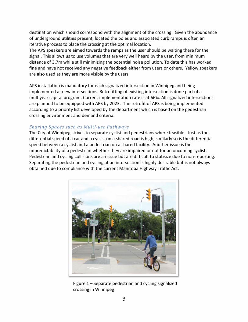
Sharing Spaces such as Multi-use Pathways
The City of Winnipeg strives to separate cyclist and pedestrians where feasible. Just as the
differential speed of a car and a cyclist on a shared road is high, similarly so is the differential
speed between a cyclist and a pedestrian on a shared facility. Another issue is the
unpredictability of a pedestrian whether they are impaired or not for an oncoming cyclist.
Pedestrian and cycling collisions are an issue but are difficult to statisize due to non-reporting.
Separating the pedestrian and cycling at an intersection is highly desirable but is not always
obtained due to compliance with the current Manitoba Highway Traffic Act.
Figure 1 – Separate pedestrian and cycling signalized
crossing in Winnipeg
6
Mobility Impaired Pedestrian Operations and Behavior
When designing alignments, grading plans and choosing material types it’s important to
understand the variety of mobility impaired users. These are various types include size of
wheels, size of chair, manual or automatic controlled chairs. Mobility impaired pedestrians not
only include those in wheelchairs, but those who have issues with balance due to loss of limbs
or issues with their ears, seniors, or those with issues with their knees or hips. Understanding
the high level of workload, effort and risk for a pedestrian with these disabilities takes by
utilizing a public right-of-way to walk is critical for designers to ensure grading of streets,
sidewalks and boulevards are done within acceptable standards. For these reasons the City of
Winnipeg strictly utilizes a 2% cross fall on all sidewalk and up to a
maximum of 4% at approaches or at constrained locations like in the downtown. Long
stretches of recreational pathways systems also include frequent rest areas to accommodate
pedestrians with varying levels of fitness. Minimizing longitudinal grading is also another
important factor to accommodate users of varying level of fitness, whereas the levelness of a
facility it important, but this needs to be balanced with providing gradual elevation changes to
provide the visually impaired with their respected cues. Another consideration is to protect
drop-offs near pedestrian facilities utilize an appropriate pedestrian clear space or railing.
Providing accessible grading is not the only consideration but accommodating snow clearing
operations and snow storage is critical to provide a clear path of travel during winter months.
This is attained by providing appropriate boulevard or amenity zones for snow storage and
provided a clear and predictable path for sidewalk plows. Not considering sidewalk plow
operations can lead to reduced snow clearing level of service, which can impact users ability to
use the facilities in the winter months which has psychological implications
Geometric Design Strategies for Improving Pedestrian Safety at Signalized Intersection
The following are some examples of design strategies that can provide additional predictability
and convenience for both a motorist and a pedestrian to improve safety at signalized
intersections.
Commentary on how median widths and bullnose design can improve
pedestrian navigation and safety
The City of Winnipeg designs crossing times for signalized intersections in accordance with the
TAC Pedestrian Crossing Control Guideline. However there are instances where a pedestrian
cannot complete the crossing during the given phase. To provide a form of predictability for
pedestrians the City of Winnipeg is utilizing Pedestrian Countdown Signals (PCS). The PCS was
first tested in Winnipeg during 2013. Following a successful trial and a user satisfaction survey
that showed above 95% satisfaction, a multiyear capital program was established for the
implementation of PCS at 40 signalized intersections each year. The PCS are being
7
implemented according to a priority list developed by the department which is based on the
pedestrian crossing environment and demand criteria.
A major benefit of PCS is that many users do not understand the meaning of the flashing red
hand and do not have enough information to decide if they have time to cross because of the
wide range of walking speeds.
The design of the location and size of a median at a signalized intersection must balance the
ability for turning vehicles, the level of compliance with adhering to the painted stop line,
provision of a mid crossing trajectory cue for visually impaired, and possibly provide a point of
refuge. The City of Winnipeg amended its design standard for median widths in 2011 from
5.0m for a major collector or minor arterial to 5.5m. This provides additional flexibility in
design to have the bullnose placed at an optimal location when left turn lanes are present.
For most intersections where the pedestrian crossing distance is not excessive the bullnose
should not intercept the path of pedestrian travel. This provides convenience for mobility
impaired users and reduces pedestrian congestion in downtown or constrained environments
during the crossing.
For large intersections, it is common to have a wider median. Having a median refuge for larger
intersections is important to provide additional guidance and safety. Wider medians also
enable proper accessible grading. For cycling facilities crossing major roads, the median width
should be sufficient room, typically 3.0m, to store a bicycle that includes a pull-behind trailer
with a shy distance to the auxiliary or travelling lanes.
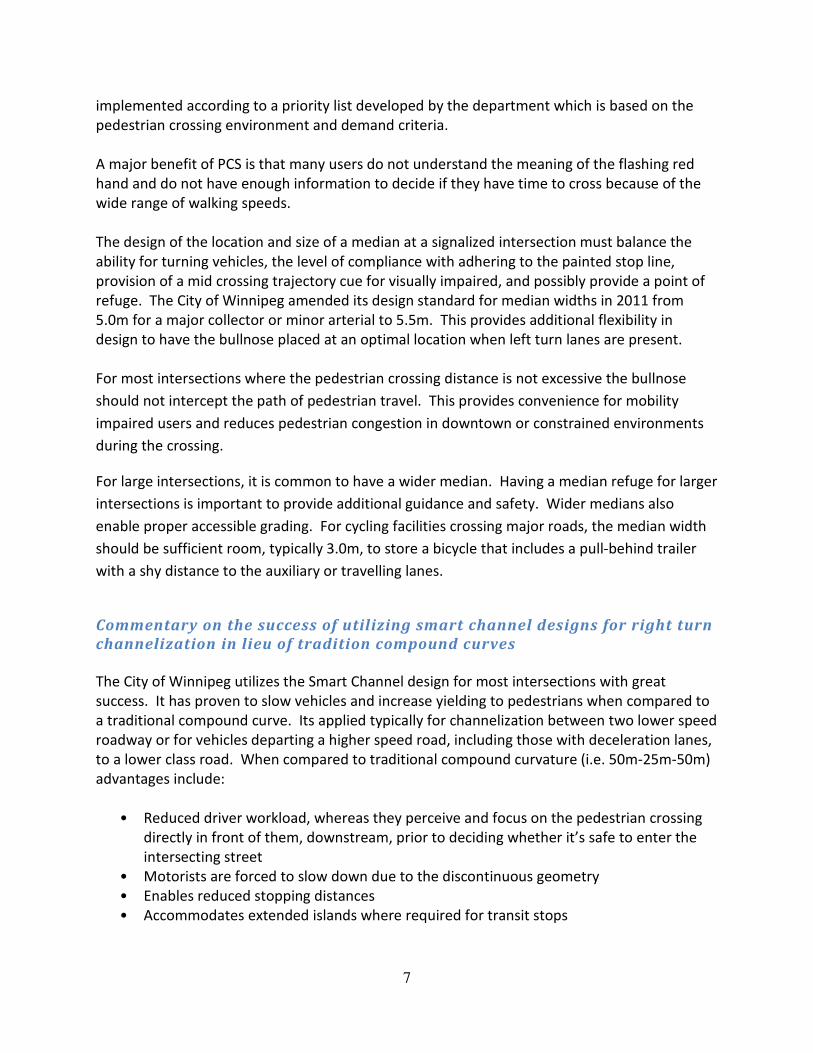
Commentary on the success of utilizing smart channel designs for right turn
channelization in lieu of tradition compound curves
The City of Winnipeg utilizes the Smart Channel design for most intersections with great
success. It has proven to slow vehicles and increase yielding to pedestrians when compared to
a traditional compound curve. Its applied typically for channelization between two lower speed
roadway or for vehicles departing a higher speed road, including those with deceleration lanes,
to a lower class road. When compared to traditional compound curvature (i.e. 50m-25m-50m)
advantages include:
• Reduced driver workload, whereas they perceive and focus on the pedestrian crossing
directly in front of them, downstream, prior to deciding whether it’s safe to enter the
intersecting street
• Motorists are forced to slow down due to the discontinuous geometry
• Enables reduced stopping distances
• Accommodates extended islands where required for transit stops
8
• Beneficial to reduce the amount drivers are required to turn their heads to see
oncoming traffic for them to yield to, especially at skewed intersections. This not only
accommodates drivers with physiological constraints but makes it easier to perceive
through moving cyclists on the intersecting street
• Reduced property requirements
Figure 2 – Example of a smart channel in Winnipeg from an
expressway to an arterial
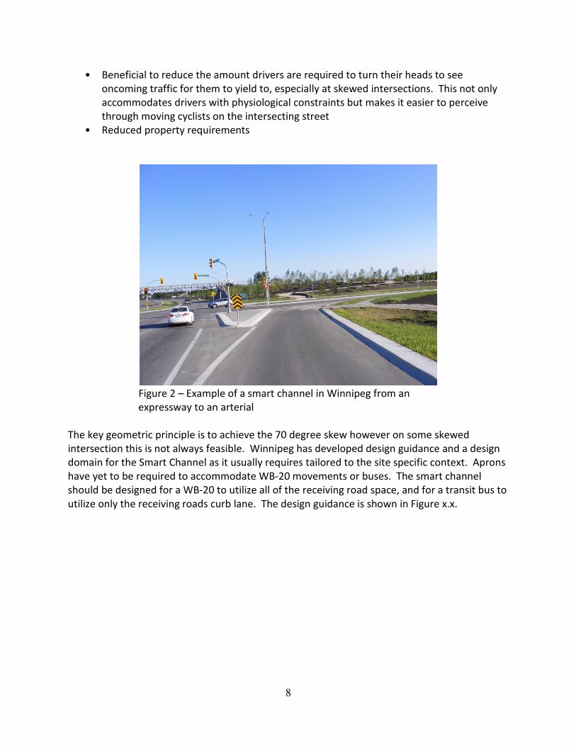
The key geometric principle is to achieve the 70 degree skew however on some skewed
intersection this is not always feasible. Winnipeg has developed design guidance and a design
domain for the Smart Channel as it usually requires tailored to the site specific context. Aprons
have yet to be required to accommodate WB-20 movements or buses. The smart channel
should be designed for a WB-20 to utilize all of the receiving road space, and for a transit bus to
utilize only the receiving roads curb lane. The design guidance is shown in Figure x.x.
9
Figure 3 – City Standard Geometry for a Smart Channel
Commentary on the effect of placing curb ramps at various locations at
channelized intersections
The City of Winnipeg does not strictly standardize the location of a curb ramp crossing with the
exception of smart channel designs, which typically require that the pedestrian crossings be
downstream of the traffic, the pedestrian crossings are preferred to be in the pedestrians’ line
of travel, or established perpendicular to the midpoint of an island. Locating the pedestrian
crossing should also consider the closest path and the route the pedestrian will travel once out
of the intersection as well as whether a dedicated right turn lane prior to the island is present.
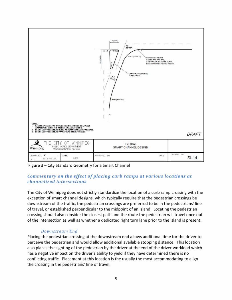
Downstream End
Placing the pedestrian crossing at the downstream end allows additional time for the driver to
perceive the pedestrian and would allow additional available stopping distance. This location
also places the sighting of the pedestrian by the driver at the end of the driver workload which
has a negative impact on the driver’s ability to yield if they have determined there is no
conflicting traffic. Placement at this location is the usually the most accommodating to align
the crossing in the pedestrians’ line of travel.
10
Figure 4 – Provencher Boulevard right turn onto Tache Avenue
demonstrates how the downstream crossing allows for good
sight lines for the driver.
At the Midpoint
Placing the pedestrian crossing at the midpoint is the most common location for within
Winnipeg and therefore it is widely understood and expected by both drivers and pedestrians.
This location may allow for the shortest crossing distance and is simplest to accommodate
accessible sidewalk grades. This locations also can allow space for a vehicle to store between
the pedestrian crossing and the cross street.
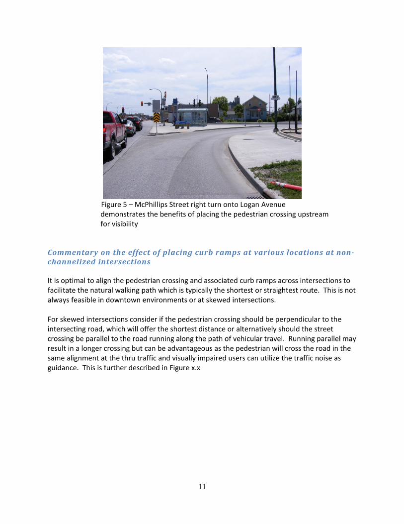
Upstream End
Placing the pedestrian crossing at the upstream end allows for the driver’s sighting of the
pedestrian to be at the top of the driver workload. If there is a lot of street furniture and
objects on the island in some cases the pedestrian may be made more visible by situating the
pedestrian in front and ahead of the other objects. Where there is no dedicated right turn lane
in advance of this crossing, the driver would have to stop in the through lane which may result
in a rear end collision.
11
Figure 5 – McPhillips Street right turn onto Logan Avenue
demonstrates the benefits of placing the pedestrian crossing upstream
for visibility
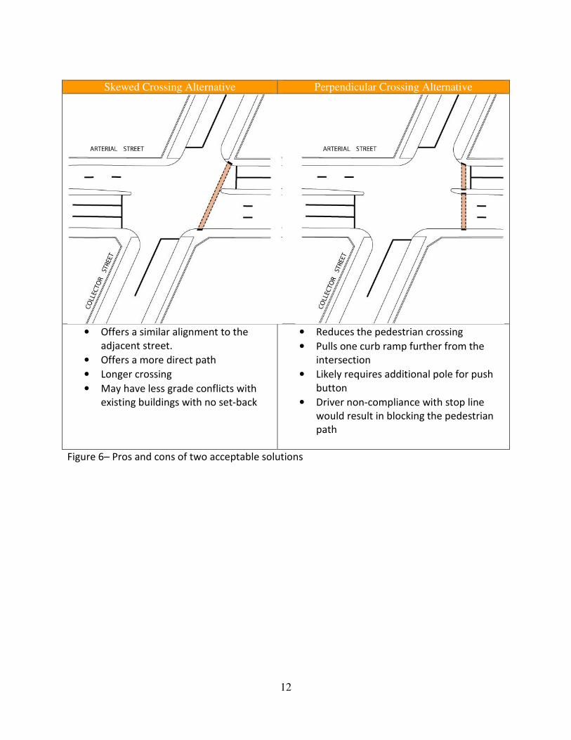
Commentary on the effect of placing curb ramps at various locations at non-
channelized intersections
It is optimal to align the pedestrian crossing and associated curb ramps across intersections to
facilitate the natural walking path which is typically the shortest or straightest route. This is not
always feasible in downtown environments or at skewed intersections.
For skewed intersections consider if the pedestrian crossing should be perpendicular to the
intersecting road, which will offer the shortest distance or alternatively should the street
crossing be parallel to the road running along the path of vehicular travel. Running parallel may
result in a longer crossing but can be advantageous as the pedestrian will cross the road in the
same alignment at the thru traffic and visually impaired users can utilize the traffic noise as
guidance. This is further described in Figure x.x
12
Skewed Crossing Alternative Perpendicular Crossing Alternative
• Offers a similar alignment to the
adjacent street.
• Offers a more direct path
• Longer crossing
• May have less grade conflicts with
existing buildings with no set-back
• Reduces the pedestrian crossing
• Pulls one curb ramp further from the
intersection
• Likely requires additional pole for push
button
• Driver non-compliance with stop line
would result in blocking the pedestrian
path
Figure 6– Pros and cons of two acceptable solutions
13
Commentary on the success of curb extensions (bump-outs) to reduce
pedestrian crossing distances
A common and successful geometric treatment to improve pedestrian safety is the use of curb
extensions, or also commonly described as bump-outs. They have many advantages such as
defining parking lanes, calming traffic, adding landscaping, facilitating road diets, reducing the
pedestrian crossing distance, providing enhanced pedestrian visibility and provide pedestrian
queue storage. Winnipeg’s design guidance for curb extension is as follows:
• Bump-outs shall have at least a 7.0m tangent section parallel to the through lane to
provide sight guidance for motorists.
• The minimum radius is 6.0m to facilitate street cleaning.
• Bump outs should have the appropriate shy distance from the through vehicular lane.