Embed Size (px)
Citation preview

199 Ghana Journal ofQeography Vol. 3. 201 I
Geomorphic Assessment of Floods within the Urban Environment of Gbawe
Mallam, Accra.
Kwabe11a Awere Gyekye0
ABSTRACT This study examined urban geomorphic conditions that lead to flooding in
urban areas of Gbawe and Ma lam. The main objective of the study was to
identify the geom01phic causes of urban flooding. The study used ArcGJS
analysis to present the results on land use change. Information on
geom01phic and geological characteristics, rainfall pattern and human
induced activities and their impact on the environment were examined.
The result of the research indicated that Ma lam Junction, Abease and
Gbawe-Zero Road are areas with the highest vulnerability to flooding. The
main input to flooding is rainfall, with the heaviest ranging between 200 and
500mm, and occurring from May-July and August-Octobe1: Relief,
geo11101phic factors, the urbanization of streams, the drying up of wetlands,
the elimination of vegetation cover as well as deficient drainage networks
and waste disposal problems are the factors that aggravate flooding in the
study area. Some major suggestions were made for effective land use and
land management
• Department of Geography & Resource Development, University of Ghana, Legon,
Tel:+2333547041803, e-mail : [email protected]
Ghana Journal of Geography, Vol. 3, page 199 - 229

200 Ghana Journal o(Geography Vol. 3. 2011
INTRODUCTION Before the appearance of Homo sapiens on Earth, a purely natural system
ruled our planet. Many geophysical events such as earthquakes, volcanic
eruptions, landsliding and/or flooding took place but threatened only the
prevailing flora and fauna. Millions of years later, the presence of humans
transfonned the geophysical events into natural disasters.
This transformation occurred simultaneously with the appearance of the
human system, when human beings began to interact with nature. The
human system itself was subjected to significant transformations, where the
concept of work and hence of social division of work, production relations
and economic-political systems appeared. These transformations and their
links to the natural system have served as templates of the dynamics of
natural hazards and therefore of natural disasters.
A natural hazard such as flooding has the characteristic of posing a danger to
the different social entities of our environment; nevertheless, this danger is
not only the result of the process per se (natural vulnerability), it is the result
of the human systems and their vulnerability to natural disasters (human
vulnerability). When both types of vulnerability have the same coordinates in
space and time, natural disasters can occur (International Decade for Natural
Disaster Reduction, 1992).For example, Hamza and Zetter (1998) argued
that urban areas are not disaster prone by nature but that the structural process
that speeds up rapid urbanization, population movement and population
concentrations greatly increase the vulnerability oflow-income urban
dwellers to disasters (Zetter,2004).
Floods often result in widespread contamination that poses both immediate
and long-tem1 threats to human health and the environment. The
environmental consequences of flooding, however, can be exh·emely
complex and difficult to assess due to their large spatial extent, multiple
sources, sinks and types of pollutants, and potential effects on nearly all
components of the environment 'filotta et al.,2003).

201 Ghana Journal of Geography Vol. 3. 2011
Natural hazards and geomorphology.
The role of applied geomorphology in urban management calls for the study
of the geomorphic processes and features of urban landscape and the
development of the requisite fundamental applied research (Elyles, 1997;
Scott, 1998). Urban geomorphology combines ambient geology, landforms,
and geornorphic processes with an evaluation of their impacts due to
urbanization (Alexouli-Livadits et al., 1997).
The study deals with urban flooding caused by rainfall overwhelming
drainage capacity. However, the cause of urban flooding is seen to be
aggravated by land use and by the characteristics of geomorphic processes
and landfom1s. The risk of flooding is defined as a function of both the
probability of a flood happening and its impact. In urban areas, the impact can
be very high because the areas affected are densely populated and conta in
vital. infrastructure (Maroukian et al., 1994).
Floods constitute one kind of natural hazard. The tem1 natural hazard implies
the occurrence of a natural condition or phenomenon which threatens or acts
hazardously in a defined space and time. A natural hazard bas been expressed
as the elements in the physical environment ham1ful to man (Burton & Kates,
1964); an interaction of people and nature (White, 1973) the probability of
occurrence of a potentially damaging phenomenon (UNDRO, 1982); and a
physical event which makes an impact on human beings and their
enviromnent (Alexander, 1993).
A flood hazard is strongly related to the exogenous geomorphic process since
it is an important ingredient of the Earth's surface dynamics. Geomorphic
hazards can be regarded as the group of threats to human resources resulting
from the instability of the Earth's surface features (Gares et al., 1994). The
importance of these features is concentrated on the response of the landforms
to the processes, rather than on their original source. The problem related to
the control and regulation of land use in many parts of Accra has serious
impacts on landform dynamics and disaster management.
202 Ghana Journal of Geography Vol. 3. 2011
Magnitude and frequency, as well as temporal and spatial scale, are key
geomorphic concepts strongly correlated to natural hazards. For a given
event, such as a flood hazard, magnitude and frequency exert a very
important control on the impact of geomorphic processes since they have an
influence on landform change and therefore on the dynamic equilibrium in
geomorphological systems. The concepts of magnitude and frequency are
essential for the assessment of natural hazards. For example, the
consequences of a.flood are measured using return periods, giving an idea of
the characteristics the flood may have (magnitude) and how often it is likely
to occur (frequency). The dynamism of the Earth's surface is enclosed within
a temporal and spatial scale. The response of the landform to the changes
caused by the processes corresponds to the magnitude and frequency of the
events, the resistance of the involved materials and the size of the concerned
landform (Summerfield,.1991 )on a time basis. Hence, the intensity and
duration of rainfall in conjunction with the nature of the landfonn and fluvial
system, developed also on a time basis, would determine the characteristics
of the flooding. In this regard, elevation and hydrogeological characteristics
play a crucial role in the nature of urban flooding.
The occurrence of different types of disasters by regions of the globe
indicated that by far floods are the most frequent and dominant phenomenon
in Africa and constitutes nearly 29 percent of global flood incidence and 54%
geomorphic related disasters by type in Africa followed by storms (25%),
earthquakes (16%), landslides (3%) and volcanoes (2 %) from 1900 to 1999
(Source: EM-DAT database). For the period 1900 to 2011 the total affected
people by flood disasters in Ghana, which occur between June-July and
September-October, is 3,743,772, (average per event affected 25,000), while
the average economic damage cost is estimated at 74,700 USD per event
(EM-DAT: The OFDA/CRED International Disaster Database, 2011).

203 Ghana Journal of Geography Vol. 3. 2011
A number of case studies from different parts of the world dealing
with increased flood problems indicated that floods are the greatest cause
economic losses from natural disasters, mainly in more developed countri
and a major cause of disaster-related deaths, mainly in the less developed
countries. Hence, investigating the conditions of flooding generation and
recording them in vulnerable urban areas is indispensable to urban planni1
and socio-economic development (Smith & Ward, 1999, p.9.). Douglas et
(2008) noted that floods are very common in African cities, are becoming
more frequent and affect the urban poor most severely. The situation
becomes serious in defenseless societies where the social system has neitl
control over the situation nor the capacity to cope with it (Barkun, 1974).
The historical planning of Accra has contributed to the emergence of som
urban disasters, such as flooding, which could have easily been preventec
The unplanned growth of Accra is attributed to the neglect of land
management and weak spatial planning when the government of Ghana v
implementing various economic development projects. Prior to 1983 lane
use planning and development control were non-existent in the cities of
Ghana, especially Accra (Larbi, 1996). During the period of colonial rule
land-use planning was primarily concentrated in newly developing areas
occupied by Europeans and on state lands to the neglect of customary Ian
although the latter constitute the dominant type of land in Accra (Larbi,
1996). After independence, the situation did not change and the plam1ing
development of Accra continued in the colonial pattern (Larbi, 1996).
When the government of Ghana started implementing the Structural
Adjustment Programme in 1983, land use planning was seriously tackled
land management did not receive enough attention (Larbi, 1996; Grant a1
Yankson, 2003). However, the management ofland is fundamental to an~
improvement in the quality of an urban environment (Aryeetey-Attoh, 2(
. 203 Ghana Journal of Geography Vol. 3. 2011
A number of case studies from different parts of the world dealing
with increased flood problems indicated that floods are the greatest cause of
economic losses from natural disasters, n~ainly in more developed countries,
and a major cause of disaster-related deaths, mainly in the less developed
countries. Hence, investigating the conditions of flooding generation and
recording them in vulnerable urban areas is indispensable to urban planning
and socio-economic development (Smith & Ward, 1999, p.9.). Douglas et al
(2008) noted that floods are very common in African cities, are becoming
more frequent and affect the urban poor most severely. The situation
becomes serious in defenseless societies where the social system has neither
control over the situation nor the capacity to cope with it (Barkun, 1974).
The historical planning of Accra has contributed to the emergence of some
urban disasters, such as flooding, which could have easily been prevented.
The unplanned growth of Accra is attributed to the neglect of land
management and weak spatial planning when the government of Ghana was
implementing various economic development projects. Prior to 1983 land
use planning and development control were non-existent in the cities of
Ghana, especially Accra (Larbi, 1996). During the period of colonial rule
land-use planning was primarily concentrated in newly developing areas
occupied by Europeans and on state lands to the neglect of customary lands,
although the latter constitute the dominant type of land in Accra (Larbi,
1996). After independence, the situation did not change and the planning and
. development of Accra continued in the colonial pattern (Larbi, 1996).
When the government of Ghana started implementing the Structural
Adjustment Programme in 1983, land use planning was seriously tackled but
land management did not receive enough attention (Larbi, 1996; Grant and
Yankson, 2003). However, the management ofland is fundamental to any
improvement in the quality of an urban environment (Aryeetey-Attoh, 2001)
and there are lasting deleterious effects on the environment if it is poorly

204 Ghana Journal of Geography Vol. 3. 2011
managed (Larbi, 1996; Aryeetey-Attoh, 2001).
The city of Accra is faced with a number of human settlement challenges:
increasing population, poor land use, fast growing and uncontrolled
constructions, inadequate and inefficient drain networks, poor waste
disposal and overcrowding. These factors escalate flood occurrence. The
problem appears to be especially critical in areas where planning and
enforcement of building regulations are ignored. The contribution of
urbanization to flooding has been documented in many urban disaster
research issues. For example, it was noted that out of the ten major floods
events recorded for the Greater Accra Metropolitan Area (GAMA) from
2001 to 2005, seven occurred during the major rainy season from March to
June, which reflects the severity of flooding from rivers, streams and
drainage channels within GAMA that has claimed several lives and
destroyed public infrastructure and private property (Songsore et al., 2009).
The economic loss brought about by such flooding is immeasurable. It is
estimated that, on the average, an amount of ten million Ghana cedis is spent
annua lly by the National Disaster Management Organization (NADMO) on
disaster prevention and management programmes.
The causes of flooding are many but generally, precipitation and spilling
from dams are the main source of floods in many countries.Rainfall in the
tropics is usually associated with several types of synoptic phenomena:
tropic cyclones, the monsoon system and easterly winds, and the Inter
Tropical Convergence Zone. Total annual rainfall may rise due to a
combination of these phenomena, but episodic high magnitude rainfall
events are usually from the first three (Gupta & Ahmad, 1999). The most
impressive high magnitude event in Ghana is the Inter Tropical Convergence
Zone. However, floods in Ghana are largely influenced by the bimodal
character of the rainfall pattern in Ghana. Flood phenomena generally

205 Ghana Journal of Geography Vol. 3. 2011
occun-ed in low-lying topographic areas in many parts of the Accra
Metropolis, for example in Mallam, Awoshie, Odawna-Circle, Dansornan
and Wireless 2, and in portions along the coastal zones. In June-July 1997
and 1999, the areas of Gbawe and Mallam experienced heavy rainstom1s,
which resulted in intense floodings of the downstream sections. Since then
there have been repeated flood cases in these areas. The more recent ones in
Gbawe and Mallam occurred in June 2007 and 2009, the outcome of which
was substanti~l prope1iy damage along with the destruction of public utility
networks, roads, bridges and other man-made structures and the slowing
down of economic activities. Such damages and losses underscore the
importance of undertaking this study. This paper investigated the
geomorphic causes and effects of flooding using ArcGIS interpretation and
field investigation. The main objective of this paper is to examine the causes
and effects of floods in Gbawe and Mallam and to recommend appropriate
solutions to the problems.
MATERIAL AND METHODS. The study applied the ArcGIS vector data to analyse the different parameters
of environmental change: drainage, land use/land cover and the geology of
the study area. Drainage network and wetlands were digitized from older
edition survey maps. In addition, roads and buildings were digitized and
combined with the digital ten-ain model's drainage network (fig.2 and fig.3)
as an overlay in order to identify changes in the natural environment.
Land cover and land use maps were obtained for the periods of 1990 and 2000
from satell ite image photographs which had been worked out to a scale
1 :280,000 (CERSGIS, 2009). This offered an opportunity to carry out a
comparative assessment on the extent and nature of changes that have
occurred in both land cover and land use over the period. Rainfall data from
three synoptic weather stations (Aburi, Weja and Accra) was obtained from
the Ghana Meteorological Services. The observation period for monthly

206 Ghana Journal of Geography Vol. 3. 2011
rainfall patterns extended from January 1991 to December 2006 and the
information was analyzed through simple graph presentation. Monthly
rainfall patterns were determined using monthly observable trends. Monthly
rainy seasons were defined as the rainy season (mid-April - July, September
and October) and the dry season as November-March. Primary data was
collected though field investigations and a semi-structured interview guide.
To assess the nature of geomorphic processes, a slope classification scheme
based on slope percentage categories was used; this was derived from slope
maps (Ghana Minerals Commission, 1998). Relief, drainage and common
open water areas were identified. The gradient range reflects the nature of the
naturally/and or culturally dissected landscape. The following gradient range
was classified:
Table 1. Gradient / Slope Classification scheme of the study area
Gradient Relief /drainage characteristics,
(degrees) gcomorphic processes.
River basin, creeks, marshy lowlands A 0-3 Poor drainage, flood plain area, siltation.
B >3-10
c >10-30
Plain lowland areas with isolated hill slopes, inselbergs, rills, and sand dunes, fairly drained/good drainage areas, sedimentation.
Good drainage, numerous sand dunes, gullies.
Location
Central Gbawe, Cemetery Road, Mallam Junction Mallam Station, Bola Road
Abease, Electricity Corporation of Ghana,
Wireless, Post Office, Zero, Old Gbawe
D >20-30 Good drainage, frequent sand dunes Bulcmi, Catchment and watershed area Cuts from sand winning. Gonste
E > 30-40 Portions of dissected lands or badlands due
F >45
to gully erosion, soil creep, Stone quanying. Watershed area, gully erosion, soil creep, flows, soil erosion.
Bulemi North (Stone Quany)
Zero North, Bulemi North

207 Ghana Journal of Geography Vol. 3. 2011
The naturally/and or culturally dissected landscape is a special type of slope
category and represents a combination of individual slope categories
covering the full range from zero to .greater than 45 degrees (0 to >4'5), each
of which characterizes a geomorphic unit but which collectively fonn a large
area to represent a heterogeneous landscape that has broad implications for
geomorphic processes.
A range of 30 to >45 degrees was classified as the slope boundary limit of the
study area where most slope processes originate; this classification was used
to identify flood prone areas, and partly respondents; the selection of
respondents however was based on purposive and random sampling in order
to get the targeted people and to avoid extreme bias. Respondents answered
questions on three categories of flood related components, namely land use
and land cover changes, causes, effects and solutions to flooding.
The sample size, 120 respondents, was proportionately divided between the
two communities of Gbawe and Mallam based on population size of over
5000 (National population census, 2000) and the extent of the problem. In the
selection of respondents, consideration was also given to the number of years
respondents have lived in the study area. A range of 3-15 years was chosen
(from preliminary survey conducted) as a period considered reasonable for
respondents to have a fair knowledge of flood incidents in their vicinity.
The data obtained was analyzed through descriptive statistics and the use of
bar and linear graphs for comparing data points and for determining the
frequency of the occurrence of events.
208 Ghana Journal ofGeography Vol. 3. 2011
THE STUDY AREA The study area, Mallam-Gbawe, is a lowland area, except for a range of
undulating hills on the northern section. Mallam-Gbawe is situated
southwest of the Accra plains and expands from the drainage divide of
McCarty Hills to the southern lowland plains of the Odokor-Mallam road
where it joins the main Pambrose marshy lowlands (fig. I). The population of
the study area is predominantly Ga and Moslem, while the rest belong to the
ethnic minority groups of Adangbe, Akan, Ewe and Fanti. The relatively fast
growth in the size of Gbawe and Mallam which were rural in 1984 but have
now attained urban status mainly as a result of the spillover of the growth of
the AMA into localities in the surrounding districts, has serious implications
for land use. Gbawe and Mallam each has a population exceeding 5000 with a
growth rate of 2.1 percent (2000 Population Census).
The geology of the area (fig. 1) is composed of the Togo series and flanked on
both sides by the Dahomeyan. To the southeast of the Dahomeyan lies the
Accraian (Mid Devonian). The Togo series are made of quartzite, schist,
sandstone, shales and phyllite; these are common varieties of metamorphic
rock. Shale is common and is metamorphosed into slate in a low-temperature
environment. The geology of the environment indicates, in some parts, a
weak-soil environment. The land area consists of gentle slopes interspersed
with plains in most parts and generally undulating at less than 76m above sea
levels. The slopes are mostly formed over the clay soils of the Dahomeyan
gneiss, with the alluvial areas smTounding the coastal lagoons being
generally flat. The Akwapim range and the Weija hills rise steeply above the
western edge. The crest oftheAkwapim range lies generally at 300m
southwards. This line of hills continues through to the Weija hills, with the
highest point reaching 192m near Weija.
From the hydrolithological characteristics of the area, the geology of the area

209 Ghana Journal of Geography Vol. 3. 2011
varies from impermeable and semi-permeable to penneable layers of rocks
and these have a profound effect on the nature of drainage, the type of
sediment transport and flooding. For example, the upper and middle courses
of river Baley show a narrow and zigzag pattern of drainage whiles at its
lower part the drainage basin is broad, indicating a change in the geological
layout and relief fonn. This formation influences the nature of flooding
effects as flood waters are concentrated at the deep-narrow upper section,
causing substaptial erosion and sediment transport, while at the lower section
a wider area is affected during flooding, causing deposits of sediments and
damage to properties.
GEOLOGY OF GBAWE-MALAM AND ITS ENVIRONS
Fig.1 . Geology of Gbawe-Mallam and its environs.

210 Ghana Journa l of Geography Vol. 3. 201 I
Climate
The climatic condition of Gbawe-Mallam is not different from the general
tropical climate of the country. As depicted from the average rainfall rates,
Gbawe and Mallam fall within the bimodal pattern of rainfall with the major
rainy seasons occutTing from May to July and from September to October
(100-500mm), and the lean season occurring from November to mid April
with an average rainfall of less than 200mm.per annum. Rainfall data from
the three weather stations, \Veija, Aburi, and Accra indicated that monthly
rainfall totals of the study area varied between 80 and l 20mm for the years
1991 to 2006.Monthly distribution of rainfall showed marked variation,
especially bet\veen the months of May and November when monthly rainfall
totals range between 50 and 300 mm. Severe flood ing usually occurs within
the main raining months of June-July and September-October. This is
associated with rainfall formation from the direction of Aburi hills and/or
squall lines from the Coast and Weija (usually of short duration but of high
intensity rainfall, 200mm).
RESULTS AND DISCUSSION
Land cover and land use
Land cover and land use maps were obtained for 1990 and 2000 from satellite
image photographs and worked out to a scale of 1 :280,000 (Fig.2).
Within the study areas, patterns of land use represent a response to the various
processes of urban growth. Traditional land use includes agriculture and
mining while current land use comprises housing, roads, markets, schools,
car parks and roadside business.
Competition for land is strong both between and within different functions.
For example, lands on the outskirts are more needed for residential and
commercial purposes while businesses compete for the best locations within
and near road arteries . Such competition affects not only the land use pattern

211 Ghana Journal of Geography Vol. 3. 20 I I
of the area but also the urban morphology and nature of flooding because
flood prone areas have been taken over by business activities.
Accra is inhabited by more than 3 million people, with a growth rate of 4%
per year, which implies that the population will double in 16 years (United
Nations, 2005; World Bank, 2007; World Bank, 2009). These projected
increases are likely to expand the city's built up area and affect land use, and
in this respect Gbawe and Mallam are no exception.
On the land use map of 1990, the land use cover of Gbawe was primarily
grassland with scattered savanna trees. Apart from the Gbawe township,
which formed the nucleus of the area, settlement was chiefly scattered or
dispersed in nature and consisted of traditional thatch huts and mud-brick
houses. The main occupation was farming and growing of vegetable crops.
There also prevailed some form of traditional hunting restricted to specific
zones. During this period the land use and land cover situation in Mallam was
quite different (511); settlement was the main land use, followed by a limited
amount of quarrying. In a few cases, patches of grassland and shrubs could be
found.
The land cover and land use for the period 2000 reflects some
substantial changes; almost the entire stretch of Gbawe was converted into
settlement. In Mallam, settlements continue to expand southwards to the
coast, and parts of the coastal lagoon (7400) were turned into sites for salt
wining. Changes in land use have seriously affected drainage in the study
area to the extent that current mapping of drainage would be difficult to
execute, except in a few places where fluvial processes show semi
permanent flood morphology and where the geologic and physiographic
conditions can easily be discerned.

212 Ghana Journal of Geography Vol. 3. 2011
Draining and filling of drainage areas for construction purposes have not
only led to the drying up of some of these areas,but have also changed the
morphology of the drainage network and are thus making the natural flow of
these rivers difficult. For example, the construction of buildings and roads
within the drainage basin and areas of low elevation in Old Gbawe, Gbawe
Zero and Mallam Junction have led to impeded water flow in periods of
heavy rainfall (especially in May-July), resulting in flooding. This was well
noted atMallam Junction and across the Mallam-Kaneshie road where the
construction of the road has reduced the accessibility of the surface run off to
the Panbrose-Densu delta and finally to the sea, thus causing severe flooding
in these parts of the area. Currently, over a 300 meter stretch of the main road
between McCarthy Hill Junctionand Mallam-Kaneshie Junction lies within
the same elevation as the immediate surroundings of Mallam Junction. As a
result, during heavy and prolonged rainfall, the road becomes easily flooded.
As depicted from the landcover and land use maps, there had been
considerable changes in land cover and land use patterns between 1990 and
2000, indicating a significant transformation of the natural environment as a
result of human interventions. Such changes in land cover and land use have
led to a reduction in the environment's capacity to regulate flood waters.
In the absence of coordinated human settlement planning and strict
enforcement of regulations on land use, addressing flood problems within
Mallam-Gbawe and for that matter floods within the urban environment
looks extremely difficult.

213 Ghana Journal of Geography Vol. 3. 2011
Fig. 2. Land use cover/land use map covering the study area for the period 1990.
J990
000 1 ~·11 !'ii Ooyc To,vu . -~~"
7200
7420
1611 41 20
t')'"?l''l'rrw O""' t 7'~-\n-VV
., 050 2 3 f!!!oZ5~~~5i--il=~~~t<1l<.1tl'U!"l•tl .. o
1:150.000
Fig. 2a. Land use cover/land use map covering the study area for the period 2000.
2000
~-;;,
0-17'~0'"\N 1 o.ro o 2 3
1:1.G0.000
' '" <."\shJ-
M-ilJ.>lf!>~"'1t1t:;~ Dn..l"l~(.-,1\ttJ111
Ki10MC10t'$

214 Ghana Journal of Geography Vol. 3. 201 J
Drainage characteristics
lHO Gr1t. !lllit ll1!1f1t4 t11;i1111a"\
+ «00 an~M. ""'"It'll • l•16 lllmlM~l''llhllllulk'lll!l>Olll°'111!
•II• Or!'a •hltAI -...ia "'ti!l~,.,. .. ,,11,11111
• UllfolMU!l.!orill~
.. IH•lt Wllllflll
The study area is drained by numerous rivers, streams and pockets of marshy
areas forming a broad drainage network. The area is characterized by gentle
slopes with low elevation; these areas are developed over semi-permeable or
impermeable formations. The drainage network consists of parallel-dendrite
streams of temporary flow in a southward direction, following the gradient of
the relief (fig. 3).
One of the major rivers in the study area is the Bale river; it takes its source
from the lo\V hills of north Gbawe and flows southwards in a dendritic
pattern, joined by other hill streams from north eastern Gbawe, through the
main township of Gbawe and Mallam and finally to the Pan bros wetlands.

215 Ghana Journal of Geography Vol. 3. 2011
~,.. ~ ., . ~ ... ......... .......... o ... ~ """"'o""""""""""'"';;;;;;;;__,....,""""""""""'..!'lo<otn ................ ..
1 : '100,000
Fig. 3. lopograpliiccil map showing· drainage of the study area.
Over 65% of respondents interviewed indicated that wetlands, including
drainage basins that once received and regulated large volumes of floods,
have now been reduced in their area coverage and capacity to carry even
small floods. Consequently, the drying up of marshy areas and lagoons of
river basins has contributed to flood events in Gbawe and Mallam.
Secondary drainage basins are formed where there is a divide between two
low depressions. When examining the drainage map (CERGIS, 1990) and
the present drainage area, based on field observations, it was noted that:
Most marshy areas and the inland lagoon do not exist anymore.
These areas have been converted into man-made structures.
The total length of the present drainage network has decreased as
compared to that of the 1970s and 80s. The banks and lower parts of
the streams are covered with settlements. Consequently, their
mapping has been impossible. Inappropriate land use impedes
rainwater flow; moreover, drainage network and basins are severely
impacted by human activities. As a result, the study area is prone to
flooding during periods of heavy rainfall.

216 Ghana Journal of Geography Vol. 3. 2011
Comparing the old drainage network of rivers to the present one (based on
field observation), it was noted that the current drainage network has been
modified, especially at the plain area of Gbawe and Mallam where slopes
fluctuate between 0 and 8%, in such a way that there are just a small number
of independent streams flowing directly into the main river. In fact, this
situation can only be observed from field observation, as the drainage map
could not reflect current changes in drainage development. Furthermore, a
number of parallel, independent streams have been created by detached
streambeds that are the result of a large material deposit over a period of time.
The sediment deposits muffle the main riverbed and divide it into more
secondary beds. The parallel arrangement of the streams is due to an upward
morphology bulge between the torrents; even though this could be caused by
natural factors such as changes in internal geologic processes and climatic
conditions, human activity is the principal cause. Once the original
morphology is disturbed, natural regulation of stream flow by morphology is
absent. At the base of McCarty Hills, talus cones originated by the change of
the gradient and the uncontrolled stream flow are developed. These talus
cones are narrower and isolated in most cases. Because of their nature they
are ephemeral and quickly disappear after the heavy rains. This fills the flood
plains, reducing the ability of the basin to carry the expected volume of water.
Estimating the magnitudes of low and high frequency floods that occtmed in
the past was not possible because evidence of high-water marks, debris,
organic deposits and other ephemeral features has been destroyed. However,
in a few cases, the high energy of large floods was sufficient to transport
coarse sediments from the channel bed onto adjacent flood plains.
The anthropogenic interventions and the uncontrolled building constrnction
are more frequent on a gentle relief where the waters of the parallel streams
217 Ghana Journal of Geography Vol. 3. 20 11
end up. However, recent high demand for land has caused a situation
whereby the highest slopes are being used for settlement. Buildings cover the
lower parts of the drainage network as shown in the land use map (Fig. 2), and
they are constructed upon the stream channels. Hence, during periods of
intense rainfall, the artificially diverted torrential streams/flows find it
difficult to transport the rainwater into the lagoon and the sea. Searching for
a natural way out, the large quantity of water flows in the direction of the
gradient of the land; as a result, strong torrential streams are generated within
the streets of the city and speed up to reach the sea, causing flooding and great
damage in the urban area to buildings and streets, bringing about the loss of
lives and properties.
The locations with high risk of flooding are presented and discussed under
Figs. 2 and 3, comprising the whole drainage between Gbawe, Mallam
Junction and Panbrose.Other affected areas are Zero Road, Zongo, Mallam
and Abease Junction.
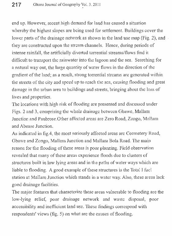
As indicated in fig.4, the most seriously affected areas are Ceemetery Road,
Gbawe and Zongo, Mallam Junction and Mallam Bola Road. The main
reason for the flooding of these areas is poor planning. Field observation
revealed that many of these areas experience floods due to clusters of
structures built in low lying areas and in the paths of water ways which are
liable to flooding. A good example of these strnctures is the Total 1 fuel
station at Mallam Junction which stands in a water way. Also, these areas lack
good drainage facilities.
The major features that characterize these areas vulnerable to flooding are the
low-lying relief, poor drainage network and waste disposal, poor
accessibility and inefficient land use. These findings correspond with
respondents' views (fig. 5) on what are the causes of flooding.
218 Ghana Journal of Geography Vol. 3. 2011
Fig 4.Areas periodically affected by flood. Fig. 5 Main causes of flooding.
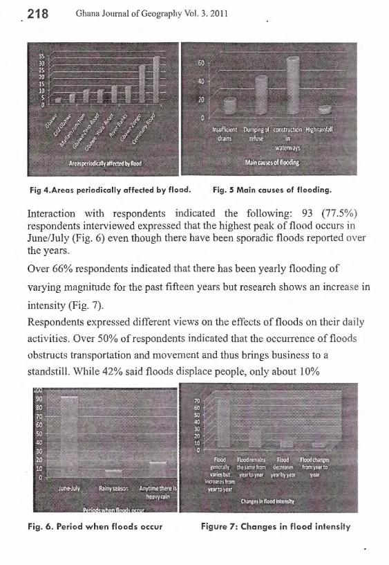
Interaction with respondents indicated the following: 93 (77.5%) respondents interviewed expressed that the highest peak of flood occurs in June/July (Fig. 6) even though there have been sporadic floods reported over the years.
Over 66% respondents indicated that there has been yearly flooding of
varying magnitude for the past fifteen years but research shows an increase in
intensity (Fig. 7).
Respondents expressed different views on the effects of floods on their daily
activities. Over 50% of respondents indicated that the occurrence of floods
obstructs transportation and movement and thus brings business to a
standstill. While 42% said floods displace people, only about 10%
Fig. 6. Period when floods occur Figure 7: Changes in flood intensity

219 G~ana Journal of Geography Vol. 3. 2011
Rainfall characteristics of the study area.
The rainfall figures presented demonstrate elements of marked unifonnity
and variability in their distribution pattern, both on monthly and yearly basis,
as noted in figs. 9, I 0, and 11. The major rainy period falls within the months
of May-June-July with the highest recorded monthly totals ranging between
80 and 300mm.
The lean period ofrainfall usually occurs within the months of January
Februa1y with rainfall amounts varying between 2.0 and 60mm. However,
extreme monthly variations of rainfall amounts of 0.0-1 OOmm were
recorded; this period is characterized by diy conditions and the absence of
floods.
The rainfall pattern shows the bimodal character; over 80% of high rainfall
figures occurred between May and July, with monthly rainfall amounts
ranging from 80-400mm, while for September-October a range of 80-

220 9hana Journal of Geography Vol. 3. 2011
180mm was recorded. During August-mid-September a range of30-130 mm
was observed. The dry season is clearly noted, stretching from December to
·March and showing decreasing rainfall amounts, from 0-120mm (figs. 9, 10,
and 11).
The monthly summary observations of rainfall indicated a substantial
variation in rainfall patterns both for monthly and yearly records. The
monthly rainfall figures for the Aburi meteorological station, 1991-1999
were generally higher (200-400mm, fig. 9), as compared to the period of
2000-2006 (200-300111111, fig. 9a), indicating a trend of gradual decrease in
rainfall amount yearly and towards a drier condition. However, there were
high rainstorm cases of different magnitudes within the period of May-July,
and September-October 2000-2006, indicating monthly rainfall variability.
From the given rainfall data and field investigations, it was noted that flood
events usually occur within the two main rainy periods of June-July when
rainfall amounts are higher (250-400mm per month).
From respondents, high floods usually occur after sho1i intervals of rainfall
which moisten the ground to an appreciable depth, giving little room for
further infiltration to take place. When this is preceded by the main rainy
periods of May, June-July, a near saturation condition of the ground is
achieved in no time and the high rainfall intensity causes a large volume of
surface run off which facilitates flooding.
High monthly rainfall from squall lines in the coastal zone of Accra, Weija
and Aburi, (figs.9, 10-1 Oa, and 11-1 la respectively), are another cause of
flooding within the Gbawe-Mallam community. As indicated, the bimodal
rainfall pattern of the three main rainfall recording stations gave the highest

221 Ghana Journal of Geography Vol. 3. 20 11
rainfall amounts within the periods of May-June-July, with the remaining
falling in September-October, which coincide with the periods of floods in
the study area. November-March is the lean.season of rainfall, and this period
shows an anomalous pattern of distribution. Mallam-Gbawe sharply comes
under the influence of the Aburi-Weija-Coastal rainfall fonnation.
Monthly Rainfall Totals, Weija1neteo. s tation , 1 991-2006 ? 600 c; ~ ~
500 .$ <::
£ 400 ~
<:: ...... ·§
300
~ 200 b -E 100 c 0 ~ 0
Jan Feb Mar Apr May Jun Jul Aug Sep Oct Nov Dec
-+-1991 yr - 1992 -+-1993 -*""1996 --*"-1999 ........ 2000 -+-2001 - 2002 - 2004 -+-2006
·····-··-----···----·-·-------Fig.9. Monthly rainfall total {mm) Weija meteorological station, 1991-2006.
Monthly nunfo.11 totnls, 1 991-1999, Ac~·rn Meteo Sta tion 600 c 500
···-----······----·------------·----···----------···--·-------··-·----···---
----- --·--·---"' c ., 400
"' c 0
300 Q. .,, ~ 'O 200 i; .0 E 100 ::; z
0
Jan Feb March April May June July Aug Sept Oct Nov Dec
-+-1991 yr --- 1992 ---1993 ..>+- 1994 _.,._199S
-.-1996 --+--1997 ~1998 ~1999
Fig.10. Monthly rainfall total {mm) Accra meteorological station, 1991-1999.
222
e .§.
600.0
500.0
~ 400.0 !§
~ 300.0 c
~ ? .c. ~ 0 ~
200.0
100.0
0.0
Ghana Journal of Geography Vol. 3. 20 JI
Monthly Rainfall Totals (nun),1999-2006, Accra rneteo station.
~- -----r-:---· ·--·~--1
- --- - -··--·············------
Jan Feb March April May June July Aug Sept Oct Nov Dec
-+-2000 ---2001
--2004 - 2005
....... 2002
-!-2006
"'*-2003
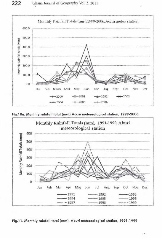
Fig.1 Oa. Monthly rainfall total (mm) Accra meteorological station, 1999-2006.
e 600 g
500 .!!! .., 0 I- 400 ~ c 300 'jij 0:: >- 200 ::c c 0 2 100
0
Monthly Rainfall Tot,1ls (mm), 1991-1999,Abmi met·eorological station
···········----·- ......... _ ...................... ___ ..................... --........ ----······-·····-- -····-····"···········
Jan Feb Mar Apr May Jun Jul Aug Sep Oct Nov Dec
-1991 - 1992 - 1993 -1994 -1995 - 1996 - -1997 - 1998 ---- 1999
Fig.11. Monthly rainfall total (mm), Aburi meteorological station, 1991 -1999

223 Ghana Journal ofG.eography Vol. 3. 2011
600
500
"E .§. 400 "' t;;
'R - 300 :E c
Monthly Rainfall Totals (nun ),2000-2006,Abl.lri meteorological station
e 200·. f-------11t-+---'\.+---,bldM-~---+--lo,:--::i.O.---->-~ g 100 ::!:
0
Jan Feb Mar Apr May Jun Jul Aug Sep Oct Nov Dec
-+-2000yr - 2001 -+-2002 ~2003
~2004 -v-2005 -+-2006 ~-----·-···-··-----··----------------------'
Fig 11 a. Monthly rainfall total (mm), Aburi meteorological station, 2000-2006
Fig. 12 Fig 12 a
Figs.12 & I 2a. The role of public and communities in flood management.
Prevention of flood hazards.
The significance of the prevention of natural disasters is made evident by the
commemoration of the International Decade for Natural Disaster Reduction
(IDNDR). Since then many countries have shown practical evidence and

224 Ghana Journal of.Geography Vol. 3. 2011
support through the adoption of comprehensive disaster management
strategies. In Ghana, The National Disaster Management Organization
(NADMO) and NGOs have been playing a decisive role in addressing
disaster issues despite their constraints in terms of funding and logistics .
Communities and individuals have shown some fom1 of support through
waste management and clean up exercises to desilt drains, and through
creating public awareness.
From the study, respondents offered some useful suggestions regarding how
to address flood problems but generally emphasized on the roles of
communities and the general public in preventing flooding which include
controlling sales of land, desisting from building and dumping waste in water
courses, constructing more and efficient drains to carry storm water and
regulating construction activities (figs. 12 and 13). Other measures are:
enforcing building regulations, demolishing structures that stand in water
ways and improving efficiency in waste management and disposal.
The study recommends effective land use through integrating geomorphic
knowledge which fonns an important aspect in the study of earth surface
dynamics, a component of disaster prevention.
CONCLUSION Natural disasters occur all over the world; however, their impact in
developing countries is greater due to the geographical location in zones
highly susceptible to natural hazards (natural vulnerability), and also due to
the different types of economic, social, political and cultural vulnerability
that exist. These types of vulnerability are indeed the result of their historical
development and their social, political, economic and cultural contexts.
Access to opportunities within the social entity is unequal and indirectly
proportional to the occurrence of flood disasters (the less opportunities, the

22 5 Ghana Journal of Geography Vol. 3. 2011
more vulnerability, the more affected by natural disasters) .
The combination of ArcGIS processing with geologic and geomorphic
studies revealed somebasic physical-geographical characteristics of Gbawe
Mallam and its immediate environs that have a direct bearing on floods.
The geologic and geomorphic conditions of the study area influence flood
phenomena; from a very steep slope to an abruptly lowland area, these
conditions fac ilitate the flow of water and the transpo1t of huge quantities of
earth materials from upper streams which are deposited on adjacent lowland
areas, causing the siltation of river beds and consequently making the area
vulnerable to flooding. Land use, through an increasing proportion of
impermeable ground in existing developments, tends to concentrate surface
run-off into drains, which increases the risk of flooding.
Floods in the study area are attributed mainly to heavy rains which usually
take place during the rainy season (May-July and August-October); however,
the situation is exacerbated by human induced activities through the process
of urbanization. The peak of floods corresponds with the occurrence of high
magnitude rainfall.
The study revealed that short tem1 changes in flood seasonality suggest that
the mean seasonality and variance of flood series often do not remain
stationary as the time scale lengthens, and that the occurrence of floods is
unpredictable.
In general, the physical-geographical conditions and geomorphic
factors of the study area, coupled with socio-economic activities, changes in
land use and land cover are the main causes of floods in the study area.
The current situation is irreversible as far as the existing buildings
and filling-up of the beds ofrivers is concerned. Nevertheless, it is necessary

226 Ghana Journal of Geography Vol. 3. 2011
to prohibit any further filling-in and construction within the beds and
floodplains to maintain the natural flow of the water. The construction of an
efficient drainage network, as well as its thorough maintenance, is an
indispensable priority for the efficient control of flooding. Finally, planting
of vegetation cover along the slopes of the surrounding area is necessary to
check erosion and sedimentation. The study also recognized different kinds
of vulnerability that impede flood management, as follows:
Lack of strong national and local institutional structures and
coordination
Lack of access to information and knowledge
Lack of public awareness
Weak buildings owned by weak individuals
An overall coordinated human settlement-planning scheme through the
adoption of efficient land-use planning and management is seen as a
fundamental tool for integrating flood prevention with urban planning to
address the problems of flooding in Gbawe-Mallam. Such a planning scheme
would regulate human activities and adopt best environmental practices to
prevent the risk of disaster-related problems due to flooding.

227 Ghana Journal of Geography Vol. 3. 2011
References
Alexander, D. (1993). Natural Disasters. University of California (UCL) Press and Chapman & Hall, New York, 632 pp.
Alexouli-Livadits, A., et al. (1997). Geomorphological Investigations of the Drainage Network and Calculation of the Peak run off storm and Sediment field of Sarantapotamos and Katsdimidi streams.
International Symposium on Engineering Geology and the Environment. Balkemia, Rotterdam. p 31-40.
Aryeetey-:Attoh, S. (2001). Urban planning and management under Structural Adjustment. In The Political Economy of Housing and Urban Development in Africa: Ghana's Experience from Colonial Times to 1998, ed. K. Konadu-Agyemang, 333-356. Westport, CT: Praeger.
Aslam A. (1982). Geomorphological study ofMegara plain. Thesis. Department of Geology. National and Kaposdistrian University of Athens, 127 p.
Beklemishev, MK., Kozliak, EL (2003). Bioremediation of concrete contaminated with n-hexadecane and naphthalene. Acta Biotechnological. 2003; 23 (2-3):197-210.
Burton, I., Kates, R.W. (1964). The perception of natural hazards in resource management. Natural Resource. J. 3, pp. 412-441.
Burton, I., Kates, R.W., White, G.F. (1968). The Human Ecology of Extreme Geophysical Events. Department of Geography, Natural Hazards Research Working Paper No. 1, University of Toronto. Centre for Research on the Epidemiology of Disasters (CRED), International Disaster Database and Emergency Events Database (EM-DAT). At http://www.cred.be/emdat. Universite' Catholique de Louvain. Brnssels, Belgium, 2010.
Douglas I., Alam K., Mchenda M., McDonnell Y. (2008). Unjust waters: Climate change, flooding, and the urban poor in Africa, Environment and urbanization, Vol.20, No. 1, pp. 187- 205.
Eyles N. (1997). Environmental geology of urban areas. In: Eyles N. (ed.) Environmental Geology of Urban Areas. (550 p.).

228 Ghana Journal ofGeogral?hY Vol. 3. 2011
Gares P.A., Sherman, D.J., Nordstrom, K.F. (1994). Geomorphology and natural hazards. Geomorphology 10, p.1- 18
Ghana Meteorological Services Department. Monthly Summary of . Observations; Monthly rainfall totals, 1991-2006.
Ghana Minerals Commission. Map 13 - Contoured Bouguer Gravity Map, 1998.
Ghana National Population Census, 2000.
Gupta A., and Ahmad, R. (1999). Geomorphology and the urban tropics: building an interface between research and usage. Geomorphology, 31 : 133-149.
Hamza M. & Zetter R. (1998). Structural Adjustment, Urban Systems, and Disaster Vulnerability in Developing Countries. Cities, Vol.15, pp. 219-229.
International Decade for Natural Disaster Reduction (IDNDR), (1992). Glossary: Internationally Agreed Glossary of Basic Terms Related to Disaster Management, DHA- Geneva, 83 pp.
Songsore, J. (2009). Integrated Disaster Risk and Environmental Health Monitoring: Greater Accra Metropolitan area (GAMA), Ghana. pp 77-78.
Kenny F. (1997). Geographic information systems and remote sensing techniques in environmental assessment. In: Elyles, N. (ed.): Environmental Geology of urban areas (590p): 507-518.
Knox J.C. , Bartlein, P. J. , Hirschbboeck K.K. (1995). The Response of floods and sediment yields to climatic variation and land use in the Upper Mississippi Valley. Quart, Res.23. p.287-300.
Land cover and land use maps of Ghana, 1990 and 2000. Centre for Remote Sensing and Geographical Information System (CERGIS), University of Ghana, Legon.
Larbi O.W. (1996). Spatial Planning and Urban Fragmentation in Accra. TWPR, Vol. 18(2). pp. 193-214.
Maroukian H., Zamani, A. ( 1994). The Implications of human interference in the natural environment of Attica, Greece. Environmental

229 Ghana Journal of Geography Vol. 3. 2011
Contamination. Sixth International conference. Greece. pp 330-332.
Metropolitan Area (GAMA), Ghana. Singapore Journal of Tropical Geography, Vol.21 (2), pp. 200-214.
Natural Disasters and Vulnerability Analysis. Office of the United Nations Disaster Relief Coordinator (UNDRO), 1982. Geneva, Switzerland.
Psilovikos A., Sotiriadis L. and Vavliakis, E. (1993). The interaction between natural and anthropogenic factors in the formation of the environment of Kassandra, Halkidiki. Third Helinik Geographic conference. Vol. B. 233-241.
Scheidegger A . E. (1994). Hazards: singularities in geomorphic systems.Geomorphology 10, pp.19- 25.
Scott, S. J. (1998). Urban Geology in Canada- a perspective. In: Karrow, P. F, and White. O.L. (ed.): Urban Geology of Canadian cities. (495 p.): 1-9.
Smith K &Ward R. (1998: Floods) Physical Processes and human impacts. John Wiley, Chichester, 382 p.
Summerfield M.A., (1991 ). Global Geomorphology: An Introduction to the Study of Landfom1s.Wiley, New York, 537 pp.
Tilotta D.C., Kozliak, E., Pyle, SJ. (2003). Environmental Contamination as a Result of Flooding: A Case Study of Heating Oil Pollution in the Red River Valley.
White G. F., (1973). Natural hazards research. In: Chorley, R.J. (Ed.), Directions in Geography, Methuen, London, pp. 193- 216.
Yankson, P. (2000) "Houses and residential neighbourhoods as work places in urban areas: the case of selected low income residential areas in greater Accra metropolitan area (GAMA), Ghana," S ingapore Journal of Tropical Geography 21(2): 200-214.
Zetter, R. and Hamza (2004), Market Economy and Urban Change: Impacts in the Developing World, Earthscan, pp. 1-40.