Embed Size (px)
Citation preview
ABSTRACT
Field observations, digital elevation model (DEM) data, and longitudinal profi le analysis reveal a perched low-relief upland landscape in the Red River region, Yunnan Province, China, which correlates to an uplifted, regional low-relief landscape preserved over the eastern margin of the Tibetan Plateau. As with other major rivers of the plateau mar-gin, the Red River has deeply incised the low-relief upland landscape, which we interpret to be the remnants of a pre-uplift or relict landscape. We examine longitudinal river profi les for 97 tributaries of the Red River. Most profi les consist of three segments sepa-rated by sharp knickpoints: an upper, low-gradient channel segment, a steeper middle channel segment, and a very steep lower channel segment. Upper channel segments correspond to the relict landscape and have not yet experienced river incision. Steeper middle and lower segments indicate onset of rapid, two-phase river incision, on the basis of which changes in external forcings, such as climate or uplift, can be inferred. In terms of two end-member scenarios, two-phase incision could be the result of pulsed plateau growth, in which relatively slow uplift dur-ing the fi rst phase is followed by rapid uplift during the second phase, or it could refl ect adjustments of the main channel to chang-ing climate conditions against the backdrop of steady plateau growth. Reconstruction of the paleo–Red River indicates ~1400 m river
incision, 1400–1500 m surface uplift, and a maximum of 750 m vertical displacement across the northern Red River fault, elevat-ing the northern Ailao Shan range above the surrounding relict landscape. On the basis of stratigraphic constraints, incision along the Red River likely began in Pliocene time.
Keywords: Asia, landscape evolution, Red River fault, Ailao Shan shear zone, erosion surface, fl uvial geomorphology, incision.
INTRODUCTION
Tectono-geomorphic studies have yielded valuable insights in Asia, where continental scale strike-slip faults, extensive crustal thick-ening, surface uplift, and regional climatic interactions have shaped the dramatic modern landscape (Hallet and Molnar, 2001; Clark, 2003; Clark et al., 2004). The eastern margin of the Tibetan Plateau has experienced extensive deformation associated with the India-Asia col-lision, particularly along the Ailao Shan shear zone and the Red River fault in southeast China and Vietnam (Fig. 1). A number of studies have focused on the Ailao Shan shear zone (Harrison et al., 1992; Leloup and Kienast, 1993; Schärer et al., 1994; Leloup et al., 1995, 2001; Harrison et al., 1996; Wang, P.L., et al., 1998, 2000; Zhang and Schärer, 1999), and some work has evaluated the Red River fault (Allen et al., 1984; Wang, E., et al., 1998; Replumaz et al., 2001). Absent in this research, however, is a signifi cant consideration of the regional geomorphology.
In this study, we combine fi eld observations with topographic data to understand aspects of the Cenozoic structural and geomorphic evolu-tion of the Red River region of Yunnan Prov-ince, China. Geomorphic observations of the
landscape can enhance our understanding of the regional geology and constrain tectonic models, specifi cally, interactions among the active fault systems, the regional uplift history, and aspects of the unroofi ng history of the shear zone. We describe locally a low-relief upland landscape, continuous with a regional low-relief upland landscape developed over the eastern plateau margin (Clark, 2003), which is deeply incised by the Red River. We reconstruct the paleo–Red River tributary network developed on the low-relief landscape, and use these data to constrain the amount of surface uplift experienced in the Red River region, and the amount and distribu-tion of dip-slip displacement on the Red River fault. Tributary morphology and channel param-eters also allow us to explore geodynamic and climatic aspects of the landscape evolution of this region.
GEOLOGIC SETTING
The study area, in Yunnan Province, China, lies east of the Eastern Himalayan Syntaxis and is currently affected by right-lateral shear and clockwise rotation as India moves northward into the Eurasian continent (Cobbold and Davy, 1988; Davy and Cobbold, 1988; Dewey et al., 1989; Holt et al., 1991; Wang and Burchfi el, 1997; Wang, E., et al., 1998; Hallet and Molnar, 2001). The Red River fault and Ailao Shan shear zone are products of this deformation.
The Oligo-Miocene Ailao Shan shear zone consists of four segments in China and Vietnam (Fig. 1). The vertically foliated gneisses of the Ailao Shan segment are bounded on the north-east by the active Red River fault and on the southwest by the probably inactive Ailao Shan fault (Fig. 1). Shearing began ca. 34 Ma (Gilley et al., 2003) and was followed by rapid cooling
Geomorphic constraints on surface uplift, exhumation, and plateau growth in the Red River region, Yunnan Province, China
L.M. Schoenbohm†
K.X WhippleB.C. Burchfi elMassachusetts Institute of Technology, Department of Earth, Atmospheric and Planetary Sciences, 77 Massachusetts Ave., Cambridge, Massachusetts 02139, USA
L. ChenYunnan Institute of Geological Sciences, 131 Baita Rd., Kunming, Yunnan, China
†Present address: Universität Potsdam, Institut für Geo wissen schaften, Postfach 60 15 53, Haus 25, Potsdam D-14415, Germany; e-mail: [email protected].
GSA Bulletin; July/August 2004; v. 116; no. 7/8; p. 895–909; doi: 10.1130/B25364.1; 7 fi gures; 2 tables; Data Repository item 2004104.
895For permission to copy, contact [email protected]
© 2004 Geological Society of America

SCHOENBOHM et al.
896 Geological Society of America Bulletin, July/August 2004
Sichuan Basin
Tibetan Plateau
YunnanPlateau
Xianshuihe-Xiaojiang
fault syste
Red River Fault
DFS
Dien
Bien
Phu
fau
lt
Sagaing
fault
Nantin
gfa
ult
Yangtze River
Salw
een River
Mekong
River Y
angtzeR
iver
Dadu
River
YalongR
iver
Red River
Pearl RiverIrr
aw
add
yR
iver
SouthChinaSea
EHS
Figure 1A
INDOCHINA BLOCK
SOUTH CHINA BLOCK
500 kmB
AilaoShan
Shear
Zone
100˚ 105˚
95˚ 100˚ 105˚
30˚
25˚
20˚
30˚
25˚
20˚
95˚INDIA
CHINA
Burma Vietnam
Figure 1B
80˚ 90˚ 100˚110˚
40˚
30˚
20˚
10˚
80˚
70˚110˚
Tibetan Plateau
N
100 km
23˚ 23˚
25˚
24˚ 24˚
25˚
104˚103˚102˚101˚100˚
104˚103˚100˚ 102˚101˚
Chuxiong Basin
Kunming
Yuanjiang
Nansa
Damagie
Ejia
Chuxiong
Xianshuihe-Xiaojiang fault systemLingchangGranite
China
Vi
etnam
Lanping-Simao Basin and Fold Belt
Ailao Shan shear zone
Red River fault
South ChinaFold Belt
A
Lakes
Quaternary Basins
Neogene sediments
Ailao Shan fault
C
Midu Basin
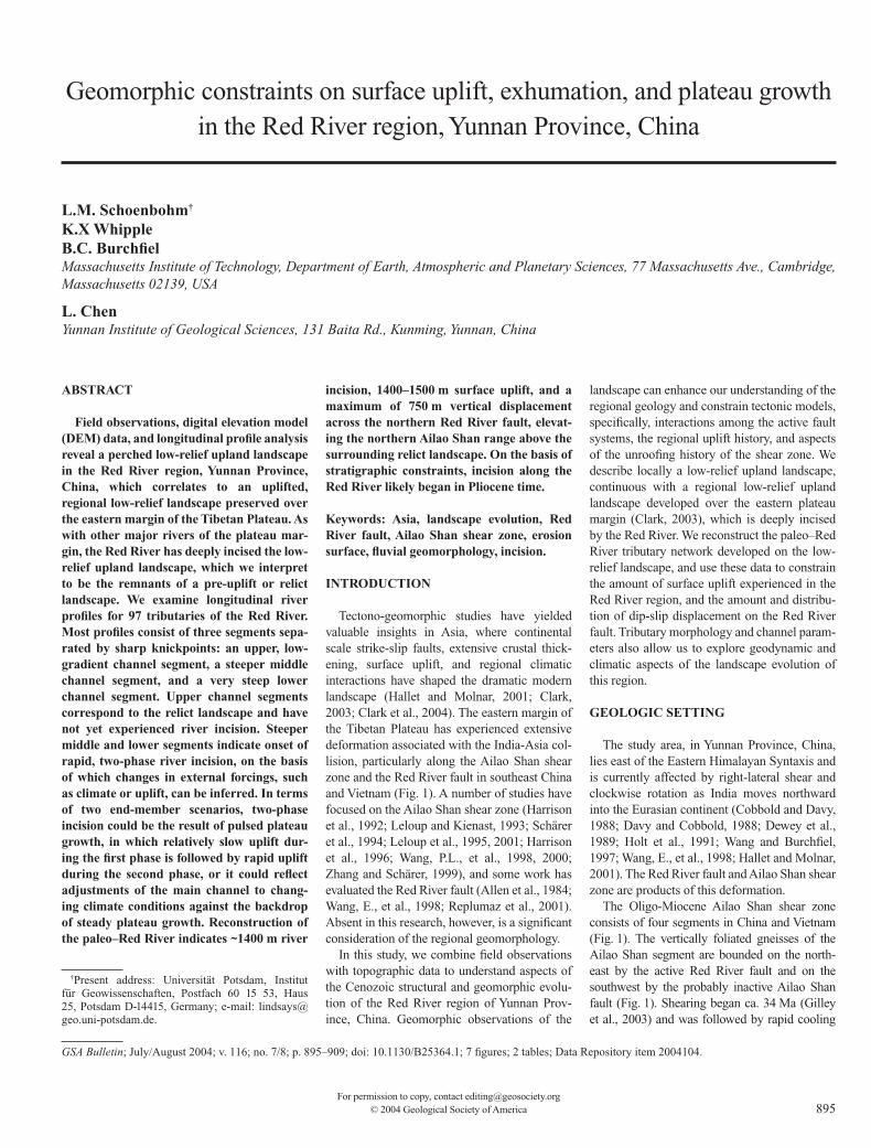
Figure 1. (A) Geologic map of fi eld area. South China block shown in shades of blue, Indochina block in shades of green, separated by the Ailao Shan shear zone and Red River fault. The South China fold belt is of mixed lithology, but in the vicinity of the Red River contains massive Triassic limestones. Chuxiong basin rocks are dominantly Mesozoic to early Cretaceous sedimentary rocks, as are rocks of the Lanping-Simao fold-and-thrust belt. The Red River drainage network is traced in blue. Active faults are marked with a heavy-weight black line. The inactive Ailao Shan fault, which marks the southern boundary of the Ailao Shan shear zone, is shown with a medium-weight line. (B) Map of the eastern margin of the Tibetan Plateau. EHS—Eastern Himalayan Syntaxis, DFS—Dali fault system. Data for map from ~1 km resolution GTOPO30 DEM (U.S. Geological Survey, 1993). The Yunnan Plateau is a physiographic feature, part of the southeastern margin of the Tibetan Plateau. Figure 1A location indicated by box. (C) Regional political map showing location of Figure 1B.
GEOMORPHIC CONSTRAINTS ON SURFACE UPLIFT, EXHUMATION, AND PLATEAU GROWTH
Geological Society of America Bulletin, July/August 2004 897
between ca. 25 and ca. 17 Ma, diachronous along strike (Harrison et al., 1996). Additional zircon and apatite fi ssion-track data indicate rapid cool-ing from 13 to 10 Ma (Bergman et al., 1997; Leloup et al., 2001), but it is unclear whether this cooling phase is continuous with that indicated by the Harrison et al. (1996) thermochronology, or if it represents a distinct cooling event. Shear sense indicators are consistently left-lateral (Leloup et al., 1995, 2001), and estimates for the amount of offset fall in the range of 700 ± 200 km (Brias et al., 1993; Leloup et al., 1995, 2001; Wang, P.L., et al., 1998). The Ailao Shan shear zone likely accommodated southward extrusion of Indochina, but the exact nature of the associ-ated crustal deformation is unclear (Tapponnier et al., 1982, 1986, 1990; Leloup et al., 1995, 2001; Wang and Burchfi el, 1997).
In contrast to the ductile, left-lateral Ailao Shan shear zone, the Red River fault (Fig. 1) is a geo-morphically prominent, right-lateral structure, approximately bounding the northeastern edge of the shear zone. The fault plane is vertical to slightly east dipping. Strike-slip estimates, based on geomorphic and geologic data, range from 5.5 to 54 km (Allen et al., 1984; Wang, E., et al., 1998; Replumaz et al., 2001). The age of incep-tion is also not well known, but estimates fall in the range 2 to 5 Ma (Allen et al., 1984; Wang, E., et al., 1998; Replumaz et al., 2001). The fault is traceable from Vietnam northwest past the north-ern segment of the Ailao Shan shear zone and into the Midu basin (Fig. 1). A prominent feature of the Red River fault in map view is a major bend near its intersection with the left-lateral Xianshuihe-Xiaojiang fault system. Northwest of this bend, triangular facets, Quaternary sedi-mentary basins, and high peak elevations within the Ailao Shan range have been interpreted to result from a dip-slip displacement on the Red River fault with the northeast side down (Allen et al., 1984; Replumaz et al., 2001; Leloup et al., 1995; Wang, E., et al., 1998). Replumaz et al. (2001) observed triangular facets southeast of the bend as well, and on this basis infer that dip-slip displacement extends along the entire length of the fault in China. However, as pointed out by Allen et al. (1984), differential erosion along the gneissic foliation of the Ailao Shan shear zone, which is subvertical but often dips slightly valleyward, can create the appearance of triangular facets in the absence of true dip-slip displacement. Wang, E., et al. (1998) argue that normal faulting does not continue south of the bend. Thus, the amount and distribution of dip-slip along the fault is uncertain but is important in interpreting the way in which the Red River fault interacts with other active fault systems in Yunnan, particularly the Xianshuihe-Xiaojiang fault system, and in constraining the amount of
exhumation of the Ailao Shan shear zone along the Red River fault.
In addition to deformation along strike-slip shear zones as a response to the India-Eurasia collision, the eastern margin of Tibet is argued to have experienced long-wavelength surface uplift as a result of pressure gradient–driven fl ow of weak lower crust from beneath Tibet and infl ation of adjacent regions (Royden, 1996; Royden et al., 1997; Clark and Royden, 2000). Surface uplift, exhumation of the Ailao Shan shear zone, and displacement along the Red River fault and other active fault systems of Yunnan have all interacted to shape the mod-ern landscape, which preserves an interpretable record of these processes.
TOPOGRAPHIC SETTING
A regionally extensive, perched, low-relief upland landscape extends from Tibet toward the South China Sea along the southeastern margin of the Tibetan Plateau, and is deeply dissected by major rivers that drain the plateau, including the Mekong, Salween, and Yangtze and their principle tributaries (Fig. 1B; Clark et al., 2002; Clark, 2003). This low-relief upland landscape continues into central and southern Yunnan, where it is incised by the Red River (Figs. 1A and 2; Clark et al., 2002; Clark, 2003). In the Red River region, low-relief landscape patches are generally between 2000 and 2500 m, except for in the northwest Ailao Shan range, where average elevations are closer to 3000 m (Fig. 2A). To the southwest of the Red River, the low-relief landscape is best preserved on the northern segment of the Ailao Shan range and can be traced in discontinuous patches toward the southeast along the crest of the range. To the northeast of the Red River, on the Yunnan Pla-teau, the low-relief landscape is extensive and is discussed by Wang, E., et al. (1998).
The low-relief upland landscape, where devel-oped on the Ailao Shan range, exhibits a “hum-mocky” topography with rounded hills separated by meandering, low-gradient, gravel- and sand-bedded streams (Figs. 3 and 4A). Relief is gener-ally less than 200 m but can reach a maximum of 500 m. Everywhere within the low-relief land-scape, bedrock is deeply weathered, capped by a saprolite layer estimated to be ~200 m thick. The original gneissic foliation of the Ailao Shan shear zone is well preserved throughout the saprolite, indicating little disruption of the weathered material. Because of the many small hills and the high porosity of the underlying material, the low-relief upland landscape is dry, uncultivated, and sparsely populated. Near Ejia (Figs. 1 and 3), the low-relief upland is developed on Ailao Shan gneiss and lower-grade metamorphic rocks
to the west, separated by the Ailao Shan fault (Bureau of Geology, Yunnan, 1990). To the east of the fault, the soil is well-drained saprolite and supports the typical vegetation of the Ailao Shan range, a mixture of grasses and conifers. In con-trast, the phyllite to the west of the fault supports a temperate rain forest because the clay-rich soils that have developed on the phyllite better retain moisture (Fig. 3). While the Ailao Shan fault does not appear to be active in a strike-slip sense here or elsewhere along the shear zone, it does form a scarp in this region, higher to the west, probably the result of differential weathering and erosion.
To the northeast of the Red River, the low-relief upland landscape is gently rolling and is developed on a variety of rocks of the Chuxiong basin and South China fold belt (Wang, E., et al., 1998; Figs. 1 and 4B). The character of the land-scape varies according to the lithology it is cut on; most notable is the hummocky topography and thick saprolite horizons which form over gran-ites. Where developed on Triassic limestones, karst landforms and thick red muds are common. Strands of the Xianshuihe-Xiaojiang fault system locally disrupt the landscape and have created a number of small pull-apart basins (Fig. 1). The landscape is often gently warped down into these extensional basins (Wang, E., et al., 1998).
The rolling topography of the perched low-relief landscape contrasts sharply with the deeply incised canyons of the Red River. The Red River fl ows in a deep valley along the Red River fault. Most tributaries, particularly those on the Ailao Shan side of the Red River, are short, steep bedrock rivers that fl ow straight and approximately perpendicular to the course of the main river (Fig. 4C). Most tributaries from the northeast are short, steep bedrock rivers as well, but a few tributaries (about four) are larger with a drainage area and morphology similar to the Red River itself. Hillslopes along the main river and in the tributary valleys are steep, with frequent landslides, discontinuous soils, and sparse vegetation. Tributaries to the Red River that have their headwaters on the low-relief upland cross over one or more knickpoints, separating a low-gradient alluvial channel above from a steep bedrock channel below.
We also observe a series of broad, mod-erately incised valleys cut into the low-relief upland landscape, but perched above the deeply incised valleys. These broad valleys are distinct from both the low-relief upland and the deep river gorges, and we refer to them as “intermediate valleys” that together form a discontinuous intermediate landscape. Relief within these valleys (between the approximate elevation of the low-relief landscape and the knickpoint above the deeply incised valleys) is

SCHOENBOHM et al.
898 Geological Society of America Bulletin, July/August 2004
generally less than 1000 m. The intermediate valleys are cultivated, soils are well developed, and bedrock is deeply weathered.
In addition to fi eld observations, we also iden-tify the different landscape components using methods developed by Clark (2003), particularly through the combined use of topographic data, river profi les, slope and relief data, geologic maps, and CORONA areal photographs. Over-lain slope and elevation maps are particularly useful for identifying low-slope areas at high elevations that correspond to the low-relief land-scape, and high-slope areas at moderate to low elevations that correspond to the incised valleys (Clark, 2003). Clark (2003) fi nds that slopes on the low-relief landscape are generally less than ~10°, and relief is less than 600 m. We apply these methods to the Red River region, using 90-meter DEM data (see Fielding et al., 1994, for description of the data set). To the northeast of the Red River, on the Yunnan Plateau, large continuous areas of the low-relief landscape are indicated by prominent low-slope zones, although the extremely low-slope areas generally are modern depositional basins along strands of the Xianshuihe-Xiaojiang fault system (Fig. 2). To the southwest of the Red River, the low-relief landscape is clear west of Ejia (Figs. 2 and 3) and can be identifi ed in discontinuous patches along the crest of the Ailao Shan range to the southeast. Low-slope regions both southwest of the Ailao Shan range and immediately along the Red River usually do not correspond to the low-relief
landscape, but rather to valley bottoms and allu-viated stretches of river (Fig. 2). Southwest of the Ailao Shan range, the low-relief, high-elevation landscape is largely absent (Fig. 2) and appears to have been removed by erosion.
MODERN, INTERMEDIATE, AND RELICT LANDSCAPES
The morphology of the southeastern margin of the Tibetan plateau, that of a deeply incised
B
23˚
24˚
25˚
23˚
24˚
25˚
101˚ 102˚ 103˚ 104˚ 100˚
Kunming
Simao
Nansa
Yuanjiang
Ejia
Midu
101˚ 102˚ 104˚ 100˚ 103˚
N
100 km
Damagie
N
100 km
Fig. 3
Trib 67
Trib 60
Trib 58
A
23˚
24˚
25˚
101˚ 102˚ 103˚ 104˚ 100˚
23˚
24˚
25˚ Kunming
Simao
Nansa
Yuanjiang
Ejia
Midu
Damagie
101˚ 102˚ 103˚ 104˚ 100˚
Figure 2. (A) DEM of fi eld area. View covers same geographic area as shown in Figure 1A. The Red River drainage network is traced in blue. The Ailao Shan is the prominent range to the immediate west and southwest of the Red River. The prominent bend in the Red River fault is centered approximately at the town of Yuanjiang. The Red River fault par-allels the course of the Red River and termi-nates in the Midu basin. The relict landscape is indicated by patterned polygons, identifi ed by the correspondence of high elevation and low-slope areas. (B) Slope map of same area. The Red River drainage network is traced in white. Low slopes (<12°) are shown in blue, and reds and browns indicate increasing slope. The relict landscape is clearly visible as low-slope regions and is indicated by pat-terned polygons. Areas of low slope that do not correspond to the relict landscape are Quaternary basins along strands of the Xian-shuihe-Xiaojiang fault system (see Fig. 1A) or river valley bottoms.

GEOMORPHIC CONSTRAINTS ON SURFACE UPLIFT, EXHUMATION, AND PLATEAU GROWTH
Geological Society of America Bulletin, July/August 2004 899
low-relief upland continuous with the Tibetan Plateau in the north and the South China coastal margin in the south, is suggestive of long-wavelength surface uplift associated with development of the Tibetan Plateau. Clark and Royden (2000) argue that this surface uplift is driven by fl ow of weak crustal material from beneath Tibet into adjacent regions, including the southeastern plateau margin. Injected mate-rial thickens the crust and results in isostatic sur-face uplift (Clark and Royden, 2000). The major rivers of the eastern margin have responded to this surface uplift through large-scale drainage reorganization (Clark et al., 2004) and by incis-ing deep gorges (Clark, 2003).
In this interpretation, the low-relief landscape we observe in the Red River region, and which Clark (2003) observes regionally, can be used as a subhorizontal datum to track tectonic develop-ment of the region. An important component of this interpretation is that the low-relief landscape has not “regraded” to present conditions; its iso-lation from the incised rivers is what allows it to record surface uplift and deformation. This is consistent with several fi eld observations in the Red River region: the deep weathering, thick saprolite, and low-gradient fl uvial channels that characterize the low-relief surface suggest response to very different conditions than the incised valleys, which are characterized by exposed bedrock, landsliding, steep channels, and high relief. Low-temperature thermochro-nologic data elsewhere in eastern Tibet also indicate slow exhumation of an apparently
correlative low-relief landscape (Kirby et al., 2002; Clark et al., 2000; Clark, 2003), and much higher exhumation rates along major tributaries to the Yangtze River (Clark et al., 2000; Clark, 2003). The low-relief landscape continues to weather, erode, and evolve, but those processes are isolated from modern base level.
In order to make clear the distinction between the base-level conditions under which these two landscape components were formed, we adopt the terms “relict landscape” (after Clark, 2003) to describe the low-relief upland landscape, and “modern landscape” to describe the incised valleys. Additionally, we employ the term “intermediate landscape” for the broad, moder-ately incised valleys perched above the deeply incised valleys and below the relict landscape. In our usage, “relict” refers to the conditions under which the landscape was formed and should not be taken to imply a stagnancy of the landscape. We prefer this term to the more commonly used “erosion surface,” because “relict landscape” implies that a variety of geomorphic processes may have been acting on the landscape (potentially deposition as well as erosion), that the original relief structure may be complex, and that the age of formation may vary across the landscape.
One measure of the age of the relict land-scape (Clark, 2003) is the age of formation of the surface, or the fi rst time at which low-relief conditions were attained. The end of tectonic unroofi ng of the Ailao Shan shear zone provides an upper limit on this measure of the age of the
landscape. Rapid cooling recorded by 40Ar/39Ar thermochronology between 25 and 17 Ma (Har-rison et al., 1996) probably resulted from uplift and exhumation of the shear zone with corre-spondent high relief over the range. Cenozoic sediments preserved along the Red River to the northeast of the shear zone are coarse fl uvial conglomerates derived from the Ailao Shan gneiss, and also indicate high relief within the range during this time (Wang, E., et al., 1998). Limited fi ssion-track data from the Ailao Shan shear zone show rapid cooling between 13 and 10 Ma (Bergman et al., 1997). The relict landscape therefore is probably not older than 10 Ma and is certainly not older than 17 Ma. To the northeast on the Yunnan Plateau the land-scape may have formed earlier: various parts of the relict landscape need only share the same historic base-level conditions, not the same age. Folded Eocene and rarely Oligocene units are beveled by the relict landscape in the Chuxiong basin (Fig. 1) and capped by undeformed Plio-cene fossil-bearing sediments, indicating the relict landscape is younger than Eocene and older than Pliocene in this region (Wang, E., et al., 1998; Clark, 2003). Flat-lying Eocene sedi-ments overlie folded units of the South China fold belt (Fig. 1), and therefore the relict land-scape may be older than Eocene in this region (Wang, E., et al., 1998; Clark, 2003).
A second measure of the age of the relict landscape (Clark, 2003) is the age at which the river incision began and the relict landscape fi rst became isolated from modern base level. The
10 km
N
Ejia
Relict landscape
Ailao Shan FaultRed River fault
Red River
Ejia
Phyllite
Relict landscape
Ailao Shan faultRed River fault
A B
Phyllite
24˚30'
101˚05' 101˚10' 101˚15' 101˚20'
101˚05' 101˚10' 101˚15' 101˚20'
24˚25'
24˚30'
101˚05' 101˚10' 101˚15' 101˚20'
101˚05' 101˚10' 101˚15' 101˚20'
24˚25'
Ailao Shan Gneiss Ailao Shan Gneiss
Figure 3. Relict landscape to the west of Ejia. Location indicated in Figure 2A. (A) Topographic map shaded with DEM. Also indicated are the Red River fault, Ailao Shan fault, Ailao Shan gneiss, and phyllite. The relict landscape is clearly discernible as a high, fl at area and is outlined with a medium-weight line. Red River is in the upper right-hand corner. (B) CORONA aerial photographs of same area as Figure 3A. Erosion surface outlined in white. Note vegetation contrast between Ailao Shan gneiss and phyllite.

SCHOENBOHM et al.
900 Geological Society of America Bulletin, July/August 2004
timing of initiation of river incision is diffi cult to determine because of the paucity of well-preserved terraces within the Red River valley. However, sedimentologic evidence from near the northern termination of the Ailao Shan shear zone (Fig. 1) suggests incision in Pliocene time or later. At Damagie, fossil-bearing Pliocene sediments are deposited on the relict landscape in what appears to be the paleo–Red River val-ley based on the fl at basal unconformity, the fl uvial facies, and the slightly lower elevation (~200 m) compared to the surrounding relict landscape. These sediments are perched high above the Red River and have been incised on all sides by the main river and two tributaries. River incision must postdate deposition of these
sediments and therefore can have begun no ear-lier than Pliocene time.
MOTIVATION: RIVER RESPONSE TO UPLIFT AND DEFORMATION
Relict landscapes (or erosion surfaces as termed by many authors) have served as impor-tant markers of tectonic uplift and deformation in a number of studies (e.g., Epis and Chapin, 1975; Gregory and Chase, 1994; Clark and Roy-den, 2000; Spotila and Sieh, 2000; Clark, 2003; Clark et al., 2004; for partial summaries, see Widdowson, 1997, and Phillips, 2002). How-ever, the rivers of the southeastern margin of the Tibetan Plateau have also responded to surface
uplift and deformation, and can be sensitive recorders of temporal and spatial variations in rock uplift rate (e.g., Whipple and Tucker, 1999, 2002; Snyder et al., 2000; Kirby and Whipple, 2001; Lague and Davy, 2003; Wobus et al., 2003; Whipple, 2004).
We expect the Red River and its tributaries to respond to long-wavelength surface uplift, tilting, and disruption of the relict landscape on a number of spatial and temporal scales. On the largest scale, from the headwaters of the Red River in central Yunnan to its outlet at the South China sea, the river should experience a long-wavelength tilt but a relatively stable base level set by sea level. Surface uplift and tilting should cause a steepening of the river gradient,
A B
DC
EFigure 4. (A) Low-relief upland landscape developed on the Ailao Shan to the west of Ejia. Relief in photo is on the order of ~200 m, view to the north. (B) Low-relief upland landscape on the Yunnan Plateau to the northeast of the Red River. (C) Deeply incised tributary to the Red River north of Ejia. Relief in photo is on the order of ~1200 m. (D) View to the northeast over the Red River valley. Red River is the light-colored subhorizontal feature in the valley bottom. Photo taken from the low-relief upland landscape on the Ailao Shan. Yunnan Plateau can be seen in the far distance. (E) Intermediate valley system, below the low-relief upland landscape but perched above deeply incised lower channel.

GEOMORPHIC CONSTRAINTS ON SURFACE UPLIFT, EXHUMATION, AND PLATEAU GROWTH
Geological Society of America Bulletin, July/August 2004 901
although channel response will also be infl u-enced by climatic conditions. Further, although far-fi eld base level does not change signifi cantly, the evolution of tributaries to the Red River will depend on the “local” base level, or the eleva-tion of the confl uence of the tributary and the main river. Because tributary local base level is set by the gradient of the Red River, changes in uplift and climate conditions will be translated to the tributaries by adjustments in gradient along the main channel. It is our interpretation that each component of the landscape—the relict, intermediate, and modern—formed under different rates of local base-level fall. The modern, deeply incised lower channel segments are responding to the local modern rate of rock uplift relative to the base level set by the Red River, the intermediate landscape formed in response to an earlier local base level set by a paleo–Red River, and the relict landscape formed under stable pre-uplift base-level con-ditions. Therefore, both surface uplift patterns and spatial-temporal patterns of incision on the Red River (set by surface uplift, climate, and sediment and rock properties) infl uence the evolution of tributary channel profi les. Finally, disruptions along the active fault systems of the southeastern margin of the Tibetan Plateau can produce local variation in rock uplift rate, which will infl uence the morphology of local tributar-ies. In sum, incision along the Red River refl ects regional surface uplift, tilting, climate condi-tions, changes in tributary local base level, and disruption along the Red River fault.
In the next section, we turn to analysis of longitudinal profi les of tributaries to the Red River, because this can be used to constrain the history of incision of the Red River. Channel parameters (such as steepness and concavity indices) can help in evaluation of the temporal and spatial sequence of incision in the Red River region: Stream-power bedrock incision modeling suggests that channel parameters should be linked to a range of external factors, including, most importantly, uplift rate and cli-mate (Howard, 1980; Seidl and Dietrich, 1992; Howard, 1994; Whipple and Tucker, 1999, 2002). Further, a reconstructed paleo–drain-age network is a basis for inferring the total amount of river incision. It can also provide a robust structural datum for measuring vertical displacement of the relict landscape across the Red River fault.
TRIBUTARY ANALYSIS
We begin with an abbreviated discussion of bedrock river incision theory, examine tribu-tary morphology and channel parameters in the context of bedrock incision modeling, and
fi nally, reconstruct the drainage network of the relict landscape.
Longitudinal Profi le Analysis
Typical river longitudinal profi les, for both bedrock and alluvial rivers, are concave and can be described by an empirical power law relationship between slope and area:
S = ksA–θ, (1)
where S is slope, or channel gradient, ks is the
channel steepness index, A is the upstream contributing drainage area, and θ is the channel concavity index. For many landscapes, k
s varies
with uplift rate, climate, and lithology, but θ var-ies little (Snyder et al., 2000; Kirby et al., 2003). This empirical relationship is similar to that described by the stream-power incision model for bedrock river incision (Howard, 1980; Seidl and Dietrich, 1992; Howard, 1994; Whipple and Tucker, 1999, 2002), which we briefl y discuss here as a framework to guide our analysis. In the analysis we consider and discuss complexi-ties in natural systems that may cause deviation from behavior expected for this simple model. The stream-power incision model combines a power law relationship between shear stress and erosion, conservation of mass, conditions of steady, uniform fl ow, and empirical rela-tions between discharge and channel width and between discharge and basin area to arrive at the expression:
E = KAmSn, (2)
where E is erosion rate, K is an erosion factor, a dimensional constant dependent on lithology, climate, and sediment load, and m and n are positive constants related to basin hydrology, hydraulic geometry, and erosion process. Relat-ing channel elevation to the balance between uplift and erosion results in the expression:
dz/dt = U(x,t) – E(x,t) = U(x,t) – KAmSn, (3)
where U is uplift rate, x is horizontal distance along the channel, and z is channel elevation. For an equilibrium channel, dz/dt = 0, equa-tion 3 can be solved for equilibrium slope (S
e):
Se = (U/K)1/nA–m/n. (4)
Note that the form of this equation is identical to equation 1, though it applies only to bedrock (or more precisely, detachment-limited) chan-nels. If the criteria inherent in the derivation of this model are met and a channel is in equilib-rium, then the steepness index of a channel (k
s in
equation 1) is a function of the ratio between uplift rate (U) and the erosion factor (K) to the 1/n power. There is strong empirical support for a positive correlation between the steepness index (k
s) and rock uplift rate (U) (e.g., Merrits
and Vincent, 1989; Snyder et al., 2000; Kirby and Whipple, 2001; Whipple, 2004). If the U/K ratio increases uniformly along the channel, through either an increase in uplift rate or a decrease in erosivity, the channel will respond by forming a new equilibrium slope, starting at the basin outlet. The equilibration will proceed as an upstream-propagating wave of erosion (Weissel and Seidl, 1998; Whipple and Tucker, 1999). For the most part, the section upstream of this migrating “knick zone” is isolated from the change in uplift rate and will maintain a profi le in equilibrium with the old uplift rate while the section downstream of the knickpoint will be equilibrated to the new conditions. The equili-bration process proceeds at a rate positively correlated to drainage area, and so the trunk stream equilibrates relatively quickly, whereas headwater streams will maintain knick zones and nonequilibrated channel segments longer (Whipple and Tucker, 1999; Whipple, 2001).
The ratio m/n in equation 4, or the intrinsic concavity index, corresponds to θ, observed concavity index in equation 1, if and only if the channel is in equilibrium and rock uplift, climatic conditions, and rock properties are spatially uniform. The intrinsic concavity index should theoretically fall between 0.35 and 0.6 (Whipple and Tucker, 1999). Observed concav-ity indices, which may be infl uenced by nonuni-form uplift, nonuniform lithology or variations in sediment fl ux and grain size (Sklar and Diet-rich, 1998; Howard, 1998; Sklar and Dietrich, 2001; Whipple and Tucker, 2002; Kirby and Whipple, 2001), range from ~0.3 to 1.2 (Tucker and Whipple, 2002; Whipple, 2004). If the concavity index is signifi cantly higher than this range, a variety of processes related to transient conditions could be in operation with important consequences (Whipple, 2004).
Tributary Morphology
Using a 90 m DEM, we extracted longitudi-nal profi les for 97 tributaries to the Red River in China, all those with a drainage area greater than 40 km2 (Figs. DR1 and DR2).1 The profi les consist of one to several channel segments separated by knickpoints, and distinct channel
1GSA Data Repository item 2004104, tributary longitudinal profi le data and analysis details, is available on the Web at http://www.geosociety.org/pubs/ft2004.htm. Requests may also be sent to [email protected].

SCHOENBOHM et al.
902 Geological Society of America Bulletin, July/August 2004
parameters (see discussion in next section) can be defi ned for each segment. We analyzed chan-nel segments according to their channel param-eters and their position within each profi le and found that tributary longitudinal profi les fall into three different morphologic categories. The dominant tributary form (78 of the 97, Figs. 5A and DR2) consists of three segments: an upper segment that travels over the relict landscape with a uniform concavity index and low steep-ness index, a middle segment with intermediate concavity and steepness indices, and a lower channel segment with high concavity and steep-ness indices (Tables 1 and DR1). For some trib-utaries, the upper segment is absent or poorly defi ned. In other cases, minor knickpoints or convex channel segments complicate segment classifi cation. In general, however, the three-segment morphology is robust and is confi rmed by our fi eld observations of relict, intermedi-ate, and modern landscapes described above (see Fig. 4). The second morphologic category consists of profi les with only two channel seg-ments (four of the 97, Figs. 5B and DR2), and the fi nal category consists of profi les that have no discernable knickpoints at all (15 of the 97, Figs. 5C and DR2). Fully equilibrated channels occur throughout the study area but are concen-trated on the Yunnan Plateau in the vicinity of the bend (Fig. DR2).
Channel Parameters
The intrinsic concavity index was found using methods developed by Snyder et al. (2000), Kirby and Whipple (2001), and Kirby et al. (2003). In this procedure, channel drainage area is extracted from a DEM, and correspond-ing slopes are calculated along the extracted channel, then these data are plotted in log-log slope-area space. A linear regression to the data yields the concavity index (the negative slope of the regression) and the steepness index (the y-intercept) (Fig. 5). Because the steepness index is highly correlated to the concavity index, a normalized steepness index was also deter-mined for each channel with a reference concav-ity index (in our case, θ = 0.45, though the exact value matters little, only that it is consistent for each analysis) to allow meaningful comparison of segments with different concavity indices.
In general, the concavity index and normal-ized steepness index for the upper and middle segments are consistent among all tributaries, and the minor variation in upper channel param-eters may refl ect the small sample size. In con-trast lower channel segments exhibit high vari-ability in these parameters (Table 1). Because the Red River fl ows directly along the Red River fault, and because we might reasonably expect
B. Tributary 58
0.5
1.0
1.5
2.0
2.5
Ele
vatio
n (k
m)
A. Tributary 60
Distance from divide (km)
C. Tributary 67
100
Drainage area (m2)
Slope
0.0
0 5 10 15 20 25
0.5
1.0
1.5
2.0
2.5E
leva
tion
(km
)
0.0
0.5
1.0
1.5
2.0
2.5
Ele
vatio
n (k
m)
0.0
Dominant tributary profile
Intermediate section missing
Fully equilibrated
103
102
101
100
Slope
103
102
101
100
Slope
103
102
101
108107106105104 109
0 = 0.92Relict
landscape Phase I
Phase II
Relictlandscape
Phase II
Phase II
0 = 6.4
0 = 0.50
0 = 0.07
0 = 1.4
0 = 0.67
Figure 5. Longitudinal profi les and slope-area data extracted from 90 m DEM (see Fielding et al., 1994, for data set details) for three representative tributaries. Locations shown in Figure 2A. Best-fi t concavity index, from equation 1, is indicated on slope-area plots. A: Tributary 60, an example of the three-segment dominant tributary form. B: Tributary 58, example in which the intermediate channel segment has been removed by headward erosion of lower segment. C: Tributary 67, an example of a fully equilibrated channel with no major knickpoints.
TABLE 1. NORMALIZED STEEPNESS AND CONCAVITY VALUES
Concavity† Ailao Shan/SW Yunnan Plateau/NE Steepness‡ Ailao Shan/SW Yunnan Plateau/NE
Upper SegmentNorth of bend 0.42 ± 0.22
(n = 11)§
0.36 ± 0.22(n = 6)
North of bend 32 ± 16(n = 11)
44 ± 15(n = 6)
South of bend 0.32 ± 0.08(n = 5)
0.40 ± 0.18(n = 6)
South of bend 40 ± 21(n = 5)
29 ± 7(n = 6)
Average 0.38 ± 0.19(n = 28)
Average 35 ± 16(n = 28)
Middle SegmentNorth of bend 0.74 ± 0.48
(n = 20)0.56 ± 0.23
(n = 18)North of bend 112 ± 70
(n = 20)95 ± 37(n = 18)
South of bend 0.51 ± 0.26(n = 29)
0.74 ± 0.40(n = 31)
South of bend 126 ± 53(n = 29)
100 ± 48(n = 31)
Average 0.64 ± 0.37(n = 98)
Average 109 ± 54(n = 98)
Lower SegmentNorth of bend 3.07 ± 1.96
(n = 22)2.34 ± 1.96
(n = 15)North of bend 390 ± 148
(n = 22)220 ± 76(n = 15)
South of bend 3.50 ± 4.36(n = 29)
4.64 ± 3.45(n = 27)
South of bend 277 ± 79(n = 29)
348 ± 176(n = 27)
Average 3.54 ± 3.38(n = 93)
Average 314 ± 141(n = 93)
Fully EquilibratedNorth of bend 0.51 ± 0.23
(n = 2)0.50 ± 0.14
(n = 7)North of bend 157 ± 122
(n = 2)129 ± 25(n = 7)
South of bend 0.54 ± 0.21(n = 3)
0.53 ± 0.09(n = 3)
South of bend 159 ± 56(n = 3)
161 ± 25(n = 3)
Average 0.51 ± 0.14(n = 15)
Average 145 ± 46(n = 15)
Note: Mean concavity and normalized steepness indices for upper, middle, lower, and fully equilibrated channel segments for entire drainage network (in bold) and by quadrant. Quadrants are (1) north and south of bend to the southwest of the Red River (Ailao Shan) and (2) north and south of the bend to the northeast of the Red River (Yunnan Plateau); see Figure 6C. Note increasing normalized steepness and concavity from upper to middle to lower segments, and high variability of lower segments.
†Concavity determined by linear regression to selected slope-area data using a 20 m contour interval.‡Normalized steepness index determined by linear regression to slope-area data with a fi xed concavity of 0.45.§Number of tributaries used in average. In some cases, more than one middle or lower channel segment can be identifi ed
in each tributary, separated by knickpoints and with slightly different steepness and concavity. Channel parameters for each segment were retained and used to determine mean values. This results, in some cases, in a greater number of channel segments than there are actual channels.

GEOMORPHIC CONSTRAINTS ON SURFACE UPLIFT, EXHUMATION, AND PLATEAU GROWTH
Geological Society of America Bulletin, July/August 2004 903
different deformation patterns north and south of the major bend, we present averaged data for each set of segments as well as averaged data for the four quadrants defi ned by the river and the bend (Fig. 6). We also present data for the 15 tributaries with no knickpoints, which we label as “fully equilibrated” in Table 1.
A number of observations emerge from these data. First, there is only minor geographic varia-tion in normalized steepness and concavity index
data for the upper and middle channel segments, which contrasts with signifi cant variability in the lower channel segments. Second, the aver-age normalized steepness index increases from the upper channel segments to the middle to the lower segments. Finally, the average concavity index for the upper landscape segments (0.38 ± 0.19) falls within the range of commonly observed values (Tucker and Whipple, 2002), and average concavity index for middle channel
segments (0.64 ± 0.37) is higher but is still within the normally observed range. Lower-seg-ment concavity indices, however, are exception-ally high (3.54 ± 3.38).
Reconstruction of Relict Landscape Channel Profi les
Of the 97 total tributary longitudinal profi les, we identifi ed well-developed “relict landscape”
0.0
0.5
1.0
1.5
2.0
2.5Total River
Incision
A. Total River IncisionA
mou
nt in
cisi
on (
km)
Northeast/Yunnan PlateauSouthwest/Ailao Shan
0 100 200 300 400 500Distance from outlet (km)
0 100 200 300 400 500
Vertical Displacement
B. Vertical Displacement
0.0
0.5
1.0
1.5
2.0
2.5
Ele
vatio
n (k
m)
Red River Fault
?
bend
bend
NWSE NWSE
Distance from outlet (km)
500 km
400 km
300 km
200 km
100 km
C. Tributary Network
Yunnan Plateaunorth of bend
Ailao Shansouth of bend
Ailao Shannorth of bend
Yunnan Plateausouth of bend
100˚ 101˚ 102˚ 103˚
104˚
25˚
24˚
23˚
100˚
104˚
25˚
24˚
23˚
3.03.0
750m
0 100 200 300 400 500
D. Middle Channel Projections
0.0
0.5
1.0
1.5
2.0
2.5E
leva
tion
(km
)
Distance from outlet (km)
bend
SE
Modern Red River Profile
Modern Red River Profile
N
Figure 6. Projected channel segment data plotted against distance from the basin outlet near the Chinese-Vietnamese border, with the bend at ~260 km upstream from basin outlet. A: River incision, calculated by projecting upper segments and subtracting modern river elevations (see inset). Regression of data south of bend shown at 1381 ± 88 m. B: Projected upper-segment elevations. Interpreted vertical displacement across the Red River fault (see inset) shown by thick lines. A maximum vertical displacement of ~750 m is recorded. Longitudinal profi le of Red River also shown. C: Approximate distances upstream from outlet and location of bend shown in relation to the Red River tributary network. D: Projected middle-segment elevations. Upper-segment displacement lines and Red River longitudinal profi le shown, same as for Figure 6B. Incision is approximately two times greater from the middle to lower segments than from the upper to middle segments.

SCHOENBOHM et al.
904 Geological Society of America Bulletin, July/August 2004
channel segments on 50 tributaries on the basis of low normalized steepness index, average concavity index values, and their position above a prominent knickpoint. Each of these segments was evaluated for conditions that might affect channel gradient or knick zone propagation, particularly lithologic contrasts along the length of each channel. Such segments were excluded, as were segments with insuffi cient data to obtain a meaningful regression. Our fi nal, conservative data set includes 12 tributaries from the Yunnan Plateau northeast of the Red River and 16 from the southwest, draining the Ailao Shan range (Fig. DR3; Table DR2; see footnote 1).
The properties of these 28 channels were ana-lyzed to estimate the preincision profi les to their confl uence with the Red River. The mean con-cavity index (θ) for the upper channel segments is 0.38 (Table 1). Using this value, drainage area and slope data, and equation 1, we obtained a steepness index (k
s) and uncertainty for each seg-
ment. From these values, we then projected the channel profi le from the knickpoint downstream to the Red River confl uence. This analysis pro-vides an estimate of the paleo–longitudinal pro-fi le of each tributary corresponding to the drain-age network developed on the relict landscape, assuming no changes in drainage area. Because we use equation 1, our analysis does not depend on the validity of bedrock incision modeling, but rather only on well-established empirical obser-vation of a power law relation between local slope and upstream drainage area.
The difference in elevation of the termina-tion of the profi le and that of the modern tribu-tary–Red River confl uence indicates the amount of subsequent incision: The reconstructed longitudinal profi les indicate 500–1600 m of incision (Fig. 6A). The difference in eleva-tion of the termination of the profi le between tributaries from the Ailao Shan range and from the Yunnan Plateau indicate the relative vertical displacement of the relict landscape by the Red River fault (Fig. 6B). Southeast of the bend in the Red River fault, tributaries from the Ailao Shan range and Yunnan Plateau project to approximately the same elevation, indicating only minor if any offset across the fault. To the northwest of the bend, however, displacement increases to a maximum of 750 m. Insuffi cient data in the vicinity of the bend hinder precise estimation of the offset in that area. Although tributary data do not extend to the northern tip of the Red River fault, fi eld observations indicate that vertical displacement must diminish toward the Midu basin as well (Fig. 1).
We also reconstructed the middle channel segment longitudinal profi les for 14 of the 28 tributaries with upper segments, and for 16 additional channel profi les with no upper
segments, for a total of 30 projections (Figs. 6C and DR3; Table DR2; see footnote 1). We used a concavity index of 0.64 (mean for middle seg-ments, Table 1). Data for tributaries with both upper- and middle-segment projections allow us to constrain the relative amount of river incision recorded by base-level fall from the relict land-scape channel to the middle segment, and from the middle segment to the modern river eleva-tion (Table 2). Though the sparseness of these data limits inferences, approximately twice as much incision occurred from the middle to lower channel segments as from the relict land-scape to middle channel segments, and appears to be greater north of the bend.
DISCUSSION
Key observations that emerge from our tribu-tary analysis are (1) total amount and distribu-tion of incision along the Red River (Fig. 6A), (2) a three-segment channel morphology for the majority of tributaries (Figs. 5 and DR2), (3) high mean concavity index (θ) for the low-ermost channel segments (Tables 1 and DR1), (4) the relative offset of relict landscape tribu-taries across the Red River fault (Fig. 6B), and (5) geographic variation in normalized steep-ness index (k
s) and concavity index (θ) for the
lowermost channel segments (Table 1). The lat-ter two factors yield information about activity along the Red River fault and will be addressed in the fi rst section of the discussion. The fi rst three factors relate to surface uplift and climatic interactions and will be addressed in a later sec-tion. Finally, we will discuss implications of our observations for exhumation of the Ailao Shan shear zone and for growth of the eastern margin of the Tibetan Plateau.
Activity along the Red River Fault
The Red River fault is clearly an active strike-slip fault, although previous workers have not been able to determine the magnitude of strike-slip or dip-slip displacement, spatial distribu-tion, or timing with certainty (Allen et al., 1984; Wang, E., et al., 1998; Replumaz et al., 2001). Because the topographic relief of the relict landscape is signifi cant relative to the amount of displacement we expect across the Red River fault, and as there may have been remnant relief along the crest of the Ailao Shan range, topog-raphy alone is an insuffi cient datum for measur-ing vertical displacement. Using instead the reconstructed drainage network mitigates these problems and allows us to place constraints on vertical displacement.
The longitudinal profi les of two directly opposing tributaries may have different concavity
or steepness indices, but their downstream eleva-tions must be the same, set by the elevation of the main channel (Seidl and Dietrich, 1992). Once river incision begins, the upper portions of the opposing tributaries are isolated from each other and begin to record any differential offset occurring downstream of the knickpoint (see Fig. 6B inset). Reconstruction of relict landscape tributaries reveals that Ailao Shan range tributar-ies are displaced vertically relative to Yunnan Plateau tributaries. Relative displacement is insignifi cant south of the bend but increases toward the north to a maximum displacement of ~750 m near the town of Ejia (Fig. 6B). Absolute displacement may have occurred in the footwall (increasing the surface elevation of the Ailao Shan range), in the hanging wall (downwarping the Yunnan Plateau), or both.
The mean normalized steepness index (ks) in
the lowest channel segments varies consider-ably by geographic region (Table 1): Channels are steepest north of the bend in the Ailao Shan range and south of the bend on the Yunnan Pla-teau (390 ± 148 and 348 ± 176, respectively), and are less steep south of the bend in the Ailao Shan range and north of the bend on the Yunnan Plateau (277 ± 79 and 220 ± 76, respectively) (Fig. 1). The steepness index in these channels varies as a function of lithology and rate of rela-tive base-level fall. Within the Ailao Shan shear zone, lithology is uniform. Therefore, variations in channel steepness index probably refl ect dif-ferent uplift conditions: In the northern Ailao Shan range, where uplift rate (and relative base-level fall) is higher as a result of dip-slip displacement on the Red River fault, steepness indices are correspondingly higher (equation 4; Table 1). Lower steepness indices north of the bend on the Yunnan Plateau may similarly result from downwarping of the hanging wall by vertical displacement on the Red River fault, and downwarping may also be responsible for the high concentration of fully equilibrated channels on the Yunnan Plateau on either side of the bend near Yuanjiang (Fig. DR2). How-ever, this analysis is complicated by lithologic
TABLE 2. PHASE II to PHASE I INCISION RATIO
Ailao Shan/SW Yunnan Plateau/NE
North of bend 3.0 ± 0.2(n = 4)†
2.8 ± 0.5(n = 3)
South of bend 1.1 ± 0.3(n = 3)
1.6 ± 0.2(n = 4)
Average 2.3 ± 0.1(n = 14)
Note: Incision during each phase determined by fi tting upper and middle channel segments using a concavity of 0.38 and 0.64, respectively (Table 1), projecting the channels to their intersection with the paleo–Red River, then subtracting modern river elevations.
†Number of tributaries used in average.

GEOMORPHIC CONSTRAINTS ON SURFACE UPLIFT, EXHUMATION, AND PLATEAU GROWTH
Geological Society of America Bulletin, July/August 2004 905
differences north and south of the bend, which probably play an important role in determin-ing the channel steepness index. Many of the tributaries from the Yunnan Plateau south of the bend drain cliff-forming Triassic limestones of the southern South China fold belt (Fig. 1), capable of supporting extremely steep chan-nels. Farther north, where tributaries drain the relatively erodible sediments of the Chuxiong red bed basin (Fig. 1), channel steepness indi-ces are lower. Why the effect of lithology is not seen in the middle and relict landscape channel segments is unclear. One possibility is that the relict landscape and middle channel segments are in transport-limited rather than detachment-limited (bedrock) conditions, and therefore, lithologic controls on channel morphology are masked (Whipple and Tucker, 2002).
The maximum gradient associated with regional tilting, which will affect tributary data, is ~2 × 10⁻³ (5000 m over 2500 km, Clark and Royden, 2000). However, because tilting is stronger near the plateau and gentler in more dis-tal positions (Clark and Royden, 2000), because we do not know the original landscape gradient, and because the Red River runs slightly oblique to the plateau axis, tilting in the study area is probably less. On this basis, and from DEM analysis, we estimate tilting was on the order of 1 × 10⁻³. Over the 500 km of the study area, if we use this value, surface uplift at the northwest end of the study area is ~500 m greater than at the southwest end. This tilting does not affect rela-tive displacement across the Red River fault, but does affect the paleo–Red River profi le recorded by tributaries from the Ailao Shan range and Yunnan Plateau. The gradient recorded by the Yunnan Plateau tributaries is ~2 × 10⁻⁴, less than our estimated tilting gradient. This is probably the result of downwarping of tributaries north-west of the bend along the Red River fault. The higher gradient recorded by Ailao Shan tributar-ies (~2 × 10⁻³) may similarly result from relative uplift of the footwall along the Red River fault.
In summary, the dip-slip component of dis-placement along the Red River fault is less than 750 m north of the bend and insignifi cant south of the bend, affecting both hanging-wall and footwall elevations. This is not consistent with models for the Red River fault in which dis-placement extends along the entire length of the fault (Allen et al., 1984; Replumaz et al., 2001). Further, a number of authors have suggested that signifi cant unroofi ng of the Ailao Shan shear zone has occurred as a result of recent normal faulting along the Red River fault (Har-rison et al., 1996; Leloup et al., 2001; Replumaz et al., 2001). Our tributary data and observations of landscape morphology indicate conclusively that no exhumation of the shear zone has
occurred since establishment of the relict land-scape, probably prior to Pliocene time.
River Incision and Surface Uplift
The existence of a regional relict landscape at high elevations, which is continuous with the Tibetan Plateau, implies signifi cant surface uplift of the southeastern plateau margin (Clark et al., 2002; Clark, 2003). We discuss inci-sion along the Red River in the context of this regional uplift below.
Incision and Surface Uplift Recorded by the Red River
The Red River has incised the landscape between ~500 and ~1600 m (Fig. 6A), though tributaries on the Yunnan Plateau record less incision. Because absolute elevations on both the Ailao Shan range and the Yunnan Plateau north of the bend have probably been affected by differential vertical displacement on the Red River fault, we cannot use the river incision recorded by these tributaries as a proxy for total river incision. South of the bend, however, tribu-taries on either side of the Red River are rela-tively unaffected by recent faulting, and these data indicate a weighted mean river incision of 1381 ± 88 m (Fig. 6A). Maximum surface uplift at the southern end of the study area is indicated by the current approximate eleva-tion of the projected tributaries, or ~1500 m (Fig. 6B). Prior to surface uplift, the paleo–Red River was probably at a similar or lower eleva-tion (<100 m) to the modern Red River, but the paleo–Red River profi le has been translated through surface uplift to its current elevation of ~1500 m (Fig. 6B). Surface uplift at this point is therefore 1400–1500 m (the amount of uplift necessary to elevate the paleo–Red River profi le from 0 m (the minimum original profi le eleva-tion) or ~100 m (the maximum original profi le elevation) to ~1500 m (the approximate eleva-tion today). Total surface uplift must increase upstream toward Tibet.
Incision and Surface Uplift Recorded by Tributaries to the Red River
Multiple-segment tributary longitudinal pro-fi les (Figs. 5 and DR2) indicate a complicated incision pattern. Knickpoints can result from a variety of processes, which we will explore below. However, it is unlikely that the knick-points in this study result from river capture events. Clark et al. (2004) argue that prior to regional uplift, most of the major rivers of eastern Tibet, including the Mekong, Salween, Yangtze, and tributaries to the Yangtze, drained through the Red River to the South China Sea. The modern drainage pattern is a result of river
captures driven by uplift of the southeastern margin. However, the morphology of the Yang-tze and other rivers (Clark et al., 2004) suggests that these captures occurred immediately prior to regional uplift and river incision, and there-fore excavation of the Red River valley was accomplished exclusively by the Red River, regardless of its prior drainage history. Knick-points within the Red River basin are therefore most likely unrelated to large-scale drainage reorganization.
In a detachment-limited bedrock river, knick-points can also result from a change in uplift rate (U) or other conditions such as precipita-tion or erosion mechanism (K) (equation 4). An increase in uplift rate initiates the migration up the profi le of a steep channel segment, separated from the upstream segments by a knickpoint (Weissel and Seidl, 1998; Whipple and Tucker, 1999). The steepness index of the newly form-ing channel segment will depend on the term (U/K)1/n from equation 4. Sudden base-level fall can also produce migrating knickpoints, but channel segments above and below the knickpoint will have the same steepness and concavity indices, assuming the background rate of base-level fall is unchanged (Whipple and Tucker, 1999).
The three-segment tributary morphology (Fig. 5A) is thus most simply interpreted as pulsed surface uplift (Fig. 7A): During the fi rst phase of incision, uplift rate increased, isolating the upper, relict landscape channel and devel-oping the intermediate channel with higher mean normalized steepness index (Table 1); during the second phase of incision, uplift rate increased further, isolating the intermediate channel and initiating the modern, lower chan-nel segment with yet higher mean normalized steepness index (Table 1). We can make this interpretation, however, only if tributary local base level remains constant throughout devel-opment of the region; that is, if the Red River maintains a relatively constant gradient during uplift. Even though the Red River is constantly incising, if the gradient is stable, absolute base level for each tributary will be constant in time, and changes in uplift rate will be directly trans-lated to the tributaries.
However, it is unlikely that the main Red River profi le is unaffected by regional uplift and climate change. The trunk river has consider-able latitude in adjusting to changes in external conditions, including possible changes in chan-nel width, sinuosity, percent alluvial cover, bed material size, bed roughness, and gradient. A crucial factor in determining the evolution of tributary longitudinal profi les, therefore, is the nature of the response of the main river to changes in uplift rate (U) and climate and ero-sion conditions (related to K).

SCHOENBOHM et al.
906 Geological Society of America Bulletin, July/August 2004
If surface uplift rate has been constant during river incision, we may infer changes in gradi-ent of the Red River on the basis of tributary morphology. Local base-level change brought about by changing absolute elevation along the trunk channel effectively enhances or detracts from the regional uplift rate. The following scenario would produce three-segment channels (Fig. 7B). As uplift rate fi rst increased, the Red River steepened, increasing absolute elevation at every point along the channel. During this period, the effects of increased uplift rate on channel steepness were dampened by rising local base level on the trunk channel. Following this, cli-mate change, possibly a shift in the Quaternary to more erosive conditions (Gregory and Chase, 1994; Molnar, 2001), or a surface uplift–induced intensifi cation of the monsoon (Ruddiman and Kutzbach, 1989) triggered downcutting of the main channel and the establishment of the new profi le at lower absolute elevations. Base-level fall initiated the lower channel segments and enhanced the effect of regional surface uplift, resulting in very steep channels.
Incision history may also be refl ected in the high concavity index of the lower channel seg-ments, which have a mean value of 3.54 ± 3.38, compared to middle-segment values of 0.64 ± 0.37 and upper-segment values of 0.38 ± 0.19 (Table 1). The effects of transient adjustment, alluviation near the tributary junction with the main river, data noise, lithology, sediment supply (Sklar and Dietrich, 1998; Howard, 1998; Sklar and Dietrich, 2001; Whipple and Tucker, 2002), bed armoring (Seidl et al., 1994), other spatially correlated effects (Kirby and Whipple, 2001; Kirby et al., 2003), or a transient response to rapid base-level fall (Gas-parini, 2004) could increase observed channel concavities, and may account for increases in the concavity index of the order observed in the lower tributary segments. However, tem-poral variations in uplift rate can also affect the concavity index of a channel by producing a series of equilibrium channel segments that sweep up the profi le in succession (Royden et al., 2000; Whipple and Tucker, 1999). If uplift rate decreases with time, channel segments formed earlier, during higher-uplift condi-tions, in the upper parts of the channel, will be steeper. Later-formed channel segments, near the tributary outlet will be less steep. If the decrease in uplift rate is smooth, the result will appear as a highly concave channel pro-fi le. High lower-channel-segment concavity index (Table 1) suggests declining uplift rate with time during the second phase of incision (Fig. 7A). Alternatively, incision along the trunk channel during the second phase of inci-sion may initially have been rapid, during the
period of base-level fall, but has fallen to more moderate values toward the present (Fig. 7B).
In summary, we assign the upper knickpoints and abandonment of the relict landscape to rapid onset of uplift-driven river incision. Two end-member scenarios emerge for subsequent development of the Red River basin, one in which tributary morphology is entirely driven by changes in uplift rate with time, the other in which uplift rate is constant in time, and tributary morphology is the result of adjust-ments of the trunk channel to external forcings
such as climate factors. We know of no geo-dynamic reason why plateau growth might be pulsed, but the possibility is certainly intrigu-ing and worth further investigation. We do, however, strongly suspect that climate change over the duration of river incision is important. Short-term climate fl uctuations would likely damp out over the duration of development of the Red River drainage. However, global climate and monsoonal patterns and intensity do vary over longer time scales, and monsoon intensity may have been enhanced by the uplift
TimeSur
face
upl
ift r
ate
TimeBas
e le
vel e
leva
tion
12 3
4
5
1 2 3 4 5
Initiation of plateau uplift Acceleration of
plateau uplift
Falling upliftrate produceshigh concavity
Phase I
Phase II
TimeSur
face
upl
ift r
ate
TimeBas
e le
vel e
leva
tion
12
3 4 5
12
3
45
Initiation of plateau uplift
Phase IPhase II
Climate triggeredrapid incision
A. Two-Stage Uplift
B. Climate Triggered Incision1Tributary Profiles
1
2
3
4
Tributary profiles
3
2
4
5
5
Figure 7. End-member scenarios resulting in two-phase incision. Time slices shown on left with numbers corresponding to positions along time axis on graphs on right. A: Two-phase uplift history. In this scenario, tributary base level (therefore the profi le of the main channel) is constant with time. Pulses in plateau growth are directly translated to tributary morphology. B: Constant uplift rate with climate interactions. In this scenario, the main channel adjusts to plateau uplift by changing its gradient and therefore increasing local tributary base level (times 2 and 3). Rapid river incision is triggered, likely by climatic conditions, and the main channel returns to a lower gradient, causing tributary base-level fall (times 4 and 5). Base-level changes, against a background of constant uplift, result in the two-phase river incision.

GEOMORPHIC CONSTRAINTS ON SURFACE UPLIFT, EXHUMATION, AND PLATEAU GROWTH
Geological Society of America Bulletin, July/August 2004 907
of the plateau surface (Ruddiman and Kutz-bach, 1989). Although the quantitative relation between climate and river erosivity is not well known, increased fl ood discharges associated with an intensifi cation of the monsoon ought to enhance river incision rates and importantly infl uence landscape evolution in the region.
As an interesting side note, channels with fewer channel segments (Figs. 5A and 5B) may result from variable rates of knickpoint migration. If the knickpoint separating the middle and lower segments migrates quickly up the channel, it may overtake the upstream knickpoint separating the upper and middle segments, erasing the middle segment entirely from the profi le (Fig. 5B). It may also migrate beyond the uppermost knickpoint, overtaking both the middle and upper segments (Fig. 5C). Knickpoint migration rate, in the stream-power bedrock incision model, is sensitive to U, K, and n (equation 4; Whipple and Tucker, 1999; Weissel and Seidl, 1998; Royden et al., 2000). As the three tributaries shown in Figure 5 are closely spaced within the relatively uniform gneisses of the Ailao Shan shear zone, to a fi rst order we would expect very similar values of U, K, and n for each tributary, and therefore expect tributary morphology to be nearly iden-tical. That this is not the case underlines the sensitivity of knickpoint migration to what we suspect are only small variations in factors that control erosion parameters.
Exhumation of the Ailao Shan Shear Zone
Development of an extensive, low-relief land-scape indicates that a period of regional erosion and relief reduction followed exhumation of the shear zone. During its exhumation, the Ailao Shan was a high range, shedding debris into a fl uvial system along its northeastern edge (Wang, E., et al., 1998). The high relief within the Ailao Shan shear zone during its unroofi ng phases was reduced to low relief and was deeply weathered by the time river incision began in the Pliocene or later. However, because the shape of the modern Red River basin is inherited from the relict landscape, and because the Ailao Shan range is a modern drainage divide, it must have remained a subtle topographic high even after reduction to low relief.
While the Ailao Shan range has experienced surface uplift since formation of the relict land-scape, the preservation of the relict landscape indicates that the shear zone has not been structurally or erosionally exhumed. We cannot assess the role of a possible paleo–Red River fault in exhumation of the Ailao Shan shear zone prior to formation of the relict landscape, but we have demonstrated that dip-slip displace-
ment along the modern Red River fault plays no role in exhumation of the shear zone, counter to the fi ndings of several other workers (Leloup et al., 1995, 2001; Harrison et al., 1996; Gilley et al., 2003). Additionally, river incision is not extensive enough to have reset low-temperature thermochronometers as it has elsewhere on the eastern margin of the Tibetan Plateau (Xu and Kamp, 2000; Clark and Royden, 2000; Kirby et al., 2002). Therefore, all thermochronologic data showing rapid cooling relate to earlier, pre–relict landscape exhumational events. In particular, fi ssion-track data (Bergman et al., 1997), which indicate rapid cooling at ca. 10 Ma, cannot be linked to initiation of normal faulting on the modern Red River fault as it is by Leloup et al. (2001).
Plateau Growth
In the Red River region, river incision in the Pliocene or later probably closely followed the initiation of growth of the eastern margin of the Tibetan Plateau. Plateau growth may have been in two phases, based on the three-segment tributary morphology, but this may also be the result of factors such as climate change in Qua-ternary time. Total surface uplift near the Chi-nese-Vietnamese border at the southern end of the study area is 1400–1500 m. The paleo–Red River defi nes the base of the relict landscape, but relief within the relict landscape is up to 500 m, and average elevation of the relict at the southeast end of the study area is ~1800 m. Subtracting from this the amount of surface uplift, average elevations were probably only a few hundred meters above sea level prior to surface uplift.
Pliocene initiation of incision in the Red River region is somewhat later than the initia-tion of river incision inferred from thermochro-nologic data from elsewhere along the plateau margin. Kirby et al. (2002) infer uplift of the plateau adjacent to the Sichuan basin in late Miocene or early Pliocene time (10–12 Ma in the Longmen Shan, west edge of Sichuan basin, and 5–7 Ma in the Min Shan, north edge of Sichuan basin) on the basis of rapid cooling recorded in (U-Th)/He and 40Ar/39Ar data. Rapid river incision in late Miocene time (7–13 Ma) is implied by the apatite (U-Th)/He data of Clark (2003). The Red River region is farther southeast along the plateau margin from Tibet than these other study areas (see Fig. 1), and thus probably experienced less overall surface uplift, and that uplift may have occurred more recently. A delay in the initia-tion of incision along the Red River compared to regions proximal to Tibet suggests outward growth of the Plateau.
CONCLUSIONS
We describe a low-relief upland landscape in the areas adjacent to the Red River in Yunnan Province, China, continuous with a landscape developed over the entire eastern margin of the Tibetan Plateau (Clark et al., 2002, 2004; Clark, 2003), which we interpret as a relict landscape: a landscape with a morphology that refl ects past rather than present base-level conditions. The relict landscape is cut by the active fault systems of Yunnan, including the Red River fault, and it is deeply incised by the Red River. Tributaries to the Red River record incision and tectonic deformation of the region, including ~1400 m river incision, ~1400–1500 m surface uplift, up to 750 m dip-slip offset across the northern portion of the Red River fault, and two phases of river incision.
The following history for structural and geo-morphic development of the region emerges. The Ailao Shan shear zone was active, and actively unroofi ng, until at least 17 Ma (Har-rison et al., 1996) and possibly as recently as 10 Ma (Bergman et al., 1997; Leloup et al., 2001). After that time, deep weathering and ero-sion reduced the area to low relief (<500 m) and low average elevation, sharing base level with the regional low-relief landscape identifi ed by Clark (2003). At some point, possibly in Plio-cene time, the area began to undergo regional uplift and tilting, and the Red River responded by incising a deep valley into the now elevated low-relief landscape, forming the relict land-scape. Regional uplift is almost certainly related to uplift of the Tibetan Plateau, and a plau-sible mechanism has been suggested by Royden (1996), Royden et al. (1997), and Clark and Royden (2000), in which the extrusion of weak lower crustal material from beneath Tibet causes the infl ation and uplift of the eastern margin of the Tibetan Plateau.
Structural deformation produced at most 750 m of uplift of the northern Ailao Shan range, tapering toward zero south of the bend and at the northern termination of the fault in the Midu basin. The relict landscape has not been erosionally or structurally removed from the Ailao Shan shear zone, and therefore no unroofi ng of the shear zone has occurred along the Red River fault or any other structure since the formation of the relict landscape.
The spatial and temporal pattern of river inci-sion refl ects both regional uplift and climate conditions. The tributary three-segment mor-phology could indicate two phases of plateau growth: relatively slow growth during the fi rst phase, then a pulse of rapid uplift during the second phase. More likely, however, the two-phase incision history results from adjustments

SCHOENBOHM et al.
908 Geological Society of America Bulletin, July/August 2004
of the trunk channel to changing conditions of uplift and climate. The trunk channel may have initially increased in gradient as a response to regional uplift, then rapidly cut down to a new equilibrium profi le after a trigger to more ero-sive conditions, such as climate change in the Quaternary or monsoonal strengthening. While we cannot rule out the intriguing possibility of pulsed plateau growth, we acknowledge that climatic conditions almost certainly will play a role in the development of any river system of this size and over this length of time.
ACKNOWLEDGMENTS
This research was supported by the Continental Dynamics program at the National Science Founda-tion (EAR-0003571). We thank Marin Clark and Wiki Royden for helpful discussion of this work; Sinan Akciz, Will Ouimet, and Christopher Studnicki-Giz-bert for discussion and manuscript reviews; Michael Stewart, Josh Feinberg, and Yin Jiyun for invaluable assistance in the fi eld; and driver Kou Jianle for fi ve safe fi eld seasons. This paper benefi ted from thorough reviews by F. Pazzaglia and J. O’Connor.
REFERENCES CITED
Allen, C.R., Gillespie, A.R., Han, Y., Sieh, K.E., Zhang, B., and Zhu C., 1984, Red River and associated faults, Yunnan Province, China: Quaternary geology, slip rates, and seismic hazard: Geological Society of America Bulletin, v. 95, p. 686–700.
Bergman, S.C., Leloup, P.H., Tapponnier, P., Schärer, U., and O’Sullivan, P., 1997, Apatite fi ssion track thermal history of the Ailao Shan–Red River shear zone, China: Strasbourg, France, paper presented at meeting, Euro-pean Union of Geoscience, 1 p.
Brias, A., Patriat, P., and Tapponnier, P., 1993, Updated interpretation of magnetic anomalies and seafl oor spreading stages in the South China Sea, implications for the Tertiary tectonics of SE Asia: Journal of Geo-physical Research, v. 98, no. B4, p. 6299–6328.
Bureau of Geology and Mineral Resources of Yunnan Prov-ince, 1990, in Regional Geology of Yunnan Province: Beijing, Geological Publishing House, 728 p.
Clark, M.K., 2003, Late Cenozoic uplift of southeastern Tibet [Ph.D. thesis]: Cambridge, Massachusetts Insti-tute of Technology, 226 p.
Clark, M.K., and Royden, L.H., 2000, Topographic ooze: Building the eastern margin of Tibet by lower crustal fl ow: Geology, v. 28, p. 703–706.
Clark, M.K., House, M., Royden, L.H., Burchfi el, B.C., Zhang, X, Tang, W., and Chen, Z., 2000, River incision and tectonic uplift in eastern Tibet from low-tempera-ture apatite U-Th/He thermochronology: Eos (Trans-actions, American Geophysical Union), Fall Meeting Supplement, v. 81, p. F1142.
Clark, M.K., Royden, L.H., Burchfi el, B.C., Whipple, K.X, House, M.A., and Zhang, X., 2002, Preservation of a low-relief, regionally continuous erosion surface in southeastern Tibet: Evidence for the transient condi-tion of the southeastern plateau margin: Geological Society of America Abstracts with Programs, v. 34, no. 6, p. 411.
Clark, M.K., Schoenbohm, L.M., Royden, L.H., Whipple, K.X, Burchfi el, B.C., Zhang, X., Tang, W., Wang, E., and Chen, L., 2004, Surface uplift, tectonics, and erosion of eastern Tibet from large-scale drain-age patterns: Tectonics, v. 23, TC1006, doi:10.1029/2002TC001402.
Cobbold, P.R., and Davy, P., 1988, Indentation tectonics in nature and experiment 2, Central Asia: Uppsala, Sweden, Geological Institute, University of Uppsala, v. 14, p. 143–162.
Davy, P., and Cobbold, P.R., 1988, Indentation tectonics in nature and experiment 1, Experiments scaled for grav-ity: Uppsala, Sweden, Geological Institute, University of Uppsala, v. 14, p. 129–141.
Dewey, J., Cande, S., and Pitman, W.C., III, 1989, Tectonic evolution of the India-Eurasia collision zone: Eclogae Geologicae Helvetiae, v. 82, p. 717–734.
Epis, R.C., and Chapin, C.E., 1975, Geomorphic and tec-tonic implications of the post-Laramide Late Eocene erosion surface in the Southern Rocky Mountains: Geological Society of America Memoir 144, p. 45–74.
Fielding, E., Isacks, B., Barazangi, M., and Duncan, C., 1994, How fl at is Tibet?: Geology, v. 22, p. 163–167.
Gasparini, N.M., Tucker, G.E., and Bras, R.L., 2004, Net-work-scale dynamics of grain-size sorting: Implica-tions for downstream fi ning, stream-profi le concavity, and drainage basin morphology: Earth Surface Pro-cesses and Landforms (in press).
Gilley, L.D., Harrison, T.M., Leloup, P.H., Ryerson, F.J., Lovera, O.M., and Wang J.H., 2003, Direct dating of left-lateral deformation along the Red River shear zone, China and Vietnam: Journal of Geophysical Research, v. 103, no. B2, 2127, doi:10.1029/2001JB001726.
Gregory, K.M., and Chase, C.B., 1994, Tectonic and climatic signifi cance of a late Eocene low-relief high-level geo-morphic surface, Colorado: Journal of Geophysical Research, v. 99, no. B10, p. 20,141–20,160.
Hallet, B., and Molnar, P., 2001, Distorted drainage basins as markers of crustal strain east of the Himalaya: Journal of Geophysical Research, v. 106, no. B7, p. 13,697–13,709.
Harrison, T.M., Chen, W., Leloup, P.H., Ryerson, F.J., and Tapponnier, P., 1992, An early Miocene transition in deformation regime within the Red River fault zone, Yunnan, and its signifi cance for the Indo-Asian tecton-ics: Journal of Geophysical Research, v. 97, no. B5, p. 7159–7182.
Harrison, T.M., Leloup, P.H., Ryerson, F.J., Tapponnier, P., Lacassin, R., and Chen, W., 1996, Diachronous initia-tion of transtension along the Ailao Shan–Red River shear zone, Yunnan and Vietnam, in Yin, A., and Har-rison, T.M., eds., The tectonic evolution of Asia: New York, Cambridge University Press, p. 208–226.
Holt, W.E., Ni, J.F., Wallace, T.C., and Haines, A.J., 1991, The active tectonics of the Eastern Himalayan Syntaxis and surrounding regions: Journal of Geophysical Research, v. 96, no. B9, p. 14,595–14,632.
Howard, A.D., 1980, Thresholds in river regimes, in Coats, D.R., and Vitek, J.D., eds., Thresholds in geo-morphology: Boston, Massachusetts, Allen and Unwin, p. 227–258.
Howard, A.D., 1994, A detachment-limited model of drain-age basin evolution: Water Resources Research, v. 30, p. 2261–2285.
Howard, A.D., 1998, Long profi le development of bedrock channels: Interaction of weathering, mass wasting, bed erosion, and sediment transport, in Tinkler, K., and Wohl, E.E., eds., Rivers over rock: Fluvial processes in bedrock channels: American Geophysical Union Geophysical Monograph 107, p. 297–319.
Kirby, E., and Whipple, K.X, 2001, Quantifying differential rock-uplift rates via stream profi le analysis: Geology, v. 29, p. 415–418.
Kirby, E., Reiners, P.W., Krol, M.A., Whipple, K.X, Hodges, K.V., Farley, K.A., Tang, W., and Chen, Z., 2002, Late Cenozoic evolution of the eastern margin of the Tibetan Plateau: Inferences from 40Ar/39Ar and (U/Th)/He thermochronology: Tectonics, v. 21, no. 1, doi:10.1029/2000TC001246.
Kirby, E., Whipple, K.X, Tang, W., and Chen, Z., 2003, Distribution of active rock uplift along the eastern mar-gin of the Tibetan Plateau: Inferences from bedrock channel longitudinal profi les: Journal of Geophysical Research, v. 108, doi:10.1029/2001JB000861.
Lague, D., and Davy, P., 2003, Constraints on the long-term colluvial erosion law by analyzing slope-area relation-ships at various tectonic uplift rates in the Siwalik Hills (Nepal): Journal of Geophysical Research, v. 106, no. B2, p. 26,561–26,591.
Leloup, P.H., and Kienast, J.R., 1993, High-temperature metamorphism in a major Tertiary ductile continental strike-slip shear zone: The Ailao Shan–Red River (P.R.C.): Earth and Planetary Science Letters, v. 118, p. 213–234.
Leloup, P.H., Lacassin, R., Tapponnier, P., Schärer, U., Zhong, D., Liu, X., Zhang, L., Ji, S., and Phan, T.T., 1995, The Ailao Shan–Red River shear zone (Yunnan, China), Tertiary transform boundary of Indochina: Tectonophysics, v. 251, p. 3–84.
Leloup, P.H., Arnaud, N., Lacassin, R., Kienast, J.R., Har-rison, T.M., Phan Trong, T.T., Replumaz, A., and Tapponnier, P., 2001, New constraints on the structure, thermochronology, and timing of the Ailao Shan–Red River shear zone, SE Asia: Journal of Geophysical Research B, v. 106, p. 6683–6732.
Merrits, D.J., and Vincent, K.R., 1989, Geomorphic response of coastal stream to low, intermediate, and high rates of uplift, Mendocino junction region, northern Califor-nia: Geological Society of America Bulletin, v. 101, p. 1373–1388.
Molnar, P., 2001, Climate change, fl ooding in arid environ-ments, and erosion rates: Geology, v. 29, p. 1071–1074.
Phillips, J.D., 2002, Erosion, isostatic response, and the miss-ing peneplains: Geomorphology, v. 45, p. 225–241.
Replumaz, A., Lacassin, R., Tapponnier, P., and Leloup, P.H., 2001, Large river offsets and Plio-Quaternary dextral strike-slip rate on the Red River fault (Yunnan, China): Journal of Geophysical Research B, v. 106, p. 819–836.
Royden, L.H., 1996, Coupling and decoupling of crust and mantle in convergent orogens: Implications for strain partitioning in the crust: Journal of Geophysical Research, v. 101, no. B8, p. 17,679–17,705.
Royden, L.H., Burchfi el, B.C., King, R.W., Wang, E., Chen, Z., Shen, F., and Liu, Y., 1997, Surface deforma-tion and lower crustal fl ow in eastern Tibet: Science, v. 276, p. 788–790.
Royden, L.H., Clark, M.K., and Whipple, K.X, 2000, Evo-lution of river elevation profi les by bedrock incision: Analytical solutions for transient river profi les related to changing uplift and precipitation rates: Eos (Trans-actions, American Geophysical Union), v. 81, Fall Meeting Supplement, Abstract T62F-09.
Ruddiman, W.F., and Kutzbach, J.E., 1989, Forcing of Late Cenozoic northern hemisphere climate by plateau uplift in southern Asia and the American west: Journal of Geophysical Research, v. 94, p. 18,409–18,427.
Schärer, U., Zhang, L., and Tapponnier, P., 1994, Duration of strike-slip movements in large shear zones: the Red River belt, China: Earth and Planetary Science Letters, v. 126, p. 379–397.
Seidl, M.A., and Dietrich, W.E., 1992, The problem of channel erosion into bedrock, in Schmidt, K.H., and de Ploey, J., eds., Functional geomorphology: Catena, supplement 23, p. 101–124.
Seidl, M.A., Dietrich, W.E., and Kirchner, J.W., 1994, Longitudinal profi le development into bedrock: An analysis of Hawaiian channels: Journal of Geology, v. 102, p. 457–474.
Sklar, L.S., and Dietrich, W.E., 1998, River longitudinal pro-fi les and bedrock incision models: Stream power and the infl uence of sediment supply, in Tinkler, K., and Wohl, E.E., eds., Rivers over rock: Fluvial processes in bedrock channels: American Geophysical Union Geophysical Monograph 107, p. 237–260.
Sklar, L.S., and Dietrich, W.E., 2001, Sediment and rock strength controls on river incision into bedrock: Geol-ogy, v. 29, p. 1087–1090.
Snyder, N.P., Whipple, K.X, Tucker, G.E., and Merritts, D.J., 2000, Landscape response to tectonic forcing: DEM analysis of stream profi les in the Mendocino triple junction region, northern California: Geological Soci-ety of America Bulletin, v. 112, p. 1250–1263.
Spotila, J.A., and Sieh, K., 2000, Architecture of transpres-sional thrust faulting in the San Bernardino Mountains, southern California, from deformation of a deeply weathered surface: Tectonics, v. 19, p. 589–615.
Tapponnier, P., Peltzer, G., Armijo, R., Le Dain, A.-Y., and Cobbold, P., 1982, Propagating extrusion tectonics in Asia: New insights from simple experiments with plasticine: Geology, v. 10, p. 611–616.
Tapponnier, P., Peltzer, G., and Armijo, R., 1986, On the mechanics of the collision between India and Asia, in Coward, M.P., and Ries, A.C., eds., Collision tectonics: Geological Society [London] Special Publication 19, p. 115–157.
Tapponnier, P., Lacassin, R., Leloup, P.H., Schärer, U., Zhong, D., Liu, X., Ji, S., Zhang, L., and Zhong, J.,
GEOMORPHIC CONSTRAINTS ON SURFACE UPLIFT, EXHUMATION, AND PLATEAU GROWTH
Geological Society of America Bulletin, July/August 2004 909
1990, The Ailao Shan/Red River metamorphic belt: Tertiary left-lateral shear between Indochina and south China: Nature, v. 343, p. 431–437.
Tucker, G.E., and Whipple, K.X, 2002, Topographic outcomes predicted by stream erosion models: Sensitivity analysis and intermodel comparison: Journal of Geophysical Research, v. 107, doi:10.1029/2001JB000162.
U.S. Geological Survey, 1993, Digital elevation models, data user guide, 5: Reston, Virginia, U.S. Geological Survey, p. 1–50.
Wang, Erchie, and Burchfi el, B.C., 1997, Interpretation of Cenozoic tectonics in the right-lateral accommoda-tion zone between the Ailao Shan shear zone and the Eastern Himalayan Syntaxis: International Geology Review, v. 39, p. 191–219.
Wang, Erchie, Burchfi el, B.C., Royden, L.H., Chen, L., Chen, J., Li, W., and Chen, Z., 1998, Late Cenozoic Xianshuihe-Xiaojiang, Red River and Dali fault sys-tems of southwestern Sichuan and central Yunnan, China: Boulder, Colorado, Geological Society of America Special Paper 327, 108 p.
Wang, P.-L., Lo C.-H., Lee, T.-Y., Chung, S.-L., Lan, C.-Y., and Nguyen, T.-Y., 1998, Thermochronological evi-dence for the movement of the Ailao Shan–Red River shear zone: A perspective from Vietnam: Geology, v. 26, p. 887–890.
Wang, P.-L., Lo C.-H., Chung, S.-L., Lee, T.-Y., Lan, C.-Y., and Trang. V.-T., 2000, Onset timing of left-lateral movement along the Ailao Shan–Red River shear zone: 40Ar/ 39Ar dating constraint from the Nam Dinh Area, northeastern Vietnam: Journal of Asian Earth Sciences, v. 18, p. 281–292.
Weissel, J.K., and Seidl, M.A., 1998, Inland propagation of erosional escarpments and river profi le evolution across the southeast Australian passive continental margin, in Tinkler, K., and Wohl, E.E., eds., Rivers over rock: Flu-vial processes in bedrock channels: American Geophysi-cal Union Geophysical Monograph 107, p. 189–206.
Whipple, K.X, 2001, Fluvial landscape response time; how plausible is steady-state denudation?: American Jour-nal of Science, v. 301, p. 313–325.
Whipple, K.X, 2004, Bedrock rivers and the geomorphol-ogy of active orogens: Annual Review of Earth and Planetary Sciences, v. 32, 10.1146/annurev.earth.32.101802.120356.
Whipple, K.X, and Tucker, G.E., 1999, Dynamics of the stream-power river incision model: Implications for height limits of mountain ranges, landscape response timescales, and research needs: Journal of Geophysical Research, v. 104, no. B8, p. 17,661–17,674.
Whipple, K.X, and Tucker, G.E., 2002, Implications of sediment-fl ux-dependent river incision models for
landscape evolution: Journal of Geophysical Research, v. 107, no. B2, doi:10.1029/2000JB000044.
Widdowson, M., 1997, The geomorphological and geologi-cal importance of paleosurfaces, in Widdowson, M., ed., Paleosurfaces: Recognition, reconstruction and paleoenvironmental interpretation: Geological Society [London] Special Publication 120, p. 1–12.
Wobus, C.W., Hodges, K.V., and Whipple, K.X, 2003, Has focused denudation sustained active thrusting at the Himalayan topographic front?: Geology, v. 31, p. 861–864.
Xu, G., and Kamp, P.J.J., 2000, Tectonics and denudation adjacent to the Xianshuihe fault, eastern Tibetan plateau: Constraints from fi ssion track thermochro-nology: Journal of Geophysical Research B, v. 105, p. 19,231–19,251.
Zhang, L.-S., and Schärer, U., 1999, Age and origin of mag-matism along the Cenozoic Red River shear belt, China: Contributions to Mineralogy and Petrology, v. 134, p. 67–85.
MANUSCRIPT RECEIVED BY THE SOCIETY 25 MARCH 2003REVISED MANUSCRIPT RECEIVED 16 NOVEMBER 2003MANUSCRIPT ACCEPTED 29 NOVEMBER 2003
Printed in the USA