Embed Size (px)
Citation preview
Geopolitical (geoeconomic) splitting of mainland and continents
Potekhin Vladimir Konstantinovich Honorary professor
of Moscow State University for Geodesy and Cartography
H eartland's E m pire!H eartland's E m pire!H eartland's E m pire!H eartland's E m pire! This is the K itezhThis is the K itezhThis is the K itezhThis is the K itezh----G rad shin ing fire!G rad shin ing fire!G rad shin ing fire!G rad shin ing fire!
Annotation Today the subject of geopolitics is defined so broadly and controversially
that the following question arises: whether geopolitics qualifies as scientific discipline. Mackinder’s Heartland, Spykman’s Rimland, fundamental dualism of sea and land, geographical determinism, and other concepts and theories of geopolitics have a hypothetical base and are mythological by nature. In geopolitics, there are no unified principles and logical structures which might reasonably be used for the adoption of different practical solutions in the field of politics, sociology, ethnology, diplomacy.
Geopolitics is, at best, an imperative of political action, the success of which is limited to the craft of political persuasion and dominance. But for the successful implementation of practical actions, it is necessary for geopolitics to have solid scientific grounds, its own research subject, and its own invariant laws, so that it would be a scientific discipline.
This article reveals the phenomenon of geo-economic splitting of the continents and its evolution in accordance with a geo-economic parameter. By using of this approach such familiar categories as “Heartland” and “Rimland” are not postulated, but arise naturally and lose all their logical inconsistencies. In the work emerge new categories are other land territories that appear along with the previously mentioned ones: Ringland (the Land of the Battles) and Spiritland (the Land of the Ancestors’ Spirits). Discontinuous belts can also be found here, but when referring to real geography.
The author believes that the article forms the theoretical conception of geopolitics and presents a surprisingly adequate image of current global events while bringing a huge potential for their research. The results are presented in the form of theorems. In particular, these theorems reveal the eternal “Battle of Sea and Land civilizations”, which, for the first time, takes specific scientific forms. Geographical dualism is filled with the contents and receives justification.
Keywords: Mackinder’s and Spykman's laws. Heartland and Rimland. Theorems of geopolitics. New laws. Spiritland and Ringland. Fundamental dualism of Land and Sea. Fight of the Sea and the Land. Geopolitical splitting of the continent. Mathematical beginnings of natural geopolitics.

Contents of article I. Identification of the Problem II. On the way to solution. III. Methodical experience of natural sciences. 3.1. General comments about application of strict methods to historical
sciences. 3.2. Galilei’s principle of idealization 3.3. Principle of economic expediency (Principle of least action) IV. "Mathematical Principles of Natural Geopolitics" 4.1. Spiritland - Land of ancestral spirits. 4.2. Heartland – Hypostasis of ancestral Land. 4.3. Rimland - Land of sea influence. 4.4. Ringland - Land of battles. V. Afterword References
***
Геополитическое расщепление материков и континентов
Потехин Владимир Константинович
Русским геополитикам: Забытым и Известным
Аннотация Сегодня предмет геополитики определен так широко и спорно, что
возникает естественный вопрос: является ли геополитика научной дисциплиной. Центр Маккиндера, Периферия Спикмена, фундаментальная двойственность Суши и Моря, их борьба, географический детерминизм, другие понятия и теории геополитики имеют гипотетическую основу и являются мифологическими по своей природе. В геополитике нет никаких объединенных принципов и логических структур, которые могли бы обоснованно использоваться для принятия различных практических решений в области политики, социологии, этнологии, дипломатии.
Геополитика, в лучшем случае императив политических выступлений, успех которых ограничен ремеслом политического убеждения и господства. Но для успешного внедрения практических действий, геополитика с необходимостью должна иметь твердое научное основание, свой
собственный предмет исследования и собственные инвариантные законы, то есть должна быть научной дисциплиной.
Эта статья показывает явление геоэкономического расщепления континентов и его развития в соответствии с некоторым геоэкономическим параметром. При помощи этого подхода такие знакомые категории как “Центр” и “Периферия” не постулируются, но возникают естественно и теряют все свои логические несоответствия. В работе появляются, новые категории, представляющие, наряду с ранее упомянутыми землями, другие территории: Ringland (Земля Сражений) и Spiritland (Земля Духов Предков). Дисконтинуальные пояса также могут быть найдены, но при апелляции к реальной географии.
Автор полагает, что статья формирует теоретическую концепцию геополитики и представляет, удивительно соответствующее, изображение текущих глобальных событий, принося огромный потенциал для их исследования. Результаты представлены в форме теорем. В частности эти теоремы показывают вечное “Сражение цивилизаций Моря и Суши”, которое, впервые, принимает определенные научные формы. Географическая двойственность заполняется геополитическим содержанием и получает своё полное обоснование.
Ключевые слова: Законы Маккиндера и Спайкмена. Хартленд и Римленд. Теоремы геополитики. Новые законы геополитики. Спиритленд и Рингленд. Фундаментальный дуализм Моря и Суши. Борьба Моря и Суши. Геополитическое расщепление материков. Математические начала натуральной геополитики.
***
To Russian geopoliticians: To those who has been forgotten, And to those whom are remembered.
I. Identification of the Problem
Politics is nothing else than an expression of one’s beliefs on the changes in
the management of the country, society, different corporate structures, on their
interaction with each other, and on practical actions aimed at achievement or
prevention of these changes. In other words, politics is a field of processes of
expression and achievement of different governmental, societal, group and
individual interests, spiritual and material values and also is the area of collision
between those who hold these interests and values.
Similarly, geopolitics is expression of one’s beliefs on the changes in the
world order: political map of the world, balance of forces, political alliances,
international relations structure, markets, access to the sources of raw materials…
and practical actions aimed at achieving the needed changes based on the
geographical factors.
The directions of these actions can be found on the political-and-economic
geography globe. Statesmen and politicians are required to correctly evaluate the
natural factors and to adequately use the vector of interests and to block the vector
of threats from other subjects of geopolitics. This will guarantee the prosperity and
the power of the country. Nevertheless, the question of how indeed does the
geopolitical assessment correspond to the reality always presents to a large extent.
And here, for successful realization of undertaken practical actions it is
necessary that the geopolitics was not simply an imperative of political action, not
only and not so much art of political influence and domination, but it would be
scientific discipline, with its theoretical basis, a method and an object of research
and invariant regularities not depending on political addictions of researchers.
But the subject of geopolitics is so broadly and controversially defined in
many publications and by various authors that often there is a question, whether is
the geopolitics scientific discipline. “Some specialists think of it [subject of
geopolitics] as of the universal solution to both internal and external problems.
Others are more reserved, but are in favour of using geopolitics in moderation. Still
another belief is that geopolitics is an obsolete approach, and all concepts based on
it are nothing else but useless philosophizing, marginal for the most part” [1, p. 5].
Certain authors include literally everything in the definition of geopolitics.
They believe that geopolitics as a science should include geographical
schematization of the landscape, diplomatic reference points, strategic positions,
accessibility to the natural resources, geographical and economic analysis of the
resources, …. In addition, it should consider the lifestyle of the population
(sedentary, nomadic, farmers, sailors …), as well as the nature of the environment
(urban, rural, mountainous area, forest-steppe area, tundra, desert …) [2].

Considering the abundance of possibilities and accidental nature of things, it
is obvious that finding the roots of the geopolitical science is an extremely difficult
task.
Appealing to Haushofer who characterized geopolitics as a flexible and
dynamic concept that is consistently changing, it is not a solution to the problem;
neither methodologically not by fact [3, p. 15]. Opinions that suggest that the
change in geopolitical assessments has resulted from the identified processes are
totally wrong and are, in any case, insufficient for placing geopolitics at the same
level as classical disciplines are placed. Geopolitical projects Meinig D.W. [4],
Cohen S. B. [5], Kirk W. [6] and other authors, only emphasize imperfections of
geopolitics as sciences.
The real problem is that the basic concepts of geopolitics were easily and
even arbitrarily transformed during the twentieth century. For example, such
concepts as “Pivot Area” and “heart-land” introduced by Mackinder in 1904 [7],
were modified into Heartland in 1919 [8, p. 96] (“a great continuous patch in the
north and center of the continent..., extending right across from the icy, flat shore
of Siberia to the torrid, steep coasts of Baluchistan and Persia, has been
inaccessible to navigation from the ocean... Let us call this great region the
Heartland of the Continent”) and there were expanded to include Tibet, Mongolia,
the Hindu Kush, and the Iranian Plateau [9, p. 130].
Mackinder did not clearly define the Western borders of Heartland. At that
time, he considered the northern part of European Russia to be the continuation of
Scandinavia, so he related it neither to Heartland nor to the European territory nor
to the “main Russian territory”.
Mackinder interpreted western, south-western, and southern parts of
European Russia stretching from the middle Volga to the Baltic Sea, the Danube,
the Black Sea, and Caucasus as strategic regions on the way to the big Heartland
[10, p. 141]. This point of view is expressed in his indicative guideline: “When our
Statesmen are in conversation with the defeated enemy, some airy cherub should
whisper to them from time to time this saying [11, p. 194]:
Who rules East Europe commands the Heartland;
Who rules the Heartland commands the World-Island;
Who rules the World-Island commands the World”.
While writing this in 1918 Mackinder’s Heartland stood still as if frozen in
anticipation of the one who will come (from the West of course) to become its
master. The path was clear.
For the purpose of this article, it is important to note that Mackinder comes
up with “The Southern Heartland” [12, p. 105] along with Heartland, introducing
the multiple nature of geographically divided Heartland to the scientific world “We
may, …, regard the interior of Africa south of the Sahara as a second Heartland.
Let us speak of it as the Southern Heartland, in contradistinction to the Northern
Heartland of Asia and Europe.”
In his next work called “The Round World and the Winning of Peace” [13]
Mackinder elevates the concept of Heartland to such a high level that he actually
overcomes his original assumptions [14, p. 122–123]. He integrated Heartland into
a new global geopolitical structure and by doing so eliminates the genesis of the
two formerly created structures of Heartland.
In anticipation of the anti-Hitler coalition victory in 1943 Mackinder
outlines the boundaries of Heartland to be those of the pre-war Soviet Union, along
with the Baltic-Black Sea “gate”, but excludes the territory outside Lena
(Lenaland). “The greatest land country with the strongest defensive position” – this
is the political portrait of Heartland. The ridges along the Altai and Hindu Kush
with the surrounding deserts and icy borders from the North securely store the
plains of Heartland from any possible military expansion.
He sees the status German territories in a way they changed to after the
World War II – as a demilitarized zone between two “power strongholds”: the land
power of Heartland in the east and the system of “amphibious power” of the North
Atlantic.
Here, the North Atlantic is perceived as “Mediterranean Ocean” and
represents the historical epicentre of the world of Christian people. The Arctic
Ocean that is faced by Russian Heartland is only the subordinate sea of the
Mediterranean Ocean.
The inner and the outer crescents are no longer a part of Mackinder’s
theory. Their place is taken by the new major element of the planetary geography –
“the belt of deserts and wastelands” that stretches to the east of the Atlantic
through Saharan Africa and continues through Arabia, Iran, and Afghanistan,
through Tibet and Mongolia, through hard-to-reach territories of Russian East
Asia, through the Bering Strait and American landscape of Alaska, through the
Rocky Mountains and the Mexican Plateau, and ends back at the Atlantic.
In essence, this is the first North/South geopolitical splitting of the land
territory which is very popular among modern geo-politicians. But in the first half
of the twentieth century this splitting was reflecting the socio-economic disparities
of the indicated territories. It can be said that the northern part of this model
represents economical Heartland and the southern part represents the periphery of
the world with Japan being the random exception in these cases.
The examples of modern China and a number of other South-East Asian
countries greatly blur this distinction demonstrating its artificiality.
On one hand, these perennial wanderings of Mackinder show his belief in
the doctrine of Heartland. On the other hand, these wanderings reveal the
doctrine’s weaknesses and the fact that the doctrine is difficult to be proved.
As if exposing these weaknesses, Nicholas John Spykman, an American
geopolitics specialist of Dutch origin who was also a political scientist, a
sociologist, and a journalist, found the Heartland doctrine’s antithesis of
“periphery” inadequate. He gave the control over Eurasia to Rimland thus limiting
the power of Heartland in Eurasia and in the rest of the world.
Spykman’s Rimland is the shore territory on both sides of the coastline. In
Eurasia, this territory lies along the coast of Europe, the Middle East, the Southern
and East Asia, which historically represent the conflict of interest territory between
the marine and the continental nations. That is why, in order for maritime nations
to dominate the world, they need the control over Rimland both on land and at sea.

Responding to Mackinder, Spykman wrote [15, p. 43]: "If there is to be a
slogan for the power politics of the Old World, it must be
'Who controls the Rimland rules Eurasia;
Who rules Eurasia controls the destinies of the world' "
In essence, these two laws are the solutions of the problem as old as the
world: Which part of Earth do you have to own to control the whole world?
The concept of “Heartland” (i.e. Heart of the World) appears to be the most
adequate attempt to answer this question. Heartland is viewed as a certain image of
a spatial center of the World Island – a stronghold of land power. However, this
concept had no fundamental scientific basis, and its author Mackinder repeatedly
changed this term and its details during the first half of the twentieth century.
Spykman’s decision is also politically clear – the circle strangling the Heartland.
But this decision is full of uncertainties.
The appeal to history shows that Mackinder and Spykman’s laws are
conventional and can even be considered a failure. During the period between the
thirteenth and the fifteenth centuries the continental Mongol Empire has been
dominating the World Island. Europe was shaking from even mentioning the
Chingiz. Not only the Russian princes, but many other rulers wanted to reign by
permission of the Horde.
Now, not on a smaller scale, over world island the protectorate of the sea
empire - the United States was established.
The same way as it was seven centuries ago, the leaders of almost all
countries in Eurasia come to Washington to “bow down” to the US president. Even
leaders of China and India act the same way. These historical facts show us that
Mackinder and Spykman’s laws are nothing but a political “slogans”.
The adequate solution to this problem requires the revision of the
geopolitical element base. There is no need to focus on adding other currently
significant criteria to the geographical ones to form a better picture of a
geopolitical model of the modern world – all this is logical and obvious. The
challenge at hand is to come up with general assumptions about the structure of the
geographical space in the context of differences between land and sea and to
materialize these assumptions. Only this can lift the veil of irrationality that covers
geopolitics. But are there really differences between the marine and continental
civilizations? And if there are, where does this line lies?
The challenge gets harder in the world politics when the meaning of the
factors that can be not directly related to the geographical environment is getting
more important. What is more, in the times of globalization this environment (and
often its components) starts to differently affect the course of events in the world in
terms of volume, meaning, and implications. There are even doubts that pose a
question of whether geopolitics is a real science or not.
In more detail, in the annex to Russia, it is possible to look [16, 17].
II. On the way to solution.
Geopolitical and geostrategic doctrines, concepts, and structures of the
modern world that has entered the third millennium go back centuries in time to
their ideological roots – to the history and culture of mankind.
Taking the primitive man as a starting point, it can be said that his initial
geographical knowledge was based on practical human activities – hunting,
fishing, and gathering. The success in these basic activities required the ability to
navigate in the nearest surroundings and the ability to mark the key places for
further navigation. It was during the primitive communal period that accumulated
primitive geographical knowledge became sufficient for the category of domestic
space which was formed.
During the Mesolithic (12000-5000 BC) and Neolithic (7000-2000 BC)
periods nomadic herding, simple farming, sporadic migration, and other related
types of travelling have been added to the established geographical knowledge. We
know this from myths, legends, tales, biblical texts, and testimonies of later ancient
authors. By this time the category of the event-space that generalized the category
of domestic space and the environment has started to form.
It was the category of event-space that became the piggy bank of natural

geographical and historical knowledge, and their images – the tales from the
earliest stages of civilization – became the guiding stars of merchants, sailors, and
generals-the conquerors. Historical aspects were important when making decisions
about political and territorial disputes as well as in the search for allies in wars
Many centuries later in situations like these ancient Greeks and Romans
were trying to find the answer to the question “What is the basis of behaviour of
the individual, influences the development of societies and civilizations, and
determines the course of history?”. Inevitably, they all came to the conclusion that
this basis was the territory.
In his “History” books Herodotus tells us that geography and territory are
both vital elements of history. He uses the example of Egypt to show us the
approach that does not separate history from the territorial-geographical grounds
[18, b. 2, item 15].
Other ancient Greek historian Thukydídes (Fukidid), describing
Peloponnesian war, has developed geographical views of Herodotus on history and
introduced 'concept of regional geopolitical power centers', which directly are
connected with certain cities of Hellas: "After exile with combined forces the
Varvara, a little bit later all Greeks and their allies which disappeared from the tsar,
joined part to the Athenians, part to the Lakedemonyana. Really, both of these
cities were then the most powerful, one on the land, another - at the sea. …" [19, b.
1, item 18].
Thucydides also uses the concept of “power principle” in the words of the
Athenian ambassadors to Sparta: “our country was acquired not with the use of
power, …our allies voluntarily came and were asking us to take over the supreme
command. …further development of our power was decided by the circumstances.
…there is nothing strange or unnatural in the fact that we accepted and kept the
power that was offered to us. …it has become a tradition that the weaker one must
obey the stronger one” [20, b. 1, items 75, 76].
Considering the historical opposition of Athens and the Peloponnesus in his
“History”, Thucydides accidentally discovered two fundamentally different
strategies of existence and struggle of the countries – the strategies of “sea” and
“land”: “Standing at the head of the allies, Lacedaemonians were not forcing them
to pay tributes, but cared about having the favourable … form of government. Over
time the Athenians forced their allies (except for hiostsy and lesbostsy) to give up
the ships and demanded tributes to be paid by all of them” [21, b. 1, item 19]. If the
concept of “monetary tributes” is to be replaced by the concept of “material gains”,
then it can be said that Thucydides described the scheme of all future geopolitical
structures – the scheme of the never-ending battle between “sea” (tallasokratiya)
and “land” (telleurokratiya).
Plato, Aristotle, and later Strabo even explained the state of culture of
different peoples by using the geographical features of their countries. Human
qualities, character, temperament, – everything depends on geography. In
particular, Strabo saw the luster, the majesty, and the power of ancient Rome in the
geographical position of the Apennine peninsula, in the irregularity of its
coastlines, and in very favorable climatic conditions [22, b. 6, ch. 4, item 1].
In spite of the fact that, even long before falling of Rome, the dream of
geopolitical representations which lasted more than one and a half thousand years
begins, and separate works of Ibn Haldun, Jeanne of Boden, de Montesquieu and
some other geniuses in the Middle Ages and Modern times was removed by spatial
geographical aspects for a supporting part, having displaced on the foreground
climatic conditions, the geopolitical thought of the XIX century comes back to the
defining space role again.
Explaining the leading role of Europe, C. Ritter says: “Europe has favorable
climate and moderate seasons because it is situated on a limited territory and is
positioned at the mid-latitudes. … It is the gift of nature to which Europe owes its
great historical unity and harmony that we cannot find anywhere else on the planet
and that are unique to (author) some individual countries” [23, p. 9].
Since Ritter, all geopolitical scientific research studies relied heavily on the
aspects of space. F. Ratzel, R. Kjellén, A. Mahan, H. Mackinder, K. Haushofer, N.
Spykman – all classical political scientists relied on spatial constructions and the

territorial principle as keystones of their work.
According to Ratzel, “The country is an organism tied to the specific part of
the earth’s surface, and its characteristics develop from the characteristics of the
people and the soil” [24, p. 5]. However, other followers of Ritter were saying that
space became not only the most important political-geographical factor of the
country and the attribute of its power, but even became the political force (they
saw the space as something more than just a physical-geographical concept). The
understanding of the fact that the fall of the state is the result of the weakening
spatial concept and the weakening spatial thoughts belongs to Ratzel … “The
decay of every country begins with its rejection of the concept of a large space” [25,
p. 262].
Kjellén introduced the analogy between the living organism and the state
to the subject of geopolitics: “Geopolitics is the study about the state as a
geographical organism or phenomenon in space, whether it is on earth, territory,
region, or the territorial form of government” [26, p. 45].
But the proper functioning of any organism involves rapid orientation in the
outer space, in other words it involves diverse system of receptors on the borders
with the outside world and a well-developed nervous system for gathering,
processing, and redistribution of the information. For the countries – these are
representation centers, support bases, and communication centers.
American naval historian and theorist, Rear Admiral Alfred Thayer Mahan,
showed this scheme in his discussions on maritime spaces. He based his
discussions on the specifics of the seas, on their radical differences from land:
“From social and political points of view sea is a great way or a vast communal
plain that can be crossed in all directions. Some lines of communication across this
plain are chosen by ships (for important reasons) more often than other lines.
These lines of communications are called trade routes…” [27, p. 38]. Obviously,
those countries that control the lines described above also control the world
economy. This is why the most important goal that every maritime country has is
to control the supporting positions of the maritime communications: ports, bases,
straits, channels. It is especially important during wars. The capturing of key
positions must be held during the time of peace and their strengthening requires
constant efforts that are, on the other hand, greatly paying off in the historical
development.
The reference position is the key to world domination.
As a great example of this approach Mahan uses British determination
during the period between the eighteenth and nineteenth centuries. Since the times
of the war of the Spanish Succession in the years 1701-1714 (and before the World
War II) England has been steadily following its geopolitical beliefs with the goal of
ensuring its supremacy at sea (the control over all vital parts of the Great Sea
Route stretching from the British Islands to the islands of the Pacific Ocean and
Japan: Gibraltar, the Cape of Good Hope, Suez, Aden, the Strait of Hormuz,
Singapore, Hong Kong, and Malaysia. Every war and every victory was used by
Britain for the expansion and strengthening of its strategic space.
We can increase the number of these examples along all historical way of
humanity development, but the event kernel of these examples will be one and the
same - a spatial and geographical position. It concerns military strategy as well as
peace interaction. Particular regional events and the history periods confirm
everything we were talking about. At that time the preferable spatial and
geographical position was lost due to technological backwardness (for example,
by aboriginal people of America in case of European conquering), or due to weak
development of space and geography (for example, in Russian-Japanese war of
1904 — 1905). If so, in the heart of historical development lays the spatial and
geographical beginning.
Many researchers looked for the way to find out the world history, but
nobody manage to receive accomplished and evidential results. Even the
materialistic branch of historical science which is based on a dialectic method and
considers social development as the natural historical process, defined by objective
laws, gives so indefinite trends of historical development that actually it has no
futurological value.
The most significant and adequate results in this direction received Böttiger
[28], he designated law of tripartite geographical development of humanity: ‘the
river, the sea and the ocean’ and Mechnikov [29, p. 258-259], [30, 270-271],
connected these phases of development with three sequential stages of social
evolution of society: ‘the dependent, subordinate and free unions’. Both Böttiger
and Mechnikov paid attention to natural and geographical conditions as the
steadiest factors of human development during long intervals of time. Due to this
fact, people became dependant of climate, regional flora and crops, livestock of
cattle, type of agriculture and conditions of production and, therefore, it
considerably defined regional historical development of mankind, built its
economy and social structure.
It is possible to say that Böttiger and Mechnikov 's began to view history as
"geohistory" for the first time. After their researches there was an obvious need of
transition from the event history describing facts in short rhythms, to the history
which require reviewing processes during the long intervals of time within
economic and social structures.
Nevertheless, the direction of a geographical vector of humanity
development still is provided convincing but not the evidential declaration.
The greatest French thinker F. Brodel’s consideration of economic and
geographical factors in the description of historical process also didn't lead to the
reproduced decision: "As it often happens, we tried, by means of sensible
arguments, to remove the difficulties encumbering our road. But as soon as we
began to work, difficulties stubbornly returned from the very beginning. Those
difficulties without which, we wouldn’t take history seriously" [31, p. 10].
Why the greatest minds of mankind couldn't give the invariant description of
world history?
III. Methodical experience of natural sciences.
According to the author’s point of view, absence of invariant decisions in
descriptions of world history is caused by shortcomings of humanities techniques
and status. The humanities don't assume responsibility of authors for forecasts of

historical events of the near future, and authors can always appeal to foss- and
force-major circumstances in world events. Punishment for a thought arbitrary, in
difference, for example, from technical science isn't provided for them. Any
designer for a creative, unreasonable and unsuccessful technical solution
practically is always threatened by professional impediment, and, in some cases,
criminal liability. Other examples in the history of the humanities are most likely
exceptions.
3.1. General comments about application of strict methods to historical
sciences.
It is possible to make some of general comments concerning sciences about
a world surrounding us.
As a rule, the same objects and the phenomena in interdisciplinary sciences
have unequal images of perception. On the contrary, adjacent concepts, even
within one science, have the general areas of intersection in reality. The science
covers reality by means of multi-layers, images of a different configuration in each
layer. But even thus in the nature there is something that isn't covered and can't be
covered and it always keeps silence. And the accurate expression about it is always
lie about life.
Thus, in case of inadequate perception of objects and the reality phenomena,
they are badly selected from world around and it is badly structured. Hence, using
them doesn't bear any constructive beginning. As a rule, in limit situations their
images can't be used and they simply die off. Specification of images of these
objects and the phenomena is connected to specification of boundaries of their
manifestation and use.
Attempts to designate exact boundaries of this or that concept, not only in
humanitarian historical sciences, but also in social, and in natural sciences, and
even in the exact sciences, as a rule, aren't successful. In new not clear situations
the boundaries of their life can go to infinity of knowledge. So, for example, in
mathematician accurate and clear since Euclid, images of the line, a surface,
volume had a clear view. In modern understanding these concepts lose their

certainty. Within strict approaches, as well as all mathematics, was succeeded to
construct curves, surfaces and volumes with a dimensionality that differs from one,
two and three, respectively.
According to the author’s point of view, it is almost impossible to enter into
science the finite system and even the countable system of categories with strictly
designated boundaries, fully displaying the phenomena of the world surrounding
us. The reason of it is the following: the set of the phenomena, events, subjects and
other objects of the nature and society is a non-enumerable open set, which can't be
settled by calculating system of closed subsets with the help of which the
understanding (brain) operates.
In this situation, during the reviewing and study of natural phenomenon
randomly taken, the European quantitative brain is stimulated to enter new
concepts. That in turn, at any stage, overflows possibilities of social inheritance of
all concepts of world around and requires new forms of accumulation, storage and
operation by information. As for Asian brain, it blurs existing concepts and
requires meditation that doesn't give the chance of their operational application and
complicates inheritance. Everything we told above restricts also the history
description.
It is anyway clear that before operating with these or those images of
subjects, events and natural phenomena, it is necessary to define area of their
existence. Otherwise, discussion is real only at the level of scholasticism.
However, the question of boundaries of the entered concepts always remains
indefinite.
But, where should we look the initial concepts of geopolitics? Whether they
will lie in modern stratifications of a surrounding us inner and material world?
Overwhelming number of researchers of the humanities think so.
According to the author, the initial concepts should be looked in absolutely
different direction – in abstraction from many lines of world around. On this way it
becomes obvious that the insufficient level of simplifications in Brodel's approach
was the reason of difficulties, and consideration of economic and geographical
factors wasn’t successful.
Such approach, often unconsciously, was used in natural sciences
successfully. For the first time the principle of idealization was explicitly applied
by Galilei when opening the first law of dynamics. We, also, in search of a vector
of historical and geographical development, will address to this principle.
3.2. Galilei’s principle of idealization
The essence of the principle of idealization consists in getting rid of factors
accompanying the considered phenomenon, having left only that is at different
conditions, masking by a set of arbitrary real geographical features and historical
events. Unfortunately, it becomes clear only after the statement of the found law
clears up what to get rid of and what to leave, reviewing this or that problem.
For the purpose of creation of a geographical vector of historical
development, at an oceanologic stage of humanity development, the author chose:
the minimum geographical field – water and overland spaces; the subject of
historical activities – Homo Communicants and a factor that updates the story -
trade communications. For receiving certain results we will remove from
reviewing the latitude and various climatic factors, restrict reviewing by the central
symmetrical continent and enter mutual interest of all settlements. Besides, we will
exclude from reviewing all subjective moments.
On this direction the author constructed six theorems of classical geopolitics
and effective applications to history of river [32], [33, pp 118-122], sea [34], [35, pp.
197 – 209] and oceanologic civilizations are received. In all theorems almost same
idealization was applied.
1) Removal of the latitude and other natural factors from reviewing.
Initially the objective consists of finding fundamental distinctions between
settlements in depths of the continent and in coastal space, instead of to describe
these distinctions. Geographical and climatic conditions and consumer resources:
the latitude factors, hilliness of the territories, forests, fertile pastures, fields, the
rivers, lakes, fauna, the ocean world, … - definitely influence on development of

these or those regions, but when reviewing the objective above, the dark moments
appear. These factors can be considered further through intensity of economic -
historical interaction.
2) Restriction be the central symmetrical continent (overland space).
The central symmetry of overland space is entered not only for gain of
perception of a problem, but for simplification of mathematical computation and
for designation of the maximum equality between settlements on the continent. It is
entered as an initial position for the subsequent calculations. In this equality, we
will look for fundamental distinctions of the settlements carried by land. Naturally,
asymmetric geographical zones, a landscape and florid coastlines can be also
included in reviewing further.
3) The assumption of mutual interest in contacts of continental settlements
is necessary to deliver continent settlements in some identical conditions and to
find economic communication boundaries between settlements in this equality.
4). Exception of subjective factors. The author adheres to the formulated
principle, "The principle of historical leveling": Subjective factors: the judgement,
vision, the decision even ingenious or insignificant masters is only display of the
developing world. These or those masters can't cancel natural processes, but only
can soften or, on the contrary, provoke their way. The world around during long
intervals of time levels their decisions and the related events. The question can be
raised only about the time of levelling of this decision or an event which can be
very different. However, this moment has so importance that simple mentioning,
even on probable examples, isn't convincing and requires separate and detailed
discussion behind frames of this research.
Impact on historical process of a subjective factor by means of activities of
masses, classes, political parties, leaders and presidents is closer to the idealistic
concept. The essence of this influence doesn't bear the evidential beginning; it
only designates possible lines of historical development.
3.3. Principle of economic expediency (Principle of least action)

Productive agricultural labour of societies in the history was possible only in
case of an attraction to water spaces, but it is only preconditions for historical
development of ancient civilizations.
By careful reviewing and discussion of different historical processes in the
cultures scattered both in time and in space, come to light the common features for
Ancient kingdoms of Egypt, Mesopotamia, China and India and Slavic
principalities of the end of the first millennium of a new era. Climatic,
geographical, natural and resource diversity of their areas of settlement and, as a
result, diversity in zonal interaction, dims unambiguous, obviously expressed and
striking tendency of attractiveness of these interactions to the river
communications. On the one hand, this tendency connected and united the
settlements near the river, and with another, differentiated them in pre-images of
the state formations.
Putting on view of this fact in river civilizations takes place surprising "The
theorem of an attraction of the linear communications" - the First theorem of
geopolitics [36, pp. 166 – 175]:
"In the assumption that the relation of costs of good’s transportations by land
and on water е > 1, the trade way between two settlements, remote from the river
coast on identical distance is economically modified to a river way, only the
distance L between settlements will be more than some critical distance".
This theorem is the economic analog one of the basic principles of the
physics, which is derived from Heronus Alexandrinus from the I century, – the
principle of least action Maupertuis (in other statements the principle of Fermat,
Euler, Lagrange, Hamilton).
The author formulated this principle in application to communication
commercial relations, which define all historical development, and calls it – "The
principle of economic expediency". In a simple statement for humanists, the
principle expresses as:
"The cost of transportation of goods between two settlements of F1 and F2
isn't surely minimum when transporting along direct F1F2, even on condition of
force major absence".
The principle of economic expediency in difference from its physical analog
isn't strictly causal. It has frame character. Each subject of near the river trade
relations, along with an economic benefit, was guided by a set of the additional
reasons: presence of relatives in this or that direction, need to meet them,
sympathy to Monica Lewinski living in some other direction, opportunity to
capture additional goods on the way, presence of pirates or gangs of robbers,
fellow travellers, dislike for this or that type of the movement, any events in
settlements on a way, even mood …. Moreover, the economic benefit of river
transportation wasn't always visible explicitly.
Unlike the river spaces, in continental spaces, the principle of economic
expediency plays a global role. But also as in the reverie areas, it divides
continental space into essentially different parts in the economic, and therefore in
political value.
It is natural, that in real geographical and climatic conditions these zonal
spaces are modified into zones of a difficult configuration, but also according to
the principle of economic expediency.
IV. "Mathematical Principles of Natural Geopolitics"
The main and actual task of researchers consists in that to find fundamental
laws of geopolitical science, to represent them in an invariant form, unchanged
relative to historical epochs, subjects and objects of the world processes, subjective
preferences of politicians and shows these laws as a system of historical
knowledge.
Let's begin with of what Mackinder dreamed of: “It appears to me, … that in
the present decade we are for the first time in a position to attempt, with some
degree of completeness, a correlation between the larger geographical and the
larger historical generalizations. For the first time we can perceive something of

the real proportion of features and events on the stage of the whole world, and may
seek a formula which shall express certain aspects, at any rate, of geographical
causation in universal history. If we are fortunate, that formula should have a
practical value as setting into perspective some of the competing forces in current
international politics. The familiar phrase about the westward march of empire is
an empirical and fragmentary attempt of the kind” [37, p. 422].
With the aim of building geographical vector of historical development of
mankind on oceanographic stage and following the principle of idealization, the
author limited to the minimal geographical field: the water and land spaces and the
historical subject of activity - a public person. Thus, land, sea and society are
allocated in the future, as the fundamental basis of geopolitics. The land and the
sea are necessary elements of human development, but only in the framework of
society appear the trade communications, which cause in history the struggle of
marine and continental civilizations.
But how should we single out this struggle out of these three elements: a
circular continent, water areas surrounding the continent and society with the
trading communications? For this we will classify all the possible relationships in
continental space. The classification will be evident, if we exclude the impact of
the chosen initial conditions on the distribution of trade relations, that is, at the
initial stage we will not enter into consideration malls. Instead, we will give each
continent point a need to trade relations with all other points. Then, since the set
{K} of points of the continent can be represented as the Union of two
fundamentally different sets: many coastal points {M} and the set of internal points
of the continent {P}, i.e. as {K} = {M}U{P}, in so far all the multitude of trade
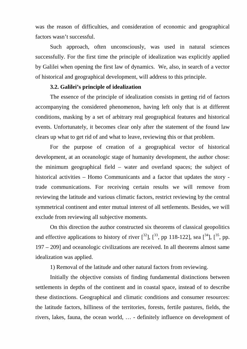
relations is divided into three sets {MM}, {PM} and {PP} (Fig. 1-a,b,c). Here, we
consider only the symmetric communications of PP. The asymmetrical
communications of PP remain outside the sphere of our tasks.
All of these trade links can be realized by sea and land routes. Due to the
fact that the original continental space was idealized to the point of radial
homogeneity and axial symmetry, we will consider only the straight land and
marine transportation, which will include mixed land-sea transportation.
Often the choice of path in trade relations was unconscious, but the selection
of these relations in the history obeys the principle of economic expediency of a
various transport.
4.1. Spiritland - Land of ancestral spirits.
Let's consider a set {MM} of commercial relations (Fig. 01-a) and we will
compare the cost of sea and overland communications in this set.
For this purpose we will write down a functional of comparison of cost of
similar transportations: F1 = fm12 – ft12
In this functional: fm12 = Cm·∪M1M2 – the cost of sea transportation, ft12 =
Ct·M1M2 – the cost of overland transportation, ∪M1M2 – sea distance between
coastal settlements of M1 and M2, M1M2 – overland distance between them, Cm

and Ct – cost price of sea and overland transportations (cost of ton-kilometer of
transportation).
If we introduce geo-economic parameter k = Cm/Ct, then the functions F1
can be rewritten in the form:
F1 = 2sinψ - k·2ψ (1)
Here, the radial size of the continent R is taken for unit that it is always
possible to make due to the choice of scale, and 2ψ - angular distance under which
the segment of M1M2 is visible from a point О.
The dependence of the functions F1 = F1 (ψ, k) are presented on Fig. 2. Even
the simplest analysis of this functionality in the form of a comparison of the cost of
land and sea transportation provides non-trivial result:
F1 = 0 → sinψ/ψ = k (1')
The whole continent is divided into two areas. The first area - Land of
ancestral spirits - Spiritland having radial dimensions
RSp = cosψ(k), (1'')
is distinguished by the fact that the trade routes from the set {MM}, passing
through the land, are more economical than the corresponding maritime
communications. The second area - the land, through which less favourable
between coastal communications lie.
The non-triviality of the obtained result shows in the theorem about the
disappearance of the Earth the Spirits Ancestors.
Theorem 3 (Theorem about the disappearance of Land of ancestral spirits).
Ancestral land, allocated in the continental spaces as the region RSp =
cosψ(k), in which lie only profitable land communications between coast points
separated by the angle ψ, exists in the geographical space only in the interval [1,
2/π] of values of the geo-economic parameter k. With decreasing this parameter to
the value of 2/π, – the land of ancestral spirits disappears from the geographical
space according to the law sinψ/ψ = k and upon k < 2/π goes into the history (Fig.
5-a).
Instead of it arises opposed - global Rimland, for all coastal points of which
the most profitable sea trade connection. Conversely when increasing the geo-
economic parameter k to a value of 2/π, Spiritland, like a Phoenix, reborn again
and when it reaches the value 1, applies to the whole continent. In this case
Rimland dies and disappears.
Naturally, these processes have the character of the geohistory, and can not
be reduced to the individual event-driven phenomena.
4.2. Heartland
The following comparison of the cost of marine and land communications in
the set {PM} trade relations (Fig. 01-b) rehabilitates the ideas of Mackinder in his
historic confrontation with Spykman.
Let's make in this set a functional of comparison the cost of transportation
by land and by sea: F2 = fmPM – ftPM
Here, fmPM = (Ct·PM0 + Cm·∪M0M) - cost sea transportations (the mixed
overland and sea) between the settlements of P and M, and ftPM = Ct·PM – the cost
of land transportation between them. Value PM0 - the distance between the point
settlement of P and a point of M0 of crossing of the radial straight line passing

through P with continent border; ∪M0M - the distance between the sea shore
points M0 and M; and PM - overland distance between populations P and M.
If angular data (r,φ) are counted from direct OM0, then the coordinates of
points P, M0 and the arbitrary coastal point of M can be written down, as (r,0),
(1,0) and (1,φ), respectively, without change of a community. Here r ∈ (0, 1), and
φ ∈ (0,π) – is the angular distance under which the segment of PM is visible from
the center of the continent.
In these variables functional F2, will be rewritten in the form convenient for
the study:
F2 = F2 (r,φ,k) = (1 - r) + φ·k - √(1+ r2 - 2r·cosφ) (2)
The result in which we are interested in - is the boundary between the best of
land and sea routes depending on the geo-economic parameter k. Typical
dependences of F2 are shown in fig. 03. Here, the zero value F2 (curve r=0,98)
limits the set M∈∈∈∈(M1~φ1,М2~φ2) of the coastal points of the continent, into
which sea communications PM through the point M0 is more profitable than land.
In turn, land communications with transportation of cargo to ports outside this set
better than the sea lines of communication through the same point M0.
Such statement can be done on any port M0′ is in the interval (M0, M1). The
difference can consist of a change in the destination area М∈(M1′,М2′). Therefore,
when transporting {PM}, condition F2 = 0 not enough to find the desired
boundaries.
Further analysis of the function F2 gives two extremes F2 (φ1*), F2 (φ2*):
(cosφ)1,2 ={ k2±√[(r2-k2)(1-k2)]}(1/r) (2')
The first extremum determines the most favorable sea route (PM1* +
∪M1*M) and, thus, maximizes the area of maritime communications. This is the
principle of least action in the form of economic expediency.
From the principle of economic expediency follows that favorable overland
ways from settlement P to coastal settlements of M lie in the directions PM∈ (PM0,
PM1*] and PM∈ [PM′, PMπ], where M′ a point, for which F2 (φ′) = F2 (φ1*), and

Mπ – the coastal point, corresponding to F2 (φ3*=π). The boundary extremum of F2
(φ3*=π) specifies areas of optimum overland and sea communications. If F2 (φ1*) ≥
F2 (φ3*=π) a point of M′ is absent, or coincides with Mπ point. The second
extremum at F2 (φ2*) = 0 outlines a limit of sea communications through M0 point.
As well as in principle of least action, in principle of economic expediency
there are also laws of refraction of trade routes. Here, the role of index of refraction
plays river geoeconomic parameter e (the size inverse to global parameter k). The
selection of one or another type of parameter is only the question of convenience.
But in geopolitics, there is one significant difference from physical
processes. Here trade paths are not determined. Therefore, any separations of the
continent on the basis of commercial communications are fundamentally statistical
in nature.
In family of the F2 (r,φ,k) functions for any r there is curve k = r (in fig. 03,
k=r= 0.9), for which extrema F2 (φ1*) and F2 (φ2*) degenerate in point of inflection
F2 (φ* ). This direction φ * allocates a region of the continent, from which any land
trade routes to the coast of the continent will be minimal in terms of economic
utility. As a consequence, and to any other point of the continent.
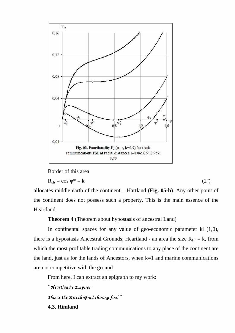
Border of this area
RHr = cos φ* = k (2'')
allocates middle earth of the continent – Hartland (Fig. 05-b). Any other point of
the continent does not possess such a property. This is the main essence of the
Heartland.
Theorem 4 (Theorem about hypostasis of ancestral Land)
In continental spaces for any value of geo-economic parameter k∈(1,0),
there is a hypostasis Ancestral Grounds, Heartland - an area the size RHr = k, from
which the most profitable trading communications to any place of the continent are
the land, just as for the lands of Ancestors, when k=1 and marine communications
are not competitive with the ground.
From here, I can extract an epigraph to my work:
“ H eartland's E m pire!H eartland's E m pire!H eartland's E m pire!H eartland's E m pire!
ThisThisThisThis is the K itezh is the K itezh is the K itezh is the K itezh----G rad G rad G rad G rad shin ing fireshin ing fireshin ing fireshin ing fire!”
4.3. Rimland

Land of ancestral spirits- is pulled together in a point as soon as geo-
economic parameter K takes the value of k′ = 2/π. Simultaneously, springing area
of global Rimland, for which the most profitable commercial ties between any two
settlements, equally remote from the ocean and separated by angular distance π
from center continent, are marine (Fig. 05-a, Fig. 05-d).
Global Rimland is completing the development of local Rimland by law (1′):
sinψ/ψ = k, k∈[1, 2/π). Like global, local Rimland highlighted the fact that the
most profitable commercial ties between the two settlements, equally remote from
the ocean and separated by the angle 2ψ (ψ < π/2) are marine.
In this case Rimland has multivalued structure:
Firstly. For different values ψ, the depth of the local Rimland may be either
higher or lower than the global Rimland, depending on the geo-economic
parameter k.
Secondly. The depth of Rimland depends on the value ψ. In this sense,
Rimland is a function of the pair coastal points. Thus, adequate meaning to the
term of Rimland always implied the adjective “mutual” Rimland.
Thirdly, for any point of Rimland there is always the surrounding, which
represents a local heartland in the sense that profitable trading communications
within this area are overland. This area merges with the global Heartland. The
configuration of this region is determined by its location and geo-economic
parameter k. Naturally, in the real landscape the given moment can play the most
important role.
Made the statement is a consequence of strict mathematical transformations
of the functional comparison of the cost of sea and land trade transportation PP
(Fig. 01-c) between continental settlements equidistant from the coasts of the
continent: F3 = fmP1P2 – ftP1P2 .
Here fmP1P2 = (Ct·P1M1 + Cm·∪M1M2 + Ct·P2M2) - the cost of mixed land-
sea transportation between settlements P1 = P(r, 0) and P2 = P(r, 2ψ), and ftP1P2 =
Ct·P1P2 - the cost of land transportation between them. Meaning P1M1 - the
distance between settlement P1 of the continent and the coastal point M1 = M(1, φ);
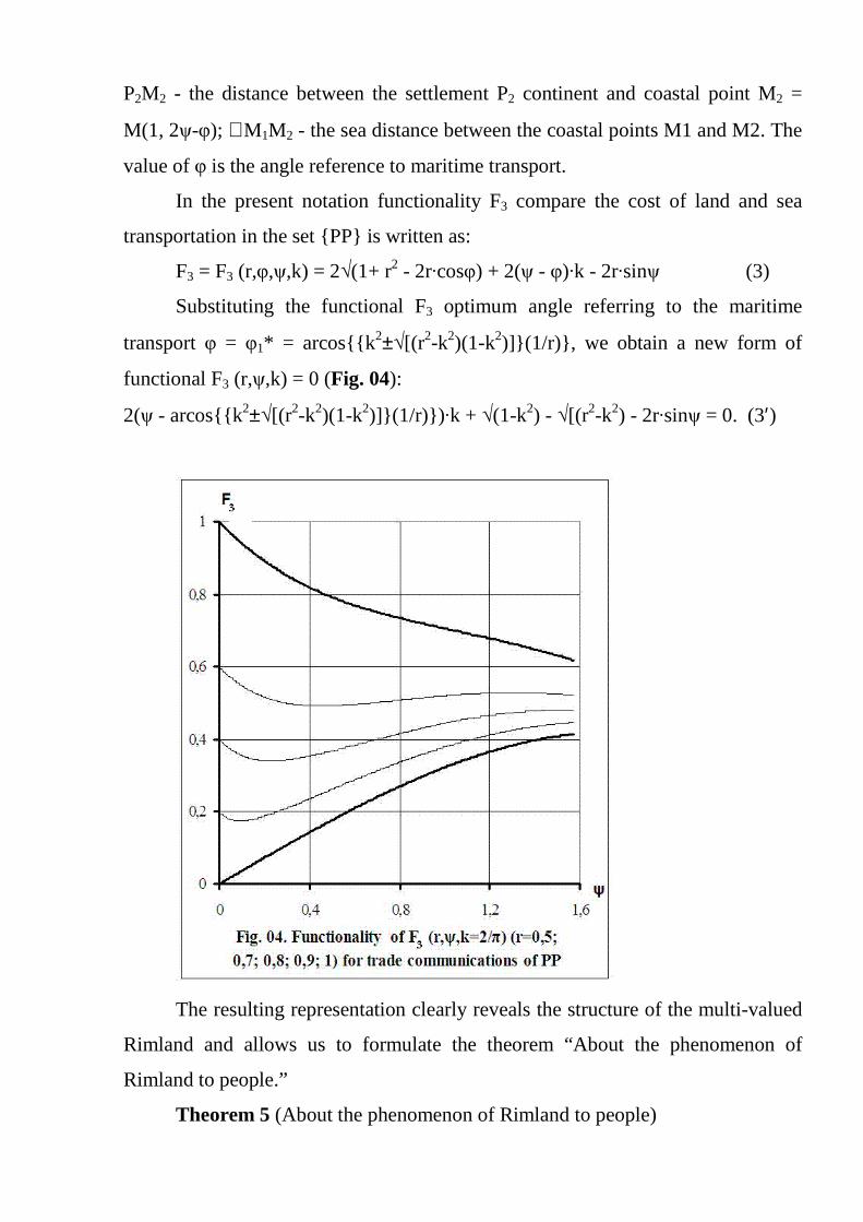
P2M2 - the distance between the settlement P2 continent and coastal point M2 =
M(1, 2ψ-φ); ∪M1M2 - the sea distance between the coastal points M1 and M2. The
value of φ is the angle reference to maritime transport.
In the present notation functionality F3 compare the cost of land and sea
transportation in the set {PP} is written as:
F3 = F3 (r,φ,ψ,k) = 2√(1+ r2 - 2r·cosφ) + 2(ψ - φ)·k - 2r·sinψ (3)
Substituting the functional F3 optimum angle referring to the maritime
transport φ = φ1* = arcos{{k2±√[(r2-k2)(1-k2)]}(1/r)}, we obtain a new form of
functional F3 (r,ψ,k) = 0 (Fig. 04):
2(ψ - arcos{{k2±√[(r2-k2)(1-k2)]}(1/r)}) ·k + √(1-k2) - √[(r2-k2) - 2r·sinψ = 0. (3′)
The resulting representation clearly reveals the structure of the multi-valued
Rimland and allows us to formulate the theorem “About the phenomenon of
Rimland to people.”
Theorem 5 (About the phenomenon of Rimland to people)
In continental space any geo-economic value of the parameter k∈[1, 2/π)
allocates an area RRm, that for any two points of this set remote from the edge of
the continent at the same distance, profitable trading communication between them
will be the sea. In the field of values k<2/π, this property begins to possess and any
two opposing point of this area, i.e. Rimland acquires a global nature.
Dimensions of Rimland can be evaluated using the fact that "ocean-fed
commerce tends, other things being equal, to form a zone of penetration round the
continents, whose inner limit is roughly marked by the line along which the cost of
four handlings, the oceanic freight, and the railway freight from the neighbouring
coast, is equivalent to the cost of two handlings and the continental railway freight"
[38, p. 42].
Discarding the cost of cargo handling works, it is possible to delineate the
border zones of penetration of Rimland in the space of the Continent. (If necessary,
the cost of these works you can always enable in functional F3).

On the plane (r,k) this boundary represents the envelope of the family of
curves (3′) depending on a parameter ψ. Thus, the maximum depth of penetration
of Rimland in the space of the continent (Fig. 05-d) is an implicit function:
k⋅arccos{(k/r2)⋅[1-(√(1-k2)-√(r2-k2))2]}+ √(1-k2)-2⋅√(r2-k2) = 0 (3′′)
Remark.
Research of the asymmetrical trade communications of PP can be conducted
by means of the functional F4(r1,ψ1,r2,ψ2,k) = F3(r1,ψ1,k)+F3(r2,ψ2,k). However,
these researches lie out of the main sphere of our task.
4.4. Ringland
Representing Heartland to the political world, Mackinder intuitively
separated it from marine civilizations by a large internal (great inner) crescent from
Germany, Austria, Turkey, India and China [39, p. 436]. But this at the dawn of the
20th century. Actual dynamics of the geopolitical image forced Mackinder in 1943
to stop using it.
In the second half of the 20th century this redoubt stretched across the
countries of the socialist community, Yugoslavia, Greece, Turkey, Syria, Lebanon,
Israel, Palestine, Iraq, Iran, Afghanistan, Pakistan, India, Southeast Asia, China,
Japan, Korea.
Today the situation is quite different. Along with zone of old conflicts,
appeared and inflame new conflicts: the Baltic States, Ukraine, the Caucasus,
Central Asian republics, Kurdish regions, Xinjiang, Tibet, The Kuriles.
Appeal to earlier times also makes it possible to outline the area of conflicts
on the periphery of the Mongol Empire and on the periphery of the Arab Caliphate.
For a thousand years before, we can specify a zone of conflict Roman Empire and
Carthage. But the most expressive areas of conflict the continental and maritime
civilizations began to emerge after the Great geographical discoveries, with the
beginning of dominance on sea expanses of Spain, the Netherlands and especially
the UK.

Thus, in the historical scale explicitly is present the conflicts zone of
continental and sea civilizations, which is evolving with the social development of
society. And this area requires its location on the continent in any theory.
In our case, this requirement is implemented in the theorem
Theorem 6 (The theorem about an eternal share of Ringland)
Optimal communication boundaries of the Heartland (2") and Rimland (3")
do not match and limit the scope of the continent that does not belong to the
Heartland, or to Rimland (Fig. 05-c). This field of communication collisions of
interests of Heartland and Rimland is Ringland. At same time, the own
communication interests of Ringland do not coincide neither with the interests of
the Heartland nor with the interests of Rimland.
Remarks
In this work a version of flat terrestrial surface is considered. It is OK, when
radius of continent much less than a quarter of the equator Earth. Considering the
Earth sphericity there are small amendments to the sizes of geoeconomic zones.
So, in flat space, the Earth of Ancestors disappears at k = 2/π irrespective of
the continent sizes.
In spherical space the Earth of Ancestors of Eurasia (S = 50,7 millions
squire km) disappears at k = 0,682. For Pandey's continent (S = 138,4 millions
squire km) it disappears at k = 0,784. That is the effect is that for the big sizes of
the continent the Earth of ancestors disappears earlier, than for the small sizes. By
increasing a terrestrial surface to the hemisphere sizes, Land of Ancestors
disappears for all k ≤ 1.
V. Afterword
Here, imitating Makinder and Spykman, it is possible complete this work
announcing epilogue in the form of the political indicative directive in fight for
world supremacy on the future:
““““W ho creates R ingland's events of E urasia ru les the W orldW ho creates R ingland's events of E urasia ru les the W orldW ho creates R ingland's events of E urasia ru les the W orldW ho creates R ingland's events of E urasia ru les the W orld ----Island;Island;Island;Island;
W ho rules W orldW ho rules W orldW ho rules W orldW ho rules W orld ----Island controls the destin ies of the m ankindIsland controls the destin ies of the m ankindIsland controls the destin ies of the m ankindIsland controls the destin ies of the m ankind”.”.”.”.
At present there is a strong and real corroboration of this declared directive.
Today, the one who makes the conflicts in Ringland and rules them isn't Ringland's
actor, but, in fact, directs destinies of mankind.
References
1 From Publishing House "Thought" / Haushofer, K. About geopolitics. Works from
different periods. – M.: Мысль, 2001. – p. 426. 2 Aron, R. Peace and War: A Theory of International Relations, 1962 3 Mikhailov, T. A. Evolution of the Geopolitical Thoughts. – M.: Весь мир, 1999 – p.
184. 4 Meinig D.W. Heartland and Rimland in Eurasian History // West Politics Quarterly. —
1956. - Vol. IX. - p. 553—569. 5 Cohen S. B. Geography and Politics in a divided World. — L.: Methuen, 1964. 6 Kirk W. Geographical Pivot of History. — Leicaster: Leicaster Universal Press, 1965. 7 Mackinder, H. J. The Geographical Pivot of History. The Geographical Journal, Vol.
23, No. 4 (Apr., 1904), pp. 421-437. 8 Mackinder H.J. Democratic Ideals and Reality: A Study in the Politics of
Reconstruction. – N.Y. 1919. – 272 p. 9 ibid. 10 ibid. 11 ibid. 12 ibid. 13 Mackinder H.J. The Round World and theWinning of the Peace. Foreing affairs. 1943.
Vol. XXI, № 4. 14 Parker G. Western Geopolitical Thought in the Twentieth Century. L.; N.Y. 1985. 15 Spykman N. The Geography of the Peace. New York: Harcourt, Brace and Company,
1944, pp. 38-44. 16 Potekhin V.K. Geopolitics in modern Russia: Forerunner, revival, a condition. The
main task of geopolitics. Scientific and practical magazine "Humanitarian Scientific Researches", http://human.snauka.ru/2012/05/1122.
17 Potekhin V.K. Geopolitics in modern Russia: Geopolitics problems. The main task of geopolitics. Scientific and practical magazine "Humanitarian Scientific Researches", http://human.snauka.ru/2012/05/1167 .
18 Herodotus. History. In 9 books. – M.: Ladomir, 1999. – 752 p. 19 Thucydides. History. / Translated by G. Stratanovsky. – М.: Ladomir, 1996. – 736 p. 20 ibid. 21 ibid. 22 Strabo. Geography. - L., 1967. Strabo. Geography in 17 books. Reprinted text
reproduction of the work issued in 1964. M.: «Ladomir», 1994. 23 Ritter C. Europe. Lectures read in the University of Berlin, issued in 1863. / Translated
from German by Y. Weinberg. - М.: Glazunov publications, 1864. – 343(+) p. 24 Ratzel F. Politische Geographic. Munchen - Lpz. 1897. 25 ibid. 26 Kjellen R. Der Staat als Lebensform. В., 1924. 27 Mahan, A. The Influence of Sea Power upon History, 1660-1783. — М.-Saint
Petersburg.: ACT-Terra Fantastica, 2002. – 634 p. 28 Böttiger C. Das Mittelmeer. Leipzig, 1859.
29 Mechnikov L.I. Civilization and great historical rivers: Articles. – M: Progress –
the Pangay, 1995. - 464 pages. 30 ibid. 31 Braudel F. Civilisation matérielle, économie et capitalisme, XVe-XVIIIe siècle. (The
material civilization, economy and capitalism. The XV-XVIII centuries v.3. World time) / Translation from French by Kubelya L.E. – M: Progress – 1992. – 679 pages.
32 Potekhin V. K. Main theorems of geopolitics: The theorem 1 - The theorem about attractiveness of linear communications. http://milresource.ru/Potekhin-T-1.pdf
33 Potekhin V. K. Mathematical laws of globalization. I. Times of river civilizations. In book: Materials of the International scientific Congress "Global studies – 2009: output ways from global crisis and model of the world device". – Moscow, the Moscow State University of M.V.Lomonosov, on May 20-23, 2009 / Under the general editorship of I.I.Abylgaziyev, I.V.Ilyin. In 2 vol. Volume 1. page 118-122. M: MAX Press, 2009. – 584 pages.
34 Potekhin V. K. Main theorems of geopolitics: The theorem 2 - Theorem about strategic advantage of the central places. http://www.milresource.ru/Potekhin-2.pdf
35 Potekhin V. K. Main theorems of geopolitics (Theorem about the advantage of sea civilizations). – Information collection. Bezopasnost, M.: FNIS. №. 3-4, 2001, page 197 – 209.
36 Potekhin V. K. Main theorems of geopolitics (Theorem of an attraction of the linear communications). - National security and geopolitics of Russia. № 3-4, 2003, page 166 – 175.
37 Mackinder, H. J. The Geographical Pivot of History. The Geographical Journal, Vol. 23, No. 4 (Apr., 1904), pp. 421-437.
38 MacKinder, Halford J. The Scope and Methods of Geography and the Geographical Pivot of History. L., 1951, p.30-44.
39 Mackinder, H. J. The Geographical Pivot of History. The Geographical Journal, Vol. 23, No. 4 (Apr., 1904), pp. 421-437.