Embed Size (px)
Citation preview
Acta Geoturistica, volume 6 (2015), number 2, 18-29
18
Geosite Boží hora at Žulová – a classic mineral deposit
JIŘÍ MALIŠ*, JAN JELÍNEK, LENKA PETRUŠKOVÁ and MARTIN KLEMPA
Institute of Geological Engineering, Faculty of Mining and Geology, VSB – Technical
University of Ostrava, 17. listopadu 15/2172, 708 33, Ostrava-Poruba, Czech Republic
(*Corresponding author e-mail: [email protected])
ABSTRACT The town of Žulová is a historic centre of stone quarrying and processing of granite,
in particular. The town is located in the north-western part of Czech Silesia, Czech
Republic. Still, this area is little known due to its location near the borders. The
absence of infrastructure, insufficient funds of the local municipalities and high
unemployment prevent the town and its surroundings from exploiting the tourist
potential in a wider scale. However, this town and its neighbouring villages certainly
have a tourist potential, especially thanks to their preserved and beautiful landscape,
interesting history and remoteness from big cities. In addition, in Žulová and the
surrounding villages there are several localities interesting from the geological point
of view. For geoscience tourism the geosites are valuable as deposits of various
minerals of contact metamorphism and as deposits of silica or pegmatite veins.
Furthermore, there are sites of historic or existing quarries related to stone
processing or sites with remarkable geomorphology. This article describes the
geological position and genesis of Boží hora geosite, along with its mineralogical
and geotourist attractiveness.
Key words: tourism, contact metamorphism, Žulová Pluton, Žulová, Silesia
INTRODUCTION
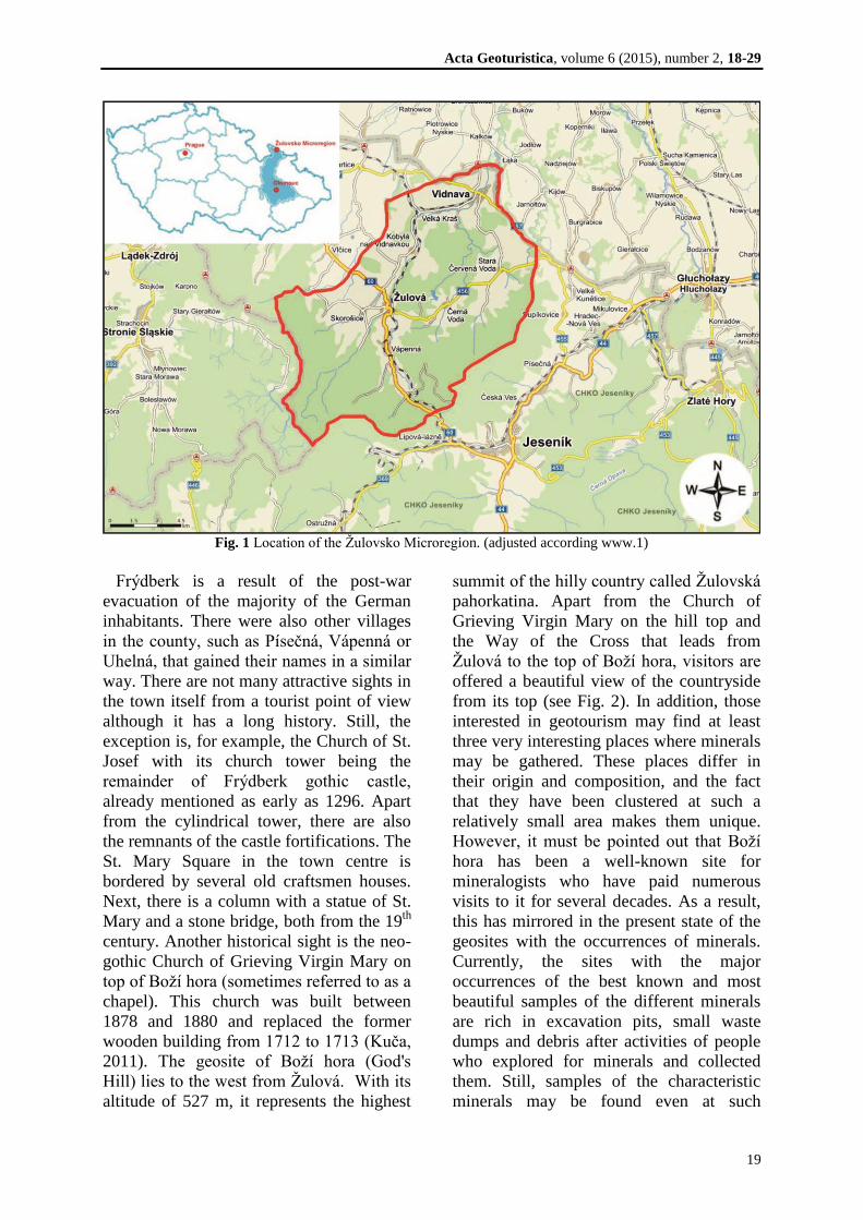
The town of Žulová lies 15 km to the
north-west from the town of Jeseník, 56 km
to the north from the town of Šumperk and
about 16 km to the south-east from the
Czech-Polish border crossing of Bílý
Potok/Paczków. It adjoins the village of
Kobylá nad Vidnavkou in the north, Vlčice
and Skorošice in the west, Vápenná in the
south and Černá Voda in the east. The
town’s acreage is 12.96 km2
according to
the cadastre register office data. Žulová is
situated 12 km from the county town of
Jeseník and 112 km from the regional city
of Olomouc. The town has about 1,300
inhabitants (or 1,327 inhabitants according
to the data of 2007). Žulová is a member of
several regional unions. It is a member of
Žulovsko Microregion which is a union of
the surrounding villages created in 2003.
Since 1993, the town has been a member of
the Union of Jeseníky Towns and Villages
(SMOJ) that was created by municipalities
of the Jeseník County. Since 1997 it has
been also a member of Praděd Euroregion
(see Fig. 1 – map of the region).
The name of Žulová town is related to the
main line of business that dominated there
from the 1850s till the end of the 20th
century, i.e. granite extraction, stone-cutting
industry and stone-industry. There used to
be a technical stone-cutting school there
too. At the times of the top industrial
prosperity as many as 5,000 workers were
employed in the quarries and workshops of
the Silesian granite industry. The history of
granite quarrying has been described in
detail in the work by T. Kruťa (1973).
However, the name of Žulová has been
used since 1948, after World War II. It has
replaced the original German name of
Acta Geoturistica, volume 6 (2015), number 2, 18-29
19
Fig. 1 Location of the Žulovsko Microregion. (adjusted according www.1)
Frýdberk is a result of the post-war
evacuation of the majority of the German
inhabitants. There were also other villages
in the county, such as Písečná, Vápenná or
Uhelná, that gained their names in a similar
way. There are not many attractive sights in
the town itself from a tourist point of view
although it has a long history. Still, the
exception is, for example, the Church of St.
Josef with its church tower being the
remainder of Frýdberk gothic castle,
already mentioned as early as 1296. Apart
from the cylindrical tower, there are also
the remnants of the castle fortifications. The
St. Mary Square in the town centre is
bordered by several old craftsmen houses.
Next, there is a column with a statue of St.
Mary and a stone bridge, both from the 19th
century. Another historical sight is the neo-
gothic Church of Grieving Virgin Mary on
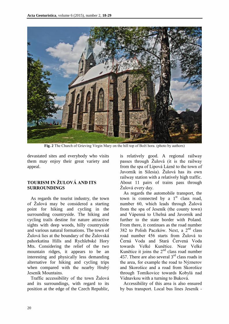
top of Boží hora (sometimes referred to as a
chapel). This church was built between
1878 and 1880 and replaced the former
wooden building from 1712 to 1713 (Kuča,
2011). The geosite of Boží hora (God's
Hill) lies to the west from Žulová. With its
altitude of 527 m, it represents the highest
summit of the hilly country called Žulovská
pahorkatina. Apart from the Church of
Grieving Virgin Mary on the hill top and
the Way of the Cross that leads from
Žulová to the top of Boží hora, visitors are
offered a beautiful view of the countryside
from its top (see Fig. 2). In addition, those
interested in geotourism may find at least
three very interesting places where minerals
may be gathered. These places differ in
their origin and composition, and the fact
that they have been clustered at such a
relatively small area makes them unique.
However, it must be pointed out that Boží
hora has been a well-known site for
mineralogists who have paid numerous
visits to it for several decades. As a result,
this has mirrored in the present state of the
geosites with the occurrences of minerals.
Currently, the sites with the major
occurrences of the best known and most
beautiful samples of the different minerals
are rich in excavation pits, small waste
dumps and debris after activities of people
who explored for minerals and collected
them. Still, samples of the characteristic
minerals may be found even at such
Acta Geoturistica, volume 6 (2015), number 2, 18-29
20
Fig. 2 The Church of Grieving Virgin Mary on the hill top of Boží hora. (photo by authors)
devastated sites and everybody who visits
them may enjoy their great variety and
appeal.
TOURISM IN ŽULOVÁ AND ITS
SURROUNDINGS
As regards the tourist industry, the town
of Žulová may be considered a starting
point for hiking and cycling in the
surrounding countryside. The hiking and
cycling trails destine for nature attractive
sights with deep woods, hilly countryside
and various natural formations. The town of
Žulová lies at the boundary of the Žulovská
pahorkatina Hills and Rychlebské Hory
Mts. Considering the relief of the two
mountain ridges, it appears to be an
interesting and physically less demanding
alternative for hiking and cycling trips
when compared with the nearby Hrubý
Jeseník Mountains.
Traffic accessibility of the town Žulová
and its surroundings, with regard to its
position at the edge of the Czech Republic,
is relatively good. A regional railway
passes through Žulová (it is the railway
from the spa of Lipová Lázně to the town of
Javorník in Silesia). Žulová has its own
railway station with a relatively high traffic.
About 11 pairs of trains pass through
Žulová every day.
As regards the automobile transport, the
town is connected by a 1st class road,
number 60, which leads through Žulová
from the spa of Jeseník (the county town)
and Vápenná to Uhelná and Javorník and
further to the state border with Poland.
From there, it continues as the road number
382 to Polish Paczków. Next, a 2nd
class
road number 456 starts from Žulová to
Černá Voda and Stará Červená Voda
towards Velké Kunětice. Near Velké
Kunětice it joins the 2nd
class road number
457. There are also several 3rd
class roads in
the area, for example the road to Nýznerov
and Skorošice and a road from Skorošice
through Tomíkovice towards Kobylá nad
Vidnavkou with a turning to Buková.
Accessibility of this area is also ensured
by bus transport. Local bus lines Jeseník -
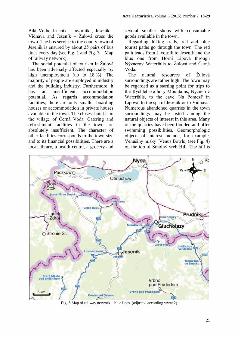
Acta Geoturistica, volume 6 (2015), number 2, 18-29
21
Bílá Voda, Jeseník - Javorník , Jeseník -
Vidnava and Jeseník – Žulová cross the
town. The bus service to the county town of
Jeseník is ensured by about 25 pairs of bus
lines every day (see Fig. 1 and Fig. 3 – Map
of railway network).
The social potential of tourism in Žulová
has been adversely affected especially by
high unemployment (up to 18 %). The
majority of people are employed in industry
and the building industry. Furthermore, it
has an insufficient accommodation
potential. As regards accommodation
facilities, there are only smaller boarding
houses or accommodation in private houses
available in the town. The closest hotel is in
the village of Černá Voda. Catering and
refreshment facilities in the town are
absolutely insufficient. The character of
other facilities corresponds to the town size
and to its financial possibilities. There are a
local library, a health centre, a grocery and
several smaller shops with consumable
goods available in the town.
Regarding hiking trails, red and blue
tourist paths go through the town. The red
path leads from Javorník to Jeseník and the
blue one from Horní Lipová through
Nýznerov Waterfalls to Žulová and Černá
Voda.
The natural resources of Žulová
surroundings are rather high. The town may
be regarded as a starting point for trips to
the Rychlebské hory Mountains, Nýznerov
Waterfalls, to the cave 'Na Pomezí' in
Lipová, to the spa of Jeseník or to Vidnava.
Numerous abandoned quarries in the town
surroundings may be listed among the
natural objects of interest in this area. Many
of the quarries have been flooded and offer
swimming possibilities. Geomorphologic
objects of interest include, for example,
Venušiny misky (Venus Bowls) (see Fig. 4)
on the top of Smolný vrch Hill. The hill is
Fig. 3 Map of railway network – blue lines. (adjusted according www.2)
Acta Geoturistica, volume 6 (2015), number 2, 18-29
22
Fig. 4 Geomorphologic objects venušiny misky. (www.3, photo by Pavla Gürtlerová, 2011; photoarchive of
Czech geological survey)
the so-called inselberg formed in the tropic
Tertiary climate. An inselberg is a unique
geomorphic formation with granite
orbicular structure; many remarkable
shapes developed in the rocky formations,
for example, rock-basins, benches, cavities
which formed by erosive activities of rain
water and the orbicular structure of granite
mentioned above. Also Borový vrch Hill
that is 1 km to the north from Žulová has a
similar character. It is also an inselberg with
a rocky town on its top, which was declared
a protected natural formation in 1987.
It is important that even the latest trends
within the tourist industry and adrenaline
lifestyle can be found in this area,
represented by the project of mountain bike
trails in Rychlebské hory Mountains. A
group of enthusiastic mountain bikers and
mountain bike lovers rebuilt a former
unused farm-house in the village Černá
Voda that became a base for mountain
biking in the surrounding hills.
Furthermore, a network of closed trails
intended for mountain bikes exclusively
was built. At present, the network is already
60 kilometres long and it consists of several
trails with various levels of difficulty. It
holds true for the greater part of the trails
that they remarkably copy old hunting
paths. That way, the trails blend with the
landscape and they hardly disturb it. This
project is very popular among active
mountain bikers within the whole
Moravian-Silesian Region and the trails
have hundreds of visitors not only at
weekends but also during holiday weekdays
over the whole season. At the same time,
this project represents an excellent model of
modern tourist and leisure time activities. It
was well-thought-out from the very
beginning, it means from the information
campaign by means of a website and social
networks including shared video clips and
photographs where the visitors are also
asked to donate further for the centre
development and building of new trails by a
small voluntary donation (for potential
visitors are a very good source of
information about the current state trails
websites http://www.rychlebskestezky.cz
/cs/).
Acta Geoturistica, volume 6 (2015), number 2, 18-29
23
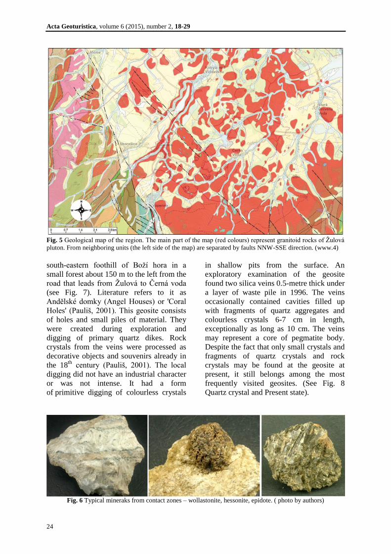
GEOLOGIC DEVELOPMENT OF THE
REGION
The described geosite of Boží hora is
located in the so-called Žulová Pluton. It
makes part of Silesicum in the Moravian-
Silesian area of the Bohemian Massif. This
formation was intensively deformed and
regionally metamorphosed during the
Variscan orogeny period. These processes
resulted in melting of the lower sections of
the crust and extrusion of the Variscan
granitic rocks that might be as old as 340
Ma.
The Žulová Pluton extrudes in the
northern part of Silesicum, and in the Czech
Republic it takes up an area of about 80
km2. In the south, it is divided from the
group of Branná by a peripheral Sudeten
fault. Towards the north, it continues to the
Polish dominion where it plunges under the
Tertiary and Quaternary deposits (Chlupáč
et al., 2002). The eastern edge at the contact
with the Devonian system of Velké Vrbno
Group is intrusive. According to Cháb and
Žáček (1994), it is the top part of a huge
body that continues further deep towards
southeast. The main body of the Pluton is
mostly created by biotite granodiorites,
granites up to quartz diorites and granitoids
rich in accidental xenoliths (Chlupáč et al.,
2002). (See Fig. 5 – Geological map of the
region)
The postorogenic origin of the massif is
documented by a minimum gneissic
banding, perfect cleavage of granitoids and
absence of mylonitic zones (Zachovalová et
al., 2002). The rocks of the Žulová Pluton
mantle are markedly affected by the contact
of Pluton and the surrounding basements
rocks, especially large accidental xenoliths
of crystalline limestones that are
perceivable at many places and even in the
middle of the Pluton. Characteristic Pluton
mantle rocks are the following: sillimanite-
biotite gneisses (migmatizated in places),
feldspathic quartzites, amphibolites,
crystalline limestones, erlans and skarns
(called tektites by some authors).
The boundary lines between the
individual types of mantle metamorphites
are not sharp (Rozkošný and Souček,
1989). The rocks come from Staré Město
Group, Branná Group and from core parts
of Desná Dome and Keprník Dome.
Various authors state the temperature and
pressure of the mantle metamorphosis
activated by impacts of intruding Žulová
Pluton ranging from 560 °C to 800 °C and
from 300 MPa to 500 MPa (Losos and
Hladíková, 1988; Žáček, 2003).
Pegmatites are rather frequent in granites
and granodiorites. They most frequently
appear as sheet bodies. They fill up
variously oriented failure cracks in deep-
seated rocks. Their thickness ranges from
4 cm to 25 cm. Pegmatites structure is
simple with a narrow medium grained
peripheral zone consisting of feldspars and
silica with a centre of pegmatite veins filled
up with coarse-grained potash feldspar and
silica.
From the mineralogical point of view, the
most interesting rocks of the Žulová Pluton
are skarns which have been called tektites
by some authors. They form in the contact
zones of granitoids and the mantle rocks.
These rocks have a very variable
composition due to the diverse composition
of xenoliths that reacted with granitoids
(Mísař et al., 1983). The most typical
minerals from the zones are the following:
hessonite, vesuvianite, epidote, diopside,
wollastonite and scheelite (see Fig. 6). The
contact zones have been described in
numerous geosites in Žulová and its close
surroundings, for example, Vycpálek
quarry, Staré Podhradí, Boží hora near
Žulová, settlement near Bergov, Borový
vrch Hill and Huttung quarry, Nietsche
quarry, Nová Červená Voda, Stará Červená
Voda, Starost quarry, Zelený vrch, Žulový
vrch, etc. (Rybák, 1972).
MINERAL PROSPECT OF BOŽÍ
HORA – GEOSITE DESCRIPTION
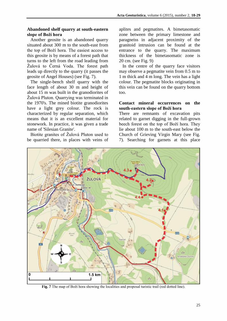
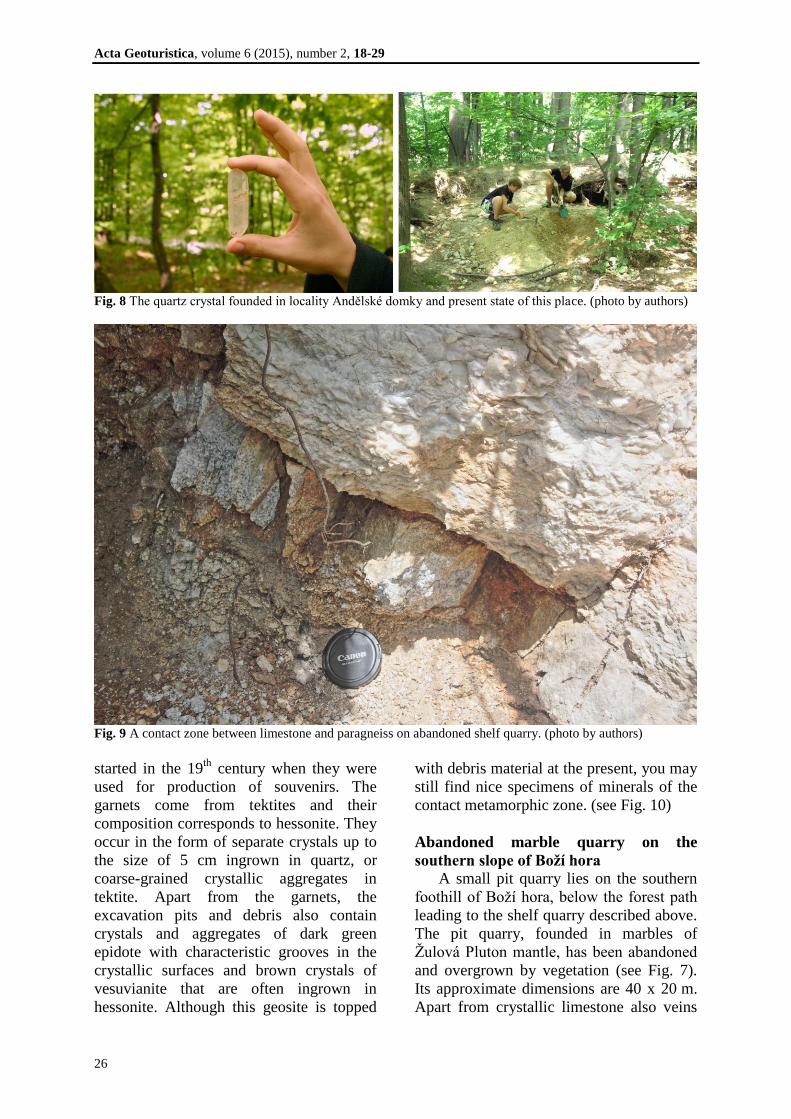
Andělské domky
The first described geosite lies at the
Acta Geoturistica, volume 6 (2015), number 2, 18-29
24
Fig. 5 Geological map of the region. The main part of the map (red colours) represent granitoid rocks of Žulová
pluton. From neighboring units (the left side of the map) are separated by faults NNW-SSE direction. (www.4)
south-eastern foothill of Boží hora in a
small forest about 150 m to the left from the
road that leads from Žulová to Černá voda
(see Fig. 7). Literature refers to it as
Andělské domky (Angel Houses) or 'Coral
Holes' (Pauliš, 2001). This geosite consists
of holes and small piles of material. They
were created during exploration and
digging of primary quartz dikes. Rock
crystals from the veins were processed as
decorative objects and souvenirs already in
the 18th
century (Pauliš, 2001). The local
digging did not have an industrial character
or was not intense. It had a form
of primitive digging of colourless crystals
in shallow pits from the surface. An
exploratory examination of the geosite
found two silica veins 0.5-metre thick under
a layer of waste pile in 1996. The veins
occasionally contained cavities filled up
with fragments of quartz aggregates and
colourless crystals 6-7 cm in length,
exceptionally as long as 10 cm. The veins
may represent a core of pegmatite body.
Despite the fact that only small crystals and
fragments of quartz crystals and rock
crystals may be found at the geosite at
present, it still belongs among the most
frequently visited geosites. (See Fig. 8
Quartz crystal and Present state).
Fig. 6 Typical mineraks from contact zones – wollastonite, hessonite, epidote. ( photo by authors)
Acta Geoturistica, volume 6 (2015), number 2, 18-29
25
Abandoned shelf quarry at south-eastern
slope of Boží hora
Another geosite is an abandoned quarry
situated about 300 m to the south-east from
the top of Boží hora. The easiest access to
this geosite is by means of a forest path that
turns to the left from the road leading from
Žulová to Černá Voda. The forest path
leads up directly to the quarry (it passes the
geosite of Angel Houses) (see Fig. 7).
The single-bench shelf quarry with the
face length of about 30 m and height of
about 15 m was built in the granodiorites of
Žulová Pluton. Quarrying was terminated in
the 1970's. The mined biotite granodiorites
have a light grey colour. The rock is
characterized by regular separation, which
means that it is an excellent material for
stonework. In practice, it was given a trade
name of 'Silesian Granite'.
Biotite granites of Žulová Pluton used to
be quarried there, in places with veins of
aplites and pegmatites. A bimetasomatic
zone between the primary limestone and
paragneiss in adjacent proximity of the
granitoid intrusion can be found at the
entrance to the quarry. The maximum
thickness of the bimetasomatic zone is
20 cm. (see Fig. 9)
In the centre of the quarry face visitors
may observe a pegmatite vein from 0.5 m to
1 m thick and 4 m long. The vein has a light
colour. The pegmatite blocks originating in
this vein can be found on the quarry bottom
too.
Contact mineral occurrences on the
south-eastern slope of Boží hora
There are remnants of excavation pits
related to garnet digging in the full-grown
beech forest on the top of Boží hora. They
lie about 100 m to the south-east below the
Church of Grieving Virgin Mary (see Fig.
7). Searching for garnets at this place
Fig. 7 The map of Boží hora showing the localities and proposal turistic trail (red dotted line).
Acta Geoturistica, volume 6 (2015), number 2, 18-29
26
Fig. 8 The quartz crystal founded in locality Andělské domky and present state of this place. (photo by authors)
Fig. 9 A contact zone between limestone and paragneiss on abandoned shelf quarry. (photo by authors)
started in the 19th
century when they were
used for production of souvenirs. The
garnets come from tektites and their
composition corresponds to hessonite. They
occur in the form of separate crystals up to
the size of 5 cm ingrown in quartz, or
coarse-grained crystallic aggregates in
tektite. Apart from the garnets, the
excavation pits and debris also contain
crystals and aggregates of dark green
epidote with characteristic grooves in the
crystallic surfaces and brown crystals of
vesuvianite that are often ingrown in
hessonite. Although this geosite is topped
with debris material at the present, you may
still find nice specimens of minerals of the
contact metamorphic zone. (see Fig. 10)
Abandoned marble quarry on the
southern slope of Boží hora
A small pit quarry lies on the southern
foothill of Boží hora, below the forest path
leading to the shelf quarry described above.
The pit quarry, founded in marbles of
Žulová Pluton mantle, has been abandoned
and overgrown by vegetation (see Fig. 7).
Its approximate dimensions are 40 x 20 m.
Apart from crystallic limestone also veins
Acta Geoturistica, volume 6 (2015), number 2, 18-29
27
of pyroxenite pegmatite extrude. These
veins extrude in lenticular bodies of
medium grained crystallic limestone from
which they are incised. They are
predominantly represented by white
plagioclase with marked insets of
clinopyroxene (diopside – Fe diopside) that
are several centimetres long and by small
crystals of titanite. However, in the past
crystals of titanite found there were up to
2 cm big. The titanite is of a light brown
colour and its crystals form characteristic
rectangular 'envelopes'.
PROPOSAL OF A GEOTOURIST
NATURE TRAIL
This chapter proposes a nature trail to
experience Boží hora geosites, which starts
from and returns to the centre of Žulová.
The Church of St. Josef in Žulová has been
chosen as the starting point. Visitors may
explore the remnants of the Frýdberk Castle
fortifications and its cylindrical tower at the
very beginning of the tour. A blue tourist
path leads from St. Josef Church to the top
of Boží hora. The path follows the
pilgrimage stops along the Way of the
Cross up to the Church of Grieving Virgin
Mary on the top. On this route there is also
the geosite with occurrences of contact
minerals on the south-eastern slope of Boží
hora (see Fig. 7). From there, the proposed
trail continues up to the Church of Grieving
Virgin Mary as mentioned above. There are
beautiful views of the Žulovská pahorkatina
Hills and Rychlebské hory Mountains’
panoramas from the top. Further on, the
blue tourist path continues from the Church
of Grieving Virgin Mary along the old
forest path that follows a contour line. Next,
the nature trail leaves the blue tourist path
and continues along the forest path to the
south-east towards the abandoned shelf
quarry. There is another stop at the second
geosite where visitors may observe a
contact zone between limestone marble and
paragneiss at the quarry entrance. The
Žulová Pluton rocks that extrude in the
form of granodiorite with pegmatite vein
are visible on the face in the quarry centre.
Fig. 10 A typical material that can be found in contact zones – hessonite. (photo by authors)
Acta Geoturistica, volume 6 (2015), number 2, 18-29
28
The nature trail continues along the forest
path for about 300 m. On the right, below
the forest path, there is another
mineralogical stop, the abandoned marble
pit quarry. Small crystals of titanite may be
found in pegmatite veins material lying on
the quarry bottom. The last mineralogical
stop of this nature trail is at Andělské
domky (Angel Houses or Coral Holes)
geosite that lies in a small forest to which
the mentioned forest path leads. Quartz
crystals and fragments of rock crystals may
be found there. From there on, the nature
trail returns to Žulová. Firstly, it is
advisable to cross the road leading from
Žulová to Černá voda and continue along
the field path, which connects to the red
tourist path after 800 m. This tourist path
passes flooded quarries and leads back to
the square in Žulová. The proposed nature
trail is about 4.5 km long and, with the
exception of the uphill gradient towards the
top of Boží hora, it is a physically
undemanding trip.
CONCLUSION
The article aims to inform readers about a
very geotourist attractive region of Žulová
and its surroundings. Analogously to works
by Štrba and Kurtová (2013), Teplická et al.
(2011), Velázquez et al. (2013), a geotourist
nature trail was proposed herein. The
example of Boží hora shows that several
diverse geological phenomena may be
found at a very small area. The nature trail
recommended here is just one from several
possible routes visitors to Žulová and its
surrounding may take and experience. This
nature trail offers visitors traces of former
human activities that markedly have formed
this area in the past centuries and evidence
of geological activities that had shaped this
landscape much earlier. The tourist
potential of Žulová and of its surrounding
has not been fully utilised, which is
attributed to the economic possibilities of
the town and of the whole region. This is
also affected by the proximity of the Hrubý
Jeseník Mountains that attract a huge part
of tourists and also by the region's position
at the edge of the Czech Republic, in
former Sudetenland. However, in spite of
this 'handicap', viable tourist projects found
their place there. The example of Rychleby
Trails project shows that also an area on the
edge of tourism industry interest, which
lacks necessary infrastructure, may attract
prospective visitors and upraise tourism
with improvements to local economy.
Better knowledge of the geological
attractiveness of the described locality may
positively contribute to this situation.
REFERENCES
Cháb, J. and Žáček, V. (1994) Geology of the
Žulová pluton mantle (Bohemian Massif,
Central Europe). Věstník Česk. geol. úst, Vol.
69, 1-12.
Chlupáč, I., Brzobohatý, R., Kovanda, J. and
Stráník, Z. (2002) Geologická minulost české
republiky. Academia, Praha, 370 p.
Kuča, K. (2011) Města a městečka v Čechách, na
Moravě a ve Slezsku / 8. díl V-Ž. Libri, Praha,
896 p.
Kruťa, T. (1973) Slezské nerosty a jejich literatura.
Moravské zemské muzeum, Brno, 414 p.
Losos, Z. and Hladíková, J. (1988) Izotopické
složení grafitů a karbonátů z pláště žulovského
masívu a jeho využití pro výpočet teplot
metamorfozy. Scr. Univ. Purkyn. brun., Geol.,
Vol. 18, No. 7, 261-272.
Mísař, Z., Dudek, A., Havlena, V. and Weiss, J.
(1983) Geologie ČSSR I Český masív. SPN,
Praha.
Pauliš, P. (2001) Nejzajímavější mineralogická
naleziště Moravy a Slezska. Kuttna, Kutná
Hora.
Rozkošný, I. and Souček, J. (1989) Contribution to
the petrology of the Žulová massif mantle.
Acta Universitatis Carolinae, Geologica, Vol.
15, No. 2, 165-197.
Rybák, J. (1972) Asociace minerálů z kontaktních
výskytů v okolí Žulové. Diplomová práce PŘF
MU, Brno.
Štrba, Ľ. and Kurtová, M. (2013) Attractive
geotourism sites in the area of the Ždiar village
(Tatra Mts. region, Slovakia).
Acta Geoturistica, Vol. 4, No. 1, 47-57.
Teplická, K., Čulková, K. and Sőkeová. E. (2011)
Mine workings in area of Gemer as a tool for
development of tourist traffic.
Acta Geoturistica, Vol. 2, No. 1, 16-22.
Velázquez, V.F., Azevedo Sobrinho, J.M.,
Acta Geoturistica, volume 6 (2015), number 2, 18-29
29
Pletsch, M.A.S.J., Guedes, A.C.M. and
Zobel, G. (2013) Geotourism in the
Salesópolis-Caraguatatuba Trail, São Paulo,
Brazil: A Possibility to Utilize Geological
Elements for Sustainable Development. Journal
of Environmental Protection, Vol. 4, 1044-
1053.
Zachovalová, K., Leichmann, J. and Čvančara, J.
(2002) Žulová Batholith: a post-orogenic,
fractionated ilmenite-allanite I-type granite.
Journal of the Czech Geological Society, Vol.
47, No. 1-2, 35-45.
Žáček, V. (2003) Thermal effects of the Žulová
Granite Pluton, Silesicum, eastern Variscan
front. Polskie Towarzystwo Mineralogiczne
Prace Specjalne, Vol. 23, No. 1, 185–188.
Internet sources
www.1: Location of the Žulovsko Microregion,
available at: http://ww.mapy.cz (accessed 13.
07. 2015)
www.2: Map of railway network, available
at:http://www.cd.cz/mapa/# (accessed 13. 07.
2015)
www.3: Venušiny misky, Gürtlerová,P. (2011)
Fotoarchív České geologické služby, available
at:
http://www.geology.cz/aplikace/fotoarchiv/foto
archiv.php?foto=20372 (accessed 15. 07. 2015)
www.4: Geological map of the region, Česká
geologická služba, available at:
http://mapy.geology.cz/geocr_50/ (accessed 12.
07. 2015)