Embed Size (px)
Citation preview

Geothermal Energy Feasibility Study
Geothermal Power Plant at Csömödér
Title Geothermal Energy Feasibility Study: Geothermal Power Plant at Csömödér
Authors Geotermia Expressz Mérnöki Tanácsadó Iroda Kft. in collaboration with MFGI
Date 03-DECEMBER-2012
Status Final
Type Text
Description The present report contains a feasibility study for geothermal power plant of geothermal energy at the region: Csömödér
Format PDF
Language En
Project TRANSENERGY – Transboundary Geothermal Energy Resources of Slovenia, Austria, Hungary and Slovakia
Work package WP6 Implementation tools for transboundary geothermal resource management
6.2.2. Detailed feasibility study concerning a cross-border plant

1
TABLE OF CONTENT
TABLE OF CONTENT .......................................................................................................................................... 1
1. Summary ........................................................................................................................................................ 3
2. Objectives and Scope of the Study ................................................................................................................. 6
3. The international and Hungarian geothermal power plant sector ................................................................ 8
4. Description of the venue of the Project ....................................................................................................... 19
5. Geological description .................................................................................................................................. 22
5.1 Geological frame .................................................................................................................................. 23
5.1.1 Quaternary .................................................................................................................................. 23
5.1.2 Tertiary ........................................................................................................................................ 23
5.2 Geophysical data ................................................................................................................................. 25
5.3 Tectonics .............................................................................................................................................. 25
5.4 Geological risks .................................................................................................................................... 25
6 Hydrogeological description ......................................................................................................................... 26
6.1 Overview of the major hydrostratigraphic units ................................................................................. 26
6.2 Hydraulic conditions ............................................................................................................................ 26
6.3 Geothermal conditions ........................................................................................................................ 27
6.4 Hydrochemical conditions ................................................................................................................... 29
6.5 Hydrogeological parameters ............................................................................................................... 30
6.6 Risks associated with geothermal exploration .................................................................................... 35
7 Exploration and energy concept .................................................................................................................. 36
7.1 Set up an Exploration concept ............................................................................................................. 36
7.1.1 The necessary information ......................................................................................................... 36
7.1.2 Carry out a desktop concept ....................................................................................................... 37
7.1.3 Complete the concept ................................................................................................................ 37
7.1.4 Estimate prospect risk................................................................................................................. 37
7.1.5 Define what would constitute an adequate drilling success ...................................................... 37
7.1.6 Identify and describe exactly the drilling target ......................................................................... 38

2
7.1.7 Develop a drilling strategy .......................................................................................................... 38
7.1.8 Utilization of Existing Hydrocarbon Wells ................................................................................... 38
7.2 Alternatives.......................................................................................................................................... 39
7.3 Selection from alternatives ................................................................................................................. 40
9. Underground facilities .................................................................................................................................. 45
9.1. The objective of drilling ....................................................................................................................... 45
9.2. Drilling, well completion ...................................................................................................................... 45
9.3. Well planning ....................................................................................................................................... 46
10. Surface facilities ....................................................................................................................................... 49
10.1. Objective of the technology ............................................................................................................ 49
10.2. Alternatives ..................................................................................................................................... 49
10.3. The appropriate technology ............................................................................................................ 53
11. Risks of the Project................................................................................................................................... 55
11.1. Risk types ......................................................................................................................................... 55
11.2. Risk mitigation ......................................................................................................................................... 56
12. Licensing ................................................................................................................................................... 58
13. Project costs, project financial supports .................................................................................................. 61
13.1. Estimated costs ............................................................................................................................... 61
14. Schedule of the project implementation, operation ............................................................................... 66
Operation .............................................................................................................................................................. 69
Bibliography .......................................................................................................................................................... 70
Appendices ............................................................................................................................................................ 72

3
1. Summary
The purpose of this Study is to prepare a feasible geothermal power plant project concept in
the territory of Transenergy Project.
The objectives of the Study are the following:
• To demonstrate the values of the results of Transenergy Project;
• To show how the geological data of Transenergy Project can be converted into an
operating geothermal system; electricity and heat production, as well as financial
return;
• To present the geological background, the geothermal technology and the permitting
process.
The task of this Study is to plan a geothermal power plant in a Transenergy region.
The geothermal potential of Hungary is well over the world average and except the active
volcanic areas it is one of the most prospective territories in Europe. In spite of this fact,
thereis no operating geothermal power plant in Hungary.
The Hungarian National Renewable Energy Action Plan aims to achieve57 MWe geothermal
power plant capacity in 2020.
The geological, hydrogeological concept of the project includes the following points:
There will be100% reinjection of the produced thermal water into the same formation, not
only because of the environmental regulations but also because of technological causes.
The project will focus on fractured karstic reservoirs, instead of sediments.It provides
better conditions for re-injecting.
Pannon sediments are not hot enough.
Thermal water production from upper Triassic as well as reinjection to middle Triassic
formation can be appropriate in Csömödér area in Zala county.
Production and reinjection relates to the same fractured system.
East of Csömödér lake ata depth 2700 m 150oC temperature is realistic.
The key points of the technology and energy conceptarelisted as below:
Two production and two reinjection wells are to be deepened.
Surface technology, small scale binary type power plant block and connection to the
electric grid and to the heat consumers.
2 MWeelectric power is realistic.
The outlet water temperature is still 75oC and appropriate for supplying 7,5 MWth heat.
2 MWe electric power and 7.5 MWth thermal heat needs two times 30 kg/s flow rate and
150 oC well-head temperature.
4
The related project has a closed loop system with 100% water reinjection into its original
formation. This technology ensures the most environment protecting renewable energy
experience.
The planned depth of the first well is close to 2700 metres. The other three wells are to be
deepened down to the triassic top 100 metres.
The well structure is the same in each well:
17 ½” conductor casing
12 1/4” anchor casing
8 1/2” production liner, then
7” tubing.
Well bottom is depending on the depth of the triassic zone.
As the well-head water temperature is 150oC, and the plant outlet water temperature is about
75oC, the appropriate technology is the binary type power plant block combined with heat
supply. The power plant machinery has to be installed near the better production well
thereforeits final venue is to be determined after the exploration phase of the project.
As the outlet temperature is fairly high (75oC), heating system should be installed. The
technology is also direct heat utilization combining with the power generation.
The project risks consist of four main parts; geological, technological, financial and
legislative.
The main technical risk in a geothermal energy utilisation project comes from the fact that the
exact technical parameters of the reservoir deep under the ground are unknown at the start of
the project. Surface and drilling exploration are the two phases that improve the
understanding of subsurface conditions.
Below -2500 m geothermal energy falls under geothermal concessionlicensing system,
whose steps are given in the Mining Act Articles 8-19 as well as in Governmental Decree
103/2011 (VI.29.). The environmental permit is issued by the green authority, the power plant
permit is issued by the Hungarian Energy Office.
The economic concept is discussed below.
Total cost of the Project is HUF5,750 million (€20.3 M).
The produced electricity can be supplied into the regional electric grid. Heat market is
available near Csömödér, including agricultural consumers, mainly heating of greenhouses
and plastic vegetable tents.
Planned feed-in tariff: 30 Ft/kWh (10.6 €cents/kWh)
Heat energy price: HUF3500 /GJ (12.36 €/GJ)
Electricity production time: 8300 hour/year

5
Annual produced electricity: 16,6 million kWh
Annual produced heat energy: 55,000 GJ
In the next decade the cooling demand is to be significantly increased. It was considered
during the determination of the energy demand (~ 10,000 GJ/doublet is cooling energy in
summer time).
Annual income from electricity: HUF500 million (€1.77 million)
Annual income from heat supply: HUF192.5 million (€0.68 million)
Total income: HUF692.5 million (€2.45 million),
Payback time: 8.3 year
There are opportunities to achieve project supports and subsidies that make project financing
more advantageous.
The duration of the project preparation is 25 months (including the concession process), and
the project implementation is 29 months. Altogether the project duration is 54 months.
The operation of geothermal power plants is reliable.
GeoEx Team prepared FEFLOW modelling concerning the project operations. The results are
shown in Appendix 1.
This project is different from Ács-Gönyű-Zlatá ns Ostrove project because the geothermal
potentialin Zala County is higher and the fractured zones are deeper. Therefore the
establishment of a geothermal power plant is feasible.
The project can support the vision of the geothermal sector. This vision was declared by
Bromley and his colleagues in the World Geothermal Congress in 2010 [2]:
„With the right attitude and approach by policy makers, investment agencies and power
companies, geothermal iscapable of contributing a significant component of theglobal
renewable energy supply by 2050 that is needed todisplace fossil fuel generation and thereby
mitigate theimpact of climate change from greenhouse gas emissions.”

6
2. Objectives and Scope of the Study
Transenergy is a Central European project, which was started in April 2010. The aim of
Transenergy Project is to create a common geothermal information system in four Central
European countries. Having an environmental focus, the purpose is to seek for sustainable,
transboundary utilization of geothermal energy resources. Based on the results of the Project,
geothermal feasibility studies are to be prepared. These Studies can prove the values of
TransEnergy Project.
The purpose of this Study is to prepare a feasible geothermal power plant project concept in
the territory of Transenergy Project.
The objectives of the Study are the following:
• To demonstrate the values of the results of Transenergy Project;
• To show how the geological data of Transenergy Project can be converted into an
operating geothermal system; electricity and heat production, as well as financial
return;
• To present the geological background, the geothermal technology and the permitting
process.
During the Study preparation the following issues are to be avoided:
• areas that are covered by a kind of geothermal system,
• ongoing geothermal permitting or exploration processes,
• heat markets covered by a geothermal operating technology.
The task of this Study is to plan a geothermal power plant in a Transenergy region.
Therefore this Study analyzes the alternatives of an available geothermal project including
• geological,
• technological,
• economic and
• financial opportunities,
• its risks, and
• its permitting process.

7
The geothermal potential of Hungary is fairly high. However, the area of Transenergy Project
is not in the most prospective Hungarian areas. Therefore, the suggested project is feasible,
but to prepare an exact business case is not considered the objective of the Study.
In order to prepare the Study, the Geothermal Express Limited formed a Project Team
involving earth sciences, technology, legal and financial experts. The Project Team carried
out the assignment in August-November 2012. The selection of the focus regions were agreed
with Transenergy Project Team. The local geological and hydrogeological information of the
Study was based on Transenergy databases.

8
3. The international and Hungarian geothermal power plant
sector
The EU Directive on Promotion of Renewable Energy Sources (Directive 2009/28/EC of the
European Parliament and of the Council of 23 April 2009 on the promotion of the use of
energy from renewable sources and amending and subsequently repealing Directives
2001/77/EC and 2003/30/EC) determines geothermal energy as energy stored in form of heat
beneath the surface of solid earth. There are three main production opportunities for
producing geothermal energy:
by ground source heat pumps,
by thermal water production and direct heat utilization, and
by thermal water/steam production and electricity generation.
Geothermal energydoes not have geographical restrictions as it exits anywhere onthe Earth.
Ground source heat pumps and enhanced geothermal system (EGS) technologies can be
employed in areas with low geothermal potential and without a thermal water reservoir as
well.
As this Study includes a geothermal power plant project concept, the international geothermal
power plant sector is to be reviewed.
In 2010 geothermal based electricity was produced by geothermal power plants in 24
countries, with a total capacity of 10,715 MWel.
The key international geothermal electricity data are shown in Table 1 and Table 2 [1].
There are more than 500 geothermal power plant blocks operating all over the World. Table 1
lists the top countries by installed capacity [1]. The table shows that only Italy is included
from the European continent. Perhaps also Iceland can be regarded to be an European
country, but not from a geological point of view. With regard to the geothermal based
electricity production, the dominant countries are not in Europe, but mainly around the Pacific
Ocean.

9
Installed Capacity in 2010 [MW]
USA 3093
Philippines 1904
Indonesia 1197
Mexico 958
Italy 843
New Zealand 628
Iceland 575
Japan 536
El Salvador 204
Kenya 167
Costa Rica 166
Table 1. Installed geothermal power plant capacities in 2010, top countries [1]
In 2010 the total produced geothermal based electricity was 67,246 GWh. The top countries
are the same as top countries of geothermal electricity capacity. The countries that have more
up-to-date geothermal power plants and electric grid have slightly better positions.
10
Geothermal Electricity Production (2010)
GWh/yr
USA
Philippines
Indonesia
Mexico
Italy
Iceland
New Zealand
Japan
Kenya
El Salvador
Costa Rica
Turkey
Papua-New Guinea
Russia
Nicaragua
16603
10311
9600
7047
5520
4597
4055
3064
1460
1422
1131
490
450
441
310
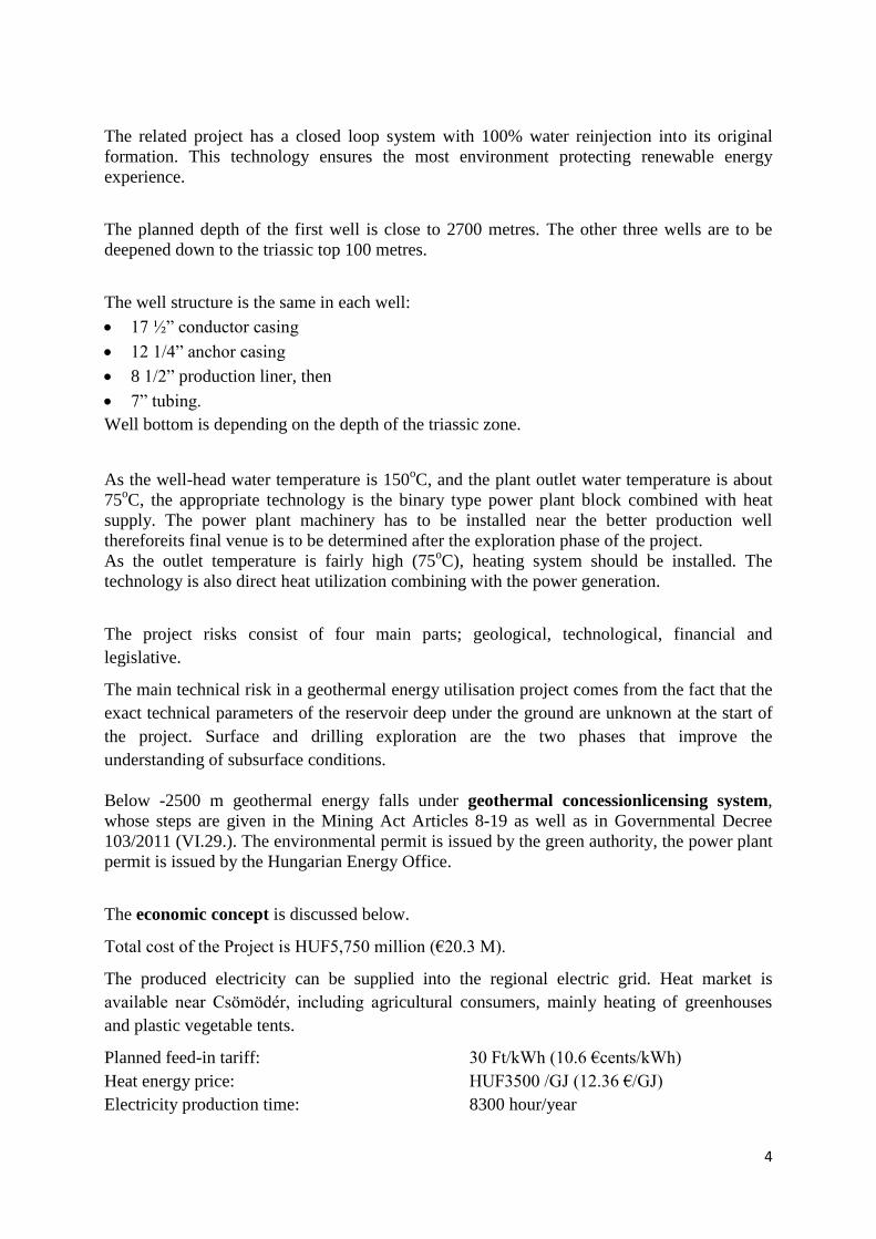
Table 2. Produced geothermal based electricity in 2010, top countries [1]
In spite of the fact that Europe is not a dominant continent in geothermal based electricity, the
European Union Member States have ambitious geothermal energy development objectives.
Figure 1 shows the general deep geothermal potential of Europe. High-enthalpy areas can be
found only in Iceland, in the Asian territory of Turkey and in Middle Italy. However, high
temperature basins can be also prospective for electricity production. There are a few of them
shown in Figure 1.
The huge majority of Transenergy Project territory is covered by such a high temperature
basin, therefore very good prospective areas can be found for geothermal electricity
production.

11
Figure 1: Deep geothermal potential of Europe (Source: EGEC 2009)
There is no time limitation in the operation of geothermal systems. The operation of
geothermal energy production is continuous except for maintenance time and trouble-
shooting. Generally 8000 hours operation per year can be planned. In the case of solar or wind
technology, the operating time is 1700-2100 hours per year.
The different temperature ranges open the door to utilize the heat in different ways. Over
120oC temperature range electricity production can be evaluated. The temperature range
between 60oC – 120
oC is appropriate for communal heat supply for heating and cooling,
district heating and domestic hot water heating.

12
Where the porosity and permeability were not appropriate for natural formation of
hydrothermal systems, GSHP and EGS long-term utilization is to be evaluated.
According to the scenario of Renewable Heating-Cooling Technology Platform - that includes
the technology development the EU-27 - geothermal heating and cooling production will
reach 160 TWh by 2020. This value would be increased 1750 TWh by 2050.
The development of three renewable energy sources is presented in Table 3.
Energy source 2007 (TWh) 2020 (TWh) 2050 (TWh)
Geotermal 8,4 160 1750
Solar 10 190 1552
Biomass 722 1447 2696
Altogether 743 1797 5998
Table 3: Expected growth of the heating and cooling energy production [7]
of the three RE resources [Source: RHC TP]
This vision was formed by RHC-TP experts, based on EUROSTAT method. Presently
geothermal and solar energy production has a low rate.They need to be developed
significantly, in accordance with domestic and European action plans and development
strategies.
Middle and Long Term Role of the Geothermal Energy in Europe [7]
A significant increase in geothermal energy can be achieved if all segments providestrong
development.
Geothermal energy production till 2020
Ground source heat pumps (GSHPs) showed exponential development even in the decade of
2000-2010 from the main segments of geothermal energy production. The development was
remarkable mainly in those countries which were able to provide the financial basis of the
background infrastructure. Their driving forces were the undeveloped gas network and the
large heat demand because ofthe cold climate. With regards to the fact that the ground source
heat pump market hasn’t developed well yet, a lot of counties including Hungary, set up
ambitious increase in the number and power of GSHPs. Heat pumps will be dominant in the
geothermal energy development.
Direct heat service development will occurmainly in those countries that have high
geothermal potential. The rising of the price of fossil energy resources and cost reduction

13
from technology development increases the competitiveness of geothermal projects and
enables growth.
The doubling of geothermal based electricity production by 2020 is estimated. Several
countries, including Hungary will establish the first geothermal power plants. The geothermal
based electricity production will rise in the continental areas of Europe. EGS system
demonstration projects will be finished.
Geothermal energy production between 2020 and 2030
The cooling demand of southern countries ensures market for growing of GSHP segment. The
European market won’t be fully covered by 2020, so further significant rise can be estimated.
The development of direct heat supply will be based on the solutions of the key technological
questions from the 2010s.
Further growth of geothermal electricity production will be based on the EGS technology.
Hybrid technologies will be emerged both with fossil energy resources and with other
renewable energies. Heat storage will increase the profitability of the existing geothermal
systems.
Geothermal based electricity production development in EU-27 countries [10]
Countries 2010 (GWh) 2020 (GWh)
Italy 5632 6750
Germany 27 1654
Greece 0 736
Portugal 163 488
France 153 475
Hungary 0 410
Spain 0 300
Ireland 0 35
Slovakia 0 30
Belgium 0 29,1
Czech Republic 0 18,4
Austria 2 2
Table 4.

14
Geothermal energy production till 2050 [7]
In GSHP development new generation of pumps can ensure the further development. The
market size will be the main constraint of the direct heat supply segment. In case of new
geothermal power plant units the EGS will become dominant. Widespread utilization of
hybrid and heat storage technologies will contribute in growth of geothermal energy
production.
The future of geothermal based electricity production in Hungary [3]
The geothermal potential of Hungary is well over the world average and except the active
volcanic areas it is one of the most prospective territories in Europe. In spite of this fact, there
are hardly any geothermal energy facilities in the country, and themajority of them are
operated on a less environmentally sound basis by not re-injecting the water. There is no
operating geothermal power plant in Hungary.
Figure 2 shows the distribution of the hydrocarbon wells in Hungary. More than 8000
hydrocarbon wells were drilled in the latest 80 years. Their well documentationprovides the
majority of the earth science information of the deeper zones between 2 and 6 kilometres.

15
Figure 2. Distribution of the hydrocarbon wells in Hungary [4]
Figure 2 shows that in Hungary deep zones are well explored. There are a lots of earth science
information and Transenergy Project collected and arranged it in the project territory.
Figure 3. Temperature of the Hungarian thermal wells
(Source: VITUKI)
16
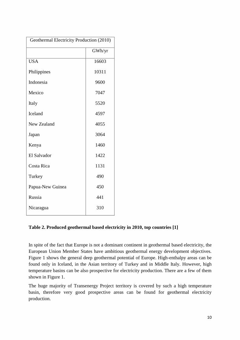
Figure 3 provides The number of thermal wells according to VITUKI is 1461.
Number of production wells: 971
Agricultural purpose: 240
Industrial purpose: 69
Multifunction purpose: 87
The temperature distribution of the wells is provided by Table 5. The temperature in more
than 100 of these wells are appropriate for supplying a district heating system.
Temp.
of the
thermal
water
30-40 oC
40-50
oC
50-60 oC
60-70 oC
70-80 oC
80-90 oC
90-100 oC
>100 oC
Total
Number
of wells 642 337 168 133 68 52 57 4 1461
Table 5. Temperature distribution of thermal water wells (Source: VITUKI)
Tasks and opportunities in short, middle and long term [3]
There are a lot of tasks and opportunities emerged related to the Hungarian geothermal energy
sector.
Operation of the old and anachronistic technologies. With regards to the age of the
domestic operating system, large cost and expertise is necessary for the maintenance.
It is not regular in the domestic practice. Raisinglevel of the maintenance technologies
is needed for Hungary to remainamong the top ten of the world in direct heat supply.
In spite of the financial crisis the geothermal energy production has to be installed on a
development spiral. It is not only an economic question. The development needs
educational and scientific activity as well.
The geothermal energy has to be placed on its reasonable rank in all energy strategies
and plans. All decision making level has to know that Hungary is very rich in
geothermal energy, one of the richest of the World except foractive volcanic areas.
During the latest two years the Hungarian National Renewable Energy Action Plan (NREAP)
[6] and the Energy Strategy till 2030 were issued. The two documents show the direction for
the Hungarian geothermal energy.

17
In the middle term the NREAP shows the direction. The Action Plan is qualified ambitious
both in international and in domestic evaluations. However, based on the excellent geothermal
potential, the Plan can be regarded as a technologically realistic estimation.
2010 2020 Growth (2020/2010)
Heat pumps, heat
service/year
0,250
PJ
5,99 PJ 5,740 PJ 23,96
Ground source heat pumps,
heat service/year
0,208
PJ
4,48 PJ 4,272 PJ 21,54
Direct heat supply with
thermal water production.
Heat service/year.
4,23 PJ 16,43 PJ 12,2 PJ 3,88
Geothermal based electricity
production, power
0 MW 57 MW 57 MW -
Geothermal based electricity
production, electric energy
0 GWh 410
GWh
410 GWh -
Table 6: Growth of the three main segments of the
Hungariangeothermal energy production [6]
The long term development will be chiefly determined by the new technologies of the 2010s.
Proposed middle and long term development directions [3]
The Hungarian economy is an integral part of the European economy; therefore the
geothermal energy production sector has to move in the mainstream of the abovementioned
European directions. However, the traditions and geological specific features of Hungary
mustbe taken into consideration.
The traditions of the up-to-date international geothermal projects include a geological
exploration phase before the preparation of the pre-feasibility study. In Hungary the
geothermal energy sector emerged from water supplying, spa and also from
hydrocarbon exploration and production sectors. Therefore the geothermal energy –
that is a heat mining sector - is often regarded as water management question or
branch of the hydrocarbon exploration and production sector. In the middle term
geothermal energy project establishment and operation has to be based on professional
regional and local geothermal exploration data.Transenergy is exactly a project that
provides these data.

18
In the middle termthe reliable reinjection technology into sandstone reservoirs must be
created, as well as in the long term must be employed. In the long term geothermal
technologies will not be acceptable in Europe without reinjection. European Union
based supports cannot be received for anachronistic technologies as well as the more
and more rigorous environmental regulations.They also force the projects into the
direction of sustainable technologies.The long term domestic geothermal vision can’t
be based on unsustainable technologies. Therefore reinjection has to be a key question
in domestic technical and financing concepts. In the international co-operation
Hungary has to develop connections with countries where the reinjection into
sandstone reservoir is also a key question (the neighbors, Germany and France).
Geothermal energy projects cannot finance exploration well or wells. Therefore during
the exploration phase it is necessary to collect the most information that supports the
right technical and financing decisions. A part of the supporting resources of the State
is needed to spend for regional data collection and creation of up-to-date technologies.
Transenergy can provide data for decision making processes as well.
After the minimizing of geological risks the competitiveness of geothermal projects
shows significant improvement. We can achieve more social value if a part of state
support would be spentfor domestic risk insurance funds instead of single project
support.
The domestic geothermal potential is significant among the European Union Member
States.Geothermal energy as a product is at the early phase of its lifecycle.
It is necessary to develop all the three geothermal segments both on European and national
level. However, the excellent potential can be exploited if the reliable reinjection technology
is developed into sandstone reservoirs in the 2010s. In the middle term the solution of
reinjection is the most important question of the Hungarian geothermal energy sector. A state
supported decade-long professional program is needed in order to solve this key technological
issue.
The future development of the geothermal energy sector is depends on the following issues:
Research&Development; Innovation
Regulations
Macroeconomic background
EU and Government subsidies
Existence of all market actors.
The development of Hungarian geothermal power generation concepts is at an early stage.
19
4. Description of the venue of the Project
Location, topography of Hungary
Hungary lies in the middle of the Carpathian basin, on a relatively flat surface mainly
surrounded by mountains. The total land area is 93,033 km2. The terrain is characterised by
limited relief (minor differences in elevation), the highest point being 1014 m above sea level,
while the lowest at 75.5 m. The majority of the land is lowland, with 84% of the total area
lying below 200 m above sea level. The two major rivers, the Danube and Tisza divide the
country into three large regions. Out of the total 9.3 million hectares of the total area of
Hungary, 7.7 million hectares are productive land (including forests, fish ponds etc.), 5.9
million hectares of which are agricultural land – a share which is uncommonly high in
Europe. Of this, 77% is arable land and 18% is grassland. Kitchen gardens, orchards and
vineyards account for 5% of the agricultural land area.
Geothermal settings
The geothermal features of the Carpathian Basin are very favourable. The Earth’s crust is
thinner and the average heat flow value is approximately 90-100 mW/m2, roughly twice the
continental average. Hungary’s geothermal resource potential is mainly associated with the
Pannonian Basin.
The geothermal gradient in the country is approximately 50-63 oC/1000 m.
Geothermal water (> 30 °C) in Hungary can be found in over 75% of the country’s territory.
Geographical conditions
The area of Zala is a hillymicro-region bordered by the valleys of the streams of Felsőzala,
Kerka, and Válicka. Its surface is highly fragmented. This terrain is Pannonianbased hilly
ground covered with glacial adobe, where the highest points are in the north and south
bounds. The average height is around 240 m. In the south and south-western direction the
terrain is fragmented by surfaceerosionvalleys,as well as by a dense networkof parallelranges
ofhills and narrowasymmetric slopes of valleys. In the south and south-western region
thehillsare of milderforms ofrelief, and the less fragmented valleys are covered with
thickgrittyadobe debris.
Surface water
The surface waters of Göcsej flow into the river Zala and Lake Balaton, or through the river
Kerka into the river Mura, but finally all the surface waters in this area end up in the river
Danube. The main rivers catchment areas are not located in this region but the smaller rivers
drainage water is collected here. The network of surface waters and valleys in this area is the
densest in the country. The present surface has developed from the complicated geological
processes ofthe past 2.5 million years. There is a close correlation between the dense network
of valleys and the Pleistocene surface increase, i.e. the current altitude.

20
The amount of the surface run-off from precipitation is considered the most favourable and
one of the largest in the country. The high runoff conditions are mainly due to the topography.
The quantity of water in the creeks and rivers, however, varies from month to month.
The resulting height of floods and the melting rate depend on the depth of the snow. The
faster the thawing and the deeper the snow, the higher the resulting floods are. There are
significant differences between the spring and summer floods. The surface are of flood plain
is 37 km2, 2 km
2 of which belong to inner areas.
9 km2 of arable land, 24 km
2 of meadows and pastures, and 2 km
2 forest areas are at risk.
Groundwater
Groundwater can be found below the surface above the first impermeable layer (clay or silt).
Under the groundwater the so called deep water is located, which appears in several zones as
layered water between two impermeable layers. A characteristic feature of this type of water
is that the temperature increases with the depth. Each water level provides a different amount
of water. The water bearing capacity of the layers fluctuates between 20 and 150 l/p/m. In this
region a positive pressure condition of waters at a height of up to 400 m frequently occurs.
This fact indicates that the waters on higher locations are under the hydrostatic pressure of the
eastern foreground of the Alps.
Thermal water with a temperature of above 60 oC occurs in the Upper Pannonian layers. Oil
research has resulted in a higher number of thermal wells than in other parts of the country.
The chemical composition is mainly dominated by Na and Cl. According to current
knowledge, it is likely to be remnants from the age of the Pannonian Sea. Presently, there are
approximately 0 – 40 sealed wells, part of which would be worth utilizing for tourism or other
(heating) purposes.
Climate
It is a moderately cool small region with 9.5 °C annual mean temperature, while the average
temperature of the vegetation period is around 16.0 -16.2 °C. The annual number of sunny
hours is between 1880 and 1920. As regards rainfall, it is a moderately wet area, however, the
southern areas are on the border of the wet zone. The average annual rainfall amounts 740 to
770 mm. The direction of the wind is mostly determined by the slopes of valleys, and winds
from the north are dominant on the higher areas.

21
Figure 3: Heat distribution map of 2000 m depth underground
(Source: Dövényi et all., 2001)
As it is shown in Figure 3, Western Hungary is among the less prospective regions of
Hungary. However, the geothermal gradient achieves the European average and profitable
geothermal project can be planned even this region.
Figure 4: Regional view with 2 pumping and 2 injection wells

22
Figure 5: Areal view with 2 pumping and 2 injection wells
ZA-INJ-01
ZA-INJ-02
ZA-PUM-01
ZA-PUM-02
23
5. Geological description
The proposed boreholes are located in the Eastern–South-Eastern direction from the Lenti
Basin—which has a Palaeozoic basement—near the settlements Csömödér and Kissziget, on
the Western side of the Ortaháza Horst revealed by seismic profiled and then by exploratory
boreholes as well.
5.1 Geological frame
The geological basement of the target area belongs to the Transdanubian Range Unit of the
ALCAPA nappe system.
5.1.1 Quaternary
The Quaternary deposits of the target area have the thickness between 80 and 100 metres and
composed by dominantly fluvial deposits (fine-grained sand, gravel, silt, clay). The upper
several decametres thick zone is characteristically built up by fine-grained clasts (silt, clay)
while the lower parts are mainly consist of a sequence of sand, silt and clay layers of variable
thickness.
5.1.2 Tertiary
Pannonian
Dunántúl Group
The sedimentary sequence consist of thin strata composed by fine-grained sand, loose
sandstone, greyish silt and marly silt, with embedded clay, variegated clay, coaly clay, lignite
and gravel layers.
Upper Pannonian Formations
The upper parts of the sedimentary sequence consist of the cycles of fluvial or lacustrine
sandy clays and sands with embedded thin layers of lignite and tuff. This unit is also known
as the Hanság Formation.
The middle part is known as the Zagyva Formation which is composed by the alternating
sequence of grey silt, clay, clay marl, medium- and fine-grained sand and loose sandstone.
The lower part consists of the alternating sequence of grey silt, laminated silt, marly silt, and
1–2 m thick grey fine-grained loose sandstone (Újfalu Formation).
The expected thickness of the Upper Pannonian sequence in the area of the proposed
boreholes is between 1200 and 1400 m.

24
Lower Pannonian Formations
In the target area the Lower Pannonian the Algyő Formation consists of lacustrine sediments
deposited in a slope environment (grey clay marl, silt with thin embedded sandstone layers).
The Algyő formation is underlain by the turbidites of the Szolnok Formation, which comprise
sandstone bodies embedded in pelite. The thickness of sandstone layers is between 5 to 10
meters. Below the Szolnok Formation lies the sequence of the lacustrine Endrőd Marl
Formation consisting of pelites such as deep grey clay marls and marls, which has the
thickness of several decametres.
The thickness of the Lower Pannonian sequence is between 1000 and 1200 m.
One may note that in the area of the elevated Ortaháza Horst the deposits Endrőd Marl
Formation are not found. This formation is characteristic in the marginal and inner areas of
deep basins. The proposed boreholes are located on the Eastern–South-Eastern flank of this
elevated horst, and therefore the occurrence of the rocks of the Endrőd Formation in the new
boreholes is likely. This is proven by the borehole Ortaháza-NY-1 in which the Endrőd
Formation is found.
Miocene
The Miocene deposits have been found in the boreholes drilled for hydrocarbon exploration,
as well as the Pannonian formations. The boreholes penetrated Sarmatian and Badenian
deposits of various facies, thickness and extent. The Miocene formations—having thickness
of up to 100 metres—comprise coarse-grained clastic and carbonate layers with discordant
bedding over their base.
Sarmatian
The Sarmatianconsists of layers of neritic-nearshore light grey loose sandstone, pebbly
sandstone, conglomerate, calcareous sandstone and yellowish limestone (TinnyeFormation)
with the thickness up to 50 m. The sequence often starts with basal conglomerate.
Badenian
The boreholesin this area penetrated greyish neritic Lithothamnium limestone, sandy
limestone, sandstone, breccia and conglomerate with thickness up to 40 m (Rákos Limestone
Formation). The Rákos Formation is underlain by a sequence of deep grey siltstone andclay
marl (Szilágy Marl Formation) which is expected to be found in the proposed abstraction
wells (which will be deeper than the injection wells). The Szilágy Marl may be interfingered
with the deposits of the Rákos Limestone Formation eastwards or north-eastwards, towards
the elevated horst of the basement.
Paleogenic Formations
In the middle zone of the elevated Ortaháza Horst boreholes drilled for the purpose of
hydrocarbon exploration penetrated 50 metres thick Upper Eocene light grey nummulitic

25
limestone (Szőc Limestone Formation). The occurrence of this formation cannot be excluded
in our target area.
Mesozoic formations
Mesozoic formations are found in the base of the Cenozoic formations. In the target area
sequences of Middle Triassic neritic dolomite and limestone as well as Lower Triassic
carbonate and siliciclasticdeposits are overlain by Cenozoic formations having thickness
between 2100 and 2800 metres. The Mesozoic basement is expected to be found between
2700 and 2800 m in the proposed abstraction wells, and between 2100 and 2250 m in the
proposed injection wells.
Middle Triassic Formations
Near the proposed injection wells ZA-INJ-01and ZA-INJ-02, on the eastern flank of the
elevated Ortháza Horst, the borehole Or-1 penetrated 180 m thick Anisian grey crystalline
limestone. This is the target formation of the present geothermal study which is expected to be
found also in the proposed abstraction wells, however at greater depth.
Lower Triassic Formations
The borehole Or-NY-1 penetrated 291 m thick Lower Triassic deposits at the depth of 3679
m, below Upper Eocene pelitie, carbonate and tuff. The upper zone of the sequence comprise
mainly carbonates, authigenic breccias, while the lower part is composed by pelites and
shales: anhydritic siltstone, dolomitic marl, chloritic quartzite, shaley clay and clay shale.
5.2 Geophysical data
The target area is relatively well covered by 2D seismic profiles. However, we positively
recommend two new seismic profiles: one across the proposed boreholes ZA-PUM-01 and
ZA-INJ-01, and another one across the proposed boreholes ZA-PUM-02 and ZA-INJ-02.
5.3 Tectonics
The elevated Ortaháza Horst and its surroundings is a complex thrust zone. The compressive
tectonic displacements are proven by the results of past hydrocarbon explorations in the
Ortaháza, Budafa and Lovászi areas. In the middle of the elevated Ortaháza Horst a second
order thrust zone is found in formations older than Neogene. Here, the northern Triassic block
is thrusted over the Eocene formations of the southern block. Near the ridge fault traces are
found by seismic surveys perpendicular to the strike of the ridge, which were verified also in
boreholes.
These cross-faults are expected to be found in the target area as well.
5.4 Geological risks
The major risk associated with the proposed boreholes is the degree of karstification and/or
fracturing, since this provides the permeability of the Triassic formations and, it has an
outstanding importance with respect to thermal water abstraction and re-injection.

26
6 Hydrogeological description
6.1 Overview of the major hydrostratigraphic units
The hydrostratigraphic units are composite units which encompass different geological
formations with the same hydrogeological properties.
The pre-Cenozoic basement comprises Paleozoic metamorphic rocks and Mesozoic
sedimentary formations with various lithological features. The Paleozoic formations have best
permeability at their weathered upper parts, or related to larger fault zones. TheMesozoic
consists of the Triassic karstified carbonate rocks (dolomite and limestone) in a large extent.
Below the basement surface a 50 or 100 m thick model layer would be used to represent
theweathered and karstified zone, which has better permeability than the underlying
unalteredrocks [13].
The pre-Cenozoic basement is overlain by the Miocene, Pliocene and Quaternary sedimentary
sequences. From bottom up the main hydrostratigraphic units are: the Miocene and lower
most Pannonian sandstone formations, the Szolnok Formation (Lower Pannonian) turbiditic
sands and the ÚjfaluFormation (Upper Pannonian) delta-front to delta-plainsediments. The
delta-front sands are the major geothermal aquifers in the region. The Újfalu Formation is
overlain by the Zagyva Formation delta-plain sands, silts and coal-bearing clays. The
uppermost Quaternary sequence with good hydraulic conductivity represents the shallowest
aquifer [13].
6.2 Hydraulic conditions
The hydrodynamic system can be represented by the variation of the static pressure with
depth. The static pressure is calculated for each well in the region where static head value was
observed using the following equation:
where Hstat is the static head [m asl], Zsc is the average elevation of the screened interval [m
asl], ρw is the density of water [kg/m3], g is the acceleration due to gravity [=9.80665 m
2/s].
We used 1000 kg/m3 for the value of the density of the water since there were no data
available for either the density of the water or the temperature profile in the wells.
The pressure distribution with respect to depth is shown on Figure 6. One can see that down
to the depth of 1400 m the pressure vs. depth graph is nearly hydrostatic. The maximum depth
is probably related to the Újfalu Formation (Upper Pannonian). However, there were no
pressure data available for older formations.
27
Figure 6: Static pressure vs depth
6.3 Geothermal conditions
Geothermal conditions are represented by the spatial distribution of the groundwater
temperature at several depths, the geothermal gradient and the surface heat flow density (heat
flux).
The spatial distribution of the temperature on the surface of the pre-Cenozoic basement is
shown on Figure 7 as extracted from the TRANSENERGY database [16]. The expected
groundwater temperature for the proposed pumping wells is about 160 °C, while for the
injection wells is about 145 °C.

28
Figure 7: The spatial distribution of the temperature on the surface of the pre-Cenozoic
basement (source: TRANSENERGY database [16])
The geothermal gradient values are varying with depth and derived using the values published
in [14]: 500 m: 49.8 °C/km; 1000 m: 47.4 °C/km; 2000 m: 45.6 °C/km; 4000 m: 42.4°C/km.
The gradient values slightly decrease with depth because of the higher heat conductivity
values of the older rock formations.
The heat-flux map of the project area and its surroundings is shown on Figure 8, after Horváth
et al. [15]. The heat-flow density value for the project area is about 90 mW/m2 which is close
to the average value valid for the Pannonian Basin.

29
Figure 8: Heat flux map (mW/m²) of the project area and its surroundings
(after Horváth et al. [15])
6.4 Hydrochemical conditions
The hydrogeochemical conditions of the major hydrostratigraphic units can be summarized
using the results of the T-JAM project [17]:
The Zagyva and Somló&Tihany Formations probably form an active regional groundwater
flow system, which recharges in the north lying Goričko hills in Slovenia. The flow direction
is assumed to be from Slovenia to Hungary. This groundwater has a lowtotal dissolved solids
(TDS) content and a high cation ratio. Nitrogen is the main dissolved gas in the Zagyva and
Somló&-Tihany Formations.
The Újfalu Formation is also a part of the active regional groundwater flow system, probably
hydraulically separated from the shallower one. This groundwater has higher TDS values, but
they have lower cation ratio compared to the previous group. They are enriched locally in
carbon dioxide or methane, but mostly air is dissolved in the groundwater.
The Szolnok Formation contains groundwater which is probably not a part of the active
regional groundwater flow system. The water is probably stagnant and isolated from the
surroundings. Due to this fact it has a high TDS content.
The Lower and Middle Miocene Formations aquifers are most likely of a very limited extent
or isolated from their surroundings, and they have a high TDS content.
Very scarce data is available from the Mesozoic aquifers in the project area. Due to the
samples collected slightly mineralized water with a combination of multiple ions is observed.

30
The TDS content of the major hydrostratigraphic units are shown on Figure 9 (source: [17]).
It can be seen that thedissolved solid content increases with formation age, with the highest
values in the Lower Pannonian and Miocene siliciclastic formations (above 10,000 mg/l). In
the Mesozoic carbonate aquifers lower TDS contents can again be measured.
Figure 9: TDS content distribution in groundwater in eleven Hungarian Formations
(after [17])
6.5 Hydrogeological parameters
The detailed values of numerous hydrogeological parameters of the different Quaternary,
Tertiary and Mesozoic hydrostratigraphic units in Hungary are given in Table 7.The data is
summarized from [13].

31
Table 7: Hydrogeological properties of the major hydrostratigraphic units
Geological units
Hydrogeological and geothermal properties
Aquifer type Hydraulic and storage parameters Transport
parameters
Geotherm
al
paramete
rs
Formation
age Formations
intergranular
(P), fissured
(F),
dualporosity
(DP), karst (K),
aquifer (AF),
aquitard (AT),
aquiclude
(AC),
unsaturated
zone (UZ)
Trans-
missivity
(m2/d)
unconfin
ed zone
Transmissiv
ity
(m2/d)
confined
weathered
or karst
zone
Hydraulic
conductivi
ty
(m/d)
confined,
freshzone
Tran-
smissivity
(m2/d)
confined
porouszone
Anisotropy
coefficient
(Kh/Kv)
Porosit
y
Specific
storage
(1/m)
Effecti
ve
porosit
y
Longitudi
nal
dispersivit
y
(m)
Thermal
conductivi
ty
(W/m/K)
Holocene Water-laid
sediments
P; AF-AT; UZ 10-2000 * * * 10 0.1-0.3 * 0.15 50-100-
150
1.5-1.8
Pleistocene
Fluvial basinal
sedimen
tcomplex, (upper)
P; AF-AT 100-2500 * * 100-2500 200-500-
1000
* 1.00E-04 0.15 50-100-
150
1.5-2.0
Fluvial basinal
sediment
complex, (lower)
P; AF-AT 100-2500 * * 100-2500 200-500-
1000
* 1.0E-3-
1.0E-4
0.15 50-100-
150
1.5-2.0

32
Upper
Pannonian
Zagyvai Fm.,
fluvial
P; AF-AT 5-50 * * 100-500-
(1000)
2000-5000 0.1-0.2 1.0E-4-
1.0E-5
0.1 50-100-
150
1.5-2.1
Somló-Tihany Fm P; AF-AT 5-50 * * 100-500-
(1000)
2000-5000 0.1-0.2 1.0E-5-
1.0E-6
0.1 50-100-
150
1.5-2.1
Újfalu Fm., delta
plain
P; AF-AT 5-50 * * 100-500 2000-5000 * 1.0E-5-
1.0E-6
0.1 50-100-
150
1.5-2.1
Újfalu Fm., delta
front sand,
sandstone
P; AF-AT * * * 50-500 2000-5000 * 1.0E-5-
1.0E-6
0.1 50-100-
150
1.5-2.1
Lower
Pannonian
Algyő ClayFm P; AT-AC * * * 0.01-0.1 2000-5000 * 1.0E-5-
1.0E-6
0.05 50-100-
150
1.5-2.1
Szolnok
Sandstone Fm
(Turbidite
sandstone)
P; AF-AT * * * 0.5-20 2000-5000 * 1.0E-5-
1.0E-6
0.1 50-100-
150
1.5-2.1
Endrod Marl Fm P; AT-AC * * * 0.01-0.1 2000-5000 * 1.0E-5-
1.0E-6
0.05 50-100-
150
1.5-2.1
Sarmatian
Kozárd Fm P; AT-AC 0.5-5 * * 0.01-1 2000-5000 0.05-
0.15
1.0E-5-
1.0E-6
0.05 50-100-
150
1.5-2.1
Tinnye Fm P; DP; K; AF-
AT
50-1000 50-1000 0.05-0.1 * 10-100 1.0E-3-
1.0E-4
0.03-
0.1
50-100-
150
2.2

33
Table 7 (continued): Hydrogeological properties of the major hydrostratigraphic units
Geological units
Hydrogeological and geothermal properties
Aquifer type Hydraulic and storage parameters Transport
parameters
Geother
mal
paramet
ers
Formation
age Formations
intergranular
(P), fissured
(F), dual
porosity
(DP), karst
(K), aquifer
(AF),
aquitard
(AT),
aquiclude
(AC),
unsaturated
zone (UZ)
Transmissi
vity
(m2/d)
unconfine
d zone
Transmissi
vity
(m2/d)
confined
weathered
or karst
zone
Hydrauli
c
conducti
vity
(m/d)
confined
, fresh
zone
Transmissi
vity
(m2/d)
confined
porouszon
e
Anisotr
opy
coeffici
ent
(Kh
/Kv)
Poros
ity
Specific
storage
(1/m)
Effecti
ve
porosit
y
Longitud
inal
dispersiv
ity
(m)
Thermal
conducti
vity
(W/m/K)
Badenian
Rákos-Lajta
Limestone Fm
DP; K; AF-
AT
* 50-1000 0.05-0.1 * 10-100 * 1.0E-3-
1.0E-4
0.03-
0.1
50-100-
150
2.2
Szilágy Clayey-
marl Fm.
P; AT-AC * 0.5-5 * 0.01-1 2000-
5000
* 1.0E-5-
1.0E-6
0.05 50-100-
150
1.5-2.1

34
Karpatian-
Badenian
Tekeres Shlier Fm P; AT-AC * 0.5-5 * 0.01-1 2000-
5000
* 1.0E-5-
1.0E-6
0.05 50-100-
150
1.5-2.1
Oligocene Csatka Gravel Fm P; DP; AF-
AT-AC
50-1000 * 50-1000 500 * 1.0E-4-
1.0E-5
0.1 50-100-
150
1.5-2.1
Eocene Szőc Limestone
Fm.
K; AF 100-2000 100-2000 0.05-0.1 * 10 * 1.0E-4-
1.0E-5
0.01-
0.03
50-100-
150
2.4
Upper
Triassic-
Jurassic
Dachstein
Limestone Fm.-
Kardosrét
Limestone Fm.
K; (F); AF 100-2000 0.05-0.1 * 10 * 1.0E-4-
1.0E-5
0.01-
0.03
50-100-
150
2.4
Upper-
middle
Triassic
Kössen Marl Fm. P; DP; AT-
AC
0.5-5 0.5-5 * 100 * 1.0E-5-
1.0E-6
0.01 50-100-
150
Main dolomite
(Hauptdolomite)
Fm
K; F; AF 100-2000 100-2000 0.05-0.1 * 10 * 1.0E-4-
1.0E-5
0.01-
0.03
50-100-
150
3.8
Veszprem Marl,
Sandorhegy
Limestone Fms.
P; DP; AT-
AC
0.5-5 0.5-5 0.001-
0.005
* 100 * 1.0E-5-
1.0E-6
0.01-
0.03
50-100-
150
2.2
Lower
Triassic
Csopak Marl Fm. P; DP; AT-
AC
0.5-5 0.5-5 0.001-
0.005
* 100 * 1.0E-5-
1.0E-6
0.01-
0.03
50-100-
150
2.2
Buzsák Fm. P; DP; AT-
AC
* 0.5-5 0.001-
0.005
* 100 * 1.0E-5-
1.0E-6
0.01-
0.03
50-100-
150
2.2

35
The uppermost Quaternary sediments of the main river valleys have the highest transmissivity
(conductivity as well). The value for transmissivity varies between 100 and 2500 m2/d. The
porosity is also high and varies from 0.1 to 0.35 meanwhile the effective porosity is around
0.15. The porosity, transmissivity, hydraulic conductivity and anisotropy of the Tertiary rocks
and sediments usually decrease with age which is more or less proportional to the burial
depth. In the Zagyva Formation transmissivity is between 100 and 500 m2/d and porosity
varies from 0.1 to 0.2 (effective porosity around 0.1). In the sandstones of the Újfalu
Formation the transmissivity is between 50 and 500 m2/d and the effective porosity around
0.1. In the underlying Szolnok formation the transmissivity is between 0.5and 20 m2/d while
the effective porosity is around 0.1. The Cretaceous and Triassic carbonate rocks arekarstified
with their transmissivity between 100-2000 m2/d. Although the hydraulic conductivity is
usually low for the fractured Mesozoic rocks, it can locally reach higher values because of
their weathered mantle, fissures and faults.
6.6 Risks associated with geothermal exploration
For the utilization of thermal waters the target formation in the project area is the Mesozoic
karstified carbonate (limestone or dolomite) formation. The upper 50 to 100 m thick zone
(mantle) has probably high permeability (several orders of magnitude higher than the
unaltered sound rock). However no direct field data is available from the project area for the
permeability and other hydrogeological (petrophysical) properties of the target formation.
Employing the values given in Table for the transmissivity of the Triassic carbonates (100 to
2000 m2/d), the expected minimum and maximum well yield may vary with a factor of 20.
The mantle of the Triassic carbonates may be very thin and, therefore, extra care is needed
during the drilling works in order to properly find it and install appropriate screens.

36
7 Exploration and energy concept
Before the selection of the appropriate geothermal area a regional and areal analysis is
required. A complete database is needed to make a professional analysis. In this case
Transenergy Project ensured the necessary database.
On regional level Zala county was selected. In this region the geological parameters show
appropriate reservoirs to supply a geothermal power plant.
A desktop study was carried out of areas selected on the basis of the regional data, as it is
presented in Chapter 5 and 6.
7.1 Set up an Exploration concept
7.1.1 The necessary information
o Well data
o Location coordinates, elevations and total depth
o Temperatures
o Pressures
o Hydraulic testing results
o Mud loss data
o Water chemistry
o Stratigraphy
o Lithological logs
o Geophysical logs
o Additional well data as needed
o Seismic data
o Survey dates and collection parameters.
o Shot-point coordinates
o Selected raw 2D data from lines within the Fábiánsebestyén project area
o Selected processed SEG-Y data from the above lines.
o Selected velocity data.
o Digital stratigraphic and fault picks
o Magneto-telluric data
o All maps from the reports.
o Any raw or interpreted data, preferably in digital format.
o Stress analyses maps, publications, reports and data.
o Digital maps
o Topography (elevations, roads, rivers, villages & protected areas).
o Top of Triassic isoline with structure information.

37
o Top of Crystalline Basement isoline with structure information.
7.1.2 Carry out a desktop concept of areas selected on the basis of the country-
level study
a. Compile database
b. Prepare base maps (incl. regional geology and geophysics, seismic lines and
wells)
c. Select and prepare well data for use in calibration of seismic data
i. Formation tops, lithology, feed points and selected reservoir
temperature, pressure and flow data if available
d. Interpret 2D seismic
i. Establish seismic stratigraphic framework by tying in well information
ii. Map enough reflectors to gain adequate insight into stratigraphy,
structure and tectonic development. Map a near-top-reservoir reflector
in detail
iii. Interpret lithology, structures and tectonic movements with focus on the
reservoir level
e. Integrate other relevant information such as fluid chemistry, hydrology,
formation pressure, well logs, well tests, etc. as needed
f. Describe the geothermal potential of the region and the exact nature of the
promising geothermal play (or plays).
g. Identify, describe and prioritize the geothermal prospects within the selected
area.
h. Estimate the play risk, i.e. risk of the conceptual model for an exploitable
resource failing the test of drilling.
7.1.3 Complete the concept of the selected prospect that was carried out as part of the
desktop study on the basis of available data.
7.1.4 Estimate prospect risk, i.e. the risk of the chosen prospect not being an
exploitable geothermal system.
7.1.5 Define what would constitute an adequate drilling success in terms of the
temperature,flow rate and fluid chemistry of the well. This definition must be
based on the requirements of a financial model for development of the
prospect.

38
7.1.6 Identify and describe exactly the drilling target (inferred fluid conductor)
within the prospect. The description should be specific enough to allow
verification (through logging, cuttings analysis, VSP-surveys, etc.) of
whether the target has been hit during drilling.
7.1.7 Develop a drilling strategy for the prospect by
i. Constructing an optimal well path
j. Identifying suitable drilling pad
k. Identifying potential drilling problems arising from subsurface conditions
l. Identifying suitable rig and drilling technology
m. Writing a well forecast, i.e. detailed prediction of strata and subsurface
conditions expected to be encountered during drilling. The forecast should be
specific and detailed enough to allow it to be compared with the actual
conditions encountered and updated as drilling progresses.
n. Developing a drilling contingency plan, in which possible responses to
unexpected situations/deviations form well forecast are described
o. Estimate drilling risk, i.e. the risk of the drill bit not intersecting the target in
the specified manner at a cost within the drilling budget specified by the
financial model for prospect development.
7.1.8 Utilization of Existing Hydrocarbon Wells
8000 hydrocarbon wells were drilled in the latest 80 years. More than 60% of them are
abandoned and numerous have good geothermal potential.
In the latest years exploration projects determined several advantages and constraints
of the utilization of existing wells.
Disadvantages
Not optimal location for geothermal purposes
Generally small diameter
Often old wells with incomplete documentation
Cement column is often not appropriate
No temperature insulation
Prospective wells are far from heat markets.
Advantages
Lower well cost for each existing well
Often existing infrastructure
Existing core samples
Well files; information

39
7.2 Alternatives
The Hungarian National Renewable Energy Action Plan aims at 57 MWe geothermal power
plant capacity by 2020.
Table includes a power plant portfolio of this 57 MWe.
Plant model,
MWel
Depth in
Pannonian
Basin (m)
Thermal
water
temperature
range (oC)
Average
electric
power
(MWel)
Estimated
installed
power plant
Total power
(MWel)
5 - 12 > 4000 160 - 200 7 3 21
2 - 5 3000 – 4000 120 - 160 3 8 24
max. 2 < 3000 < 120 1.0 12 12
Total 2.7 21 57
Table 8 : Geothermal power plant opportunities and a project portfolio
Depending on the depth and regional geothermal potential, there are four main opportunities
to construct geothermal power plants in Hungary as below
1. Micro Power Plant Projects (<1 MWe) in deeper zones of sandstone reservoirs
Depth: 2-2.5 km,
Temperature range: 110/80oC
Further direct heat utilization from the plant outlet thermal water: 80/40oC range
Yield range: 30- 60 kg/s.
2. Small Scale Power Plant Projects (1-3 MWe) in fractured carbonate reservoirs
Depth: 2.5-3.5 km
40
Temperature range: 150/80oC
Further direct heat utilization from the plant outlet thermal water: 80/40oC range
Yield range: 60 -100 kg/s
3. EGS Power Plant (2-5 MWe) in stimulated fractured carbonate reservoirs
Depth: 2.5 – 4.5 km
Temperature range: 160/80oC
Yield range: 60- 100 kg/s
4. EGS Power Plant (5-12 MWe)
Reservoir is created by hydrofracking the basement under the Pannonian sediments.
Depth: 4 – 5.5 km
Temperature range: 200/90oC
Yield range: 80 – 120 kg/s
7.3 Selection from alternatives
Initial decisions
During the creation of the geological concept at the beginning of the project, the project team
made some significant decisions, based on theissues of geology, technical feasibility and
environmental legislation.
There would be100% reinjection of the produced thermal water into the same formation,
not only because of the environmental regulations but also because of technological
causes.
The project would focus on fractured karstic reservoirs, instead of sediments.It provides
better conditions for re-injecting.
Risk optimisation instead of temperature dominance, to increase the feasibility.
Concept of geology
Pannon sediments are not hot enough.

41
Thermal water production from upper Triassic, reinjection to middle Triassic formation
can be appropriate in Csömödér area.
The production and reinjection relates to the same fractured system.
East from Lake Csömödér at 2700 m depth 150oC temperature can be achieved.
Technology
Two production and two reinjection wells.
Surface technology, small scale binary type power plant block and connection to the
electric grid and to the heat consumers.
2 MWeelectric power is realistic.
The outlet water temperature is still 75oC and appropriate for supplying 7,5 MWth heat.
Energy
2 MWe electric power and 7.5 MWth thermal heat needs two times 30 kg/s flow rate and
150 oC well head temperature.
7.4.Conceptual energy calculations of the planned power plant
Reservoir temperature 155 oC
Temperature drop in production well (with high flow velocity) 5 oC
Well-head temperature, entering the power plant: 150oC
Thermal water temperature at outlet of the power plant: 75oC
Thermal water mass rate (including both production wells): 60 kg/s
With regards to the high temperature of the thermal water, its density is: 920 kg/m3
Planned energy efficiency of the power plant: 13%
Brut capacity of the power plant: 2450 kWe
Parasitic power (own electricity consumption of the whole system): 450 kWe
Net capacity of the power plant: 2000 kWe.
The outlet temperature is 75oC. The heat of the thermal water can be utilized.
Its heat capacity is: 7,500 kWth.
42
8. Environmental impacts
Geothermal energy has several significant characteristicsthat make it suitable for climate
change mitigation. These include:
global-wide distribution;
indigenous resource;
production independent of season;
immune from weathereffects and climate change impacts;
effective for on and offgrid developments and for provision of base-load power.
Environmentally sound technology
Geothermal developments have relatively minor environmental impact.
Small footprint for surface
Indeed, relative to other energyoptions there are distinct advantages, such as a relativelysmall
footprint for surface facilities (power plant, pipelines etc), of average 0.35 km2/100 MWe.
Minor pollution
Nevertheless, thedisposal of waste water containing small quantities ofchemicals (boron,
mercury and arsenic) and gases (H2S andCO2) is an important issue, and various methods are
usedfor dealing with it, including: total reinjection of separatedwater, condensate and gases;
chemical treatment and mineral extraction.
Natural CO2 emissions from hightemperature systems, when exhausted from steam
turbines,are typically less than 10% of those emitted by burning coalin an equivalent power
plant (averaging 100 g/kWh), whilethose from low temperature resources are negligible (0 –
1g/kWh). Most binary systems, district heating, EGS andCHP schemes typically operate by
keeping fluids in aclosed-loop, hence have zero operating emissions.
Impacts and hazards on the surrounding
Any geothermal activity needs to deal with the significantimpacts on the surrounding
physical, biological and socioeconomicenvironment. The major concerns are listed below.
Reservoirpressure decrease.It occurs mainly in the sandstone aquifers. Somefields have
been exploited more than seventy years, thus thepiesometric head of the reservoir has
subsided between 10 – 70 m. The supply of thecarbonate aquifers Hungary seems to
beunexhausted.
Induced seismicity (earthquakes) has become anenvironmental and social issue at some
EGS projects.However, an international protocol has been developed fordealing with it
(Majer et al., 2008). To date, although smallearthquakes are sometimes felt, induced
seismicity hascaused no significant damage to buildings and structures.

43
Land subsidence from pressure decline has occurred and caused concern at a few high
temperature developments,however, monitoring identifies potential effects which
canusually be remedied, and targeted injection is sometimesused to minimize it.
Pollution of groundwaters and thewaterways on the surface with thermal effects, as well
as emission ofdissolved gases. It occurs only if the reinjection is not solved and the loop is
not closed.
Noise. The power plant machinery is ilstalled in a house, therefore the noise emission is
minimal.
Freshwater aquifers are located above the geothermalreservoirs. Thus the drilling
operations can be hazardous.During normal drilling situations downhole drilling fluidsare
usually the greatest potential threat to the environment.In the case of oil-based mud the
cuttings also present aproblem. There is a variety of chemicals that are toxic
e.g.chromates. During the well completion operations acid jobscan be hazardous.
Blow out can be the greatest environmentalhazard while drilling.
The salinity of the Hungarian geothermal brines iscomparable to that of seawater. The
water of the upperPannonian aquifer contains mainly sodium or calciumcarbonate, the
brine in the lower Pannonian formationscontains mainly sodium chloride. The
environmentalimpact of the released thermal waters can be serious.
Thermal waters contain dissolved gases, mainly methane,nitrogen, carbon dioxide and
hydrogen sulphide. Methane isseparated from the water and utilized in
auxiliaryequipment. The H2S is more harmful because of its acid,corrosive nature. This
may lead to perforation of the casingand damaging of the cement sheet as well.
Fortunately H2Sis present only in a few Hungarian geothermal wells.
Some Hungarian thermal water contains toxic materials:arsenic, beryllium, chromium,
organic materials (pesticides)and pathogenic organisms, bacteria. If released to thenatural
waterways, toxic materials and the relative warmwaste waters harm the wildlife of these
waters.
Solutions
Most problems of environmental pollution can be avoidedby means of reinjection of the
thermal water to its originalformation. The reinjection is very useful for some other reasons as
well.
The pressure support of the reservoir can beprovided,
the enthalpy of the rock matrix becomes exploitable and
the surface ground subsidence can also beavoided.
Reinjection is already a routine technology in the geothermal energy sector. It is relatively
simple to inject hydraulically intokarstic carbonate aquifers, but short circuiting the
injectedfluid to the production wells introduces a risk.
It is amore complex procedure to inject into a sandstone reservoir as thenecessary injection
pressure can substantially increasewithin a relatively short time. The permeability can
decrease because of formation damage. It can occur because of clayswelling, pore space

44
blocking by fine particles orprecipitation of dissolved solids due to the mixing ofinjected
water and the formation water or due to temperature changes.
There are a lot of efforts ongoing tosolve these problems: theoretical analyses,
numericalsimulation, laboratory and in-situ experiments. Successfulindustrial experiments
were also carried out on the Hungarian Plain.
The best practices are as follows:
asuitable choice of place and depth of the injection well,
correctly designed and completed well,
good hydraulic performance, and
very slow transient performance processes(pressure, temperature, flow rate).
The operation of geothermal power plants causes120 g CO2/kWh emission (Bertani and
Thain, 2002). However, in the future 10 g CO2/kWh can be estimated, because of the
technology development. It is a significant development potential in the mitigation of carbon-
dioxide emission (Fridleifsson et al. 2008 and Mádlné 2008).
As the related project has a closed loop system with 100% water reinjection into its original
formation, this technology ensures the most environment protecting renawable energy
experience.

45
9. Underground facilities
9.1. The objective of drilling
The objective of the project is to establish a2 MWe electric power plant with a further 7.5
MWth thermal heat capacity. This surface technology has to be supplied by two production
wells, each of them with 30 kg/s thermal water mass rate and 150 oC well head temperature.
The objective of the four well is to supply appropriate quantity, temperature and quality
thermal water as well as to re-inject it into the same formation.
The special objective of the first well is to explore and to discover the aimed formation.
The aims of the first well:
Zero injuries, accidents
Maintain environmental harmony with nature and the community
Provide a wellbore that may be logged successfully
Obtain accurate geologic information
Minimize formation damage
Gather data to optimize drilling performance and future well planning.
9.2. Drilling, well completion
The planned depth of the first well is close to 2700 metres. The final depth is determined on
the basis of lithology and lost-circulation zone.
The other three wells are to be deepened till triassic top 100 metres.
Well structure is the same in every well:
17 ½” surface casing
12 1/4” anchor casing
8 1/2” production liner, then
7” tubing.
Well bottom depends on the depth of the triassic zone. Production is carried out with
Grundfos type electric submersible pump.

46
9.3. Well planning
Define what would constitute an adequate drilling success in terms of the temperature,
flow rate and fluid chemistry of the well. This definition must be based on the
requirements of a financial model for development of the prospect.
Identify and describe exactly the drilling target (inferred fluid conductor) within the
prospect. The description should be specific enough to allow verification (through
logging, cuttings analysis, VSP-surveys, etc.) of whether the target has been hit during
drilling.
Develop a drilling strategy for the prospect by
o Constructing an optimal well path
o Identifying suitable drilling pad
o Identifying potential drilling problems arising from subsurface conditions
o Identifying suitable rig and drilling technology
o Writing a well forecast, i.e. detailed prediction of strata and subsurface conditions
expected to be encountered during drilling. The forecast should be specific and
detailed enough to allow it to be compared with the actual conditions encountered and
updated as drilling progresses.
o Developing a drilling contingency plan, in which possible responses to unexpected
situations/deviations form well forecast are described
o Estimate drilling risk, i.e. the risk of the drill bit not intersecting the target in the
specified manner at a cost within the drilling budget specified by the financial model
for prospect development.
Estimate the probability of success of the well, i.e. the probability of the well failing to
achieve adequate success. This estimate should take into account the play risk, the
prospect risk and the drilling risk.
Necessary information
o Well data
Location coordinates, elevations and total depth
Temperatures
Pressures
Hydraulic testing results
Mud loss data
Water chemistry
Stratigraphy
Lithological logs
Geophysical logs
Additional well data as needed
o Seismic data
Survey dates and collection parameters.
Shot-point coordinates
Selected raw 2D data

47
Selected processed SEG-Y data from the above lines.
Selected velocity data.
Digital stratigraphic and fault picks
o Magneto-telluric data
All maps from the reports.
Any raw or interpreted data, preferably in digital format.
o Stress analyses maps, publications, reports and data.
o Digital maps
Topography (elevations, roads, rivers, villages & protected areas).
Top of Triassic isoline with structure information.
Top of Crystalline Basement isoline with structure information.
The geotechnical concept is to drill until the well penetrates upper 50 m. of the upper triassic
formation.
The planned location of the wells is presented in Figure 7 .
The draft scheme of a well is shown in Figure 10 .

48
Ground surface Drilling hole size
Conductor casing
Anchor casing
Production liner
Tubing
Johnson filter
Fillering bed
Fø 17 ½”
Fø 12 ¼”
Fø 8 ½”
Fø 7 ”
30 m
500 m
450 m
2500 m
2570 m
2600 m
2670 m
2700 m
Figure 10: Csömödér
project
Draft well scheme

49
10. Surface facilities
10.1. Objective of the technology
The aimed electric power is 2 MWe. The outlet water temperature is still 75oC and appropriate
for supplying 7,5 MWth heat.
2 MWe electric power and 7.5 MWth thermal heat needs two 30 kg/s flow rate and 150 oC well
head temperature, as it is shown in Figure 11 .
Figure 11 : Binary geothermal power plant capacity ranges
10.2. Alternatives
Dry steam power plants
This technological system needs a hydrothermal underground system with temperature greater
than 200 oC. In the reservoir the fluid is in steam phase. There are only a few of them of the
World, in the European continent only in Italy.

50
Figure 12 shows a simple schematic of a dry steam power plant. The steam flows through a
particulate remover and a final moisture remover directly to the single-pressure turbine. Then
the steam flows through the condenser and pumped to the water cooling tower. Finally the
cooled water is reinjected into the reservoir.
Figure 12 : Schematic of a Dry Steam Power Plant
Single-flash power plants
It is a widespread technology in the geothermal industry. More than a hundred of single-flash
power plants are operating in the World. They constitute almost the half of the total installed
geothermal power capacity . The range of the power of the plants is between 3 to 90 MWe.
The schematic of the technology is shown in Figure 13. The geofluid has undergone a
flashing process; a process of transitioning a pressurized liquid to a mixture of liquid and
vapor. The flashing process may occur in a number of places, where it is pressure drop:
in the reservoir,
in the production well,
in the inlet to the cyclone separator.
The schematic show the process: the brine is produced by the production well and flows to the
cyclone separator. The steam part goes to the turbine, the waste brine goes to the direct heat
processes. The steam from the turbine is condensed with physical and chemical separation by
water cooling and the cooling tower ensures air cooling as well.
Double-flash steam power plants
In the case of double-flash steam 15 – 25% power output increase can be achieved. The
machinery is more complex and requires more cautious operation and maintenance. There are
almost a hundred double-flash plants operates all over the World with the power between 5
and 110 MWe.
The technology is based on the single-flash plant but there is a second flash process imposed
on the separated liquid leaving the primary separator in order to generate additional steam at a
lower pressure.

51
Two main sort of designs are possible. In the first case a flasher is added to a single-flash
system and two tube transport the steam to the turbine; a lower and a higher pressure pipeline.
The turbine is a dual-admission. single-flow machine.
In the other case two separate turbines are used; one for the low pressure steam, one for the
high pressure steam. The condensing system can be installed with one or two separate
condensers.
During the plant design the maximum possible efficiency can be determined by optimization
of theses technical opportunities.
Figure 13: Flash Steam Power Plant
Binary cycle power plants
Binary plants are the most widely used type of the geothermal power industry. They
constitute over 30% of all units, but generate only the 3% of the total power. The power range
is between 0.2 MWe and 12 MWe. A basic binary power plant in simplified schematic is
shown in Figure 14.
If the geofluid temperature is less than 150oC, a flash-steam plant becomes so low efficient
that it is not recommended to build. Moreover, there is a strong likelihood of calcium
carbonate scaling in the wells. It is a simple solution to pass the geofluid as a compressed
liquid through the heat exchangers and dispose of it in injection wells still in the liquid phase.
With the design of the heat exchangers the thermodynamic losses can be minimized.
In this technology a working fluid receives heat from the geofluid, evaporates, expands, flows
trhough a turbine, then condenses and is pumped back to the evaporator.
Figure presents a draft of a binary power system. This technology can be used to utilize the
heat energy of waste steam or water, but the geothermal utilization is widespread as well.
Working fluid selection is a key question during the design of the binary power plant. The
thermal efficiency is not appropriate to compare the different working fluids, because with the

52
same efficiency the working fluids provide different power. The highest power can be extract
from the working fluid that has the lowest latent heat. The best thermodynamic case is the
supercritical temperature of the working fluid. The optimal cycle can be achieved on
supercritical temperature.
The first approach to determine the efficiency of the cycle is the Carnot efficiency. This is the
highest possible efficiency.
However, the brine is not an isothermal heat source. Thus there are more realistic formulas,
but the key issue remains; the cycle efficiency depends mainly on the temperature differences
between the heat source and the heat sink.
Figure 14 : Simple schematic of an Ormat type bynary type geothermal power plant
Combined Heat and Power (CHP) plants
Figure 15 presents a simple method of a CHP system. The utilization of the heat of the waste
brine significantly improves the efficiency of the whole geothermal system. The waste heat
can be utilized both for heating and cooling. The heating system can provide direct heat
energy both for the local industry, agriculture and local communities in cascade form. A strict
optimization of the waste heat utilization is needed, taking into consideration the seasonal and
other requests of the direct heat consumers. Lindal developed this theory in the 70s of the last
century as it is shown in Figure 16.
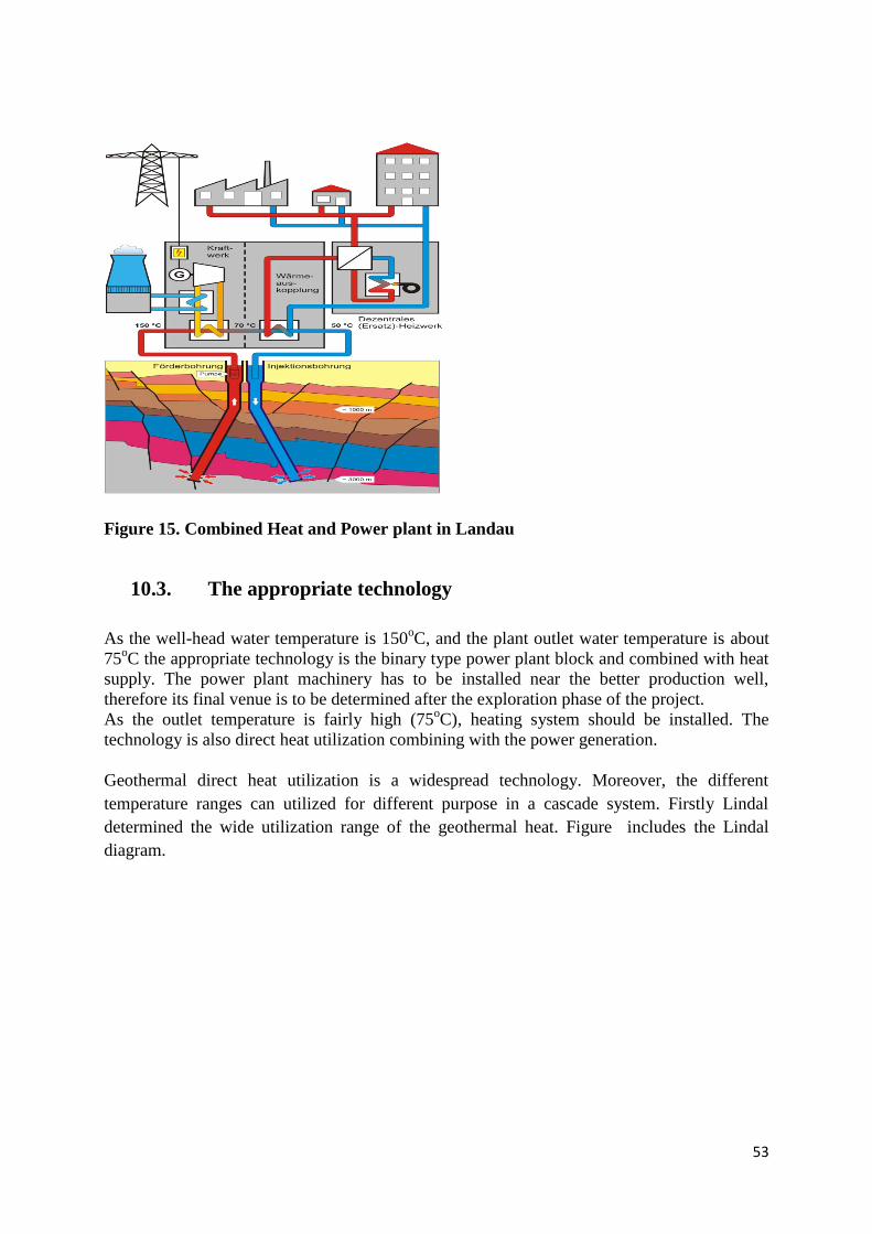
53
Figure 15. Combined Heat and Power plant in Landau
10.3. The appropriate technology
As the well-head water temperature is 150oC, and the plant outlet water temperature is about
75oC the appropriate technology is the binary type power plant block and combined with heat
supply. The power plant machinery has to be installed near the better production well,
therefore its final venue is to be determined after the exploration phase of the project.
As the outlet temperature is fairly high (75oC), heating system should be installed. The
technology is also direct heat utilization combining with the power generation.
Geothermal direct heat utilization is a widespread technology. Moreover, the different
temperature ranges can utilized for different purpose in a cascade system. Firstly Lindal
determined the wide utilization range of the geothermal heat. Figure includes the Lindal
diagram.

54
Figure 16: Lindal diagram

55
11. Risks of the Project
11.1. Risk types
Drilling-geological risk
The main technical risk in a geothermal energy utilisation project comes from the fact that the
exact technical parameters of the reservoir deep under the ground are unknown. Surface and
drilling exploration are the two phases that improve understanding of subsurface conditions.
However, information gained from the exploration is always limited, and therefore every
geothermal project has geology-based risks.
Geothermal resource related risks
Geothermal resources are known as high risk projects, the risks involved are listedhere below.
Even though the risks of geothermal resources can never beeliminated there are several steps
that can be taken to minimise the risk impactand strategies to deal with the situations if they
do occur. There exists experiencein the world to deal with most of the risk factors and
associated calamity.
Geothermal resource risks
temperature of the reservoir (and enthalpy)
permeability the reservoir
resource size
initial gas content in thermal water
changing gas content in thermal water
reservoir changes associated with mass extraction and pressure drawdown
including cool influx, loss of surface thermal features and subsidence
scaling in the formation and surface facilities
reinjection returns
seismicity
Geothermal resource risks that pose fatal constraints on geothermal projects arelimited to:
low temperature
poor permeability
small reservoir size.
Technology related risks
Costs of connections to customers with varied actual heating systems aredifficult to
assess.
Costs of related DH rehabilitation are difficult to assess.
Unexpected environmental impacts – costs of mitigation.

56
Economic risks
Market risk related to fluctuations of fuel prices that may make the geothermalplant
uneconomic.
Market penetration risks – heat sales.
Demand risk – less than estimated heat demand.
Risks of cost over-runs, of late completion.
Lifetime risks (reliable operation and performance risks, risk of new regulations.
Ownership risk (unspecified owners, change of owners, mergers,bankruptcies.
Technological design premises for theresource
Geology of the resource
Temperature of the resource
Yield of the resource
Chemical content of the thermal water
State of the borehole, casings, cements
Equipment availability
Technology that makes best use of the resource
Availability of the technology
Price of the raw materials, services
Time schedule of the project
Proximity to market location, market size.
11.2. Risk mitigation
The mitigation of these risks is one of the key challenges of every geothermal project. There
are financial and technical risks mitigation methods used in international practice.
The risk can be reduced with testing existing boreholesand the resource is estimated before
any development is started. Utilization existing borehole generatesanother type risk. It
involves the state of theborehole itself, its age and condition of the casing, cementing.
The risk of drilling should be reduced by geophysical surveys, seismics before selecting the
well site.
Risk insurance
This is not a financing tool, because it does not improvethe profitability of the project.
However, it is one of the most important risk mitigation tools, because it addresses the two
most significant challenges of a geothermal project; the geological risk and the fact that this
risk influences the early phase of the project. Traditional insurance cannot offer solutions for
geological/exploration risk.

57
This insurance covers the majority (70–90%) of the amount invested in the geothermal
exploration if the cause of the failure comes from a geological situation that could not have
been foreseen. The investor pays an insurance fee and cost allowances (5–20%).
This kind of insurance is available in Germany, France and Switzerland among the European
countries. The Geothermal Energy Development Fund (GeoFund) offers this insurance in
international processes. Hungary and Slovakiaare not yet a targeted country, and therefore
only a market-based or state-subsidised fund can be established in Hungary and Slovakia.
This kind of subsidy is not provided in Hungary and insurance companies are not offering this
risk insurance in their portfolio. it is high time for them to enter this activity.

58
12. Licensing
Transenergy Project summarized the legal background both in Hungary and Slovakia. The
following description on the Licensing as well as Appendix 2 is based on this work.
Geothermal energy concession
Below -2500 m geothermal energy (with, or without thermal water abstraction) falls under
concession, whose steps are given in the Mining Act articles 8-19 as well as in Governmental
Decree 103/2011 (VI.29.). Environmental permit, and (if necessary water permits) are issued
by the green authority.
District heating
In the field of district heating, two authorities are empowered: the Hungarian Energy
Commission and the local government. According to Act XVIII of 2005 on district heating
(articles 4-8) the Hungarian Bureau of Energy is the responsible authority in case that heat
energy and electrical energy are produced in a construction , either separately, or combined
and heat energy is produced partly, or completely for district heating. For this reason a permit
for the installation and a permit for the operation of a heat producing construction are granted
by the Hungarian Bureau of Energy. In all other cases, (i.e. producing only heat energy for
district heating, but no electrical energy), the local government is the responsible authority.
Legal backgroung of the geothermal concession
The exploration/exploitation is based on concession, which general rules are described in the
Act XVI of 1991 on Concession, specific regulations related to mineral resources and
geothermal energy in the Mining Act Sections in articles 8−19. Closed areas − below a depth
of 2500 m from the surface − can be assigned for exploration, exploitation and utilization by
the Minister for domestic or foreign, legal or natural persons, and their companies without
legal entities after concluding a concession contract (8§). Contents and the evaluation of the
open tender are regulated by articles 10–11.
According to Mining Act article 9 − and taking into consideration regulations set in the
Governmental Decree 103/2011 (VI.29.) on the complex vulnerability and impact assessment
of the natural occurrences of mineral resources and geothermal energy − the Minister shall
take into account the closed areas to be designated for concession, in which the mining of the
given raw material, or the exploitation of the geothermal energy seems to be favorable.
According to the Governmental Decree 103/2011 (VI.29.) the aim of the complex
vulnerability and impact assessment is to determine those areas, where mining activity
cannot be performed due to environmental- and nature protection, water management and
protection of water resources, protection of cultural heritage, - agriculture, public health,

59
national defense, land-use, transportation issues, as well as mineral resource management.
Furthermore the aim of the study is to set up the rules of the mining activity to be performed
in the frame of the concessional contract.
According to article 2, the investigation and the study is done by the Hungarian Office for
Mining and Geology (MBFH) together with the Eötvös Loránd Geophysical Institute, the
Geological Institute of Hungary and the Water and Environment Protection Directorate, also
involving public authorities. Study is performed for those closed areas, where mining of a
certain raw material, or exploitation of geothermal energy can be potentially favorable taking
into account available geological data as well as initiatives from entrepreneurs. The detailed
content of the study is listed in Appendix 2 of the decree. It includes the geographical location
of the area, description of land-use, geological, hydrogeological, tectonic characterization and
status of previous exploration, protected areas related to the water management plans, status
of the surface- and subsurface (ground)water bodies, their monitoring, rate of subsurface
groundwater abstraction, other valid licenses for exploration and exploitation. The study also
summarizes data related to the geological environment of geothermal energy, expected
amount to be exploited, foreseen exploration and exploitation methods, introduction of the
energy concept, duration of activity and forecast of environmental impacts with a special
regard to surface and subsurface (ground)water bodies, drinking water resources, areas of
natural protection (Natura 2000), and possible transboundary effects.
According to article 4, MBFH sends out the study to the public authorities listed in Appendix
1 for comments and supplement with further specific data. These authorities determine those
areas where mining activity cannot be performed, or only with certain restrictions. According
to articles 5-6, MBFH collects and incorporates all these additional information and puts
together the report, which is checked by the contributing authorities whether their comments
were properly incorporated. After a public consultancy MBFH finalizes the report
According to article 10 of the Mining Act, the Minister calls a public tender for
concession, in which – in addition to the general contents set up in the Act XVI of 1991 on
Concession – the location of the concessional area with the indication of other already
existing bids owned by a third party, activities to be performed in the frame of the concession,
a work programme and the regulations set up in the complex vulnerability and impact
assessment, as well as securities serving its performance are determined. The call also has to
inform about the tendering conditions, payment duties, regulations about remediation and
guidelines of evaluation. The public call has to be published in the official journal of the
European Union.
According to article 12 of the Mining Act, the Minister shall conclude a concessional
contract with the winner of the public competition, in which the duration of the
concession, the work programme and the securities serving its performance are determined.
The holder of the concession should establish a concessional enterprise for carrying out the
mining activity within 90 days of the signature of the contract (13§).

60
The contract may be concluded for a period of not more than 35 years, which may be
extended on one more occasion, by not more than half of the term of the concession contract.
According to article 14 of the Mining Act, the planned period of prospection for geothermal
energy cannot be longer than 4 years within the period of the concession. This may be
extended on not more than two occasions, by half of the original period of prospection per
occasion. Within the period of 1 year of the completion of the prospection, the mining
entrepreneur may initiate the designation of a geothermal protection zone (’equivalent’ of the
mining plot). In case the concessional activity is due to an environmental impact assessment
(see Governmental Decree 314/2005 (XII.25.)), the period of this procedure does not fall
within the 1 year.
Concession license (22§) gives an exclusive right to the entrepreneur to submit a technical
operation plan, and —in case of its approval — the commencement of geological exploration
(instrumental measurements, analyses, drillings), and the initiation for the designation of the
geothermal protection zone based on the accepted closing report of prospection. The special
rules of exploration, exploitation and utilization of geothermal energy are summarized by
Mining Act Section 22/B. According to this, in closed areas (> -2500 m) geothermal energy
can be exploited solely from the geothermal protection zone, which is designated by the
mining inspectorate. According to article 15 of the Mining Act utilization for energetic
purposes should be commenced within 3 years after the designation of the geothermal
protection zone, otherwise refund must be paid, in default whereof the concession shall be
discontinued. It should be noted here, that the mining legislation still lacks the regulation of
the geothermal protection zone.
According to Article 20 of the Mining Act,the rate of the mining royalty shall be 2 per cent
of the value of the exploited geothermal energy. No mining royalty needs to be paid for
geothermal energy exploited from an energy carrier of a temperature not higher than 30 °C or
for the quantity of geothermal energy which utilization rate exceeds 50% (such supporting
efficient utilization).
It is important to point out, that ZA-PUM-02 and ZA-INJ-02 wells are located in SCI type
Natura 2000 area, therefore the enviromental licensing process can be longer than usual.

61
13. Project costs, project financial supports
13.1. Estimated costs
The dominant cost is the cost of the wells. The market price of the underground facilities is
determined by three main factors.
The price of the crude oil. If it is high, there are a lot of drilling orders from oil
industry and drilling companies are engaged. It can strongly increase the drilling price.
Exchange rate of forint both to euro and US dollar. Raw material is procured from
world market and their price is determined in USD or EUR.
The time of procurement. Prices change quickly. If the procurement process lets time
for procuring materials, the price can be lower than in case of prompt purchase.
The following figure shows the monthly average exchange rate of the Hungarian forint
to EUR and USD in the latest year.
Figure 17: Monthly average exchange rate of the Hungarian forint
to EUR and USD inthe latest year

62
Figure 18: Changing of the Brent Oil Price in the latest year
To determine oil price and HUF/EUR, HUF/USD rates inthe calculations is a business
strategy decision of the investor.
So, significant changes can occur into all directions in the project cost estimations.
Process Cost, HUF million
Further data processing, evaluation. Project
technical planning.
20
Project management, licencing 60
Underground facilities: drilling four wells (~2700 m
deep), well completion, testing, reservoir
stimulation
4 x 800 = 3 200
Surface technology: ESP, land acquisition, heat
pipelines, injection pumps, filters
320
Fabrication and installation of the power plant
machinery
1 300
Connection to electric grid and heat consumers 300
Financing costs (~10% of the Budget) 550

63
Total 5750
Table 9 : Planned costs of Csömödér Project
Total cost of the Project is HUF5,750 million (€20.3 M), as it is detailed in Table 9.
1 € ~ 283 HUF in November 2012.
13.2. Energy price, financial return
Electricity and heat market
The produced electricty can be supplied into the regional electric grid.
Heat market is available near Csömödér. Agricultural consumers, mainly heating of
greenhouses and plastic vegetable tents.
Financial calculations
Planned feed-in tariff: 30 Ft/kWh (10.6 €cents/kWh)
Heat energy price: HUF3500 /GJ (12.36 €/GJ)
Electricity production time: 8300 hour/year
Annual produced electricity: 16,6 million kWh
Annual produced heat energy: 55,000 GJ
In the next decade coolin demand is to be significantly increased. It was considered during the
determination of the energy demand (~ 10,000 GJ/doublet is cooling energy in summer time).
Annual income from electricity: HUF500 million (€1.77 million)
Annual income from heat supply: HUF192.5 million (€0.68 million)
Total income: HUF692.5 million (€2.45 million),
Payback time: 8.3 year
13.3. Financial support opportunities
The competitiveness of renewable energies to fossil energy resources is limited. One of the
main causes of this fact is the undeveloped infrastructure. Investors and political leaders
64
haven’t got technical and financial solutions that are appropriate to launch large numbers of
projects. There is no stabilemanufacturing and servicing background available. Only little
number and short experience accumulated concerning the sustainable technologies so
far.There are only few well educated, experienced professionals. Moredemonstration projects
and programs need togo forward from this situation. Furthersupports from the European
Union, national and regional institutionsare needed asfinancial tools to develop the RE
infrastructure.
Project support
This is the simplest and most popular supporting form in Hungary, it is not so popular in other
countries. Formerly KIOP, presently KEOP abbreviated operative program supported and
supports a lot of projects in Hungary. This is the main driving force of the domestic
geothermal sector, but it isn’t enough to achieve the aims of the national objectives. This
method is not appropriate to support technological research and developmentprograms.
Obligatory and subsidized electricity takeover
In Hungary the feed-in tariff system is under reconstruction now. In the countries, where the
development of geothermal based electricity is strongly subsidized (Germany, France, etc.),
the takeover price is over 20 eurocents and further bonuses can be received for combined heat
and power and EGS technologies. In order to achieve the ambitious national strategic aims
Hungary should join these countries.
Tax allowances
It is common in Europe, but in Hungary this subsidy doesn’t exist. It is a practical solution in
countries, which have tight cash flow, because during the support process the state doesn’t
need to pay cash.
Risk insurance
This support is not a financing tool, because it doesn’t improvethe profitability of the project.
However it is one of the most important, because it handles the two most significant problems
of a geothermal project; the geological risk and that this risk emerges at the early phase of the
project. Traditional insurances can’t offer solutions for the geological/exploration risk.
This insurance ensures the majority (70 – 90%) of the invested amount of the geothermal
exploration if the cause of the failure comes from geological situation that can’t be foreseen
before. The investor pays insurance fee and cost allowances (5 – 20%).
This kind of insurance only exists in Germany, France and Switzerland among the European
countries. The Geothermal Energy Development Fund (GeoFund) operates this insurance tool
in international processes. Hungary is not yet a targeted country because of the size of the
Gross Domestic Product, therefore only market based or state subsidized fund can be
established in Hungary.

65
Structural Funds
The financial resources of project supports are European Union Structural Funds. Central
Eastern European countries, including Hungary and Slovakia have huge potentials concerning
renewableenergy, but the available national sources are not enough to cover a change in the
present energy production trends.Structural Funds represent a major financial source
forinvestments to be implemented but renewable energy resources should be given more
priority.

66
14. Schedule of the project implementation, operation
A well prepared investor with a lots of competences is needed to implement sucha a big
project.As the staff of the geothermal investors is generallysmall, most of the projects process
is to be implemented by contractors. The following work processes are to be directed:
Engineering
Planning and engineering processes are generally implemented by contractors. The processes
are regularly reviewed. Key decisions are to be made by the management of the investor.
Procurement
Besidetaking the key decisions, the investor participates in the procurement processes.
Therefore the investor requires special external technical expertise. Experts have to make
proposals and prepare the decisions.
Construction
The drilling is implemented bya rig of a drilling company. All construction processes
implemented by contractors have to be supervised by the investor’s staff.
Management
The general project management is performed by the investor’s project managers. The
management of special processes by the managers of contractors is also continuously
monitored by the investor’s management.
Some parts of the project implementation and the whole operational aspects are managed by
people local to the Sites.

67
Work phases of the establishment of the power plant
months
1 2 3 4 5 6 7 8 9 10 11 12 13 14 15 16 17 18 19 20 21 22 23 24 25
Project preparations
Reevaluation of seismic data, geological/hydrogeololical concepts
Preparation of the licensing documentation, initiation of the geothermal
concession
Issuing concession tender
Transacting the concession tender, contracting
Table 10: Project preparations
Project preparation is rather long, because the concession process. All technical plans have to be prepared in order to prepare a complete
concession documentation.
Project preparation processs
Reevaluation of seismic data, geological/hydrogeololical concepts, finalizing the project complex concept 2 months
Preparation of the licensing documentation,initiation of the geothermal concession 3 months
The related Ministry prepares and issues the concession tender 12months
Transacting the concession tender, contracting with Ministry 8months
Preparations total 25 months

68
Table 11: Project implementation
Project implementation process
Contracting with the drilling and service companies, and deepening the first well 6months
Testing the well, evaluation and reservoir stimulation if it is necessary, final decision concerning other wells 1 month
Deepening the further three wells, testing, reservoir stimulations if they are necessary 6 months
Finalization of the surface technology, procurement contract related to the power plant block 2months
Fabrication of the block machinery, site preparation 11 months
Installation of the machinery 2 months
Test operation 1 month
Implenementation total 29 months
Altogether 54 months
Work phases of the establishment of the power plant months
Project implementation 1 2 3 4 5 6 7 8 9 10 11 12 13 14 15 16 17 18 19 20 21 22 23 24 25 26 27 28 29
Contracting and deepening the first well
Testing the well, evaluation and reservoir stimulation
Deepening the further three wells, testing, reservoir stimulations
Finalization of the surface technology, procurement contract related to the power plant block
Fabrication of the block machinery
Installation of the machinery
Test operation
69
Operation
Operation of geothermal plants is reliable. Their general factors are the following [2].
Capacity factor: 75-95%,
Load factor: 84-96%,
Availability factor: 92-99%.
Geothermal developments have planned (economic)lifetimes of 20-30 years; although ~50%
of the currentglobal installed capacity has been in operation for >25years.
Surfacefootprints of typical geothermal power developments arerelatively low providing a
distinct advantage in optimizingland use.
Depletion inreservoir pressure and temperature occurs with time, butrecovery through natural
heat recharge allows depletedresources to be re-used after a rest period.
GeoEx Team prepared FEFLOW modelling concerning the project operations. The
results are shown in Appendix 1.
The project can support the vision of the geothermal sector. This vision was declared by
Bromley and his colleagues in the World Geothermal Congress in 2010 [2]:
„With the right attitude and approach by policy makers, investment agencies and power
companies, geothermal iscapable of contributing a significant component of theglobal
renewable energy supply by 2050 that is needed todisplace fossil fuel generation and thereby
mitigate theimpact of climate change from green house gas emissions.”

70
Bibliography
[1] BERTRANI R.: Geothermal Power Generation in the World, 2005–2010 Update Report,
World Geothermal Congress, Bali, 2010
[2] BROMLEY C. et al.: Contribution of Geothermal Energy to Climate Change Mitigation:
the IPCC Renewable Energy Report, World Geothermal Congress, Bali, 2010
[3] KUJBUS A.: Hungarian Geothermal Energy in the Common Vision of the European
Renewable Energy, Miskolc University Scientific Issues, 2012
[4] KUJBUS A.: Exploration of Deeper (2 – 5 km) Geothermal Resources in Hungary, World
Geothermal Congress, Bali, 2010
[5] KUJBUS A.: How to Achieve the Geothermal Objectives of the National Renewable
Energy Action Plan of Hungary? International Geothermal Energy Workshop, Budapest, May
2011.
[6] MINISTRY OF NATIONAL DEVELOPMENT: National Renewable Energy Action
Plan, December 2010.
[7] EUROPEAN TECHNOLOGY PLATFORM ON RENEWABLE HEATING AND
COOLING: Common Vision for the Renewable Heating&Cooling sector in Europe,
Publication Office of the European Union, Luxembourg, 2011
[8] INTERNATIONAL ENERGY AGENCY:Geothermal Heat and Power Technology
Roadmap, Paris, 2011
[9] EUROPEAN RENEWABLE ENERGY COUNCIL, BRUSSELS: Mapping Renewable
Energy Pathways Towards 2020, 2011
[10] EUROPEAN RENEWABLE ENERGY COUNCIL:Renewable Energy in Europe,
second edition, Brussels, 2010
[11] Albert, G., Szeiler, R., Fodor, L., Gyalog, L., Jocha-Edelényi, E., Kercsmár, Z.,
Magyari, A., Maigut, V., Maros, G., Nádor, A., Orosz, L., Palotás, K., Selmeczi, I., Uhrin,
A., Vikor, A. (Hungary); Atzenhofer, B., Berka, R., Bottig, M., Brüstle, A., Hörfarter, Ch.,
Schubert, G., Weilbold, J. (Austria); Baráth, I., Fordinál, K., Kronome, B., Maglay, J., Nagy,
A. (Slovakia); Jelen, B., Lapanje, A., Rifelj, H., Rižnar, I., Trajanova, M. (Slovenia) 2012.
Summary report of Geological models. TRANSENERGY –Transboundary Geothermal
Energy Resources of Slovenia, Austria, Hungary and Slovakia — GeoZS–ŠGÚDŠ–GBA–
MÁFI, 189 pp., Ljubljana–Bratislava–Vienna–Budapest.
[12] Fodor, L., Uhrin, A., Palotás, K., Selmeczi, I., Nádor, A., Tóthné Makk, Á., Scharek,
P., Riznar, I., Trajanova, M. 2011. Geological-structural geological conceptual model. T-JAM

71
Screening of the geothermal utilization, evaluation of the thermal groundwater bodies and
preparation of the joint aquifer management plan in the Mura-Zala basin. Operational
Programme Slovenia-Hungary. 2007–2013 — GeoZS–MÁFI, 52 pp., Ljubljana–Budapest.
[13] Rman, N., Tóth, G. 2011. Hydrogeological conceptual model. T-JAM Screening of the
geothermal utilization, evaluation of the thermal groundwater bodies and preparation of the
joint aquifer management plan in the Mura-Zala basin. Operational Programme Slovenia-
Hungary. 2007–2013 — GeoZS–MÁFI, 23 pp., Ljubljana–Budapest.
[14] Tóth, G., Muráti, J., Rajver, D. 2011. Geothermal conceptual model. T-JAM
Screening of the geothermal utilization, evaluation of the thermal groundwater bodies and
preparation of the joint aquifer management plan in the Mura-Zala basin. Operational
Programme Slovenia-Hungary.2007–2013 — GeoZS–MÁFI, 40 pp., Ljubljana–Budapest.
[15] Horváth, F.,Bada, G.,Windhoffer, G. 2005. A Pannon-medence jelenkori
geodinamikájának atlasza: Euro-konform térképsorozat és magyarázó (Atlas of the present-
daygeodynamics of the Pannonian Basin: Euroconform maps with explanatory text). –OTKA
nyilvántartásiszám/OTKA registration number: T034928
[16] Goetzl, G., Zekiri, F.(editors); Lenkey, L., Rajver, D., Svasta, J. (authors)
2012.Summary Report „Geothermal Models at Supra-Regional Scale”.TRANSENERGY –
Transboundary Geothermal Energy Resources of Slovenia,Austria, Hungary and Slovakia —
GeoZS–ŠGÚDŠ–GBA–MÁFI, 91 pp., Ljubljana–Bratislava–Vienna–Budapest.
[17] Rman, N., Szőcs, T. 2011. Hydrogeochemical conceptual model.T-JAM Screening of
the geothermal utilization, evaluation of the thermal groundwater bodies and preparation of
the joint aquifer management plan in the Mura-Zala basin. Operational Programme Slovenia-
Hungary.2007–2013 — GeoZS–MÁFI, 43 pp., Ljubljana–Budapest.

72
Appendices
Appendix 1 : FEFLOW modeling of the planned geothermal sytem
Appendix 2 : Hungarian legislation related to geothermal power plants
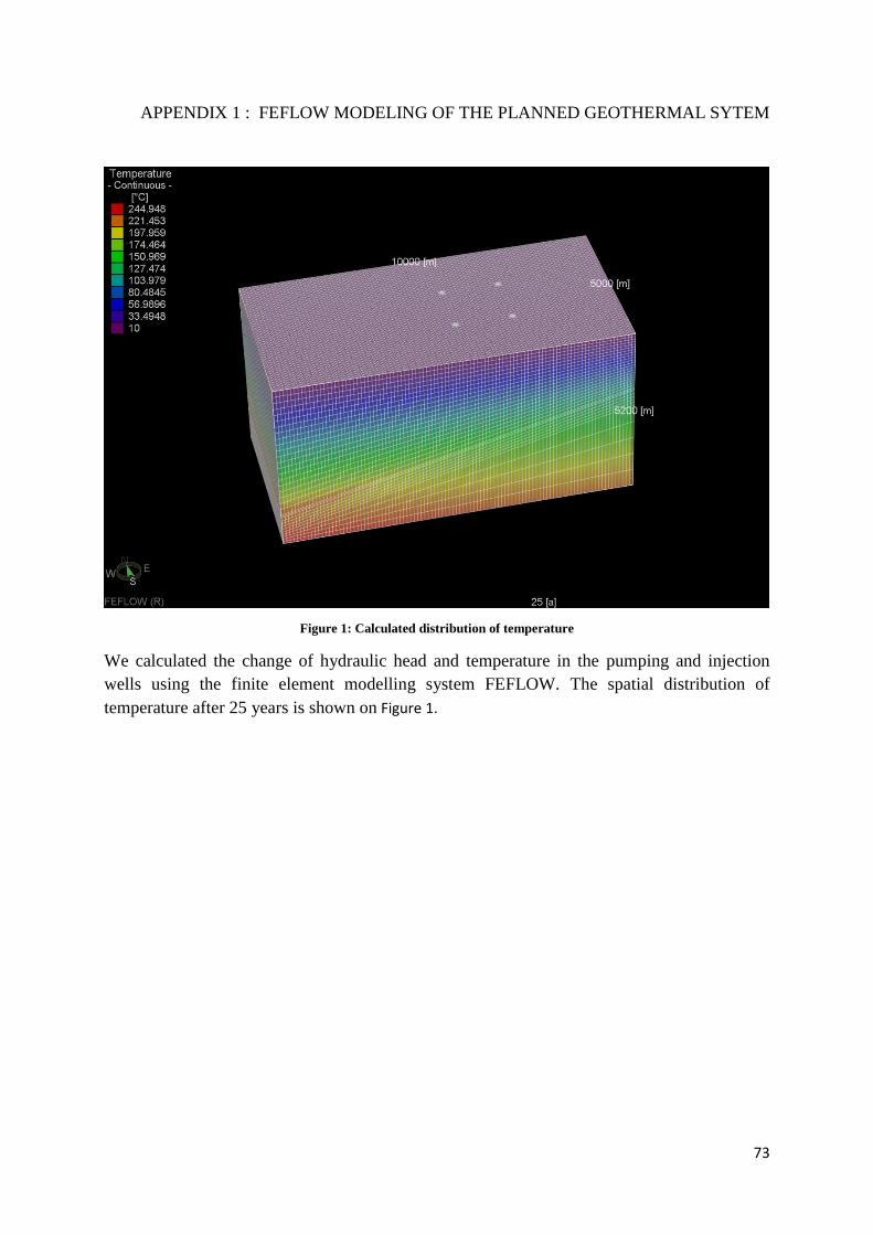
73
APPENDIX 1 : FEFLOW MODELING OF THE PLANNED GEOTHERMAL SYTEM
Figure 1: Calculated distribution of temperature
We calculated the change of hydraulic head and temperature in the pumping and injection
wells using the finite element modelling system FEFLOW. The spatial distribution of
temperature after 25 years is shown on Figure 1.

74
160
160.2
160.4
160.6
160.8
161
161.2
161.4
161.6
161.8
162
0 5 10 15 20 25
Tem
pe
ratu
re [
°C]
Time [years]
ZA-PUM-02
Figure 2: Temporal variation of temperaure in pumping wells
The temporal variation of the water temperature in the proposed pumping wells is shown on
Figue 2Hiba! A hivatkozási forrás nem található.. You can see, that the temperature would
increase in time after 25 years by about 0.6 °C in both wells.
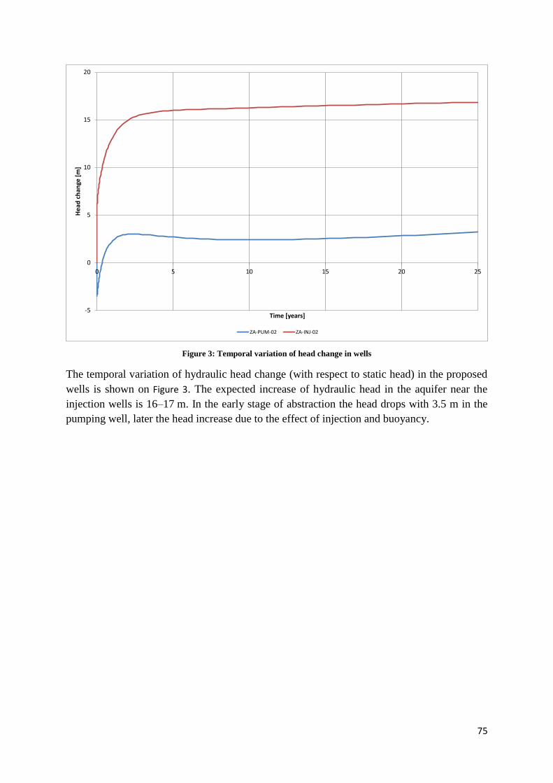
75
-5
0
5
10
15
20
0 5 10 15 20 25
Hea
d c
han
ge [
m]
Time [years]
ZA-PUM-02 ZA-INJ-02
Figure 3: Temporal variation of head change in wells
The temporal variation of hydraulic head change (with respect to static head) in the proposed
wells is shown on Figure 3. The expected increase of hydraulic head in the aquifer near the
injection wells is 16–17 m. In the early stage of abstraction the head drops with 3.5 m in the
pumping well, later the head increase due to the effect of injection and buoyancy.
76
APPENDIX 2
Hungarian legislation related to geothermal power plants
(Prepared by Transenergy Project Team)
EU Directive on Promotion of Renewable Energy Sources (Directive 2009/28/EC of the
European Parliament and of the Council of 23 April 2009 on the promotion of the use of
energy from renewable sources and amending and subsequently repealing Directives
2001/77/EC and 2003/30/EC) ensures a legislation opportunity for renewable energy sources
to develop in a rapid way.
This Directive establishes a common framework for the promotion of energy from renewable
sources [Transenergy Project, Legislation Overview, 2012]. It sets mandatory national targets
for the overall share of energy from renewable sources in gross final consumption of energy
and for the share of energy from renewable sources in transport. It lays down rules relating to
statistical transfers between Member States, joint projects between Member States and with
third countries, guarantees of origin, administrative procedures, information and training, and
access to the electricity grid for energy from renewable sources.
Exploitation of geothermal energy in Hungary is under a dual regulation of mining and
environmental protection – water management. Utilization of geothermal energy falls within
the scope of the Mining Act XLVIII of 1993, except for cases when it happens with production
of groundwater (1§). In this latter case the provisions of the environmental and water
management legislation have to be considered. In view of that, the licensing procedure is also
two-folded and depends on two basic facts: whether the geothermal utilization happens with
or without the abstraction of thermal water, and on the depth (below or above -2500 m, i.e.
whether it is obliged to concession or not, according to the Mining Act). Accordingly, the
licensing procedure can be initiated at the ‘green authorities’ (above -2500 m, with water
production), or at the mining authorities (below -2500 m, without water production). However
in all cases the partner authority takes part in the licensing procedure as consulting co-
authority (Table 1).
In mining and geology affairs the competent designated authority is the Hungarian Office for
Mining and Geology, which has 5 regional offices (Mining Inspectorates, as first-instance
authorities). The Hungarian Office for Mining and Geology, as a governmental agency is
supervised by the Ministry of National Development. Its main task in the licensing procedure
is related to the concessional procedure (below -2500 m,), and the technical-safety licensing
of deep drillings (for details see the Mining Act in the legislation overview).

77
In environment and water management-related affairs, the competent designated authority is
the National Inspectorate for Environment, Nature and Water under the supervision of the
Ministry of Rural Development. It has 10 regional inspectorates and 2 sub-offices (‘green
authorities’) at first instance. In the licensing procedure they are responsible for issuing the
different water- and environmental permits, outline protection zones (see details in the
legislation overview).
Table 1 Flow chart of licensing procedures
Depth below
surface (m)
Licensing
Authority
Consulting co-
authority
0-20
20-2500 Open area Closed loop,
no water
produced
(GSHP)
Regional Mining
Inspectorate
Abstraction of
thermal water
Regional
Inspectorates for
Environment,
Nature and Water
Regional Mining
Inspectorates
(technical-safety
licensing of deep
drilling)
Below 2500 Closed
area
(concessio
n
procedure)
Abstraction of
thermal water
Regional Mining
Inspectorates
Inspectorate for
Environment,
Nature and Water
(water permits)
without
production of
thermal water
(EGS)
Regional Mining
Inspectorates
Inspectorate for
Environment,
Nature and Water
(environmental
impact assessment)
None of the above listed regional first-instance authorities’ territorial shape of competence fits
with the official EU NUTS regions in Hungary.
Furthermore, local municipalities also have a decisive role in licensing affairs. The Hungarian
Bureau of Energy has got a prime role in power plants, electricity, gas network issues and
setting the trade-in prices. It has no regional authorities.

78
The licensing/permission procedure is always conducted by the responsible authority (see
‘licensing authority’ in Table 1) that has to collect and incorporate the opinion of the
participating co-authority, so this is not the task of the applicant (however the applicant has to
provide all necessary documentations). (Principle of ‘concentration’ or ‘one-stop shop’
according to Act CXL of 2004 on the general rules of administrative official procedures and
services).
The Mining Act XLVIII of 1993 came into force on 14th June, 1993. It was amended several
times; its latest amendment came into force on June 25, 2011. Government Decree 203/1998
(XII.19) is responsible for the enforcement of the Mining Act.
Among others, the scope of the Mining Act (1§) is to control the mining of raw materials, the
research, exploitation and utilization of geothermal energy (in case if it is not connected with
the abstraction of thermal groundwater), and all the activities in relation to the aforementioned
topics. Survey and exploitation of thermal groundwaters yielding geothermal energy is not
under the force of the Mining Act, but it is regulated by the environmental and water
management legislation.
The amendment of the Mining Act at the beginning of 2010 (after a long-time debate)
attempted the partial relief of the former incompatibility between the water management and
the mining legislation, according to which — considering geothermal energy — the territory
of the entire country is considered as a closed area below a depth of 2500 m from the surface
(49§). Thus, its exploration can take place in a concessional system. This means that the
license of the prospection, exploitation and utilization of geothermal energy in this depth
interval is issued by the mining inspectorate, in case it is not connection with water
abstraction. (According to the Government Decree 267/2006 it is the duty of the Hungarian
Office for Mining and Geology to be within the competence of a mining inspectorate and
operate according to the rules fixed in the Mining Act 44 §).
According to 3§ of the Mining Act, mineral resources and geothermal energy are, at their
natural place of occurrence, in state property. As (minerals and) geothermal energy are
exploited for energetic use, they are transferred into the property of the mining entrepreneurs,
who pays royalty (20§). The State delegates licensing to mining inspectorates (at first level)
or to the responsible Minister (in case of concession contract).
The Mining Act acknowledges three types of exploration and mining activity. The first type is
a preliminary surface survey (4§) which does not require a permit. In order to carry out this
activity the company needs to have an agreement with the caretaker/user of the land and
report the commencement of prospection to the mining authorities 30 days in advance. The
report has to contain the exploration plan (text and map showing locations). This type of
survey does not pose any exclusive rights for the operator concerning mineral exploitation.
Geoscientific data gained during the preliminary survey has to be sent to the Hungarian Office
for Mining and Geology.

79
Mining activities performed on the basis of authority permission are defined by articles 5–7 of
the Mining Act.
The third type of exploration/exploitation is based on concession, which general rules are
described in the Act XVI of 1991 on Concession, specific regulations related to mineral
resources and geothermal energy in the Mining Act Sections in articles 8−19. Closed areas −
below a depth of 2500 m from the surface − can be assigned for exploration, exploitation and
utilization by the Minister for domestic or foreign, legal or natural persons, and their
companies without legal entities after concluding a concession contract (8§). Contents and the
evaluation of the open tender are regulated by articles 10–11.
According to Mining Act article 9 − and taking into consideration regulations set in the
Governmental Decree 103/2011 (VI.29.) on the complex vulnerability and impact assessment
of the natural occurrences of mineral resources and geothermal energy − the Minister shall
take into account the closed areas to be designated for concession, in which the mining of the
given raw material, or the exploitation of the geothermal energy seems to be favorable.
According to the Governmental Decree 103/2011 (VI.29.) the aim of the complex
vulnerability and impact assessment is to determine those areas, where mining activity cannot
be performed due to environmental- and nature protection, water management and protection
of water resources, protection of cultural heritage, - agriculture, public health, national
defense, land-use, transportation issues, as well as mineral resource management.
Furthermore the aim of the study is to set up the rules of the mining activity to be performed
in the frame of the concessional contract.
According to article 2, the investigation and the study is done by the Hungarian Office for
Mining and Geology (MBFH) together with the Eötvös Loránd Geophysical Institute, the
Geological Institute of Hungary and the Water and Environment Protection Directorate, also
involving public authorities listed in Appendix 1. Study is performed for those closed areas,
where mining of a certain raw material, or exploitation of geothermal energy can be
potentially favorable taking into account available geological data as well as initiatives from
entrepreneurs. The detailed content of the study is listed in Appendix 2 of the decree. It
includes the geographical location of the area, description of land-use, geological,
hydrogeological, tectonic characterization and status of previous exploration, protected areas
related to the water management plans, status of the surface- and subsurface (ground)water
bodies, their monitoring, rate of subsurface groundwater abstraction, other valid licenses for
exploration and exploitation. The study also summarizes data related to the geological
environment of geothermal energy, expected amount to be exploited, foreseen exploration and
exploitation methods, introduction of the energy concept, duration of activity and forecast of
environmental impacts with a special regard to surface and subsurface (ground)water bodies,
drinking water resources, areas of natural protection (Natura 2000), and possible
transboundary effects.
According to article 4, MBFH sends out the study to the public authorities listed in Appendix
1 for comments and supplement with further specific data. These authorities determine those

80
areas where mining activity cannot be performed, or only with certain restrictions. According
to articles 5-6, MBFH collects and incorporates all these additional information and puts
together the report, which is checked by the contributing authorities whether their comments
were properly incorporated. After a public consultancy MBFH finalizes the report
According to article 10 of the Mining Act, the Minister calls a public tender for concession, in
which – in addition to the general contents set up in the Act XVI of 1991 on Concession – the
location of the concessional area with the indication of other already existing bids owned by a
third party, activities to be performed in the frame of the concession, a work programme and
the regulations set up in the complex vulnerability and impact assessment, as well as
securities serving its performance are determined. The call also has to inform about the
tendering conditions, payment duties, regulations about remediation and guidelines of
evaluation. The public call has to be published in the official journal of the European Union.
According to article 12 of the Mining Act, the Minister shall conclude a concessional contract
with the winner of the public competition, in which the duration of the concession, the work
programme and the securities serving its performance are determined. The holder of the
concession should establish a concessional enterprise for carrying out the mining activity
within 90 days of the signature of the contract (13§).
The contract may be concluded for a period of not more than 35 years, which may be
extended on one more occasion, by not more than half of the term of the concession contract.
According to article 14 of the Mining Act, the planned period of prospection for geothermal
energy cannot be longer than 4 years within the period of the concession. This may be
extended on not more than two occasions, by half of the original period of prospection per
occasion. Within the period of 1 year of the completion of the prospection, the mining
entrepreneur may initiate the designation of a geothermal protection zone (’equivalent’ of the
mining plot). In case the concessional activity is due to an environmental impact assessment
(see Governmental Decree 314/2005 (XII.25.)), than the period of this procedure does not fall
within the 1 year.
Concession license (22§) gives an exclusive right to the entrepreneur to submit a technical
operation plan, and —in case of its approval — the commencement of geological exploration
(instrumental measurements, analyses, drillings), and the initiation for the designation of the
geothermal protection zone based on the accepted closing report of prospection. The special
rules of exploration, exploitation and utilization of geothermal energy are summarized by
Mining Act Section 22/B. According to this, in closed areas (> -2500 m) geothermal energy
can be exploited solely from the geothermal protection zone, which is designated by the
mining inspectorate. According to article 15 of the Mining Act utilization for energetic
purposes should be commenced within 3 years after the designation of the geothermal
protection zone, otherwise refund must be paid, in default whereof the concession shall be
discontinued. It should be noted here, that the mining legislation still lacks the regulation of
the geothermal protection zone.

81
According to article 20 of the Mining Act the rate of the mining royalty shall be 2 per cent of
the value of the exploited geothermal energy. No mining royalty needs to be paid for
geothermal energy exploited from an energy carrier of a temperature not higher than 30 °C or
for the quantity of geothermal energy which utilization rate exceeds 50% (such supporting
efficient utilization).
According to article 4 of the Government Decree 203/1998. (XII.19.) on the execution of the
Mining Act royalty shall be defined in a self-assessment and shall be paid to the account of the
central budget separated for this purpose. Section 34 defines the utilized quantity of
geothermal energy as the part utilized for the purposes of energy generation of the quantity
exploited from the energy carrier with a temperature exceeding 30 °C. In this respect the
person using geothermal energy for medical, balneological, or water supply purposes on the
basis of a water license, shall not qualify as a mining entrepreneur, even if the exploited
thermal water is used also for the purposes of a secondary energetic utilization.
Governmental Decree 54/2008 (III.20.) determines the specific value of geothermal energy
and its calculation methodology. According to article 3, the value derived from the
geothermal energy − exploited for the purposes of the generation of energy − can be
determined as the multiplication of the amount of the exploited energy (E) (from a carrier of a
temperature at least 30°C) and the specific value.
According to the Annex 1/b of the Governmental Decree, the specific value − in case of its
direct exploitation together with the geothermal carrier (‘thermal groundwater’) is 1650 Ft/GJ,
whereas in case of the heat transfer material being recirculated in the Earth’s crust, the
specific value is 325 Ft/GJ. The amount of geothermal energy exploited for the purposes of
the generation of energy must be measured by the entrepreneur: temperature and amount at
the well-heads and the temperature of the energy carrier (‘thermal water’) at the heat
exchanger outflow point. Based on this the exploitation of geothermal energy coupled with
water extraction:
E = V • (Twh-The) / 2 • 0,004186, where
E = the amount of exploited energy in GJ
V = volume of exploited water (m3)
Twh = temperature at wellhead (°C)
The = temperature at heat exchanger outflow (°C)
Mining royalty in thousand Forints: E • 1650 / 1000
In case of the exploitation of the geothermal energy via the circulation of secondary heat-
exchanger fluids:
E = V • (Twh-The)/2 • Tf, where

82
E = the amount of exploited energy in GJ
V = volume of exploited energy carrier at the well-head (m3)
Twh = temperature at wellhead (°C)
The = temperature at heat exchanger outflow (°C)
Tf = specific heat of the circulated fluid GJ/m3 • °C
Mining royalty in thousand Forints: E • 325 / 1000
According to article 25 of the Mining Act on geological data supply and handling of the data,
the mining entrepreneur has to send annually the geological data obtained in the course of the
mining activity to the organization responsible for geological tasks. The Governmental
Decree 267/2006 (XII.20.) on the Hungarian Office for Mining and Geology nominates this
organization as responsible for performing state geological tasks, including handling the
National Archive of Geological, Geophysical and Mining Data. Initial data concerning the
geological conditions of geothermal energy should be sent in a closing report of exploration,
whereas a report on the calculation of exploited and utilized quantities should be sent to the
Hungarian Office for Mining and Geology annually.
Concerning the publicity of data, information for the site of prospection, the amount and of
the annual production and the holder of the exploration right are public. Data concerning
technologies, exploration and exploitation methods, logistics, know-how supplied in the
closing report and resource assessment are confidential during the period of the license and
until the approval of the plan of closure of the mine, or in the absence of the designation of a
geothermal protection zone − for 1 year after the acceptance of the closing report of
prospection.
Mining activity can be only carried out on the basis of an approved technological-operation
plan (Mining Act 27§), which should be prepared by taking the following aspects into
consideration: the rules related to technical safety, health protection and fire-protection, the
requirements of mineral resource management, water management as well as environmental
protection, nature conservation and landscape protection. The content of the technological-
operation plan is regulated by article 13 of the Government Decree 203/1998. (XII.19.) on the
execution of the Mining Act, and it is approved by the mining inspectorate.
According to Governmental Decree 203/1998 (XII. 19) − among others − the followings
belong directly to the competence of Hungarian Office for Mining and Geology on first level
(3§): the register of royalties, the control of royalty income, preparation of decisions of the
minister in connection with mineral resource management and with concession contracts, the
operation of the Hungarian State Geological, Geophysical and Mining Archive, the State
Mineral Resource Register, and the Geological and Mining Informational System, as well as
the register of the national mineral and geothermal resources.

83
The Hungarian regulation of energetics, especially its electric energy part renewed completely
according to the common market liberalization obligations in 2007. The major aims of Act
LXXXVI of 2007 on electric energy (1§) are to promote the competitiveness of the economy
through the development of an effectively operating electric energy market, the enforcement
of the principles of energy efficiency, energy economy and security supply in line with the
principles of sustainable development. In addition, it also aims to assist/help the production of
electricity produced by energy gained from renewable energy sources and waste, as well as
the co-produced electricity. The provisions of law on electricity co-generated with thermal
energy have to be applied in accordance with the regulations of Act XVIII of 2005 for district
heating (2§).
Articles 9–13 discuss separately how to promote the production of electricity produced by
energy gained from renewable energy sources and waste, as well as the co-generated
electricity for the sake of protection of the environment and nature, as well as saving the
usage of primary energy sources. For this purpose it creates a differentiated, compulsory
acceptance system considering the energy sources, the production processes, the nominal
efficiency of the power plant, the efficiency of energy transformation and the time of
establishment of the power plant. The main considerations are as follows:
the necessary long-term security and consistency in accord with energy policy
principles has to be guaranteed
while maintaining competition among generators, the competitive disadvantage in the
course of the sale of the generated electricity has to be alleviated
the acceptance price, quantity and duration of the electric energy has to be established
in view of the average time of return of the production process, the effectiveness of the
use of the energy source in line with the natural conditions of Hungary, the carrying
capacity of the users and the development in the effectiveness of the technologies, as
well as the effect of the technology on the operation of the electricity system
the compulsory acceptance of co-generated electricity has to aim at helping the co-
generated energy production based on the useful heat demand, has to be founded on
savings in the use of primary energy sources, and it must not hinder the controllability
of the electricity network.
Neither the co-generated electricity production beyond the useful heat demand, nor heat
production from renewable energy sources can be facilitated through the compulsory
acceptance network considering these viewpoints.
The producer is obliged to make a balance circle contract according to the commercial code of
the acceptance system operator. The compulsory acceptance can happen on market price
(11§), or on an acceptance price established in a regulation [Governmental Decree 389/2007
(XII.23.)]. Based on the demand of the producer, the Hungarian Energy Office verifies the

84
quantity of electricity and useful heat produced by energy gained from renewable energy
sources or waste, as well as the primary energy source used for the production of co-generated
energy (12§).
In accordance with Act LXXXVIII of 2003 on energy taxes no energy tax has to be paid on
self-used electricity generated from renewable energy sources (3 §).
Governmental Decree 389/2007 (XII.23.) on the compulsory acceptance system and feed-in
tariffs of electricity produced by energy gained from renewable energy resources and waste,
as well as the co-generated electricity is especially important considering geothermal energy
utilization. The decree discusses in details the general rules of feed-in obligations of
electricity produced by energy gained from renewable energy sources and waste (3§), the
cases of acceptance (4§), the administrative licensing procedures (6§) and the rules how to
practice it (7§), the certificate of origin (8§) and the steps of control (9§). Annex 1 of the
decree contains the compulsory acceptance base prices of the electricity produced from
renewable energy sources in a geothermal power plants yielding less than 20 MW.
Ft/kWh
peak period 29.56
normal period 26.46
low peak period 10.80
GKM/Ministerial Decree 110/2007 (XII.23.) disposes on the calculation method to determine
the quantity of the useful heat and the co-generated electricity.
The scope of Act XVIII of 2005 on district heating covers all legal relationships that affect the
production, supply and utilization of district heating. The provisions of the law concerning the
exploitation and establishment of geothermal energy for district heat purposes have to be
applied in accordance with Act XLVIII of 1993 on mining, as well as the regulations of Act
LVII of 1995 on water management. The rules how to establish the highest administrative
price of district heating are contained in Act LXXXVII of 1990 on the establishment of prices
(57§). The environmental and financial benefits of energy produced and co-generated from
renewable energy sources have to be taken into account in the course of the establishment of
prices.
According to article 1 of Governmental Decree 157/2005 (VIII.15.)on the execution of the act
on district heating, the utilization possibilities of renewable energy sources, their technical
and economic conditions have to be surveyed by the license applicant in the course of the
establishment, reconstruction, enlargement of the district heat production facilities. The result
of the survey aiming at the utilization of renewable energy carriers has to be attached to the

85
application in all cases. The establishment and the operation license for district heat
production has to be issued by the licensing authorities for the utilization of renewable energy
carriers if the economic conditions are similar or better, than other options.
The Act LIII of 1995 on the general rules of environmental protection is to set up rules related
to the protection and maintenance of natural resources, their sustainable utilization and
management. According to article 2, the scope of the act covers the inanimate components of
the environment (including earth and water), their natural and man-made environment, the
activities that utilize, load, pose hazard or pollute the environment.
Protection of earth is regulated in articles 14-17. According to article 14, the protection of
earth encompasses the surface and subsurface, the soil, rocks and minerals as well as their
processes. According to article 15 only those processes can operate on the surface or in the
subsurface, and only those materials can be disposed, which do not effect or pollute them.
Basic principles regarding the protection of waters are given in articles 18-21. According to
article 18, the protection of water encompasses the protection of surface and groundwaters,
their reserves, quality (including temperature conditions) and quantity. The load and
utilization of the environment has to be planned and carried out in a way that the
environmental targets regarding the status of the waters should be achieved, i.e. the status of
the surface and groundwaters should not deteriorate. The actions to achieve the good status
have to be determined in the river basin management plans, which details are regulated in the
Governmental Decree 221/2004 (VII.21.).
According to article 19, during the utilization of the environment, it has to be ensured that
groundwater dependant terrestrial ecosystems should be sustained, and the quality and
quantity of waters ensuring their utilization should not deteriorate.
According to article 21 the utilization of water, their load, the input of used and wastewaters
into water bodies − after a necessary treatment − can happen only in a way that does not threat
the natural processes and the quality and quantity renewal of the water reserves. This is
especially relevant regarding the re-injection of thermal groundwaters, which is regulated
among others in Governmental Decrees 147/2010 (IV.29.) and 219/2004 (VII.21.).
According to article 68, those activities which are supposed to have a significant load on the
environment, have to be preceded by the performance of an environmental impact assessment,
which details are given in the Governmental Decree 314/2005 (XII.25.).
The aim of the Governmental Decree 219/2004 (VII.21.) on the protection of groundwaters is
to regulate tasks, rights and obligations associated with ensuring and maintaining the good
status of groundwater, progressive reduction and prevention of their pollution, a sustainable
water use based on the long-term protection of available groundwater resources and the
remediation of the geological medium.

86
According to article 4, as a fundamental principle, the status of groundwater bodies should
meet the objectives of good quality and quantity status by the deadline referred to in the Act
on the general rules of environmental protection (December 22, 2015). To meet these
objectives it has to be ensured that no deterioration of status of surface and groundwaters
takes place, all significant man-related adverse trends in groundwater status reverse, the status
of poor water bodies and those at risk progressively improve, and on the areas where the
geological medium or the groundwater is damaged should be registered and controlled and
their status should improve by remediation. The status of groundwater is determined by the
poorer out of the qualitative and quantitative status.
The outline of water bodies and the details of characterization of their status is regulated in
the KvVM / Ministerial Decree 30/2004 (XII.30.) on certain rules of examination of
groundwaters.
A groundwater body is in good quantitative status if the long-term (min. 6 years) annual
abstraction rate does not exceed the available groundwater resource determined in the
Governmental Decree 221/2004 (VII.21.), abstraction does not cause a permanent decrease in
groundwater level or hydraulic head, ecological or chemical status of associated surface
waters are not threatened by any deterioration in the coupled groundwaters which could hold
back the achievement of their environmental objectives. Furthermore criteria are that no
alterations in the subsurface flow directions take place which could cause significant changes
in the chemical or physical status of the groundwater body and no terrestrial ecosystems
depending on groundwaters are damaged.
A groundwater body is in good chemical status if its monitoring proves no contamination,
measured values do not exceed the thresholds, do not hinder to achieve the environmental
objectives of associated surface waters as a consequence of poor water quality, and no
terrestrial ecosystems depending on groundwaters are damaged.
A groundwater body is in good qualitative status if it has good chemical status and its
temperature does not decrease to such extent which may cause changes in its chemical or
qualitative status, or flow paths and does not disturb utilization.
According to article 4/B, during river basin management those areas have to be outlined in
groundwater bodies at risk − in accordance with the regulations of the KvVM /Ministerial
Decree 30/2004 (XII.30.) − where there is a permanent decrease in groundwater level, or
hydraulic head, or there is a constant increase of contamination.
According to article 5, the outline of groundwater bodies is based on the boundaries of the
aquifers, water temperature, subsurface water divides, hydrodynamic and quality status of
groundwaters. Details are given in the Governmental Decree 221/2004 (VII.21.) on certain
rules of river basin management. Groundwater bodies have to be monitored according to the
provisions of the KvVM/Ministerial Decree 30/2004 (XII.30.) on certain rules of examination
of groundwaters and to regulations related to the river basin management. Based on the

87
results, the status of the groundwater body has to be evaluated regularly, but at least in each 6
years related to river basin management plans.
According to article 6, the survey of the status of water bodies, their monitoring and if
necessary actions are the task of the environmental- and nature protection and water
management inspectorates.
According to article 7, groundwaters have to be classified according to their status and level
of protection, considering their recharge, transmissivity of the aquifer and the protected areas.
Guidelines of classifications are listed in Appendix 2. According to this, the hydrogeological
protection zones of the water abstractions for mineral and medicinal waters are considered as
outstandingly vulnerable areas to be protected.
According to article 9, in order to achieve the good quality status, water abstraction cannot
exceed the abstraction limit value and cannot cause the physical or chemical deterioration of
the groundwater body.
Quality protection of groundwaters is regulated by article 10. The main aspects are to prevent
re-injection of contaminating materials into groundwaters and to limit those activities which
would cause the deterioration of the good chemical status of the water body, or would
permanently increase the concentration of contaminating materials.
Disposal of waste materials into groundwaters is regulated in article 13. According to its
provisions, abstracted groundwater can be re-injected to the same aquifer ensuring that the re-
injected water does not contain any materials different from the originally abstracted water
(e.g. in geothermal utilization a closed-loop technology), and thus does not cause the
deterioration of water quality.
The environmental register of groundwaters and geological medium (FAVI) is regulated
under articles 34-35.
KvVM /Ministerial Decree 30/2004 (XII.30.) on certain rules of examination of groundwaters
applies to the rights and obligations established for the designation of groundwater bodies,
characterization and assessment of their status, their monitoring, , the review of the
aforementioned tasks, as well as the collection, processing and reporting of data necessary for
the execution of these tasks.
Rules of designation of groundwater bodies are discussed in articles 2-3. Article 2 determines
the rules of spatial delineation (identification, GIS database presentation). In case of
transboundary aquifers, designation should be harmonized with the relevant country,
involving the Geological and Geophysical Institute of Hungary. According to article 3, water
bodies should be designated on the type and occurrence of the aquifer, such as karstic
formations, non-karstic and porous formations of basin areas, and formations of non-karstic
mountainous areas. Based on the outflow temperature, the 2 main categories are cold waters
with a temperature below 30 °C, and thermal groundwaters with temperature exceeding 30
°C. Groundwater bodies should be delineated considering the subsurface catchment areas,

88
flow patterns, geological build-up of the aquifer, natural hydrogeochemical conditions and
vulnerability. During the designation it has to be considered that all aquifers of sufficient
porosity and permeability to allow abstraction of more than 100 m3/day should be assigned to
a groundwater body.
Characterization of groundwater bodies are discussed under articles 4-7. According to article
4, ware bodies should be characterized with a special regard to registered protected areas,
water bodies at risk, and those parts of transboundary aquifers which may be affected by
transboundary impacts, as well as those parts of a groundwater body, which supply surface
water bodies or terrestrial ecosystems.
For the chemical status assessment the background concentration of natural components has
to be determined.
KvVM /Ministerial Decree 33/2005 (XII.27.) on the administrative service fees of
environment, nature protection and water authorities determine the fees to be paid for the
different water permits (preliminary, construction, operation) depending on the amount of
thermal water to be exploited and re-injected (in m3/day).
According to Governmental Decree 314/2005 (XII.25.) on environmental impact assessment
has to be prepared for activities that include thermal groundwater abstraction exceeding 5
million m3/year, or re-injection of 3 million m3/year for the generation of electricity or direct
heat, or in all cases where thermal groundwater exploitation from karstic aquifers exceeds 500
m3/day, or 2000 m3/day from porous aquifers. Furthermore, an environmental impact
assessment has to be prepared for geothermal power plants of 20 MW, or more, and for all
power plants without output restrictions which are established within the protection zone of
mineral-, medicinal-, or drinking water resources, or on nature protection areas.
The environmental impact assessments are licensed by the environmental-, nature protection
and water management inspectorates.
During the drilling of thermal water wells, the produced waste (e.g. drilling mud, drilling
devices) has to be handled according to the provisions of the Act XLIII of 2000 on waste
management.
The scope of the Act LVII of 1995 on water management is related to the surface and
groundwaters, their natural aquifers (such including thermal waters and their reservoirs), all
activities which influence these reservoirs, the utilization and management of water resources,
as well as collection, processing, supply and utilization of all those data which are necessary
for the evaluation of (ground)waters and their survey. In the following text we talk only about
groundwater.
According to article 6, (ground)waters and their natural aquifers are in state property.
89
Water management is regulated in articles 14-15. According to article 14, mineral and
medicinal waters have to be protected by determining their protection zones, which is
regulated under Governmental Decree 123/1997 (VII.8.) on the protection of water resources.
According to article 15 groundwater resources can be utilized only to that extent that the
dynamic equilibrium of recharge and abstraction is maintained without quality deterioration,
and targets related to the good status of waters phrased in the Water Framework Directive are
achieved. During the utilization of mineral-, medicinal, and thermal waters balneological
utilization should be prioritized. Thermal water abstracted solely for geothermal energy
utilization has to be re-injected according to Governmental Decree 147/2010 (IV.29.) on the
general regulations related to the activities and establishments serving the utilization,
protection and mitigation of damages of waters.
The act defines priority to satisfy water demands as the following (15§):
- water uses aimed at substantial drinking water supply, public health and emergency
responses to disasters
- medicinal purposes, as well as direct services of the population
- livestock watering, fish-farming
- nature conservation
- economic
- other activities (such as sport, recreation, tourism, balneology)
This means that thermal water abstraction for energy production, as economic activity is
placed at a low level of the hierarchy.
Article 15/A regulates water resource fee, which the user is obliged to pay to the state after
the amount of water used, or reserved in the water permits for construction and operation.
According to article 15/C no water resource fee has to be paid after the amount of
groundwater re-injected into the same aquifer.
Governmental Decree 72/1996 (V.22.) on the implementation of authority powers in water
management regulates the powers of the organizations in water administration. According to
article 1, these tasks are performed by the Environment and Nature Protection and Water
Management Inspectorates.
In addition to water permits, the other major task of the Environment and Nature Protection
and Water Management Inspectorates is the delineation of protection zones of water resources
(9§). The details are regulated in the Governmental Decree 123/1997 (VII.18.) on the
protection of water resources.
The scope of theKvVM / Ministerial Decree 101/2007 (XII.23.) on the rules of intervention to
groundwater resources and guidelines to the drilling of wells covers all activities related to

90
the planning, execution and operation of production-, reinjection- and monitoring wells, as
well as the rights and obligations of their technical designer, constructor and supervisor.
During planning (3§) a water permit has to be applied for in line with the Governmental
Decree 72/1996 (V.22.) on the implementation of authority powers in water management. It
has to be considered that the well does not make a hydrodynamic connection between
different groundwater bodies.
According to article 5, all wells deeper than 30 m can be drilled only on the basis of a water
permit. During drilling a wide range of geophysical, technical, and hydrodynamic
measurements have to be performed, which are listed in Appendix 1. These are the following:
Geophysical logging: SP, gamma, resistivity, as additional measurements: neutron-porosity,
micro-resistivity, bottom-hole temperature, acoustic, thermal logging, mud-resistivity,
magnetic susceptibility, etc.
Technical measurements, e.g. checking of inner diameter and bottom, position of screens, etc.
Hydrodynamic measurements: flow and thermal logging at max. yield (below 100 m –
bottom-hole temperature, below 500 m – continuous thermal logging), well capacity (at 80,
60 and 40 % yield), pressure gradients, etc.
According to article 5, the gas content of the well has to be measured according to the KHVM
Ministerial Decree 12/1997 (VIII.29.) on de-gassing and gas sampling of groundwaters.
A separate article (5/A) discusses thermal wells. According to this, a thermal well has to be
equipped with a special well-head that makes possible the differential water abstraction
following the actual water demand, thus the economical an sustainable utilization of thermal
groundwater bodies. Thermal wells have to be outfitted with devices that are resistant to
changes in temperature and aggressive waters. It also has to be considered to hinder scale
precipitations and make it possible to remove them.
According to article 5 of the KvVM Ministerial Decree 30/2008 (XII.31.) on the technical
regulations related to the activities and establishments serving the utilization, protection and
mitigation of damages of waters, during the planning of a well, the conceptual
hydrogeological model of the targeted groundwater body has to be considered, as well as data
related to the groundwater reserves, abstraction value limit (Mi), the water demand of the
groundwater dependent ecosystems, and the water quality of the aquifer. In case of thermal
wells, it has to be ensured, that the water levels can be detected, the amount of abstracted
water can be measured continuously, changes in the quality and quantity in the groundwater
reserves can be observed, as well as access for sampling.
The distance between the wells has to be established in a way, that even co-production of
wells abstracting water from the same aquifer, the drop in yield would not overcome 10% of
the original amount to be produced by a single well. During determining the distance, the
91
local conditions, decreases in yield, groundwater-level, pressure, quality and temperature have
to be taken into account.
Governmental Decree 147/2010 (IV.29.) on the general regulations related to the activities
and establishments serving the utilization, protection and mitigation of damages of waters
comprises the most important regulations concerned reinjection of thermal groundwater.
According to article 10, waterworks (wells) aiming water production solely for energetic
purposes have to be planned in away, that their operation does not affect unfavorably the
discharge and temperature of thermal karstic springs. The thermal groundwater abstracted for
energetic purposes has to be reinjected to the same aquifer after utilization.
According to article 11, thermal groundwater can be utilized for medicinal and other health
purposes, as drinking – and mineral water, for balneology, warm water supply in households,
heat production and generation of electricity. During the planning of utilization, a multi-
purpose (cascade system) operation and economic water use should be targeted. The
utilization of accompanying gases should be also considered. During the construction of a
waterworks using thermal groundwater, the safe disposal of utilized water, especially their
reinjection has to be taken care of. Throughout the selection of a potential surface reservoir,
environmental aspects and natural recharge processes have to be considered. Thermal water
for household warm water supply can be delivered to the pipeline system only if the water
meets the quality requirements of drinking water. If the thermal water is a certified mineral-,
or medicinal water, than water treatment has to be designed on the basis of individual
analyses. Medicinal waters can be treated only by a technology that does not weaken its
healing effect.