Embed Size (px)
Citation preview
Journal of Earth Science and Engineering 3 (2013) 168-179
Geotop of Lut Playa: Quaternary Geomorphologic
Evidence and Civilization
Adel Sepehr1 and Seyed Ali Almodaresi2
1. College of Natural Resources and Environment, Ferdowsi University of Mashhad, Mashhad 91779, Iran
2. Engineering Faculty, Yazd Branch, Islamic Azad University, Yazd 89167, Iran
Received: January 2, 2013/Accepted: February 10, 2013/Published: March 25, 2013. Abstract: The cultural and geomorphological heritages in Playas as a key address to find out past fluctuations called geotop. Iran is strategically located on an important trade route (Silk Road) between four cradles of civilization namely, Babylon, Mesopotamia, Indus and Yangtze (Chinese). Iran is grafting point of four human civilizations which creates Persian civilization about 4,000 years ago. The Lut Desert and Dasht-e Kavir located the central and eastern Iran have been focal points for human settlements since 7,000 years ago. The geoarcheological findings on the Siyalk hills of Kashan located in the Dasht-e Kavir and Jiroft region located in the Lut desert are confirmations for human settlement since more than 7,000 years ago. Shorehzar that is a Persian equivalent word for Arabic word of Sabkha is considered as a Playa geomorphic type which involves precious evidences of quaternary fluctuations. In this article, geomorphological and paleoenvironmental investigations are integrated to provide a framework of environmental change for the late Pleistocene and early-mid Holocene periods in the main deserts of Iran, Lut. In this article based on main geotops of Lut, the quaternary evolutions have been discussed. The investigations are showing that Playas were bed of civilization in Iran Deserts. Key words: Geotops, playa, sabkha, shorehzar, quaternary, Lut.
1. Introduction
Playas are important geomorphic features of the
Iran’s arid regions and are considered to be very
sensitive to hydrologic and climatic changes. Those
classified as a geomorphologic unit of Iran desert
areas. Playas are diverse in size from very small
depressions of a few tens of m2 to massive tectonic
basins, which may extend up to 10,000 km2.
According to the given the range of origins and scales,
displays wide range of variability in morphology,
hydrology and sedimentology. Playas are a
fundamentally different environment from dry
desiccated deserts, and identification of playas has
significant implications for the planet’s hydro-climatic
Corresponding author: Adel Sepehr, assistant professor,
main research fields: quantitative geomorphology, ecogeomorphology, equilibrium, chaos and thresholds, desertification and land degradation assessment, uncertainty and fuzzy-MCDM, geo-hazards monitoring, ecosystem, pattern dynamics and tipping points. E-mail: [email protected]; [email protected].
history.
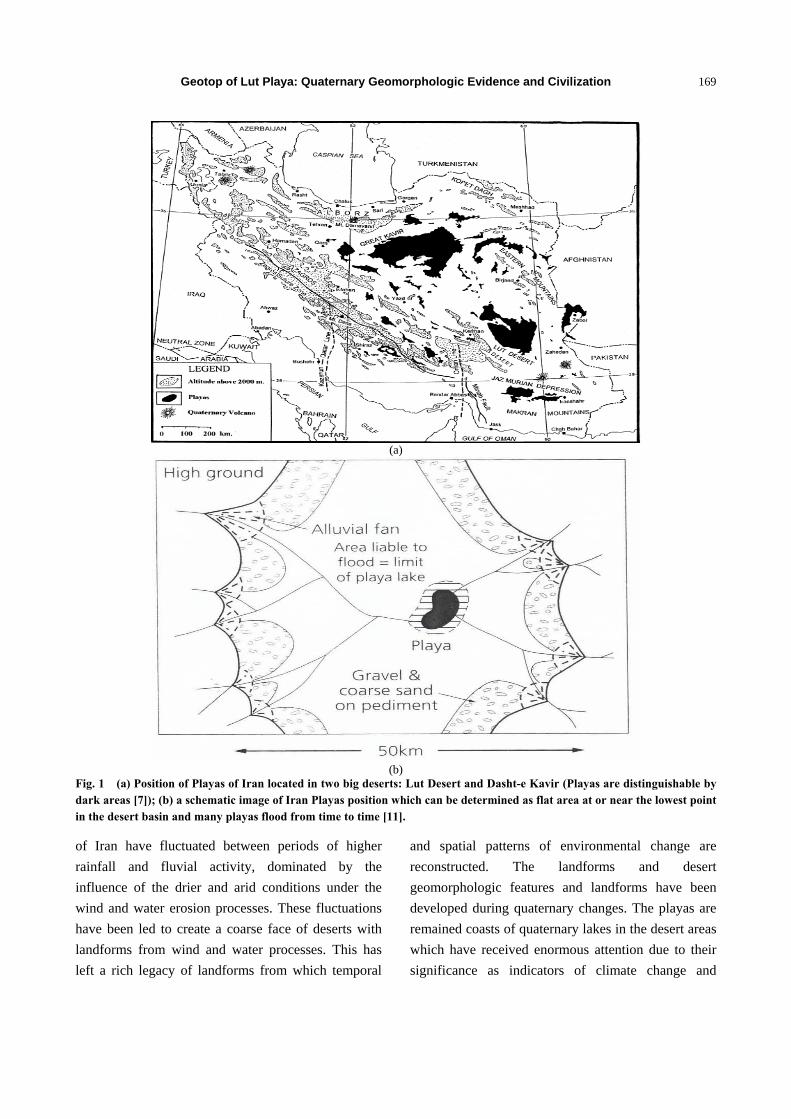
A playa in desert and arid regions of Iran can be
determined as flat area at or near the lowest point in
the desert basin and many playas flood from time to
time (Fig. 1b). The main geomorphologic facies and
types of Iran Playas are Kavir, Sabkha, alluvial fans,
salty lake and clay pans. While the landscape and
drainage in playa catchments provide a qualitative
assessment of climatic and hydrological regime in the
past, playa sediments preserve a wealth of
palaeo-environmental information. Fig. 1a shows a
schematic image of Iran Playas location of Iran desert
areas. According to Krinsley [7], Iran includes more
than 60 playas. In this paper, the definition of playa by
Rosen [11] as an intercontinental basin where the
water budget of the playa lake is negative involving
precipitation, surface and ground waters flows and
evapotranspiration has been adopted.
During the late quaternary, the climate of Iran
playas specially the playas located in the central desert
DAVID PUBLISHING
D
Geotop of Lut Playa: Quaternary Geomorphologic Evidence and Civilization
169
(a)
(b)
Fig. 1 (a) Position of Playas of Iran located in two big deserts: Lut Desert and Dasht-e Kavir (Playas are distinguishable by dark areas [7]); (b) a schematic image of Iran Playas position which can be determined as flat area at or near the lowest point in the desert basin and many playas flood from time to time [11].
of Iran have fluctuated between periods of higher
rainfall and fluvial activity, dominated by the
influence of the drier and arid conditions under the
wind and water erosion processes. These fluctuations
have been led to create a coarse face of deserts with
landforms from wind and water processes. This has
left a rich legacy of landforms from which temporal
and spatial patterns of environmental change are
reconstructed. The landforms and desert
geomorphologic features and landforms have been
developed during quaternary changes. The playas are
remained coasts of quaternary lakes in the desert areas
which have received enormous attention due to their
significance as indicators of climate change and
Geotop of Lut Playa: Quaternary Geomorphologic Evidence and Civilization
170
palaeo-hydrological reconstruction.
Iran deserts considering the central Iran have been a
focal point for human settlement since 7,000 years ago.
The geoarcheological findings on the Siyalk hills of
Kashan located in the Dasht-e Kavir and Jiroft region
located in the Lut desert are confirmations for this
claim.
The Geotopes are the meeting places of elements
recording the geological history of each region. Those
are the irrefutable witnesses of an everlasting
evolution of life on earth, such as volcanoes, caves,
gorges, fossilized areas, large geological rifts, ancient
mines, geological formation or landscapes chiseled by
natural forces throughout the geological ages.
The geomorphologic types of playa such as Kavir,
salt lake and morphologic facies, have been caused the
playa as a unique entity for geoarchaeology studies in
Iran. In addition, all of geomorphologic facies of playa
and desert are clues to understating the evolutions of
region, a geotop. Kavir is a Persian word considered
as a type of playa unit in geomorphology which
involves several geomorphic facies such as Lake of
Kavir, Dagh (clay plain) and Kavir Fan. Sabkhas are
supratidal, forming along arid coastlines and are
characterized by evaporate-carbonate deposits with
some silici-clastics. Sabkha in Persian called
Namakzar or Shorehzar, which means salty area or
land covers with salt sheets with high vulnerability to
wind erosion.
Iran in addition to having such regions have
different geotop areas, including glacier stone, dyke
and sill, erratic rocks, deserts and playas. Iran having
more than 60% desert environments has vast expanse
areas of playa units. Central Iran with a wide section
of the Lut desert can be a good sample of playa
landforms which are an evidence for geoarchaeology
and also with high potential for geo-tourism activities.
This tectonic playa involves one of the biggest ergs in
the world. In this research, the main landforms of Lut
desert, hottest point in the world, which are geotops of
Lut to realize quaternary period have been
investigated.
Also, in this article, the geoarchaeological role of
Playas as a cradle of civilization in Iran where
developed the cities and old culture of Iran has been
considered. The geomorphology and climatology
evolutions of famous playas in Iran have been
discussed to investigate quaternary fluctuations.
Playas in Iran in fact are holes that have been water
in the past and coming as large and small lakes. The
dominant periods of colder and wetter, the water level
has increased.
Equilibrium level of water in these lakes with a
beach after a while has created a special beach-form
that called Lake Terraces. Lake terraces are observed
on the sidelines of today’s deserts and that depending
on how many of them exist in the desert,
developments and changes in regional water balance
is characterized. In the margin of this terrace is usually
found handmade ancient hills, that this cultural
phenomenon, clear many of the features on beach’s
civil population.
The range of landforms in Iran desert and playas is
diverse, reflecting extremes of climate during the
quaternary. Until recently the evolution of the physical
landscape of Iran deserts was poorly understood. The
geological, geomorphological and palaenvironmental
work of Krinsley [7], for first time as integrated
research, however, has addressed large gaps in this
knowledge. Terrestrial evidence is available from
dunes, lacustrine sediments, terraces, alluvial fans,
inselberg, sabkha, kavir, clay pans (Dagh), dry and
salty lake and playas facies.
The desert of Iran is pivotal for understanding late
quaternary climate behavior and ecosystem response
in the low-latitude regions. During Holocene, the Iran
Playa has undergone a number of important changes
in vegetation, fauna, and human occupation and
utilization of the landscape largely driven by changes
in the regional climate.
In Iran, deserts where saltine environments are
generally called “Kavir”. Such environments cover a
Geotop of Lut Playa: Quaternary Geomorphologic Evidence and Civilization
171
considerable area in central Iran and are closed
drainage basins typically occurring within fault
bounded depressions. Playas or continental sabkhas
develop in the central parts of these arid to semi-arid
closed drainage basins, where the water table is close
to the surface and evaporation exceeds input from
atmospheric precipitation. This scenario is commonly
associated with the precipitation of evaporate minerals
and/or saline crusts and soils. Desert sedimentary and
geomorphologic systems typically comprise a variety
of sub environments including ephemeral fluvial
rivers of the distal parts of the alluvial fans, aeolian
dunes/inter dunes, sand sheets, salt/mud flats and
playa-lakes. These are highly sensitive to internal and
externally imposed environmental changes.
Respective sub-environments of a desert system
interact closely and undergo sedimentary and
morphological adjustments in response to
environmental modification, such as change in
climatic and tectonic regimes.
2. Area Descriptions
Iran’s geography consists of a plateau surrounded
by mountains and divided into drainage basins. Iran is
a high plateau bordered by several mountain ranges
including the Alborz Mountains in the north,
Kopeh-Dagh Mountains in the northeast, Azerbaijan
Plateau in the northwest, Zagros Mountains extending
from the northwest to southeast, Makran Mountains in
southeast and the dispersed high massifs like the
Massif of Kerman in east-central and the Massif of
Shir-Kuh in central Iran. Deserts of Iran surrounded in
these mountains belts, Alborz in north and Zagros in
the west and south which have been hidden many
Playas within. These resistant mountain shields avoid
from moisture entrance to central parts which has been
led main desert regions forming of Iran, Lut and
Dasht-e Kavir.
Lut Desert with the extent of 100,000 km2 is the
most arid area in the Iranian central plateau where is
considered to be one of the direst places on earth Lut
Desert is one of the largest of desert basins, 480 km
large and 320 km wide, a large salt desert in
southeastern Iran and is the world’s 25th largest desert
(Fig. 2). The lowest elevation in Iran (250 m asl) is
located in the center of this desert. Soils of the area are
gypsiferous and/or saline, but no scientific data on the
soils, especially origin of salts, are available. Krinsley
[7] conducted on the playas of Iran, including Lut playa
is still the most valid scientific report about the area.
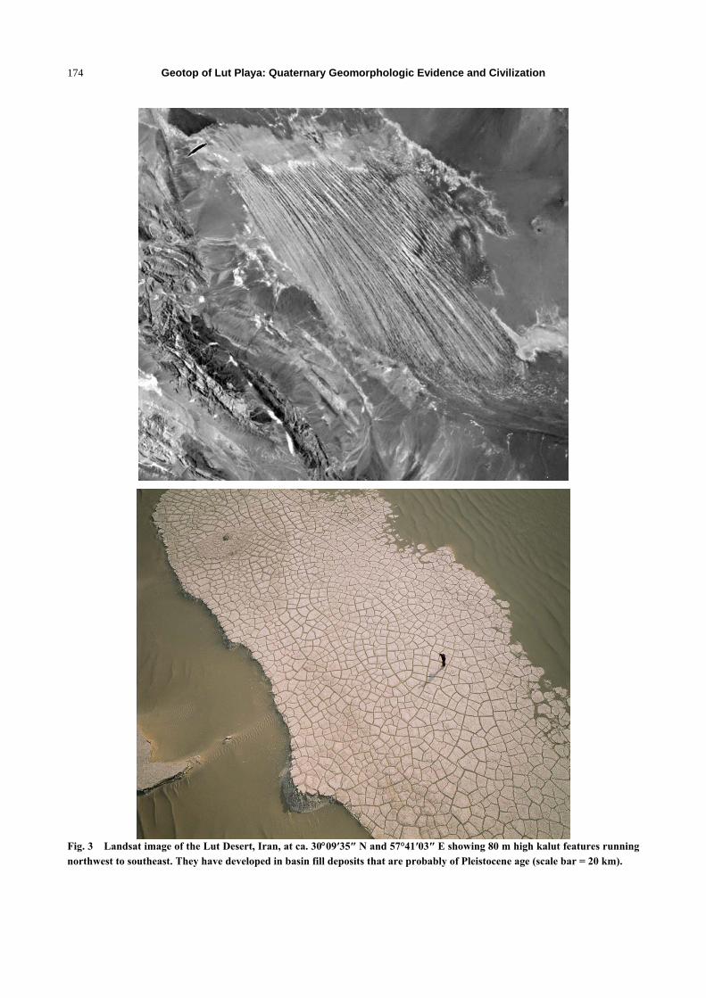
The Lut Desert of southern Iran contains classic
mega-Yardang [7] developed in Pleistocene basin fill
deposits (silty clays, gypsiferous sands), with an
estimated thickness of 135-200 m. The area involved
is ca. 150 km long and 50 km wide. The ridges (kaluts)
run from the northwest to southeast and attain heights
of 60-80 m. They extend for tens of kilometers. At
their downwind end, there is a large dune field (Fig. 3).
Measurements of MODIS (moderate resolution
imaging spectra radiometer) sensor from 2003-2005
testify that the hottest land surface on earth is located
in Lut Desert where land surface temperature reaches
about 71 °C. In other study of seven years (2003-2010)
of global land surface temperatures as measured by
satellites, the Lut Desert is ranked as hottest point in
five of the years (2004, 2005, 2006, 2007 and 2009).
Fig. 2 shows a portion of the Lut Desert in Iran by
ETM+, Landsat 7. The image is a pseudo color and
was acquired on July 6, 1999 by ETM+.
3. Methods and Material Studied
The studied regions were identified from air
photographs and the Google Earth satellite imagery
onto published topographic maps 1:50,000 and
1:25,000.
To determine playas and geomorphological, the
ETM+ and TM Landsat imagery and field checking for
detail and accuracy in some regions were applied. The
findings and results of research of Krinsley [7] under
studying Iran Playas were used to investigate changes
fluctuations in Lut Desert and reconstruct conditions
in the playas.
Geotop of Lut Playa: Quaternary Geomorphologic Evidence and Civilization
172
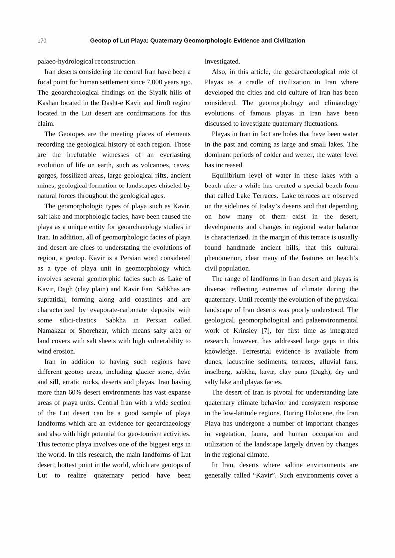
Fig. 2 The Erg of Lut Desert, the hottest point in the world with average temperature 70 °C for August month.
Analysis of landform evolutions provided details
for vegetation change and dating for past periods.
Based on the role of geotops of investigated playas in
Lut deserts of Iran, the correlation between playas and
civilization development has been assessed.
4. Results and Analyses
Geomorphological, palaeoenvironmental and
archaeological geotops from Lut playa and deserts is
presented below based on the key playa and geotop
regions present in the study area.
4.1 Mega-Yardang and Kalut
The eastern part of Lut Desert is a low plateau
covered with salt flats. In contrast, the center has been
sculpted by the wind into a series of parallel ridges
and furrows, extending over 150 km and reaching 75
m in height. These ridges in Turkmen language called
Yardang. This area is also riddled with ravines and
sinkholes. The southeast is a vast expanse of sand, big
erg, with dune more than 400 m high, among the
tallest in the world. These big dunes that are
consequence of water and wind operations in Persian
called Kalut (Fig. 3).
Mega-yardangs probably tend to occur in trade
wind areas with unidirectional or narrow bimodal
wind directions, as is made evident by their
association in some cases with barchans, a dune form
that only occurs where winds are relatively constant in
direction.
ERG- Sand Sea
ETM+, 1999-Pseudo Color
Geotop of Lut Playa: Quaternary Geomorphologic Evidence and Civilization
173
It is only with such constant wind directions that
forms can develop that are parallel to the prevailing
wind. They sometimes occur upwind of sand seas, in
areas where sand transport occurs (e.g., the Lut).
There is some evidence in the case of the Lut that
winds there may be relatively variable in direction, but
there is very little reliable data on wind characteristics
in that area. However, Liu et al. [10] have suggested
that there is severe topographic channeling of winds
and the formation of a low-level jet in the area, and
this appears to coincide in alignment with that of the
yardangs.
There is very little evidence as to the age and rate of
formation of mega-yardangs developed in hard rocks,
although there is some evidence that smaller yardangs
can be excavated to depths of some metres in lacustrine
and swamp deposits of mid-Holocene age [3, 9, 13].
Mega-yardangs may be old and persistent features that
have been shaped over millions of years, not least by
high velocity glacial age trade winds [6]. The
Mega-yardangs of Lut, for example, are yardangs that
originated in pre-Pleistocene times, possibly in the
Miocene or earlier, and in these regions there has been
a protracted time available for yardang formation.
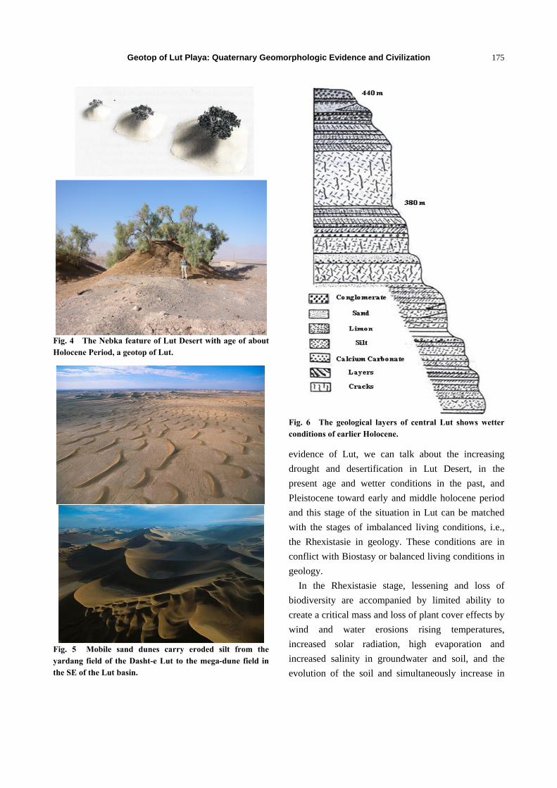
4.2 Nebka and Rebdo (Vegetation Dune)
Nebka is a vegetation mounds, commonly found on
sand plains, are large clumps or clusters of small trees
and shrubs such as Acacia (tarfa) and Tamarix
(tamarisk) with accumulations of sand at their bases,
trapped by the vegetation. These plants catch the
grains of sand with their branched boughs. If the
plants grow the nebka also rises up. In this respect
they are similar to very large, solitary coppice dunes,
or to parabolic dunes. They differ, however, in size
and distribution. These accumulations are caused by
the presence of a rock, plant or other obstacle in the
path of sand particles in movement. In the Lut Desert,
there are two types of nebka: sand arrow nebkas,
which are small ovoid dunes (50 cm in height, 150 cm
in length and 40 cm in breadth) lying in the direction
of the prevailing wind; and bushy nebkas, similar to
sand arrow nebkas, but capable of reaching a height of
2 m and a length of 3 m to 4 m (Fig. 4).
The research approved that increase in height of the
canopy is accompanied with an increase of nebkas
height and the consequently increase of nebkas areas.
According to the formation of nebkas of Lut, seems
the age of nebka’s Lut back to the mid Pleistocene
through to the late Holocene.
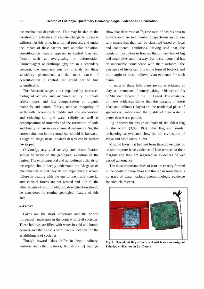
4.3 Erg (Sand Dunes Sea): Linear and Transverse
Dunes
The desert landscape of Lut is dominated by mega
linear, Barkhan and transverse sand dunes of Tertiary
and Holocene ages with reactivation during the late
Holocene (Fig. 5). Mega-dunes of the Lut Desert are
the largest and tallest dune field in the world, reaching
over 475 m in height and covering an area
approximately 50 × 150 km2. The dunes appear to be
the resting place for all the sand and silt excavated by
winds that carved the adjacent Lut Desert Yardang
field.
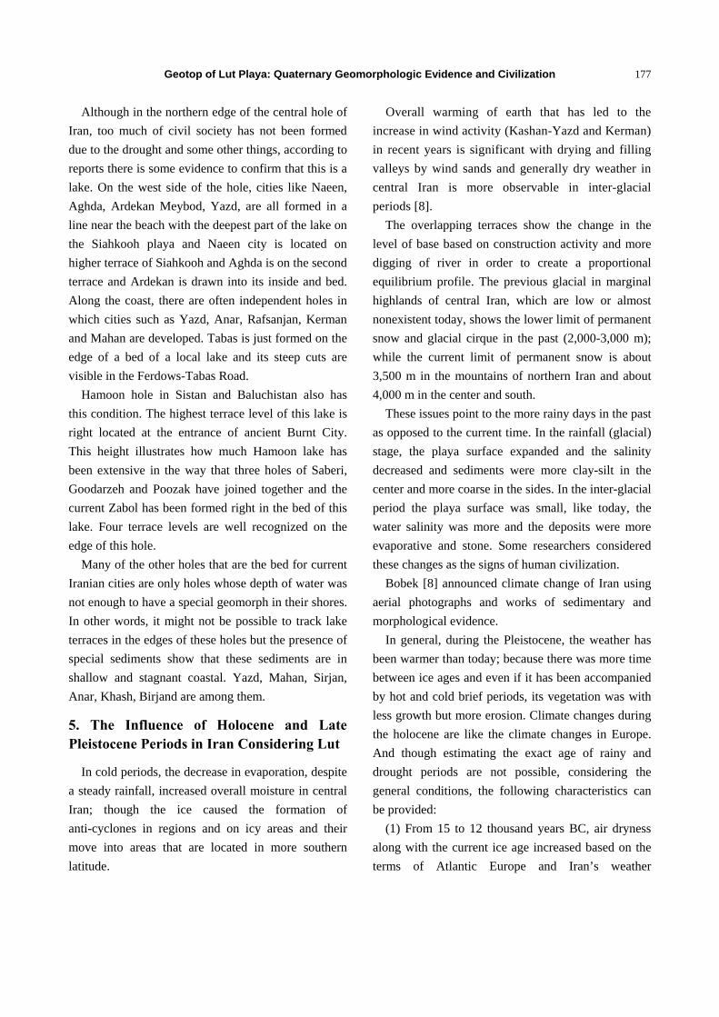
The morphology, provenance and origin of the
dunes of Lut are complex and controversial. Using
ASTER (Advanced Spaceborne Thermal Emission
and Reflection Radiometer) imagery, it has been
determined that they are longitudinal dunes shaped
under a former wind regime and now being reshaped
by transverse wind. The geological layer which has
been shown in Fig. 6 indicates the wetter conditions of
earlier holocene. Exiting Barkhan dunes shape is
reason for sand abundance.
The spacing and relief of dunes are contributing
factors to the shapes of dunes. Low relief causes less
turbulence in the air stream that high relief, and
therefore less change in dune form.
The equilibrium of a sand dune is a delicate
chemical state of equilibrium; the slightest change in
the conditions involves changes in the state of
equilibrium.
Hence, considering the biological and geological
Geotop of Lut Playa: Quaternary Geomorphologic Evidence and Civilization
174
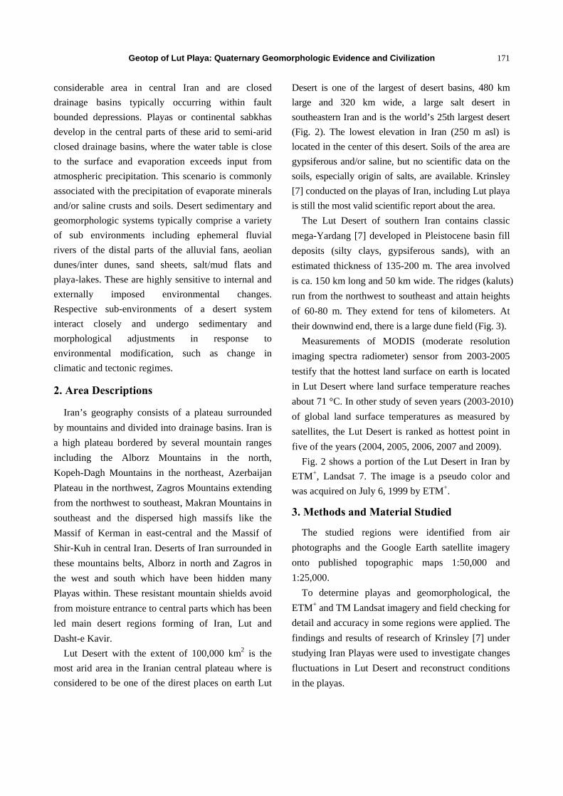
Fig. 3 Landsat image of the Lut Desert, Iran, at ca. 3009′35″ N and 57°41′03″ E showing 80 m high kalut features running
northwest to southeast. They have developed in basin fill deposits that are probably of Pleistocene age (scale bar = 20 km).
Geotop of Lut Playa: Quaternary Geomorphologic Evidence and Civilization
175
Fig. 4 The Nebka feature of Lut Desert with age of about Holocene Period, a geotop of Lut.
Fig. 5 Mobile sand dunes carry eroded silt from the yardang field of the Dasht-e Lut to the mega-dune field in the SE of the Lut basin.
Fig. 6 The geological layers of central Lut shows wetter conditions of earlier Holocene.
evidence of Lut, we can talk about the increasing
drought and desertification in Lut Desert, in the
present age and wetter conditions in the past, and
Pleistocene toward early and middle holocene period
and this stage of the situation in Lut can be matched
with the stages of imbalanced living conditions, i.e.,
the Rhexistasie in geology. These conditions are in
conflict with Biostasy or balanced living conditions in
geology.
In the Rhexistasie stage, lessening and loss of
biodiversity are accompanied by limited ability to
create a critical mass and loss of plant cover effects by
wind and water erosions rising temperatures,
increased solar radiation, high evaporation and
increased salinity in groundwater and soil, and the
evolution of the soil and simultaneously increase in
Geotop of Lut Playa: Quaternary Geomorphologic Evidence and Civilization
176
the mechanical degradation. This may be due to the
construction activities or climate change to increase
stiffness. At this time, in a normal process, and under
the impact of these factors such as solar radiation,
desertification feature appears in central Iran and
factors such as overgrazing or deforestation
(Human-agent or Anthropology) are in a secondary
concern; the emphasis put by officials on these
subsidiary phenomena as the main cause of
desertification in central Iran could not be true
scientifically.
The Biostasie stage is accompanied by increased
biological activity and increased ability to create
critical mass and fast compensation of organic
materials and natural forests, relative tranquility of
earth with increasing humidity and low evaporation
and reducing soil and water salinity as well as
decomposition of minerals and the formation of soils
and finally, a rise in sea chemical sediments. So, the
current situation in the central Iran should be known at
a stage of Rhegsistasie in which deserts can be further
developed.
Obviously, any vital activity and desertification
should be based on the geological evolution of the
region. The environmental and agricultural officials of
the region should deeply understand the Rhegsistasie
phenomenon so that they do not experience a second
failure in dealing with the environment and material
and spiritual forces are not wasted and like all the
other talents of soil; in addition, desertification should
be considered in routine geological feature of this
area.
4.4 Lakes
Lakes are the most important and the widest
influential landscapes in the context of civil societies.
These hollows are filled with water in cold and humid
periods and their coasts were later a location for the
establishment of societies.
Though inward lakes differ in depth, salinity,
vastness and other features, Krinsley’s [7] findings
show that their ratio of B/P (the ratio of basin’s area to
playa’s area) are in a number of spectrums and this in
turn means that they can be classified based on local
and continental conditions. Having said that, the
coasts of most lakes in Iran are the primary bed of big
and small cities and in a way, Iran’s civil potential has
an undeniable coincidence with their surfaces. The
existence of historical hills in the form of bedrock and
the margin of these hollows is an evidence for such
claim.
In most of these hills there are some evidence of
clays and remnants of pottery baking in historical hills
of Shahdad, located in the Lut Desert. The existence
of these evidences shows that the margins of these
lakes and hollows (Playas) are the residential place of
special civilizations and the quality of their water is
better than warm periods.
Fig. 7 shows the ensign of Shahdad, the oldest flag
of the world (3,000 BC). This flag and similar
archaeological evidence show the old civilization of
Playa and basin lakes in Iran.
Most of lakes that had not been through tectonic or
erosion rupture have evidence of lake terraces in their
margins and they are regarded as evidences of wet
period governance.
The most important cities of Iran are exactly formed
in the coasts of these lakes and though in some there is
no trace of water various geomorphologic evidence
for such claim exist.
Fig. 7 The oldest flag of the world which was an ensign of Shhadad civilization in Lut Desert.
Geotop of Lut Playa: Quaternary Geomorphologic Evidence and Civilization
177
Although in the northern edge of the central hole of
Iran, too much of civil society has not been formed
due to the drought and some other things, according to
reports there is some evidence to confirm that this is a
lake. On the west side of the hole, cities like Naeen,
Aghda, Ardekan Meybod, Yazd, are all formed in a
line near the beach with the deepest part of the lake on
the Siahkooh playa and Naeen city is located on
higher terrace of Siahkooh and Aghda is on the second
terrace and Ardekan is drawn into its inside and bed.
Along the coast, there are often independent holes in
which cities such as Yazd, Anar, Rafsanjan, Kerman
and Mahan are developed. Tabas is just formed on the
edge of a bed of a local lake and its steep cuts are
visible in the Ferdows-Tabas Road.
Hamoon hole in Sistan and Baluchistan also has
this condition. The highest terrace level of this lake is
right located at the entrance of ancient Burnt City.
This height illustrates how much Hamoon lake has
been extensive in the way that three holes of Saberi,
Goodarzeh and Poozak have joined together and the
current Zabol has been formed right in the bed of this
lake. Four terrace levels are well recognized on the
edge of this hole.
Many of the other holes that are the bed for current
Iranian cities are only holes whose depth of water was
not enough to have a special geomorph in their shores.
In other words, it might not be possible to track lake
terraces in the edges of these holes but the presence of
special sediments show that these sediments are in
shallow and stagnant coastal. Yazd, Mahan, Sirjan,
Anar, Khash, Birjand are among them.
5. The Influence of Holocene and Late Pleistocene Periods in Iran Considering Lut
In cold periods, the decrease in evaporation, despite
a steady rainfall, increased overall moisture in central
Iran; though the ice caused the formation of
anti-cyclones in regions and on icy areas and their
move into areas that are located in more southern
latitude.
Overall warming of earth that has led to the
increase in wind activity (Kashan-Yazd and Kerman)
in recent years is significant with drying and filling
valleys by wind sands and generally dry weather in
central Iran is more observable in inter-glacial
periods [8].
The overlapping terraces show the change in the
level of base based on construction activity and more
digging of river in order to create a proportional
equilibrium profile. The previous glacial in marginal
highlands of central Iran, which are low or almost
nonexistent today, shows the lower limit of permanent
snow and glacial cirque in the past (2,000-3,000 m);
while the current limit of permanent snow is about
3,500 m in the mountains of northern Iran and about
4,000 m in the center and south.
These issues point to the more rainy days in the past
as opposed to the current time. In the rainfall (glacial)
stage, the playa surface expanded and the salinity
decreased and sediments were more clay-silt in the
center and more coarse in the sides. In the inter-glacial
period the playa surface was small, like today, the
water salinity was more and the deposits were more
evaporative and stone. Some researchers considered
these changes as the signs of human civilization.
Bobek [8] announced climate change of Iran using
aerial photographs and works of sedimentary and
morphological evidence.
In general, during the Pleistocene, the weather has
been warmer than today; because there was more time
between ice ages and even if it has been accompanied
by hot and cold brief periods, its vegetation was with
less growth but more erosion. Climate changes during
the holocene are like the climate changes in Europe.
And though estimating the exact age of rainy and
drought periods are not possible, considering the
general conditions, the following characteristics can
be provided:
(1) From 15 to 12 thousand years BC, air dryness
along with the current ice age increased based on the
terms of Atlantic Europe and Iran’s weather
Geotop of Lut Playa: Quaternary Geomorphologic Evidence and Civilization
178
conditions;
(2) From 12 to 9 thousand years BC, less rainy
weather, equivalent to the polar conditions of Central
Europe, was ruling, which is associated with the
mesolithic civilizations of the East Iran. And from 8 to
6 thousand years BC in Iran, wetter conditions of
moist oceanic conditions in Europe could be seen;
(3) From 6 to 3 thousand years BC, with the
alternation of warm and cold periods, and in some
cases the occurrence of floods and rainfall, such as
loot flood stage (probably the Noah’s Flood), there
was raging in Iran. But from three thousand years
until 1800 BC, drought and low lake levels have
occurred internally;
(4) From 1800 BC until the beginning of the
Christ’s birth, there is more moisture in central Iran
compared to today and from the year 500 AD, there
was drought and then again till 1200 AD, adequate
moisture has ruled the region. Then from 1200 AD,
the Iranian plateau tended to drought until the 16th
century, probably with the little ice age, humidity
increased again and from the early twentieth-century
drought increased. In this regard [4], maintains that in
621 AD, i.e., the beginning of the lunar calendar, there
was a lake in Saveh which was drained and Saveh
was set in that place. Iran’s neighbors, such as
Turkey and Iraq had such conditions. In general, air
dryness is accompanied by the loss of plant cover and
the destruction of villages and abandoning the
ways [4].
Also, appropriate weather conditions could be one
of the reasons of the campaign of the attacking
countries to the region, like the invasion of Alexander
(325 BC) to Iran. According to historians, the Tigris
was dried and Mashhad civilization and Lut
civilization were developed (4000 BC). In the same
year, the Persian Gulf advanced into Mesopotamia up
to 150 km with Tigris and Euphrates inclining
separately (Today, the Tigris and Euphrates are
contiguous near the Persian Gulf). Central Persia in
500 BC had better conditions. And the existence of
single trees on steep mountains of Iran signifies
favorable weather conditions prevailing at that time.
Before the Christ’s birth, due to favorable weather
conditions in Shiraz and because of water flow,
Perspolis was chosen as the capital of the country. But
now the area is completely dry. General conditions of
the Iran desert show that this region was better in the
past than today. So that Iranians to celebrate, fired the
plant gained from the desert [12].
Abandoning most of the villages inside Lut Desert
and Sabzevar in recent years, in addition to economic
and urban attractions, are the result of dehydration and
low levels of ground water and onshore wind and sand.
Thus, we can point to Rhegsistasie stage or stages of
imbalanced living conditions, in some parts of the
Iranian plateau, which started decades ago and
continues. This stage which is accompanied by the
severe erosion of heights and degradation, sand storm,
the flood and the destruction of vegetation and loss of
critical mass and increased salinity fields is well
known in the Iranian Plateau. It is natural that
Biostasie stages were associated with the flourishing
of civilization and the development of life with
quaternary history which must be accompanied by
periods of high rainfall and wet enough to dampen the
glacier margins. The main evidences for this process
include:
(1) The existence of a wide alluvial valley that
shows there is more water in the past;
(2) Deposition of lower salinity and sweeter
aquifers indicate wetter conditions;
(3) Huge sand dunes which result in the filling of
the alluvial valley with the wind deposition show the
increase in dryness and imbalanced living conditions
with a decrease in Biostasie in Iran plateau;
(4) In Iran, the snow line altitude reached
2,000-2,800 m in glacial periods, while today this line
is at an altitude of 3,000 m to 4,000 m. The glacial
were U-shaped opening valleys in Alborz, in Kerman
and Talysh Mountains, but today permanent glacial is
only observable in Alamkooh.
Geotop of Lut Playa: Quaternary Geomorphologic Evidence and Civilization
179
6. Conclusions
Most Iranian large and small cities are in the coastal
margin of quaternary lakes water whose water level is
much higher than present. Redirection of the river on
the one hand and mountain glacier fluctuations on the
other hand are among the main factors affecting the
crystallinity and physical form of civil societies.
Formation of civil society in quaternary lake margins
have made the physical development of the city
toward a convergence point which tends to be a star,
the principle that in Europe because of the role of
glaciers is completely different from what is seen in
Iran and it is a point which should not be neglected by
physical and urban planners. Since if the development
is toward the center of Playa and the previous climatic
conditions be repeated with no doubt most of these
cities are flooded with water.
Acknowledgments
The authors wish to thank Dr. M.R. Nowjavan,
academic staff at the Islamic Azad University,
Meybod branch and Dr. M.H. Ramesht, a professor at
the geoarchaeology and head of University of Isfahan,
for their help with this work and the guidance of
preparing this article.
References
[1] A. Gabriel, The southern Lut and Iranian Baluchistan, Geographical Journal 92 (1938) 193-208.
[2] A.S. Goudie, Arid geomorphology, Progress in Physical Geography 3 (1979) 421-426.
[3] A.S. Goudie, Yardang landforms from Kharga Oasis, south-western Egypt, Zeitschrift für Geomorphologie Supplementband 116 (1999) 97-112.
[4] B. Mostofi, Y. Paran, A reappraisal of the main sedimentary basins of Iran and their oil prospects, Bulletin of the Iranian Petroleum Institute 14 (1964) 513-523.
[5] B.J. Buck, Late quaternary landscape evolution: Paleoclimate and geoarchaeology, Southern New Mexico West Texas, Ph.D. Thesis, New Mexico State University, Las Cruces, 1996.
[6] D. K. Rea, The paleoclimatic record provided by eolian deposition in the deep sea: The geologic history of wind, Reviews of Geophysics 32 (1994) 159-195.
[7] D.B. Krinsley, A geomorphological and paleoclimatological study of the playas of Iran, Ph.D. Thesis, United States Geological Survey, 1970.
[8] H. Bobek, Nature and implications of quaternary climatic changes in Iran, in changes of climate, in: Symposium on Changes of Climate with Special Reference to and Zones, Rome, UNESCO, 1963.
[9] J. Riser, Le role du vent au cours des derniers millenaires dans le basin Saharien D’Araouane (Mali), Bulletin de l’Association de Géographes Français 62 (1985) 311-317.
[10] M. Liu, D.L. Westphal, T.R. Holt, Q. Xu, Numerical simulation of a low-level jet over complex terrain in southern Iran, Monthly Weather Review 128 (2000) 1309-1327.
[11] M.R. Rosen, The importance of groundwater in playas: A review of playa classifications and the sedimentology and hydrology of playas, in: M.R. Rosen (Ed.), Palaeoclimate and Basin Evolution of Playa Systems, Geological Society of America, USA, 1994, pp. 1-18.
[12] M.T. Siyahpoush, About Paleoclimatology of Iran, Ibne Sina Press, Tehran, 1973. (in Persian)
[13] N.S. Embabi, Playas of the western desert, Egypt, Annales Academiae Fennicae Geologica-Geographica 160 (1999) 5-47.