Embed Size (px)
Citation preview
Expeditions in Siberia in 1999
Edited by Volker Rachold
Russian-German Cooperation SY 2000: The Expedition LENA 1999 by the participants of the expedition edited by Volker ßachol and Mikhail N. Gregoriev
-̂ *
EURASIAN ICE SHEETS: German-Russian Expedition Polar Ural '99 by Wolf-Dieter Hermichen, Anette Gierlichs, Frank Wischer and Dmitry Bolshiyanov
Ber. Polarforsch. 354 (2000) ISSN 01 76 - 5027
Volker Rachold, Wolf-Dieter Hermichen & Frank Wischer, Alfred-Wegener- Institute for Polar and Marine Research, Research Department Potsdam, PO Box 60 01 49, D-14401 Potsdam, Germany
Anette Gierlichs, Alfred-Wegener-Institute for Polar and Marine Research, Columbusstrasse D-27568 Bremerhaven
Mikhail N. Grigoriev, Permafrost Institute, Russian Academy of Sciences 677018 Yakutsk, Yakutia, Russia
Dmitry Bolshiyanov, Arctic and Antarctic Research Institute, Bering St. 38, 199397 St. Petersburg, Russia
Contents
Russian-German Cooperation SYSTEM LAPTEV SEA 2000:
The Expedition LENA 1999
by the participants of the expedition edited by Volker ßachol and Mikhail N. Grigoriev
EURASIAN ICE SHEETS:
German-Russian Expedition Polar Ural '99
by Wolf-Dieter Hermichen, Anette Gierlichs, Frank Wischer and Dmitry Bolshiyanov
page 1-269
page 271 -303

Russian-German Cooperation SYSTEM LAPTEV SEA 2000:
The Expedition LENA 1999
by the participants of the expedition
edited by Volker ßachol and Mikhail N. Grigoriev
Volker Rachold, Alfred-Wegener-Institute for Polar and Marine Research, Research Department Potsdam, PO Box 60 01 49, D-14401 Potsdam, Germany
Mikhail N. Grigoriev, Permafrost Institute, Russian Academy of Science 677018 Yakutsk, Yakutia, Russia
The Expedition LENA 99 Table of Contents
Contents 1 lntroduction ................................................................................. 6
2 Expedition Itinerary ..................................................................... 9 2.1 Selection of working areas ............................................................................... 9 2.2 General logistics and transport ...................................................................... 10 2.3 Time tables of individual working groups .................................................... 13
2.3.1 Team 1 a-C (Samoylov Island) ........................................................... 13 2.3.2 Team 2 a (Arga Island) ........................................................................ 14 2.3.3 Team 2 b (RV Dunay) .......................................................................... 15 2.3.3 Team 3 (Lyahkovsky Island) ............................................................. 16 2.3.4 Team 4 (Olenyokskaya Channel) ..................................................... 17 2.3.5 Team 5 (Bykovsky Peninsula) ........................................................... 18
2.4 Appendix ............................................................................................................ 20 Table A2-1: List of participants ................................................................................ 2 0 Table A2-2: Participating institutions ........................................................................ 21
3 Modern Processes in Permafrost Affected Soils ....................... 2 2 3.1 General Introduction ........................................................................................ 22 3.2 The distribution of soils on Samoylov Island and other
comparison sites of the Lena Delta .............................................................. 22 3.3 Thermal and hydrologic dynamics of the active layer ............................... 25 3.4 Seasonal variability of trace gas emission (CH4. COn) and in situ
process studies ................................................................................................. 28 3.4.1 Methode and field experiments ......................................................... 28 3.4.2 Preliminary Results .............................................................................. 30
3.5 CO;, - Fluxes in permafrost affected soils ..................................................... 37 3.5.1 Team 1 A (winter) ................................................................................. 37
3.5.1 . 1 Introduction .............................................................................. 37 3.5.1 . 2 Field studies ............................................................................ 38
3.5.2 Team 1 B (spring) ................................................................................. 39 3.5.2.1 Introduction .............................................................................. 39 3.5.2.2 Field studies ............................................................................ 39
3.5.3 Team 1 C (summer) ............................................................................. 40 3.5.3.1 lntroduction .............................................................................. 40 3.5.3.2 Methods and first results of field work ................................ 40
3.5.4 Description of the sites and profiles .................................................. 41 3.6 Monitoring for bird populations in the Lena Delta ...................................... 45
3.6.1 Methods and materials ........................................................................ 45 3.6.2 Results and discussion ....................................................................... 46
3.7 References ........................................................................................................ 49 3.8 Appendix ............................................................................................................ 50
Table A3-1 : List of soil samples ............................................................................... 50 Table A3-2: Abundance of birds on the channels of Lena Delta in the nesting period (ind.110 km) ................................................................................................. 52 Table A3-3: Abundance of birds on the channels of Lena Delta in the brood period (ind.110 km) ................................................................................................. 53 Table A3-4: Abundance of birds on the channels of Lena Delta in the fall migration period (ind.110 km) ................................................................................... 54
Table of Contents The Exoedition LENA 99
4 Coastal Processes in the Laptev Sea and the Environmental History of the Lena Delta .................................. 5 5 4.1 Introduction ........................................................................................................ 55 4.2 Lake sediment studies on Arga Island ......................................................... 57
4.2.1 lntroduction ............................................................................................ 57 4.2.2 Samples and methods ........................................................................ 58 4.2.3 Preliminary results ............................................................................... 62
4.3 Coastal erosion studies in the Laptev Sea ................................................. 65 43.1 lntroduction ............................................................................................ 65 4.3.2 Methods ................................................................................................. 66 4.3.3 Preliminary results ............................................................................... 70
4.4 Geological-Geomorphological Studies in the Western and Central Sectors of the Lena Delta ................................................................. 75 4.4.1 Introduction ............................................................................................ 75 4.4.2 Methode ................................................................................................. 75 4.4.3 Study area ............................................................................................. 75 4.4.4 Results of the field studies .................................................................. 77 4.4.5 Preliminary co~~clusions ...................................................................... 88
4.5 Observations of water level oscillations in the Olenyokskaya Channel ............................................................................................................. 90
4.6 Aeolian sedimentation processes in the Lena Delta ................................. 92 4.7 References ........................................................................................................ 96 4.8 Appendix ............................................................................................................ 98
Table A4-1: List of stations for lake sediment studies on Arga Island .......................... 98 Table A4-2: List of samples for lake sediment studies on Arga Island .................................................................................................................... 99 Table A4-3: Boreholes temperature measurments in Nikolay Lake (Arga Island) and Ivashkina lagoon, May 1999 ............................................................................ 100 Table A4-4: List of stations for coastal erosion studies ............................................ 101 Table A4-5: List of samples for coastal erosion studies ............................................ 1 0 2 Table A4-6: Water temperature profiles ('C) along the Laptev Sea coast ................... 103 Table A4-7: Hydrometeorological characteristics along the Laptev Sea coast (bottom water temperature -Tb . air temperature -Ta) .............................................. 104 Table A4-8: List of samples for Geological-Geomorphological Studies in ihe Lena Delta .......................................................................................................... 105 Table A4-9: Bone samples for Geological-Geomorphological Studies in the Lena Delta .......................................................................................................... 110
5 Paleociimate Signals of See-rich Permafrost ........................... 1 13 5.1 Quaternary deposits of Big Lyakhovsky Island ........................................ 113
5.1 . 1 lntrorfuction ......................................................................................... 113 5.1 . 2 Genlogical-geomorphological situation ........................................ 115 5.1 . 3 Methods of field studies ................................................................... 118 5.1 . 4 Description of the outcrop ................................................................ 119 5.1 . 5 Cryolithological and sedimentological studies ............................ 125 5.1 . 6 Geochronometric age determination ............................................. 127 5.1 . 7 Thermokarst processes .................................................................... 131 5.1 . 8 Ground ice and water ....................................................................... 137 5.1.9 Paleontological research at the southern coast of
Bol'shoy Lyakhovsky Island ............................................................ 151
The Expedition LENA 99 Table of Contents
5.1 . 10 Recent and fossil soils ...................................................................... 162 5.1.1 1 Trip to Khaptagai Tas hills - study of recent Snow patch
phenomena ........................................................................................ 165 5.2 Ice Complex On Bykovsky Peninsula ........................................................ 169
5.2.1 Research aims ................................................................................... 169 5.2.2 Site survey and geomorphologic observations ........................... 170 5.2.3 Sampling sites ................................................................................... 173 5.2.4 Stratigraphie and sedimentological observations ...................... 177 5.2.5 Cryolithological observations ......................................................... 180 5.2.6 The sampling methods and the samples collected .................... 181 5.2.7 Mammal bone collecting .................................................................. 181 5.2.8 Conclusion ......................................................................................... 182
5.3 References ..................................................................................................... 183 5.4 Appendix ......................................................................................................... 187
A5-1 : Profile map of sample positions (German version) .......................................... 1 8 8 A5-1-1 : Legend .................................................................................................. 188
A5-2: Profile map (Russian version) ....................................................................... 195 A5-2-1: Schematic profile of permafrost deposits . South coast of Bol'shoy Lyakhovsky Island ................................................................................................ 195 A5-2-2: Bol'shoy Lyakhovsky Island. south coast. R-side exposure ......................... 196 A5-2-3: Bol'shoy Lyakhovsky Island. south coast. L-side exposure ......................... 199 A5-3: List of sediment samples collected on Bol'shoy Lyakhovsky Island ................. 201 A5-4: List of 0SL.samples .................................................................................... 212 A5-5: List of alas samples ...................................................................................... 213 A5-6: List of water and ice samples collected on Bol'shoy Lyakhovsky island during field season 1999 ............................................................................. 214 A5-7: List of bone samples ................................................................................... 223 A5-8: List of small fossil samples (rodents. insects. ostracodes. seeds) .................... 254 A5-9: List of peat samples for botanical analysis ...................................................... 257 A5-10: List of mollusc samples .............................................................................. 258 A5-1 1: List of sarnples for paleornagnetics ............................................................. 259 A5-12: Description of soll profiles .......................................................................... 260 A5-13: List of samples collected by the Bykovsky team at the upper part of MKh main section in 1999 ..................................................................................... 264 A5-14: The composition of the marnrnal bone collection (Bykovsky Peninsula. 1999) ................................................................................................. 268 A5-15: Mammal bones. found in 1999 within the Mamontova Khayata cliff (Bykovsky Peninsula) ........................................................................................... 269
1 Introduction The Expedition LENA 99
1 Introduction (V. ßachol and M. N. Grigoriev)
Our knowledge of the Arctic climate system has been significantly improved through multi-disciplinary investigations carried out in the Siberian Arctic during previous Russian-German projects, such as THE LAPTEV SEA SYSTEM (1 994-1 997) and TAYMYR (1 994-1 997). The results are presented in a collection of Papers published by Kassens et al. (in press).
Detailed climatic reconstructions of the late Quaternary and important information concerning the complex modern system were obtained and form the basis for the prediction of future climate changes. The investigations documented that the closely coupled land-ocean system of the Laptev Sea with the East Siberian hinterland and its complex connections, such as the Lena Delta, represent a key region for understanding environmental changes. Our present knowledge indicates that environmental changes in this area not only affect the Arctic Ocean but also contribute to variations in the global system.
The Project SYSTEM LAPTEV SEA 2000 is based on these results but addresses completely new scientific problems as well. The following subjects are studied:
A. Seasonal variability of modern fluxes in permafrost areas balance of greenhouse gases (carbon dioxide and methane) and process studies of the methane cycle water and energy flux in permafrost soils microbial communities and carbon dioxide flux in permafrost soils
B. Environrnental reactions of the terrestrial-marine system of the Siberian Arctic during the last 100 years
marine environmental reactions and material balance
atmospheric input of radio-nuclides sensibility of marine Arctic ecosystems
C. Land-ocean interactions and the influence On the sediment budget of the Laptev Sea
environmental and climatic history of the Lena Delta * particle transport in the delta-shelf system
D. Terrestrial system: short- and medium-term climatic trends in the Siberian Arctic
terrestrial climatic signals in ice-rich permafrost deposits
E. Marine system: long-term climatic trends in the Siberian Arctic causes and consequences of short- and medium-term climatic trends in permafrost regions acoustic signatures of submarine permafrost
Within the framework of the project SYSTEM LAPTEV SEA 2000 the first terrestrial expedition to the Lena Delta was performed during summer 1998
The Expedition LENA 99 1 Introduction
(Rachold and Grigoriev, 1999). Based On the experiences and results of this first expedition, the second expedition LENA 99 was carried out from April 26 to September 19, 1999. A multi-disciplinary, Russian-German team of 42 scientists worked in the Lena Delta, on the New Siberian Islands and in the Laptev Sea coastal region (Figure 1-1). The expedition LENA 99 was organized by the AWI-Potsdam in close CO-operation with the Arctic and Antarctic Research Institute, St. Petersburg, the Permafrost Institute, Yakutsk, and the Lena Delta Reserve, Tiksi.
The scientific program of the expedition covered the terrestrial research objectives of the project SYSTEM LAPTEV SEA 2000, i.e.:
A. Seasonal variability of modern fluxes in permafrost areas (+ Chapter 3: Modern Processes in Permafrost Affected Soils)
C. Land-ocean interactions and the influence On the sediment budget of the Laptev Sea (+ Chapter 4: Coastal Processes in the Laptev Sea and the Environmental History of the Lena Delta)
D. Terrestrial System: short- and medium-term climatic trends in the Siberian Arctic (+ Chapter 5: Paleoclimate Signals of Ice-rich Permafrost)
References Kassens, H., Bauch, H., Dmitrenko, l., Eicken, H., Hubberten, H.-W., Melles, M., Thiede, J. and
Tirnokhov, L. (1999), Land-Ocean Systems in the Siberian Arctic: dynamics and history.
Springer, Berlin, 71 1 pp.
Rachold, V. and Grigoriev, M. N. (1999): Russian-Gerrnan Cooperation SYSTEM LAPTEV SEA 2000: The Lena Delta 1998 Expedition. Rep. Polar Res. 316, 1-259.
Acknowledgments The success of the expedition LENA 99 would have not been possible without the Support by several Russian, Yakutian, and German institutions and authorities. In particular, we would like to express our appreciation to the Tiksi Hydrobase and the Lena Delta Reserve, special thanks to D. Melnichenko and D. Gorokhov. The members of the expedition wish to thank the captain of RV Dunay and his Crew and the staff of the biological station Samoylov.
The expedition was funded by the German and Russian Ministries of Science and Technology (BMBF-Verbundvorhaben SYSTEM LAPTEV-SEE 2000, LAPEX).
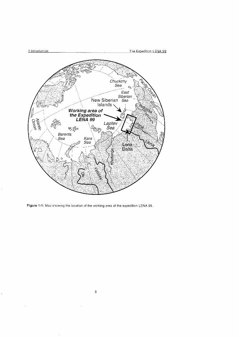
Figure 1-1: Map showing the location of the working area of the expedition LENA 99.

The Expedition LENA 99 2 Ex~edition Itineraty
2 Expedition Itinerary (V. ßachol and M. N. Grigoriev)
2.1 Selection of working areas With respect to the scientific program, the expedition group had been divided into several teams prior to the expedition. For each team specific working areas, shown in Figure 2-1, had been selected.
Team 1 (Samoylov Island), which concentrated on modern processes of permafrost affected soils, used a biological station of the Lena Delta Reserve on the island Samoylov in the central part of the Lena Delta. The field work was carried out close to the station on Samoylov Island. In order to Cover both winter and summer conditions, continuous measurements were carried out from the beginning of May to the beginning of September. For that reason, the Samoylov team was divided into three sub-teams (team 1 a-C). Samoylov station is equipped with a kitchen, a dining room, some living rooms that were used as laboratories and a Sauna. The participants lived in small tents during the expedition. A cook was provided by the Lena Delta Reserve.
( Chapter 3: Modern Processes in Permafrost Affected Solls).
Team 2 a (Arga Island) and 2 b (RV Dunay) focused on modern and ancient sedimentation in the Lena Delta and the Laptev Sea coast. The objectives were to understand the genesis of deep lakes of the Arga Island in the Western Lena Delta (Team 2a: Arga Island) and to quantify the material input to the Laptev Sea by coastal erosion (Team 2b: Dunay). The field work of team 2a was carried out during winter conditions in early May in order to carry out lake sediment coring and ground penetrating radar studies from the ice-cover of the lake. A tractor sledge including a bullock with living rooms for the participants was used for transportation. Team 2 b was based aboard the vessel Dunay. During the summer season coastal erosion studies were performed around the Lena Delta and along the coastline of the eastern Laptev Sea. The vessel Dunay, which was chartered from the Tiksi Hydrobase, is constructed for navigation work in the delta and in the coastal regions of the Laptev Sea. The participants of the expedition lived in one of the cabins of the ship. The ship is provided with a dining room, a cook and a shower. Two motorboats for the work in shallow regions were available.
( Chapter 4: Coastal Processes in the Laptev Sea and the Environmental History of the Lena Delta)
For their paleoclimatic/paleoecological work program carried out during the summer season team 3 (Lakhovsky Island) had chosen an outcrop at the southern coast of the Island Bolshoy Lyakhovsky. The 2 km wide and 30 m high ice-complex was studied and sampled in detail. The Lyakhovsky team lived in a field camp.
( Chapter 5: Paleoclimate Signals of Ice-rich Permafrost)
Team 4 (Olenyokskaya Channel) carried out paleogeographical investigations along the Olenyokskaya Channel in the western part of the Delta during the summer season. Rubber boats were used for transportation and the participants lived in a field camp.
( Chapter 4: Coastal Processes in the Laptev Sea and the Environmental History of the Lena Delta)
Team 5 (Bykovsky Peninsula) completed the paleontological work on Bykovsky Peninsula, which was started during the expedition LENA 98. The team lived in a field camp on Bykovsky Peninsula during summer.
( Chapter 5: Paleoclima te Signals o f Ice-rich Perma frost)
2.2 General logistics and transport The general logistics of the LENA 1999 Expedition were jointly organized by the Permafrost Institute (Yakutsk), the Arctic and Antarctic Research Institute (St. Petersburg) and the Research Unit Potsdam of the Alfred Wegener Institute. Logistic operations in Tiksi (renting of busses, trucks, helicopters etc.) were organized by the Tiksi Hydrobase.
Due to the long duration of the field work and the large number of participants very complex logistic operations had to be organized. Figure 2-2 shows the timetable and the transport logistics.
The Exoedition LENA 99 2 Exoedition Itineratv
Figure 2-1 : Location map of the expedition LENA 99
A
IV)
iht 1 St. Petersburg-Tiksi: 30 Team 1 a, Team 2a
Regular Flight ~ i k s i - ~oscow: June 5
Team 1 a, Team 2a Moscow - Tiksi:
Team 1 b
Team 4:
Team 5:
Regular Flight Charterflight Tiksi - Moscow: Tiksi - St. Petersburg:
Teamlb Jul31 sep 08 Team 1c.Team 2b, Team 3, Moscow - Tiksi: Team 4, Team 5
Team 1 C, Team 2b, Team 3, Team 4,
Team 5
The Ex~edition LENA 99 2 Exoedition Itinerary
2.3 Timetables of individual working groups
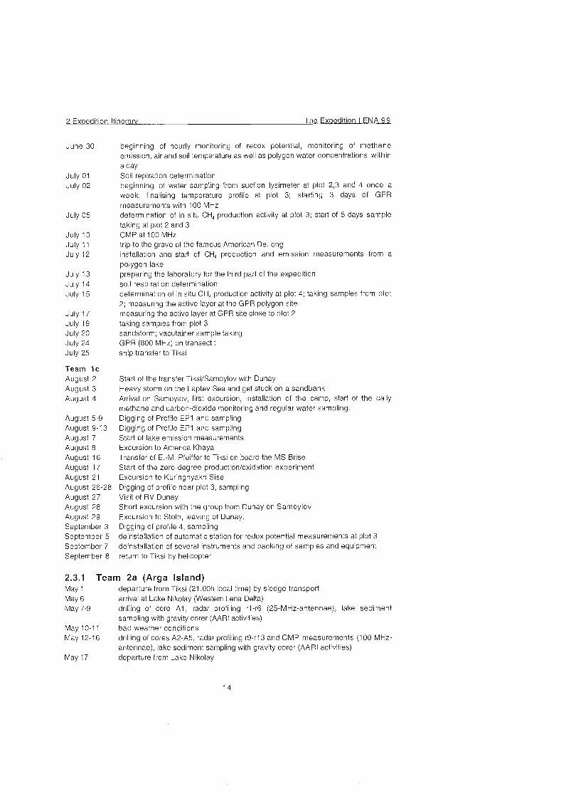
2.3.1 Team 1 (Samoylov Island)
Team 1a May 2 May 3-6 May 7 May 8 May 9 -25
May 22: May 23-24 May 26 May 27
Team 1b June 05 June 06
June 07
June 08
June 09
June 10 June 11
June 12
June 13 June 14 June 15 June 17
June 18
June 19 June 20
June 21 June 22-23 June 25
June 26
June 27
June 28
transport of equipment to Samoylov with two trucks; return to Tiksi waiting in Tiksi flight to Samoylov by military helicopter set up of laboratory; check of automated soil and climate stations on Samoylov field work: data collection On soil thermal and hydrologic dynamics; Snow, soil, gas and water sampling, Snow surveys arrival of team 2a (Schwamborn & Schneider) on Samoylov drilling of permafrost cores packing of equipment and samples and waiting for helicopter flight to Tiksi by helicopter
transfer Tiksi-Samoylov by helicopter, first inspection of the investigation sites beginning daily gas sampling for C H andCO, emission, daily soil monitoring at plot 3 (temperature, water table, permafrost table); checking the sites and the Instruments Installation of the gas chromatograph, calibration of FID-detector and first analysis of gas samples; taking samples from plot 2, logger start; test measurements with the GPR-system, installing a polygon measuring field calibration of the WLD-detector; starting the routine measurements (depth of active layer, TDR- and temp.-data); starting GPR with 500MHz each second day analysing of gas samples by gas chromatography; taking samples from plot 3 (nuncs and vacutainer) calibration of the gas exchange System taking samples from plot 2; GPR along the transect t (SOOMHz), installing new measureing field close to plot 2 starting gas exchange analysis every second day; start of weekly GPR measurments at both investigation sites beginning TDR and temperature monitoring each second day at plot 2 and 4 working as lumerjack for the banja; first GPR measurments at 800 MHz taking samples from plot 2 and 4 (vacutainer) beginning gas sampling for analysis CH4 and CO, emission at plot 4 each second
d ay beginning of water sampling (tundra lake) once a week and inspection of automatic weather and soil station (plot 3) taking samples from plot 3 taking samples from plot 3; new transect from permafrost cellar to the edge of the island, investigating it with both antennas first mosquito attacks, taking samples from plot 3; GPR: transect t at 800 MHz measuring the thawing depth at polygon site used for GPR measurements determination of soil respiration; new GPR high Center investigation site, using both antennas expedition to Stolb mountain; thawing depth measurements at GPR site close to plot 2 beginning of 3 day digging for a new profile at plot 3 for temperature measurements Installation of automatic station for redox potential measurements at plot 3
2 Expedition Itinerary The Expedition LENA 99
June 30
July 01 July 02
July 05
July 10 July 11 July 12
July 13 July 14 July 15
July 17 July 19 July 20 July 24 July 25
Team 1c August 2 August 3 August 4
August 5-9 August 9-1 3 August 7 August 8 August 16 August 17 August 21 August 26-28 August 27 August 28 August 29 September 3 September 5 September 7 September 8
beginning of hourly monitoring of redox potential, monitoring of methane emission, air and soil temperature as well as polygon water concentrations within a day Soil repiration determination beginning of water sampling from suction lysimeter at plot 2,3 and 4 once a week; finalising temperature profile at plot 3; starting 3 days of GPR measurements with 100 MHz determination of in situ CH4 production activity at plot 3; start of 5 days sample taking at plot 2 and 3 CMP at 100 MHz trip to the grave of the famous American DeLong installation and stad of CH4 production and emission measurements from a polygon lake preparing the laboratory for the third part of the expedition soil respiration determination determination of in situ CH4 production activity at plot 4; taking samples from plot 2; measuring the active layer at the GPR polygon site measuring the active layer at GPR site close to plot 2 taking samples from plot 3 sandstorm; vacutainer sample taking GPR (800 MHz) on transect t ship transfer to Tiksi
Start of the transfer Tiksi!SamoyIov with Dunay Heavy storm on the Laptev Sea and get stuck on a sandbank Arrival on Samoylov, first excursion, Installation of the camp, start of the daily methane and carbon-dioxide monitoring and regular water sampling. Digging of Profile EP1 and sampling Digging of Profile EP1 and sampling Start of lake emission measurements Excursion to America Khaya Transfer of E.-M. Pfeiffer to Tiksi on board the MS Brise Start of the Zero degree production!oxidation experiment Excursion to Kuringnyakh Sise Digging of profile near plot 3, sampling Visit of RV Dunay Short excursion with the group from Dunay on Samoylov Excursion to Stolb, leaving of Dunay. Digging of profile 4, sampling deinstallation of automatic Station for redox potential measurements at plot 3 deinstallation of several Instruments and packing of samples and equipment return to Tiksi by helicopter
2.3.1 Team 2a (Arga Island) May 1 departure from Tiksi (21.00h local time) by siedge transport May 6 arrival at Lake Nikolay (Western Lena Delta) May 7-9 drilling of core A l , radar profiling r1-r6 (25-MHz-antennae), lake sediment
sampling with gravity corer (AARI activities) May 10-1 1 bad weather conditions May 12-1 6 dr~lling of cores A2-A5, radar profiling r9-r13 and CMP measurements (100-MHz-
antennae), lake sediment sampling with gravity corer (AARI activities) May 17 departure from Lake Nikolay
The Expedition LENA 99 2 Expedition Itinerary
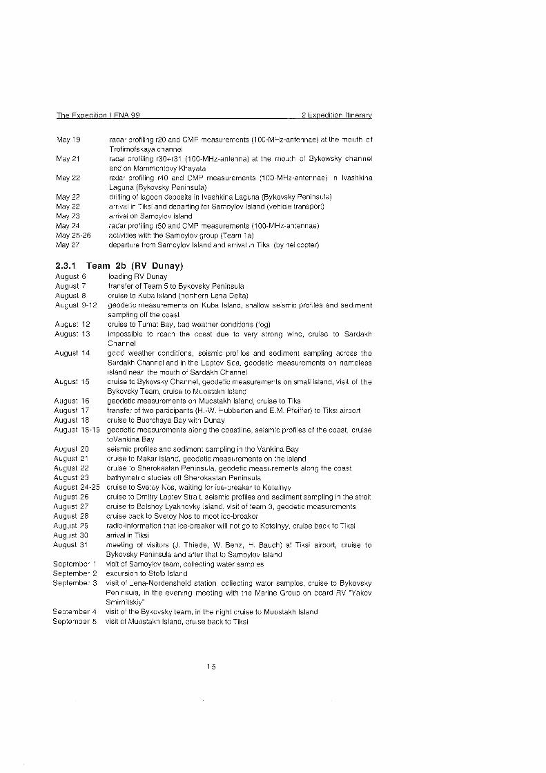
May 19
May 21
May 22
May 22 May 22 May 23 May 24 May 25-26 May 27
radar profiling r20 and CMP rneasurernents (100-MHz-antennae) at the rnouth of Trofirnofskaya channel radar profiling r30+r31 (100-MHz-antenna) at the rnouth of Bykowsky channel and On Marnrnontovy Khayata radar profiling r40 and CMP rneasurernents (100-MHz-antennae) in Ivashkina Laguna (Bykovsky Peninsula) drilling of lagoon deposits in Ivashkina Laguna (Bykovsky Peninsula) arrival in Tiksi and departing for Sarnoylov Island (vehicle transport) arrival on Samoylov Island radar profiling r50 and CMP measurements (1 00-MHz-antennae) activities with the Samoylov group (Team 1a) departure frorn Sarnoylov Island and arrival in Tiksi (by helicopter)
2.3.1 Team 2b (RV Dunay) August 6 August 7 August 8 August 9-12
August 12 August 13
August 14
August 15
August 16 August 17 August 18 August 18-19
August 20 August 21 August 22 August 23 August 24-25 August 26 August 27 August 28 August 29 August 30 August 31
September 1 September 2 September 3
September 4 September 5
loading RV Dunay transfer of Team 5 to Bykovsky Peninsula cruise to Kuba Island (northern Lena Delta) geodetic rneasurernents on Kuba Island, shallow seismic profiles and Sediment sampling off the coast cruise to Turnat Bay, bad weather conditions (fog) impossible to reach the coast due to vety strong wind, cruise to Sardakh Channel good weather conditions, seisrnic profiles and sedirnent sarnpling across the Sardakh Channel and in the Laptev Sea, geodetic rneasurernents on nameless island near the mouth of Sardakh Channel cruise to Bykovsky Channel, geodetic rneasurernents On srnall island, visit of the Bykovsky Team, cruise to Muostakh Island geodetic rneasurernents on Muostakh Island, cruise to Tiksi transfer of two participants (H.-W. Hubberten and E.M. Pfeiffer) to Tiksi airport cruise to Buorchaya Bay with Dunay geodetic rneasurements along the coastline, seismic profiles of the coast, cruise toVan kina Bay seismic profiles and sedirnent sarnpling in the Vankina Bay cruise to Makar Island, geodetic rneasurernents on the island cruise to Sherokastan Peninsula, geodetic measurernents along the coast bathyrnetric studies off Sherokastan Peninsula cruise to Svetoy Nos, waiting for ice-breaker to Kotelnyy cruise to Drnitry Laptev Strait, seisrnic profiles and sedirnent sampling in the strait cruise to Bolshoy Lyakhovky Island, visit of team 3, geodetic rneasurements cruise back to Svetoy Nos to rneet ice-breaker radio-inforrnation that ice-breaker will not go to Kotelnyy, cruise back to Tiksi arrival in Tiksi rneeting of visitors (J. Thiede, W. Benz, H. Bauch) at Tiksi airport, cruise to Bykovsky Peninsula and after that to Sarnoylov Island visit of Sarnoylov team, collecting water sarnples excursion to Stolb Island visit of Lena-Nordensheld Station, collecting water sarnples, cruise to Bykovsky Peninsula, in the evening rneeting with the Marine Group on board RV "Yakov Srnirnitskiy" visit of the Bykovsky tearn, in the night cruise to Muostakh Island visit of Muostakh Island, cruise back to Tiksi
2 Exoedition Itinerarv The Exoedition LENA 9 9
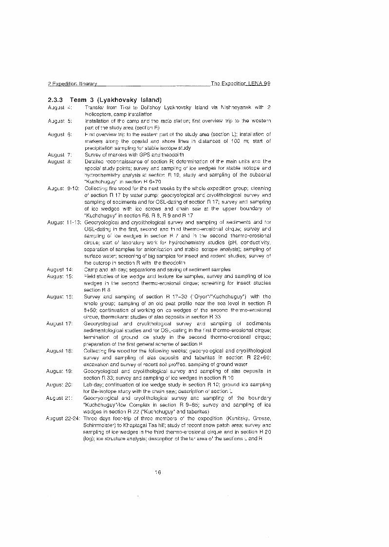
2.3.3 Team 3 (Lyakhovsky Island) August 4:
August 5:
August 6:
August 7: August 8:
August 14: August 15:
August 16:
August 17:
August 18:
August 19:
August 20:
August 21:
August 22-24
. .
Transfer from Tiksi to Bol'shoy Lyakhovsky Island via Nishneyansk with 2 Helicopters, camp installation Installation of the camp and the radio station; first overview trip to the western part of the study area (section R) First overview trip to the eastern part of the study area (section L); Installation of markers along the coastal and shore lines in distances of 100 rn; start of precipitation sampling for stable isotope study Survey of markers with GPS and theodolith Detailed reconnaissance of section R; determination of the main units and the special study points; survey and sampling of ice wedges for stable isotope and hydrochemistry analysis at section R 19, study and sampling of the subaerial "Kuchchuguy" in section R 6+70 Collecting fire wood for the next weeks by the whole expedition group; cleaning of section R 17 by water pump; geocryological and cryolithological survey and sampling of sedirnents and for OSL-dating of section R 17; survey and sampling of ice wedges with ice screws and chain saw at the upper boundary of "Kuchchuguy" in section R6, R 8, R 9 and R 17 Geocryological and cryolithological survey and sampling of sediments and for OSL-dating in the first, second and third thermo-erosional cirque; survey and sarnpling of ice wedges in section R 7 and in the second thermo-erosional cirque; start of laboratory work for hydrochemistry studies (pH, conductivity, separation of samples for anionlcation and stable isotope analysis); sarnpling of surface water; screening of big samples for insect and rodent studies; survey of the outcrop in section R with the theodolith Camp and lab day; separations and saving of sediment samples Field studies of ice wedge and texture ice sarnples, survey and sampling of ice wedges in the second thermo-erosional cirque; screening for insect studies section R 8 Survey and sampling of section R 17+30 ("0lyor"l"Kuchchuguy") with the whole group; sampling of an old peat profile near the sea level in section R 8+50; continuation of working On ice wedges of the second thermo-erosional cirque, thermokarst studies of alas deposits in section R 33 Geocryological and cryolithological survey and sampling of sediments sedimentological studies and for OSL-dating in the first thermo-erosional cirque; termination of ground ice study in the second thermo-erosional cirque; preparation of the first general scheme of section R Collecting fire wood for the following weeks; geocryological and cryolithological survey and sampling of alas deposits and taberites in section R 22+60; excavation and survey of recent soil profiles, sampling of ground water Geocryological and cryolithological survey and sampling of alas deposits in section R 33; survey and sampling of ice wedges in section R 10 Lab day; continuation of ice wedge study in section R 10; ground ice sarnpling for Be-isotope study with the chain saw; description of section L Geocryological and cryolithological survey and sarnpling of the boundary 'Kuchchuguy"1Ice Complex in section R 9+85; survey and sampling of ice wedges in section R 22 ("Kuchchuguy" and taberites) Three days foot-trip of three members of the expedition (Kunitsky, Grosse, Schirrmeister) to Khaptagai Tas hill; study of recent Snow patch area; survey and sarnpling of ice wedges in the third thermo-erosional cirque and in section R 20 (log); ice structure analysis; description of the far area of the sections L and R
The Expedition LENA 99 2 Expedition Itinerary
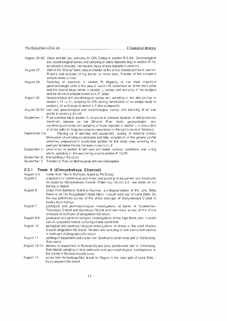
August 25-26
August 27:
August 28:
August 29:
August 30-31
September 1:
Camp and lab day; sampling for OSL-Dating in section R 9+95; Geocryological and cryolithological survey and sampling of valley deposits (log) in section R 19; ice structure analysis; thermokarst study of alas deposits in section L Visit of the "Dunay" team; documentation of the whole coastal profiles in section R and L and recovery of big bones by motor boat, Transfer of first complete sample series to Tiksi Sampling of paleosols in section R; Mapping of the most important geomorphologic units in the area of section R; determination of the main units and the Special study points in section L; survey and sampling of ice wedges and ice structure analysis in section L 21 (alas) Geocryological and cryolithological survey and sampling of two alas profiles in section L 11 - L 14; sampling for OSL-dating; termination of ice wedge study in section L 21 and study of section L 2 (fluvial deposits) Lab day; geocryological and cryolithological survey and sampling of an alas profile in section L 21+50 Final overview-trip to section R, exkursion to a known location of well preserved mammoth remains On the Zimov'e River bank; geocryological and cryolithological survey and sampling of fluvial deposits in section L 3; Installation of an ice cellar for large ice samples; description of the Ice Complex in Section L
September 2-4: Packing up of samples and equipment, sawing of mammal bones; Modulation of sampling CO-ordinates and lists, completion of the general profile schemes, preparation of acolumnar section for the study area; sampling of a peat profile below the Ice Complex in section L 9
September 5: Description of section R with new and better outcrop conditions after a big storm, sampling of the weathering crust in section R 13+50
September 6: Dismantling of the camp September 7: Transfer to Tiksi via Nishneyansk with two Helicopters
2.3.1 Team 4 (Olenyokskaya Channel) August 3-4 August 5
August 6
August 7
August 8-9
August 10
August 11
tranfer from Tiksi to Samoylov Island by RV Dunay preparation of rubber boat and motor and packing of equipment and foodstuffs for cruise by Olenyokskaya Chanel. Pollen trap station L-3 was taken off on Samoylov Island. cruise from Samoylov Island to Gusinca - a biological station of the Lena Delta Reserve on the Kuogastakch-Aryta Island in south-west patt of Lena Delta. By the way preliminary survey of the shore outcrops of Olenyokskaya Chanel in locality Buor-Kchaya. geological and geomorphological investigations of banks of Tyuerenkey- Tebyulege Chanel and Arynskaya Chanel and preliminary survey of the shore outcsops of norht Part of Jangylakch-Sis Island. geological and geomorphological investigations of the high flood plain in south part of Jangylakch Island, sampling of lake sediments. geological and geomorphological investigations of shores of the small chanels around Jangylakch-Sis Island. Studies and sampling of one permafrost section in north part of Jangylakch-Sis Island packing of equipment and cruise from Gusinca to south-west patt of Kchardang- Sise Island
August 12-13 delivery of equipment to Byracan-Kyuele Lake (south-west part of Kchardang- Sise Island), sampling of lake sediments and geomorphological investigations in the vicinity of Byracan-Kyuele Lake.
August 13 cruise from Kchardang-Sise Island to Nagym in the West Part of Lena Delta - Kyuryuelyakch-Sis Island
2 Expedition Itinerarv The Exoedition LENA 99
August 14 levelling along the line and placing hydrologikal post for measuring of water level in Olenyokskaya Chanel
August 15-16 hourly observations for level of water on the hydrologikal post, geological and geomorphological investigations in the west part of Kyuryuelyakch-Sis Island
August 17 sampling of one perrnafrost section along Olenyokskaya Chanel, packing of equipment and samples for cruise from Nagym to Gusinca.
August 18 cruise from Nagym to Gusinca, sarnpling for 14C-dating from the shore outcrops of first above the flood plain terrase by the way
August 19 sampling of permafrost section of the first above the flood plain terrace in the vicinity of Gusinca
August 20-21 delivery of equipment to Jangylakch-Sisin-Kyuele Lake (Jangylakch-Sis Island)
August 22 August 23
August 24
August 25
August 26
August 30
August 31 September 1
September 2
September 3 September 4 September 5
and sarnpling of lake sediments and geomorphological investigations in the vicinity of Jangylakch-Sisin-Kyuele Lake. packing of equipment and sarnples for cruise from Gusinca to Buor-Kchaya stay in Gusinca because of bad weather conditions. Pollen trap station L-2 was taken off by employee of the Lena Delta Reserve in Sagastyr 1s. cruise from Gusinca to Buor-Kchaya, sampling for 14C-dating from the shore outcrops of first above the flood plain terrase by the way, camp construction in Buor-Kchaya, visit of Samoylov Island team was divided into two groups in twos members in every group for geological and geomorphological investigations in the vicinity of Buor-Kchaya and cruise from Samoylov Island to Yugus-Yie (Yeppiries 1s.) - central part of Lena Delta. Pollen trap station L-1 was taken off in Yugus-Yie. geological studies of the shore outcsops of right bank of Olenyokskaya Chanel in the vicinity of Buor-Kchaya, studies and sampling of permafrost section of second above the flood plain terrace in the right bank of MalayaTumatskaya Chanel. for geological and geomorphological investigations in the vicinity of Buor- Kchaya (Olenyokskaya Chanel) and by chanels of central parri of Lena Delta from Malaya Tumatskaya Chanel to Arynskaya Chanel with sampling for 14C- dating from the shore outcrops of the high flood plain and the first above the flood plain terrase by the way work wasn't possible because of bad weather conditions (very strong wind - sandy storrn) end of cruise from Yugus-Yie to Samoylov Is., visit of Samoylov 1s. sampling of the ice wedge of ice-complex for methane concentration and for stable isotope analysis in Buor-Kchaya. Work was carried out together Samoylov Group. sampling of one permafrost section in Buor-Kchaya, packing of samples and
equipment, dismanting of the camp, return to Samoylov Is., loading of the equipment On the board of the vessel Dunay. leaving Sarnoylov 1s. On the board of Dunay for excursion to Bykovsky Peninsula excursion to Bykovsky Peninsula excursion to Muostakch Island, shipping back to Tiksi
2.3.4 Team 5 (Bykovsky Peninsula) August 7-8 shipping by 'Dunay' from Tiksi to the Bykovsky Peninsula (SiegertJKunitsky '98
camp site), loss of part of the team's equipment and food (later compensated by the team 2b) in the landing accident under stormy weather, camp construction
August 9 emergency revision, drying, and repair of equipment and food supply, camp construction
August 10 first overview inspection of the Mamontovy Khayata cliff exposure, search of poorly preserved '98 landmarks and realising that a new survey is necessary
The Expedition LENA 99 2 Expedition Itinerarv
August 11-12
August 13-14
August 15
August 16
August 17-21
August 22
August 23
August 24-25
August 26
August 27
August 28
August 29-31
August 31 September 1
September 2
September 3
September 5
storrn and rain, planning the site survey, preparation of the land rnarkers, visit and ernergency staying On by P.Nikolskiy and A.Basilyan with their experimental 6-wheel cross-country vehicle theodolite survey of the NW half of the Marnontovy Khayata cliff, selection of the profile for detailed study at the toprnost part of the cliff, lest sarnpling for rnacrofossils in the upper part of Ice Cornplex, fossil bone collecting calculation of the survey and building of the new site plan and profile, correlated with the old one, test screening for rnacrofossils, brief visit by 'Dunay' and the AWI-Potsdarn Chief with the tearn 2b, excursion across the site area and the Ice Cornplex with Prof. H.-W. Hubberten storrn and rain, sarnpling and screening for rnacrofossils in the upper level of Ice Cornplex investigation of the Ice Cornplex profile frorn the top of the Marnontovy Khayata cliff to the depth 17 rn (Sartanian and end-Karginian) along the sequence of baidzherakhs H-F - description and sedirnent sarnpling, prirnary sarnple processing, bone collecting at the cliff and low-tide bars excursion along the coast to the NW edge of the Marnontovy Bysagasa alass and the next Yedorna, bone collecting and search for a white whale modern carcass cornpleting of regular sarnpling of the main sequence (H-F), control instrurnentary levelling of the profile processing of the collected sarnples (sarnpling for pollen, drying, sarnpling for AMS) sarnpling of the main sequence for plant, insect, and other rnacrofossils, selection of additional profiles to fill the gap in the rnain one (ice wedge crossing), study of soil profiles on top of the Yedorna (description, sarnpling) o n Dr. E.-M. Pfeiffer request processing of the collected sarnples (sarnpling for pollen, drying, sarnpling for AMS), search for bones in the upper part of the Marnontovy Khayata Ice Cornplex photographic survey (docurnentation) of the Marnontovy Khayata section, excursion to the exposures in 2.2 km SE frorn the Camp, screening of rnacrofossil sarnples processing of the collected sarnples (sarnpling for pollen, drying, sarnpling for AMS), screening of rnacrofossil sarnples, search for bones in the upper part of the Marnontovy Khayata Ice Cornplex, additional detailed study of the rnain profile and its photographic survey arrival of 'Dunay' and landing of the Team 2b (Erosion Group) sarnpling and description of the additional profile of baydzherakh E to fill the gap in the main profile, taking rnore sarnples for rnacrofossil screening in the rnain profile, discovery of in situ bones in baydzherakhs Mal and Ma2 (near '98 RP 4.9) processing of the collected sarnples, screening of rnacrofossil sarnples, discovery of baby rnarnrnoth skull in baydzherakh Mal processing of the collected samples, screening of rnacrofossil sarnples, excavation of baby rnarnrnoth skull, rneeting with the Marine Group on board RV 'Yakov Srnirnitskiy" excavation of baby rnarnrnoth skull, lecture and excursion to the Marnontovy Khayata Ice Cornplex with the Gerrnan visitors (Prof. J.Thiede, Dr. H.Bauch, Dr. W. Benz, sarnple and bone packing sarnple and bone packing, shipping by 'Dunay' back to Tiksi
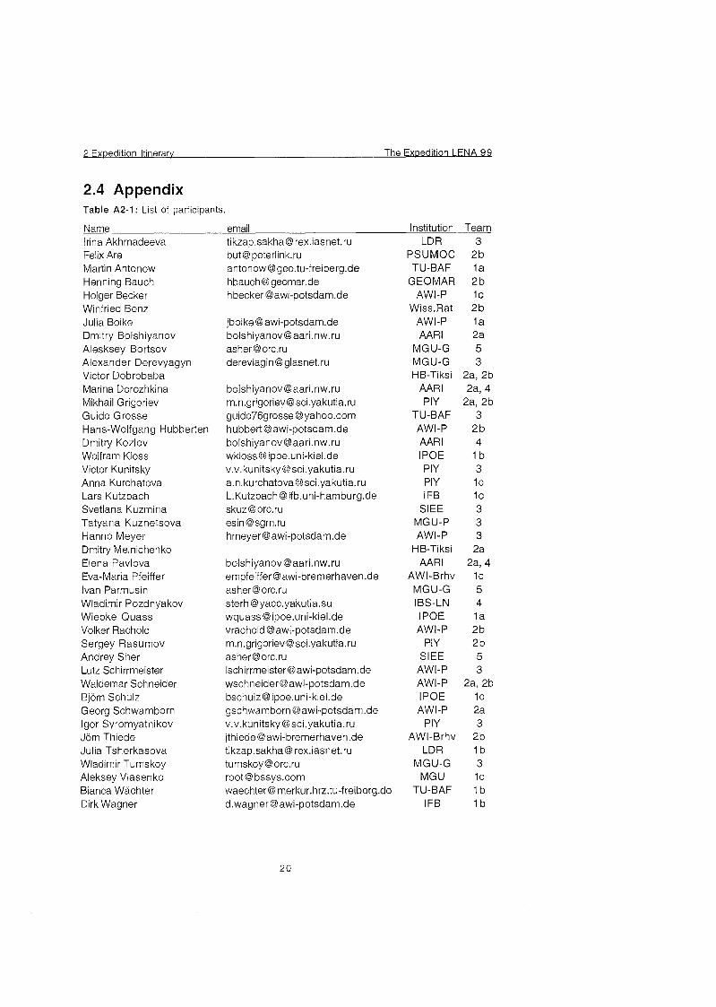
2.4 Appendix Table A2-1: List of participants.
Name email Institution Team Irina Akhmadeeva Felix Are Martin Antonow Henning Bauch Holger Becker Winfried Benz Julia Boike Dmitry Bolshiyanov Alesksey Bortsov Alexander Derevyagyn Victor Dobrobaba Marina Dorozhkina Mikhail Grigoriev Guido Grosse Hans-Wolfgang Hubberten Dmitry Kozlov Wolfram Kloss Victor Kunitsky Anna Kurchatova Lars Kutzbach Svetlana Kuzmina Tatyana Kuznetsova Hanno Meyer Dmitry Melnichenko Elena Pavlova Eva-Maria Pfeiffer Ivan Parmusin Wladimir Pozdnyakov Wiebke Quass Volker Rachold Sergey Rasumov Andrey Sher Lutz Schirrmeister Waldemar Schneider Björ Schulz Georg Schwamborn Igor Syromyatnikov Jör Thiede Julia Tsherkasova Wladimir Tumskoy Aleksey Vlasenko Bianca Wächte Dirk Wagner
tikzap.sakha@ rex.iasnet.ru but @peterlink.ru [email protected] hbauch @geomar.de hbeckeraawi-potsdam.de
jboike @awi-potsdam.de [email protected] [email protected] dereviagin @glasnet.ru
[email protected] [email protected] [email protected] [email protected] [email protected] wkloss@ ipoe.uni-kiel.de v.v.kunitsky @sci.yakutia.ru [email protected] L.Kutzbach @ ifb.uni-hamburg.de [email protected] esin @sgm.ru hmeyer @awi-potsdam.de
[email protected] empfeiffera awi-bremerhaven.de [email protected] sterh @yacc.yakutia.su wquass@ ipoe.uni-kiel.de vrachold @awi-potsdam.de [email protected] [email protected] [email protected] [email protected] [email protected] gschwamborn @awi-potsdam.de v.v.kunitsky @sci.yakutia.ru jthiede @awi-bremerhaven.de tikzap.sakha@ rex.iasnet.ru tumskoy @orc.ru root @ bssys.com waechtert3merkur.hrz.t~-freiberg.de [email protected]
LDR 3 PSUMOC 2 b TU-BAF 1a
GEOMAR 2 b AWI-P IC
Wiss.Rat 2 b AWI-P 1a AAR1 2a
MGU-G 5 MGU-G 3 HB-Tiksi 2a, 2b
AAR1 2a, 4 PIY 2a, 2b
TU-BAF 3 AWI-P 2b AAR1 4 IPOE 1 b PIY 3 PIY 1 C
I FB 1 C
SIEE 3 MGU-P 3 AWI-P 3
HB-Tiksi 2a AAR1 2a, 4
AWI-Brhv l c MGU-G 5 IBS-LN 4 I POE 1 a AWI-P 2b
PIY 2b SIEE 5
AWI-P 3 AWI-P 2a, 2b IPOE 1 C
AWI-P 2a PIY 3
AWI-Brhv 2b LDR 1b
MGU-G 3 MGU 1 C
TU-BAF I b I FB 1b
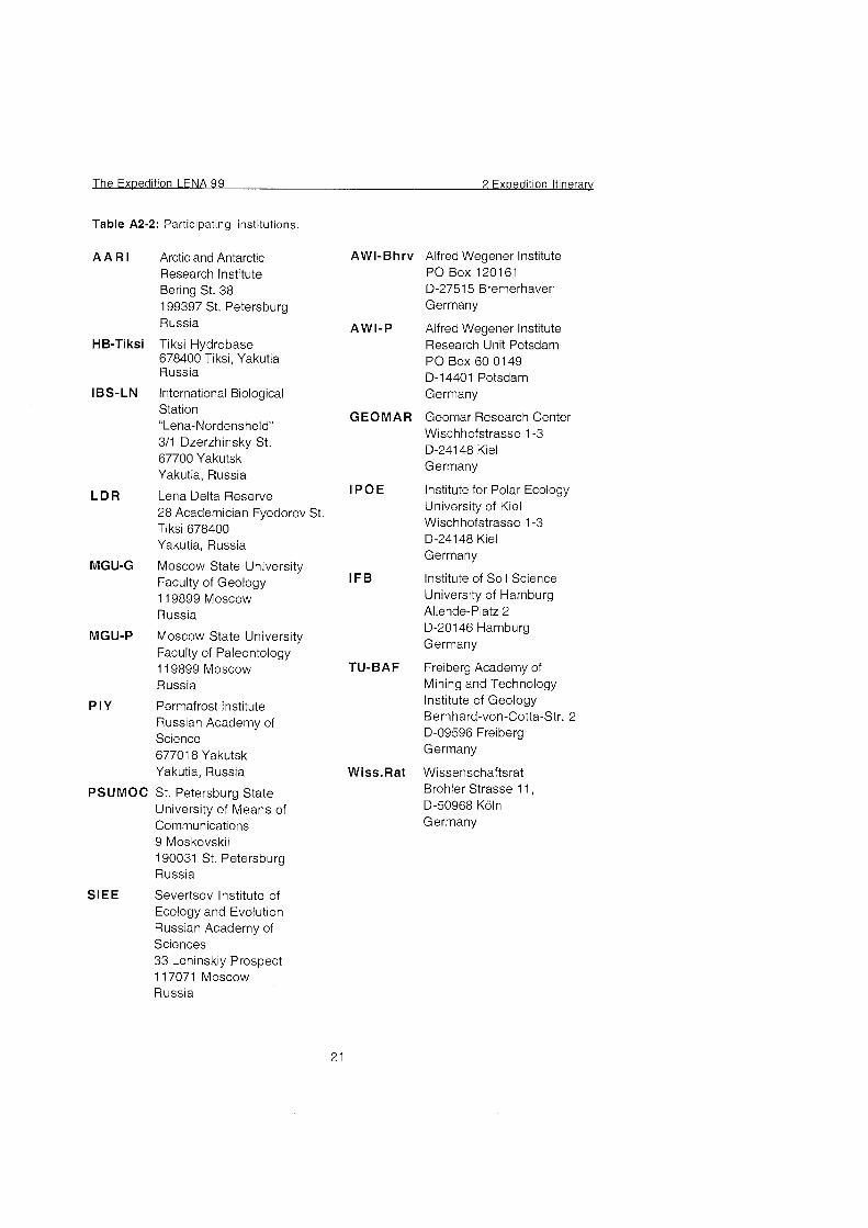
Table A2-2: Participating institutions.
A A R l Arctic and Antarctic Research Institute Bering St. 38 199397 St. Petersburg Russia
HB-Tiksi Tiksi Hydrobase 678400 Tiksi, Yakutia Russia
IBS-LN International Biological Station 'Lena-Nordensheld" 311 Dzerzhinsky St. 67700 Yakutsk Yakutia, Russia
L D R Lena Delta Reserve 28 Academician Fyodorov St, Tiksi 678400 Yakutia, Russia
MGU-G Moscow State University Faculty of Geology 1 19899 Moscow Russia
MGU-P Moscow State University Faculty of Paleontology 1 19899 Moscow Russia
PIY Permafrost Institute Russian Academy of Science 67701 8 Yakutsk Yakutia, Russia
PSUMOC St. Petersburg State University of Means of Communications 9 Moskovskii 190031 St. Petersburg Russia
SIEE Severtsov Institute of Ecology and Evolution Russian Academy of Sciences 33 Leninskiy Prospect 1 17071 Moscow Russia
AWI-Bhrv Alfred Wegener Institute PO Box 1201 61 D-27515 Bremerhaven Germany
AWI-P Alfred Wegener Institute Research Unit Potsdam PO Box 60 0149 D-14401 Potsdam Germany
GEOMAR Geomar Research Center Wischhofstrasse 1-3 D-24148 Kiel Germany
I P O E Institute for Polar Ecology University of Kiel Wischhofstrasse 1 -3 D-24148 Kiel Germany
IFB Institute of Soil Science University of Hamburg Allende-Platz 2 D-20146 Hamburg Germany
TU-BAF Freiberg Academy of Mining and Technology Institute of Geology Bernhard-von-Cotta-Str. 2 D-09596 Freiberg Germany
Wiss.Rat Wissenschaftsrat Brohler Strasse 11, D-50968 Köl Germany
3 Modern Processes in Permafrost Affected Soils The Exoedition LENA 99
3 Modern Processes in Permafrost Affected Soils
(E,-M. Pfeiffer, D. Wagner, H. Becker, A. Vlasenko, L. Kutzbach, J. Boike, W. Quass, W. Kloss, B. Schulz, A. Kurchatova, V. I. Pozdnyakov and I.
Akhmadeeva)
3.1 General objectives of the soil related investigations
(E. -M. Pfeiffer)
The investigations of the modern processes are focused on the energy an
hydrological dynamics and trace gas fluxes (CH4 and COg) of permafrost
affected soils in the Lena Delta 1 Northeast Siberia. The main field works - having started in 1998 - could be finished in the different parts (winter/spring,
springlsummer and Summer season) of the 99-Expedition. Additional sediment,
soil, water, ice and plant samples could be taken for more necessary analysis.
The seasonal emission of methane and carbon dioxide from different polygon
tundra sites were studied by field experiments and combined with biochemical
and microbial process experiments under defined field laboratory conditions.
The methane generation in tundra cryosols at near Zero temperatures in
different soll horizons as well as the influence of the vegetation on gas emission
were investigated by special field experiments. The results show the importance
of the trace gas emission from permafrost soils for the regional 1 global methane
budget.
The soil related investigations in the Lena Delta are necessary to understand
the modern processes of these sensitive ecosystems and to estimate the
impact on possible global climate changes. The soil processes will supply the
necessary data base for further investigations like studies On permafrost
associated gas hydrates or special research on the surviving ability of
microorganisms in extreme habitats
3.2 The distribution of soils on Samoylov Island and other comparison sites of the Lena Delta
(I. Akhmadeeva, A. Kurchatova and E.-M. Pfeiffer)
During the Lena Delta Expedition 1999, the soil survey on Samoylov Island and other sites was completed. Soil mapping was carried out by the description of
typical landscape units in dependence of vegetation, relief position, water
The Exoedition LENA 99 3 Modern Processes in Permafrost Affected Soils
regime, the parent material and other Parameters. Soil and plant samples were taken for additional analysis in Yakutsk and Germany.
The soil distribution is shown in Figure 3-1. The soils were classified according to the classification of Yelovskaya (Table 3-1). The soil map and patterned ground map of the island after the international classification is in Progress and
will be presented after processing of all analytical and morphological data.
The first terrace in the western part of the island is dominated by weak
developed and wet soil without any Pattern ground structure (soil type:
Permafrost Alluvial Layered Poorly Developed). The main soils of the island are wet soils, which are dominated by humus accumulation and cryoturbation (Permafrost Peat Gley). The general description of the island and of the
investigation area were given in the last year's report (Pfeiffer et al., 1999).
The main soil investigations are focused On the active layer and their correlated
processes. To get more information to the associated deeper buried soils and
the permafrost sediments two deep soil profiles (ice wedge polygon soil, 5 m depth; peat soil 7.5 m depth) on southeastern part of Samoylov Island were investigated. Soil and plant samples were taken for additional peatlpollen studies and ^C-analysis. These studies are necessary for the CO-operation with the other projects On paleoenvironmental and paleoclimatic studies of the Laptev Sea program.
Table 3-1 : Classification of soils of Samoylov Island.
1 (Primitive) Alluvial 1 Alluvial Typical 1 Permafrost 1 Permafrost Alluvial 1 AT
1 Alluvial Turfness 1 Turfness Typical 1 Permafrost Alluvial 1 ATG
Index APr
Section Poorly Developed (Primitive)
1 Turfness Gley 1 Permafrost 1 Permafrost Alluvial 1 AMPshG 1 Alluvial Peat-Gley 1 Muddy-Peatish-Gley 1
1 Permafrost Alluvial 1 AMPG
Order Primitive Alluvial
1 Muddy-Peat-Gley 1 1 1 Permafrost Alluvial 1 AMG 1
Type Permafrost Alluvial Layered Poorlv Develooed
Subtype
1 Gley 1 Permafrost Peatish- 1 PshG
Gley Humus-Gley
Accumulative- Humus
Permafrost Turfness-Gley Permafrost Peat-
Accumulative- Humus Typical
Muddy-Gley Permafrost Turfness- Gley Typical Permafrost Peat-Gley
Permafrost Straw
TG
PG
Gley Permafrost Straw S
Figure 3-1: Soil map of Samoylov Island (for legend See Table 3-2).
The Expedition LENA 99 3 Modern Processes in Permafrost Affected Soils
Table 3-2: Legend of soil map of Samoylov Island.
Color and index
APr
3.3 Thermal and hydrologic dynamics of the active layer
Permafrost Alluvial Layered Poorly
AT
ATG AMPshG
AMPG
AMG
AMPG+AMPshG
TG
PG+PshG+TG
S B
RS DL
v3
(J. Boike and H. Becher)
Developed (Primitive)
Permafrost Alluvial Turfness Typical
Permafrost Alluvial Turfness Gley
Permafrost Alluvial Muddy-Peatish-Gley
Permafrost Alluvial Muddy-Peat-Gley
Permafrost Alluvial Muddy-Gley
Soil complex
Permafrost Turfness-Gley Typical
Soil complex
Permafrost Straw
Beach
Zones of retreat shores
Drained lake
Channels and lakes
Soll ~ i t s
Microclimate and soil temperature were continuously logged using automated
stations from August 1998 to September 1999 at the low centered polygon site.
A Summary of instruments and methods is provided in Friedrich & Boike (1999).
Soil moisture and temperature were recorded and soil water from suction
lysimeters sampled manually every other day at sites 1 and 2 from May to September 1999. Between May 7 and May 27, 1999, Snow pits were dug to
permit determination of Snow physical characteristics (structure, temperature,
density, grain size and form).
3 Modern Processes in Permafrost Affected Soils The Expedition LENA 99
20 Air temperature
10
0
- -10
ti L. -20
-30
-40
-50
* r Sciltemperaturein organic surhce l lyer Polygon center
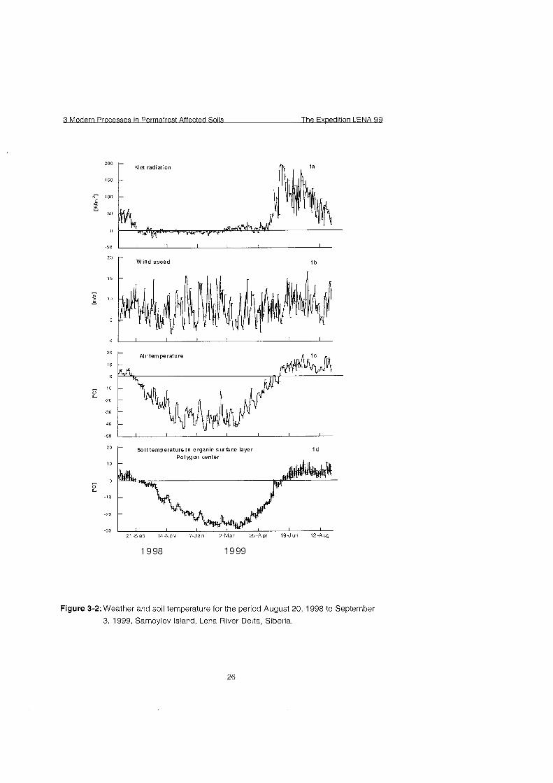
Figure 3-2: Weather and soil temperature for the period August 20, 1998 to September
3, 1999, Samoylov Island, Lena River Delta, Siberia.
The Expedition LENA 99 3 Modern Processes in Permafrost Affected Solls
0 1
2
5 3
4
- 10
E Å 5 5 n 15 a> U
ace <: 6 b
20 0:1
depth hoar with several layers; 25 very loose and dry; 7
grains > 3 mm
30
snow temperature [¡C
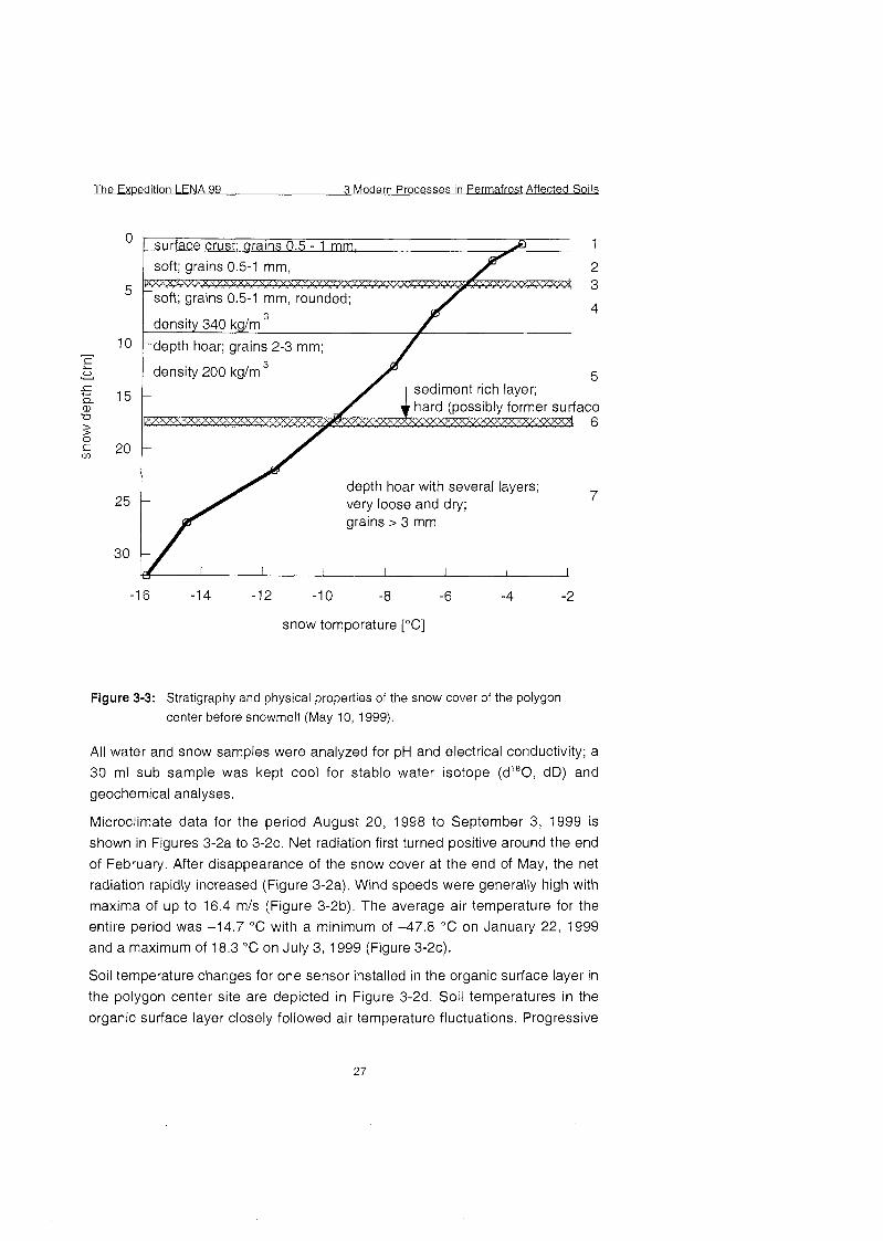
Figure 3-3: Stratigraphy and physical properties of the snow cover of the polygon
center before snowmelt (May 10, 1999).
All water and Snow samples were analyzed for pH and electrical conductivity; a
30 ml sub sample was kept cool for stable water isotope (dJ8O, dD) and
geochemical analyses.
Microclimate data for the period August 20, 1998 to September 3, 1999 is
shown in Figures 3-2a to 3-2c. Net radiation first turned positive around the end
of February. After disappearance of the Snow cover at the end of May, the net
radiation rapidly increased (Figure 3-2a). Wind speeds were generally high with
maxima of up to 16.4 mls (Figure 3-2b). The average air temperature for the
entire period was -14.7 "C with a minimum of -47.8 OC on January 22, 1999
and a maximum of 18.3 OC on July 3, 1999 (Figure 3-2c).
Soll temperature changes for one Sensor installed in the organic surface layer in
the polygon center site are depicted in Figure 3-2d. Soil temperatures in the
organic surface layer closely followed air temperature fluctuations. Progressive
3 Modern Processes in Permafrost Affected Soils The Expedition LENA 99
decreases in air temperature at the end of September initiated the phase
change in the soil. During fall and spring the phase change occurred rapidly and no Zero curtain effect (temperature stabilization around 0 'C) was observed.
Snow depth was very heterogeneous spatially and varied between 40 cm in the polygon Centers and 0 to 5 cm on the apex. A surface crust and hardened
layers within the Snow profile contained a large amount of aeolian sediments and indicated high wind speeds (Figure 3-3). Large depth hoar crystals with grain sizes larger than 3 mm were the result of steep temperature gradients
between soil and air and their associated vapor pressure gradients. In addition, the long grass tundra vegetation promoted depth hoar formation by preserving a
loose, aerated layer at the snow cover base. Figure 3-3 shows the snow
temperature, stratigraphy and physical properties of the initially cold, dry snow period. Around May 23, the snow cover started to become isothermal and phase change was initiated.
3.4 Seasonal variability of trace gas emission (CH4, CO,) and in situ process studies
(D. Wagner, L. Kutzbach, H. Becker, A. Vlasenko and E,-M. Pfeiffer)
3.4.1 Methode and field experiments
The investigations on Samoylov Island, a representative island in the Lena delta (N 72', E 126') includes field measurements of the methane and carbon dioxide
emission of a typical ice-wedge tundra and the process studies of methane
fluxes (production, oxidation, emission).
Daily measurements of trace gas emission (CH4, CO,), thaw depth, water level and soll temperature were carried out from the beginning of June 1999 to the
end of August 1999 at the low centre polygon site. The CH4 and CO, release from the floodplain site and from a polygon lake were also periodically
monitored. The used method (close chamber system) and the investigation sites had been described previously (Pfeiffer et al. 1999). Furthermore, the CH4
and COg concentration in the backwater of the polygon centre as well as the
Pore water concentration of all investigation sites was periodically analyzed.
A series of field experiments were conducted to investigate the plant-mediated methane flux. Special glass bottles (500 or 1000 ml) were used to enclose single tillers of Carex concolor (Figure 3-4). In the bottom of the flask was a round hole, which could be fitted by a rubber stopper, The stopper was drilled
out and cut Open on one side. The prepared rubber stopper was wrapped
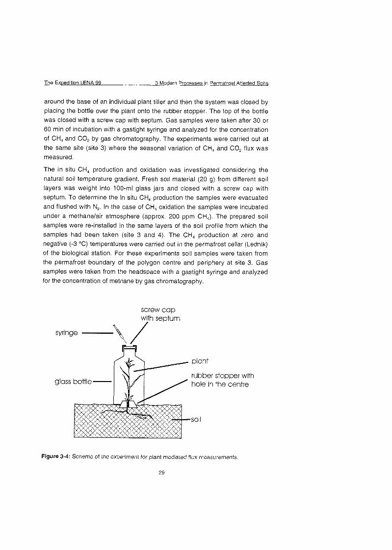
The Expedition LENA 99 3 Modern Processes in Permafrost Affected Soils
around the base of an individual plant tiller and then the System was closed by
placing the bottle over the plant onto the rubber stopper. The top of the bottle was closed with a screw cap with septum. Gas samples were taken after 30 or 60 min of incubation with a gastight syringe and analyzed for the concentration of CH4 and CO, by gas chromatography. The experiments were carried out at
the Same site (site 3) where the seasonal variation of CH4 and COg flux was measured.
The in situ CH4 production and oxidation was investigated considering the
natural soil temperature gradient. Fresh soil material (20 g) from different soil layers was weight into 100-ml glass jars and closed with a screw cap with septum. To determine the in situ CH4 production the samples were evacuated
and flushed with N,. In the case of CH4 oxidation the samples were incubated
under a methanelair atmosphere (approx. 200 ppm C^). The prepared soil
samples were re-installed in the Same layers of the soil profile from which the samples had been taken (site 3 and 4). The CH4 production at Zero and negative (-3 'C ) temperatures were carried out in the permafrost cellar (Lednik) of the biological station. For these experiments soil samples were taken from the permafrost boundary of the polygon centre and periphery at site 3. Gas samples were taken from the headspace with a gastight syringe and analyzed
for the concentration of methane by gas chromatography.
screw cap with seotum
syringe -\/ plant
rubber stopper with hole in the centre
soil
Figure 3-4: Scheme of the experiment for plant mediated flux measurernents.
29
3 Modern Processes in Permafrost Affected Soils The Exoedition LENA 99
An automatic station for longtime recording of redox potentials (Fiedler and
Fischer, 1994) was installed along a transect through a low centre polygon. The
redox potential was determined in the top and bottom Zone of the active layer in
intervals of one hour at 16 measuring points.
CH4 and CO, concentrations were determined with a Chrompack (GC 9003)
gas chromatograph in the field laboratory. The instrument was equipped with a Poraplot Q and a Molesieve 5A capillar column connected with a switching
valve. CH4 was analyzed by a flame ionization detector (FID) and CO, by a hot
wire detector (HWD). All gas sample analyses were done after calibration with
standards of known concentrations of the respective gases. Helium was used as carrier gas.
3.4.2 Preliminary Results
The closed chamber measurements of CH. emission from the centre of a wet
polygon tundra showed right from the start of soll thawing a relatively high CH4
emission rate (> 15 mg h" m") at the beginning of June, which increased with
continuing thawing of the active layer (Figure 3-5b). The highest CH4 emission
was observed during July with a rate between 70 - 80 mg CH4 d" m-'.
The maximum thaw depth of the soil was reached in August (Figure 3-5a).
During this period, the CH4 emission decreased again and showed a rate on an
average of 24.8 Â 6.8 mg CH4 d" m",. In contrast to the polygon centre the CH4
emission from the border was lower than 10 mg CH4 d"' m', during the whole
season.
The Exwedition LENA 99 3 Modern Processes in Permafrost Affected Solls
a
-U- centre
a nnn
Figure 3-5:Thaw depth (a), CH4 emission (b) and redox potential (C) of the polygon
centre and border for the season 1999.
3 Modern Processes in Permafrost Affected Soils The Exoedition LENA 99
totalfluxofpolygoncentre plant flux through Carex concolor
1999 Figure 3-6: Total and plant-mediated CH4 flux from the polygon centre in August
1999.
Figure 3-7: Total and plant-mediated CHa flux from the polygon border in August
1999.
The Exwedition LENA 99 3 Modern Processes in Perrnafrost Affected Soils
tim [h]
Figure 3-8: CH4 production of the bottom Zone of the active layer for the polygon
centre.
temperature [¡C 0 2 4 6 8 10
I i polygon centre
CH4 production rate [nmol h g ' ]
Figure 3-9: Vertical profile of in situ CH4 production and soil temperature for the
polygon centre.
Figure 3-10: CH4 production of the bottom Zone of the active layer at positive (P), Zero
(z) and negative (n) temperatures (1, 2 - number of a series, a - polygon
periphery, b - polygon centre).
The redox potential of the centre and of the bottom layer of the border showed
during the period of soil thawing in July more fluctuations between +200 and
-100 mV as in August where the redox potential was more or less constant at
-160 mV (Figure 3-5c). These values are in the range of natural methane
producing environments (Wang et al., 1993). In contrast the redox potential of
the top layer of the border was relatively high with about +450 mV.
The results indicate that under these conditions the CH, oxidation became more
important and therefore the CHÃ emission decreased in the Course of the
season.
The plant-rnediated CH4 flux ranged between 38 - 236 pg CH, d"' from the
polygon centre and 8 - 26 pg CH4 d"' from the border of polygon (Figure 3-6 and
3-7). The calculated CH4 flux through single tillers of Carex concolor accounted
to 74 Â 19 O/O of the total CH4 emission from the centre, whereas the plant-
mediated CH, emission frorn the border of the polygon accounted only to 27 Â
10 % of the total CH4 emission. The CH4 emission through Carex concolor
correlated significantly with the plant biomass (r = 0.91) and also a strong
correlation was found between the stocking density of Carex concolor and the
release of CH4 (r = 0.87, results are not shown).
The Expedition LENA 99 3 Modern Processes in Permafrost Affected Soils
The investigation of in situ CH4 production activity showed that methane
formation occurred already at the bottom of the active layer at temperatures
between 0.6 and 1.2 'C (Figure 3-8). The vertical profiles of in situ CH4
production and soil temperature of the polygon centre showed a rate of 1.0
nmol h"' g"' in the bottom Zone of the active layer, which had a temperature of
about 1 'C (Figure 3-9). The highest CH4 production rate was determined in the
top layer of the polygon with 38.9 nmol h-' g" at an average temperature of 10
'C. Even the incubation experiment at Zero and negative temperatures showed
a significant CH4 production (Figure 3-10). Therefore we assume that in
cryosols a methanogenic community exist, which is adapted to the low in situ
temperatures. This would be of great ecological significance because methane
formation is the last step of anaerobic decomposition of soll organic matter. The
results indicated that CH4 production will occur in the active layer until the soil is
completely refreezed in late autumn.
C H oxidation [nmol h-1 g-11
0
5 -
10- - E 0 1 5 - 5 Q. - 0 ¥
20-
25 -
30
Figure 3-1 1 : Vertical profile of in situ CH4 oxidation for the polygon centre.
The border of the polygon showed methane oxidation activity down to a soil
depth of 30 cm (Figure 3-1 1). The rate of methane oxidation was in the range
between 0.2 - 0.9 nmol h" g", whereas the highest rate was analyzed in the
bottom layer (20 - 30 cm soil depth) of the profile. In contrast methane oxidation
of the polygon centre was only detectable in the upper 5 cm. The soil
0 100 200 300 400 500 600 700 800 900 1000
- ! - centre
- border
11
I1 T II *.-4
................................................ .- 9
I ~ I ~ I ~ I ~ I ~ I ~ I ~ I ~ I ~
3 Modern Processes in Permafrost Affected Soils The Exoedition LENA 99
temperature ranged from about 6 'C in top layer to about 2.4 'C in the bottom
layer of the border. This demonstrates that there is no significant correlation
between soil temperature and methane oxidation activity.
The Isolation and characterization of methanogenic and methane oxidizing bacteria, which is still in Progress, should clarify the physiological potential and ecological significance of these microorganisms.
The differences in CH4 fluxes between centre and border of the polygon were
due to widely differing ecological conditions. The type of vegetation and the
distribution of roots are considered to be an important factor. In the centre a waterlogged, organic-rich and extremly strong rooted horizon was situated directly at the soil surface. Anaerobic conditions combined with sufficient
substrate availability stimulated methanogenesis. The dense mat of rhizomes and roots implied an effective uptake and transport of CH4 by the aerenchyma
of Carex concolor. On the border the soil was deeper thawed than in the centre.
Because of drainage to the polygon centre the water table on the border was
distinctly below the soil surface. Water-saturated conditions permitting methanogenesis occurred not in the organic-rich, strongly rooted surface horizon but in deeper horizons characterized by sandy sediments and a low organic content. Thus, substrate availability for methanogenesis was lower than in the centre. The coverage of vascular plants was small on the border and
most of the roots were found in the aerobic surface horizon. Root density in the
Zone of methanogenesis was low and, therefore, the potential of CH4 uptake by
plant aerenchyma was limited. On the border most of the CH4 had to diffuse
through the soil and to pass Zone of CH4 oxidation.
The Expedition LENA 99 3 Modern Processes in Permafrost Affected Soils
3.5 CO2 - Fluxes in permafrost affected soils
(W. Quass, W. Kloss and B. Schulz)
To investigate the seasonal variability of CO2-fluxes, three expedition teams
visited Samoylov Island from April to September. The first group started at the
end of April and finished the field part at the 27th of May. The second group
started the field investigations on the 6^ of June, end of this field studies were
the 24th of July. The third and last group did their investigations between the 5"
of August and Gth of September.
3.5.1 Team 1 A (winter)
(W. Quass)
3.5.1.1 Introduction
In recent years, scientists found evidence of a carbon loss in form of CO, at
high latitudes during the winter months (dein et al. 1995; Zimov et al. 1996;
Oechel et al. 1997; Mast et al. 1998; Grogan and Chapin 1999). Two
mechanisms can be used as explanations for the observed winter efflux:
metabolic processes of cold tolerant soil microorganisms andlor CO, loss during
ice formation in the freezing soil (Coyne and Kelley 1971).
The hypothesis of Zimov (1993) emphasizes that during the freezing process
much of the free soil water is attracted to the freezing front, creating a relatively
warm, caused by the release of latent heat, and well-aerated microenvironment.
Supported by the exothermic process of soil respiration, heat is produced which
might be enough heat to retard the soil freezing and enable further
decompositions even at temperatures below O°C
Changes of soil physical properties due to the freezing process might be
another explanation for winter CO, effluxes. A release of CO, may arise from
the freezing of soll water (Coyne and Kelley 1971).
The freezing process leads, in dependence of the soil substrate and the actual
soil water content, to the formation of cracks in the permafrost by differential
expansion and contraction of the permafrost-soil System, which occurs
throughout the arctic cold season. The mechanical disturbances by the freezing
process creates conduits for the release of trapped, subsurface CO, (Oechel et
al. 1 997).
3 Modern Processes in Permafrost Affected Soils The Exuedition LENA 99
The early Start of the expedition offered the possibility to get more information about the CO2 fluxes in wintertime.
3.5.1.2 Field studies
The first group was able to experience the arctic winter conditions on Samoylov Island. The field investigations began at the 7^ of May, they were based on the
sites Set-up in 1998 (see Pfeiffer et al. 1999). The whole island was still snow-
covered.
The investigation started with the mapping of snow heights at Plot 3 and at the
surrounding polygons, in order to get more knowledge about winter conditions, especially snow-coverage and ice content of the polygon Centers.
Soil temperature profiles at Plot 2 (thermistor pearls were installed at the end of last summer) were taken every 30 minutes between May and September, in 5
to 10 cm steps down to a depth of 60 Cm.
No thaw depth was determined in this early period. A temperature rise above O° was not noticed before the end of May. For estimating further variations in
thaw depth, a transect through a polygon field was created. This transect is 18 m long with 15 gauge points and it includes the apex, cracks and the centre of one polygon.
For determination of the soil CO, - flux two different methods were used:
A: The determination of carbon dioxide evaluation was performed with the
CO2 gas-exchange system (Walz-Germany). Measurements were carried out with soil samples in the closed system of the minicuvette. The track
modus of the system enabled respiration measurements with respect to outside temperatures.
Measurements were carried out at frozen and thawing samples. Thawing
happened at different temperature steps during the test.
B: The second method was carried out with the help of vacutainers and medical drain tubes (Becton-Dickinson). This method is not destructive and collects 12 ml of air samples, which are analyzed in a gas chromatograph in the laboratory in Kiel. Special interest was put on the boundary layer between snow cover and soil surface.
The 0-layer of the soils at the measurement sites were also sampled, as well as exposed sites near the thermokarst lake. Sampling became more frequent as soon as the snow cover started to decrease.
The Expedition LENA 99 3 Modern Processes in Permafrost Affected Soils
Interannual differences in soil temperatures, especially surface temperatures, and varying soil water contents account for changes in the net CO2 efflux.
Temperature and TDR data were investigated in the year 1998 and 1999 by the automatic climate station of AWI-Potsdam. This device gives a good opportunity
to estimate the thermal properties of the soil, especially during thawing and freeze-back. Thermocouples and TDR-probes at the sampling sites for gas measurements give necessary data for the prediction of microenvironmental properties.
And with the help of these data, laboratory test On soil respiration under
controlled conditions should give more Information about CO, fluxes in frozen soils.
3.5.2 Team 1 B (spring)
(W. Kloss)
3.5.2.1 Introduction
On the 5^ of June the second team arrived expectantly on Samoylov Island by
helicopter. The river break-up had happened just a few days ago and the rising water level and high amounts of floating ice made an outside camping for the first days impossible.
3.5.2.2 Field studies
Daily temperature and TDR measurements continued. Sampling of gas probes with the help of vacutainers needed to be varied because of the snow-free and
thawing soil surface. For sampling the upper soil horizon, the atmosphere had
to be excluded. Therefore liquid Agar-Agar was poured for sealing on the soil surface. At sites with high vegetation, it was cut of before.
With a continuing thawing-depth, deeper soil horizons were sampled with needles of various defined lengths. Particular horizons of profiles at site 2 and 3
were sampled with this method.
In this early thawing period, samples of Site 2 and 3 were measured in the gas
exchange System with track modus. A well-aerated slope near a thermokarst
lake and Plot 4 was included in these measurements. TDR measurements control the volumetric water content at the sampling sites. At Site 3 TDR measurements started after the 2nd of July in an organic and in a mineral part of the apex. The temperature measurements at Site 2 and 3 were continued in
3 Modern Processes in Permafrost Affected Soils The Expedition LENA 99
time steps of 30 min, as well as thawing depths measurements (Figure 3-13).
Measurements of the active layer were as well extended on site 4.
At Plot 3 the depths of the active layer were measured at the transect with 18 gauge points. The distance between the gauge points was between 80 and 200 cm. Differences of thaw-depth between the apex, including cracks, and the
centre part of the low-centre polygon were well determined (Figure 3-12).
3.5.3 Team 1 C (summer)
(B. Schulz)
3.5.3.1 Introduction
Soil bacteria decompose organic material and so they produce gases (e.g.,
CO2, CHJ, which play an important role in climate change. For these reasons
soil microbiota and the gaseous emissions were investigated.
Soil bacteria are found in all horizons of permafrost affected soils even beneath the permafrost table, but from horizon to horizon the microbial community structure differs in a wide range. Because soil properties can change on small spatial scales in wet tundra ecosystems, it is necessary to investigate all types of sites.
The objective of this study is to describe the abundances and the distribution of
bacteria in different sites of a low-center-polygon. Another aim is to investigate
the soil chemical and soil physical characteristics in order to find out, which Parameters control the presence of soil bacteria and their metabolic processes.
3.5.3.2. Methods and first results of field work
In 1998 and 1999 samples were taken at different sites of a low-center-polygon in a typical wet tundra ecosystem. In 1998, only the border of a polygon was
sampled. In order to investigate the exact distribution of bacteria with depth,
samples were taken in 2 cm steps. In 1999 a transect through a low-center-
polygon was dug (digging and pedological descriptions were done together with L. KUTZBACH of TPl), so that all sites of a polygon (border, slope and the polygon centre) with its characteristics of microbial habitats and microbial community structure can be analyzed (Table 3-3 to 3-5). This was done to be able to transfer the results to whole polygons. For an overview on bacterial
communities at the time of maximum thaw-depth, sampling in 1999 took part at the end of August. Further information on the polygon sites were noticed, e.g. botanical descriptions and pedological information.
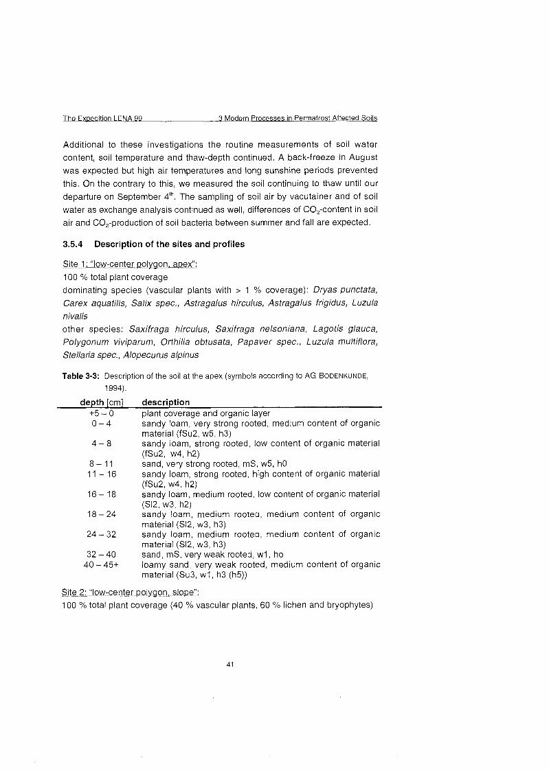
Additional to these investigations the routine measurements of soil water
content, soil temperature and thaw-depth continued. A back-freeze in August
was expected but high air temperatures and long sunshine periods prevented
this. On the contrary to this, we measured the soil continuing to thaw until our
departure on September 4^. The sampling of soil air by vacutainer and of soil
water as exchange analysis continued as well, differences of COa-content in soil
air and CO,-production of soil bacteria between summer and fall are expected.
3.5.4 Description of the sites and profiles
Site 1 : "low-center polygon, a~ex" :
100 % total plant coverage
dominating species (vascular plants with > 1 % coverage): Dryas punctata,
Carex aquatilis, Salix spec., Astragalus hirculus, Astragalus frigidus, Luzula nivalis other species: Saxifraga hirculus, Saxifraga nelsoniana, Lagotis glauca, Polygonum viviparum, Orthilia obtusata, Papaver spec,, Luzula multiflora, Stellaria spec., Alopecurus alpinus
Table 3-3: Description of the soil at the apex (symbols according to AG BODENKUNDE,
1 994).
depth [cm] description +5 - 0 plant coverage and organic layer
sandy loam, very strong rooted, medium content of organic material (fSu2, w5, h3) sandy loam, strong rooted, low content of organic material (fSu2, w4, h2) sand, very strong rooted, mS, w5, h0 sandy loam, strong rooted, high content of organic material (fSu2, w4, h2) sandy loam, medium rooted, low content of organic material (S12, w3, h2) sandy loam, medium rooted, medium content of organic material (S12, w3, h3) sandy loam, medium rooted, medium content of organic material (S12, w3, h3) sand, mS, very weak rooted, w1, ho loamy sand, very weak rooted, medium content of organic material (Su3, w1, h3 (h5))
Site 2: "low-center polygon, slope": 100 % total plant coverage (40 % vascular plants, 60 % liehen and bryophytes)
3 Modern Processes in Permafrost Affected Soils The Ex~edition LENA 99
dominating species (vascular plants with > 1 % coverage): Carex aquatilis, Polygonum vivipara, Orthilia obtusata, Parrya nudicaulis, Astragalus spec., Luzula spec., Salix glauca, other species: Salix reptans, Valeriana capitata, Saxifraga hirculus, Saxifraga nelsoniana, Dryas punctata, Lagotis glauca, Pedicularis spec., Equisetum variegatum
Table 3-4: Description of the soil at the slope.
depth [cm] description
+9 - 0 plant coverage and organic layer 0 - 4 sand, very strong rooted, very low content of organic
material (mS, w5, h1) 4 - 9 sand, very strong rooted, low content of organic material
(mS, w5, h2) 9 - 19 sandy loam, strong rooted, low content of organic material
(Su2, w4, h2) 19-24 sand, weak rooted (mS, w2, h0)
24 - 35+ sand, weak rooted, high content of organic material (mS, w1, h4)
Site 3: "low-center wolvqon, center":
100 % total plant coverage (30 % vascular plants, 70 % bryophytes)
dominating species (vascular plants with > 1 % coverage): Carex aquatilis, Carex lugens other species: Salix reptans, Salix glauca, Carex spec., Caltha palustris, Pedicularis spec,, Polygonum vivipara, Arctagrostis spec., Saxifraga cernua, Saxifraga spec., Equisetum variegatum
Table 3-5; Description of the soil at the center
depth [cm] description
+9 - 0 plant coverage and organic layer 0 - 1 5 organic material with low content of sand, very strong
rooted (mS, w6, h6-h7) 15 - 20 sand, medium rooted (mS, w3, h0) 20 - 45 organic material with low content of sand ((ms), WO) 45 - 50 sand (WO)
50 + organic material with low content of sand ((ms), WO)
The complete description of sites and the analysis of microbial communities at
the different sites is in Progress.
The Ex~edition LENA 99 3 Modern Processes in Perrnafrost Affected Soils
Figure 3-12: Transect of thaw-depth at Plot 3 between 6. June - 30. August 1999.
43
3 Modern Processes in Perrnafrost Affected Soils The Ex~edition LENA 99
Figure 3-13: Thaw-depth at Plot 4 and Plot 2 between 8 June and 31 August 1999.
44
The Expedition LENA 99 3 Modern Processes in Permafrost Affected Soils
3.6 Monitoring for bird populations in the Lena Delta
(V. I. Pozdnyakov)
In 1999 investigations of the status of bird populations in the Lena Delta in
accordance with the program of 1998 were continued (Pozdnyakov, 1999;
Solovieva, 1999). We studied character of seasonal distribution On territory and
abundance, characteristic of breeding success of various groups of birds per year and characteristic of fall migration period.
3.6.1 Methods and materials
The observations were conducted from June 29 till September 23 mainly in the
southern part of the Delta, Like in 1998, a motor boat was used on the main
channels (Pozdnyakov, 1999). The total length of registration routes was 2823 km. We inspected a few nesting colonies of birds. Unfortunately, the
observations of nested biology were limited because the work had begun in the
late nesting period, Therefore breeding success was estimated as positive
mainly by meetings of broods or young birds after the nesting period.
The inspected region was divided into sites, which corresponded to sites of
1998 and have received the Same numbers. The records were not conducted
on sites 5, 6, 8 and 9 in 1999, and on sites 12-15 in 1998.
1. Channel sites in the southern Part of the Lena Delta, joining the principal
channel of the Lena River 72'24' - 72'36' N; 125'25' - 127'0' E. Total length of
routes was 249 km.
2. The southern part of the Arynskaya Channel up to 72'50' N. The length of
routes was 187 km.
3. The channels between the southern parts of the Arynskaya and the Malaya
Tumatskaya Channels up to 72'54' N. The length of routes was 126 km.
4. The channels between the southern parts of the Malaya and the Bolschaya
Tumatskaya Channels up to 72'54' N. The length of routes was 126 km.
7. The southern part of the Bolschaya Tumatskaya Channel up to 72'54' N. The
length of routes was 26 km.
10. The channels between the Bolschaya Trofimovskaya and Bykovskaya Channels, south from 72'45' N. The length of routes was 11 7 km.
11. The Bykovskaya Channel. The length of routes was 1005 km.
3 Modern Processes in Permafrost Affected Soils The Expedition LENA 99
12. Southern part of the Olenekskaya channel up to 72'40' N. The length of
routes was 197 km.
13. Channels between the southern parts of Olenekskaya and Arynskaya
Channels up to 72'50' N. The length of routes was 129 km.
14. Channels between the Bolschaya Tumatskaya and Bolschaya
Trofimovskaya Channels, south from 73' N. The length of routes was 494 km.
15. Western part of the Bolschaya Trofimovskaya Channel up to 128'25' E. The
length of routes was 167 km.
The period of observations was divided into three parts appropriate to main
parameters of seasonal activity of birds (Table A3-2 - A-3-4): 0 nesting period, till July 15;
0 brood period, July 16 - August 15;
fall migration period, from August 16 till completion of works.
3.6.2 Results and discussion
During the whole observation period 48 bird species were registered, 37 of
them during the records on the channels (Table A3-2 to A3-4). In addition the
following species could be observed earlier: Brent Goose (Branta bernicla),
Golden Eagle (Aquila chrysaetos), Gyrfalcon (Falco rusticolus), Ptamigan
(Lagopus mutus), Turstone (Arenaria interpres), Red-necked Stint (Calidris
ruficollis), Snipe (Gallinago gallinago), Pintail Snipe (G. stenura), Swallow
(Hirundo rustica), Redpoll (Acanthis flammea), Rosy Finch (Leucosticte arctoa).
The average density of birds on the channels of the Lena Delta was 20.43
individuals per 10 km channel.
In 1999 the breeding success of majority of bird species in the Lena Delta
appeared high. The warm and fast spring promoted concerted beginning of
nesting. Nesting success depended on lemming density. After one year with
high depression of lemmings number, the number of Arctic Fox was very low.
We did not register destruction of eggs and nests by Arctic Fox. In 1999 on all
territory of the Delta happened rapid lemming's number growth.
Loons, We observed only usual for the Delta Black-throated Loon (Gavia
arctica) and Red-throated Loon (G. stellata). Both species were successfully
breeding. In the brood of a Red-throated Loon, observed on August 25, the
young birds were not able to fly yet. The flocks of Black-throated Loon from 6-
10 birds preparing to fall migration were observed in late August - beginning of
September in the central pari of the Delta on sites 4 and 7.
Geese. The breeding of the geese in 1999 was successful. In colonies of Brent
Geese the hatch of chicks began On July 7-8. The average size of clutch at this
time was 4.24 eggs (n = 41). From 48 examined nests only 2 (4.1 %) were
destroyed by large gulls.
All young White-fronted Geese (Anser albifrons) could fly on August 20. The
large flocks of birds, preparing for fall migration, were met on sites 3, 4, 7. The
average amount of birds in flocks was 27.8 (n = 28), maximum 130.
On August 10 we observed the flock (44 birds) from the molting adults of Bean
Geese (Anser fabalis) with chicks On site 2. During preparation for fall migration
the average of the observed flocks was 14.4 (n=20) and maximurn 1 00.
In fall migration period on the feeding's places the White-fronted Geese and
Bean Geese were derivated by the mixed congestions. The maximurn number
(99.1 3 individuals/lO km) of these two species together was marked on site 3.
Swans. Bewicks Swan (Cygnus bewickii), which is common in the Lena Delta,
was observed. The greatest abundance (10.96 individuals/lO km) was marked
in the nesting period on site 15. Flocks of non-breeding birds were observed
here. First broods, abandoning the nests, were observed on July 9. The
average of brood for all period of observations was 3.93 (n = 14). The fall
migration passed in September. Bred swans flied by families (adults with young
birds).
Ducks. The breeding of Long-tailed Duck (Clangula hyemalis), King Eider
(Somateria spectabilis) and Steller's Eider (Polysticta stellen) was successful. At
the end of the incubation period of King Eider an average of 4.82 eggs (n = 11)
was determined. The earliest beginning of hatching in nests of this species was
marked on July 10. In the middle of August a high number of Pintail (Anas
acuta) was observed in the central part of the delta (site 14). The flocks reached
500 birds and the abundance was 26.99 individuals/lO km of channel. In the
Same region we observed the flock of 28 Teals (Anas crecca) on August 14.
Predators. Rough-legged Buzzard (Buteo lagopus) and Peregrine (Falco
peregrinus) nested on all sites which were known from previous years. Flying
young Buzzards were observed since August 10 and Peregrines from the
beginning of September. Gyrfalcon (Falco rusticolus) and Golden Eagle (Aquila
chrysaetos) were observed in the Olenekskaya channel on August 23. Both
birds were young. In 1999 the Snowy Owl (Nyctea scandiaca) did not breed in
the Lena Delta. Only once (August 26) a single adult bird was Seen on site 4.
Waders. All species of this bird group observed in the investigation area were
successfully breeding. But on channels of the delta they were appreciable only
3 Modern Processes in Perrnafrost Affected Soils The Expedition LENA 99
in the fall migration period. The greatest abundance was marked on site 14. By
August 20 the fall migration of waders in the delta was completed.
Skuas. In the investigation area the abundance of skuas was low. Arctic Skua (Stercorarius parasiticus) and Long-tailed Skua (S. longicaudus) were breeding.
Large gulls. Distribution and abundance of large gulls on channels of the Delta
in 1999 corresponded to 1998. The flying young birds were Seen after August
20.
Small gulls and terns. Sabiners Gall (Xema sabini) in the southern part of the
delta was not breeding. The breeding of Ross's Gull (ßhodostethi rosea) and Arctic Tern (Sterna paradisaea) was successful. The emerging of chicks in the nest of Ross's Gall was observed on July 10. On July 23 a few migrating birds
of this species were observed on the Bykovskaya Channel (site 11). First flying
young of Arctic Terns were Seen on August 8. The departure of terns from the
Delta proceeded until August 17.
Passerines. Except for Snow Banting (Plectrophenax nivalis), which nests in peat breakaways of islands, Passerines were observed On channels of the Delta in nesting and hatching periods very seldom. The autumnal migration of Northern Wheatear (Oenanthe oenanthe), Lapland Bunting (Calcarius lapponicus) and Pipit (Anthus sp.) was observed on Olenekskaya (site 12) and
Bykovskaya (site 11) Channels in the last third of August.
The Ex~edition LENA 99 3 Modern Processes in Permafrost Affected Soils
3.7 References Clein J.S and J.P. Schimmel (1995): Microbial Activity of Tundra and Taiga Soils at Sub-Zero
Temperatures, Soll Biol. Biochem. Vol. 27, No. 9, 1231-1234
Coyne, P.I. and J.J. Kelley (1971): Release of carbon dioxide from frozen soil to the arctic
atmosphere, Nature 234, 407-408
Grogan, P. and F.S. Chapin 111 (1999): Artic Soil Respiration: Effects of Climate and Vegetation
Depend on Season, Ecosystem 2: 451 -459
Mast, M.A.; K.P.Wickland, R.T. Striegl, and D.W. Clow (1998): Winter fluxes of C02 and CH4
from subalpine soils in Rocky Mountain National Park, Colorado, Global
Biogeochemical Cycles, Vol. 12, No. 4, 607-620
Oechel, W.C.; G. Voulitis, and S.J. Hastings (1997): Cold season C02 emission from arctic
soils, Global Biogeochemical Cycles, Vol. 11, No. 2, 163-1 72
Pfeiffer, E.-M.; Akhmadeeva, 1.; Becker, H.; Friedrich, K.; Wagner, D.; Quass, W.; Zhurbenko,
M.; Zöllner E. (1999): Modern processes in permafrost affected soils. In: Rachold, V.
(eds.) Russian-German Cooperation SYSTEM LAPTEV SEA 2000: The Lena Delta
1998 Expedition. Reports on Polar Research 315, 19-79.
Pozdnyakov, V.I. (1999): Distribution and Abundance of Birds on the Channels of the Lena
Delta. Reports of the Polar Research, Volume 315, p.48-51.
Solovieva, D.V. (1 999): Ornithological observations. Reports of the Polar Research, Volume
315, p.46-48
Wang, Z.P.; DeLaune, R.D.; Masscheleyn, P.H.; Patrick Jr., W.H. (1993): Soil redox and pH
effect on methane production in a flooded rice soil. Soil Sci. Soc. Am. J. 57, 382-385.
Yelovskaya (1987): Classification and diagnosis of perrnafost soils in Yakutia. Publ. Yakutian
Section of the Siberian Branch of the Academy of Science USSR: 172 p. (in Russian).
Zimov, S.A., G.M. Zimova, S.P Davidov, O.V. Prosiannikova, I.V. Semiletova, and I.P.
Semiletov (1996): Winter biotic activity and production of C02 in siberian soils, J.
Geophys. Res. 98,5017-5023
3 Modern Processes in Permafrost Affected Soils The Exoedition LENA 99
3.8 Appendix
Table A3-1: List of soil samples.
Number Samples Planned Analysis
LD99 6182-61 85 soil samples P1 0 C analysis
LD99 61 87-61 89 soil samples P1 1 chemical
LD99 6200-6202 plant material C analysis
LD99 6203-6221 soil samples P1 1 chemical
LD99 6223-6250 soil samples P1 0 chemical
LD99 6251 -6253 plant material C analysis
LD99 6254-6261 peat samples '*C analysis
LD99 61 66-61 70 soil samples chemical
LD99 6171-61 74 soil samples chemical
LD99 6357-6361 soil samples P8 chemical, microbiological
LD99 6362-6370 soil samples P6 chemical, microbiological
LD99 6371 -6376 soil samples chemical, microbiological
LD99 6381 -6389 undisturbed soil samples physical
LD99 6390-6394 soil samples P8 rnicrobiological
LD99 6395-6400 soil samples P6 microbiological
LD99 641 6-6420 soil samples P9 chernical, rnicrobiological
LD99 6421 -6424 undisturbed soil samples phisical
LD99 6428-6432 soil samples P9 microbiological
LD99 6456-6473 soil samples Arga microbiological
LD99 6474-6479 sediments Nikolay Lake rnicrobiological
LD99 6480-6487 sediments Nikolay Lake microbiological
LD99i 001 -003 gas samples chemical
LD99i 005-006 gas samples chernical
LD99i 008-009 gas samples chemical
LD99i 01 3-01 7 gas samples chemical
LD99i 022-024 gas samples chernical
LD99i 026-029 gas samples chemical
LD99i 032 gas samples chemical
LD99i 037-040 gas samples chemical
LD99i 061 -066 gas samples chemical
LD99i 128a-131 a gas sarnples chemical
LD99i 143a-146a gas samples chernical
LD99i 152-1 64 gas samples chemical
LD99i 175-1 78 gas samples chernical
The Expedition LENA 99 3 Modern Processes in Permafrost Affected Solls
Table A3-1: continuation.
Number Samples Planed Analysis
LD99i 190-1 99 gas samples chemical
LD99i 230-349 gas samples chemical
LD99i 007 ice samples chemical
LD99i 01 0-01 2 ice samples chemical
LD99i 041 -059 ice samples, frozen chemical LD99i 018-021 soll samples chemical, microbiological
LD99i 025 soil sarnples chemical, microbiological
LD99i 030-031 soil samples chemical, microbiological
LD99i 033-036 soil samples chemical, microbiological
LD99i 060 soil samples chemical, microbiological
LD99i 080-140 soil samples chemical, microbiological
LD99i 165-1 74 soil samples chemical, microbiological
LD99i 180-1 89 soil samples chemical, microbiological
LD99i 200-222 soil samples chemical, microbiological
LD99i 120a-127a soil samples chemical, microbiological
LD99i 132a-142a soil samples chemical, microbiological
LD99i 141 -1 51 soil samples chemical, microbiological
LD99i 067-077 undisturbed soil samples physical
LD99i 078-079 soil samples chemical, microbiological
3 Modern Processes in Perrnafrost Affected Solls The Expedition LENA 99
Table A3-2: Abundance of birds on the channels of Lena Delta in the nesting period
(ind.110 km).
The Expedition LENA 99 3 Modern Processes in Permafrost Affected Soils
Table A3-3: Abundance of birds on the channels of Lena Delta in the brood period
(ind.110 km).
Table A3-4: Abundance of birds on the channels of Lena Delta in the fall migration
period (ind.110 km).
The Expedition LENA 99 4 Coastal Processes and the Historv of the Lena Delta
4 Coastal Processes in the Laptev Sea and the Environmental History of the Lena Delta
4.1 Introduction
(V. Rachold and M. N. Grigoriev)
Accumulation and erosion in the coastal Zone are of major importance for the
modern and ancient sediment budget of the Laptev Sea. The amount of
sediment transported by the Siberian rivers is relatively well quantified.
However, the portion of sediment that is deposited in the river deltas, mainly the
Lena Delta, and, therefore, never actually reaches the Laptev Sea is not known.
Furthermore the amount of material delivered to the Laptev Sea through the
erosion of ice-rich coastlines has not been accurately quantified (Rachold et al.,
in press).
The Lena Delta is a large Arctic delta and the conditions are very different from
that of delta regions in lower latitudes. It is the main connection between
interfering continental and marine processes within the Laptev Sea. The
sedimentation history of the Lena Delta, its importance as a fossil accumulation
area as well as the processes that control the lateral extension, are poorly
understood, While the main part of the eastern Lena Delta is assumed to be an
actual ,,activel' delta the Western part consists of mainly of sandy deposits (Arga
Island) and Ice Complexes of different origin (Rachold et al., 1999).
Shore dynamics directly reflecting the complicated land-ocean interactions play
an important role in the balance of sediments, organic carbon and nutrients in
the Arctic Basin. Formerly the rivers were considered as the main suppliers of
sediments into the World Ocean. However, the results of recent investigations
showed pronounced regional differences in the ratio between riverine and
coastal erosion sediment input. Thus, Are (1999) suggested that the amount of
sediment supplied to the Laptev Sea by rivers and shores is at least of the
Same order but probably the coastal erosion input is considerably larger than
the input of the rivers.
Our working group consisting of three individual teams focussed On the
reconstruction of the sedimentation history of the Lena Delta and the
quantification of coastal sediment input to the Laptev Sea. The working areas
visited during the LENA 99 expedition are shown in Figure 4-1.
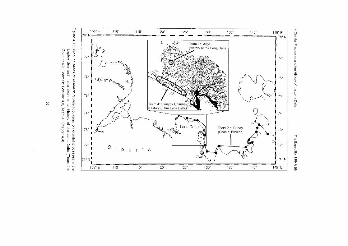
Team 2a: Arga * "
Fhe Spedition LENA 99 4 Coastal Processes and the Historv of the Lena Delta
4.2 Lake Sediment Studies on Arga Island
(G. Schwamborn, D. Yu. Bolshiyanov, M. Dorozhkina, M. N. Grigoriev, E. Yu.
Pavolva, W. Schneider and V. E. Tumskoy)
4.2.1 Introduction
The Lena River draining to the Siberian Arctic is considered to be the main
sediment source for the Laptev Sea. Nevertheless, the Lena Delta - occupying
an area of 28.000 km2 - is a poorly studied and complicated region of land-
ocean-interactions in the Arctic. There are many unsolved questions concerning
the environmental and sedimentation history, geomorphology, genesis of
deposits, permafrost distribution and climatic variability in that area.
There are different opinions On the genesis and age of the second sandy
terrace (north-western sector of the Lena Delta). Its lower horizons may be
apparently identified with sandy deposits underlying the south-western Delta Ice
Complex. The upper horizon is an accumulative layer of channel alluvium
accumulated after active lower Holocene erosion. The sandy terrace is
penetrated by a dense net of ice wedges, related to the Holocene or, possibly,
the pre-Holocene. Furthermore, sheet ice up to 2 m thickness is found here.
The volumetric ice content of the upper horizon of the sandy terrace is about 25
%. These layers are supposed to contain larger ice bodies. This may explain
the formation processes of numerous large thermokarst lakes and active
contemporary thermokarst processes On the second terrace.
To survey and quantify the stratigraphic sequence of Lake Nikolay (western
Delta Lena) ground penetrating radar studies (25 MHz and 100 MHz antennas)
from the winterly ice Cover have been applied in connection with drilling
activities to determine the geologic composition. The '99 activities complement
shallow seismic studies and first sediment sampling at the Same site from
summer '98 (Schwamborn et al., 1999) and help to solve questions concerning
the environmental and sedimentation history, geomorphology, and genesis
especially for the second terrace deposits in western Delta Lena.
Major concerns guiding this 99's campaign have been as follows:
what is the origin and age of the second terrace sandy deposits (Arga
Island) of western Delta Lena?
what is the origin and age of Arga Islandxs lakes, i.e. Lake Nikolay?
The following methods have been applied:
radar sounding
4 Coastal Processes and the History of the Lena Delta The Expedition LENA 99
to determine suitable sites for coring lake sediments
to find possible ground ice occurrences
to identy the talik - permafrost boundary below the water body
lake sediment coring
for identifying the lithofacies of the subground
for providing material for age determination by the radiocarbon
method
comparison of radar sounding (25 MHz and 100 MHz) with shallow seismic
data (frequencies in the range of 1.5 - 11.5 kHz), which had been obtained
in the year before
water and ground temperature measurement
for identifying the talik boundary and
for heat flow determination.
4.2.2 Samples and methods
Ground Penetrating Radar (GPR) analyses produced the data necessary to
outline the subsurface stratigraphy of Lake Nikolay area. The commercially
available Impulse radar equipment used for these observations was a
RAMACIGPR System, which consists of a control unit, a field PC and 25 and
100 MHz antenna units containing both transmit and receive antennas. The
control unit generates timing signals to key the transmitter on and off and
synchronizes this keying with the receiver. Digital commanding and recording in
the field was managed on a HUSKY field PC along with the packaged signal
processing software. General settings of the software when collecting data have
been chosen in the following way:
25 MHz antenna 100 MHz antenna samples 1024 1536
stacks 128 128
horizontal spacing interval 2.00 m 1 .OO m
vertical resolution ca. 1 .OO m ca. 0.30 m
The time window was set to record in a length of 2000 ns. This allowed
receiving signals through a water column of about 30 m at maximum and from
the sedimentary environment below the deeper basins. Radar wave velocity in
water is 33 mlps and in unconsolidated sediments about 60 mlps. For the
permafrost sediments a value of 11 0 mlps is assumed. Estimates for sediment
thicknesses are based On these values (Davies and Annan, 1989).
A total number of 13 profiles have been collected with data for about 30 km of
subsurface profiling (see Figure 4-2, Table A4-1, appendix). This was done out

The Expedition LENA 99 4 Coastal Processes and the Historv of the Lena Delta
of a diese1 vehicle which pulled a textile sheet 45 m behind where the antennas
were mounted on. The 25 MHz antennas have been fixed with an offset of 4 m,
the 100 MHz antennas with an offset of 1 m, respectively. Additionally, 4 CMP
measurements yielded velocity Information for the radar waves. They have
been recorded at shallow lake areas, deep basins and On land. The CMP
measurements covered a distance of 30 or 50 m to both sides with antenna
spacing intervals of 25 cm or 100 cm, respectively. Along with subsurface
profiling the thickness of lake ice and the water depth have been measured
conventionally for certain key sites.
- - shallow seismic '98 (1.5 - 11.5 kHz)
L/'\ - radar sounding '99 (25 and 100 MHz)
, sediment cores
t +' water depth
n
Figure 4-2: Localities of radar profiles on Lake Nikolay. Since one primary objective of
the radar profiling was to compare characteristics of the 25 MHz and 100
MHz records with acoustic data the shallow seismic profiles gained in the
Summer '98 are shown, too. They have been recorded with the
'GeoChirp" System, a sediment echosounder, which sends out and
processes a sweep of signals in the range of 1.5 - 11.5 kHz. Analog
printouts are provided already in the field.
4 Coastal Processes and the Historv of the Lena Delta The Expedition LENA 99
After profiling the 16 bit data have been loaded into GRADIX software that
provides radar processing with a variety of filtering functions and data display formats.
In some cases high quality sub-bottom information was obtained without data
processing. This is valid especially for profiles of deeper basins where lake
sediments can be found. However, signal processing substantially improved the
records when signal-to-noise ratios were low, i.e. the shallow areas of Lake
Nikolay where sediments are object to permafrost conditions.
Based on the results of the radar studies, lake sediment sampling was carried
out by gravity corer and permafrost drilling equipment, respectively. The drilling
locations are shown in Figure 4-2 and Table A4-1 (appendix). A total number of
5 sediment cores (up to 7 m length) were recovered from Nikolay Lake by
permafrost drilling. In addition one 5,90 m long core was retrieved from
Ivashkina Laguna, Bykovsky Peninsula (see Figure 4-3 and 4-4). Furthermore,
12 lake sediment cores (up to 95 cm) were obtained by gravity coring. The
recovered sediments will be analyzed for sedimentological and geochemical
properties and used for AMS-Cl4 age determinations (see Table A4-2).
Borehole IV2-99
A LIV8 LIV7 LIV6 LIV5 LIV4 LIV3 LIV2 LIV1 LIV9 LIV10 B Sand bank 2650
Legend
Peat-clay stratitying
1-1 Fine sand
1 COOI pieces
1 organic pieces
~ iv3 - ice drilling
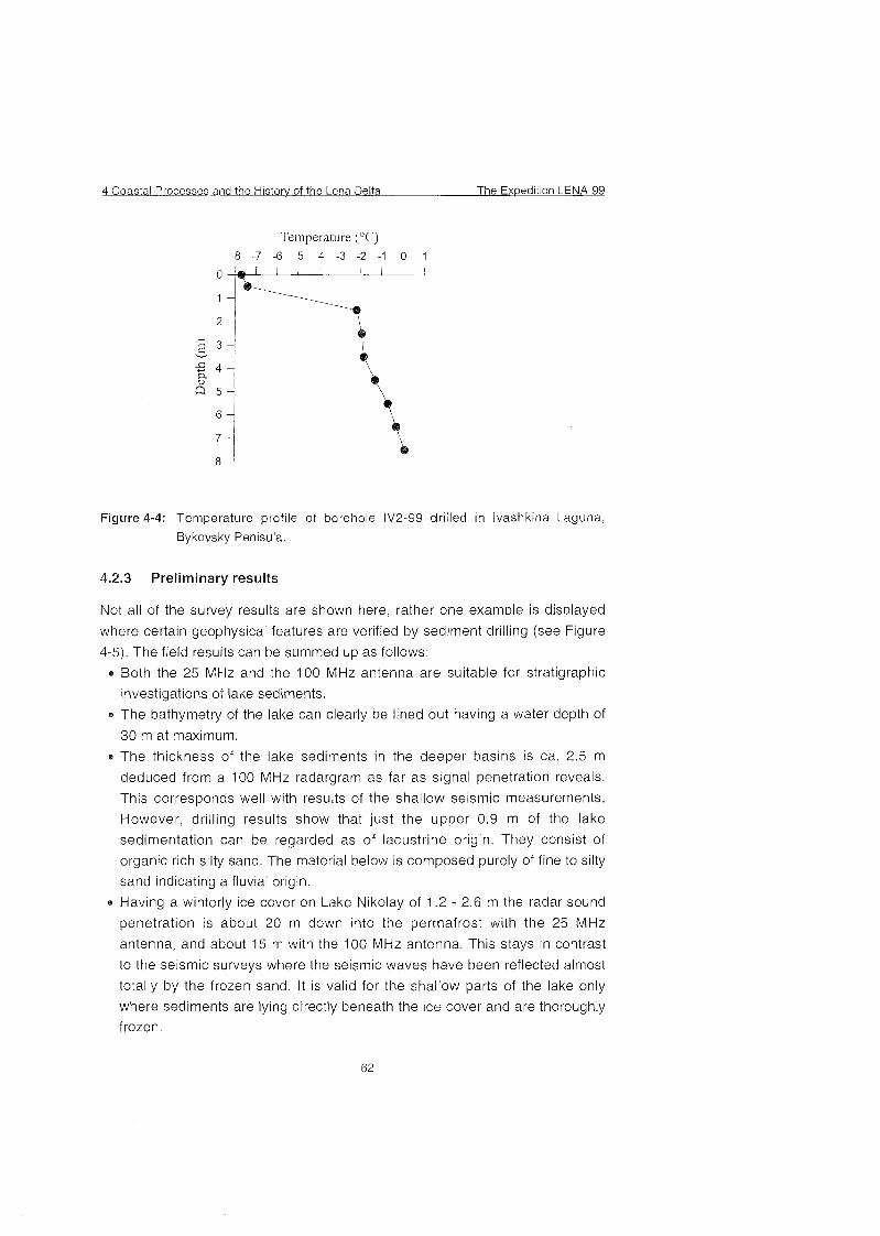
4 Coastal Processes and the Historv of the Lena Delta The Expedition LENA 99
Temperature (¡C
Figure 4-4: Temperature profile of borehole IV2-99 drilled in Ivashkina Laguna,
Bykovsky Penisula.
4.2.3 Preliminary results
Not all of the survey results are shown here, rather one example is displayed
where certain geophysical features are verified by sediment drilling (see Figure
4-5). The field results can be summed up as follows:
à Both the 25 MHz and the 100 MHz antenna are suitable for stratigraphic
investigations of lake sediments.
e The bathymetry of the lake can clearly be lined out having a water depth of
30 m at maximum.
The thickness of the lake sediments in the deeper basins is ca. 2.5 m
deduced from a 100 MHz radargram as far as signal penetration reveals.
This corresponds well with results of the shallow seismic measurements.
However, drilling results show that just the upper 0.9 m of the lake
sedimentation can be regarded as of lacustrine origin. They consist of
organic rich silty sand. The material below is composed purely of fine to silty
sand indicating a fluvial origin.
Having a winterly ice cover on Lake Nikolay of 1.2 - 2.6 m the radar sound
penetration is about 20 m down into the permafrost with the 25 MHz
antenna, and about 15 m with the 100 MHz antenna. This stays in contrast
to the seismic surveys where the seismic waves have been reflected almost
totally by the frozen sand. It is valid for the shallow Parts of the lake only
where sediments are lying directly beneath the ice cover and are thoroughly
frozen.
The Expedition LENA 99 4 Coastal Processes and the Historv of the Lena Delta
Inclined reflectors in these shallow areas are interpreted to represent fluvial
layering of the sandy subground. They are equally inclined towards the
deeper basins.
Since radar waves are absorbed in the saturated lake sediments there are
no possibilities to detect the talik-permafrost boundary below the deeper
basins.
The occurrence of ice bodies and other types of ground ice cannot be
observed in the radar charts.
The fluctuations in ice Cover thickness cannot be observed in the
radargrams at first, either.
All radar charts are affected by strong multiple occurrence created by the
lake ice - lake water interface.
Organic samples from drilling cores no. A l and no. A5, and gravity cores no.
CN 2 and no. CN 6 have been prepared to be dated by the radiocarbon
method to reveal the age of the lake deposits.
Temperature measurements, which were conducted in the boreholes drilled
from lake ice, allowed to determine the position and dynamics of the sublake
permafrost table (see Table A4-3, appendix). Ground and water temperature
show that the table of subwater permafrost has a very steep angle of
incidence from shallow to deep water. Sometimes the permafrost table is
characterized by an adverse gradient (concave) towards land near the steep
lake bottom slope.
Large ice bodies under lake shallows within the second sandy terrace of the
Lena Delta were not found by drilling. The existence of such ice bodies
could be documented by deeper seismic and drilling methods. Nevertheless,
we assume that large inclusions of ice or ice rich deposits occur in the Arga
Island sandy horizons and that the numerous deep lake depressions of the
Arga Island were formed mainly in Holocene as a result of thermokarst land
subsidense.
\ , T-profile of A5 A5 ,44 ,42 AI T-profile of A l
(frozen sediments) (water column)
radar profile r9-2 (100 MHz) legend
X 5 ice
1 1 water (electr conduct 47 9 rnS/crn)
silty sand, organic rich [ +/- fine sand (talik)
frozen sand * AMS sarnpl~ng
The Exwedition LENA 99 4 Coastal Processes and the History of the Lena Delta
4.3 Coastal erosion studies in the Laptev Sea
(F. E. Are, M.N. Grigoriev, H.-W. Hubberten, V. ßachold S. 0. ßasumo and W. Schneider)
4.3.1 Introduction
The main goal of investigations was a quantitative evaluation of coastal
dynamics through three parameters:
Land loss or accretion,
a Amount of coastal erosion products entering the sea,
Amount of sediments consumed for delta advance into the sea.
Obtaining values of the land loss or accretion is simple in principle. For that it is
enough to measure the displacement of the shoreline during definite time.
These measurements may be carried out (1) by the comparison of aerial
photographs, maps and space Images taken in various times, (2) using results
of long-run monitoring of coastal dynamics or (3) by means of field
measurements of modern shore line position and subsequent comparison of
results with old maps etc.
Evaluation of the second Parameter is much more complicated. The coastal
erosion takes place both above the sea level (cliff destruction) and under the
sea level (shoreface erosion). The cliff geometry may be easily measured, but it
is not the case with the shoreface because its outer boundary often is not
pronounced either morphologically or lithologically or otherwise. This situation is
especially often observed in shallow Arctic seas along coasts composed of very
fine-grained sediments. Thus, a special scientific problem arises: how to
determine the outer boundary of the shoreface. The scarce factual data
available suggest that in shallow seas the sediment type plays an important role
in shoreface formation. Therefore, the morphology and the bottom sediment
lithology of the shoreface in different coastal environments are studied as a first
step for solving this problem.
In addition to bathymetrical profiling and bottom sediment sampling, shallow
seismic studies were included in the program of field work in order to identify
the boundary between modern coastal erosion sediments and underlying non-
eroded sediments as well as the upper boundary of ice bonded permafrost.
Essentially, both boundaries are the paleo-climatic signals. Furthermore,
shallow seismic profiling also produces high quality bathymetrical profiles.
4 Coastal Pro.cesses and the kiistorv of the Lena Delta The Expedition LENA 99
Investigations were carried out on several key sections of the coast (Figure 4-6
and Table A4-4, appendix), situated in various environments and consisted of
five main Parts:
1 Geodetic measurements were performed on land to obtain the modern
horizontal and vertical position of the shores. On erosional shores the
position of the cliff base and the cliff upper edge was measured. On
accretional shores the subject of measurements was the shoreline.
Characteristic terrestrial features, which could be identified On arial
photographs a.s well, such as sharp turns of small streams, small water
bodies, boundaries of different types of vegetation etc., served as natural
marks. Measurements were carried out using a laser theodolite Elta 50 R. Duriny good weatlier conditions 3.2 km of shoreline could be measured
from one theodolite positioii with an accuracy of some millimeters. The
geodetic measurements are indicated as (C) "coastal studies" in Figure 4-6
and Table A4-4 (appendix).
2 Shoreface profile measurements were carried out from the shoreline across
the outer boundary of the shoreface. At water depth > 2 m these
measurements were carried out using the echo sounder on board of the
vessel Dunay, which has a resolution of about 2 cm. A small portable echo
sounder on board of a motor boat with 10 cm resolution was used in near
shore shallows with water depths < 2 m. During the measurements the
position of the vessel Dunay was fixed by GPS. The location of the motor
boat in shallows up to 1.5 km from the shore was measured using a
theodolite and an on-shore ranye marked by poles. Shoreface
measurements are indicated with (s) "shallow water profiling" and (d) "deep
water profiling".
3 Bottom sediment sampling along the shoreface profiles was carried out in
intervals of 0.1-1.0 km usinq a light grab sampler (indicated by (b) "bottom
sediment sampling"). A !ist of samples is presented in the appendix (Table
A4-5).
4 For shallow seismic profiling a sediment echo sounder (Geoacoustics
GeoChirp 6100A) was used (see chapter 4.2 and Schwamborn et al.,
1999). Shallow seismic stu'iios are indicated by (g) "geophysics" in Figure
4-6 and Ta-ble A4-4).
5 Additionadly, teinperature profiles in the sea water column were recorded at
several stations marked by (t) "temperature measurements". Sea water
The Expedition LENA 99 4 Coastal Processes and the Historv of the Lena Delta
temperature measurements were carried out at 14 stations from Dunay.
Two thermal cables with temperature Sensors were used for measurements
of water temperature on a vertical water profile. The depth of the bottom
Sensor was checked by echo sounding. Air temperature, wind direction and
speed, characteristics of currents and wave regime were determined as well
(see Table A4-6, A4-7 appendix).
6 About 1000 aerial photographs (scales 1 :30,000-80,000) and 150
topographic maps (scales 1 :25,000-300,000) were purchased for study of
the Laptev Sea coast dynamics by remote methods. The remote material
was produced in 1951 - 1991 and Covers all key sites listed below.
Theodolite profiles and bench marks recorded in the field could be identified
in the remote material. Furthermore, arial photos and maps are used for
long-term analysis of coastal dynamics of the key sites by computer
techniques, which allow to estimate an average rate of shoreline retreat and
long-term trends of the Laptev Sea coast quite precisely.
The following key sections have been selected (see Figure 4-6):
1 Arga Island, north-east coast of the Lena Delta (Stations 1,2,3), a sea
dominated, erosional, 10 m high coast composed of fine-grained sands with
low ice content (ca. 20-30 %)
2 Amerika-Kuba Island (Station 4) in the northern Part of modern Lena Delta,
which is bounded by a 3 m high cliff, composed of loams, sands and peat
3 A nameless island in the Sardakh Channel mouth (Station 5), which is an
accretional flood plain, 0-1 m high, composed of silt, fine-grained sand and
peat, ice contents 25-40 %
4 Orto-Yuos Island in the Bykovsky Channel mouth (Station 7), the first
terrace of the Lena Delta, 1-3 m high, smoothly turning into an accretional
flood plain, cornposed of silt, fine-grained sand and peat, ice contents 25-40
%
5 Muostakh Island located at the entrance to Tiksi Bay (Station 8), a remnant
of the coastal plain, 20 rn high, 500 m wide and 7 km long, composed of
small polygonal ice wedges (ice contents 60-85 X ) , characterized by a
steep angle after thawing
6 West coast of Buor-Khaya Peninsula (Station 10) and Shirokostan
Peninsula (Station 13), a sea dominated, erosional coast, bordering a
coastal plain up to 30-40 m high, composed of large polygonal ice wedges
4 Coastal Processes and the Historv of the Lena Delta The Expedition LENA 99
(ice contents 60-85 X), characterized by a steep angle after thawing, with
vast lake-thermokarst depressions
7 North-west coast of Makar Island (Station 12), an up to 40 m high remnant of the coastal plain situated at the off-shore edge of a vast marsh, which is
composed of small polygonal ice wedges (ice contents 60-85 X), characterized by a small angle after thawing
8 West coast of Buor-Khaya Peninsula (Station 9), south coast of Dmitry
Laptev Strait (Station 16), south coast of Bolshoy Lyakhovsky Island
(Station 17) and west coast of Bykovsky Peninsula (Station 20 and 21), all
of which are erosional coasts, 30-40 m high, composed of small polygonal ice wedges (ice contents 60-85 %), characterized by a small angle after
thawing
9 Vankina Guba Bay (Station 1 I ) , penetrating 30 km into the land, which is a subject to wind surges up to 6-10 m high (Tarakanov and Biryukov, 1974),
representing a complicated coastal system with vast marshes and erosional
cliffs, ice contents 60-85 %

105' E 11O0 115' 1 20Â 125' 130' 135O 140' '8' N
145' E 780 r
77O 77O d: deep water profiling
76' 76"
75" 75O
74O 74O
73" 7 3 O
72' 72'
1" N 71° --.--
105' E 1 10' 115" 1 20Â 125' 130' 135O 140' 145' E
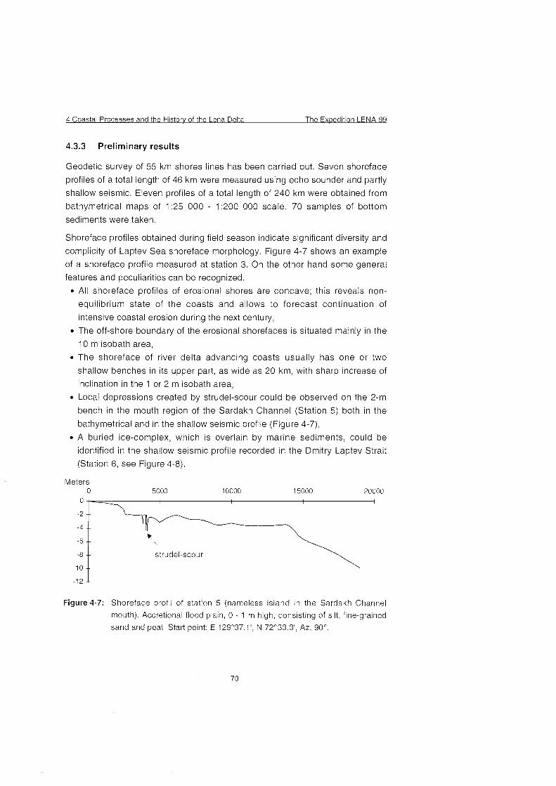
4 Coastal Processes and the Historv of the Lena Delta The Expedition LENA 99
4.3.3 Preliminary results
Geodetic survey of 55 km shores lines has been carried out. Seven shoreface
profiles of a total length of 46 km were measured using echo sounder and partly
shallow seismic. Eleven profiles of a total length of 240 km were obtained from
bathymetrical maps of 1:25 000 - 1:200 000 scale. 70 samples of bottom
sediments were taken.
Shoreface profiles obtained during field season indicate significant diversity and
complicity of Laptev Sea shoreface morphology. Figure 4-7 shows an example
of a shoreface profile measured at station 3. On the other hand some general
features and peculiarities can be recognized.
All shoreface profiles of erosional shores are concave; this reveals non-
equilibrium state of the coasts and allows to forecast continuation of
intensive coastal erosion during the next century,
The off-shore boundary of the erosional shorefaces is situated mainly in the
10 m isobath area,
The shoreface of river delta advancing coasts usually has one or two
shallow benches in its upper part, as wide as 20 km, with sharp increase of
inclination in the 1 or 2 m isobath area,
Local depressions created by strudel-scour could be observed On the 2-m
bench in the mouth region of the Sardakh Channel (Station 5) both in the
bathymetrical and in the shallow seismic profile (Figure 4-7),
A buried ice-complex, which is overlain by marine sediments, could be
identified in the shallow seismic profile recorded in the Dmitry Laptev Strait
(Station 6, See Figure 4-8).
Meters 0
I
-6 -- Ã ̂
-8 -- strudel-scour
-10 --
Figure 4-7: Shoreface profil of station 5 (nameless island in the Sardakh Channel
mouth). Accretional flood plain, 0 - 1 m high, consisting of silt, fine-grained
sand and peat. Start point: E 129°37.1' N 72¡33.3' Az. 90°
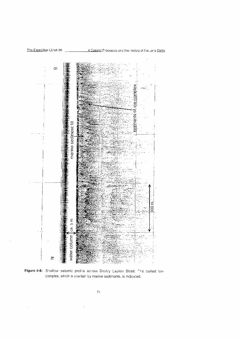
The Expedition LENA 99 4 Coastal Processes and the Historv of the Lena Delta
Figure 4-8: Shallow seismic profile across Dmitry Laptev Strait. The buried ice-
comples, which is overlain by marine sediments, is indicated.
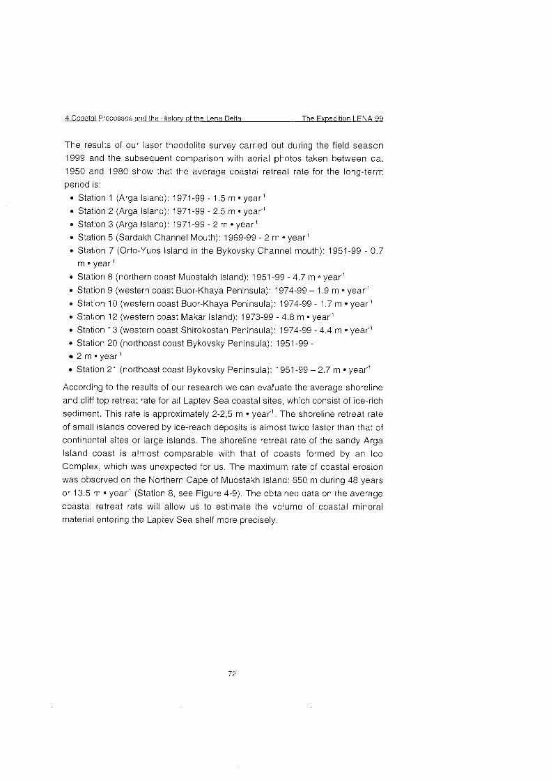
4 Coastal Processes and the Historv of the Lena Delta The Exoedition LENA 99
The results of our laser theodolite survey carried out during the field season
1999 and the subsequent comparison with aerial photos taken between ca.
1950 and 1980 show that the average coastal retreat rate for the long-term
period is:
Station 1 (Arga Island): 1971 -99 - 1.5 m year"'
0 Station 2 (Arga Island): 1971 -99 - 2.5 m year"
Station 3 (Arga Island): 1971-99 - 2 m year"
Station 5 (Sardakh Channel Mouth): 1969-99 - 2 m year"'
Station 7 (Orto-Yuos Island in the Bykovsky Channel mouth): 1951-99 - 0.7
m year"
0 Station 8 (northern coast Muostakh Island): 1951 -99 - 4.7 m * year"
e Station 9 (western coast Buor-Khaya Peninsula): 1974-99 - 1.9 m year-'
Station 10 (western coast Buor-Khaya Peninsula): 1974-99 - 1.7 m year"
Station 12 (western coast Makar Island): 1973-99 - 4.8 m * year"
Station 13 (western coast Shirokostan Peninsula): 1974-99 - 4.4 m year"'
Station 20 (northeast coast Bykovsky Peninsula): 1951 -99 - 2 m * year-'
0 Station 21 (northeast coast Bykovsky Peninsula): 1951-99 - 2.7 m year-'
According to the results of our research we can evaluate the average shoreline
and cliff top retreat rate for all Laptev Sea coastal sites, which consist of ice-rich
sediment. This rate is approximately 2-2,5 m * year". The shoreline retreat rate
of small islands covered by ice-reach deposits is almost twice faster than that of
continental sites or large islands. The shoreline retreat rate of the sandy Arga
Island coast is almost comparable with that of coasts formed by an Ice
Complex, which was unexpected for us. The maximum rate of coastal erosion
was observed on the Northern Cape of Muostakh Island: 650 m during 48 years
or 13.5 m * year" (Station 8, See Figure 4-9). The obtained data on the average
coastal retreat rate will allow us to estimate the volume of coastal mineral
material entering the Laptev Sea shelf more precisely.
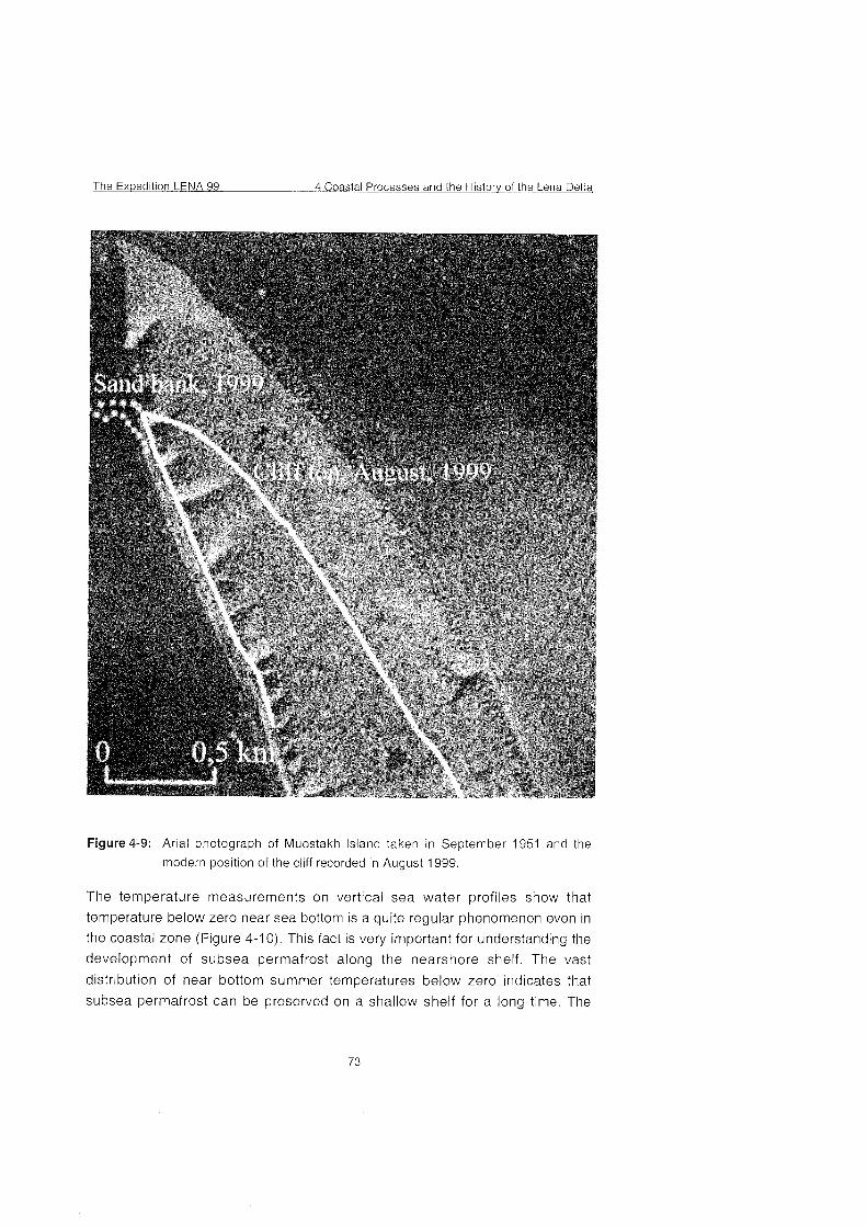
The Expedition LENA 99 4 Coastal Processes and the Historv of the Lena Delta
Figure 4-9: Arial photograph of Muostakh Island taken in September 1951 and the
modern position of the cliff recorded in August 1999.
The temperature measurements on vertical sea water profiles show that
temperature below Zero near sea bottom is a quite regular phenomenon even in
the coastal Zone (Figure 4-1 0). This fact is very important for understanding the
development of subsea permafrost along the nearshore shelf. The vast
distribution of near bottom Summer temperatures below Zero indicates that
subsea permafrost can be preserved on a shallow shelf for a long time. The
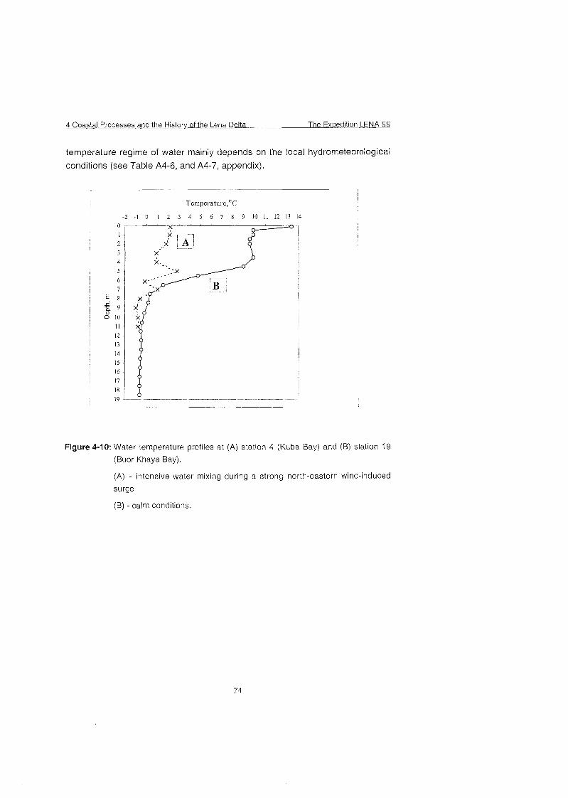
4 Coastal Processes and the History of the Lena Delta The Exuedition LENA 99
temperature regime of water mainly depends on the local hydrorneteorological
conditions (see Table A4-6, and A4-7, appendix).
Figure 4-10: Water temperature profiles at (A) station 4 (Kuba Bay) and (B) station 19
(Buor Khaya Bay).
(A) - intensive water mixing during a strong north-eastern wind-induced
surge
(B) - calrn conditions.
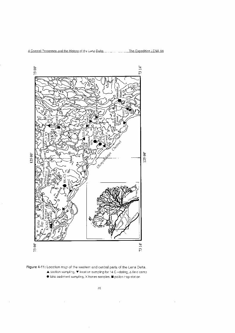
4 Coastal Processes and the History of the Lena Delta The Expedition LENA 99
0 0 2 W m r- r-
Figure 4-1 1 : Location map of the western and central parts of the Lena Delta. A section sampling, V location sampling for 14 C -dating, A field camp
 lake sediment sampling, X bones sarnples,  pollen trap station
The Expedition LENA 99 4 Coastal Processes and the Histoy of the Lena Delta
The Olenyokskaya Channel is the south-westernmost branch of the Lena River
Delta. It is oriented in the sub-latitudinal direction. The left-hand branch shore is
mainly bedrock being formed by the mountain slopes of the Chekanovsky range
system. The right-hand shore of the branch consists of numerous delta islands.
The length of the Olenyokskaya Channel is 229 km. It has a meandering
channel with a width ranging between 0.25 and 2.4 km at the exit. The water
depth is between 1.5 m and 11.3 m. The lowest depths (1.5-1.6 m) are
observed in the upstream reaches over the first 95 km. There are 5 bars with a total length of 17.5 km. The current speed comprises 0.3 to 0.7 mls. With
moving westward, the current speed decreases. The segment from the
Batyyalakhsky bar to the exit to the Olenyok Bay is subjected to the action of
wind surges.
There is a developed polygonal- ridge and flat-hillocky complex of tundra bog
lowland and tundra peat- and peat-gley soils belonging to a permafrost tundra-
arctic type within the study area (Atlas of the Arctic, 1985).
The vegetation communities of the study area are represented by dwarf shrub
and herbaceous-dwarf shrub (Dryas octopetata, Cassiope tetragona, Salix
nummularia, Salix reptans, Luzula confusa, Poa arctica, Papaver pulvinatum,
Saxifraga hirculus, Valeriana capitata), moss (Tomenthyphnum nitens) and
liehen of northern and Arctic East Siberian tundra in combination with
herbaceous-hypno and polygonal bogs.
4.4.4 Results of the field studies
The following geomorphologic levels were identified in the study area:
low floodplain and a complex of modern channel features (1-4 m a.s.1.) of
modern age;
high floodplain (4-8.5 m a.s.1.) of Late Holocene age;
first above the floodplain terrace (9-12 m a.s.1.) of Early-Middle Holocene
age; second above the floodplain terrace (13-29 m a.s.1.) of Late-Pleistocene-
Early Holocene age.
third above the floodplain terrace (30-60 m a.s.1.) of Late-Pleistocene age;
The data obtained agree in general with a complex of earlier identified terrace
levels for the Lena Delta (Korotayev, 1984; Grigoriev, 1993; Pavlova and
Dorozhkina, 1999).
The low floodplain is traced by Segments of different width (some meters to
3.5-4 km) along the branches. The low floodplain surface is sparsely covered
4 Coastal Processes and the Histow of the Lena Delta The Expedition LENA 99
with vegetation. The low floodplain is annually flooded with water during the
floods and frequent wind surges.
The low floodplain deposits are represented by alluvial fine- and medium
grained sands and the sand-silt-clayey alternation strata with plant macro-
remains. Active accumulation processes forming the strata of sand alternation
and silt-clayey deposits with plant macro-remains occur during wind surges at
the periodical flooding of the low floodplain areas covered with vegetation.
Active accumulation of sand material with the formation of wide near-channel
sandy shoals (Diring-Ayan-Belkeye Island, sands of Kukula-Kumaga, Butun-
Kumaga, etc.), alluvial longshore ridges and spits occurs in the areas of large
bends near the convex shores of the branches. The surface of sand shoals is
flat and devoid of vegetation. Sands are undulated-layered.
The complex of current channel features includes channel bars and islets
comprised of alluvial sands (Kel'tegey-Bel'key Island, sands of Byrakan-
Kumaga, etc.) They are up to 7 m high. Their active formation occurs during the
flood period. When the water level in the branches reaches the low water level,
the islets and the near-channel shoals dry. At this time, eolian processes are
active at their surface with the formation of the eolian relief features (sand
ripples, hillocky sands, and barkhans). The surface is devoid of vegetation.
The lake ratio coefficient for the low floodplain surface comprises 0-37 %. The
low floodplain is characterized by the development of mort lakes, that have an
elongated shape and a meandering coastline.
As a result of the influence of the channel flow, a thermo-erosion recess up to 4
m high and up to 3-10 m deep forms in some places near the rear seam of the
low floodplain.
Cryogenic processes within the low floodplain are manifested in the presence of
separate frost cracks without a pronounced polygonal character. Sometimes,
separate areas of developed bar concave polygons with small bogs in the
Center are observed.
The high floodplain (4-8.5 m) is developed everywhere throughout the entire
length of the branches presenting a flooded surface during the flood only in
some rare years. The high floodplain along the Olenyokskaya Channel is
represented by areas of different width (up to 1 km), that are attached to the
relics of the first above the floodplain terrace. In the central delta area along the
Arynskaya, Balaganakh-Uesya branches, etc., the high floodplain is
represented by a complex of large delta islands.
The Expedition LENA 99 4 Coastal Processes and the Historv of the Lena Delta
In general, the sediments of the high floodplain level in the western delta area
are similar to the high floodplain deposits developed in its northern area
(Pavlova and Dorozhkina, 1999) being represented by layered silty-sandy peat
deposits.
The following datings were obtained for the deposits comprising the high
floodplain:
2850±20 BP (LU-4414) for a sample of observation point 80-1 (72O48'06.5"
N, 123O37'28" E) at a height of 2.10-2.15 m above the waterline of the
Olenyokskaya Channel
3930±9 BP (LU-4413) for a sample of observation point 127-1 (72O36'50"
N, 125O53'30"E) at a height of 5.15-5.20 m above the waterline of the
Arynskaya Channel.
These datings indicate that the time of formation and the age of the high
floodplain in the western delta area are determined as Late Holocene, which is
in agreement with previous data (Pavlova et. al., 1999).
The high floodplain deposits have a high ice content with a developed lens-
shaped, layered and reticulate structure. The outcrops of ice veins are observed
everywhere in the high floodplain shore exposures. The ice vein width reaches
5-7 m with visible vertical thickness of up to 3.5 m, The distance between the
veins is 5-8 m. A polygonal and polygonal-bar micro-relief is widespread on the
high floodplain surface. The polygons are characterized by a tetragonal shape
reaching 10-1 1 m in the cross-section. The central depressed polygon areas
are swampy.
Thermo-erosion processes cause an intense decay of the high floodplain
shores. The shore decay results from a downfall of large (3-8 m) soil blocks that
separate along the cracks and thermo-erosion ruts bedding along the ice veins.
The formation of a thermo-erosion recess contributes to a more rapid process of
the downfall of blocks,
The lake ratio coefficient for the high floodplain surface comprises 12.5-1 7.2%
The high floodplain is characterized by a wide spreading of mort and
thermokarst lakes. The mort lakes have an elongated shape with a meandering
coastline reaching 2-2.5 km in length. The thermokarst lakes formed as a result
of melting of ice saturated deposits and multiple ice veins are characterized by
a rounded shape.
The investigated nameless thermokarst lake located in the southeastern area of
Jangylakh-Sis Island is confined to the height level of the high floodplain, The
lake area is 0.5 km2, the coastline length is 2.2 km and the prevailing depth is 5
4 Coastal Processes and the Historv of the Lena Delta The Exwedition LENA 99
m. The southeastern lake shore is low and swampy whereas the northwestern
shore is high and precipitous with a typical hillocky, small raviney relief
presenting a bench of the third above the floodplain terrace with a relative
elevation of 3 m. During high floods, river water penetrates into the lake,
A 0.80 m long bottom sediment core (DSK-Cl) was retrieved from the deepest
northeastern lake area (72'32' 15" N, 125'26' 10" E) (see Figure 4-1 1).
Lacustrine sediments are represented by clayey silts of dark-grey color with
non-uniform organic matter interlayers with a thickness between 0.1 to 2 mm.
The f irst above the f loodplain accumulat ion terrace (9-12 m a.s.1.) is
observed along the branches presenting local island segments of different
width. The deposits of the first above the floodplain terrace are similar in
composition to the high floodplain sediments being represented by silty-sandy-
peaty deposits. One of the typical sediment sections of the first above the
floodplain terrace is section KA-S3 (72'29' 33" N, 125'1 8' 45" E), located on the
left bank of the Tyuerenkey-Tebyulege branch (see Figure 4-1 1). The absolute
height of the shore exposure lip is 12.5 m a.s.1. The KA-S3 section deposits
were described and sampled and are represented from the waterline down as
follows (see Figure 4-1 2):
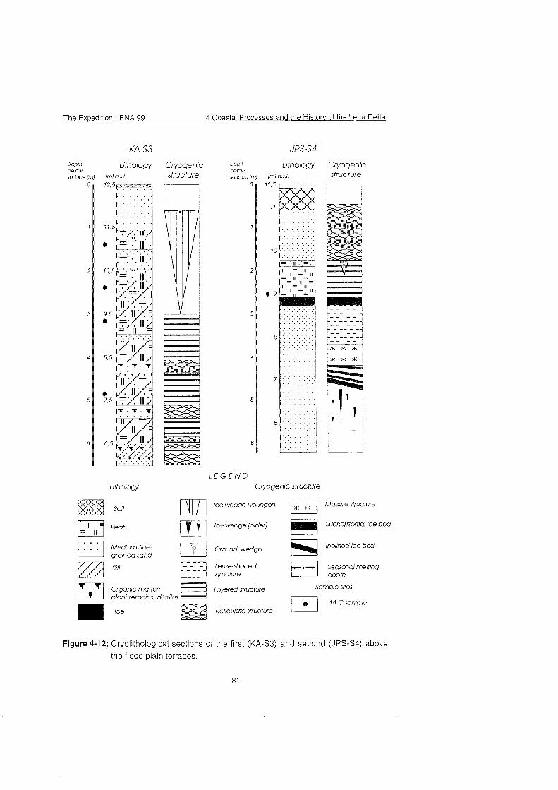
The Expedition LENA 99 4 Coastal Processes and the Historv of the Lena Delta
Deplh Lithology Cryogenic Depth belovd Lithology Cryogenic below suriace [ml I ~ I a s 1 structure surfoce (mj PI o-s.1 struc fure
L E G E N D t i t h o l o ~ Cryogenlc structure
soi1 []TIPI lce wedge [younger) F] Masswe strucfure
pq 'eaf lce wedge (older) Subhorizontal ice bed
à Medium fine- à Ground wedge Inclined ice bed grained sand
Sllt Lense shaped Seasonai meitlng structure depth
Organic matter Layered structure Sample sites
plant remains detntus 74 Csampie
ice Reticulote stuciure
Figure 4-12: Cryolithological sections of the first (KA-S3) and second (JPS-S4) above
the flood plain terraces.
4 Coastal Processes and the Historv of the Lena Delta The Expedition LENA 99
12.50-12.45 m - Soil-vegetation layer
12.45-1 1.45 m - Pale-yellow-reddish-colored, fine-, close-grained, ferruginated and horizontally
layered sand. Lamination is governed by the interlayers of strongly decomposed organic matter.
11.45-1 1.30 m - Silty-sandy-peaty alternation strata. The silt interlayers are dark-grey colored
with a thickness of 1 cm. Fine-grained sand interlayers of a pale-yellow color up to 1. 2 Cm thick.
The interlayers of brown-colored fibrous peat are 1.4 cm thick.
11.30-1 1 .OO m - Strongly sandy peat, fine-, close-grained sand.
11.00-10.85 m -Fine- and close-grained sand of a pale-yellow color with plant macro-remains.
10.85-10.70 m - Peat with a large content of fine- and close-grained sand.
10.70-10.55 m - Pale-yellow colored fine- and medium-grained sand
10.55-10.25 m - Peat with a large content of fine-grained sand.
10.25-9.20 m - Silty-sandy-peat alternation strata. Silty interlayers of a darkgrey color up to 1.5
cm thick, Interlayers of fine-and medium-grained pale-yellow sand up to 2.5 cm thick. Interlayers
of loose carton-like brown-colored peat with a thickness of 2-3 cm. In the 11.10-1 1.05 interval,
there is a fragment of wood 14 cm in diameter.
9.20-9.05 m - Reddish carton-like peat with a large ice content.
9.05-8.80 m - Fine-grained sand of a pale-yellow color with fine fibrous plant macro-remains.
8.80-8.30 m - Silt and peat alternation strata. Silt interlayers of a dark-grey color with a
thickness of 0.7-1 Cm. Interlayers of brown-colored carton-like peat with wood fragments up to
2-3 cm thick.
8.30-8.15 m - Yellowish-grey, fine-, close- arid medium-grained ferruginated sand with plant
macro-remains.
8.15-7.40 m - Silty-sand-peat alternation strata, Silty interlayers of a dark-grey color 0.7-1 cm
thick. interlayers of fine-and medium-grained pale-yellow sand up to 1 cm thick. Interlayers of
brown-colored peat with a thickness of 0.3-1 cm. The character of lamination is horizontally-
undulated.
7.40-7.10 m - Brownish-grey colored fine-, close- and medium-grained sand with a very large
content of plant macro-remains.
7.10-6.50 m - Silt and peat alternation strata of a grey-brown color. Peat is fibrous, slightly
decomposed with separate twigs and roots.
6.50-6.20 m - Grey-colored silt with plant macro-remains and ice interlayers 0.1-0.2 cm thick.
6.20-6.00 m - Yellowish-grey, fine-grained ferruginated sand with plant macro-remains.
6.00-0.0 m - Talus.
The following datings were obtained for the deposits comprising the first above
the floodplain terrace along the Olenyokskaya Channel:
6870±23 BP (LU-4409) for a sample of KA-S3-5 (6.60-6.65 m) * 51 OO±l4 BP (LU-441 1) for a sample of observation point 81-1 (72'45'26"
N, 124°05'26.5"E 8.t a hsight of 2.00-2.05 m above the waterline.
These datirigs inr i ieat~ ?hat the tune of formation and the age of the first above
the floodplain terrace in the western delta area are determined as Middle
Holocene, which is in agreement with previous data (Pavlova et. al., 1999).
The first above ihe floodplain terrace deposits with a large ice content are
characterized by the developed massive, lens-shaped and reticulate cryogenic
The Exuedition LENA 99 4 Coastal Processes and the Historv of the Lena Delta
structures. Ice veins are widespread in the deposits. The outcrops of ice veins
are observed in the shore exposures of the first above the floodplain terrace.
The width of the ice veins in the upper portion is 1.5 to 2.5 m, the visible vertical
thickness is up to 3-5 m and the distance between the individual veins is up to
11-13 m. The ice veins are frequently overlapped with laminated peat-silt
deposits,
The flat hummocky surface of the first above the floodplain terrace is
characterized by the developed polygonal and polygonal-bar micro-relief. In
general flat polygons are most developed. The polygons often have a regular
rectangular shape with a size up to 12-15 m in the cross-section. The central
areas of the polygons are swampy being often occupied by small lakes.
Along the shores of the branches, bedding of thermo-erosion ruts occurs along
the ice veins. The process of shore destruction of the first above the floodplain
terrace is similar to the character of destruction of the high floodplain shores.
The lake ratio coefficient is between 7.5 to 15.6%. Thermokarst lakes of a round
shape with smooth coastline contours and mort elongated lakes are developed
at the surface of the first above the floodplain terrace.
The second above the floodplain terrace has a fragmentary development in
the form of erosion remnant with absolute top marks of 13-19 m a.s.1. The relics
of the second above the floodplain terrace sharply differ from the other terrace
evels by the lithological composition of the deposits, the geomorphologic
surface habit and the character of the vegetation Cover. The deposits are
characterized by a uniform composition and structure. They are mainly
represented by quartz fine-, close- and medium-grained, sub-horizontally and
obliquely-laminated sands.
The deposits of the second above the floodplain terrace are described in the
section JPS-S4 (72'54' 43" N, 125'52' 50" E) of the sand remnant (16 m a.s.1.)
On the left shore of the Malaya Tumatskaya Channel (see Figure 4-1 1). The
absolute height of the shore exposure lip is 11.5 m a.s.1. The description is from
the top down (see Figure 4-12) :
0.0-0.1 m - Fine-graitied pale yellow polymict sands;
0.1 -0.6 m - Turf;
0.6-1.75 m - Fine-grained, pale yellow horizontally undulated-laminated sands with a polymict-
quartz composition. Lamination is determined by alternation of grey interlayers 0.3-1.5 cm thick
enriched with organic matter and sand interlayers 1-12 cm thick. The bottom portion contains
ferrugination spots and interlayers. The contact with lower Strata is clear, undulated and
stressed with the ferrugination interlayer 0.4-2 cm thick.
4 Coastal Processes and the Historv of the Lena Delta The Expedition LENA 99
1.75-1.90 m - Peat-sand alternation strata. The thickness of brown colored peat interlayers is
0.5-0.7 Cm. The thickness of pale-yellow sand interlayers is 0.5-1.5 Cm. The strata is broken by
a vertical frost crack (with a visible thickness of 35 cm) going deep to the lower lying strata. The
crack is filled with fine-grained sand. Intense ferrugination is observed along the crack sides, the
sides are irregular and lacerated, The crack width is 10-13 crn. The vertical displacement along
the crock of the northern and southern blocks comprises 7 crn;
1.90-2.60 m - Brown-colored well decomposed peat with lenses of fine-grained yellow colored
sand;
2.60-2.80 m - Ice is in layers. The layer sloping angle is 10'. The contact with the above lying
strata is uniform and with the lower strata - pockety;
2.80-3.70 m - Fine-grained yellowish-grey colored quarts sands with reddish ferrugination spots
and streaks. The spots are elongated along the long axis from bottom to top. At the contact with
the lower strata, there is a thin ferrugination interlayer with a thickness of 0.3-0.4 cm.
3.70-4.20 m - Fine-grained pale-yellow undulated-horizontally-laminated sands. The character
of the cryogenic structure is massive.
4.20-4.75 m - Fine-grained pale-yellow colored quartz undulated-horizontally-larninated sands.
The strata contain the oblique ice veins with the sloping angles of 10° 20° 30' and 45'. The
thickness of ice veins increases downward the section comprising between 0.5 to 25 crn;
4.75-5.75 m - Fine-grained pale-yellow colored quartz undulated-horizontally-laminated sands
with subvertical ice veins and veinlets 0.3 -5 cm thick.
5.75-1 1 .OO rn - Talus.
The character of the cryogenic microrelief of relics of the second above the
floodplain terrace and tlie thermo-erosion, eolian modern relief-forming
processes are described in (Pavlova and Dorozhkina, 1999). The lake
coefficient is 12.5-60.9 %.
The third above the floodplain terrace presents large erosion remnants
located in the southwestern Zone of the study territory - along the right-hand
shore of the Olenyokskaya Channel (Kurungnakh-Sise, Jangylakh-Sis,
Khardang-Sise and Kyuryuelyakh-Sis Islands). The absolute top marks of the
relics comprise 30-60 m a.s.1. A typical feature of the third above the floodplain
level is widespread deposits of the ice complex in the upper section portion of
the relics. The deposits comprising the relics of the third above the floodplain
level were investigated and described at three locations: Kurungnakh-Sise,
Jangylakh-Sis and Kyuryuelyakh-Sis Islands.
The deposits investigated in the shore exposure (the absolute height of the
shore exposure lip is 36 m a.s.1.) in the northern part of Jangylakh-Sis Island on
the left-hand shore of the Arynskaya Channel - section DJS-SI (72'38' 40" N,
125O30' 58" E) (see Figure 4-1 1) . are presented from the waterline:
0.0-2.0 m - Talus;
2.0-4.5 m - Brown carton-like, horizontally laminated peat with lamination stressed by thin
interlayers of close-grained sand.
The Expedition LENA 99 4 Coastal Processes and the Historv of the Lena Delta
4.5-5.5 m - Fine-grained pale-yellow undulated-horizontally layered sand with a quartz-feld spar
composition. Lamination is emphasized by dark interlayers enriched with organic matter;
5.5-9.0 m - Brown-colored laminated peat. Lamination is determined by interlayers of fine-,
close-grained sand;
9.0-24.2 m - Fine-, close-grained horizontally layered sand with a quartz-feldspathic
composition. Lamination is governed by alternation of thin interlayers of fine-grained sand with
interlayers of close-grained sand. Organic remains in the form of fibers and twigs appear in the
upper 0.6 m in the 23.6-24.2 m interval. Permafrost sand with lenses and veins of massive large
bubbly ice;
24.2-36.0 m - Ice complex deposits represented by a laminated sandy peat-loam alternation
strata broken by multiple ice veins. The visible vein width is up to 6 m.
Above the outcrop lip to an absolute height of 41 m a.s.1, the slope is turf-covered being
represented by a complex of hillocky relief.
The description of the section is in agreement with the previous description
(Galabala, 1987). The obtained 14C-dating in the 2.0-4.5 m intervals revealed
an age of more than 32000 years BP (MAG-539) and in the 5.5-9.0 m interval - 39000+3400 years BP (MAG-538) (Galabala, 1987).
The composition and structure of the third above the floodplain terrace
investigated along the right-hand shore of the Olenyokskaya Channel in the
vicinity of Buor-Khaia, BCh-S5 (72' 19' 31" N, 126' 16' 07" E) and in the vicinity
of Nagym, KS-S2 (72'52' 51" N, 123' 11' 58" E) (see Figure 4-1 1) agree in
general with those described before (Kunitsky, 1989; Schwamborn et al., 1999).
In section BCh-S5 the base of the ice complex is located at a height of 24 m a.s.1. with an ice complex thickness of 11-12 m. In section KS-S2 the base of
the ice complex is observed at a height of 10-1 1 m above the waterline with an
ice complex thickness of 7-8 m. For determining the age of the onset of the
formation of the ice complex, samples for radiocarbon analysis were collected
from all sections studied from the base of the Yedoma deposits (see Table A4-
9, appendix).
In the vicinity of Buor-Khaia in the talus, bone remains of the mammoth complex
fauna were detected that have melt from the Yedoma deposits. The bone
remains of the mammoth fauna were found in the lake shore exposure south of
Kuba Bay with an absolute mark of 16.8 m above the waterline (see Table A4-9,
appendix),
In August 1997 A. Ye. Paselsky, a fisherman from Taimylyr, found an in-situ
mammoth scull in the ice complex deposits of the third above the floodplain
terrace of the Olenyokskaya Channel 3.6 km downstream from Nagym. In July
1998, the scull was frozen out from the deposits containing it. I. I. Vinokurov, a
fisherman from Taimylyr working in the Nagym fishery area, informed us about
the unique finding for the western delta sector. The well-preserved scull, with
4 Coastal Processes and the H i s t o ~ of the Lena Delta The Exoedition LENA 99
the size of 0.65 x1.05 m, was found not far from the place of observation near
the fisherman' house and supplemented to the collection of bone remains from
the ice complex of the western delta sector.
The surface of the third above the floodplain terrace, which's upper cocle is
represented by Yedoma deposits with a high ice content, is characterized by the
most active development of cryogenic processes. In the flattened water divide
areas under the conditions of conservation of the ice veins, general surface
planation occurs with the formation of a polygon-free micro-relief or flat often
hexagonal polygons with leveled bars and overgrown small bogs. A bar micro-
relief with concave swampy polygons is often developed at the swampy gentle
slopes of the third above the floodplain terrace. Near the terrace lip under the
conditions of drained slopes, a thermokarst polygonal bar micro-relief is formed
with melting rills between the bars. Steep benches of the third terrace are
characterized by a hillocky relief.
Alas troughs with round thermokrast lakes and pingos confined to their bottoms
are widespread over the terrace surface. The lake sizes vary between some
meters and 1-2 km in the cross-section, with pingos reaching a height of 28-30
m. Sometimes the alas depressions combine forming a general alas trough
complicated in configuration and significant in area (up to 10 km wide).
A strongly branched thermo-erosion network is observed on Khardang-Sise,
Jangylakh-Sis and Kurungnakh-Sise Islands with ravines entrenched here to
the ice complex deposits to a depth of 35 m at the mouth width of up to 70 m.
The Cross profile of the ravines is V-shaped, with the bottom becoming flatter
and the profile attaining a box-like form closer to the mouth.
Flat bottom dells without a channel and sometimes with rudimentary channels,
along which melt and rainwater is discharged are widely developed at the
terrace surface. The length of dells varies between some meters and 4.5 km.
The lake ratio coefficient changes from 0 to 14.4%. Thermokarst lakes are
confined to the height level of the third above the floodplain terrace. Lakes
Byrakan-Kyuele (Khardang Island) and Jangylakh-Sisin-Kyuele (Jangylakh-Sis)
were studied. Lake Byrakan-Kyuele has an area of 2.4 km2. Its coastline length
is 4.6 km and the waterline mark is 23.4 m a.s.1. The lake basin presents a
calicular-shaped trough. A sand shoal with depths of 0.5-1.6 m gently sloping
towards the lake Center is traced along the southern shore over 400 m. At a
depth of 2 m there is a dramatic depth increase to 6.5-7 m. The largest depth
reaches 9 m being observed closer to the northern lake shore (see Figure 4-
13). The northern underwater trough slope is more steep.
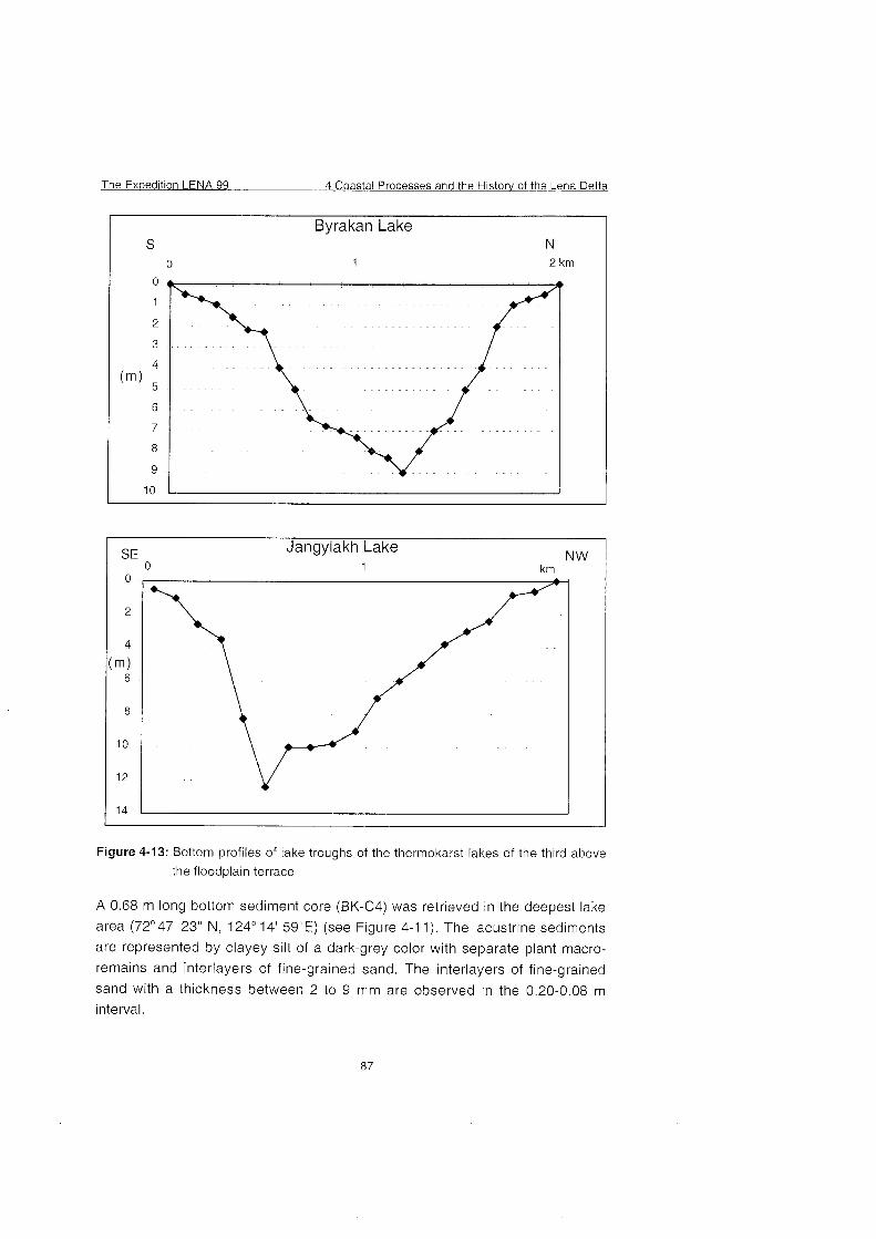
The Ex~edition LENA 99 4 Coastal Processes and the History of the Lena Delta
Byrakan Lake S N
0 1 2 km
SE Jangylakh Lake 0 1
NW km
Figure 4-13: Bottom profiles of lake troughs of the thermokarst lakes of the third above
the floodplain terrace
A 0.68 m long bottom sediment core (BK-C4) was retrieved in the deepest lake
area (72'47' 23" N, 124' 14' 59"E) (see Figure 4-1 1). The lacustrine sediments
are represented by clayey silt of a dark-grey color with separate plant macro-
remains and interlayers of fine-grained sand. The interlayers of fine-grained
sand with a thickness between 2 to 9 mm are observed in the 0.20-0.08 m
interval.
4 Coastal Processes and the Historv of the Lena Delta The Expedition LENA 99
The area of Lake Jangylakh-Sisin-Kyuele comprises 1.8 km2, the coastline
length is 4 km and the waterline mark is 13.6 m a.s.1. The prevailing depths,
comprising 9.5-10 m at the maximum lake depth of 12.3 m, are observed in the
lake Center (see Figure 4-13). A sand shoal with a depth of 0.5 m and a width of
300 m extends along the northern-northwestern shore.
A 0.58 m long bottom sediment core (JSK-C5) was retrieved in the deepest
central area of the lake (72' 33' 23" N, 125'26' 31 "E) (see Figure 4-1 1). The
lacustrine sediments are represented by clayey silt of a greenish-brown color
with a mixture of fine-grained laminated sand. The lamination is determined by
a different content of organic matter and fine-grained sand.
The shores of the thermokarst lakes of the third above the floodplain terrace are
characterized by relative elevations of up to 11 -1 8 m, steep slopes up to 20-25'
and a wide development of hillocky-raviney relief.
Three spore-pollen traps were recovered in the Lena Delta:
L-1 in the Yugus-Jie area with coordinates: 72' 50' 17" N, 125' 49' 15" E;
L-2 on Sagastyr Island with coordinates: 73' 23' 14" N, 126' 36' 53" E;
e L-3 on Samoylov Island with coordinates: 72' 22' 43" N, 126' 31' 08"E.
A herbarium was collected along the study traverse in the Lena Delta.
4.4.5 Preliminary Conclusions
The main geomorphologic levels were revealed and followed within the Western
delta sector as a result of field studies. Each height level was characterized by a
representative section of Quaternary deposits and the composition and
structure of the upper Strata of bottom lacustrine sediments were determined.
Sampling for spore-pollen and diatom analyses, analysis of plant macro-
remains and dating was undertaken from the sections and lacustrine
Quaternary sediment cores. The spore-pollen traps were recovered for
revealing the character of pollen transfer in the Lena River Delta.
For revealing the specific geological-geomorphologic structure and the relief
formation history of the Lena River Delta, geomorphologic maps of the major
delta segments at 1:lOO 000 and 1 :200 000 scales were compiled based On
field observations and Interpretation of aerial survey data (Pavlova and
Dorozhkina, 1999). A comparison of the maps of major segments and an
analysis of earlier obtained and published data On the available sections of
quaternary deposits (Korotaev, 1984; Tomirdiaro et. al., 1985; Galabala, 1987;
Kunitsky, 1989; Grigoriev, 1993; Nagaoka, 1994; Kuptzov and Lisitzin, 1996;
The Expedition LENA 99 4 Coastal Processes and the History of the Lena Delta
Pavlova and Dorozhkina, 1999; Pavlova et. al., 1999; Siegert et al., 1999;
Schwamborn et.al., 1999) allow the following conclusions:
The thickness of the ice complex deposits in the eastern delta sector is 2-3-
fold greater compared to that in the western sector.
The base of the ice complex declines from 10 to 28 m a.s.1. in the western
area to -8 to -10 m a.s.1. in the eastern area.
A sharp decrease of the base level of the ice complex is observed east of
the Malaya and Bolshaya Tumatskaya Channels.
The eastern delta sector is mainly characterized by young datings (10-30
kyr) whereas the western sector - by more ancient datings (older than 30
kyr) located at similar hypsometric marks.
A full complex of terraces is developed in the western delta area while only
two floodplain levels and relics of the third above the floodplain level are
observed in the eastern area.
The established typical features testify to the tectonic regime change and the
modification of the hydrographic network of the Lena River Delta during the Late
Pleistocene and Holocene.
Submerging of the base of the ice complex deposits from west to east and
increasing thickness in the Same direction, as well as the radiocarbon dating
distribution indicates that from the Late Pleistocene the western and eastern
delta areas developed in different directions under the conditions of the
prevailing steady tectonic rise of the western delta sector and lowering or
stabilizing of the eastern sector.
The boundary between the two delta areas has a submeridional strike and is
located between the Malaya and Bolshaya Tumatskaya Channels.
The differences in the tectonic regimes of the western and eastern delta
sectors account for the development of the entire complex of terraces in the
western delta area while only two floodplain levels and relics of the third
above the floodplain level are observed in the eastern area.
The absence of the terrace levels of Late Pleistocene-Early Holocene and
Early-Middle Holocene age in the geomorphologic series in the eastern delta
area indicates that the onset of more active neotectonic motions took place
at the end of the Late Pleistocene-Early Holocene.
The development of the first above the floodplain terrace of Early-Middle
Holocene age within the southwestern delta area indicates that this Part of
the delta was a sedimentation area in the Early-Middle Holocene. The main
runoff of the Lena River at that time was in the northwestern direction along
the Olenyokskaya Channel.
4 Coastal Processes and the Histow of the Lena Delta The Ex~edition LENA 99
a The predominant development of the high floodplain of Late Holocene age in
the northeastern delta area indicates a change in the main Lena runoff
direction during the second half of the Holocene to the northeast-eastern
due to tectonic causes.
The data obtained will serve as a basis for further detailed paleogeographic
reconstructions of the environmental evolution of the Lena Delta in the
Pleistocene and Holocene,
Acknowledgements: The authors are grateful to D. Kozlov (Department of
Polar Geography Countries, RF SRC AARI), V. Pozdnyakov (International
Biological Station "Lena-Nordensheld") and to V. Achikasov and V. Dormidontov
(State Reserve Ust'-Lensky) who directly took part in the field studies.
The authors express their gratitude to the expedition participant A. Sher, senior
scientist of the Institute of the Problems of Ecology and Evolution, RAS for
determining the collection of bone remains.
The authors would also like to thank all who provided help and support during
the field studies.
4.5. Observations of water level oscillations in the Olenyokskaya Channel
(E. Pavlova., M. Dorozhkina and D. Kozlov)
Observations of water level oscillations in the Olenyokskaya Channel in the
area of a MINILOG-sensor LD98M02 (with coordinates (72' 52,941' N, 123'
14,580' E)) set up in 1998 (Antonow et al., 1999), were carried out for linking
the automated MINILOG Sensor data on the water level oscillations with the
absolute marks.
A hydrological station with a visual readout was sei up on the right-hand shore
of the Olenyokskaya Channel, 2.4 km downstream from Nagym, in the area of
the triangulation point 106 of the Main Administration of the NSR (24.8 a.s.1.) as
a result of leveling on August 14, 1999. The coordinates of the hydrological
station are 72' 53' 10" N, 123' 14' 28" E.
The observations at the hydrological station were performed every hour from 0
h on August 15 to 21 h on August 16, 1999. The diagram of water level
oscillations is presented in Figure 4-14. The minimum water level values
comprised -250 mm (for 16 h on August 16, 1999) and the maximum value was
+I 15 mm (for August 18, 1999).
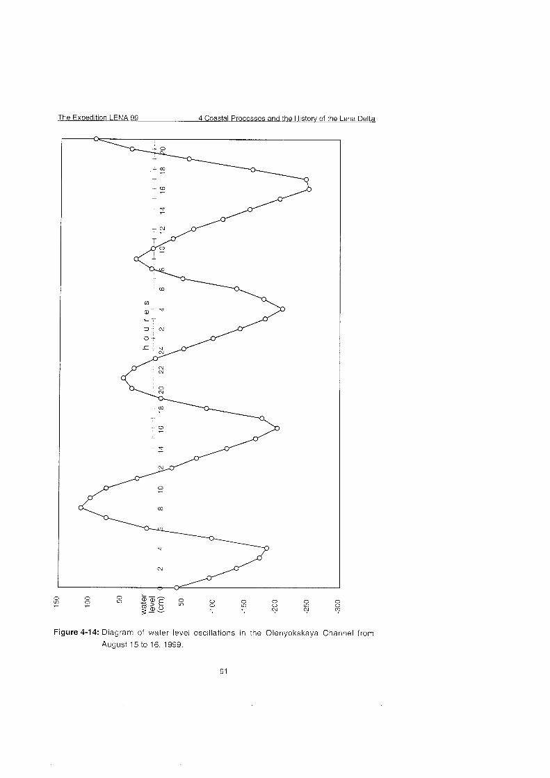
Figure 4-14: Diagram of water level oscillations in the Olenyokskaya Channel from
August 15 to 16, 1999.
4 Coastal Processes and the Historv of the Lena Delta The Expedition LENA 99
4.6 Aeolian sedimentation processes in the Lena Delta
(M. Antonow and J. Boike)
During the short Arctic Summer season sediment is mainly transported by the
Lena River. Wind also affects the particle transport of the delta region, strongly
stressing the vegetation or wiping it out. As a result of the aeolian activity, many
deflation plains were observed mainly in the Arga region (NW-delta). Although
large meteorological data Sets and climatic models exist, the magnitude of
aeolian mass transport from the Siberian hinterland via the Lena delta towards
the Laptev Sea is poorly understood. After break-up, the sediment-laden river
ice supplies a large amount of (former) aeolian particles to the Lena river bed
and the Laptev Sea shelf. A Campbell Scientific automatic weather station
installed On Samoylov during July 1998 continuously recorded meteorological
parameters. The wind speed during the winter months averaged around 4 m/s.
Maximum wind speeds with up to 10 m/s occurred between December to
January and originated from the south-west as well as from the north (see
Figure 4-1 5). 20 rnaxirnum wind speed
1998
Wind speed
1999
wind speed [rn/s]
180
August 98 to September 99
180
Months October 98 to April 99
Figure 4-15: Near bottom wind activities (speed and direction) of the investigations
area during the field period 199811 999.
The Exuedition LENA 99 4 Coastal Processes and the Histow of the Lena Delta
Environmental studies have been performed on the island Samoylov (N 72O227
E 126O30; area - 1,200 ha) at the end of the winter season in 1999. This island
is one of about 1500 islands of that region and is representative for the south-
western part of the delta. Due to seasonal changes of river water levels, four
terraces were shaped with an elevation maximum of 12 m above sea level.
Water and wind action formed an (thermo)abrasion coast with nearly vertical
cliffs and a very narrow beach at the eastern and southern banks.
During May and June the thickness of Snow was measured on the island along
19 transects (see Figures. 4-16 and 4-18). 54 surface snow samples (each of
20x20x2.5cm) were melted and filtered (0.45 micron HVLP filters by Millipore) to
determine the amount of aeolian particles. The deposited aeolian sediment is
remarkable high during the onset of the Arctic spring and depicts the
meteorological conditions during the field period. The particle content of the
surface Snow samples ranges from a few mg/l of fine-grained material to about
10 g/l of aeolian particles (Figures 4-15 and 4-17). The grain-size of the aeolian
material even reaches the sand fraction greater than 63 microns .
Samoylov Island Late Holocene
episodic flooding surface
per~odic flooding surface
snow transect with sample site
T-X
Figure 4-16: Location of Snow sampling during the expedition Lena 99ITeam 1a. For
snow transects See Figure 4-1 8.
4 Coastal Processes and the Historv of the Lena Delta The Expedition LENA 99
Figure 4-17: Aeolian particle distribution in the area of Samoylov Island. The
concentration of particles in the Snow samples is given in g/l.
The Expedition LENA 99 4 Coastal Processes and the History of the Lena Delta
0
5 0
1 0 0
1 5 0
2 0 0
X s s m m
x x x X =
2 5 0
3 0 0
Figure 4-18: In-situ Snow coverage (cm) on and around Samoylov Island. For the
positions of transects See Figure 4-16.
4 Coastal Processes and the Historv of the Lena Delta The Expedition LENA 99
4.7 References Antonow, M., Grigoriev, M.N., Rachold, V. and Reimnitz, E. (1999): Seasonal changes of water
level in the Lena Delta region. In: Rachold (ed.): Expeditions in Siberia in 1999. Rep.
Polar. Res. 315, 92-93.
Are, F.E. (1999) The role of coastal retreat for sedimentation in the Laptev Sea. In: Kassens H,
Bauch H, Dmitrenko I, Eicken H, Hubberten HW, Melles M, Thiede J and Timokhov L
(eds) Land-Ocean Systems in the Siberian Arctic: dynamics and history. Springer,
Berlin, 287-299
Atlas of the Arctic (1 985): GGUK, Moscow, 204 pp. (in Russian).
Davies, J.L. and Annan, A.P., 1989. Ground-Penetrating-Radar for High-Resolution Mapping of
Soil and Rock Stratigraphy, Geophysical Prospecting, Vol. 37, 531 -551.
Galabala, R.O. (1987): New data on the Lena Delta structure. In: The Quaternary period of
North East Asia. Magadan, DVO AN SSSR, 152-170 (in Russian)
Grigoriev, M.N. (1993): Cryomorphogenesis of the Lena River mouth area. Yakutsk, SO AN
SSSR, 176 pp. (in Russian).
Korotaev, V.N. (1984): The formation of the hydrographic network of the Lena Delta in the
Holocene. Vestnic MGU, Ser. 5, No. 6, 39-44 (in Russian)
Kunitsky, V.V. (1989): Cryolithology of the Lena lower reaches. Yakutsk, SO AN SSSR, 162 pp.
(in Russian).
Kuptsov, V.M. and Lisitsin, A.P. (1 996): Radiocarbon of Quaternary along shore and bottom
deposits of the Lena and the Laptev Sea sediments. Mar. Chem. 53, 301 -31 1.
Nagaoka, D. (1994): Properties of Ice-complex Deposits in Eastern Siberia. - In; Proceedings of
the Second Symposium on the Joint Siberian Permafrost Studies between Japan and
Russia in 1993, Tsukuba.
Niessen, F. and Melles, M., 1995. Lacustrine sediment echosounding and physical properties,
Berichte zur Polarforschung, Vol. 174: Die Expedition ARKTIS-XI2 mit FS Polarstern
1994, Hubberten, H.-W. (ed.), pp. 69.
Pavlova, E. and Dorozhkina, M. (1999). Geological-Geomorphological Studies in the Northern
Lena River Delta. In: Rachold (ed.): Expeditions in Siberia in 1999. Rep. Polar. Res.
31 5, 11 2-1 26.
Pavlova. E., Dorozhkina, M. and Rachold, V. (1999). - Geomorphological structure of the
western sector of the Lena River Delta. Fifth workshop on Russian-German
Cooperation, Laptev Sea System 2000, St.Petersburg, Russia, 25-29 November 1999.
Rachold, V., Grigoriev, M.N. and Antonow, M. (1999): Modern sedimentation and the
environmental history of the Lena Delta. In: Rachold (ed.): Expeditions in Siberia in
1999. Rep. Polar, Res. 31 5, 81 -1 44.
Rachold, V., Grigoriev, M.N., Are, F.E., Solomon, S., Reimnitz, E., Kassens, H. and Antonow, A
(in press): Coastal Erosion vs. Riverine Sediment Discharge in the Arctic Shelf Seas.
Geol. Rundsch.
Schwamborn, G., Schneider, W., Grigoriev, M.N., Rachold, V. and Antonow, M. (1999):
Sedimentation and environmental history of the Lena Delta. In: Rachold (ed.):
Expeditions in Siberia in 1999. Rep. Polar. Res. 31 5,94-111
The Expedition LENA 99 4 Coastal Processes and the Histow of the Lena Delta
Siegert, C. et al. (1999): Paleoclimate signals of ice-rich permafrost. In: Rachold (ed.):
Expeditions in Siberia in 1999. Rep. Polar. Res. 315, 145-190.
Tarakanov, L.V. and Biryukob, V.Yu. (1 974): Geomorphologie evidence of Laptev Sea modern
ingression in Shirokostan Peninsula area. - Geomorphology 4, 98-100.
Tomirdiaro, S.V., Arslanov, K.H. and Chernenkiy, B.I. et. al. (1985): Geochronology of key
sections of arctic and subarctic types of ice-complex. - In: Geochronology of the
Quaternary period. Tallinn, 62 (in Russian)
Position \I 73"19'31" M 73'19'35'' M 73'19'37'' M 73'19'37'' M 73'1 9'39" M 73'19'31 " M 73'19'31 " N 73'19'31 " N 7S019'31 " M 73'19'31 " N 73'19'31 " N 73'19'31 " N 73'20'36" N 73'20'36'' N 73'20'36'' N 73'20'36" N 73'20'36'' N 71'44'38'' \I 73'19.842' \I 73'19.195' M 73'20.208' M 73'19.527' N 73'20.1 67' N 73'19.619' N 73'19.633' N 73'20.719' N 73O18.997' N 73O19.619' N 72'58.488' N 71°47.24 ' N 71 '47.1 67' N 71 '44.633' N 72'22.220'
Nikolay Lake Nikolay Lake Nikolay Lake Nikolay Lake Nikolay Lake Nikolay Lake Nikolay Lake Nikolay Lake Nikolay Lake Nikolay Lake Nikolay Lake Nikolay Lake Nikolay Lake Mikolay Lake Nikolay Lake Nikolay Lake Nikolay Lake
Ivashkina Laguna Nikolay Lake Nikolay Lake Nikolay Lake Nikolay Lake Nikolay Lake Nikolay Lake Nikolay Lake Nikolay Lake Arga Island
Nikolay Lake Trofimofsky Ch. Bykowsky Ch.
Mammontovy Kh. Ivashkina Laguna
Lake sediments Lake Sediments Lake Sediments Lake Sediments Lake Sediments Lake Sediments Lake Sediments Lake Sediments Lake Sediments Lake Sediments Lake Sediments Lake Sediments Lake Sediments Lake Sediments Lake Sediments Lake Sediments Lake Sediments
Lagoonal Sediments Radar profiles Radar profiles Radar profiles Radar profiles Radar profiles Radar profiles* Radar profiles* Radar profiles Radar profiles* Radar profiles Radar profiles* Radar profiles Radar profiles Radar profiles*
drilling drilling drilling drilling drilling
gravity coring gravity coring gravity coring gravity coring gravity coring gravity coring gravity coring gravity coring gravity coring gravity coring gravity coring gravity coring
drilling 25-MHz-ant. 25-MHz-ant. 25-MHz-ant. 25-MHz-ant. 25-MHz-ant.
100-MHz-ant. 100-MHz-ant. 100-MHz-ant. 100-MHz-ant. 100-MHz-ant. 100-MHz-ant. 100-MHz-ant. 100-MHz-ant. 100-MHz-ant.
Samoylov Island Radar profiles* 'CMP-measurements
The Expedition LENA 99 4 Coastal Processes and the Historv of the Lena Delta
Table A4-2: List of samples for lake sediment studies on Arga Island
sample site depth Sediments type of analyses
recovered by drilling (D) grain ice 1 water TC,TOC, 14C
LD99-A01 (D)
LD99-A02 (D)
LD99-A03 (D)
LD99-A04 (D)
LD99-A05 (D)
LD99-CN1 * (G)
LD99-CN1 D ** (G)
LD99-CN2 (G)
LD99-CN3 (G)
LD99-LS-10-1 * (G)
LD99-LS-10-2 * (G)
LD99-CNPP-1 * (G)
LD99-CNPP-2 * (G)
LD99-CNPP-3 * (G)
LD99-CN4 * (G)
LD99-CN5 * (G)
LD99-CN6 (G)
LD99-lv.2 *** (D)
size content N S fAMS'
* provided for AARI, St. Petersburg ** provided for IFB, University Hamburg * * provided for MGU-P, Moscow State University
4 Coastal Processes and the History of the Lena Delta The Expedition LENA 99
Table A4-3: Boreholes temperature measurments in Nikolay Lake (Arga Island) and
Date
- M ~ Y 07
May 09
May 11
Ivashkina lagoon, May 1999.
W a t e 1 Bore- 1 Depth, rn
Temperature, 'C
The Expedition LENA 99 4 Coastal Processes and the Historv of the Lena Delta
Table A4-4: List of Stations for coastal erosion studies.
location Arangastakh-Turnula
Peninsula (Arga Islandl Gerasirn Island (Kuba
Bav)
~tation LD99-
Kuba-Aryta Island
CR ... 1
-PP
2 - --
3
4
5
6 - - -.
7 P-
8
9 P-
10
11 - -~
12 -P
13
14 -
15 -
16 P-p
17 P
Turnat Bay (near ~rner'c: Kuba Island
Hans-Aryta Island (rnouti region of S a r d a k h --
rnouth region of Sardakh -. - Channel
Orto Yuos Island near Bvkovsky Cape -..
date
09 08 99 -
10 08 99
11 08 99 - -
12 08 99
14 08 99
14 08 99
15 08 99 - --
15 08 99 -PP -
18 08 99
19 08 99
20 08 99
21 08 99
22 08 99 -P -
24 08 99
25 08 99 -P -
26 08 99
27 08 99 .-
Muostakh Island
Buor-Khaya Peninsula (Hargy Lake
Buor-Khaya Pen L s u ~ .- (Alas site)
Vankina Guba Bay
Makar Island
Shrokostan Peninsula
Svyatoy Nos Cape
Drnitry Laptev Strait -P
Drnitry Laptev Straft (Oiyagoskty Yar,
3olshoy Lyakhovky Islanc ~Zirnovie R ive~Mouse)~
Yana Bay
Buor-Khaya Cape
iykovsky Peninsula (Ho t~ Hapsaqay-Khayata) Bykovsky Peninsula
(Mamontovv-Kiiayata)
4 Coastal Processes and the Historv of the Lena Delta The Expedition LENA 99
Table A4-5: List of samples for coastal erosion studies
station LD99- no. of type of sampling samples
marine surface sarnples, profile marine surface sarnples, profile
cliff samples 6
marine surface samples, profile
11
marine surface sarnples, profile
coast samples 2
marine surface sarnples, profile marine surface sarnples, profile
cliff samples 3
marine surface samples, profile
cliff sarnoles 4
cliff samples 4
marine surface samples, orofile
start coordinates end coordinates
73'39.1 83' 125"51.250'
The Expedition LENA 99 4 Coastal Processes and the H i s t o ~ of the Lena Delta
Table A4-6: Water temperature profiles ('C) along the Laptev Sea coast.
Stations l
4 Coastal Processes and the History of the Lena Delta The Expedition LENA 99
Table A4-7: Hydrometeorological characteristics along the Laptev Sea coast (bottom
water temperature - Tb , air temperature - Ta).
NÂ
St.
3
4
T b ,
OC
2.0
-0.8
Date
10. 08
12.08
Lati- tude, N o
73 35,951
73 4488
Alti- tude, E O
125 23,OO 126
1700
Wind direc- tion
N
NE
Wind velo- city,
rnisec 6-8
8-10
Wave height,
m
0.5
1.0
Wave lenght, m
7
12
Ta, OC
5.5
6.7
Depth, m
2.7
11.0
g o a s t a l Processes and the History of the Lena Delta
Table A4-8: List of samples for geological-geomorphological studies in the Lena
PA DA PR D
X X X
X
X X
X
X X
X
X X
X
X X X
X
X X
X
X X
X
X X X
Delta (abbreviations See end of table).
Study site DJS-SI: Arynskaya
Sample no Depth (m)
DJS-SI - 1 23,5-23,6
DJS-SI - 2 23,6-23,7
DJS-SI - 3 23,7-23,8
DJS-SI - 4 23,8-23,9
DJS-SI - 5 23,9-24,O
DJS-SI - 6 24,O-24,l
DJS-SI - 7 24,l-24,2
DJS-SI - 8 24,2-24,25
DJS-SI - 9 24,25-24,30
DJS-SI - 10 24,30-24,35
DJS-SI -1 1 24,35-24,40
DJS-SI - 12 24,45-24,50
DJS-SI - 13 24,55-24,60
DJS-SI - 14 24,65-24,70
DJS-SI - 15 24,75-24,80
Channel (72' 38' 40" N, 125'30' 58"
Sediment
fine sand with plant remains
peat with clay interbeds
Study site KS-S2: Olenekskaya Channel, Nagym (72'52' 51" N, 123'1 1' 58" E).
18' 45" E).
PA DA PR D
X X
X
X X
X
X X X
X
X X
X
X X
X
X X
X
X X
Study site KA-S3:
Sarnple no Depth (m)
KA-S3-1 6,OO-6,05
KA-S3-2 6,15-6,20
KA-S3-3 6,30-6,35
KA-S3-4 6,45-6,50
KA-S3-5 6,60-6,65
KA-S3-6 6,75-6,80
KA-S3-7 6,90-6,95
KA-S3-8 7,05-7,IO
KA-S3-9 7,20-7,25
KA-S3-10 7,35-7,40
KA-S3-11 7,50-7,55
KA-S3-12 7,65-7,70
KA-S3-13 7,80-7,85
PA DA PR D
X
X
X
X
X
X
Sample no Depth (m)
KS-S2-1 6,24-6,31
KS-S2-2 6,93-7,13
KS-S2-3 7,67-7,70
KS-S2-4 7,61-7,64
KS-S2-5 10,96-11,Ol
KS-S2-6 1 1,30-11,35
Tyuerenkey-Tebyulege Channel (72'29' 33" N, 1
Sediment
fine sand with plant remains
silt with plant remains
alternating bedding of peat and silt
fine sand with plant remains
medium sand with plant remains
alternating bedding of peat, fine
Sand , silt
Sediment
fine sand with plant remains
peat
4 Coastal Processes and the Historv of the Lena Delta The Expedition LENA 99
Table A4-8: continued.
AS3-45 subresent
fine, medium sand with plant
remains
alternating bedding of peat, silt
fine sand with plant remains
peat
alternating bedding of peat, fine
sand , silt
peat with fine sand
fine, medium sand
peat with fine sand
fine sand with plant remains
peat with fine sand
alternating bedding of peat, fine
sand , silt
fine horizontal laminated sand
Study siteBCH-S5: Olenekskaya Channel, Buor-Khaia (72' 19' 31 " N, 126'1 6' 07" E).
Sample no Depth (m)
BCh-S5-1 2,85-2,90
BCh-S5-2 2,95-3,OO
BCh-S5-3 3,lO-3,15
BCh-S5-4 3,20-3,25
BCh-S5-5 3,61-3,62
BCh-S5-6 4,08-4,09
Sediment
silt
sandy peat
peat
PA DA PR D
X X
X X
X X
X X
X X
X X
The Expedition LENA 99 4 Coastal Processes and the Histow of the Lena Delta
Table A4-8: continued.
Study siteJPS-S4: Malaya Turn
Sample no Depth (m)
JPS-S4-1 1,95-2,OO
JPS-S4-2 2,OO-2,05
JPS-S4-3 2,55-2,60
JPS-S4-4 3,OO-3,05
JPS-S4-5 3,30-3,35
JPS-S4-6 3,65-3,70
JPS-S4-7 4,lO-4,15
JPS-S4-8 4,50-4,55
JPS-S4-9 4,95-5,OO
JPS-S4-10 5,60-5,65
Study site DSK- Cl: Central pai
Sample no Depth (m)
DSK-C1-1
DSK-C1-2
DSK-C1-3
DSK-C1-4
DSK-C1-5
DSK-C1-6
DSK-C1-7
DSK-C1-8
DSK-C1-9
DSK-C1-10
DSK-Cl-11
DSK-C1-12
DSK-C1-13
DSK-C1-14
DSK-C1-15
DSK-C1-16
DSK-C? -1 7
DSK-C1-18
DSK-C1-19
DSK-(21-20
DSK-Cl-21
DSK-C1-22
DSK-C1-23
DSK-Cl-24
DSK-C1-25
DSK-C1-26
DSK-C1-27
DSK-C1-28
DSK-C1-29
skaya Channel, Djeppiries-Sise (7;
Sediment
sandy peat
fine sand
3f Anonyrnous Lake (72'32' 15" F
Sediment
pelitic silt with organic interbeds
fine sand
pelitic silt with organic interbeds
14' 43" N, 125'52' 50" E).
PA DA PR D
X
X
X X
X
X
X
X
X
X
X
125'26' 10" E).
PA DA PR C
X >
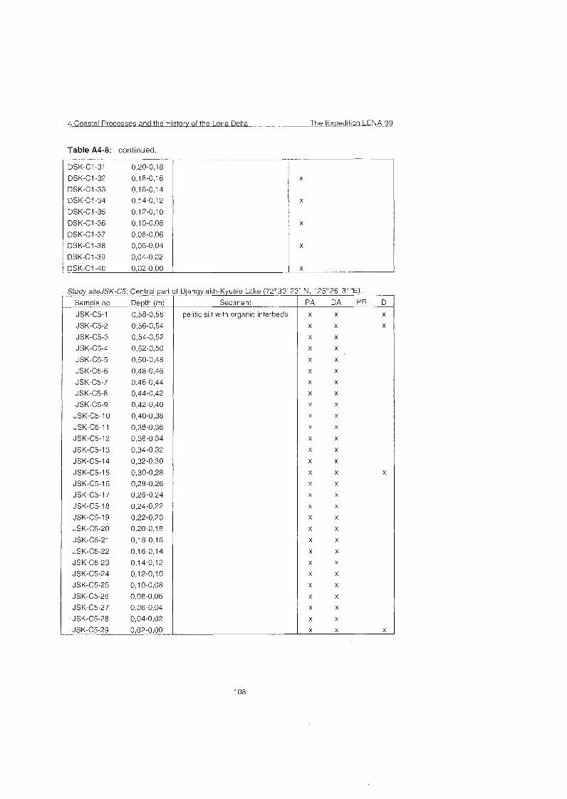
4 Coastal Processes and the Historv of the Lena Delta The Ex~edition LENA 99
Table A4-8: continued.
7 DSK-Cl-31 0,20-0,18
DSK-Cl-32 0,18-0,16
DSK-Cl-33 0,16-0,14
DSK-Cl-34 0,14-0,12
DSK-Cl-35 0,12-0,lO
DSK-Cl-36 0,lO-0,08
DSK-Cl-37 0,08-0,06
DSK-Cl-38 0,06-0,04
DSK-Cl-39 0,04-0,02
DSK-Cl-40 0,02-0,OO
Study siteJSK-CS: Central pari
Sample no Depth (m)
Djangylakh-Kyuele Lake (72'33' 2
Sediment
pelitic silt with organic interbeds
N, 125'26' 31 "E).
PA DA PR D
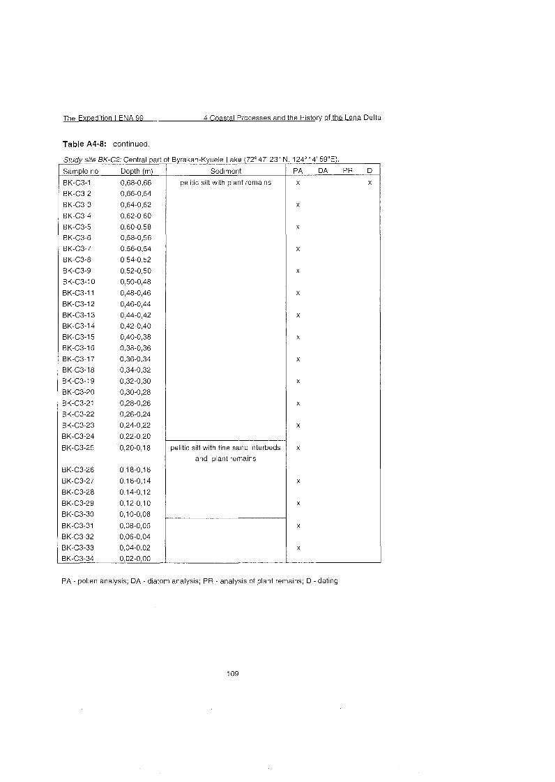
The Exoedition LENA 99 4 Coastal Processes and the Historv of the Lena Delta
Table A4-8: continued.
Study site BK-C2: Central patt
Sample no Depth (m)
Byrakan-Kyuele Lake (72'47' 23"
Sediment
pelitic silt with plant remains
pelitic silt with fine sand interbeds
and plant remains
PA - pollen analysis; DA - diatom analysis; PR - analysis of plant remains; D - dating
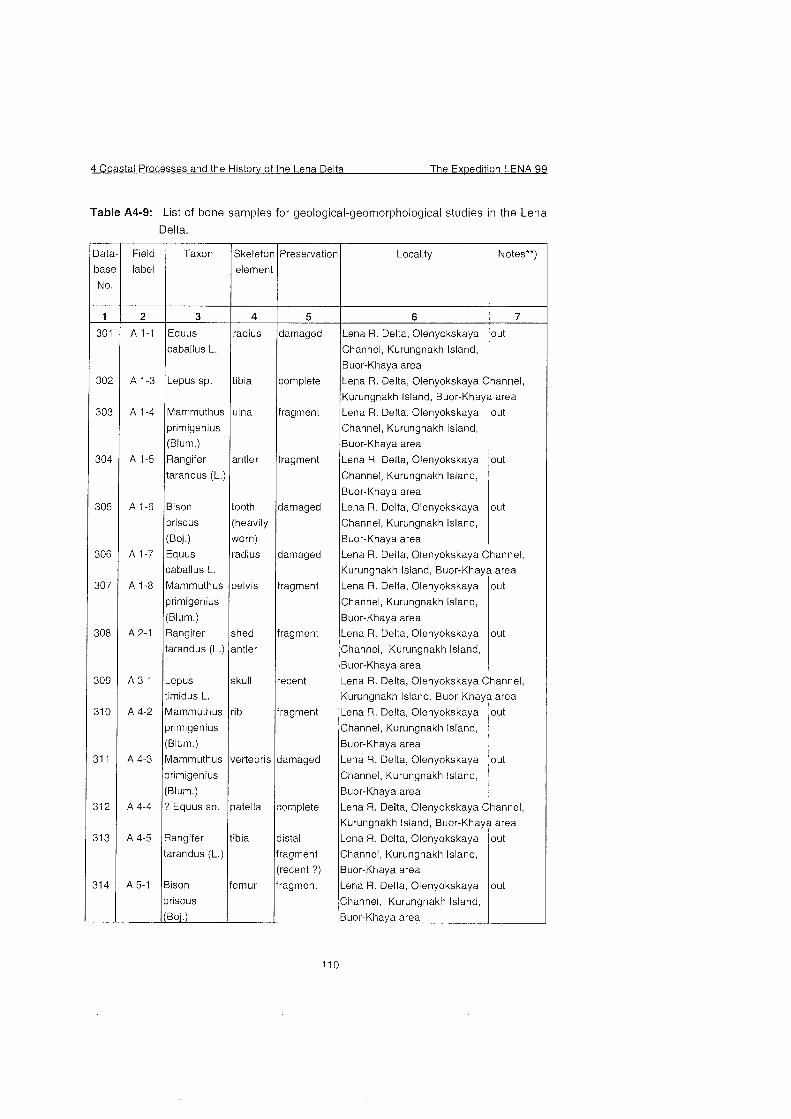
4 Coastal Processes and the Historv of the Lena Delta The Ex~edition LENA 99
Table A4-9: List of bone samples for geological-geomorphological studies in the Lena
Delta.
3at
bas
No
- 1
30'
30;
30:
3 0 ~
305
30â
307
30Â
30s
31 G
31 1
31 2
31 3
31 4
-
Field
label
2
A 1-1
A 1-3
Taxon
3
A 1-4
A 1-5
Equus
caballus L.
Lepus sp.
A 1-6
Skeleton
element
4
Mammuthus
primigenius
(Blum.)
Rangifer
A 1-7
A 1-8
A 2-1
radius
tibia
tarandus (L.)
Bison
priscus
(Boi.) E ~ U U S
caballus L.
Mammuthus
primigenius
(Blum.)
Rangifer
tarandus (L.)
worn)
radius
pelvis
shed
antler
recent
fragment
damag ed
complete
Preservation
5
damaged
complete
ulna
antler
damaged
fragment
fragment
A 3-1
A 4-2
A 4-3
A 4-4
fragment
fragment
tooth
(heavily
(Boj.) ~ u o r - ~ h a ~ a area
110
Locality
6
damaged
Lepus
timidus L.
Mammuthus
primigenius
(Blum.)
Mammuthus
primigenius
(Blum.)
? Equus sp.
A 4-5
A 5-1
Notes**)
7
skull
rib
vertebris
patella
Lena R. Delta, Olenyokskaya
Channel, Kurungnakh Island,
Buor-Khaya area
Rangifer
tarandus (L.)
Bison
priscus
out
tibia
femur
Lena R. Delta, Olenyokskaya Channel,
Kurungnakh Island, Buor-Khaya area
distal
fragment
(recent ?)
fragment
Lena R. Delta, Olenyokskaya
Channel, Kurungnakh Island,
Buor-Khaya area
Lena R. Delta, Olenyokskaya
Channel, Kurungnakh Island,
Buor-Khaya area
Lena R. Delta, Olenyokskaya
Channel, Kurungnakh Island,
Buor-Khaya area
out
out
out
Lena R. Delta, Olenyokskaya Channel,
Kurungnakh Island, Buor-Khaya area
Lena R. Delta, Olenyokskaya
Channel, Kurungnakh Island,
Buor-Khaya area
Lena R. Delta, Olenyokskaya
Channel, Kurungnakh Island,
Buor-Khaya area
out
out
Lena R. Delta, Olenyokskaya Channel,
Kurungnakh Island, Buor-Khaya area
Lena R. Delta, Olenyokskaya
Channel, Kurungnakh Island,
Buor-Khaya area
Lena R. Delta, Olenyokskaya
Channel, Kurungnakh Island,
Buor-Khaya area
out
out
Lena R. Delta, Olenyokskaya Channel,
Kurungnakh Island, Buor-Khaya area
Lena R. Delta, Olenyokskaya
Channel, Kurungnakh Island,
Buor-Khaya area
Lena R. Delta, Olenyokskaya
Channel, Kurungnakh Island,
out
out
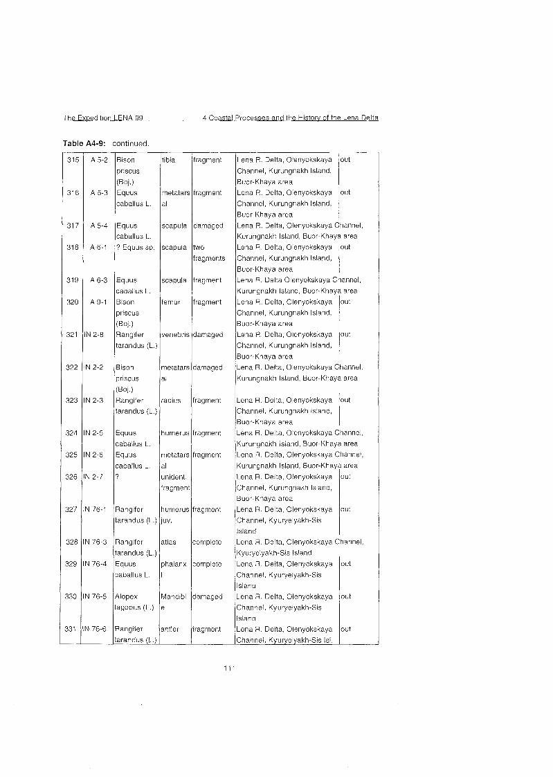
The Exwedition LENA 99 4 Coastal Processes and the Historv of the Lena Delta
Table A4-9: continued
A 5-2 Bison tibia fragment
priscus
(Boi.) A 5-3 Equus metatars fragment
caballus L. al
A 5-4 Equus
caballus L.
A 6-1 ? E ~ U U S sp.
A6-3 E ~ U U S
caballus L.
A 9-1 Bison
priscus
(Boj.) '1 2-8 Rangifer
tarandus (L.)
scapula damaged
scapula two
fragments
scapula fragment
femur fragment
vertebris damaged
( W . ) J 2-3 Rangifer radius fragment
tarandus (L.)
12-5 Equus humerus fragment
caballus L.
J 2-6 Equus metatars fragment
caballus L. al
J 2-7 ? unident.
7 6 - 3 Rangifer atlas complete
tarandus (L.)
176-4 Equus phalanx complete
caballus L. I
7 6 - 5 Alopex Mandibl darnaged
lagopus (L.) e
7 6 - 6 Rangifer antler fragment
tarandus (L.)
Lena R. Delta, Olenyokskaya
Channel, Kurungnakh Island,
Buor-Khaya area
Lena R. Delta, Olenyokskaya
Channel, Kurungnakh Island,
Buor-Khaya area
out
out
Lena R. Delta, Olenyokskaya
Channel, Kurungnakh Island,
Buor-Khaya area
out
Kurungnakh Island, Buor-Khaya area
Lena R. Delta, Olenyokskaya Channel,
Kurungnakh Island, Buor-Khaya area
Lena R. Delta, Olenyokskaya Channel,
Kurungnakh Island, Buor-Khaya area
Lena R. Delta, Olenyokskaya Channel,
Lena R. Delta, Olenyokskaya
Channel, Kurungnakh Island,
Buor-Khaya area
Lena R. Delta, Olenyokskaya
Channel, Kyuryelyakh-Sis
Island
Lena R. Delta, Olenyokskaya
Channel, Kurungnakh Island,
Buor-Khaya area
out
out
out
Lena R. Delta, Olenyokskaya Channel,
Kyuryelyakh-Sis Island
Lena R. Delta Olenyokskaya Channel,
Kurungnakh Island, Buor-Khaya area
Lena R. Delta, Olenyokskaya
Channel, Kyuryelyakh-Sis
Island
Lena R. Delta, Olenyokskaya
Channel, Kyuryelyakh-Sis
Island
Lena R. Delta, Olenyokskaya
Channel, Kyuryelyakh-Sis Isl.
Lena R. Delta, Olenyokskaya
Channel, Kurungnakh Island,
Buor-Khaya area
Lena R. Delta, Olenyokskaya
Channel, Kurungnakh Island,
Buor-Khaya area
out
out
out
out
out
Lena R. Delta, Olenyokskaya Channel,
Kurungnakh Island, Buor-Khaya area
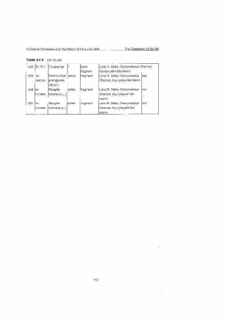
4 Coastal Processes and the Historv of the Lena Delta The Exwedition LENA 99
Table A4-9: continued
332 IN 76-7 ? Lepus sp. I I
Rangifer
335 1;:mber itarandus (L.)
333
334
?
pelvis
antler
no
number
no
nurnber
bone
fragment
fragment
fragment
Mammuthus
primigenius
(Blum.)
Rangifer
tarandus (L.)
antler
Lena R. Delta, Olenyokskaya Channel,
Kyuryelyakh-Sis Island
fragment
Lena R. Delta, Olenyokskaya
Channel, Kyuryelya-Sis Island
Lena R. Delta, Olenyokskaya
Channel, Kyuryelyakh-Sis
Island
Lena R. Delta, Olenyokskaya
Channel, Kyuryelyakh-Sis
out
out
out
The Expedition LENA 99 5 Paleoclimate Sianals of Ice-Rich Permafrost De~osits
5 Paleoclimate Signals of Ice-Rich Permafrost Deposits
5.1 Quaternary Deposits of Bol'shoy Lyakhovsky Island
5.1 .I Introduction
(V. Kunitsky and L. Schirrmeister)
Ice-rich permafrost deposits, called ,,Ice Complex" and their associated
thermokarst formations are the most important archives of the Quaternary climatic and environmental history in the nonglaciated areas of North Siberia.
Large parts of Bol'shoy Lyakhovsky Island are covered by such permafrost deposits.
The cliffs of the south-coast of the Bol'shoy Lyakhovsky Island contain deposits of the Lower, Middle and Upper Quaternary. In summer 1999, a group of Russian and German scientists studied 6 km of the coastal outcrops east and west of the Zimov'e river (Figure 5-1) in order to record different characteristics for the reconstruction of the paleoclimatic and paleoenvironmental conditions in the Laptev Sea region.
Main topics of the field work were:
Geological and cryolithological mapping and facies differentiation of the
deposits;
Sampling of frozen sediments and measurement of ice contents; Characterisation of different types and generations of ice wedges; Investigation of ice crystal structure; Detailed sampling of typical ice wedges for stable isotope and
hydrochemistry analyses;
Sampling of recent waters like rain, surface water, Snow patches, ground water; Measurement of pH and electrical conductivity of ice and water samples; Sampling for age determination: Conventional radiocarbon dating, AMS, Optical Stimulated Luminescence (OSL); Paleomagnetics, UranlThorium- dating;
Collection of fossil mammal bones; Screening of sediments for rodents and insect studies
Sampling for paleobotanical analyses (especially carpological and palynological studies)
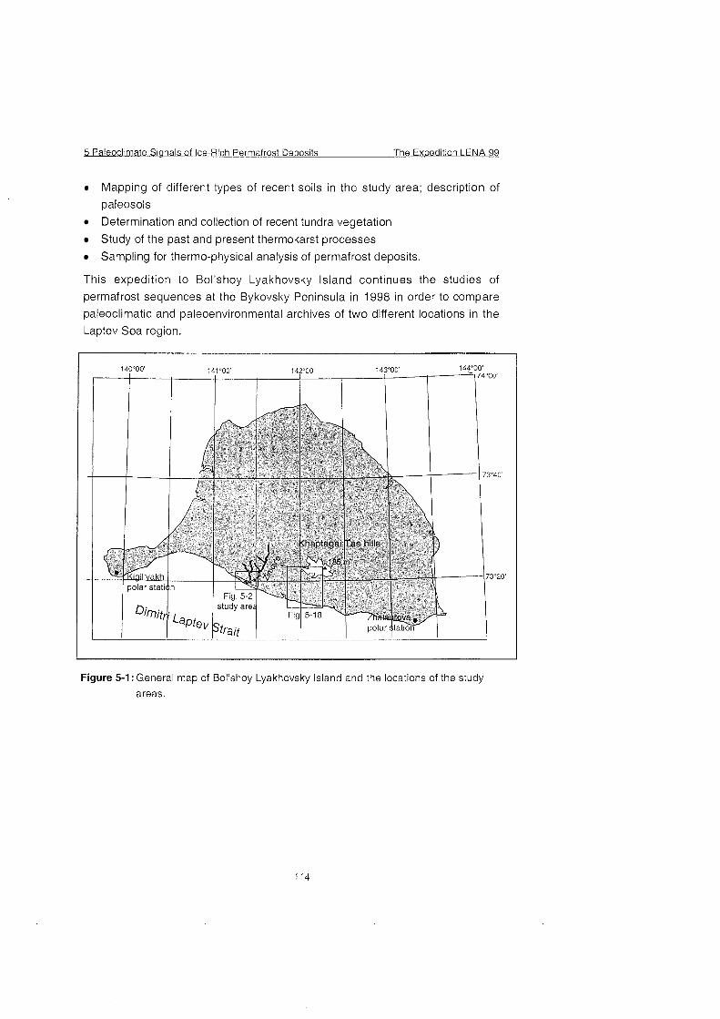
5 Paleoclimate Sianals ofke-Rich Permafrost De~osits The Exwedition LENA 99
Mapping of differemt types of recent soils in the study area; description of
paleosols
Determination and collection of recent tundra vegetation
Study of the past and present thermokarst processes
Sampling for thermo-physical analysis of permafrost deposits.
This expedition to Bol'shoy Lyakhovsky lsland continues the studies of
permafrost sequences at the Bykovsky Peninsula in 1998 in order to compare
paleoclimatic and paleoenvironmental archives of two different locations in the
Laptev Sea region.
Figure 5-1: General map of Bol'shoy Lyakhovsky lsland and the locations of the study
areas.
The Ex~edition LENA 99 5 Paleoclimate Sianals of lce-Rich Permafrost De~osi ts
5.1 -2 Geological-geomorphological situation
(V. Kunitsky, L. Schirrmeister)
Bol'shoy Lyakhovsky lsland is the southern Part of New Siberian lsland
Archipelago. The lsland is situated at the eastern boundary of the Laptev Sea
between 139O90' - 143'30' E and 73'10' - 75O55' N (Figure 2-1). The north and
the south rime of the island consist of hills with altitudes of about 100 to 300 m
a.s.1. which act as bifurcations. The central part and the coastal regions have
altitudes up to Ca 40 m a.s.1.. River mouths, lce Complex elevations (Edoma),
big thermokarst depressions (alases), wide flat valleys (logs), gullies or ravines
(ovrags) form the south coast of Bol'shoy Lyakhovsky lsland.
5 Paleoclimate sianals of lce-Rich Permafrost De~osits The Ex~edition LENA 99
Figure 5-2: Detailed geomorphological map of the study area
116
The Ex~edition LENA 99 5 Paleoclimate Signals of lce-Rich Permafrost Dewosits
The oldest rocks of the lsland are Proterozoic amphibolites and crystalline slates. They are exposed at the Emii-Tas hill, the most eastern Pari of the lsland (Krasnyi 1981). Palaeozoic rocks like Permian sandstones and phyllitic slates of the Burustasky Series (P,Bt) are visible at the slopes of Emii-Tas and
Khaptagai-Tas hills, Mesozoic sandstone, siltstones and clay stones of Upper
Jurassic and Lower Cretaceous were drilled down to 70 m depth at the Bol'shoy Lyakhovsky lsland (Telepnev 1981). Some fissures of these rocks were filled by ice. In addition a Cretaceous or Paleogenic weathering crust On Pre-Cenozoic rock consisting of debris and clay was drilled to 16 m thickness (Alekseev et al. 1991).
While Eocene sands and gravels were drilled in depths of about 27 to 60 m at
the north part of the island, Miocene silts, sands and gravei were found in
depths of about 7 to 36 m at the east part. Miocene deposits contain the Khapchansky Horizon which is characterized by a pollen spectrum typical for
colder conditions (Pinus, Betula, Alnus) (Grinenko at al. 1998 a). Eocene and Miocene deposits are Part of the cryolithozone of Bol'shoy Lyakhovsky lsland. Upper Pliocene deposits (N:) were determined by Arkhangelov et al. (1996) in
the south part of the island near the mouth of Zimov'e river. These peaty silts were dated by thermoluminescence between 950k250 ka and 980 k250 ka
(Table 5-3). The horizon contains syngenetic ice wedges, which are 2 to 3 m
wide. lt was called ,,Olyor-Suite" by Arkhangelov et al. (1 996). The Same author
designate the following horizon as ,,Kuchchuguy-Suite" with a TL-age of 360290 ka (Table 5-3). Both names were provisionally used for this report in order to describe the several cryolithological units.
One of the problems of the study area is the absence of a general usable scale of Quaternary stratigraphy. Therefore we used different scales:
Stratigraphic scheme of lvanov (1 968, 1970, 1972)
Unified regional stratigrafic scheme of Quaternary deposits of the Yana
lndigirka Lowland and its mountainous surroundings and the decision of the expert commission of Quaternary (Sher et al. 1987) Stratigraphic scheme of Alekseev (1 989)
Regional stratigraphic scheme of Paleogene and Neogene deposits of east
Yakutia (Grinenko et al. 1998db)
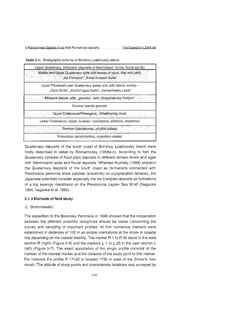
5 Paleoclimate Sianals of lce-Rich Permafrost Deposits The Ex~edition LENA 99
Table 5-1 : Stratigraphie scheme of Bol'shoy Lyakhovsky lsland.
Upper Pliocene/Lower Quaternary (peaty silts with debris, sands) - ,,Olyor-Suite"; ,,Kuchchuguy-Suite", ,,Kanarchasky Layer"
Miocene (sands, silts , gravels) - with ,,Khapchansky Horizon"
I Eocene (sands gravels) I I Upper Cretaceous1Paleogene; (Weathering crust)
I Lower Cretaceous; Upper Jurassic (sandstone, siltstone, claystone) I Permian (sandstones, phyllitic slates)
I Proterozoic (amphibolites, crystalline slates) I Quaternary deposits of the south coast of Bol'shoy Lyakhovsky lsland were firstly described in detail by Romanovsky (1958a-C). According to him the Quaternary consists of flood plain deposits in different terrace levels and ages with thermokarst lakes and fluvial deposits. Whereas Kunitsky ( I 998) explains the Quaternary deposits of the south coast as formations connected with Pleistocene perennial Snow patches (snezhniki) On cryoplanation terraces, the
Japanese scientists consider especially the lce Complex deposits as formations
of a big swampy marshland On the Pleistocene Laptev Sea Shelf (Nagaoka
1 994; Nagaoka et al. I 995).
5.1.3 Methods of field study
(L. Schirrmeister)
The expedition to the Bykovsky Peninsula in 1998 showed that the cooperation
between the different scientific disciplines should be closer concerning the
survey and sampling of important profiles. At first numerous markers were established in distances of 100 m as simple orientations at the shore or coastal line depending On the coastal stability. The marker R 1 to R 35 stood in the west section R (right) (Figure 5-6) and the markers L 1 to L 25 in the east section L
(left) (Figure 5-7). The exact appellation of the single profile consists of the number of the nearest marker and the distance of the study point to this marker.
For instance the profile R 17+30 is located 1730 m west of the Zimov'e river mouth. The altitude of study points and characteristic locations was surveyed by
The Expedition LENA 99 5 Paleoclimate Sianals of Ice-Rich Permafrost De~osi ts
theodolith or also by tape measure near the sea. The bigger profiles were
cleaned with the help of a water pump. The appendant ice wedges were
separately sampled and only cleaned after sampling. Furthermore the water
pump was used in order to screen big sediment samples for rodent study (50
kg, 1 mm mesh) and insect study (20 kg, 0,5 mm mesh). Special important
methods for different scientific disciplines are described within the several
chapters.
5.1.4 Description of the outcrop
(V. Kunitsky, L. Schirrmeister; G. Grosse, T, Kuznetsova, S. Kuz'mina, V,
Tumskoy, A. Dereviagin, H. Meyer)
The study area of the Summer 99 expedition is located On the Dimitri Laptev
Strait about 2.5 km to the east and 3.5 km to the west of the Zimov'e river at the
south coast of Bol'shoy Lyakhovsky Island (Figure 5-1). The following
geomorphologic elements can be distinguished: the mouth and the valley with
flood plain of the Zimov'e river; Ice Complex elevations (Edoma) (about 40 m
a.s.l.), big thermokarst depressions with gentle slopes (alases, diameter: 1-2
km, altitude: 12-1 5 m a.s.l.), wide and flat, U-shaped thermo-erosional valleys
(log, altitude: 20 to 10 m a.s.l.), deep (until 5 m), strait (50-100 m) and V-shaped
thermo-erosional ravines or gullies (ovrags). The wide and flat valleys (logs)
occur on Ice Complex elevations as well as in alas depressions. Thermal
abrasion destroys the Ice Complex elevations at the bank of Dimitri Laptev
Strait and forms so called thermo-erosional cirques, semicircular outbreaks of the coastal line and about 50 m wide thermoterraces (10 m a.s.1.) with
thermokarst mounds (baydzharakhs, 2 to 5 m high) in front of the Ice Complex
wall (Figure 5-3).
5 Paleoclimate Signals of Ice-Rich Perrnafrost Deuosits The Exwedition LENA 99
Figure 5-3: South coast of Bol'shoy Lyakhovsky Island at the mouth of the Zimov'e river with big thermo-erosional cirques and thermoterraces in front of the
Ice Complex wall.
Figure 5-4: Schematic coastal Cross profile from south coast of Bol'shoy Lyakhovsky
Island.
The Ex~edition LENA 99 5 Paleoclimate Sianals of Ice-Rich Permafrost Dewosits
Altogether eleven different geological cryolithological units were found. The
rocks of the basement, like Permian quartzitic sandstone, slates, basalt,
granites, quartz-pebbles, porphyry were found as debris or as solid rock on the beach in some cases. Bigger stones show phenomena of parallel frost shattering. A well developed (matured), yellowish to greenish-grey zonated weathering crust forms the first visible horizon. An ice-rich, coarse clastic
deposit with stones of reworked basement, peat inclusions, peat horizons and paleosols, which are provisionally named ,,Olyor-Suite" followed the weathering
crust. The next unit, provisionally named ,,Kuchchuguy-Suite", consists of two facies: a dryer subaerial silty-sandy series with many vertically orientated grass
roots and subaquatic sediments with molluscs. The so called "subaquatic
Kuchchuguy" consists again of two horizons, divided by a layer of ice wedge pseudomorphs. Some authors (V. Tumskoy, T. Kuznetsova, S. Kuzmina) consider the upper horizon of the "subaquatic Kuchchuguy" as a separate unit named "Krest-Yuryask-Suite" after Ivanov (1 968) (see Chapter 5.1.7 and 5.1.9 and Appendix A5-2 to 5-2-3). So called taberites - thawed and refrozen
permafrost deposits were visible below various subaquatic deposits.
The Late Pleistocene Ice Complex formed the big ice walls at the coast. It contains big ice wedges and many peat inclusions and paleosols in the upper level. The Ice Complex deposits are partly destructed by thermokarst. These thermokarst depressions are filled by Holocene subaerial and subaquatic alas
deposits. Latter are underlain by talik formations (taberites). Additional
Holocene deposits occur On thermo-erosional wide flat valleys (log) and ravines
or gullies (ovrag). At last recent fluvial, alluvial and slope deposits close the sedimentary history of the study area (Figure 5-3). All these units are
characterized by different types of ice wedges, distinguished in size, shape, colour, ice structure and ice-crystal size and texture, gas and sediment contents (Chapter 5.1.8).
5 Paleoclimate sig7
thermoerosional Active layer /-
Active layer F I l ~ e ~ o s i t s of 1 thermoerosional
Figure 5-5: Columnar section of the studied permafrost deposits On Bol'shoy Lyakhovsky Island (see also A5-2).
The Ex~edition LENA 99 5 Paleoclimate Sianals of Ice-Rich Permafrost De00SitS
The section R west of the Zimov'e river mouth consists of three big thermo- erosional cirques and a smaller one. They are separated each other by wide
and flat thermo-erosional valleys (logs). The end of the Western Part is formed by a therrno-erosional ravine (ovrag) followed by a big thermokarst depression (alas) (Figure 5-6). This alternation of Ice Complex elevations and thermokarst depressions continues to the interior of the coastal region. The coastal cliff in front of the 20 m high Ice Complex walls form a step of about 5 to 10 m a.s.1. (Figure 5-4). The thermoterraces consist of dryer deposits than the Ice
Complex. Thermoterraces are intersected by numerous brooks, which were supplied by the melted ice from the Ice Complex walls.
Section L east of the Zirnov'e river mouth Starts with fluvial deposits of the river
valley within an alas depression. Following a big thermo-erosional cirque divided in to parts by a flat thermo-erosional valley is visible. The study area of the section L also concludes with a wide extended alas thermokarst depression (Figure 5-7). This depression contains a System of connected thermo-erosional valleys
5 Paleoclimate Sianals of Ice-Rich Permafrost Deuosits The Expedition LENA 99
Figure 5-6: Schematic outcrop profile of section R (see also A5-2).
124
NW SE masl
20
10
0 9 10 11 12 13 14 15 16 17 18 19 20 21
Rav~ne (Log) sed~ments B lce Complex ~ K u c h c h u g u Y (subxpatlc) ~ e o l o g l c a boundary
Fluv~at~ie sed~ments m ~ l a s sedlments (subaertal) m ~ h e r m o k a r s t ITIOUII~S lce wedge shore cl~ff
m ~ e a c h - and mudflat sedtments K J C ~ C ~ U ~ ~ U Y (subaer~al) \y w d g e pseudomorphs à œ G u l l i e
5 Paleoclimate Sianals of Ice-Rich Permafrost De~osits The Expedition LENA 99
5.1.5 Cryolithological and sedimentological studies
(L. Schirrmeister, G. Grosse, V. Kunitsky)
The different genetic units numerated above (chapter 5.1.4) were characterized during the fiele) studies in ice content (gravimetric), cryostructure, colour, organic remains, sedimentary structures, grain size and carbonate content. Their typical sedimentological and cryological features are summarized in Table
5-2. The special attention of survey and sampling was directed to the
boundaries of important units like ,,01yor"/,,Kuchchuguy", ,,Kuchchuguy"/lce
Complex and to the bottom of alas deposits. The sediments were mostly frozen,
and samples were taken with small hatchets and a hammer. In the camp the samples were divided into two small Parts for palynological and
micropaleontological analyses and a larger part for sedimentological studies. Firstly, after thawing water was sucked off for stable isotope and hydrochemical analyses.
Table 5-2: Sedimentological and cryological characteristics of typical permafrost
deposits of Bol'shoy Lyakhovsky Island.
genetic units
Fluvial
deposits
Valley deposits
(log)
sedimentological description
- brownish grey to light brown
- fine to medium grained sands, Cross and ripple bedding
- layers of peaty plant detritus
- grey, brownish spotted
- strongly rooted upper Part
cryological description of sediment
- no cryostructures visible
- ice content 30-90 %
- banded, lenslike reticulated
- ice content 40-100 %
Alas deposits
Alas lake
deposits
Ice Complex
Taberites
- grey, stratified, peaty soil horizons
- several grass roots, twigs, peat Covers
- grey, brown, ochre; carbonate rich
- sandy silt, ripple and fine bedding
- shells horizons, sapropel layers with
plant detritus, peat inclusions
- pseudomorphosis with wood remains
- grey brown
- silty fine-sand (alevrit)
- peaty paleosols, brown spotted
- peat inclusions (10-20 crn), vertical grass roots, small twigs
- grey with small black sulphide patches
- dense; larninated; without grass roots
- banded, lens like reticulated
- ice content 80-120 %
- dotted distributed ice
- ice content 30-60 %
- banded, alternation of ice band
(3-5 cm) and sediment interlayers
- fine to coarse lens like reticulated
- ice content 60-1 70 %
- some finely distributed ice
- i Ce content 25-50 %
The Exoedition LENA 99 5 Paleoclimate Signals of Ice-Rich Perrnafrost De~osits
subaquatic ,Kuchchuguy"
(older alas lake deposits)
subaerial
,Kuchchuguyr'
,,Olyof'
weathering
crust
- blue grey to light grey, black sulphide
patches, brownish oxidation zones
- fine-dispers distributed organic material,
biturninous
- twigs, shells, peat inclusions
- larninated; carbonate rich
- some dotted distributed ice
- ice content 20-30 %
- larninated, partly cryoturbated
- silty fine-sand (alevrit)
irregularly distributed
- fine-sandy to silty rnatrix
5.1.6. Geochronometric age determination
(G.Grosse, LSchirrmeister, V. Kunitsky, A. Dereviagin, T. Kuznetsova)
There are only few data of age determinations so far available for the Bol'shoy
Lyakhovsky outcrop locality. The Pre-Cenozoic basement of the outcrop area consists of Permian sandstones. Further, there are some dykes belonging to Cretaceous granitic intrusions in the whole region (Drachev and Savostin 1993).
On this basement a CretaceousIPaleogene weathering crust and different Quaternary sediment sequences are situated. These sediments where dated in
different ways by Russian and by Japanese scientists. It is important to note that the results of age determinations from Russian and Japanese scientists are
quite different. To disclaim or confirm these data our team took samples for OSL (Optically Stimulated Luminescence)-, paleomagnetics-, radiocarbon dating and Unh-dating.
Arkhangelov (1 996) dated eight samples of the outcrop west of the Zimov'e river
by thermoluminescence method (TL). The determined ages range from 57 Â 15
ka in the upper part of the Ice Complex (second thermo-erosional cirque) up to
980 Â 245 ka in the lower part of the ,,Olyor" suite near the weathering crust of Permian sandstone. Arkhangelov (1996) did some paleomagnetic measurements with ,,Olyorl' sediments, too. The age was dated near the
5 Paleoclirnate Sianals of Ice-Rich Perrnafrost De~osi ts The Ex~edition LENA 99
Brunhes-Matuyama boundary. We could not locate exactly the position of
sample RTL-758 (s. Table 5-3) but it must be somewhere in the Ice Complex.
The samples RTL-755 and RTL-757 contain fluviatil sediments which could not
be found again by our team. According to Arkhangelov (1 996), the Ice Complex
sediments are much older than those dated by Kunitsky (1 996, 1998) and
Nagaoka (1995). The limnic sediments could be Part of the Kazanzev
(equivalent to Eem). Between ,,Kuchchuguy" and ,,Olyorl' there is a big Span of
time by some 100.000 years which has to be explained.
Kunitsky (1996, 1998) also dated samples by TL. The ages ranging from 61 k
15 ka up to 114 Â 28 ka. Some pieces of wood found in alas sediments were
dated by Kunitsky (1998, 1999b) with about 7.000 years by conventional
radiocarbon dating. A young lake sediment west of the third thermo-erosional
cirque was dated with 7.993 Â 183 years. A peat horizon laying above had an
age of 6.436 Â 174 years. Japanese scientists dated six samples from peat
layers in the Ice Complex Formation by radiocarbon method (Nagaoka et al.
1995). The range of those data is from 7.370 Â 820 years, near the top of the
Ice Complex elevation up to >42.240 years at almost 25 m depth below the
surface.
As shown above there are some problems with age determinations at this
outcrop. Data are correct within sampling of one field team but often
controversial in comparison with results of other teams. Additionally, the
punctual sampled TL data of Arkhangelov (1996) have a huge range in age,
and geological consequences cannot clearly be reproduced. A source for errors
may be methodical problems in used definite age determination techniques
accepted in the international science community. In general, it has to be
mentioned that TL-ages above about 150 ka are reliable only under certain
conditions (quartz dates from well bleached very low radioactive sediments).
This is not the case in the region investigated. For instance, in case of the
thermoluminescence method the signal needs 15 to 20 h of direct sunlight to
bleach the sediment to a level which can be reconstructed in the laboratory. But
sedirnents in these regions are often transported in suspension with water, so
water and suspended sediment reduce the bleaching of minerals. Furthermore
by the lack of sunlight in polar regions during long times the bleaching effect is
reduced. Both problems can cause overestimated ages by TL.
The Expedition LENA 99 5 Paleoclirnate Sianals of Ice-Rich Permafrost Deposits
Table 5-3: Previous age determinations on Bol'shoy Lyakhovsky Island
Because of the problems mentioned above, we have chosen the Optical Stimulated Luminescence method for absolute dating. The minerals which
Kunitsky
can be dated by OSL need only a very short time (a few minutes) to become bleached. So there will be much less problems with overestimated ages. Altogether we sampled 16 single points for dating sediments by OSL and in
respect to the problems of reduced bleaching effects 1 sample of recent
sediment too. We have chosen most of those points with the knowledge of layer boundaries for fixing them with an absolute age.
Determined age
(rnethod of dating)
11 0-90 Â 5 Ma (KIAr)
Sarnple nurnber
(year of sarnpling)
61 Â ± 5 ka (TL)
3 5 1 0 ka (TL)
36±1 ka (TL)
94±2 ka (TL)
1 14±2 ka (TL)
7,993 Â 183 a ("*C)
6.456 Â 174 a (14C)
7594 Â 255 ("C)
RTL-741 (1 996)
RTL-821 (1 998)
RTL-822 (1 998)
RTL-740 (1 996)
RTL-742 (1 996)
PI-1 197 (1998)
PI-1 198 (1 998)
PI-1 196 (1 999a)
Drachev and Savostin (1993)
Granitic intrusions in the basement
Sequence Depth below
surf ace
Alevrit, ,,Kuchchuguy"
,,Kuchchuguy"
,,Kuchchuguy"
,,Kuchchuguy"
Taberit
Alas (lake sedirnent)
Alas (peat layer)
valley deposits (log)
(roots, twigs)
5 rn
0.8 rn
5 Paleoclimate Sianals of Ice-Rich Perrnafrost Dewosits The Expedition LENA 99
We sampled in two different ways. The first was by hammering an opaque PVC cylinder horizontally into the sediment sequence chosen for sampling (used for
unfrozen sediments). The second way was by coring with similar PVC cylinders and a hand drilling machine with accumulator (used for frozen sediments). To
decrease the exposure to light we iised opaque plastic bags while handling the
samples. For most of the samples we did additionally in situ Gamma ray measurements which are used for laboratory correction of the radioactive history of the sample. A second sample of the Same sediment is used for moisture content determinations, one precondition of correct dating. The range for the OSL method actually is from 1.000 up to 200.000 years BP.
With radiocarbon dating we can obtain additional Information about the Late
Pleistocene evolution of the study area. Several in situ bones and wood pieces were found in different altitudes of the outcrop. We can determine time ranges
in which certain mammalian species existed on Bol'shoy Lyakhovsky with bones which were found not in situ at the beach or reworked in the outcrop. Bones will be dated in the Geological Institute of the Russian Academy of Science in Moscow. Radiocarbon AMS dating will be used for exact age determination of separated small plant remains like roots, moss-plants, twigs
and seeds, which are presumed to be in situ, This material will be dated in the
Leibniz Laboratory for age determination and isotopic studies in Kiel. Samples of bigger peat horizons and bigger wood remains will be dated by conventional
radiocarbon dating at the Permafrost Institute in Yakutsk.
Whereas conventional radioca.rbon dating is useful only for the last 40 ka and AMS dating perhaps for the last 60 ka, the OSL dating reaches the last 200 ka.
Older deposits will be dated by Unh ethod, which should be useful up to 500
ka. For dating by U/Th method we sampled a frozen peat horizon in the ,,Olyor- Suite" near the sea. level (section R8+50) by sawing out a cube measuring
30x30~30 cm, This frozen cube was taken to the laboratory of Lower Saxon Survey of Soil Research in Hannover.
Paleomagnetic investigations have been carried out in section R where the sediments were dated Mg3 (Arkhangelov 1996). Sediments presented the
provisionally named ,,Olyor-Suite" and ,,Kuchchuguy-Suitec'. Samples were collected with a sheet-steel cube (45 mm) from flat surfaces into special
cardboard boxes (24x24 mm) taking into consideration the accurate orientation to the North. The sample equipment was constructed by P. Minyuk. Ten samples (each in 6 specimen) from different levels of the ,,Olyor-Suite" were collected (8 samples from thawed dry sediment, 2 samples from frozen sediment). Additionally, a biqger monolith of sediment was taken which was
The Expedition LENA 99 5 Paleoclimate Signals of Ice-Rich Perrnafrost De~osits
conserved with paraffin. It was very difficult to take non-disturbed samples because of the very high ice contents of the sediments. Further investigations
are being provided in the Laboratory of Main Geomagnetic Field and Magnetic Petrology (Institute of Physics of the Earth, Russian Academy of Science).
5.1.7. Thermokarst Processes
(V. Tumskoy)
Thermokarst is defined as an integral set of physico-geological processes and
phenomena including thawing of ground ice inclusions and deposits, subsidence of thawed ground and formation of negative forms of micro- and mesorelief (Grechichshev et al. 1980). The initial concept of thermokarst embraced only the relief forms but subsequentiy it was extended to processes generating these forms (Katasonov 1979).
The shapes of thermokarst formations are largely dependent On the morphology of thawing ice inclusions. This thesis underlies the existing classifications of
thermokarst. Specifically, they differentiate the thermokarsts developing in texture-forming, massive, intrusive and wedge ices. Due to these factors, the
thermokarst processes develop at different rates, have zonal and regional peculiarities and lead to differing relief forms of thermokarst. The largest and most significant in its manifestation is the thermokarst induced by the thaw of
thick syngenetic ice wedges and high-ice deposits of the Ice Complex. Its development leads to the formation of relatively deep thermokarst lakes, their
subsequent expansion and drainage. As a result, high-ice deposits are
degraded leaving depressions called alases in Siberia. The above-mentioned
processes are accompanied by transformation of initial deposits and accumulation of new ones reflecting conditions of their formation. The Set of the deposits formed due to the occurrence of the above processes will further be
called ,,alas complex". A typical region of the Ice Complex occurrence and the thermokarst development is the north of Yana-lndigirka Lowland and the
Novosibirsk Islands.
The aim of studying alas deposits in Bol'shoy Lyakhovsky Island was to establish their relationship with embedding rocks and to reconstruct the time and conditions of their formation and development. The possibility of the occurrence of analogous but more ancient deposits was also investigated.
Nowadays, large alases occur widely in Bol'shoy Lyakhovsky Island. The thermokarst lakes proper are rare and have insignificant sizes. Alases are found mostly in the western part of the island where they are confined to a subsided
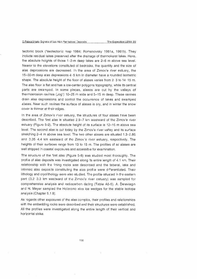
5 Paleoclirnate Signals of Ice-Rich Permafrost De~os i ts The Ex~edition LENA 99
tectonic block (Neotectonic map 1984; Romanovsky 1961a, 1961b). They
include residual lakes preserved after the drainage of therrnokarst lakes. Here, the absolute heights of these 1-2-m deep lakes are 2-6 m above sea level.
Nearer to the elevations constituted of bedrocks, the quantity and the size of
alas depressions are decreased. In the area of Zimov'e river estuary, the
15-30-m deep alas depressions 4-5 km in diameter have a rounded isometric
shape. The absolute height of the floor of alases varies from 2-3 to 14-15 m.
The alas floor is flat and has a low-center polygons topography, while its central
parts are swamped. In some places, alases are cut by the valleys of
thermoerosion ravines (,,logs) 10-25 m wide and 5-1 5 m deep. These ravines
drain alas depressions and control the occurrence of lakes and swamped
alases. Near such ravines the surface of alases is dry, and in winter the Snow
Cover is thinner at their edges.
In the area of Zimov'e river estuary, the structures of four alases have been described. The first alas is situated 2.9-7 km westward of the Zimov'e river
estuary (Figure 5-2). The absolute height of its surface is 12-15 m above sea
level. The second alas is cut today by the Zimov'e river valley and its surface stretching 2-4 m above sea level. The two other alases are situated 1.3-2.85
and 3.35-4.4 km eastward of the Zimov'e river estuary, respectively. The
heights of their surfaces range from 13 to 15 m. The profiles of all alases are
well stripped in coastal exposures and accessible for examination.
The structure of the first alas (Figure 5-8) was studied most thoroughly. The
profile of alas deposits was investigated along its entire length of 4.1 km. Their
relationship with the lining rocks was described and the taberal, lake and
intrinsic alas deposits constituting the alas profile were differentiated. Their
lithology and cryolithology were also studied. The profile situated in the eastern
part (3.2-3.3 km westward of the Zimov'e river estuary) was sampled for
comprehensive analysis and radiocarbon dating (Table A5-5). A. Dereviagin
and H. Meyer sampled the Holocene alas ice wedges for the stable isotope
analysis (Chapter 5.1.8).
As regards other exposures of the alas complex, their profiles and relationships
with the embedding rocks were described and their structures were established.
All the profiles were investigated along the entire length of their vertical and
horizontal strike.
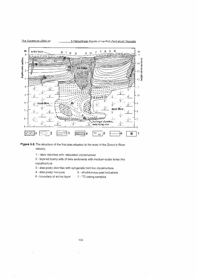
The Expedition LENA 99 5 Paleoclirnate Signals of Ice-Rich Permafrost Dewosits
Figure 5-8: The structure of the first alas situated to the West of the Zimov'e River
estuary.
1 - taber alevrites with reticulated cryostructure
2 - layered loamy silts of lake sediments with medium-scale lense like
cryostructure
3 - alas peaty alevrites with syngenetic belt like cryostructure
4 - alas peaty horizons 5 - allochtonous peat inclusions 6 - boundary of active layer 7 - 14C-dating samples
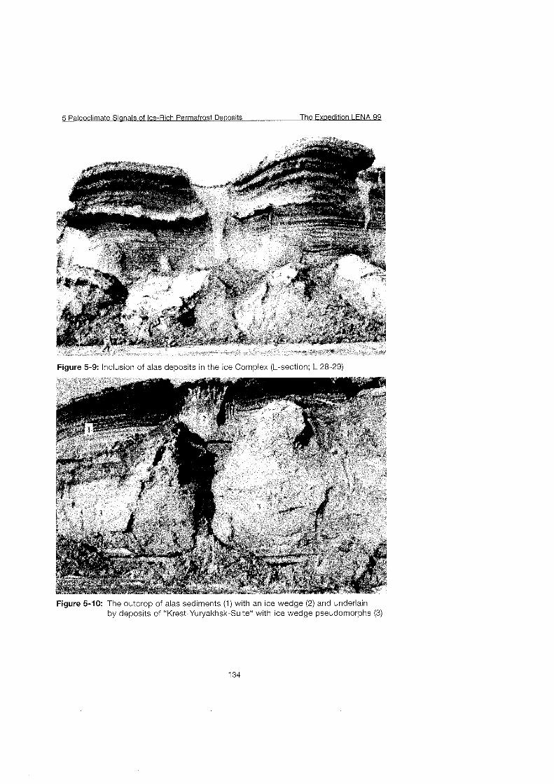
5 Paleoclimate Sianals of Ice-Rich Permafrost De~osits The Ex~edition LENA 99
Figure 5-9: Inclusion of alas deposits in the Ice Complex (L-section; L 28-29)
Figure 5-10: The outcrop of alas sediments (1) with an ice wedge (2) and underlain by deposits of "Krest-Yuryakhsk-Suite" with ice wedge pseudomorphs (3)
The Ex~edition LENA 99 5 Paleoclimate Sianals of Ice-Rich Permafrost De~osits
First Results
The results of field work suggest the following conclusions relative to the
development of thermokarst in Bol'shoy Lyakhovsky Island.
1. Thermokarst was widely developed on the island territory. The consequence
of this is a vast actual occurrence of alas depressions. 2. Alases are predominantly confined to negative tectonic structures. They fuse
here with each other and form an alas plain with small individual outliers of the ice complex. Nearer to elevations, the number and the size of alas
depressions go On the decrease. Alases are separated by interalas
elevations constituted by the ice complex. 3. Thermokarst developed along the ice wedges of the ice complex with
formation of thermokarst lakes under which the ice complex deposits thawed and formed depressions that were subsequently drained and transformed into alases. This is Seen from the structure of the alas profiles, the base of which is composed of thin taberal deposits overlain with lacustrine lamellar
alevrites and loams and crowned with the alas deposits proper including peat
interlayers.
4. The relationship between the alas deposits and the enclosing and lining rocks is determined by conditions of the ice complex occurrence. For
instance, in the area of Zimov'e river estuary the floor of the ice complex was below sea level. For this reason, the absolute height of an alas formed here does not exceed 2-4 m above sea level, whereas the floor of the alas
deposits is below modern sea level. In other profiles the ice complex floor was found to lie 13-15 m above sea level and to be lined with low-ice
alevrites of the ,,Kuchchuguy Suite". Therefore, the absolute heights of the surface of alas depressions are not less than 14-15 m. At the edges of
alases one can See everywhere inclusions of alas deposits into the ice complex that lines them to a Stretch of 100-200 m (Figure 5-9). A lake did not
exist here for a relatively long time and was relatively shallow and hence the
ice complex did not have enough time to thaw completely. In their middle Part, the alas deposits overlie directly the deposits belonging to the ,,Krest-
Yuryakhsk Suite". 5. The profile of the alas complex deposits has a regular structure. Its base
includes in some places taberal deposits composed of greenish-grey alevrites with a large-scale reticulate cryogenic texture. These are the thawed ice complex deposits partially transformed by bottom processes. Offen there is no clear-cut interface between the taberal deposits and the lake Sediments, which Substitute them up the profile. The latter are represented by silty loams
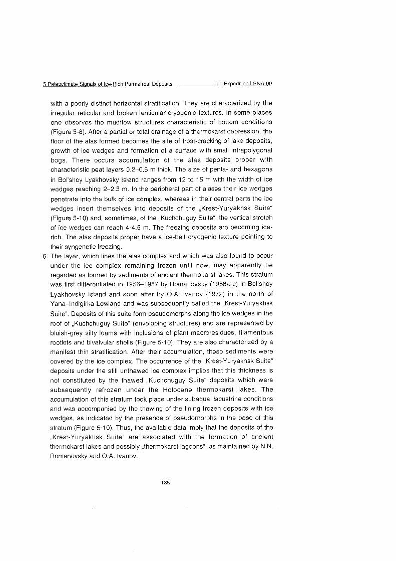
5 Paleoclirnate Sianals of Ice-Rich Permafrost Deposits The Expedition LENA 99
with a poorly distinct horizontal stratification. They are characterized by the irregular reticular and broken lenticular cryogenic textures. In some places
one observes the mudflow structures characteristic of bottom conditions
(Figure 5-8). After a partial or total drainage of a thermokarst depression, the
floor of the alas formed becomes the site of frost-cracking of lake deposits,
growth of ice wedges and formation of a surface with small intrapolygonal
bogs. There occurs accumulation of the alas deposits proper with
characteristic peat layers 0.2-0.5 m thick. The size of penta- and hexagons
in Bol'shoy Lyakhovsky Island ranges from 12 to 15 m with the width of ice wedges reaching 2-2.5 m. In the peripheral Part of alases their ice wedges
penetrate into the bulk of ice complex, whereas in their central parts the ice
wedges insert themselves into deposits of the ,,Krest-Yuryakhsk Suite"
(Figure 5-1 0) and, sometimes, of the ,,Kuchchuguy Suite"; the vertical stretch
of ice wedges can reach 4-4.5 m. The freezing deposits are becoming ice-
rich. The alas deposits proper have a ice-belt cryogenic texture pointing to
their syngenetic freezing.
6. The layer, which lines the alas complex and which was also found to occur under the ice complex remaining frozen until now, may apparently be
regarded as formed by sediments of ancient thermokarst lakes. This stratum was first differentiated in 1956-1 957 by Romanovsky (1 958a-C) in Bol'shoy
Lyakhovsky Island and soon after by O.A. Ivanov (1972) in the north of Yana-lndigirka Lowland and was subsequently called the ,,Krest-Yuryakhsk
Suite". Deposits of this suite form pseudomorphs along the ice wedges in the
roof of ,,Kuchchuguy Suite" (enveloping structures) and are represented by
bluish-grey silty loams with inclusions of plant macroresidues, filamentous
rootlets and bivalvular shells (Figure 5-1 0). They are also characterized by a manifest thin stratification. After their accumulation, these sediments were
covered by the ice complex. The occurrence of the ,,Krest-Yuryakhsk Suite"
deposits under the still unthawed ice complex implies that this thickness is
not constituted by the thawed ,,Kuchchuguy Suite" deposits which were
subsequently refrozen under the Holocene thermokarst lakes. The
accumulation of this stratum took place under subaqual lacustrine conditions
and was accompanied by the thawing of the lining frozen deposits with ice wedges, as indicated by the presence of pseudomorphs in the base of this
stratum (Figure 5-10). Thus, the available data imply that the deposits of the
,Krest-Yuryakhsk Suite" are associated with the formation of ancient
thermokarst lakes and possibly ,,thermokarst lagoons", as maintained by N.N. Romanovsky and O.A. Ivanov.
The Expedition LENA 99 5 Paleoclimate Sianals of lce-Rich Perrnafrost Deuosits
5.1.8 Ground ice and water
(H. Meyer, A. Dereviagin & I. Syromyatnikov)
Introduction
Field work was carried out on the south coast of Bol'shoy Lyakhovsky Island in
the area around Zimov'e River. The section consists of eleven stratigraphic units, which were subdivided by sedimentary and cryolithological aspects (see
Figures 5-4 to 5-7 and Table 5-5). The oldest stratigraphic unit is Permian
sandstone, that is found in the working area as Tertiary weathering crust only.
The next younger units are the provisionally named "Olyor" and "Kuchchuguy"
as well as the Late Pleistocene Ice Complex with steep ice walls reaching 35 m a.s.1.. All younger facies such as alas, proluvial-deluvial (or log) and fluvial
deposits are presumably of Holocene age. Its deposition is related to the
destruction of the older units by processes like thermal erosion or thermal
denudation.
The cryolithological differentiation of the section is different compared to a
common sedimentological subdivision. In the field, especially ice wedges
cannot easily be attributed to a discrete sedimentary unit. Firstly, ice wedges
grow perpendicular to the sedimentation, secondly, they may traverse
sedimentological boundaries. A younger ice wedge may enter an older
stratigraphic unit. This phenomenon has to be taken into account for a
stratigraphic subdivision of a working area.
Two types of ground ice were studied in the working area: ice wedges and
segregated ice. The sources of segregated ice formation can be
suprapermafrost ground water of the active layer (rnainly in syngenetic type of
freezing), and also Pore and free water in epigenetic type of freezing (Popov
1967; MacKay 1983). The source of ice wedge ice formation is mainly snowmelt
water (Shumsky 1960; Romanovsky 1977). The stable isotope composition of
ice wedges reflects mean annual winter temperatures (Vaikmae 1991). Therefore, ice wedges are perspective archives for paleoclimatic research,
especially when ice wedges of different age and different geneses are available.
Different types of ice wedges as well as mostly fine dispersed segregated ice
occur in all stratigraphic units. The oldest generation of ice wedges enters from
so called "Olyorian" deposits into the weathering crust of Permian sandstone.
The youngest generation is found in the recent active layer characterized by modern ice wedge growth.
5 Paleoclimate Sianals of Ice-Rich Permafrost Dewosits The Expedition LENA 99
The combination of last year's sampling site, the Bykovsky Peninsula, and this
year's working area Bol'shoy Lyakhovsky Island extends considerably the understanding of the regional paleoclimate. Ice complex, alas and log deposits can be found in both areas, enabling us to identify these deposits and their respective types of ground ice easily during the 1999 expedition. The main difference between the two areas is the occurrence of sediment and ground ice,
which are much older than the Ice Complex on Bol'shoy Lyakhovsky Island. According to thermoluminescence data by Arkhangelov (1989), "Olyorian"
sediments are about 950 ka old, "Kuchchuguy" sediments have been dated 350
ka (see also section 5.1.6). Additionally, Bol'shoy Lyakhovsky Island has been closer to the sea compared to the Bykovsky Peninsula. Thus, gradients of
continentality and winter temperatures between both sites should be expected. This hypothesis may be proved by stable isotope method and different sources of (winter) precipitation may be identified.
Sampling and methods
Sampling was performed as described in last year's field report (Meyer et al.
1999). In total, 670 samples of ground ice, surface water, ground water, rain water and of Snow patches were collected in the area around Zimov'e River. An overview of the sampling sites for ground and surface water, Snow patches and active layer ice is given in Figure 5-1 1, excluding ground ice samples.
Rainwater was collected close to the camp (see flag).
The Expedition LENA 99 5 Paleoclimate Sianals of Ice-Rich Permafrost Deoosits
Figure 5-1 1 : O v e ~ i e w of the working area inclusive sampling sites for ground and
surface water, Snow patches and active layer ice
5 Paleoclirnate Sianals of Ice-Rich Perrnafrost De~osi ts The Ex~edition LENA 99
Generally, the Same sampling strategy as last year has been applied to ground
ice. Ice wedges and segregated ice were sampled in all stratigraphic units. The
locations of ground ice samples can be deduced from Figures A5-1 to 5-1 -3 and
Table 5-4. In order to get a complete vertical profile of all stratigraphic units, we
sampled ice wedges in different heights of the outcrop (Table 5-4). The lateral
position is given in three Parts: the letter R or L defines the section of the
outcrop, the numbers give the distance from the mouth of Zimov'e River. For
example R32+20 signifies: right section, 3220m from the mouth of Zimov'e
River in a NW-SE striking profile (see also Figures 5-1 1 and 5-2).
In total, 28 ice wedges were described and sampled. The most intensive
sampling was carried out for ice wedge LYA-R-10-1 in the Ice complex, which is
cut by coastal erosion perpendicularly to its growth structure and easily to reach
and to sample. Some ice wedges were sampled, because they contain two or
more generations of ice wedges. R-17-1 shows i. e. the contact between
'Kuchchuguy" and "Olyor" and sections R-8 and R-9 the contact between Ice
Complex and "Kuchchuguy".
The Exwedition LENA 99 5 Paleoclimate Sianals of Ice-Rich Permafrost D e ~ o s i t s
Table 5-4: Sampled ice wedges including colour of ice, lateral position in the outcrop
and respective height above sea level (see also Table 5-5)
Height
CE Stratigraphic unit Nurnber Colour of ice Lateral a.s.1.
NEDGE of posit ion (TOP
sarnples outcrop)
LYA-R-1-1 Log?
LYA-R-8-112 Ice complex/Kuchchuguy
LYA-R-6-1
LYA-F-9-1
LYA-R-7-1
LYA-R-10-1
LYA-R-10-2
LYA-R-17-1
LYA-R-17-2
LYA-R-19-1
LYA-R-20-1
.YA-R-22-1
.YA-R-32-1
.YA-R-32-2
.YA-R-32-3
.YA-R-32-4
.YA-R-32-5
_YA-TZ-2-1
-YA-TZ-2-2
.YA-TZ-2-3
YA-TZ-2-4
.YA-TZ-2-5
-YA-TZ-2-6
-YA-TZ-3-1
.YA-L-21-1
.YA-L-15-1
.YA- L-2-1
.YA- L-6-1
otal :
Ice complex/Kuchchuguy
Ice complex/Kuchchuguy
Kuchchuguy
Ice complex
Ice complex
Kuchchuguy/Olyor
Kuchchuguy/Olyor
Log
Log?
Kuchchuguy
Modern ice wedge
Alas
Modern ice wedge
Modern ice wedge
Modern ice wedge
Log?
Ice complex
Log?
Ice complex
Ice complex/Kuchchuguy
Ice complex
Ice complex
&las
Modern ice wedge
Fluvial deposits
Ice complex
28 ice wedges
grey, transparent
grey, transparent and Polosatic*
light grey, transparent and
Polosatic*
grey, transparent
light grey and transparent
yellowish grey and transparent
grey, transparent
grey, transparent and Polosatic*
grey, transparent and Polosatic*
white and milky
yellowish grey and milky
grey, transparent and Polosatic*
white and milky
yellowish grey and milky
white and milky
white and milky
white and milky
grey, transparent
light grey and transparent
grey, transparent
yellowish grey and transparent
yellowish grey arid transparent,
Polosatic*
yellowish grey and transparent
yellowish grey and transparent
white and milky
white and milky
colourless and transparent
yellowish grey and transparent
Polosatic: verv sediment-rich zebra-strioed subvertical structures interruoted bv ice veinlets
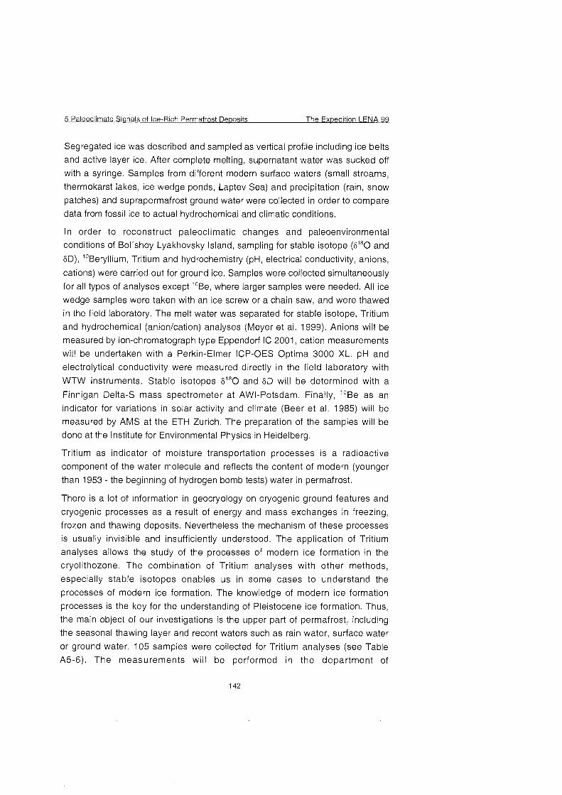
5 Paleoclimate Signals of Ice-Rich Permafrost Deposits The Exuedition LENA 99
Segregated ice was described and sampled as vertical profile including ice belts
and active layer ice. After complete melting, supernatant water was sucked off
with a syringe. Samples from different modern surface waters (small streams,
thermokarst lakes, ice wedge ponds, Laptev Sea) and precipitation (rain, Snow
patches) and suprapermafrost ground water were collected in order to compare
data from fossil ice to actual hydrochemical and climatic conditions.
In order to reconstruct paleoclimatic changes and paleoenvironmental conditions of Bol'shoy Lyakhovsky Island, sampling for stable isotope (S^O and
5D), Beryll ium, Tritium and hydrochemistry (pH, electrical conductivity, anions,
cations) were carried out for ground ice. Samples were collected simultaneously
for all types of analyses except ^Be, where larger samples were needed. All ice
wedge samples were taken with an ice screw or a chain saw, and were thawed
in the field laboratory. The melt water was separated for stable isotope, Tritium
and hydrochemical (anionlcation) analyses (Meyer et al. 1999). Anions will be
measured by ion-chromatograph type Eppendorf IC 2001, cation measurements
will be undertaken with a Perkin-Elmer ICP-OES Optima 3000 XL. pH and
electrolytical conductivity were measured directly in the field laboratory with
WTW Instruments. Stahle isotopes SI8O and 5D will be determined with a
Finnigan Delta-S mass spectrometer at AWI-Potsdam. Finally, ''Be as an
indicator for variations in solar activity and climate (Beer et al. 1985) will be
measured by AMS at the ETH Zurich. The preparation of the samples will be
done at the Institute for Environmental Physics in Heidelberg.
Tritium as indicator of moisture transportation processes is a radioactive
component of the water molecule and reflects the content of modern (younger
than 1953 - the beginning of hydrogen bomb tests) water in permafrost.
There is a lot of information in geocryology on cryogenic ground features and
cryogenic processes as a result of energy and mass exchanges in freezing,
frozen and thawing deposits. Nevertheless the mechanism of these processes
is usually invisible and insufficiently understood. The application of Tritium
analyses allows the study of the processes of modern ice formation in the
cryolithozone. The combination of Tritium analyses with other methods,
especially stable isotopes enables us in some cases to understand the
processes of modern ice formation. The knowledge of modern ice formation
processes is the key for the understanding of Pleistocene ice formation. Thus,
the main object of our investigations is the upper Part of permafrost, including
the seasonal thawing layer and recent waters such as rain water, surface water
or ground water. 105 samples were collected for Tritium analyses (see Table
A5-6). The measurements will be performed in the department of
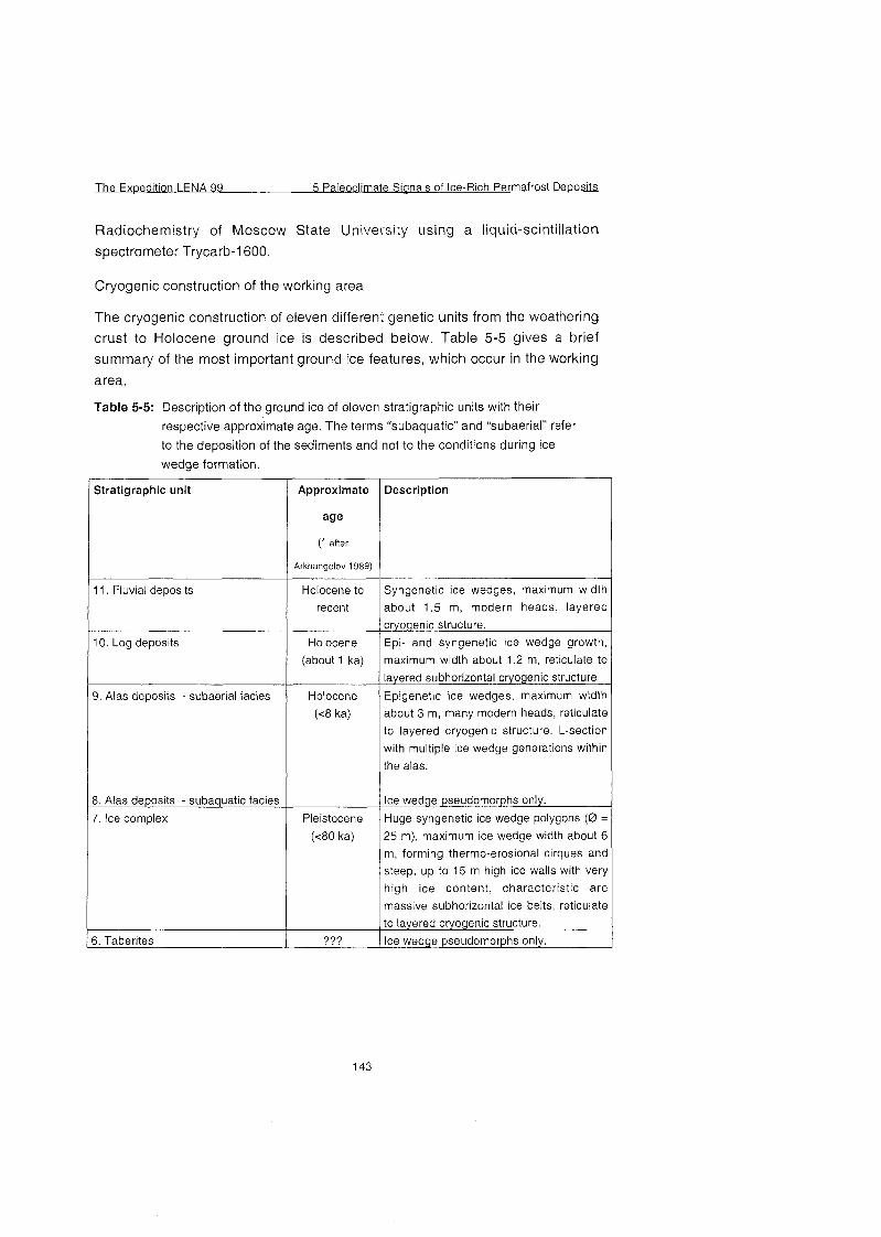
The Exoedition LENA 99 5 Paleoclirnate Sianals of Ice-Rich Permafrost Deposits
Radiochemistry of Moscow State University using a liquid-scintillation spectrometer Trycarb-1600.
Cryogenic construction of the working area
The cryogenic construction of eleven different genetic units from the weathering
crust to Holocene ground ice is described below. Table 5-5 gives a brief Summary of the most important ground ice features, which occur in the working
area.
Table 5-5: Description of the ground ice of eleven stratigraphic units with their
respective approximate age. The terms "subaquatic" and "subaerial" refer
to the deposition of the sediments and not to the conditions during ice
wedge formation.
stratigraphic unit
11. Fluvial deposits
10. Log deposits
9. Alas deposits - subaerial facies
8. Alas deposits - subaquatic facies
7. Ice cornplex
3. Taberites
Approximate
age
aiier
Arkhangelov 1989)
Holocene to
recent
Holocene
(about 1 ka)
Holocene
(c8 ka)
Pleistocene
(<80 ka)
Description
Syngenetic ice wedges, rnaximurn width
about 1.5 rn, modern heads, layered
cryogenic structure.
Epi- and syngenetic ice wedge growth,
rnaxirnurn width about 1.2 rn, reticulate to
layered subhorizontal cryogenic structure
Epigenetic ice wedges, maximum width
about 3 rn, rnany modern heads, reticulate
to layered cryogenic structure. L-section
with multiple ice wedge generations within
the alas.
Ice wedge pseudomorphs only.
Huge syngenetic ice wedge polygons (0 =
25 m), rnaximurn ice wedge width about 6 m, forrning thermo-erosional cirques and
steep, up to 15 rn high ice walls with very
high ice content, characteristic are
massive subhorizontal ice belts, reticulate
to layered cryogenic structure.
Ice wedge pseudornorphs only.
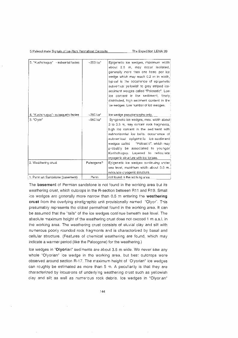
5 Paleoclimate Sianals of Ice-Rich Permafrost Deoosits The Expedition LENA 99
. "Kuchchuguy" - subaerial facies
I. "Kuchchuguy"- subaquatic facies
. "Olyor"
. Weathering crust
. Permian Sandstone (basement)
-350 ka*
-350 ka'
-950 ka*
Paleogene?
Perm
Epigenetic ice wedges, maximum width
about 2.5 m, may occur isolated,
generally more than one head per ice
wedge which may reach 0.2 m in width,
typical is the occurrence of epigenetic
subvertical yellowish to grey striped ice-
sediment wedges called "Polosatic". Low
ice content in the sediment, finely
distributed, high sediment content in the
ice wedges. Low number of ice wedges.
Ice wedge pseudomorphs only.
Syngenetic ice wedges, max. width about
3 to 3.5 m, may contain rock fragments,
high ice content in the sediment with
subhorizontal ice belts, occurrence of
subvertical epigenetic ice-sediment
wedges called "Polosatic", which may 1 probably be associated to younger
Kuchchuguy. Layered to reticulate
Epigenetic ice wedges continuing under
sea level, maximum width about 0.5 m.
reticulate cryogenic structure.
not found in the working area
The basement of Permian sandstone is not found in the working area but its
weathering crust, which outcrops in the R-section between R11 and R19. Small
ice wedges are generally more narrow than 0.5 m entering the weathering
crust from the overlying stratigraphic unit provisionally named "Olyor". This
presumably represents the oldest permafrost found in the working area. It can
be assumed that the "tails" of the ice wedges continue beneath sea level. The
absolute maximum height of the weathering crust does not exceed 1 m a.s.1. in
the working area. The weathering crust consists of eluvial clay and silt with
numerous poorly rounded rock fragments and is characterized by basal and
cellular structure. (Features of chemical weathering are found, which may
indicate a warmer period (like the Paleogene) for the weathering.)
Ice wedges in "Olyorian" sediments are about 3.5 m wide. We never saw any
whole "Olyorian" ice wedge in the working area, but best outcrops were
observed around section R-17. The maximum height of "Olyorian" ice wedges
can roughly be estimated as more than 5 m. A peculiarity is that they are
characterized by inclusions of underlying weathering crust such as yellowish
clay and silt as well as numerous rock debris. Ice wedges in "Olyorian"
The Ex~edition LENA 99 5 Paleoclimate Signals of Ice-Rich Permafrost De~osits
sediments rnay be subdivided into two parts which rnay occur side by side: an
ice-rich part with low sediment content, light grey transparent ice with a great
number of gas bubbles 21 mm and poorly developed subvertical structures and
ice-soil-wedges provisionally named "polosatic". Polosatics probably belong to
the next younger genetic unit "Kuchchuguy", and thus, are explained there. The
question whether the two parts represent different generations of ice wedges
rnay be solved by stable isotope method.
Horizontally orientated ice belts predominate the cryogenic structure of the
,,01yor". The thickness of the ice belts is about 15 mm in the upper part of the
profile and not more than 5 mm in the lower part of the profile. The growth of ice
wedge was probably both syngenetic, as shown by the subvertical flexure of ice
belts close to ice wedges, and epigenetic (the "polosatic" part) to the
sedimentation. Paleomagnetic investigations conducted in the upper part of
'Olyorian" suite allow us to associate these sediments with the magnetic
inverse episode Jaramillo about 990-1 070 Ka BP (Kravchinsky et al. 1998).
The "Kuchchuguy" unit is characterized by relatively low ice content in the
mostly massive-structured sediment. Ice wedges are epigenetic and rather rare
compared to other units. The ice wedges in "Kuchchuguy" sediments have
different width from 1 m to 2.5 m and show some specific features:
In most cases "Kuchchuguy" ice wedges contain ice-soil-wedges "polosatic" (see Figure 5-12). "Polosatic" is a phenomenon of very sediment-rich zebra-
striped vertical bands interrupted by (elementary?) ice veinlets. The thickness of
ice veins is generally about 1 to 3 mm, but rnay reach up to 1 Cm. Ice in
polosatic" is dirty, turbid and yellowish, but rnay be also clear and transparent.
The thickness of mineral layers is normally about of 1-2 mm, but it rnay be
significantly higher. The genesis of "Polosatic" is unknown, but the entering of
polosatic" into older "Olyorian" ice wedges is certainly associated with
"Kuchchuguy" cryolithological unit. The contact with "Olyorian" ice wedges
could clearly be Seen in section R-17, where "Kuchchuguy" ice wedges Cross
the sedimentary boundary between the two units. Vertical striped "polosatic"-
structures can be found between 1 m and 17 m a.s.l., even in contact or
adjacent to overlying Ice Complex.
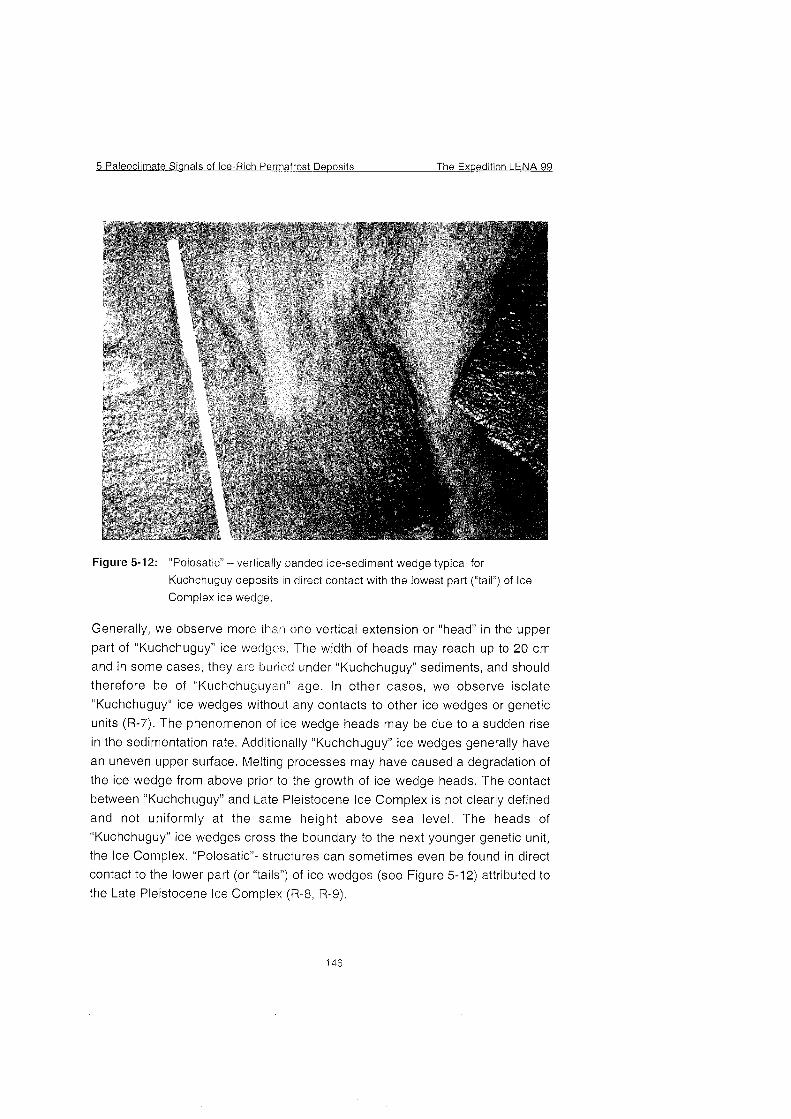
5 Paleoclimate Signals of Ice-Rich Permafrost De~osits The Exuedition LENA 99
Figure 5-12: "Polosatic" - vertically banded ice-sediment wedge typical for
Kuchchuguy deposits in direct contact with the lowest part ("tail") of Ice
Complex ice wedge.
Generally, we observe more than one vertical extension or "head" in the upper
part of "Kuchchuguy" ice wedges, The width of heads may reach up to 20 cm
and in some cases, they are buried under "Kuchchuguy" sediments, and should
therefore be of "Kuchchuguyan" age. In other cases, we observe isolate
"Kuchchuguy" ice wedges without any contacts to other ice wedges or genetic
units (R-7). The phenomenon of ice wedge heads may be due to a sudden rise
in the sedimentation rate. Additionally "Kuchchuguy" ice wedges generally have
an uneven upper surface. Melting processes may have caused a degradation of
the ice wedge from above prior to the growth of ice wedge heads. The contact
between "Kuchchuguy" and Late Pleistocene Ice Complex is not clearly defined
and not uniformly at the Same height above sea level. The heads of
'Kuchchuguy" ice wedges Cross the boundary to the next younger genetic unit,
the Ice Complex. "Polosatic"- structures can sometimes even be found in direct
contact to the lower Part (or "tails") of ice wedges (see Figure 5-12) attributed to
the Late Pleistocene ice Complex (R-8, R-9).
The Expedition LENA 99 5 Paleoclimate Sianals of Ice-Rich Permafrost De~osi ts
Some parts of permafrost profile of "Kuchchuguy" sediments have visible marks of thawed ice wedges. These ice wedge pseudomorphs belong to the subaquatic sediment facies of "Kuchchuguy" unit and are usually associated with alas depressions.
The Ice Complex is characterized by huge syngenetic ice wedge polygons, which may reach 25 m in diameter. A Single ice wedge may attain widths up to 6 m and vertical dimensions up to 25 m. The colour of ice wedges is usually yellowish-grey and has well-defined subvertical structures such as elementary ice veins, oval gas bubbles and orientated thin mineral layers. The mean thickness of elementary veins is generally about 1-4 mm. The cryogenic
structure of the Ice Complex has been formed by syngenetic freezing of
deposits in landscapes with a thin active layer (Siegert & Romanovsky 1996).
Other typical cryolithological features in the sediment are massive subhorizontal 2 to 4 cm thick ice belts, which are always bound upward close to the ice
wedges. The ice of ice belts is clean, transparent and includes numerous bubbles of air. Thermal erosion of the Ice Complex causes typical geomorphological forms such as up to 15 m high and about 70 to 75O steep ice walls (Figure 5-13) as well as semicircles called "thermo-erosional cirques".
The extension of thermo-erosional cirques is about 400-700 m (Figure 5-3) and they are characterized by 50 m to 100 m wide thermoterraces with numerous
baydzharahks (or thermokarst mounds) formed by melting processes. Four
thermo-erosional cirques (TZ-1, TZ-2 and TZ-3 and L-TZ-1) were studied during the field work.
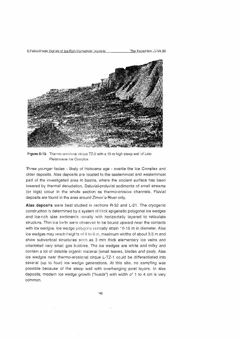
5 Paleoclimate Signals of Ice-Rich Permafrost De~osi ts The Expedition LENA 99
Figure 5-13: Thermo-erosional cirque TZ-2 with a 15 m high steep wall of Late
Pleistocene Ice Complex
Three younger facies - likely of Holocene age - overlie the Ice Complex and older deposits. Alas deposits are located to the easternmost and westernmost part of the investigated area in basins, where the ancient surface has been
lowered by thermal denudation. Deluvial-proluvial sediments of small streams (or logs) occur in the whole section as thermo-erosive channels. Fluvial
deposits are found in the area around Zimov'e River only.
Alas deposits were best studied in sections R-32 and L-21. The cryogenic construction is determined by a System of thick epigenetic polygonal ice wedges and ice-rich alas sediments usually with horizontally layered to reticulate structure. Thin ice belts were obqerved to be bound upward near the contacts with ice wedges. Ice wedge polygons normally attain 10-15 m in diameter. Alas
ice wedges may reach heights of 6 to 8 rn, niaximum widths of about 3.5 m and
show subvertical structures such as 3 mm thick elementary ice veins and orientated very small gas bubbles. The ice wedges are white and milky and
contain a lot of datable organic material (small leaves, blades and peat). Alas ice wedges near thermo-erosional cirque L-TZ-1 could be differentiated into several (up to four) ice wedge generations. At this site, no sampling was possible because of the steep wall with overhanging peat layers. In alas deposits, modern ice wedge growth ("heads") with width of 1 to 4 cm is very common.
The Exwedition LENA 99 5 Paleoclimate Sianals of lce-Rich Permafrost Deposits
Logs or shallow small streams and their respective thermo-erosive channels are typical features in the whole working area (see Figures 5-4 to 5-6 and 5-1 1). Both epigenetic and syngenetic ice wedges with a maximum width of about 1.5 m are found. Generally, log deposits are in direct contact with the lce complex.
Log ice wedges are characterized by white to gray, milky ice with subvertically orientated and elongated gas bubbles 2 1 mm resembling a string of beads.
The elementary ice veinlets are between 1 to 4 Cm thick but not easily identified.
The Holocene fluvial deposits are characterized by ice wedge polygons with small diameter, In the working area, they are found in the Holocene fluvial terrace in the mouth of Zimov'e river only. The maximum height of the fluvial deposits is about 5 m, the width of ice wedges may reach 1.5 m. The ice
wedges have modern heads in the upper Part and show subvertically orientated
2 to 6 mm thick ice veins, very thin layers of sediment and elongated gas
bubbles. The ice is relatively clear, colourless and transparent. Enclosed sediments are characterized by a layered cryogenic structure bound upward
near ice wedges.
Additionally, active ice wedges with widths of 1 to 4 Cm have been observed in some parts of the section, especially in the alas near R-32. All these modern "heads" of ice wedges were sampled because they may be useful as standards for paleotemperature reconstruction.
lce wedges are neither found in the taberites, which are thawed and refrozen
sediments of former taliks, nor in the subaquatic parts of both ~cKuchchuguy''
and alas deposits. Here, ice wedge pseudomorphs display a former existence of ice wedges. The higher heat capacity of episodically Open water bodies causes melting and talik formation.
lnvestigations of the crystalline structure of ground ice
In addition to geochemical investigations of ground ice, the ice structure was
studied using polarising lenses. The method of crystalline structure analyses is widely used in geocryological investigations of ground ice and most generally employed in studies of polygonal ice wedges. The crystalline structure of ice wedges largely depends On the conditions of ice wedge formation. lt is based On specific characteristics of ice crystal size, shape and orientation, which represent the conditions of crystallisation (Solomatin 1974).
During the field season, ice wedges of five different genetic units (E'Olyor'', "Kuchchuguy", lce Complex, alas and log) were sampled. 50th) studies of crystalline structure of "Olyorian" and "Kuchchuguy" ice wedges as weil as the
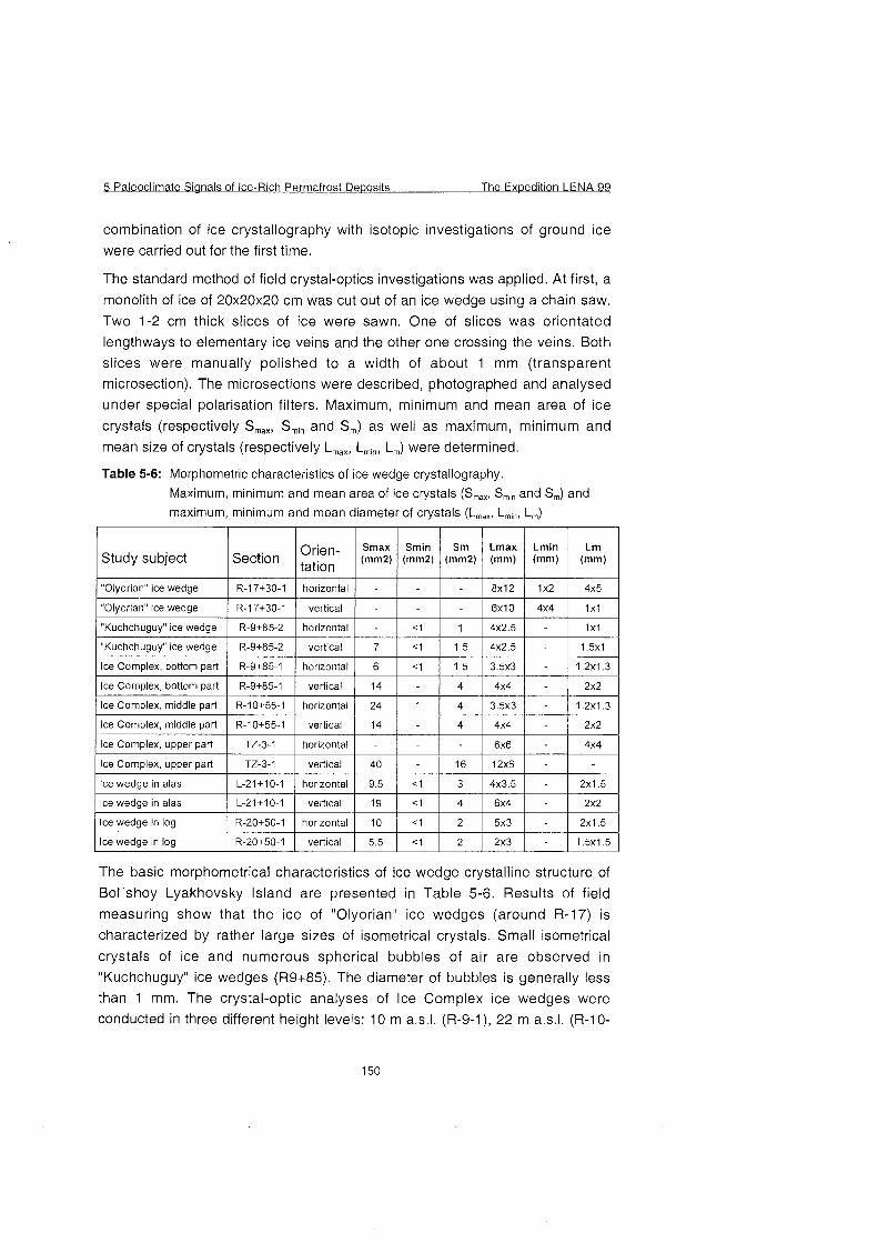
5 Paleoclimate Sianals of lce-Rich Permafrost Deposits The E x ~ e d i t i o n LENA 99
combination of ice crystallography with isotopic investigations of ground ice were carried out for the first time.
The standard method of field crystal-optics investigations was applied. At first, a
monolith of ice of 20x20~20 Cm was cut out of an ice wedge using a chain saw. Two 1-2 Cm thick slices of ice were sawn. One of slices was orientated lengthways to elementary ice veins and the other one crossing the veins. Both slices were manually polished to a width of about 1 mm (transparent microsection). The microsections were described, photographed and analysed under special polarisation filters. Maximum, minimum and mean area of ice
crystals (respectively Smax, Smin and Sm) as well as maximum, minimum and mean size of crystals (respectively Lmax, Lmin, Lm) were determined.
Table 5-6: Morphornetric characteristics of ice wedge crystallography.
Maximum, rninirnurn and mean area of ice crystals (Smax, Sm,,, and Sm) and maxirnurn, rninimurn and mean diarneter of crystals (Lmax, L,,,,,,, L,,,)
1 "OIyorianc'ice wedge 1 R-17+30-I 1 horizontal 1 - 1 - 1 - 1 8x12 1 1x2 1 4x5 1 ~"0lyorian"icewedge 1 R-17+30-I 1 vertical 1 - 1 - 1 - 1 6 x 1 0 1 4x4 1 1x1 1
1 lce Cornplex, upper part 1 TZ-3-1 1 horizontal 1 - 1 - 1 - 1 6x6 1 - 1 4x4 1
I "Kuchchuguy" ice wedge
"Kuchchuguy" ice wedge
lce Cornplex, bottorn part
lce Cornplex, bottorn part
lce Cornplex, rniddle part
lce Cornplex, rniddle part
R-9+85-2
R-9+85-2
R-9+85-I
R-9+85-I
R-10+55-I
R-10+55-I
lce Cornplex, upper Part
The basic morphometrical characteristics of ice wedge crystalline structure of
Bol'shoy Lyakhovsky lsland are presented in Table 5-6. Results of field
measuring show that the ice of "Olyorian" ice wedges (around R-17) is
characterized by rather large sizes of isometrical crystals. Small isometrical crystals of ice and numerous spherical bubbles of air are observed in "Kuchchuguy" ice wedges (R9+85). The diameter of bubbles is generally less than 1 mm. The crystal-optic analyses of lce Cornplex ice wedges were conducted in three different height levels: I 0 m a.s.1. (R-9-I), 22 m a.s.1. (R-IO-
lce wedge in alas
lce wedge in log
lce wedge in log
horizontal
vertical
horizontal
vertical
horizontal
vertical
TZ-3-1
lce wedge in alas
L-21+10-I
R-20+50-I
R-20+50-I
-
7
6
14
24
14
vertical
L-21+10-I
vert~cal
horizontal
vertical
< I
< I
< I
I
40
horizontal 1 9.5 1 < I 1 3
19
I 0
5.5
I
I .5
I ,5
4
4
4
16
4x3,s
< I
< I
< I
4x2.5
4x2,s
3 . 5 ~ 3
4x4
3 . 5 ~ 3
4x4
12x6 -
-
4
2
2
-
-
-
-
-
-
2x1.5
1x1
I .5xI
I .2xI .3
2x2
1.2x1.3
2x2
6x4
5x3
2x3
-
-
-
2x2
2x1.5
1.5x1.5
The Exuedition LENA 99 5 Paleoclimate Sianals of lce-Rich Permafrost De~osits
1) and 27 m a.s.1. (TZ-3-1). The biggest sized crystals were observed in the
upper Part of lce Complex. Crystals have an elongated form and both spherical
and cylindrical bubbles of gas were observed. Cylindrical bubbles have vertical
orientation reaching 5 mm. The diameter of gas bubbles is about 1 mm. The
middle Part of the lce Complex profile is characterized by slightly smaller size of
crystals. Bubbles of gas mostly have a cylindrical form and their vertical size
reaches to 12 mm. The horizontal size of air bubbles is not more than 1 mm. The bottom Part of lce Complex is characterized by small size of crystals and
small spherical (diameter about 0.5 mm) bubbles of gas.
lce wedges in alas and log deposits also have a different crystalline structure of
ice (Table 5-6). Size of spherical gas bubbles both in alas and log ice wedges is
less than 1 mm. The data handling will be continued and photographs will
supplement visual observation. lt is expected to make statistical analysis of
obtained data.
5.1.9 Paleontological research at the southern coast of Bol'shoy
Lyakhovsky lsland
(T. Kuznetsova and S. Kuzmina)
Siratigraphic and paleontological studies were one of important components of
the multidisciplinary research of the Pleistocene deposits at the southern coast
of Bol'shoy Lyakhovsky lsland, These studies included the search and
collecting of large and small fossil vertebrate remains, fossil and modern
insects, plant macrofossils, and fossil molluscs.
Large mammal fossils
The famous Russian Novosibirsk Expedition of 1886, led by A.Bunge and
E.ToII, collected nearly 2000 bones and discovered many species of fossil
mammals, previously not known in the Arctic, such as saiga antelope, a large
lion-like panther, woolly rhino, and many others (Cherskiy 1891). This collection
was made mostly at the southern coast of the island, which became one of the
most important Pleistocene sites in whole Siberia. In 1956, a few hundred
bones were collected by V.D.Lebedev and N,N.Romanovsky at the Same site
(Vangengeim 1963). In recent years, a few occurrences of woolly mammoth
with preserved soft tissues were recorded here (Lozhkin 1977; Arkhangelov
1996; Lazarev in press). The site also became a rich field for ivory hunters and
illegal bone collectors. That has been for the first time since the last century,
when mammal bones were collected here professionally, and exposed in
relation to the study of the sediments.
5 Paleoclimate Sianals of lce-Rich Perrnafrost Deposits The Expedition LENA 99
when mammal bones were collected here professionally, and exposed in relation to the study of the sediments.
During our work in 1999, with the active help of all the team members, we collected 1028 bones and bone fragments of large mammals (Table A5-7). The
collecting was rather thorough - all of the found identifiable fragments were registered, to obtain as complete statistics of species composition as possible.
The bones were collected from an about 10 km Iong Segment of the island southern coast - 4 km west of the Zimov'e River mouth (side W'), and 6 km east of it (side "L"), both On the shore and within the coastal cliffs. As 1998 On the Bykovsky Peninsula, the major Part of the collection unfortunately Comes from the shore, which is common in permafrost regions. Strictly in situ in the
sediments, 33 bones were found (group "a"), 20 of them belonging to an
articulated skeleton of bison (sample BL-0193-R).
The second group ("b") includes 54 bones found within the exposures, mostly in the thermo-erosional cirques I, 11, and 111 On the R side, beneath almost vertical walls of lce Complex exposed. By their finding locations, it is possible to define the area, where the bones came from, with more or less certainty. These areas are marked as "the bone fields", and the altitude of their lower boundaries was
instrumentally defined as the level of minimum height of the original position of
the bones. Group "C" (134 samples) incorporates the bone specimens found at the exposures, but in or On the scree. For these bones, it is not always possible
even to infer from which member of the section they came. They can only be related to the particular station of the cliff, and to the sediments occurring not lower than the finding location.
The most of the material has been collected On the shore. lt was divided into two groups - the bones, picked up On the L side (group "d", 226 specimens),
and those collected On ihe R side (group "e", 442 specimens). Such a
subdivision was potentially important, since On the side R the earliest deposits (of the "Olyorian" age) are exposed, and correspondingly, the most ancient
bones could be encountered. On the L side, the earliest are the deposits of the middle member (''Kuchchuguy"), and the occurrence of the Early Pleistocene
bones is less likely. During our work, we could several times observe the
transportation of bones by the coastal waves along the shore R from the
landmark R-25 (the cape) to the landmark R-0. However, bones from beyond the cape were never Seen to be transported closer to the camp. The coastal bone transport along the L shore was also observed, but we never recorded the
transport from the L to the R shore, and vice versa. We can assume, that the Zimov'e River mouth is an obstacle for such transportation. Whether these Sets
The Ex~edition LENA 99 5 Paleoclirnate Sianals of lce-Rich Permafrost De~os i t s
of bones have some real difference in taxonomic or other composition can only be concluded after detailed morphological study of the collection.
One more small group of bones recorded separately (group "f", 38 specimens) Comes from the Zimov'e River floodplain. They have been redeposited into the modern river deposits from the sediments, eroded by the river. This group includes the bones with some remains of soft tissues, found at the site, where a partial skin and foot of mammoth was found in 1995. We registered the bones scattered around the camp site as a completely separate group (group "g", 96
specimens). These bones were collected in various areas of the island by
previous expeditions and bone hunters, and left behind near the camp, so their provenance can be recorded as "the Bol'shoy Lyakhovsky lsland" only.
Table 5-7 summarizes the present taxonomic composition of the collection. The 1999 collection, by its size and taxonomic composition is comparable with the 1886 collection by A. Bunge. The latter, however, as reconstructed from Cherskiy (1891), had abnormally low percentage of mammoth bones ( I .7%)
and very high number of hare bones (17.670)~ with reindeer bones dominating
the sample (39%). That looks like possible collecting biases. From that point, our collection seems more adequately corresponding to the other Late Pleistocene local faunas, lt is dominated by mammoth and horse fossils (25.1 70 and 24.770 respectively), followed by bison (19.5%) and reindeer (18Y0).
Unusually high is the number of muskox fossils (7.270). Hare bones are only
2.370. Woolly rhino, carnivores (panther and wolf), and saiga antelope each are less than 170 of the whole collection. lt should be noted that these calculations
are based On the preliminary identification only, and may have undergone some
minor changes in the Course of the detailed study of this huge collection. In particular, we have not yet found bones of red deer (Cewus elaphus), known
from the 1896 collection; identification of Praeovibos sp. (an Early Pleistocene muskox) is still to be confirmed, and if so, it would be a very important novelty. There are some other interesting features of this collection (e.g., very large size of panther and most bison bones), but this is a matter of more detailed morphological studies.
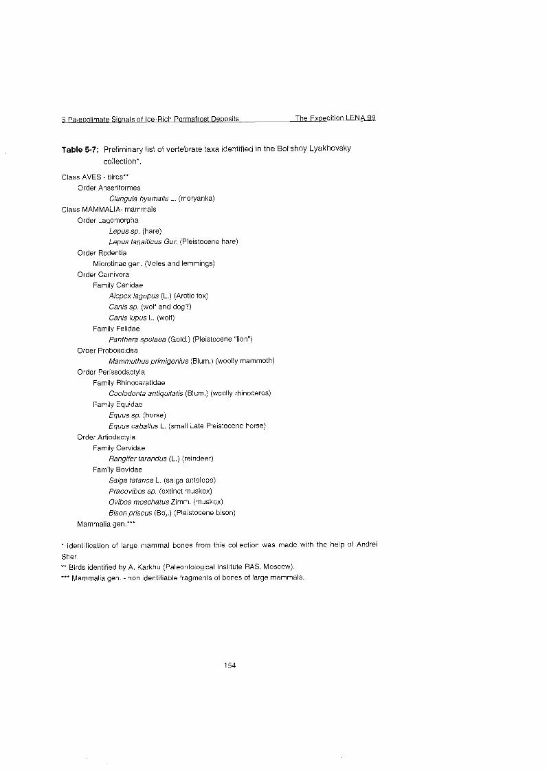
Table 5-7: Prelirninary list of veriebrate taxa identified in the Bol'shoy Lyakhovsky
collection*.
Class AVES - birds** Order Anseriformes
Clangula hyemalis L. (moryanka)
Class MAMMALIA- mammals
Order Lagomorpha
Lepus sp. (hare) Lepus tanaiticus Gur. (Pleistocene hare)
Order Rodentia
Microtinae gen. (Voles and lemmings)
Order Carnivora Family Canidae
Alopex lagopus (L.) (Arctic fox)
Canis sp. (wolf and dog?)
Canis lupus L. (wolf)
Family Felidae
Panthera spelaea (Gold.) (Pleistocene "lion")
Order Proboscidea
Mammuthus primigenius (Blum.) (woolly mammoth)
Order Perissodactyla Family Rhinoceratidae
Coelodonta antiquitatis (Blum.) (woolly rhinoceros)
Farnily Equidae Equus sp. (horse)
Equus caballus L. (small Late Pleistocene horse)
Order Artiodactyla
Family Cervidae ßangife tarandus (L.) (reindeer)
Family Bovidae
Saiga tatarica L. (saiga antelope)
Praeovibos sp. (extinct muskox)
Ovibos moschatus Zimm. (muskox)
Bison priscus (Boj.) (Pleistocene bison)
Mammalia gen.'**
* Identification of large mammal bones from this collection was made with the help of Andrei
Sher.
** Birds identified by A. Karkhu (Paleontological Institute RAS, Moscow).
* * Mammalia gen. - non identifiable fragments of bones of large mammals.
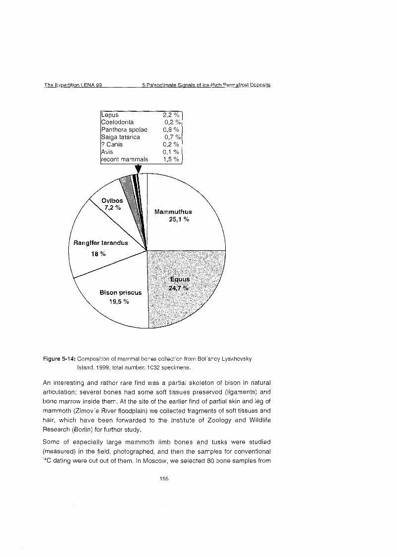
The Expedition LENA 99 5 Paleoclimate Sianals of Ice-Rich Permafrost De~os i ts
Mammuthus
Rangifer tarandus
Figure 5-14; Composition of mammal bones collection from Bol'shoy Lyakhovsky Island, 1999, total number: 1032 specimens.
An interesting and rather rare find was a partial skeleton of bison in natural
articulation; several bones had some soft tissues preserved (ligaments) and
bone marrow inside them. At the site of the earlier find of partial skin and leg of
mammoth (Zimov'e River floodplain) we collected fragments of soft tissues and
hair, which have been forwarded to the Institute of Zoology and Wildlife Research (Berlin) for further study.
Some of especially large mammoth limb bones and tusks were studied
(measured) in the field, photographed, and then the samples for conventional
I4C dating were cut out of them. In Moscow, we selected 80 bone samples from
5 Paleoclirnate Signals of Ice-Rich Perrnafrost De~osits The Exuedition LENA 99
the whole collection and sent them to the Radiocarbon Laboratory of the
Geological Institute RAS. There are only a few ^C dates on mammal bones available from the whole Novosibirsk Archipelago, so the dating of our collection
is very important to determine the time of occurrence of certain rnammal species on the islands.
Small mammal fossils
Because of limited time, the search and screening for small mammal fossils has
been carried out in the lowermost ("Olyorian") part of the section. Six samples,
50 to 80 kg each, were screened from 4 sites in this member (Figures A5-2 to
A5-2-3; Table A5-8). As this member is very poorly exposed and frozen, and the thawing was very slow, we were not able to take more samples. The screening was performed by the hand sieve with 1 mm mesh, and with water supply by a
motor pump in a special screening box (constructed by A. Sher), also with 1 mm mesh. For the reference collection, we screened one sample (BL-0-1001 -L) from the beach, quite rich for small mammal bones, skull fragments, and teeth,
and also collected recent rodent bones on the island.
Fossil insects and plant macrofossils
There was no systematic study of Pleistocene fossil insects on Bol'shoy
Lyakhovsky Island before our expedition, except three isolated samples, collected in different time by A. Arkhangelov and V. Kunitsky and studied by S.
Kiselyov (manuscript). Those samples contained a rather smal! number of
fossils, and gave only a very approximate idea on the insect fauna composition.
We sampled all the accessible horizons of the section, giving preference to the facies, most potential for preservation of insect fossils in sufficient quantities. Usually these fossils are most abundant in fine-grained sands and silts, enriched with plant detritus. If the plant organic is represented mostly by thread-
like roots, these sediments usually contain few insect fossils. The latter are not
found in heavily decomposed peat and pure moss autochthonous peat, but can be abundant at the base and top of the peat layer. Relatively rich insect assemblages can come from slightly decomposed allochthonous peat, in the
sediments with alternating thin layers of organic (peat) and mineral composition.
Sometimes insect fossils are very abundant in coarser facies, such as coarse- grained sand and gravel rich with plant detritus, but in these cases the species
composition of the assemblage can be misrepresented because of the enrichment of the sample with the most resistant larger elements of the insect
The Ex~edition LENA 99 5 Paleoclimate Sianals of Ice-Rich Perrnafrost De~osi ts
skeleton. Most Pleistocene insect fossils are represented by beetles
(Coleoptera).
Different members of the'studied section on Bol'shoy Lyakhovsky Island are not equally characterized by insect fossils. Large and representative fossil
assemblages have been obtained from the "Krest-Yuryakh" member and from
the Holocene deposits. Fossil assemblages from the "Olyorian" member are less rich, and from the "Kuchchuguy" and "Yedoma" members - even smaller.
The sample size for insect fossils varies from 10-20 kg for the sediments, rich with plant detritus (and usually containing abundant insect fossils), to 100 kg for those containing few plant detritus; on the average, the amount of screened sediment was 40-50 kg. Since the technical problem of extracting frozen
sediment from the exposure has not been solved since 1998 (Siegert et al,
1999), we had to sample only a thin, freshly thawed Cover of the sediment, still remaining in its original position. To obtain such a large volume of thawed
matrix, we had to take each sample from a strip up to 0.4 m high and up to 2 m long (along the strike of the sediment layer). All the samples were screened with a hand sieve with 0.5 mm mesh.
In the practice of the Russian paleoecological studies, the samples for plant macrofossils are most commonly obtained by the screening, similar to the
described above, and have similar volume. In 1999, however, we used a
different method, suggested by our German colleagues. Samples of up to 0.5
kg were taken every 30 cm along the vertical profile, and no screening was used in the field. One or two carpological samples were always taken from the Same layer, where an insect sample was taken from, and then upward and downward from it with 30 cm intervals. This difference in methods should be
taken into account when comparing the future results with the previously obtained paleocarpological evidence from the Russian Arctic.
Both insect screening residual and the carpological samples were taken in fabric bags to facilitate the necessary sample drying.
In total, 25 samples for insect fossils were screened from the Bol'shoy Lyakhovsky Island sections, and 67 carpological samples taken (Table A5-8).
From the lower member ("Olyorian") only one sample was screened and one carpological sample taken (Figures A5-2 to A5-2-3; Table A5-8), but some
insect fossils will be also obtained from 6 samples that were screened for small mammals (sieve 1.0 mm), with special precautions to provide the preservation of insect remains.
5 Paleoclimate Signals of Ice-Rich Permafrost Deposits The Expedition LENA 99
The next member ("subaerial Kuchchuguy") was sampled at three sites (Figures
A5-2 to A5-2-3; Table A5-8) totally 5 insect and 25 carpological samples. The
first site was at the bottom of the "Kuchchuguy", immediately above the boundary with the "Olyorian" (Figure 5-15a). At the second site (R-6+70 m, the
Third creek, or Volodya's burrow), the lower and middle parts of this member were sampled (Figure 5-15b). At the third site, the upper part of the 'Kuchchuguy" was sampled (Figure 5-1 5c), beneath its contact with the "Yedoma", in the thermo-erosional cirque II. Three insect and 6 carpological
samples were taken from the "subaquatic Kuchchuguy". All the sections studied
are in the coastal cliffs, both on the L and the R sides.
The Expedition LENA 99 5 Paleoclimate Sip-ials of Ice-Rich Permafrost De~osits
R-6, site "Volodya's burrow" b
LEGEND
Figure 5-15: (a-g) Fossil insect and carpological sampling sites at the right side (R)
from the camp (west of the Zimov'e River mouth).
5 Paleoclirnate Signals of Ice-Rich Permafrost Deoosits The Exuedition LENA 99
The "Krest-Yuryakh" deposits overlie tiie "subaquatic Kuchchuguy" with a sharp unconformity. From the "Krest-Yuryakh" member, 4 insect and 7 carpological samples were taken (Figures 5-15d, 5-16d). The upper Ice Complex (the 'Yedoma Suite") has been sampled insufficiently, because its sections were hardly accessible. In total, 6 insect and 22 carpological samples have been
collected from the sections on the L side. From the Holocene alas deposits
(side L), 3 insect and 3 carpological samples were taken (Figure 5-16b). Fluvial Sediments of the Holocene age were sampled in the section of the low terrace of the Zimov'e River near the camp (Figure 5-1 6c) - 3 insect and 3 carpological samples.
1 L-1 7 Holocene (alas) b
L-0 Holocene ( left bank o the ZinKJvYe R . ) C
I iiuchchug~y~~ l
Figure 5-16: (b-d) Fossil insect and carpological sampling sites at the left side (L)
from the camp (west of the Zimov'e River mouth).
The Exwedition LENA 99 5 Paleoclimate Sianals of Ice-Rich Permafrost Deposits
The modern insect fauna of Novosibirsk Islands is very poorly known (the last
extensive collection was obtained by the Bunge Expedition in 1896), so modern
beetles were also collected in 1999. This collection is necessary for comparison
with the fossil species, but also has an independent importance. It includes water tigers Agabus nigripalpis Shlb. (59 specimens), a catopid beetle
Cryocatops poppiusi Jeann. ( I ) , staphylin beetles Tachinus arcticus Motsch.
( log) , leaf beetles Chrysolina (67), including such rare species as C. wollosowiczi Tcbs. and C'bungei Tbst., ground beetles Pterostichus agonus
Horn. ( I ) , Curtonotus alpinus Pauk ( I ) , Bembidion sp. ( I) , and Pterostichus (Cryobius) spp (43 specirnens of 2-3 species). A comparative sample of modern
plant detritus was taken from the surface of the Zimov'e River left bank. General low species diversity in combination with high numbers of individual
species is very typical for the harsh conditions of the High Arctic. It is interesting
to note that some beetles, belonging to different families (ground beetles, leaf beetles), demonstrate similar deformations of their chitin (the wrinkling,
narrowing of the upper ends of elytra), that is caused by the effect of low
temperatures On young beetles at the Stage of their transformation from the
puparian to imago. Large numbers of fossils with these kinds of deformations
can be an indirect evidence of low summer temperature in the past.
Collecting of seeds of modern plants, also for comparative purpose, has been
attempted, but only very few plants could be found with ripe seeds before we
left the island: Salix sp., Potentilla sp., Draba sp., Cochlearia sp., ßanunculu
sp., Polygonum sp., Saxifraga sp., Sausuria sp. Sorne more plants with seeds were also collected during the short stop in Nizhneyansk (Oxytropus sp.,
Senecio sp., Artemisia sp., Eriophorum sp.).
In Course of the study and description of the sections, both on the L and the R side, T. Kuznetsova and V. Tumskoy collected 6 peat sarnples to analyse their
botanical composition (Figures A5-2 to A5-2-3, Table A5-9). These samples have been sent for identification to the Botanical Institute RAS.
Fossil molluscs
A few shells and their fragments were determined only as Pisidium sp. from this
region (Kunitsky, 1998). New samples with great number of Gastropoda and Bivalvia were collected from "Krest-Yuryakh" deposits to analyze taxonomic
composition and paleoecological conditions of their inhabitation (Table A5-10).
5 Paleoclirnate Sianals of Ice-Rich Perrnafrost Dewosits The Expedition LENA 99
5.1.10 Recent and fossil soils of the south coast of Bol'shoy Lyakhovsky Island
( I . Akhmadeeva)
During the 1999 expedition soils of the southern coast of the Bol'shoy
Lyakhovsky Island, district of the mouth of Zimov'e river were studied. The
topographic map 1 :25.000 was used as cartographic basis. During this study 93
descriptions of soil pits and 3 descriptions of geologic profiles were made, in one which of the tracks of ancient soils were detected. Soil pits were produced by the generally accepted methods. 103 samples for carrying out a standard Set of chemical analysis in soil-analytical lab of Yakutsk were taken from pits and denudations and 69 samples are going to be processed in Germany. The position of several pits are shown in Figure 5-17. A soil map of a scale 1:10.000
is in preparation. Except for soil research, on each pit the geobotanical descriptions were fulfilled. The herbarium is assembled and contain 66 species of plants. One of them is new for the Arctic islands. For classifying soils we used the classification of Yelovskaya (1987).
Figure 5-17: Position of soil pits.
The Expedition LENA 99 5 Paleoclimate Sianals of Ice-Rich Permafrost Deposits
The mapped area Covers the river flat of Zimov'e from its mouth up to 3.5 km upstream and adjoining non-flood-plain territories representing slope-undulating
ovals with hollows between them. The river worked out a channel and has
derivated flood plains on the bottoms of the alas System. All soils, including
alluvial, are cryoturbated in different degrees . Classification and characteristics
of soil-subtypes of the studied area is given below and in appendix A5-12.
Section: Poorly developed, primitive; Order: Primitive alluvial. Type: Permafrost alluvial layered poorly developed (primitive) soll
This type occupies completely the first terrace and partially also the second
terrace, especially closer to marine coast. On granulometrical composition it is
difficult to refer them to the particular type, as the stratified Strata in pits with
alternation of mudded loamy, sandy and peated Stratums is usually uncovered.
This type of soils melts deeper than all the others, because it is not protected by
vegetation.
Section: Alluvial; Order: Purely alluvial; Type: Permafrost alluvial sod soils
This type occupies terrace 2, which is flooded not every year and where there
are conditions for derivation almost of continuous plant Cover. The type is
represented by a subtype ,,Permafrost alluvial sod-gley".
The type ,,Permafrost alluvial peat- soils" occupies all swamps on the river flat.
These swamps are widely distributed on the river flat and their expansion is
comparable with the length of a nowadays channel of the river. The depth of
thaw changes from 23 up to 30 Cm. The thickness of peat horizon ranges from
17 to 24 cm, therefore, according to the classification of Yelovskaya (1 987), the
soil of these swamps belong to two subtypes: ,,Permafrost alluvial muddy-peaty-
gley" (at a thickness of peat from 8 up to 20 cm) and ,,Permafrost alluvial
muddy-peat-gley" (peat horizon is 20-50 cm). However, in this case this division appears formal, as all of the soils of this type are shaped here in similar
conditions, and the dispersion in thickness of peat is very insignificant, only 7
cm. The mudding of peat increases with depth, the peat is spread also by
strongly mudded grey gleyic horizons containing clusters of peat and plant
remains.
The relief strongly influences the formation of non-river-flat soils of this district,
especially the micro- and the nanorelief. Soils of the section ,,GleyU, order
,Humus-gley" are formed under conditions of constant or, anyway of durably strong humification on the negative forms of the relief (depressions between
baydzharakhs and hillocks, hollows). The profile of these hydromorphic soils
5 Paleoclimate Sianals of Ice-Rich Permafrost De~osits The Expedition LENA 99
looks like the profile of ,,Permafrost alluvial peat-gley", also formed in conditions
of strong humification. However, there is also one essential difference. Soil of
river-flat swamps exists in rather quiet conditions, almost without input of particles from outside. The natural arrangement of peat horizon On gleyic soils was observed within the profiles. We observed diversities in gley soils. The hollows with steep sides gain permanently material from steep inclines, especially during spring Snow melt. Therefore the profile represents alternation of more or less peaty muddy stratums. The upper horizon is conventional
muddy peat. The depth of thaw varies from 27 up to 45 cm. Soils of depressions
between baydzharakhs differ from soils of hollows a little by the greater regulation. Soils of one subtype ,,Permafrost peatish-gley" which is included in the type ,,Permafrost peat-gley" are mapped in the study area.
The largest Square in the research area is covered by soil of the section
,Permafrost cryoturbated", divided into two orders depending on the intensity of cryoturbations. These are ,,Perniafrost cryoturbated with destructive profile",
with the completely destroyed profile, and ,,Permafrost cryoturbated with
distorted profile", with broken positions of soll horizons, isolated in the profile.
The order ,,Permafrost cryoturbated with destructive profile" includes only the type ,,Permafrost effused". These soils of mud circles (pyatny medallion) of the spotted tundra are not distinguished in different genetic horizons. The profile is homogeneous in colour and granulometrical composition (loamy sand or loam).
Sometimes gleying is observed at the bottom of the profile.
Some types of soils concern the order ,,Permafrost cryoturbated distorted". The classification of thein 1s difficult, is mixed a.nd needs further development.
During work on Bol'shoy Lyakliovsky Island also fossil soils were studied. A small amount of buried humus were found in some outcrop profiles (Appendix A5-12).
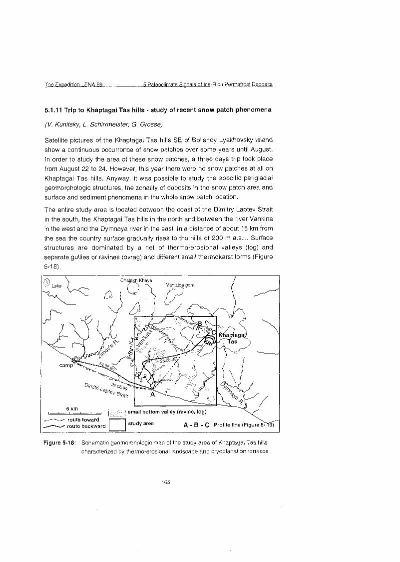
The Ex~edition LENA 99 5 Paleoclimate Sianals of Ice-Rich Perrnafrost De~osits
5.1.1 1 Trip to Khaptagai Tas hills - study of recent snow patch phenomena
(V. Kunitsky, L. Schirrmeister, G. Grosse)
Satellite pictures of the Khaptagai Tas hills SE of Bol'shoy Lyakhovsky Island show a continuous occurrence of Snow patches over some years until August.
In order to study the area of these Snow patches, a three days trip took place
from August 22 to 24. However, this year there were no Snow patches at all on
Khaptagai Tas hills. Anyway, it was possible to study the specific periglacial geomorphologic structures, the zonality of deposits in the Snow patch area and surface and sediment phenomena in the whole Snow patch location.
The entire study area is located between the coast of the Dimitry Laptev Strait
in the south, the Khaptagai Tas hills in the north and between the river Vankina in the west and the Dymnaya river in the east. In a distance of about 15 km from
the sea the country surface gradually rises to the hills of 200 m a.s.1.. Surface structures are dominated by a net of thermo-erosional valleys (log) and separate gullies or ravines (ovrag) and different small thermokarst forms (Figure 5-1 8).
- - - -X route toward route backward [l study area A - B - C Profite line f F i g u r M 1
Figure 5-18: Schematic geomorphologic map of the study area of Khaptagai Tas hills
characterized by thermo-erosional landscape and cryoplanation terraces
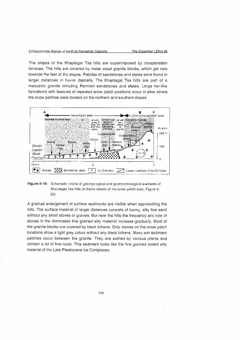
5 Paleoclirnate Sianals of Ice-Rich Perrnafrost Deposits The Expedition LENA 98
The slopes of the Khaptagai Tas hills are superimposed by cryoplanation terraces. The hills are covered by meter sized granite blocks, which get rare towards the feet of the slopes. Pebbles of sandstones and slates were found in
larger distances in fluvial deposits. The Khaptagai Tas hills are part of a mesozoic granite intruding Permian sandstones and slates. Large kar-like formations with features of repeated Snow patch positions occur in sites where the snow patches were located On the northern and southern slopes.
B 1 %- lce complex area -,,cold snow ~atches,' area I - - . Deposits of active layer: siii si I MI^ silt with rock si n\,th rockdebris of gante
~IJSS of Oebrisot roch slaie, f nt wanile and oebns Nivation an0 mi ky Santistone. of Nat ion m, a,s, , qJartz and slate granite hd,ow
cfyOpdi ente Cryoplanation
Edoma terrace Edoma
Dimitri 100
- 0
1 Gran~te B Sandstone, slate 0 lce Cornplex Lower boundary of lce Complex
Figure 5-19: Schematic profile of geocryological and geomorphological elements of
Khaptagai Tas hills (in frame details of the Snow patch area, Figure 5-
20)
A gradual enlargement of surface sediments are visible when approaching the hills. The surface material of larger distances consists of loamy, silty fine sand without any small stones or gravels. But near the hills the frequency and size of
stones in the dominated fine grained silty material increase gradually. Most of the granite blocks are covered by black lichens. Only stones On the snow patch locations show a light grey colour without any black lichens. Many wet sediment
patches occur between the granite. They are settled by various plants and
contain a lot of fine roots. This sediment looks like the fine grained rooted silty material of the Late Pleistocene Ice Complexes.
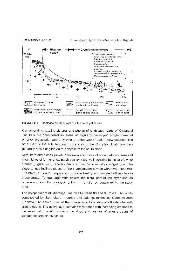
The Expedition LENA 99 5 Paleoclimate Sianals of Ice-Rich Permafrost Deuosits
N : Nivation -++--- Cryoplanation terrace - - WS hollow rn, a.s.1. Plant of nival meadow
(determined by I. Akhmadeeva): Saxifraga nivalis (L.), S. spinulosa (Adams), S. cespitosa (L.), Ranunculus Sabinii (R. Br.), Draba sp., Arctofila fulva (Trin., Anderss.), Chryososplenium alternifolium (L.), Alopecurus alpinus (Smith.)
>
Granite with cracks W h stones C d e r of ,
Boundary of filled by ice granite without lichens) active layer
Black stones (granite debris Silt with rock debris of with black cover of lichens) 0 grantte . and rnany roots
Figure 5-20: Schematic profile of a part of the Snow patch area
Corresponding satellite pictures and photos of landscape, Parts of Khaptagai Tas hills are considered as areas of regularly developed single forms of
embryonic glaciation and they belong to the type of ,,coldu Snow patches. The
other Part of the hills belongs to the area of Ice Complex. Their boundary
generally runs along the 80 m-isohypse of the south slope.
Nival kars and niches (nivation hollows) are traces of Snow patches. Areas of
nival niches of former Snow patch positions are well identified by fields of ,,white
stones" (Figure 5-20). The bottom of a nival niche usually changes down the
slope to less inclined places of the cryoplanation terrace with nival meadows.
Therefore, a meadow vegetation grows in freshly accumulated silt patches in
these areas. Tundra vegetation Covers the distal part of the cryoplanation
terrace and also the cryopediment which is followed downward to the study
area.
The cryopediment of Khaptagai Tas hills between 80 and 60 m a.s.1. becomes
complicated by thermokarst mounds and belongs to the Ice Complex area
(Edoma). The active layer of the cryopediment consists of silt (alevrite) with
granite debris. The active layer contains less debris with increasing distance to
the Snow patch positions down the slope and besides of granite debris of
sandstones and slates occurs.
5 Paleoclimate Signals of Ice-Rich Permafrost Deposits The Expedition LENA 99
The Ice Complex area comprises not only the cryopediment but also a less inclined plain with polygonal Patterns trenched by ravines. The altitude of this plain gradually decreases towards Dimitri Laptev Street. At the boundary to the cryopediment the active layer of Edoma consists of silt (alevrite) with single
inclusions of gruss (flint, hornfels and milky quartz). But close to the sea the active layer consists only of silt, exposed in mud circles and thermokarst
mounds (Figure 5-19).
The special feature composition and fabric of the upper horizons of the cryolithozone along the studied profile permits to consider the important role of nivation and cryoplanation processes for the formation of Ice Complex deposits
at the south slope of Khaptagai-Tas hills. Snow patches are possibly more
important for the genesis of Quaternary ice-rich permafrost deposits of Northern
Siberia than presumed until now. A number of geocryological phenomena described in the Ice Complex and the underlain older Quaternary deposits are found again in the area of snow patches of Khaptagai Tas hills.
The Exwedition LENA 99 5 Paleoclimate Sianals of lce-Rich Permafrost Deuosits
5.2 lce Complex On Bykovsky Peninsula
(A, Sher, I , Parmuzin and A. Bortsov)
5.2.1 Research aims
In 1998, the Russian-German team led by Drs. C.Siegert and V.Kunitsky conducted a very interesting and successful field research On the Bykovsky Peninsula, mainly On the famous lce Complex site Mamontovy Khayata. That
research, aimed at the multidisciplinary study of a Iong succession of lce
Complex, resulted in an unparalleled collection of geological, sedimentological, geocryological, paleoecological, and paleontological data, which should provide a detailed analysis of paleoclimatic signals from ice-rich permafrost during the last 50-60 thousand years (Siegert et al., 1999). A thorough chronological
control was insured by a unique number of samples for I4C dating, both of microscopic plant organic for AMS, and mammal bone and bulk peat samples for conventional dating.
The sampling, most detailed in the middle Part of this almost 40-m high cliff (between about 9 and 24 m a.s.l.), was, however, rather sparse at the foot of the cliff (covered by slope sediments) and in its upper part, which was hardly
accessible in the Summer of 1998, as a steep frozen wall being actively destroyed. The team managed to collect some samples near the top line of the cliff, but a vertical gap about 10 m (24-34 m a.s.1.) remained undated, and the
interval between 27 and 33 m a.s.1. could not be studied at all. That manifested
in the AMS date succession obtained, which revealed a time gap of about 72-15 ka, corresponding to the most of the last "glacial" (Sartanian) (Schirrmeister et al., submitted). Since this gap roughly corresponded to the unsampled intewal of the existing sediment, it was evidently caused by the sampling bias, but not by the break in sedimentation,
To fill that gap, a small additional team was organized in the Lena Delta 99
Expedition (Team 5, Bykovsky), which included the three authors of this report
chapter. lnitially, the field team was organized by the Severtsov Institute of
Ecology and Evolution RAS, to fulfil the tasks of the RFBR project 98-04-48084 "Evolution of continental arctic biota at the borderlands of north-eastern Asia (shelf land of the Laptev and East Siberian Seas)" and the related (additional) expedition grant RFBR 99-04-63067. However, those grants were quite small, and our field work would not be possible without the financial and logistic support of the Russian-German Lena Delta 99 Expedition.
5 Paleoclimate Signals of lce-Rich Perrnafrost Dewosits The Ex~edition LENA 99
5.2.2 Site survey and geomorphologic observations
The team was based On the Same camp spot as in 1998, so there is no need to repeat here the general site descriptions, maps and profiles published in the 98' report (Siegert et al., 1999). In accordance with the original goal, the team work was concentrated in the upper third of the cliff, which was being actively destroyed by thermal denudation. Precise correlation with the 98' landmarks
and sampling sites was absolutely necessary, but unfortunately no old landmarks were found preserved On the top line of the cliff. Only one marked
stick was found in mud not very far down from its original position (RP 5.5), while the few others - quite far down in the mud flows. Some 98' sampling marks preserved On tops of baydzherakhs were useful (BI, R8, Bl5), but that did not solve the whole problem of correlation. Additional sampling could not be started without a new theodolite survey of the cliff. The new survey covered the
SE side of the alas (from the Camp Creek to the foot of the yedoma), the NW slope of the Mamontovy Khayata (MKh) yedoma hill, its top, and the upper Part
of its SE slope. Another theodolite line was laid off along the beach, to make
correction for the distances measured.
The results of the survey were quite satisfactory, and showed a good correlation with the 98' survey results, for instance, in the maximum height of the MKh yedoma hill, in the position and altitude of some inactive baydzherakhs, etc. By
the "MKh yedoma hill" we mean the NW Part of the Mamontovy Khayata,
between the camp alas and the first erosional valley to the south-east; here, at the distance between Ca 300 and 1000 m from the camp, the studies were
concentrated both in 98' and in 99'. On the other hand, the survey revealed some interesting topographic features, confirmed by further observations, and important for the site geomorphology (Figure 5-21).
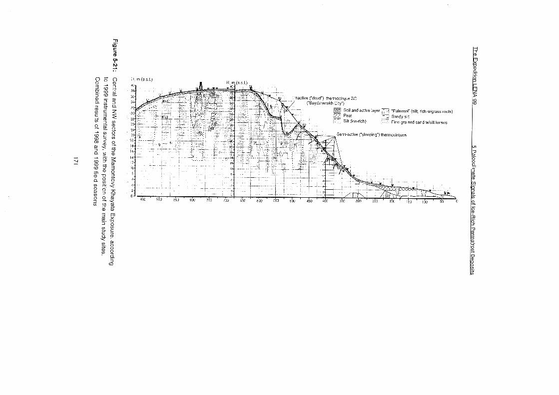
5 Paleoclirnate Sianals of lce-Rich Permafrost De~osi ts The Ex~edition LENA 99
The MKh yedoma hill has a flat, essentially horizontal top part, which is about
100-150 m wide (in NW-SE direction) and positioned at about 39 m a.s.1. The only morphological features of this flat top, except normal polygonal, are very shallow elongated grooves near the cliff edge, corresponding to the large ice wedges of the lce Complex beneath the soil, On the NW side (facing the camp alas), the surface of the hill gently descends to the alas surface. The WNW
slope of the MKh hill (towards the alas) is somewhat steeper in the middle part (8 to 34 m a.s.1.) and more gentle in the upper Part (34-39 m) and at its foot (6-8
m), where the slope denudation products accumulate and creep over the alas
surface. This slope shows no additional erosional forms on its surface. In the upper part of the NW flank of the MKh hill a large ancient thermocirque can be observed (between the 98' landmarks 5.5 and 4.2). The cirque is totally inactive and covered with lash herbs. A few inactive baydzherakhs 2-3 m high tower above the cirque floor, each fixed by herbaceous vegetation, more stable than
that On the baydzherakhs within the active cliff. This dead thermocirque
(labelled as the "Baydzherakh City" (BC) was faced almost straight North. From the side of the main cliff, the cirque is being intensively destroyed by thermal
denudation, and forms very steep frozen walls. The undercut edge of the ancient cirque should not be taken for the top line of the main cliff, as it was pictured in the 98' report (Siegert et al., 1999, Figure 5-9 b,c).
We dwell at length on these newly documented morphological features because
of their importance for the interpretation of stratigraphy of the NW flank of the MKh hill. Our survey and observations do not allow to agree with the
assumption (Schirrmeister et al., submitted) that some "valley deposits" are
present on the top of the lce Complex at this flank of the MKh hill. Unlike the SE flank, where the runoff valleys are well developed morphologically and confirmed by the corresponding sediment sections, at the NW flank of the MKh hill only superimposed thermocirques can be found. Repeated cycles of thermocircue formation can be easily observed at the present MKh cliff, which
has relatively low activity due to an insufficient removal of the denudation
products accumulating at the cliff foot (the sand bar blocking the shore, the
thermo-terrace protecting effect, etc.). Because of general low activity of the MKh cliff in the recent years, many active thermocirques get covered with a thick layer of frozen mud, and the cirque becomes inactive ("dead"). But from time to time, new thermodenudation centres appear near the "dead" cirque, and
the latter becomes either involved in the active denudation process again (rejuvenate), or undercut by a new active cirque. In both cases, newly emerging
baydzherakhs (no matter if they inherited the old ones, or cut out anew) may include in their upper Pari the remnants of the old frozen mud formed during the
The Expedition LENA 99 5 Paleoclirnate Sianals of lce-Rich Perrnafrost Deposits
previous denudation cycle. lt is very important to distinguish between the original baydzherakh core (presenting the sediment in undisturbed position) and the top part, which includes the mixture of all kinds of material, transported by mud flows from the upper levels. As we could observe, this top part is often
frozen, and looks quite similar to the main baidzherakh's core.
The survey has also provided a more detailed picture of the alas topography. The geodesic profile from the camp to the foot of the MKh hill revealed the following elements in the alas surface (cf. Figure 5-21):
1. the lowest central Part (1-2 m a.s.l,), corresponding to the camp creek valley;
2. the main alas surface (3-3.5 m a.s.l.), very slightly sloping from its periphery to the centre;
3. peripheral part (4 m a.s.l.), build by the peat mounds, encircling the alas and
corresponding to the thick marginal peat outcrop in the cliff; 4. the marginal Part (4-6 m a.s.l.), transitional to the yedoma slope, were the
yedoma denudation products creep over the alas surface.
5.2.3 Sampling sites
In Summer 1999, the weather conditions kept the MKh cliff in a moderate
activity. The most evident was the thawing out of the ice wedges immediately beneath the upper edge of the active exposure. The blocks of the surface soil
(mostly moss sod) or separate hummocks were torn away in great numbers, and slid down the ice. That resulted in the visible retreat of the upper edge above the wide ice wedges, while the baydzherakhs of the uppermost level were destroyed evidently slower. Consequently, in the highest part of the cliff, a series of baydzherakhs developed, that looked like the "capes" of the cliff top
line, keeping the upper soil On their top. These capes were still the part of the hill top surface, joining it On the back side, while the three other sides were
rather steep and well exposed for 5-6 m down the cliff. These baydzherakhs of the topmost level allowed rather easy descent of the researchers with the minimum safety measures, and presented very suitable sites for the studying the uppermost 5-6 m of the section, In this condition, the top baydzherakhs persisted until they were separated from the main yedoma surface, at least for
two weeks, which gave enough time for the section study and sampling. Further down, the steep faces of the baydzherakhs passed to more gentle slope of the exposed icy sediment or to the thawing ice wedges of longitudinal (parallel to the top edge) orientation. In this Zone, the products of thermodenudation of the upper layer periodically accumulated as a liquid mud, but they could be cleared, and the original frozen sediment could be reached,
5 Paleoclimate Sianals of Ice-Rich Permafrost De~osits The Exoedition LENA 99
The next level of baydzherakhs down the cliff was found within the interval
between 7-9 to 11-12 m from the top. Those did not rise much above the slope
in their back patt, but had rather steep and actively destroyed sea-side faces 2-
3 m high. Further down, two-three levels of baydzherakhs of similar kind could
be found separated by bare eroded ice wedges and the mud flows running over
them. In 14-16 m from the top of the highest portion of the cliff, accumulation of
mud flows was much more extensive, with few scattered baydzherakhs towering over them, usually lacking fresh exposures (weathered).
For the main study profile, we were able to select almost continuous chain of
baydzherakhs, starting from a very impressive one of the top level
(baydzherakh "H"), and following down to the depth of 17 m through
baydzherakhs "V", "L", "M", and "F". The gap in this succession above "V",
related to a longitudinal ice wedge exposure, was covered in the neighbouring
baydzherakh "E" (Figures 5-22a, 22b). The main profile was positioned in the
highest part of the MKh hill, straight above the horizontal landmark of 750 m
from the camp creek, and in 30-50 m NW from the navigation signal. It
corresponds to the 99' landmark R5, and is supposed to be located between the
98' landmarks RP4.4 and RP4.5.
Additional profile was studied 150 m further SE (cf. Figure 5-22a), where the
baby mammoth skull was found (baydzherakhs "Mal" and "Ma2", approximately
corresponding to the 98' landmark RP4.9). According to our survey, the yedoma
surface at this point is 36 m a.s.1,
The Exoedition LENA 99 5 Paleoclimate Sianals of Ice-Rich Permafrost Decosits
AMS dates on plant organic (Kiel) 0 Conventional 14C dates on plant organic (Yakutsk)
D Conventional 14C dates on bone collagene (Moscow)
1'""'J Soil and active layei
Peat
Silt (ice-nch)
"Paleosol" (silt, rich wlgrass roots)
Sed~rnent sarnples
Carpological ("C3') and screened (3") sarnples
Figure 5-22a: Mamontovy Khayata Exposure, Zone 3 (675-975 m from the Camp).
Combined results of 1998 and 1999 field seasons. Dashed rectangle - detailed sampled Part (cf. Figure 5-23).
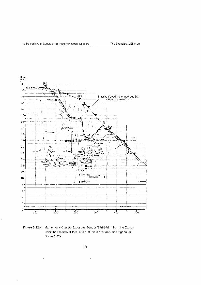
5 Paleoclimate Signals of Ice-Rich Permafrost Dewosits The Expedition LENA 99
H, m
nactive ("dead") thermocirque BC ('Baydzherakh City")
650 600 550 500 450 400
Figure 5-22b: Mamontovy Khayata Exposure, Zone 2 (375-675 m from the Camp).
Combined results of 1998 and 1999 field seasons. See legend for
Figure 5-22a.
The Ex~edition LENA 99 5 Paleoclimate Signals of Ice-Rich Permafrost Dewosits
5.2.4 stratigraphic and sedimentological observations
Several stratigraphic units can be recognized in the upper part of the MKh
yedoma hill. Some of them can be traced for 100-200 m along the strike, and for
that reason can be considered as the general elements of the yedoma section.
The top soil layer, overlying Ice Complex and cutting large ice wedges, is
usually 0.5-0.7 m thick (Figure 5-23) - altitude ca. 39.2-38.5 m a.s.1. in the
main profile.
The upper "peat layer". The baydzherakhs of the topmost level have the
core, highly enriched with poorly decomposed plant remains. Strictly
speaking, they do not form a true peat layer, but numerous separated
inclusions of peat ("peat hummocks") in the ice-rich silty sediment. They
consist mostly of perfectly preserved sphagnurn moss and sedges, and are
quite likely of the autochthonous origin. In Course of the baydzherakh
thawing, these plant remains form large hanging fringe, and from the
distance they appear to be a continuous peat layer. The sediment, including
the "hummocks", is ice-saturated silt, with large inclusions of very pure ice.
Since these peat accumulations build the core of the baydzherakhs, occur
between the large ice wedges, and have lateral deformations (bent upward
along the contact with the ice wedges), they most evidently form a part of Ice
Complex, and are not superimposed on it. The thickness of this unit is up to
2.3-3.0 m. (altitude ca. 38.5-36.0 m a.s.1. in the main profile.
The upper sand layer. The base of the baydzherakhs of the topmost level
consists of fine to medium-grained silty sand with vaguely pronounced
bedding, possibly with some fine cross-bedding. The sand has massive
cryo-structure and relatively low ice ccntent, but the latter increases to the
bottom of the unit, where thick (1-2 cm) horizontal ice bands occur. The
layer contains relatively few grass roots, but is rather rich for insect and plant
macrofossils. The thickness of the sand layer varies from 1 to 2 m - altitude
ca. 36.0-34.0 m a.s.1. in the main profile.
Ice-rich silt. It is exposed between the baydzherakhs of the toprnost level
and the next level downward, on a gently sloping surface under
thermodenudation, locally covered by mud flows from thawing baydzherakhs
above it. This sediment contains enormous amount of structure-forming ice
(lens-like and reticulated cryostructure), and is rather rich with grass roots
and tiny woody sticks (dwarf shrubs ?), though not visible in the section. The
thickness of this unit is estimated as up to 4 m (in the main profile it includes
a longitudinal ice wedge) - altitude Ca. 34.0-30.0 m a.s.1. in the main profile.
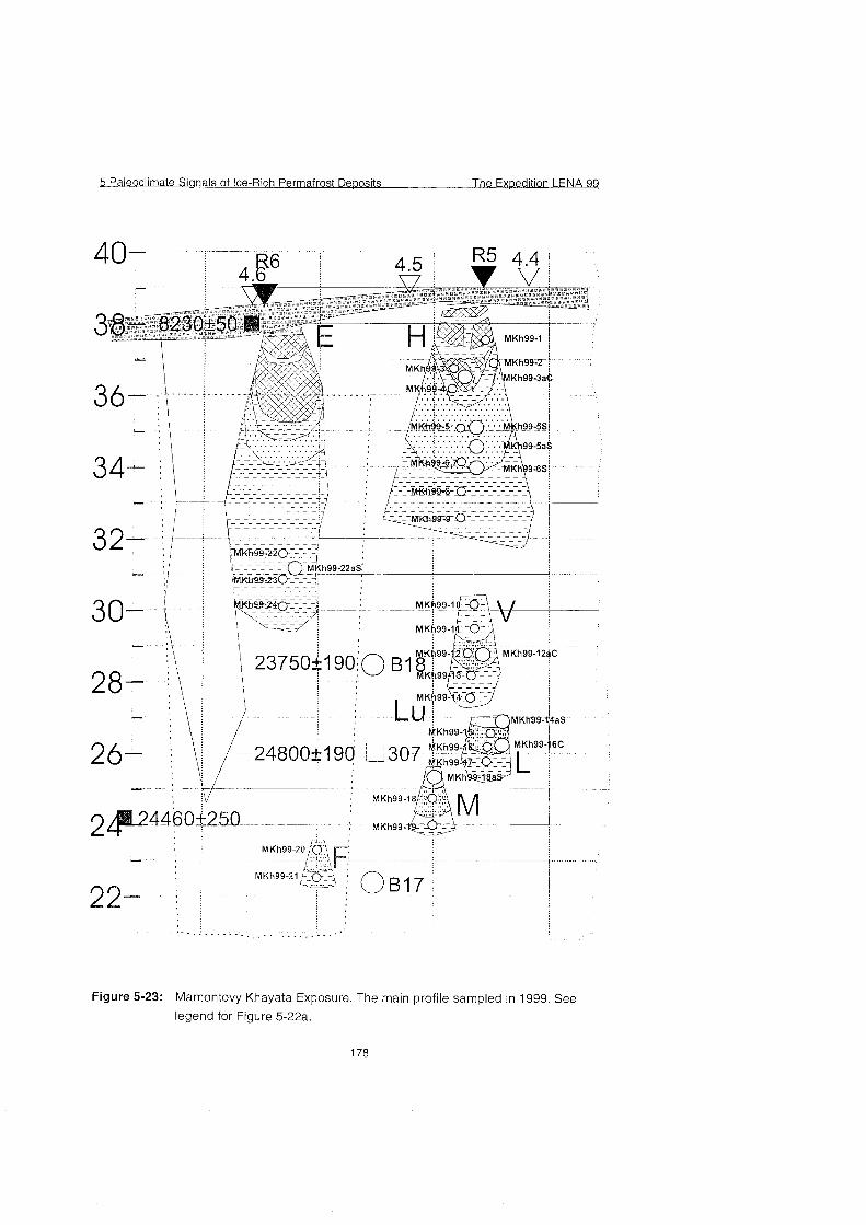
5 Paleoclimate Sianals of Ice-Rich Permafrost De~osits The Ex~edition LENA 93
Figure 5-23: Mamontovy Khayata Exposure. The main profile sampled in 1999. See
legend for Figure 5-22a.
The Expedition LENA 99 5 Paleoclirnate Sianals of Ice-Rich Perrnafrost Deposits
Further down the section, four more levels of baydzherakhs have essentially
similar structure to each other. Their core is presented by a layer of less than 1
m thickness, permeated by numerous grass roots. For some reasons (partly
because of their relatively low ice content), these layers support a steeper
(almost vertical) slope, actually forming the sea-side exposure of a
baydzherakh, It seems that the whole network of baydzherakhs is pre-defined
by the occurrence of these layers. Due to the shape of mini-cliffs and their
slightly darker color, they can often be traced across several neighboring
baydzherakhs of the Same altitude. They are always underlain by silt with a very
rich ice content (at the foot of each particular baydzherakh and between them in
the vertical profile) and overlain by seemingly more sandy layer. The middle
layer is especially rich for grass roots, sometimes forming furcating Systems
(branches); it also includes woody sticks (twigs or roots of dwarf shrubs),
usually without any traces of rounding. Woody roots are even more common in
the upper sandy layer, but grass roots also present there,
These three units - the lower ice-rich silt, the middle grass root layer, and the
upper sandy layer - form a cycle, repeating in each baydzherakh in the studied
part of the section. Since our colleagues who made more detailed '98 work at
the MKh section concluded that the whole Ice Complex section represents a
succession of paleosols, marked by vertical grass roots and shrub remains
(Siegert et al., 1999; Schirrmeister et al., submitted), quite arbitrarily, we called
the middle layer "paleosol". It should be, however, noted, that the buried soils,
described up to the fine details in the middle part of the cliff ('98), seem different
from what we could observe in the upper part. For instance, we failed to
observe pronounced brown spots, or peat inclusions, or general peaty
composition of our "soils" in the interval of 23 to 30 m a.s.1. Neither we observed
any cryoturbations, typical for buried soils. Finally, the frequent alteration of soil
and mineral horizons, such as described in baydzherakhs KB 2, KB 3, KB 4, KB
6 (13-20 m a.s.1.) (Siegert et al., 1999, Tab. A5-2) is quite different from what we
observed in the upper part. A few soil horizons described in the top part of the
section in '98 (op. cit.) presumably come from our upper "peat layer". So, it is
possible that the buried soils change their character through the MKh section
from its middle to the upper part. Hopefully, that can be solved after the analytic
work is done through the whole section.
Thus, in the interval 23-30 m a.s.1. we recognized four horizons as possible
subaerial surfaces, which we currently label as paleosols "V" (28.5-29.2 m
a.s.l.), "L" (26.0-26.7 m ), "M" (24.2-25.0 m), and "F" (23.0-23.7 m). It is possible
that at least one more soil horizon is present in the interval of 31 .O-32.5 m a.s.l.,
5 Paleoclirnate Signals of Ice-Rich Perrnafrost Deoosits The Exoedition LENA 99
poorly exposed in the main profile, but it was not clearly Seen in the profile R6
as well.
5.2.5 Cryolithological observations
The whole upper part of the MKh section contains a system of thick ice wedges
of a presumably single generation. They have been described many tirnes
before, but a few cryolithological features that we observed are worth mentioning. First, it seems possible that the conclusion about the extreme width
of the ice wedges in MKh - up to three times wider than the ground columns (Tomirdiaro, 1984) - can be to some extent exaggerated. Such an Impression can be partially related to the oblique cross-cuttings of the wedges in the cliff, partially to a sharp widening of the ice wedges in the very top part of the cliff, which is the best exposed and impressive. While the conic or pyramidal shape
of the baydzherakhs in the middle part of the cliff seems primarily due to their
thermal denudation, the topmost level of the baydzherakhs, as we observed, originally has such a shape. That is due to the fact that in the uppermost 2-3 m of the cliff the ice wedges are really much wider than the ground columns, but at
5-6 m from the top they are already almost equal to each other in their width.
A possible explanation of this fact is that the Pleistocene (yedoma) ice wedges
are subjected to the recent epigenetic frost cracking and the formation of
younger wedges, entering the older ones from the top. We observed sorne
vertical off-shoots of ice, raising from the middle of a large ice wedge into the top soll up to the bottom of the active layer. It is possible that the corresponding portion of the large wedge is a-ctually represented by a younger generation of
ice (some vertical stripes of more white ice were observed). But this phenomenon requires further special study by permafrost experts.
Our observations did not confirm the earlier statement (Tomirdiaro &
Chernen'ky, 1987) that the Ice Complex sediments in MKh display strong
upward bending at the contacts with ice wedges only in the lower part of the section, while in the upper these deformations are much less pronounced, to which these authors attach important genetic meaning. Throughout the whole upper part of the section studied by us, lateral deformations in the ground
blocks are extremely strong. They are most clearly outlined by a layer of silt with very high ice content and fine lens-like cryogenic structure, occurred in the basal parts of most baydzherakh sections. In the lateral zones of the ground
column this layer bends up along the contact with the ice wedge for up to one meter or more, acquiring almost vertical position.
The Exoedition LENA 99 5 Paleoclirnate Signals of Ice-Rich Permafrost De~os i t s
5.2.6 The sampling methods and the samples collected
In the studied 17-m interval of the section (22 to 39 m a.s.1.) we took 24 basic
(sediment) samples (Table A5-13, appendix), from which we separated 24
pollen samples and picked 17 samples of grass roots and twigs for the AMS-
dating from them (some more have been picked later in Potsdam). All basic
samples were taken from frozen sediment. Also, 10 samples were taken from
freshly melted sediments on steep baydzherakhs walls for small mammal
remains, insect and plant macrofossils. Almost all samples contained visible
insect fossils. As the previous experience showed, even using the sieve of 0.5
mm mesh can result in the loss of some smallest plant and insect fossils. To
avoid that, we tried a new method of sample processing. A sample was
repeatedly floatated in the bucket, and then the silty suspension with many
floating organic remains was poured intc fabric bags, slightly squeezed, left to
drain and dried. Much of silt particles went out with water through the fabric
pores, but hopefully all the smallest fossils were preserved. Although some
mineral remained in the sample, with this rese~at ion we labelled these parts of
the sample as "light fraction". The heavy fraction, which remained in the bucket,
was either processed in the Same way (through another fabric bag), or
screened through the 0.5 mm sieve. The methods applied to particular samples
are listed in Table A5-13.
5.2.7 Mamma1 bone collecting
In addition to about 600 bones, collected in the MKh area in 1998, we found and
identified 300 more bones, about 220 of them have been preserved and
transported to Moscow (Table A5-14 and A5-15). As in 1998, most bones were
collected On the shore and sand bars. Only 16 bones were found within the
exposure itself (there is some information that before our arrival to the site, the
bones, recently appeared in the mud flows, have been picked up by a team of
illegal bone collectors). Among those few bones, however, there are some
important findings, especially wanted in the upper Part of the cliff.
In a frozen wall of baydzherakh Mal (Station 900 m from the Camp, height 33.5
m a.s.1.) a partial skull of baby mammoth was found. Besides the fact that
almost no bones have been found in situ in the upper part of the MKh cliff
before (and they are very much needed for the dating), this one is actually a
very rare paleontological find because cf the juvenile age of this mammoth, The
specimen is a facial fragment of skull with milk teeth and two still unerupted
tusks of the permanent generation, each about 10 cm long. The baby was
probably about 1 year old. Also in situ, on the other side of the Same
5 Paleoclimate Sianals of Ice-Rich Permafrost De~osits The Ex~edition L E N A X
baydzherakh another fragment of a baby mammoth skull was found (occipital),
which can belong to the Same individual. A few meter down from this site, at ca
28 m a.s.l., a humerus of a baby mammoth was found in the mud, that possibly
may belong to the Same individual.
Another interesting find is a shed ander of a young deer, found in the top soil
layer (the first find of an in situ bone in this unit). Unfortunately, because of the
young individual age, it is hard to decide whether it belongs to reindeer, or to
moose, but the bone can be used for the AMS dating, and also is interesting
because of its peculiar preservation.
A bone of hare was found in baydzherakh Ma2 (28 m a.s.l.), and a bone of
reindeer on the slope of a baydzherakh at Stn. 700 (29 m a.s.1.). Because of
their high position in the section, these bones, as well as a few other bones,
found in the upper part of the MKh cliff, may be usefui for the AMS dating.
The bones collected on the shore and bars almost do not change the 98'
mammal species list, with one important exception. For the first time On
Bykovsky Peninsula a bone is found that can be older than the Late
Pleistocene. This is a fragment of a lower jaw of a very large horse. As far as
we know, during the time of deposition of the main Ice Complex (late Middle to
Late Pleistocene) horses in this region were represented by small caballine
forms. The horses of such a large size like a fragment found were known in the
Early and Middle Pleistocene (large caballine forms) and in the Late Pliocene - Early Pleistocene (large plesippine forms, such as Equus verae Sher). This find,
though rather poor (no teeth preserved, so the exact taxonomic position cannot
be solved) and possibly redeposited from the sediments, currently not exposed
at this site above the sea level, may confirm the existence of the Middle or even
Early Pleistocene sediments in this area (cf. Slagoda, 1991).
5.2.8 Conclusion
A small size of the '99 Bykovsky team (as compared with '98) did not allow to
carry out the study of the isotopic composition of fossil ice, and a more detailed
research of the geocryological features of various sedimentary facies. But as a
whole, the main research tasks were fulfilled, and it is clear that when the
analytical studies and other laboratory work are completed, the combined
evidence, obtained in 1998 and 1999 will make the Mamontovy Khayata section
a unique and most detailed interdisciplinary archive of the Late Pleistocene
(Kargin-Sartan) time not only for the Laptev Sea area, but for the whole Siberian
Arctic.
The Exoedition LENA 99 5 Paleoclimate Sianals of Ice-Rich Permafrost Deoosits
5.3 References Alekseev (1 989): Quaternary stratigraphy of the Novosibirsk Island.- In: Yanshin, A.L. (ed.):
Quaternary Period.- International Geological Congress, XXVIII Session; Moscow:
Nauka, 1989: 159-1 6 (in Russian).
Alekseev, M.N.; Arkhangelov, A.A.; Ivanonova, N.M.; Patyk-ara, N.G.; Plakht ,I.V.; Sekretov,
S.B.; Shkarubo, S.I. (1991): Laptev Sea and East-Sibirian Cenozoic - Atlas of paleogeographic map of Eurasian shelf during the Mesozoic and Cenozoic.- volurne 1
Moscow, Inst. of Geology, Russian Academy of Science: 1-20 (In Russian).
Arkhangelov, A. A., Konishev, V. N., Rozenbaum, G. E. (1989): Primorsko-Novosibirsky Region,
Regional cryolithology, In: Popov, A. I. (Ed.), Moscow University Press, p. 128-151 (In
Russian).
Arkhangelov, A.A., Mikhalev, D.V., Nikolaev, V.I. (1996): Reconstruction of formation conditions
of permafrost and climates in Northern Eurasia. In: Razvitie oblasti mnogoletney
merzloty i periglyatsial'noy zony Severnoy Evrazii i usloviya rasseleniya drevnego
cheloveka., M., 85-1 09 (In Russian).
Arkhangelov, A.A.; Mikhalev, D.V. & Nikolaev, V.I. (1996): Reconstruction of formation
conditions of permafrost and climates in Northern Eurasia.- In: Velichko, A.A.,
Arkhangelov, A.A., Borisova, O.K. et al. (eds.): History of permafrost regions and
periglacial zones of northern Eurasia and conditions of old human settlement; Moscow,
Institute of Geography, Russian Academy of Science , 1996: 85-109 (in Russian).
Beer, J,, M. Andree, H. Oeschger, B. Stauffer, R. Balzer, G. Bonani, C. Stoller, M. Suter, W.
Wolfli, & R. C. Finkel (1 985): Be-10 variations in polar ice cores. Greenland Ice Core;
Geophysics, Geochemistry and the Environment, 33, p. 66-70.
Cherskiy, I.D. (1 891): The description of the collection of post-Tertiary mammals, collected by New Siberian expedition of 1885-86, Zapiski Imper. Akadernii Nauk (Prilozhenie k LXV
tomu), 65, 1, 1-707 (In Russian).
Drachev,S.S. and Savostin, L.A., (1993): Ophiolites of the Bol'shoi Lyakhov Island (Novosibirsk
Islands). Geotektonika, 6: 33-51 (in Russian).
Grechichshev, S.E.; Chistinov L.V., Shur, Yu. L. (1980): Kryogenesis of physico-geological
processes and their prognosis.- Moscow: Nedra, 1980: 324 p. (in Russian).
Grinenko, O.V.; Sergeenko, A.I.. Belolubsky l,N. (1998a): Paleogene and Neogene of North-
East Russia. Part 1.: Regional stratigrafic scheme of Paleogene and Neogene deposits
of North-East Russia and Explanatory note.- Publications of Yakutian Centre of
Science Siberian Branch, Section of the Russian Academy of Science 1998: 22 P.,
Yakutsk (in Russian).
Grinenko, O.V.; Sergeenko, A.I.. Belolubsky 1,N. (1998b): Paleogene and Neogene of North-
East Russia. Part 1.: Regional stratigrafic scheme of Paleogene and Neogene deposits
of Eastern and Explanatory note.- Publications of Yakutian Centre of Science Siberian
Branch, Section of the Russian Academy of Science, 1998: 36 p., Yakutsk (in Russian).
Ivanov (1968):Stratigraphy and correlation of Neogene and Quaternary deposits in the subarctic
plain of north-east USSR.- In: Problems of study of Quaternary. III. All-Union conference
for Quaternary study (Khabarovsk, 1968), thesis.- Publication of Khabarovsk branch of
the Geographie Society of USSR: 70-72 (in Russian).
5 Paleoclimate Sianals of Ice-Rich Permafrost De~osits The Exoedition LENA 99
Ivanov (1970): The fundamental stage of the development of subarctic plain.- In: Northern Ice
Sea and his coast during the Cenozoic; Leningrad, Hydrometeorological Publ., 1970:
474-479 (in Russian).
Ivanov, O.A. (1972): Stratigraphy and correlation of Neogene and Quaternary deposits in the
subarctic Part of East Yakutia.- Problems of study of Quaternary period.- Moscow,
Nauka: 202-21 1 (in Russian).
Katasonov, E.M. (1979): About the terms ,,thermokarst" and ,,thermokarst forms of the relief".- In:
Structure and absolute geochronology of alas deposits in Central Yakutia. - Nauka,
1979: 4-7 (in Russian).
Krasny, L Y. (1981): Geology of Yakutia ASSR: Nedra: 300 p. Yakutsk (in Russian)
Kravchinsky, V. A., Pek, J., Cakhan H. et al., (1998): Magnetostratigraphic scale of Late
Cenozoic of central Asia according to data of deep drilling at Baikal; In: Global changes
of nature, Dobrecov, N. L. and Kovalenko V. I. (Eds.), Novosibirsk RAN (In Russian).
Kunitsky, V. V. (1996): Chemical composition of continuous grown ice wedges of the Ice
Complex.- In: Cryolithozone anf groundwater of Siberia, part 1.: Morphology of the
cryolithozone, Publ. of Melnikov Permafrost Institute Yakutsk, Russian Academy of
Science, Siberian Branch: 93-1 17, Yakutsk (in Russian).
Kunitsky, V. V. (1998): The Ice Complex and cryoplanation terraces on Big Lyakhovsky Island,.-
In: Kamensky R.M.; Kunitsky, V.V.; Olovin, B.A. & Shepelev, V.V. (eds.): Problems of
geocryology (collected paper)., Publ. of Melnikov Permafrost Institute Yakutsk, Russian
Academy of Science, Siberian Branch: 60-72, Yakutsk (in Russian).
Kunitsky, V. V. (1999a): Ice complex and hypothesis of the sartan glaciation in Northern
Yakutia.. Quaternary Environment of the Eurasien North (QUEEN). Third workshop,
Oystese, 16-1 8 April 1999, abstracts , p. 30.
Kunitsky V. V. (1999b): Study of Ice Complex deposits with methods of monitoring of natural
outcrops.- international conference ,,Monitoring of Cryoshere", Pushchino, 20-23 April
1999, abstracts: 124-1 25 (in Russian).
Lazarev, P. A. (in press): On the new findings of mamrnoth remains with soft tissues on
Novosibirsk Islands. Proc. Of Paleontological Institute, RAS
Lozhkin, A. V. (1977): Radiocarbon dating of Upper Pleistocene deposits on Novosibirsk islands
and age of the Yedoma Suite of Northeast USSR. Doklady AN SSSR, 235,2,435-437
(In Russian).
MacKay, J. R. (1983): Oxygen isotopic variation in permafrost, Tuktoyaktuk peninsula area,
NWT. Geol. Surv. Can. Pap., B, 18, p. 67-76.
Meyer, H., Dereviagin A. & Syromyatnikov I. (1999): Ground ice studies. - In: Rachold, V. (Ed.):
Expeditions in Siberia in 1998, Reports on Polar Research 315, p. 155-163
Nagaoka, D. (1 994): Properties of Ice Complex deposits in Eastern Siberia. In: Inoue, G. (ed.):
Proceedings of the Second Symposium on the Joint Siberian Permafrost Studies
between Japan and Russia in 1993, Isebu Tsukuba-Japan, p. 14-1 8.
Nagaoka, D., Saijo, K., Fukuda, M. (1995): Sedimental environment of the Edoma in high Arctic
eastern Siberia. In: Takahashi, K., Osawa, A., and Kanazawa, Y. (eds.): Proceedings of
the third Symposium on the Joint Siberian Permafrost Studies between Japan and
Russia in 1994, Tsukuba, Japan, p. 8-13.
Neotectonic map (1984): Neotectonic map of SSSR 1: 4.000.000 (in Russian).
The Expedition LENA 99 5 Paleoclimate Sianals of Ice-Rich Permafrost Deposits
Popov, A.I. (1967): Cryolithology. - Moscow University Press, 304 p. (in Russian).
Romanovsky, N.N. (1958a): Permafrost structures in Quaternary deposits.- In: Science College
report, Geological-geographical Serie, No. 3; Moscow: 185-189 (in Russian).
Romanovsky, N.N. (1958b): Paleogeographic conditions of formation of the Quaternary
deposits on Bol'shoy Lyakhovsky Island (Novosibirsky Islands).- In: Questions of
Physical Geography of Polar region: Publications of Moscow State University, 1958: 80-
88 (in Russian).
Romanovsky, N.N. (1958~): New data about teh construction of Quaternary deposits on
Bol'shoy Lyakhovsky Island (Novosibirsky Islands) .- In: Science College report,
Geological-geographical Serie, No. 2; Moscow: 243-248 (in Russian).
Romanovsky, N.N. (1961a): Erosional-thermokarst kettles in the north of the coastal lowland of
Yakutia and Novosibirsky Islands.- In: Permafrost studies, issue 1: 124-144 (In
Russian).
Romanovsky, N.N. (1961 b): About the construction of Yana-lndigirka Coastal Lowland and its
forming conditions.- In: Permafrost studies, issue 2: 129-139 (In Russian).
Romanovsky, N.N. (1977) Ice wedges system formation. - Novosibirsk, 216 p. (in Russian).
Schirrmeister, L., Siegert, Ch., Kunitzky, V., Grootes, P., Erlenkeuser, H. (2000): Late
Quaternary ice-rich permafrost sequences as an archive for the Laptev Sea Region
paleoenvironment. Geologische Rundschau (submitted).
Sher, A.V.; Kaplina, T.N.; Ovander, M.G.; (1 987): Unified regional stratigraphic scheme for
Quaternary deposits in the Yana-Kolyma Lowland and ita mountain surroundings.
(Scheme I). - In: Resolution of the Joint stratigraphic Conference on Quaternary of the
East USSR (Magadan 1982). Note of explanation to the regional stratigraphic diagrams
of Quaternary of the East USSR. Magadan, Northeastern Complex Research Institute,
Far-Eastern Branch, Siberian Department of the Academy of Sciences of USSR. P. 29-
69 (In Russian).
Shumsky, P.A. (1960): About the genesis of ice wedges. - Works of INMERO 26, p. 81-97 (in
Russian).
Siegert, C. & Romanovsky, N.N. (1996): The Laie Pleistocene "Ice Complex" - a phenomenon
of the non-glaciated areas of Northern Eurasia. QUEEN Workshop, Strasbourg,
November 1996.
Siegert, C., et al. (1999): Paleoclimate signals of Ice-rich Permafrost - In: Rachold, V. (Ed.):
Expeditions in Siberia in 1998, Reports on Polar Research 315, p. 145-259.
Slagoda, E.A. (1991): Microstructure features of the deposits of Ice Complexes in Northern
Yakutia (by the example of Bykov Peninsula). In: Gilichinskiy D.A., Ed. Kriologiya pochv.
Pushchino, IPFS PNTs AN SSSR, 38-47 (In Russian)
Solomatin, V.I. (1974): The structure and genesis of the polygonal ice wedges in the
Pleistocene deposits of Northern Yakutia. - In: Popov, A. I. (Ed.): Problems of
Cryolithology, Vol. 4, Moscow University Press, p. 7-29. (In Russian).
Telepnev (1981): Subaquatic frozen Zone of the coastal part of Bol'shoy Lyakovsky Island.-
Kryolithozone of the arctic shelf; C: 44-53; Permafrost Institute Yakutsk, Section of the
Russian Academv of Science.
5 Paleoclimate Sianals of Ice-Rich Permafrost Deposits The Expedition LENA 99
Tomirdiaro, S.V. (1 984): Periglacial landscapes and loess accumulation in the Late Pleistocene
Arctic and Subarctic. In: A. A. Velichko, H. E. Wright,Jr. and C. W. Barnosky, Eds., Late
Quaternary environments of the Soviel Union, London, The University of Minnesota
Press, Longman, 1984,141 -146.
Tomirdiaro, S.V. & Chernen'kiy, B.I. (1987): Cryogenic deposits of Fast Arctic and Subarctic. AN
SSSR Far-East Science Centre, 196 p. (in Russian).
Vaikmae, R. (1991): Oxygen-18 in Permafrost Ice.- International Symposium of the Use of Isotope Techniques in Water Resources Development. - International Atomic Energy
Agency, Vienna, 11 -1 5 March 1991.
Vangengeim, E.A. (1963): Fauna of Quaternary mammals from the Bol'shoy Lyakhov Island. In:
Novosibirskie ostrova. Trudy Arkticheskogo i Antarkticheskogo nauchno-
issledovatel'skogo instituta, 224, 73-87 (In Russian).
Yelovskaya (1987): Classification and diagnosis of permafrost soils in Yakutia.- Publ. Yakutian
Section of Sibirian Branch of Academy of Science USSR: 172 p. (in Russian).
The Exwedition LENA 99 5 Paleociimate Sianals of Ice-Rich Permafrost Deposits
5.4 Appendix A5-1: Profile map of sample positions (German version).
A5-1-1: Legend.
A5-1-2: R-section.
A5-1-3: L-section.
A5-2: Profile map (Russian version).
A5-2-1: Schematic profile of permafrost deposits. South coast of Bol'shoy Lyakhovsky Island.
A5-2-2: Bol'shoy Lyakhovsky Island, south coast, F?-side exposure.
A5-2-3: Bol'shoy Lyakhovsky Island, south coast, L-side exposure.
List of sediment samples collected on Bol'shoy Lyakhovsky Island.
List of OSL-samples.
List of alas samples.
List of water and ice samples collected on Bol'shoy Lyakhovsky island during
field season 1999.
List of bone samples.
List of small fossil samples (rodents, insects, ostracodes, seeds).
List of peat samples for botanical analysis.
List of mollusc samples.
List of samples for paleomagnetics.
Description of soil profiles.
List of samples collected by the Bykovsky team at the upper part of MKh main section in 1999.
The composition of the mammal bone collection (Bykovsky Peninsula, 1999).
Mammal bones, found in 1999 within the Mamontova Khayata cliff (Bykovsky
Peninsula).
5 Paleoclimate Sianals of Ice-Rich Perrnafrost De~osits The Exoedition LENA 99
A5-1: Profile map of sample positions (German version)
A5-1-1: Legend.
Legend
l!lm Active layer lce wedge
Fluviatil sedirnents lce wedge pseudornorphs
p y - - - - Beach- and rnudflat sedirnents Geological boundary
1 shore cliff Log sedirnents
Alas sedirnents (subaquatic) GuI,ies
D Alas sedirnents (subaerial) Sediment sarnples ( S )
Peat EI OSL sarnples (OSL)
E 3 lce Cornplex lce sarnples (I)
Therrnokarst rnounds lce crystallography (F)
3 Kuchchuguy (subaerial) Bone (0) I teeth (R) sarnples
** Kuchchuguy (subaquat~c) Bone fields
nsects 1 Molluscs sarnples (B)
rn Reworking horizon Plant rernain sarnples (OS)
I Olyor Paleornagnetic sarnples (PM)
Weathering crust of the basernent
Debris flow
The Ex~edition LENA 99 5 Paleoclimate Sianals of Ice-Rich Permafrost De~osits
A5-1: Profile map of sample positions (German version).
5 Paleoclimate Signals of Ice-Rich Permafrost Decosits The Ex~edition L E N A B
A5-1-2: continuation.
The Exoedition LENA 99 5 Paleoclimate Signals of Ice-Rich Permafrost Deposits
A5-1-2: continuation.
5 Paleoclimate Signals of Ice-Rich Permafrost Deoosits The Exoedition LENA 99
A5-1: Profile map of sample positions (German version).
A5-1-3: L-section.
The Exoedition LENA 99 5 Paleoclimate Signals of Ice-Rich Permafrost Dewosits
A5-1-3: continuation.
5 Paleoclirnate Sianals of Ice-Rich Perrnafrost De~osits The Ex~edition L E N A B
A5-1-3: continuation.
The Expedition LENA 99 5 Paleoclirnate Signals of Ice-Rich Perrnafrost Dewosits
A5-2: Profile map (Russian version).
A5-2-1: Schematic profile of permafrost deposits. South coast of Bol'shoy Lyakhovsky
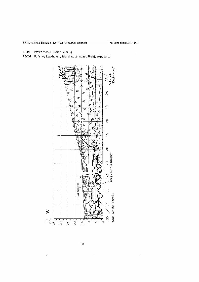
5 Paleoclirnate Sianals of Ice-Rich Permafrost De~os i ts The Exwedition LENA 93
A5-2: Profile map (Russian version).
A5-2-2: Bol'shoy Lyakhovsky Island, south coast, R-side exposure.
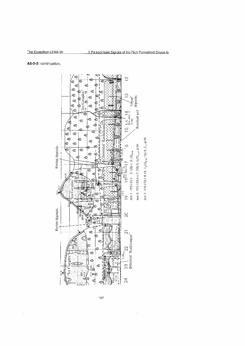
The Expedition LENA 99 5 Paleoclirnate Signals of Ice-Rich Perrnafrost Deposits
A5-2-2: continuation
", * . ",
i 0 CL
u
. - 0 ..-. ra
Â¥ W
/ 2
03 0 E! . .
(-0
3 . .
U") 3
à . . P.
? <-0 0 U")
+ 03
C"'
C^J
<B 0>
0
% Co" . . z t̂l . . (-0 3 . . U") - 00 2 U") + 03
C"'
Co
0 <Å
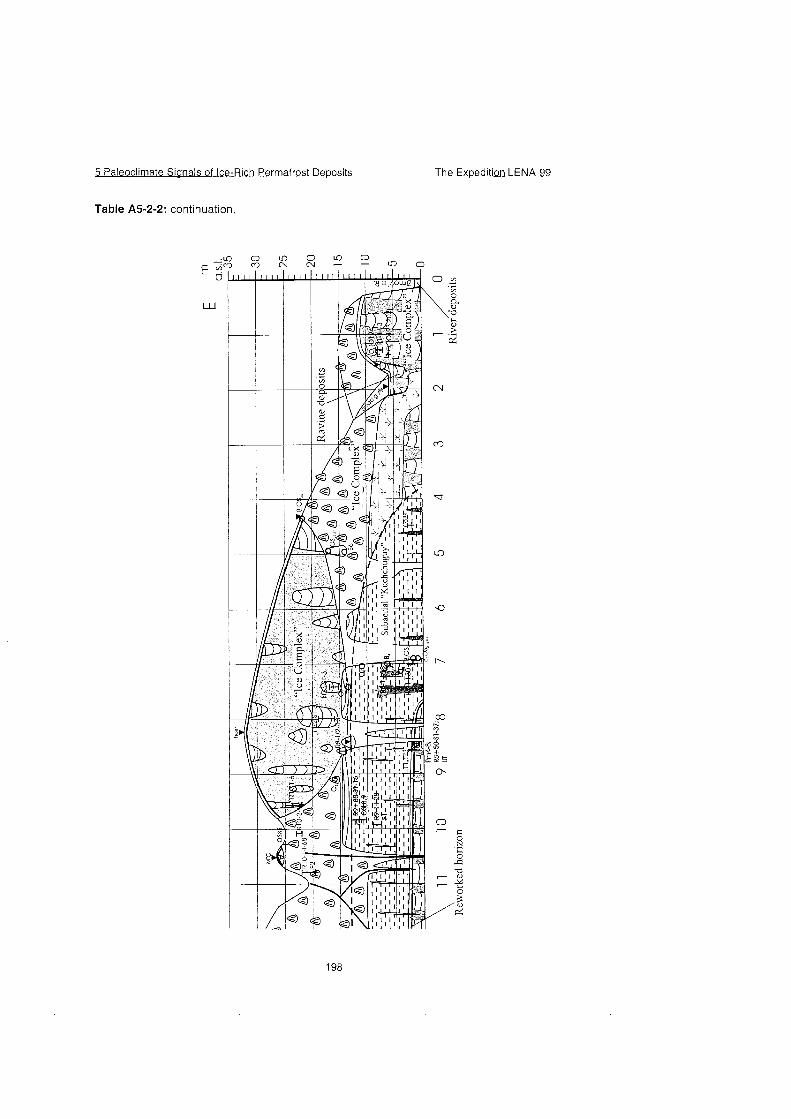
5 Paleoclimate Sianals of Ice-Rich Permafrost Deuosits The Exuedition L E N A B
Table A5-2-2: continuation.
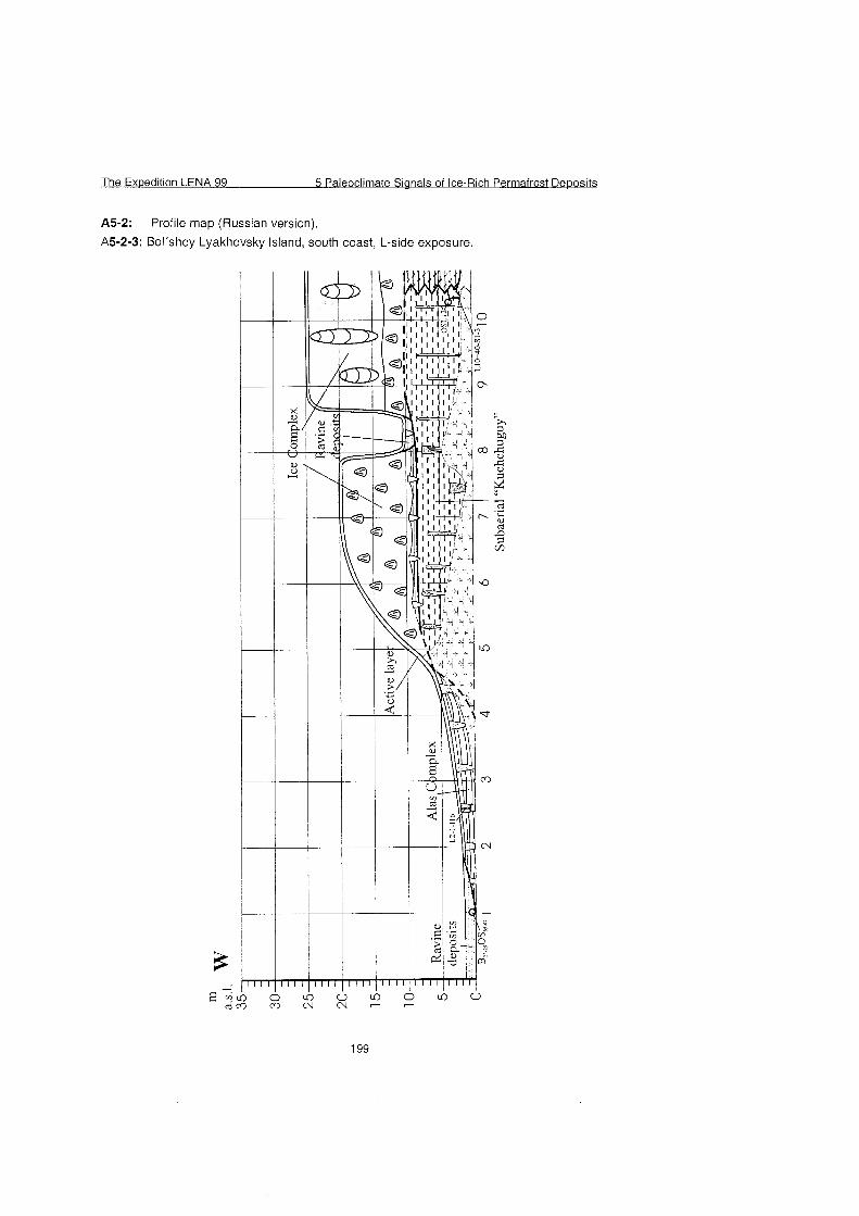
The Expedition LENA 99 5 Paleoclimate Sianals of Ice-Rich Perrnafrost Dewosits
A5-2: Profile map (Russian version).
A5-2-3: Bol'shoy Lyakhovsky Island, south coast, L-side exposure.
The Exoedition LENA 99 5 Paleoclimate Sianals of Ice-Rich Permafrost Deoosits
A5-3: List of sediment samples collected on Bol'shoy Lyakhovsky Island.
5 Paleoclirnate Sianals of Ice-Rich Perrnafrost De~osits The Expedition LENA-
A5-3: continuation,
- U") (0
l C M N
)(Dt.
The Expedition LENA 99 5 Paleoclimate Sianals of Ice-Rich Permafrost Deoosits
A5-3: continuation.
- -
-
C C
t- C
r 1
-r C t -
C
0
- 0
C
-
-
- 2 2 3 ,- 'f. - . C-
r C
N) 0 ¥t-
no.
8 1
8 2
8 3
8 4
8 5
8 6
8 7
8 8
8 9
9 0
91
92
9 3
9 4
sample
R14+40-S-7
R14+40-S-8
R14+40-S-9
R14+40-S-10
~8+50-S-I
R8+50-S-2
~8+50-S-3
R8+50-S-4
~8+50-S-5
~8+50-S-6
~8+50-S-7
~8+50-S-8
~8+50-S-9
~8+50-S-10
^> 01 U o o 2. -! C
EU 0' ?
Sediment typ
Kuchchuguy
Kuchchuguy
Kuchchuguy Kuchchugu~
peat
pest
peat
peat
pest
peat
peat
pest
peat
pest
l ight [m]
profile
2,6
3,6
4,3 5
0,05
0,1 0,13
0,16
0,19
0,22
0,25
0,28
0,31
0,34
altitude
[m, a.s.l.1
5,6
6,6
7,3 8
0,05
0,1 0,13
0,16
0,19
0,22
0,25
0,28
0,31
0,34
horizontal
position
R 850
remarks
thawed, dry, R14+40-OSL-7
thawed, dry
frozen
frozen
frozen
frozen
frozen
frozen
frozen
frozen
frozen
frozen
ice content
gravim. [%I 33 , l
27,7
carb.
+ -
no. sarnple Sediment typ bight [m] alt i tude 1 horizontal1 remarks 1 ice content 1 carb
1 09 ~8+50-S-25 pest 0,79 0,79 frozen, Unh-sarnple 1 1 0 ~8+50-S-26 pest 0,82 0,82 frozen, Unh-sample
1 1 1 ~8+50-S-27 pest 0,85 0,85 frozen, Unh-sample 1 1 2 ~8+50-S-28 pest 0,9 0,9 frozen, Unh-sample 1 1 3 ~8+50-S-29 pest 0,95 0,95 unfrozen 1 1 4 ~8+50-S-30 pest 1 1 unfrozen 1 1 5 ~8+50-S-31 pest 1 ,05 1,05 unfrozen
I I 6 ~ 8 + 5 0 - ~ - 3 2 pest 1 ,I 1 , I unfrozen
1 1 7 ~8+50-S-33 pest 1 ,15 1 ,15 unfrozen
1,2 1 2 unfrozen 1 ,25 1 ,25 unfrozen
1 20 ~8+50-S-36 O ~ Y O ~ 2 ,5 2 , s 47 , l - 1 2 1 R8+50-S-37 , Kuchchugu~ 3 , 3 ,
129 ITZ-2-2 alevrite 0,75 17,65 roots, Fe-impr. 48,9 -
1 30 1 TZ-2-3 alevrite 1 ,4 1 8 , 3 76,7 + 131 ITZ-3-1 alevrite 0,1 1 3 R 820 marker 13 m a.s.1. 101,4 -
1 32 1 TZ-3-2 peat inclusion 0 , 3 13,2 75,7 -
133 1TZ-3-3 alevrite 0 ,8 13,7 85,2 -
134 R22+60-S-1 Kuchchugu~ 1 1 R 2260 OSL-10 24,4 + -t
135 ~ 2 2 + 6 0 - ~ - 2 Kuchchuguy, peat incl. 1 ,05 1 ,05 OSL-11
I 36 ~ 2 2 + 6 0 - ~ - 3 Taberit 2 2
5 Paleoclimate Sianals of Ice-Rich Permafrost Dewosits The Exoedition LENA 99
A5-3: continuation.
The Exoedition LENA 99 5 Paleoclimate Signals of Ice-Rich Permafrost Deposits
A5-3: continuation. - F
4
- 1:t
a CG
- C +
.C
.- L
7-
u. .,- +
a a - U (t a a - V. lr
cc CT a -
- a
- lr C C\
-
> "3
U D .C
D ^ Ã̂! V, IT. 00
CT a - m r. 7- -
5 Paleoclimate Sianals of Ice-Rich Permafrost De~osits The Exoedition LENA 99
A5-3: continuation.
220 Li4-S-4 alas lake deposit 5,4 ice wedge pseudomorphosis
22 1 LI 3 + 8 0 - ~ - 1 older alas lake deposit 5 L 1380 subaquatic Kucheguy 26 + + peat incl. , younger alas
222 ~13+80-s -2 lake deposit 5,4 223 ~13+80 . .~ -3 younger alas lake deposit 5,42 41,7 (+) 224 L13+80-S-4 younger alas lake deposit 5,8 L1 3+80-OSL-15 49,5 (+9
D 01 U 0 0
3. 3 C
B). 0 3
stones of Khaotaaai Tas reaion
D UI U
no.
266
267
268
269
270
27 1
272
273
274
275
. " e
sample
L9-S-13
R13+50-grau
R13+50-gelb
~ 1 3 + 5 0 - g r ~ n
Rezent 1
Rezent 2
Rezent 3
KGT-1-1
KGT-1-2
KGT-1-3
1 iya-Y Igranit
sample for structure analyse
1 Khaptagai Tas
2 samples
2 samples perhaps only active layer of the thermo terracce
shells
0
g 0
-3 C
S). 0 3
Sediment typ
alevrite
weathering crust
weathering crust weathering crust
Lya-X sandstone
2,5 3,1
1
1,5
1,5
R8+50
R8+50
R9+85
R22+50
R22+50
R25
1 Khaptagai Tas
Olyor over the peat Kuchchuguy ice complex (?) Kuchchuguy taberite or lake deposit lake deposit
light [m]
profile
recent sample of waters bottom
recent sample of waters bottom
recent sarnple of waters bottom
recent alevrit
alevrite aeolian material (?)
Khaptagai Tas, pyatny medalion
Khaptagai Tas, between granite blocks
Khaptagai Tas, between granite blocks
altitude
[m, a.s.l.1
9,7 1
1,2
1,4
horizontal
position
R 1350
remarks ice content
gravim. [%I
carb.
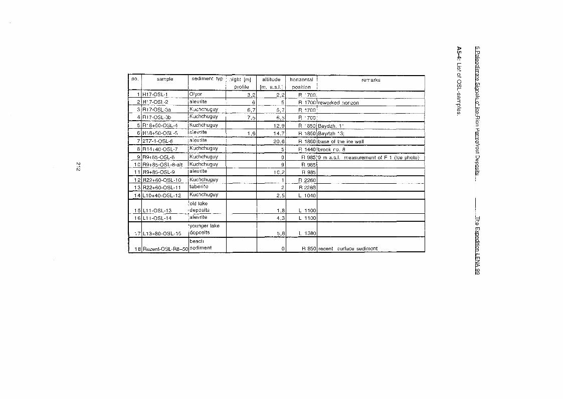
no. sarnple 1 sedirnent typ 1 hight [rn] 1 altitude 1 horizontal 1 rernarks
1 5
1 6
1 7
1 8
L1 1 -0SL-13
L1 1 -0SL-14
L1 3+80-OSL-15
Rezent-OSL-R8+50
old lake deposits alevrite
younger lake de~osi ts
beach se?dirnent
1,8
4,3
5,8
0
L 1100
L1100
L 1380
R 850 recent surface sedirnent
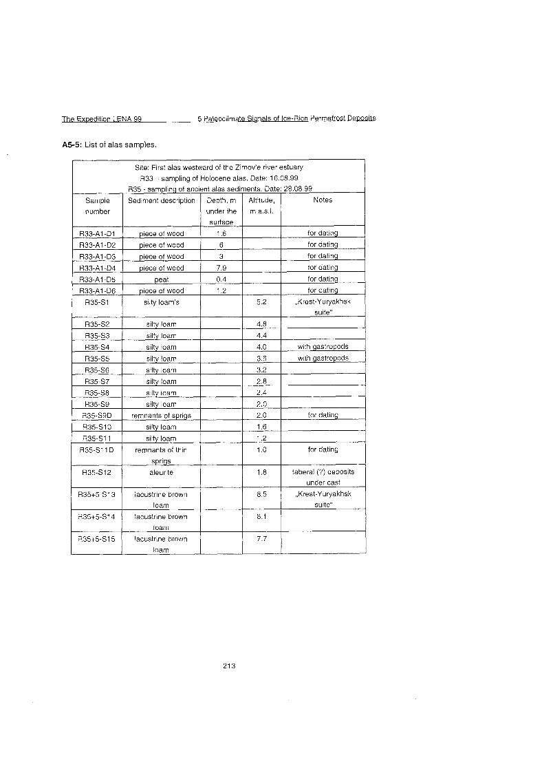
The Exoedition LENA 99 5 Paleoclimate Signals of Ice-Rich Permafrost De~osits
A5-5: List of alas samples.
Site: First alas westward of the Zimov'e river estuary
U33 - sarnpling of Holocene alas. Date: 16.08.99
loam
loam
7.7 R35+5-SI 5 lacustrine brown
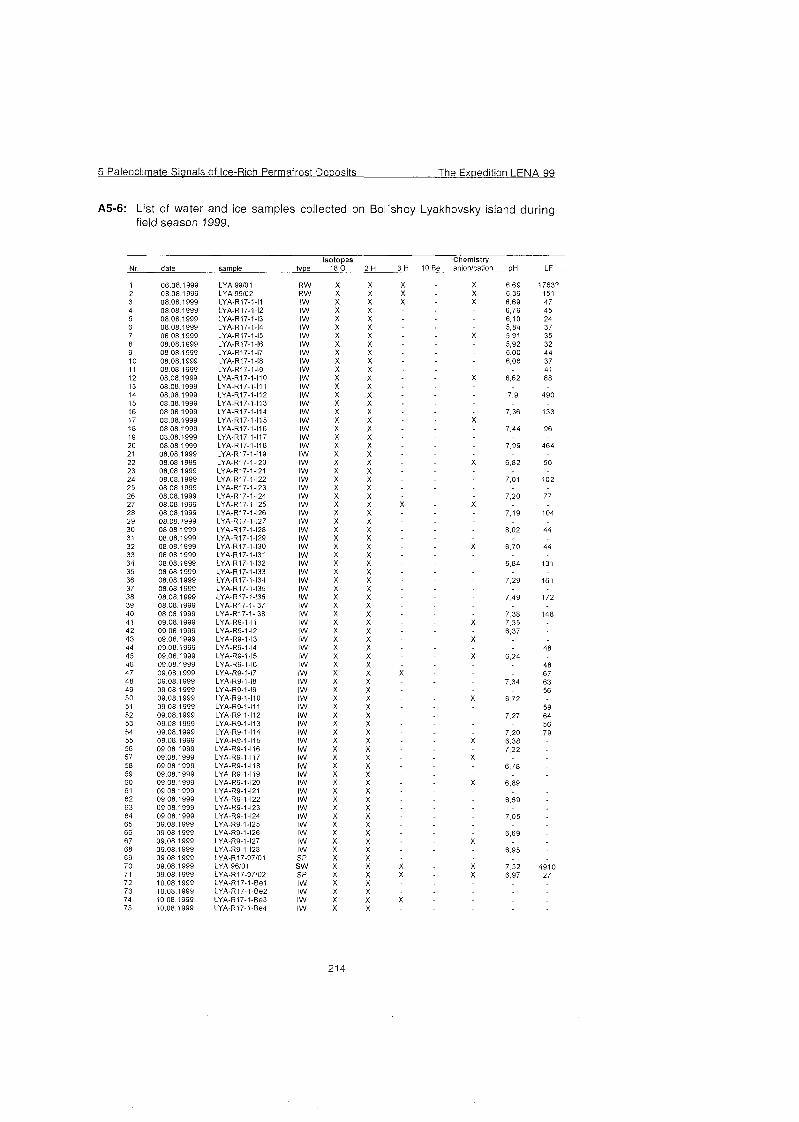
5 Paleoclimate Sianals of Ice-Rich Permafrost De~osits The Expedition LENA 99
A5-6: List of water and ice samples collected on Bol'shoy Lyakhovsky island during field season 1999.
Isotopes Chernistry Nr date sample type 18 0 2 H 3 H 10 Be anion/cation pH LF
1 06.08 1999 LYA 99/01 R W X X X X 6.69 17637 2 08.08 1999 LYA 99/02 R W X X X - X 6.39 151 3 08.08 1999 LYA-R17-1-17 I W X X X X 6.69 47 4 08 08 1999 LYA-R17-1.12 IW X X 6.79 45 5 08 08 1999 LYA-R17-1-13 IW X X 6 08 08.1999 LYA-R17-1-14 I W X X - 7 08 08.1999 LYA-R17-1-15 IW X X
12 08.08.1999 LYA-R17-1-110 I W X X - 13 08.08.1999 LYA-R17-1-111 IW X X 14 08.08.1999 LYA-R17-1-112 IW X X
18 08.08.1999 LYA-R17-1-116 I W X X - 19 08.08 1999 LYA-R17-1-117 IW X X 20 08.08 1999 LYA-R17-1-118 IW X X
X X X X X X X X X X X X X X X X X X X X X X X X x x x X X X X X X X X X x X X
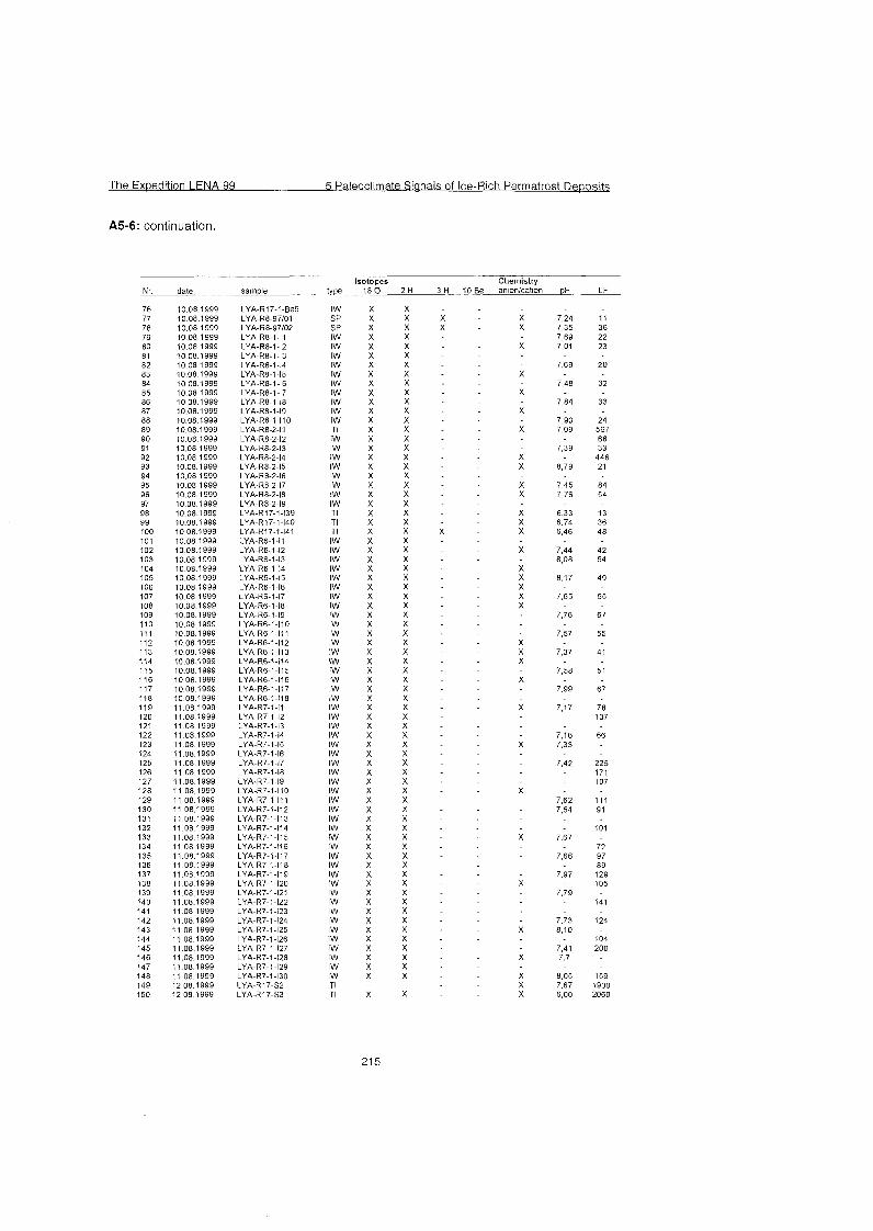
The Ex~edition LENA 99 5 Paleoclimate Sianals of Ice-Rich Perrnafrost Deposits
A5-6: continuation.
Isotopes 18 0
X X X X X X X X X X X X X X X X X X X X X X X X X X X X X X X X X X X X X X X X X X X X X X X X X X X X X X X X X X X X X X X X X X X X X X X X X
X
date sarnple
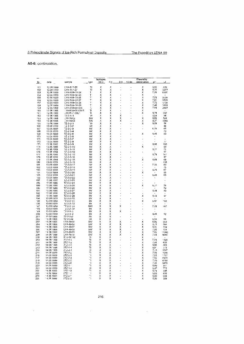
5 Paleoclirnate Sianals of Ice-Rich Perrnafrost De~osi ts The Exoedition LENA 99
A5-6: continuation.
Isotopes 1 8 0 2 H 3 H date sarnple
LYA-R17-S5 LYA-R17-S7 LYA-R18+50-S4 LYA-R18+50-S5 LYA-R18+50-S6 LYA-R18+50-S7 LYA-R18+50-S8 LYA-R18+50-S9 LYA-R18+50-SI0 LYA-R18+50-OSL5 LYA-R17-OSL1 TZ-2-1-11 LYA 96/02 LYA 96/03 TZ-2-2-11 TZ-2-2-12
X X X X X X X X X X x x - X X x x - X X X X X X x x x X X X X X X x x - X X
X X x x - X X
X X X X X x x x
X X X X X X X X X X X X X X X X X X X X
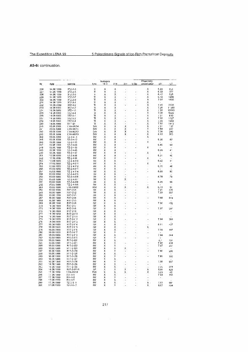
The Expedition LENA 99 5 Paleoclimate Sianals of Ice-Rich Permafrost De~os i t s
A5-6: continuation.
Isotopes date sample type 1 8 0
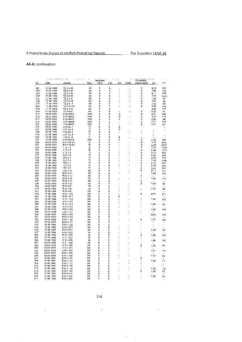
5 Paleoclirnate Siqnals of Ice-Rich Perrnafrost Deposits The Expedition LENA 99
-
A5-6: continuation.
Isotopes Chernistry Nr date sarnple type 18 0 2 H 3 H 10 Be anlon/cation
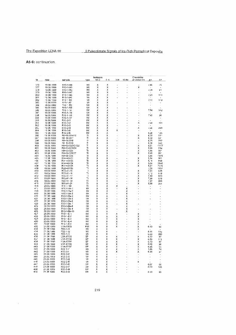
The Expedition LENA 99 5 Paleociimate Sianais of ice-Rich Permafrost Deoosits
A5-6: continuation.
sample Isotopes
180 2 H 3 H date
X X X X X X X X X X x x . X X x x - X X x x - X X X X X X x x - X X X X X X x x - X X X X X X X x x - X X X X X X
X X x x - X X
X X X X x x x
X X X X X X X X X X X X X X X X X X
X X X X X X X X X X X X X X X X X X
5 Paleoclimate Sianals of Ice-Rich Permafrost Deposits The Expedition LENA 99
A5-6: continuation.
Isotopes 18 0
X X
type date
The Exoedition LENA 99 5 Paleoclimate Sianals of Ice-Rich Permafrost Deoosits
A5-6: continuation.
Isotopes tvpe 18 0 date sarnple
L-21-1-Be12 L-15-1-11 (head)
5 Paleoclimate Sianals of Ice-Rich Permafrost Deposits The Expedition L E N A B
A5-6: continuation.
Isotopes Chemistr i Nr date sample type 18 0 2 H 3 H 10 Be an~on/cat~on pH LF
621 29.08 1999 L-2-1-113 IW X X 6,95 80 622 29 08.1999 L-2-1-114 IW X X 623 29 08 1999 L-2-1-115 (head) IW X X X X 6,79 69 624 29 08 1999 LYA-96/18 SW X X X X 7.32 20100 625 29 08 1999 LYA-98/10 G W X X X X 7.15 331 626 30 08 1999 LYA-96/19 SW X X X 6,39 292 627 30 08 1999 LYA-96/20 SW X X X 6,24 167 628 30 08 1999 LYA-96/21 SW X X X 6.13 202 629 30 08 1999 B15-2 Tl X X X 737 383
R W X X X X 5 9 128 SW X X X X 631 95 SW X X X X 722 267
648 31 08 1999 LYA-97/16 649 31 08 1999 LYA 96/27 650 31 08 1999 LYA-98/11
- 655 01 09 1999 LYA-99/13 R W X X X X 6.13 207 656 01 09 1999 L3-SI Tl X X 6.20 2530 657 01 09 1999 L 3 4 5 Tl X X 6.94 614 658 01 09 1999 LYA-95/01 SI X X 6,52 3270 659 01 09 1999 LYA-95/02 SI X X 6,65 2080 660 03 09 1999 L6-I1 IW X X
Abbreviations SP = Snow patch RW = ram water IW = ice wedge ice SW = surface water GW = ground water SI = sea lce Tl = segregated ice AL = active layer ice MW = meitwater
BL-0 32 1 L IMammuthus primigenius llower molar tooth (M3) [fragment 1 e lshore L
BL-0 33 1 L [Mammuthus primigenius lpelvis lfragment 1 e l s h o r e ~
samples
BL-0 1 BL-0 2 BL-0 3 BL-0 4 BL-0 5 BL-0 6 BL-0 7 BL-0 8 BL-0 9 BL-0 10 BL-0 11 BL-0 12
Side
R L L L L L L L L L R R
Taxon
Mammuthus primigenius Mammuthus primigenius Mammuthus primigenius Mammuthus primigenius Rangifer tarandus Rangifer tarandus Bison priscus Bison priscus Equus sp. Ovibos sp. Equus sp. Mammuthus primigenius
Skeleton element
tusk tusk tooth tusk pelvis scapula phalanx ll ??????????? metatarsale lll cranium humerus lumbar vertebra
P U1 -Ã̂
W 0 U 0 s (D
W
0) -0 (D
Å ̧
Preservation
fragment fragment fragment fragment -- fragment fragment
fragment fragment distal fragment
b
Type
a e e e e e e e e e b
R, 1 1 1 TC, bone field "0 VI"
Locality in situ IV TC, boundary ""Kuchchuguy"" /"Ice Cornplex" L, shore L, shore 5 - 6 km from the camp L, shore 5 - 6 km from the camp
-7 L, shore 5 - 6 km from the camp L, shore 5 - 6 km from the camp L, shore 5 - 6 km from the camp L, shore 5 - 6 km from the camp L, shore R, 1 1 1 TC, bone field "0 VI"
13, 14from 1
Notes
from Volodya trashed trashed trashed
trashed trashed trashed trashed trashed samples 12,
ril ril +
samples BL-0 34 BL-0 35 BL-0 36 BL-0 37 BL-0 38 BL-0 39 BL-0 40 BL-0 41 BL-0 42 BL-0 43 BL-0 44 BL-0 45 BL-0 46 BL-0 47 BL-0 48 BL-0 49 BL-0 50 BL-0 51 BL-0 52
BL-0 53 BL-0 54 BL-0 55 BL-0 56 BL-0 57 BL-0 58 BL-0 59 BL-0 60 BL-0 61 BL-0 62 BL-0 63 BL-0 64 BL-0 65 BL-0 66
Side L L L L L L L L L L L L R R R R R R R
R R R R R R R R R R R R R R
Taxon Mammuthus primigenius Rangifer tarandus Rangifer tarandus Bison priscus Marnmuthus prirnigenius
P
Mammuthus prirnigenius Bison priscus Equussp. Equussp. Rangifer tarandus Panthera spelaea Mamrnuthus primigenius Equus sp. Rangifer tarandus Marnrnuthus prirnigenius Marnrnuthus prirnigenius Equus sp. Large mammal Marnrnuthus prirnigenius
Bison priscus Bison priscus Ovibos sp. Rangifer tarandus Marnrnuthus prirnigenius Equus sp. Marnrnuthus prirnigenius Rangifer tarandus Equus sp. Rangifer tarandus Equussp. Rangifer tarandus Equus sp. Bison priscus
Skeleton element tusk lumbar vertebra scapula humerus tooth
ulna astrogalus metatarsale 111 shed antler mandibula cranium phalanx I ulna tusk metacatpale I fernur rib tusk
rnetatarsale phalanx I ?cervical vertebra epistrofeurn pelvis (OS iliurn) rnetatarsale 111 radius craniurn calcaneus phalanx I rnetatarsale lll lurnbar vertebra phalanx I1 thorax vertebra
Preservation fragment
fragrnent distal fragment fragment fragment
?????????? fragment
damaged fragment fragment distal fragrnent fragrnent fragment
fragment distal fragrnent fragment occipital fragment
deforrnity
Type e e e e e e e e e e e e C
C
C
b b b b
b C
C
C
C
C
C
C
C
C
C
C
C
C
Locality shore L shore L shore L shore L shore L shore L shore L shore L shore L shore L shore L, under t TC shore L R, ITC R,ITC R, I TC R 1 1 1 TC, bone field "0 VI" R 1 1 1 TC, bone field "0 VI" R 1 1 1 TC, bone field "0 VI" R 111 TC, bone field "0 VI" alas TC, 3 - 4 m above "Kuchchuguy" R, alas TC R, alas TC R, alas TC R, alas TC R,IIITC R,l l lTC R,IIITC R,IIITC R,l l lTC R,IIITC R, 111 TC R, lll TC R,l l lTC
Piotes C14
trashed
C14
trashed
trashed
trashed trashed
juv., C14
samples 1 Side l ~ a x o n Iskeleton element 1 Preservation 1 Type l ~ o c a l i t ~ 1 Notes
lmandible (left stem) with 1 BL-0 67 BL-0 68 BL-0 69 BL-0 70 BL-0 71 BL-0 72 BL-0 73 BL-0 74 BL-0 75 BL-0 76 BL-0 77 BL-0 78 BL-0 79 BL-0 80
BL-0 81 BL-0 82 BL-0 83 BL-0 84
BL-0 85 BL-0 86 BL-0 87 BL-0 88 BL-0 89 BL-0 90 BL-0 91 BL-0 93 BL-0 94 BL-0 95 BL-0 96 BL-0 97 BL-0 98 BL-0 99
L R R L L L L L L L L L L L
L L L L
L L L L L L L L L L L L L L
Mammuthus primigenius Lepus sp. Lepus sp. Equussp. Mammuthus primigenius Rangifer tarandus Bison priscus Bison priscus Rangifer tarandus Equus sp. Equussp. Rangifer tarandus Rangifer tarandus Ovibos sp.
Mammuthus primigenius Ovibos sp. Bison priscus Equus sp.
Equus sp. Bison priscus Bison priscus Bison priscus Bison priscus Bison priscus Rangifer tarandus Rangifer tarandus Rangifer tarandus Rangifer tarandus Ovibos sp. Mammalia Mammalia Rangifer tarandus
milk teeth dp2 - dp3 cranium tibia femur tusk shed antler atlas radius humerus calcaneus phalanx I metacarpale metatarsale phalanx I lower molar tooth (M3) heavily worn atlas femur femur
thorax vet?ebra phalanx I1 phalanx I1 phalanx I calcaneus phalanx I1 astrogalus shed antler astrogalus radius metacarpale bone bone tibia
damaged distal fragment
fragment
distal fragment distal fragment sample damaged
fragment damaged
sample damaged fragment fragment sample damaged (2 pieces)
fragment
fragment
proximal fragment distal fragment fragment fragment distal fragment
e d C
e e e e e e e e e e e
e e e e
e e e e e e e e e e e e e e
shore L shore R, 100 m (Rl) R,IIITC L, shore near the camp L, shore near the camp L, shore near the camp L, shore near the camp L, shore near the camp L, shore near the camp L, shore near the camp L, shore near the camp L, shore near the camp L, shore near the camp L, shore near the camp
juv.
C14
juv.
juv. juv.
L, shore near the camp L, shore near the camp L, shore near the camp L, shore near the camp
L, shore near the camp L, shore near the camp L, shore near the camp L, shore near the camp L, shore near the camp L, shore near the camp L, shore near the camp L, shore near the camp L, shore near the camp L, shore near the camp L, shore near the camp L, shore near the camp L, shore near the camp L, shore near the camp
trashed trashed
trashed juv.
trashed
5 Paleoclimate Sianals of lce-Rich Permafrost Deposits The Ex~edition LENA 99
A5-7: continuation.
B L - 0 233 1 R IEquus sp 1 phalanx 1 1 b IR, 1 TC, bone field '"7 V"
BL-0 234 R Equussp. metatarsale lll b R, l TC, bone field "? V" BL-0 235 R Equussp. phalanx I11 b R, l TC, bone field "? V"
mandibula (left stem) with

B L - 0 279 ] R l ~ ~ u u s sp. Ipelvis lfragrnent with copulasl C IR, from scree, "Kuch." altidude 1
5 Paleoclirnate Sianals of Ice-Rich Perrnafrost De~osits The Expedition LENA 99
A5-7: continuation.
Â¥ 3-
C- -- CD a U T 3 z "0 X, W * - CO 'V - - - - i -C 0 L - 3 :
y ^ 6 a m n U L W U
E Â 2 Â - ".
CL a --
0 C
--
'E'S CD a
L E (0 (t - + --
3
? /
2 s > ' C 7 ;z -- +
W W 3 2 C C CD <Q 0 ) 0 E L E L n 0 CO m -3 -3
5 5 E E $ 5 5 5 -- CL 0"
--
in CD Co Co Cu Cu
0 0 m m
samples BL-0 314 BL-0 315 BL-0 316
BL-0 317
D Y 0 0
2 s.. 0 3
-)
? rn
(D Q- e. O "3
i- n-, z D Cd Cd
Side R R R
R
N W Cd
Taxon Bison priscus Rangifer tarandus Bison priscus
Bison priscus
BL-0 337 BL-0 338 BL-0 339 BL-0 340 BL-0 341 BL-0 342 BL-0 343 BL-0 344 BL-0 345
Skeleton element radius rnetatarsal scapula rnandible (left Stern) with tooth M3
R R R R R R R R R
Preservation
distal fragrnent proximal fragrnent
Mammuthus primigenius Equussp, Bison priscus Ovibos sp. Rangifer tarandus Rangifer tarandus Mammuthus primigenius Mammuthus primigenius Bison priscus
Type d d d
d
calcaneus radius pelvis tibia calcaneus astrogalus tusk pelvis fernur
Locality R, shore R, shore R, shore
R, shore
sample damaged
fragrnent distal fragment
fragrnent fragrnent distal fragment
Notes juv.
d d d d d d d d d
R, shore R, shore R, shore R, shore R, shore R, shore R, shore R, shore R, shore
C14 C14
BL-0 351 BL-0 352 BL-0 353 BL-0 354 BL-0 355 BL-0 356 BL-0 357 BL-0 358 BL-0 359 BL-0 360 BL-0 361 BL-0 362 BL-0 363 BL-o 364 BL-0 365 BL-0 366
BL-0 367 BL-0 368 BL-0 369 BL-0 370 BL-0 371 BL-0 372 BL-0 373 BL-0374 BL-0 375 BL-0 376 BL-0 377 BL-0 378 BL-0 379
R R R R R R R R R R R R R
r R R R
R R R L R R L R R R R R R
Mammuthus primigenius Marnrnuthus prirnigenius Marnmuthus primigenius Mammuthus primigenius Marnmuthus prirnigenius Equussp. Bison priscus Marnrnuthus primigenius Bison priscus Ovibos sp. Equus sp. Ovibos sp. Bison priscus E ~ U U S sp. Rangifer tarandus ? Bison priscus
Marnmuthus primigenius Bison priscus Mammuthus prirnigenius Marnrnuthus primigenius Bison priscus Rangifer tarandus Bison priscus Equus sp. Marnmuthus prirnigenius Coelodonta antiqua Rangifer tarandus Rangifer tarandus Rangifer tarandus
rib tusk lower molar tooth (?M3) thorax vertebra upper molar tooth (M3) humerus pelvis cetvical vertebra scapula pelvis phalanx l astrogalus radius radius humerus fernur Iower molar tooth (M2 or M3) metacarpale upper molar tooth (M3) tusk radius shed antler horn sheet humerus tooth astrogalus atlas phalanx 1 lurnbar vertebra
damaged fragment damaged fragment
fragrnent fragrnent fragment fragment
. proximal fragment
fragment
fragment
fragment fragment fragrnent fragrnent
fragment
d d d d d d d d d d d d d d d d
d d d e d d d d d d d d d
R, shore R, shore R, shore R, shore R, shore R, shore R, shore R, shore R, shore R, shore R, shore R, shore R, shore R, shore R, shore R, shore
C14 C14
C1 4
juv. trashed
R, shore R, shore R, shore L, shore 10 km from camp R, shore R, shore R, shore R, shore R, shore R, shore R, shore R, shore R, shore
C14
The Expedition LENA 99 5 Paleoclimate Sianals of Ice-Rich Permafrost De~osi ts
A5-7: continuation.
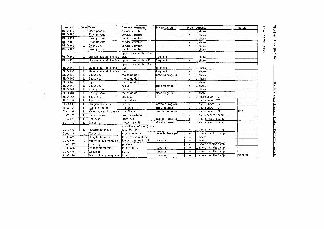
D 01 - ̂0 0
3. ¥ C
0). 0 3
1 1 1 Imabdibula (left stem) with 1 1 1 1 1 BL-0 473 BL-0 474 BL-0 475 BL-0 476 BL-0477 BL-0 478 BL-0479 BL-0 480
L L L L L L L L
Rangifer tarandus Equus sp. Rangifer tarandus Mammuthus primigenius Equussp. Rangifer tarandus Equus sp. Mammuthus primigenius
teeth P2 - M3 thorax vertebra lower molar tooth (M3) lower molar tooth (M3) phalanx metacarpale pelvis femur
sample damaged
fragment
deformity fragment fragment
e e e e e e e e
L, shore near the camp L, shore near the camp L, shore L, shore L, shore near the camp L, shore near the camp L, shore near the camp L, shore near the camp trashed
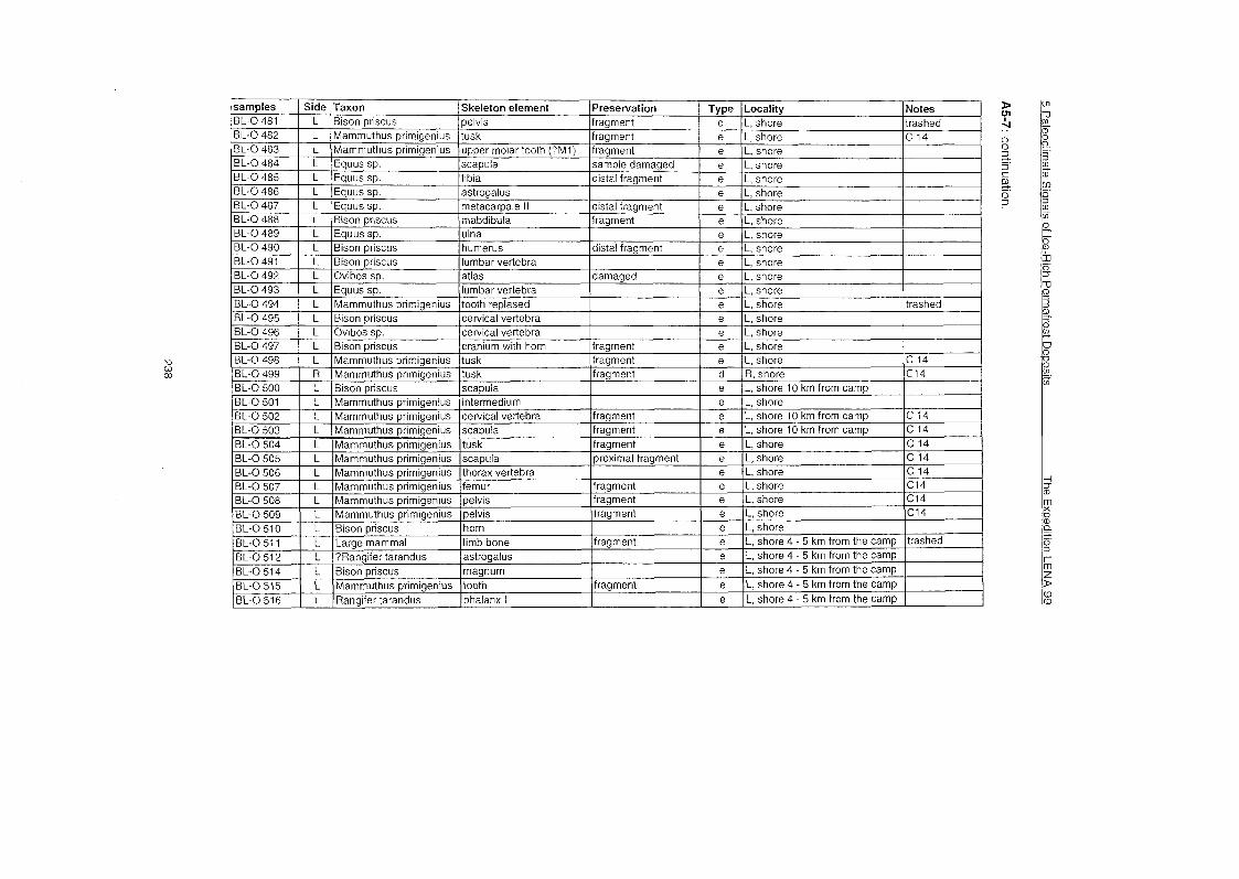
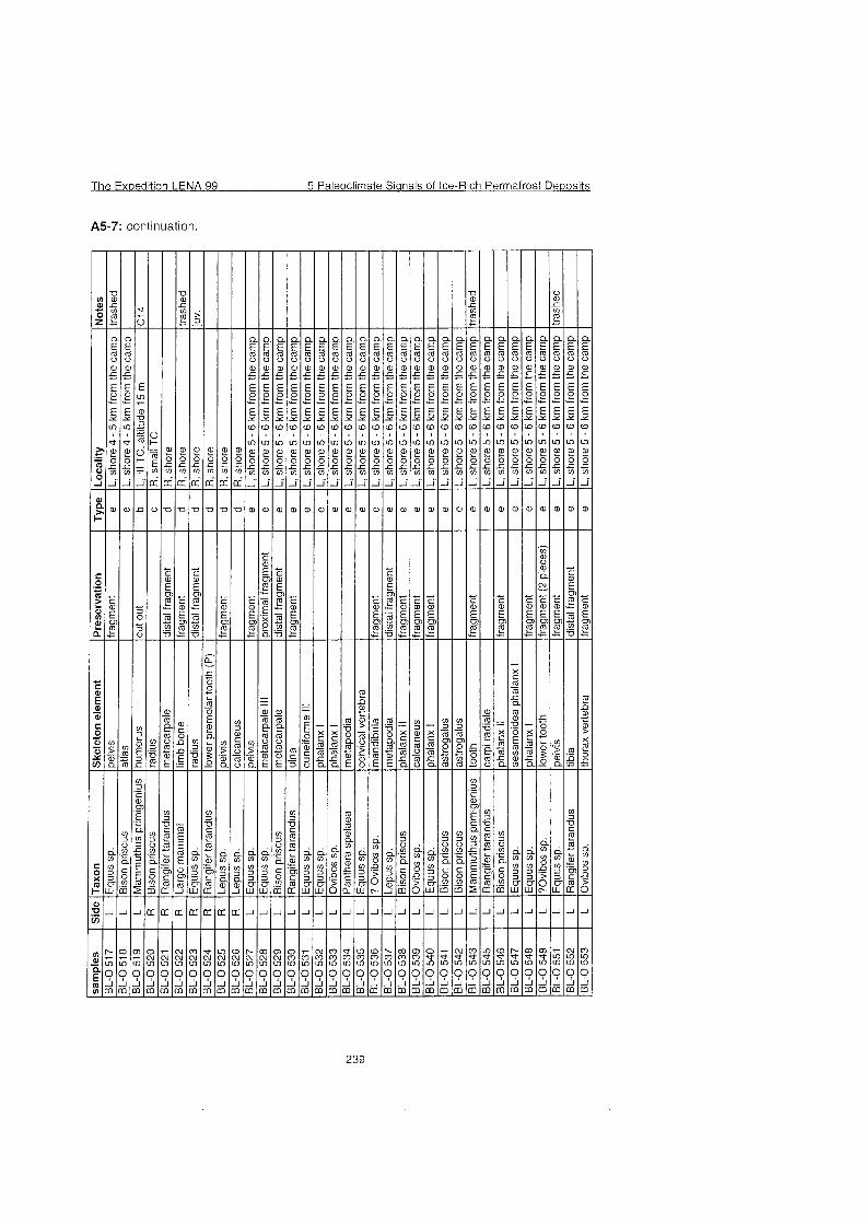
The Exoedition LENA 99 5 Paleoclirnate Sianals of Ice-Rich Perrnafrost Deoosits
A5-7: continuation
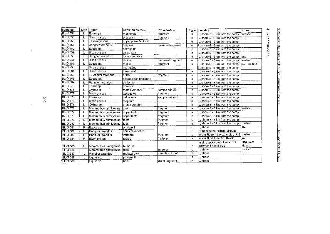
IBL-0 595 l L [Bison ~r i scus I radius l~roxirnal fraarnent 1 e IL. shore I 1 1 1 Bison priscus or Ovibos 1 1 1 1 1 1
n 0 -I C. ""I C
B). 0 Ã
1 1 1 mandibula (riaht stem) 1 1 1 1 1
BL-0 668 BL-0 669 BL-0 670 BL-0 671 BL-0 672 BL-0 673 BL-0 674
L L L L L L L
BL-0 675 BL-0 676 BL-0 677 BL-0 678 BL-0 679 BL-0 680 BL-0 681 BL-0 682 BL-0 683 BL-0 684 BL-0 685 BL-0 686 BL-0 687 BL-0 688
Ovibos sp Rangifer tarandus Ovibos sp Bison priscus Equussp Equussp Equussp
L L L L L L L L L L R R R R
scapula astrogalus metatarsale phalanx II metatarsale 1 1 1 metacarpale I11 ulna
Rangifer tarandus Rangifer tarandus Ovibos sp. Equus sp. Mammuthus primigenius ? Saiga tatarica Ovibos sp. Bison priscus Equus sp. Mammuthus primigenius Mammuthus primigenius Bison priscus Ovibos sp. Rangifer tarandus
proximal fragment
distal fragment fragment fragment fragment fragment
with P4 - M\ astrogalus lower tooth (M) phalanx lll tibia thorax vertebra cranium atlas metapodia II or IV tibia calcaneus humerus cervical? vertebra astrogalus
e e e e e e e
fragment
fragment fragment sample damaged fragrnent fragrnent distal fragment distal fragrnent fragment distal fragment
fragment
L, shore 10 km from camp L, shore 10 km from camp L, shore 10 km from camp L, shore 10 km from camp L, shore 10 km from camp L, shore 10 km from camp L, shore 10 km from camp
e e e e e e e e e e d d d d
trashed
L, shore 10 km from camp L, shore 10 km from camp L, shore 10 km from camp L, shore 10 km from camp L, shore 10 km from camp L, shore 10 km from camp L, shore 10 km from camp L, shore 10 km from camp L, shore 10 km from camp L, shore 10 km from camp R, cape shore R, cape shore U, cape shore R, cape shore
trashed
trashed
trashed
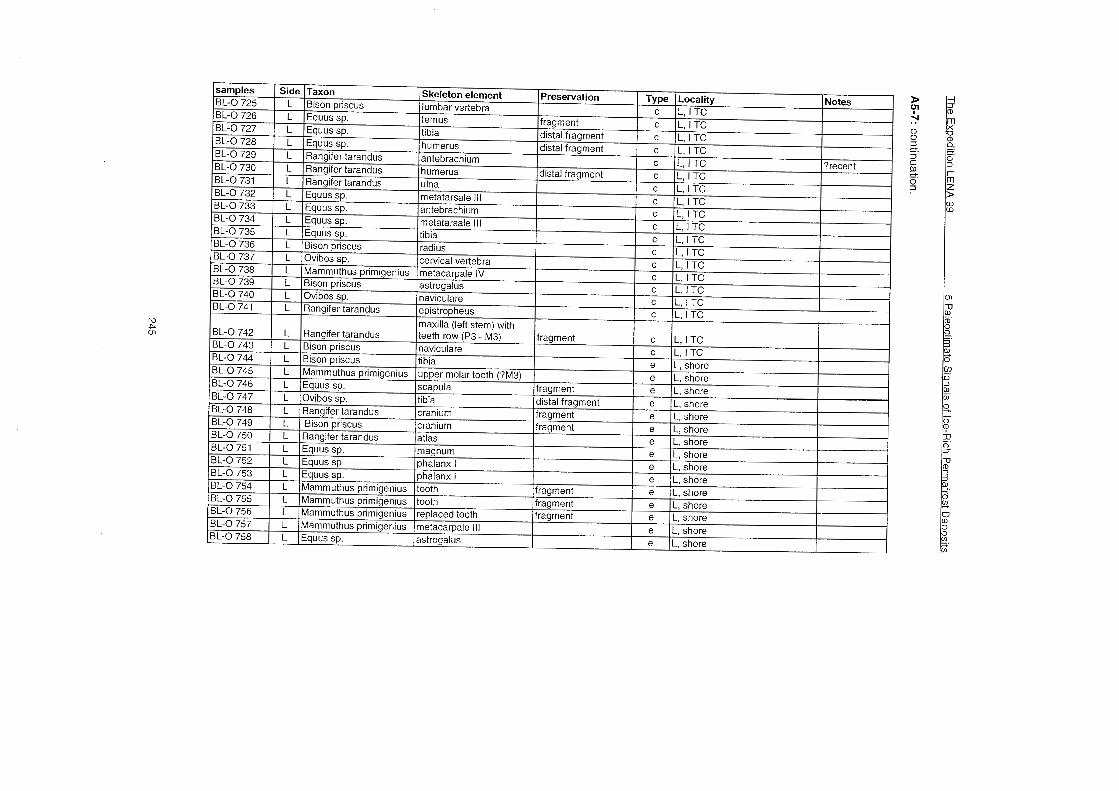
0 0
3. 3 C
SB. 0 -i
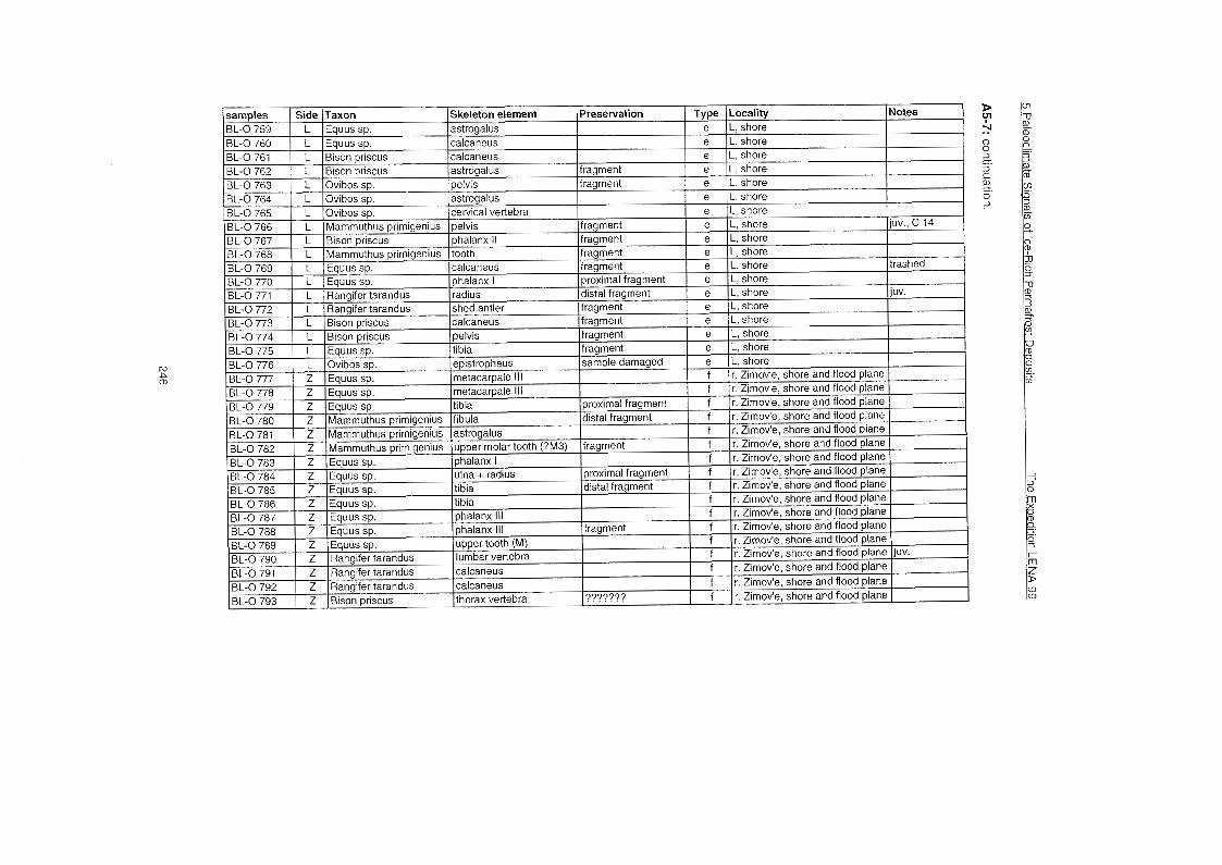
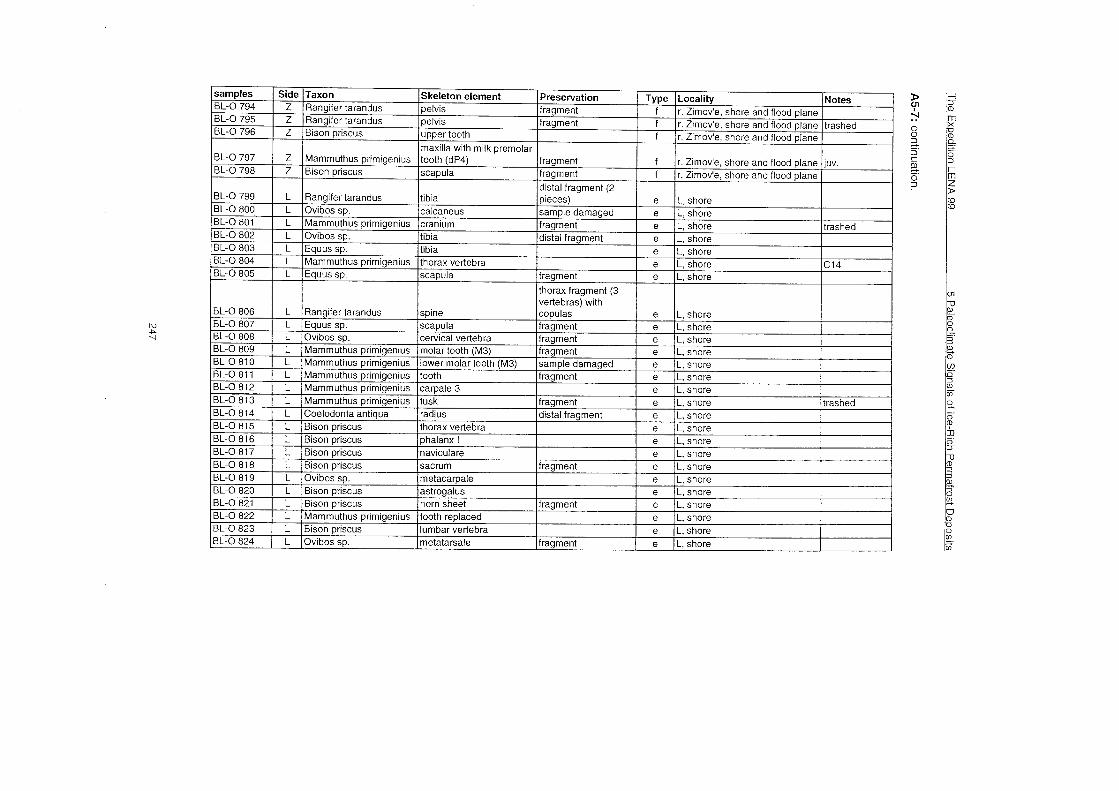
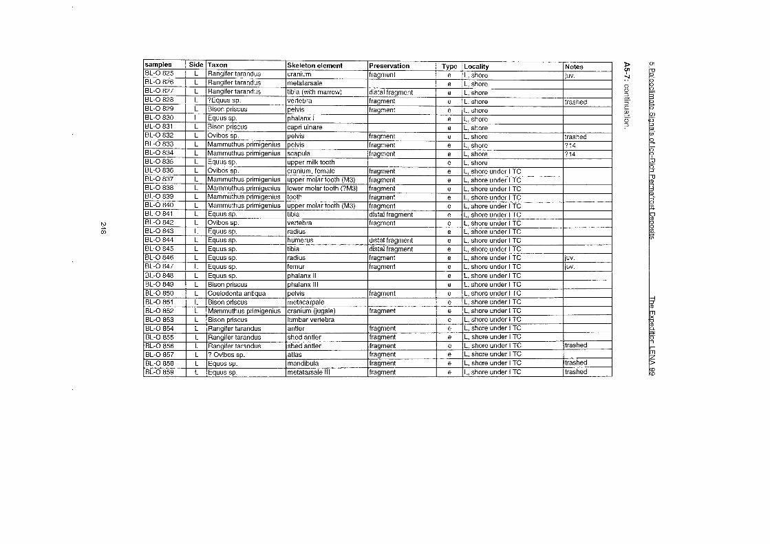
sarnples BL-0 860 BL-0 861 BL-0 862 BL-0 863 BL-0 864
BL-0 865 BL-0 866 BL-0 867 BL-0 868 BL-0 869 BL-0 870 BL-0 871 BL-0 872 BL-0 873 BL-0 874
Side L L L L Z
Z Z Z Z Z Z Z Z Z Z
Taxon Ovibos sp. Rangifer tarandus Rangifer tarandus Equus sp. Mammuthus prirnigenius
Mammuthus primigenius Mammuthus prirnigenius Marnrnuthus primigenius Mammuthus primigenius Mammuthus prirnigenius Mamrnuthus primigenius Mammuthus primigenius Mammuthus prirnigenius Mamrnuthus primigenius Bison priscus
Skeleton element metatarsale phalanx ll lumbar vertebra metepodia lumbar vertebra thorax vertebra with copulas thorax vertebra rib rib vertebra vertebra ulnare pisiforme phalanx pasterior scapula
Preservation
fragment distal fragrnent
fragment
fragment fragment
fragment
Type e e e e f
f f f f f f f f f f
Locality L, shore under l TC L, shore under l TC L, shore under l TC L, shore under l TC ? r. Zimov'e near rnammoth' skin
? r. Zimov'e near mammoth' skin ? r. Zimov'e near rnammoth' skin ? r. Zimov'e near mammoth' skin ? r. Zimov'e near mammoth' skin ? r. Zimov'e near mammoth' skin ? r. Zimov'e near mammoth' skin ? r. Zimov'e near mammoth' skin ? r. Zimov'e near rnammoth' skin ? r. Zimov'e near mammoth' skin ? r. Zimov'e
Notes
juv. trashed
C14
C14 C14
trashed
5 Paleoclimate Sianals of Ice-Rich Permafrost Dewosits The Expedition LENA 99
A5-7: continuation.
The Exoedition LENA 99 5 Paleoclimate Sianals of Ice-Rich Permafrost De~os i t s
A5-7: continuation.
samples
BL-0 960 0 0
3. -3 8
(B. 0 ?
BL-0 979 BL-0 980 BL-0 981 BL-0 982 BL-0 983 BL-0 984 BL-0 985 BL-0 986 BL-0 987 BL-0 988 BL-0 989 BL-0 990 BL-0 991
Side
L L L L L L L L L L L L L
Taxon
Marnrnuthus prirnigenius ? Marnrnuthus
Marnrnuthus prirnigenius Marnrnuthus prirnigenius Marnrnuthus prirnigenius Rangifer tarandus Rangifer tarandus Ovibos sp. Marnrnuthus prirnigenius Marnrnuthus prirnigenius Marnrnuthus prirnigenius Marnrnuthus prirnigenius Marnrnuthus prirnigenius Marnrnuthus prirnigenius Marnrnuthus prirnigenius
Skeleton element lower prernolar milk tooth (dp3)
tooth tooth tooth craniurn craniurn craniurn tooth tooth tooth tooth tooth tooth tooth
Preservation
fragrnent
fragrnent fragrnent fragrnent fragrnent fragrnent fragrnent fragrnent fragrnent fragrnent fragrnent fragrnent fragrnent fragrnent
Type
g
e e e e e e e e e e e e e
Locality
near camp (C. f. d. U. 1.)
Notes
L, shore 10 km frorn camp L, shore 10 km frorn camp L, shore 10 km frorn camp L, shore 10 km frorn camp L, shore L, shore L, shore L, shore L, shore L, shore L, shore L, shore L, shore
trashed trashed trashed trashed trashed trashed trashed trashed trashed trashed trashed trashed trashed
D
; 0 -s e. 3 C
(B. 0 3
OS-10 R-6 2 yellowish-grey sandy silt with grass roots B-5 OS-11 R-6 2,3 yellowish-grey sandy silt with grass roots
OS-12 R-6 2,s yellowish-grey sandy silt with grass roots OS-13 R-6 2,8 yellowish-grey sandy silt with grass roots OS-14 R-6 3,1 yellowish-grey sandy silt with grass roots OS-15 R-6 4 yellowish-grey sandy silt with grass roots OS-16 R-6 4,3 yellowish-grey sandy silt with grass roots OS-17 R-6 4,6 yellowish-grey sandy silt with grass roots OS-18 R-6 4.9 yellowish-grey sandy silt with grass roots
B-4 OS-19 R-6 5,2 yellowish-grey sandy silt with grass roots OS-20 R-6 5,5 yellowish-grey sandy silt with grass roots OS-21 R-6 5,8 yellowish-grey sandy silt with grass roots
Index "B" - samples screened with 0.5 rnm rnesh. Index "Rn - sarnples screened with 1,O rnrn rnesh. Index "OS" - seeds sarnples
B-25 10s-67 IL-0 2,3 Igrey sand and silt with plant detritus recent B-0 1 L-0 0 lrnodern sedirnent (subface sarnple)
Sarnple Material
BL-R-T1 Peat, dark-brown, slightly compressed
BL-R-T2 Peat, dark-brown, tightly compressed
BL-L-T3 Peat, brownish-red, slightly compressed
BL-L-T4 Peat, brownish-red, slightly compressed
BL-L-T5 Peat, brownish-red, slightly compressed
BL-R-T6 Peat, dark-brown, tightly comoressed
Site Altitude Deposits
side R, R 8+60m, stream 812 - 1.4 - 1.6m Upper "Olyorian", upper part
side R, R 8+60m, stream 813 - 1.0 - 1.4m Upper "Olyorian", lower part side L, L34+40m Ice complex deposits, basal part
side L, L 50m -10 - 12m "Subaquatic Kuchchuguy"
side L, L 50m -10 - 12m "Subaquatic Kuchchuguy"
side L 1 Holocene deposits
5 Paleoclimate Signals of Ice-Rich Permafrost Dewosits The Exwedition LENA 99
A5-10: List of mollusc samples.
5 Paleoclimate Sianals of Ice-Rich Permafrost Deposits The Exoedition LENA 98
A5-12: Description of soil profiles.
Type: Permafrost alluvial layered poorly developed (primitive) soil Pit 23.20.08.99 terrace 1 : 1 km from the mouth of Zimov'e river (by the river) Vegetation: Poa alpigena 30 %; more than anything; some dead leaves of cereals I 0-23 cm Loam, strong muddy, greyish-rusty-brown with dirty-grey spots (gleyed),
slowly boundary of alive and dead roots, average amount of allochthonous plant remains; wet; lamination is only visible in frozen material by allochthonous plant remains; homogeneous grain size composition; rough boundary, weakly fuzzy; a crack with rusty streak from this horizon toward to the bottom; squeezed. Loamy sand, muddy; dirty-bluish-grey with many black spots of semi- decayded vegetation; rnore or less stratified by plant remains, homogeneous grain size composition; rusty fissures and horizon boundaries. 3 interlayers: 1) Loamy sand, muddy rusty-grey-brown, rust spreads on it from a crack - 1.5 crn; 2) muddy sand + loam, the Same colour, as 1) - 2 Cm; 3) Loarny sand bluish-grey, rnuddy, similar to 1 1 - 3.5 Cm.; all interlayers are moist. Sand, well stratified, various grain size composition ( fine up coarse sand), light-rusty, moist, interlayers with organic matter. Loamy sand, muddy; dirty-bluish-grey with many black spots of serni- decayded vegetation; more or less stratified by plant rernains, homogeneous grain size composition; rusty fissures and horizon boundaries, moist. Sand, well stratified, various grain size composition (fine to coarse sand, with debris), light-rusty, moist, interlayers with organic matter. Loamy sand dark - bluish-grey, with less plant remains than 11, moist.
Permafrost is lower - the soil with a small amount of ice.
Pit 101.22.08.99 45 m from sea shore Vegetation: Poa alpigena 40 %, Stellaria hurnifusa 5 %. I 0-26 cm Loamy sand, dirty-grey with gleyed, rusty spots, wet, plant remains (thin roots
in a common mass, clusters and discontinuous interlayers). I1 26-39 crn coarse sand with debris (about 40 %), yellow with rusty shade, wet, plant
remains - separate black slices of roots. I 39-48cm Loarny sand with large grains of sand, middle muddy, brownish-grey,
stratified, thixotropic, wet, average amount of plant rernains IV 48-56 cm Loamy sand bluish-steel-grey with rusty films on cracks, wet - moist, average
amount of plant rernains.
Subtype: Permafrost alluvial sod-gley; Pi?. 108. Vegetation: Mosses (alive 5 %, black dead 2 %, green mostly dead 40 %), Cereal 40, Stellaria
hurnifusa 2-3 %, Cochlearia un. Ao 0-1 cm Dead rernains of plants. AotA1 1-7 cm Very dense netting of roots, plant remains between the roots, treated by
frost, wet. Bg ' 7-15 crn Loamy sand, muddy, bluish-grey with rusty spots, moist; less netting of
alive and dead roots than in AotA1, any cut off chunk (the block hold the form).
G 15-33 cm Loarny sand with separate sand clusters; Gleyic horizon, bluish-steel colour with rusty streaks on separate cracks; moist; many plant rernains, but they do not hold loarny sand as a rnonolith.
33-37cm Interlayer of various rnainly coarse sands with unrounded debris, yellowish-grey, slightly rusty; moist more wet.
Permafrost is lower (grey loarny sand), there is a little ice.
The Ex~edition LENA 99 5 Paleoclirnate Sianals of Ice-Rich Perrnafrost De~osi ts
A5-12: continuation
Type: Perrnafrost alluvial peat-gley soils; Pit 9 Vegetation: Mosses 98 %, cereals + sedges 40 %, Herbs (Chrysosplenium alternifolium,
Pedicularis sudetica ssp. albolabiata) 1 O/O
To 0-3 cm Dark - brown dead rnosses. T1 3-8 crn Peat, brown, poorly muddy, interlocked by roots, without any larnination
probably, T2 8-13 crn Peat light-brown, rnoss-grassy, rnuddy, interlocked by the roots. Tg 13-17 crn Peat bluish-brown, rnuddy, poorly sanded, rnoss-grassy. Gt 17-29 crn Loarny sand, rnuddy up to loarn, grey, rnany grass remains. Perrnafrost is deeper.
Subtype: Perrnafrost peatish-gley; Pit 18. Tv 0-1 crn Alive rnosses. T2 1-2 crn Brown peat, destroyed by permafrost, alrnost without mud and roots. T2G 2-8 crn Brown peat and rnud dirty-grey between a dense netting of thick roots;
rnoist. GT 8-18 crn Loarny sand - loarn, strong rnuddy and peaty, dense netting of shallow alive
roots, rnoist,rnany plant rernains. Gt 18-32 crn Loarn, dirty-grey with rusty streaks and spots. Moist, water oozes on cracks;
rnany plant rernainsl. G 32-42 crn Loarn, bluish-grey with separate rusty spots, rnany plant rernains. Permafrost is lower - soil with a great rnany of ice (large streaks).
Type: Perrnafrost effused; Pit 1.9.08.99 Top 01 a hill. Nano-relief: diarneter of rnounds is 20-50 cm, height is about 10 crn. There is a lot of lernming
holes in cracks. Mounds: Vascular plants 40 Oh, Lichens 80 %, rnosses shallow, pressed to soil, covered by
lichens 5 %, Salix polaris 20 %, S. glauca 2-3 %, Cereals (Alopecurus alpinus etc.) 15 %, Herbs (Senecio atropurpureus, Pediculan's) 5 %.
Cracks: Lichens 15 O/O, Mosses higher and noticeable 50 %, Salix polaris + S. glauca 10, Herbs (Saxifraga hieracifolia, Potentilla hyparctica, ranunculus sp.) 5 %.
Pit-hole: the bottorn is absolutely even, ice occures under a crack or mound indipendent of the position.
1a a mound 0-0.5 crn
AOT1 [2] 0.5-3 crn Bg 3-15 cm her 15-1 8 crn CG 18-34 crn
Permafrost is lower.
1 b a crack 0-0.3 crn
AT2 0.3-11 crn
CG [Cg '1 17-36 crn
Crust of mosses and lichens. Dense sod , with dark - brown peat, wet, netting by roots. Loarn, yellowish-grey, structured (fine grains) to non structured; wet. Spot of cryoturbated humus: loarn, dark - brown-grey, wet. Loarn, heavier than Bg, dirty - bluish-grey with light-rusty streaks and spots, thixotropic, a vertical expansion is moved; wet, on contact with permafrost, rnoist; a few of plant remains.
Crust of rnosses and lichens. Peat dark-brown, partially rnineralised, loose: the knife enters easily, on boundary with Bg strongly loosened (alrnost up to a hollow), wet, is pierced by roots; sinuous boundary , streaks of pea on a crack . Loarn, yellowish-grey with grey shade, srnall spot of hurnus. At vertical expansion is rnoved apart by stratums; wet, but not enough for alive roots. Loarn, heavier, than Bg, dirty-bluish-grey with light-rusty streaks and spots, thixotropic, at vertical expansion is rnoved apart by straturns. Wet, on contact with perrnafrost is rnoist. A very srnall arnount of plant remains.
Perrnafrost is lower.
5 Paleoclirnate Signals of Ice-Rich Perrnafrost Deposits The Exoedition LENA 99
A5-12: continuation
Description of pale0 sols Section R 17 sarnples: 2-1 2, 20-30, 45-55, 60-75, 80-90, 95-1 05, 11 5-125, 145-1 55 Vegetation: Cereals 60 %, Herbs (Cochlearia 20 %, Papaver lapponicumun).
AV 0-1 crn A1gL 1-19cm
19-59 crn
A l g " buried 59-78 crn
Bg' buried 78-91 crn
Gburied 91-112crn
112-143 crn
Dense sod. Loarny sand, brown - grey, hornogeneous (particles of peat, plant rests, particles of rnosses, saved greenish colour), it is bad stratified (bent in different directions, variable thickness, srnall clusters of peat), rusty spots of the incorrect form; cornpressed, thawed. On cracks rnore friable and rnore peat. Rough boundary with underlying horizon, bent-tongue, but clear, weakly gleyed, non-peaty straturns. Loarny sand, dusty, yellowish-grey, bad stratified. Stratums go is not consent general slope of a surface and slope of horizons (declination to the opposite direction). Lenses both clusters of peat and loarny sand with the large contents of plant rests. In the bulk loarny sand - thin roots. Rusting on Courses of the roots. A gleyed by vague straturns and in a nuance of colour. Transition rough, but clear. Loarny sand dusty, on colour is very sirnilar to A1g ', but rnore
gleyed (the general steel nuance), bad stratified (straturns are bent in different directions, variable thickness, srnall clusters of peat), rusty spots of the incorrect form. Cornpressed, thawn. The boundary light crooked, but clear. Rusty fil On the contact of two horizons . wood. Loarny sand dusty, yellowish-grey tinged with blue. Dirnply layer, film of rusting in various directions (on any internal cracks). It is not enough of plant rests. Frozen, ice streak are not visible. Loarny sand dusty, bluish-grey, frozen, thin, light bent schlieren of ice, general declination of thern corresponds to declination of a surface and horizons; rnore plant rests than in B buried; boundary rough, leaked-spotty, noticeable On colouring. Loarny sand dusty, yellowish-grey, non-gleying, frozen, schlieren thiner, ice is less, than in G buried, the general declination schlieren corresponds to declination of a surface and horizons.
The olior 143-lower 200 crn Hashed thickness, grey and yellow spots, loarny-sandy filler, rock debris, clusters of sand.
The Expedition LENA 99 5 Paleoclirnate Sianals of Ice-Rich Perrnafrost Deposits
A5-12: continuation
Section R1811. samples: 0-1 2, 12-24, 24-33, 33-40, 40-49, 49-63, 63-85, 85-1 10, 11 0-1 30, 130-1 55, 155-1 84,
190-220, 230-260 TFK - ,,test for a knife" - the depth of penetration of a knife into rock.
Cg " 12-24 crn
A buried 24-33 crn
B buried 33-40 crn
G buried 40-49 cm
49-63 crn
63-1 84 crn
184-1 88 cm 188-230 crn 230-280 crn
Brownish-grey with buried bands rnore hurnused and brown. Colouring is very rough (more grey and yellowish diffuse spots), brown small roots are visible in rnore hurnused bands . Isolated points of a rusting on Courses of the roots. It is not enough of plant rests. TFK = 9.5 crn. More gleyed and stratified. The layer is rnore grey and rnore yellow
bands. Grey colour is both in horizontally prolated spots. Subhorizontal small crack is grey - brown, hurnused,The brown srnall roots are visible. It is not so rnuch plant rests in remaining parts of horizon a little, so srnall-sized. TFK = 7 Cm. Most hurnused horizon, is brown - grey, stratified, diffuse interlayers of yellowish-grey colour. Plant rests are average arnount. TFK = 10 crn. Yellow-grey, structured: very - very small-sized grains, a little larger then poppy-seeds. TFK = 11.5 crn Loarny sand, rnuddy up to loarn, dirty - grey, stratified. It is not enough of plant rests, but there are interlayers a plenty of very srnall-sized roots. Above horizon a thin dash line of a rusting. TFK = 12 crn. Strangely enough, is sirnilar to B buried, but rneet both non-structured clusters; more hurnused on contact with permafrost. TFK = 8 crn. The frozen rocks are lower. There are grey - brown hurnused discontinuous bands under declination 45degrees and rnore on a yellowish-grey background. Their greatest arnount and density is observed on a depth 110-130 crn. There is alrnost a spot (sloping - striped) here. All this plot(site) under srnall declination to the sea is intersected by rnore icy, than rnain rock, small bands. It is appreciable 'poppy-seed3 structure. All this is loamy sand. Well noticeable icy bands go On depthes: 68, 84, 93, 11 6-1 19, 142, 160 and is lower 184 cm (about it below). Ice band with frozen inside it plant rests. Loarny sand frozen, almost without vegetation and humus spots. Loarny sand frozen with an interesting structure: the denudation looks as the rnutton wool, been rnatted by horizontal bands. Humus is not noticeably.
sarnples: 0-1 1, 11-22, 22-27, 27-40, further through 10 crn. High baydjarakh with a flat apex vegetation: rnosses low 20 %, Cereals (Alopecurus, Poa) 5-8 %, Oxyria 1 %, Papaver
lapponicum un. A l 0-22 cm Greyish-brown, clusters of peat. B 22-27 crn Greyish-yellow, stratified. G 27-40 crn Precise stratified, and the straturns are bent downwards, into Cracks. Bluish-
grey and yellow - grey laminas. A 40-50 cm Humus horizon. Probably, in the not infringed condition it was above-
permafrost a Stratum of accurnulation of a humus. Brown - grey. 50-410 cm Uniform thikness of loamy sand with diffuse light noticeable broad bands rnore
grey (hurnused) and rnore yellow colour. Light icy. On depthes 60-70, 90-120, 140-160 crn the bands are traced is grey - dark blue of points (Vivianite?).
arnple No. a,s.l.,
lepth in 1 sarnple )cal Sediment sample (taken frorn rofile, (all sarnples taken frorn frozen Sediment) the sedimen
1 I
Description
Melt- ed ,
Cryo-structure water I
rernov
before drying)
No. Description
Macrofossil sarnple (all sarnples taken frorn freshlv rnelted and
undisplaced sedirnent)
No Method
Origi- nal
volu- rne
-
arnp '"g date
-- I P - - -- I 1 .2 9 11 I 12 - I 13 i 14 15
iite Baydzherakh "H" ("Hans" ), Stn 745, 10 m SE of 1999 landrnark R5 39 2 m a s l (ca 1998 RP 4 4), top level of activelv destroved b-khs. capped bv modern soll on the top Yedoma surface
sedges) in "hummocks"
I P P - -- - P- P - - M - -- P P P -- - P M-
2,8 Silt with high ice content beneath the peat core of the b-kh i intercalating with silt lenses
PP- -L ---
litres -- - - - - -- - - P -- -- - -- - - - - --
1Kh99-5s 353 Sand and silt ~/;mall bone 1 MKh99- Floatation, then heavy ca8 fragrnents and insects 5 s fraction water-screened, litres
i 1 sieve 0 5 mrn
4 5 I 6 4 3-4 5 Sand and silt wlsmall bone 1
fragrnents and insects I
I
I Fine- and m e d ~ u ~ s a n d , Massive, with intercalating with silt lenses thick (1-2 cm)
horizontal ice bands
5,9 Silt with high ice content 1 I Lens-like
I 6,6 ISilt with high ice content Lens-like,
reticulated
I
7 9 9 14 1 15 I l ~ ~ h 9 9 - IFIoatation then heavv ica 5 i 17
5 a ~ fraction water-screened, 1 Iitres isleve 0 5 mm
lenses
I I I I I
Site Baydzherakh "E" ("Erdel" ), Stn 780 under the 1999 landmark R6 38 7 m a s l (ca 1998 RP 4 6), top level of actively destroyed b-khs, capped by modern soll On the top Yedoma surface
31,3 7 3-7 6 Ice-rich silt with thread-like r o e t s and soft (rotten 7) woody 1 roots
M - 2 2
L i MKh99-23 i 31 ' 7,7 ISilt with high ice content
I 1 I
i
31 8 1 6 9 1S1lt with high ice content e s - l i k e , with 1 450 MKh99-22P 1 numerous small
I land some larae 1
Banded, 1 350 I aiteration of 1 I lens-like and 1 massive ,
MKh99-23P
1 2 4 5 6 7 9 11 12 13 14 15 MKh99-24 30 3 8 4 Silt with high ice content Banded, I 300 MKh99-24P 1 I 1 9
alteration of I lens-like and massive
Site Baydzherakh " V ("Vanya" ) Stn 745 9 rn below landmark R5 39 2 rn a s l (ca 1998 RP 4 4), and directly below b-kh "H" separated from it by an ice wedge, ,end level of b-khs from the top
I 1501MKh99-IOP arass roots +I I 1 1 9 8
parallel to the cliff sec
MKh99-10 30,2 9 Silt with high ice content Lens-like
I
9 7 'sandy silt with srnall woody twigsi~assive land verv few arass roots ROD of
10 4 Silty sand, very rich with plant IMassive organic - grass roots, twigs (yellow inside), small woody sticks - "paleosol" V I
10,4 Silty sand, very rich with plant organic - grass roots, twigs (yellow inside) small woody sticks - "paleosol" V
11 0 Silt with high ice content Lens-like with thick (up to 2 cm) ice bands
11,7 Silt with high ice content and Lens-like numerous arass rootlets I
Site Baydzherakh "L" ("Lyosha" ) Stn 145, 12 m be
MKh99-14aq 27,O 112 1-12 4Silty Sand I
I 12 5 Sandy silt with srnall woody twigsi
and grass roots (top of paleosol "L") i
MKh99-16 26 2 13,O ISilt rich with nurnerous grass i rootlets and srnall Sterns - I paleosol MV i
woody sticks 1 1 I
25 MKh99-11 P woody sticks 1
50 MKh99-12P grass roots + woody sticks I
D cn 01 -0 A (B M CD
0 0
2. 3 C
SB. 0 :3 1 (B
CÂ
"-t 5 - 8 0 l l"-t I J MKh99-16~ 26,2 12 7- Silt rich with numerous grass 1
13 0 i r r - s ~ - ~ - --J --.. 8 , L lMKh99- ~Floatation then heavv l ? l 51 Rl
I J U L I C ~ diiu wridii srems - I 1 paleosol "L"
1 I 6 fraction poured into fabnc l l i ies 1 I I I baq and dried no sieve
I used I
MKh99-17 25,8 13 4 Silt Banded, 1 601MKh99-17P Igrass roots I
I I :dSr;ren of twigs, and I I ' 2 1 8 lens-like and woody sticks
I Site Baydzherakh "M" ("Maloy" ), Stn 750, 14 m below landrnark R5 39 2 m a s l , and 10 m E frorn b-kh "L"
I
I 1 1 2 1 8 MKh99-18a 25,4,13 7-13 'Sandy silt with srnall woody twigs I MKh99- 1 Floatation then heavy
I I (above paleosol "M") I 18aS fraction water-screened i 5 litreSi '
5 Paleoclimate Signals of Ice-Rich Perrnafrost De~osits The Expedition LENA 99
A5-14: The composition of the mammal bone collection (Bykovsky Peninsula, 1999).
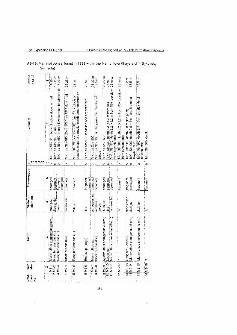
The Expedition LENA 99 5 Paleoclirnate Sianals of Ice-Rich Perrnafrost De~osi ts
A5-15: Mammal bones, found in 1999 within the Mamontova Khayata cliff (Bykovsky Peninsula).

German-Russian Expedition POLAR URAL '99
A contribution to the EC-project EURASIAN ICE SHEETS
by Wolf-Dieter Hermichen, Anette Gierlichs, Frank Wischer and Dmitry Bolshiyanov
Wolf-Dieter Hermichen, Frank Wischer : Alfred Wegener Institute for Polar and Marine Research, Research Department Potsdam, PO Box 600149, D1 4401 Potsdam, Germany
Anette Gierlichs: : Alfred Wegener Institute for Polar and Marine Research, Columbusstraße D-27568 Bremerhaven
Dmitry Bolshiyanov; Arctic and Antarctic Research Institute (AARI), Bering St. 38, 199397 St. Petersburg, Russia
n PO1 AR URAL '99
1. Introduction (W.-D. Hermichen, D. Bolshiyanov)
Since 1998 the lake sediment group of AWI-Potsdam is involved in the research project 'Eurasian Ice Sheets' supported by the Commission of the European communities (ENV 4-CT97-0563) which is run by 6 groups from Bergen University (N), Geological Survey of Finland, Geological Survey of Norway, Lund University (S), Alfred Wegener Institute Bremerhaven-Potsdam (D), and by the University of Wales (Centre for Glaciology Aberystwyth, GB) in CO-operation with Russian scientific groups. After Svendsen (1 997) the major scientific objectives of the project are: 1. To reconstruct from field observations and remote sensing the glacial and climate history of the Eurasian Arctic for the last glacial cycle, especially for the period 20,000-1 8,000 yrs BP. >Mapping of the WeichselianIValdaian maximum ice sheet extent and associated ice-marginal features; >Establishing a chronology for the last glacial maximum (LGM) in the different sectors of the Russian mainland; reconstructing former ice-flow directions and interactions between the different ice sheets and domes during the LGM; >Reconstruction of the periglacial environment during the Late-Weichselian, including ice-dammed lakes and vegetation. 2. Numerical modelling of ice sheets and their sensivity to climatic change. The contribution of the AWI is focused onto studies of sediment sequences from lake basins of the area Polar Urals-Pechora Basin. Based on former Russian-German CO-operation in paleoenvironmental research in the Siberian Arctic (e.g. Melles, 1994; Melles, Hagedorn, Bolshiyanov, 1997), a joint AARI-AWI expedition to the Polar Urals - "PolarUral-99"- was agreed, aiming to the coring of bottom sediments from Lake Lyadhej-To (68'15'N, 65¡45'E C. 150 m a.s.1.) and Lake Bol'shoe Shchuch'e (67'54'N, 66'18'E, C. 120 m a.s.1.). On the base of a survey, made in August 1998 (Hermichen and Wischer, 1999), coring on Lake Lyadhej-To was performed in April 1999 from the lake ice Cover by the AWI-group. In the Course of 10 days 45 meters were cored at 3 stations. The cores represent the complete lacustrine sediment sequence, including the uppermost Part of the basal till-like layer. Contemporarily, the limnological-geomorphological survey of the Lake Bol'shoe Shchuch'e and its surroundings was done by the AARI-group (see section 4).
2. Expedition itinerary (W.-D. Hermichen)
Partici~ants, With respect to different working places the expedition team consistsed of 2 groups:
I AR URAI '99
Group "Shchuch'e": Bolshiyanov, Dmitry (geographer) AAR1 St.Petersburg Pavlov, Maxim (student of geography) - St.Petersburg State University;
Group "Lyadhej-To": Gierlichs, Anette (geophysicist, PhD-student) - AWI Bremerhaven Hermichen, Wolf-Dieter (geophysicist) - AWI Potsdam Müller Gerald (technician) - AWI Potsdam Wischer, Frank (geologist, PhD-student) - AWI Potsdam Ippolitov, Valery (general assistant) - Agency VICAAR St.Petersburg Minnekhonov, Viktor (driver) - Company Polyarnouralgeologiya Vorkuta Pizhashov, Sergey (driver) - Company Polyarnouralgeologiya Vorkuta
Course of the expedition The German Part of the logistical preparation of 'PolarUral-99' was carried out by the expedition staff in Potsdam and Bremerhaven in January-February 1999, supported by the AWI-logistics department. Within the Russian Federation, people from AAR1 St. Petersburg, Agency VICAAR St. Petersburg and Company Polyarnouralgeologiya Vorkuta, kindly supported the expedition.
February 23. - 28: Shipping of the expedition equipment (20 ft-container, 4250 kg) fromBremerhaven1Hafenlager to St. PetersburgISouth Customs Post by truck.
March 1 - 12: Customs clearance in St. PetersburgISouth Customs Post. March 15 - April 12: Shipping of the container from St. Petersburg to Vorkuta
by railway,
March 29 -April 1: Train journey of Bolshiyanov, Ippolitov and Pavlov the from St. Petersburg to Vorkuta. April 7 - 9: Flight of the German participants from Berlin to Vorkuta via St. Petersburg - Syktyvkar. April 1 - 12: Preparation to the expedition in Vorkuta including preparation of
thesledge-tractor train, purchase of food supplies, acquaintance with Information about the survey area in the archives of Polyarnouralgeologiya.
April 13: Flight (MI-8) of 2 groups to Lake Bol'shoe Shchuch'e (Bolshiyanov, Pavlov) and to Lake Lyadhej-To (Gierlichs, Hermichen, Wischer).
April 16 - 18: Journey of the sledge-tractor train from Vorkuta to Lake Lyadhhej-To (Müller Ippolitov, Minnekhonov, Pizhashov).
on PO1 AR URAI 99
April 13-22:
April 14 - 22:
April 19 - 29: April 23:
April 24 - 27:
April 30 - May 01:
May 02 - 09:
May 03 - 07:
May 10:
May 25:
June 13 - 17:
Hydrological and geomorphological studies in the valley of Lake Bol'shoe Shchuch'e, bottom lacustrine sediment sampling. Ramaq-GPR (ground penetrating radar) survey on Lake Lyadhhej-To. Sediment coring at 3 sites on Lake Lyadhhej-To Evacuation of the group from Lake Shchuch 'e by MI-8, airborne visual geomorphological observations along the route from Lake Shchuch'e to Lake Lyadhej-To. Bolshiyanov, Pavlov and Gierlichs return to Vorkuta. Bolshiyanov, Paviov and Gierlichs fly to St. Petersburg via Syktyvkar. Journey of the sledge-tractor train from Lake Lyadhhej-To to the Vorkuta-base of Polyarnouralgeologiya (Hermichen, Müller Wischer, Ippolitov, Minnekhonov, and Pizhashov) Loading of the expedition container in Vorkuta, completion of all administrative activities, dispatch of the container with cargo to St. Petersburg by railway (Ippolitov). Return of Hermichen, Mülle and Wischer to Germany (by railway to St. Petersburg via Vologda). Departure of the expedition container from Vorkuta and flight of Ippolitov to St. Petersburg. End of the expedition Arrival of of the expedition container in St. Petersburgl South Customs Post. Shipping of the expedition container from St. Petersburg to BremerhavenlHafenlager by truck.
I AR URAI '99
3. Coring of bottom sediments on Lake Lyadhej-To ( A. Gierlichs, W.-D. Hermichen, and F. Wischer)
3.1 Working area Lake Lyadhej-To is located at the western foothills of the Polar Urals (68'15'N, 65'45'E, 150 m a.s.l.), inside the hypothetical southern limit of the last glaciation. Field investigations indicate that the Lyadhej-To may be carved into bedrock, and therefore it seemed to be well suited for achieving a long continuous sedimentary record since the last deglacation. Today it is situated in a tundra-landscape. Numerous smaller (presumably thermokarst- Iglaciokarst-) lakes surround it. Geomorphological evidence for a (presumably early- to mid-Weichselian) Kara-ice sheet margin was found C. 25 km to the south of the study site: Endmoraines (deposited at an altitude of C. 550 m a.s.1.) indicating glacier
Fig 1: Bathymetric map of Lake Lyadhej-To, based on former measurements and radar-profiling. Depth contours are given in meters. Coring sites are marked by dots, GPR profiles b y straight lines.
lobes having invaded into some valleys of the northernmost Ural mountains (Astakhov et al., 1999). But, there are also alternative conclusions from geomorphological studies, pointing to a local glaciation of the Polar Urals in Weichselian time (see section 4 of this report).
Geometry of the lake basin Lake Lyadhej-To is ca. 2.5 km long and 1.5 km wide. It is divided into a southern and a northern basin, which are up to 26 m and 21 m deep, respectively. Main inflows are three rivulets in the

n PO1 AR URAL '99
south, whereas a minor inflow and the outflow are situated in the north of the lake (see fig.l) The lake has a shallow shoreline, only in the south there is a steep slope with a height of approximately 15 m.
Hvdrologv The lake is mesotrophic to oligotrophic, ice-free in summer. In April 1999 it was covered by ice, 1.9 m thick. Temperature of the water column was slightly above O° without distinct changes. At the beginning of August 1998 the uppermost 5m had a temperature of 16OC, a gradual decrease to 11 'C occurred in depths between 5 m and 15 m which was followed by a slighter decrease to 9OC at the bottom. Dissolved oxygen values vary between 9 and 10.8 mg 11. The conductivity is low with values between 45 and 67 pScm11, the water is neutral to slightly basic (pH 7.4 to 8.3).
3.2 Survey of bottom sediments in Lake Lyadhej-To using ground- penetrating radar (GPR) (A. Gierlichs)
Only little was known about the geometry of the lake basin and about its sediment prior to the fieldwork. That's why a survey with a RAMACIGPR system was performed on the snow-covered lake ice to map the water depth and the sediment-thickness and to get information on the hardrock surface topography beneath the bottom sediments.
Eauipment and measurements The RAMACIGPR system is a digital ground penetrating radar system with true 16 bit AID converter. The maximum number of samples is variable. We chose 2048 sampling points. In this survey 25 MHz antennae were used with an offset of 4 meters. Because the profiles had to be recorded On foot On the lake ice - external-triggering using keyboard, the spacing of the recorded traces was 4 meters, too. Profiles with a maximum length of 1000 meters were recorded. The signal itself was stacked 2048 times for noise reduction and signal enhancement. The water depth was about 25 meters maximum. With a velocity of sound in water of Ca. 30 mlps and with an assumed velocity of sediments of 200 mlps, a recording length of 2000 ns was chosen. So it was possible to record signals also from deeper areas of the sediments. Five transections of the lake were measured; especially the deepest parts of the two basins and the ridge between them were the points of interest. At the deepest parts of the lake the layering of the sediments assumed to be undisturbed. CMP measurements give velocity-information about the 'C'ommon 'M'id 'P'oint between the transmitter and receiver antennae. Two CMP measurements for velocity information were recorded at the ridge, where the water depth was well known. The distance between the antennae was increased to 30 m symmetric for each trace and the signal was stacked 4096 times.
Data processing: The profiles were pre-processed with the software GRADIX in the field camp, to determine the best coring sites. Traces were filtered and printed using an AGC with a window length of 48 ns. The CMP measurement show three main reflectors (fig. 2): The first at 290 ns with a velocity of 220 mlps, the second at 510 ns with a velocity of 510 mlps and the third at 630 ns with a velocity of 11 0 mlps. With this information it is possible to estimate the thickness of the sediments in the basins. The reflections and velocity Information of deeper areas are not discussed here, because the main aspect is the thickness of the sedirnents. Results: The signal between 0 and 200 ns at the southern basin (Profile 1lFig.3) and between 0 and 250 ns at the northern basin (Profile 2lFig.4) shows the ice on the sea surface. In the deepest Part of the southern basin the sediment layers are approximately 4 meters thick (profile 1). In the northern basin the received signals indicate about 8 meters of sediments (profile 2). The data in between shows the water column of the lake. Interna1 structures of the sediments are not resolved. Profile 3 (Fig.5) was measured on the ridge of Lake Lyadhej-To. Unfortunately the profile missed the ridge in the eastern Part of the profile. The profile starts at the Western shore of the lake. Traces 1 to 18 show ice from 0 to 200 ns. The water depth increases from west to east and the ice and the sediments can be resolved. The structure of the sediments between 600 ns and 1100 ns of traces 1-25 and 40-60 is unusual. It is not yet clear, whether this structure is artificial or not. The sediments have a thickness of about 12 meters (250 ns). The data quality is good along the whole profile. The next profile starts at the southern point and ends at the camp on the ridge in the middle of the lake (Profile 4lFig.6). The points, at which profile 1 and profile 3 intersect profile 4 are marked in the plots. Profile 1 is not exactly at the deepest point of the southern basin, whereas profile 3 is right on the top of the ridge. The penetration of the signal into the sediment-layer On the ridge is about 500 ns. Around trace 180 several reflections with a total traveltime of 800 ns - 900 ns are detected. The signal at the slope of the ridge, between trace 100 and 130, looks quite Strange - it is not yet clear, if this is a result of a technical problem. The horizontal signal between 600 ns and 700 ns, which can be correlated at all traces, seems to be the multiple of the ice Cover of the lake. Profile 5a+b (Figs. 7, 8) starts at the ridge and ends in the northern Part of the lake. Here, the sediments of the ridge are also detected quite well. Reflections of the sediments were found with a total traveltime of 700 ns for the traces 1 - 40. The reflections from deeper parts at the beginning of profile 5a are probably artificial. These signals, which move parallel and slightly upwards, are recorded again around trace 20 with a total traveltime of 600 ns to 1100 ns. Between traces 40 and 80 a multiple of the lake bottom can be Seen at 900 ns. The multiple at 600 - 700 ns is recorded again in profile 5b. The profile starts at the camp and ends in the northern Part of the lake and shows decreasing sediment thickness with increasing waterdepth. It is not yet clear,
whether this results from the energy loss of the signal due to bad coupling. At the deepest Part of the northern basin the intersecting point with profile 2 is marked again in the plot. Profile 2 gives also new information about the topography of the lake. The deepest part of this basin was expected to be more eastern. The new information about the water depth of the northern basin and about the sediment coverage is shown in profile 2. The signal of the Western slope of the ridge - trace 1 - 20, between 300 ns and 800 ns - is probably an effect of a temporary malfunction of the antenna. This did not occur in other parts of the profile. The thickness of the sediments here varies between 200 - 150 ns. The deepest point of this profile shows less sediment than the shallower parts like the profiles mentioned before. The multiple, often Seen between 600 ns and 700 ns On other profiles, is missing completely.
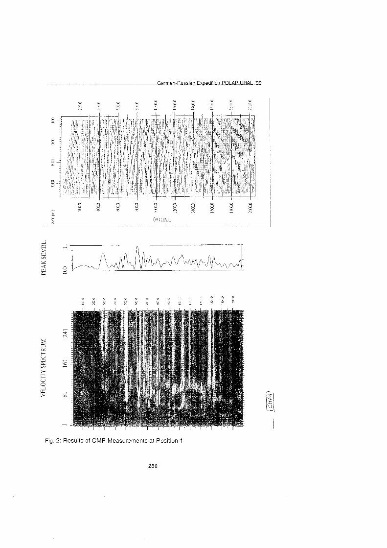
G-n PO1 AR URAI '92 . .
Fig. 2: Results of CMP-Measurements at Position 1
280
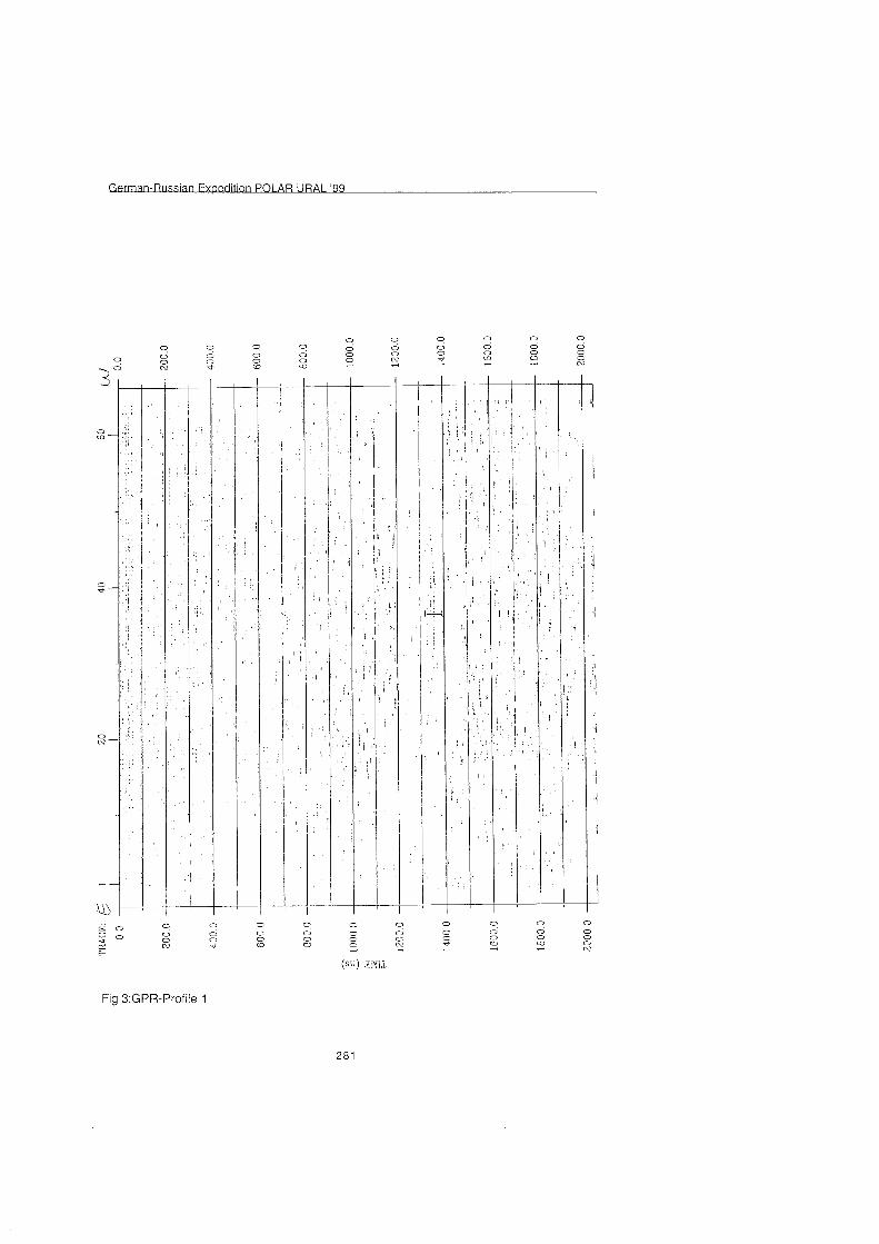
Fig 3:GPR-Profile 1
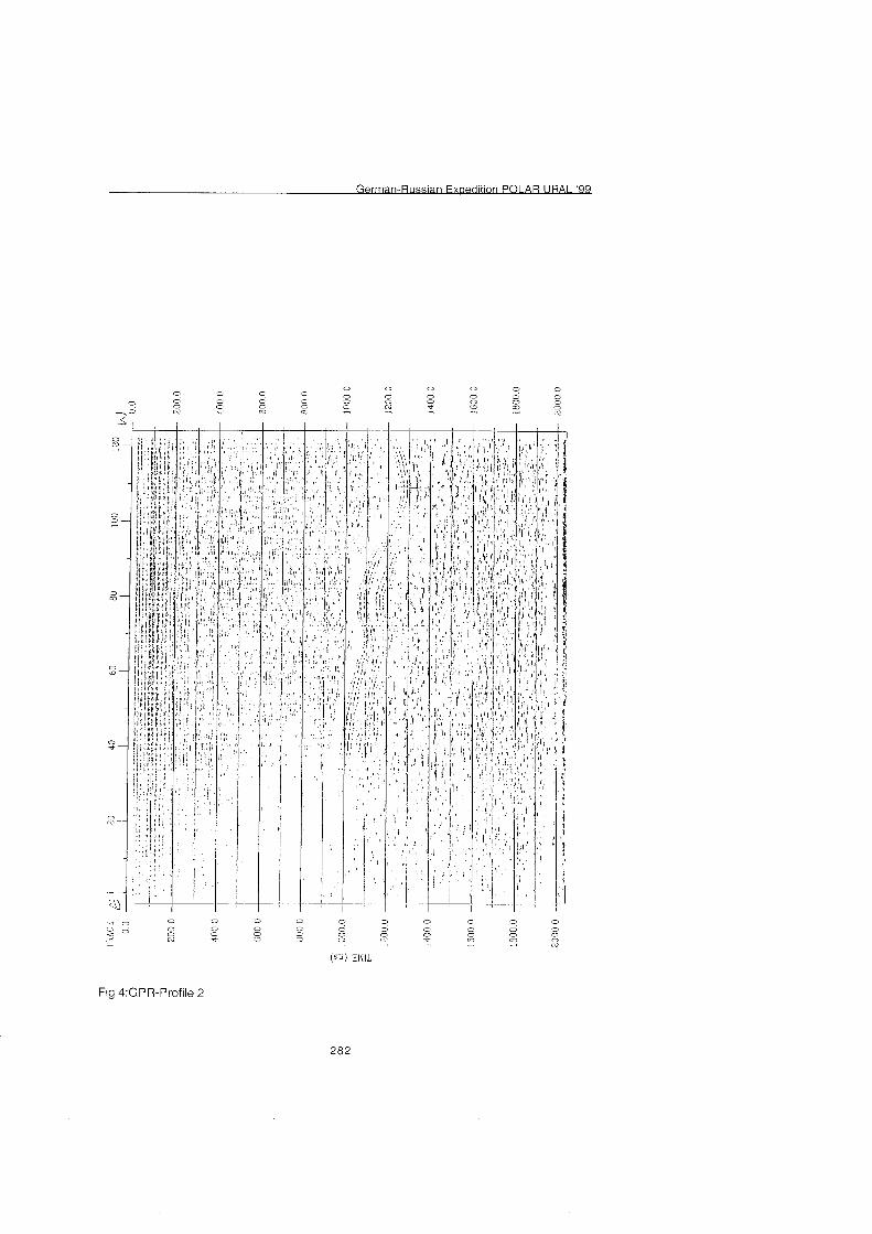
n PO1 AR URAI '99
Fig 4:GPR-Profile 2
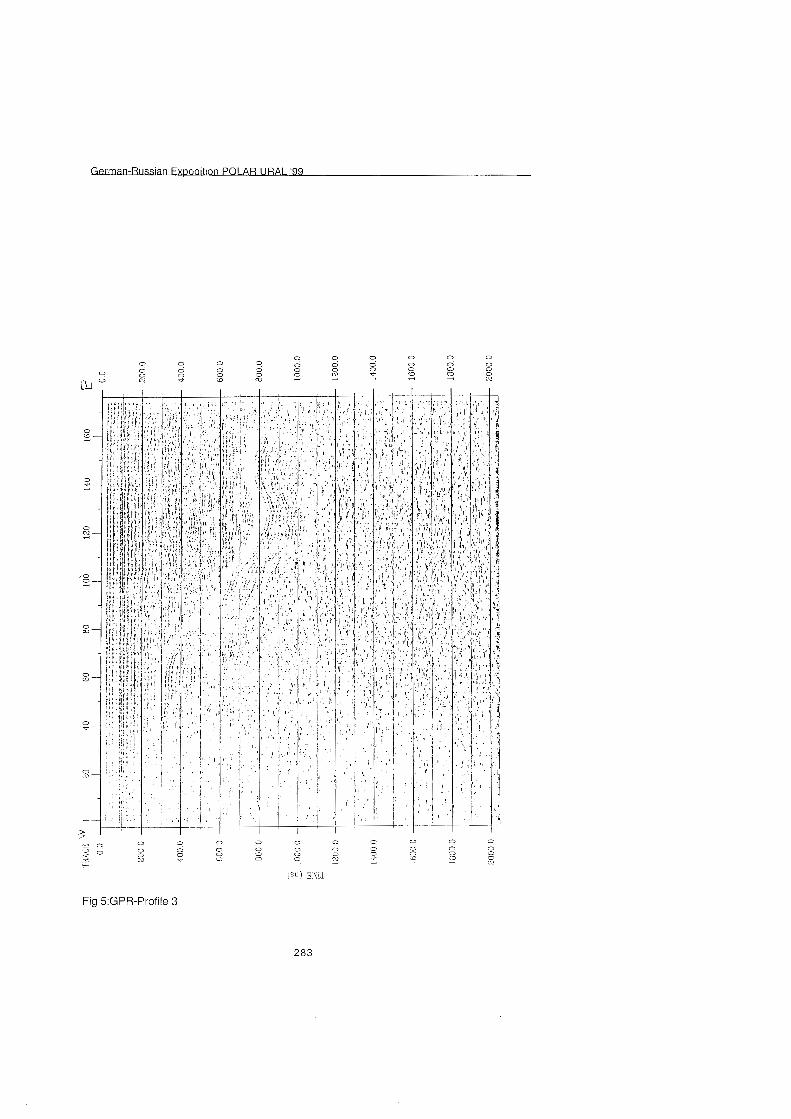
n PO1 An URAI '99
Fig 5:GPR-Profile 3
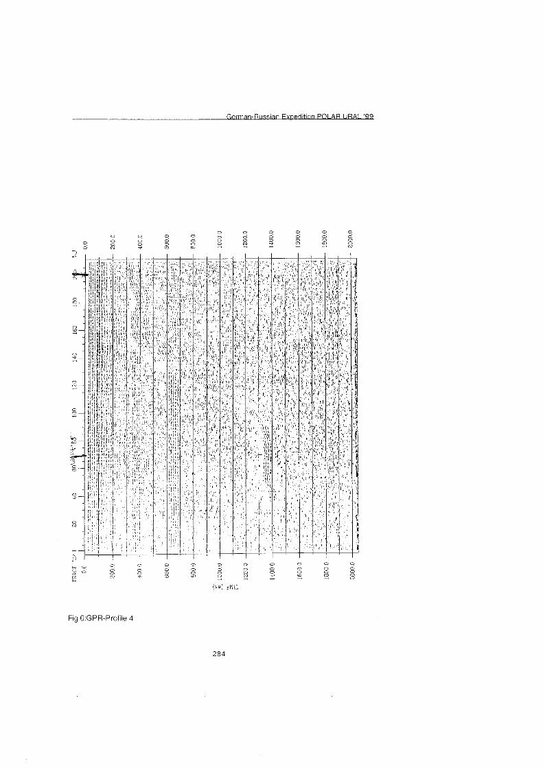
I AR URAL '99
Fig 6:GPR-Profile 4
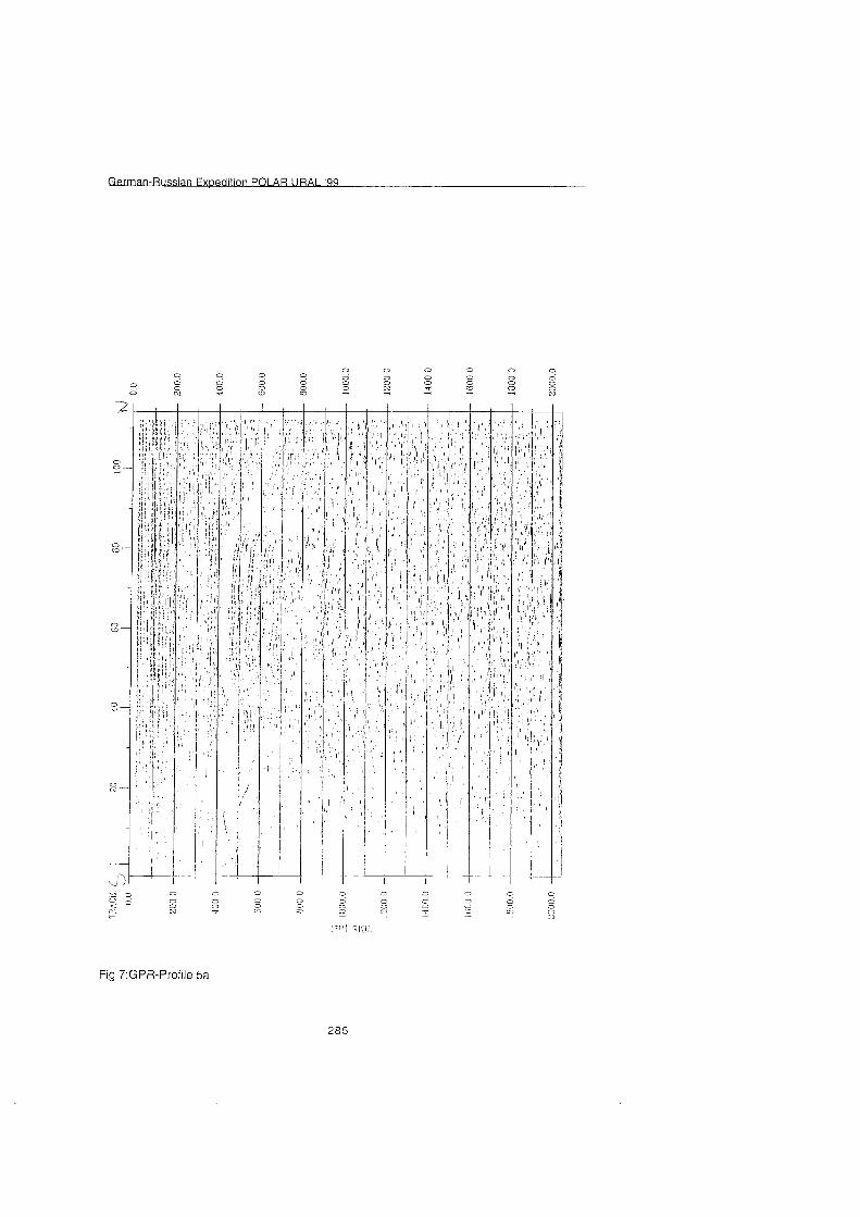
n PO1 AR URAI '99
Fig 7:GPR-Profile 5a
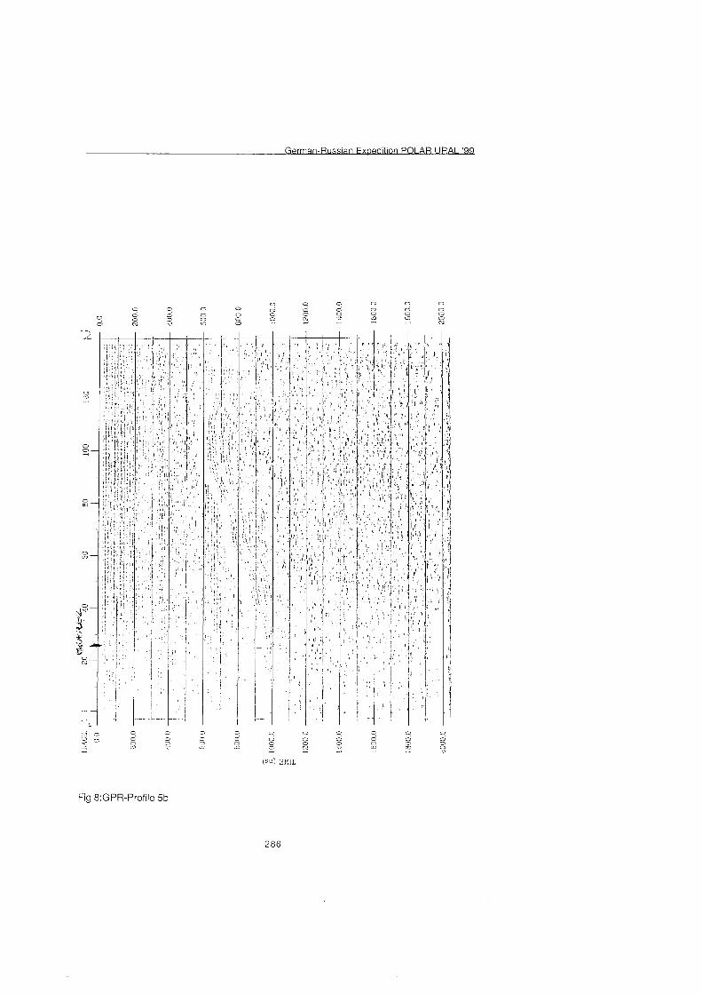
Fig 8:GPR-Profile 5b
Conclusion: The RAMACIGPR system is a good opportunity for pre-surveying frozen lakes to determine coring sites. Although air temperature was often below -15OC, it was possible to measure a total of C. 4.5 km with a good penetration of the sediments. Due to logistic problems, the antenna had to be moved on foot. Moving the antennae with a snowmobile on sledges is a more advanced way of GPR-profiling, well established in other parts of polar research. Continuous measurements and longer profiles could be recorded using internal triggering. The icy surface of the lake caused some damage to the antennae so that they did not work reliably on all parts of the profiles. Fortunately they could be repaired during the expedition. The drilling results correspond quite well with the predicted sediment thickness derived from radar measurements. In the southern basin 4 meters of lacustrine sediments were expected and 7.8 meters were recovered. In the northern basin 8 meters thickness was predicted, and 7.0 meters were found. Beside the information on the thickness of the sediments, the topography of the lake bottom was also measured. Former measurements were corrected using the new information given from the radar profiles. Unfortunately the conditions for the measurements were not optimal, otherwise the whole lake could have been surveyed with GPR. The survey with the 25 MHz antenna gives an idea of sediment structures below the lake bottom and the topography of the lake bottom itself. With maximum water depth of 25 m and a lacustrine sediment thickness of 8 m Lake Lyadhej-To is an optimum-testing site for high-resolution GPR. Using 50 MHz and 100 MHz antennae would give detailed information on internal structures of the sediment section.
3.3 Coring: Equipment and procedures (F. Wischer)
Coring was carried out through holes in the 1.9-m thick ice Cover, using a tripod with hand-operated winches. A special tent protected the working site. Two types of coring devices were used - both equipped with a plastic liner (inner diameter 60mm) to take in the sediment column. A light gravity corer was applied for the sampling of soft near-surface sediments. It is able to recover a maximum core length of 55 Cm. Longer sediment cores were obtained with a piston corer; a manually operated hammer (20kg) supplies the penetration of the corer. The maximum recovery with every employment is 3 m, limited by the length of liner. However, deeper situated sediment can also be sampled, because the Start of the coring process is controlled by release of the piston at a defined depth of the corer. The piston is fixed in the lower tube aperture during the way of the corer through the water column and the overlaying sediments. Therefore, it is possible to obtain a sediment sequence of more than 20 m by matching overlapping cored sequences. A detailed description of coring technique is given by Melles et al. (1 994).
After recovering the piston corer from the water, it was immediately transported to the heated field station to avoid freezing. The cores were cut into Segments of a length 2100 cm, sealed airtight and labelled. Before sealing the visible sediment was described roughly. Finally, the cores were stored in thermoboxes at a temperature >O°C
3.4 Field description of the sediment columns (F. Wischer)
Sediment coring was started at site PG 1436 (see fig.l and table, given below) on top of the underwater-plateau at a water depth of 7 m. The sediment recovery was 7.6 m. Thanks to the results of GPR profiling (which indicated unstratified sediments with a thickness > 25 rn), we decided to stop the coring at site PG 1436. Two more promising sites could be located by GPR: PG 1437 in the northern and PG 1438 in the southern basins. At site PG 1437 11.8m could be obtained at a water depth of 21.7 m, coring at PG 1438 resulted in a core of 10 m (water depth 24.4 m). Due to the covering plastic tubes the sediments could be described only roughly: At sites PG 1437 (northern basin) and PG 1438 (southern basin) an unstratified, poorly sorted, consolidated diamicton occurs at the base, which was interpreted as a moraine, deposited during the last glacier advance. The uppermost seven rneters of PG 1437 consist of laminated and stratified clayey silts (or silty clays) of dark greyish to black colour, which are rich in organic rernains. They were interpreted as limnic sediments, reflecting the cornplete post-glacial lake history. Site PG 1438 contains cornparable sediments between 6.5 rn and 0 m. The sequence between 8.0 m and 6.5 m consists of partly stratified sands with some clay layers and can be interpreted as a state of low autochthonous biomass production in the lake. The sediment succession of PG 1436 is comparable to the other sections only in the top three meters. The deeper parts consist of poorly sorted, partly stratified clastic sedirnents, which may have been deposited by a mass flow, e. g. by a landslide or a mudflow from a nearby mountain valley, as field observations suggest.
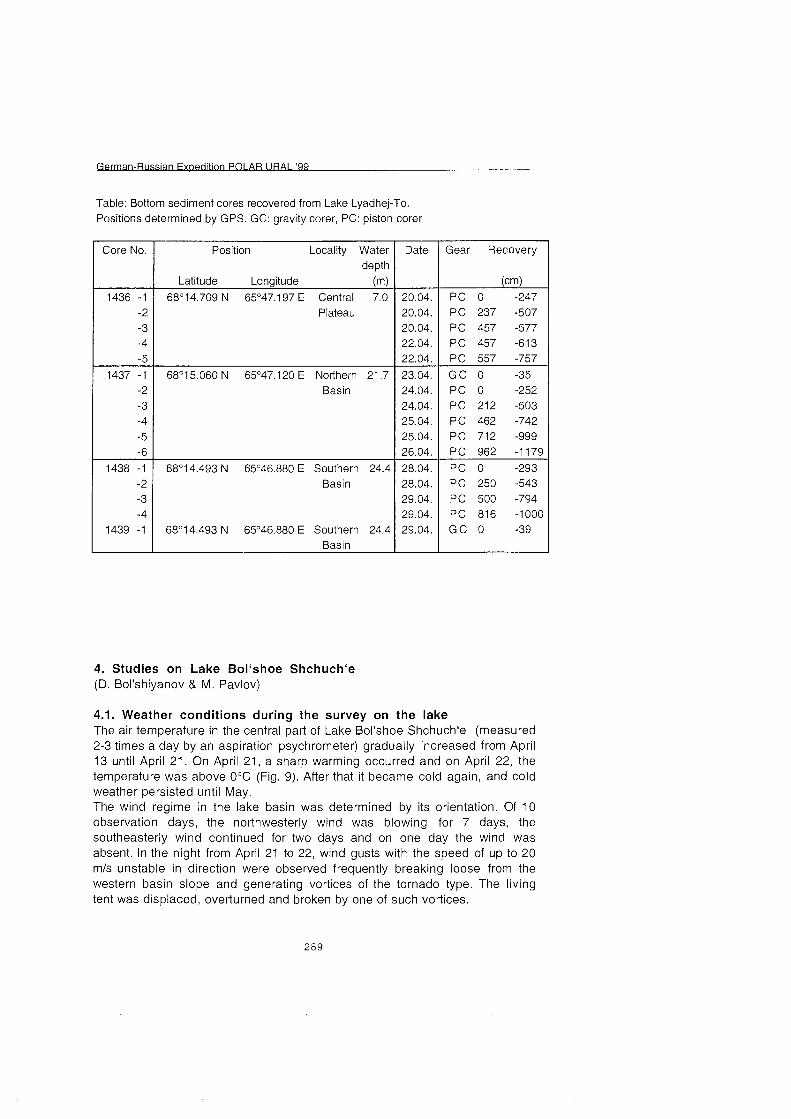
Table: Bottom sediment cores recovered from Lake Lyadhej-To. Positions determined by GPS. GC: gravity corer, PC: piston corer
68O1 5.060 N 65O47.120 E Northern 21.7 Basin
Core No.
Basin
Basin
Position Locality Water depth
Latitude Longitude (4
Date
1436 -1 68'14.709 N 65'47.197 E Central 7.0 -2 Plateau -3 -4 -5
Gear Recovery
4. Studies on Lake Bol'shoe Shchuch'e (D. Bol'shiyanov & M. Pavlov)
4.1. Weather conditions during the survey On the lake The air temperature in the central Part of Lake Bol'shoe Shchuch'e (measured 2-3 times a day by an aspiration psychrometer) gradually increased from April 13 until April 21. On April 21, a sharp warming occurred and on April 22, the temperature was above O° (Fig. 9). After that it became cold again, and cold weather persisted until May. The wind regime in the lake basin was determined by its orientation. Of 10 observation days, the northwesterly wind was blowing for 7 days, the southeasterly wind continued for two days and on one day the wind was absent. In the night from April 21 to 22, wind gusts with the speed of up to 20 mls unstable in direction were observed frequently breaking loose from the Western basin slope and generating vortices of the tornado type. The living tent was displaced, overturned and broken by one of such vortices.
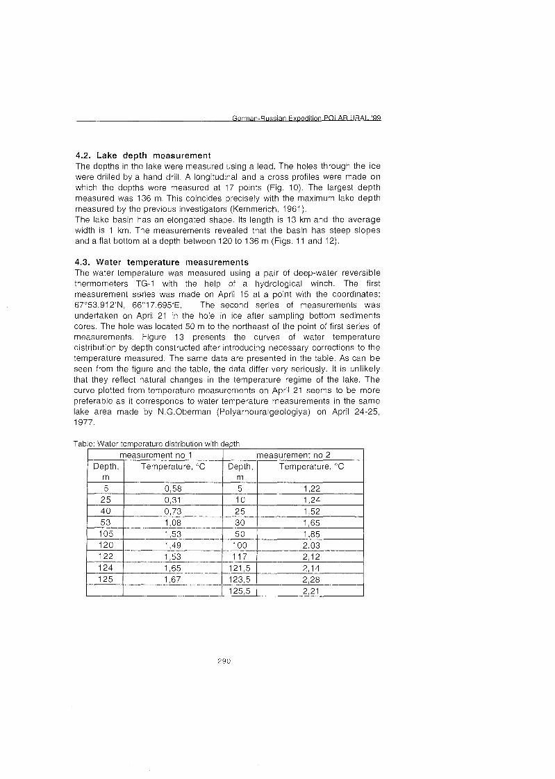
4.2. Lake depth measurement The depths in the lake were measured using a lead. The holes through the ice were drilled by a hand drill. A longitudinal and a Cross profiles were made on which the depths were measured at 17 points (Fig. 10). The largest depth measured was 136 m. This coincides precisely with the maximum lake depth measured by the previous investigators (Kemmerich, 1961). The lake basin has an elongated shape. Its length is 13 km and the average width is 1 km. The measurements revealed that the basin has steep slopes and a flat bottom at a depth between 120 to 136 m (Figs. 11 and 12).
4.3. Water temperature measurements The water temperature was measured using a pair of deep-water reversible thermometers TG-1 with the help of a hydrological winch. The first measurement swies was made on April 15 at a point with the coordinates: 67'53.91 2'N, 66'1 7.695'E. The second series of measurements was undertaken on April 21 in the hole in ice after sampling bottom sediments cores. The hole was located 50 m to the northeast of the point of first series of measurements. Figure 13 presents the curves of water temperature distribution by depth constructed after introducing necessary corrections to the temperature measured. The Same data are presented in the table. As can be Seen from the figure and the table, the data differ very seriously. It is unlikely that they reflect natural changes in the temperature regime of the lake. The curve plotted from temperature measurements on April 21 seems to be more preferable as it corresponds to water temperature measurements in the Same lake area made by N.G.Oberman (Polyarnouralgeologiya) on April 24-25, 1977.
Table: Water temperature distribution with depth
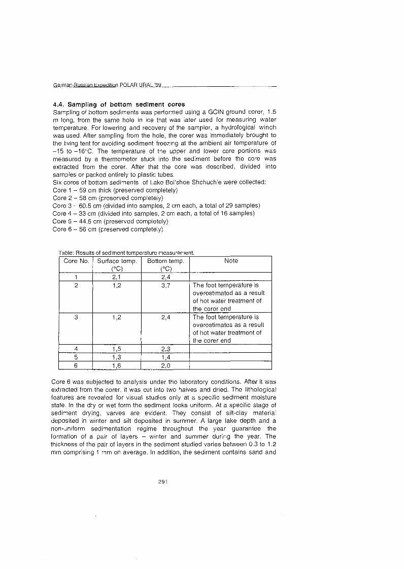
4.4. Sampling of bottom sediment cores Sampling of bottom sediments was performed using a G01N ground corer, 1.5 m long, from the Same hole in ice that was later used for measuring water temperature. For lowering and recovery of the sampler, a hydrological winch was used. After sampling from the hole, the corer was immediately brought to the living tent for avoiding sediment freezing at the ambient air temperature of -15 to -16OC. The temperature of the upper and lower core portions was measured by a thermometer stuck into the sediment before the core was extracted from the corer. After that the core was described, divided into samples or packed entirely to plastic tubes. Six cores of bottom sediments of Lake Bol'shoe Shchuch'e were collected: Core 1 - 59 cm thick (preserved completely) Core 2 - 58 cm (preserved completely) Core 3 - 60.5 cm (divided into samples, 2 cm each, a total of 29 samples) Core 4 - 33 cm (divided into samples, 2 cm each, a total of 16 samples) Core 5 - 44.5 cm (preserved completely) Core 6 - 56 cm (preserved completely)
of hot water treatment of
6
Core 6 was subjected to analysis under the laboratory conditions. After it was extracted from the corer, it was cut into two halves and dried. The lithological features are revealed for visua! studies only at a specific sediment moisture state. In the dry or wet form the sediment looks uniform. At a specific Stage of sediment drying, varves are evident. They consist of silt-clay material deposited in winter and silt deposited in summer. A large lake depth and a non-uniform sedimentation regime throughout the year guarantee the formation of a pair of layers - winter and summer during the year. The thickness of the pair of layers in the sediment studied varies between 0.3 to 1.2 mm comprising 1 mm on average. In addition, the sediment contains sand and
gravel interlayers up to several mm thick. They are rhythmically deposited in the water bodies. As shown by the studies of varved clays of current sub-glacial water bodies in the Arctic (Bolshiyanov, 1985) and in the Antarctic (Bolshiyanov et al., 1991), the sandy-gravel interlayers in the Strata of bottom sediments serve as evidence of the catastrophic events of the detrital material discharge to the lakes due to snow-ice mass melting periodically accumulating in the lake basins. At the time of their degradation, a large amount of water is released during a short time resulting in erosion and transport of detrital material to the accumulation basins. Counting the varves and determining the location of sand-gravel interlayers in the section allows determining an approximate time of the catastrophic events. The spore-pollen studies also allow specifying the glaciation periods connected with local climate cooling. After counting the pairs of layers and ice interlayers dividing them, samples for spore-pollen analysis and of organic matter for radiocarbon dating were collected. Figure 14 presents the structure of cores 5 and 6 and the sampling intervals. From the diagram in Figure 15 one can determine the time of deposition of sand interlayers in the lake that probably resulted from the discharge of a large quantity of detrital material to the lake and from melting of small glaciers and firn.
4.5. Geomorphological observations in the valley of Lake Bol'shoe Shchuch'e and along the route to Lake Lyadhhey-To The valley of Lake Bol'shoe Shchuch'e is a geomorphological expression of the Earth's crust fault. The strike of the "Shchuch'e" fault is NW -323'. This direction corresponds to the direction of the main lineaments in this area. The directions of the main lineaments were measured over the 9750 km2 area using the 1 :500 000 scale map. A rose-diagram of lineaments was plotted (Fig. 16) where two directions dominate: NE - 42' and NW - 31 5'. The northern half of the lake basin is cut by an anticlinal massive comprised of slates, quartzite-sandstone and effusive rocks of Bedamelskaya suite of the upper Proterozoic-Cambrian. Along the western slope of the basin these rocks are displaced northwestward over 8 km compared with the eastern slope. The entire western slope and the southern half of the eastern slope are comprised of the Ordovician slates, siltstone, sandstone and conglomerates. At the slopes of the southern Part of the lake, dikes of gabbro-diabase outcrop to the surface. A cross-profile of the valley is trapezoidal - steep straight slopes and a flat bottom. The asymmetry of the lake basin slope is expressed in a steeper and straight western slope and in the eastern slope complicated with erosion entrenchments. The asymmetry is due to the rock bedding features. The rocks outstripped at the western slope have incidence up to 70 along the 65' azimuth, i.e. in conformity with the slope. The rocks at the eastern slope dip at the 20' angles to the southeast - 110° i.e. across the strike. An asymmetry of the lake basin morphology is also expressed in the meridional direction. The slopes and watershed of the southern part of the basin are much lower. The highest marks of the Proterozoic-Cambrian massive in the northern
area are up to 1223 m whereas in the southern area the watershed heights reach only 500-580 m. Cirques are present at the western slope of the tectonic basin. At the eastern slope, the erosion grooves in the upper parts of the slopes, combine into funnel-shaped systems of dry valleys. The asymmetry in the basin morphology is also reflected in vegetation. The osier shrubs in the northern half of the lake reach the 500-600 m heights at the eastern eroded slope. At the western straight talus slope, the osier shrubs have no place to fasten and reach only the 300 m height. In the southern half of the basin at the eastern slope, larch reaches the 170-1 80 m height above the lake level. In the southern area of the basin, the terraces at the heights of 120-1 70 and 50 m above the lake level are clearly pronounced. There is a terrace 7-10 m above the water level on both lakeshores in the accumulative debris cones and at the bedrock slope. Its width is up to 25-30 m and the surface is comprised of the rounded pebble and is covered by vegetation (moss, liehen and wild rosemary). The lowest terrace which points to the increased lake level stand in the past is located at the 3 m height above the water level. The morphology of the Lake Bol'shoe Shchuch'e basin and the absence of accumulation of ice deposits indicates that the glaciers, which partly occupied it, did not mechanically reworked the relief significantly. The lake terraces probably formed as a result of lake being dammed by mountain glaciers. Airborne visual observations undertaken during the flight to Lake Lyadhey-To revealed that the formation of the glacial relief features in the valleys of the northern slope of the Polar Urals was rather caused by the local mountain glaciers. Thus, a described bend of the glacial ridges upward the Polar Urals valleys could be due not to the penetration of the Kara ice shield to the Urals valleys as described by Astakhov et al. (1999) but to other causes. Figure 17 depicts such a ridge that served as the main proof of the Kara ice shield advance from the north to the mountains up to a height of 560 m (Astakhov et al., 1999). As can be Seen in this figure, there is a ring structure eastward in the next valley of Lake Ochety whose formation was caused by melting of dead ice buried by glacial deposits. The center of this structure has a sink with a lake (Fig. 17-a). The slopes of this structure were completely preserved and that is why it looks as a ring. The margin of the first "Kara" moraine bending southward could also be determined by ice melting in the center of the accumulated glacial deposits. A concave relief of this feature and the lake left from ice melting indicates this. The slope and erosion processes shade the northern part of the ring structure. An explicitly pronounced southward arch is also worked in addition by current nivation processes that are clearly marked by the firn preserved during Summer under the northern arch slope. Thus, the Kara origin of these glacial deposits cannot be attributed to only the direction of the end moraine orientation. There are other mechanisms that result in the formation of such features.
n PO1 AR URAI '99
References
Astakhov, V.I., Svendsen, J.I., Matiouchkov, A., Mangerud, J., Maslenikova, 0.) and Tveranger, J. ( 1999): Marginal formation of the last Kara and Barents ice sheets in Northern European Russia. - Boreas, vol. 28, n 1, p. 23-45.
Bolshiyanov, D.Yu. (1985): Sedimentation in the modern sub-glacial lake (by the example of Lake Izmenchivoye, Severnaya Zemlya archipelago). - Vestnik LGU, V. 7, Issue 1, P. 43-50.
Bolshiyanov, D.Yu., Verkulich S., Pushina Z,, Kirienko E. (1991): Some features of the Late Pleistocen and Holocen history of the Bunger Hills (East Antarctica).- Proceedings Intern. 6-th Symp. Antarctic Earth Sciences, T O ~ Y O , 1991, P. 101 -1 06.
Hermichen, W.-D. & F. Wischer (1 999): Eurasian ice sheets: Expedition to the Lake Lyadhej-To (Polar Urals). In: Rachold, V. (editor), Berichte zur Polarforschung 31 5: 261 -268.
Kemmerich, A.O. (1 961): Hydrography of the North, Sub-Polar and Polar Urals. Moscow, 139 p.
Melles, M. (Editor) (1 994): The expeditions NORILSKITAYMYR 1993. Berichte zur Polarforschung 148: 3-25.
Melles, M., Kulbe, T., Overduin, P.P., Verkulich, S. (1 994): The Expedition Bunger Oasis 1993194 of the AWI Research Unit Potsdam. In Melles, M. (ed.): The Expeditions NorilskITaymyr 1993 and Bunger Oasis 1993194 of the AWI- Research Unit Potsdam. Berichte zur Polarforschung, 148:27-80.
Melles, M., B. Hagedorn and D. Bolshiyanov (1997): Russian-German Cooperation - The expedition TAYMYRISEVERNAYA ZEMLYA 1996. Berichte zur Polarforschung 237, 169 p.
Svendsen, J.I. (1997): Ice sheets and climate in the Eurasian Arctic at the last glacial maximum (EURASIAN ICE SHEETS). Research proposal submitted to the Comission of the European Communities. University of Bergen. 55 P.
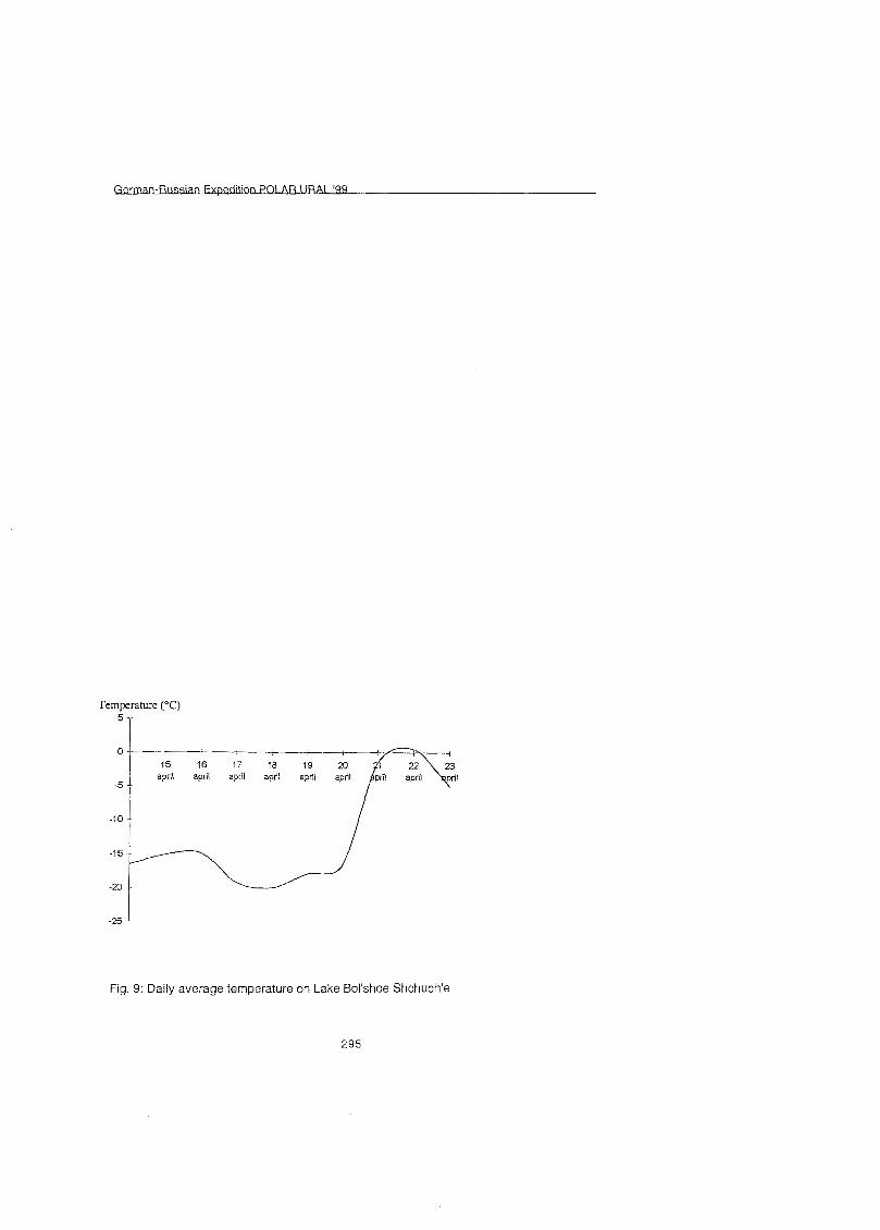
Fig. 9: Daily average temperature on Lake Bol'shoe Shchuch'e
295
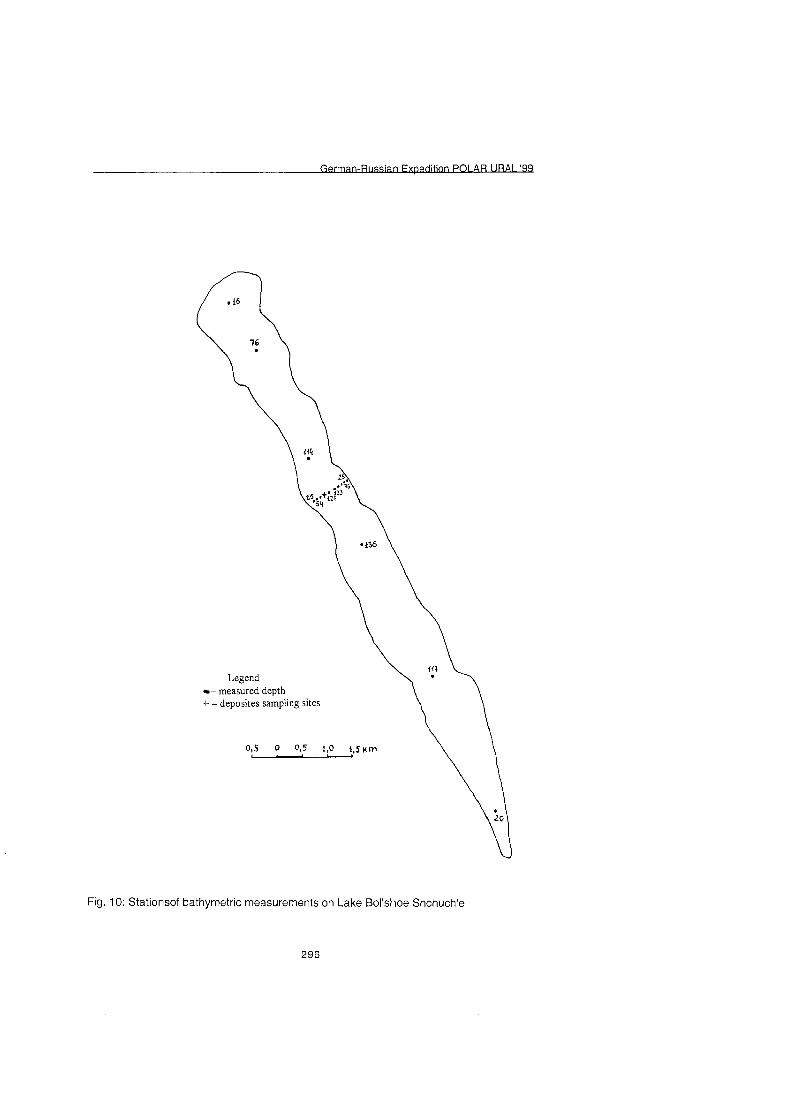
I AB URAI '99
Legend - measured depth
+ - deposites sampling sites
Fig. 10: Stationsof bathymetric measurements on Lake Bol'shoe Shchuch'e
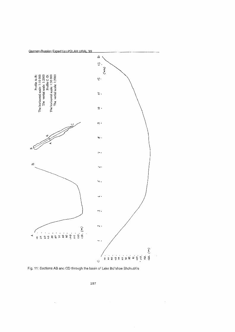
I AR URAI '99
Fig. 11: Sections AB and CD through the basin of Lake Bol'shoe Shchuch'e
297
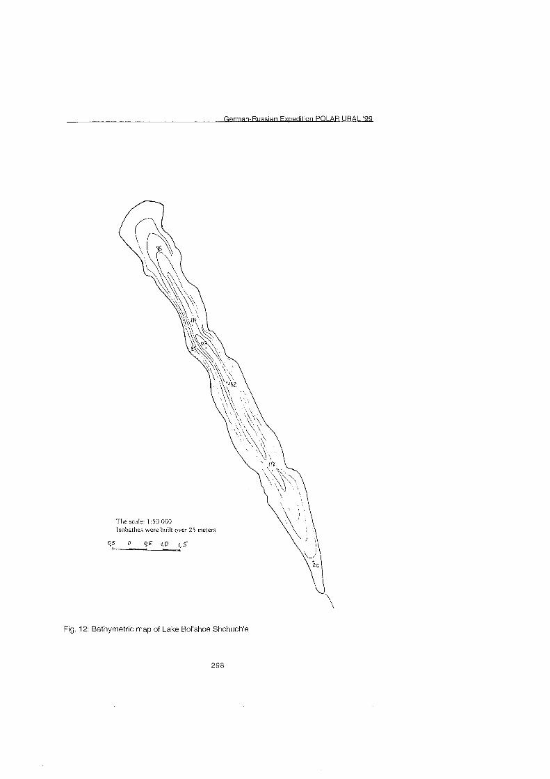
AR URAI '99
The scale: 1 :50 000 lsobathes were built over 25 meters
Fig. 12: Bathyrnetric map of Lake Bol'shoe Shchuch'e
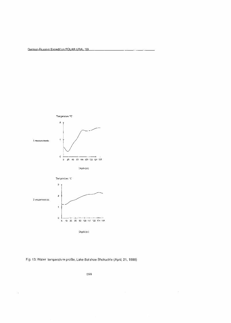
Fig. 13: Water temperature profile, Lake Bol'shoe Shchuch'e (April, 21, 1999)
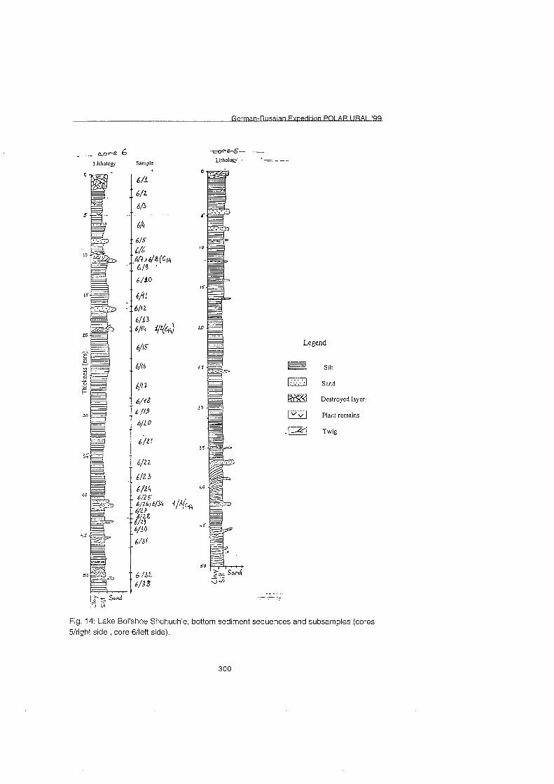
n PO1 AR URAI '99
Legend
siit
Sand
Destroyed layer:
Plant rernains
. Twig
Fig. 14: Lake Bol'shoe Shchuch'e, bottom sediment sequences and subsamples (cores 5lright side , core 6lleft side).
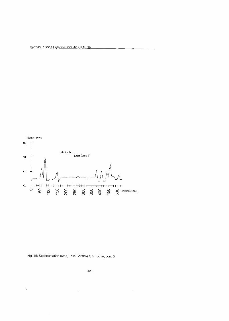
URAI '99
Shchuche
Fig. 15: Sedimentation rates, Lake Bol'shoe Shchuch'e, core 5.
30 1
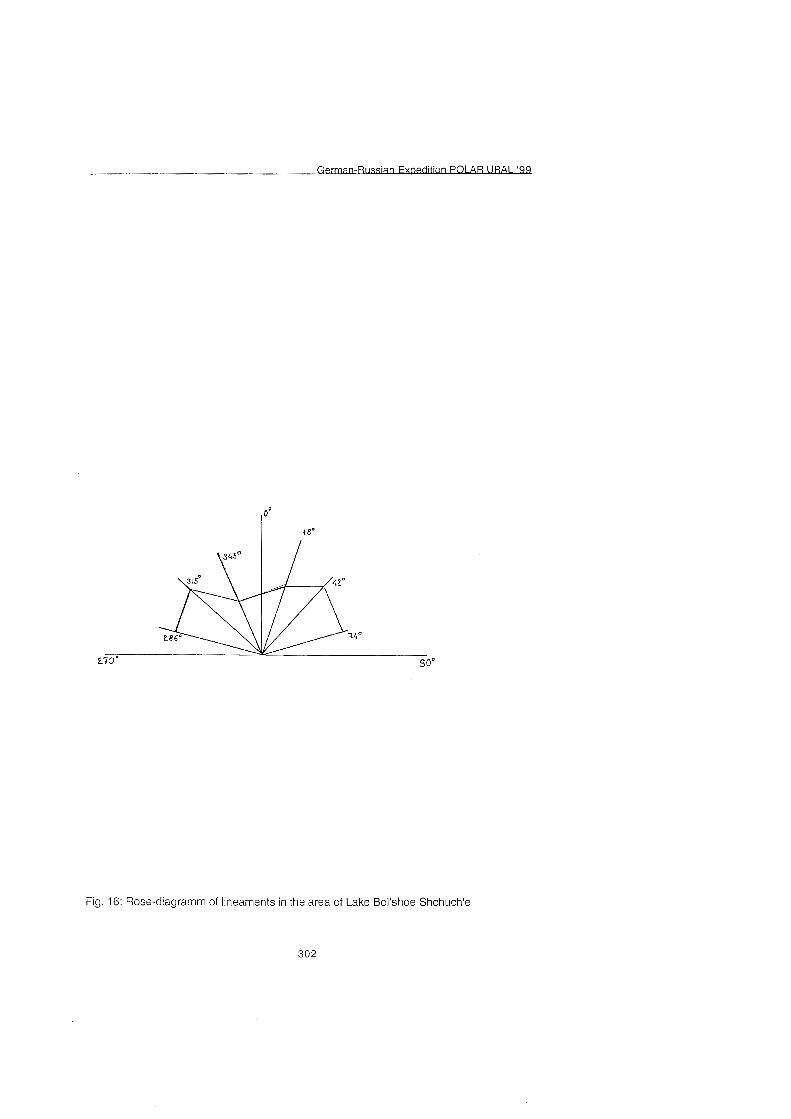
Fig. 16: Rose-diagramm of lineaments in the area of Lake Bol'shoe Shchuch'e
302
on PO1 AR URAI '99 P--
Fig. 17: Air-photograph (N - top) of the northwestern slope of the Polar Urals with morainic features discussed in the text.
Folgende Hefte der Reihe ,, erichte zur Polarforschung" sind bisher erschienen:
* Sonderheft Nr. 111981 - J3ie Antarktis und ihr Lebensraum" Eine Einführun fü Besucher - Herausgegeben im Auftrag von SCAR
* Heft Nr. 111982 - -Die Filchner-Schelfeis-Expedition 1980181" zusammengestellt von Heinz Kohnen
* Heft Nr. 211982 - ãDeutsch Antarktis-Expedition 1980181 mit FS ãMeteor First International BIOMASS Experiment (FIBEX) - Liste der Zooplankton- und Mikronektonnetzfäng zusammengestellt von Norbert Klages
* Heft Nr. 311982 - ãDigital und analoge Krill-Echolot-Rohdatenerfassung an Bord des Forschungs- schiffes ,Meteor'" (im Rahmen von FIBEX 1980/81, Fahrtabschnitt ANT III), von Bodo Morgenstern Heft Nr, 411982 - ,,Filchner-Schelfeis-Expedition 1980181" Liste der Planktonfäng und Lichtstärkemessunge zusammengestellt von Gerd Hubold und H. Eberhard Drescher
* Heft Nr. 511982 -"Joint Biological Expedition on RRS 'John Biscoe', February 1982" by G. Hempel and R. B. Heywood
* Heft Nr. 611982 - ãAntarktis-Expeditio I981182 (Unternehmen ,Eiswarte')" zusammengestellt von Gode Gravenhorst Heft Nr. 711982 - ãMarin-Biologische Begleitprogramm zur Standorterkundung 1979180 mit MS ,Polar- sirkel' (Pre-Site Survey)" - Stationslisten der Mikronekton- und Zooplanktonfäng sowie der Bodenfischerei zusammengestellt von R. Schneppenheim Heft Nr. 811983 - "The Post-Fibex Data Interpretation Workshop" by D. L. Cram and J.-C. Freytag with the collaboration of J. W. Schrnidt, M. Mall, R. Kresse, T. Schwinghammer
* Heft Nr. 911983 -"Distribution of some groups of zooplankton in the inner Weddell Sea in summer 1979/8OU by I. Hempel, G. Hubold, B. Kaczmaruk, R. Keller, R. Weigmann-Haass Heft Nr. 1011983 - ãFluo im antarktischen Ökosystem - DFG-Symposium November 1982 zusammengestellt von Dieter Adelung Heft Nr. 1111983 -"Joint Biological Expedition on RRS 'John Biscoe', February 1982 (11)" Data of micronecton and zooplankton hauls, by Uwe Piatkowski Heft Nr. 1Y1983 - ãDa biologische Programm der ANTARKTIS-I-Expedition 1983 mit FS ,Polarsterns" Stationslisten der Plankton-, Benthos- und Grundschleppnetzfäng und Liste der Probennahme an Robben und Vögeln von H. E. Drescher, G. Hubold, U. Piatkowski, J. Plöt und J. VoÃ
* Heft Nr. 1311983 - ãDi Antarktis-Expedition von MS ,PolarbjÖrn 1982183" (Sommerkampagne zur Atka-Bucht und zu den Kraul-Bergen), zusammengestellt von Heinz Kohnen Sonderheft Nr. Y1983 - ,,Die erste Antarktis-Expedition von FS ,Polarstern' (Kapstadt, 20. Januar 1983 - Rio de Janeiro, 25. Mär 1983)", Bericht des Fahrtleiters Prof. Dr. Gotthilf Hempel Sonderheft Nr. 311983 - 3icherheit und überlebe bei Polarexpeditionen" zusammengestellt von Heinz Kohnen
* Heft Nr. 1411983 - Jie erste Antarktis-Expedition (ANTARKTIS I) von FS ,Polarsterns 1982183" herausgegeben von Gotthilf Hempel Sonderheft Nr. 411983 -"On the Biology of Krill Euphausia superba" - Proceedings of the Seminar and Report of the Krill Ecology Group, Bremerhaven 12. - 16. May 1983, edited by S. B. Schnack Heft Nr. 1511983 - "German Antarctic Expedition 1980181 with FRV 'Walther Herwig' and RV 'Meteor"' - First International BIOMASS Experiment (FIBEX) - Data of micronekton and zooplankton hauls by Uwe Piatkowski and Norbert Klages Sonderheft Nr. 511984 - "The observatories of the Georg von Neumayer Station", by Ernst Augstein Heft Nr. 1611984 - "FIBEX cruise zooplankton data" by U. Piatkowski, I. Hempel and S. Rakusa-Suszczewski
* Heft Nr. 1711984 - Fahrtbericht (cruise report) der ,Polarsterns-Reise ARKTIS I, 1983 von E. Augstein, G. Hempel und J. Thiede Heft Nr. 1811984 -,,Die Expedition ANTARKTIS II mit FS ,Polarstern' 1983184", Bericht von den Fahrtabschnitten 1, 2 und 3, herausgegeben von D. Füttere Heft Nr. 1911984 - ãDi Expedition ANTARKTIS II mit FS ,Polarstern' 1983184", Bericht vom Fahrtabschnitt 4, Punta Arenas-Kapstadt (Ant-1\14), herausgegeben von H. Kohnen Heft Nr. 2011984 - ãDi Expedition ARKTIS II des FS ,Polarstern' 1984, mit Beiträge des FS ,ValdiviaS und des Forschungsflugzeuges ,Falcon 20' zum Marginal Ice Zone Experiment 1984 (MIZEX)" von E. Augstein, G. Hempel, J. Schwarz, J. Thiede und W. Weigel Heft Nr. 2111985 - "Euphausiid larvae in plankton from the vicinity of the Antarctic Penisula, February 1982" by Sigrid Marschall and Elke Mizdalski Heft Nr. 2Y1985 - "Maps of the geographical distribution of macrozooplankton in the Atlantic sector of the Southern Ocean" by Uwe Piatkowski Heft Nr. 2311985 - ,,Untersuchungen zur Funktionsmorphologie und Nahrungsaufnahme der Larven des Antarktischen Krills Euphausia superba Dana" von Hans-Peter Marschall
Heft Nr. 2411985 - J.Jntersuchungen zum Periglazial auf der König-Georg-Inse Südshetlandinseln Antarktika. Deutsche physiogeographische Forschungen in der Antarktis. - Bericht übe die Kampagne 1983184" von Dietrich Barsch, Wolf-Dieter Blümel Wolfgang Flügel Roland Mäusbacher Gerhard Stäblein Wolfgang Zick
* Heft Nr. 2511985 -,,Die Expedition ANTARKTIS 111 mit FS ,Polarstern9 198411 985" herausgegeben von Gotthilf Hempel.
* Heft Nr. 2611985 -"The Southern Ocean"; A survey of oceanographic and marine meteorological research work by Hellmer et al.
* Heft Nr. 2711986 - ,,Spätpleistozä Sedimentationsprozesse am antarktischen Kontinentalhang vor Kapp Norvegia, östlich Weddell-See" von Hannes Grobe Heft Nr. 2811986 - -Die Expedition ARKTIS 1 1 1 mit ,Polarsternv 1985 mit Beiträge der Fahrtteilnehmer, herausgegeben von Rainer Gersonde Heft Nr. 2911986 - ,,5 Jahre Schwerpunktprogramm ,Antarktisforschung' der Deutschen Forschungsgemeisnchaft." Rückblic und Ausblick. Zusammengestellt von Gotthilf Hempel, Sprecher des Schwerpunktprogramms Heft Nr. 301.1986 - "The Meteorological Data of the Georg-von-Neumayer-Station for 1981 and 1982" by Marianne Gube and Friedrich Obleitner
* Heft Nr. 3111986 - Jur Biologie der Jugendstadien der Notothenioidei (Pisces) an der Antarktischen Halbinsel" von A. Kellermann
* Heft Nr. 3211986 - ãDi Expedition ANTARKTIS IV mit FS ,Polarstern' 1985186" mit Beiträge der Fahrtteilnehmer, herausgegeben von Dieter Füttere Heft Nr. 3311987 - ãDi Expedition ANTARKTIS-IV mit FS ,Polarstern' I985186 - Bericht zu den Fahrtabschnitten ANT-IVl3-4" von Dieter Karl Füttere Heft Nr. 3411987 - ,,Zoogeographische Untersuchungen und Gemeinschaftsanalysen an antarktischen Makroplankton" von U. Piatkowski Heft Nr. 3511987 - Jur Verbreitung des Meso- und Makrozooplanktons in Oberflächenwasse der Weddell See (Antarktis)" von E. Boysen-Ennen Heft Nr. 3611987 - ãZu Nahrungs- und Bewegungsphysiologie von Salpa thompsoni und Salpa fusiformis!' von M. Reinke Heft Nr. 3711987 - "The Eastern Weddell Sea Drifting Buoy Data Set of the Winter Weddell Sea Project (WWSP)" 1986 by Heinrich Hoeber und Marianne Gube-Lehnhardt Heft Nr. 3811987 -"The Meteorological Data of the Georg von Neumayer Station for 1983 and 1984" by M. Gube-Lenhardt Heft Nr. 3911987 - ãDi Winter-Expedition mit FS ,Polarstern' in die Antarktis (ANT VII-3)" herausgegeben von Sigrid Schnack-Schiel Heft Nr. 4011987 - "Weather and Synoptic Situation during Winter Weddell Sea Project 1986 (ANT Vl2) July 16 - September 10, 1986" by Werner Rabe Heft Nr. 4111988 - ãZu Verbreitung und Ökologi der Seegurken im Weddellmeer (Antarktis)" von Julian Gutt Heft Nr. 42/1988 -"The zooplankton community in the deep bathyal and abyssal zones of the eastern North Atlantic" by Werner Beckmann
* Heft Nr. 4311988 - "Scientific cruise report of Arctic Expedition ARK IV13" Wissenschaftlicher Fahrtbericht der Arktis-Expedition ARK IVl3, compiled by Jör Thiede Heft Nr. 4411988 - "Data Report for FV 'Polarstern' Cruise ARK IVII, 1987 to the Arctic and Polar Fronts" by Hans-Jürge Hirche Heft Nr. 4511988 - ãZoogeographi und Gemeinschaftsanalyse des Makrozoobenthos des Weddellrneeres (Antarktis)" von Joachim Voà Heft Nr. 4611988 -"Meteorological and Oceanographic Data of the Winter-Weddell-Sea Project 1986 (ANT V13)" by Eberhard Fahrbach Heft Nr. 4711988 - ãVerteilun und Herkunft glazial-mariner Geröll am Antarktischen Kontinentalrand des östliche Weddellmeeres" von Wolfgang Oskierski Heft Nr. 4811988 - ãVariatione des Erdmagnetfeldes an der GvN-Station" von Arnold Brodscholl
* Heft Nr. 4911988 - ,,Zur Bedeutung der Lipide irn antarktischen Zooplankton" von Wilhelm Hagen * Heft Nr. 5011988 - ãDi gezeitenbedingte Dynamik des Ekström-Schelfeises Antarktis" von Wolfgang Kobarg
Heft Nr. 5111988 - ãÖkomorpholog nototheniider Fische aus dem Weddellmeer, Antarktis" von Werner Ekau Heft Nr. 52/1988 - ãZusammensetzun der Bodenfauna in der westlichen Fram-Straße von Dieter Piepenburg
* Heft Nr. 5311988 - ãUntersuchunge zur Ökologi des Phytoplanktons im südöstlich Weddellrneer (Antarktis) im Jan.1Febr. 1985" von Eva-Maria Nöthi Heft Nr. 5411988 - ãDi Fischfauna des östliche und südliche Weddellmeeres: geographische Verbreitung, Nahrung und trophische Stellung der Fischarten" von Wiebke Schwarzbach Heft Nr. 5511988 - "Weight and length data of zooplankton in the Weddell Sea in austral spring 1986 (Ant. Vl3)" by Elke Mizdalski Heft Nr. 5611989 - "Scientific cruise report of Arctic expeditions ARK IVII, 2 & 3 by G. Krause, J. Meinke und J. Thiede
Heft Nr. 5711989 - ãDi Expedition ANTARKTIS V mit FS ,Polarstern' 1986187" Bericht von den Fahrtabschnitten ANT Vl4-5 von H. Miller und H. Oerter Heft Nr. 5811989 - ãDi Expedition ANTARKTIS VI mit FS ,Polarstern' 1987188" von D. K. Füttere Heft Nr. 5911989- %Die Expedition ARKTIS Vlla, 1b und 2 mit FS ,Polarstern' 1988" von M. Spindler Heft Nr. 6011989 - ãEi zweidimensionales Modell zur thermohalinen Zirkulation unter dem Schelfeis" von H. H. Hellmer Heft Nr. 6111989 - "Die Vulkanite im westlichen und mittleren Neuschwabenland, Vestfjella und Ahlmannryggen, Antarktika" von M. Peters
* Heft Nr. 62/1989 - "The Expedition ANTARKTIS Vll/1 and 2 (EPOS I) of RV 'Polarstern' in 1988/89", by I. Hempel Heft Nr. 6311989 - ,,Die Eisalgenflora des Weddellmeeres (Antarktis): Artenzusammensetzung und Biomasse sowie Okophysiologie ausgewählte Arten" von Annette Bartsch Heft Nr. 6411989 -"Meteorological Data of the G.-V.-Neumayer-Station (Antarctica)" by L. Helmes Heft Nr. 6511989 -"Expedition Antarktis V1113 in 1988189" by I. Hempel, P. H. Schalk, V. Smetacek Heft Nr. 6611989 - ,,Geomorphologisch-glaziologische ~ e t ~ i l k a r t i e r u n ~ des arid-hochpolaren Borgmassivet, Neuschwabenland, Antarktika" von Karsten Brunk Heft Nr. 6711990 - "Identification key and catalogue of larval Antarctic fishes", edited by Adolf Kellermann Heft Nr. 6811990 - "The Expedition Antarktis V1114 (Epos leg 3) and Vlll5 of RV 'Polarstern' in 1989", edited by W. Arntz, W. Ernst, I. Hempel Heft Nr. 6911990 - ãAbhängigkeit elastischer und rheologischer Eigenschaften des Meereises vom Eisgefüge" von Harald Hellmann
* Heft Nr. 7011990 - *Die beschalten benthischen Mollusken (Gastropoda und Bivalvia) des Weddellmeeres, Antarktis", von Stefan Hain Heft Nr. 7111990 - ,,Sedimentologie und Paiäornagneti an Sedimenten der Maudkuppe (Nordöstliche Weddellmeer)", von Dieter Cordes Heft Nr. 7211990 -"Distribution and abundante of planktonic copepods (Crustacea) in the Weddell Sea in summer 1980181", by F. Kurbjeweit and S. Ali-Khan Heft Nr. 7311990 - Jur Frühdiagenes von organischem Kohlenstoff und Opal in Sedimenten des südliche und östliche Weddellmeeres", von M. Schlüte Heft Nr. 7411990 - ãExpeditione ANTARKTIS-VIII13 und Vllll4 mit FS ,Polarstern' 1989" von Rainer Gersonde und Gotthilf 1-lempel Heft Nr. 7511991 - ,,Quartär Sedimentationsprozesse am Kontinentalhang des Süd-Orkey-Plateau im nordwestlichen Weddellmeer (Antarktis)", von Sigrun Grüni Heft Nr. 7611990 - ,,Ergebnisse der faunistischen Arbeiten im Benthal von King George Island (Südshetlandinseln Antarktis)", von Martin Rauschert Heft Nr. 7711990 - ãVerteilun von Mikroplankton-Organismen nordwestlich der Antarktischen Halbinsel unter dem Einfluà sich ändernde Umweltbedingungen im Herbst", von Heinz Klöse Heft Nr. 7811991 - ,,Hochauflösend Magnetostratigraphie spätquartär Sedimente arktischer Meeresgebiete", von Norbert R. Nowaczyk Heft Nr. 7911991 - ãÖkophysiologisc Untersuchungen zur Salinitäts und Temperaturtoleranz antarktischer Grünalge unter besonderer Berücksichtigun des ß-Dimethylsulfoniumpropiona (DMSP) - Stoffwechsels", von Ulf Karsten Heft Nr. 8011991 - ãDi Expedition ARKTIS Vll l l mit FS ,Polarstern' 1990", herausgegeben von Jör Thiede und Gotthilf Hempel Heft Nr. 8111991 - ,,Paläoglaziologi und Paläozeanographi im Spätquartà am Kontinentalrand des südliche Weddelmeeres, Antarktis", von Martin Melles Heft Nr. 82/1991 - ,,Quantifizierung von Meereseigenschaften: Automatische Bildanalyse von Dünnschnitte und Parametisierung von Chlorophyll- und Salzgehaltsverteilungen", von Hajo Eicken Heft Nr. 8311991 -,,Das Fließe von Schelfeisen - numerische Simulationen mit der Metholde der finiten Differenzen", von Jurgen Determann Heft Nr. 8411991 -,,Die Expedition ANTARKTIS-VIIIII-2, 1989 mit der Winter Weddell Gyre Study der Forschungsschiffe ,Polarstern' und ,Akademik Fedorov'", von Ernst Augstein, Nikolai Bagriantsev und Hans Werner Schenke Heft Nr. 8511991 - ãZu Entstehung von Unterwassereis und das Wachstum und die Energiebilanz des Meereises in der Atka Bucht, Antarktis", von Josef Kipfstuhl
* Heft Nr. 8611991 -,,Die Expedition ANTARKTIS-VIII mit FS ,Polarstern' 1989/90. Bericht vom Fahrtabschnitt ANT-VIIIl5", von Heinz Miller und Hans Oerter Heft Nr. 8711991 - "Scientific cruise reports of Arctic expeditions ARK Vl l l -4 of RV 'Polarstern' in 1989" edited by G. Krause, J. Meincke & H. J. Schwarz Heft Nr. 8811991 - ãZu Lebensgeschichte dominanter Copepodenarten (Calanus finmarchicus, C. glacialis, C. hyperboreus, Metridia longa) in der Framstraße" von Sabine Diel
Heft Nr. 8911991 - ,,Detaillierte seismische Untersuchungen am östliche Kontinentalrand des Weddell-Meeres vor Kapp Norvegia, Antarktis", von Norbert E. Kaul Heft Nr. 9011991 - Jie Expedition ANTARKTIS-VIII mit FS ,Polarstern' 1989190. Bericht von den Fahrtabschnitten ANT-VIIIl6-7", herausgegeben von Dieter Karl Füttere und Otto Schrems Heft Nr. 9111991 - "Blood physiology and ecological consequences in Weddell Sea fishes (Antarctica)", by Andreas Kunzmann Heft Nr. 92/1991 - ãZu sommerlichen Verteilung des Mesozooplanktons im Nansen-Becken, Nordpolarmeer", von Nicolai Mumm H e f t Nr. 9311991 - ãDi Expedition ARKTIS VII mit FS ,Polarstern', 1990. Bericht vom Fahrtabschnitt ARK V11/2", herausgegeben von Gunther Krause Heft Nr. 9411991 - ãDi Entwicklung des Phytoplanktons im östliche Weddellmeer (Antarktis) beim Übergan vom Spätwinte zum Frühjahr" von Renate Scharek Heft Nr. 9511991 - ,,Radioisotopenstratigraphie, Sedimentologie und Geochemie jungquartäre Sedimente des östliche Arktischen Ozeans", von Horst Bohrmann Heft Nr. 9611991 - ,,Holozän Sedimentationsentwicklung im Scoresby Sund, Ost-Grönland von Peter Marienfeld Heft Nr. 9711991 -,,Strukturelle Entwicklung und Abkühlungsgeschicht von Heimefrontfjella (Westliches Dronning Maud LandIAntarktika)", von Joachim Jacobs Heft Nr. 9811991 - ãZu Besiedlungsgeschichte des antarktischen Schelfes am Beispiel der Isopoda (Crustacea, Malacostraca)", von Angelika Brandt
* Heft Nr. 9911992 -"The Antarctic ice sheet and environmental change: a three-dimensional modelling study", by Philippe Huybrechts
* Heft Nr. 10011992 - Jie Expeditionen ANTARKTIS 1x11-4 des Forschungsschiffes ,Polarstern' 1990191" herausgegeben von Ulrich Bathmann, Meinhard Schulz-Baldes, Eberhard Fahrbach, Victor Smetacek und Hans-Wolfgang Hubberten Heft Nr. 10111992 - ãWechselbeziehunge zwischen Schwermetallkonzentrationen (Cd, Cu, Pb, Zn) im Meerwasser und in Zooplanktonorganismen (Copepoda) der Arktis und des Atlantiks", von Christa Pohl Heft Nr. 102/1992 - ,,Physiologie und Ultrastruktur der antarktischen Grünalg Prasiola crispa ssp. antarcfica unter osmotischem Streà und Austrocknung", von Andreas Jacob
* Heft Nr. 10311992 - ãZu Ökologi der Fische im Weddellmeer", von Gerd Hubold Heft Nr. 10411992 - ,,Mehrkanalige adaptive Filter fü die Unterdrückun von multiplen Reflexionen in Verbindung mit der freien Oberfläch in marinen Seismogrammen", von Andreas Rosenberger Heft Nr. 30511992 -"Radiation and Eddy Flux Experiment 1991 (REFLEX Ij", von Jör Hartmann, Christoph Kottmeier und Christian Wamser Heft Nr. 10611992 - ,,Ostracoden im Epipelagial vor der Antarktischen Halbinsel - ein Beitrag zur Systematik sowie zur Verbreitung und Populationsstruktur unter Berücksichtigun der Saisonalität" von Rüdige Kock
* H e f t Nr. 10711992 - ,,ARCTIC '91: Die Expedition ARK-VIIIl3 mit FS ,Polarstern' 19911', von Dieter K. Füttere H e f t Nr. 10811992 - ,,Dehnungsbeben an einer Störungszon im Ekström-Schelfei nördlic der Georg-von-Neumayer-Station, Antarktis. - Eine Untersuchung mit seismologischen und geodätische Methoden", von Uwe Nixdorf.
* H e f t Nr. 10911992 - ,,Spätquartä Sedimentation am Kontinentalrand des südöstlich Weddellmeeres, Antarktis", von Michael Weber. H e f t Nr. 11 011 992 - ,,Sedimentfazies und Bodenwasserstrom am Kontinentalhang des norwestlichen Weddellmeeres", von Isa Brehme. H e f t Nr. 11111992 - ãDi Lebensbedingungen in den Solekanälche des antarktischen Meereises", von Jürge Weissenberger. H e f t Nr. 11211992 - ãZurTaxonomi von rezenten benthischen Foraminiferen aus dem Nansen Becken, Arktischer Ozean", von Jutta Wollenburg. H e f t Nr. 11311992 -,,Die Expedition ARKTIS Vll l l l mit FS ,Polarstern' 1991", herausgegeben von Gerhard Kattner.
* H e f t Nr. 11411 992 - ãDi Gründungsphas deutscher Polarforschung, 1865 - 1875, von Reinhard A. Krause. H e f t Nr. 11511992 -"Scientific Cruise Report of the 1991 Arctic Expedition ARK Vllll2 of RV 'Polarstern' (EPOS II)", by Eike Rachor. H e f t Nr. 11611992 - "The Meteorological Data of the Georg-von-Neumayer-Station (Antarctica) for 1988, 1989, 1990 and 199Ir', by Gert König-Langlo Heft Nr. 11711992 -,,Petrogenese des metamorphen Grundgebirges der zentralen Heimefrontfjella (westliches Dronning Maud Land 1 Antarktis)", von Peter Schulze. Heft Nr. 11811993 -,,Die mafischen Gäng der Shackleton Range 1 Antarktika: Petrographie, Geochemie, Isotopengeochemie und Paläomagnetik von Rüdige Hotten.
* Heft Nr. 11911993 - ,,Gefrierschutz bei Fischen der Polarmeere", von Andreas P. A. Wöhrmann * Heft Nr. 12011993 -"East Siberian Arctic Region Expedition '92: The Laptev Sea - its Significance for
Arctic Sea-lce Formation and Transpolar Sediment Flux", by D. Dethleff, D. Nürnberg E. Reimnitz, M. Saarso and Y. P. Sacchenko. -"Expedition to Novaja Zemlja and Franz Josef Land with RV. 'Dalnie Zelentsy"', by D. Nürnber and E. Groth.
* Heft Nr. 12111993 - ãDi Expedition ANTARKTIS XI3 mit FS ,Polarstern' 1992", herausgegeben von Michael Spindler, Gerhard Dieckrnann und David Thornas Heft Nr. 122i1993 - ãDi Beschreibung der Korngestalt mit Hilfe der Fourier-Analyse: Pararnetrisierung der morphologischen Eigenschaften von Sedirnentpartikeln", von Michael Diepenbroek.
* Heft Nr. 12311993 - ,,Zerstörungsfrei hochauflösend Dichteuntersuchungen mariner Sedimente", von Sebastian Gerland. Heft Nr. 12411993 - ãUrnsat und Verteilung von Lipiden in arktischen marinen Organismen unter besonderer Berücksichtigun unterer trophischer Stufen", von Martin Graeve. Heft Nr. 12511993 -,,Ökologi und Respiration ausgewählte arktischer Bodenfischarten", von Christian F. von Dorrien. Heft Nr. 12611993 - ãQuantitativ Bestimmung von Paläournweltpararneter des Antarktischen Oberflächenwasser im Spätquartie anhand von Transferfunktionen mit Diatomeen", von Ulrich Zielinski
* Heft Nr. 12711993 - ,,Sedirnenttransport durch das arktische Meereis: Die rezente lithogene und biogene Materialfracht", von Ingo Wollenburg. Heft Nr. 12811993 - "Cruise ANTARKTIS XI3 of RV 'Polarstern': CTD-Report", von Marek Zwierz. Heft Nr. 12911993 - ãReproduktio und Lebenszyklen dominanter Copepodenarten aus dem Weddellrneer, Antarktis", von Frank Kurbjeweit Heft Nr. 13011993 - ,,Untersuchungen zu Ternperaturregirne und Massenhaushalt des Filchner-Ronne-Schelfeises, Antarktis, unter besonderer Berücksichtigun von Anfrier- und Abschrnelzprozessen", von Klaus Grosfeld Heft Nr. I3111993 - ãDi Expedition ANTARKTIS XI5 mit FS ,Polarstern' 1992, herausgegeben von Rainer Gersonde Heft Nr. 132/1993 - ãBildun und Abgabe kurzkettiger halogenierter Kohlenwasserstoffe durch Makroalgen der Polarregionen", von Frank Laturnus Heft Nr. 13311994 - "Radiation and Eddy Flux Experiment 1993 (REFLEX I/)", by Christoph Kottrneier, Jör Hartrnann, Christian Warnser, Axel Bochert, Christof Lüpkes Dietrnar Freese and Wolfgang Cohrs
* Heft Nr. 13411994 - "The Expedition ARKTIS-IWI", edited by Hajo Eicken and Jens Meincke Heft Nr. 13511994 - ,,Die Expeditionen ANTARKTIS Xl6-8, herausgegeben von Ulrich Bathrnann, Victor Srnetacek, Hein de Baar, Eberhard Fahrbach und Gunter Krause Heft Nr. 13611994 - ãUntersuchunge zur Ernährungsökolog von Kaiserpinguinen (Aptenodytes forsten) und Königspinguine (Aptenodytes patagonicus)", von Klernens Püt Heft Nr. 13711994 - ãDi känozoisch Vereisungsgeschichte der Antarktis", von Werner U. Ehrrnann Heft Nr. 13811994 - ãUntersuchunge stratosphärische Aerosole vulkanischen Ursprungs und polarer stratosphärische Wolken mit einem Mehrwellenlängen-Lida auf Spitzbergen (79' N, 12" E)", von Georg Beyerle Heft NT. 13911994 - /2harakterisierung der Isopodenfauna (Crustacea, Malacostraca) des Scotia-Bogens aus biogeographischer Sicht: Ein rnultivariater Ansatz", von Holger Winkler. Heft Nr. 14011994 - ãDi Expedition ANTARKTIS XI4 mit FS ,Polarstern' 1992, herausgegeben von Peter Lernke Heft Nr. 14111994 - ,,Satellitenaltirnetrie übe Eis - Anwendung des GEOSAT-Altimeters übe dem Ekströrnisen Antarktis", von Clernens Heidland Heft Nr. 142i1994 -"The 1993 Northeast Water Expedition. Scientific cruise report of RV 'Polartstern' Arctic cruises ARK 1x12 and 3, USCG 'Polar Bear' cruise NEWP and the NEWLand expedition", edited by Hans-Jurgen Hirche and Gerhard Kattner Heft Nr. 14311994 - ãDetailliert refraktionsseisrnische Untersuchungen irn inneren Scoresby Sund Ost-Grönland" von Notker Fechner Heft Nr. 14411994 -"Russian-Gerrnan Cooperation in the Siberian Shelf Seas: Geo-System Laptev Sea", edited by Heidemarie Kassens, Hans-Wolfgang Hubberten, Sergey M. Pryamikov and Rüdige Stein Heft Nr. 14511994 -"The 1993 Northeast Water Expedition. Data Report of RV ,Polarstern' Arctic Cruises IW2 and 3", edited by Gerhard Kattner and Hans-Jürge Hirche. Heft Nr. 14611 994 - "Radiation Measurements at the German Antarctic Station Neurnayer 1982 - 1992", by Torsten Schrnidt and Gerd König-Langlo Heft Nr. 14711994 - ,,Krustenstrukturen und Verlauf des Kontinentalrandes irn Weddell-Meer /Antarktisw, von Christian Hübscher Heft Nr. 14811994 -"The expeditions NORILStOTAYMYR 1993 and BUNGER OASIS 1993/94 of the AWI Research Unit Potsdarn", edited by Martin Melles.
* Heft Nr. 14911994 - Jie Expedition ARCTIC '93. Der Fahrtabschnitt ARK-1x14 mit FS ,Polarstern3 1993", herausgegeben von Dieter K. Fütterer Heft Nr. 15011994 - ãDe Energiebedarf der Pygoscelis-Pinguine: eine Synopse", von Boris M. Culik. Heft Nr. 15111994 - "Russian-Gerrnan Cooperation: The Transdrift l Expedition to the Laptev Sea", edited by Heidernarie Kassens and Valeriy Y. Karpiy. Heft Nr. 152/1994 - ãDi Expedition ANTARKTIS-X mit FS ,Polarstern' 1992. Bericht von den Fahrtabschnitten 1 ANT-X 1 1a und 2", herausgegeben von Heinz Miller. Heft Nr. 15311994 - ãArninosäur und Hurninstoffe im Stickstoffkreislauf polarer Meere", von Ulrike Hubberten. Heft Nr. 15411994 -"Regional and seasonal variability in the vertical distribution of mesozooplankton in the Greenland Sea", by Claudio Richter.
Heft N r . 15511995 -,,Benthos in polaren Gewässern" herausgegeben von Christian Wiencke und Wolf Arntz. Heft N r . 15611995 -"An adjoint model for the determination of the mean oceanic circulation, air-sea fluxes and mixing coefficients", by Reiner Schlitzer. Heft N r . 15711995 - ãBiochemisch Untersuchungen zum Lipidstoffwechsel antarktischer Copepoden", von Kirsten Fahl.
** Heft N r . 15811995 - ãDi Deutsche Polarforschung seit der Jahrhundertwende und der Einfluà Erich von Drygalskis", von Cornelia Lüdecke
* Heft Nr. 15911995 -"The distribution of 9180 in the Arctic Ocean: Implications for the freshwater balance of the halocline and the sources of deep and bottom waters", by Dorothea Bauch. Heft N r . 16011995 - ãRekonstruktio der spätquartär Tiefenwasserzirkulation und Produktivitä im östliche Südatlanti anhand von benthischen Foraminiferenvergesellschaftungen", von Gerhard Schmiedl. Heft N r . 16111995 - ãDe Einfluà von Salinitä und Lichtintensitä auf die Osmolytkonzentrationen, die Zellvolumina und die Wachstumsraten der antarktischen Eisdiatomeen Chaetoceros so. und Navicula sp. unter besonderer Berücksichtigun der Aminosäur Prolin", von Jürge Nothnagel. Heft N r . 16211995 - ,,Meereistransportiertes lithogenes Feinmaterial in spätquartär Tiefseesedimenten des zentralen östliche Arktischen Ozeans und der Framstraße" von Thomas Letzig. Heft N r . 16311995 - Jie Expedition ANTARKTIS-XI12 mit FS ,Polarstern' 1993/94", herausgegeben von Rainer Gersonde. Heft N r . 16411995 - ãRegional und altersabhängig Variation gesteinsniagnetischer Parameter in marinen Sedimenten der Arktis", von Thomas Frederichs. Heft N r . 16511995 - ãVorkommen Verteilung und Umsatz biogener organischer Spurenstoffe: Sterole in antarktischen Gewässern" von Georg Hanke. Heft N r . 16611995 - ãVergleichend Untersuchungen eines optimierten dynamisch-thermodynamischen Meereismodells mit Beobachtungen im Weddellmeef', von Holger Fischer.
* Heft N r . 16711995 - ãRekonstruktione von Paläo-Umweltparameter anhand von stabilen Isotopen und Faunen-Vergesellschaftungen planktischer Foraminiferen im Südatlantik" von Hans-Stefan Niebler Heft N r . 16811995 - J3ie Expedition ANTARKTIS XI1 mit FS ,Polarsterns 1993194. Bericht von den Fahrtabschnitten ANT Xll l l und 2", herausgegeben von Gerhard Kattner und D~eter Karl Füttere Heft N r . 16911995 - ,,Medizinische Untersuchung zur Circadianrhythmik und zum Verhalten bei Uberwinterern auf einer antarktischen Forschungsstation", von Hans Wortmann Heft-Nr. 17011995 - DFG-Kolloquium: Terrestrische Geowissenschaften - Geologie und Geophysik der Antarktis. Heft N r . 17111995 - ,,Strukturentwicklung und Petrogenese des metamorphen Grundgebirges der nördliche Heimfrontfjella (westliches Dronning Maud LandIAntarktika)", von Wilfried Bauer. Heft N r . 17211995 - ãDi Struktur der Erdkruste im Bereich des Scoresby Sund, Ostgrönland Ergebnisse refraktionsseismischer und gravimetrischer Untersuchungen", von Holger Mandler. Heft N r . 17311995 - ãPali30zoisch Akkretion am paliiopazifischen Kontinentalrand der Antarktis in Nordvictorialand - P-T-D-Geschichte und Deformationsmechanismen im Bowers Terrane", von Stefan Matzer. Heft N r . 17411995 - "The Expedition ARKTIS-XI2 of RV 'Polarstern' in 1994" edited by Hans-W. Hubberten Heft N r . 17511995 - "Russian-German Cooperation: The Expedition TAYMYR 1994", edited by Christine Siegert and Gmitry Bolshiyanov.
* Heft N r . 17611995 - "Russian-German Cooperation: Laptev Sea System", edited by Heidemarie Kassens, Dieter Piepenburg, Jör Thiede, Leonid Timokhov, Hans-Wolfgang Hubberten and Sergey M. Priamikov. Heft N r . 17711995 - ãOrganische Kohlenstoff in spätquartär Sedimenten des Arktischen Ozeans: Terrigener Eintrag und marine Produktivität" von Carsten J. Schubert Heft N r . 17811995 - "Cruise ANTARKTIS XI114 of RV 'Polarstern' in 1995: CTD-Report", by Jür Sildam. Heft N r . 17911995 - ,,Benthische Foraminiferenfaunen als Wassermassen-, Produktions- und Eisdriftanzeiger im Arkti- schen Ozean", von Jutta Wollenburg. Heft N r . 18011995 - ,,Biogenopal und biogenes Barium als Indikatoren fü spätquartä Produktivitiitsanderungen am antarktischen Kontinentalhang, atlantischer Sektor", von Wolfgang J. Bonn. Heft N r . 18111995 - ãDi Expedition ARKTIS XI1 des Forschungsschiffes ,Polarstern' 1994", herausgegeben von Eberhard Fahrbach. Heft N r . 18211995 -"Laptev Sea System: Expeditions in 1994", edited by Heidemarie Kassens. Heft N r . 18311996 - ãInterpretatio digitaler Parasound Echolotaufzeichnungen im östliche Arktischen Ozean auf der Grundlage physikalischer Sedimenteigenschaften", von Uwe Bergmann. Heft N T . I8411996 -"Distribution and dynarnics of inorganic nitrogen compounds in the troposphere of continental, coastal, marine and Arctic areas", by Maria Dolores Andres Hernandez. Heft N r . 18511996 -",,Verbreitung und Lebensweise der Aphroditen und Polynoiden (Polychaeta) im östliche Weddell- meer und im Lazarevmeer (Antarktis)", von Michael Stiller. Heft N r . 18611996 -"Reconstruction of Late Quaternary environmental conditions applying the natural radionuclides "'Th, '¡Be "'Pa and "'U: A study of deep-sea sediments from the eastern sector of the Antarctic Circumpolar Current System", by Martin Frank. Heft N r . 18711996 - "The Meteorological Data of the Neumayer Station (Antarctica) for 1992, 1993 and 1994", by Gert König-Lang1 and Andreas Herber. Heft N T . 18811996 - Jie Expedition ANTARKTIS-XI13 mit FS ,Polarstern' 1994", herausgegeben von Heinz Miller und Hannes Grobe. Heft N r . 18911996 - Jie Expedition ARKTIS-VIIl3 mit FS ,Polarstern' 1990, herausgegeben von Heinz Miller und Hannes Grobe
Heft Nr. 19011996 - "Cruise report of the Joint Chilean-German-ltalian Magellan ,Victor Hensen' Campaign in 1994", edited by Wolf Arntz and Matthias Gorny. Heft Nr. 19111996 -,,Leitfähigkeits und Dichtemessung an Eisbohrkernen", von Frank Wilhelms. Heft Nr. 192/1996 - ,,Photosynthese-Charakteristika und Lebensstrategie antarktischer Makroalgen". von Gabriele Weykarn. Heft Nr. 19311996 - ãHeterogen Reaktionen von N205 und Hbr und ihr Einfluà auf den Ozonabbau in der polaren Stratosphäre" von Sabine Seisel. Heft Nr. 19411996 - ,,Ökologi und Populationsdynamik antarktischer Ophiuroiden (Echinodermata)", von Corinna Dahm. Heft Nr. 19511996 - -Die planktische Foraminifere Neogloboquadrina pachyderma (Ehrenberg) im Weddellmeer, Antarktis", von Doris Berberich. Heft Nr. 19611996 - ãUntersuchunge zum Beitrag chemischer und dynamischer Prozesse zur Variabilitä des stratosphärische Ozons übe der Arktis", von Birgit Heese Heft Nr. 19711996 -"The Expedition ARKTIS-XI12 of 'Polarstern' in 1995", edited by Gunther Krause. Heft Nr. 19811996 - ,,Geodynamik des Wesiantarktischen Riftsystems basierend auf Apatit-Spaltspuranalysen", von Frank Lisker. Heft Nr. 19911996 - "The 1993 Northeast Water Expedition. Data Report on CTD Measurements of RV 'Polarstern' Cruises ARKTIS 1x12 and 3 , by Gerion Budeus and Wolfgang Schneider. Heft Nr. 20011996 -"Stability of the Thermohaline Circulation in analytical and numerical models", by Gerrit Lohmann. Heft Nr. 20111996 - ,,Trophische Beziehungen zwischen Makroalgen und Herbivoren in der Potter Cove (King George-Insel, Antarktis)", von Katrin Iken. Heft Nr. 202/1996 - ãZu Verbreitung und Respiration ökologisc wichtiger Bodentiere in den Gewässer um Svalbard (Arktis)", von Michael K. Schmid.
* Heft Nr. 20311996 - ãDynamik Rauhigkeit und Alter des Meereises in der Arktis - Numerische Untersuchungen mit einem großskalige Modell", von Markus Harder. Heft Nr. 20411996 - ãZu Parametrisierung der stabilen atmosphärische Grenzschicht übe einem antarktischen Schelfeis", von Dörth Handorf. Heft Nr. 20511996 - "Textures and fabrics in the GRIP ice core, in relation to climate history and ice deformation", by Thorsteinn Thorsteinsson. Heft Nr. 20611996 - ãDe Ozean als Teil des gekoppelten Klimasystems: Versuch der Rekonstruktion der glazialen Zirkulation mit verschieden komplexen Atmosphärenkomponenten" von Kerstin Fieg. Heft Nr. 20711996 - ,,Lebensstrategien dominanter antarktischer Oithonidae (Cyclopoida, Copepoda) und Oncaeidae (Poecilostomatoida, Copepoda) im Bellingshausenmeer", von Cornelia Metz. Heft Nr. 20811996 - ,,Atmosphäreneinflu bei der Fernerkundung von Meereis mit passiven Mikrowellenradiometern", von Christoph Oelke. Heft Nr. 20911996 - ãKlassifikatio von Radarsatellitendaten zur Meereiserkennung mit Hilfe von LIne-Scanner-Messun- gen", von Axel Bochert. Heft Nr. 21011996 - ,,Die mit ausgewählte Schwämme (Hexactinellida und Demospongiae) aus dem Weddellmeer, Antarktis, vergesellschaftete Fauna", von Kathrin Kunzmann. Heft Nr. 21111996 - "Russian-German Cooperation: The Expedition TAYMYR 1995 and the Expedition KOLYMA 1995", by Dima Yu. Bolshiyanov and Hans-W. Hubberten. Heft Nr. 212/1996 - "Surface-sediment composition and sedimentary processes in the central Arctic Ocean and along the Eurasian Continental Margin", by Ruediger Stein, Gennadij I. Ivanov, Michael A. Levitan, and Kirsten Fahl. Heft Nr. 21311996 - ,,Gonadenentwicklung und Eiproduktion dreier Calanus-Arten (Copepoda): Freilandbeobachtungen, Histologie und Experimente", von Barbara Niehoff Heft Nr. 21411996 -,,Numerische Modellierung der Ubergangszone zwischen Eisschild und Eisschelf", von Christoph Mayer. Heft Nr. 21511996 - ãArbeite der AWI-Forschungsstelle Potsdam in Antarktika, 1994/95", herausgegeben von Ulrich Wand. Heft Nr. 21611996 - ,,Rekonstruktion quartäre Klimaänderunge im atlantischen Sektor des Südpolarmeere anhand von Radiolarien", von Uta Brathauer. Heft Nr. 21711996 - ,,Adaptive Semi-Lagrange-Finite-Elemente-Methode zur Lösun der Flachwassergleichungen: Implementierung und Parallelisierung", von Jör Behrens. Heft Nr. 21811997 -"Radiation and Eddy Flux Experiment 1995 (REFLEX lll)", by Jorg Hartmann, Axel Bochert, Dietmar Freese, Christoph Kottmeier, Dagmar Nagel and Andreas Reuter. Heft Nr. 21911997 - ãDi Expedition ANTARKTIS-XI1 mit FS ,Polarstern' 1995. Bericht vom Fahrtabschnitt ANT-XIIl3, herausgegeben von Wilfried Jokat und Hans Oerter. Heft Nr. 22011997 - ãEi Beitrag zum Schwerefeld im Bereich des Weddellmeeres, Antarktis. Nutzung von Altimetermessungen des GEOSAT und ERS-I", von Tilo Schöne Heft Nr. 22111997 - ãDi Expeditionen ANTARKTIS-XIIIII-2 des Forschungsschiffes ,Polarstern' 1995196", herausgegeben von Ulrich Bathmann, Mike Lukas und Victor Smetacek. Heft Nr. 222/1997 - "Tectonic Structures and Glaciomarine Sedimentation in the South-Eastern Weddell Sea from Seismic Reflection Data", by Laszlo Oszko.
Heft Nr. 22311997 - ãBestimrnun der Meereisdicke mit seismischen und elektromagnetisch-induktiven Verfahren", von Christian Haas. Heft Nr. 22411997 - ãTroposphärisc Ozonvariationen in Polarregionen", von Silke Wessel. Heft Nr. 22511997 - ãBiologisch und ökologisch Untersuchungen zur kryopelagischen Amphipodenfauna des arktischen Meereises", von Michael Polterrnann. Heft Nr. 22611997 - "Scientific Cruise Report of the Arctic Expedition ARK-XI11 of RV 'Polarstern' in 1995", edited by Eike Rachor. Heft Nr. 22711997 - ãDe Einfluà kompatibler Substanzen und Kryoprotektoren auf die Enzyme Malatdehydrogenase (MDH) und Glucose-6-phosphat-Dehydrogenase (G6P-DH) aus Acrosiphonia arcta (Chlorophyta) der Arktis", von Katharina Kück Heft Nr. 22811997 - ãDi Verbreitung epibenthischer Mollusken im chilenischen Beagle-Kanal", von Katrin Linse. Heft Nr. 22911997 - ãDa Mesozooplankton im Laptevrneer und östliche Nansen-Becken -Verteilung und Gerneinschaftsstrukturen irn Spätsommer" von Hinrich Hanssen. Heft Nr. 23011997 - ãModel eines adaptierbaren, rechnergestützten wissenschaftlichen Arbeitsplatzes am Alfred-Wegener-Institut fü Polar- und Meeresforschung", von Lutz-Peter Kurdelski Heft Nr. 231-11997 - ãZu Ökologi arktischer und antarktischer Fische: Aktivität Sinnesleistungen und Verhalten", von Christopher Zimmermann Heft Nr. 232/1997 - ãPersistent chlororganische Verbindungen in hochantarktischen Fischen", von Stephan Zimmermann Heft Nr. 23311997 -,,Zur Ökologi des Dimethylsulfoniumpropionat (DMSP)-Gehaltes temperierter und polarer Phytoplanktongemeinschaften im Vergleich mit Laborkulturen der Coccolithophoride Emiliania huxleyi und der antarkti- schen Diatomee Nitzschia lecointei', von Doris Meyerdierks. Heft Nr. 23411997 - Jie Expedition ARCTIC '96 des FS ,Polarstern' (ARK XIII) mit der Arctic Climate System Study (ACSYS)", von Ernst Augstein und den Fahrtteilnehrnern. Heft Nr. 23511997 - ãPolonium-21 und Blei-219 im Südpolarrneer Natürlich Tracer fü biologische und hydrographische Prozesse im Oberflächenwasse des Antarktischen Zirkumpolarstroms und des Weddellrneeres", von Jana Friedrich Heft Nr. 23611997 -"Determination of atmospheric trace gas amounts and corresponding natural isotopic ratios by rneans of ground-based FTIR spectroscopy in the high Arctic", by Arndt Meier. Heft Nr. 23711997 - "Russian-Gerrnan Cooperation: The Expedition TAYMYRISEVERNAYA ZEMLYA 1996", edited by Martin Melles, Birgit Hagedorn and Dmitri Yu. Bolshiyanov Heft Nr. 23811 997 - "Life strategy and ecophysiology of Antarctic rnacroalgae", by Ivan M. Gomez. Heft Nr. 23911997 -,,Die Expedition ANTARKTIS Xllll4-5 des Forschungsschiffes ,Polarstern' 1996, herausgegeben von Eberhard Fahrbach und Dieter Gerdes, Heft Nr. 24011997 - ãUntersuchunge zur Chrom-Speziation in Meerwasser, Meereis und Schnee aus ausgewählte Gebieten der Arktis", von Heide Giese. Heft Nr. 24111997 -"Late Quaternary glacial history and paleoceanographic reconstructions along the East Greenland continental rnargin: Evidence frorn high-resolution records of stable isotopes and ice-rafted debris", by Seung-11 Nam. Heft Nr. 242/1997 -"Thermal, hydrological and geochernical dynamics of the active layer at a continuous perrnafrost site, Taymyr Peninsula, Siberia", by Julia Boike. Heft Nr. 24311997 - ãZu Paläoozeanographi hoher Breiten: Stellvertreterdaten aus Foraminiferen", von Andreas Mackensen. Heft Nr. 24411997 - "The Geophysical Observatory at Neumayer Station, Antarctica, Geornagnetic and seismological Observations in 1995 and 1996, by Alfons Eckstaller, Thomas Schmidt, Viola Graw, Christian Mülle and Johannes Rogenhagen. Heft Nr. 24511997 - ,,Temperaturbedarf und Biogeographie mariner Makroalgen - Anpassung mariner Makroalgen an tiefe Temperaturen, von Bettina Bischoff-Bäsmann Heft Nr. 24611997 - ãÖkologisc Untersuchungen zur Fauna des arktischen Meereises", von Christine Friedrich. Heft Nr. 24711997 - ãEntstehun und Modifizierung von marinen gelöste organischen Substanzen", von Berit Kirchhoff. Heft Nr. 24811997 -"Laptev Sea System: Expeditions in 1995", edited by Heidemarie Kassens. Heft Nr. 24911997 - "The Expedition ANTARKTIS Xllll3 (EASIZ I) of RV 'Polarstern' to the eastern Weddell Sea in 1996, edited by Wolf Arntz and Julian Gutt. Heft Nr. 25011997 - ãVergleichend Untersuchungen zur Ökologi und Biodiversitä des Mega-Epibenthos der Arktis und Antarktis", von Adreas Starrnans. Heft Nr. 25111997 - Jeitliche und räumlich Verteilung von Mineralvergesellschaftungen in spätquartär Sedimenten des Arktischen Ozeans und ihre Nützlichkei als Klirnaindikatoren währen der Glazial/Interglazial-Wechsel", von Christoph Vogt. Heft Nr. 252,1997 -,,Solitär Ascidien in der Potter Cove (King George Island, Antarktis). Ihre ökologisch Bedeutung und Populationsdynamik, von Stephan Kühne Heft Nr. 25311997 -"Distribution and role of microprotozoa in the Southern Ocean", by Christine Klaas. Heft Nr. 25411997 - Jie spätquartä Klima- und Urnweltgeschichte der Bunger-Oase, Ostantarktis", von Thomas Kulbe
Heft Nr. 25511997 - "Scientific Cruise Report of the Arctic Expedition ARK-XI1112 of RV 'Polarstern' in 1997", edited by Ruediger Stein and Kirsten Fahl. Heft Nr. 25611998 - ãDa Radionuklid Tritium im Ozean: Meßverfahre und Verteilung von Tritium im Südatlanti und im Weddellmeer", von Jürge Sültenfuà Heft Nr. 25711998 - ãUntersuchunge der Saisonalitä von atmosphärische Dimethylsulfid in der Arktis und Antarktis", von Christoph Kleefeld. Heft Nr. 25811998 - ,,Bellingshausen- und Amundsenmeer: Entwicklung eines Sedimentationsmodells", von Frank-Oliver Nitsche. Heft Nr. 25911998 - "The Expedition ANTARKTIS-XIVl4 of RV 'Polarstern' in 1997, by Dieter K. Fütterer
* Heft Nr. 26011998 - ãDi Diatomeen der Laptevsee (Arktischer Ozean): Taxonomie und biogeographische Verbreitung", von Holger Cremer Heft Nr. 26111998 - ãDi Krustenstruktur und Sedimentdecke des Eurasischen Beckens, Arktischer Ozean: Resultate aus seismischen und gravimetrischen Untersuchungen", von Estella Weigelt. Heft Nr. 262/1998 - "The Expedition ARKTIS-XI1113 of RV 'Polarstern' in 1997, by Gunther Krause. Heft Nr. 26311998 - ,,Thermo-tektonische Entwicklung von Oates Land und der Shackleton Range (Antarktis) basierend auf Spaltspuranalysen", von Thorsten Schäfer Heft Nr. 26411998 - ãMessunge der stratosphärische Spurengase CIO, HCI, 03 , N20, H20 und OH mittels flugzeugge- tragener Submillimeterwellen-Radiometrie", von Joachim Urban. Heft Nr. 26511998 - ãUntersuchunge zu Massenhaushalt und Dynamik des Ronne Ice Shelfs, Antarktis", von Astrid Lambrecht. Heft Nr. 26611998 -3cientific Cruise Report of the Kara Sea Expedition of RV 'Akademie Boris Petrov' in 1997, edited by Jens Matthiessen and Oleg Stepanets. Heft Nr. 26711998 - ãDi Expedition ANTARKTIS-XIV mit FS ,Polarstern' 1997. Bericht vom Fahrtabschnitt ANT-XIVl3, herausgegeben von Wilfried Jokat und Hans Oerter. Heft Nr. 26811998 - ãNumerisch Modellierung der Wechselwirkung zwischen Atmosphär und Meereis in der arktischen Eisrandzone", von Gerit Birnbaum. Heft Nr. 26911998 -"Katabatic wind and Boundary Layer Front Experiment around Greenland (KABEG '97)", by Gunther Heinemann. Heft Nr. 27011998 - "Architecture and evolution of the continental crust of East Greenland from integrated geophysical studies", by Vera Schlindwein. Heft Nr. 27111998 -"Winter Expedition to the Southwestern Kara Sea - Investigations on Formation and Transport of Turbid Sea-Ice", by Dirk Dethleff, Per Loewe, Dominik Weiel, Hartmut Nies, Gesa Kuhlmann, Christian Bahe and Gennady Tarasov. Heft Nr. 272/1998 - ,,FTIR-Emissionsspektroskopische Untersuchungen der arktischen Atmosphäre" von Edo Becker. Heft Nr. 27311998 --Sedimentation und Tektonik im Gebiet des Agulhas Rücken und des Agulhas Plateaus (,SETA- RAP')", von Gabriele Uenzelmann-Neben. Heft Nr. 27411998 - "The Expedition ANTARKTIS XIVl2, by Gerhard Kattner. Heft Nr. 27511998 - ãDi Auswirkung der 'NorthEastWaterC-Polynya auf die Sedimentation von NO-Grönlan und Untersuchungen zur Paläo-Ozeanographi seit dem Mittelweichsel", von Hanne Notholt. Heft Nr. 27611998 - ãInterpretatio und Analyse von Potentialfelddaten im Weddellmeer, Antarktis: der Zerfall des Superkontinents Gondwana", von Michael Studinger. Heft Nr. 27711998 - ãKoordinierte Programm Antarktisforschung". Berichtskolloquium im Rahmen des Koordinierten Programms ,,Antarktisforschung mit vergleichenden Untersuchungen in arktischen Eisgebieten", herausgegeben von Hubert Miller. Heft Nr. 27811998 - ãMessun stratosphärische Spurengase übe ~~-?+lesund, Spitzbergen, mit Hilfe eines bodengebundenen Mikrowellen-Radiometers", von Uwe Raffalski. Heft Nr. 27911998 - "Arctic Paleo-River Discharge (APARD). A New Research Programme of the Arctic Ocean Science Board (AOSB)", edited by Ruediger Stein. Heft Nr. 28011998 - ,,Fernerkundungs- und GIS-Studien in Nordostgrönland von Friedrich Jung-Rothenhäusler Heft Nr. 28111998 - ãRekonstruktio der Oberflächenwassermasse der östliche Laptevsee im Holozä anhand von aquatischen Palynomorphen", von Martina Kunz-Pirrung. Heft Nr. 28211998 - "Scavenging of "'Pa and "Th in the South Atlantic: Implications for the use of the 23'Pa/mTh ratio as a paleoproductivity proxy", by Hans-Jürge Walter. Heft Nr. 28311998 -,,Sedimente irn arktischen Meereis - Eintrag, Charakterisierung und Quantifizierung", von Frank Lindemann. Heft Nr. 28411998 - ,,Langzeitanalyse der antarktischen Meereisbedeckung aus passiven Mikrowellendaten", von Christian H. Thomas. Heft Nr. 28511998 - ãMechanisme und Grenzen der Temperaturanpassung beim Pierwurm Arenicola marina (L.)", von Angela Sommer. Heft Nr. 28611998 - ,,Energieumsätz benthischer Filtrierer der Potter Cove (King George Island, Antarktis)", von Jens Kowalke. Heft Nr. 28711998 -"Scientific Cooperation in the Russian Arctic: Research from the Barents Sea up to the Laptev Sea", edited by Eike Rachor.
Heft Nr. 28811998 - ãAlfre Wegener. Kommentiertes Verzeichnis der schriftlichen Dokumente seines Lebens und Wirkens", von Ulrich Wutzke. Heft Nr. 28911998 - "Retrieval of Atmospheric Water Vapor Content in Polar Regions Using Spaceborne Microwave Radiometry", by Jungang Miao. Heft Nr. 29011998 - ãStrukturell Entwicklung und Petrogenese des nördliche Kristallingürtel der Shackleton Range, Antarktis: Proterozoische und Ross-orogene Krustendynamik am Rand des Ostantarktischen Kratons", von Axel Brommer. Heft Nr. 29111998 - ,,Dynamik des arktischen Meereises - Validierung verschiedener Rheologieansätz fü die Anwendung in Klimamodellen", von Martin Kreyscher. Heft Nr. 29211998 -,,Anthropogene organische Spurenstoffe im Arktischen Ozean, Untersuchungen chlorierter Bi- phenyle und Pestizide in der Laptevsee, technische und methodische Entwicklungen zur Probenahme in der Arktis und zur Spurenstoffanalyse", von Sven Utschakowski. Heft Nr. 29311998 - ãRekonstruktio der spätquartär Klima- und Umweltgeschichte der Schirmacher Oase und des Wohlthat Massivs (Ostantarktika)", von Markus Julius Schwab. Heft Nr. 29411998 - ,,Besiedlungsmuster der benthischen Makrofauna auf dem ostgrönländisch Kontinentalhang", von Klaus Schnack. Heft Nr. 29511998 - ,,Gehäuseuntersuchunge an planktischen Foraminiferen hoher Breiten: Hinweise auf Umweltveränderunge währen der letzten 140.000 Jahre", von Harald Hommers. Heft Nr. 29611998 - "Scientific Cruise Report of the Arctic Expedition ARK-XIII/I of RV 'Polarstern' in 1997", edited by Michael Spindler, Wilhelm Hagen and Dorothea Stübing Heft Nr. 29711998 - ,,Radiometrische Messungen im arktischen Ozean - Vergleich von Theorie und Experiment", von Klaus-Peter Johnsen. Heft Nr. 298111998 -"Patterns and Controls of COp Fluxes in Wet Tundra Types of the Taimyr Peninsula, Siberia - the Contribution of Soils and Mosses", by Martin Sornmerkorn. Heft Nr. 29911998 -"The Potter Cove coastal ecosystem, Antarctica. Synopsis of research performed within the frame of the Argentinean-German Cooperation at the Dallmann Laboratory and Jubany Station (Kind George Island, Antarctica, 1991 - 1997)", by Christian Wiencke, Gustavo Ferreyra, Wolf Arntz & Carlos Rinaldi. Heft Nr. 30011999 - "The Kara Sea Expedition of RV 'Akademik Boris Petrov' 1997: First Results of a Joint Russian- Gerrnan Pilot Study", edited by Jens Matthiessen, Oleg V. Stepanets, Ruediger Stein, Dieter K. Fütterer and Eric M. Galimov. Heft Nr. 30111999 - "The Expedition ANTARKTIS XVl3 (EASIZ II)", edited by Wolf E. Arntz and Julian Gutt. Heft Nr. 30211 999 - ,,Sterole im herbstlichen Weddellmeer (Antarktis): Großräumi Verteilung, Vorkommen und Um- satz", von Anneke Mühlebach Heft Nr. 30311999 - ãPolar stratosphärisch Wolken: Lidar-Beobachtungen, Charakterisierung von Entstehung und Entwicklung", von Jens Biele. Heft Nr. 30411999 - ,,Spätquartä Paläoumweltbedingunge am nördliche Kontinentalrand der Barents- und Kara- See. Eine Multi-Parameter-Analyse", von Jochen Knies. Heft Nr. 30511999 - "Arctic Radiation and Turbulence Interaction Study (ARTIST)", by Jör Hartmann, Frank Albers, Stefania Argentini, Axel Bochert, Ubaldo Bonafe, Wolfgang Cohrs, Alessandro Conidi, Dietmar Freese, Teodoro Geor- giadis, Alessandro Ippoliti, Lars Kaleschke, Christof Lüpkes Uwe Maixner, Giangiuseppe Mastrantonio, Fabrizio Raveg- nani, Andreas Reuter, Giuliano Trivellone and Angelo Viola. Heft Nr. 30611999 - "German-Russian Cooperation: Biogeographic and biostratigraphic investigations on selected sediment cores from the Eurasian continental margin and marginal seas to analyze the Late Quaternary clirnatic variability", edited by Robert R. Spielhagen, Max S. Barash, Gennady I. Ivanov, and Jör Thiede. Heft Nr. 30711999 - Struktur und Kohlenstoffbedarf des Makrobenthos am Kontinentalhang O~tgrönlands" von Dan Seiler. Heft Nr. 30811999 -"ARCTIC '98: The Expedition ARK-XIVIla of RV 'Polarstern' in 1998" edited by Wilfried Jokat. Heft Nr. 30911999 - ãVariabilità der arktischen Ozonschicht: Analyse und Interpretation bodengebundener Millimeterwellenmessungen", von Björn-Marti Sinnhuber. Heft Nr. 31011999 - ãRekonstruktio von Meereisdrift und terrigenem Sedimenteintrag im Spätquartä Schwermineral- assoziationen in Sedimenten des Laptev-See-Kontinentalrandes und des zentralen Arktischen Ozeans", von Marion Behrends. Heft Nr. 31 111999 - ,,Parameterisierung atmosphärische Grenzschichtprozesse in einem regionalen Klimamodell der Arktis", von Christoph Abegg. Heft Nr. 31211999 - ãSolar und terrestrische Strahlungswechselwirkung zwischen arktischen Eisfläche und Wolken", von Dietmar Freese. Heft Nr. 31311999 - "Snow accumulation on Ekströmisen Antarctica", by Elisabeth Schlosser, Hans Oerter and Wolfgang Graf. Heft Nr. 31411999 - ãDi Expedition ANTARKTIS XVl4 des Forschungsschiffes ,Polarstern' 1998", herausgegeben von Eberhard Fahrbach. Heft Nr. 31511999 -"Expeditions in Siberia in 1998", edited by Volker Rachold. Heft Nr. 31611999 - ãDi postglaziale Sedimentationsgeschichte der Laptewsee: schwermineralogische und sedimentpetrographische Untersuchungen", von Bernhard Peregovich. Heft-Nr. 31711999 -,,Adaption an niedrige Temperaturen: Lipide in Eisdiatomeen", von Heidi Lehmal. Heft-Nr. 31811999 - ãEffizient parallele Lösungsverfahre fü elliptische partielle Differentialgleichungen in der numerischen Ozeanmodellierung", von Natalja Rakowsky.
Heft-Nr. 31911999 - "The Ecology of Arctic Deep-Sea Copepods (Euchaetidae and Aetideidae). Aspects of their Distribution, Trophodynamics and Effect on the Carbon Flux", by Holger Auel. Heft-Nr. 32011999 - "Modellstudien zur arktischen stratosphärische Chemie im Vergleich mit Meßdaten" von Veronika Eyring. Heft-Nr. 321/1999- "Analyse der optischen Eigenschaften des arktischen Aerosols", von Dagmar Nagel. Heft-Nr. 32211999 - "Messungen des arktischen stratosphärische Ozons: Vergleich der Ozonmessungen in ~~ -A lesund , Spitzbergen, 1997 und 1998", von Jens Langer. Heft-Nr. 32311999 - "Untersuchung struktureller Elemente des südöstlich Weddellmeeres / Antarktis auf der Basis mariner Potentialfelddaten", von Uwe F. Meyer. Heft-Nr. 32411999- "Geochemische Verwitterungstrends eines basaltischen Ausgangsgesteins nach dem spätpleistozän Gletscherrückzu auf der Taimyrhalbinsel (Zentralsibirien) - Rekonstruktion an einer sedimentäre Abfolge des Lama Sees", von Stefanie K. Harwart. Heft-Nr. 32511999 - "Untersuchungen zur Hydrologie des arktischen Meereises - Konsequenzen fü den kleinskaligen Stofftransport", von Johannes Freitag. Heft-Nr. 32611999- "Die Expedition ANTARKTIS XIV/2 des Forschungsschiffes 'Polarstern' 1998", herausgegeben von Eberhard Fahrbach. Heft-Nr. 32711999 - "Gemeinschaftsanalytische Untersuchungen der Harpacticoidenfauna der Magellanregion, sowie erste similaritätsanalytisch Vergleiche mit Assoziationen aus der Antarktis", von Kai Horst George. Heft-Nr. 32811999 - "Rekonstruktion der Paläo-Umweltbedingunge am Laptev-See-Kontinentalrand währen der beiden letzten Glazial/Interglazial-Zyklen anhand sedimentologischer und mineralogischer Untersuchungen", von Claudia Müller Heft-Nr. 32911999 - "Räumlich und zeitliche Variationen atmosphärische Spurengase aus bodengebundenen Messungen mit Hilfe eines Michelson interferometers", von Justus Notholt. Heft-Nr. 33011999 - "The 1998 Danish-German Excursion to Disko Island, West Greenland", edited by Angelika Brandt, Helge A. Thomsen, Henning Heide-Jergensen, Reinhard M. Kristensen and Hilke Ruhberg. Heft-Nr. 33111999 - "Poseidon" Cruise No. 243 (Reykjavik- Greenland - Reykjavik, 24August - 11 September 1998): Climate change and the Viking-age fjord environment of the Eastern Settlement, sw Greenland", by Gerd Hoffmann, Antoon Kuijpers, and Jör Thiede. Heft-Nr. 33211999 - "Modeling of marine biogeochemical cycles with an emphasis on vertical particle fluxes", by Regina Usbeck. Heft-Nr. 33311999 - "Die Tanaldaceenfauna des Beagle-Kanals und ihre Beziehungenzur Faunades antarktischen Festlandsockels", von Anja Schmidt. Heft-Nr. 33411999 - "D-Aminosäure als Tracer fü biogeochemische Prozesse im Fluß-Schelf-Ozean-Syste der Arktis", von Hans Peter Fitznar, Heft-Nr. 33511999- "Ökophysiologisch Ursachen der limitierten Verbreitung reptanter decapoder Krebse in der Antarktis", von Markus Frederich. Heft-Nr. 33611999 - "Ergebnisse der Untersuchung des grönländisch Inlandeises mit dem elektromagnetischen Reflexionsverfahren in der Umgebung von NGRIP", von Fidan Göktas Heft-Nr. 33711999 - "Paleozoic and mesozoic tectono-thermal history of central Dronning Maud Land, East Antarctica, - evidence from fission-track thermochronology", by Stefanie Meier. Heft-Nr. 33811999- "Probleme hoher Stoffwechselraten bei Cephalopoden aus verschiedenen geographischen Breiten", von Susanne Zielinski. Heft-Nr. 33911999- "The Expedition ARKTIS XV/I", edited by Gunther Krause. Heft-Nr. 34011999 - "Microbial Properties and Habitats of Permafrost Soils On Taimyr Peninsula, Central Siberia", by Nicole Schmidt. Heft-Nr. 34111999 - '~Photoacclimation of phytoplankton in different biogeochemical provinces of the Southern Ocean and its significance for estimating primary production", by Astrid Bracher. Heft-Nr. 34211999 - "Modern and Late Quaternary Depositional Environment of the St. Anna Trough Area, Northern Kara Sea", edited by Ruediger Stein, Kirsten Fahl, Gennadij 1. Ivanov, Michael A. Levitan, and Gennady Tarasov. Heft-Nr. 34311999- "ESF-IMPACT Workshop/Oceanic impacts: mechanisms and environmental perturbations, 15-17 April 1999 in Bremerhaven", edited by Rainer Gersonde and Alexander Deutsch. Heft-Nr. 34411999- "Die Klimageschichte der hohen nördliche Breiten seit dem mittleren Miozän Hinweise aus sedimentologischen-tonmineralogischen Analysen (ODP Leg 151, zentrale Framstraße)" von Amelie Winkler. Heft-Nr. 34511999- "Kurzfristige Klimaschwankungen im Scotiameer und Ergebnisse zur Kalbungsgeschichte der Antarktis währen der letzten 200000 Jahre", von Annette Hofmann. Heft-Nr. 34612000- "Glazialmarine Sedimentationsentwicklung am westantarktischen Kontinentalrand im Amundsen- und Bellingshausenmeer - Hinweise auf Paläoumweltveränderung wahrend der quartäre Klimazyklen", von Claus-Dieter Hillenbrand. Heft-Nr. 34712000 - "Zur Ökologi des Phytoplanktons im arktischen Laptevmeer - ein jahreszeitlicher Vergleich", von Kirsten Tuschling. Heft-Nr. 34812000 - "Untersuchungen zum Fettstoffwechsel des Südliche See-Elefanten (Mirounga leonina L.) in der Antarktis", von Sven Ramdohr.
Heft-Nr. 34912000 - "Licht- und Temperatureinfluà auf den enzymatischen Oxidationsschutz der antarktischen Eisdiatomee Entomoneis kufferathii Manguin", von Raimund Schriek. Heft-Nr. 35012000 - "Die Expedition ARKTIS XV/3 des Forschungsschiffes 'Polarstern' 1999", herausgegeben von Ursula Schauer. Heft-Nr. 35112000 - "Dissolution kinetics of biogenic silica in marine environments", by Dirk Rickert. Heft-Nr. 35212000- "Geometrie und Kinematik des tertiäre Deckenbaus im West Spitzbergen Falten- und Uberschiebungsgürtel Br~ggerhalv0ya, Svalbard", von Kerstin Saalmann. Heft-Nr. 35312000 - "Zur Ökologi der Benthos-Foraminiferen der Potter Cove (King George Island, Antarktis)", von Michaela Mayer. Heft-Nr. 35412000- "Expeditions in Siberia in 1999", edited by Volker Rachold. * vergriffen / out of print. '* nur noch beim Autor 1 only from the author