Embed Size (px)
Citation preview

Getting the Map Getting the Map into the Computerinto the Computer
Getting Started with
Geographic Information Systems
Chapter 4

Data requirements and Data requirements and sourcessources
Most economic uses of geographic data require:
cartographic data publicly available demographic and
economic data privately available data proprietary data

GIS cartographic data can beGIS cartographic data can be
Purchased. Found from existing sources in digital form. Captured from analog maps by
GEOCODING.

GIS attribute data can beGIS attribute data can be
Purchased Found digitally or on maps Proprietary, in digital or non-spatial form
GEOCODING ADDRESS MATCHING

Address matchingAddress matching
Much customer, vendor, or facilities data are available by street address, or at least ZIP Code.
The spatial data handling functions of most GISs can assist with address matching into a spatial database, given required data.
There are always problems.

Commercial vendorsCommercial vendors

Finding Existing Map DataFinding Existing Map Data
Map libraries Reference books State and local agencies Federal agencies Commercial data suppliers

Federal Data AgenciesFederal Data Agencies
USGS NOAA Census Bureau many more...

National Spatial Data ClearinghouseNational Spatial Data Clearinghouse

U.S. Bureau of the CensusU.S. Bureau of the Census

Your Spatial Data “Rights”Your Spatial Data “Rights” US Federal
FOIA COFUR
State Local Protection for national security, proprietary
info, privacy Attributes vs. map data

GEOCODINGGEOCODING
Geocoding is the conversion of spatial information into digital form.
Geocoding involves capturing the map, and sometimes also capturing the attributes.

Geocoding methods for mapsGeocoding methods for maps
Digitizing Scanning Field Data Collection

GEOCODING LEAVES A GEOCODING LEAVES A “STAMP” ON DATA“STAMP” ON DATA
The method of geocoding can influence the structure and error associated with the spatial information which results.
Example: scanning (raster), digitizing (vector).

DigitizingDigitizing
Captures map data by tracing lines from a map by hand
Uses a cursor and an electronically-sensitive tablet
Result is a string of points with (x, y) values

The Digitizing TabletThe Digitizing Tablet
Digitizer cursor transmitsa pulse from an electomagneticcoil under the view lens.
Pulse is picked up bynearest grid wires undertablet surface.
Result is sent tocomputer afterconversion tox and y units.
map

Selecting points to digitizeSelecting points to digitize
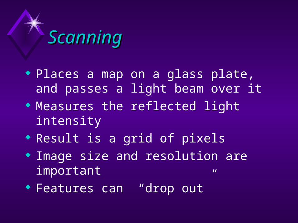
Scanning Scanning
Places a map on a glass plate, and passes a light beam over it
Measures the reflected light intensity Result is a grid of pixels Image size and resolution are important Features can “drop out”

Field data collectionField data collection

The Role of ErrorThe Role of Error
Enforcement for map data is usually by using topology.
Map and attribute data errors are the data producer's responsibility, but the GIS user must understand error.
Accuracy and precision of map and attribute data in a GIS affect all other operations, especially when maps are compared across scales.

Geocoding other recordsGeocoding other records
A common operation Based on some geographic attribute of
records that our software can relate to geographic coordinates: street address (TIGER or private match data) ZIP codes or Census tracts (allocate to
centroids)

coming next…..coming next…..
What is where?


![Skaffold - storage.googleapis.com · [getting-started getting-started] Hello world! [getting-started getting-started] Hello world! [getting-started getting-started] Hello world! 5](https://img.pdfslide.net/doc/110x75/5ec939f2a76a033f091c5ac7/skaffold-getting-started-getting-started-hello-world-getting-started-getting-started.jpg)