Embed Size (px)
Citation preview

GIS /CAD Project Workflow`
New York State Association of Professional Land Surveyors
56th Annual Surveyors Conference & ExhibitionVerona, New York
Presented by
John Cookeand
Kevin R. Zelinsky,GISP, CMS
Wetland Studies and Solutions, Inc.5300 Wellington Branch Drive, Suite 100 Gainesville, Virginia 20155703.679.5600 (Main Number)
Remington & Vernick Engineers 232 Kings Highway East Haddonfield, New Jersey 08033856.795.9595 (Main Number)

Wetland Studies and Solutions, Inc.www.wetlandstudies.com
Wetland Studies and Solutions, Inc., a Davey Tree company, the leadingnatural & cultural resources consultant in Northern Virginia, assists developersand public works agencies with the permitting process and creates innovativesolutions to water quality issues affecting the Chesapeake Bay region.
CivilTraining, LLCwww.civiltraining.com
A division of Wetland Studies and Solutions, Inc.Provides training, implementation and consulting services to the CivilEngineering, Surveying and GIS / Mapping communities.
2
Remington & Vernick Engineers and Affiliateswww.rve.com
Remington & Vernick Engineers and Affiliates are a full‐service consulting firmproviding professional services in all areas of engineering, planning, andtechnical support for over a century.

InstructorsJohn Cooke joined Wetland Studies and Solutions, Inc. in the fall of 2009 after working as anindependent consultant and AutoCAD® instructor for over twenty years. John presently operates theCivilTraining, LLC division of Wetland Studies and Solutions, Inc. (WSSI), a Davey Tree company, andsupports Engineering, GIS and Surveying technology efforts within the office and to clients nationwide.He has been continuously affiliated with Autodesk Civil/Survey applications since 1989, functioninginitially in development and then in consulting and training roles. He has an extensive background in thedevelopment, implementation and training of Autodesk AEC Civil Engineering, Surveying, GIS and BIMsolutions and has provided training to thousands of individuals nationwide, assisted numerous clients inimplementing Civil software, CAD standards and practices, and provided project consulting to manyclients in unusual or challenging project applications. Within WSSI, he participates in developmentefforts for Engineering and Survey automation, including the creation of custom software for streamrestoration based on AutoCAD® Civil 3D®.
Kevin Zelinsky is the CADD/Cartography/GIS Department Head and Associate with Remington & VernickEngineers in Haddonfield, New Jersey. He oversees the entire mapping operation for the firm's elevenregional offices located throughout Pennsylvania, New Jersey and Delaware. Kevin received his GISPcertification from URISA in 2004, earned his Certified Mapping Scientist, GIS/LIS certification from ASPRSin 2006, and received his Professional Certificate in Geomatics from Rutgers University in 2008. He hasover twenty‐five years of experience in the civil engineering and cartographic industry, and his municipalmaps have been honored with a variety of awards for excellence. Kevin is an accredited teacher of GISfundamentals to municipal employees in the State of New Jersey and is also a member of the GISCertification Institute (GISCI) Outreach Committee, which encourages GIS students and professionals toattain the level of education and experience needed for GISP certification.
3

Goals
4
• Create project proposal ArcGIS™ ArcMap™ exhibits
• Export various GIS data layers and import them into AutoCAD® Civil3D® for field basemaps
• Consume, analyze, QA/QC, and display field data utilizing AutoCADCivil 3D, ArcGIS ArcMap, Microsoft® Excel®, and Microsoft Access®
• Deliver the project to the client in the correct format withappropriate metadata
Outline
• Project Proposal‐ defining technical project requirements; creatingproposal exhibits
• Field Base Mapping‐ downloading and converting county GIS data toAutoCAD® Civil 3D® field basemaps
• Field Data Acquisition and QA/QC‐ planning and implementing a fielddata acquisition and QA/QC plan
• Spatial Analysis‐ performing spatial analysis tasks to support projectrequirements
• Cartographic Display‐ utilizing ArcGIS™ ArcMap™ to create customcartographic deliverables
• Delivery to the Client‐ converting data to Geodatabase format andupdating metadata
5

Outline
6
Project Proposal
Field Base Mapping
Field Data Acquisition and QA/QC
Spatial Analysis
Cartographic Display
Delivery to the Client

Project Proposal
Project Description:
7
This demonstration will focus on a tree inventory project as part of a
Community Forestry Master Plan in the Borough of Collingswood, New Jersey.
This plan is in compliance with the Borough’s Shade Tree Advisory Council and
encompasses approximately 1.923 square miles, of which more than 60 acres
are Knight’s Park (public park), and ultimately 6,000 trees. It should be noted
that although we are describing a tree inventory project throughout this
seminar, the principles and techniques can be applied to any inventory
project that requires the collection of a large amount of data (e.g., storm
sewers, sanitary sewers, cadastral mapping, and water distribution systems).
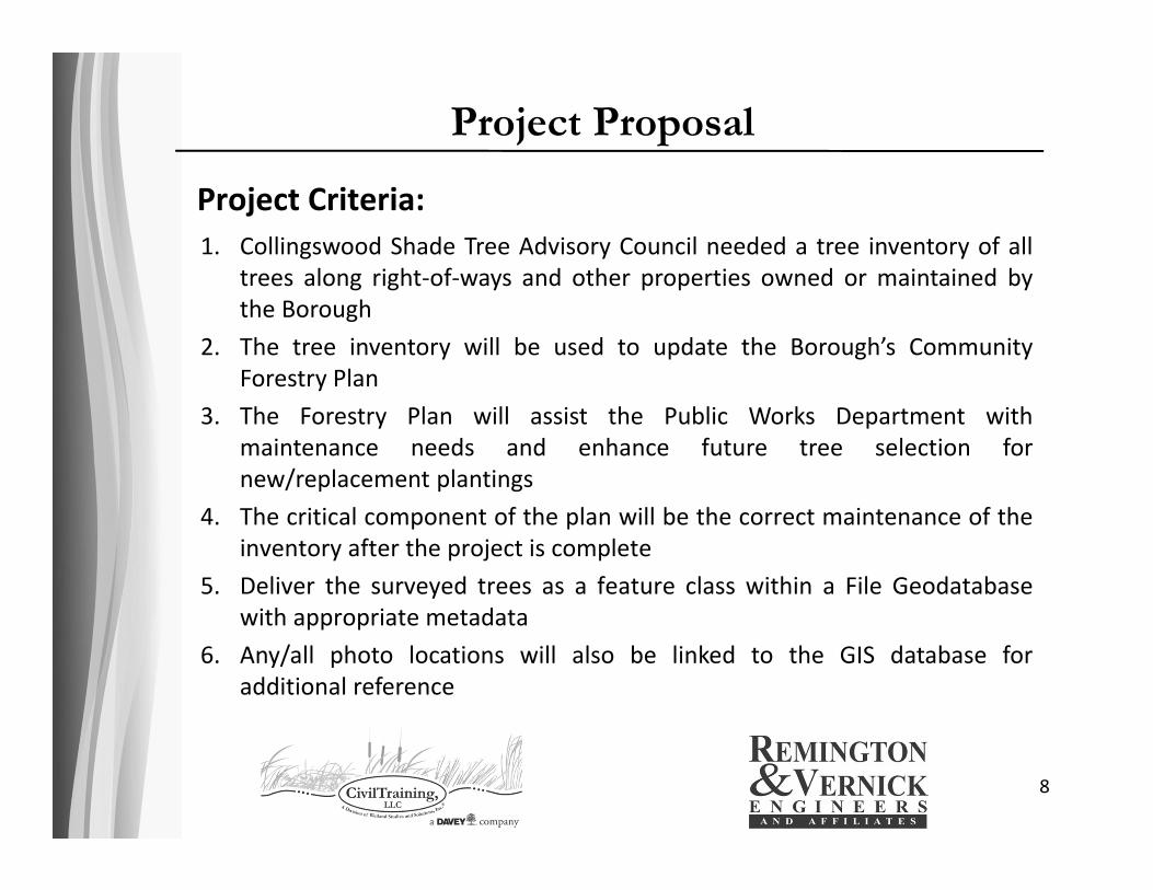
Project Proposal
Project Criteria:
8
1. Collingswood Shade Tree Advisory Council needed a tree inventory of alltrees along right‐of‐ways and other properties owned or maintained bythe Borough
2. The tree inventory will be used to update the Borough’s CommunityForestry Plan
3. The Forestry Plan will assist the Public Works Department withmaintenance needs and enhance future tree selection fornew/replacement plantings
4. The critical component of the plan will be the correct maintenance of theinventory after the project is complete
5. Deliver the surveyed trees as a feature class within a File Geodatabasewith appropriate metadata
6. Any/all photo locations will also be linked to the GIS database foradditional reference
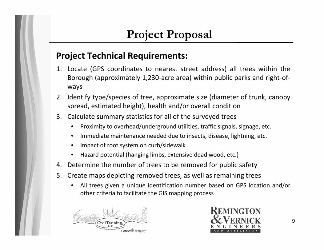
Project Proposal
Project Technical Requirements:
9
1. Locate (GPS coordinates to nearest street address) all trees within theBorough (approximately 1,230‐acre area) within public parks and right‐of‐ways
2. Identify type/species of tree, approximate size (diameter of trunk, canopyspread, estimated height), health and/or overall condition
3. Calculate summary statistics for all of the surveyed trees• Proximity to overhead/underground utilities, traffic signals, signage, etc.• Immediate maintenance needed due to insects, disease, lightning, etc.• Impact of root system on curb/sidewalk• Hazard potential (hanging limbs, extensive dead wood, etc.)
4. Determine the number of trees to be removed for public safety5. Create maps depicting removed trees, as well as remaining trees
• All trees given a unique identification number based on GPS location and/orother criteria to facilitate the GIS mapping process

Project Proposal
10

Project Proposal
11
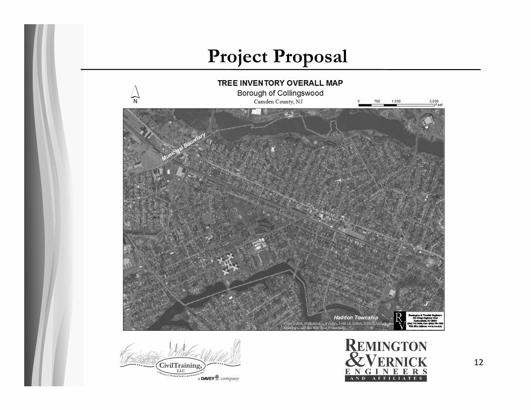
Project Proposal
12
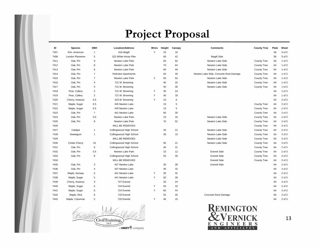
Project Proposal
13
ID Species DBH Location/Address Wires Height Canopy Comments County Tree Plate Sheet
7407 Elm, American 1 616 Magill Y 20 16 56 5 of 5
7408 London Planetree 5 322 White Horse Pike 60 42 Magill Side 56 5 of 5
7411 Oak, Pin 9 Newton Lake Park 65 62 Newton Lake Side County Tree 64 1 of 3
7412 Oak, Pin 8 Newton Lake Park 70 64 Newton Lake Side County Tree 64 1 of 3
7413 Oak, Pin 6 Newton Lake Park 60 46 Newton Lake Side County Tree 64 1 of 3
7414 Oak, Pin 7 Parkview Apartments 50 30 Newton Lake Side, Concrete Root Damage County Tree 64 1 of 3
7415 Oak, Pin 7 Newton Lake Park Y 55 52 Newton Lake Side County Tree 64 1 of 3
7416 Oak, Pin 4 721 W. Browning 45 25 Newton Lake Side County Tree 64 1 of 3
7417 Oak, Pin 5 721 W. Browning 40 30 Newton Lake Side County Tree 64 1 of 3
7418 Pear, Callery 2 721 W. Browning Y 35 24 64 1 of 3
7419 Pear, Callery 2 721 W. Browning Y 40 18 64 1 of 3
7420 Cherry, Kwanza 0.5 623 W. Browning Y 10 6 64 2 of 3
7421 Maple, Sugar 0.5 445 Newton Lake 15 5 County Tree 64 2 of 3
7422 Maple, Sugar 0.5 445 Newton Lake 15 5 County Tree 64 2 of 3
7423 Oak, Pin 7 441 Newton Lake 60 30 County Tree 64 2 of 3
7424 Oak, Pin 0.5 Newton Lake Park 15 16 Newton Lake Side County Tree 64 2 of 3
7425 Oak, Pin 8 Newton Lake Park 70 52 Newton Lake Side County Tree 64 2 of 3
7426 WILL BE REMOVED County Tree 64 2 of 3
7427 Catalpa 1 Collingswood High School 25 21 Newton Lake Side County Tree 64 2 of 3
7428 Sweetgum 1 Collingswood High School 30 10 Newton Lake Side County Tree 64 2 of 3
7429 WILL BE REMOVED Newton Lake Side County Tree 64 2 of 3
7430 Choke Cherry 10 Collingswood High School 50 21 Newton Lake Side County Tree 64 2 of 3
7431 Oak, Pin 6 Collingswood High School 40 31 County Tree 64 2 of 3
7432 Oak, Pin 0.5 Newton Lake Park 15 12 Everett Side County Tree 64 2 of 3
7433 Oak, Pin 8 Collingswood High School 55 30 Everett Side County Tree 64 2 of 3
7434 WILL BE REMOVED Everett Side County Tree 64 2 of 3
7435 Oak, Pin 3 437 Newton Lake 35 28 Everett Side 64 2 of 3
7436 Oak, Pin 4 437 Newton Lake 45 32 64 2 of 3
7437 Maple, Norway 4 441 Newton Lake Y 35 32 64 2 of 3
7438 Maple, Sugar 5 441 Newton Lake Y 50 36 64 2 of 3
7439 Cherry, Kwanza 3 727 Everett 26 24 64 2 of 3
7440 Maple, Sugar 5 724 Everett Y 55 32 64 2 of 3
7441 Maple, Sugar 6 724 Everett Y 60 44 64 2 of 3
7442 Maple, Red 6 719 Everett 55 35 Concrete Root Damage 64 2 of 3
7443 Maple, Columnar 2 720 Everett Y 40 15 64 2 of 3

Project Proposal
14
Address Condition Key
688 Haddon on Collings Side Check Condition Check Condition:
19 E. Madison Check Condition The tree is either diseased or not doing well
409 Lees Check Condition from lack of water, soil, or other factor.
266 Harvard Check Condition Leaves are sparse, discolored, and/or
403 Franklin Check Condition misshapen. Removal is probably not a priority
10 Palmer Check Condition but will be in a few years. These trees were
601 Park on Lakeview Side Check Condition recorded, measured, and mapped.
340 Woodlawn Terr. Building E Check Condition
340 Woodlawn Terr. Building A Check Condition Dead:
218 Woodlawn Terr. Check Condition The tree is dead. There is no sign of leaf
270 Harvard Check Condition growth on any of the branches. This tree is
270 Harvard Check Condition probably a priority to remove and will not
507 Woodlawn Check Condition recover. These trees were not recorded nor
302 Lees Check Condition mapped, and no measurements were taken.
317 Dayton Check Condition
711 Merrick Check Condition Needs Help:
739 Park Check Condition Although not on this list, this is on the main
700 Park on Dayton Side Check Condition data list. These are young trees recently
601 Park on Lakeview Side Check Condition planted that are doing poorly, probably from
744 Belmont Check Condition a lack of water or root space. These trees
16 Collings Check Condition should be able to recover and removal is
Corner of Franklin and Haddon Check Condition probably not needed. These trees were
108 Haddon Check Condition recorded, measured, and mapped.
Corner of Church and Park Check Condition
110 Coolidge Check Condition

Project Proposal
15
Project Proposal
16
Address Condition Key
Section 1: Ash Check Condition Check Condition:
Section 1: Norway Maple Check Condition The tree is either diseased or not doing well
Section 1: Norway Maple Check Condition from lack of water, soil, or other factor.
Section 1: Redwood Check Condition Leaves are sparse, discolored, and/or
Section 1: Scholar Tree Check Condition misshapen. Removal is probably not a priority
Section 1: Sugar Maple Check Condition but will be in a few years. These trees were
Section 1: Sugar Maple Check Condition recorded, measured, and mapped.
Section 1: Sugar Maple Check Condition
Section 1: Sycamore Check Condition Dead:
Section 12A: Horsechestnut Check Condition The tree is dead. There is no sign of leaf
Section 12A: Pin Oak Check Condition growth on any of the branches. This tree is
Section 12B: Pin Oak Check Condition probably a priority to remove and will not
Section 13: Choke Cherry Check Condition recover. These trees were not recorded nor
Section 13: Pin Oak Check Condition mapped, and no measurements were taken.
Section 13: Pin Oak Check Condition
Section 2: Black Pine Check Condition Needs Help:
Section 2: Pin Oak Check Condition Although not on this list, this is on the main
Section 2: Pin Oak Check Condition data list. These are young trees recently
Section 2: Pin Oak Check Condition planted that are doing poorly, probably from
Section 2: Pin Oak Check Condition a lack of water or root space. These trees
Section 2: Pin Oak Check Condition should be able to recover and removal is
Section 2: Pin Oak Check Condition probably not needed. These trees were
Section 2: Red Maple Check Condition recorded, measured, and mapped.
Section 2: Red Maple Check Condition
Section 2: Sugar Maple Check Condition

Project Proposal
17

Field Base Mapping
18
Export Feature
Classes from ArcMap to Shapefiles
Import Shapefiles
into Civil 3D
Stylize GIS Data with
Layer Manager
Use Map Query to
Import GIS Data
Clip GIS Data to Project Extents
Plot Basemap for Field Work
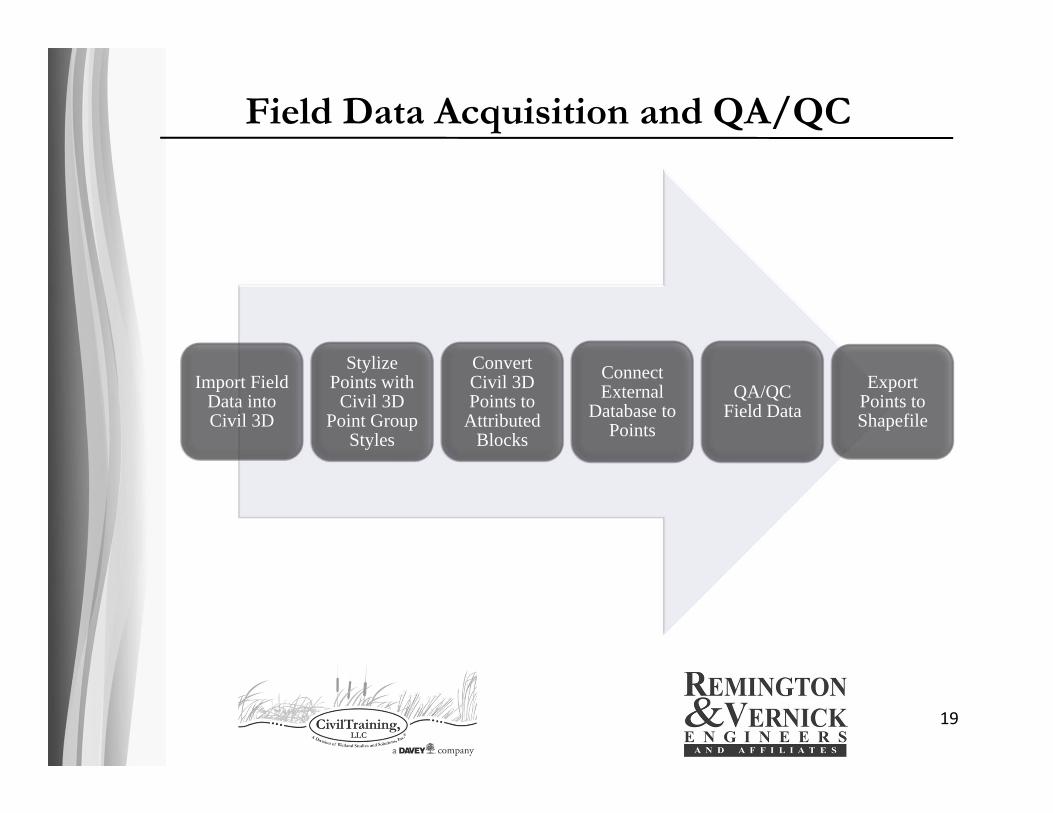
Field Data Acquisition and QA/QC
19
Import Field Data into Civil 3D
Stylize Points with
Civil 3D Point Group
Styles
Convert Civil 3D Points to
Attributed Blocks
Connect External
Database to Points
QA/QC Field Data
Export Points to Shapefile
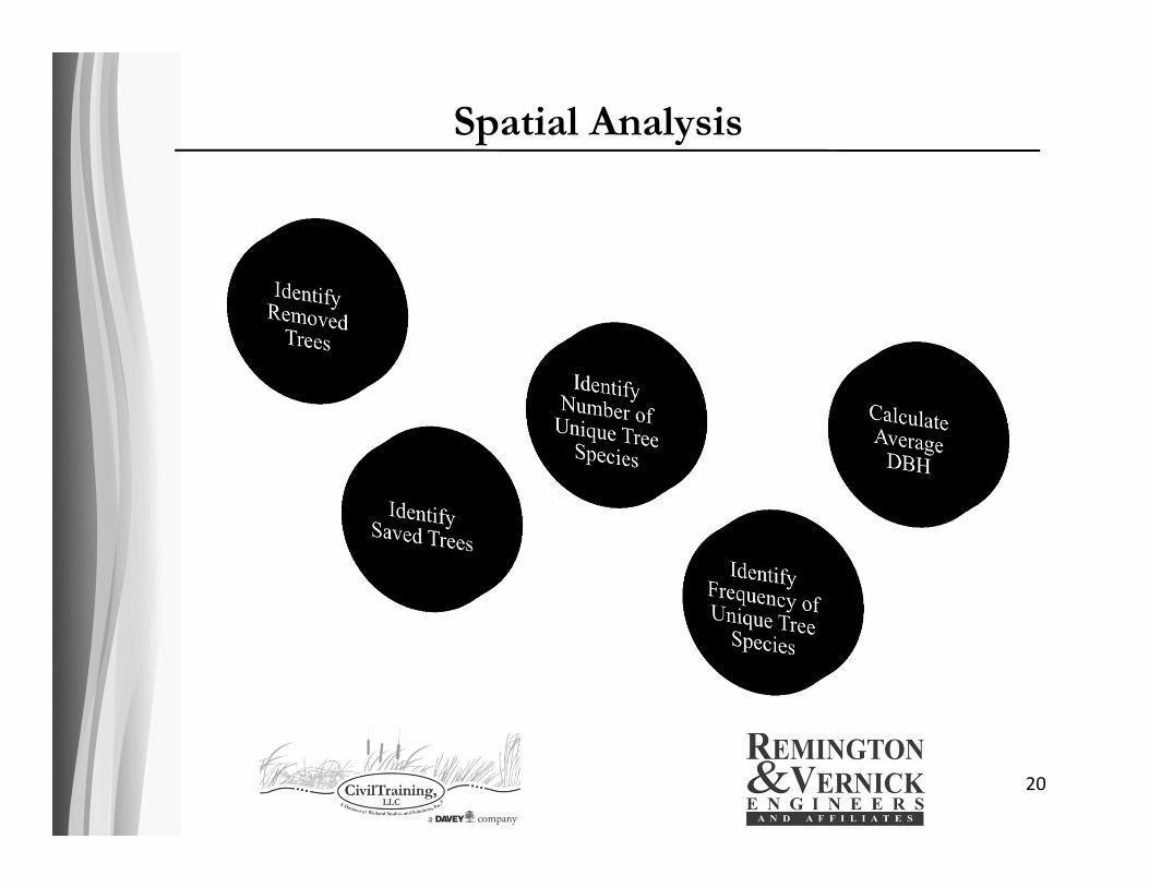
Spatial Analysis
20

Cartographic Display
21

Cartographic Display
22
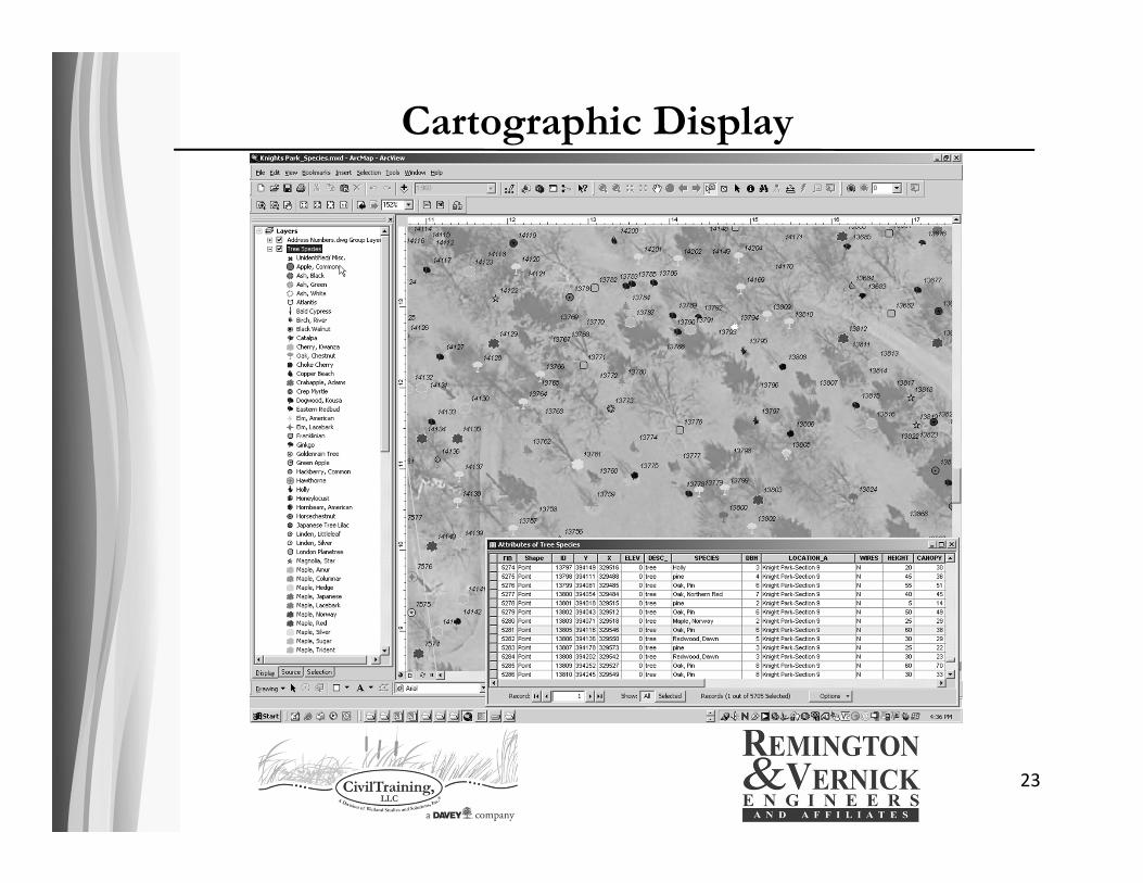
Cartographic Display
23
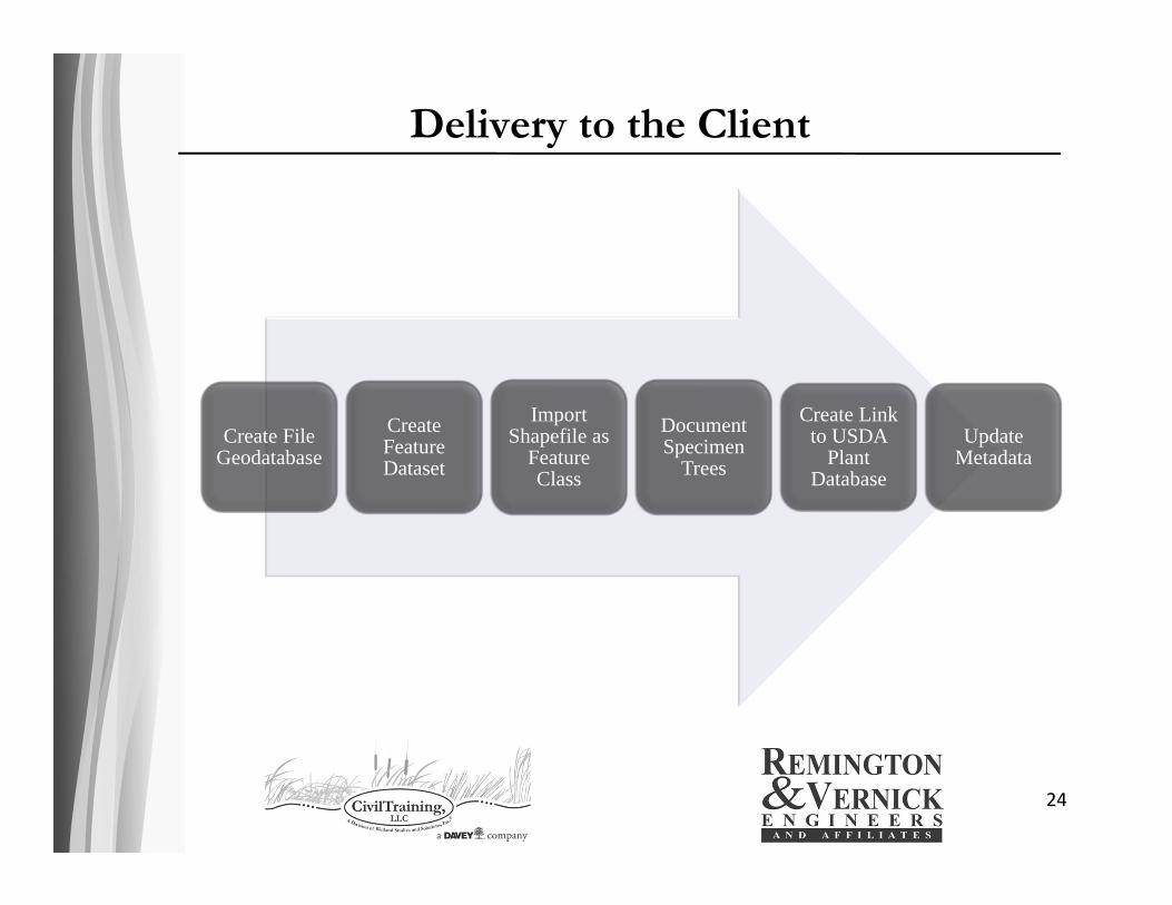
Delivery to the Client
24
Create File Geodatabase
Create Feature Dataset
Import Shapefile as
Feature Class
Document Specimen
Trees
Create Link to USDA
Plant Database
Update Metadata

Contact InformationJohn CookeEngineering & Survey Technology CoordinatorCivilTraining, LLC 732.869.0592 (Cell) 703.679.5672 (Office)John.Cooke@civiltraining .com
25
Kevin R. Zelinsky, GISP, CMS, Associate CADD/Cartography/GIS Department HeadRemington & Vernick Engineers and Affiliates 856.795.9595 Ext. 1064 (Office)[email protected]
Wetland Studies and Solutions, Inc.5300 Wellington Branch DriveGainesville, Virginia 20155703.679.5600 (Main Number)703.679.5601 (Fax)www.wetlandstudies .comwww.civiltraining.com
Remington & Vernick Engineers and Affiliates
232 Kings Highway EastHaddonfield, New Jersey 08033856.795.9595 (Main Number)856.795.1882 (Fax)www.rve .com