Embed Size (px)
Citation preview

Glacial History of the Great Lakes
Ice Block Activity
Activity Description:
Students will observe a model of a glacier, using ice blocks and clay, to better understand the
effects of glaciers on a land mass. The ice block activity will model the differences between
glacial till and stratified drift. Students will observe and document a demonstration and then
participate in a discussion about glacial erosion and the subsequent processes.
Estimated Lesson Time:
* 1 Class Period
Standards:
Michigan High School:
HS-ESS2.C (HS-ESS2-1)-The History of the Planet Earth
HS-ESS2.A (HS-ESS2-4) - Earth Materials and Systems
Michigan Middle School:
MS-ESS2.C (MS-ESS2-2) - The Roles of Water in Earth’s Surface Processes
MS-ESS3.A (MS-ESS3-1) - Constructing Explanations and Designing Solutions
Focus Question(s):
* What were the effects of glaciation on Michigan’s ground surface?
* How were the great lakes formed?
Objectives:
* Students will be able to describe (and draw) the effects of glaciation on Michigan’s surface.
* Students will be able to distinguish between the different types of glacial deposition.
* Students will be able to define glacial erosion and explain its importance.
Student Misconceptions we aim to challenge:
* Glaciers are simply frozen water.
* The Great Lakes were always where they are today.
Vocabulary:
Erosion: the process by which the surface of the earth is worn away by wind, water, waves and
or glaciers
Glacier: a large body of ice moving slowly down a slope or valley or spreading outward on a
land surface
Glacial Erosion: the process of weathering and transportation of sediments by moving ice or
glaciers
Glacial Till: unsorted sediment deposited directly from a glacier

Stratified Drift: sediments deposited by glacial melt water
Materials:
*A projector or a means for displaying images that complement content material
* Small container (recommend a 50 mL aluminum dish)
* Water
* Sand and gravel
* Refrigerator/freezer
* Drawing paper (optional)
* Clay
* Computers and internet access (optional)
Procedure:
* Before Class: Freeze a mixture of sand, gravel, and water into a container (small aluminum
disks) to create an ice block that represents a glacier. Also, prepare a sample of frozen water into
a similar container to allow students to compare a large ice cube without any sediment and the
ice block that represents a glacier.
* In Class: Inform students that in order to begin the new unit, Michigan Sand Dunes, it is
necessary to first understand the geologic history of the Michigan basin. (Access the
complimentary PowerPoint for the following content material as a file attachment.)
Approximately 2 million years ago, in the Pleistocene era, the weather became very cold and lots
of snow began to fall. The snow could not melt during the short, cooler summers, and over
thousands of years it piled and got tightly packed down into layers of solid ice. Over time these
layers of ice continued to accumulate and grow, eventually becoming huge ice sheets known as
continental glaciers.
* The ice sheets grew up to two miles in height and covered most of what is now known as
Canada. The glaciers grew and slowly flowed south across what is now present-day Michigan.
*Prior to glaciation the area now defined by the Great Lakes had several deep river valleys

connected and draining water to the northeast and into the Atlantic Ocean. As glaciers advanced
into the region, the glaciers moved more easily through the lower river valleys than the
surrounding upland areas. Large sections of the glaciers, called a “lobes,” moved through those
valleys that existed where Lake Michigan and the other Great Lakes are now, weathering and
eroding them deeper than the surrounding areas.
*Glaciers are capable of great erosion. Ice can scrape, scour, and tear rock from the floor and
walls of a valley and carry it downward. Once rock debris (dust, sand, pebbles, and even large
boulders) is within a glacier it does not settle out like load carried in flowing water. Instead, the
sediments can be carried and deposited great distances from their source.
*The glaciers moved slowly over land, scraping up rocks underneath them like bulldozers and
covering all of Michigan with thick ice. They pulled along rocks and fossils from the north and
carried them hundreds of miles south. As global temperatures fluctuated over long periods of
time the glaciers advanced and retreated an estimated twenty or more times across the Great
Lakes region. As they advanced the glaciers eroded the land and as they retreated the glaciers
deposited their sediment load.

*About 20,000 years ago, global temperatures started to rise steadily and the glaciers in the Great
Lakes region began their final retreat. As they melted, the more deeply eroded regions filled with
water to eventually become what is now known as the Great Lakes.
*There are two types of glacial deposits: (1) glacial drift: materials deposited directly by the
glacier are known as glacial till and are typically poorly sorted with rocks ranging in size from
boulders to clay-sized particles, and (2) stratified drift: sediment laid down by glacial melt water
and is typically made of sorted sediments deposited in layers.
*As the glaciers moved, they ground rocks into sand, silt, and clay. The melting glaciers
deposited a blanket of this sediment over most of the state, covering the older sedimentary,
igneous, and metamorphic rocks of Michigan. The loose glacial sediments covering Michigan
now vary in thickness from a few inches to hundreds of feet.
Ice Block Demonstration
* Distribute two ice blocks to the the students: one containing sediments (sand) within the ice
and one with no sediment. Discuss how a real glacier would have accumulated the sand and the
gravel. Review glacial erosion.
* Then distribute clay to the students and have students spread it out evenly to a thickness of
approximately 1 cm or more. Instruct the students to slide their ice blocks across the clay with
downward force and make observations. Ask your students to compare what occurred with the
ice block with sediments and the ice block with no sediments. How do the two ice blocks affect
the clay differently? If students will not have their own ice blocks (class demo), ask students
these questions while they observe the teacher’s ice block. Ask the students to record their
hypotheses and observations.

* After the students push the ice blocks across the clay have them leave the ice in place on the
clay and allow them to melt. Once melted, have students observe and compare the effects of
meltwater runoff and the formation of “lakes”. Have students attempt to make connections
between glacial landforms features and those found in the clay. Some features that may be
represented include terminal moraines, lateral moraines, meltwater streams, outwash plains, etc.
PhET Simulation Activity
* As an enrichment activity to solidify concepts learned from this activity, students will log on to
computers and go to the following URL address: http://phet.colorado.edu/en/simulation/glaciers.
The computer must have the most up to date version of Adobe Reader to allow PhET computer
simulations to run. Students will click on Run Now! and will follow the complementary student
handout while interacting with this PhET computer simulation. This simulation aims to explain
how environmental conditions such as temperature and precipitation impact glacial mass, how
ice moves within a glacier, and finally it will demonstrate how glaciers grow/advance and
shrink/retreat and the effects of both outcomes.
Additional Activity
Episode 7-01: Great Lakes from the series “How the Earth was Made” by History HD, a 15
minute video clip that can be viewed by the class. This video clip can be accessed by selecting
the link below. Once you access this website below, be sure to click the next button located
beside the play button to advance the glacier chapter. Have students write a short response or
summary after watching the video clip. http://www.infocobuild.com/books-and-
films/science/HowTheEarthWasMadeSe1/episode-07.html
Citations:
Tarbuck, Edward J., and Frederick K. Lutgens. Earth: An Introduction to Physical Geology.
Tenth ed. Upper Saddle River, New Jersey: Pearson Education, Inc., 2011. 488-517.
"When Glaciers Covered Michigan-Lesson Plan." Department of Natural Resources of
Michigan. State of Michigan, 9 Aug. 2010. Web. 28 June 2013.
<http://www.michigan.gov/dnr/0,4570,7-153-54463_18670_18793-94369--,00.html>.
"Great Lakes." How the Earth was Made. History Channel. n.d. Web. 17 July 2013.
<http://www.infocobuild.com/books-and-films/science/HowTheEarthWasMadeSe1/episode-
07.html>

Student Handout
Glacial History of the Great Lakes
Today’s Questions:
● What were the effects of glaciation on Michigan?
● How did the Great Lakes form?
Predict what will happen when you slide your ice blocks across the clay. Explain why you think
this will happen.
Make some initial observations of the ice blocks before they melt, where has the sediment
settled? Is this a good representation of sediment placement in a real glacier? Why or why not? :
How did the two ice blocks behave differently when pushed across the clay? Which one better
represents a real glacier?:
Draw and label what you see after the ice block with sediment has melted (show detail):
Glacial Till is defined as...

Stratified Drift is defined as...
Which type of glacial deposition is represented by the ice block model? Glacial till? Stratified
drift? Both? Explain.

Student Handout Answer Key
Glacial History of the Great Lakes
Today’s Questions:
● What were the effects of glaciation on Michigan?
● How did the Great Lakes form?
Predict what will happen when you slide your ice blocks across the clay. Explain why you think
this will happen.
* Student answers will vary
Make some initial observations of the ice blocks before they melt, where has the sediment
settled? Is this a good representation of sediment placement in a real glacier? Why or why not? :
* The ice block with sediment is not as clear as the one without sediment, most of the sediment
in it has settled to the bottom of the ice block. This is not a completely accurate representation of
a real glacier because sediment in a glacier is spread throughout, not just on the bottom. That
said, higher concentrations of sediment are found near the bottom of the glacier than elsewhere.
How did the two ice blocks behave differently when pushed across the clay? Which one better
represents a real glacier?:
* The ice block without sediment slid smoothly across the clay, not leaving much of a trail. The
ice block with sediment scraped the clay in many places and left behind pieces of rock and sand.
The glacier with sediment more accurately portrays a glacier,because no glacier is ever void of
material.

Draw and label what you see after the ice block with sediment has melted (show detail):
Glacial Till is defined as...
*Unsorted sediment deposited directly from the glacier
Stratified Drift is defined as...
*Sediments that are laid down or deposited by glacial melt water.
Which type of glacial deposition is represented by the ice block model? Glacial till? Stratified
drift? Both? Explain.
* Glacial till is most easily seen by this experiment, because the clay holds back the material and
ice as it moves. There is also not much ice, therefore the meltwater deposition (stratified drift)
will be less significant.

phET Activity Handout
Name ___________________ Period ______ Date_____________________
Glacier Simulation Activity
Objectives:
• Determine the factors that affect the motion of glaciers
• Observe the effects of the glacier on the local environment, including glacial till and glacial
runoffs.
Google “Phet” and click on the first link, then “Play with Sims”, then “Glaciers”
Background:
1. Describe the following term to someone who did not study Earth Science.
a. Glacier –
2. Understanding glacier formation, what is the relationship between the following:
a. Temperature and glacier size
b. Snowfall amount and glacier size.
Explain what causes a glacier to grow or shrink?
3. Glaciers are described as the “Most Erosive Force in Nature”, what does this
statement mean? Explain the difference between weathering and erosion.
4. What is the material that is transported with glaciers called? ___________
Procedure:
1. Open http://phet.colorado.edu/new/simulations/ and click on “Glacier”, or go to
Google and type “phet” and click on the first link.
2. Turn off the snowfall effect. Play with the simulation for 5 minutes. Grab the bear and
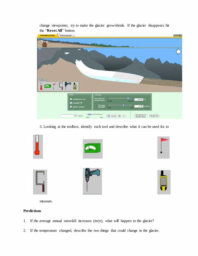
change viewpoints, try to make the glacier grow/shrink. If the glacier disappears hit
the “Reset All” button.
3. Looking at the toolbox, identify each tool and describe what it can be used for to
measure.
Predictions
1. If the average annual snowfall increases (m/yr), what will happen to the glacier?
2. If the temperature changed, describe the two things that could change in the glacier.

3. If the temperature is decreased and the snowfall is increased,
a. Will the equilibrium line move up the mountain or down the mountain? Explain.
b. What will this do to the glacier? (advance or retreat) Explain.
c. What will happen to the glaciers thickness and length if the climate change as #3 describes?
I. Glacier Observations
Many features are present when a glacier advances or retreats on a mountain slope.
Answer the following questions about the features of the glacier valley.
1. What are the tiny black dots that move through the glacier? Where did this
material originate? Where are the black dots deposited?
2. Create the largest glacier possible and turn the time up to FAST.
a. What is created at the end of the glacier time goes on?
maximum and decrease the temperature to its lowest point.
a. How many years will it take the glacier to return to its original position?
b. Could this occur in real life?
5. Look at the picture below and identify at least 5 erosional or depositional features on the
glacier in Alaska.
b. Adjust the temperature and/or snowfall settings (carefully!) to create 3 to 4 end moraines.
Explain what you did to make this happen.
c. Look at the figure below and circle four areas where there is strong evidence for this type of
deposition (include at least one in Michigan).

d. Now, in the glacier simulation, decrease the temperature so that the glacier advances past
your furthest moraine and then increase the temperature so that it recedes again. Explain what
happened to your end moraines?
e. In the figure above, the red moraines are younger and the purple moraines are older. Using
what you have learned, explain why there are far more red moraines than purple moraine.
4. Press RESET ALL, and set the glacier back to its starting location. Make the
glacier completely melt away. Once this is done, increase the snowfall to


phET Activity Handout
Name: Answer Key Period ______ Date_____________________
Glacier Simulation Activity
Objectives:
● • Determine the factors that affect the motion of glaciers.
● • Observe the effects of the glacier on the local environment, including glacial till and
glacial runoffs.
Google “Phet” and click on the first link, then “Play with Sims”, then “All Sims”, then
“Glaciers” (then “Run Now!”, etc.?)
Background:
1. Describe the following term to someone who did not study Earth Science.
a. Glacier –Answers will vary from student to student. But hopefully students have something
similar to the following: an assortment of ice and rock moving due to gravity. The rocks in the
ice ranging in particle size from boulders to clay sized particles. Glaciers can also be extremely
large and can even cover entire continents. A glacier accumulates more ice in the winter than ice
that melts in the summer allowing a glacier to persist all year long.
2. Understanding glacier formation, what is the relationship between the following:
a. Temperature and glacier size
There is an inverse relationship between temperature and glacier size. As the temperature
increases, the glacier size decreases. Likewise as the temperature decreases, the glacier size
increases.
b. Snowfall amount and glacier size.
There is a positive correlation relationship between the amount of snowfall and glacier size. As
the snowfall amount increases the glacier size also increases. Similarly as the snowfall amount
decreases, the glacier size decreases.
Explain what causes a glacier to grow or shrink?
The glacier will advance, or grow, when the average annual temperature is low (below 66.2
degrees Fahrenheit) and when the average annual snowfall is high (above 3.1 feet). The glacier
will recede, or shrink ,when the average annual temperature is high (above 66.2 degrees
Fahrenheit) and when the average annual snowfall is low (below 3.1 feet).
3. Glaciers are described as the “Most Erosive Force in Nature”, what does this
statement mean? Explain the difference between weathering and erosion.
Weathering occurs when water, wind, and ice degrade a rock or building in such a manner that
the physical and/or chemical properties are altered from the degradation. Mechanical
weathering results in the fracturing of rock into smaller pieces. Chemical Weathering results in
the alteration of the mineral composition of rock material by the removal or addition of
elements. Erosion generally refers to the transportation of material by forces such as water,

wind, or ice.
A glacier causes significant amounts of mechanical weathering as it advances over rock material
due to abrasion. It then erodes this weathered material as glacial drift, transporting and
depositing it great distances from its original location.
4. What is the material that is transported with glaciers called? Glacial till or “drift”
Procedure:
1. Open http://phet.colorado.edu/new/simulations/ and click on “Glacier”, or go to
Google and type “phet” and click on the first link.
2. * Turn off the snowfall effect. Play with the simulation for 5 minutes by changing the
temperature and snowfall amounts. Use the bear and change viewpoints, and try to
make the glacier grow/shrink. If the glacier disappears hit the “Reset All” button.
3. Looking at the toolbox, identify each tool and describe what it can be used for to
measure.

Predictions
1. If the average annual snowfall increases (m/yr), what will happen to the glacier?
If the average snowfall increase, the glacier will grow.
2. If the temperature changed, describe the two things that could change in the glacier.
If the temperature is changed, the thickness and the length of the glacier are changed.
3. If the temperature is decreased and the snowfall is increased,
a. Will the equilibrium line move up the mountain or down the mountain? Explain.
The equilibrium line will move down the mountain, because there is more ice is being added to
the glacier than ice is melting.
b. What will this do to the glacier? (advance or retreat) Explain.
The glacier will advance because more ice is being added to the glacier than ice is melting.
c. What will happen to the glaciers thickness and length if the climate change as #3 describes?
The thickness and length of the glacier will continue to grow and increase as long as the amount
of ice being made exceed the amount of ice melting.
I. Glacier Observations
Many features are present when a glacier advances or retreats on a mountain slope.
Answer the following questions about the features of the glacier valley.
1. What are the tiny black dots that move through the glacier? Where did this
material originate? Where are the black dots deposited?
The black dots represent glacial till or drift within the ice. They have originated from the
weathered rock underneath the glacier. They are deposited in front of the glacier. From there the
till or drift if by a river or stream is sorted by traveling downstream.
2. Create the largest glacier possible and turn the time up to FAST.
a. What is created at the end of the glacier time goes on?
At the end of the glacier, there is a pile of tiny black dots that are accumulating creating a very

large pile of glacial till. These are called “end moraines”.
b. Adjust the temperature and/or snowfall settings (carefully!) to create 3 to 4 end moraines.
Explain what you did to make this happen.
To make this happen, the temperature setting had to be slightly increased or the snowfall setting
had to be slightly decreased, at different intervals of time.
c. Look at the figure below and circle four areas where there is strong evidence for this type of
deposition (include at least one in Michigan).
d. Now, in the glacier simulation, decrease the temperature so that the glacier advances past
your furthest moraine and then increase the temperature so that it recedes again. Explain what
happened to your end moraines?
The end moraines have been weathered and eroded away by the advancing glacier.
e. In the figure above, the red moraines are younger and the purple moraines are older. Using
what you have learned, explain why there are far more red moraines than purple moraine.
The red moraines are the result of a more recent period of glacial advance which weathered and
eroded the older (purple) end moraines. This then receded, leaving behind the younger (red) end
moraines
4. Press RESET ALL, and set the glacier back to its starting location. Make the
glacier completely melt away. Once this is done, increase the snowfall to
maximum and decrease the temperature to its lowest point.
a. How many years will it take the glacier to return to its original position?

It takes approximately 20 years for the glacier to return to its original position.
b. Could this occur in real life?
It is very unlikely that weather could change so drastically in such a short period of time from so
warm all year that the glacier completely disappears to so cold that the glacier would grow so
quickly that it not only returns to its normal size but no longer is a stable glacier but an
advancing one.
5. Look at the picture below and identify at least 5 erosional or depositional features on the
glacier in Alaska.
Worth discussing or reviewing with students on the image above:
*“Drift” (in the ice)
*Till (deposited in front of the glacier)
*Stratified Drift
*End moraine
*Lateral moraine
*Medial moraine
*Braided Stream
*Horns
*Aretes
*Cols
*Cirques

*Hanging Valleys


![Glacial Lake Levels and Eastern Great Lakes Palaeo-Indianslabs.eeb.utoronto.ca/mcandrews/PDFs/049[1].pdf · 2008-09-22 · GLACIAL LAKE LEVELS AND EASTERN GREAT LAKES PALAEO-INDIANS](https://img.pdfslide.net/doc/110x75/5e42222967e726557a1b4cf8/glacial-lake-levels-and-eastern-great-lakes-palaeo-1pdf-2008-09-22-glacial.jpg)