Embed Size (px)
Citation preview
Global and Planetary Change 129 (2015) 69–91
Contents lists available at ScienceDirect
Global and Planetary Change
j ourna l homepage: www.e lsev ie r .com/ locate /g lop lacha
The middle Holocene climatic records from Arabia: Reassessinglacustrine environments, shift of ITCZ in Arabian Sea, and impacts of thesouthwest Indian and African monsoons
Yehouda Enzel a,⁎, Yochanan Kushnir b, Jay Quade c
a The Fredy and Nadine Herrmann Institute of Earth Sciences, The Hebrew University of Jerusalem, Givat Ram, Jerusalem 91904, Israelb Lamont–Doherty Earth Observatory, Columbia University, 61 Route 9W, PO Box 1000, Palisades, NY 10964-8000, USAc Department of Geosciences, University of Arizona, 1040 E. 4th Street, Tucson, AZ 85721, USA
⁎ Corresponding author. Tel.: +972 2 6584210; fax: +E-mail addresses: [email protected] (Y. En
http://dx.doi.org/10.1016/j.gloplacha.2015.03.0040921-8181/© 2015 Elsevier B.V. All rights reserved.
a b s t r a c t
a r t i c l e i n f oArticle history:Received 14 July 2014Received in revised form 3 March 2015Accepted 11 March 2015Available online 21 March 2015
Keywords:ArabiaIndian monsoonAfrican monsoonHolocene paleoclimatelakeITCZSomali jet
A dramatic increase in regional summer rainfall amount has been proposed for the Arabian Peninsula during themiddleHolocene (ca. 9-5 ka BP) based on lacustrine sediments, inferred lake levels, speleothems, and pollen. Thisrainfall increase is considered primarily the result of an intensified Indian summer monsoon as part of theinsolation-driven, northward shift of the boreal summer position of the Inter-Tropical Convergence Zone(ITCZ) to over the deserts of North Africa, Arabia, and northwest India.We examine the basis for the proposed drastic climate change in Arabia and the shifts in the summer monsoonrains, by reviewing paleohydrologic lacustrine records from Arabia. We evaluate and reinterpret individual lake-basin status regarding their lacustrine-like deposits, physiography, shorelines, fauna and flora, and conclude thatthese basins were not occupied by lakes, but by shallow marsh environments.Rainfall increase required to support such restrictedwetlands ismuch smaller than needed to form andmaintainhighly evaporating lakes and we suggest that rainfall changes occurred primarily at the elevated edges of south-western, southern, and southeastern Arabian Peninsula. These relatively small changes in rainfall amounts andlocal are also supported by pollen and speleothems from the region. The changes do not require a northwardshift of the Northern Hemisphere summer ITCZ and intensification of the Indian monsoon rainfall. We proposethat (a) latitudinal and slight inland expansion of the North African summer monsoon rains across the RedSea, and (b) uplifted moist air of this monsoon to southwestern Arabia highlands, rather than rains associatedwith intensification of Indian summer monsoon, as proposed before, increased rains in that region; theseAfrican monsoon rains produced the modest paleo-wetlands in downstream hyperarid basins. Furthermore,we postulate that as in present-day, the ITCZ in the Indian Ocean remained at or near the equator all yearround, and the Indian summermonsoon, throughdynamically induced air subsidence, can reduce rather than en-hance summer rainfall in the Levant and neighboring deserts, including Arabia. Our summary suggests a widen-ing to the north of the latitudinal range of the rainfall associated with the North African summer monsoonmoisture crossing the Red Sea to the east. We discuss other mechanisms that could have potentially contributedto the formation and maintaining of the modest paleo-wetlands.
© 2015 Elsevier B.V. All rights reserved.
Contents
1. Introduction . . . . . . . . . . . . . . . . . . . . . . . . . . . . . . . . . . . . . . . . . . . . . . . . . . . . . . . . . . . . . . . 701.1. Structure of this reassessment . . . . . . . . . . . . . . . . . . . . . . . . . . . . . . . . . . . . . . . . . . . . . . . . . . . 70
2. Geographical and Meteorological constraints on Arabian rainfall . . . . . . . . . . . . . . . . . . . . . . . . . . . . . . . . . . . . . . . 702.1. Annual and seasonal rainfall distribution . . . . . . . . . . . . . . . . . . . . . . . . . . . . . . . . . . . . . . . . . . . . . . 702.2. Synoptic climatology of Arabia rainfall . . . . . . . . . . . . . . . . . . . . . . . . . . . . . . . . . . . . . . . . . . . . . . . . 70
2.2.1. Summer rainfall in Arabia . . . . . . . . . . . . . . . . . . . . . . . . . . . . . . . . . . . . . . . . . . . . . . . . . 712.2.2. The southwest monsoon: Somali Jet over the Arabian Sea . . . . . . . . . . . . . . . . . . . . . . . . . . . . . . . . . . . 71
3. Lake versus marsh/wetland/discharge environments in arid lands . . . . . . . . . . . . . . . . . . . . . . . . . . . . . . . . . . . . . . 71
972 2 5662581.zel), [email protected] (Y. Kushnir), [email protected] (J. Quade).
70 Y. Enzel et al. / Global and Planetary Change 129 (2015) 69–91
4. Lacustrine-like deposits from Arabia . . . . . . . . . . . . . . . . . . . . . . . . . . . . . . . . . . . . . . . . . . . . . . . . . . . . 734.1. General considerations . . . . . . . . . . . . . . . . . . . . . . . . . . . . . . . . . . . . . . . . . . . . . . . . . . . . . . . 734.2. Shorelines . . . . . . . . . . . . . . . . . . . . . . . . . . . . . . . . . . . . . . . . . . . . . . . . . . . . . . . . . . . . 804.3. Marsh deposits . . . . . . . . . . . . . . . . . . . . . . . . . . . . . . . . . . . . . . . . . . . . . . . . . . . . . . . . . . 814.4. Asymmetry in deposition . . . . . . . . . . . . . . . . . . . . . . . . . . . . . . . . . . . . . . . . . . . . . . . . . . . . . . 824.5. Faunal and floral remains . . . . . . . . . . . . . . . . . . . . . . . . . . . . . . . . . . . . . . . . . . . . . . . . . . . . . . 824.6. Lake-budget calculations . . . . . . . . . . . . . . . . . . . . . . . . . . . . . . . . . . . . . . . . . . . . . . . . . . . . . . 824.7. Summarizing lacustrine-like indicators . . . . . . . . . . . . . . . . . . . . . . . . . . . . . . . . . . . . . . . . . . . . . . . . 83
5. Limited vegetation changes in Arabia . . . . . . . . . . . . . . . . . . . . . . . . . . . . . . . . . . . . . . . . . . . . . . . . . . . . 836. Rainfall shifts based on Speleothems . . . . . . . . . . . . . . . . . . . . . . . . . . . . . . . . . . . . . . . . . . . . . . . . . . . . 837. Middle Holocene regional hydroclimatology and its implications . . . . . . . . . . . . . . . . . . . . . . . . . . . . . . . . . . . . . . . 84
7.1. Hydroclimatic pattern . . . . . . . . . . . . . . . . . . . . . . . . . . . . . . . . . . . . . . . . . . . . . . . . . . . . . . . 847.2. Constraints on early to mid-Holocene climate . . . . . . . . . . . . . . . . . . . . . . . . . . . . . . . . . . . . . . . . . . . . 857.3. Southwest monsoon winds and upwelling off-Oman assist keeping Arabia dry . . . . . . . . . . . . . . . . . . . . . . . . . . . . . . 86
7.3.1. Upwelling off-southern Oman . . . . . . . . . . . . . . . . . . . . . . . . . . . . . . . . . . . . . . . . . . . . . . . 867.4. A shift in ITCZ? . . . . . . . . . . . . . . . . . . . . . . . . . . . . . . . . . . . . . . . . . . . . . . . . . . . . . . . . . . 867.5. Implications to pre-Holocene interglacial climates of Arabia . . . . . . . . . . . . . . . . . . . . . . . . . . . . . . . . . . . . . . 877.6. Implication for human-lacustrine association in Arabia . . . . . . . . . . . . . . . . . . . . . . . . . . . . . . . . . . . . . . . . 87
8. Conclusions . . . . . . . . . . . . . . . . . . . . . . . . . . . . . . . . . . . . . . . . . . . . . . . . . . . . . . . . . . . . . . . 87Acknowledgments . . . . . . . . . . . . . . . . . . . . . . . . . . . . . . . . . . . . . . . . . . . . . . . . . . . . . . . . . . . . . . . 88Appendix A. Supplementary data . . . . . . . . . . . . . . . . . . . . . . . . . . . . . . . . . . . . . . . . . . . . . . . . . . . . . . . 88References . . . . . . . . . . . . . . . . . . . . . . . . . . . . . . . . . . . . . . . . . . . . . . . . . . . . . . . . . . . . . . . . . . 88
1. Introduction
Temporal patterns of Holocene lake-level status fromArabia to India(e.g., Street-Perrott and Harrison, 1985; Street-Perrott et al., 1989;Street-Perrott and Perrott, 1993; Kohfeld andHarrison, 2000; Braconnotet al., 2004) have led investigators to advocate large hydroclimaticchanges during the early to middle Holocene in Arabia (e.g., Robertsand Wright, 1993). In a recent influential example, Wanner et al.(2008)mapped a 12°–15° northward shift in themiddle Holocenemon-soon rains over the Arabia-Near East-West Asia sector, based on paleo-climatic proxy-records including the lake status reconstructions for 6 ka.More conservative, but still substantial, estimates of northward dis-placement of the middle Holocene summer monsoon rainfall belt overArabia and West Asia have also been proposed (e.g., Fleitmann et al.,2007; Fig. 11 in Junginger et al., 2014). Existing summaries ofHolocene paleoclimates of the Arabian Sea and its African, Arabian,and Indian margins (e.g., Overpeck et al., 1996; Gasse, 2000;Hoelzmann et al., 2004; Prasad and Enzel, 2006; Staubwasser andWeiss, 2006; Fleitmann et al., 2007; Lézine et al., 2007, 2010;Wanner et al., 2008; Conroy and Overpeck, 2012) point primarily tothe Indian summer monsoon (ISM) and to a lesser extent, to theAfrican summer monsoons as explaining the amounts, seasonality andspatial distribution of past rainfall in Arabia.
The proposed northward expansion of summer rains across theArabian Peninsula has been widely interpreted to represent a north-ward shift of the Inter-Tropical Convergence Zone (ITCZ) that hasbeen proposed as a major driver of Holocene changes in the hydrologyand vegetation in that area. Thiswas postulated because of the proposedincreased depth, area, or simply the presence of Arabian paleolakes.These lakes were taken as part of the evidence of high seasonal rainfall,which is needed to overcome the high rates of regional evaporationin the hyperarid Arabian Peninsula (currently is N2200 and as highas ~3000 mm yr−1, with pan or potential evaporation 3000–4000 mm yr−1, see ElNesr et al., 2010; Sorman and Abdulrazzak,1995). As several of these lake basins have no contributing watersheds,this implies a problematic assertion: the annual rainfall must have beenat the magnitude of the above evaporation rates, unless these basinswere primarily fed by regional groundwater flow or were only ephem-eral; if such rainfall values are too high, then only ephemeral, shallowponds could have formed.
1.1. Structure of this reassessment
In this paper we describe the present-day rainfall distribution in theArabian Peninsula and the geographical and atmospheric mechanismsthat control it. We then review the paleoenvironmental observationsthat underlie the proposed higher stands of the Arabian lakes. We usethe information in the original reports and published research to distin-guish betweenmarshy or shallow water environments and open waterbodies of lakes. This distinction is critical given the large moisture sur-plus necessary for the formation and maintenance of open lakes com-pared with a mosaic of wetland environments. Following this reviewwe look at published pollen and speleothemdata to gain a better pictureof the region's paleoclimatology.
Finally, we propose explanations for the paleo-precipitation patternsemerging from the above lacustrine, speleothems, and pollen records,based on themodern atmospheric and ocean circulation in the northernIndian Ocean and its margins.
2. Geographical and Meteorological constraints on Arabian rainfall
2.1. Annual and seasonal rainfall distribution
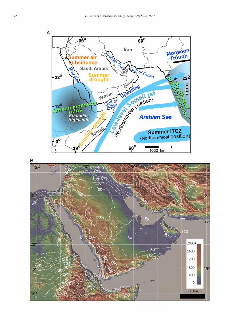
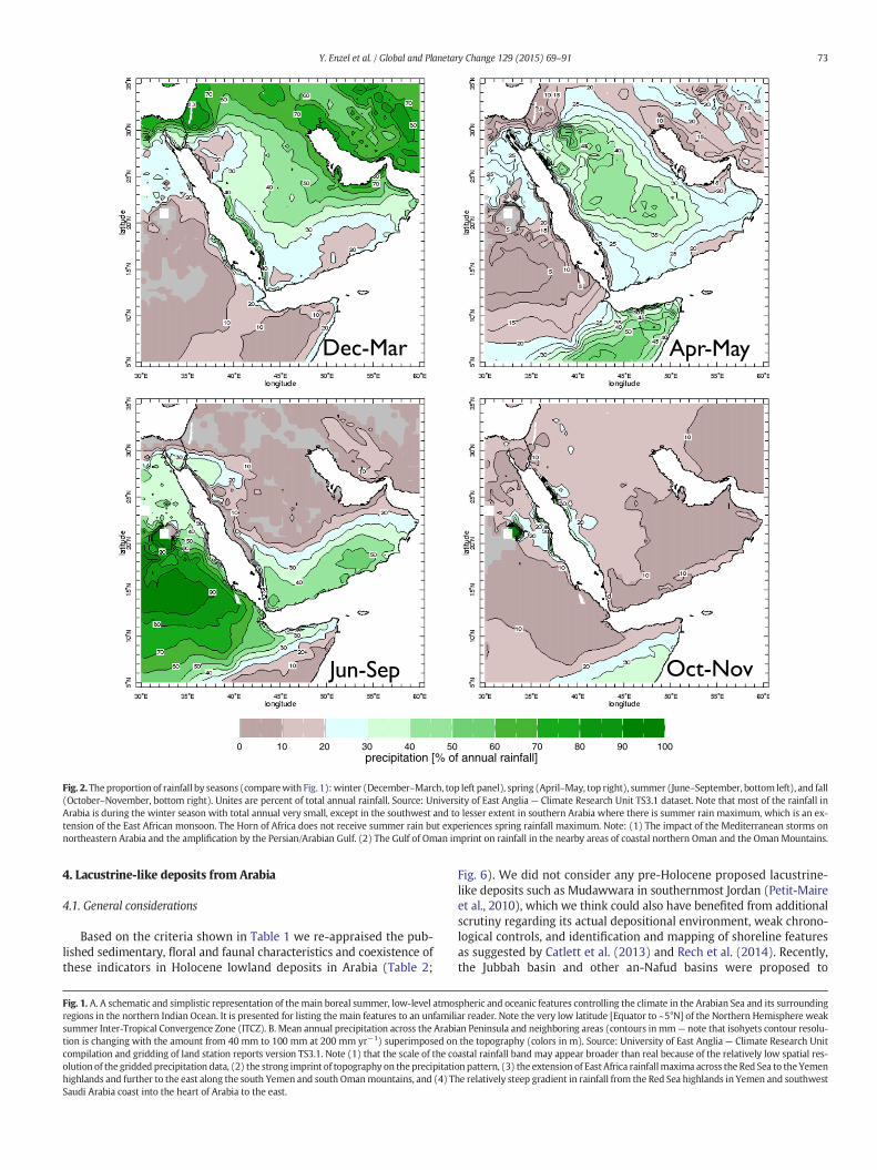
TheArabian Peninsula is part of the Sahara-Arabian-Thar subtropicaldesert belt. As such its climate is dry, with most parts of the peninsulareceiving ≤100 mm yr−1 of rainfall (Fig. 1). The topography stronglyaffects the spatial pattern of the mean annual rainfall (Fig. 1) withonly the elevated areas in the southwestern Peninsula experiencing≥~500 mm annually (e.g., Subyani and Al-Dakheel, 2009) with highestpoints in Yemen receiving up to 800 mm yr−1.
The seasonal distribution of rainfall (Fig. 2) indicates thatmost of theinner peninsula and the coastal strip along the Persian/Arabian Gulf andthe Gulf of Oman coasts receive most of their rainfall in winter andspring. In contrast, the mountain ranges of southwestern Saudi Arabiaand Yemen are dominated by summer rains (see also Almazroui,2011; Almazroui et al., 2012, 2013).
2.2. Synoptic climatology of Arabia rainfall
Wepresent several atmospheric circulation patterns that govern thewinter and summer rainfall in different parts of the Arabian Peninsula.
71Y. Enzel et al. / Global and Planetary Change 129 (2015) 69–91
Their timing, magnitude and moisture sources are different indicatingthat a slight re-organization of these systems might create the basisfor the change in rainfall patterns depicted by the paleoenvironmentalrecords.
We have identified four rain-causing mechanisms that can affectthe Arabian Peninsula during late fall, winter and early spring.a) Mediterranean cyclones that migrate into the Levant are dominantrainfall mechanisms in this region between October and May (Alpertet al., 2004; Almazroui et al., 2012). They bring little rain to Arabia, al-though they can become the dominant source of rainfall in thepeninsula's east-northeast, relative to other seasons. b) The semi-permanent low-pressure trough over the Red Sea, when combinedwith an eastwardmoving upper level trough can create local convectiverainfall over the southern Levant, Sinai, and western and northern Ara-bian Peninsula and cause local flooding. c) The winter–spring tropicalplumes (TPs, also can be considered as across-Sahara atmospheric riv-ers), which originate over the eastern tropical Atlantic or tropicalAfrica and move eastward across northern North Africa (Alpert et al.,2004; de Vries et al., 2013; Tubi and Dayan, 2014); occasionally, whencombined with the subtropical jet positioned at a relatively southernlatitude, these plumes can bringwidespread, one to three days long, tor-rential rainfall and flooding into Arabia, Sinai, and southern Jordan andIsrael (e.g., Ziv, 2001; Kahana et al., 2002; Barth and Steinkohl, 2004;Rubin et al., 2007; Tubi andDayan, 2014); andd) northeastwintermon-soon winds over the Gulf of Oman could have bring rain to the south-eastern edges of Arabia.
2.2.1. Summer rainfall in ArabiaThe broader regional pattern of monthly precipitation during sum-
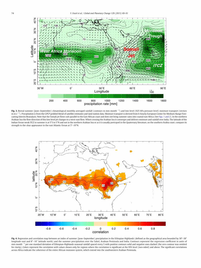
mer (June–September, Fig. 3) indicates that southern Arabia falls be-tween two regional monsoon systems. In the west, the Africansummer monsoon extends eastward along the sub-Saharan Sahel tothe prominent local maximum over the Ethiopian Highlands and acrossthe Red Sea into the mountains of southwestern Saudi Arabia andYemen and westernmost Oman. Rainfall intensity in this part of thepeninsula varies in phase with African summer monsoon intensity(Fig. 4). A band of rainfall extends farther east in Yemen into southernOman, along the southern coastal topography (Fig. 1B).
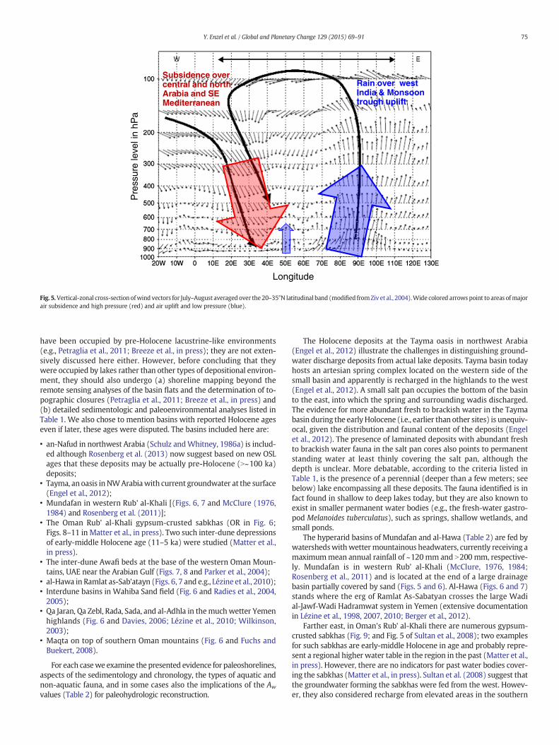
The peninsula's interior is hyperarid, receiving b80 mm yr−1. Thesubsidence aloft induced by the heavy convection associated with theISM (Rodwell andHoskins, 1996),which is strongest over the EastMed-iterranean, extends over much of the Arabian Peninsula and possiblyalso brings northerly winds to southern Arabia and even to northernArabian Sea region (Figs. 1 and 5). Moreover, the local high surface albe-do together with the overlying dry air leads to a net loss of radiative en-ergy, solar and infrared. The resulting radiative cooling of theatmosphere must be balanced by the adiabatic warming associatedwith large-scale subsidence, which further intensifies the drying of thedesert (Charney, 1975). The moisture transport vectors (Fig. 3) andthe rainfall minimum inland (Fig. 1b) suggest that the narrow zone ofrainfall in coastal southern Arabia is associated with local orographicuplift (e.g., see left panels in Fig. 5 of Fleitmann et al., 2007). Very littlemoisture is transported inland across and over the coastal mountains.The low-level flow over the interior is mostly from the northwest(Fig. 2 in Ziv et al., 2004) and is dry and weak. Thus, in the interior ofthe Arabian Peninsula summer rainfall drops rapidly north of itsYemeni–Omani southern coast to b10 mm for the entire summer sea-son (Almazroui et al., 2012).
2.2.2. The southwest monsoon: Somali Jet over the Arabian SeaThe summertime southwesterly monsoon winds, which supply the
moisture to the mountainous southernmost Arabian Peninsula, form alow-level jet, which peaks in intensity at altitudes of 1000–1800 mabove sea level (Findlater, 1969a,b, 1971, 1977; Slingo et al., 2005). Re-ferred to as the Somali or Findlater jet, these winds cross the equator inthe trade wind belt north of Madagascar. The jet parallels the northeast
African coast, in part constrained by the high East African orography(Findlater, 1969a; see Fig. 5.31 in Krishnamurti et al., 2013) and forcedby the northward pressure gradient. North of the equator, the low-level Somali jet is deflected by the Coriolis effect eastward from theEast African highlands and across the Arabian Sea and heading directlytowards India. Over the Arabian Sea the winds evaporate large amountsof moisture and eventually, over India and the Bay of Bengal, it feed theISM rains (Findlater, 1971, 1977; Halpern andWoiceshyn, 2001; Slingoet al., 2005; Turner and Annamalai, 2012; Krishnamurti et al., 2013)with rainfall maxima where uplifted (Fig. 3).
3. Lake versus marsh/wetland/discharge environments in arid lands
Quantitative estimates of past changes in rainfall and temperatureon the continents rely heavily on solving hydrological/energy budgetsof past lakes (e.g., Mifflin andWheat, 1979; Street-Perrott and Harrison,1985; Benson, 1986; Benson and Paillet, 1989; Enzel, 1992). The mainconcept for these reconstructions is that at steady state in closed basinlakes, direct rainfall and runoff into a lake are balanced by evaporativelosses (e.g., Street-Perrott and Harrison, 1985). The primary source ofinflow for lakes in arid and semiarid basins is surface runoff(e.g., Mifflin and Wheat, 1979; Street-Perrott and Harrison, 1985;Enzel, 1992), as groundwater recharge and direct rainfall in these envi-ronments are usually low (e.g., Yechieli and Wood, 2002). The little re-charge of groundwater when it occurs is more efficient in supplyingwater to terminal basins in arid regions as it is less susceptible to evap-oration losses and leads to the formation of fresh to saline wetlands.
Clearly, an accurate reconstruction of a paleolake area is vital, sinceevaporative loss from a lake depends primarily on its surface area(e.g., Benson and Paillet, 1989). Surface area reconstruction is straight-forward where paleolake shorelines are well preserved, but can bemore difficult where shore deposits are old and/or local erosion ratesare high. It is also important to clearly distinguish between lake andother lacustrine deposits in wet environments characterized byground-water discharge such as springs, wet meadows, shallowmarshes or discharging saline playas (Mifflin and Wheat, 1979; Rosen,1991, 1994; Pigati et al., 2014).
In their seminal study of the hydrological basins in the Great Basin–Mojave deserts of the western United States, Mifflin andWheat (1979)outlined for thefirst time a hydro-physiographic criterion for separatingbasins with evidence for paleolake existence from those without. Untilthis 1979 study, researchers had not been rigorous in distinguishingtrue lake deposits from the other types of deposits of similar appear-ance. This distinction is of the utmost importance given the very differ-ent paleohydrologic conditions required to support an openwater body,even if it is a shallow lake, compared with other lacustrine environ-ments. It requires much less water input into a drainage basin to main-tain a shallow and patchy wetland or discharging playa, fed bygroundwater that is mainly sheltered from direct evaporation than anopen surface of a lake under ~2 m yr−1 of evaporation or even less.
Following studies usingMifflin andWheat's (1979) approach, exam-ined lacustrine-like sediments in lowland basins lacking shorelines,mainly in North and South America the distinction was possible. Re-searchers were able to define deposits of spring heads, wet meadows,shallow marshes and even shallow local pools, where these could beeasily be mistaken for, and in some cases were actually reported as,lake deposits (Quade, 1986; Quade and Pratt, 1989; Quade et al., 1995,1998, 2003; Rech et al., 2002, 2003; Pigati et al., 2009, 2011, 2014).Other examples of basins first defined as paleolakes and later shownas shallow wetlands are from northwest India (e.g., Enzel et al., 1999)and southern Jordan (Catlett et al., 2013, Catlett, 2014; Mischke et al.,2016). Table 1 summarizes the geomorphic, sedimentologic, and floraland faunal criteria that distinguish lake from wetland deposits (seealso Pigati et al., 2014). This table guides us in re-interpreting the pub-lished information on the deposits in the basins of Arabia.
A
B
72 Y. Enzel et al. / Global and Planetary Change 129 (2015) 69–91
0 10 20 30 40 50 60 70 80 90 100precipitation [% of annual rainfall]
Fig. 2.The proportion of rainfall by seasons (comparewith Fig. 1):winter (December–March, top left panel), spring (April–May, top right), summer (June–September, bottom left), and fall(October–November, bottom right). Unites are percent of total annual rainfall. Source: University of East Anglia — Climate Research Unit TS3.1 dataset. Note that most of the rainfall inArabia is during the winter season with total annual very small, except in the southwest and to lesser extent in southern Arabia where there is summer rain maximum, which is an ex-tension of the East African monsoon. The Horn of Africa does not receive summer rain but experiences spring rainfall maximum. Note: (1) The impact of the Mediterranean storms onnortheastern Arabia and the amplification by the Persian/Arabian Gulf. (2) The Gulf of Oman imprint on rainfall in the nearby areas of coastal northern Oman and the OmanMountains.
73Y. Enzel et al. / Global and Planetary Change 129 (2015) 69–91
4. Lacustrine-like deposits from Arabia
4.1. General considerations
Based on the criteria shown in Table 1 we re-appraised the pub-lished sedimentary, floral and faunal characteristics and coexistence ofthese indicators in Holocene lowland deposits in Arabia (Table 2;
Fig. 1. A. A schematic and simplistic representation of themain boreal summer, low-level atmoregions in the northern Indian Ocean. It is presented for listing the main features to an unfamilisummer Inter-Tropical Convergence Zone (ITCZ). B. Mean annual precipitation across the Arabition is changing with the amount from 40 mm to 100 mm at 200 mm yr−1) superimposed oncompilation and gridding of land station reports version TS3.1. Note (1) that the scale of the coolution of the gridded precipitation data, (2) the strong imprint of topography on the precipitatihighlands and further to the east along the south Yemen and south Omanmountains, and (4) TSaudi Arabia coast into the heart of Arabia to the east.
Fig. 6). We did not consider any pre-Holocene proposed lacustrine-like deposits such as Mudawwara in southernmost Jordan (Petit-Maireet al., 2010), which we think could also have benefited from additionalscrutiny regarding its actual depositional environment, weak chrono-logical controls, and identification and mapping of shoreline featuresas suggested by Catlett et al. (2013) and Rech et al. (2014). Recently,the Jubbah basin and other an-Nafud basins were proposed to
spheric and oceanic features controlling the climate in the Arabian Sea and its surroundingar reader. Note the very low latitude [Equator to ~5°N] of the Northern Hemisphere weakan Peninsula and neighboring areas (contours inmm— note that isohyets contour resolu-the topography (colors in m). Source: University of East Anglia — Climate Research Unitastal rainfall band may appear broader than real because of the relatively low spatial res-on pattern, (3) the extension of East Africa rainfallmaxima across the Red Sea to the Yemenhe relatively steep gradient in rainfall from the Red Sea highlands in Yemen and southwest
West Africa Monsoon
Monsoon Trough
ITCZ
SSoommaalliiJJeett
Fig. 3. Boreal summer (June–September) climatological monthly-averaged rainfall (contours in mm month−1) and low level (925 hPa pressure level) moisture transport (vectorsinm s−1). Precipitation is from the GPCP gridded blend of satellite estimates and land station data. Moisture transport is derived from 6-hourly European Center for Medium-Range Fore-casting Interim Reanalysis. Note that the Somali jet flows sub-parallel to the East African coast and does not bring summer rains into coastal east Africa (See Figs. 1 and 2). In the northernArabian Sea the flow direction of this low level jet changes to awest-east flow.When crossing the Arabian Sea it converges and deliversmoisture and rainfall over India. The latitude of theIndian Ocean weak ITCZ in summer is at 5°S to 5°N and not in the northern Arabian Sea or as it is usually portrayed in the Quaternary literature, on the southern Arabia coast; compare itsstrength to the clear appearance in the east Atlantic Ocean at 5°–10°N.
Fig. 4. Regression and correlation map between an index of summer (June–September) precipitation in the Ethiopian Highlands (defined as the geographical area bounded by 30°–38°longitude east and 8°–16° latitude north) and the summer precipitation over the Sahel, Arabian Peninsula and India. Contours represent the regression coefficient in units ofmm month−1 per one standard deviation of Ethiopian-Highlands seasonal rainfall spaced every 5 with positive contours solid and negative ones dashed (the zero contour was omittedfor clarity). Colors represent the correlation with values shown only for regions where the correlation is significant at the 95% level (two-sided) and above. The significant correlationsacross Africa indicate the coherence of the entire African monsoon system, which extend into the southwestern Arabian Peninsula.
74 Y. Enzel et al. / Global and Planetary Change 129 (2015) 69–91
Rain over west India & Monsoon trough uplift
Subsidence over central and north Arabia and SE Mediterranean
Longitude
Pre
ssur
e le
vel i
n hP
a
Fig. 5.Vertical-zonal cross-section ofwind vectors for July–August averaged over the 20–35°N latitudinal band (modified fromZiv et al., 2004).Wide colored arrows point to areas ofmajorair subsidence and high pressure (red) and air uplift and low pressure (blue).
75Y. Enzel et al. / Global and Planetary Change 129 (2015) 69–91
have been occupied by pre-Holocene lacustrine-like environments(e.g., Petraglia et al., 2011; Breeze et al., in press); they are not exten-sively discussed here either. However, before concluding that theywere occupied by lakes rather than other types of depositional environ-ment, they should also undergo (a) shoreline mapping beyond theremote sensing analyses of the basin flats and the determination of to-pographic closures (Petraglia et al., 2011; Breeze et al., in press) and(b) detailed sedimentologic and paleoenvironmental analyses listed inTable 1. We also chose to mention basins with reported Holocene ageseven if later, these ages were disputed. The basins included here are:
• an-Nafud in northwest Arabia (Schulz andWhitney, 1986a) is includ-ed although Rosenberg et al. (2013) now suggest based on new OSLages that these deposits may be actually pre-Holocene (N~100 ka)deposits;
• Tayma, an oasis in NWArabiawith current groundwater at the surface(Engel et al., 2012);
• Mundafan in western Rub' al-Khali [(Figs. 6, 7 and McClure (1976,1984) and Rosenberg et al. (2011)];
• The Oman Rub' al-Khali gypsum-crusted sabkhas (OR in Fig. 6;Figs. 8–11 in Matter et al., in press). Two such inter-dune depressionsof early-middle Holocene age (11–5 ka) were studied (Matter et al.,in press).
• The inter-dune Awafi beds at the base of the western Oman Moun-tains, UAE near the Arabian Gulf (Figs. 7, 8 and Parker et al., 2004);
• al-Hawa in Ramlat as-Sab'atayn (Figs. 6, 7 and e.g., Lézine et al., 2010);• Interdune basins in Wahiba Sand field (Fig. 6 and Radies et al., 2004,2005);
• Qa Jaran, Qa Zebl, Rada, Sada, and al-Adhla in themuchwetter Yemenhighlands (Fig. 6 and Davies, 2006; Lézine et al., 2010; Wilkinson,2003);
• Maqta on top of southern Oman mountains (Fig. 6 and Fuchs andBuekert, 2008).
For each casewe examine the presented evidence for paleoshorelines,aspects of the sedimentology and chronology, the types of aquatic andnon-aquatic fauna, and in some cases also the implications of the Aw
values (Table 2) for paleohydrologic reconstruction.
The Holocene deposits at the Tayma oasis in northwest Arabia(Engel et al., 2012) illustrate the challenges in distinguishing ground-water discharge deposits from actual lake deposits. Tayma basin todayhosts an artesian spring complex located on the western side of thesmall basin and apparently is recharged in the highlands to the west(Engel et al., 2012). A small salt pan occupies the bottom of the basinto the east, into which the spring and surrounding wadis discharged.The evidence for more abundant fresh to brackish water in the Taymabasin during the earlyHolocene (i.e., earlier than other sites) is unequiv-ocal, given the distribution and faunal content of the deposits (Engelet al., 2012). The presence of laminated deposits with abundant freshto brackish water fauna in the salt pan cores also points to permanentstanding water at least thinly covering the salt pan, although thedepth is unclear. More debatable, according to the criteria listed inTable 1, is the presence of a perennial (deeper than a few meters; seebelow) lake encompassing all these deposits. The fauna identified is infact found in shallow to deep lakes today, but they are also known toexist in smaller permanent water bodies (e.g., the fresh-water gastro-pod Melanoides tuberculatus), such as springs, shallow wetlands, andsmall ponds.
The hyperarid basins of Mundafan and al-Hawa (Table 2) are fed bywatershedswithwettermountainous headwaters, currently receiving amaximummean annual rainfall of ~120mm and N200 mm, respective-ly. Mundafan is in western Rub' al-Khali (McClure, 1976, 1984;Rosenberg et al., 2011) and is located at the end of a large drainagebasin partially covered by sand (Figs. 5 and 6). Al-Hawa (Figs. 6 and 7)stands where the erg of Ramlat As-Sabatyan crosses the large Wadial-Jawf-Wadi Hadramwat system in Yemen (extensive documentationin Lézine et al., 1998, 2007, 2010; Berger et al., 2012).
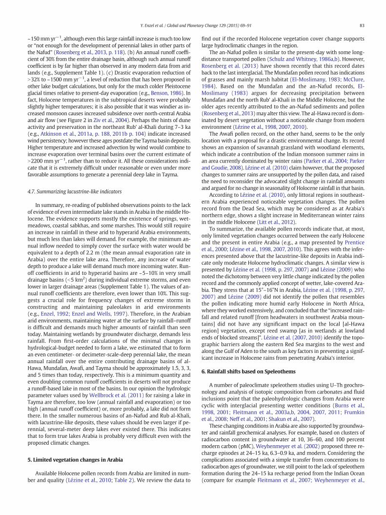
Farther east, in Oman's Rub' al-Khali there are numerous gypsum-crusted sabkhas (Fig. 9; and Fig. 5 of Sultan et al., 2008); two examplesfor such sabkhas are early-middle Holocene in age and probably repre-sent a regional higher water table in the region in the past (Matter et al.,in press). However, there are no indicators for past water bodies cover-ing the sabkhas (Matter et al., in press). Sultan et al. (2008) suggest thatthe groundwater forming the sabkhas were fed from the west. Howev-er, they also considered recharge from elevated areas in the southern
Table 1Criteria for distinguishing betweenmarsh/swamp/discharging playa environments and a lake in arid to hyperarid lowlands [based onMifflin andWheat (1979) and subsequent research byPigati et al. (2009, 2011, 2014), Quade (1986), Quade and Pratt (1989), Rosen (1994), Quade et al. (1995, 1998, 2003, 2008), and Rech et al. (2002, 2003)]. Al= flooded, wet, or lake surfacearea; Ab=Drainage basin area, (Aw index = Al/Ab) see discussion by Mifflin and Wheat (1979) and references therein regarding the Pluvial Index or hydrologic index, termed Aw or Z. Forexample, Aw=1=Al/Ab, where lake area is the total drainage basin area; commonly, it is expressed as a percentage (i.e. Aw in this example is 100) (e.g., Hudson and Quade, 2013;Mifflin andWheat, 1979).
Marsh/swamp/discharge Shallow/deep lake
Physiography andlandformassociation
Low elevation basins with local hydrographic closure and limitedcontributing drainage area [i.e., high Aw index]; These basins can beinter-dunes or bordered by coalescent alluvial fans.
Relatively large contributing drainage areas, higher elevation basins withlower evaporation, hydrographically closed or with overflowing spillways(e.g., low Aw index or low Pluvial Index, Mifflin and Wheat (1979).
Shore environmenta) Depositional No shorelines per se, since wetlands, wet meadows, and springs are not
high-energy (too shallow, not even minor waves); transition to marginat similar elevation.
High-energy wave action produces beach berms and spits composed ofreworked sediments of the surrounding landforms (e.g., dunes, alluvial fan)with distinct sedimentology of the well-sorted, cross-bedded sand and/orgravel, with noticeable unconformities. They are constructive, tens ofcentimeters to meters high landforms, cutting the preexisting topography.They occur even if lakes are only a fewmeters deep (e.g., Enzel et al., 1992).In carbonate-rich lakes these features are locally cemented by tufa intobeach rock. Laterally continuous to semi-continuous.
b) Transition frombasin's center tomargin
Small vertical difference between the flat basin floor and margins, basinmargin deposits are usually flat, lateral transition to non-aquaticsurroundings marked by browner color, increasingly un-bioturbatedsand or silt, less nodular carbonate. Organic rich “black mats” locallycommon. Margin discharge zone sometimes surrounding the basin withaccumulating fine grained deposits that can be rich in reeds andmistaken as beach deposit.
Usually a large topographic difference between basin center and marginsthat present shoreline. The basin bottom is flat with or without a cleardeeper point. No "black mats".
c) Erosional No erosional features by water body at margins. If groundwater has arole, their discharge zone is at the upstream margins and less than 1–2m above basin floor and can be altered/eroded by aeolian deflationfollowed.
Wave-cut cliffs and/or polished surfaces in bedrock; minor gravel lags; tufacemented where lake is carbonate rich.
Basin sedimentsa) Asymmetry Asymmetry in fine-grained deposits and thickness in the basin are
pronounced with elevated deposition in the direction of incominggroundwater.
Asymmetry in mostly related to clastic deposition at the entrance of thefluvial systems and evaporites are away from the fluvial system.
b) Delta No delta deposits, alluvial fans may prograde into basin flats without theimpact of standing water on their distribution.
Fluvial systems end in delta deposits, especially where surface runoff is crucialfor water budget. The delta top is usually at or near the level of shorelines.
c) Bedding/lithology Bioturbated green mudstone, marls, and locally extensive nodularcarbonates and calcretes, sometimes full of root channels. Can bediatomaceaous where local waters are silica-rich. Evaporates exist onlyin true terminal saline wetlands where groundwater flow downstreamis limited and evaporation controls outflow. Lamination can occur wherealgal mats are present or where seasonal variations in water table areassociated with dust deposition.
Bedded or laminated green to gray clay, silt, mudstone or marls but nomajor nodular carbonate. Diatomites where waters silica-rich. Evaporitesassociated with dry periods
Fauna Distinctive mix of terrestrial, semi-aquatic, and aquatic mollusks; anddistinctive ostracodes (Quade et al., 1995, 1998). Fossil remains of largeherbivores across the basin (i.e. not only at margins).
Nearly all aquatic mollusks and distinctive ostracodes; terrestrial molluskvery rare. Larger herbivores at basin margins.
Flora Organic mats and algal mats with well-preserved sedges and grasses canbe common. Reed vegetation is abundant as evident in organic-richdeposits, pollen, or root casts or all.
76 Y. Enzel et al. / Global and Planetary Change 129 (2015) 69–91
edges of Arabia ~200 km to the south. Fig. 9 indicates that head-waters of streams draining these mountains (with altitudes ofN1000 m) northward to the Rub' al-Khali experience annualprecipitation N 200 mm yr−1. Furthermore, Fig. 5 of Sultan et al.(2008) points to the potential of these elevated southern mountainsin explaining the isotopic composition of shallow groundwater in thesouthern sabkhas zone.
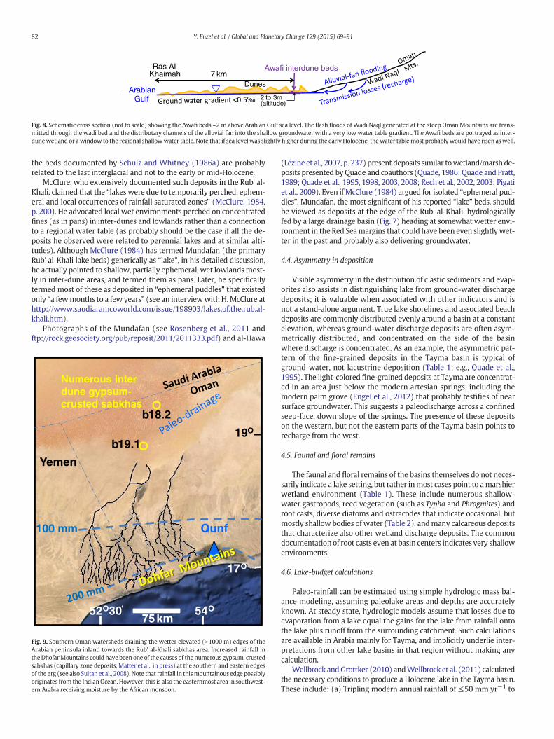
The Awafi inter-dune deposits (Table 2; Figs. 6–8 and Plate 4 inParker and Goudie, 2008) are at a distal part of Wadi Naqal drainagebasin (~75 km2), where its alluvial fan (Al Farraj and Harvey, 2000,2004) interacts with the United Arab Emirates (UAE) dune field(e.g., Goudie et al., 2000). The headwaters ofWadi Naqal are at altitudesN1500 m at the western Oman Mountains, UAE, an area receiving onlywinter rains either byMediterranean cyclones or by the northeastmon-soonflowing over theGulf of Oman. At the highest altitude of thewater-shed, the mean annual precipitation is 100–130 mm yr−1 (Fig. 2 andParker et al., 2004). Lower elevations in the watershed receive muchless rainfall. Between the distal part of the alluvial fan and the ArabianGulf (Figs. 6 and 8), thewater table was near the surface before modernintensive ground-water pumping and, in places, even now. At a distanceof ~7 km from the Arabian Gulf, the Awafi inter-dune floor (Fig. 8) is
b3–5 m above modern sea level. The top of the Holocene beds is ~2 mbelow the inter-dune floor (Parker et al., 2004; i.e. 1–3 m above sealevel at most) and therefore we suspect they were influenced by thelow water table gradient (~0.5‰) to the gulf, especially during the sealevel rising phase or even a slightly (0.5–1 m) higher sea level of theearly Holocene. When the chronologies of Goudie et al. (2000) andParker et al. (2004) are compared, it can be concluded that the duneswere established only shortly before the Awafi beds were deposited atthe time of the early Holocene sea level rise. This indicates a genetic as-sociation between dunes, sea level rise, and rising water table to formthe Awafi wetlands. Awafi is currently far from the influence of themonsoon summer precipitation and receives its rainfall mainly in theboreal winter and spring (Figs. 1 and 2).
The recently published Wahalah deposits from the United ArabEmirates (Fig. 6) are located ~19 km southwest of the Awafi deposits(Preston et al., in press) and present similar settings. The currentinter-dune basin floor is only 3–4 m meter above modern sealevel (based on Google Earth) with the main deposit ~1.5–2.2 mbelow basin floor (estimated from Preston et al., in press). Wahalah de-posits are located ~4.2 km from the Arabian Gulf indicating a very lowgradient of ~0.5‰ or less. Furthermore, an alternative to the C3–C4
Table 2Holocene records of lacustrine-like beds in Arabiaa. We use only Holocene data and ignore evidence to earlier indicators unless subsequent research provided newer Holocene ages beds considered older [mainly in Mundafan (Rosenberg et al.,2011)]. Locations of basins are marked in Fig. 6 using the bold letters under basin name below.
Basin name Original report Lat./long. Indicators of environments Shoreline features Lake statusb Vegetation (e.g., by) Reinterpreted in this research
An-Nafud, NW SaudiArabiaN
Thin lake beds[Schulz andWhitney(1986a,b);Whitney et al.(1983);Rosenberget al. (2013)]
28°18′/40°56′ Cemented sand, desiccationcracks, calcareous crusts,laminated diatomites, fossiliferouslimestone, green claey silt,burrows, numerousroots/rhizome remains ofPhragmites and Typha andMollusks,”indicating swamps”.
Not reported by authors and notobserved in satellite images
a) 2 (intermediate), in RobertandWright (1993); (b) wette[Braconnot et al. (2004)].But “All lakes were essentiallyof playa type”
As todayc+ longdistance transport(Schulz and Whitney,1986a,b)
Discharge depositsd “at thebottom of inter-dunedepressions” (Schulz andWhitney, 1986a). Wetlandmosaic, with few extremelyshallow pools.
Nafud Asir /Urayk,NW Saudi ArabiaN
As abovew/one thicksand-rich bed
25°30′/44°30′ Similar to the above Not reported by authors and notobserved in satellite images
As above As above As above
Taymae
NW ArabiaT
Engel et al.(2012); Ginauet al. (2012).
27°38′38°33′
Layers of mud, laminatedaragonite, some ooids and gradedclastics (sand to mud), highdiversity faunal remains,especially ostracodes (manydeformed); foraminifera; roots,plant remains, evaporites (someringing the basin), gastropods. Nodelta or alluvial fan, but withpronounced asymmetry ofevaporates and other depositsfrom south to north.
Bioclastic remains several metersabove basin floor (Engel et al.,2012, p. 137). Evidence forpermanent water above thesaltpan is laterally discontinuous(or “disjunct”, Engel et al., 2012,p. 136). No shoreline is observedin satellite images
Not in lake status database No data Discharging shallow wetland,with occasional standing water,primarily fed by groundwaterand perhaps floods; rapidfluctuations in and changingsalinities.
Mundafanf, SWSaudi Arabia, (Rub'al-Khali Site 1)M
McClure(1984)
18°33′/45°′19′ Mostly massive bedsg,h of sandymarls, calcareous cementedsandstones, algal “chara chalk”(mats?), fossil reed (Phragmites)and Typha, gastropods (mostlyMelanoides) and ostracodes,foraminifera, diatoms, numerousroot and burrowing casts,gypsum. Clays mostlynon-fossiliferous, Land snails(summary in Table V-1, p. 140 ofMcClure, 1984)
Nonei
Not reported by authors and notobserved in satellite images
(a) High, much wetter(Roberts and Wright, 1993).(b) Much wetter (Braconnotet al., 2004)
Grasses, mainly marshwet habitat. Morestable dunes. Slightlywetter than northernRub' al-Khali.(El-Moslimany, 1983,1990; McClure, 1984)
Ponds, marshes, and possiblydischarge deposits from aregional shallow alluvial aquiferand floods related to the largefeeding drainage basin size(N2500 km2).
Mundafanj, SWSaudi ArabiaM
Rosenberget al. (2011)
As above Marl, sand, cemented sand, silt,phytoclasts, burrows, root casts,fossil reed, gastropods (numerous,mainly Melanoides), andostracodesl. The foraminiferal
identified characterize coastalswamps, salt marshes, andlagoons and in Mundafan brackishwater. Charophytes indicateshallow depth.l
Nonek .Not reported by authorsand not observed in satelliteimages
As above As above As above with indicators of verysallow brackish water
(continued on next page)
77Y.Enzeletal./G
lobalandPlanetary
Change129
(2015)69
–91
for
sr
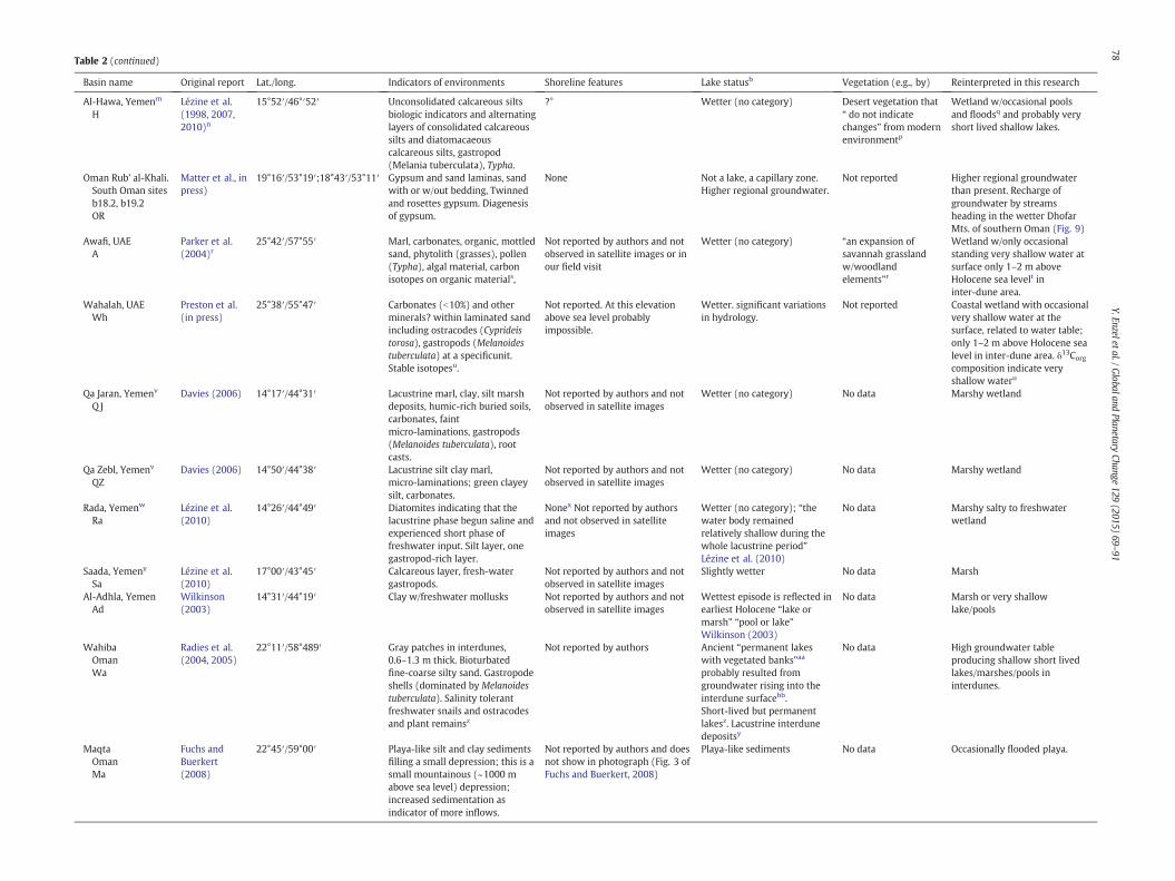
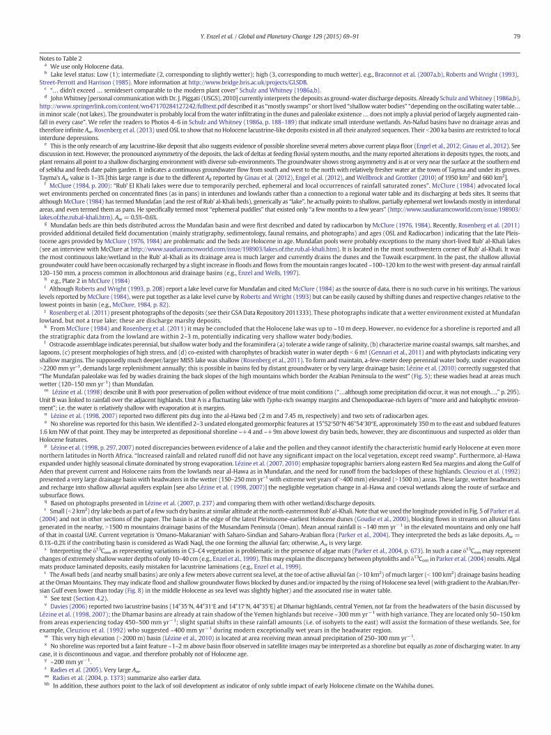
Table 2 (continued)
Basin name Original report Lat./long. Indicators of environments Shoreline features Lake statusb Vegetation (e.g., by) Reinterpreted in this research
Al-Hawa, Yemenm
HLézine et al.(1998, 2007,2010)n
15°52′/46°′52′ Unconsolidated calcareous siltsbiologic indicators and alternatinglayers of consolidated calcareoussilts and diatomacaeouscalcareous silts, gastropod(Melania tuberculata), Typha.
?° Wetter (no category) Desert vegetation that“ do not indicatechanges” from modernenvironmentp
Wetland w/occasional poolsand floodsq and probably veryshort lived shallow lakes.
Oman Rub' al-Khali.South Oman sitesb18.2, b19.2OR
Matter et al., inpress)
19°16′/53°19′;18°43′/53°11′ Gypsum and sand laminas, sandwith or w/out bedding, Twinnedand rosettes gypsum. Diagenesisof gypsum.
None Not a lake, a capillary zone.Higher regional groundwater.
Not reported Higher regional groundwaterthan present. Recharge ofgroundwater by streamsheading in the wetter DhofarMts. of southern Oman (Fig. 9)
Awafi, UAEA
Parker et al.(2004)r
25°42′/57°55′ Marl, carbonates, organic, mottledsand, phytolith (grasses), pollen(Typha), algal material, carbonisotopes on organic materials,
Not reported by authors and notobserved in satellite images or inour field visit
Wetter (no category) “an expansion ofsavannah grasslandw/woodlandelements”r
Wetland w/only occasionalstanding very shallow water atsurface only 1–2 m aboveHolocene sea levelt ininter-dune area.
Wahalah, UAEWh
Preston et al.(in press)
25°38′/55°47′ Carbonates (b10%) and otherminerals? within laminated sandincluding ostracodes (Cyprideistorosa), gastropods (Melanoidestuberculata) at a specificunit.Stable isotopesu.
Not reported. At this elevationabove sea level probablyimpossible.
Wetter. significant variationsin hydrology.
Not reported Coastal wetland with occasionalvery shallow water at thesurface, related to water table;only 1–2 m above Holocene sealevel in inter-dune area. δ13Corgcomposition indicate veryshallow wateru
Qa Jaran, Yemenv
Q JDavies (2006) 14°17′/44°31′ Lacustrine marl, clay, silt marsh
deposits, humic-rich buried soils,carbonates, faintmicro-laminations, gastropods(Melanoides tuberculata), rootcasts.
Not reported by authors and notobserved in satellite images
Wetter (no category) No data Marshy wetland
Qa Zebl, Yemenv
QZDavies (2006) 14°50′/44°38′ Lacustrine silt clay marl,
micro-laminations; green clayeysilt, carbonates.
Not reported by authors and notobserved in satellite images
Wetter (no category) No data Marshy wetland
Rada, Yemenw
RaLézine et al.(2010)
14°26′/44°49′ Diatomites indicating that thelacustrine phase begun saline andexperienced short phase offreshwater input. Silt layer, onegastropod-rich layer.
Nonex Not reported by authorsand not observed in satelliteimages
Wetter (no category); “thewater body remainedrelatively shallow during thewhole lacustrine period”Lézine et al. (2010)
No data Marshy salty to freshwaterwetland
Saada, Yemeny
SaLézine et al.(2010)
17°00′/43°45′ Calcareous layer, fresh-watergastropods.
Not reported by authors and notobserved in satellite images
Slightly wetter No data Marsh
Al-Adhla, YemenAd
Wilkinson(2003)
14°31′/44°19′ Clay w/freshwater mollusks Not reported by authors and notobserved in satellite images
Wettest episode is reflected inearliest Holocene “lake ormarsh” “pool or lake”Wilkinson (2003)
No data Marsh or very shallowlake/pools
WahibaOmanWa
Radies et al.(2004, 2005)
22°11′/58°489′ Gray patches in interdunes,0.6–1.3 m thick. Bioturbatedfine-coarse silty sand. Gastropodeshells (dominated by Melanoidestuberculata). Salinity tolerantfreshwater snails and ostracodesand plant remainsz
Not reported by authors Ancient “permanent lakeswith vegetated banks”aa
probably resulted fromgroundwater rising into theinterdune surfacebb.Short-lived but permanentlakesz. Lacustrine interdunedepositsy
No data High groundwater tableproducing shallow short livedlakes/marshes/pools ininterdunes.
MaqtaOmanMa
Fuchs andBuerkert(2008)
22°45′/59°00′ Playa-like silt and clay sedimentsfilling a small depression; this is asmall mountainous (~1000 mabove sea level) depression;increased sedimentation asindicator of more inflows.
Not reported by authors and doesnot show in photograph (Fig. 3 ofFuchs and Buerkert, 2008)
Playa-like sediments No data Occasionally flooded playa.
78Y.Enzeletal./G
lobalandPlanetary
Change129
(2015)69
–91
Notes to Table 2a We use only Holocene data.b Lake level status: Low (1); intermediate (2, corresponding to slightly wetter); high (3, corresponding to much wetter). e.g., Braconnot et al. (2007a,b), Roberts and Wright (1993),
Street-Perrott and Harrison (1985). More information at http://www.bridge.bris.ac.uk/projects/GLSDB.c “… didn't exceed … semidesert comparable to the modern plant cover” Schulz and Whitney (1986a,b).d JohnWhitney [personal communicationwith Dr. J. Piggati (USGS), 2010] currently interprets the deposits as ground-water discharge deposits. Already Schulz andWhitney (1986a,b),
http://www.springerlink.com/content/wn47170284127242/fulltext.pdf described it as “mostly swamps” or short lived “shallowwater bodies” “depending on the oscillatingwater table…inminor scale (not lakes). The groundwater is probably local from thewater infiltrating in the dunes and paleolake existence… does not imply a pluvial period of largely augmented rain-fall in every case”. We refer the readers to Photos 4–6 in Schulz and Whitney (1986a, p. 188–189) that indicate small interdune wetlands. An-Nafud basins have no drainage areas andtherefore infinite Aw. Rosenberg et al. (2013) usedOSL to show that noHolocene lacustrine-like deposits existed in all their analyzed sequences. Their b200 ka basins are restricted to localinterdune depressions.
e This is the only research of any lacustrine-like deposit that also suggests evidence of possible shoreline several meters above current playa floor (Engel et al., 2012; Ginau et al., 2012). Seediscussion in text. However, the pronounced asymmetry of the deposits, the lack of deltas at feeding fluvial systemmouths, and themany reported alterations in deposits types, the roots, andplant remains all point to a shallowdischarging environmentwith diverse sub-environments. The groundwater shows strong asymmetry and is at or very near the surface at the southern endof sebkha and feeds date palm garden. It indicates a continuous groundwater flow from south and west to the north with relatively fresher water at the town of Tayma and under its groves.Tayma's Aw value is 1–3% [this large range is due to the different Ad reported by Ginau et al. (2012), Engel et al. (2012), and Wellbrock and Grottker (2010) of 1950 km2 and 660 km2].
f McClure (1984, p. 200): “Rub’ El Khali lakes were due to temporarily perched, ephemeral and local occurrences of rainfall saturated zones”. McClure (1984) advocated localwet environments perched on concentrated fines (as in pans) in interdunes and lowlands rather than a connection to a regional water table and its discharging at beds sites. It seems thatalthoughMcClure (1984) has termedMundafan (and the rest of Rub' al-Khali beds), generically as “lake”, he actually points to shallow, partially ephemeral wet lowlandsmostly in interdunalareas, and even termed them as pans. He specifically termed most “ephemeral puddles” that existed only “a fewmonths to a few years” (http://www.saudiaramcoworld.com/issue/198903/lakes.of.the.rub.al-khali.htm). Aw = 0.5%–0.6%.
g Mundafan beds are thin beds distributed across the Mundafan basin and were first described and dated by radiocarbon by McClure (1976, 1984). Recently, Rosenberg et al. (2011)provided additional detailed field documentation (mainly stratigraphy, sedimentology, faunal remains, and photographs) and ages (OSL and Radiocarbon) indicating that the late Pleis-tocene ages provided by McClure (1976, 1984) are problematic and the beds are Holocene in age. Mundafan pools were probably exceptions to the many short-lived Rub' al-Khali lakes(see an interview with McClure at http://www.saudiaramcoworld.com/issue/198903/lakes.of.the.rub.al-khali.htm). It is located in the most southwestern corner of Rub' al-Khali. It wasthe most continuous lake/wetland in the Rub' al-Khali as its drainage area is much larger and currently drains the dunes and the Tuwaik escarpment. In the past, the shallow alluvialgroundwater could have been occasionally recharged by a slight increase in floods and flows from themountain ranges located ~100–120 km to thewestwith present-day annual rainfall120–150 mm, a process common in allochtonous arid drainage basins (e.g., Enzel and Wells, 1997).
h e.g., Plate 2 in McClure (1984)i Although Roberts andWright (1993, p. 208) report a lake level curve for Mundafan and citedMcClure (1984) as the source of data, there is no such curve in his writings. The various
levels reported byMcClure (1984), were put together as a lake level curve by Roberts andWright (1993) but can be easily caused by shifting dunes and respective changes relative to thelowest points in basin (e.g., McClure, 1984, p. 82).
j Rosenberg et al. (2011) present photographs of the deposits (see their GSAData Repository 2011333). These photographs indicate that a wetter environment existed at Mundafanlowland, but not a true lake; these are discharge marshy deposits.
k FromMcClure (1984) and Rosenberg et al. (2011) it may be concluded that the Holocene lake was up to ~10 m deep. However, no evidence for a shoreline is reported and allthe stratigraphic data from the lowland are within 2–3 m, potentially indicating very shallow water body/bodies.
l Ostracode assemblage indicates perennial, but shallowwater body and the foraminifera (a) tolerate awide range of salinity, (b) characterizemarine coastal swamps, salt marshes, andlagoons, (c) present morphologies of high stress, and (d) co-existed with charophytes of brackish water in water depth b 6 m! (Gennari et al., 2011) and with phytoclasts indicating veryshallowmargins. The supposedly much deeper/larger MIS5 lake was shallow (Rosenberg et al., 2011). To form andmaintain, a-few-meter deep perennial water body, under evaporationN2200mm yr–1, demands large replenishment annually; this is possible in basins fed by distant groundwater or by very large drainage basin; Lézine et al. (2010) correctly suggested that“The Mundafan paleolake was fed by wadies draining the back slopes of the high mountains which border the Arabian Peninsula to the west” (Fig. 5); these wadies head at areas muchwetter (120–150 mm yr–1) than Mundafan.
m Lézine et al. (1998) describe unit B with poor preservation of pollen without evidence of true moist conditions (“…although some precipitation did occur, it was not enough…,” p. 295).Unit B was linked to rainfall over the adjacent highlands. Unit A is a fluctuating lake with Typha-rich swampymargins and Chenopodiaceae-rich layers of “more arid and halophytic environ-ment”; i.e. the water is relatively shallow with evaporation at is margins.
n Lézine et al. (1998, 2007) reported two different pits dug into the al-Hawa bed (2 m and 7.45 m, respectively) and two sets of radiocarbon ages.o No shorelinewas reported for this basin.We identified 2–3 undated elongated geomorphic features at 15°52′50″N 46°54′30″E, approximately 350m to the east and subdued features
1.6 km NW of that point. They may be interpreted as depositional shoreline ~+4 and ~+9m above lowest dry basin beds, however, they are discontinuous and suspected as older thanHolocene features.
p Lézine et al. (1998, p. 297, 2007) noted discrepancies between evidence of a lake and the pollen and they cannot identify the characteristic humid early Holocene at even morenorthern latitudes in North Africa. “Increased rainfall and related runoff did not have any significant impact on the local vegetation, except reed swamp”. Furthermore, al-Hawaexpanded under highly seasonal climate dominated by strong evaporation. Lézine et al. (2007, 2010) emphasize topographic barriers along eastern Red Seamargins and along the Gulf ofAden that prevent current and Holocene rains from the lowlands near al-Hawa as in Mundafan, and the need for runoff from the backslopes of these highlands. Cleuziou et al. (1992)presented a very large drainage basin with headwaters in thewetter (150–250mmyr–1 with extremewet years of N400mm) elevated (N1500m) areas. These large, wetter headwatersand recharge into shallow alluvial aquifers explain [see also Lézine et al. (1998, 2007)] the negligible vegetation change in al-Hawa and coeval wetlands along the route of surface andsubsurface flows.
q Based on photographs presented in Lézine et al. (2007, p. 237) and comparing them with other wetland/discharge deposits.r Small (b2 km2) dry lake beds as part of a few such dry basins at similar altitude at thenorth-easternmost Rub' al-Khali. Note thatweused the longitude provided in Fig. 5 of Parker et al.
(2004) and not in other sections of the paper. The basin is at the edge of the latest Pleistocene-earliest Holocene dunes (Goudie et al., 2000), blocking flows in streams on alluvial fansgenerated in the nearby, N1500 m mountains drainage basins of the Musandam Peninsula (Oman). Mean annual rainfall is ~140 mm yr−1 in the elevated mountains and only one halfof that in coastal UAE. Current vegetation is ‘Omano-Makaranian’ with Saharo-Sindian and Saharo-Arabian flora (Parker et al., 2004). They interpreted the beds as lake deposits. Aw =0.1%–0.2% if the contributing basin is considered as Wadi Naql, the one forming the alluvial fan; otherwise, Aw is very large.
s Interpreting the δ13Com as representing variations in C3–C4 vegetation is problematic in the presence of algae mats (Parker et al., 2004, p. 673). In such a case δ13Com may representchanges of extremely shallowwater depths of only 10–40 cm (e.g., Enzel et al., 1999). This may explain the discrepancy between phytoliths and δ13Com in Parker et al. (2004) results. Algalmats produce laminated deposits, easily mistaken for lacustrine laminations (e.g., Enzel et al., 1999).
t The Awafi beds (and nearby small basins) are only a fewmeters above current sea level, at the toe of active alluvial fan (N10 km2) ofmuch larger (b 100 km2) drainage basins headingat the OmanMountains. Theymay indicate flood and shallow groundwater flows blocked by dunes and/or impacted by the rising of Holocene sea level (with gradient to the Arabian/Per-sian Gulf even lower than today (Fig. 8) in the middle Holocene as sea level was slightly higher) and the associated rise in water table.
u See text (Section 4.2).v Davies (2006) reported two lacustrine basins (14°35′N, 44°31′E and 14°17′N, 44°35′E) at Dhamar highlands, central Yemen, not far from the headwaters of the basin discussed by
Lézine et al. (1998, 2007); the Dhamar basins are already at rain shadow of the Yemen highlands but receive ~300 mm yr−1 with high variance. They are located only 50–150 kmfrom areas experiencing today 450–500 mm yr−1; slight spatial shifts in these rainfall amounts (i.e. of isohyets to the east) will assist the formation of these wetlands. See, forexample, Cleuziou et al. (1992) who suggested ~400 mm yr−1 during modern exceptionally wet years in the headwater region.
w This very high elevation (N2000 m) basin (Lézine et al., 2010) is located at area receiving mean annual precipitation of 250–300 mm yr−1.x No shorelinewas reported but a faint feature ~1–2m above basin floor observed in satellite imagesmay be interpreted as a shoreline but equally as zone of discharging water. In any
case, it is discontinuous and vague, and therefore probably not of Holocene age.y ~200 mm yr−1.z Radies et al. (2005). Very large Aw.aa Radies et al. (2004, p. 1373) summarize also earlier data.bb In addition, these authors point to the lack of soil development as indicator of only subtle impact of early Holocene climate on the Wahiba dunes.
79Y. Enzel et al. / Global and Planetary Change 129 (2015) 69–91

Fig. 6. Directions of moisture supply and rainstorms in the Arabian Peninsula and their associated and controlling atmospheric circulation patterns. The present-day maximum northernlocation of the boreal summer rainfall and two proposed (Wanner et al., 2008 and e.g., Fleitmann et al., 2007) early-middle Holocene boreal summer ITCZs are marked in relationshipswith sites of Holocene records in the peninsula. Note that south-easternmost Arabia is susceptible to minor changes in the Southwest monsoon and is the area also affected by north-ward-moving Arabian Sea cyclones. Lacustrine deposits/basins are in yellow with empty circles indicating lakes without Holocene shorelines: A= Awafi, H = Al-Hawa, M=Mundafan,Ma = Maqta, N = an-Nafud, OR = Southern Oman Rub al-Khali, QJ = Qa Jaran, QZ = Qa Zebl, Ra = Rada, Sa = Saada, Wa = Wahiba, and Wh = Wahalah (references are detailed inTable 2). Note that Rosenberg et al. (2013) did not identify any Holocene lacustrine-like deposits in any of the sequences they analyzed in the inter-dune basins of an-Nafud. Ab =Lake Abhe (Gasse and Street, 1978) is in arid Ethiopia and Djibouti. DS = Dead Sea in Israel and Jordan (e.g., Enzel et al., 2003). Speleothems with (solid blue triangles) or without(empty blue triangles) early-middle Holocene records are: Ht=Hoti Cave (Burns et al., 1998, 2001; Fleitmann et al., 2003b, 2007; Neff et al., 2001); KD=Kahf Defore cave (speleothemswith a large gap between ~9 and 1 ka; Fleitmann et al., 2004); Kh= Khsheifa Cave, near Jawa, Jordan; the record ends at ~70 ka and has no Holocene speleothems (Frumkin et al., 2008);Mk=Mukalla Cave (Fleitmann et al., 2011); Q=Qunf Cave (Fleitmann et al., 2003a, 2007); S= Socotra Island caveswith (Hoq Cave, in eastern Socotra; 7–0 ka) andwithout [Dimarshim(0–4.5 ka) and Moomi (N~11 ka) in western and Casecas (1–0 ka) in eastern Socotra] early-middle Holocene record (Fleitmann et al., 2007; Shakun et al., 2007; Van Rampelbergh et al.,2013; SG = Surprise and Gecko caves without speleothems in the last 350 ka (Fleitmann et al., 2004); SC + BL = Star and Broken Lag caves without speleothems in the last 350 ka(Fleitmann et al., 2004). KJ = Kwar al Jaramah and Su = Suwayh are pollen records from Lézine (2009) and Lézine et al. (2010).
80 Y. Enzel et al. / Global and Planetary Change 129 (2015) 69–91
interpretation of the measured δ13Corg along this section, can use theBaertschi effect (and not the change in C3-C4) that is best applicablein such environments where algal mats produce organic matter (e.g.,Enzel et al., 1999 and references therein). If used, the δ13Corg results(Preston et al., in press) indicate that the water depth throughout thewetland existence was always extremely shallow, probably not morethat 10–20 cm. All these evidences indicate that rather than beinginterpreted as a lake (Preston et al., in press), these deposits probablyindicate coastal inter-dune sabkhawith the characteristic sandy laminasthat are largely impacted by sea level and groundwater. Furthermore,the similar chronologies of Awafi and Wahalah deposits (~8.5–6 ka)are both associated with maximum sea level.
The late Pleistocene and Holocene inter-dune basins in an-Nafud innorthwestern Arabia (Schulz and Whitney, 1986a; Rosenberg et al.,2013) have no drainage basin and may not contain Holocene depositsas suggested earlier (Table 2). Al-Adhla, Qa Jaran, Qa Zebl, Rada, andSada are located in the much wetter Yemen highlands (Wilkinson,2003; Davies, 2006; Lézine et al., 2010) and are impacted by the NorthAfrican summer rains. However, even in this wetter environment thebasins were occupied by wetlands and not by lakes (Table 2), but
this may be the result of basin physiography and surface and subsurfaceoutflow from these wetlands.
4.2. Shorelines
Among all the distinguishing features of paleolakes, perhaps mostimportant is the presence of fossil shorelines. Distinct shoreline com-posed of gravel or sandy berms with N0.5 m relief can form aroundlakes in little as a single season to a few decades, depending on localconditions (Hunter et al., 1990; Enzel, 1992; Enzel et al., 1992;Thompson and Baedke, 1995; Adams and Wesnousky, 1998; Bartovet al., 2006). By contrast, shorelines are not found around springs norshallow ground-water fed wetlands b~3 m deep, nor in ephemeral(usually seasonal) wet playas, pans, or sabkhas. Late-Quaternary-ageshorelines indicative of stable paleolakes should be well preserved inthe Arabian Peninsula, given its extreme aridity and generally modestrelief. Paleoshorelines of late Quaternary (25–7 ka) age are amply pre-served, for example, in the Great Basin of the western USA (MifflinandWheat, 1979), central Tibet (Hudson and Quade, 2013), PatagonianSouth America (Stine and Stine, 1990; Anselmatti et al., 2006), and sub-
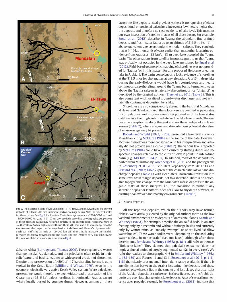
Fig. 7. The drainage basins of (A) Mundafan, (B) Al-Hawa, and (C) Awafi and the currentisohyets of 100 and 200 mm in their respective drainage basins. Note the different scalesfor these basins. See Fig. 6 for location. Their drainage areas are ~2500–3000 km2 and13,000–14,000 km2, and ~80–100 km2, respectively according to topography, but portionsof these drainage basins may not drain directly to the specific basin. Additional rains insouthwestern Arabia highlands will shift these 200 mm and 100 mm isohyets to theeast to cover the respective drainage basins of al-Hawa and Mundafan by more rains.Such past shifts by as little as 100–200 km will dramatically increase the rainfall,recharge of shallow alluvial aquifer and flows. The line (marked as “7 km”) in C tracksthe location of the schematic cross section in Fig. 8.
81Y. Enzel et al. / Global and Planetary Change 129 (2015) 69–91
Saharan Africa (Burrough and Thomas, 2009). These regions are wetterthan peninsular Arabia today, and the paleolakes often reside in high-relief structural basins, leading to widespread erosion of shorelines.Despite this, preservation of N50% of ~17 ka shoreline berms is quitetypical in the Great Basin (Mifflin and Wheat, 1979), even in thegeomorphologically very active Death Valley system. Were paleolakespresent, we would therefore expect widespread preservation of lateQuaternary (25–6 ka) paleoshorelines in peninsular Arabia, exceptwhere locally buried by younger dunes. However, among all these
lacustrine-like deposits listed previously, there is no reporting of eitherdepositional or erosional paleoshoreline even a fewmeters higher thanthe deposits and therefore no clear evidence of lake level. This matchesour own inspection of satellite images of all these basins. For example,Engel et al. (2012) describe in Tayma the abundant fine-graineddeposits and fresh-water fauna up to an altitude of 811.5 m, i.e. ~11 mabove equivalent-age layers under the modern saltpan. They concludethat at 9–10 ka, thousands of years earlier thanmost other lacustrine ev-idence from Arabia, a ~18-km2, ~13-m deep lake occupied the Taymabasin. The observations from satellite images suggest to us that Taymawas probably not occupied by the deep lake envisioned by Engel et al.(2012). Field-based geomorphic mapping of shorelines was not provid-ed for Tayma (or in this matter, for any proposed Holocene or earlierlake in Arabia!). The basin conspicuously lacks evidence of shorelinesat the 811.5 m or for that matter at any elevation. A ≥13 m deep lakeduring the early-Holocene would have left conspicuous and nearlycontinuous paleoshorelines around the Tayma basin. Permanent waterabove the Tayma saltpan is laterally discontinuous, or “disjunct” asdescribed by the original authors (Engel et al., 2012; Table 2). This isalso consistent with localized ground-water discharge, and not withlaterally continuous deposition by a lake.
Shorelines are also conspicuously absent in the basins at Mundafan,al Hawa, and Nafud, although these locations are counted as paleolakesin compilations and in cases even incorporated into the lake statusdatabase as either high, intermediate, or low lake level stands. The onepossible exception is along the east and northeast edges of al-Hawa,Yemen (Table 2), where a vague and discontinuous potential shorelineof unknown age may be present.
Roberts and Wright (1993, p. 208) presented a lake level curve forMundafan, citing McClure (1984) as the source of the data. However,McClure himself was more conservative in his interpretation and actu-ally did not provide such a curve (Table 2). The various levels reportedby McClure (1984) could have been caused by shifting dunes and re-spective changes relative to the current lowest points in inter-dunebasin (e.g., McClure, 1984, p. 82). In addition, most of the deposits re-ported from Mundafan by Rosenberg et al. (2011, and the photographsin Rosenberg et al., 2011, GSA Data Repository item 2011333 andCrassard et al., 2013; Table 2) present the characteristics of wetland dis-charge deposits (Table 1) with clear lateral horizontal transition intosame-level basinmargin deposits, not to a shoreline. There is no notice-able topographic change from the Mundafan marsh deposits to the or-ganic mats at these margins. i.e., the transition is without anyshoreline deposit or landform, does not allow to any depth of water, in-dicating shallow wetland marshy environments (Table 2).
4.3. Marsh deposits
All the reported deposits, which the authors may have termed“lakes”, were actually viewed by the original authors more as shallowwetland environments or as deposits of occasional floods. Schulz andWhitney (1986a), for example, describe the an-Nafud beds, in an areafeeding only by direct rain and without drainage basins and currentlyonly by winter rains, as “mostly swamps” or short-lived “shallowwater bodies”. These water bodies were “depending on the oscillatingwater table… in minor scale” (i.e., not lakes), although after thesedescriptions, Schulz and Whitney (1986a, p. 181) still refer to them as“Holocene lakes”. They claimed that paleolake existence “does notimply a pluvial period of largely augmented rainfall in every case”. Werefer the readers to photographs 4–6 in Schulz and Whitney (1986a,p. 188–189) and Figures 11 and 13 in Rosenberg et al. (2013, p. 116–118) that clearly present small inter-dune sandy wetlands. If there isany distinction between the Arabia lacustrine-like deposits and thosereported elsewhere, it lies in the sandier and less clayey characteristicsof the Arabian deposits as can be seen in these figures. i.e., theArabia de-posits are even less characteristic lake deposits. A set of several lumines-cence ages provided recently by Rosenberg et al. (2013), indicate that
DunesArabian
Gulf
Awafi interdune beds7 km
Ras Al-Khaimah
2 to 3m (altitude)
Fig. 8. Schematic cross section (not to scale) showing the Awafi beds ~2 m above Arabian Gulf sea level. The flash floods of Wadi Naql generated at the steep OmanMountains are trans-mitted through the wadi bed and the distributary channels of the alluvial fan into the shallow groundwater with a very low water table gradient. The Awafi beds are portrayed as inter-dunewetland or awindow to the regional shallowwater table. Note that if sea level was slightly higher during the early Holocene, thewater tablemost probablywould have risen aswell.
82 Y. Enzel et al. / Global and Planetary Change 129 (2015) 69–91
the beds documented by Schulz and Whitney (1986a) are probablyrelated to the last interglacial and not to the early or mid-Holocene.
McClure, who extensively documented such deposits in the Rub' al-Khali, claimed that the “lakes were due to temporarily perched, ephem-eral and local occurrences of rainfall saturated zones” (McClure, 1984,p. 200). He advocated local wet environments perched on concentratedfines (as in pans) in inter-dunes and lowlands rather than a connectionto a regional water table (as probably should be the case if all the de-posits he observed were related to perennial lakes and at similar alti-tudes). Although McClure (1984) has termed Mundafan (the primaryRub' al-Khali lake beds) generically as “lake”, in his detailed discussion,he actually pointed to shallow, partially ephemeral, wet lowlandsmost-ly in inter-dune areas, and termed them as pans. Later, he specificallytermed most of these as deposited in “ephemeral puddles” that existedonly “a fewmonths to a few years” (see an interviewwithH.McClure athttp://www.saudiaramcoworld.com/issue/198903/lakes.of.the.rub.al-khali.htm).
Photographs of the Mundafan (see Rosenberg et al., 2011 andftp://rock.geosociety.org/pub/reposit/2011/2011333.pdf) and al-Hawa
b19.1
b18.2
75 km
19O
17O
54O52O30’
Yemen
100 mm Qunf
Numerous inter-dune gypsum-crusted sabkhas
Fig. 9. Southern Oman watersheds draining the wetter elevated (N1000 m) edges of theArabian peninsula inland towards the Rub' al-Khali sabkhas area. Increased rainfall intheDhofarMountains could have beenone of the causes of thenumerous gypsum-crustedsabkhas (capillary zone deposits, Matter et al., in press) at the southern and eastern edgesof the erg (see also Sultan et al., 2008). Note that rainfall in thismountainous edge possiblyoriginates from the IndianOcean. However, this is also the easternmost area in southwest-ern Arabia receiving moisture by the African monsoon.
(Lézine et al., 2007, p. 237) present deposits similar towetland/marsh de-posits presented byQuade and coauthors (Quade, 1986; Quade and Pratt,1989; Quade et al., 1995, 1998, 2003, 2008; Rech et al., 2002, 2003; Pigatiet al., 2009). Even if McClure (1984) argued for isolated “ephemeral pud-dles”, Mundafan, the most significant of his reported “lake” beds, shouldbe viewed as deposits at the edge of the Rub' al-Khali, hydrologicallyfed by a large drainage basin (Fig. 7) heading at somewhat wetter envi-ronment in the Red Seamargins that could have been even slightlywet-ter in the past and probably also delivering groundwater.
4.4. Asymmetry in deposition
Visible asymmetry in the distribution of clastic sediments and evap-orites also assists in distinguishing lake from ground-water dischargedeposits; it is valuable when associated with other indicators and isnot a stand-alone argument. True lake shorelines and associated beachdeposits are commonly distributed evenly around a basin at a constantelevation, whereas ground-water discharge deposits are often asym-metrically distributed, and concentrated on the side of the basinwhere discharge is concentrated. As an example, the asymmetric pat-tern of the fine-grained deposits in the Tayma basin is typical ofground-water, not lacustrine deposition (Table 1; e.g., Quade et al.,1995). The light-colored fine-grained deposits at Tayma are concentrat-ed in an area just below the modern artesian springs, including themodern palm grove (Engel et al., 2012) that probably testifies of nearsurface groundwater. This suggests a paleodischarge across a confinedseep-face, down slope of the springs. The presence of these depositson the western, but not the eastern parts of the Tayma basin points torecharge from the west.
4.5. Faunal and floral remains
The faunal and floral remains of the basins themselves do not neces-sarily indicate a lake setting, but rather inmost cases point to amarshierwetland environment (Table 1). These include numerous shallow-water gastropods, reed vegetation (such as Typha and Phragmites) androot casts, diverse diatoms and ostracodes that indicate occasional, butmostly shallow bodies of water (Table 2), andmany calcareous depositsthat characterize also other wetland discharge deposits. The commondocumentation of root casts even at basin centers indicates very shallowenvironments.
4.6. Lake-budget calculations
Paleo-rainfall can be estimated using simple hydrologic mass bal-ance modeling, assuming paleolake areas and depths are accuratelyknown. At steady state, hydrologic models assume that losses due toevaporation from a lake equal the gains for the lake from rainfall ontothe lake plus runoff from the surrounding catchment. Such calculationsare available in Arabia mainly for Tayma, and implicitly underlie inter-pretations from other lake basins in that region without making anycalculation.
Wellbrock andGrottker (2010) andWellbrock et al. (2011) calculatedthe necessary conditions to produce a Holocene lake in the Tayma basin.These include: (a) Tripling modern annual rainfall of ≤50 mm yr−1 to
83Y. Enzel et al. / Global and Planetary Change 129 (2015) 69–91
~150mmyr−1, although even this large rainfall increase ismuch too lowor “not enough for the development of perennial lakes in other parts ofthe Nafud” (Rosenberg et al., 2013, p. 118). (b) An annual runoff coeffi-cient of 30% from the entire drainage basin, although such annual runoffcoefficient is by far higher than observed in any modern data from aridlands (e.g., Supplement Table 1). (c) Drastic evaporation reduction ofN32% to ~1500 mm yr−1, a level of reduction that has been proposed inother lake budget calculations, but only for the much colder Pleistoceneglacial times relative to present-day evaporation (e.g., Benson, 1986). Infact, Holocene temperatures in the subtropical deserts were probablyslightly higher temperatures; it is also possible that it was windier as in-creased monsoon causes increased subsidence over north-central Arabiaand air flow (see Figure 2 in Ziv et al., 2004). Perhaps the hints of duneactivity and preservation in the northeast Rub' al-Khali during 7–3 ka(e.g., Atkinson et al., 2011a, p. 188, 2011b p. 104) indicate increasedwindpersistency; however these ages postdate the Taymabasin deposits.Higher temperature and increased advection by wind would combine toincrease evaporation over terminal basins over the current estimate ofN2200 mm yr−1, rather than to reduce it. All these considerations indi-cate that it is extremely difficult under reasonable or even under morefavorable assumptions to generate a perennial deep lake in Tayma.
4.7. Summarizing lacustrine-like indicators
In summary, re-reading of published observations points to the lackof evidence of even intermediate lake stands in Arabia in themiddleHo-locene. The evidence supports mostly the existence of springs, wet-meadows, coastal sabkhas, and some marshes. This would still requirean increase in rainfall in these arid to hyperarid Arabia environments,but much less than lakes will demand. For example, the minimum an-nual inflow needed to simply cover the surface with water would beequivalent to a depth of 2.2 m (the mean annual evaporation rate inArabia) over the entire lake area. Therefore, any increase of waterdepth to produce a lake will demandmuch more incoming water. Run-off coefficients in arid to hyperarid basins are ~5–10% in very smalldrainage basins (b5 km2) during individual extreme storms, and evenlower in larger drainage areas (Supplement Table 1). The values of an-nual runoff coefficients are therefore, even lower than 10%. This sug-gests a crucial role for frequency changes of extreme storms inconstructing and maintaining paleolakes in arid environments(e.g., Enzel, 1992; Enzel and Wells, 1997). Therefore, in the Arabianarid environments, maintaining water at the surface by rainfall–runoffis difficult and demands much higher amounts of rainfall than seentoday. Maintaining wetlands by groundwater discharge, demands lessrainfall. From first-order calculations of the minimal changes inhydrological-budget needed to form a lake, we estimated that to forman even centimeter- or decimeter-scale-deep perennial lake, the meanannual rainfall over the entire contributing drainage basins of al-Hawa, Mundafan, Awafi, and Tayma should be approximately 1.5, 3, 3,and 5 times than today, respectively. This is a minimum quantity andeven doubling common runoff coefficients in deserts will not producea runoff-based lake in most of the basins. In our opinion the hydrologicparameter values used by Wellbrock et al. (2011) for raising a lake inTayma are therefore, too low (annual rainfall and evaporation) or toohigh (annual runoff coefficient) or, more probably, a lake did not formthere. In the smaller numerous basins of an-Nafud and Rub al-Khali,with lacustrine-like deposits, these values should be even larger if pe-rennial, several-meter deep lakes ever existed there. This indicatesthat to form true lakes Arabia is probably very difficult even with theproposed climatic changes.
5. Limited vegetation changes in Arabia
Available Holocene pollen records from Arabia are limited in num-ber and quality (Lézine et al., 2010; Table 2). We review the data to
find out if the recorded Holocene vegetation cover change supportslarge hydroclimatic changes in the region.
The an-Nafud pollen is similar to the present-day with some long-distance transported pollen (Schulz and Whitney, 1986a,b). However,Rosenberg et al. (2013) have shown recently that this record datesback to the last interglacial. TheMundafan pollen record has indicationsof grasses and mainly marsh habitat (El-Moslimany, 1983; McClure,1984). Based on the Mundafan and the an-Nafud records, El-Moslimany (1983) argues for decreasing precipitation betweenMundafan and the north Rub' al-Khali in the Middle Holocene, but theolder ages recently attributed to the an-Nafud sediments and pollen(Rosenberg et al., 2013)may alter this view. The al-Hawa record is dom-inated by desert vegetation without a noticeable change from modernenvironment (Lézine et al., 1998, 2007, 2010).
The Awafi pollen record, on the other hand, seems to be the onlylocation with a proposal for a drastic environmental change. Its recordshows an expansion of savannah grassland with woodland elements,which indicate a contribution of the Indian monsoon summer rains inan area currently dominated by winter rains (Parker et al., 2004; Parkerand Goudie, 2008). Lézine et al. (2010) claim however, that the proposedchanges to summer rains are unsupported by the pollen data, and raisedthe need to reconsider the advocated slight change in rainfall amountsand argued for no change in seasonality of Holocene rainfall in that basin.
According to Lézine et al. (2010), only littoral regions in southeast-ern Arabia experienced noticeable vegetation changes. The pollenrecord from the Dead Sea, which may be considered as at Arabia'snorthern edge, shows a slight increase in Mediterranean winter rainsin the middle Holocene (Litt et al., 2012).
To summarize, the available pollen records indicate that, at most,only limited vegetation changes occurred between the early Holoceneand the present in entire Arabia (e.g., a map presented by Prenticeet al., 2000; Lézine et al., 1998, 2007, 2010). This agrees with the infer-ences presented above that the lacustrine-like deposits in Arabia indi-cate only moderate Holocene hydroclimatic changes. A similar view ispresented by Lézine et al. (1998, p. 297, 2007) and Lézine (2009) whonoted the dichotomy between very little change indicated by the pollenrecord and the commonly applied concept of wetter, lake-covered Ara-bia. They stress that at 15°–16°N in Arabia, Lézine et al. (1998, p. 297,2007) and Lézine (2009) did not identify the pollen that resemblesthe pollen indicating more humid early Holocene in North Africa,where theyworked extensively, and concluded that the “increased rain-fall and related runoff [from headwaters in southwest Arabia moun-tains] did not have any significant impact on the local [al-Hawaregion] vegetation, except reed swamp [as in wetlands at lowlandends of blocked streams]”. Lézine et al. (2007, 2010) identify the topo-graphic barriers along the eastern Red Sea margins to the west andalong the Gulf of Aden to the south as key factors in preventing a signif-icant increase in Holocene rains from penetrating Arabia's interior.
6. Rainfall shifts based on Speleothems
A number of paleoclimate speleothem studies using U–Th geochro-nology and analysis of isotopic composition from carbonates and fluidinclusions point that the paleohydrologic changes from Arabia werecyclic with interglacial presenting wetter conditions (Burns et al.,1998, 2001; Fleitmann et al., 2003a,b, 2004, 2007, 2011; Frumkinet al., 2008; Neff et al., 2001; Shakun et al., 2007).
These changing conditions in Arabia are also supported by groundwa-ter and rainfall geochemical analyses. For example, based on clusters ofradiocarbon content in groundwater at 10, 36–60, and 100 percentmodern carbon (pMC), Weyhenmeyer et al. (2002) proposed three re-charge episodes at 24–15 ka, 6.3–0.9 ka, and modern. Considering thecomplications associated with a simple transfer from concentrations toradiocarbon ages of groundwater, we still point to the lack of speleothemformation during the 24–15 ka recharge period from the Indian Ocean(compare for example Fleitmann et al., 2007; Weyhenmeyer et al.,
84 Y. Enzel et al. / Global and Planetary Change 129 (2015) 69–91
2002). We also reiterate the question raised by Weyhenmeyer et al.(2000) to the absence of 10–36 pMC from the aquifer samples(Weyhenmeyer et al., 2002); such values should have existed if theearly Holocenewas thewettest episode. They explain this gap in their re-sults by the little room available in the coastal aquifer for the rechargingwater during the early Holocene sea level rise (Weyhenmeyer et al., 2000p. 844).
Holocene-age speleothems are mainly restricted to the elevatedareas in the southern and southeastern edges of the peninsula (Fig. 6)(e.g., Fleitmann et al., 2007) and a few from Socotra Island (Shakunet al., 2007; VanRampelbergh et al., 2013); nonewas recovered from in-land peninsula locations, away from coastal ranges (Fleitmann et al.,2004; Frumkin et al., 2008).
The rainfall amounts necessary for speleothem formation on thesouthern fringes of the Arabian Peninsula are basically unknown (andprobably depend on individual cave recharging conditions), but the un-derlying assumption is that it was greater than today, although fewcaves do drip even today (Burns et al., 2001; Fleitmann et al., 2003a,b,2011). In the Negev, Vaks et al. (2010) assumed that a mean annual(in this case it is actually winter) precipitation of 300–350mm is neces-sary for speleothem formation. Fleitmann et al. (2011) suggest a dou-bling or more of the current rainfall in Hoti and Mukalla Caves toproduce the MIS 1 and MIS 5 speleothems in southern Arabia. Theserainfall increases are attributed to increased moisture transport intoArabia from the northern Indian Ocean through the southwest Indianmonsoon (Fleitmann et al., 2003b; Weyhenmeyer et al., 2002).
The longest Holocene records in Socotra Island are from its eastern(Hoq Cave, since ~7 ka; Van Rampelbergh et al., 2013) and western(Dimarshim Cave; since ~4.5 ka; Fleitmann et al., 2007; Shakun et al.,2007) parts of the island that currently are receiving winter rains andlate spring (April–May) rains, respectively. Socotra Island does not re-ceive rain during the heart of the southwest Indian monsoon months(July–August; Scholte and De Geest, 2010). The winter rains are deliv-ered to northeast Socotra by the northeast winter monsoon windswith amounts increasing with altitude (Scholte and De Geest, 2010;Van Rampelbergh et al., 2013); this may indicate the potential of thenortheast winter monsoon to generate rainfall where it flows overlarge stretches of water (as in Gulf of Oman upwind of the OmanMountains).
The peninsular Arabian caves, such as Hoti, Qunf, and Mukalla, thatcontain early-middle Holocene speleothems (Burns et al., 1998;Fleitmann et al., 2011) are located in mountainous areas at altitudesbetween 650 and 1500m. The annual precipitation for the two caves ac-cording to the CRU TS 2.1 gridded dataset (Mitchell and Jones, 2005) areN120 and ~170 mm yr−1, respectively. However, current mean annualrainfall in these regions strongly increases with altitude (e.g., Al-Rawasand Valeo, 2009; Kwarteng et al., 2009; Weyhenmeyer et al., 2002), andthe higher altitudes of the recharge areas of Hoti and Mukalla Cavesmay thus receive even today 250–350 and N300 mm yr−1, respectively.The exact amounts are unknown and the actual increase should bemore carefully estimated.
Isotopic composition of the fluid inclusions in the Hoti Cavespeleothems indicates Indian Ocean origin for the speleothem-formingwater, although at present this region gets most of its rainfall in the bo-real winter and spring (Fig. 2). Rains from the south or with southernisotopic composition (in contrast to a Mediterraneanmoisture sources)were proposed to be generated by three potential ways: from the ISM,from regional and/or local convective orographic rain cells, or bynorthward-moving Arabian Sea tropical cyclones (Fleitmann et al.,2003b;Weyhenmeyer et al., 2002), which have similar isotopic compo-sition to storms over India. Of these mechanisms, Fleitmann et al.(2003a,b) favored increased ISM rains and associated shifts in ITCZ.Their main argument for this preference was the coeval existence ofthe abovementioned lakes in Arabia (Fleitmann et al., 2003b, p. 231)challenged here. An additional potential water source, not consideredin the existing literature, is the nearby Gulf of Oman (primarily for
Hoti Cave), which should have an isotopic composition similar to theIndian Ocean, from which the gulf is extended. This source should beexamined and considered as effective under the winter northeast mon-soon and may explain episodes of significant recharge in coastal north-ern Oman.
In summary, Holocene speleothems are confined to the coastalmountain fringes of the southern Arabian Peninsula (i.e. within~100 km from the coast) and do show somewhat wetter conditions,in the middle Holocene. The water source could be increasedISM rains (Fleitmann et al., 2003a,b) or Arabian Sea cyclones(Weyhenmeyer et al., 2002), or potentially even winter air flow overthe Gulf of Oman.
In contrast with these near-coast Holocene speleothems, onlyspeleothems predating 300 ka are found (Fleitmann et al., 2004) in a se-ries of caves in north-central Arabia (Kh, SC, BL, and SG in Fig. 6); youn-ger speleothems are conspicuously absent. Frumkin et al. (2008) usedthe age distribution of these and other speleothems from the Levantto Arabia to demonstrate the distinct two zones of speleothem forma-tion and their relationships to moisture sources: Mediterranean mois-ture producing the Levant-northernmost Arabia speleothems andsouthern sub-tropical moisture producing the extreme southern Arabi-an Peninsula speleothems. The restricted spatial and temporal distribu-tion of speleothems indicate that there is no overlap between these twosources for at least 300,000 years; i.e. for at least three glacial–intergla-cial cycles. This points to very scanty rainfall in central and northernArabia and should be in the focus of all proposals for monsoon rainfallin Arabia during earlier interglacial.
7. Middle Holocene regional hydroclimatology and its implications
7.1. Hydroclimatic pattern
Our re-examination of the hydroclimatic proxy evidence suggeststhat during the middle Holocene, the southwest and southeastArabian Peninsula were somewhat wetter than today but the coreof the peninsula remained dry, as in the previous 300,000 years. In-creased rainfall in the southwest, was most likely related to intensi-fication in the African summer monsoon rain incursion into Arabia.Northwestern Arabia could have been impacted also by more fre-quent winter and spring tropical plumes that affect the area today(Fig. 6; and e.g., Barth and Steinkohl, 2004; Tubi and Dayan, 2014).It seems that only south-easternmost Arabia could have beenimpacted by small shifts in the Somali Jet that brought summer rainsto that region.
An increase in rainfall amounts on the Yemen highlands, as aresult of the more active African monsoon, would imply increasedrainfall amounts farther east (i.e. shifting isohyets to the east), cover-ing larger portions of headwaters of the drainage basins feedingMundafan and al-Hawa (Figs. 7 and 8). This feeding was either directby floods or indirectly by increased recharge to the aquifers throughtransmission losses. Our view is that rainfall-related environmentalconditions in the interior of Arabia or even just north of the southerncoastal ranges were not much different than today during the mid-Holocene (and to that extent also in earlier interglacials). Based onthe evidence presented in this study, atmospheric circulation pat-terns and rainfall increase associated with such changes were appar-ently much more moderate than proposed until now. To associateatmospheric causes of hydrologic changes in northern Arabia withthose of southern Arabia is probably against the climate dynamicsthat controls the region's hydrological cycle.
Current rainfall in north and east Saudi Arabia andOman is highly in-fluenced by winter rainfall in the form of Mediterranean cyclones andassociated formation of new cyclonic depressions in front of the ZagrosMountains or winter–spring tropical plumes (Barth and Steinkohl,2004; Rubin et al., 2007; Tubi and Dayan, 2014). If the seasonality andlocation of current rainfall patterns have anything to teach us, increased
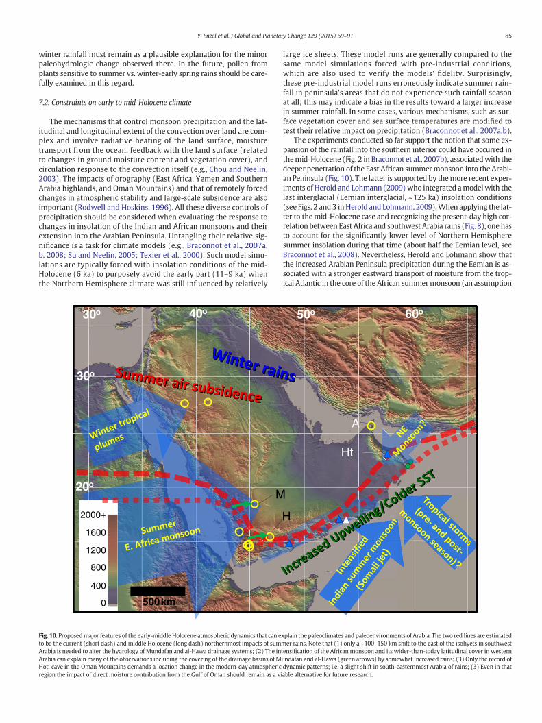
85Y. Enzel et al. / Global and Planetary Change 129 (2015) 69–91
winter rainfall must remain as a plausible explanation for the minorpaleohydrologic change observed there. In the future, pollen fromplants sensitive to summer vs. winter-early spring rains should be care-fully examined in this regard.
7.2. Constraints on early to mid-Holocene climate
The mechanisms that control monsoon precipitation and the lat-itudinal and longitudinal extent of the convection over land are com-plex and involve radiative heating of the land surface, moisturetransport from the ocean, feedback with the land surface (relatedto changes in ground moisture content and vegetation cover), andcirculation response to the convection itself (e.g., Chou and Neelin,2003). The impacts of orography (East Africa, Yemen and SouthernArabia highlands, and Oman Mountains) and that of remotely forcedchanges in atmospheric stability and large-scale subsidence are alsoimportant (Rodwell and Hoskins, 1996). All these diverse controls ofprecipitation should be considered when evaluating the response tochanges in insolation of the Indian and African monsoons and theirextension into the Arabian Peninsula. Untangling their relative sig-nificance is a task for climate models (e.g., Braconnot et al., 2007a,b, 2008; Su and Neelin, 2005; Texier et al., 2000). Such model simu-lations are typically forced with insolation conditions of the mid-Holocene (6 ka) to purposely avoid the early part (11–9 ka) whenthe Northern Hemisphere climate was still influenced by relatively
M20o
40o30o
500 km
30o
0
800
400
1200
1600
2000+
Fig. 10. Proposedmajor features of the early-middle Holocene atmospheric dynamics that can eto be the current (short dash) and middle Holocene (long dash) northernmost impacts of sumArabia is needed to alter the hydrology of Mundafan and al-Hawa drainage systems; (2) The inArabia can explainmany of the observations including the covering of the drainage basins of MHoti cave in the Oman Mountains demands a location change in the modern-day atmosphericregion the impact of direct moisture contribution from the Gulf of Oman should remain as a vi
large ice sheets. These model runs are generally compared to thesame model simulations forced with pre-industrial conditions,which are also used to verify the models' fidelity. Surprisingly,these pre-industrial model runs erroneously indicate summer rain-fall in peninsula's areas that do not experience such rainfall seasonat all; this may indicate a bias in the results toward a larger increasein summer rainfall. In some cases, various mechanisms, such as sur-face vegetation cover and sea surface temperatures are modified totest their relative impact on precipitation (Braconnot et al., 2007a,b).
The experiments conducted so far support the notion that some ex-pansion of the rainfall into the southern interior could have occurred inthemid-Holocene (Fig. 2 in Braconnot et al., 2007b), associatedwith thedeeper penetration of the East African summermonsoon into the Arabi-an Peninsula (Fig. 10). The latter is supported by themore recent exper-iments of Herold and Lohmann (2009)who integrated amodelwith thelast interglacial (Eemian interglacial, ~125 ka) insolation conditions(see Figs. 2 and 3 inHerold and Lohmann, 2009).When applying the lat-ter to themid-Holocene case and recognizing the present-day high cor-relation between East Africa and southwest Arabia rains (Fig. 8), one hasto account for the significantly lower level of Northern Hemispheresummer insolation during that time (about half the Eemian level, seeBraconnot et al., 2008). Nevertheless, Herold and Lohmann show thatthe increased Arabian Peninsula precipitation during the Eemian is as-sociated with a stronger eastward transport of moisture from the trop-ical Atlantic in the core of the African summermonsoon (an assumption
H
Ht
50o
A
60o
xplain the paleoclimates and paleoenvironments of Arabia. The two red lines are estimatedmer rains. Note that (1) only a ~100–150 km shift to the east of the isohyets in southwesttensification of the African monsoon and its wider-than-today latitudinal cover in westernundafan and al-Hawa (green arrows) by somewhat increased rains; (3) Only the record ofdynamic patterns; i.e. a slight shift in south-easternmost Arabia of rains; (3) Even in thatable alternative for future research.
86 Y. Enzel et al. / Global and Planetary Change 129 (2015) 69–91
consistentwith the strong zonal coherence of the African summermon-soon, see Fig. 4). The mid-Holocene experiments cited above also showthat over the southern peninsula rainfall amounts increase by 40–240 mm during the entire summer season. The largest increase occursover themountains in southwest Arabia,where annual rainfall amountsare relatively high today reaching N500 mm (Fig. 1); there the modelsproject an increase to nearly 800 mm per summer season. Furthereast, along and across the coastal mountains the increase projected bythe models is by far smaller, between ~100 and 160 mm for the entiresummer season. The degree of spread inland is less certain becausethe models' coarse resolution, which affects both the presentation ofthe topography and the latitudinal extent of the rainfall. Herold andLohmann show that insolation-induced summer rainfall would have in-creased over the southwestern peninsula and evaporation rates de-crease due to the related increase in cloudiness. Thus overallprecipitation–evaporation difference increases andmore water is avail-able for surface runoff and storage, but still, evaporation remains high.
The modeling results on the link between intensified summer pre-cipitations in the Sahel during high insolation are backed by observa-tions showing that lakes around the Ethiopian Highlands stood athigher level during the early- to middle Holocene (Gasse and Roberts,2005); unlike in Arabia, these lakes, however, present clear Holoceneshorelines.
7.3. Southwest monsoon winds and upwelling off-Oman assist keepingArabia dry
As indicated above (Section 2) the low-level Somali jet is influencedby the elevated topography of the Ethiopian Highlands (Fig. 1A). AtQuaternary time scales this “deflection” by the blocking topography ofthe EthiopianHighlands permanently prevents this jet fromcurving far-ther north over Africa to enter Arabia beyond its southern edges. There-fore, the Somali jet flow direction and its moisture transport during themid-Holocene (and earlier Quaternary times) could be viewed as atsimilar location as today's (e.g., Fig. 1A), although it could have occurredwith increased wind speed (e.g., Bassinot et al., 2011).
Comparatively little of the moisture transport related to the Somalijet converges over the coasts of Africa (e.g., arid Somali experiencespractically no summer rain; Fig. 2) and the Arabian Peninsula. The Ara-bian Sea itself is a region of moisture transport divergence forming aminimum rainfall zone between Africa in the west and the Indian sub-continent to the east. The Indian Ocean marine ITCZ lies far to thesouth, at or close to the equator (Figs. 1 and 3). Notably, the Indian sum-mer monsoon (i.e., the Somali jet) winds also force upwelling and seasurface cooling along the southern Arabia coast. This cooling further sta-bilizes the coastal atmosphere (e.g., Evan and Camargo, 2011) thatlimits moisture transport inland to Oman.
7.3.1. Upwelling off-southern OmanAs the Somali jet flows sub-parallel to the coast of southern Arabia
(e.g., Turner and Annamalai, 2012), its related upwelling off that coastcools sea surface temperatures (SSTs). The main proxies of oceanic up-welling at the continental margin of southern Oman, and therefore di-rect indicators of surface winds associated with the Somali jet in theArabian Sea are variations in the abundance of the planktonic foramin-ifer Globigerina bulloides. The percentage abundances of G. bulloides arehighly and positively correlatedwith rates of coastal upwelling, nutrientavailability, and cooler SSTs (e.g., Overpeck et al., 1996; Peterson et al.,1991; Prell, 1984; Prell et al., 1990; Sirocko et al., 1993). This upwellingindex retrieved in cores recovered off the southern Arabia coast, indi-cates increased mid-Holocene upwelling and cooler SSTs between 9.5and 5.5 ka (e.g., extensive discussion in Overpeck et al., 1996; Prelland Van Campo, 1986). The intensity of upwelling (and colder SSTs) istied, via wind-stress-forced Ekman flow, to the strength of the south-west monsoon winds — the surface expression of the Somali jet(Anderson and Prell, 1992, 1993; Bassinot et al., 2011; Prell et al.,
1990). Therefore, the intensification of the early and middle Holocenemonsoonwinds is probably the result of themore intense and/or persis-tent Somali jet component of the ISM. As in other hyperarid coastal de-serts forced by Ekman-flow and strongupwelling (e.g., Namib, Atacama,NE Sahara and in our case also Somali in coastal Horn of Africa), the re-sulted colder SSTs and intensify ISMwinds are expected to exert a neg-ative influence on rainfall along the southern coast of the ArabianPeninsula. By contrast, in peninsular India and especially at its westernedge, the rains will increase with stronger winds of the Somali jet(Halpern and Woiceshyn, 2001). This may be part of the explanationfor some of the regional climatic contrasts in the areas affected by theISM (e.g., Staubwasser, 2006).
The amplified upwelling along the southern Arabia coast could havealso reduced the frequency and impact of northern Arabian Sea tropicalcyclones, as it currently does during the heart (July–Sept) of the sum-mer monsoon season (Evan and Camargo, 2011). These Arabian Sea cy-cloneswere proposed as a potential source of rainfall for late Pleistocenerecharge of coastal eastern Oman aquifers (Weyhenmeyer et al., 2002).This can be a plausible scenario under a weaker summer monsoon andtherefore, reduced upwelling and possibly higher SSTs off Oman;recharge contribution (i.e. precipitation) during the early and middleHolocene was much reduced in Oman (Weyhenmeyer et al., 2002),in agreement with upwelling and lowered SSTs limiting cyclone gener-ation in the Arabian Sea under intensified Somali jet. The aboveatmosphere-ocean circulation indicates that the ISM reduces ratherthan enhances rains in most of the Arabian Peninsula whereas theAfrican monsoon played a larger role as perhaps also the winter north-east monsoon and the winter–spring tropical plumes.
7.4. A shift in ITCZ?
As indicated in the Introduction, the prevailing assumption in manypaleoclimatological studies is that the insolation-induced changes insummer rainfall in the Arabian Peninsula are associated with the globalzonal movement of the ITCZ north and south in boreal summer andwinter, respectively. It is therefore important to note that the summerrains along the peninsula's southern mountainous region are discon-nected with the boreal summer Indian Ocean ITCZ. The latter appearsas a westward extension of the eastern Indian Ocean ITCZ and is locatedfar south of the peninsula and rarely north of the equator; during ex-treme cases the ITCZ reaches the equator or the maximum latitude of5°N (Fig. 3).
The global ITCZ, the convection zone that is associated with (infact constitutes) the ascending branch of the Hadley Circulation isinterrupted over the Indian Ocean due to the dominating influence ofthe Indian Ocean Monsoon and the massive convection center overthe western tropical Pacific (Waliser and Gautier, 1993; Waliser andSomerville, 1994). Overall, the Northern Hemisphere Hadley circulationcell of the boreal summer is very weak and its rising branch and associ-ated ITCZ convection is located usually south of 5°N, depending on lon-gitude (Dima and Wallace, 2003; Tanaka et al., 2004) (Figs. 1 and 3).This rising branch preferentially feeds the southern Hadley Cell. More-over, over the Indian Ocean sector, the divergent summer circulation(that which is associated with the vertical mass overturning) is notaligned with the global Hadley Circulation, i.e., displaying associationwith the zone of low-level convergence and upper-level divergencestretching roughly parallel to the equator. Rather, convergence and di-vergence zones are aligned almost perpendicular to the equator, in alongitudinal direction (Tanaka et al., 2004). This transverse (meridio-nal) circulation cell, with its rising branch extending over a broad re-gion, from the Bay of Bengal (with some ascending air also overwestern peninsular India) to the west tropical Pacific, and sinkingbranch over North Africa and the eastern Mediterranean, is part of thetropical Walker Circulation (Texier et al., 2000; Tanaka et al., 2004)and is driven by the summer monsoon and the massive Indo-Pacificconvection center. The summer rains in southwestern Arabia today
87Y. Enzel et al. / Global and Planetary Change 129 (2015) 69–91
are in fact not related to the Indian Ocean ITCZ but rather, as arguedabove, primarily to the African summermonsoon. Duringmaximum in-solation, when both the ISM and the African summer monsoon werestronger due mainly to enhanced summer warming over land, it ishard to envision that the Indian Ocean ITCZ has intensified or movednorth. Rather, it is the latitudinal expansion and/or northward move-ment of the African summer monsoon that has led to or has been asso-ciated with the intensification and expansion of rainfall over southernand western Arabia. Indeed, general circulation models of the mid-Holocene and the last interglacial confirm this scenario (more aboutthis below in Section 7.5).
7.5. Implications to pre-Holocene interglacial climates of Arabia
The proposed wetter early-middle Holocene climate in Arabia iscommonly extended to pre-Holocene, insolation maxima interglacialtimes. This practice is based on the lacustrine (or wetlands as proposedabove) and speleothems (e.g. Rosenberg et al., 2011; Fleitmann et al.,2007). We do not claim to the contrary. However, we discuss belowthe abovementioned climatic causes in explanations of earlier intergla-cial climatology and the degree of hydrologic impacts and changes. Theregional physiography and themain ocean and atmosphere circulationsof the northern Arabian Sea and its surrounding continents are assumedsimilar to both the early tomiddle Holocene and earlier interglacials. Forexample, as the Somali jet is a low-level jet (b2 km in the atmosphere),it cannot penetrate through and across the elevated southwestern edgesof Arabia and northeastern Africa; i.e., the Somali jet (the actual ISMwind) is practically blocked by the regional physiography and elevatedtopography from entering Arabia. Questioning the proposed mecha-nisms of changing pre-Holocene, interglacial Arabia climate is, there-fore, important as they are commonly hypothesized as facilitators ofhuman migration out of Africa and across Arabia. Our main point hereis that claims to increased wetness in Arabia through ISM rains, incases even all the way to the peninsula's northern hyperarid edges,should be founded on better understanding of climatology, field dataand clearer interpretations. To tie this increased wetness, if ever oc-curred in the magnitude proposed, to the ISM is in many ways contra-dicting current understanding of the main topographic, oceanographicand atmospheric forcing. For example, based on scarce field evidenceand U–Th ages, an enormous Eemian (and earlier interglacials) openwater lake (~40 m deep, N2000 km2) was proposed by Petit-Maireet al. (2010) to fill the Mudawwara depression in northern Arabia (atthe Jordanian–Saudi Arabia border); its formation was associated byPetit-Maire et al. (2010) with drastic shift to the north of the ISM.More recent studies (Catlett, 2014; Catlett et al., 2013; Rech et al.,2014, 2016) challenged the existence of such a lake during the last inter-glacial, claiming that (a) the U–Th ages on these deposits are problem-atic and therefore, Mudawwara deposits “should not be used asevidence for enhanced precipitation [and lake]… during Pleistocene in-terglacial periods” (Catlett et al., 2013), and (b) based on sedimentologyof the deposits in Mudawwara, their spatial distribution, lateral faciesassemblages, the presence of archeological materials, root voids, andother trace fossils, as well as invertebrate fossil assemblages,Mudawwara (as well as other basins in southern Jordan) were actuallyfed by ground-water discharge and were not lakes (Rech et al., 2014).
Even the recent revision of the chronology of Mundafan and an-Nafud beds (Rosenberg et al., 2011, 2013), indicating that they are notHolocene deposits and probably related to the somewhatwetter last in-terglacial in western Arabia, does not provide evidence of increasedIndian summer monsoon. More so, Rosenberg et al. (2013) apply themodeling results of Herold and Lohmann (2009) to indicate a growingimportance of the African monsoon in western Arabia. Additionalmodeling by Kutzbach et al. (2014, see their Fig. 4a) shows an extensionof theAfricanmonsoon summer rains into Arabia during last interglacialmaximum insolation (~125 ka) in a spatial pattern thatmimics present-day correlation of rainfall across Africa and Arabia (Fig. 8).
When analyzing interglacial climatology (of low to mid-latitudesand mainly the early and middle Holocene and the last interglacial)most modeling and analyses focus primarily on the summer circula-tion and practically avoid the impacts of winter rainfall during inter-glacials as potential causes of the observed hydroclimatic changes. Arecent exception (Kutzbach et al., 2014) to this dominated summer-circulation-interglacial climates approach has implication to Arabiapaleoclimatology. They focus on atmospheric circulation overthe Mediterranean and Middle East during maximum NorthernHemisphere seasonality (~125 ka) and comparing it with the later(~110 ka) minimum seasonality. They point to the importance ofwinter circulation in addition to summer circulation. Among the fea-tures observed in their results (but not discussed there) is a notice-able increase of airflow into northwestern Arabia and the Levantfrom the eastern tropical (20°–30°N) Atlantic, sub-paralleling theequator (Fig. 3 in Kutzbach et al., 2014); this airflow trajectory is ob-served during modern precipitating winter–spring tropical plumesimpacting northwestern Arabia (e.g., Rubin et al., 2007; Tubi andDayan, 2014). i.e., in addition to the African summer monsoonexpanding across the Red Sea into Arabia, heavy rainfall can reachnorthwestern Arabia (and in this case even northeastern Egypt,Sinai, Negev, and southern Jordan) during the winter season; boththe African summermonsoon and the winter–spring tropical plumesare plausible alternatives to the ISM as primary factors in increasingregional rainfall. The two season rainfall may have been another al-ternative to the somewhat wetter Arabia during the last interglacialrelative to the early and middle Holocene.
7.6. Implication for human-lacustrine association in Arabia
Recently, new research connects prehistoric (late Pleistocene andHolocene) human crossing and habitation of Arabiawith potentially im-proved hydroclimatic conditions. These findings are exciting, but westress that there is no need for lakes to explain the distribution ofhumans in Arabia; wetlands are sufficient or even superior to lakes inproviding needed resources to humans and animals (e.g., Ashley et al.,2010a,b). This distinction is important as the mixed terminology used:lake, lacustrine deposit or environment, dry playa lake or ephemerallake should be supported by evidence that is then associated withmag-nitudes of hydroclimatic changes. For example, the recent identifica-tions of human artifacts and faunal remains around and in flatlowland basins in Arabia were associated with the existence of lakesduring various interglacials (e.g. Petraglia et al., 2011; Crassard et al.,2013); these terms (lakes) should not be lightly used as they are ex-tremely important in regional paleoclimatology. Efforts in studyingpaleoenvironments in Arabia (and elsewhere in the world current de-serts) should go beyond the identification of lacustrine-like deposits,which consist of many types and deposited in diverse environments,and, if possible, present evidence for a water depth of at least a fewme-ters; such deeper perennial or short-lived water bodies are crucial forscaling paleoclimatic interpretations.
8. Conclusions
1) The sedimentologic, floral and faunal characteristics of lacustrine-like deposits in Arabia point to shallowwetland paleoenvironments,not lakes. At steady state, smaller surface areas of wetlands versuslakes require a much smaller increase in Arabian rainfall than the3- or 4-fold increase envisioned by other studies. Since lakes didnot occupy these basins, lake budget calculations are not a suitableapproach to estimating changes in rainfall-runoff-evaporation inArabia. Although these wetter environments indicate a wetter cli-mate, the hydroclimatic changes needed to explain them are muchsmaller than those required for lakes. Furthermore, the lake basinsof Arabia lack evidence of shorelines, the main criteria for even ashallow lake.
88 Y. Enzel et al. / Global and Planetary Change 129 (2015) 69–91
2) The creation of the observed depositional environments does not re-quire (a) substantial reduction in annual evaporation or (b) anorder-of-magnitude increase in annual runoff coefficients. Fromthis we conclude that modest, not dramatic, increase in rainfallcould have accounted for the early- to mid-Holocene paleowetlanddevelopment in Arabia.
3) The spatial distribution of the rare Holocene speleothems and pollenspectra recovered from Arabia support the conclusion from thelacustrine-like deposits of only modestly wetter early-middle Holo-cene climates. Overmost of Arabia, which currently experiences lowrainfall amounts and winter rain maxima, major paleohydrologicchanges are not apparent. The most notable changes are at thesouthern edges of the peninsula.
4) The Indian Ocean has had little impact on Arabia beyond the south-ern edges of the peninsula. Both the Indian summer monsoon andthe ITCZ are not the main atmospheric features bringing additionalmoisture into Arabia. The intensified summer southwest monsoonwinds, manifested in the intensification of the low-level Somali jetflowing sub-parallel to Arabia southern edge, delivered substantiallymore moisture eastward, towards India, but far less dramaticallynorthward into Arabia. This is primarily due to the stabilizing effectof increased upwelling (in response to the Somali jet) off-southernOman and the associated colder coastal SSTs. That said, southernsources of moisture could have accounts for rainfall increases inthemountainous southern fringes of Arabia due to orographic lifting.For interior Arabia andmainly at its northwestern edges, increases inwintertime rainfall, as opposed to southerly summer moisture,should be seriously considered and tested using seasonality as po-tentially inferred from pollen. This first should be verified in easternMediterranean and Levant records that are located atmosphericallyupstream of Arabia or are affected by tropical plumes at their south-ern edges.
5) The most pronounced increase in precipitation occurred in south-western Arabia. There, during earlier Holocene, the intensificationof the African monsoon and not of the Indian summer monsoon, af-fected a wider latitudinal range east of the Red Sea and deliveredmore rainfall across the Red Sea highlands to impact the drainagebasin flowing east into the sandy deserts of Arabia. Tropical plumescan bring rainfall to northwesternArabia. i.e., it should be consideredthat neither a single season nor a single climatic pattern controls theproposed minor hydroclimate changes in Arabia.
6) Research should focus on the often-ignored disagreement betweenGCM simulations of early- to mid-Holocene (and earlier intergla-cials) climates and earlier conclusions regarding Arabian Peninsularainfall. Specifically, the proposed extensive latitudinal shifts of theITCZ and considerable intensification of rainfall, based on the earlierinferences of lake, pollen and speleothems records and the GCMs re-sults of e.g., Braconnot et al. (2004, 2007a), Bosmans et al. (2012),Marzin and Braconnot (2009), Zhao et al. (2005) can be reconciledby our reevaluation of the data.
Acknowledgments
Dr. Ron Kahana (Met Office Hadley Centre, Exeter) provided anexcellent critical colleague review. We thank H. Gildor, J. Pigati, and J.Rech for fruitful discussions over the years on the latitudinal changesin monsoons and ITCZ and on the meaning of “lacustrine environ-ments”. We also thank the GCP editors for inviting this review and theeditor (T. Cronin) and an anonymous reviewer for their efforts in editingthis longmanuscript. We acknowledge financial support from Lamont–Doherty Earth Observatory (Columbia University) to YE and The LadyDavis Foundation and The Fredy and Nadine Herrmann Institute ofEarth Sciences (The Hebrew University of Jerusalem) to YK and JQ thatenabled mutual visits to focus on this work. YK was also supported bythe U.S. National Oceanic and Atmospheric Administration (NOAA)grant NA10OAR4320137. YE research is funded by the Israel Science
Foundation—The Dead Sea Deep Core, Center of Excellence (Grant No.1436/14). This article carries the designated LDEO publication # 7890.
Appendix A. Supplementary data
Supplementary data to this article can be found online at http://dx.doi.org/10.1016/j.gloplacha.2015.03.004.
References
Adams, K., Wesnousky, S., 1998. Shoreline processes and the age of the Lake Lahontanhighstand in Jessup embayment, Nevada. Geol. Soc. Am. Bull. 110, 1318–1332.
Al Farraj, A., Harvey, A.M., 2000. Desert pavement characteristics on wadi terrace andalluvial fan surfaces: Wadi Al-Bih, UAE and Oman. Geomorphology 35, 279–297.
Al Farraj, A., Harvey, A.M., 2004. Late Quaternary interactions between aeolian and fluvialprocesses: a case study in the northern UAE. J. Arid Environ. 56, 235–248.
Almazroui, M., 2011. Calibration of TRMM rainfall climatology over Saudi Arabia during1998–2009. Atmos. Res. 99, 400–414.
Almazroui, M., Islam, N.M., Athar, H., Jones, P.D., Rahman, M.A., 2012. Recent climatechange in the Arabian Peninsula: annual rainfall and temperature analysis of SaudiArabia for 1978–2009. Int. J. Climatol. 32, 953–966.
Almazroui, M., Abid, M.A., Athar, H., Islam, M.N., Eshan, M.A., 2013. Interannual variabilityof rainfall over the Arabian Peninsula using the IPCC AR4 Global Climate Models. Int.J. Climatol. 33, 2328–2340.
Alpert, P., Osetinsky, I., Ziv, B., Shafir, H., 2004. Semi-objective classification for dailysynoptic systems: application to the Eastern Mediterranean climate change. Int.J. Climatol. 24 (8), 1001–1011.
Al-Rawas, G.A., Valeo, C., 2009. Characteristics of rainstorm temporal distributions in aridmountainous and coastal regions. J. Hydrol. 376, 318–326.
Anderson, D.M., Prell, W.L., 1992. The structure of the southwest monsoon winds over theArabian Sea during the late Quaternary — observations, simulation, and marinegeologic evidence. J. Geophys. Res. Oceans 97, 15481–15487.
Anderson, D.M., Prell, W.L., 1993. A 300 KYR record of upwelling off Oman during the lateQuaternary — evidence of the Asian southwest monsoon. Paleoceanography 8,193–208.
Anselmatti, F.S., Ariztegui, D., de Batist, M., Gephardt, A.C., Haberzatettl, T., Niessen, F.,Ohlendorf, C., Zolitschka, B., 2006. Environmental history of southern Patagonia byseismic stratigraphy of Laguna Potrok Aike. Sedimentology 56, 873–892.
Ashley, G.M., Barboni, D., Domínguez-Rodrigo, M., Bunn, H.T., Mabulla, A.Z.P., Diez-Martin,F., Barba, R., Baquedano, E., 2010a. A spring and wooded habitat at FLK Zinj and theirrelevance to origins of human behavior. Quat. Res. 74, 304–314.
Ashley, G.M., Barboni, D., Domínguez-Rodrigo, M., Bunn, H.T., Mabulla, A.Z.P., Diez-Martin,F., Barba, R., Baquedano, E., 2010b. Paleoenvironmental and paleoecological recon-struction of a freshwater oasis in savannah grassland at FLK North, Olduvai Gorge,Tanzania. Quat. Res. 74, 333–343.
Atkinson, O.A.C., Thomas, D.S.G., Goudie, A.S., Parker, A.G., 2011a. Holocene developmentof multiple dune generations in the northeast Rub'al-Khali, United Arab Emirates. TheHolocene 22, 179–189.
Atkinson, O.A.C., Thomas, D.S.G., Goudie, A.S., Baily, R.M., 2011b. Late Quaternary chronol-ogy of major dune ridge development in the northeast Rub' al-Khali, United ArabEmirates. Quat. Res. 76, 93–105.
Barth, H.J., Steinkohl, F., 2004. Origin of winter precipitation in the central coastal low-lands of Saudi Arabia. J. Arid Environ. 57, 101–115.
Bartov, Y., Bookman, R., Enzel, Y., 2006. Current depositional environments at the DeadSea margins as indicators of its past levels. In: Enzel, Y., Agnon, Stein, M. (Eds.),New Frontiers in Dead Sea Paleoenvironmental Research. Geological Society ofAmerica Special Paper 401, pp. 127–140.
Bassinot, F.C., Marzin, C., Braconnot, P., Marti, O., Mathien-Blard, E., Lombard, F., Bopp, L.,2011. Holocene evolution of summer winds and marine productivity in the tropicalIndian Ocean in response to insolation forcing: data-model comparison. Clim. Past7, 815–829.
Benson, L.V., 1986. The sensitivity of evaporation rate to climate change—results of anenergy-balance approach. U.S. Geological Survey Water-Resources InvestigationRep. 86-4148. 1-22, U.S. Department of the Interior, U.S. Geological Survey, Denver,Colorado (40 pp.).
Benson, L.V., Paillet, F.L., 1989. The use of total lake-surface area as an indicator of climaticchange: examples from the Lahontan basin. Quat. Res. 32, 262–275.
Berger, J.F., Bravard, J.P., Purdue, L., Benoist, A., Mouton, M., Breamer, F., 2012. Rivers of theHadarmawt watershed (Yemen) during the Holocene: clues for late functioning.Quat. Int. 266, 142–161.
Bosmans, J.H.C., Drijfhout, S.S., Tuenter, E., Lourens, L.J., Hilgen, F.J., Weber, S.L., 2012.Monsoonal response to mid-Holocene orbital forcing in a high resolution GCM.Clim. Past 8, 723–740.
Braconnot, P., Harrison, S.P., Jouassaume, S., Hewitt, C.D., Kitoh, A., Kutzbach, J.E., Liu, Z.,Otto-Bliesner, B., Syktus, J., Weber, S.L., 2004. Evaluation of PMIP coupled ocean-atmosphere simulations of the mid-Holocene. In: Battarbee, R.W., Gasse, F., Stickley,C.E. (Eds.), Past Climate Variability Through Europe and Africa. Springer, Dordrecht,The Netherlands, pp. 515–533.
Braconnot, P., Otto-Bliesner, B., Harrison, S., Joussaume, S., Peterchmitt, J.Y., Abe-Ouchi, A.,Crucifix, M., Driesschaert, E., Fichefet, T., Hewitt, C.D., Kageyama, M., Kitoh, A., Laine, A.,Loutre, M.F., Marti, O., Merkel, U., Ramstein, G., Valdes, P., Weber, S.L., Yu, Y., Zhao, Y.,2007a. Results of PMIP2 coupled simulations of theMid-Holocene and Last GlacialMax-imum— Part 1: experiments and large-scale features. Clim. Past 3, 261–277.

89Y. Enzel et al. / Global and Planetary Change 129 (2015) 69–91
Braconnot, P., Otto-Bliesner, B., Harrison, S., Joussaume, S., Peterchmitt, J.Y., Abe-Ouchi, A.,Crucifix, M., Driesschaert, E., Fichefet, T., Hewitt, C.D., Kageyama, M., Kitoh, A., Loutre,M.F., Marti, O., Merkel, U., Ramstein, G., Valdes, P., Weber, L., Yu, Y., Zhao, Y., 2007b.Results of PMIP2 coupled simulations of the Mid-Holocene and Last Glacial Maxi-mum — Part 2: feedbacks with emphasis on the location of the ITCZ and mid- andhigh latitudes heat budget. Clim. Past 3, 279–296.
Braconnot, P., Marzin, C., Gregoire, L., Mosquet, E., Marti, O., 2008. Monsoon response tochanges in Earth's orbital parameters: comparisons between simulations of theEemian and of the Holocene. Clim. Past 4, 281–294.
Breeze, P.S., Drake, N.A., Groucutt, H.S., Parton, A., Jennings, R.P., White, T.S., Clark-Balzan,L., Shipton, C., Scerri, E.M.L., Stimpson, C.M., Crassard, R., Hilbert, Y., Alsharekh, A., Al-Omari, A., Petraglia,M.D., 2015. Remote sensing andGIS techniques for reconstructingArabian palaeohydrology and identifying archaeological sites. Quat. Int. http://dx.doi.org/10.1016/j.quaint.2015.01.022 (in press).
Burns, S.J., Matter, A., Frank, N., Mangini, A., 1998. Speleothem-based paleoclimate recordfrom northern Oman. Geology 26, 499–502.
Burns, S.J., Fleitmann, D., Matter, A., Neff, U., Mangini, A., 2001. Speleothem evidence fromOman for continental pluvial events during interglacial periods. Geology 29, 623–626.
Burrough, S.L., Thomas, D.S.G., 2009. Geomorphological contributions to palaeolimnologyon the African continent. Geomorphology 103, 285–298.
Catlett, A.G., 2014. Pluvial Deposits in Mudawwara, Jordan and Their Implications forMediterranean and Monsoonal Precipitation in the Levant. (M.Sc. Thesis), MiamiUniv., Oxford, Ohio (32 pp.).
Catlett, G.A., Rech, J.A., Pigati, J.S., Al Kuisi, M., 2013. Paleoclimatic implications of pluvialdeposits in Mudawwara, Jordan. Geol. Soc. Am. Abstr. Programs 45 (7), 680.
Charney, J.G., 1975. Dynamics of deserts and drought in Sahel. Q. J. R. Meteorol. Soc. 101,193–202.
Chou, C., Neelin, J.D., 2003. Mechanisms limiting the northward extent of the northernsummer monsoons over North America, Asia, and Africa. J. Clim. 16, 406–425.
Cleuziou, S., Inizan, M.-L., Marcolongo, B., 1992. Le peupelment pré-et protohistorique dusystéme fluviatile fossile du Jawf-Hadaramawt au Yémen. Paléorient 18, 2–29.
Conroy, J.L., Overpeck, J.T., 2012. Regionalization of present-day precipitation in the great-er monsoon region of Asia. J. Clim. 24, 4073–4095.
Crassard, R., Petraglia, M.D., Drake, N.A., Breeze, P., Gratuze, B., Alsharekh, A., Arbach, A.,Groucutt, H.S., Khalidi, L., Michelsen, N., Robin, C.J., Schiettecatte, J., 2013. Middlepalaeolithic and neolithic occupations around Mundafan Palaeolake, Saudi Arabia:implications for climate change and human dispersals. PLoS One 8 (7), e69665.
Davies, C.P., 2006. Holocene paleoclimates of southern Arabia from lacustrine deposits ofthe Dhamar highlands, Yemen. Quat. Res. 66, 454–464.
de Vries, A.J., Tyrlis, E., Edry, D., Krichak, S.O., Steil, B., Lelieveld, J., 2013. Extreme precip-itation events in the Middle East: dynamics of the Active Red Sea Trough. J. Geophys.Res. Atmos. 118, 7087–7108.
Dima, I.M., Wallace, J.M., 2003. On the seasonality of the Hadley cell. J. Atmos. Sci. 60,1522–1527.
El-Moslimany, A.P., 1983. History of Climate and Vegetation in the Eastern Mediterraneanand the Middle East From the Pleniglacial to the Mid-Holocene. University ofWashington (PhD Thesis, 228 pp.).
El-Moslimany, A.P., 1990. Ecological significance of common nonarboreal pollen: exam-ples from drylands of the Middle East. Rev. Palaeobot. Palynol. 64, 343–350.
ElNesr, M., Alazba, A., Abu-Zreig, M., 2010. Spatio-temporal variability of evapotranspira-tion over the Kingdom of Saudi Arabia. Appl. Eng. Agric. 26, 833–842.
Engel, M., Brückner, H., Pint, A., Wellbrock, K., Ginau, A., Voss, P., Grottker, M., Klasen, N.,Frenzel, P., 2012. The early Holocene humid period in NW Saudi Arabia—sediments,microfossils, and palaeo-hydrological modeling. Quat. Int. 266, 131–141.
Enzel, Y., 1992. Flood frequency of the Mojave River and the formation of late Holoceneplaya lakes, southern California. The Holocene 2, 11–18.
Enzel, Y., Wells, S.G., 1997. Extracting Holocene paleohydrology and paleoclimatology in-formation from modern extreme flood events: an example from southern California.Geomorphology 19, 203–226.
Enzel, Y., Brown,W.J., Anderson, R.Y., McFadden, L.D.,Wells, S.G., 1992. Short-durationHolo-cene lakes in theMojave River drainage basin, southern California. Quat. Res. 38, 60–73.
Enzel, Y., Ely, L.L., Mishra, S., Ramesh, R., Amit, R., Lazar, B., Rajaguru, S.N., Baker, V.R.,Sandler, A., 1999. High-resolution Holocene environmental changes in the Thar De-sert, northwestern India. Science 284, 125–128.
Enzel, Y., Bookman, R., Sharon, D., Gvirtzman, H., Dayan, U., Ziv, B., Stein, M., 2003. LateHolocene climates of the Near East deduced from Dead Sea level variations andmodem regional winter rainfall. Quat. Res. 60, 263–273.
Evan, A.T., Camargo, S.J., 2011. A climatology of Arabian Sea cyclonic storms. J. Clim. 24,140–158.
Findlater, J., 1969a. A major low-level air current near Indian Ocean during northern sum-mer. Q. J. R. Meteorol. Soc. 95, 362–380.
Findlater, J., 1969b. Interhemispheric transport of air in lower troposphere over westernIndian Ocean. Q. J. R. Meteorol. Soc. 95, 400–403.
Findlater, J., 1971. Mean monthly airflow at low levels over the Western Indian Ocean.Geophysical Memoirs 115. Meteorological Office, London, UK (53 pp.).
Findlater, J., 1977. Observational aspects of the low-level cross-equatorial jet stream ofthe western Indian Ocean. Pure Appl. Geophys. 115, 1251–1262.
Fleitmann, D., Burns, S.J., Mudelsee, M., Neff, U., Kramers, J., Mangini, A., Matter, A., 2003a.Holocene forcing of the Indian monsoon recorded in a stalagmite from SouthernOman. Science 300, 1737–1739.
Fleitmann, D., Burns, S.J., Neff, U., Mangini, A., Matter, A., 2003b. Changing moisturesources over the last 330,000 years in Northern Oman from fluid-inclusion evidencein speleothems. Quat. Res. 60, 223–232.
Fleitmann, D., Matter, A., Pint, J.J., Al-Shanti, M.A., 2004. The speleothemn record of cli-mate change in Saudi Arabia. Jeddah, Saudi Arabia, Saudi Geological Survey Open-File Report SGS-OF-2004-8 (40 pp.).
Fleitmann, D., Burns, S.J., Mangini, A., Mudelsee, M., Kramers, J., Villa, I., Neff, U., Al-Subbary, A.A., Buettner, A., Hippler, D., Matter, A., 2007. Holocene ITCZ and Indianmonsoon dynamics recorded in stalagmites from Oman and Yemen (Socotra).Quat. Sci. Rev. 26, 170–188.
Fleitmann, D., Burns, S.J., Pekala, M., Mangini, A., Al-Subbary, A., Al-Aowah, M., Kramers, J.,Matter, A., 2011. Holocene and Pleistocene pluvial periods in Yemen, southern Arabia.Quat. Sci. Rev. 30, 783–787.
Frumkin, A., Bar-Matthews, M., Vaks, A., 2008. Paleoenvironment of Jawa basalt plateau,Jordan, inferred from calcite speleothems from a lava tube. Quat. Res. 70, 358–367.
Fuchs, M., Buerkert, A., 2008. A 20 ka sediment record from the Hajar Mountain range inN-Oman, and its implication for detecting arid–humid periods on the southeasternArabian Peninsula. Earth Planet. Sci. Lett. 265, 546–558.
Gasse, F., 2000. Hydrological changes in the African tropics since the Last Glacial Maxi-mum. Quat. Sci. Rev. 19, 189–211.
Gasse, F., Roberts, C.N., 2005. Late quaternary hydrologic changes in the arid and semiaridbelt of northern Africa: implications for past atmospheric circulation. In: Diaz, H.F.,Bradley, R.S. (Eds.), The Hadley Circulation: Present, Past and Future. KluwerAcademic Publishers, pp. 313–345.
Gasse, F., Street, F.A., 1978. Late Quaternary lake-level fluctuations and environments ofthe northern Rift Valley and Afar region (Ethiopia and Djibouti. Palaeogeogr.Palaeoclimatol. Palaeoecol. 24, 279–325.
Gennari, G., Rosenberg, T., Spezzaferri, S., Berger, J.-P., Fleitmann, D., Preusser, F., Al-Shanti,M., Matter, A., 2011. Faunal evidence of a Holocene pluvial phase in southern Arabiawith remarks on the morphological variability of Helenina anderseni. J. Foraminifer.Res. 41, 248–259.
Ginau, A., Engel, M., Bruckner, H., 2012. Holocene chemical precipitates in the continentalsabkha of Tayma (NW Saudi Arabia). J. Arid Environ. 84, 26–37.
Goudie, A.S., Colls, A., Stokes, S., Parker, A.I.,White, K., Al-Farraj, A., 2000. Latest PleistoceneandHolocene dune construction at the north-eastern edge of the Rub' al-Khali, UnitedArab Emirates. Sedimentology 47, 1011–1021.
Halpern, D., Woiceshyn, P.M., 2001. Somali Jet in the Arabian Sea, El Nino, and India rain-fall. J. Clim. 14, 434–441.
Herold, M., Lohmann, G., 2009. Eemian tropical and subtropical African moisture trans-port: an isotope modelling study. Clim. Dyn. 33, 1075–1088.
Hoelzmann, P., Gasse, F., Dupont, L.M., Salzmann, H., Staubwasser, M., Leuschner, D.C.,Sirocko, F., 2004. Palaeoenvironmental changes in the arid and sub arid belt (Sahara-Sahel-Arabian Peninsula) from 150 kyr to present. In: Battarbee, R.W., Gasse, F.,Stickley, C.E. (Eds.), Past Climate Variability Through Europe and Africa. Springer,Dordrecht, The Netherlands, pp. 219–256.
Hudson, A., Quade, J., 2013. Long-term east-west asymmetry in monsoon intensificationon the Tibetan Plateau. Geology 41, 351–354.
Hunter, R.E., Reiss, T.E., Chin, J.L., Anima, R.J., 1990. Coastal depositional and erosional ef-fects of the 1985–1987 high lake levels in Lake Michigan. Open-File Report 90-272.U.S. Geological Survey, Washington, D.C.
Junginger, A., Roller, S., Olaka, L.A., Trauth, M.H., 2014. The effects of solar irradiationchanges on the migration of the Congo Air Boundary and water levels of paleo-Lake Suguta, Northern Kenya Rift, during the African Humid Period (15–5 ka BP).Palaeogeogr. Palaeoclimatol. Palaeoecol. 396, 1–16.
Kahana, R., Ziv, B., Enzel, Y., Dayan, U., 2002. Synoptic climatology of major floods in theNegev Desert, Israel. Int. J. Climatol. 22, 867–882.
Kohfeld, K.E., Harrison, S.P., 2000. Howwell canwe simulate past climates? Evaluating themodels using global palaeoenvironmental datasets. Quat. Sci. Rev. 19, 321–346.
Krishnamurti, T.N., Stefanova, L., Misra, V., 2013. Tropical Meteorology: An Introduction.Springer (423 pp.).
Kutzbach, J.E., Chen, G., Cheng, H., Edwards, R.L., Liu, Z., 2014. Potential role of winter rain-fall in explaining increased moisture in the Mediterranean and Middle East duringperiods of maximum orbitally-forced insolation seasonality. Clim. Dyn. 42,1079–1095.
Kwarteng, A.Y., Dorvlo, A., Vijaya Kumar, G.T., 2009. Analysis of a 27-year rainfall data(1977–2003) in the Sultanate of Oman. Int. J. Climatol. 29, 605–617.
Lézine, A.-M., 2009. Timing of vegetation changes at the end of the Holocene HumidPeriod in desert areas at the northern edge of the Atlantic and Indian monsoon sys-tems. Compt. Rendus Geosci. 341, 750–759.
Lézine, A.M., Saliege, J.F., Robert, C., Wertz, F., Inizan, M.L., 1998. Holocene lakes fromRamlat as-Sab'atayn (Yemen) illustrate the impact of monsoon activity in SouthernArabia. Quat. Res. 50, 290–299.
Lézine, A.-M., Tiercelin, J.-J., Robert, C., Saliege, J.-F., Cleuziou, S., Inizan, M.-L., Braemer, F.,2007. Centennial to millennial-scale variability of the Indian monsoon during theearly Holocene from a sediment, pollen and isotope record from the desert ofYemen. Palaeogeogr. Palaeoclimatol. Palaeoecol. 243, 235–249.
Lézine, A.-M., Robert, C., Cleuziou, S., Inizan, M.-L., Braemer, F., Saliege, J.-F., Sylvestre, F.,Tiercelin, J.-J., Crassard, R., Mery, S., Charpentier, V., Steimer-Herbet, T., 2010. Climatechange and human occupation in the Southern Arabian lowlands during the last de-glaciation and the Holocene. Glob. Planet. Chang. 72, 412–428.
Litt, T., Ohlwein, C., Neumann, F.H., Hense, A., Stein, M., 2012. Holocene climate variabilityin the Levant from the Dead Sea pollen record. Quat. Sci. Rev. 49, 95–105.
Marzin, C., Braconnot, P., 2009. Variations of Indian and African monsoons induced by in-solation changes at 6 and 9.5 kyr BP. Clim. Dyn. 33, 215–231.
Matter, A., Neubert, E., Preusser, F., Rosenberg, T., Al-Wagdani, K., 2015. Palaeo-environmental implications derived from lake and sabkha deposits of the southernRub' al-Khali, Saudi Arabia and Oman. Quat. Int. http://dx.doi.org/10.1016/j.quaint.2014.12.029 (in press).
McClure, H.A., 1976. Radiocarbon chronology of late Quaternary lakes in Arabian Desert.Nature 263, 755–756.
McClure, H.A., 1984. Late Quaternary Palaeoenvironments of the Rub' al-Khali. (Ph.D. thesis),Department of Geography, University College London (245 pp.).
90 Y. Enzel et al. / Global and Planetary Change 129 (2015) 69–91
Mifflin, M.D., Wheat, M.M., 1979. Pluvial lakes and estimated pluvial climates of Nevada.Nevada Bureau of Mines and Geology Bull 94. University of Nevada, Reno (57 pp.).
Mischke, S., Ginat, H., Faerstein, G., Porat, N., Braun, P., Rech, Jason, 2016. Fossil-based re-constructions of ancient water bodies in the Levantine deserts. In: Enzel, Y., Bar-Yosef,O. (Eds.), Quaternary Environments, Climate Change, and Humans in the Levant.Cambridge University Press (accepted for publication).
Mitchell, T.D., Jones, P.D., 2005. An improved method of constructing a database ofmonthly climate observations and associated high-resolution grids. Int. J. Climatol.25, 693–712.
Neff, U., Burns, S.J., Mangini, A., Mudelsee, M., Fleitmann, D., Matter, A., 2001. Strong co-herence between solar variability and the monsoon in Oman between 9 and 6 kyrago. Nature 411, 290–293.
Overpeck, J., Anderson, D., Trumbore, S., Prell, W., 1996. The southwest Indian Monsoonover the last 18000 years. Clim. Dyn. 12, 213–225.
Parker, A.G., Goudie, A.S., 2008. Geomorphological and palaeoenvironmental investiga-tions in the southeastern Arabian Gulf region and the implication for the archaeologyof the region. Geomorphology 101, 458–470.
Parker, A.G., Eckersley, L., Smith, M.M., Goudie, A.S., Stokes, S., Ward, S., White, K., Hodson,M.J., 2004. Holocene vegetation dynamics in the northeastern Rub' al-Khali desert,Arabian Peninsula: a phytolith, pollen and carbon isotope study. J. Quat. Sci. 19,665–676.
Peterson, L.C., Overpeck, J.T., Kipp, N.G., Imbrie, J., 1991. A high resolution late Quaternaryupwelling record from the anoxic Cariaco Basin, Venezuela. Paleoceanography 6,99–119.
Petraglia, M.D., Alsharekh, A.M., Crassard, R., Drake, N.A., Groucutt, H., Parker, A.G.,Roberts, R.G., 2011. Middle Paleolithic occupation on a Marine Isotope Stage 5 lake-shore in the Nefud Desert, Saudi Arabia. Quat. Sci. Rev. 30, 1555–1559.
Petit-Maire, N., Carbonel, P., Reyss, J.L., Sanlaville, P., Abed, A., Bourrouilh, R., Fontugne, M.,Yasin, S., 2010. A vast Eemian palaeolake in Southern Jordan (29°N). Glob. Planet.Chang. 72, 368–373.
Pigati, J.S., Bright, J.E., Shanahan, T.M., Mahan, S.A., 2009. Late Pleistocene paleohydrologynear the boundary of the Sonoran and Chihuahuan Deserts, southeastern Arizona,USA. Quat. Sci. Rev. 28, 286–300.
Pigati, J.S., Miller, D.M., Bright, J.E., Mahan, S.A., Nekola, J.C., Paces, J.B., 2011. Chronology,sedimentology, and microfauna of groundwater discharge deposits in the centralMojave Desert, Valley Wells, California. Geol. Soc. Am. Bull. 123, 2224–2239.
Pigati, J.S., Rech, J.A., Quade, J., Bright, J., 2014. Desert wetlands in the geologic record.Earth Sci. Rev. 132, 67–81.
Prasad, S., Enzel, Y., 2006. Holocene paleoclimates of India. Quat. Res. 66, 442–453.Prell, W.L., 1984. Variations of monsoonal upwelling: a response to changing solar
radiation. In: Hansen, J.E., Takahashi, T. (Eds.), Climate Processes and ClimateSensitivity. American Geophysical Union Geophysical Monograph 29. AGU,Washington, D.C., pp. 48–57.
Prell, W.L., Van Campo, E., 1986. Coherent response of Arabian Sea upwelling and pollentransport to late Quaternary monsoonal winds. Nature 323, 526–528.
Prell, W.L., Marvil, R.E., Luther, M.E., 1990. Variability in upwelling fields in the northwest-ern Indian Ocean 2. Data-model comparison at 9000 years B.P. Paleoceanography 5,447–457.
Prentice, I.C., Jolly, D., et al., 2000. Mid-Holocene and glacial-maximum vegetation geog-raphy of the northern continents and Africa. J. Biogeogr. 27, 507–519.
Preston, G.W., Thomas, D.S.G., Goudie, A.S., Atkinson, O.A.C., Leng, M.J., Hodson, M.J.,Walkington, H., Charpentier, V., Méry, S., Borgi, F., Parker, A.G., 2015. A multi-proxyanalysis of the Holocene humid phase from the United Arab Emirates and its implica-tions for southeast Arabia's Neolithic populations. Quat. Int. http://dx.doi.org/10.1016/j.quaint.2015.01.054 (in press).
Quade, J., 1986. Late Quaternary environmental changes in the upper Las Vegas Valley,Nevada. Quat. Res. 26, 340–357.
Quade, J., Pratt, W.L., 1989. Late Wisconsin groundwater discharge environments of thesouthwestern Indian Spring valley, southern Nevada. Quat. Res. 31, 351–370.
Quade, J., Mifflin, M.D., Pratt, W.L., McCoy, W., Burckle, L., 1995. Fossil spring deposits in thesouthern Great basin and their implications for changes inwater-table levels near YuccaMountain, Nevada, during Quaternary time. Geol. Soc. Am. Bull. 107, 213–230.
Quade, J., Forester, R.M., Pratt, W.L., Carter, C., 1998. Black mats, spring-fed streams, andlate-glacial-age recharge in the southern Great Basin. Quat. Res. 49, 129–148.
Quade, J., Forester, R.M., Whelan, J.E., 2003. Late Quaternary paleohydrology andpaleotemperature changes in southern Nevada. In: Enzel, Y., Wells, S.G., Lancaster,N. (Eds.), Paleoenvironments and Paleohydrology of the Mojave and southernGreat Basin Deserts. Boulder, Colorado, Geol. Soc. Am. Special Paper 368,pp. 165–188.
Quade, J., Rech, J.A., Betancourt, J.L., Latorre, C., Quade, B., Rylander, K.A., Fisher, T., 2008.Paleowetlands and regional climate change in the central Atacama Desert, northernChile. Quat. Res. 69, 343–360.
Radies, D., Preusser, F., Matter, A., Mange, M., 2004. Eustatic and climatic controls on thedevelopment of the Wahiba Sand Sea, Sultanate of Oman. Sedimentology 51,1359–1385.
Radies, D., Hasiotis, S.T., Preusser, F., Neubert, E., Matter, A., 2005. Paleoclimatic signifi-cance of Early Holocene faunal assemblages in wet interdune deposits of the WahibaSand Sea, Sultanate of Oman. J. Arid Environ. 62, 109–125.
Rech, J.A., Quade, J., Betancourt, J.L., 2002. Late Quaternary paleohydrology of the centralAtacama Desert (lat 22 degrees-24 degrees S), Chile. Geol. Soc. Am. Bull. 114,334–348.
Rech, J.A., Pigati, J.S., Quade, J., Betancourt, J.L., 2003. Re-evaluation of mid-Holocene de-posits at Quebrada Puripica, northern Chile. Palaeogeogr. Palaeoclimatol. Palaeoecol.194, 207–222.
Rech, J.A., Pigati, J.S., Al Kuisi, M., Bright, J., 2014. The rise and fall of late Pleistocenepaleolakes in southern Jordan. Geol. Soc. Am. Abstr. Programs 45 (7), 680.
Rech, J.A., Ginat, A., Catlett, G.A., Mischke, S., Tully, E.W., Pigati, J.S., 2016. Pleistocenewaterbodies and associated geologic deposits in the southern Levant. In: Enzel, Y., Bar-Yosef, O. (Eds.), Quaternary Environments, Climate Change, and Humans in theLevant. Cambridge University Press (accepted for publication).
Roberts, N., Wright Jr., H.E., 1993. Vegetational, lake-level, and climatic history of theNear East and southwest Asia. In: Wright Jr., H.E., Kutzbach, J.E., Webb III, T.,Ruddiman, W.F., Street-Perrott, A.F., Bartlein, P.J. (Eds.), Global ClimatesSince the Last Glacial Maximum. University of Minnesota Press, Minneapolis,Minnesota, pp. 194–220.
Rodwell, M.J., Hoskins, B.J., 1996. Monsoons and the dynamics of deserts. Q. J. R. Meteorol.Soc. 122, 1385–1404.
Rosen, M.R., 1991. Sedimentologic and geochemical constrains on the hydrologic evolu-tion of Bristol Dry Lake, California, USA. Palaeogeogr. Palaeoclimatol. Palaeoecol. 8,229–257.
Rosen, M.R., 1994. The importance of groundwater in playas: a review of playa classifica-tions and the sedimentology and hydrology of playas. Geol. Soc. Am. Spec. Pap. 289,1–18.
Rosenberg, T.M., Preusser, F., Fleitmann, D., Schwalb, A., Penkman, K., Schmid, T.W., Al-Shanti, M.A., Kadi, K., Matter, A., 2011. Humid periods in southern Arabia: windowsof opportunity for modern human dispersal. Geology 39, 1115–1118.
Rosenberg, T.M., Preusser, F., Risberg, J., Plikk, A., Kadi, K.A., Matter, A., Fleitmann, D., 2013.Middle and Late Pleistocene humid periods recorded in palaeolake deposits of theNafud desert, Saudi Arabia. Quat. Sci. Rev. 70, 109–123.
Rubin, S., Ziv, B., Paldor, N., 2007. Tropical plumes over eastern North Africa as a source ofrain in the Middle East. Mon. Weather Rev. 135, 4135–4148.
Scholte, P., De Geest, P., 2010. The climate of Socotra Island (Yemen): a first-time assess-ment of the timing of the monsoon wind reversal and its influence on precipitationand vegetation patterns. J. Arid Environ. 74, 1507–1515.
Schulz, E., Whitney, J.W., 1986a. Upper Pleistocene and Holocene lakes in the An Nafud,Saudi Arabia. Hydrobiologia 143, 175–190.
Schulz, E., Whitney, J.W., 1986b. Vegetation in north-central Saudi Arabia. J. Arid Environ.10, 175–186.
Shakun, J.D., Burns, S.J., Fleitmann, D., Kramers, J., Matter, A., Al-Subary, A., 2007. A high-resolution, absolute-dated deglacial speleothem record of Indian Ocean climate fromSocotra Island, Yemen. Earth Planet. Sci. Lett. 259, 442–456.
Sirocko, F., Sarnthein, M., Erlenkeuser, H., Lange, H., Arnold, M., Duplessy, J.C., 1993.Century-scale events in monsoonal climate over the past 24,000 years. Nature 364,322–324.
Slingo, J., Spencer, H., Hoskins, B., Berrisford, P., Black, E., 2005. The meteorology of theWestern Indian Ocean, and the influence of the East African Highlands. Phil. Trans.R. Soc. A 363, 25–42.
Sorman, A.U., Abdulrazzak, M.J., 1995. Estimation of actual evaporation using precipita-tion and soil moisture records in arid climates. Hydrol. Process. 9, 729–741.
Staubwasser, M., 2006. An overview of Holocene South Asian monsoon records —
monsoon domains and regional contrasts. J. Geol. Soc. India 68, 433–446.Staubwasser, M., Weiss, H., 2006. Holocene climate and cultural evolution in late
prehistoric-early historic West Asia — introduction. Quat. Res. 66, 372–387.Stine, S., Stine, M., 1990. A record from Lake Cardiel of climate change in southern South
America. Nature 345, 704–708.Street-Perrott, F.A., Harrison, S.P., 1985. Lake levels and climate reconstruction. In: Hecht,
A.D. (Ed.), Paleoclimate Analysis and Modeling. Wiley, New York, pp. 291–340.Street-Perrott, F.A., Perrott, R.A., 1993. Holocene vegetation, lake levels, and climate of
Africa. In: Wright Jr., H.E., Kutzbach, J.E., Webb III, T., Ruddiman, W.F., Street-Perrott, A.F., Bartlein, P.J. (Eds.), Global Climates Since the Last Glacial Maximum.University of Minnesota Press, Minneapolis, Minnesota, pp. 318–356.
Street-Perrott, F.A., Marchand, D.S., Roberts, N., Harisson, S.P., 1989. Global lake-levelvariations from 18,000 to 0 years ago: a paleoclimatic analysis. U.S. Department ofEnergy Technical Report 46,Washington, D.C. 20545 (Distributed by National Techni-cal Information Service, Springfield, VA 22161).
Su, H., Neelin, J.D., 2005. Dynamical mechanisms for African monsoon changes during themid-Holocene. J. Geophys. Res. Atmos. 110 (paper D19105).
Subyani, A.M., Al-Dakheel, A.M., 2009. Multivariate geostatistical methods ofmean annualand seasonal rainfall in southwest Saudi Arabia. Arab. J. Geosci. 2, 19–27.
Sultan, M., Sturchio, N., Al Sefry, S., Milewski, A., Becker, R., Nasr, I., Sagintayev, Z., 2008.Geochemical, isotopic, and remote sensing constraints on the origin and evolutionof the Rub Al Khali aquifer system, Arabian Peninsula. J. Hydrol. 356, 70–83.
Tanaka, H.L., Ishizaki, N., Kitoh, A., 2004. Trend and interannual variability of Walker,monsoon and Hadley circulations defined by velocity potential in the upper tropo-sphere. Tellus Ser. A Dyn. Meteorol. Oceanogr. 56, 250–269.
Texier, D., deNoblet, N., Braconnot, P., 2000. Sensitivity of the African and Asianmonsoonsto mid-Holocene insolation and data-inferred surface changes. J. Clim. 13, 164–181.
Thompson, T.A., Baedke, S.J., 1995. Beach-ridge development in Lake Michigan: shorelinebehavior in response to quasi-periodic lake-level events. Mar. Geol. 129, 163–174.
Tubi, A., Dayan, U., 2014. Tropical plumes over the Middle East: climatology and synopticconditions. Atmos. Res. 145–146, 168–181.
Turner, A., Annamalai, H., 2012. Climate change and the South Asia summer monsoon.Nat. Clim. Chang. 2, 587–595.
Vaks, A., Bar-Matthews, M., Matthews, A., Ayalon, A., Frumkin, A., 2010. Middle-Late Qua-ternary paleoclimate of northern margins of the Saharan-Arabian Desert: reconstruc-tion from speleothems of Negev Desert, Israel. Quat. Sci. Rev. 29, 2647–2662.
Van Rampelbergh, M., Fleitmann, D., Verheyden, S., Cheng, H., Edwards, L., De Geest, P., DeVleeschouwer, D., Burns, S.J., Matter, A., Claeys, P., Keppens, E., 2013. Mid- to late Ho-locene Indian Ocean Monsoon variability recorded in four speleothems from SocotraIsland, Yemen. Quat. Sci. Rev. 65, 129–142.
Waliser, D.E., Gautier, C., 1993. A satellite-derived climatology of the ITCZ. J. Clim. 6,2162–2174.

91Y. Enzel et al. / Global and Planetary Change 129 (2015) 69–91
Waliser, D.E., Somerville, R.C.J., 1994. Preferred latitudes of the intertropical convergencezone. J. Atmos. Sci. 51, 1619–1639.
Wanner, H., Beer, J., Buetikofer, J., Crowley, T.J., Cubasch, U., Flueckiger, J., Goosse, H.,Grosjean, M., Joos, F., Kaplan, J.O., Kuettel, M., Mueller, S.A., Prentice, I.C., Solomina,O., Stocker, T.F., Tarasov, P., Wagner, M., Widmann, M., 2008. Mid- to Late Holoceneclimate change: an overview. Quat. Sci. Rev. 27, 1791–1828.
Wellbrock, K., Grottker, M., 2010. Reconstruction of mid-Holocene climate conditions fornorth-western Arabian oasis Tayma. 4th International Conference on Water Re-sources and Arid Environments (ICWRAE 4), Riyadh, Saudi Arabia, pp. 694–703(http://www.icwrae-psipw.org/images/stories/2010/New_Technologies/5/index.html).
Wellbrock, K., Voss, P., Grottker,M., 2011. Reconstructionofmid-Holocene climate conditionsfor north-western Arabian oasis Tayma. Int. J. Water Resour. Arid Environ. 1, 200–209.
Weyhenmeyer, C.E., Burns, S.J., Waber, H.N., Werner, A.-H., Kipfer, R., Loosli, H.H., Matter,A., 2000. Cool glacial temperatures and changes inmoisture source recorded in Omangroundwaters. Science 287, 842–845.
Weyhenmeyer, C.E., Burns, S.J., Waber, H.N., Macumber, P.G., Matter, A., 2002. Isotopestudy of moisture sources, recharge areas, and groundwater flow paths within the
eastern Batinah coastal plain, Sultanate of Oman. Water Resour. Res. 38 (1184),2-1–2-22.
Whitney, J.W., Faulkender, D.J., Rubin, M., 1983. The environmental history and presentcondition of Saudi Arabia's northern sand seas. U.S. Geological Survey Open-FileReport 83-749 (39 pp.).
Wilkinson, T.J., 2003. The organization of settlement in highland Yemen during theBronze and Iron Age. Proc. Semin. Arab. Stud. 33, 157–168.
Yechieli, Y., Wood, W., 2002. Hydrogeologic processes in saline systems: playas, sebkhas,and saline lakes. Earth-Sci. Rev. 58, 343–365.
Zhao, Y., Braconnot, P., Marti, O., Harrison, S.P., Hewitt, C., Kitoh, A., Liu, Z., Mikolajewicz,U., Otto-Bliesner, B., Weber, S.L., 2005. A multi-model analysis of the role of the oceanon the African and Indian monsoon during the mid-Holocene. Clim. Dyn. 25,777–800.
Ziv, B., 2001. A subtropical rainstorm associated with a tropical plume over Africa and theMiddle-East. Theor. Appl. Climatol. 69, 91–102.
Ziv, B., Saaroni, H., Alpert, P., 2004. The factors governing the summer regime of the east-ern Mediterranean. Int. J. Climatol. 24, 1859–1871.