Embed Size (px)
Citation preview

Breaking speed limits in reservoir simulation...
Global Case Studies
www.rfdyn.com
Global Case Studies www.rfdyn.com
“Occasionally someone comes along with a truly new approach. And it is usually met with disbelief, because the status quo is always more comfortable. With over 35 years experience in reservoir simulation, I would like to say, that tNavigator® have created this Eureka moment and have taken simulation into the 21st century.
Superfast processing comes with a synchronised GUI for maps, line graphs and well displays; it allows for immediate timestep by timestep analysis of the history match in progress.
Stop/Retrace/Start technology allows for ad hoc intervention during a run, alleviating the need to wait to the last timestep; effectively conducting multiple runs in one.
Interrogation of the results is so improved, that one now considers whole new data, which were previously left untouched.
Truly a game changer!”
Bruce StevensReservoir Engineer - 35 years simulation experience
Background of Rock Flow Dynamics
2005RFSim launched at end of 2005
Live runtime monitoring capability
2006 First work on tNavigator®
2007 First large scale software development contract with TNK-BP
iFlood product launched
2009 European Tech Tour Association award for most perspective innovative high-tech companies in the Russian Federation
Rock Flow Dynamics2
Global ase Studies www.rfdyn.com
2015 Four NOC’s acquire tNavigator®
Company move head development office to accommodate massive team
tNavigator® is supported in 20 countries
800+ active users in 125 companies
Reservoir consultancy team is established
Company ethosFormed in 2005 the vision was to create a software technology that put the power back into the hands of technical experts.
2010 Breakthrough year – Intel Capital invest in RFD and global expansion begins
2013 Regional offices established worldwide to give global 24/7 support
BG Group sign corporate agreement
30 companies using tNavigator®
First global agreements with Occidental and BG Group
For years, companies, decision makers and decision providers have had to concede deep understanding of their asset due to limitations of inefficient and costly software that does not keep up with the continuous improvement of modern hardware.
Rock Flow Dynamics supports today’s best engineering and technical practices by creating a 21st century technology for today and tomorrow...
Better decisions, lower costs, continuous improvement.
Parallel hydrodynamics for geological scale 3
U n c e r t a in t y > Ge olo
gical m
odels > Simulation C
ases
>
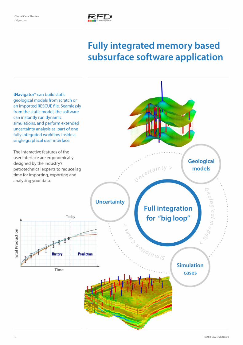
tNavigator® can build static geological models from scratch or an imported RESCUE file. Seamlessly from the static model, the software can instantly run dynamic simulations, and perform extended uncertainty analysis as part of one fully integrated workflow inside a single graphical user interface.
The interactive features of the user interface are ergonomically designed by the industry’s petrotechnical experts to reduce lag time for importing, exporting and analysing your data.
Fully integrated memory based subsurface software application
Uncertainty
Geological models
Simulation cases
Full integration for “big loop”
Tota
l Pro
duct
ion
Time
Today
Rock Flow Dynamics
Global Case Studies rfdyn.com
4

Single integrated technology platform
tNavigator® is truly unique. It is the first fully-parallel, memory-based subsurface technology to take the technical expert from static model building to dynamic simulation and into probabilistic forecasting & uncertainty quantification inside one seamless, fully integrated and intelligent software package.
Support of the common input formats. Seamless fit in the company workflows. No concealed connectors. No painful data QC. No time wasted.
Friendly licensing policy without extra charge for features and parallel cores. Significant cost saving for the clients!
Initially tNavigator® began development as a reservoir simulator. Bridging the gap between outdated simulation software coding and modern day advances in hardware.
Every line of functional code is written in parallel so there is near unlimited scalability of model acceleration for hydrodynamic calculations.
Due to the sophisticated techniques used for the solver design tNavigator® grew into something far bigger than originally conceived. Calculating black oil models with compositional models and thermal compositional models became not just an idea, but a reality.
Multi-physics, coupled with multi-physics in order to link your assets together is no longer just a pipe dream.
Parallel hydrodynamics for geological scale
Global Case Studies www.rfdyn.com
5
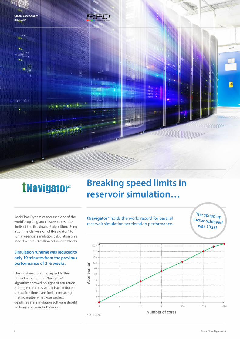
Breaking speed limits in reservoir simulation…
Number of cores
Acc
eler
atio
nA
ccel
erat
ion
Number of cores
1024
512
256
128
64
32
16
8
4
2
11 4 16 64 256 1024 4096
tNavigator® holds the world record for parallel reservoir simulation acceleration performance.
SPE 162090
Rock Flow Dynamics accessed one of the world’s top 20 giant clusters to test the limits of the tNavigator® algorithm. Using a commercial version of tNavigator® to run a reservoir simulation calculation on a model with 21.8 million active grid blocks.
Simulation runtime was reduced to only 19 minutes from the previous performance of 2 ½ weeks.
The most encouraging aspect to this project was that the tNavigator® algorithm showed no signs of saturation. Adding more cores would have reduced simulation time even further meaning that no matter what your project deadlines are, simulation software should no longer be your bottleneck!
Rock Flow Dynamics
Global Case Studies rfdyn.com
6
The speed up factor achieved was 1328!
Global Case Studies rfdyn.com
Examples of utilising near unlimited hardware resources on the cloud are:
• Simulation of small to very large models
• Assisted history matching projects• Prediction cases • Optimization studies • Hundreds / thousands of runs in
minimum timeframe
All of this can be done from a your laptop or workstation via standard internet connection. The end user can monitor calculations in real time and pause the simulation at any time step. The reservoir engineer can add a well, add a tracer, modify well controls during the paused simulation and restart at any point...all on the cloud.
Costs are simple to monitor and easy to control.
For large projects there are huge benefits from economy of scale to block book resources, eliminating the fear of unexpected project creep.
The reservoir engineer can now feel empowered to put all those wonderful ideas into practice!
It takes only 30 minutes to allocate hardware and setup the system ready for simulations!
Reservoir simulation on the cloud…
Rock Flow Dynamics have created the industry’s first fully fledged reservoir simulation cloud offering.
tNavigator® is the industry’s first fully fledged reservoir simulation cloud solution.
Parallel hydrodynamics for geological scale
Global Case Studies www.rfdyn.com
7
Rock Flow Dynamics
Global Case Studies www.rfdyn.com
8
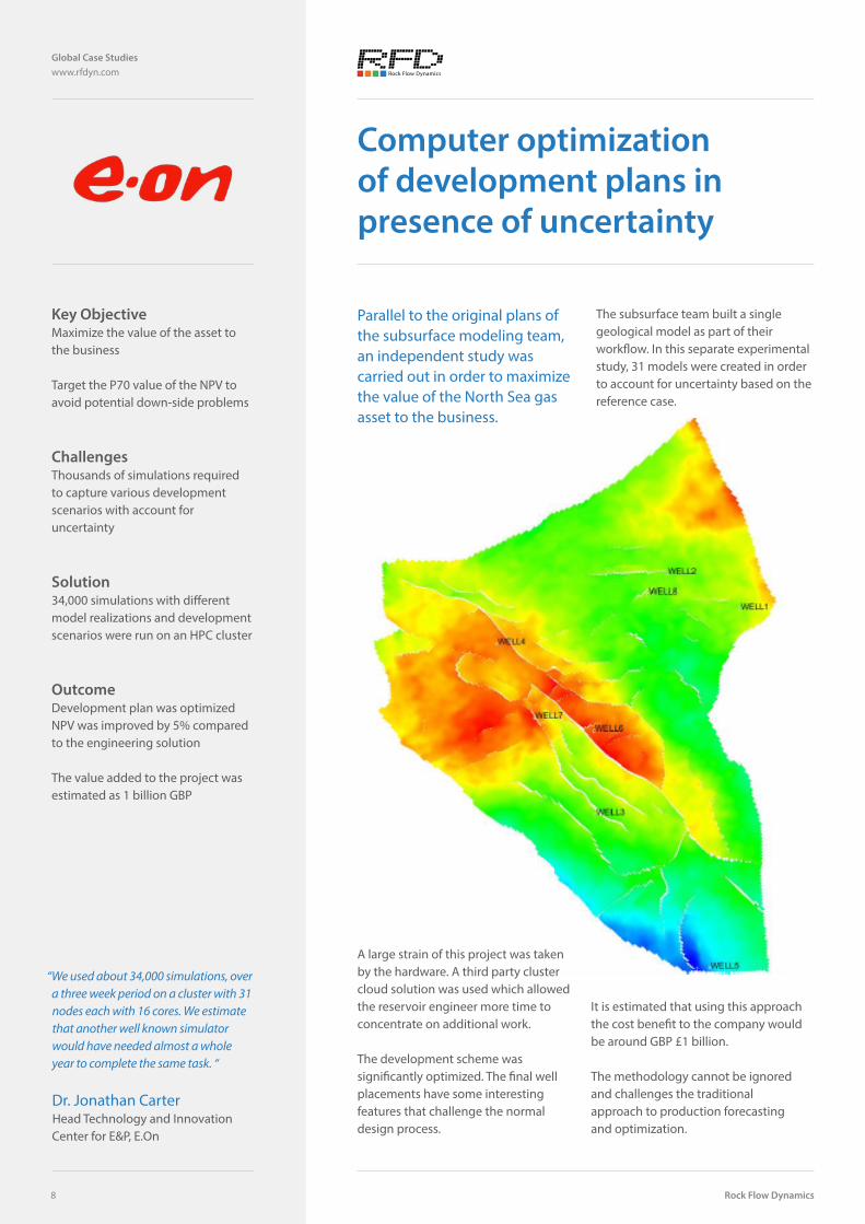
Computer optimization of development plans in presence of uncertainty
Key ObjectiveMaximize the value of the asset to the business
Target the P70 value of the NPV to avoid potential down-side problems
ChallengesThousands of simulations required to capture various development scenarios with account for uncertainty
Solution34,000 simulations with different model realizations and development scenarios were run on an HPC cluster
OutcomeDevelopment plan was optimizedNPV was improved by 5% compared to the engineering solution
The value added to the project was estimated as 1 billion GBP
Parallel to the original plans of the subsurface modeling team, an independent study was carried out in order to maximize the value of the North Sea gas asset to the business.
The subsurface team built a single geological model as part of their workflow. In this separate experimental study, 31 models were created in order to account for uncertainty based on the reference case.
“We used about 34,000 simulations, over a three week period on a cluster with 31 nodes each with 16 cores. We estimate that another well known simulator would have needed almost a whole year to complete the same task. “
Dr. Jonathan CarterHead Technology and Innovation Center for E&P, E.On
A large strain of this project was taken by the hardware. A third party cluster cloud solution was used which allowed the reservoir engineer more time to concentrate on additional work.
The development scheme was significantly optimized. The final well placements have some interesting features that challenge the normal design process.
It is estimated that using this approach the cost benefit to the company would be around GBP £1 billion.
The methodology cannot be ignored and challenges the traditional approach to production forecasting and optimization.
Parallel hydrodynamics for geological scale
Global Case Studies www.rfdyn.com
9
A typical UK Northern North Sea oil field: waterflood in a very heterogeneous Brent reservoir
Key ObjectiveLocating and quantifying the remaining oil pockets, sufficiently large enough to warrant further development
ChallengesOnly 26% recovery despite 38 years of water-flood development
Recent wells, based on mapping and material balance could only target ‘under-developed edges’
SolutionUse of tNAV to run 100’s of sensitivities determining the required heterogeneity to match local water- breakthrough timing and watercut development
OutcomeFully History Matched model identifies local thief zones with water breakthrough versus layers with remaining oil
Main field locations with sufficient oil can now be targeted
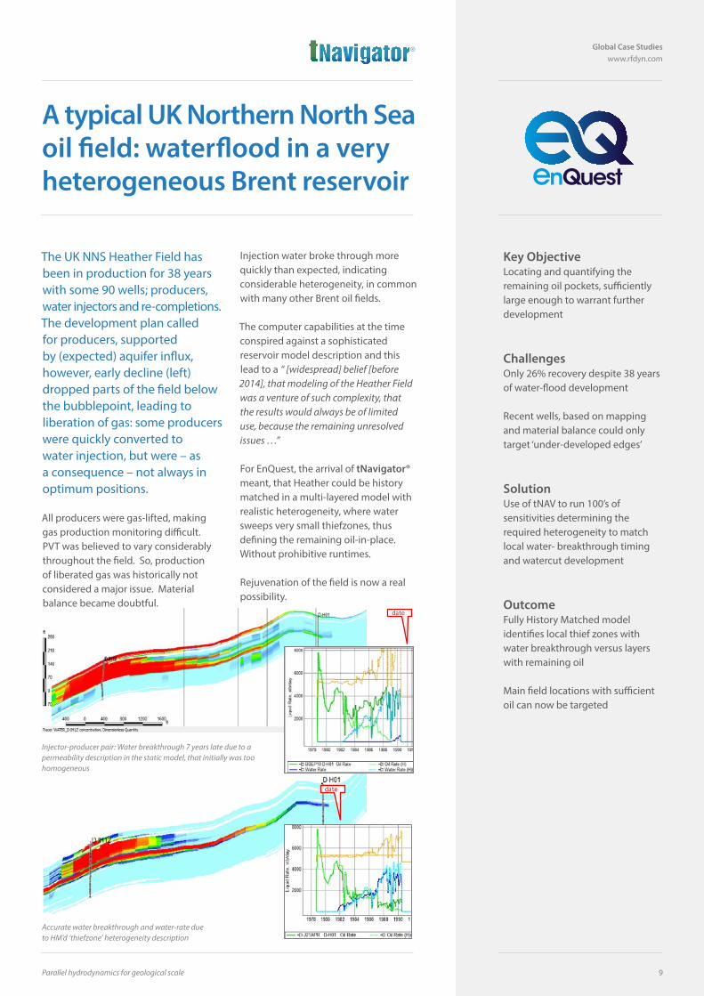
The UK NNS Heather Field has been in production for 38 years with some 90 wells; producers,water injectors and re-completions. The development plan called for producers, supported by (expected) aquifer influx, however, early decline (left) dropped parts of the field below the bubblepoint, leading to liberation of gas: some producers were quickly converted to water injection, but were – as a consequence – not always in optimum positions.
All producers were gas-lifted, making gas production monitoring difficult. PVT was believed to vary considerably throughout the field. So, production of liberated gas was historically not considered a major issue. Material balance became doubtful.
Injection water broke through more quickly than expected, indicating considerable heterogeneity, in common with many other Brent oil fields.
The computer capabilities at the time conspired against a sophisticated reservoir model description and this lead to a “ [widespread] belief [before 2014], that modeling of the Heather Field was a venture of such complexity, that the results would always be of limited use, because the remaining unresolved issues …”
For EnQuest, the arrival of tNavigator® meant, that Heather could be history matched in a multi-layered model with realistic heterogeneity, where water sweeps very small thiefzones, thus defining the remaining oil-in-place. Without prohibitive runtimes.
Rejuvenation of the field is now a real possibility.
Accurate water breakthrough and water-rate due to HM’d ‘thiefzone’ heterogeneity description
Injector-producer pair: Water breakthrough 7 years late due to a permeability description in the static model, that initially was too homogeneous
date
date
Rock Flow Dynamics
Global Case Studies www.rfdyn.com
10
Integrated uncertainty quantification project with multiple history matches prediction cases based on static and dynamic parameters
Key ObjectiveProbabilistic production forecast in a challenging field with account for uncertainty based on the defined development scenario for 25 years period
ChallengesHuge demand in simulations
Lack of tools for integrated uncertainty workflows
SolutionIntegrated assisted history matching workflow involving static, dynamic and technological uncertainties
Massive simulations with tNavigator® and HPC cluster
OutcomeMultiple history matching solutions and probabilistic production forecastBetter understanding of the reservoir
More reliable decisions about the field development
Drilling plan reviewed with risk management
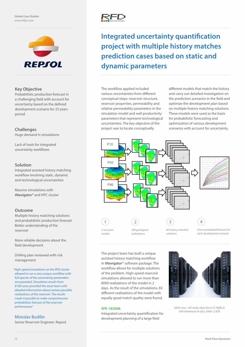
The workflow applied included various uncertainties from different conceptual steps: reservoir structure, reservoir properties, permeability and relative permeability parameters in the simulation model and well productivity parameters that represent technological uncertainties. The key objective of the project was to locate conceptually
different models that match the history and carry out detailed investigation on the prediction scenarios in the field and optimize the development plan based on multiple history matching solutions. These models were used as the basis for probabilistic forecasting and optimization of various development scenarios with account for uncertainty.
The project team has built a unique assisted history matching workflow in tNavigator® software package. The workflow allows for multiple solutions of the problem. High-speed reservoir simulations allowed to run more than 8000 realizations of the model in 2 days. As the result of the simulations, 83 different realizations of the model with equally good match quality were found.
“High-speed simulations on the RFD cluster allowed to run a very unique workflow with full specter of the uncertainty parameters incorporated. Simulation results from 8100 cases provided the asset team with detailed information about various possible realizations of the reservoir. The results made it possible to make comprehensive probabilistic forecast of the reservoir performance.”
Miroslav BudilinSenior Reservoir Engineer. Repsol.
2000 cores, 100 nodes (dual Xeon E5 2680v2) FDR Infiniband 56 Gb/s, RAM 12.8TB
SPE-182008.Integrated uncertainty quantification for development planning of a large field
1
3 structure models
2
300 geological realizations
3
83 history matched solutions
4
One consolidated forecast for each development scenario
P10
P50
P90
3 structure models
300geological realizations
83 history matched solutions
One consolidated forecast for each
development scenario
P10
P50
P90
Parallel hydrodynamics for geological scale
Global Case Studies www.rfdyn.com
11
Fresh water injection in brine reservoirs
Key ObjectiveOptimize development of the field with high salinity
ChallengesEffects of changes in reservoir properties due to dissolution of the rock salt play significant role
No technology with detailed description of the physical process available at the market
SolutionUnique features were implemented in tNavigator® based on client specifications
The model was tuned to match the lab results
Tuned model was used for field development planning
OutcomeThe results of study showed significant influence of the desalinization process on oil water displacement
Better understanding of the reservoir was achieved
Field development plan was optimized with account of all critical effects
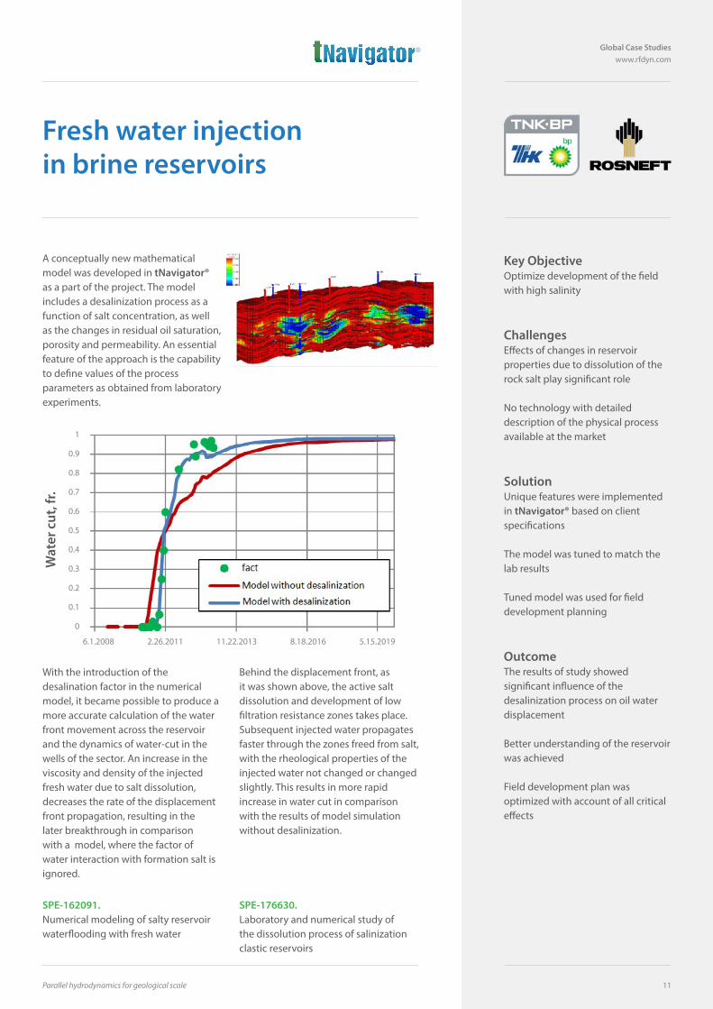
A conceptually new mathematical model was developed in tNavigator® as a part of the project. The model includes a desalinization process as a function of salt concentration, as well as the changes in residual oil saturation, porosity and permeability. An essential feature of the approach is the capability to define values of the process parameters as obtained from laboratory experiments.
With the introduction of the desalination factor in the numerical model, it became possible to produce a more accurate calculation of the water front movement across the reservoir and the dynamics of water-cut in the wells of the sector. An increase in the viscosity and density of the injected fresh water due to salt dissolution, decreases the rate of the displacement front propagation, resulting in the later breakthrough in comparison with a model, where the factor of water interaction with formation salt is ignored.
Behind the displacement front, as it was shown above, the active salt dissolution and development of low filtration resistance zones takes place. Subsequent injected water propagates faster through the zones freed from salt, with the rheological properties of the injected water not changed or changed slightly. This results in more rapid increase in water cut in comparison with the results of model simulation without desalinization.
SPE-162091.Numerical modeling of salty reservoir waterflooding with fresh water
SPE-176630.Laboratory and numerical study of the dissolution process of salinization clastic reservoirs
Wat
er c
ut, f
r.
1
0.9
0.8
0.7
0.6
0.5
0.4
0.3
0.2
0.1
0
6.1.2008 2.26.2011 11.22.2013 8.18.2016 5.15.2019
Rock Flow Dynamics
Global Case Studies www.rfdyn.com
12
Key ObjectiveOptimize model grid resolution for Samatlor - huge field in Western Siberia
Evaluate the hardware requirements for the project
ChallengesExtreme simulation time
High-performance computing is required to run models with multi-million grids
SolutionScalable tNavigator® solver combined with HPC cluster demonstrate reasonable simulation time
OutcomeSimulation results from different grid resolutions were compared
Recommendation on trade-offs between simulation time and accuracy were given
Optimal model grids were chosen for each specific task
Monster model simulations
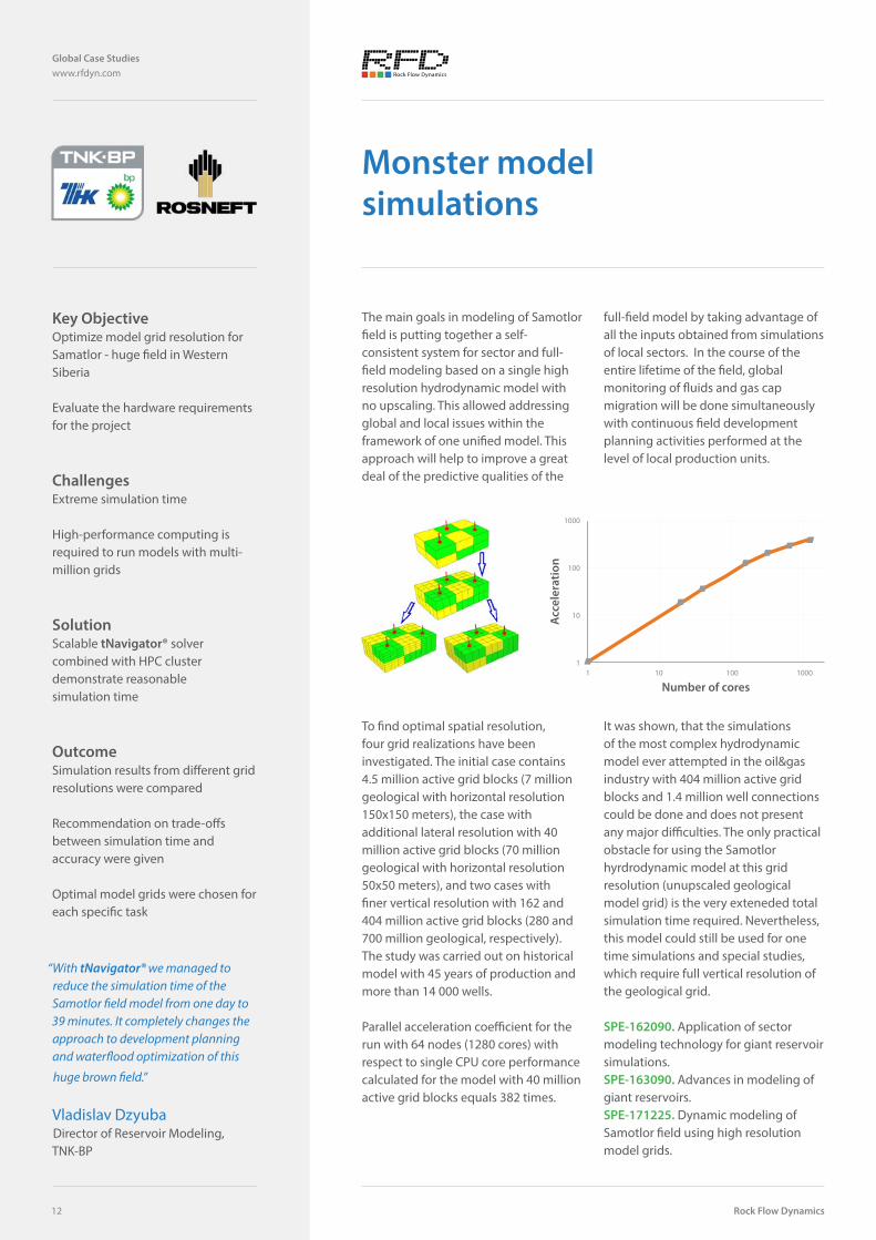
The main goals in modeling of Samotlor field is putting together a self-consistent system for sector and full-field modeling based on a single high resolution hydrodynamic model with no upscaling. This allowed addressing global and local issues within the framework of one unified model. This approach will help to improve a great deal of the predictive qualities of the
full-field model by taking advantage of all the inputs obtained from simulations of local sectors. In the course of the entire lifetime of the field, global monitoring of fluids and gas cap migration will be done simultaneously with continuous field development planning activities performed at the level of local production units.
To find optimal spatial resolution, four grid realizations have been investigated. The initial case contains 4.5 million active grid blocks (7 million geological with horizontal resolution 150x150 meters), the case with additional lateral resolution with 40 million active grid blocks (70 million geological with horizontal resolution 50x50 meters), and two cases with finer vertical resolution with 162 and 404 million active grid blocks (280 and 700 million geological, respectively). The study was carried out on historical model with 45 years of production and more than 14 000 wells.
Parallel acceleration coefficient for the run with 64 nodes (1280 cores) with respect to single CPU core performance calculated for the model with 40 million active grid blocks equals 382 times.
It was shown, that the simulations of the most complex hydrodynamic model ever attempted in the oil&gas industry with 404 million active grid blocks and 1.4 million well connections could be done and does not present any major difficulties. The only practical obstacle for using the Samotlor hyrdrodynamic model at this grid resolution (unupscaled geological model grid) is the very exteneded total simulation time required. Nevertheless, this model could still be used for one time simulations and special studies, which require full vertical resolution of the geological grid.
SPE-162090. Application of sector modeling technology for giant reservoir simulations.SPE-163090. Advances in modeling of giant reservoirs.SPE-171225. Dynamic modeling of Samotlor field using high resolution model grids.
“With tNavigator® we managed to reduce the simulation time of the Samotlor field model from one day to 39 minutes. It completely changes the approach to development planning and waterflood optimization of this
huge brown field.”
Vladislav DzyubaDirector of Reservoir Modeling, TNK-BP
Acc
eler
atio
n
Number of cores
1000
100
10
11 10 100 1000
Parallel hydrodynamics for geological scale
Global Case Studies www.rfdyn.com
13
Accurate modeling of fractured wells in full field simulations
Key ObjectiveBuild a simulation model of a large field with 800+ wells that properly captures behavior of wells with hydraulic fractures
ChallengesIf the fractures are greater than grid block size, the only way to simulate it is transmissibility multiplier that varies in time
Lack of natural tools to model fractured wells
SolutionA new approach for modeling of fractured wells with ‘virtual perforations’ was implemented in tNavigator®
OutcomeAccurate description of fractured wells dynamic for full field model scale was obtained
History matching cycles were dramatically reduced
Schedule for fracture jobs was optimized based on more accurate prediction models
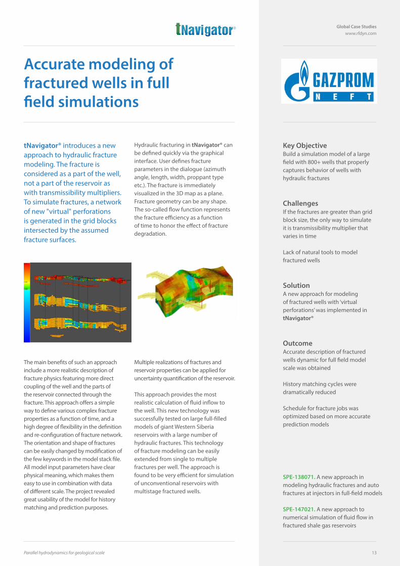
tNavigator® introduces a new approach to hydraulic fracture modeling. The fracture is considered as a part of the well, not a part of the reservoir as with transmissibility multipliers. To simulate fractures, a network of new "virtual" perforations is generated in the grid blocks intersected by the assumed fracture surfaces.
Hydraulic fracturing in tNavigator® can be defined quickly via the graphical interface. User defines fracture parameters in the dialogue (azimuth angle, length, width, proppant type etc.). The fracture is immediately visualized in the 3D map as a plane. Fracture geometry can be any shape. The so-called flow function represents the fracture efficiency as a function of time to honor the effect of fracture degradation.
The main benefits of such an approach include a more realistic description of fracture physics featuring more direct coupling of the well and the parts of the reservoir connected through the fracture. This approach offers a simple way to define various complex fracture properties as a function of time, and a high degree of flexibility in the definition and re-configuration of fracture network. The orientation and shape of fractures can be easily changed by modification of the few keywords in the model stack file. All model input parameters have clear physical meaning, which makes them easy to use in combination with data of different scale. The project revealed great usability of the model for history matching and prediction purposes.
Multiple realizations of fractures and reservoir properties can be applied for uncertainty quantification of the reservoir.
This approach provides the most realistic calculation of fluid inflow to the well. This new technology was successfully tested on large full-filled models of giant Western Siberia reservoirs with a large number of hydraulic fractures. This technology of fracture modeling can be easily extended from single to multiple fractures per well. The approach is found to be very efficient for simulation of unconventional reservoirs with multistage fractured wells.
SPE-138071. A new approach in modeling hydraulic fractures and auto fractures at injectors in full-field models
SPE-147021. A new approach to numerical simulation of fluid flow in fractured shale gas reservoirs
Rock Flow Dynamics
Global Case Studies www.rfdyn.com
14
Improve Productivity with High Performance Reservoir Simulation Technique
Key ObjectiveReal time monitoring for history matching
Optimize the injection pattern in a reasonable time
Hydraulic fracturing event for hundreds wells need to be simulated
ChallengesThe old way to analyse the efficiency of injection pattern is a time consuming work
Multiple hydraulic fracturing is well-known issue in reservoir simulation
SolutiontNavigator® was used to solve this problem
The producing-injection pairs are calculated automatically during the simulation
OutcomeReduce the time used for injection optimization by 80%
Improve productivity of reservoir simulation used in the field plan development by 100%.
The reservoir structures are very complex in the west part of China. Water pattern flood method are widely used in order to improve the production in those reservoirs with poor properties. It’s quite difficult to build an efficient injection pattern for those reservoirs. The old approach to set the injectors’ locations is based on the geological concept which has very poor quality in the beginning before history match, as well as the production dynamic analysis. On one hand, the geological model may change a lot after history match. Therefore we will have an obvious conflict with the concept of the design pattern. On the other hand, the analysis based on the well productions can’t give enough information of the pattern efficiency.
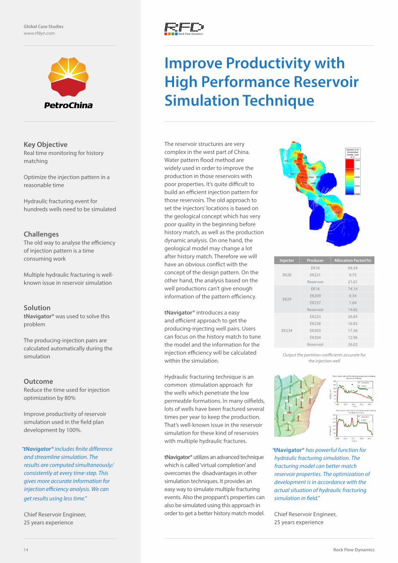
tNavigator® introduces a easy and efficient approach to get the producing-injecting well pairs. Users can focus on the history match to tune the model and the information for the injection efficiency will be calculated within the simulation.
Hydraulic fracturing technique is an common stimulation approach for the wells which penetrate the low permeable formations. In many oilfields, lots of wells have been fractured several times per year to keep the production. That’s well-known issue in the reservoir simulation for these kind of reservoirs with multiple hydraulic fractures.
tNavigator® utilizes an advanced technique which is called ‘virtual completion’ and overcomes the disadvantages in other simulation techniques. It provides an easy way to simulate multiple fracturing events. Also the proppant’s properties can also be simulated using this approach in order to get a better history match model.
“tNavigator® includes finite difference and streamline simulation. The results are computed simultaneously/consistently at every time-step. This gives more accurate information for injection efficiency analysis. We can
get results using less time.”
Chief Reservoir Engineer, 25 years experience
Output the partition coefficients accurate for the injection well
Injector Producer Allocation Factor(%)
EK28
EK16 69.24
EK231 9.75
Reservoir 21.01
EK29
EK16 74.14
EK209 9.34
EK237 1.64
Reservoir 14.82
EK234
EK233 26.83
EK238 16.83
EK303 17.36
EK304 12.96
Reservoir 26.02
“tNavigator® has powerful function for hydraulic fracturing simulation. The fracturing model can better match reservoir properties. The optimization of development is in accordance with the actual situation of hydraulic fracturing simulation in field.”
Chief Reservoir Engineer, 25 years experience
• • • • • • • •
• • • • • • • •
• • • • • • • •
• • • • • • • •
• • • • • • • •
• • • • • • • •
• • • • • • • •
• • • • • • • •
• • • • • • • •
• • • • • • • •
• • • • • • • •
• • • • • • • •
• • • • • • • •
• • • • • • • •
Parallel hydrodynamics for geological scale
Global Case Studies www.rfdyn.com
15
Improve Productivity with High Performance Reservoir Simulation Technique
Reduce Simulation Inaccuracy with Fine Geological Model using High Speed Simulation Technique
Key ObjectiveFinish geological model screening within a reasonable time frame
Using fine geological model in reservoir simulation research
ChallengesHundreds of models will be simulated during screening, will take a very long time.
More parameters used in the CAHM will also cause large number of cases which need to be simulated
SolutiontNavigator® deployed on a cluster to use more computing resources
Fine geological model is used in history match as well as prediction
Outcome17 times speed-up compared with industry standard simulators
Use of fine geological model to avoid grid upscaling and reduce the inaccuracy
Modifications in the fine grid after history match will return to geological process to improve the entire research
Reservoir simulation with fine geological model is a better way to enhance accuracy of simulation research. When using a fine geological model, there will be no grid upscaling to change the geometrical structures and effect the results.
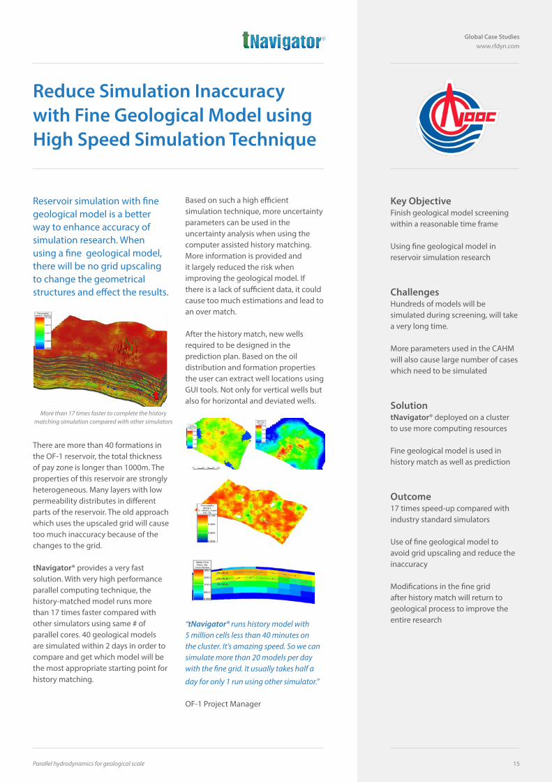
There are more than 40 formations in the OF-1 reservoir, the total thickness of pay zone is longer than 1000m. The properties of this reservoir are strongly heterogeneous. Many layers with low permeability distributes in different parts of the reservoir. The old approach which uses the upscaled grid will cause too much inaccuracy because of the changes to the grid.
tNavigator® provides a very fast solution. With very high performance parallel computing technique, the history-matched model runs more than 17 times faster compared with other simulators using same # of parallel cores. 40 geological models are simulated within 2 days in order to compare and get which model will be the most appropriate starting point for history matching.
Based on such a high efficient simulation technique, more uncertainty parameters can be used in the uncertainty analysis when using the computer assisted history matching. More information is provided and it largely reduced the risk when improving the geological model. If there is a lack of sufficient data, it could cause too much estimations and lead to an over match.
After the history match, new wells required to be designed in the prediction plan. Based on the oil distribution and formation properties the user can extract well locations using GUI tools. Not only for vertical wells but also for horizontal and deviated wells.
“tNavigator® runs history model with 5 million cells less than 40 minutes on the cluster. It’s amazing speed. So we can simulate more than 20 models per day with the fine grid. It usually takes half a
day for only 1 run using other simulator.”
OF-1 Project Manager
More than 17 times faster to complete the history matching simulation compared with other simulators
USA1980 Post Oak BoulevardSuite 2030,Houston, TX 77056 T: +1 713-337-4450
Canada#500-602 12 Ave SWCalgary, Canada, AB T2R 1J3T: +1 (403) 998-9299
MexicoEnergy, Construction & ServicesFraccionamiento CarrizalCalle Tapotzingo N° 126Villahermosa, Tabasco. México C.P: 86038.T: +52 1 993 165 2400
Uruguay y Venezuela - Bolivia - Colombia - Chile - Ecuador - PeruGaulois EnergiaCebollatí 1710 - Of 704Montevideo - UruguayT : +598 24 12 72 72
BrazilGaulois EnergiaRua Visconde de Inhaúma, 134 - 20 andar Centro - Rio de Janeiro - RJ, CEP 20091-901 - BrasilT: +55 21 3232-2600
ArgentinaGaulois EnergiaLibertad 451 C.A.B.A. ArgentinaPhone: +54-11-4381-7403T: +54 911 58805351
United Kingdom214 Union StreetAberdeen, AB10 1TLUnited KingdomT: +44 (0) 1224 517826
MalaysiaOnyx IES Sdn. Bhd.Suite 26.1 Level 26, Menara IMC,Letter Box No 62,8 Jalan Sultan Ismail50250 Kuala Lumpur, MalaysiaT: +603 2070 0255
RussiaMoscowProfsoyuznaya St. 25A, 117418, Moscow, RussiaT: +7 499 409 05 00
TyumenChelyuskintsev St. 10, 625000TyumenRussiaT: +7 912 078 9638
UfaKommunisticheskaya St. 116450000Ufa, RussiaT: +7 (347) 216-47-01
KuwaitFirst Bateel Trading & Contracting Co.T: +965 22665552
UAEX Systems LLCSuite 1102, New Nissan Building, Najda St.P.O.Box 109418, Abu Dhabi, UAET: + 971 2 6744556
OmanYAS Consulting Engineers LLCOffices #11 & #12Building No. 3221, Way No. 3341Al KhuwairOmanT: +968 244 88857
Saudi ArabiaGulf Technology Compass LLC (GTC) 6157 Al Yarmok Mada TowerUnit No 802 Al-Khobar 34423-4187Eastern Province, Saudi ArabiaT: +966 13 8999883
PakistanPetroSol (Pvt) Limited604-Horizon TowerBlock-3, Clifton Karachi, PakistanT: +92 (21) 3587 6490
West AfricaFairfax Oilfield Services Ltd.Plot 43Osu-Bad Street, Airport WestAccra, Ghana T: +233 (0)302797916
ChinaColchis Petro Consulting (Beijing) Co. Ltd.C2001, SP TowerTsinghua Science ParkBeijing 100084, ChinaT: +86 10 8215 8077
AustraliaPetrosys Pty Ltd.Level 4N, 191 Pulteney Street, Adelaide SA 5000T: +61 8 8227 2799
IranTehran Energy ConsultantsT:+98(21) 88768462 - 88741283
VietnamEastsea Star Co, Ltd22D8, Saigon Pearl Villas92 Nguyen Huu Canh Street, Ward 22Binh Thanh District, Ho Chi Minh CityT: (+84 8) 6291 5578 – (+84 8) 6291 5579
IndiaReservoilA - 31 Sudershana Sector - 17 Vashi Navi MumbaiT: 0091-227659419