Embed Size (px)
Citation preview
Find links to fishing licenses, season dates, regulations, where to fish and more at:fishingwisconsin.org
Find us on Facebook (facebook.com/WIDNR)Watch us on YouTube (youtube.com/ user/ WIDNRTV)
FY I
SIGN UP for Fisheries Updates. Go to fishingwisconsin. org to sign
up and stay informed on fisheries issues.
Follow “fishwisconsin” on Twitter. Subscribe at fishingwisconsin.org
An new initiative aims to create new participants or increase par-ticipation rates of current or lapsed anglers.
Early Inland Trout January 6 (5 a.m.) to May 4
General Hook and Line InlandMay 5 to March 3, 2019
General Inland Trout May 5 (5 a.m.) to Oct. 15
Largemouth BassNorthern Zone HarvestMay 5 to March 3, 2019
Smallmouth BassNorthern Zone Catch-and-ReleaseMay 5 to June 15
Smallmouth BassNorthern Zone Harvest June 16 to March 3, 2019
Large and Smallmouth Bass Southern Zone May 5 to March 3, 2019
Musky – Northern Zone May 26 to Nov. 30
Musky – Southern Zone May 5 to Dec. 31
Northern Pike May 5 to March 3, 2019
Walleye May 5 to March 3, 2019
Lake Sturgeon (hook and line) Sept. 1 to Sept. 30
Free Fishing WeekendJune 2 - 3, 2018 summerJanuary 19 -20, 2019 winter
2018 SEASON DATES
http://www.pinterest.com/wdnr/
WISCONSINANGLER
Dear
Director, Bureau of Fisheries Managment
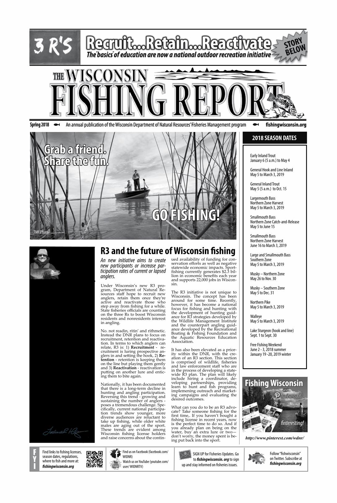
R3 and the future of Wisconsin fishing
Under Wisconsin’s new R3 pro-gram, Department of Natural Re-sources staff hope to recruit new anglers, retain them once they’re active and reactivate those who step away from fishing for a while. State fisheries officials are counting on the three Rs to boost Wisconsin residents and nonresidents interest in angling.
No. not readin, ritin’ and rithmetic. Instead the DNR plans to focus on recruitment, retention and reactiva-tion. In terms to which anglers can relate, R3 is: 1) Recruitment - re-cruitment is luring prospective an-glers in and setting the hook, 2) Re-tention - retention is keeping them on the line but playing them gently and 3) Reactivation - reactivation is putting on another lure and entic-ing them to bite again.
Nationally, it has been documented that there is a long-term decline in hunting and angling participation. Reversing this trend - growing and sustaining the number of anglers - poses a tremendous challenge. Spe-cifically, current national participa-tion trends show younger, more diverse audiences are reluctant to take up fishing, while older white males are aging out of the sport. These trends are evident among Wisconsin fishing license holders and raise concerns about the contin-
ued availability of funding for con-servation efforts as well as negative statewide economic impacts. Sport-fishing currently generates $2.3 bil-lion in economic benefits each year and supports 22,000 jobs in Wiscon-sin.
The R3 initiative is not unique to Wisconsin. The concept has been around for some time. Recently, however, it has become a national focus for fishing and hunting with the development of hunting guid-ance for R3 strategies developed by the Wildlife Management Institute and the counterpart angling guid-ance developed by the Recreational Boating & Fishing Foundation and the Aquatic Resources Education Association. It has also been elevated as a prior-ity within the DNR, with the cre-ation of an R3 section. This section is comprised of wildlife, fisheries and law enforcement staff who are in the process of developing a state-wide R3 plan. The plan will likely include hiring a coordinator, de-veloping partnerships, providing learn to hunt and fish programs, implemening outreach and market-ing campaigns and evaluating the desired outcomes.
What can you do to be an R3 advo-cate? Take someone fishing for the first time,. If you haven’t bought a fishing license in recent years, now is the perfect time to do so. And if you already plan on being on the water, buy an extra lure or two—don’t worry, the money spent is be-ing put back into the sport.
Grab a friend.Share the fun.
GO FISHING!TMF Photo
I am excited to report that 2017 was another very productive year for the fisheries program in Wisconsin. We produced over 7 million fish for stock-ing our waters and were also able to fill many critical vacancies around the state including 10 fisheries biologists and 10 fisheries management techni-cians. These new hires along with our seasoned employees are going to have another busy year in 2018.
Some may consider 2018 to be the “year of the plan”. For the first time in DNR history, the fisheries program will be developing a statewide trout manage-ment plan. Efforts will begin in Janu-ary and continue throughout the year with many opportunities for input from you the angler. We will also be updat-ing the 30-plus year old Lake Superior management plan as well as revising the decade-old sturgeon management plan. There will be ample opportunity for stakeholder input as these plans are developed. It is our job to manage these amazing fishery resources but you as a stakeholder are also an important com-ponent in making our fisheries great and we want to hear from you. To find out more about how to be involved in any of the planning efforts in 2018 visit dnr.wi.gov/topic/fishing.
I am looking forward to some good open water fishing when the weather heats up. Maybe I’ll see you on the wa-ter.
““

2 Fish Wisconsin! fishingwisconsin.org
The fish are here, there, everywhere! Where are you going to be in 2018?
WALLEYE
Interested in a water? Want more information? Contact the local fisheries biologist dnr.wi.gov/topic/fishing/people/fisheriesbiologist.html
n BARRON COUNTYSilver Lake - 331 acres. In a 2017 fish-eries survey, the density of adult (≥15 in) walleye was estimated to be 2.2 fish/acre, which was an increase from the most recent survey in 2009 when it was 1.9 fish/acre. Of the 320 adult walleye handled in the survey, 65% were between 15 to 20inches in length. Current regulation: The Silver Lake walleye fishery is managed with a 15-in minimum length limit, but walleye 20-24 inches may not be harvested, and only 1 walleye longer than 24 inches may be harvested, 3 fish daily bag limit. Access information: There is one public boat landing at Grant County Park on the south end of Silver Lake off CTH B. The park is maintained by Barron County and includes a restroom, picnic shelter, volleyball net, and a swimming beach. Silver Lake is a deep seepage lake, and the water level can fluctu-ate by as much as 12 feet over several years. Silver Lake has excellent water quality and is one of few lakes in Bar-ron County that has walleye natural reproduction.
n BROWN, OCONTO AND MARINETTE COUNTIESFox River, Oconto River, Peshtigo River, Menominee River and Green Bay Since 2012, Wisconsin DNR has assessed the magnitude of walleye spawning migra-tions into the Fox River located in south-ern Green Bay and into the Oconto, Peshtigo and Menominee Rivers found along the west shore of Green Bay by using daytime electroshocking. Elec-trofishing is conducted just below the dams in these rivers to capture Walleye during the estimated peak of the spring spawning run. Electroshocking runs in 2017 were conducted at least twice per river between March 28 and April 18 with the water temperature varying by river from 36°F to 44°F. During elec-troshocking we captured 1,248 Walleye that ranged in length from 14” to 29.5”. In 2017, the spring run was later than normal and was very short in length likely due an unusually cold spring with a fast warm-up. DNR also assesses the walleye population during the fall to look at young of year production and year class strength. In 2017, dur-ing our nighttime YOY Walleye index electroshocking survey on the lower Fox River, we captured 434 Walleye that had average length of 14”. Most of the captured Walleye were less than 18” in length and many (27%) were young of year Walleye. During YOY Walleye assessments on Green Bay, we captured 111 Walleye that averaged 14” in length. Similar to the Walleye captured on the Fox River, Walleye captured on Green Bay were mostly less than 18” in length and many were young of the year. Results of our 2017 Fall electrofishing index surveys show that the relative abundance of young of the year (YOY) Walleye at the fall fingerling stage was above average on the Fox River and slightly below aver-age on Green Bay. When the river and
bay YOY catch is combined, it appears that 2017 was an above average year for Walleye. Walleye from the exception-ally large 2013 year class are now in the 18” to 22” range and were commonly caught by anglers and seen in DNR surveys in 2017. It is likely that this year class and others produced from 2014 through 2017 will carry the fishery in the near future. Current regulation: The rules vary by location and anglers should check for walleye fishing rules in the Wisconsin-Michigan Boundary,
Tributary Stream to Lake Michigan and the Lake Michigan sections of the regu-lation pamphlet for season and harvest rules. Access information: There are many good boat launches in the area. Good shore fishing opportunities exist on the Fox, Menominee, Oconto and Peshtigo Rivers. Check the Lake Michi-gan page for access information. www.dnr.wi.gov/topic/fishing/lakemichi-gan/TributaryAccess.html Since 2007 the only poor year class was the 2012 year class. Recruitment in the 2010’s has been exceptional with good year classes produced regularly Relative abundance of young-of-year Walleye in the lower Fox River (DePere Dam to mouth), lower Green Bay (south of a line drawn from Longtail Point to Point Sable), as measured by catch per unit effort (CPUE; number per hour) from data collected in electrofishing index surveys during 1993-2017.
n BURNETT COUNTYUpper Clam Lake (1,338 acres) and Lower Clam Lake (366 acres). 2017 survey data found Clam Lake walleye ranged from 11.5 to 28.2 inches. The average length was 16.2 inches. Fifty-eight percent of the adult walleye sampled were be-tween 15 – 20 inches. The two lakes are shallow and featureless, so it can be dif-ficult to find fish. Many anglers who are successful use trolling to find wall-eye roaming the lakes. Current Regula-tion: 15” - 20” may be kept, except one fish may be over 24”; daily bag limit of 3 fish. Access: There are two boat launch-es on Upper Clam Lake and one launch on Lower Clam Lake. Upper Clam Lake has one landing on the SE portion of the lake off of Clam Lake Drive and
the other landing is on the SW side at the end of Cumberland Point Rd. The launch for Lower Clam Lake is on the N side of Hwy 70. Walleye present in Clam Lake today likely originate from wild walleye populations in the Clam River upstream. These immigrants have taken advantage of the dramatic changes to vegetation and turbidity caused by common carp in the lake.
n CALUMET, FOND DU LAC, GREEN LAKE, OUTAGAMIE, SHA-WANO, WAUSHARA, WAUPACA AND WINNEBAGO COUNTYThe Winnebago System includes the four lakes (Lakes Winnebago, Butte des Morts, Winneconne, and Poygan) along with all their tributaries from their mouths upstream to the first dam including the upper Fox and Wolf Rivers. 165,246 acres for the lakes and roughly 142 river miles The Winneba-go System walleye fishery continues to provide respectable fishing oppor-tunities for boat and shoreline anglers throughout the system. Annual sur-veys conducted by DNR staff and local volunteers continue to reveal a healthy self-sustaining walleye population. There were 4,962 male walleye and 1,039 female walleye tagged during the 2017 spring electrofishing assessment. The strong 2008, 2011, and 2013 year classes continue to dominate the adult walleye population. Nearly 100% of male walleyes mature at age 3, but the majority of female walleye (~82%) will make their first spawning run at age 5. Therefore, anglers should see more fish from the 2013 year class moving throughout the system in 2018. An-glers can also expect to see good num-bers of fish from the strong 2016 year class, which will provide a good boost to the adult walleye population and provide future fishing opportunities. Lastly, the annual Lake Winnebago trawling assessment revealed a strong year class of young of year trout perch (456.3 YOY/trawl) and a weak year class of gizzard shad (1.3 YOY/trawl). Although trout perch will provide
good forage opportunities, walleye an-glers on the system know that gizzard shad can often drive walleye fishing success on the system. Therefore, an-glers may have a better chance at con-vincing some walleyes to bite the hook in 2018. Current Regulations: The sys-tem is open year round for walleye and sauger. There is a combined daily bag limit of 5 fish, of which only 1 may be a sauger. There is no minimum length limit for either species. Access Informa-tion: There are numerous access points around the Winnebago system. Con-sult a map of the system to see what ac-cess is near where you want to launch, or go to the DNR’s Boat and Shore Fishing Access Website to search for access information (http://dnr.wi.gov/topic/lands/boataccess). DNR fisheries staff has tagged walleye annually on the Winnebago System since 1993. In that time span, 169,701 walleye have been tagged on the system. The wall-eye tagging program relies on anglers to report any tagged fish they catch by mailing them to the Oshkosh DNR of-fice (625 East County Road, Y Oshkosh WI 54901) or emailing them to [email protected]. Anglers are encouraged to check their walleye catch for tags and report them properly. Anglers that return tags can expect a mailed certificate that provides information about the tagged fish they caught. - Adam Nickel, fisheries biologist, Oskosh
n CLARK, JACKSON, LA CROSSE, MONROE AND TREMPEA-LEAU COUNTIESBuckhorn Lake (24 acres) and Emerald Lake (26 Acres), Jackson County; and the upper Black River (above the Black River Falls dam), Clark and Jackson Counties, and lower Black River (below the Black River Falls dam), Jackson, Monroe, La Crosse, and Trempealeau Counties. Catch rates for Buckhorn and Emerald Lakes are based on spring 2017 netting results (expressed as aver-age number of fish caught per net lift) and for the Black River, catch rates are
based on 2017 electrofishing results (expressed as average number of fish captured per mile of river surveyed). Buckhorn Lake: Total catch rate was 1.2/net lift, catch rate of 15”+ fish was
Madeline Roberts, Water Resources Management Specialist in Spooner, holds a 25+ inch walleye from the St. Louis River, Douglas County. Photo: Paul Piszczek
Luke Lorenzen holding his first walleye caught on an Oneida County Lake.Photo: Tom Lorenzen
3 Wisconsin Fishing Report - 2018
0.5/net lift and maximum size captured was 22”. The last comparable survey was conducted in 2009. Total catch rate was 0.1/net lift, catch rate of 15”+ fish was 0.1/net lift and maximum size captured was 22”. Emerald Lake: Total catch rate was 0.6/net lift, catch rate of 15”+ fish was 0.4/net lift and maxi-mum size captured was 25”. The last comparable survey was conducted in 2009. Total catch rate was 0.5/net lift, catch rate of 15”+ fish was 0.3/net lift and maximum size captured was 19”. Black River, upper: Total catch rate was 9/mile, catch rate of 15”+ fish was 2.6/mile and maximum size captured was 18”. In 2016, total catch rate was 15/mile, catch rate of 15”+ fish was 4.3/mile and maximum size captured was 18”. Black River, lower: Total catch rate was 7.7/mile, catch rate of 15”+ fish was 2/mile and maximum size captured was 26”. In 2016, total catch rate was 4.7/mile, catch rate of 15”+ size fish was 1/mile and maximum size captured was 24”. Regulation: Black River up-stream of CTH OO (T26NR2W Sections 20 and 21 – Clark County) walleye from 15 inches but less than 20 inches may be kept, except 1 fish may be over 24 inches/ daily bag limit 3 fish (Ceded Territory standard walleye regulation). For the Black River downstream of CTH OO, Clark County, and Buckhorn and Emerald Lakes minimum length is 15 inches and daily bag limit is 5 fish. - Dan Hatleli, fisheries biologist, Black River Falls.
n CRAWFORD, GRANT AND VERNON COUNTIESMississippi River Pool 9-10 - 53,391 acres and 65 miles of open water In mid-October 2017 a DNR electrofishing crew collected a total of one hundred and thirty-six walleye by electrofishing at night in the near-shore areas around wingdams in Pool 9. In our sample, adult walleyes were between 10 to 25 inches with the largest measuring 25.7-inches. Catch-per-unit-effort was approximately one hundred sixteen adult walleye per hour. Our fall young-of-year (YOY) survey results in Pool 10 showed poor reproduction during the spring of 2017 with a catch rate of only 32 YOY walleye per hour. However, YOY walleye reproduction in 2015 was exceptional at 166 YOY walleye per hour which will help maintain the fishery for year years to come. Current regulation: The Mississippi River is open year round for walleye. The daily bag limit is 6 fish with a 15-inch mini-mum length limit on walleye. Access information: There are many boat and shore fishing access locations along the Mississippi River. The waters of Pool 9 are part of the Upper Mississippi River Wildlife and FishRefuge. The Refuge is located in four states: Minnesota, Wisconsin, Iowa and Illinois along the Mississippi River and was established in in 1924 as a refuge for fish, wildlife and plants. The refuge encompasses one of the largest blocks of floodplain habitat in the lower 48 states and cov-ers just over 240,000 acres which ex-tends 261 river miles from the Chip-pewa River in Wisconsin to near Rock Island, Illinois.
n DOUGLAS COUNTYSt. Louis River and Estuary - 12,000 acresWalleye lengths ranged from 18 to 27 inches in the most recent survey (2015), with an average of 23 inches. Female Walleye were generally larger than male Walleye. Current regulation: May 12 through March 1; 15-inch mini-mum length; daily limit is two fish. Ac-cess information: Arrowhead Landing and Fishing Pier: Located in the City of Superior where Belknap Street joins the river. The landing features paved parking, an ADA accessible picnic area, and portable restrooms. Go to http://dnr.wi.gov/topic/lands/boatac-cess/ for complete information. Oli-
ver Landing: Located in the Village of Oliver, just south of Superior, at end of East Detroit Street. The landing has paved parking and portable restrooms. Barker’s Island Landing: Located in the City of Superior at the end of Marina Driver. Features restrooms and paved
parking. Loon’s Foot Landing: Located in the City of Superior just west of the Nemadji River. Restrooms and paved parking. The St. Louis River supports the largest self-sustaining Walleye population in the Lake Superior basin, which is genetically distinct from other populations in the Great Lakes. Unlike many Walleye populations in the Great Lakes, the St. Louis River population persisted through intense environ-mental degradation and exploitation between the 1800s and mid-1900s. The Federal Clean Water Act of 1972 paved the way for dramatic water quality im-provements to the St. Louis River, par-ticularly with construction of the West-ern Lake Superior Sanitary District in Duluth, Minnesota, which began oper-ating in 1979. Improved water quality prompted Wisconsin DNR and Min-nesota DNR to improve the Walleye population by stocking over 450,000 fingerlings between 1989 and 1993. Minnesota DNR continued to stock fry annually until 2006. St. Louis River/Lake Superior Walleye grow slowly and can be relatively long-lived, with some fish being 31 inches and nearly 25 years old.
Minnesuing Lake is a 432 acre lake. A walleye population estimate was com-pleted in 2017. The walleye population was low in abundance with 0.4 adult walleye/acre. However, the size struc-ture was good with an average length of 19.8 inches and a maximum length of 26 inches. Ninety-seven percent of the walleye captured were 14 inches or lon-ger. Please note there is a mercury fish consumption advisory on Minnesuing Lake. Women of childbearing age (50 years old) and children under 15 years old should not eat walleye greater than 20 inches. Women older than 50 years old and children older than 15 years old should eat only one meal per month of walleye less than 20 inches. Please see fish consumption advisory or advice on other species. Regulation: Walleye of any length may be kept with a bag limit of 3 fish per day. Access informa-tion: There are 4 boat landings. The landing best suited for trailer access is a county owned landing on the north-west end of the lake. —Scott Toshner, fisheries biologist, Brule
n EAU CLAIRE COUNTYLake Eau Claire - 860 acres. The walleye population on Lake Eau Claire in east-ern Eau Claire County is healthy ac-cording to recent fisheries survey data. A walleye population estimate was
conducted in the spring of 2017 and it was calculated that there were 4.8 adult walleye per acre. This is well above the statewide average, but the walleye fish-ery here flies under the radar as pan-fish are the primary target on Lake Eau Claire. Many nice walleye were caught in the survey including fish in excess of 11 pounds. The regulation on Lake Eau Claire three walleye may be kept and they must be between 15-20 inches ex-cept one may be over 24 inches. Access Information: Two main access loca-tions: Northside – located off of North-shore Drive Circle, Southside – located off of Southshore Drive. - Joseph Gerbyshak, fisheries biologist, Eau Claire
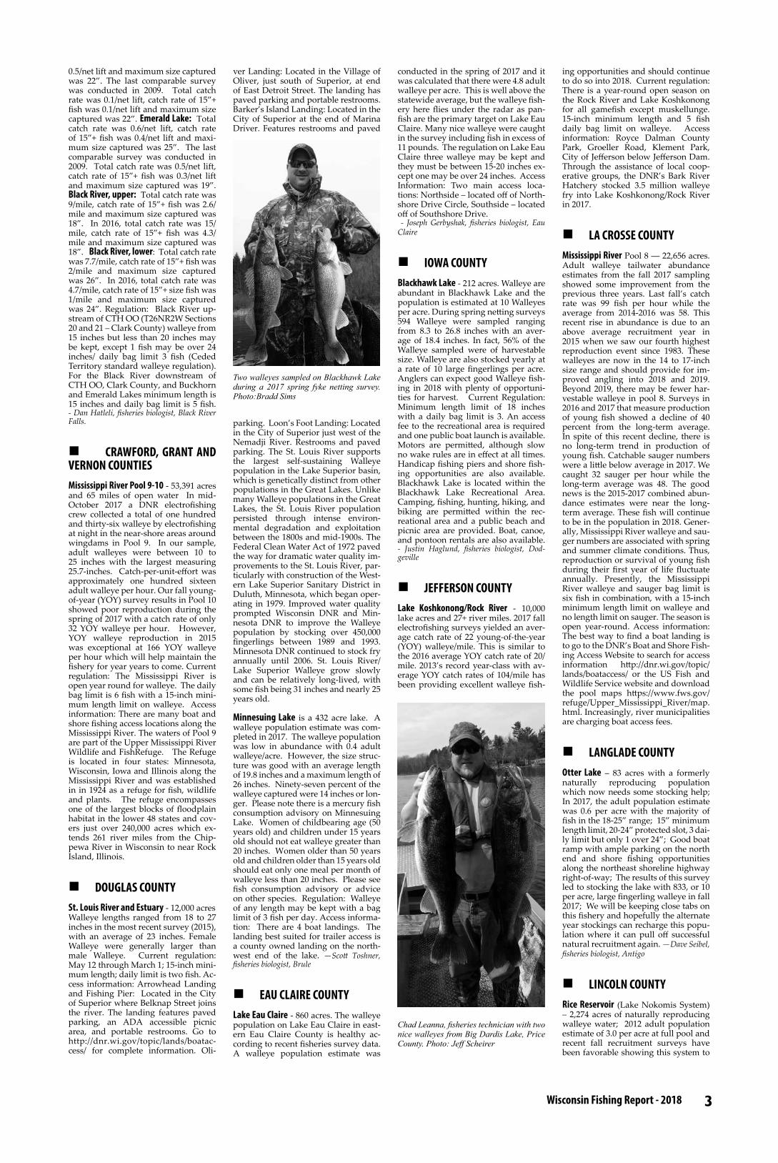
n IOWA COUNTYBlackhawk Lake - 212 acres. Walleye are abundant in Blackhawk Lake and the population is estimated at 10 Walleyes per acre. During spring netting surveys 594 Walleye were sampled ranging from 8.3 to 26.8 inches with an aver-age of 18.4 inches. In fact, 56% of the Walleye sampled were of harvestable size. Walleye are also stocked yearly at a rate of 10 large fingerlings per acre. Anglers can expect good Walleye fish-ing in 2018 with plenty of opportuni-ties for harvest. Current Regulation: Minimum length limit of 18 inches with a daily bag limit is 3. An access fee to the recreational area is required and one public boat launch is available. Motors are permitted, although slow no wake rules are in effect at all times. Handicap fishing piers and shore fish-ing opportunities are also available. Blackhawk Lake is located within the Blackhawk Lake Recreational Area. Camping, fishing, hunting, hiking, and biking are permitted within the rec-reational area and a public beach and picnic area are provided. Boat, canoe, and pontoon rentals are also available. - Justin Haglund, fisheries biologist, Dod-geville
n JEFFERSON COUNTYLake Koshkonong/Rock River - 10,000 lake acres and 27+ river miles. 2017 fall electrofishing surveys yielded an aver-age catch rate of 22 young-of-the-year (YOY) walleye/mile. This is similar to the 2016 average YOY catch rate of 20/mile. 2013’s record year-class with av-erage YOY catch rates of 104/mile has been providing excellent walleye fish-
ing opportunities and should continue to do so into 2018. Current regulation: There is a year-round open season on the Rock River and Lake Koshkonong for all gamefish except muskellunge. 15-inch minimum length and 5 fish daily bag limit on walleye. Access information: Royce Dalman County Park, Groeller Road, Klement Park, City of Jefferson below Jefferson Dam. Through the assistance of local coop-erative groups, the DNR’s Bark River Hatchery stocked 3.5 million walleye fry into Lake Koshkonong/Rock River in 2017.
n LA CROSSE COUNTYMississippi River Pool 8 ― 22,656 acres. Adult walleye tailwater abundance estimates from the fall 2017 sampling showed some improvement from the previous three years. Last fall’s catch rate was 99 fish per hour while the average from 2014-2016 was 58. This recent rise in abundance is due to an above average recruitment year in 2015 when we saw our fourth highest reproduction event since 1983. These walleyes are now in the 14 to 17-inch size range and should provide for im-proved angling into 2018 and 2019. Beyond 2019, there may be fewer har-vestable walleye in pool 8. Surveys in 2016 and 2017 that measure production of young fish showed a decline of 40 percent from the long-term average. In spite of this recent decline, there is no long-term trend in production of young fish. Catchable sauger numbers were a little below average in 2017. We caught 32 sauger per hour while the long-term average was 48. The good news is the 2015-2017 combined abun-dance estimates were near the long-term average. These fish will continue to be in the population in 2018. Gener-ally, Mississippi River walleye and sau-ger numbers are associated with spring and summer climate conditions. Thus, reproduction or survival of young fish during their first year of life fluctuate annually. Presently, the Mississippi River walleye and sauger bag limit is six fish in combination, with a 15-inch minimum length limit on walleye and no length limit on sauger. The season is open year-round. Access information: The best way to find a boat landing is to go to the DNR’s Boat and Shore Fish-ing Access Website to search for access information http://dnr.wi.gov/topic/lands/boataccess/ or the US Fish and Wildlife Service website and download the pool maps https://www.fws.gov/refuge/Upper_Mississippi_River/map.html. Increasingly, river municipalities are charging boat access fees.
n LANGLADE COUNTYOtter Lake – 83 acres with a formerly naturally reproducing population which now needs some stocking help; In 2017, the adult population estimate was 0.6 per acre with the majority of fish in the 18-25” range; 15” minimum length limit, 20-24” protected slot, 3 dai-ly limit but only 1 over 24”; Good boat ramp with ample parking on the north end and shore fishing opportunities along the northeast shoreline highway right-of-way; The results of this survey led to stocking the lake with 833, or 10 per acre, large fingerling walleye in fall 2017; We will be keeping close tabs on this fishery and hopefully the alternate year stockings can recharge this popu-lation where it can pull off successful natural recruitment again. —Dave Seibel, fisheries biologist, Antigo
n LINCOLN COUNTYRice Reservoir (Lake Nokomis System) – 2,274 acres of naturally reproducing walleye water; 2012 adult population estimate of 3.0 per acre at full pool and recent fall recruitment surveys have been favorable showing this system to
Two walleyes sampled on Blackhawk Lake during a 2017 spring fyke netting survey.Photo:Bradd Sims
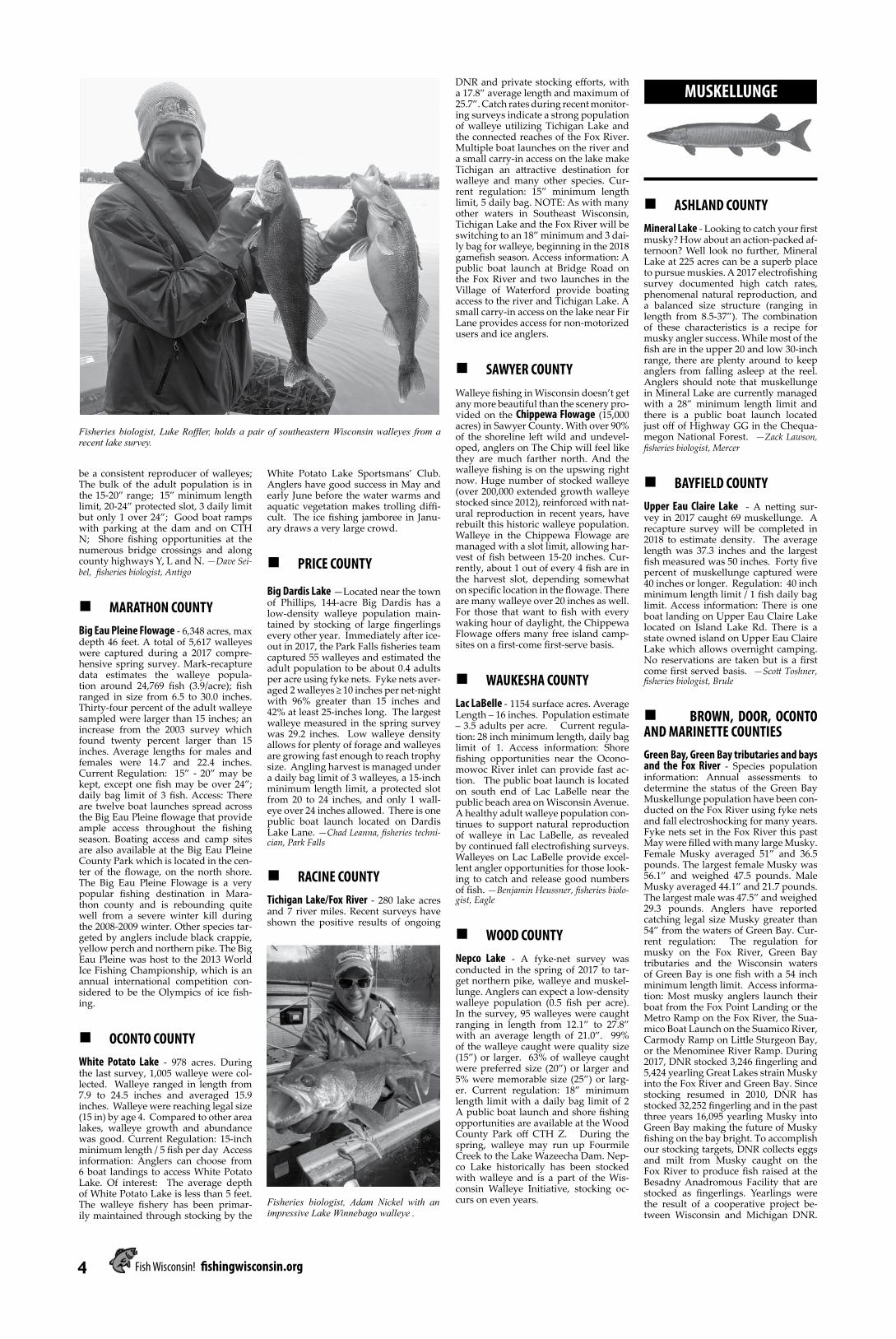
Chad Leanna, fisheries technician with two nice walleyes from Big Dardis Lake, Price County. Photo: Jeff Scheirer
4 Fish Wisconsin! fishingwisconsin.org
be a consistent reproducer of walleyes; The bulk of the adult population is in the 15-20” range; 15” minimum length limit, 20-24” protected slot, 3 daily limit but only 1 over 24”; Good boat ramps with parking at the dam and on CTH N; Shore fishing opportunities at the numerous bridge crossings and along county highways Y, L and N. —Dave Sei-bel, fisheries biologist, Antigo
n MARATHON COUNTYBig Eau Pleine Flowage - 6,348 acres, max depth 46 feet. A total of 5,617 walleyes were captured during a 2017 compre-hensive spring survey. Mark-recapture data estimates the walleye popula-tion around 24,769 fish (3.9/acre); fish ranged in size from 6.5 to 30.0 inches. Thirty-four percent of the adult walleye sampled were larger than 15 inches; an increase from the 2003 survey which found twenty percent larger than 15 inches. Average lengths for males and females were 14.7 and 22.4 inches. Current Regulation: 15” - 20” may be kept, except one fish may be over 24”; daily bag limit of 3 fish. Access: There are twelve boat launches spread across the Big Eau Pleine flowage that provide ample access throughout the fishing season. Boating access and camp sites are also available at the Big Eau Pleine County Park which is located in the cen-ter of the flowage, on the north shore. The Big Eau Pleine Flowage is a very popular fishing destination in Mara-thon county and is rebounding quite well from a severe winter kill during the 2008-2009 winter. Other species tar-geted by anglers include black crappie, yellow perch and northern pike. The Big Eau Pleine was host to the 2013 World Ice Fishing Championship, which is an annual international competition con-sidered to be the Olympics of ice fish-ing.
n OCONTO COUNTYWhite Potato Lake - 978 acres. During the last survey, 1,005 walleye were col-lected. Walleye ranged in length from 7.9 to 24.5 inches and averaged 15.9 inches. Walleye were reaching legal size (15 in) by age 4. Compared to other area lakes, walleye growth and abundance was good. Current Regulation: 15-inch minimum length / 5 fish per day Access information: Anglers can choose from 6 boat landings to access White Potato Lake. Of interest: The average depth of White Potato Lake is less than 5 feet. The walleye fishery has been primar-ily maintained through stocking by the
MUSKELLUNGE
White Potato Lake Sportsmans’ Club. Anglers have good success in May and early June before the water warms and aquatic vegetation makes trolling diffi-cult. The ice fishing jamboree in Janu-ary draws a very large crowd.
n PRICE COUNTY
Big Dardis Lake —Located near the town of Phillips, 144-acre Big Dardis has a low-density walleye population main-tained by stocking of large fingerlings every other year. Immediately after ice-out in 2017, the Park Falls fisheries team captured 55 walleyes and estimated the adult population to be about 0.4 adults per acre using fyke nets. Fyke nets aver-aged 2 walleyes ≥ 10 inches per net-night with 96% greater than 15 inches and 42% at least 25-inches long. The largest walleye measured in the spring survey was 29.2 inches. Low walleye density allows for plenty of forage and walleyes are growing fast enough to reach trophy size. Angling harvest is managed under a daily bag limit of 3 walleyes, a 15-inch minimum length limit, a protected slot from 20 to 24 inches, and only 1 wall-eye over 24 inches allowed. There is one public boat launch located on Dardis Lake Lane. —Chad Leanna, fisheries techni-cian, Park Falls
n RACINE COUNTYTichigan Lake/Fox River - 280 lake acres and 7 river miles. Recent surveys have shown the positive results of ongoing
DNR and private stocking efforts, with a 17.8” average length and maximum of 25.7”. Catch rates during recent monitor-ing surveys indicate a strong population of walleye utilizing Tichigan Lake and the connected reaches of the Fox River. Multiple boat launches on the river and a small carry-in access on the lake make Tichigan an attractive destination for walleye and many other species. Cur-rent regulation: 15” minimum length limit, 5 daily bag. NOTE: As with many other waters in Southeast Wisconsin, Tichigan Lake and the Fox River will be switching to an 18” minimum and 3 dai-ly bag for walleye, beginning in the 2018 gamefish season. Access information: A public boat launch at Bridge Road on the Fox River and two launches in the Village of Waterford provide boating access to the river and Tichigan Lake. A small carry-in access on the lake near Fir Lane provides access for non-motorized users and ice anglers.
n SAWYER COUNTYWalleye fishing in Wisconsin doesn’t get any more beautiful than the scenery pro-vided on the Chippewa Flowage (15,000 acres) in Sawyer County. With over 90% of the shoreline left wild and undevel-oped, anglers on The Chip will feel like they are much farther north. And the walleye fishing is on the upswing right now. Huge number of stocked walleye (over 200,000 extended growth walleye stocked since 2012), reinforced with nat-ural reproduction in recent years, have rebuilt this historic walleye population. Walleye in the Chippewa Flowage are managed with a slot limit, allowing har-vest of fish between 15-20 inches. Cur-rently, about 1 out of every 4 fish are in the harvest slot, depending somewhat on specific location in the flowage. There are many walleye over 20 inches as well. For those that want to fish with every waking hour of daylight, the Chippewa Flowage offers many free island camp-sites on a first-come first-serve basis.
n WAUKESHA COUNTYLac LaBelle - 1154 surface acres. Average Length – 16 inches. Population estimate – 3.5 adults per acre. Current regula-tion: 28 inch minimum length, daily bag limit of 1. Access information: Shore fishing opportunities near the Ocono-mowoc River inlet can provide fast ac-tion. The public boat launch is located on south end of Lac LaBelle near the public beach area on Wisconsin Avenue. A healthy adult walleye population con-tinues to support natural reproduction of walleye in Lac LaBelle, as revealed by continued fall electrofishing surveys. Walleyes on Lac LaBelle provide excel-lent angler opportunities for those look-ing to catch and release good numbers of fish. —Benjamin Heussner, fisheries biolo-gist, Eagle
n WOOD COUNTYNepco Lake - A fyke-net survey was conducted in the spring of 2017 to tar-get northern pike, walleye and muskel-lunge. Anglers can expect a low-density walleye population (0.5 fish per acre). In the survey, 95 walleyes were caught ranging in length from 12.1” to 27.8” with an average length of 21.0”. 99% of the walleye caught were quality size (15”) or larger. 63% of walleye caught were preferred size (20”) or larger and 5% were memorable size (25”) or larg-er. Current regulation: 18” minimum length limit with a daily bag limit of 2 A public boat launch and shore fishing opportunities are available at the Wood County Park off CTH Z. During the spring, walleye may run up Fourmile Creek to the Lake Wazeecha Dam. Nep-co Lake historically has been stocked with walleye and is a part of the Wis-consin Walleye Initiative, stocking oc-curs on even years.
n ASHLAND COUNTY Mineral Lake - Looking to catch your first musky? How about an action-packed af-ternoon? Well look no further, Mineral Lake at 225 acres can be a superb place to pursue muskies. A 2017 electrofishing survey documented high catch rates, phenomenal natural reproduction, and a balanced size structure (ranging in length from 8.5-37”). The combination of these characteristics is a recipe for musky angler success. While most of the fish are in the upper 20 and low 30-inch range, there are plenty around to keep anglers from falling asleep at the reel. Anglers should note that muskellunge in Mineral Lake are currently managed with a 28” minimum length limit and there is a public boat launch located just off of Highway GG in the Chequa-megon National Forest. —Zack Lawson, fisheries biologist, Mercer
n BAYFIELD COUNTY Upper Eau Claire Lake - A netting sur-vey in 2017 caught 69 muskellunge. A recapture survey will be completed in 2018 to estimate density. The average length was 37.3 inches and the largest fish measured was 50 inches. Forty five percent of muskellunge captured were 40 inches or longer. Regulation: 40 inch minimum length limit / 1 fish daily bag limit. Access information: There is one boat landing on Upper Eau Claire Lake located on Island Lake Rd. There is a state owned island on Upper Eau Claire Lake which allows overnight camping. No reservations are taken but is a first come first served basis. —Scott Toshner, fisheries biologist, Brule
n BROWN, DOOR, OCONTO AND MARINETTE COUNTIESGreen Bay, Green Bay tributaries and bays and the Fox River - Species population information: Annual assessments to determine the status of the Green Bay Muskellunge population have been con-ducted on the Fox River using fyke nets and fall electroshocking for many years. Fyke nets set in the Fox River this past May were filled with many large Musky. Female Musky averaged 51” and 36.5 pounds. The largest female Musky was 56.1” and weighed 47.5 pounds. Male Musky averaged 44.1” and 21.7 pounds. The largest male was 47.5” and weighed 29.3 pounds. Anglers have reported catching legal size Musky greater than 54” from the waters of Green Bay. Cur-rent regulation: The regulation for musky on the Fox River, Green Bay tributaries and the Wisconsin waters of Green Bay is one fish with a 54 inch minimum length limit. Access informa-tion: Most musky anglers launch their boat from the Fox Point Landing or the Metro Ramp on the Fox River, the Sua-mico Boat Launch on the Suamico River, Carmody Ramp on Little Sturgeon Bay, or the Menominee River Ramp. During 2017, DNR stocked 3,246 fingerling and 5,424 yearling Great Lakes strain Musky into the Fox River and Green Bay. Since stocking resumed in 2010, DNR has stocked 32,252 fingerling and in the past three years 16,095 yearling Musky into Green Bay making the future of Musky fishing on the bay bright. To accomplish our stocking targets, DNR collects eggs and milt from Musky caught on the Fox River to produce fish raised at the Besadny Anadromous Facility that are stocked as fingerlings. Yearlings were the result of a cooperative project be-tween Wisconsin and Michigan DNR.
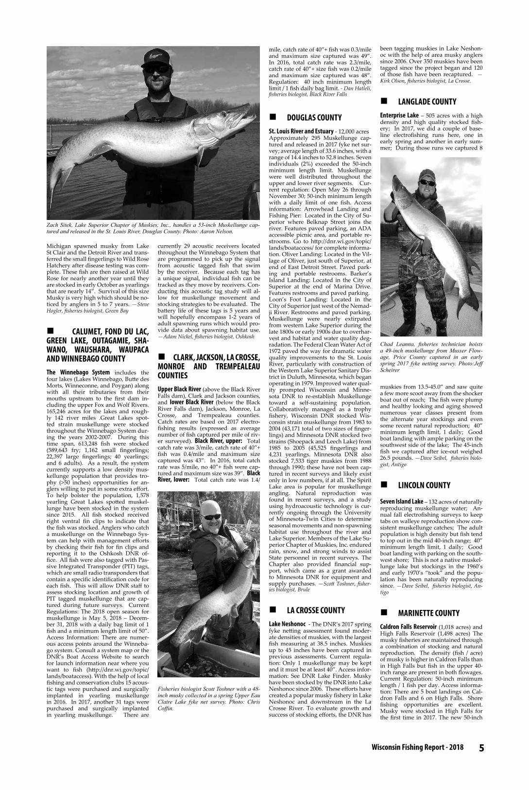
Fisheries biologist, Luke Roffler, holds a pair of southeastern Wisconsin walleyes from a recent lake survey.
Fisheries biologist, Adam Nickel with an impressive Lake Winnebago walleye .
5 Wisconsin Fishing Report - 2018
Michigan spawned musky from Lake St Clair and the Detroit River and trans-ferred the small fingerlings to Wild Rose Hatchery after disease testing was com-plete. These fish are then raised at Wild Rose for nearly another year until they are stocked in early October as yearlings that are nearly 14”. Survival of this size Musky is very high which should be no-ticed by anglers in 5 to 7 years. —Steve Hogler, fisheries biologist, Green Bay
n CALUMET, FOND DU LAC, GREEN LAKE, OUTAGAMIE, SHA-WANO, WAUSHARA, WAUPACA AND WINNEBAGO COUNTYThe Winnebago System includes the four lakes (Lakes Winnebago, Butte des Morts, Winneconne, and Poygan) along with all their tributaries from their mouths upstream to the first dam in-cluding the upper Fox and Wolf Rivers. 165,246 acres for the lakes and rough-ly 142 river miles .Great Lakes spot-ted strain muskellunge were stocked throughout the Winnebago System dur-ing the years 2002-2007. During this time span, 613,248 fish were stocked (589,643 fry; 1,162 small fingerlings; 22,397 large fingerlings; 40 yearlings; and 6 adults). As a result, the system currently supports a low density mus-kellunge population that provides tro-phy (>50 inches) opportunities for an-glers willing to put in some extra effort. To help bolster the population, 1,578 yearling Great Lakes spotted muskel-lunge have been stocked in the system since 2015. All fish stocked received right ventral fin clips to indicate that the fish was stocked. Anglers who catch a muskellunge on the Winnebago Sys-tem can help with management efforts by checking their fish for fin clips and reporting it to the Oshkosh DNR of-fice. All fish were also tagged with Pas-sive Integrated Transponder (PIT) tags, which are small radio transponders that contain a specific identification code for each fish. This will allow DNR staff to assess stocking location and growth of PIT tagged muskellunge that are cap-tured during future surveys. Current Regulations: The 2018 open season for muskellunge is May 5, 2018 – Decem-ber 31, 2018 with a daily bag limit of 1 fish and a minimum length limit of 50”. Access Information: There are numer-ous access points around the Winneba-go system. Consult a system map or the DNR’s Boat Access Website to search for launch information near where you want to fish (http://dnr.wi.gov/topic/lands/boataccess). With the help of local fishing and conservation clubs 15 acous-tic tags were purchased and surgically implanted in yearling muskellunge in 2016. In 2017, another 31 tags were purchased and surgically implanted in yearling muskellunge. There are
currently 29 acoustic receivers located throughout the Winnebago System that are programmed to pick up the signal from acoustic tagged fish that swim by the receiver. Because each tag has a unique signal, individual fish can be tracked as they move by receivers. Con-ducting this acoustic tag study will al-low for muskellunge movement and stocking strategies to be evaluated. The battery life of these tags is 5 years and will hopefully encompass 1-2 years of adult spawning runs which would pro-vide data about spawning habitat use. —Adam Nickel, fisheries biologist, Oshkosh
n CLARK, JACKSON, LA CROSSE, MONROE AND TREMPEALEAU COUNTIESUpper Black River (above the Black River Falls dam), Clark and Jackson counties, and lower Black River (below the Black River Falls dam), Jackson, Monroe, La Crosse, and Trempealeau counties. Catch rates are based on 2017 electro-fishing results (expressed as average number of fish captured per mile of riv-er surveyed). Black River, upper: Total catch rate was 3/mile, catch rate of 40”+ fish was 0.4/mile and maximum size captured was 43”. In 2016, total catch rate was 5/mile, no 40”+ fish were cap-tured and maximum size was 39”. Black River, lower: Total catch rate was 1.4/
mile, catch rate of 40”+ fish was 0.3/mile and maximum size captured was 49”. In 2016, total catch rate was 2.3/mile, catch rate of 40”+ size fish was 0.2/mile and maximum size captured was 48”. Regulation: 40 inch minimum length limit / 1 fish daily bag limit. - Dan Hatleli, fisheries biologist, Black River Falls
n DOUGLAS COUNTYSt. Louis River and Estuary - 12,000 acresApproximately 295 Muskellunge cap-tured and released in 2017 fyke net sur-vey; average length of 33.6 inches, with a range of 14.4 inches to 52.8 inches. Seven individuals (2%) exceeded the 50-inch minimum length limit. Muskellunge were well distributed throughout the upper and lower river segments. Cur-rent regulation: Open May 26 through November 30; 50-inch minimum length with a daily limit of one fish. Access information: Arrowhead Landing and Fishing Pier: Located in the City of Su-perior where Belknap Street joins the river. Features paved parking, an ADA accessible picnic area, and portable re-strooms. Go to http://dnr.wi.gov/topic/lands/boataccess/ for complete informa-tion. Oliver Landing: Located in the Vil-lage of Oliver, just south of Superior, at end of East Detroit Street. Paved park-ing and portable restrooms. Barker’s Island Landing: Located in the City of Superior at the end of Marina Drive. Features restrooms and paved parking. Loon’s Foot Landing: Located in the City of Superior just west of the Nemad-ji River. Restrooms and paved parking. Muskellunge were nearly extirpated from western Lake Superior during the late 1800s or early 1900s due to overhar-vest and habitat and water quality deg-radation. The Federal Clean Water Act of 1972 paved the way for dramatic water quality improvements to the St. Louis River, particularly with construction of the Western Lake Superior Sanitary Dis-trict in Duluth, Minnesota, which began operating in 1979. Improved water qual-ity prompted Wisconsin and Minne-sota DNR to re-establish Muskellunge toward a self-sustaining population. Collaboratively managed as a trophy fishery, Wisconsin DNR stocked Wis-consin strain muskellunge from 1983 to 2004 (43,171 total of two sizes of finger-lings) and Minnesota DNR stocked two strains (Shoepack and Leech Lake) from 1985 to 2005 (45,525 fingerlings and 4,231 yearlings. Minnesota DNR also stocked 7,533 tiger muskies from 1988 through 1990; these have not been cap-tured in recent surveys and likely exist only in low numbers, if at all. The Spirit Lake area is popular for muskellunge angling. Natural reproduction was found in recent surveys, and a study using hydroacoustic technology is cur-rently ongoing through the University of Minnesota-Twin Cities to determine seasonal movements and non-spawning habitat use throughout the river and Lake Superior. Members of the Lake Su-perior Chapter of Muskies, Inc. endured rain, snow, and strong winds to assist State personnel in recent surveys. The Chapter also provided financial sup-port, which came as a grant awarded to Minnesota DNR for equipment and supply purchases. —Scott Toshner, fisher-ies biologist, Brule
n LA CROSSE COUNTYLake Neshonoc - The DNR’s 2017 spring fyke netting assessment found moder-ate densities of muskies, with the largest fish measuring at 38.5 inches. Muskies up to 45 inches have been captured in previous assessments. Current regula-tion: Only 1 muskellunge may be kept and it must be at least 40”. Access infor-mation: See DNR Lake Finder. Musky have been stocked by the DNR into Lake Neshonoc since 2006. These efforts have created a popular musky fishery in Lake Neshonoc and downstream in the La Crosse River. To evaluate growth and success of stocking efforts, the DNR has
been tagging muskies in Lake Neshon-oc with the help of area musky anglers since 2006. Over 350 muskies have been tagged since the project began and 120 of those fish have been recaptured. —Kirk Olson, fisheries biologist, La Crosse.
n LANGLADE COUNTY Enterprise Lake – 505 acres with a high density and high quality stocked fish-ery; In 2017, we did a couple of base-line electrofishing runs here, one in early spring and another in early sum-mer; During those runs we captured 8
muskies from 13.5-45.0” and saw quite a few more scoot away from the shocker boat out of reach; The fish were plump and healthy looking and aging showed numerous year classes present from the alternate year stockings and even some recent natural reproduction; 40” minimum length limit, 1 daily; Good boat landing with ample parking on the southwest side of the lake; The 45-inch fish we captured after ice-out weighed 26.5 pounds. —Dave Seibel, fisheries biolo-gist, Antigo
n LINCOLN COUNTY
Seven Island Lake – 132 acres of naturally reproducing muskellunge water; An-nual fall electrofishing surveys to keep tabs on walleye reproduction show con-sistent muskellunge catches; The adult population is high density but fish tend to top out in the mid 40-inch range; 40” minimum length limit, 1 daily; Good boat landing with parking on the south-west shore; This is not a native muskel-lunge lake but stockings in the 1960’s and early 1970’s “took” and the popu-lation has been naturally reproducing since. —Dave Seibel, fisheries biologist, An-tigo
n MARINETTE COUNTY Caldron Falls Reservoir (1,018 acres) and High Falls Reservoir (1,498 acres) The musky fisheries are maintained through a combination of stocking and natural reproduction. The density (fish / acre) of musky is higher in Caldron Falls than in High Falls but fish in the upper 40-inch range are present in both flowages.Current Regulation: 50-inch minimum length / 1 fish per day. Access informa-tion: There are 5 boat landings on Cal-dron Falls and 6 on High Falls. Shore fishing opportunities are excellent. Musky were stocked in High Falls for the first time in 2017. The new 50-inch
Zach Sitek, Lake Superior Chapter of Muskies, Inc., handles a 53-inch Muskellunge cap-tured and released in the St. Louis River, Douglas County. Photo: Aaron Nelson.
Chad Leanna, fisheries technician hoists a 49-inch muskellunge from Musser Flow-age, Price County captured in an early spring 2017 fyke netting survey. Photo:Jeff Scheirer
Fisheries biologist Scott Toshner with a 48-inch musky collected in a spring Upper Eau Claire Lake fyke net survey. Photo: Chris Coffin.

6 Fish Wisconsin! fishingwisconsin.org
LARGEMOUTH BASS
minimum length limit will go into effect in 2018.
n PRICE COUNTYMusser Flowage ―563 acres. Spring fyke netting surveys in 2017 showed Musser’s musky population at moder-ate density with good size structure (11% were 42 inches or greater). Spring fyke netting targeting muskies yielded 52 muskies at a capture rate of 0.87 muskies per net-night with size rang-ing from 16 - 49.9 inches. Early spring fyke netting in 2017 targeting walleyes also captured 12 muskies. Four of the muskies handled in the spring were 47 inches or longer. Stocking occurs every other year at a rate of 0.5 fingerlings per acre. This reservoir of the Elk River of-fers ample forage and has a history of producing large muskies. There are two public boat launches and one shore fish-ing pier located near the dam. Musser follows the statewide regulation with a daily bag limit of 1 muskie and a mini-mum length limit of 40 inches. Season opens the last Saturday in May and runs through November 30th. —Chad Leanna, fisheries technician, Park Falls
n SHAWANO COUNTYCloverleaf Chain of Lakes - 316 acres. In 2017, The DNR completed a spring net-ting survey of the Cloverleaf Chain of Lakes. A total of 34 individual muskies were captured during the netting sur-vey. Eight of the 34 muskies were cap-tured twice during the survey resulting in a total of 42 captures. Size structure of the 34 individual muskies captured ranged from 33.3 – 47.4 inches with a mean size of 39.7 inches. Although the Cloverleaf Chain of Lakes is a very small waterbody and is classified as a Class B musky fishery, it still supports a moder-ate density of muskies (i.e., 0.22 muskies per acre during the last population esti-mate in 2013-2014) and has the potential to grow some very large muskies. Dur-ing the 2017 survey, 13 muskies over 40 inches were captured with the largest at nearly 47.5 inches. Current Regulation: Daily bag limit of 1 muskellunge with a minimum length limit of 40 inches. Ac-cess information: A public boat access is located on the west side of Grass Lake off CTY HWY Y and a fishing pier/ca-noe access is located on the north side of Round Lake off Cloverleaf Lake Rd. The Cloverleaf Chain of Lakes is one of the lakes being stocked with large fin-gerling walleyes in odd years as part of the Wisconsin Walleye Initiative. This should give anglers additional opportu-nities for a great day of fishing. —Jason-Breeggemann, fisheries biologist, Shawano
n SHEBOYGAN COUNTY Random Lake - 209 acres. During 2017 spring fyke netting surveys a total of 51 muskellunge were captured. The mark and recapture samples yielded an adult muskellunge population estimate of 0.6/acre. This density is considered above average when compared to other sur-veys statewide. Lengths ranged from 26.5 to 44 inches with an average length of 34.5 inches. While trophy potential is limited, Random Lake offers excel-lent musky action. Current regulation: 40 inch minimum length limit and 1 fish daily bag. Access information: There is a public boat launch and shorefishing op-portunity at Lake View Park, Random Lake, WI.
n WAUKESHA COUNTYPewaukee Lake - 2437 surface acres. Av-erage length – 34 inches, population es-timate – 0.62 adults per acre. Current regulation: 40 inch minimum length, daily bag limit of 1. Access information: There are two boat launches found on Pewaukee Lake; the county park launch on the west side and Smokey’s Muskie Shop on the east side. Pewaukee Lake is home to the largest musky density in southeastern Wisconsin. Not only do the muskies in Pewaukee boast an aver-age size of 34 inches, anglers annually catch a few fish over 50 inches. Abun-dant yellow perch, black crappie and bluegills make up an excellent forage base for this thriving musky popula-tion. —Benjamin Heussner, fisheries biolo-gist, Eagle
n WOOD COUNTYNepco Lake - 496 acres. A fyke-net survey was conducted in the spring of 2017 to target northern pike and muskellunge. Anglers can expect a low-density mus-kellunge population. Ten muskellunge were caught during the survey ranging in length from 19.7” to 47.1” with an av-erage length of 36.7”. The 47.1” fish was a female that weighed 27 lbs. The next largest fish were 40.9” and 45.1” males. Current regulation: 40” minimum length limit with a daily bag limit of 1. Catch and Release is promoted to get this fishery established. A public boat launch and shore fishing opportunities are available at the Wood County Park off CTH Z. The Consolidated Musky Club of Wisconsin Rapids has been working with the Department to stock muskellunge into Nepco Lake at a low stocking rate, every other year. Fish have been marked in some way with either a fin clip or inserted with a Pas-sive Integrated Transponder (PIT) tag.
There is ample prey in Nepco Lake for muskellunge. —Jen Bergman, fisheries bi-ologist, Wisconsin Rapids
n VILAS COUNTYBig Arbor Vitae - 1070 acres. A mark and recapture survey completed in spring of 2017 estimated a density of 0.22 adult muskellunge per acre. During the sur-vey 31 fish 40+ inches were captured with the largest being a 49.5-inch female. Current regulation: 40 inch minimum length limit, bag 1. There are two public landings with dock and paved parking - one on the north side of the lake off Buckhorn Rd., the other off from Hwy 70 on the southeast side. There is also an unimproved gravel landing off Arbor Vitae Dr. on the south side of the lake with parking for several rigs. Big Arbor Vitae Lake also sports a nice largemouth bass fishery with several 19” fish having been recorded in DNR surveys. —Hadley Boehm, fisheries biologist, Woodruff
n BAYFIELD AND DOUGLAS COUNTIESBayfield County: Owen, Upper Eau Claire, Middle Eau Claire, Lower Eau Claire, Atkins, Jackson, Namekagon and Diamond Lakes. Douglas County: Bond, Upper St. Croix and Whitefish Lakes.
Largemouth bass populations are gen-erally increasing across Douglas and Bayfield counties. Special regulations have been implemented on the above waters to allow for a largemouth bass consumption opportunity for anglers. Along with the change to largemouth bass being open to harvest on the regu-lar gamefishing season opener, anglers have increased opportunities to har-vest largemouth bass on these lakes. These same lakes also have an 18 inch minimum length limit for smallmouth bass and 1 smallmouth bass/day bag limit. The smallmouth bass regulation is intended to provide a quality fish-ing opportunity for anglers. Current regulation: No minimum length for largemouth bass. Smallmouth bass have a minimum length of 18 inches with 1 smallmouth bass/day. Combined bag limit of 5 fish/day for bass. Several of the lakes included above are a part of a DNR study regarding bass and walleye populations.
n BUFFALO COUNTYMississippi River – Pool 5. The 2017 fall electrofishing survey showed good numbers above and below the 14-inch length limit. Overall, nearly 81 adult and juvenile largemouth bass were cap-tured per hour. Forty eight percent of surveyed largemouth bass were greater than 12 inches, while one in three large-mouth were greater than the 14-inch length limit. Surveyed fish topped out just shy of 19 inches. Current regulation: 14-inch minimum length; 5 in total with smallmouth bass. Access information: Check DNR website for access locations. Interesting info: The population of largemouth bass has been trending up-ward for many years. Our 2017 survey showed another good year for survival of young largemouth bass and signals good fishing into the foreseeable future.
n CRAWFORD AND GRANT COUNTIESMississippi River Pool 10 - 20,617 acres and 34 miles of open water. The Wiscon-sin Department of Natural Resources surveyed backwater lakes, sloughs, and side channels in October and November 2017 near Prairie du Chien, to determine the health of the game fishery. Catch-per-unit effort for largemouth bass was at 27 fish per hour and size ranged from 5.1 to 20.0 inches. The average size for largemouth bass was 11 inches. Larger bass in the 4 to 5-pound range are not uncommon and each year a handful of 6-pound-plus fish are caught by tourna-ment anglers. Current regulation: Con-tinuous Open Season, 14” minimum length with a 5-fish daily bag limit. There are many boat and shore fishing access locations along the Mississippi River. The waters of Pool 10 are part of the Upper Mississippi River Wildlife and FishRefuge. The refuge is located in four states: Minnesota, Wisconsin, Iowa and Illinois along the Mississippi River and was established in in 1924 as a refuge for fish, wildlife and plants. The refuge encompasses one of the largest blocks of floodplain habitat in the lower 48 states. Bordered by steep wooded bluffs the Mississippi River corridor and refuge offer scenic beauty and produc-tive fish and wildlife habitat unmatched in the heart of America. The refuge cov-ers just over 240,000 acres and extends 261 river miles from north to south at the confluence of the Chippewa River in Wisconsin to near Rock Island, Illinois and has been designated as a Wetland of International Importance (Ramsar) and a Globally Important Bird Area.
n IRON COUNTYNorth Bass Lake. Conveniently located close to town with a paved boat launch and ample parking, North Bass offers anglers 194 acres of completely undevel-oped northern Wisconsin water which is home to an impressive largemouth bass population. A 2017 netting survey sampled 137 largemouth at a high rate of 9.7/net-night ranging in length from 8.6-18.9”. Relatively high densities cre-ate an opportunity for consistent action, but the quality size structure also pro-vides potential for getting the camera out.
Chad Leanna and Kendal Patrie, fishery technicians, with 48- and 49-inch muskellunge from Musser Flowage, Price County captured in an early spring 2017 fyke netting survey. Photo: Jeff Scheirer
Kendal Patrie, fishery technician with a ro-bust 21-inch largemouth bass from Fireside Lakes, Rusk County captured in an early spring 2017 fyke netting survey. Photo: Jeff Scheirer

7 Wisconsin Fishing Report - 2018
n JACKSON AND TREMPEALE-AU COUNTIESBuckhorn Lake (24 acres), Emerald Lake (26 acres), and White Creek Flowage (140 acres), Jackson County; Lake Henry (40 acres), Trempealeau County. Species Population Information: based on 2017 electrofishing surveys and catch rates expressed as average number of fish captured per mile of shoreline (#/mile).Buckhorn Lake: Total catch rate was 11/mile, catch rate of 14”+ fish was 7/mile, catch rate of 18”+ fish was 2/mile, and maximum size captured was 20”. The last comparable survey was conducted in 2009. Total catch rate was 11/mile, catch rate of 14”+ fish was 6.5/mile, catch rate of 18”+ fish was 1.7/mile, and maxi-mum size captured was 19”. Emerald Lake: Total catch rate was 10/mile, catch rate of 14”+ fish was 3.1/mile, catch rate of 18”+ fish was 1.3/mile, and maximum size captured was 19”. The last com-parable survey was conducted in2009. Total catch rate was 6/mile, catch rate of 14”+ fish was 2.7/mile, catch rate of 18”+ fish was 1/mile, and maximum size captured was 18”. White Creek Flowage: Total catch rate was 2.7/mile, catch rate of 14”+ fish was 1.8/mile, catch rate of 18”+ fish was 0.9/mile, and maximum size captured was 19”. No past survey information was available for compari-son. Lake Henry: Total catch rate was 12/mile, catch rate of 14”+ fish was 6.7/mile, no fish larger than 18” were cap-tured, and maximum size captured was 17”. The last comparable survey was conducted in 2002. Total catch rate was 15.6/mile and no fish larger than 14” were captured. Maximum size cap-tured was 11”. Regulation: 14 inch min-imum length limit/5 fish daily bag limit. Access Information: Buckhorn Lake has two boat landings (southwest – GPS 44.40687N, -90.74107W, and southeast – GPS 44.40777N, -90.73801W). Em-erald Lake has a carry-in access on the west side (GPS 44.40354N, -90.75592W). White Creek Flowage has a boat landing on the southwest side (GPS – 44.36986N, -90.53807W). Lake Henry has a boat landing on the south side of the lake (GPS – 44.29881N, -91.22828W) and a fishing pier located on the north side of the lake (GPS – 44.30001N, -91.23005W).
n LA CROSSE, TREMPEALEAU AND VERNON COUNTIESMississippi River, Pools 7 and 8 and up-per 9, ― 53,850 acres. Largemouth bass fishing on the Mississippi River near La Crosse is well known. There are profes-sional bass tournaments every summer weekend, and some very large tourna-ments are scheduled every year. Since the late 1990’s, this fishes’ numbers have doubled on this large river. Large-mouth bass numbers sampled in pools 7, 8 and upper 9 during the fall of 2017 from Trempealeau, WI downstream to Lansing, IA showed steady or improved numbers. In the reach of Pool 8 from La Crescent, MN downstream to Lawrence Lake, 2017 bass numbers remained the same when last sampled in 2013. Aver-age size increased over 3 inches since 2013 to 8.4 inches and nine percent were over 14 inches. In the Trempealeau Lakes area, largemouth bass numbers increased three-fold since 2013. Aver-age bass size remained the same as 2013 (8.6 inches) and ten percent were over 14 inches in 2017. In the Lansing area four percent of largemouth bass were over 14 inches and the average size was 6.8 inches. On Wisconsin waters of the Mississippi River, five total bass at least 14 inches can be kept daily. The season is continuous. Access information: The best way to find a boat landing is to go to the DNR’s Boat and Shore Fish-ing Access Website to search for access information http://dnr.wi.gov/topic/lands/boataccess/ or the US Fish and Wildlife Service website and download the pool maps https://www.fws.gov/refuge/Upper_Mississippi_River/map.html. Increasingly, river municipalities are charging boat access fees.
n LANGLADE COUNTYRabe Lake – Help us eradicate large-mouth bass from this 6-acre, naturally reproducing brook trout spring pond; No length limit and daily bag of 5 fish; Harvest season opens the first Saturday in May and ends on October 15 with the trout season; Please help out the brook-ies and target bass for removal here. They are great tasting from this cool spring water! Boat ramp with parking
Stocked trout lakes managed for put-and-take trout: Crooked Lake, Pence Lake, Rogers Lake, and Townline Lake; 5 daily and no length limit; Help us make these stocked trout lakes the best they can be by targeting and removing the trout eating largemouth bass!
n LINCOLN COUNTYStocked trout lakes managed for put-and-take trout: Ament Lake, Henson Lake, Larson Lake, Moraine Lake, and Tahoe Lake; 5 daily and no length limit; Help us make these stocked trout lakes the best they can be by targeting and removing the trout eating largemouth bass!
n OCONTO COUNTY Reservoir Pond - 417 acres. Previous sur-veys showed that Reservoir Pond has a respectable largemouth bass popula-tion. The average length of bass col-lected during the last survey was 14 inches and fish up to 20 inches were collected. Sixty percent of largemouth bass collected were over the 14-in mini-mum length limit. Since Reservoir Pond is relatively shallow (average depth = 5 ft.) and there is a lot of aquatic vegeta-tion and flooded timber, bass can hide and feed just about anywhere around the lake. Current regulation: 14-inch
minimum / 5 fish per day. Access infor-mation: There are 2 well developed boat landings and several undeveloped ac-cess points available for smaller boats/canoes. There is no early catch-and-release season for largemouth bass on Reservoir Pond even though it is within the northern bass zone. Anglers can ac-cess Horn Lake, Little Horn Lake and Explosion Lake from Reservoir Pond.
n PIERCE AND ST. CROIX COUN-TIESLake George- 135 acres. Also known as Spring Valley Reservoir, it is located on the St. Croix/Pierce County border. It is surrounded by the Eau Galle Recre-ational Area. Largemouth bass numbers
are moderate at 1.5 per acre, but bass can be found up to 20 inches. Twenty five percent of the largemouth bass sam-pled in 2017 were 14 inches or greater. Lake George follows general inland wa-ters fishing regulations. The recreational area has an improved boat landing in the main day use area with an ADA ac-cessible fishing pier and an unimproved landing in the northwest day use area for carry-in boat access. Boating is lim-ited to non-gasoline powered boats.
n POLK COUNTYLoveless Lake - 141 acres. Loveless Lake has an abundant largemouth bass pop-ulation with good size structure. The catch rate of largemouth bass was high (84.4 fish/mile) during a recent electro-fishing survey. However, unlike most small lakes with high largemouth bass catch rates, the size structure of was also good, as 53% of the bass handled were 14 inches or larger, with the largest bass pushing 20 inches. Current regulation: The largemouth bass fishery in Love-less Lake is managed with the statewide 14 inch minimum length limit and five fish daily bag limit. Access informa-tion: There is one boat landing on the south end of Loveless Lake near 160th St. Loveless Lake is a small lake with sharp-breaking shorelines. Anglers will also find respectable populations of oth-er popular sportfish species.
Pipe Lake - 293 acres. Pipe Lake has an abundant largemouth bass population with low size structure, making it an excellent option for the harvest-mind-ed bass angler or anyone interested in fast angling action. A recent fisheries survey found a largemouth bass adult population density of 10.1 fish/acre, which is considered very high. With the high abundance, the size structure and growth rates of largemouth bass are poor. Most bass are between 10-14 inches and few fish are over 14 inches, but since Pipe Lake has a no minimum length limit and five fish daily bag limit, anglers are able (and encouraged) to harvest bass less than 14 inches. In-creasing the harvest of small (<14 inch) bass should increase the size structure of the population. Access information: There is one boat landing on Pipe Lake located on the north end of the lake off 220th Ave. Pipe Lake is considered a seepage lake and has excellent water quality.
n RUSK COUNTYFireside Lakes —302 acres. Rice and Mud Lakes make up the two-lake chain known as Fireside Lakes. In a late spring 2017 electrofishing survey DNR crews captured 19 largemouth bass per shoreline mile. At moderately high abundance the largemouth bass popu-lation showed good size structure (46% were 14 inches or longer). The largest largemouth bass we handled during our 2017 Fireside lakes survey was an impressive 21.6 incher that we cap-tured during early spring fyke netting. Fireside Lakes are in the southern bass zone and the current harvest regulation is five largemouth bass or smallmouth bass in combination may be kept and they must be at least 14 inches. A public boat landing with space for parking is located on the eastern end of the lake off Indian Point Road. —Chad Leanna, fishery technician, Park Falls
n SAWYER COUNTYNelson Lake (2,716 acres) in Sawyer County has historically been known as a lake with potential to catch a big large-mouth bass. After a period of time when largemouth bass size declined, the big bass are starting to return. A 2017 sur-vey found that there are currently 44% more bass over 14 inches than 5 years ago. There’s also more habitat to fish for bass. In the last 6 years, the Nelson Lake Association has added over 1,000 trees to the lake to serve as fish habitat near shore. There are two public boat ramps on Nelson Lake, one off of Dam Road and on off of Gerlach Road.
n WALWORTH COUNTYLake Geneva - 5401 acres. Recent bass surveys on Lake Geneva have produced very good catch rates and size structure, including a 14.3” average length and 21.5” maximum length. Anglers are re-porting excellent fishing days, particu-larly in the fall. Current regulation: 14” minimum length limit, 5 daily bag. Ac-cess information: Six public boat launch-es are available on Geneva: Lake Street in Fontana (west side), E Geneva Street in Williams Bay (north side), Chapin Road (north side – no parking), Wrigley Drive in Lake Geneva (northeast side), Hillside Road (southeast side) and Linn
Fisheries technician Evan Sniadajewski with an 18-inch largemouth bass from Nel-son Lake in Sawyer County.
Fisheries technician Matt Anchor holds a 20.3-inch largemouth bass sampled on the Mount Morris chain of lakes, Waushara County.

8 Fish Wisconsin! fishingwisconsin.org
Road (south side). Shorefishing oppor-tunities are available at several parks and municipal fishing piers across the lake.
n WAUKESHA COUNTYPewaukee Lake - 2437 surface acres. Spe-cies population information: Average length – 13 inches with average abun-dance and excellent trophy potential. Current regulation: 14 inch minimum length, daily bag limit of 5. Access in-formation: There are two boat launches found on Pewaukee Lake; Nagawau-kee County Park launch on the west side and Smokey’s Muskie Shop on the east side. Pewaukee Lake has excellent largemouth bass size structure with top tournament creels averaging greater than 4 lbs. per fish.
Eagle Spring Lake - 270 surface acres. Species population information: Aver-age length – 9 inches. Current regula-tion: No minimum length limit - large-mouth bass and smallmouth bass from 14 inches to 18 inches may not be kept, and only 1 fish over 18 inches is allowed. The daily bag limit is 5. Access informa-tion: The public launch is located on the lakes’ east side off of county Highway E, near Eagle Spring Pub. This lake has an abundant population of largemouth so anglers are encouraged to harvest bass less than 14” to help reduce the popula-tion improve growth rates.
n WAUPACA COUNTY
Brekk/Brekke Lake - 45 acres. Large-mouth bass population information: In 2017, The DNR completed a spring electrofishing survey of Brekke Lake. A total of 1.14 miles of shoreline were electrofished. Ninety largemouth bass were captured, resulting in a CPUE of 78.95 largemouth bass per mile of shore-line electrofished. Largemouth bass cap-tured during the electrofishing survey ranged in size from 3.9 to 18.9 inches with an average length of 9.3 inches. There should be plenty of largemouth bass action with a density this high as well as the opportunity to catch a large-mouth bass over 18 inches. Current Regulation: 2017: Only largemouth bass or smallmouth bass less than 14” may be kept, except one fish may be over 18” with a daily bag limit of 3 in total. 2018 Regulation: Only largemouth or
smallmouth bass less than 14” may be kept, except one fish may be over 18”. Access information: One public boat access is located along the west shore on N Rollofson Lake Rd. Brekke Lake also has a high-density bluegill popula-tion making it a great lake to take a kid fishing if anglers are interested in a lot
of fishing action, although bluegill size structure is on the small side.
n WAUSHARA COUNTYMount Morris Lake - 117-acre flowage made up of a chain of 5 lakes. Species population information: 2017 survey results; relative abundance of just over 43 bass/mile of electrofishing shoreline, mean size of 13.8” with a maximum of 20.5”. Current regulation: 14”Mini-mum, Bag of 5. Access information: 1 developed County Park landing and 1 smaller access on the upper end of the flowage. This lake is popular among lo-cal bass angling clubs.
n ASHLAND AND BAYFIELD COUNTIESChequamegon Bay - Lake Superior. Chequamegon Bay deserves its repu-tation as a trophy smallmouth fishery. Spring surveys have shown the average length of smallmouth to be around 18 inches. Many year-classes contribute to the population and we consistently see fish older than 20 years. Current regu-lation: May 5 through June 15 is catch and release only. From June 16 to March 3 one fish over 22 inches can be kept. Prior to the current regulation, the aver-age length of Chequamegon Bay small-mouth was only 14 inches and most fish were less than 10 years old. The current fishery gives anglers a greater opportu-nity to tangle with trophy fish!
n BARRON COUNTY Silver Lake - 331 acres. Silver Lake has a respectable smallmouth bass fishery. Roughly half of the smallmouth bass handled in a recent survey were 14 inches or larger, with smallmouth over 18 inches present. Current regulation: The Silver Lake smallmouth bass fish-ery is managed with the statewide bass regulation- 14 inch minimum length limit and five fish daily bag limit. There is one public boat landing at Grant County Park on the south end of Silver Lake off CTH B. The park is maintained by Barron County and includes a re-stroom, picnic shelter, volleyball net, and a swimming beach. Smallmouth bass do well in Silver Lake due to the abundance of rock and gravel which are habitats that smallmouth prefer. In ad-dition to smallmouth bass, bass anglers will also find a largemouth bass popula-tion with moderate size structure.
n CLARK, JACKSON, LA CROSSE, MONROE AND TREMPEALEAU COUNTIESUpper Black River (above the Black River Falls dam), Clark and Jackson Counties, and lower Black River (below the Black River Falls dam), Jackson, Monroe, La Crosse, and Trempealeau Counties. Catch rates are based on 2017 electro-fishing results (expressed as average number of fish captured per mile of riv-er surveyed). Black River, upper: Total catch rate was 59/mile, catch rate of 14”+ fish was 14/mile and maximum size captured was 17”. In 2016, total catch rate was 47/mile, catch rate of 14”+ fish was 2/mile and maximum size captured
was 17”. Black River, lower: Total catch rate was 1.1/mile, catch rate of 14”+ fish was 0.3/mile and maximum size cap-tured was 16”. In 2016, total catch rate was 4.2/mile, catch rate of 14”+ size fish was 1/mile and maximum size captured was 20”. Regulation: 14 inch minimum length limit / 5 fish daily bag limit.
n DOOR COUNTYGreen Bay waters. The smallmouth bass fishery along the Green Bay waters of Door County is well known for its out-standing abundance and robust size structure. Although the 2017 creel data are not yet available, smallmouth bass sport fishing catch per effort has recent-ly declined from the high levels experi-enced several years back. Angler catch rates declined in 2016 to 0.56 small-mouth caught per hour fished; falling below the previous 15 year average of 0.67. Fyke netting surveys of the spawn-ing populations in the Sturgeon Bay area in 2015 and 2017 indicate mixed trends in catch per effort (measure of relative abundance) since the previous survey in
2009. Overall, the Door County small-mouth meta-population is in relatively good condition. Continued increase of Lake Michigan water levels should pro-vide more smallmouth spawning and nursery habitat that was lost during the record low levels recorded around 2012-2013. Current regulation: The rules vary
by location and date; anglers should check the smallmouth fishing rules in the Tributary Streams to Green Bay and Lake Michigan and the Lake Michigan sections of the regulation pamphlet for season and harvest rules. Access infor-mation: There are many boat launches in the area including several in Sturgeon Bay and Little Sturgeon Bay; Peninsula State Park is one of the sites that pro-vide access to areas in northern Door County. Anglers can refer to a map of the area for boat launch sites or go to: http://dnr.wi.gov/topic/lands/boatac-cess for a listing of some of the launches in the area. One of the better shore fish-ing sites is the George K. Pinney County Park (formerly the Olde Stone Quarry Park) that is located at the north side of the mouth of Sturgeon Bay. As part of a UW-Stevens Point research proj-ect examining spatial genetic structure of smallmouth bass across Wisconsin, samples were collected in 2017 from eight smallmouth populations around Green Bay and the Lake Michigan shore of Door County. Investigating the re-gional population genetic structure will provide important information that can be used to best inform management in Green Bay and Lake Michigan. Results will be available in 2018.
n DUNN COUNTY The lower Red Cedar River was surveyed in 2017 for 15.1 miles, from below the dam in Menomonie to County Road Y near the confluence with the Chippewa River. Smallmouth bass were the most common gamefish found. Density was low at 6.6 per mile. Lengths up to 23.5 inches were sampled but the major-ity were 6 to 16 inches. The lower Red Cedar can make for an enjoyable fish-ing float trip as there are also walleye, sauger, northern pike, and largemouth bass. Channel catfish up to 23 inches can be found in likely looking holes and snags along the way. Access is by way of boat landings in Menomonie, Dunnville and County Road Y in the Dunnville Wildlife Area. The Red Cedar follows general inland waters regulations. Ob-servation Opportunity: Lake sturgeon can be seen up close in late May below the Menomonie dam on the Red Cedar
River as they cruise the bedrock shelves after spawning. Fishing for lake stur-geon is closed on the Red Cedar River, so take only pictures of these ancient fish.
SMALLMOUTH BASS
Madeline Roberts with a 19.5-inch smallmouth caught out of a canoe on the Namekagon River.
Fisheries biologist Laura Schmidt with a smallmouth bass on Chequamegon Bay.
Fisheries technician Steve Gospodarek holding a 23” largemouth bass captured during fall electrofishing on Pewaukee Lake. Photo: Benjamin Heussner

9 Wisconsin Fishing Report - 2018
NORTHERN PIKE
n GREEN LAKE COUNTYBig Green Lake - 7,346 acres, 236’ max depth. 75% of the lake is >20’ in depth Species population information: 2016 survey information; relative abundance of 12.5/mile of electrofished shoreline, size range of 6”-18.5” with a mean size of 13.2”. Current regulation: 14” Mini-mum, Bag of 5. Access information: There are numerous developed land-
ings located around the lake. Most do require a fee. Most anglers target these fish during pre-spawning periods along the numerous rocky points and bars located in this lake. A few “hardy” an-glers also fish deep water, late into fall, hoping to land a “trophy”.
n IOWA COUNTY Mineral Point Branch - 6.5 miles of small-mouth bass water. The Mineral Point Branch supports a fishable population of smallmouth bass. Recent surveys sampled 65 yearling and adult small-mouth from 4.4 to 15.8 inches with an average adult size of 12.0 inches. Fifty percent of the adult smallmouth were 12 inches or greater. Current Regu-lation: Fourteen inch minimum with a daily bag limit of 5. Access information: The Mineral Point Branch supports just over 6.5 miles of fishable smallmouth bass water. It is currently absent of pub-lic fishing access via stream bank ease-ments. Anglers wishing to fish from shore will have to gain permission from private landowners. The Mineral Point Branch is named after Wisconsin’s third oldest city settled in 1827. The area was a center for lead and zinc mining dur-ing the 1800’s. The Mineral Point Branch also contains a 42-acre impoundment, Ludden Lake, which supports a small fishery of gamefish and panfish. - Bradd Sims, fisheries biologist, Dodgeville
n LANGLADE COUNTY
When targeting smallmouth bass think big water and rocky water. Smallmouth bass prefer boulder and rocky habitat and in Langlade County, the Wolf River has 46 miles of rocks galore. Anywhere downstream from the Post Lake dam east of Elcho all the way downstream to the Menominee County line is prime smallmouth water. Parts of the Wolf River grade to coldwater and are better suited for trout, but warmer stretches hold plenty of smallies. Most fish are in the 10-16” range, but there are smallies up to 20” present. There is a 14” mini-mum length limit and a daily bag limit of 5 bass. Harvest season north of STH 64 starts the third Saturday in June, and south of STH 64 starts the first Saturday in May. Right below the Post Lake dam
there is a county park with a fishing dock and plenty of shore fishing oppor-tunities. This is a popular area. There is also a boat ramp to launch small boats and canoes and kayaks. Throughout the county, the Upper Wolf River Fish-ery Area provides ample public walk-in access to the Wolf River.
n LINCOLN COUNTYIn Lincoln County, the Wisconsin River and its impoundments cut the county in half and provide 50 miles and over 5,000 acres of top-notch brown bass fish-ing opportunities. The Wisconsin River system throughout the county produc-es high density and high size quality populations. The majority of fish are in the 12-18” range, but fish over 20” are caught. There is a 14” minimum length limit and a daily bag limit of 5 bass. Harvest season north of STH 64 starts the third Saturday in June, and south of STH 64 starts the first Saturday in May. The impoundments all have several boat ramps and between state, county, and utility company land, there are plenty of shore fishing opportunities.
n MARINETTE COUNTY Chalk Hills Flowage - 866 acres. Data col-lected in 2016 demonstrated an average length of bass collected was 15 inches and fish up to 20 inches were measured. There are scattered areas of rock and aquatic vegetation that provide good smallmouth bass habitat. Current regulation: 14-inch minimum / 5 fish per day. Access information: Anglers can choose from 4 boat landings from Pemene Falls to the Chalk Hills dam. This section of the Menominee rivers supports diverse habitat with shal-low river water (less than 5 feet) above Chalk Hills. The impoundment has a maximum depth of 30 ft and 80% of the impoundment is greater than 3 ft.
n SAWYER AND WASHBURN COUNTIES Fishing smallmouth in rivers is about as much fun as it gets. Northern Wisconsin offers many great opportunities for river smallmouth fishing, but the Namekagon River in Sawyer and Washburn Counties stands out. There are numerous access points along this stretch of river allow-ing for shore fishing, wading, or fishing from a canoe. There are 18 free campsites scattered along the river maintained by the National Park Service between Hay-ward and Trego if you want to make it an overnight trip. The smallmouth bass fishing in this reach of river is fantastic for both size and numbers. Over half of all smallmouth caught by anglers are 14 inches or longer. Anglers should target large pools below rapids and wood in the water.
n WAUKESHA COUNTYPine Lake - 703 surface acres. Spe-cies population information: Average length – 13 inches. Current regulation: 14” minimum length, daily bag limit of 5. Access information: The public boat launch is located on the north end of the lake off of Hwy K. Rocky substrate, deep drop offs and woody structure provides excellent habitat for smallmouth bass on Pine Lake. Recent fall electrofishing surveys have shown excellent size struc-ture, abundance and trophy potential for smallmouth bass.
n BAYFIELD COUNTYUpper Eau Claire Lake - 1,030 acres. The last fisheries survey revealed a mod-est pike population. In a 2017 netting survey 78 pike were collected; pike av-eraged 19.1 inches and the largest mea-sured 40 inches. 53% of pike collected were 20 inches or greater. Current Regu-lation: no minimum length / 5 fish per day. Access information: There is one boat landing on Upper Eau Claire Lake located on Island Lake Rd. There is a state owned island on Upper Eau Claire Lake which allows overnight camping. No reservations are taken but is a first come first served basis.
n BROWN, DOOR, OCONTO AND MARINETTE COUNTIESGreen Bay and tributaries - The late, wet springs of 2013 and 2014 provided fa-vorable conditions for northern pike spawning. Those two excellent year classes will continue to provide qual-ity size fish in the upper 20-inch range and greater. Because the vast size of the bay reduces competition between top predators and because it hosts an abun-dance of prey fish such as yellow perch, gizzard shad, and round gobies, we do not see stunted populations of pike as is commonly seen in many inland lakes. In winter, using a tip-up with a large shiner or dead smelt fished just off of the bottom in shallow water can work well. Current regulation for Green Bay and major tributaries: Open all year. Daily limit is 5. No minimum length limit. Current regulation for all other Green Bay tributaries: Open 1st Saturday in May to 1st Sunday in March. Daily limit is 5. No minimum length limit. Access information There are numerous boat access and tributary access locations along Green Bay. In early spring, adult northern pike migrate from Green Bay in tributaries and ditches to spawn in shallow wetlands, often travelling doz-ens of miles. Because of this behavior, pike in Green Bay are very susceptible to poor year classes during dry springs. The critical time period for spawning, incubation, hatching, and finally fry mi-gration back to Green Bay is from late March through May.
n BURNETT COUNTYUpper Clam Lake (1,338 acres) and Lower Clam Lake (366 acres). Pike catch during the 2017 survey improved by 64% when compared to the previous survey for Clam Lake. Most of the northern pike sampled were between 20 and 30 inches, but fish were sampled up to 35 inches. Northern pike have likely benefitted from a recent resurgence of aquatic vegetation, which pike utilize for habi-
tat. Current Regulation: no minimum length limit, five fish daily bag limit Ac-cess: There are two boat launches on Upper Clam Lake and one launch on Lower Clam Lake. Upper Clam Lake has one landing on the SE portion of the lake off of Clam Lake Drive and the other landing is on the SW side at the end of Cumberland Point Rd. The launch for Lower Clam Lake is on the N side of Hwy 70. Northern pike are one of six gamefish that are present year-round in Clam Lake. The others being walleye, largemouth bass, smallmouth bass, channel catfish, and lake sturgeon (no season on sturgeon here). There are also many non-game species including: redhorse, sucker, bullhead, bowfin, and minnows.
n CALUMET, FOND DU LAC, GREEN LAKE, OUTAGAMIE, SHA-WANO, WAUSHARA, WAUPACA AND WINNEBAGO COUNTYThe Winnebago System includes the four lakes (Lakes Winnebago, Butte des Morts, Winneconne, and Poygan) along with all their tributaries from their mouths upstream to the first dam in-cluding the upper Fox and Wolf Rivers.165,246 acres for the lakes and roughly 142 river miles. The Winnebago System provides anglers with various northern pike fishing opportunities, particularly for ice fishing on the Upriver Lakes of Lake Poygan, Lake Winneconne, and Lake Butte des Morts. In the spring of
Smallmouth bass caught from the Wisconsin River near Rhinelander. Photo: Karl Schei-degger
Fisheries technician, Jake Thompson, shows off a large northern pike captured during a spring fisheries survey in Marathon County. Photo: Al Niebur
Chad Leanna, Fishery technician with a northern pike from Big Dardis Lake, Price County. Photo:Jeff Scheirer

10 Fish Wisconsin! fishingwisconsin.org
2017 DNR fisheries crews set fyke nets on Lake Poygan to assess the north-ern pike population. There were 1,665 northern pike captured and 10% of fish handled were larger than the 26” minimum length limit. The presence of quality sized northern pike was also ob-served with 62 fish surpassing 32 inches. Good opportunities exist throughout the system particularly for quality-tro-phy sized fish, but fishing success can be driven by forage base trends, par-ticularly gizzard shad. The 2017 Lake Winnebago trawling survey indicated a weak gizzard shad hatch on the system (1.3 YOY/trawl), which could be good news for anglers hoping to hook into a few northern pike on the system in 2018. Current Regulations: The current open season for northern pike is May 5, 2018– March 3, 2019 with a daily bag limit of 2 and a minimum length limit of 26”. Access Information: There are numer-ous accesses around the Winnebago system. Consult a system map or the DNR’s Boat Access Website to search for launch information near where you want to fish (http://dnr.wi.gov/topic/lands/boataccess). - Adam Nickel, fisheries biologist, Oshkosh
n CLARK, JACKSON, LA CROSSE, MONROE AND TREMPEALEAU COUNTIESBuckhorn Lake (24 acres) and Emerald Lake (26 Acres), Jackson County; Lake Henry (40 acres) and Lake Martha (16 acres), Trempealeau County; and the upper Black River (above the Black River Falls dam), Clark and Jackson Coun-ties, and lower Black River (below the Black River Falls dam), Jackson, Mon-roe, La Crosse, and Trempealeau Coun-ties. Catch rates for Buckhorn, Emerald, Henry, and Martha Lakes are based on spring 2017 netting results (expressed as average number of fish caught per net lift) and for the Black River, catch rates are based on 2017 electrofishing results (expressed as average number of fish captured per mile of river surveyed). Buckhorn Lake: Total catch rate was 1/net lift, catch rate of 26”+ fish was 0.4/net lift and maximum size captured was 31”. The last comparable survey was conducted in 2009. Total catch rate was 0.2/net lift, catch rate of 26”+ fish was 0.1/net lift and maximum size captured was 33”. Emerald Lake: Total catch rate was 1/net lift, catch rate of 26”+ fish was 0.7/net lift and maximum size captured was 37”. The last comparable survey was conducted in 2009. Total catch rate was 0.5/net lift, catch rate of 26”+ fish was 0.3/net lift and maximum size cap-tured was 33”. Lake Henry: Total catch rate was 2.5/net lift, catch rate of 26”+ fish was 0.1/net lift and maximum size captured was 33”. The last comparable survey was conducted in 2010. Total catch rate was 1.9/net lift, catch rate of 26”+ fish was 0.4/net lift and maximum size captured was 33”. Lake Martha: To-tal catch rate was 3.6/net lift, catch rate of 26”+ fish was 0.4/net lift and maximum
size captured was 31”. The last com-parable survey was conducted in 2006. Total catch rate was 4.3/net lift, catch rate of 26”+ size fish was 0.3/net lift and maximum size captured was 27”. Black River, upper: Total catch rate of pike was 2.2/mile, catch rate of 26”+ fish was 0.9/mile and maximum size captured was 29”. In 2016, total catch rate was 1.3/mile, catch rate of 26”+ fish was 0.4/mile and maximum size captured was 27”. Black River, lower: Total catch rate of pike was 0.4/mile, catch rate of 26”+ pike was 0.2/mile and maximum size
captured was 33”. In 2016, total catch rate was 2.4/mile, catch rate of 26”+ size fish was 0.7/mile and maximum size captured was 31”. Regulation: Black River upstream of Highway 10, Lake Henry and Lake Martha – No minimum length limit/daily bag limit of 5 fish. For Buckhorn and Emerald Lakes, and the Black River downstream of Highway 10 – Minimum length limit of 26”/daily bag limit of 2 fish.
n DODGE COUNTYLake Emily - 268 acres. During 2017 spring fyke netting surveys a total of 964 northern pike were captured. The mark and recapture samples yielded an adult northern pike population estimate of 13.6/acre. This density is considered very high when compared to other sur-veys statewide. Lengths ranged from 14.7 to 35.5 inches with an average size of 20.4 inches. Lake Emily would offer an excellent action opportunity with limited harvest. Current regulation: 26 inch minimum and 2 fish daily bag Access information: Lake Emily Public Boat Launch can be found at 11434 Lake Drive, Randolph, WI 53956
n GREEN LAKE AND MAR-QUETTE COUNTIESLake Puckaway - 5039 acres. 2017 sur-vey; Length range 10”-38.5” with a mean of 25”, PSD21 = 87. 32” Mini-mum, Bag of 1. Access information: 3 well developed access sites on the south shore in the village of Marquette and 2 developed landings on the north shore. North shore landings can be tricky when water levels drop in the summer months. The lake can also be accessed from several landings on the river both up and downstream of the lake. The state record northern pike of 38 lbs. was reported to have been caught from Lake Puckaway in 1952.
n IRON COUNTYGile Flowage - 3,384 acres. A recent elec-trofishing survey sampled 37 northern pike in moderate abundances, ranging in length from 8.8–38.3”, and averag-ing 16.8”. The Gile is a great place for
anglers looking to take some pike home for a fish fry or fill some jars for pick-ling. That said, don’t be surprised if you run into one of these trophy specimens we’ve consistently contacted in recent survey efforts. Currently, there is no minimum length limit and a total daily bag limit of 5 northern pike on the Gile Flowage, and anglers can access from any of 4 different public boat landings.
n LANGLADE COUNTYOtter Lake – 83 acres; Naturally repro-ducing, medium to high density, with nice size quality; We did a survey here in 2017 and estimated the adult popula-tion at over 1.2 per acre; The majority of the fish were in the 18-30” range but we saw some pike up close to 40”; No length limit, 5 daily; Good boat ramp with ample parking on the north end and shore fishing opportunities along the northeast shoreline highway right-of-way; Would be a fun little lake to stick some tip ups in for pike!
n LINCOLN COUNTYSilver Lake – 82 acres; Naturally repro-ducing, medium to high density pike population with decent size quality; 2017 survey estimated the adult popula-tion at 0.9 per acre with the majority in the 16-25” size range; No length limit, 5 daily; Good boat ramp with roadside parking on the west shore; The biggest pike we captured in our nets was 37.5”
n MARINETTE COUNTYPeshtigo Flowage - 232 acres. The last fisheries survey revealed an abundant pike population. Over 500 pike were collected; pike averaged 18 inches and the largest measured over 40 inches. Several fish between 25 and 30 inches were collected. No minimum length / 5 fish per day . Access information: There are 2 boat landings on the flowage; one is located in the Town of Peshtigo and the other is north of Highway 64 in the Peshtigo River State Forest. The flow-age offers both moving and still water habitats making pike easier to target during the summer.
n MONROE COUNTYLake Tomah - 245 Acres. Lake Tomah supports an impressive northern pike population with high trophy potential. A spring population estimate revealed a population density of 4 pike per acre, 20% of which were greater than 32”. The largest pike caught was just under 40” and 17.25 lb. Current regulation: Only 1 Northern Pike may be kept and it must be 32” or larger Access information: Multiple boat landings. See DNR Lake Finder. Due to extremely high densities of common carp, Lake Tomah was treat-ed with rotenone in 2009, killing the carp and limited gamefish populations, and re-stocked with northern pike, black crappie, largemouth bass and bluegill between 2010 and 2012. Since the initial stocking, impressive popula-tions of each species have emerged and are now naturally reproducing. - Kirk Olson, fisheries biologist , La Crosse
n PIERCE AND ST. CROIX COUN-TIESLake George- 135 acres. Also known as Spring Valley Reservoir, it is located on the St. Croix/ Pierce County border. It is surrounded by the Eau Galle Rec-reational Area. While better known for largemouth bass, you may hook a trophy northern pike in Lake George. Lake George has a low-density pike population of 0.3 northern pike per acre, but has occasional fish over 40 inches. Northern pike 22- 30 inches are common. Lake George follows general
inland waters fishing regulations. The recreational area has an improved boat landing in the main day use area with an ADA accessible fishing pier, and an unimproved landing in the northwest day use area for carry-in boat access. Boating is limited to non-gasoline pow-ered boats.
n POLK COUNTYLong Lake - 272 acres. Long Lake is an excellent choice for anglers interested in catching northern pike with above aver-age size structure. Of the 450 northern pike captured in a recent netting sur-vey, 79% were between 20-30 inches, and 10% were 30-36 inches. Current regulation: Northern pike in Long Lake are managed with a 26-inch minimum length limit and two fish daily bag limit.Access information: Anglers can access Long Lake by the boat landing on the west side of the lake near 180th St. There is also a nice fishing pier near the boat landing for shore anglers. Long Lake is a productive, shallow (17 ft max) lake.
n PRICE COUNTY
Big Dardis Lake ―144 acres. Spring fyke netting surveys showed Big Dar-dis’ s northern pike population at low to moderate density with very good size structure. Marking and recaptur-ing pike during our early spring netting survey yielded a population estimate of 1.45 adults per acre. Spring fyke netting captured 3.9 northern pike per net-night with 14.3% of our sample 28 inches or longer. The largest pike handled during this survey was a 35.6 inch female. The current regulation is a daily bag limit of 5 and no minimum length limit. There is one public boat launch located on Dardis Lake Lane. – Chad Leanna, fishery technician, Park Falls
n RACINE COUNTY
Eagle Lake - 515 acres. A spring netting survey in 2015 produced an incred-ibly high catch rate of northern pike in Eagle Lake, with a 27.1” average length and 36.1” maximum length. The lake is clearly capable of producing big fish at a 40” minimum length limit, with a very strong forage base of panfish and pike spawning habitat throughout the lake. Ice fishing action is off the charts, though the lake is very popular during hard water so get there early. Current regulation: 40” minimum length limit, 1 daily bag Access information: A public boat launch with a large parking lot on the northeast side of the lake off Church Road at Eagle Lake County Park, an-other public boat launch with a large parking lot on the west side of the lake off Minnetonka Drive, and a third pub-lic boat launch on the south side of the lake off Eagle Road. The County Park
Fisheries technician Matt Anchor holds a 38.5-inch northern pike caught during spring survey work on Lake Puckaway.
Kyle Kuss, fisheries technician, with a 42-inch northern pike during spring fyke net survey on Lake George, St. Croix County
Fisheries technician Josh Krall holding a 36.1” 11.5 lb female pike from a recent spring survey.

11 Wisconsin Fishing Report - 2018
PANFISH
provides shorefishing opportunities and other family activities. Eagle Lake currently has restrictive harvest regu-lations for several species following a recent chemical treatment. This allows northern pike to grow to trophy size of 40” and beyond.
n WAUKESHA COUNTY Big Muskego Lake - 2200 surface acresSpecies population information: Av-erage length – 22 inches with fish ob-served up to 40 inches. Current regula-tion: 40 inch minimum length, daily bag limit of 1. Access information: There are three public launches located on the lakes’ east, south and southeast sides found on Boxhorn and Durham Drive. Big Muskego is shallow lake averaging 3 feet deep and has heavy aquatic plants and big northern pike. The conservative minimum length and bag limits provide exciting catch and release opportunities for both bass and pike.
n WOOD COUNTYNepco Lake - 496 acres. A fyke-net survey was conducted in the spring of 2017 to target northern pike. Anglers can expect a higher density pike population with a lot of quality size pike with an oppor-tunity for harvest. The population es-timate was 1,732 (95% CI 1273-2710) or a density of 3.5 pike/acre (95% CI 2.6-5.5 pike/acre). Northern pike ranged in size from 9.1” to 37.1” with an average size of 21.5”. 62% of the pike were of quality size (21”) or larger, 3.9% were preferred size (28”) or larger and 14% were 26” or larger. Current regulation: 26” mini-mum length limit with a daily bag limit of 2. A public boat launch and shore fishing opportunities are available at the Wood County Park off CTH Z. In the winter months once the lake is ice cov-ered, Domtar Paper Co LLC may pro-vide public access to the west side of the lake. Ice conditions are never safe below the HWY 13 bridge, which prevents ac-cess to the west side from the east side at the Wood County Park. Northern pike historically have been stocked in Nepco Lake and with the recent survey data, stocking was discontinued due to the high numbers. The 2017 survey also showed that there is ample prey (yel-low perch, bluegill, pumpkinseed, and suckers) for northern pike and other predators species that inhabit the lake including largemouth bass, walleye and muskellunge.
n BROWN, DOOR, OCONTO AND MARINETTE COUNTIESGreen Bay. Surveys from 2002 to 2013 indicate reasonably strong year classes of yellow perch but a reduced 2014 year class size was observed in trawling sur-veys. Year class strength rebounded in 2015 and 2016, with moderately strong year classes represented in southern Green Bay surveys. Those year class-es will provide fishing opportunities throughout the season. Sport fishing harvest is estimated from an annual creel survey. Fish obtained through that survey were used to describe the age and size composition of the catch. Open water harvest of yellow perch in 2016 was 72,223 fish, compared to 93,964 fish in 2015. A majority (52%) of the open water harvest in 2016 was from the 2013 year class, while the 2014 year class comprised 36%. The mean length of open-water harvested yellow perch was 8.7 inches (n=134), compared
to 8.5 inches in 2015. Winter harvest is influenced largely by ice conditions, daily bag limits, angler effort, and abun-dance of adult perch. Harvest of perch through the ice continues to be a minor component of the overall harvest, with an estimated 4,711 fish taken between January 1 and March 15, 2016. Anglers often have good luck catching perch in harbors or river mouths in the fall months. Up to date fishing information can be found at on the DNR website, keywords ‘Green Bay fishing report’. Current regulation: Open May 20 to March 15. Daily limit is 15 yellow perch. No minimum length. Access informa-tion: There are dozens of boat and shore access locations to fish for yellow perch on Green Bay. Diets of yellow perch can be diverse and may include zooplank-ton such as daphnia or the invasive spiny waterflea, invertebrates like cad-disfly larvae, or other fish such as small perch, round gobies, or shiners.
n CALUMET, FOND DU LAC, GREEN LAKE, OUTAGAMIE, SHA-WANO, WAUSHARA, WAUPACA AND WINNEBAGO COUNTY
The Winnebago System. Acres and river length: 165,246 acres for the lakes and roughly 142 river miles. Anglers looking to catch panfish on the Winnebago Sys-tem should experience better results in 2018, largely due to strong year classes of yellow perch, black crappie, and blue-gills in 2016. Catch rates of yearling and adult yellow perch (10.6/trawl) during fall bottom trawl assessments on Lake Winnebago were the highest they have been since 2011 (14.0/trawl). 2012 was a banner year for perch fishing on Lake Winnebago and 2018 is shaping up to be a great year as well. Most yellow perch handled in October assessments were 6.5-7.9”, but these fish will likely grow to 8-10” by mid-summer of 2018. Black crappie follow a similar trend as yellow perch, with the catch rate of yearling and adult black crappie (7.8/trawl) be-ing the highest since 2011 (21.8/trawl). 84.8% of the black crappie handled dur-ing October assessments were 6.5-7.9” and should provide anglers good action oriented fisheries opportunities in 2017.Spring fyke net catches of yellow perch (98.2/net) on Lake Poygan were in the 96th percentile relative to statewide data. Catch was dominated (73.4%) by 5.5-7.9” fish. Yellow perch on Lake Poy-gan exhibit very fast growth rates, so these fish should provide quality fishing opportunities on Lake Poygan in 2018. Catch rates of bluegill and black crap-pie in spring fyke nets on Lake Poygan were 21.8/net and 5.8/net respectively. These catch rates rank in the 64th per-centile for bluegill and 67th percentile for black crappie relative to statewide data. Current Regulations: The sea-son is open year round for panfish with an aggregate daily bag limit of 25 fish and no minimum length limit on any species. Access Information: There are numerous accesses around the Win-nebago system ranging from multi-lane launch facilities with ample parking to small unpaved town access at road ends. Many of the larger, more devel-oped sites require a daily or seasonal launch fee. Consult a map of the sys-tem to see what access is near where you want to launch, or go to the DNR’s Boat and Shore Fishing Access Website to search for access information (http://dnr.wi.gov/topic/lands/boataccess). - Ryan Koenigs, fisheries biologist, Oshkosh
n CRAWFORD AND GRANT COUNTIES Mississippi River Pool 11 - 20,617 acres and 34 miles of open water. The Wis-consin Department of Natural Resourc-es surveyed backwater lakes in October and November 2017 near Cassville, WI to determine the health of the fishery. The bluegill population looked very healthy with many bluegill in the 6 to 8-inch range with the largest bluegill in our survey at 9.6 inches. Catch-per unit effort for adult bluegill was at 13 fish per hour. Panfish are the most targeted fish on the Mississippi River and provide excellent angling opportunities during open water and the winter fishery. Ice anglers should continue to find success in the backwater lakes up and down the
river. However, anglers should beware of thin ice near flowing sloughs and ar-eas entering backwater lakes. Current regulation: Continuous open season, with a daily bag limit of 25 bluegills. Access information: There are many boat and shore fishing access locations along the Mississippi River. Check out the following websites for more details. The waters of Pool 11 are part of the Up-per Mississippi River Wildlife and Fish Refuge. The refuge is located in four states: Minnesota, Wisconsin, Iowa and Illinois along the Mississippi River and was established in in 1924 as a refuge for fish, wildlife and plants. The refuge encompasses one of the largest blocks of floodplain habitat in the lower 48 states. Bordered by steep wooded bluffs the Mississippi River corridor and ref-uge offer scenic beauty and productive fish and wildlife habitat unmatched in the heart of America. The refuge cov-ers just over 240,000 acres and extends 261 river miles from north to south at the confluence of the Chippewa River in Wisconsin to near Rock Island, Illinois and has been designated as a Wetland of International Importance (Ramsar) and a Globally Important Bird Area.
n EAU CLAIRE COUNTYLake Altoona - 720 acres. The yellow perch population in Lake Altoona re-mains healthy even after a 12-foot draw-down during the winter of 2015/2016. According to fisheries survey data col-lected in 2017, catch rates were as high as 700 perch per net with many fish over 12 inches. One perch was 14.8 inch and 2 pound 6 ounces which is one of the largest perch recorded in the DNR’s da-tabase, so there is potential for some tru-ly special fish on Lake Altoona. Being so close to Eau Claire, fishing pressure is high, so there is a 10 fish daily bag limit for panfish. Access: The primary boat landing is located at the County Park off Kewin St. on the south side of the lake. - Joseph Gerbyshak, fisheries biologist, Eau Claire
n IOWA COUNTYBlackhawk Lake - 212 acres. Blackhawk Lake yields a healthy population of pan-fish including bluegill, black crappie, and yellow perch. Spring electrofishing surveys yielded a total catch of 214 Blue-gills at a catch rate of 204 Bluegill per mile. Average length was 6 inches with a maximum length of 9.7 inches. Yel-low perch and black crappies were also present in spring surveys. Both exhib-ited low numbers during electrofishing surveys; however, black crappie growth rates were higher than statewide aver-ages with an average size of 9.6 inches
and a maximum size of 12 inches. An-glers can expect good angling opportu-nities for panfish, especially during the ice fishing season. Current Regulation: No length limit and a daily bag limit of 25 fish. Access information: An access fee to the recreational area is required and one public boat launch is available. Motors are permitted, although slow no wake rules are in effect at all times. Handicap fishing piers and shore fish-ing opportunities are also available. Blackhawk Lake is located within the Blackhawk Lake Recreational Area. Camping, fishing, hunting, hiking, and biking are permitted within the recre-ational area and a public beach and pic-nic area are provided. Boat, canoe, and pontoon rentals are also available. - Jus-tin Haglund, bisheries biologist – Dodgeville
n JACKSON AND TREMPEALE-AU COUNTIESBuckhorn Lake (24 acres), Emerald Lake (26 acres), and White Creek Flowage (140 acres), Jackson County; Lake Henry (40 acres), Trempealeau County. Spe-cies Population Information: based on spring 2017 netting results and catch rates expressed as average number of fish captured per net lift.
Black Crappies
Buckhorn: Total catch rate was 10/net lift, catch rate of 9”+ fish was 1.2/net lift, catch rate of 10”+ fish was 0.5/net lift, and maximum size captured was 13”. The last comparable netting survey was conducted in 2009. Total catch rate was 11/net lift, catch rate of 9”+ fish was 0.7/net lift, catch rate of 10”+ fish was 0.2/net lift and maximum size captured was 11”. Emerald: Total catch rate was 16/net lift, catch rate of 9”+ fish was 1.6/net lift, catch rate of 10”+ fish was 0.8/net lift, and maximum size captured was 12”. The last comparable netting survey was conducted in 2009. Total catch rate was 20/net lift, catch rate of 9”+ fish was 1.9/net lift, catch rate of 10”+ fish was 0.3/net lift and maximum size captured was 11”. White Creek Flowage: Total catch rate was 25/net lift, catch rate of 9”+ fish was 0.4/net lift, no 10”+ fish were cap-tured, and maximum size captured was 9.5”. No past survey information was available for comparison. Lake Henry: Total catch rate was 4.2/net lift, catch rate of 9”+ fish was 2.1/net lift, catch rate of 10”+ fish was 1.3/net lift, and maxi-mum size was 11”. The last comparable netting survey was conducted in 2010. Total catch rate was 3.4/net lift, catch rate of 9”+ fish was 0.9/net lift, catch rate of 10”+ fish was 0.2/net lift, and maxi-mum size was 10.5”.
Bluegills
Buckhorn: Total catch rate was 25/net lift, catch rate of 7”+ fish was 1.4/net lift, catch rate of 8”+ fish was 0.3/net lift, and maximum size captured was 9”. In 2009, total catch rate was 3.9/net lift, catch rate
A young angler with a pumpkinseed caught on Tomahawk Lake, Oneida County. August 2017. Photo: John Kubisiak
Fisheries biologist, Joseph Gerbyshak, shows off two jumbo perch caught on Lake Altoona during a spring 2017 fisheries survey.

12 Fish Wisconsin! fishingwisconsin.org
of 7”+ fish was 2.5/net lift, catch rate of 8”+ fish was 0.4/net lift, and maximum size captured was 8.5”. Emerald: Total catch rate was 20/net lift, catch rate of 7”+ fish was 2.3/net lift, catch rate of 8”+ fish was 0.3/net lift, and maximum size captured was 8”. In 2009, total catch rate was 1.5/net lift, catch rate of 7”+ fish was 0.6 per net lift, no 8”+ fish were captured, and maximum size captured was 7.5”. White Creek Flowage: Total catch rate was 34/net lift, catch rate of 7”+ fish was 20/net lift, catch rate of 8”+ fish was 0.1/net lift, and maximum size was 8”. Lake Henry: Total catch rate was 1.4/net lift, catch rate of 7”+ fish was 0.3/net lift, no 8”+ fish were captured, and maximum size was 7.5”. In 2010, total catch rate was 3.4/net lift, catch rate of 7”+ fish was 1.3/ net lift, no 8”+ fish were captured, and maximum size was 7.5”.
Yellow Perch
Buckhorn: Total catch rate was 10.9/net lift, catch rate of 10”+ fish was 0.5/net lift and maximum size captured was 10”. In 2009, total catch rate was 3/net lift, no 10”+ fish were captured, and maximum size captured was 8”. Emerald: Total catch rate was 3.7/net lift, catch rate of 10”+ fish was .05/net lift, and maximum size captured was 11.5”. In 2009, total catch rate was 0.1/net lift, no 10”+ fish were captured, and maximum size cap-tured was 7”. White Creek Flowage: To-tal catch rate was 2/net lift, no 10”+ fish were captured, and maximum size cap-tured was 9.5”. Lake Henry: Total catch rate was 0.5/net lift, catch rate of 10”+ fish was .05/net lift, and maximum size captured was 11”. In 2010, total catch rate was 2.9/net lift, catch rate of 10”+ fish was 0.1/net lift, and maximum size captured was 11”. Regulation: All lakes listed - no minimum length limit/25 dai-ly aggregate bag limit for panfish. Other Information: Accessible fish facilities in our area are available at Lake Wazee, Black River Flowage, and Teal Flowage in Jackson County, Mead and Arbutus Lakes in Clark County, and Second Lake, Arctic Springs Pond and Lake Henry in Trempealeau County.
n KENOSHA, MILWAUKEE, OZAUKEE, RACINE AND SHEBOY-GAN COUNTIESLake Michigan and tributaries - In 2017 the yellow perch sport harvest was comprised of fish that were primar-ily 5 years old from the 2012-year class. Most fish that are sport caught are 4-7 years old, and we expect these year classes of perch to support the fishery again in 2018. In 2017 the sport har-vest of yellow perch decreased some from previous years, but anglers were still able to get a few nice perch under the right conditions. The best times to target perch near-shore is a few days af-ter west winds bring cooler water and baitfish close to shore; when the water begins to warm up after cooling seems to be the best time to target perch. Early mornings seem to be the most produc-tive, and don’t overlook a midday bite in mid to late July. Current regulation: Open from June 16 – April 30. Daily bag limit is 5 yellow perch with no mini-
mum length. Access information: There are many boat and shore access loca-tions to fish for yellow perch.
n LA CROSSE, TREMPEALEAU AND VERNON COUNTIESMississippi River, Pools 7 and 8 and upper 9, ― 53,850 acres. In the reach of Pool 8 from La Crescent, MN downstream to Lawrence Lake, bluegill, yellow perch, black crappie, and overall panfish num-bers in 2017 remained the same when last sampled in 2013. Average bluegill size increased by 1 inch since 2013 and seven percent of bluegill were over 7 inches. Yellow perch size increased by over 1.3 inches and one in ten yellow perch exceeded 9 inches. In the Trem-pealeau Lakes area of Pool 7, combined panfish numbers increased 180 percent since 2013. Bluegill numbers increased over seven-fold while black crappie and yellow perch remained the same. At Trempealeau Lakes, average blue-gill size decreased by over 1 inch since 2013 and six percent of bluegill were over 7 inches. Average yellow perch size remained the same at 7.2 inches and 16 percent were over 9 inches. In the Lansing area of Pool 9 fifteen per-cent of bluegill were over 7 inches and the average size was 5.1 inches. Average yellow perch size was 8.2 inches and 26 percent were over 9 inches. The daily bag limit for Wisconsin waters of the Mississippi River is 25 bluegill and sun-fishes combined, 25 yellow perch and 25 crappie. There are no minimum length limits and the season is continuous. Ac-cess information: The best way to find a boat landing is to go to the DNR’s Boat and Shore Fishing Access Website to search for access information http://dnr.wi.gov/topic/lands/boataccess/ or the US Fish and Wildlife Service website and download the pool maps https://www.fws.gov/refuge/Upper_Mississip-pi_River/map.html. Increasingly, river municipalities are charging boat access fees.
n LANGLADE COUNTYRolling Stone Lake – 672 acres; Year in and year out this lake just keeps produc-ing numbers of quality bluegill, crappie, and perch; It is no secret to anglers as evidenced by the hundreds of ice an-glers out there year after year; It prob-ably benefits from partial winterkills, almost on an annual basis, due to the abundance of aquatic plants in this shal-low lake burning up the oxygen under the ice; These partial winterkills prob-ably help to maintain balance of preda-tors and prey and keep the abundant young panfish thinned out enough to allow fast growth to occur; No length limit and 25 daily combined; Boat ramp with parking on NE part of the lake.
n LINCOLN COUNTYLake Alice – 1,369 acre impoundment on the Wisconsin River; Bluegill, pump-kinseed, crappie, and perch; Great habi-tat, with lots of wood and standing tim-ber throughout the flowage and aquatic vegetation in the shallow bays and on the east end of the flowage; Consistent producer for numbers and size quality; No length limit and 25 daily combined; Boat ramps with parking scattered around the lake.
n MANITOWOC COUNTYManitowoc County lakes are all less than 140 acres. Inland lakes in Mani-towoc County are small and easy to fish with small boats. Panfish, mainly bluegill, yellow perch and rock bass are popular with local anglers. Most lakes have abundant panfish although in some lakes they average less than 6” in length. Best bets for shore fish-ing include Long Lake and Gass Lake. Other lakes have good boat launches. Experienced anglers or beginners can spend an enjoyable day of fishing on these lakes. Surveys were conducted on Long Lake and Bullhead Lake in 2017. Bluegill dominated our panfish catch on Bullhead Lake followed by Black Crap-pie and Yellow Perch. Captured panfish from Bullhead Lake were slightly above the average size for fish in other Mani-
towoc County lakes, but were captured low number. On Long Lake, we cap-tured many Black Crappie and Bluegill but the average size was small. Current regulation: Statewide rules, except for Silver Lake, Manitowoc County which has a 10 panfish bag limit and Bullhead, English, Long, Harpt and Pigeon Lakes in Manitowoc County that are part of the ongoing Statewide panfish experi-ment. Please check the regulation pam-phlet for the current panfish bag limits and seasonal restrictions on these lakes.
n MARATHON COUNTYBig Eau Pleine Flowage - 6,348 acres, max depth 46 feet. A total of 6,028 black crappies were captured during a 2017 comprehensive spring survey, provid-ing a relative abundance of 46.7 fish per net-night. Crappie ranged in size from 4 to 13.4 inches, with an average length of 9.7 inches. Nearly one hundred per-cent of the black crappie caught were over 8 inches, with twenty-eight percent being over 10 inches. Observed growth was consistent with the state average; on average a 4-year-old crappie was 8.8 inches. Current Regulation: Current statewide panfish regulation, daily bag limit of 25. Access: There are twelve boat launches spread across the Big Eau Ple-ine flowage that provide ample access throughout the fishing season. Boating access and camp sites are also available at the Big Eau Pleine County Park which is located in the center of the flowage, on the north shore. The Big Eau Pleine Flowage is a very popular fishing des-tination in Marathon county. Two very strong year classes of black crappie (4yr old and 8yr old) were present in our sur-vey; these two large year classes were both produced following notable win-ter kills on the flowage (2008 and 2012). Other species targeted by anglers in-clude walleye, yellow perch and north-ern pike. The Big Eau Pleine was host to the 2013 World Ice Fishing Champion-ship, which is an annual international competition considered to be the Olym-pics of ice fishing.
n MARQUETTE COUNTYLake Noquebay - 2,398 acres. Big blue-gill, pumpkinseed, crappie and perch can be found in Lake Noquebay located just northeast of Crivitz. Bluegill over
8 inches and crappie over 10 inches are not uncommon. Additionally, nice sized yellow perch and pumpkinseed can also be expected. Lake Noquebay has good weed growth in certain areas of lake and the water is moderately stained. Cur-rent Regulations: 25 in total (bluegill, pumpkinseed, yellow perch, crappie) Access information: Lake Noquebay can be accessed from a boat ramp lo-cated on the northwest side of the lake on Boat Landing Road or from Lake No-quebay County Park. Due to its size, fishing Lake Noquebay on a windy day
can be difficult because there are few places to get out of the wind.
n ONEIDA COUNTYCarrol Lake– 352 acres; Madeline Lake – 159 acres (511 acres combined). Car-rol (352 acres) and Madeline (159 acres) Lakes in Oneida County are panfish factories. Productive water quality along with ample amounts of shallow, vegetated areas, make these lakes ideal for producing high numbers of panfish. The lakes have been popular panfisher-ies for many years, and with relatively high fishing pressure, the better-sized panfish tended not to stay within the fishery for very long. At the beginning of the 2016-17 fishing season, the pan-fish regulation was changed by allowing only 10 of any one panfish species to be kept. Although this regulation has yet to be in place for two full seasons, recent angler creel data suggests that reduced harvest may be resulting in more qual-ity panfish available in the fishery. In a 2005-06 angler creel survey on Carrol Lake, lengths of bluegill, pumpkinseed, black crappie, and yellow perch aver-aged 6.6”, 6.6”, 9.0”, and 7.9”, respec-tively. Compare that with the results from the 2017 open-water angler creel survey where bluegills averaged 7.4”, pumpkinseeds 7.2”, black crappie 9.6”, and yellow perch 9.1”. These results show promise that reduced bag limits may be helping to produce better qual-ity panfisheries! Carrol and Madeline Lakes each have a public boat landing, are connected via a navigable channel, and are managed under a 25 panfish bag limit, but no more than 10 of any one species may be kept. Regulations: 25 panfish may be kept, but no more than 10 of any one species. Access: Car-rol – 1 public boat landing; Madeline – 1 public boat landing.
n ONEIDA COUNTYTurtle-Flambeau Flowage (TFF): Crap-pies, crappies, and more crappies! With 13,500 acres with seemingly endless stump fields to fish in the spring-time and plenty of deep water holes, old lake basins, and river channels to target later in the season, the Turtle-Flambeau Flowage boasts an unparalleled crappie opportunity. A recent spring fyke-net-ting survey sampled 727 black crappies,
ranging in length from 4.6” – 14.2” and averaging 10.3”. Not only do many of these crappies stretch the tape, but they are also thick across the back. The TFF is a great place for anglers seeking quality action for quality slabs! Anglers should note the 10” minimum length limit on black crappies and the 10 fish daily bag limit for panfish on the TFF. There is good access from 6 different public boat launches as well as many other private resort access points.
The work is just beginning - A tub of bluegills from a neeting survey on Lake Poygan ready to be counted and measured.
A bluegill displays its characteristics on the measuring board before being returned to the water. The fish was collected during a 2017 fyke net survey on Blackhawk Lake, Iowa County.
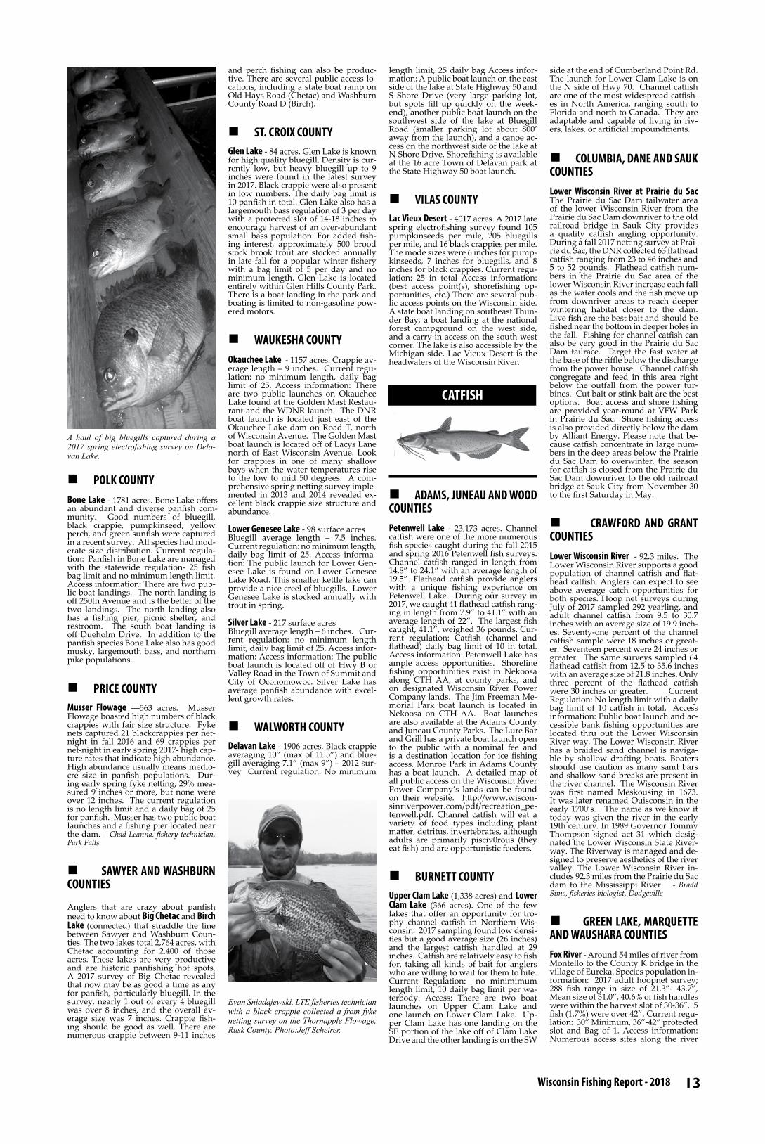
13 Wisconsin Fishing Report - 2018
CATFISH
n POLK COUNTYBone Lake - 1781 acres. Bone Lake offers an abundant and diverse panfish com-munity. Good numbers of bluegill, black crappie, pumpkinseed, yellow perch, and green sunfish were captured in a recent survey. All species had mod-erate size distribution. Current regula-tion: Panfish in Bone Lake are managed with the statewide regulation- 25 fish bag limit and no minimum length limit. Access information: There are two pub-lic boat landings. The north landing is off 250th Avenue and is the better of the two landings. The north landing also has a fishing pier, picnic shelter, and restroom. The south boat landing is off Dueholm Drive. In addition to the panfish species Bone Lake also has good musky, largemouth bass, and northern pike populations.
n PRICE COUNTYMusser Flowage ―563 acres. Musser Flowage boasted high numbers of black crappies with fair size structure. Fyke nets captured 21 blackcrappies per net-night in fall 2016 and 69 crappies per net-night in early spring 2017- high cap-ture rates that indicate high abundance. High abundance usually means medio-cre size in panfish populations. Dur-ing early spring fyke netting, 29% mea-sured 9 inches or more, but none were over 12 inches. The current regulation is no length limit and a daily bag of 25 for panfish. Musser has two public boat launches and a fishing pier located near the dam. – Chad Leanna, fishery technician, Park Falls
n SAWYER AND WASHBURN COUNTIES
Anglers that are crazy about panfish need to know about Big Chetac and Birch Lake (connected) that straddle the line between Sawyer and Washburn Coun-ties. The two lakes total 2,764 acres, with Chetac accounting for 2,400 of those acres. These lakes are very productive and are historic panfishing hot spots. A 2017 survey of Big Chetac revealed that now may be as good a time as any for panfish, particularly bluegill. In the survey, nearly 1 out of every 4 bluegill was over 8 inches, and the overall av-erage size was 7 inches. Crappie fish-ing should be good as well. There are numerous crappie between 9-11 inches
and perch fishing can also be produc-tive. There are several public access lo-cations, including a state boat ramp on Old Hays Road (Chetac) and Washburn County Road D (Birch).
n ST. CROIX COUNTYGlen Lake - 84 acres. Glen Lake is known for high quality bluegill. Density is cur-rently low, but heavy bluegill up to 9 inches were found in the latest survey in 2017. Black crappie were also present in low numbers. The daily bag limit is 10 panfish in total. Glen Lake also has a largemouth bass regulation of 3 per day with a protected slot of 14-18 inches to encourage harvest of an over-abundant small bass population. For added fish-ing interest, approximately 500 brood stock brook trout are stocked annually in late fall for a popular winter fishery with a bag limit of 5 per day and no minimum length. Glen Lake is located entirely within Glen Hills County Park. There is a boat landing in the park and boating is limited to non-gasoline pow-ered motors.
n WAUKESHA COUNTYOkauchee Lake - 1157 acres. Crappie av-erage length – 9 inches. Current regu-lation: no minimum length, daily bag limit of 25. Access information: There are two public launches on Okauchee Lake found at the Golden Mast Restau-rant and the WDNR launch. The DNR boat launch is located just east of the Okauchee Lake dam on Road T, north of Wisconsin Avenue. The Golden Mast boat launch is located off of Lacys Lane north of East Wisconsin Avenue. Look for crappies in one of many shallow bays when the water temperatures rise to the low to mid 50 degrees. A com-prehensive spring netting survey imple-mented in 2013 and 2014 revealed ex-cellent black crappie size structure and abundance.
Lower Genesee Lake - 98 surface acresBluegill average length – 7.5 inches. Current regulation: no minimum length, daily bag limit of 25. Access informa-tion: The public launch for Lower Gen-esee Lake is found on Lower Genesee Lake Road. This smaller kettle lake can provide a nice creel of bluegills. Lower Genesee Lake is stocked annually with trout in spring.
Silver Lake - 217 surface acresBluegill average length – 6 inches. Cur-rent regulation: no minimum length limit, daily bag limit of 25. Access infor-mation: Access information: The public boat launch is located off of Hwy B or Valley Road in the Town of Summit and City of Oconomowoc. Silver Lake has average panfish abundance with excel-lent growth rates.
n WALWORTH COUNTYDelavan Lake - 1906 acres. Black crappie averaging 10” (max of 11.5”) and blue-gill averaging 7.1” (max 9”) – 2012 sur-vey Current regulation: No minimum
length limit, 25 daily bag Access infor-mation: A public boat launch on the east side of the lake at State Highway 50 and S Shore Drive (very large parking lot, but spots fill up quickly on the week-end), another public boat launch on the southwest side of the lake at Bluegill Road (smaller parking lot about 800’ away from the launch), and a canoe ac-cess on the northwest side of the lake at N Shore Drive. Shorefishing is available at the 16 acre Town of Delavan park at the State Highway 50 boat launch.
n VILAS COUNTYLac Vieux Desert - 4017 acres. A 2017 late spring electrofishing survey found 105 pumpkinseeds per mile, 205 bluegills per mile, and 16 black crappies per mile. The mode sizes were 6 inches for pump-kinseeds, 7 inches for bluegills, and 8 inches for black crappies. Current regu-lation: 25 in total Access information: (best access point(s), shorefishing op-portunities, etc.) There are several pub-lic access points on the Wisconsin side. A state boat landing on southeast Thun-der Bay, a boat landing at the national forest campground on the west side, and a carry in access on the south west corner. The lake is also accessible by the Michigan side. Lac Vieux Desert is the headwaters of the Wisconsin River.
n ADAMS, JUNEAU AND WOOD COUNTIESPetenwell Lake - 23,173 acres. Channel catfish were one of the more numerous fish species caught during the fall 2015 and spring 2016 Petenwell fish surveys. Channel catfish ranged in length from 14.8” to 24.1” with an average length of 19.5”. Flathead catfish provide anglers with a unique fishing experience on Petenwell Lake. During our survey in 2017, we caught 41 flathead catfish rang-ing in length from 7.9” to 41.1” with an average length of 22”. The largest fish caught, 41.1”, weighed 36 pounds. Cur-rent regulation: Catfish (channel and flathead) daily bag limit of 10 in total. Access information: Petenwell Lake has ample access opportunities. Shoreline fishing opportunities exist in Nekoosa along CTH AA, at county parks, and on designated Wisconsin River Power Company lands. The Jim Freeman Me-morial Park boat launch is located in Nekoosa on CTH AA. Boat launches are also available at the Adams County and Juneau County Parks. The Lure Bar and Grill has a private boat launch open to the public with a nominal fee and is a destination location for ice fishing access. Monroe Park in Adams County has a boat launch. A detailed map of all public access on the Wisconsin River Power Company’s lands can be found on their website. http://www.wiscon-sinriverpower.com/pdf/recreation_pe-tenwell.pdf. Channel catfish will eat a variety of food types including plant matter, detritus, invertebrates, although adults are primarily pisciv0rous (they eat fish) and are opportunistic feeders.
n BURNETT COUNTYUpper Clam Lake (1,338 acres) and Lower Clam Lake (366 acres). One of the few lakes that offer an opportunity for tro-phy channel catfish in Northern Wis-consin. 2017 sampling found low densi-ties but a good average size (26 inches) and the largest catfish handled at 29 inches. Catfish are relatively easy to fish for, taking all kinds of bait for anglers who are willing to wait for them to bite.Current Regulation: no minimimum length limit, 10 daily bag limit per wa-terbody. Access: There are two boat launches on Upper Clam Lake and one launch on Lower Clam Lake. Up-per Clam Lake has one landing on the SE portion of the lake off of Clam Lake Drive and the other landing is on the SW
side at the end of Cumberland Point Rd. The launch for Lower Clam Lake is on the N side of Hwy 70. Channel catfish are one of the most widespread catfish-es in North America, ranging south to Florida and north to Canada. They are adaptable and capable of living in riv-ers, lakes, or artificial impoundments.
n COLUMBIA, DANE AND SAUK COUNTIESLower Wisconsin River at Prairie du Sac The Prairie du Sac Dam tailwater area of the lower Wisconsin River from the Prairie du Sac Dam downriver to the old railroad bridge in Sauk City provides a quality catfish angling opportunity. During a fall 2017 netting survey at Prai-rie du Sac, the DNR collected 63 flathead catfish ranging from 23 to 46 inches and 5 to 52 pounds. Flathead catfish num-bers in the Prairie du Sac area of the lower Wisconsin River increase each fall as the water cools and the fish move up from downriver areas to reach deeper wintering habitat closer to the dam. Live fish are the best bait and should be fished near the bottom in deeper holes in the fall. Fishing for channel catfish can also be very good in the Prairie du Sac Dam tailrace. Target the fast water at the base of the riffle below the discharge from the power house. Channel catfish congregate and feed in this area right below the outfall from the power tur-bines. Cut bait or stink bait are the best options. Boat access and shore fishing are provided year-round at VFW Park in Prairie du Sac. Shore fishing access is also provided directly below the dam by Alliant Energy. Please note that be-cause catfish concentrate in large num-bers in the deep areas below the Prairie du Sac Dam to overwinter, the season for catfish is closed from the Prairie du Sac Dam downriver to the old railroad bridge at Sauk City from November 30 to the first Saturday in May.
n CRAWFORD AND GRANT COUNTIESLower Wisconsin River - 92.3 miles. The Lower Wisconsin River supports a good population of channel catfish and flat-head catfish. Anglers can expect to see above average catch opportunities for both species. Hoop net surveys during July of 2017 sampled 292 yearling, and adult channel catfish from 9.5 to 30.7 inches with an average size of 19.9 inch-es. Seventy-one percent of the channel catfish sample were 18 inches or great-er. Seventeen percent were 24 inches or greater. The same surveys sampled 64 flathead catfish from 12.5 to 35.6 inches with an average size of 21.8 inches. Only three percent of the flathead catfish were 30 inches or greater. Current Regulation: No length limit with a daily bag limit of 10 catfish in total. Access information: Public boat launch and ac-cessible bank fishing opportunities are located thru out the Lower Wisconsin River way. The Lower Wisconsin River has a braided sand channel is naviga-ble by shallow drafting boats. Boaters should use caution as many sand bars and shallow sand breaks are present in the river channel. The Wisconsin River was first named Meskousing in 1673. It was later renamed Ouisconsin in the early 1700’s. The name as we know it today was given the river in the early 19th century. In 1989 Governor Tommy Thompson signed act 31 which desig-nated the Lower Wisconsin State River-way. The Riverway is managed and de-signed to preserve aesthetics of the river valley. The Lower Wisconsin River in-cludes 92.3 miles from the Prairie du Sac dam to the Mississippi River. - Bradd Sims, fisheries biologist, Dodgeville
n GREEN LAKE, MARQUETTE AND WAUSHARA COUNTIESFox River - Around 54 miles of river from Montello to the County K bridge in the village of Eureka. Species population in-formation: 2017 adult hoopnet survey; 288 fish range in size of 21.3”- 43.7”, Mean size of 31.0”, 40.6% of fish handles were within the harvest slot of 30-36”. 5 fish (1.7%) were over 42”. Current regu-lation: 30” Minimum, 36”-42” protected slot and Bag of 1. Access information: Numerous access sites along the river
A haul of big bluegills captured during a 2017 spring electrofishing survey on Dela-van Lake.
Evan Sniadajewski, LTE fisheries technician with a black crappie collected a from fyke netting survey on the Thornapple Flowage, Rusk County. Photo:Jeff Scheirer.

14 Fish Wisconsin! fishingwisconsin.org
from Montello to Eureka including nu-merous sites in the area around Princ-eton.
n JEFFERSON COUNTYRock River - Hustisford to Watertown During 2017 hoop netting surveys a to-tal of 603 channel catfish were captured at a rate of 37.7/net night. That catch rate is above average when compared with other hoop net surveys statewide. Lengths ranged from 10.9 to 26.5 inches with an average size of 15.3 inches. Cur-rent regulation: 10 fish daily bag, open year round. Access information: There is a public boat launch and shorefishing opportunity at Kaul Park off CTH CW west of HWY 67.
n KENOSHA AND RACINE COUNTIESFox River - 35 miles from the Racine-Waukesha County line down to the Wisconsin-Illinois state line. Recent cat-fish surveys on the Fox River produced very high catch rates of 20”+ channel catfish and flathead catfish, including fish up to 37” and 24 pounds. Multiple boat launches and several shorefishing areas provide very good public access.Current regulation: no length limit, 10 total catfish, open year round. Access information: Boat launches at Bridge Road north of Waterford, in Waterford, at County Highway JB, and at County Highway F. Canoe/kayak launches in Waterford, Rochester, and at County Highway C near Wilmot. Excellent shorefishing access at various parks and public areas along the river. Contact lo-cal municipalities for more information.
n PRICE COUNTYSouth Fork Flambeau River - When com-pared with their larger counterparts in the southern two-thirds of the state, northern Wisconsin’s medium-size riv-ers are certainly not popular destina-tions among catfish anglers. Nonethe-less, those with patience and persistence can find angling and harvest opportuni-ty for channel catfish in the deeper pools of the South Fork Flambeau River near the northern extent of the species range in the state. In July and August 2017, we fished five hoop-nets baited with soymeal at nine deep-water sites in the South Fork Flambeau between its origin at the Round Lake Dam and the canoe landing about 20 river miles down-stream. Our 37 net-nights of survey ef-fort yielded 19 channel catfish that were 18 – 32 inches long. Our low catch rate indicated low population abundance, but 63% of the catfish in our sample were 24 inches or longer. Not all river pools produced catfish—the two up-stream- and downstream-most nets ac-counted for 95% of the catch. A handful of anglers specifically seek out catfish using nightcrawlers, cut-bait, or stink-bait, often at night from shore, or in daylight from canoes or kayaks in both the North Fork and South Fork of the Flambeau River. Their success seems better in the middle and lower river reaches versus the headwater segments. Carry-in access is available at several developed and makeshift sites on public land and at road crossings, but beware that low streamflow can make down-stream navigation difficult in summer. Motorized boats are not recommended. Catfish season is open year-round with a daily bag limit of 10 and no minimum length limit. – Jeff Scheirer, fisheries biolo-gist, Park Falls
n WAUPACA AND WINNEBAGO COUNTIES Wolf River - 32.55 miles from the mouth of the Wolf River where it enters Lake Poygan to the town of New London. Channel catfish population information: In 2017, The DNR completed an early summer (i.e., early June) netting survey of the Wolf River in Waupaca County near Weyauwega, WI. Although the pri-mary objective of the netting survey was to assess the flathead catfish population in the Wolf River, three hoop nets were specifically set to assess the channel cat-fish population. These three hoop nets were baited with soy meal and were set out for six nights for a total of 18 net nights specifically targeting chan-nel catfish. A total of 497 channel catfish were caught in these nets for an average of 27.61 channel catfish per net night. Catches ranged from 0 – 78 channel catfish per net night in the baited hoop nets. Size structure showed plenty of harvestable size channel catfish in this stretch of the Wolf River with channel catfish averaging 19.8 inches and rang-ing from 11.1 to 33.3 inches. The Wolf River provides an often overlooked channel catfish fishery with potential for lots of action as well as plenty of har-vestable size fish. Current Regulation: Daily bag limit of 25 channel catfish in total, but only 24 if one flathead cat-fish is possessed. There is no minimum length limit for channel catfish. Access information: Seven boat accesses, two
shore fishing opportunities, and one carry-in canoe/kayak ramp are located along the Wolf River between Lake Poygan and the town of New London. One or two calls come in each year from anglers who report catching a “blue cat-fish.” However, these are likely medium to large channel catfish that don’t have any spots on their body. The closest confirmed capture of a blue catfish to Wisconsin waters was from the Missis-sippi River near Bellevue, Iowa, some 20 miles south of the Wisconsin-Illinois boundary in 1972. They are rarely seen in the Mississippi above the juncture with the Missouri River.
n BURNETT COUNTYUpper St. Croix River. Upper St. Croix River-between Confluence with Name-kagon River and St. Croix Falls (Bur-nett County and WI/MN border). Lake Sturgeon sampled in 2017 ranged from 16.8 to 60.7 inches in length. The aver-age length was 26.0 inches. 94% of the sturgeon sampled in 2017 were juvenile sturgeon (less than 45 inches). The Up-per St. Croix River offers a good oppor-tunity to catch lake sturgeon. Most fish are 20 to 30 inches, but large adults over 60 inches are present. Anglers who fish during the sturgeon catch and release season should take special care while handling fish once landed. Land the fish, photograph it (if you choose to), and release it quickly to reduce stress and ensure survival. Current regula-tion and season: catch and release only. June 16 – March 1. There are several boat and canoes launches on the Upper St. Croix River. Visit the National Park Service website for more information: http://www.nps.gov/sacn/planyour-visit/maps.htm. Wisconsin DNR and Minnesota DNR both use yellow dan-gler tags on the Upper St. Croix River to mark fish that have been sampled. These marked fish allow DNR staff to track fish movement and growth. Wis-consin anglers are encouraged to report tagged Upper St. Croix River sturgeon to Wisconsin DNR in Spooner. Please report the 5 digit dangler tag number, total length of the fish, approximate lo-cation caught, and date caught to Craig Roberts- Wisconsin DNR fisheries biolo-gist: 715-635-4095 or [email protected] .
n CHIPPEWA, DUNN, EAU CLAIRE AND PEPIN COUNTIESLower Chippewa River - 100 river miles from Lake Holcombe to the Mississippi River. The Lower Chippewa River (Lake Holcombe downstream to the Missis-sippi River) offers anglers an opportu-nity to harvest a lake sturgeon greater than 60 inches during the hook-and-line season. If an angler intends to harvest a fish, they must first purchase a harvest tag and, if successful, register their catch. Seventeen lake sturgeon were harvested in the 2017 season, which is second highest since the 60” minimum has been in place. The majority of the harvest oc-curred between Chippewa Fall Flowage Dam and the Dells Pond Dam. Anglers also reported catching numerous sub-legal fish, a sign of a healthy sturgeon population. Night crawlers or cut bait presented in deep holes of the river is a good combination for a successful sturgeon fishing trip. Access: There are dozens of boat landings along the river and its impoundments. Joseph Gerbyshak – fisheries biologist, Eau Claire
n COLUMBIA, DANE AND SAUK COUNTIES
Lake Wisconsin and the lower Wisconsin River. Lake Wisconsin, from the Kil-bourn Dam at Wisconsin Dells down to the Prairie du Sac Dam offers excellent opportunities for anglers to catch lake sturgeon during the September hook and line fishing season. While only one fish has been harvested from the Dells area since 2012, large fish are avail-able for anglers to encounter. During a spring 2017 population monitoring sur-vey, WDNR staff collected 104 lake stur-geon below the Kilbourn Dam ranging from 30 to 70 inches in length with 15 fish larger than 60 inches. Anglers may target the upper end of the main part of Lake Wisconsin, or in among the rock formations in the Dells with large tackle and nightcrawlers as the preferred bait. The Prairie du Sac Dam tailwater area of the lower Wisconsin River from the Prairie du Sac Dam downriver to the US Hwy. 12 bridge provides another qual-ity lake sturgeon fishing opportunity for anglers. During a population monitor-ing survey in the fall of 2017, WDNR collected 102 lake sturgeon in nets and they ranged from 22 to 69 inches in length with 11 fish larger than 60 inches. Additionally, seven lake sturgeon were harvested during the September 2017 hook and line fishing season. Over the past couple of years anglers have also reported catching large numbers of sub-legal sturgeon, so there is the potential for good catch-and-release action in ad-dition to a harvest opportunity. Again, the preferred bait for lake sturgeon is nightcrawlers. The sturgeon regulation for both areas of the Wisconsin River described above is a 60-inch minimum length limit with a one fish season bag limit. Anglers who intend to harvest a sturgeon must first purchase a harvest tag and must register their catch if suc-cessful.
n DOUGLAS COUNTY
St. Louis River and Estuary - 12,000 acresMinnesota DNR and University of Wis-consin – Stevens Point captured and released 134 Lake Sturgeon in Spring 2017. Total lengths ranged from 38 to 64 inches, and many fish were males. The 64-inch fish weighed 70 pounds. Cur-rent regulation: Open June 16 through April 14; No harvest; Catch-and-release only. Access information: Arrowhead Landing and Fishing Pier: Located in the City of Superior where Belknap Street joins the river. The landing fea-tures paved parking, an ADA accessible picnic area, and portable restrooms. Go to http://dnr.wi.gov/topic/lands/boatac-cess/ for complete information. Oliver Landing: Located in the Village of Oli-ver, just south of Superior, at end of East Detroit Street. The landing has paved parking and portable restrooms. Bark-er’s Island Landing: Located in the City of Superior at the end of Marina Driver. Features restrooms and paved parking. Loon’s Foot Landing: Located in the City of Superior just west of the Nem-adji River. Restrooms and paved park-
Fisheries biologist Luke Roffler with a pair of big Fox River channel catfish from Keno-sha County in the summer of 2017..
Fisheries biologist, Jen Bergman, holding a flathead catfish captured during electrofish-ing surveys in the Wisconsin River. Photo: Al Niebur
Angler Charles Domke lands a large flathead catfish in June 2017. The fish was originally tagged on 06/15/2004. At that time, its age was estimated to be 25+. Now the fish is pushing 40 years old!
LAKE STURGEON
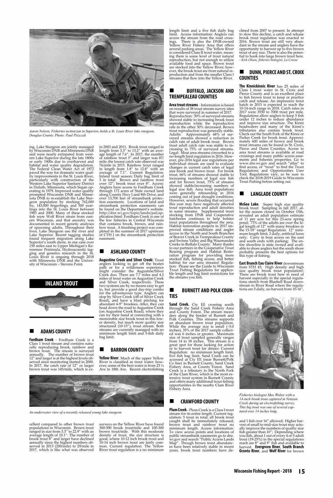
15 Wisconsin Fishing Report - 2018
ing. Lake Sturgeon are jointly managed by Wisconsin DNR and Minnesota DNR and were nearly extirpated from west-ern Lake Superior during the late 1800s or early 1900s due to overharvest and habitat and water quality degradation. The Federal Clean Water Act of 1972 paved the way for dramatic water qual-ity improvements to the St. Louis River, particularly with construction of the Western Lake Superior Sanitary District in Duluth, Minnesota, which began op-erating in 1979. Improved water quality prompted Wisconsin DNR and Minne-sota DNR to re-establish the Lake Stur-geon population by stocking 762,000 fry, 143,000 fingerlings, and 500 year-lings into the St. Louis River between 1983 and 2000. Many of these stocked fish were Wolf River strain from east-ern Wisconsin, and that ancestry was documented in recent genetic analyses of spawning adults. Throughout their lives, Lake Sturgeon use the river and Lake Superior. Recent tagging studies found frequent migration along Lake Superior’s south shore, in one case over 150 miles east to Upper Michigan’s Ke-weenaw Peninsula. Hydroacoustic tag-ging and genetics research in the St. Louis River is ongoing through 2018 with Minnesota DNR and the Univer-sity of Wisconsin – Stevens Point.
n ADAMS COUNTYFordham Creek - Fordham Creek is a Class 1 trout stream and contains natu-rally reproducing brook, rainbow and brown trout. The stream is surveyed annually. The number of brown trout 12” and larger is at the highest levels ob-served since monitoring started in 2000. In 2017, the catch rate of 12” or larger brown trout was 145/mile, which is ex-
cellent compared to other brown trout populations in Wisconsin. Brown trout ranged in size from 3.3” to 22.9” with an average length of 10.1”. The number of brook trout 8” and larger have declined annually since the highest numbers ob-served in 2013 (200/mile) to 29/mile in 2017, which is like what was observed
in 2003 and 2011. Brook trout ranged in length from 3.3” to 13.2” with an aver-age length of 7.6”. In 2017, the number of rainbow trout 5” and larger was 87/mile; the lowest catch rate observed was 76/mile in 2015. Rainbow trout ranged in length from 1.8” to 12.8” with an average of 7.1”. Current Regulation: Inland trout season; Daily bag limit of 3 in total: Brown and rainbow trout over 12”; brook trout over 8”. Access: Anglers have access to Fordham Creek through 172 acres of State owned land along County Hwy J and 8th Drive, and over 13,700 feet of streambank protec-tion easements. Locations of land and streambank protection easements can be found on the Department’s website. http://dnr.wi.gov/topic/lands/pal/ap-plication.html. Fordham Creek is one of the few fisheries in Central Wisconsin that contains brook, brown, and rain-bow trout. A brushing project was com-pleted in the summer of 2017 upstream of CTH J on the streambank protection easement.
n ASHLAND COUNTYAugustine Creek and Silver Creek: Trout anglers looking to get off the beaten path or for a wilderness experience might consider the Augustine/Silver Creek duo. There are 7.7 miles and 4.2 miles of trout water on Augustine Creek and Silver Creek, respectively. These two systems are by no means easy to get to, but provide a good day-trip combo for the adventurous type. Anglers can stop by Silver Creek (off of Silver Creek Road), and have a blast pitching for abundant 4-9” brookies. After, they can head down the road to Augustine Creek (on Augustine Creek Road), where they can try their hand at connecting with a memorable size brook trout in this low-er density, but much more quality size structured (10-15”), trout stream. Both streams are currently managed with no minimum length limit and 5-fish daily bag limit.
n BARRON COUNTYYellow River. Much of the upper Yellow River is classified as trout water; how-ever, some of the best water is from 23 ¼ Ave to 18th Ave. Recent electrofishing
surveys on the Yellow River have found 300-500 brook trout/mile and 100-300 brown trout/mile. With this moderate density of trout, the size structure is good, where 10-12 inch brook trout and 10-14 inch brown trout are fairly com-mon. Current regulation: The Yellow River trout regulation is a no minimum
length limit and a five fish daily bag limit. Access information: Anglers can access the stream from the road cross-ings. There is also the DNR-owned Yellow River Fishery Area that offers several parking areas. The Yellow River is considered Class II trout water, mean-ing there is some level of trout natural reproduction, but not enough to utilize available food and space. Brown trout are stocked into the Yellow River; how-ever, the brook trout are from natural re-production and from the smaller Class I streams that flow into the Yellow River.
n BUFFALO, JACKSON AND TREMPEALEAU COUNTIESArea trout streams - Information is based on results of 38 trout stream survey sites that were surveyed in summer of 2017.Reproduction: 50% of surveyed streams showed stable to increasing brook trout reproduction while the reproductive rate in the other 50% decreased. Brown trout reproduction was generally stable.Adults: Approximately 68% of sur-veyed streams showed a reduction in catch rate of adult brook trout. Brown trout adult catch rate was stable to in-creasing in 75% of surveyed streams. Legal: Most area streams converted to a no-length limit regulation in 2016. How-ever, pre-2016 legal size regulations per individual stream are used to evaluate changes in current catch rates of legal size brook and brown trout. For brook trout, 66% of streams showed stable to increasing numbers of legal size fish and for brown trout, 75% of streams showed stable/increasing numbers of legal size fish. Area trout populations were generally rebounding in 2016 coming out of past drought conditions. However, severe flooding that occurred this year may have negatively affected trout reproduction and adult densities in some streams. Supplemental trout stocking from DNR and Cooperative hatcheries continues to help bolster trout populations throughout the area. Habitat restoration projects in 2017 im-proved stream conditions and angler access in the North and South Branches of Beaver Creek in Trempealeau County and Swinns Valley and Big Waumandee Creeks in Buffalo County. Many thanks to our partners in the Cooperative Trout Rearing program and Habitat Resto-ration program for providing more stocked fish, fishing access, and better habitat for our area streams! Regula-tion: Please see the Guide to Wisconsin Trout Fishing Regulations for applica-ble length and bag limit restrictions for the streams you fish.
n BURNETT AND POLK COUN-TIESSand Creek. Cty EE crossing south through the Sand Creek Fishery Area and County Forest. The stream mean-ders along the border of Burnett and Polk Counties. This streams supports an abundant brown trout population. While the average size is small (~5.0 inches), 35% of the 2017 sample collect-ed was 6 inches or greater. Maximum size of trout sampled generally ranges from 14 to 18 inches. This stream is a great spot for those looking for action or to harvest trout for dinner. Current Regulation: no minimum length limit, five fish bag limit. Sand Creek can be accessed at Cty EE (near Burnett/Polk Co line) in Burnett County, Sand Creek Fishery Area, or County Forest. Sand Creek is a tributary to the North Fork of the Clam River, which is the most ex-tensive trout system in Burnett County and offers many additional trout fishing opportunities in the nearby Clam River Fishery Area.
n CRAWFORD COUNTYPlum Creek - Plum Creek is a Class I trout stream for its entire length. Current reg-ulation: 5 trout in total: all brook trout caught shall be immediately released; brown trout and rainbow trout no minimum length. Access information: To view access points and locations of public streambank easements go to dnr.wi.gov and search “Public Access Lands Map”. Though brown trout abundanc-es have been relatively stable in recent years, brook trout numbers have de-
clined from 2007 to present. In attempt to slow this decline, a catch and release brook trout regulation was enacted in 2016. Brown trout are still very abun-dant in the stream and anglers have the opportunity to harvest up to five brown trout of any size. There is also the poten-tial to hook into large brown trout here. - Kirk Olson, fisheries biologist, La Crosse
n DUNN, PIERCE AND ST. CROIX COUNTIESThe Kinnickinnic River has 25 miles of Class I trout water in St. Croix and Pierce County and is an excellent place to fish brown trout to keep or practice catch and release. An impressive trout hatch in 2015 is expected to reach the 10-14-inch range in 2018. Catch rates in 2017 were 3550 to 7000 trout per mile. Regulations allow anglers to keep 5 fish under 12 inches to reduce abundance and improve size structure. The Kinni headwaters and many of the Kinni’s tributaries also contain brook trout. Check out the South Fork of the Kinni or Parker Creek for brook trout. Approxi-mately 600 miles of brown and brook trout streams can be found in St. Croix, Pierce and Dunn Counties. Access to area trout streams is available at road crossings and many public access ease-ments and fisheries properties. Go to www.dnr.wi.gov and search ”atlas” to find access, or “trout” to find the Trout Regulations and Opportunities User Tool. Regulations vary, so be sure to check the 2018-2019 Guide to Wisconsin Trout Fishing before setting out.
n LANGLADE COUNTY
McGee Lake; Super high size quality brook trout: Sampling in fall 2017, af-ter the season closed on October 15th, revealed an adult population estimate of 11 per acre for this 23-acre spring pond; 73% of the adults are over the le-gal length of 12” with many brookies in the 15-18” range! Regulation: 12” mini-mum length limit, 2 daily, artificial lures only; Carry in boat access on the east and south ends with parking; The en-tire shoreline is state owned and avail-able to shore anglers but the south shore probably presents the best options for this type of fishing.
East Branch Eau Claire River downstream from STH 45; High density and high size quality brook trout population!; There are brook trout here in need of harvest especially in the special regula-tions stretch from Bluebell Road down-stream to River Road where the regula-tions are 5 daily, no harvest from 10-16”,
and 1 fish over 16” allowed; Higher har-vest of small to mid-size trout may actu-ally improve the numbers of quality size fish greater than 10”; Depending where you fish, about 1 out of every 4 or 5 adult trout (19-25%) in the special regulations reach are 8” and 9” fish and available to harvest. Evergreen River, South Branch Oconto River, and Wolf River for brown
Aaron Nelson, Fisheries technician in Superior, holds a St. Louis River lake sturgeon, Douglas County. Photo: Paul Piszczek
An underwater view of a recently released young lake sturgeon
INLAND TROUT
Fisheries biologist Max Wolter with a 14-inch brook trout captured in Venison Creek during an electrofishing survey. This big trout was one of several cap-tured over 14 inches long.

16 Fish Wisconsin! fishingwisconsin.org
trout. Stocked Lakes – Crooked (brooks), Jack (rainbows), Pence (browns), Rogers (browns), and Townline (rainbows); 5 daily and no length limit.
n LINCOLN COUNTY
Brook Trout – Big Pine Creek, Prairie River, and New Wood River. Brown Trout – Prairie River and North Branch Prairie River. Stocked Lakes – Ament (brooks), Henson (brooks), Larson (rain-bows), Moraine (rainbows), and Tahoe (rainbows); 5 daily and no length limit; Ament and Tahoe lakes are both now open EVERY YEAR!
n MARINETTE COUNTYNorth Branch Beaver Creek – 21st Road (Lat: 45.1447, Long: -88.0367). In 2017, the North Branch of the Beaver had numerous habitat improvements com-pleted; fishability brushing, brush bun-dling, and large wood installation from 21st Road downstream to 19th Road. Staff from the DNR’s Wild Rose Trout Habitat Improvement Station will con-tinue these same improvements in 2018, from the next bridge upstream, 25th road (Lat: 45.1585, Long: -88.0577). With access to the Peshtigo river just down-stream, fish can move freely up and down many miles of river. Because of this the NBBC is notorious for large brown trout and quality brook trout. When the river is running crystal clear, these fish can be a challenge to catch. Stealth is an angler’s asset on this excel-lent trout stream.
Thunder Lake (135 acres). Streams: Peshtigo River (above Caldron Falls) Population information: DNR stocks catchable sized brook and brown trout prior to opening day. Thunder Lake is an opening day hot spot for rainbow trout anglers. Between 3,000 & 4,000 rainbows are stocked before opening day. For anglers wanting to target brook and brown trout, the Peshtigo River above Caldron Falls can be worth the trip. About 2,500 brook trout and 2,500 brown trout are stocked at various loca-tions along the river. Current Regula-tion: Thunder Lake: 3-fish bag: 8-inch minimum length limit. Peshtigo River: Opening day to October 15 = 3-fish/bag: 8-inch minimum length limitOctober 16 to November 15 = catch & release : artificial only. Access informa-tion: Good access is available through McClintock Park, Goodman Park and along Benson Lake Rd.
n MARQUETTE COUNTYChaffee Creek – 14th Ave . A large-scale project conducted by the DNR’s Wild Rose Trout Habitat Improvement Sta-tion and volunteers from local Trout Unlimited Chapters has shown great results on this section of river. The project starts at the bridge crossing on 14th Ave and continues for over one mile upstream. Fishability is excellent with the addition of five newly installed overhead bankcovers, two riffles and numerous brush bundles and log sills.
This should defiantly increase your chances of running into one of the big Mecan River brown trout that season-ally migrate through this section of river. Downstream from 14th Ave has had habitat improvement work in the past as well. Both areas offer outstand-ing fishing. Two DNR parking areas are located on 14th Ave: (Lat: 43.9498 Long: -89.3475)
n OCONTO COUNTYSouth Branch Oconto River - Hwy T . Upstream of the bridge crossing (Lat: 45.1723, Long: -88.6190), the US Forest Service maintains a Barrier Free Fishing
Trail, one of the few trails of this kind in our state. Ten fishing platforms are scattered along a ¼ mile of stream al-lowing access to anglers of all abilities. During the summers of 2016 and 2017, staff from the DNR’s Wild Rose Trout Habitat Improvement Station, with a lot of help from Trout Unlimited (TU) volunteers, completed fishability brush-ing, brush bundling, and large wood installation along the Barrier Free Fish-ing Trail. These TU workdays draw vol-unteers from across northeastern Wis-consin. Improved areas to fish continue upstream, past the designated trail. The US Forest Service also maintains three campsites and a pit toilet at this location. Additional dispersed campsites, right on the river, are available off Old Grave Road, just south of the bridge crossing. This area is an excellent spot for fami-lies to fish, picnic, or for anglers with low mobility. Brook and brown trout in this section are not overly picky about what they’ll eat, but some experimen-tation may be necessary! South Branch Oconto River – Spruce Road. Work on this section of river began in 2015, start-ing at the DNR parking area at the north end of Spruce Rd (Lat: 45.0388, Long: -88.4470) downstream to Hill Rd (Lat: 45.0292, Long: -88.4412). Large willows that were impeding navigability and de-grading trout habitat were cut, winched, and anchored to provide increased feeding, resting, and refuge cover for brook and brown trout. Migratory fish from the main branch of the Oconto River can be found in this section as they search for cooler water in summer and as they move to upstream spawn-ing sites in fall. Habitat improvement work will continue in 2018 downstream of Hill Road to the DNR parking area on Hwy 32 (Lat: 45.0224 Long: -88.4169) and below. While wading is quite good and there is ample room to cast, a large rain event can change river conditions quickly. Anglers have the opportunity to trout fish from a canoe in this unique fishery. Canoe entry points exist North of the Spruce Rd parking area and East of the Hill Rd Bridge. The trip from the Spruce Rd parking area to the parking lot West of the Hwy 32 Bridge takes two hours of paddling. Allow more time if your fishing for the beautiful brookies and browns that inhabit this area.
n PEPIN COUNTYPlum Creek - 20.1 miles of classified trout water. Plum Creek originates in Pierce County and meanders through Pepin County before flowing into the Chip-
pewa River. Plum Creek is ‘good sized’ trout water by the time it reaches Pepin County and there are many good fish-ing opportunities to be had there. Plum Creek has a moderately high density of both brook trout and brown trout, with good size structure, which can make of a nice mixed bag. Because of the fairly even mixture of brook trout and brown trout, tiger trout (brook trout brown trout hybrids), are a regu-lar occurrence in fisheries surveys and are another draw for anglers to Plum Creek. The daily bag limit is three trout and brown trout must be 12 inches and brook trout must be 8 inches. Access: In Pepin County access to the stream can be found off of numerous road-stream crossings. - Joseph Gerbyshak, fisheries biolo-gist, Eau Claire
n RICHLAND COUNTYCamp Creek - 5.5 miles of trout water.Camp Creek supports a healthy popu-lation of brown trout. Recent surveys sampled 265 yearling and adult brown trout per mile ranging from 5.9 to 18.1 inches with an average size of 9.7 inch-es. Fourteen percent of the brown trout sampled were 12 inches or greater. Current regulations: 3 trout under 12 inches may be kept. Access informa-tion: There are approximately 3.75 miles of public fishing available via public fishing easements and fisheries prop-erties along Camp Creek. Remaining trout water may be accessed by gaining permission from landowners or by ac-cessing the stream from road right of ways. Camp creek is considered a class one trout fishery and is able to maintain a fishable population of trout through natural reproduction. Recent instream trout habitat projects were completed downstream of County G. - Bradd Simsfisheries biologist, Dodgeville
n SAWYER COUNTYLooking for a fishing adventure where your effort may be rewarded with big brook trout? Venison Creek (approx. 7.5 miles long) in Sawyer Co. may be worth a look. Venison lies just northeast of the Chippewa Flowage and can be accessed from Venison Creek Road and Forest Road 304. But even though the roads may get you close, you’ll still need to do some exploring to find prime fish-ing areas. Once you arrive, you have a shot at some truly special brook trout. A 2017 survey found brook trout over 10 inches to be common with some even approaching 15 inches in certain reaches of the stream. The big trout in this dark stained water have a very distinctive appearance and will make for a unique photo op if you can bag a trophy.
n SHAWANO COUNTYNorth Branch Embarrass River - 33.9 miles of Class I, II, and III trout water. In 2017, The DNR completed electrofishing runs at 11 stations along the North Branch Embarrass River upstream from where the river intersects Schoolhouse Rd, southeast of the town of Bowler. Aver-age catch per unit effort (CPUE as the number of brook trout per mile of elec-trofishing) at the 11 sites was 703 brook trout per mile of stream. CPUE ranged from 174 – 1,890 brook trout per mile of stream. The highest densities of brook trout were in the upper reaches of the river. The mean length of brook trout captured was 5.9 inches with brook trout ranging in size from 1.9 – 12.3 inches captured. The high densities of brook trout should provide anglers with a lot of action, especially along stretches around the town of Bowler and up-stream. Current regulation: Green. Dai-ly bag limit and length limit: 5 trout of any length. Access information: 18 pub-lic road crossings provide access points along with 40 acres of DNR owned land just north of the town of Bowler. The DNR has completed some habitat resto-ration along a stretch of river that runs through property owned by Shawano County, located just off CTY HWY D, northwest of Bowler in the town of Al-mon. Brown trout population infor-mation: In 2017, The DNR completed electrofishing runs at 11 stations along the North Branch Embarrass River up-stream from where the river intersects Schoolhouse Rd, southeast of the town
of Bowler. Brown trout were captured at nine of the 11 stations that were sam-pled. Mean brown trout catch per unit effort (CPUE as the number of brown trout per mile of stream electrofished) at these nine sites was 219.7 brown trout per mile of stream sampled. CPUE ranged from 10.5 – 735.4 brown trout per mile of stream with the highest densities observed around the town of Bowler. Although densities of brown trout are not extremely high, the North Branch Embarrass River has some high quality brown trout as brown trout > 15 inches were captured at six sites and brown trout > 18 inches were captured at four sites. Current Regulation: Green Daily bag limit and length limit: 5 trout of any length. Access information: 18 public road crossings provide access points along with 40 acres of DNR owned land just north of the town of Bowler. The DNR Ranger Station located just west of the town of Bowler provides a great place for the public to access the North Branch of the Embarrass River as well as a place where anglers can shore fish for brown trout.
n SHEBOYGAN COUNTYOnion River and its tributaries. 10 miles of Class I brown trout waters. 2017 sur-veys yielded an average length of 7.4 inches, with a maximum length of 20 inches. A survey at one popular access site had a catch rate of 1030 fish per mile which ranks it around the 87th percen-tile when compared with other all other brown trout waters statewide. Current regulation: Upstream of CTH E – daily bag limit 2, minimum length limit 12 inches, artificial lures only. Down-stream of CTH E – daily bag limit 3, minimum length limit 8 inches, no gear restrictions. Access information: The best access is from the bridge at CTH E and a number of points along CTH U just southwest of Plymouth. Upstream of CTH E anglers will find extensive habitat work in a number of stretches and this is generally were we find the larger fish in our surveys.
n TAYLOR COUNTYBig Rib River - County highway C to State Highway 64. The Park Falls Fish Team surveyed 6 sites along this stretch of river and found an average of 706 brook trout per mile and 91 brown trout per mile. The largest brook trout measured were just over 11 inches and the larg-est brown trout was just over 18 inches. The Big Rib showed very good signs of natural reproduction in the upstream areas of this segment for both brook and brown trout. The current harvest regu-lation in this reach is a daily bag limit of 3 trout with a minimum length limit of 8 inches. —Chad Leanna, fisheries technician, Park Falls
n VERNON COUNTYUpper Coon Creek Watershed - Coon Creek, Bohemian Valley Creek, Rul-land’s Coulee Creek, Spring Coulee Creek and Timber Coulee Creek. Recent
Kim Kuber, fisheries technician, holds a nice brown trout during a recent survey of Camp Creek, Richland County. Photo: Bradd Sims
Head shot of a lake-run brown trout captured and released in the Bois Brule River, Doug-las County. Photo:Paul Piszczek.
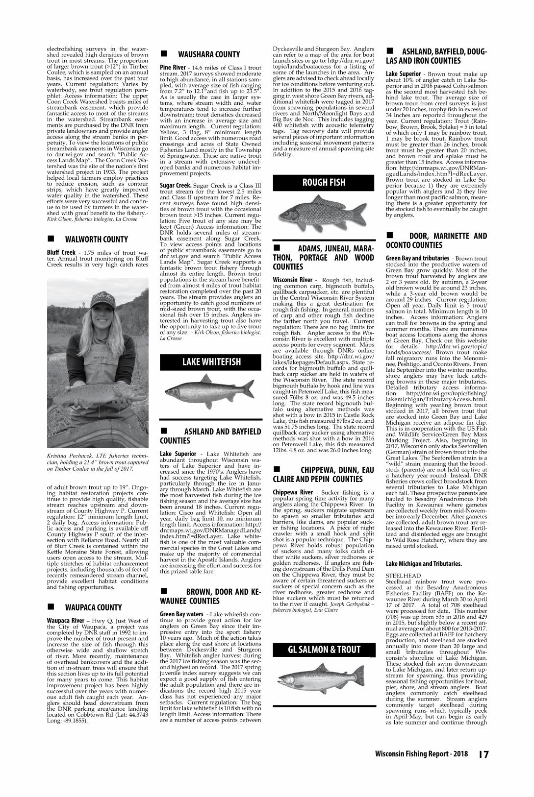
17 Wisconsin Fishing Report - 2018
electrofishing surveys in the water-shed revealed high densities of brown trout in most streams. The proportion of larger brown trout (>12”) in Timber Coulee, which is sampled on an annual basis, has increased over the past four years. Current regulation: Varies by waterbody, see trout regulation pam-phlet. Access information: The upper Coon Creek Watershed boasts miles of streambank easement, which provide fantastic access to most of the streams in the watershed. Streambank ease-ments are purchased by the DNR from private landowners and provide angler access along the stream banks in per-petuity. To view the locations of public streambank easements in Wisconsin go to dnr.wi.gov and search “Public Ac-cess Lands Map”. The Coon Creek Wa-tershed was the site of the nation’s first watershed project in 1933. The project helped local farmers employ practices to reduce erosion, such as contour strips, which have greatly improved water quality in the watershed. These efforts were very successful and contin-ue to be used by farmers in the water-shed with great benefit to the fishery.- Kirk Olson, fisheries biologist, La Crosse
n WALWORTH COUNTYBluff Creek - 1.75 miles of trout wa-ter. Annual trout monitoring on Bluff Creek results in very high catch rates
of adult brown trout up to 19”. Ongo-ing habitat restoration projects con-tinue to provide high quality, fishable stream reaches upstream and down-stream of County Highway P. Current regulation: 12” minimum length limit, 2 daily bag. Access information: Pub-lic access and parking is available off County Highway P south of the inter-section with Reliance Road. Nearly all of Bluff Creek is contained within the Kettle Moraine State Forest, allowing users open access to the stream. Mul-tiple stretches of habitat enhancement projects, including thousands of feet of recently remeandered stream channel, provide excellent habitat conditions and fishing opportunities.
n WAUPACA COUNTYWaupaca River – Hwy Q. Just West of the City of Waupaca, a project was completed by DNR staff in 1992 to im-prove the number of trout present and increase the size of fish through this otherwise wide and shallow stretch of river. More recently, maintenance of overhead bankcovers and the addi-tion of in-stream trees will ensure that this section lives up to its full potential for many years to come. This habitat improvement project has been highly successful over the years with numer-ous adult fish caught each year. An-glers should head downstream from the DNR parking area/canoe landing located on Cobbtown Rd (Lat: 44.3743 Long: -89.1855).
n WAUSHARA COUNTYPine River - 14.6 miles of Class I trout stream. 2017 surveys showed moderate to high abundance, in all stations sam-pled, with average size of fish ranging from 7.2” to 12.1”and fish up to 23.5”. As is usually the case in larger sys-tems, where stream width and water temperatures tend to increase further downstream; trout densities decreased with an increase in average size and maximum length. Current regulation: Yellow, 3 Bag, 8” minimum length limit. Good access with numerous road crossings and acres of State Owned Fisheries Land mostly in the Township of Springwater. These are native trout in a stream with extensive undevel-oped banks and numerous habitat im-provement projects.
Sugar Creek. Sugar Creek is a Class III trout stream for the lowest 2.5 miles and Class II upstream for 7 miles. Re-cent surveys have found high densi-ties of brown trout with the occasional brown trout >15 inches. Current regu-lation: Five trout of any size may be kept (Green) Access information: The DNR holds several miles of stream-bank easement along Sugar Creek. To view access points and locations of public streambank easements go to dnr.wi.gov and search “Public Access Lands Map”. Sugar Creek supports a fantastic brown trout fishery through almost its entire length. Brown trout populations in the stream have benefit-ed from almost 4 miles of trout habitat restoration completed over the past 20 years. The stream provides anglers an opportunity to catch good numbers of mid-sized brown trout, with the occa-sional fish over 15 inches. Anglers in-terested in harvesting trout also have the opportunity to take up to five trout of any size. - Kirk Olson, fisheries biologist, La Crosse
n ASHLAND AND BAYFIELD COUNTIESLake Superior - Lake Whitefish are abundant throughout Wisconsin wa-ters of Lake Superior and have in-creased since the 1970’s. Anglers have had success targeting Lake Whitefish, particularly through the ice in Janu-ary through March. Lake Whitefish are the most harvested fish during the ice fishing season and the average size has been around 18 inches. Current regu-lation: Cisco and Whitefish: Open all year, daily bag limit 10, no minimum length limit. Access information: http://dnrmaps.wi.gov/DNRManagedLands/index.htm?l=dRecLayer. Lake white-fish is one of the most valuable com-mercial species in the Great Lakes and make up the majority of commercial harvest in the Apostle Islands. Anglers are increasing the effort and success for this prized table fare.
n BROWN, DOOR AND KE-WAUNEE COUNTIESGreen Bay waters - Lake whitefish con-tinue to provide great action for ice anglers on Green Bay since their im-pressive entry into the sport fishery 10 years ago. Much of the action takes place along the east shore at locations between Dyckesville and Sturgeon Bay. Whitefish angler harvest during the 2017 ice fishing season was the sec-ond highest on record. The 2017 spring juvenile index survey suggests we can expect a good supply of fish entering the adult population and there are in-dications the record high 2015 year class has not experienced any major setbacks. Current regulation: The bag limit for lake whitefish is 10 fish with no length limit. Access information: There are a number of access points between
Dyckesville and Sturgeon Bay. Anglers can refer to a map of the area for boat launch sites or go to: http://dnr.wi.gov/topic/lands/boataccess for a listing of some of the launches in the area. An-glers are advised to check ahead locally for ice conditions before venturing out. In addition to the 2015 and 2016 tag-ging in west shore Green Bay rivers, ad-ditional whitefish were tagged in 2017 from spawning populations in several rivers and North/Moonlight Bays and Big Bay de Noc. This includes tagging 400 whitefish with acoustic telemetry tags. Tag recovery data will provide several pieces of important information including seasonal movement patterns and a measure of annual spawning site fidelity.
n ADAMS, JUNEAU, MARA-THON, PORTAGE AND WOOD COUNTIES Wisconsin River - Rough fish, includ-ing common carp, bigmouth buffalo, quillback carpsucker, etc. are plentiful in the Central Wisconsin River System making this a great destination for rough fish fishing. In general, numbers of carp and other rough fish decline the farther north you travel. Current regulation: There are no bag limits for rough fish. Angler access to the Wis-consin River is excellent with multiple access points for every segment. Maps are available through DNRs online boating access site. http://dnr.wi.gov/lakes/lakepages/Default.aspx. State re-cords for bigmouth buffalo and quill-back carp sucker are held in waters of the Wisconsin River. The state record bigmouth buffalo by hook and line was caught in Petenwell Lake, this fish mea-sured 76lbs 8 oz. and was 49.5 inches long. The state record bigmouth buf-falo using alternative methods was shot with a bow in 2015 in Castle Rock Lake, this fish measured 87lbs 2 oz. and was 51.75 inches long. The state record quillback carp sucker using alternative methods was shot with a bow in 2016 on Petenwell Lake, this fish measured 12lbs. 4.8 oz. and was 26.0 inches long.
n CHIPPEWA, DUNN, EAU CLAIRE AND PEPIN COUNTIESChippewa River - Sucker fishing is a popular spring time activity for many anglers along the Chippewa River. In the spring, suckers migrate upstream to spawn so smaller tributaries and barriers, like dams, are popular suck-er fishing locations. A piece of night crawler with a small hook and split shot is a popular technique. The Chip-pewa River holds robust population of suckers and many folks catch ei-ther white suckers, silver redhorses or golden redhorses. If anglers are fish-ing downstream of the Dells Pond Dam on the Chippewa River, they must be aware of certain threatened suckers or suckers of special concern such as the river redhorse, greater redhorse and blue suckers which must be returned to the river if caught. Joseph Gerbyshak – fisheries biologist, Eau Claire
n ASHLAND, BAYFIELD, DOUG-LAS AND IRON COUNTIES Lake Superior - Brown trout make up about 10% of angler catch in Lake Su-perior and in 2016 passed Coho salmon as the second most harvested fish be-hind lake trout. The average size of brown trout from creel surveys is just under 20 inches, trophy fish in excess of 34 inches are reported throughout the year. Current regulation: Trout (Rain-bow, Brown, Brook, Splake) = 5 in total of which only 1 may be rainbow trout, 1 may be brook trout. Rainbow trout must be greater than 26 inches, brook trout must be greater than 20 inches, and brown trout and splake must be greater than 15 inches. Access informa-tion: http://dnrmaps.wi.gov/DNRMan-agedLands/index.htm?l=dRecLayer. Brown trout are stocked in Lake Su-perior because 1) they are extremely popular with anglers and 2) they live longer than most pacific salmon, mean-ing there is a greater opportunity for the stocked fish to eventually be caught by anglers.
n DOOR, MARINETTE AND OCONTO COUNTIESGreen Bay and tributaries - Brown trout stocked into the productive waters of Green Bay grow quickly. Most of the brown trout harvested by anglers are 2 or 3 years old. By autumn, a 2-year old brown would be around 23 inches, while a 3-year old brown would be around 29 inches. Current regulation: Open all year. Daily limit is 5 trout/salmon in total. Minimum length is 10 inches. Access information: Anglers can troll for browns in the spring and summer months. There are numerous boat access locations along the shores of Green Bay. Check out this website for details. http://dnr.wi.gov/topic/lands/boataccess/. Brown trout make fall migratory runs into the Menomi-nee, Peshtigo, and Oconto Rivers. From late September into the winter months, shore anglers may have luck catch-ing browns in these major tributaries. Detailed tributary access informa-tion: http://dnr.wi.gov/topic/fishing/lakemichigan/TributaryAccess.html. Beginning with yearling brown trout stocked in 2017, all brown trout that are stocked into Green Bay and Lake Michigan receive an adipose fin clip. This is in cooperation with the US Fish and Wildlife Service/Green Bay Mass Marking Project. Also, beginning in 2017, Wisconsin only stocks Seeforellen (German) strain of brown trout into the Great Lakes. The Seeforellen strain is a “wild” strain, meaning that the brood-stock (parents) are not held captive at a hatchery year-round. Instead, DNR fisheries crews collect broodstock from several tributaries to Lake Michigan each fall. These prospective parents are hauled to Besadny Anadromous Fish Facility in Kewaunee where gametes are collected weekly from mid-Novem-ber into early December. After gametes are collected, adult brown trout are re-leased into the Kewaunee River. Fertil-ized and disinfected eggs are brought to Wild Rose Hatchery, where they are raised until stocked.
Lake Michigan and Tributaries.
STEELHEADSteelhead rainbow trout were pro-cessed at the Besadny Anadromous Fisheries Facility (BAFF) on the Ke-waunee River during March 30 to April 17 of 2017. A total of 708 steelhead were processed for data. This number (708) was up from 535 in 2016 and 429 in 2015, but slightly below a recent an-nual average of about 800 for 2013-2017. Eggs are collected at BAFF for hatchery production, and steelhead are stocked annually into more than 20 large and small tributaries throughout Wis-consin’s shoreline of Lake Michigan. These stocked fish swim downstream to Lake Michigan, and later return up-stream for spawning, thus providing seasonal fishing opportunities for boat, pier, shore, and stream anglers. Boat anglers commonly catch steelhead during the summer. Stream anglers commonly target steelhead during spawning runs which typically peek in April-May, but can begin as early as late summer and continue through
Kristina Pechacek, LTE fisheries techni-cian, holding a 21.4” brown trout captured on Timber Coulee in the fall of 2017.
LAKE WHITEFISH
ROUGH FISH
GL SALMON & TROUT

18 Fish Wisconsin! fishingwisconsin.org
winter depending on conditions. Dif-ferent genetic strains of steelhead run upstream at different times, including Skamania which generally run early summer through fall, Chambers Creek (late fall to spring), and Ganaraska (spring). Since 2008, Skamania have not been stocked in Wisconsin due to fish health concerns. With anticipation of new hatchery space to accommodate Skamania and associated health risks, the DNR recently acquired Skamania eggs and plans to stock Skamania into the Kewaunee and Root Rivers again starting spring 2018. After ten years without Skamania stocked, this stock-ing in 2018 will be an exciting initial step towards rebuilding Wisconsin’s Skamania program. Also beginning in 2018, all steelhead stocked into Lake Michigan will be marked with adipose fin clips and coded wire tags as part of a collaborative and lake-wide project to evaluate wild production, movements, growth, and stocking methods. Cur-rent regulation: Open all year. Five fish daily bag limit (total trout and salmon). Ten inch minimum length limit. Access information: Many boat and shore ac-cess locations are available (http://dnr.wi.gov/topic/lands/boataccess/, http://dnr.wi.gov/topic/fishing/lakemichi-gan/TributaryAccess.html).
CHINOOK SALMONChinook salmon were processed at the Strawberry Creek Salmon Spawning Facility in Sturgeon Bay during Octo-ber 2-19 of 2017, and a total of 4,191 Chinook salmon were handled. This total is just under the long term annual average of about 4,700 Chinooks for Strawberry Creek, but is above recent lows of 1,869 for year 2015 and 3,047 for 2016. These returns commonly fluctuate and are impacted by several factors including rainfall, temperature, weir operations, and stocking num-bers. Chinook lengths at Strawberry Creek during 2017 ranged from 12.9-44.0 inches (average 33 inches) and weights ranged from 0.8-31.9 pounds (average 14.2 pounds). Many of these Chinooks are just 2-3 years old, but can grow quickly to become one of the largest salmonid species in the lake. Chinooks provide great opportunity for fishing, and the Chinook fishery is supported by stocked and wild fish. Chinook salmon swim all through-out Lake Michigan, and anglers in Wisconsin commonly catch Chinooks stocked in Illinois, Indiana, Michigan, and Wisconsin. Many wild Chinooks are caught by Wisconsin anglers too, most of which likely originated from the State of Michigan and Canadian waters of Lake Huron. For 2017, gen-eral reports indicated an ok season for Chinook salmon fishing, with many anglers catching a mixed bag of several species and decent sized fish, but with variable success due to factors includ-ing temperature, wind, and forage dis-tributions. Current regulation: Open all year. Five fish daily bag limit (to-tal trout and salmon). Ten inch mini-mum length limit. Access information: Many boat and shore access locations are available (http://dnr.wi.gov/topic/lands/boataccess/, http://dnr.wi.gov/topic/fishing/lakemichigan/Tributary-Access.html). - Nick Legler, fisheries biolo-gist, Sturgeon Bay
n DOUGLAS COUNTYLake Superior - Lake Trout still make up the bulk of anglers catch in the in Lake Superior, yet abundance had de-clined in recent years. This has led to a series of Emergency Rules for the Apostle Island Region (East of Bark Point). Population surveys have shown this decrease has reversed due to the effectiveness of the Emergency Rules and numbers have increased. The Apostle Islands region supports popu-lations of naturally reproducing lake trout, while the western end still needs stocking to maintain high catch rates; however, 80% of Lake Trout harvested in the Western Arm are naturally pro-duced and not from hatchery opera-tions. The average Lake Trout caught throughout the year is about 21 inches, but fish exceeding 40 inches are caught, demonstrating true trophy potential. Current regulation: Lake trout only: The Lake trout season is open from December 1 through September 30. West of Bark Point: 15 inch minimum length, bag limit of 3, but only 1 over 25 inches. Check Regulations for Emer-
gency Rules for Lake Trout in waters east of Bark Point. Trout (Rainbow, Brown, Brook, Splake) = 5 in total of which only 1 may be rainbow trout, 1 may be brook trout. Rainbow Trout must be greater than 26 inches, Brook Trout must be greater than 20 inches, and all other trout must be greater than 15 inches. Salmon (Coho, Chinook, Pink, Atlantic) = 5 in total with no minimum length limit and no closed season Access information: http://dn-rmaps.wi.gov/DNRManagedLands/index.htm?l=dRecLayer. In November 2017, the DNR captured and released a Lake Trout that had been caught 7 times previously, the first in 1981. This fish shows the importance of the Gull Island Shoal Refuge in the protection of Lake Trout.
Bois Brule River - 44 miles.
BROWN TROUTA total of 4,079 lake-run Brown trout were counted passing the Sea lam-prey barrier/fishway in Fall 2016. The Brown trout count fluctuated between 3,000 and 4,000 for the last 13 years. 74% of all Brown trout in Fall 2016 ranged from 18 to 24 inches, and the run peaked during early-August. In the upper river, the most recent sur-vey (Summer 2016) found nearly 14% of resident Brown trout were 12 to 20 inches long. Current regulation: Sea-son is different for lower and upper river. Lower River: Downstream from U.S. Highway 2; Season: Open March 31 through November 15; Daily bag: 5 trout and salmon in total, only two may be brown trout over 15 inches. Upper River: Upstream from U.S. Highway 2; Season: Open May 5 to September 30. Access information: Go to http://dnr.wi.gov/topic/StateForests/bruleRiver/ and click on the “Maps and Pubs” tab. All access points only at designated areas in the Brule River State For-est. Easy access at many points, espe-cially U.S. Highway 2, Copper Range Campground, and State Highway 13. Brown trout is native to Europe and was initially imported over 100 years ago after native species (Brook or “Speckled” trout) declined with tim-ber harvest, fires, and other regional land use changes. Today, lake-run and stream–resident Brown trout in the Bois Brule River sustain themselves by reproducing naturally in the tributar-ies; no hatchery fish are added, a rar-ity for many of today’s fisheries. Since these “wild” stocks respond strongly to their environments, such as the tem-peratures of the river and lake and flow of the river, their migration numbers and timing can challenge anglers of all skill levels. Brown trout are most ac-tive during low daylight and at night. Coupled with densely wooded sur-roundings of the Brule River State For-est, the Brown trout help create a truly unique fishing experience, if not an overall adventure unmatched by any other regional resource. Aquatic habi-
tats have been modified over the years to increase spawning success and the area available for young fish to grow. Large wood was installed near in the upper river near Cutler Creek in 2016, which increased the aquatic habitat di-versity and submerged woody cover in the area.
COHO SALMONA total of 2,323 Coho salmon were counted passing the Sea Lamprey bar-rier/fishway in Fall 2016. The Coho salmon count typically fluctuated be-tween 1,000 and 2,000 over the last 11 years. 41% of Coho salmon in Fall 2016 ranged from 23 to 28 inches, and the run peaked during mid to late-Septem-ber. Current regulation: Season is dif-ferent for lower and upper river. Lower River: Downstream from U.S. High-
way 2; Season: Open March 31 through November 15; Minimum Length: 12 inches; Daily bag: 5 trout and salmon in total; Upper River: Upstream from U.S. Highway 2; Season: Open May 5 to September 30. Access information: Go to http://dnr.wi.gov/topic/StateForests/bruleRiver/ and click on the “Maps and Pubs” tab. All access points only at des-ignated areas in the Brule River State Forest. Easy access at many points, es-pecially U.S. Highway 2, Copper Range Campground, and State Highway 13. Coho salmon are native to the Pacific Northwest United States, and they first established reproducing populations in the Bois Brule River in the 1970s from stocks introduced elsewhere in Lake Superior. Today, the stock is self-
sustained by reproducing naturally in Lake Superior south shore tributaries, including the Bois Brule and its tribu-taries. Coho salmon migrate to the Bois Brule primarily in the fall and early winter, although some migrate earlier, during the late summer. Environmen-tal factors such as river and lake water temperature and river flow can signifi-cantly influence the numbers of fish and the timing of river migration. Aquatic habitats have been modified over the years to increase spawning success and the area available for young fish to grow. Large wood was installed in the upper river near Cutler Creek in 2016, which increased the aquatic habitat di-versity and submerged woody cover in the area.
STEELHEADA total of 6,268 Steelhead were count-ed passing the Sea Lamprey barrier/fishway from Fall 2016 through Spring 2017. Nearly half of the total ranged from 20 to 25 inches long and weighed three to five pounds. 23% exceeded the minimum length limit of 26 inches. An-nual run counts and timing vary rela-tive to river and lake conditions, partic-ularly during spring according to lake and river ice-out. Current regulation: Season is different for lower and upper river. Lower River: Downstream from U.S. Highway 2; Season: Open March 31 through November 15; Minimum length: 26 inches; Daily bag: 5 trout and salmon in total, only one may be a rainbow trout. Upper River: Upstream from U.S. Highway 2; Season: Open May 5 to September 30. Access infor-mation: Go to http://dnr.wi.gov/topic/StateForests/bruleRiver/ and click on the “Maps and Pubs” tab. All access points only at designated areas in the Brule River State Forest. Easy access at many points, especially U.S. Highway 2, Copper Range Campground, and State Highway 13. Steelhead is a non-native, naturalized species first im-ported from the western United States over 100 years ago after native species (Brook or “Speckled” trout) declined with timber harvest, fires, and other regional land use changes. Today, the stock is self-sustained (i.e., wild), meaning no hatchery fish are added to the system, a rarity for many of today’s fisheries. As with many wild stocks, environmental factors such as river and lake water temperature and river flow can significantly influence the numbers of fish and the timing of river migra-tion; this can challenge anglers of all skill levels. These wild fish, coupled with the densely wooded surroundings of the Brule River State Forest, help cre-ate a truly unique fishing experience, if not an overall adventure unmatched by any other regional resource. The 26-inch minimum length limit exists because it is the length at which most Steelhead have spawned at least one in their natural environment. Aquatic habitats have been modified over the years to increase spawning success and the area available for young fish to grow. Large wood was installed in the upper river near Cutler Creek in 2016, which increased the aquatic habitat di-versity and submerged woody cover in the area.
n KENOSHA, MILWAUKEE, OZAUKEE, RACINE AND SHEBOY-GAN COUNTIESLake Michigan and tributaries
BROWN TROUTBrown trout fishing in 2016 remained consistent with previous years with 23,879 fish taken. Anglers experienced many days of great brown trout fish-ing. Fishing should remain produc-tive in 2018 through late fall and into the winter months at most ports along the lake, with the Milwaukee harbor being the most popular and produc-tive brown trout fisheries. With round gobies providing an abundant food source, browns show good growth rates and most reach the 15 to 20 pound range. We anticipate that the brown trout will continue to provide a strong fishery for both shore and boat anglers in 2018. Current regulation: Open all year. Daily bag limit is 5 in total; 10 inches or larger in total length. Access information: There are many boat and shore access locations to fish. http://dnr.wi.gov/topic/lands/boataccess/ http://dnr.wi.gov/topic/fishing/lake-
Terry Margenau, Lake Superior Fisheries Supervisor (retired), and Caden Eberle hold a brown trout caught trolling in the Apostle Islands. Photo: Terry Margenau
Riley Thill holds a 16 lb. brown trout caught while trolling on Green Bay in March 2017. Riley is an active member of the newly formed Marinette High School Fishing Team.

19 Wisconsin Fishing Report - 2018
michigan/fallfishing.html http://dnr.wi.gov/topic/fishing/lakemichigan/TributaryAccess.html
RAINBOW TROUTIn 2016 rainbow trout fishing was fan-tastic! Wisconsin anglers harvested 76,846 rainbows, which was the highest since 1999. In 2017 the spring steelhead run was early due to an unseasonably warm winter/spring, and the summer open water fishery produced rainbows fairly consistently. With the recent warmer winters look for the steelhead run to start early and last through late April. Anglers should have suc-cess catching both strains of steelhead (Chambers Creek and Ganaraska), along with the nearshore strain of Arlee rainbow trout. In addition, the Skamania strain of steelhead will also be reintroduced in Wisconsin waters in 2018. Current regulation: Open all year. Daily bag limit is 5 in total; 10 inches or larger in total length. Access information: There are many boat and shore access locations to fish.
CHINOOK SALMONIn 2016 Chinook salmon fishing was slightly better than the past few years with 139,082 fish taken. In 2017 some of the largest Chinooks in recent years were caught. Many fish were well over 20 -30 pounds from several of the ports along the lake, and the largest taken in 2017 was over 40 pounds. The fall fish-ing in 2017 was more sporadic than past years with prolonged mild weather and low water in rivers. Weather pat-terns changed significantly in mid-July putting Chinook out of reach for most anglers as they moved offshore into
Michigan waters. Salmon ran up most tributaries in healthy numbers late in the season, and anglers took advantage of some great shore and stream fishing at that time. We hope that trend contin-ues; with solid numbers of fish being available and overall size increasing, the 2018 Chinook season is surely go-ing to be one to get out and take ad-vantage of. Current regulation: Open all year. Daily bag limit is 5 in total; 10 inches or larger in total length. Access information: There are many boat and shore access locations to fish.
COHO SALMONThe coho fishing season typically starts off in the warmer southern waters of Lake Michigan and then progresses northward all the way to Sheboygan waters. Coho fishing was phenom-enal in 2016 when anglers harvested 125,964, which was the most coho tak-en since 1997. In 2017 coho were qual-ity size with several fish reaching 17-18 pounds! In addition, coho salmon fishing was really good in 2017 with coho catches coming in at many differ-ent ports throughout spring and early summer. If weather patterns mimic that of 2017, anglers can look forward to another good coho bite in 2018. About 400,000 + coho are stocked annually in Wisconsin waters, and this should hold true through 2018 as well. Current reg-ulation: Open all year. Daily bag limit is 5 in total; 10 inches or larger in total length. Access information: There are many boat and shore access locations to fish.
LAKE TROUTApproximately 300,000 lake trout are stocked in Lake Michigan annually by the U.S. Fish and Wildlife Service. Furthermore, evidence of natural re-production has been documented through DNR surveys as well as in the sport fishery. In 2016 a total of 19,137 fish were taken, which was the lowest since 2011. Anglers from Sheboygan to Kenosha reported good catches of lake trout, and it seems anglers are target-ing this fish more in recent years. Cur-rent regulation: Open all year. Daily bag limit is 2* in total; 10 inches or larg-er in total length. However, no pos-session of lake trout is allowed within the Mid-Lake Reef Complex. (*Subject to change. See dnr.wi.gov/topic/fish-ing/for the current regulation.) Access information: There are many boat and shore access locations to fish.
Can adding trees to lakes in-crease walleye abundances?Walleye in northern Wisconsin support important recreational and tribal fish-eries. Over the past 30 years, walleye natural reproduction and associated production in some lakes has declined and management actions such as regu-lations and stocking have been used to support these fisheries. Beginning in 2015, researchers and biologists began studying a less intuitive approach to bolstering walleye abundances through the addition of trees to a northern Wis-consin lake - to test whether wood ad-dition improves walleye production or the number of walleye a given lake can sustain.
Previous research has suggested that much of the carbon found in fishes
of nutrient-poor, northern Wiscon-sin lakes is derived from land-based sources (e.g., leaf litter, woody habitat). That is, annual autumn leaf litter from deciduous trees and less frequent ad-ditions of coarse woody habitat (trees falling into lakes) are being incorpo-rated into the food webs of nutrient-
poor lakes through decomposition and supporting their fisheries. This study aims to supplement natural, land-based nutrient inputs by adding trees to a northern Wisconsin lake to test whether walleye and other fish species production increases. Currently, there is a negative relationship between the number of trees in northern Wisconsin lakes and lakeshore residential devel-opment suggesting that the develop-ment process is removing wood from lakes manually or through thinning of the riparian forest.
This study was initiated in 2015, and after three years of baseline monitoring to better understand the fish communi-ty and aquatic ecosystem of the study lake, the first round of tree additions will take place in the spring of 2018 with the long-term goal of improv-ing fish production of multiple sport- (walleye, muskellunge, smallmouth bass) and panfishes (bluegill, yellow perch). Following the initial round of tree drops, the fish and aquatic com-munity will be monitored for five years to test for responses. Two additional tree drop and monitoring periods will then follow in five year increments to complete this long-term study.
For more information on the project, contact: [email protected]
Bill Gobin, advanced fisheries technician at the Brule Rearing Station, handles a 20+ inch coho salmon from the lower Bois Brule River, Douglas County. Photo: Paul Piszczek.
Wisconsin anglers reeled in their place in fishing history in 2017 by establishing the first state records for fish caught and released live. The new live release records program is part of a larger effort to promote quality fishing and encourage the careful release of trophy-size popular sport species.
LIVE RELEASE FISH RECORDS
Rod Eberly of Appleton submitted the first ever application under the Live Release record fish program launched by the Department of Natural Resources. Eberly’s historic catch was a 17.75-inch white bass caught and released May 8 from the Fox River in Brown County.
Update: Kevin Larson of Hud-son surpassed the Eberly fish by ¼” with his 18.0-inch white bass caught and released on August 23 from Cedar Lake in St. Croix/Polk counties.
Eric Amenda from Germantown caught and released an 8.25-inch pumpkinseed sunfish on May 28 from Pleasant Lake in Waushara County.
Update: Erika Carter of De Pere bettered the Amenda pumpkin-seed sunfish by ½” with her 8.75-inch fish caught and released on July 4 from Lake Noquebay in Marinette County.
Live release state fish records set in 2017Dennis Wilkerson of Twin Lakes caught and released a 10.5-inch rock bass on June 10 from Powers Lake in Kenosha County.
Ben Halfen of Prairie du Sac caught and released a 10.5-inch bluegill on June 16 from Reynard Lake in Bay-field County, establishing the first live release state record for bluegill.Aaron Fuchs of Baraboo wrestled a 47.0-inch flathead catfish on Sep-tember 3 from the Wisconsin River in Sauk County. The fish was re-turned to the water with a ceremo-nial SPLASH!
Jacob Holmstrom from Danburry caught and released a 53.0-inch musky on June 24 from a Burnett County lake.
The DNR recognizes live release re-cords by length for specific fish spe-cies meeting qualifying lengths. The angler is required to submit an of-ficial record application and photos showing the fish lying along a ruler or other measuring device, and with the angler.
For more information, visit dnr.wi.gov/topic/fishing/recordfish/Liv-eRelease.html
Rod Eberly of Appleton, with his 17-3/4” white bass caught and released from the Fox River in Brown County.. The fish was the first fish submit-ted in the DNR’s new Live Release record fish cat-egory.
(Records are fleeting...this ini-tial record was later surpassed 3 months later by an 18” fish).
LEAVE NO LINE BEHINDWhen monofila-ment fishing line is disposed of improperly, it can cause serious problems for wildlife, people, boat propellers and the environ-ment. The DNR is coordinating a pilot project to collect this fish-ing line and re-cycle it into new products such as tackle boxes and fish habitat structures.
Fishing line causes problems when left in the water or put in the trash.
PVC monofilamentcollection bin
For more information:http://dnr.wi.gov/topic/Recy-
cling/FishingLine. html

20 Fish Wisconsin! fishingwisconsin.org
Printed on Recycled Paper
The Wisconsin Department of Natural Resources provides equal opportunity in its employment, programs, services, and func-
tions under an Affirmative Action Plan. If you have any questions, please write to Chief,
Public Civil Rights, Office of Civil Rights, U.S. Department of the Interior, 1849 C. Street,
NW, Washington, D.C. 20240.
This publication is available in alterna-tive format (large print, Braille, etc.) upon
request. Please call (608) 267-7498 for more information.
Note: If you need technical assistance or more information, call the Accessibility
Coordinator at 608-267-7490 / TTY Access via relay – 711
2018 Wisconsin Fishing ReportWisconsin Department of
Natural Resources P.O. Box 7921
Madison, WI 53707-7921
Getting Hooked on Wisconsin FishingCommunity/urban fishing program provides access to fishing fun!
PUB-FH-506-rev2018
URBAN FISHINGn KENOSHA, MILWAUKEE, OUTAGAMIE, OZAUKEE, RACINE, ROCK, SHEBOYGAN, WALWORTH, WASHINGTON and WAUKESHA COUNTIESUrban Fishing Waters Include the fol-lowing; Kenosha County: Anderson Park, Bong Children’s Pond, Milwau-kee County: Brown Deer Park, Dineen Park, Estabrook Park, Franklin High School, Greenfield Park, Holler Park, Humboldt Park, Jackson Park, Juneau Park, Kosciuszko Park, McCarty Park, McGovern Park, Miller Park, Mitchell Park, Oak Creek Parkway, Saveland Park, Schoetz Park, Scout Lake, Sheri-dan Park, Washington Park, Wilson Park; Outagamie County: Appleton Memorial Pond; Ozaukee County: Harrington Beach Quarry, Mequon Rotary Park East and West, Puck-etts Pond, Schowalter Park, Willow Brooke Park; Racine County: Gorney Park, Johnson Park, Lockwood Park, Pritchard Park, Quarry Lake, Reservoir Park; Rock County: Lions Park Pond Sheboygan County: Kohler-Andrae State Park Pond, Sheboygan Quarry, Memorial Park, River Park Lagoon ; Walworth County: Ceylon Lagoon, Congdon Park Millpond Park Pond; Washington County: Boot Lake, Hart-ford Millpond, Homestead Hollow Park, Kewaskum Millpond, Regner Pond Sandy Knoll Park, Wells Lake, Wiedenbach Park Pond; Waukesha County: Calhoun Park, Delafield Rear-ing Pond, Foxbrook Pond Heyer Park North and South, Lapham Peak Pond, Lepper Dam Millpond, Lions Park-Overland, Menomonee Park, Minooka Park, Muskego Park, Nixon Park, Regal Park, and Woodfield North and South. County: Waukesha Lake size: Urban fishing waters are small lakes and ponds under 25 acres. Species popula-tion information: Average Length – 8
inches. Current regulation: Designat-ed urban waters have a year-round sea-son, no length limits, and a special sea-son (March 10 thru April 27, 2018) for juveniles 15 years of age and younger and certain disabled anglers. They also have a daily bag limit of three (3) trout, one (1) gamefish (largemouth bass, smallmouth bass, walleye, sauger, and northern pike), and ten (10) panfish (bluegill, crappie, pumpkinseed, yel-low perch, and bullhead) Access infor-mation: Shore fishing opportunities are found at all urban ponds. Stocking in-formation is available seasonally on the Urban Waters Fishing Hotline at 414-263-8494 or toll free at 888-347-4563.
n LANGLADE COUNTYRemington Pond – City of Antigo – 5 acres. Only juveniles 15 years of age and younger and certain disabled an-glers may fish. Stocked with rainbow trout in the spring and brook trout in the fall. The Antigo Chapter of Trout Unlimited periodically stocks trout also for the kids to enjoy. Open year around – no length limit, 3 trout per day, 1 bass or northern pike per day, 10 panfish (bluegill, sunfish, crappie, perch, bullhead) per day.
n LINCOLN COUNTYMirror Lake – City of Tomahawk – 4 acres. Only juveniles 15 years of age and younger and certain disabled an-glers may fish. Stocked with rainbow trout in the spring and brook trout in the fall. Open year around – no length limit, 3 trout per day, 1 bass or northern pike per day, 10 panfish (bluegill, sun-fish, crappie, perch, bullhead) per day
n SAWYER COUNTYThousands of people visit Hayward, Wisconsin each summer. Many are serious anglers, but some may be be-ginners or just curious about fishing.
Shue’s Pond is in a small park located adjacent to downtown Hayward on 3rd and Kansas Street. There are picnic tables, a gazebo, and plenty of fishing access to the pond. Shue’s Pond is con-nected to Smith Lake Creek and Lake Hayward and it’s always full of pan-fish that are willing to bite. Shue’s is a great location for kids or families that want to try fishing in an easily acces-sible spot with good odds of catching some fish. There are several bait shops within a few blocks of the pond. Kids under 16 can fish for free, anyone 16 and older needs a license to fish.
n WASHINGTON COUNTYRegner Park Pond - 2 acres The pond is stocked annually with rainbow trout from the state hatchery system. The City of West Bend also regularly stocks other species. Current regulation: Year-round season, no length limits, and a special season (March 10 thru April 27, 2018) for juveniles 15 years of age and younger and certain disabled anglers. There is also a daily bag limit of three (3) trout, one (1) gamefish (largemouth bass, smallmouth bass, walleye, sauger, and northern pike), and ten (10) pan-fish (bluegill, crappie, pumpkinseed, yellow perch, and bullhead). Access in-formation: (best access point(s), shore-fishing opportunities, etc.) Regner Park, 800 N Main Street, West Bend, WI 53090 Regner Park Pond was recently dredged and fish habitat was added to improve the angling experience. Other park amenities include trails, sports fa-cilities and play areas, plus a summer swimming pond and winter ice rink.
Close to Home series promotes shore fishing Fifty places to fish from shore within 60 minutes of Milwaukee.
Fall may be the last thing on many an-glers’ minds this time of year, but when summer winds down, we don’t want you to forget about the famous trout and salmon spawning run that takes place every year in and around Milwaukee’s harbor mouths and rivers.
To make sure you get the most of your fishing experience, we’ve got informatio for anglers looking to fish the spectacu-lar runs that highlight 50 places to fish from shore within 60 minutes of down-town Milwaukee.
And although it’s not fall, you certain-ly don’t need to wait for the leaves to change color to take advantage of these hotspots. They’re great places to fish year-round.
Visit dnr.wi.gov/topic/Fishing/Docu-ments/LakeMichigan/closetohome_let-ter.pdf