Embed Size (px)
Citation preview
S C O T T I S H S T A T U T O R Y I N S T R U M E N T S
2015 No. 435
SEA FISHERIES
The Inshore Fishing (Prohibition of Fishing and Fishing
Methods) (Scotland) Order 2015
Made - - - - 16th December 2015
Laid before the Scottish Parliament 18th December 2015
Coming into force - - 8th February 2016
The Scottish Ministers make the following Order in exercise of the powers conferred by sections 1
and 2A of the Inshore Fishing (Scotland) Act 1984(a) and all other powers enabling them to do so.
In accordance with section 1(1) of that Act, they have consulted such bodies as they considered
appropriate.
Citation and commencement
1. This Order may be cited as the Inshore Fishing (Prohibition of Fishing and Fishing Methods)
(Scotland) Order 2015 and comes into force on 8th February 2016.
Interpretation
2. In this Order—
“beam trawl” means a type of demersal trawl which has its mouth extended by a beam, bar or
other rigid device;
“boundary line” means a boundary delineated by a line as described in any of Schedules 1 to
13;
“co-ordinate” means a co-ordinate of latitude and longitude according to the World Geodetic
System 1984 Datum(b);
“creel” means a basket, small cage, pot, receptacle or container with one or more openings or
entrances which may be baited and is placed on the seabed for the purpose of catching sea
fish;
“demersal seine net” means an encircling net, attached to ropes, which is laid on, and towed
across, the seabed;
(a) 1984 c.26 (“the 1984 Act”). Section 1 was amended by the Inshore Fishing (Scotland) Act 1994 (c.27) (“the 1994 Act”),
section 1. Section 2A was inserted by the Environment Act 1995 (c.25), section 103(2). The definition of “Scottish inshore waters” in section 9(1) of the 1984 Act was amended by section 4(2) of the 1994 Act. Sections 1 and 9(1) of the 1984 Act were also amended by S.I. 1999/1820. The functions of the Secretary of State were transferred to the Scottish Ministers by virtue of the Scotland Act 1998 (c.46), section 53.
(b) The World Geodetic System 1984 datum is defined at paragraph 2.1 of the United States National Imagery and Mapping Agency Technical Report TR8350.2, third edition, amendment 1 of 3rd January 2000 entitled “Department of Defense World Geodetic System 1984” (http://earth-info.nga.mil/GandG/publications /tr8350.2/wgs84fin.pdf).
2
“demersal trawl” means a net which is towed along the seabed;
“dredge” means—
(a) a mechanical dredge; or
(b) a suction dredge which raises material and sea fish from the seabed by the use of a solids
pump, air lift or water jets which dig into the seabed;
“fishing gear” means a beam trawl, demersal seine net, demersal trawl, dredge, handline,
passive gear, pelagic trawl, rod and line, or any other device used for fishing purposes, and
any rope or wire associated with the gear;
“handline” means a single fishing line which is held in a person’s hand;
“horse mussel” means horse mussel of the species Modiolus modiolus;
“parlour creel” means a creel which has at least two compartments, entry to one or more of
which is likely to be gained only through an internal connection from another compartment;
“passive gear” means any fishing gear or catch operation which does not require an active
movement of the gear, including—
(a) gillnets, trammel nets and trap nets;
(b) drifting gillnets and drifting trammel nets, any of which may be equipped with anchoring,
floating or navigational gear;
(c) long lines and lines; and
(d) creels and parlour creels;
“pelagic trawl” means any trawl or encircling net which has no contact with the seabed during
a fishing operation; and
“set net” means—
(a) a gillnet, trammel net or trap net; or
(b) a drifting gillnet or drifting trammel net, either of which may be equipped with anchoring,
floating or navigational fishing gear.
Prohibited methods of fishing in the East Mingulay Protected Area
3.—(1) Fishing for sea fish with a dredge, beam trawl, demersal seine net or demersal trawl is
prohibited in the East Mingulay Protected Area.
(2) Subject to paragraph (3), fishing for sea fish with any fishing gear is prohibited in the Inner
East Mingulay Protected Area.
(3) The prohibition in paragraph (2) does not apply to fishing for sea fish with a pelagic trawl.
(4) In this article—
“East Mingulay Protected Area” means the area described in Part 1 of Schedule 1; and
“Inner East Mingulay Protected Area” means the area described in Part 2 of Schedule 1.
Prohibited fishing and prohibited methods of fishing in the Loch Creran Protected Area
4.—(1) Subject to paragraphs (3) and (4), fishing for sea fish with any fishing gear is prohibited
in the Loch Creran Protected Area.
(2) Fishing for horse mussels is prohibited in the Loch Creran Protected Area.
(3) The prohibition in paragraph (1) does not apply to fishing for sea fish with a rod and line or a
handline.
(4) The prohibition in paragraph (1) does not apply to fishing for sea fish with a creel or parlour
creel in—
(a) the Loch Creran First Creel Fishing Excepted Area; or
(b) the Loch Creran Second Creel Fishing Excepted Area.
3
(5) In this article—
“Loch Creran Protected Area” means the area described in Part 1 of Schedule 2;
“Loch Creran First Creel Fishing Excepted Area” means the area described in Part 2 of
Schedule 2; and
“Loch Creran Second Creel Fishing Excepted Area” means the area described in Part 3 of
Schedule 2.
Prohibited methods of fishing in the Loch Laxford Protected Area
5.—(1) Fishing for sea fish with a dredge, beam trawl, demersal trawl or demersal seine net is
prohibited in the Loch Laxford Protected Area.
(2) In this article, “Loch Laxford Protected Area” means the area described in Schedule 3.
Prohibited methods of fishing in the Loch Sween Protected Area
6.—(1) Subject to paragraphs (2) and (3), fishing for sea fish by hand or with a dredge, beam
trawl, demersal seine net or demersal trawl is prohibited in the Loch Sween Protected Area.
(2) Subject to paragraph (3), the prohibition in paragraph (1) does not apply to fishing for sea
fish in the Loch Sween Excepted Area—
(a) from a fishing boat with a gross tonnage of no more than 75 tonnes, with a demersal trawl
or a mechanical dredge; or
(b) by hand.
(3) Fishing for sea fish with a mechanical dredge in the Loch Sween Excepted Area is
prohibited at any time other than between 0700 hours and 2100 hours on Monday to Friday of
each week.
(4) In this article—
“by hand”, in relation to sea fishing, means the catching or collection of sea fish without using
any fishing gear;
“Loch Sween Protected Area” means the area described in Part 1 of Schedule 4; and
“Loch Sween Excepted Area” means the area described in Part 2 of Schedule 4.
Prohibited fishing and prohibited methods of fishing in the Loch Sunart Protected Area
7.—(1) Subject to paragraph (3), fishing for sea fish with a dredge, set net, long line, line, beam
trawl, demersal trawl, demersal seine net, creel or parlour creel is prohibited in the Loch Sunart
Protected Area.
(2) Fishing for horse mussels is prohibited in the Loch Sunart Protected Area.
(3) The prohibition in paragraph (1) does not apply to fishing for sea fish with a creel or parlour
creel in the Loch Sunart Creel Fishing Excepted Area.
(4) In this article—
“Loch Sunart Protected Area” means the area described in Part 1 of Schedule 5; and
“Loch Sunart Creel Fishing Excepted Area” means the area described in Part 2 of Schedule 5.
Prohibited fishing and prohibited methods of fishing in the Southern Inner Sound Protected
Area
8.—(1) Subject to paragraphs (2), (3) and (4), fishing for sea fish with a dredge, beam trawl,
demersal trawl or demersal seine net is prohibited in the Southern Inner Sound Protected Area.
(2) Subject to paragraphs (3) and (4), the prohibition in paragraph (1) does not apply to fishing
for sea fish with a mechanical dredge, beam trawl, demersal trawl or demersal seine net in the
4
Southern Inner Sound Protected Area from 1st April to 30th September in each year (both dates
inclusive).
(3) Paragraph (2) does not apply to fishing for sea fish in the Southern Inner Sound Protected
Area—
(a) from a fishing boat with a registered length greater than 12 metres, with a demersal trawl;
(b) from a fishing boat, with any trawl other than a single trawl.
(4) Paragraph (2) does not apply to fishing for sea fish in the Lochs Duich, Long and Alsh
Additional Protected Area.
(5) Fishing for horse mussels is prohibited in the Lochs Duich, Long and Alsh Additional
Protected Area.
(6) In this article—
“Southern Inner Sound Protected Area” means the area described in Part 1 of Schedule 6;
“Lochs Duich, Long and Alsh Additional Protected Area” means the area described in Part 2
of Schedule 6; and
“single trawl” means a single net towed by a two warp rig in which the net has a single
groundrope bosom.
Prohibited fishing and prohibited methods of fishing in the Noss Head and Sinclair Bay
Protected Area
9.—(1) Fishing for sea fish with a dredge, beam trawl, demersal trawl or demersal seine net is
prohibited in the Noss Head and Sinclair Bay Protected Area.
(2) Fishing for horse mussels is prohibited in the Noss Head and Sinclair Bay Protected Area.
(3) In this article, “Noss Head and Sinclair Bay Protected Area” means the area described in
Schedule 7.
Prohibited methods of fishing in the Sanday Protected Area
10.—(1) Fishing for sea fish with a dredge, beam trawl, demersal trawl, demersal seine net or set
net is prohibited in the Sanday Protected Area.
(2) In this article, “Sanday Protected Area” means the area described in Schedule 8.
Prohibited methods of fishing in the St Kilda Protected Area
11.—(1) Fishing for sea fish with a dredge, beam trawl, demersal trawl, demersal seine net or set
net is prohibited in the St Kilda Protected Area.
(2) In this article, “St Kilda Protected Area” means the area described in Schedule 9.
Prohibited methods of fishing in the Treshnish Isles Protected Area
12.—(1) Fishing for sea fish with a dredge, beam trawl, demersal trawl, demersal seine net or set
net is prohibited in the Treshnish Isles Protected Area.
(2) In this article, “Treshnish Isles Protected Area” means the area described in Schedule 10.
Prohibited fishing and prohibited methods of fishing in the Upper Loch Fyne Protected Area
13.—(1) Subject to paragraph (2), fishing for sea fish with a dredge, beam trawl, demersal trawl
or demersal seine net is prohibited in the Upper Loch Fyne Protected Area.
(2) The prohibition in paragraph (1) does not apply to fishing for sea fish from a fishing boat
with a gross tonnage of no more than 75 tonnes, with a demersal trawl in the Upper Loch Fyne
Excepted Area.
(3) Fishing for horse mussels is prohibited in the Upper Loch Fyne Protected Area.
5
(4) Fishing for sea fish with a creel, parlour creel, set net or long line is prohibited in the Upper
Loch Fyne Additional Flame Shell Protected Area.
(5) In this article—
“Upper Loch Fyne Protected Area” means the area described in Part 1 of Schedule 11;
“Upper Loch Fyne Excepted Area” means the area described in Part 2 of Schedule 11; and
“Upper Loch Fyne Additional Flame Shell Protected Area” means the area described in Part 3
of Schedule 11.
Prohibited fishing and prohibited methods of fishing in the Loch Goil Protected Area
14.—(1) Subject to paragraph (2), fishing for sea fish with a dredge, beam trawl, demersal trawl
or demersal seine net is prohibited in the Loch Goil Protected Area.
(2) The prohibition in paragraph (1) does not apply to fishing for sea fish from a fishing boat
with a gross tonnage of no more than 75 tonnes, with a demersal trawl in the Loch Goil Excepted
Area.
(3) Fishing for horse mussels is prohibited in the Loch Goil Protected Area.
(4) In this article—
“Loch Goil Protected Area” means the area described in Part 1 of Schedule 12; and
“Loch Goil Excepted Area” means the area described in Part 2 of Schedule 12.
Prohibited methods of fishing in the Wyre and Rousay Sounds Protected Area
15.—(1) Fishing for sea fish with a dredge, beam trawl, demersal trawl or demersal seine net is
prohibited within the Wyre and Rousay Sounds Protected Area.
(2) In this article, “Wyre and Rousay Sounds Protected Area” means the area described in
Schedule 13.
Revocations
16.—(1) The following provisions of the Inshore Fishing (Prohibition of Fishing and Fishing
Methods) (Scotland) Order 2004(a) are revoked—
(a) the entry relating to Loch Sween, listed as item 6 in column 1 of Schedule 1;
(b) the entry relating to the Southern Inner Sound including Lochs Carron, Kishorn, Duich,
Alsh and Hourn, listed as item 8 in column 1 of Schedule 1;
(c) the entry relating to Loch Laxford, listed as item 13 in column 1 of Schedule 1; and
(d) the entry relating to Sinclair Bay, listed as item 21 in column 1 of Schedule 1.
(2) The Inshore Fishing (Prohibited Methods of Fishing) (Loch Creran) Order 2007(b) is
revoked.
RICHARD LOCHHEAD
A member of the Scottish Government
St Andrew’s House,
Edinburgh
16th December 2015
(a) S.S.I. 2004/276. (b) S.S.I. 2007/185.
6
SCHEDULE 1 Article 3
EAST MINGULAY PROTECTED AREA
PART 1
DESCRIPTION OF THE EAST MINGULAY PROTECTED AREA
Interpretation
1. In Part 1 of this Schedule—
co-ordinate “A” is 56°52.134′ North latitude and 007°19.976′ West longitude;
co-ordinate “B” is 56°46.941′ North latitude and 007°20.174′ West longitude;
co-ordinate “C” is 56°45.316′ North latitude and 007°20.597′ West longitude;
co-ordinate “D” is 56°44.085′ North latitude and 007°22.547′ West longitude;
co-ordinate “E” is 56°42.513′ North latitude and 007°26.966′ West longitude;
co-ordinate “F” is 56°46.807′ North latitude and 007°29.761′ West longitude;
co-ordinate “G” is 56°48.125′ North latitude and 007°29.311′ West longitude;
co-ordinate “H” is 56°51.383′ North latitude and 007°23.490′ West longitude; and
co-ordinate “I” is 56°52.132′ North latitude and 007°21.490′ West longitude.
Description of the East Mingulay Protected Area
2. The East Mingulay Protected Area is that part of Scottish inshore waters, including the seabed
and subsoil, which is enclosed by the boundary lines (the topographical descriptions of which are
provided in the third column of the following table) which join in the order given the co-ordinates
listed in the second column.
Boundary Line Co-ordinates between which the
boundary line extends
Topographical description of
boundary line
1. A to B Geodesic line
2. B to C Geodesic line
3. C to D Geodesic line
4. D to E Geodesic line
5. E to F Geodesic line
6. F to G Geodesic line
7. G to H Geodesic line
8. H to I Geodesic line
9. I to A Geodesic line
PART 2
DESCRIPTION OF THE INNER EAST MINGULAY PROTECTED AREA
Interpretation
3. In Part 2 of this Schedule—
co-ordinate “J” is 56°48.125′ North latitude and 007°29.311′ West longitude;
7
co-ordinate “K” is 56°50.188′ North latitude and 007°25.625′ West longitude;
co-ordinate “L” is 56°50.189′ North latitude and 007°21.544′ West longitude;
co-ordinate “M” is 56°49.834′ North latitude and 007°20.952′ West longitude;
co-ordinate “N” is 56°48.571′ North latitude and 007°22.010′ West longitude;
co-ordinate “O” is 56°48.575′ North latitude and 007°23.777′ West longitude;
co-ordinate “P” is 56°47.122′ North latitude and 007°23.773′ West longitude;
co-ordinate “Q” is 56°46.034′ North latitude and 007°25.958′ West longitude;
co-ordinate “R” is 56°44.885′ North latitude and 007°26.203′ West longitude;
co-ordinate “S” is 56°44.436′ North latitude and 007°25.453′ West longitude;
co-ordinate “T” is 56°43.162′ North latitude and 007°25.141′ West longitude;
co-ordinate “U” is 56°42.513′ North latitude and 007°26.966′ West longitude; and
co-ordinate “V” is 56°46.807′ North latitude and 007°29.761′ West longitude.
Description of Inner East Mingulay Protected Area
4. The Inner East Mingulay Protected Area is that part of Scottish inshore waters within the East
Mingulay Protected Area, including the seabead and subsoil, which is enclosed by the boundary
lines (the topographical descriptions of which are provided in the third column of the following
table) which join in the order given the co-ordinates listed in the second column.
Boundary Line Co-ordinates between which the
boundary line extends
Topographical description of
boundary line
1. J to K Geodesic line
2. K to L Geodesic line
3. L to M Geodesic line
4. M to N Geodesic line
5. N to O Geodesic line
6. O to P Geodesic line
7. P to Q Geodesic line
8. Q to R Geodesic line
9. R to S Geodesic line
10. S to T Geodesic line
11. T to U Geodesic line
12. U to V Geodesic line
13. V to J Geodesic line
8
SCHEDULE 2 Article 4
LOCH CRERAN PROTECTED AREA
PART 1
DESCRIPTION OF THE LOCH CRERAN PROTECTED AREA
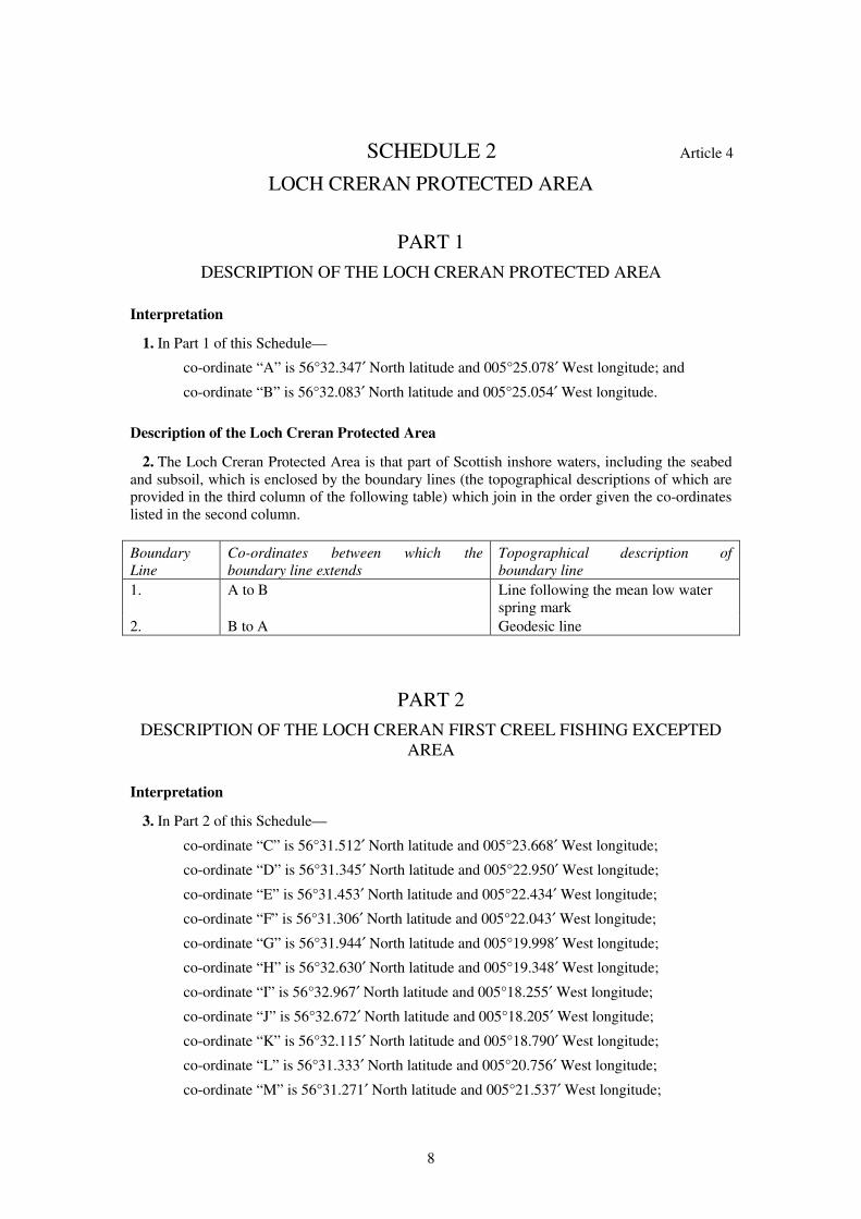
Interpretation
1. In Part 1 of this Schedule—
co-ordinate “A” is 56°32.347′ North latitude and 005°25.078′ West longitude; and
co-ordinate “B” is 56°32.083′ North latitude and 005°25.054′ West longitude.
Description of the Loch Creran Protected Area
2. The Loch Creran Protected Area is that part of Scottish inshore waters, including the seabed
and subsoil, which is enclosed by the boundary lines (the topographical descriptions of which are
provided in the third column of the following table) which join in the order given the co-ordinates
listed in the second column.
Boundary
Line
Co-ordinates between which the
boundary line extends
Topographical description of
boundary line
1. A to B Line following the mean low water
spring mark
2. B to A Geodesic line
PART 2
DESCRIPTION OF THE LOCH CRERAN FIRST CREEL FISHING EXCEPTED
AREA
Interpretation
3. In Part 2 of this Schedule—
co-ordinate “C” is 56°31.512′ North latitude and 005°23.668′ West longitude;
co-ordinate “D” is 56°31.345′ North latitude and 005°22.950′ West longitude;
co-ordinate “E” is 56°31.453′ North latitude and 005°22.434′ West longitude;
co-ordinate “F” is 56°31.306′ North latitude and 005°22.043′ West longitude;
co-ordinate “G” is 56°31.944′ North latitude and 005°19.998′ West longitude;
co-ordinate “H” is 56°32.630′ North latitude and 005°19.348′ West longitude;
co-ordinate “I” is 56°32.967′ North latitude and 005°18.255′ West longitude;
co-ordinate “J” is 56°32.672′ North latitude and 005°18.205′ West longitude;
co-ordinate “K” is 56°32.115′ North latitude and 005°18.790′ West longitude;
co-ordinate “L” is 56°31.333′ North latitude and 005°20.756′ West longitude;
co-ordinate “M” is 56°31.271′ North latitude and 005°21.537′ West longitude;
9
co-ordinate “N” is 56°30.921′ North latitude and 005°22.547′ West longitude; and
co-ordinate “O” is 56°31.294′ North latitude and 005°23.682′ West longitude.
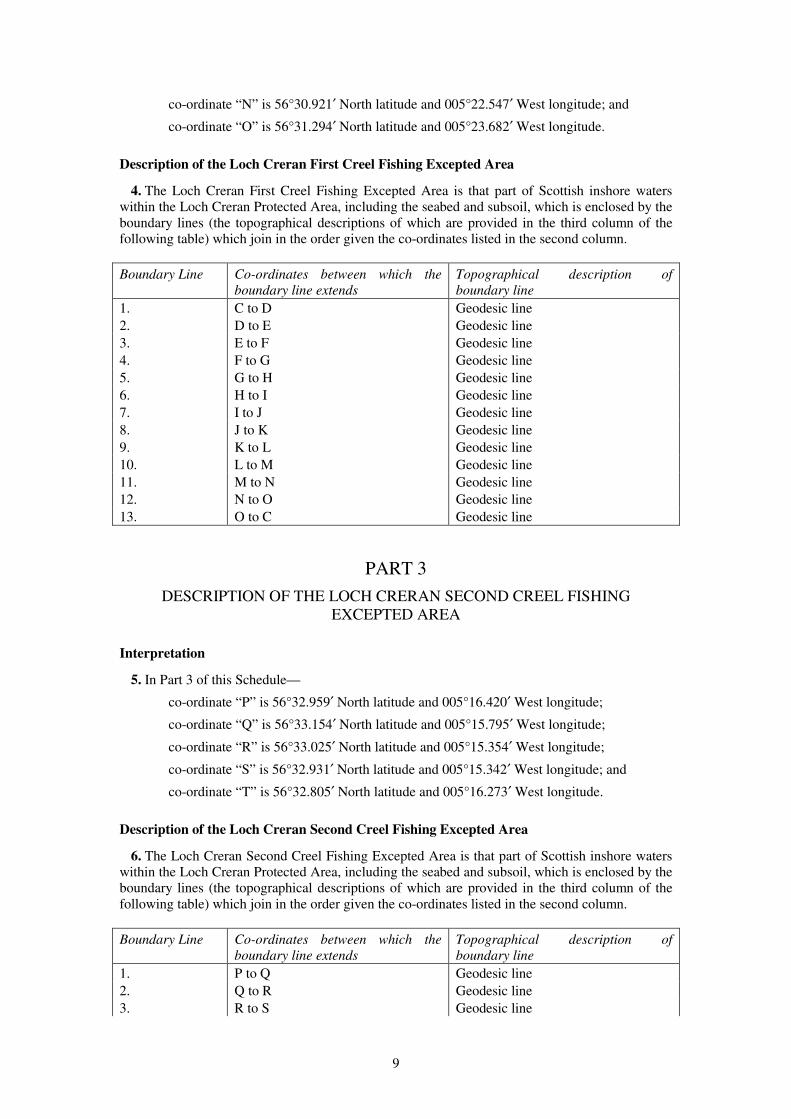
Description of the Loch Creran First Creel Fishing Excepted Area
4. The Loch Creran First Creel Fishing Excepted Area is that part of Scottish inshore waters
within the Loch Creran Protected Area, including the seabed and subsoil, which is enclosed by the
boundary lines (the topographical descriptions of which are provided in the third column of the
following table) which join in the order given the co-ordinates listed in the second column.
Boundary Line Co-ordinates between which the
boundary line extends
Topographical description of
boundary line
1. C to D Geodesic line
2. D to E Geodesic line
3. E to F Geodesic line
4. F to G Geodesic line
5. G to H Geodesic line
6. H to I Geodesic line
7. I to J Geodesic line
8. J to K Geodesic line
9. K to L Geodesic line
10. L to M Geodesic line
11. M to N Geodesic line
12. N to O Geodesic line
13. O to C Geodesic line
PART 3
DESCRIPTION OF THE LOCH CRERAN SECOND CREEL FISHING
EXCEPTED AREA
Interpretation
5. In Part 3 of this Schedule—
co-ordinate “P” is 56°32.959′ North latitude and 005°16.420′ West longitude;
co-ordinate “Q” is 56°33.154′ North latitude and 005°15.795′ West longitude;
co-ordinate “R” is 56°33.025′ North latitude and 005°15.354′ West longitude;
co-ordinate “S” is 56°32.931′ North latitude and 005°15.342′ West longitude; and
co-ordinate “T” is 56°32.805′ North latitude and 005°16.273′ West longitude.
Description of the Loch Creran Second Creel Fishing Excepted Area
6. The Loch Creran Second Creel Fishing Excepted Area is that part of Scottish inshore waters
within the Loch Creran Protected Area, including the seabed and subsoil, which is enclosed by the
boundary lines (the topographical descriptions of which are provided in the third column of the
following table) which join in the order given the co-ordinates listed in the second column.
Boundary Line Co-ordinates between which the
boundary line extends
Topographical description of
boundary line
1. P to Q Geodesic line
2. Q to R Geodesic line
3. R to S Geodesic line
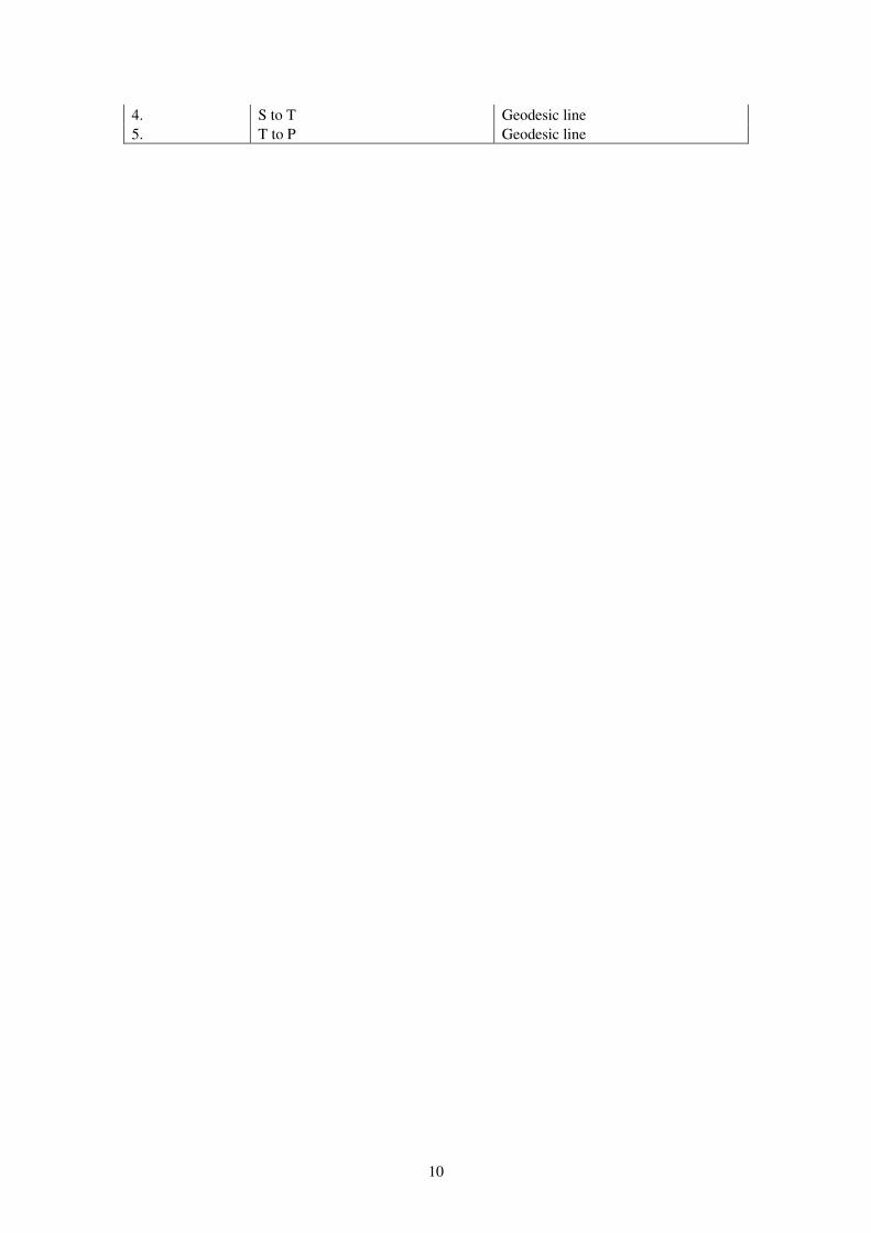
10
4. S to T Geodesic line
5. T to P Geodesic line
11
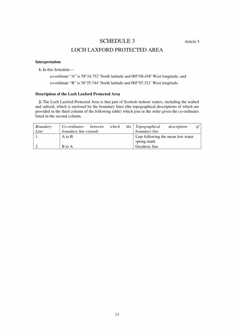
SCHEDULE 3 Article 5
LOCH LAXFORD PROTECTED AREA
Interpretation
1. In this Schedule—
co-ordinate “A” is 58°24.752′ North latitude and 005°08.438′ West longitude; and
co-ordinate “B” is 58°25.744′ North latitude and 005°07.321′ West longitude.
Description of the Loch Laxford Protected Area
2. The Loch Laxford Protected Area is that part of Scottish inshore waters, including the seabed
and subsoil, which is enclosed by the boundary lines (the topographical descriptions of which are
provided in the third column of the following table) which join in the order given the co-ordinates
listed in the second column.
Boundary
Line
Co-ordinates between which the
boundary line extends
Topographical description of
boundary line
1. A to B Line following the mean low water
spring mark
2. B to A Geodesic line
12
SCHEDULE 4 Article 6
LOCH SWEEN PROTECTED AREA
PART 1
DESCRIPTION OF THE LOCH SWEEN PROTECTED AREA
Interpretation
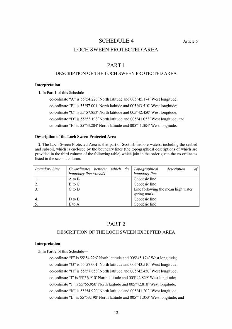
1. In Part 1 of this Schedule—
co-ordinate “A” is 55°54.226′ North latitude and 005°45.174′ West longitude;
co-ordinate “B” is 55°57.001′ North latitude and 005°43.510′ West longitude;
co-ordinate “C” is 55°57.853′ North latitude and 005°42.450′ West longitude;
co-ordinate “D” is 55°53.198′ North latitude and 005°41.053′ West longitude; and
co-ordinate “E” is 55°53.204′ North latitude and 005°41.084′ West longitude.
Description of the Loch Sween Protected Area
2. The Loch Sween Protected Area is that part of Scottish inshore waters, including the seabed
and subsoil, which is enclosed by the boundary lines (the topographical descriptions of which are
provided in the third column of the following table) which join in the order given the co-ordinates
listed in the second column.
Boundary Line Co-ordinates between which the
boundary line extends
Topographical description of
boundary line
1. A to B Geodesic line
2. B to C Geodesic line
3. C to D Line following the mean high water
spring mark
4. D to E Geodesic line
5. E to A Geodesic line
PART 2
DESCRIPTION OF THE LOCH SWEEN EXCEPTED AREA
Interpretation
3. In Part 2 of this Schedule—
co-ordinate “F” is 55°54.226′ North latitude and 005°45.174′ West longitude;
co-ordinate “G” is 55°57.001′ North latitude and 005°43.510′ West longitude;
co-ordinate “H” is 55°57.853′ North latitude and 005°42.450′ West longitude;
co-ordinate “I” is 55°56.910′ North latitude and 005°42.829′ West longitude;
co-ordinate “J” is 55°55.950′ North latitude and 005°42.810′ West longitude;
co-ordinate “K” is 55°54.920′ North latitude and 005°41.202′ West longitude;
co-ordinate “L” is 55°53.198′ North latitude and 005°41.053′ West longitude; and
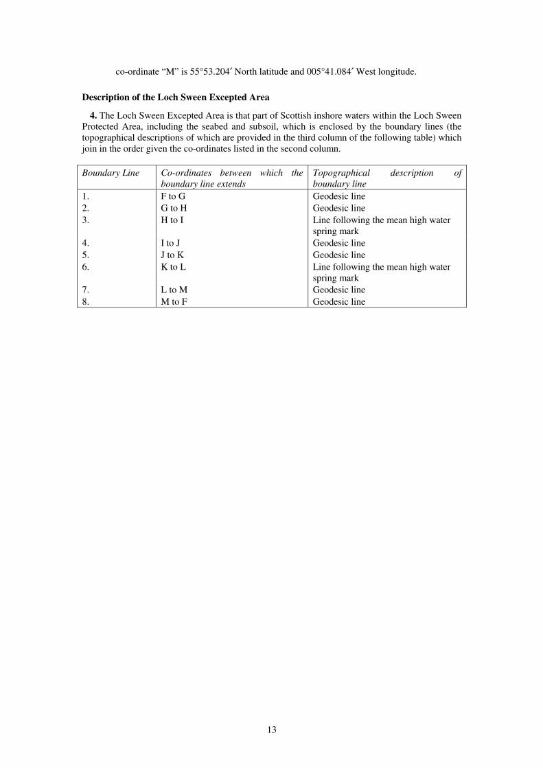
13
co-ordinate “M” is 55°53.204′ North latitude and 005°41.084′ West longitude.
Description of the Loch Sween Excepted Area
4. The Loch Sween Excepted Area is that part of Scottish inshore waters within the Loch Sween
Protected Area, including the seabed and subsoil, which is enclosed by the boundary lines (the
topographical descriptions of which are provided in the third column of the following table) which
join in the order given the co-ordinates listed in the second column.
Boundary Line Co-ordinates between which the
boundary line extends
Topographical description of
boundary line
1. F to G Geodesic line
2. G to H Geodesic line
3. H to I Line following the mean high water
spring mark
4. I to J Geodesic line
5. J to K Geodesic line
6. K to L Line following the mean high water
spring mark
7. L to M Geodesic line
8. M to F Geodesic line
14
SCHEDULE 5 Article 7
LOCH SUNART PROTECTED AREA
PART 1
DESCRIPTION OF THE LOCH SUNART PROTECTED AREA
Interpretation
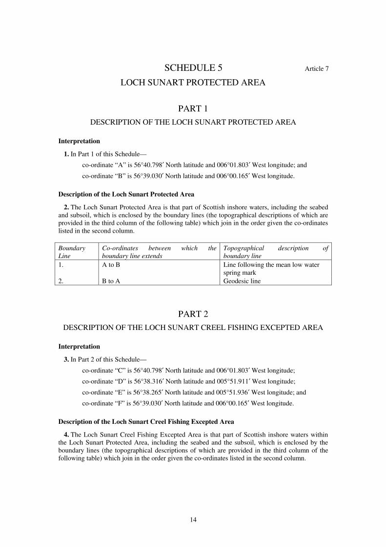
1. In Part 1 of this Schedule—
co-ordinate “A” is 56°40.798′ North latitude and 006°01.803′ West longitude; and
co-ordinate “B” is 56°39.030′ North latitude and 006°00.165′ West longitude.
Description of the Loch Sunart Protected Area
2. The Loch Sunart Protected Area is that part of Scottish inshore waters, including the seabed
and subsoil, which is enclosed by the boundary lines (the topographical descriptions of which are
provided in the third column of the following table) which join in the order given the co-ordinates
listed in the second column.
Boundary
Line
Co-ordinates between which the
boundary line extends
Topographical description of
boundary line
1. A to B Line following the mean low water
spring mark
2. B to A Geodesic line
PART 2
DESCRIPTION OF THE LOCH SUNART CREEL FISHING EXCEPTED AREA
Interpretation
3. In Part 2 of this Schedule—
co-ordinate “C” is 56°40.798′ North latitude and 006°01.803′ West longitude;
co-ordinate “D” is 56°38.316′ North latitude and 005°51.911′ West longitude;
co-ordinate “E” is 56°38.265′ North latitude and 005°51.936′ West longitude; and
co-ordinate “F” is 56°39.030′ North latitude and 006°00.165′ West longitude.
Description of the Loch Sunart Creel Fishing Excepted Area
4. The Loch Sunart Creel Fishing Excepted Area is that part of Scottish inshore waters within
the Loch Sunart Protected Area, including the seabed and the subsoil, which is enclosed by the
boundary lines (the topographical descriptions of which are provided in the third column of the
following table) which join in the order given the co-ordinates listed in the second column.
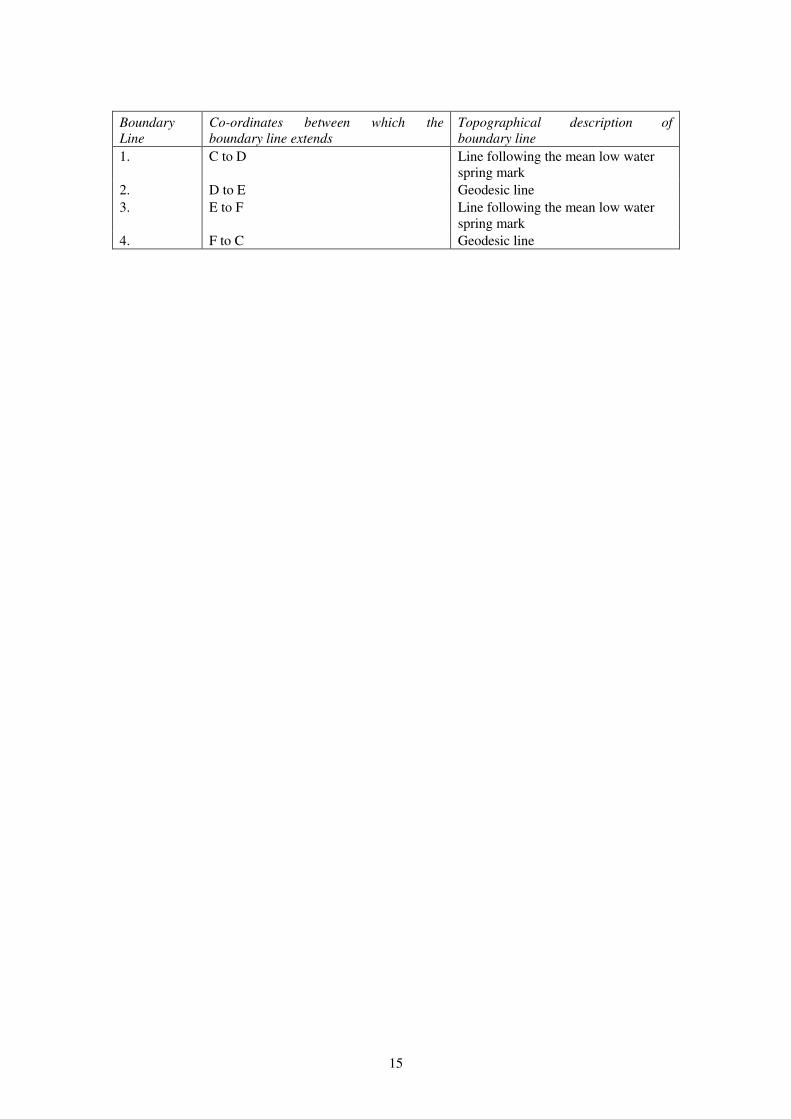
15
Boundary
Line
Co-ordinates between which the
boundary line extends
Topographical description of
boundary line
1. C to D Line following the mean low water
spring mark
2. D to E Geodesic line
3. E to F Line following the mean low water
spring mark
4. F to C Geodesic line
16
SCHEDULE 6 Article 8
SOUTHERN INNER SOUND PROTECTED AREA
PART 1
DESCRIPTION OF THE SOUTHERN INNER SOUND PROTECTED AREA
Interpretation
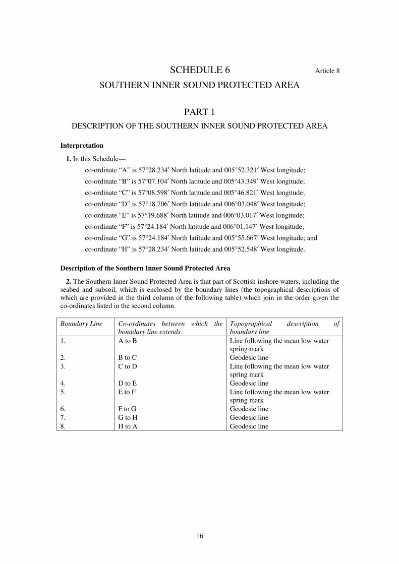
1. In this Schedule—
co-ordinate “A” is 57°28.234′ North latitude and 005°52.321′ West longitude;
co-ordinate “B” is 57°07.104′ North latitude and 005°43.349′ West longitude;
co-ordinate “C” is 57°08.598′ North latitude and 005°46.821′ West longitude;
co-ordinate “D” is 57°18.706′ North latitude and 006°03.048′ West longitude;
co-ordinate “E” is 57°19.688′ North latitude and 006°03.017′ West longitude;
co-ordinate “F” is 57°24.184′ North latitude and 006°01.147′ West longitude;
co-ordinate “G” is 57°24.184′ North latitude and 005°55.667′ West longitude; and
co-ordinate “H” is 57°28.234′ North latitude and 005°52.548′ West longitude.
Description of the Southern Inner Sound Protected Area
2. The Southern Inner Sound Protected Area is that part of Scottish inshore waters, including the
seabed and subsoil, which is enclosed by the boundary lines (the topographical descriptions of
which are provided in the third column of the following table) which join in the order given the
co-ordinates listed in the second column.
Boundary Line Co-ordinates between which the
boundary line extends
Topographical description of
boundary line
1. A to B Line following the mean low water
spring mark
2. B to C Geodesic line
3. C to D Line following the mean low water
spring mark
4. D to E Geodesic line
5. E to F Line following the mean low water
spring mark
6. F to G Geodesic line
7. G to H Geodesic line
8. H to A Geodesic line
17
PART 2
DESCRIPTION OF THE LOCHS DUICH, LONG AND ALSH ADDITIONAL
PROTECTED AREA
Interpretation
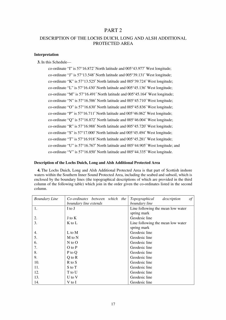
3. In this Schedule—
co-ordinate “I” is 57°16.872′ North latitude and 005°43.977′ West longitude;
co-ordinate “J” is 57°13.548′ North latitude and 005°39.131′ West longitude;
co-ordinate “K” is 57°13.525′ North latitude and 005°39.724′ West longitude;
co-ordinate “L” is 57°16.430′ North latitude and 005°45.136′ West longitude;
co-ordinate “M” is 57°16.491′ North latitude and 005°45.164′ West longitude;
co-ordinate “N” is 57°16.586′ North latitude and 005°45.710′ West longitude;
co-ordinate “O” is 57°16.630′ North latitude and 005°45.836′ West longitude;
co-ordinate “P” is 57°16.711′ North latitude and 005°46.062′ West longitude;
co-ordinate “Q” is 57°16.872′ North latitude and 005°46.004′ West longitude;
co-ordinate “R” is 57°16.988′ North latitude and 005°45.720′ West longitude;
co-ordinate “S” is 57°17.000′ North latitude and 005°45.494′ West longitude;
co-ordinate “T” is 57°16.918′ North latitude and 005°45.281′ West longitude;
co-ordinate “U” is 57°16.767′ North latitude and 005°44.905′ West longitude; and
co-ordinate “V” is 57°16.850′ North latitude and 005°44.335′ West longitude.
Description of the Lochs Duich, Long and Alsh Additional Protected Area
4. The Lochs Duich, Long and Alsh Additional Protected Area is that part of Scottish inshore
waters within the Southern Inner Sound Protected Area, including the seabed and subsoil, which is
enclosed by the boundary lines (the topographical descriptions of which are provided in the third
column of the following table) which join in the order given the co-ordinates listed in the second
column.
Boundary Line Co-ordinates between which the
boundary line extends
Topographical description of
boundary line
1. I to J Line following the mean low water
spring mark
2. J to K Geodesic line
3. K to L Line following the mean low water
spring mark
4. L to M Geodesic line
5. M to N Geodesic line
6. N to O Geodesic line
7. O to P Geodesic line
8. P to Q Geodesic line
9. Q to R Geodesic line
10. R to S Geodesic line
11. S to T Geodesic line
12. T to U Geodesic line
13. U to V Geodesic line
14. V to I Geodesic line
18
SCHEDULE 7 Article 9
NOSS HEAD AND SINCLAIR BAY PROTECTED AREA
Interpretation
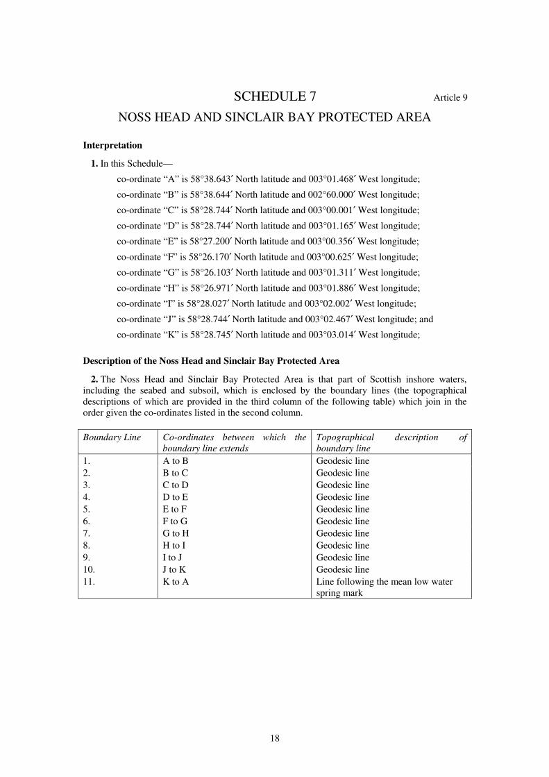
1. In this Schedule—
co-ordinate “A” is 58°38.643′ North latitude and 003°01.468′ West longitude;
co-ordinate “B” is 58°38.644′ North latitude and 002°60.000′ West longitude;
co-ordinate “C” is 58°28.744′ North latitude and 003°00.001′ West longitude;
co-ordinate “D” is 58°28.744′ North latitude and 003°01.165′ West longitude;
co-ordinate “E” is 58°27.200′ North latitude and 003°00.356′ West longitude;
co-ordinate “F” is 58°26.170′ North latitude and 003°00.625′ West longitude;
co-ordinate “G” is 58°26.103′ North latitude and 003°01.311′ West longitude;
co-ordinate “H” is 58°26.971′ North latitude and 003°01.886′ West longitude;
co-ordinate “I” is 58°28.027′ North latitude and 003°02.002′ West longitude;
co-ordinate “J” is 58°28.744′ North latitude and 003°02.467′ West longitude; and
co-ordinate “K” is 58°28.745′ North latitude and 003°03.014′ West longitude;
Description of the Noss Head and Sinclair Bay Protected Area
2. The Noss Head and Sinclair Bay Protected Area is that part of Scottish inshore waters,
including the seabed and subsoil, which is enclosed by the boundary lines (the topographical
descriptions of which are provided in the third column of the following table) which join in the
order given the co-ordinates listed in the second column.
Boundary Line Co-ordinates between which the
boundary line extends
Topographical description of
boundary line
1. A to B Geodesic line
2. B to C Geodesic line
3. C to D Geodesic line
4. D to E Geodesic line
5. E to F Geodesic line
6. F to G Geodesic line
7. G to H Geodesic line
8. H to I Geodesic line
9. I to J Geodesic line
10. J to K Geodesic line
11. K to A Line following the mean low water
spring mark
19
SCHEDULE 8 Article 10
SANDAY PROTECTED AREA
Interpretation
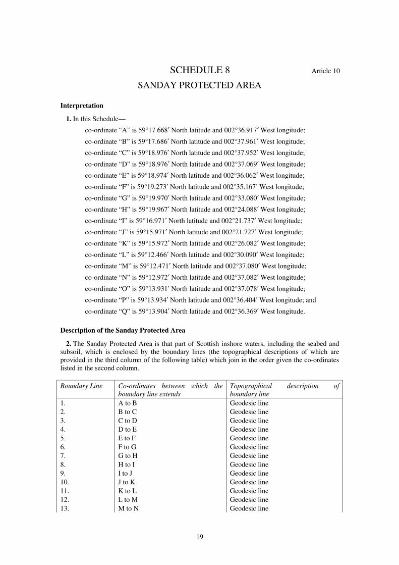
1. In this Schedule—
co-ordinate “A” is 59°17.668′ North latitude and 002°36.917′ West longitude;
co-ordinate “B” is 59°17.686′ North latitude and 002°37.961′ West longitude;
co-ordinate “C” is 59°18.976′ North latitude and 002°37.952′ West longitude;
co-ordinate “D” is 59°18.976′ North latitude and 002°37.069′ West longitude;
co-ordinate “E” is 59°18.974′ North latitude and 002°36.062′ West longitude;
co-ordinate “F” is 59°19.273′ North latitude and 002°35.167′ West longitude;
co-ordinate “G” is 59°19.970′ North latitude and 002°33.080′ West longitude;
co-ordinate “H” is 59°19.967′ North latitude and 002°24.088′ West longitude;
co-ordinate “I” is 59°16.971′ North latitude and 002°21.737′ West longitude;
co-ordinate “J” is 59°15.971′ North latitude and 002°21.727′ West longitude;
co-ordinate “K” is 59°15.972′ North latitude and 002°26.082′ West longitude;
co-ordinate “L” is 59°12.466′ North latitude and 002°30.090′ West longitude;
co-ordinate “M” is 59°12.471′ North latitude and 002°37.080′ West longitude;
co-ordinate “N” is 59°12.972′ North latitude and 002°37.082′ West longitude;
co-ordinate “O” is 59°13.931′ North latitude and 002°37.078′ West longitude;
co-ordinate “P” is 59°13.934′ North latitude and 002°36.404′ West longitude; and
co-ordinate “Q” is 59°13.904′ North latitude and 002°36.369′ West longitude.
Description of the Sanday Protected Area
2. The Sanday Protected Area is that part of Scottish inshore waters, including the seabed and
subsoil, which is enclosed by the boundary lines (the topographical descriptions of which are
provided in the third column of the following table) which join in the order given the co-ordinates
listed in the second column.
Boundary Line Co-ordinates between which the
boundary line extends
Topographical description of
boundary line
1. A to B Geodesic line
2. B to C Geodesic line
3. C to D Geodesic line
4. D to E Geodesic line
5. E to F Geodesic line
6. F to G Geodesic line
7. G to H Geodesic line
8. H to I Geodesic line
9. I to J Geodesic line
10. J to K Geodesic line
11. K to L Geodesic line
12. L to M Geodesic line
13. M to N Geodesic line
20
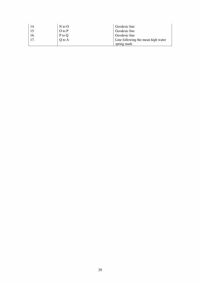
14. N to O Geodesic line
15. O to P Geodesic line
16. P to Q Geodesic line
17. Q to A Line following the mean high water
spring mark
21
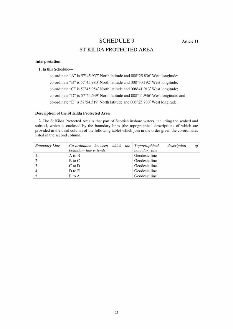
SCHEDULE 9 Article 11
ST KILDA PROTECTED AREA
Interpretation
1. In this Schedule—
co-ordinate “A” is 57°45.937′ North latitude and 008°25.836′ West longitude;
co-ordinate “B” is 57°45.980′ North latitude and 008°30.192′ West longitude;
co-ordinate “C” is 57°45.954′ North latitude and 008°41.913′ West longitude;
co-ordinate “D” is 57°54.549′ North latitude and 008°41.946′ West longitude; and
co-ordinate “E” is 57°54.519′ North latitude and 008°25.780′ West longitude.
Description of the St Kilda Protected Area
2. The St Kilda Protected Area is that part of Scottish inshore waters, including the seabed and
subsoil, which is enclosed by the boundary lines (the topographical descriptions of which are
provided in the third column of the following table) which join in the order given the co-ordinates
listed in the second column.
Boundary Line Co-ordinates between which the
boundary line extends
Topographical description of
boundary line
1. A to B Geodesic line
2. B to C Geodesic line
3. C to D Geodesic line
4. D to E Geodesic line
5. E to A Geodesic line
22
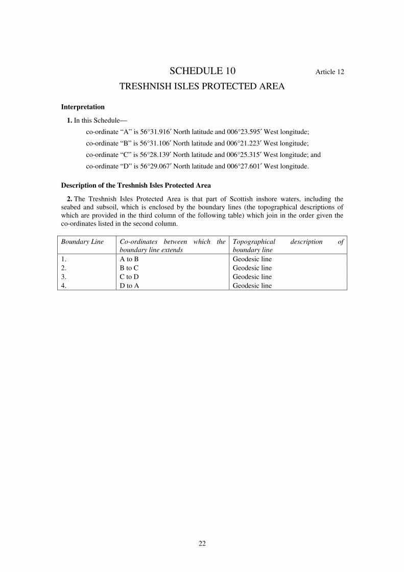
SCHEDULE 10 Article 12
TRESHNISH ISLES PROTECTED AREA
Interpretation
1. In this Schedule—
co-ordinate “A” is 56°31.916′ North latitude and 006°23.595′ West longitude;
co-ordinate “B” is 56°31.106′ North latitude and 006°21.223′ West longitude;
co-ordinate “C” is 56°28.139′ North latitude and 006°25.315′ West longitude; and
co-ordinate “D” is 56°29.067′ North latitude and 006°27.601′ West longitude.
Description of the Treshnish Isles Protected Area
2. The Treshnish Isles Protected Area is that part of Scottish inshore waters, including the
seabed and subsoil, which is enclosed by the boundary lines (the topographical descriptions of
which are provided in the third column of the following table) which join in the order given the
co-ordinates listed in the second column.
Boundary Line Co-ordinates between which the
boundary line extends
Topographical description of
boundary line
1. A to B Geodesic line
2. B to C Geodesic line
3. C to D Geodesic line
4. D to A Geodesic line
23
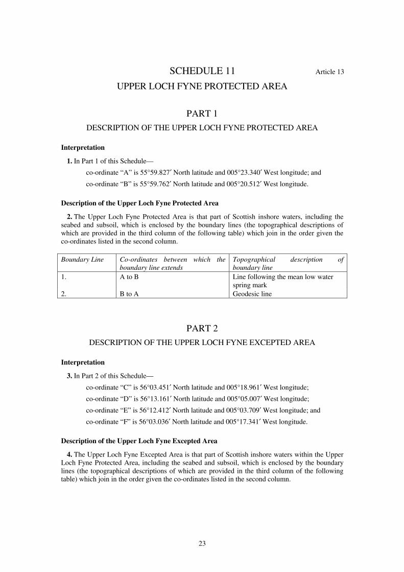
SCHEDULE 11 Article 13
UPPER LOCH FYNE PROTECTED AREA
PART 1
DESCRIPTION OF THE UPPER LOCH FYNE PROTECTED AREA
Interpretation
1. In Part 1 of this Schedule—
co-ordinate “A” is 55°59.827′ North latitude and 005°23.340′ West longitude; and
co-ordinate “B” is 55°59.762′ North latitude and 005°20.512′ West longitude.
Description of the Upper Loch Fyne Protected Area
2. The Upper Loch Fyne Protected Area is that part of Scottish inshore waters, including the
seabed and subsoil, which is enclosed by the boundary lines (the topographical descriptions of
which are provided in the third column of the following table) which join in the order given the
co-ordinates listed in the second column.
Boundary Line Co-ordinates between which the
boundary line extends
Topographical description of
boundary line
1. A to B Line following the mean low water
spring mark
2. B to A Geodesic line
PART 2
DESCRIPTION OF THE UPPER LOCH FYNE EXCEPTED AREA
Interpretation
3. In Part 2 of this Schedule—
co-ordinate “C” is 56°03.451′ North latitude and 005°18.961′ West longitude;
co-ordinate “D” is 56°13.161′ North latitude and 005°05.007′ West longitude;
co-ordinate “E” is 56°12.412′ North latitude and 005°03.709′ West longitude; and
co-ordinate “F” is 56°03.036′ North latitude and 005°17.341′ West longitude.
Description of the Upper Loch Fyne Excepted Area
4. The Upper Loch Fyne Excepted Area is that part of Scottish inshore waters within the Upper
Loch Fyne Protected Area, including the seabed and subsoil, which is enclosed by the boundary
lines (the topographical descriptions of which are provided in the third column of the following
table) which join in the order given the co-ordinates listed in the second column.
24
Boundary Line Co-ordinates between which the
boundary line extends
Topographical description of
boundary line
1. C to D Line following the mean low water
spring mark
2. D to E Geodesic line
3. E to F Line following the mean low water
spring mark
4. F to C Geodesic line
PART 3
DESCRIPTION OF THE UPPER LOCH FYNE ADDITIONAL FLAME SHELL
PROTECTED AREA
Interpretation
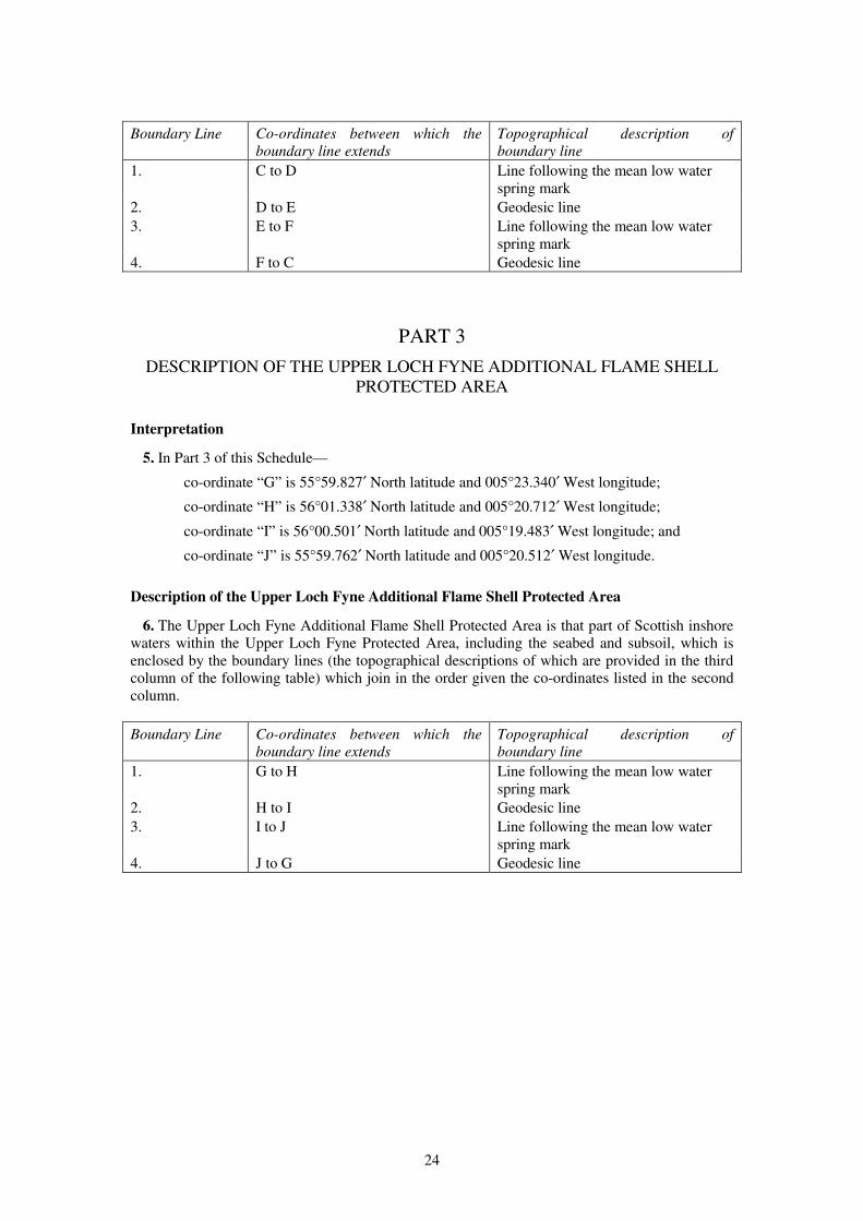
5. In Part 3 of this Schedule—
co-ordinate “G” is 55°59.827′ North latitude and 005°23.340′ West longitude;
co-ordinate “H” is 56°01.338′ North latitude and 005°20.712′ West longitude;
co-ordinate “I” is 56°00.501′ North latitude and 005°19.483′ West longitude; and
co-ordinate “J” is 55°59.762′ North latitude and 005°20.512′ West longitude.
Description of the Upper Loch Fyne Additional Flame Shell Protected Area
6. The Upper Loch Fyne Additional Flame Shell Protected Area is that part of Scottish inshore
waters within the Upper Loch Fyne Protected Area, including the seabed and subsoil, which is
enclosed by the boundary lines (the topographical descriptions of which are provided in the third
column of the following table) which join in the order given the co-ordinates listed in the second
column.
Boundary Line Co-ordinates between which the
boundary line extends
Topographical description of
boundary line
1. G to H Line following the mean low water
spring mark
2. H to I Geodesic line
3. I to J Line following the mean low water
spring mark
4. J to G Geodesic line
25
SCHEDULE 12 Article 14
LOCH GOIL PROTECTED AREA
PART 1
DESCRIPTION OF THE LOCH GOIL PROTECTED AREA
Interpretation
1. In Part 1 of this Schedule—
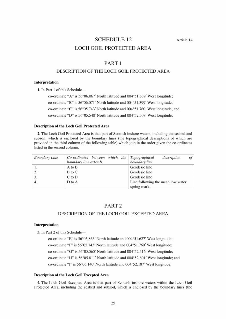
co-ordinate “A” is 56°06.067′ North latitude and 004°51.639′ West longitude;
co-ordinate “B” is 56°06.071′ North latitude and 004°51.399′ West longitude;
co-ordinate “C” is 56°05.743′ North latitude and 004°51.760′ West longitude; and
co-ordinate “D” is 56°05.540′ North latitude and 004°52.508′ West longitude.
Description of the Loch Goil Protected Area
2. The Loch Goil Protected Area is that part of Scottish inshore waters, including the seabed and
subsoil, which is enclosed by the boundary lines (the topographical descriptions of which are
provided in the third column of the following table) which join in the order given the co-ordinates
listed in the second column.
Boundary Line Co-ordinates between which the
boundary line extends
Topographical description of
boundary line
1. A to B Geodesic line
2. B to C Geodesic line
3. C to D Geodesic line
4. D to A Line following the mean low water
spring mark
PART 2
DESCRIPTION OF THE LOCH GOIL EXCEPTED AREA
Interpretation
3. In Part 2 of this Schedule—
co-ordinate “E” is 56°05.863′ North latitude and 004°51.627′ West longitude;
co-ordinate “F” is 56°05.743′ North latitude and 004°51.760′ West longitude;
co-ordinate “G” is 56°05.565′ North latitude and 004°52.416′ West longitude;
co-ordinate “H” is 56°05.811′ North latitude and 004°52.601′ West longitude; and
co-ordinate “I” is 56°06.140′ North latitude and 004°52.187′ West longitude.
Description of the Loch Goil Excepted Area
4. The Loch Goil Excepted Area is that part of Scottish inshore waters within the Loch Goil
Protected Area, including the seabed and subsoil, which is enclosed by the boundary lines (the
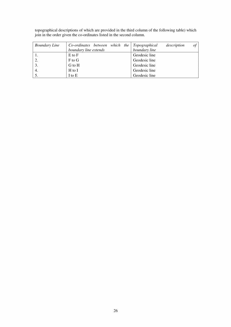
26
topographical descriptions of which are provided in the third column of the following table) which
join in the order given the co-ordinates listed in the second column.
Boundary Line Co-ordinates between which the
boundary line extends
Topographical description of
boundary line
1. E to F Geodesic line
2. F to G Geodesic line
3. G to H Geodesic line
4. H to I Geodesic line
5. I to E Geodesic line
27
SCHEDULE 13 Article 15
WYRE AND ROUSAY SOUNDS PROTECTED AREA
Interpretation
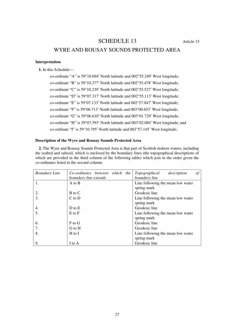
1. In this Schedule—
co-ordinate “A” is 59°10.694′ North latitude and 002°55.249′ West longitude;
co-ordinate “B” is 59°10.277′ North latitude and 002°55.478′ West longitude;
co-ordinate “C” is 59°10.239′ North latitude and 002°55.527′ West longitude;
co-ordinate “D” is 59°07.317′ North latitude and 002°55.113′ West longitude;
co-ordinate “E” is 59°07.133′ North latitude and 002°57.047′ West longitude;
co-ordinate “F” is 59°06.713′ North latitude and 003°00.653′ West longitude;
co-ordinate “G” is 59°06.610′ North latitude and 003°01.729′ West longitude;
co-ordinate “H” is 59°07.593′ North latitude and 003°02.084′ West longitude; and
co-ordinate “I” is 59°10.795′ North latitude and 002°57.145′ West longitude;
Description of the Wyre and Rousay Sounds Protected Area
2. The Wyre and Rousay Sounds Protected Area is that part of Scottish inshore waters, including
the seabed and subsoil, which is enclosed by the boundary lines (the topographical descriptions of
which are provided in the third column of the following table) which join in the order given the
co-ordinates listed in the second column.
Boundary Line Co-ordinates between which the
boundary line extends
Topographical description of
boundary line
1. A to B Line following the mean low water
spring mark
2. B to C Geodesic line
3. C to D Line following the mean low water
spring mark
4. D to E Geodesic line
5. E to F Line following the mean low water
spring mark
6. F to G Geodesic line
7. G to H Geodesic line
8. H to I Line following the mean low water
spring mark
9. I to A Geodesic line
28
EXPLANATORY NOTE
(This note is not part of the Order)
Article 11(1) of Regulation (EU) No 1380/2013 of the European Parliament and of the Council on
the Common Fisheries Policy (OJ L 354, 28.12.2013, p.22) empowers EU member States to adopt
conservation measures which are necessary for compliance with obligations under EU
environmental legislation. This Order prohibits, subject to certain exceptions where applicable,
specified methods of fishing within specified areas which have been designated as a Special Area
of Conservation or as a Marine Protected Area.
Article 3 and Schedule 1 prohibit fishing for sea fish with specified fishing gear in an area of
Scottish inshore waters in East Mingulay. Fishing with any fishing gear except a pelagic trawl is
also prohibited in a smaller inner area within the larger protected area.
Article 4 and Schedule 2 prohibit fishing for sea fish with any fishing gear in an area of Scottish
inshore waters in Loch Creran. Fishing for horse mussels is also prohibited in the same protected
area. An exception to the prohibition applies throughout the protected area so as to permit fishing
for sea fish with a rod and line or a handline. Exceptions also apply so as to permit fishing for sea
fish with a creel or parlour creel in two excepted fishing areas within the larger protected area.
Article 5 and Schedule 3 prohibit fishing for sea fish with specified fishing gear in an area of
Scottish inshore waters in Loch Laxford.
Article 6 and Schedule 4 prohibit fishing for sea fish by hand or with specified fishing gear in an
area of Scottish inshore waters in Loch Sween. An exception to the prohibition applies so as to
permit fishing by specified methods within an excepted area within the larger protected area.
However, part of the exception permits fishing only between certain hours of specified days of the
week.
Article 7 and Schedule 5 prohibit fishing for sea fish with specified fishing gear in an area of
Scottish inshore waters in Loch Sunart. Fishing for horse mussels is also prohibited in the same
protected area. An exception applies so as to permit fishing for sea fish with a creel or parlour
creel in a designated fishing area within the larger protected area.
Article 8 and Schedule 6 prohibit fishing for sea fish with specified fishing gear in an area of
Scottish inshore waters in the Southern Inner Sound. A seasonal exception applies so as to permit
fishing with specified types of fishing gear within the protected area. However, the exception does
not apply to fishing by specified methods, or to fishing in two smaller areas within the larger
protected area. Fishing for horse mussels is also prohibited in the two smaller areas.
Article 9 and Schedule 7 prohibit fishing for sea fish with specified fishing gear in an area of
Scottish inshore waters in Noss Head and Sinclair Bay. Fishing for horse mussels is also
prohibited in the same protected area.
Article 10 and Schedule 8 prohibit fishing for sea fish with specified fishing gear in an area of
Scottish inshore waters in Sanday.
Article 11 and Schedule 9 prohibit fishing for sea fish with specified fishing gear in an area of
Scottish inshore waters in St Kilda.
Article 12 and Schedule 10 prohibit fishing for sea fish with specified fishing gear in an area of
Scottish inshore waters in the Treshnish Isles.
Article 13 and Schedule 11 prohibit fishing for sea fish with specified fishing gear in an area of
Scottish inshore waters in Upper Loch Fyne. Fishing for horse mussels is also prohibited in the
same protected area. An exception to the prohibition applies so as to permit fishing from boats
with a gross tonnage of no more than 75 tonnes, using a demersal trawl, in a designated area
within the larger protected area. Fishing with a creel, parlour creel, set net or long line is also
prohibited in an additional smaller protected area within the larger protected area.
29
Article 14 and Schedule 12 prohibit fishing for sea fish with specified fishing gear in an area of
Scottish inshore waters in Loch Goil. Fishing for horse mussels is also prohibited in the same
protected area. An exception to the prohibition applies so as to permit fishing from boats with a
gross tonnage of no more than 75 tonnes, using a demersal trawl, in a designated area within the
larger protected area.
Article 15 and Schedule 13 prohibit fishing for sea fish with specified fishing gear in an area of
Scottish inshore waters in the Wyre and Rousay Sounds.
Article 16 revokes entries in the Inshore Fishing (Prohibition of Fishing and Fishing Methods)
(Scotland) Order 2004 relating to Loch Sween; the Southern Inner Sound including Lochs Carron,
Kishorn, Duich, Alsh and Hourn; Loch Laxford; and Sinclair Bay. It also revokes the Inshore
Fishing (Prohibited Methods of Fishing) (Loch Creran) Order 2007.
Any person who contravenes a provision contained in this Order commits an offence under section
4 of the Inshore Fishing (Scotland) Act 1984.
A business and regulatory impact assessment has been prepared in relation to this Order and
placed in the Scottish Parliament Information Centre. A copy of this can be obtained from Marine
Scotland, the Scottish Government, Victoria Quay, Edinburgh EH6 6QQ.
© Crown copyright 2015
Printed in the UK by The Stationery Office Limited under the authority and superintendence of Carol Tullo, the Queen’s Printer
for Scotland.


£6.00
S2015121718 12/2015 19585
http://www.legislation.gov.uk/id/ssi/2015/435