Embed Size (px)
Citation preview

Goingwith
the Flow
Understanding Effects of Land Management on Rivers Floods and Floodplains
Barbara Ellis-Sugai and Derek C Godwin
Going with the Flow Understanding Effects of Land Management
on Rivers Floods and Floodplains
Barbara Ellis-Sugai and Derek C Godwin
Oregon Sea Grant Corvallis Oregon
ORESU-T-01-003
4 bull Going with the Flow Understanding Effects of Land Management on Rivers Floods and Floodplains
copy 2002 by Oregon State University ISBN 1-881826-27-9
When ordering copies of this publication request publication number ORESU-T-01-003 Oregon Sea Grant Oregon State University 322 Kerr Administration Bldg Corvallis OR 97331-2131 (541) 737-2716 seagrantorstedu
This publication was funded by the National Sea Grant College Proshygram of the US Department of Commercersquos National Oceanic and Atshymospheric Administration under NOAA grant number NA76RG0476 (project number AESG-4) and by appropriations made by the Oregon State legislature The views herein do not necessarily reflect the views of any of those organizations
Sea Grant is a unique partnership with public and private sectors combining research education and technology transfer for public service This national network of universities meets the changing enshyvironmental and economic needs of people in our coastal ocean and Great Lakes regions
Authors Barbara Ellis-Sugai Siuslaw National Forest and Derek C Godwin Extension Sea Grant Oregon State University
Illustration credits fig 1mdashFrom Living in the Environment Princishyples Connections and Solutions 7th edition by G T Miller copy 1992 Reprinted with permission of Wadsworth an imprint of the Wadshysworth Group a division of Thomson Learning Fax 800-730-2215 fig 3mdashOregon Watershed Assessment Manual fig 4mdashby Ralph Penunuri fig 5mdashby Ralph Penunuri fig 8mdashFarm Services Agency Marion County fig 9mdashReprinted by permission of the publisher from A View of the River by Luna B Leopold Cambridge Mass Harvard Univershysity Press Copyright copy 1994 by the President and Fellows of Harvard College Originally published in ldquoRiversrdquo by Luna B Leopold in the American Scientist 50 (1962)525 Permission to reprint also granted by the American Scientist fig 10mdashby Ralph Penunuri fig 11mdashOreshygon State University Archives fig 12mdashReprinted by permission of the publisher from A View of the River by Luna B Leopold Cambridge Mass Harvard University Press figs 13a and 13bmdashby Ralph Penunuri fig 14mdashby Ralph Penunuri fig 18mdashDerek Godwin fig 20mdashReprinted by permission of the publisher from A View of the River by Luna B Leopold Cambridge Mass Harvard University Press Figs 2 6a and 6b 7 15 16 17 19 21 22 23 25 25 26mdashUS Forest Service
Editing and layout Rick Cooper
Going with the Flow Understanding Effects of Land Management on Rivers Floods and Floodplains bull 5
Contents Introduction 7
A Stream Network Defines a Watershed 7
Streams Are Always Changing 9
Why Do Streams Meander 13
Pools Riffles and Gravel Bars 16
The Effects of Changing Sinuosity 16
What Is a ldquoStablerdquo Stream 18
Predicting the Extent of Channel Migration 19
Why Is the Streambank Eroding 19
Stabilizing Streambanks 21
Large Wood in Streams and Floodplains 22
Understanding Floods and Floodplains 23
The Flood Frequency Concept 24
How Humans Interact with Rivers to Change Flood Events 25
The Economics of Floodplain Management 28
Reducing the Impacts of Floods 28
Stream Rehabilitation Restoration and Enhancement 28
Conclusions 31
Bailey Creek Case Study 32
Glossary 36
Literature Cited 37
Resources for Further Information 38
6 bull Going with the Flow Understanding Effects of Land Management on Rivers Floods and Floodplains
1ndash24 Chapter 1 Overview of Stream Corridors
The processes that develop the charac-teristic structure seen in the lateral viewof a stream corridor also influencestructure in the longitudinal viewChannel width and depth increasedownstream due to increasing drainagearea and discharge Related structuralchanges also occur in the channelfloodplain and transitional uplandfringe and in processes such as erosionand deposition Even among differenttypes of streams a common sequenceof structural changes is observable fromheadwaters to mouth
Longitudinal Zones
The overall longitudinal profile of moststreams can be roughly divided intothree zones (Schumm 1977) Some ofthe changes in the zones are character-ized in Figures 127 and 128
Zone 1 or headwaters often has thesteepest gradient Sediment erodes fromslopes of the watershed and movesdownstream Zone 2 the transfer zonereceives some of the eroded material Itis usually characterized by wide flood-plains and meandering channel pat-terns The gradient flattens in Zone 3the primary depositional zone Thoughthe figure displays headwaters as moun-tain streams these general patterns andchanges are also often applicable to wa-tersheds with relatively small topo-graphic relief from the headwaters tomouth It is important to note that ero-sion transfer and deposition occur inall zones but the zone concept focuseson the most dominant process
Watershed Forms
All watersheds share a common defini-tion a watershed is an ldquoarea of land that
1C A Longitudinal View Along the StreamCorridor
Figure 127 Three longitudinal profile zones Channel and floodplain characteristics change asrivers travel from headwaters to mouthSource Miller (1990) copy1990 Wadsworth Publishing Co
Introduction
Many people are seeking to actively improve fish habishytat and water quality for salmon and trout in the Pacific Northwest The most common approaches are
to conduct stream and riparian enhancement projects to imshyprove these functions Understanding river processes floods and floodplains is invaluable in planning successful projects This publication attempts to provide basic information to help landowners watershed groups and resource professionals implement successful enhancement projects and management plans that ultimately improve fish habitat and water quality
A Stream Network Defines a Watershed A watershed is an area of land that collects rain and snow and discharges much of it to a stream river or other water body A watershed has a stream network made up of a main stream with tributaries that flow into it Not all streams within a watershyshed have the same characteristics Several stream classification systems have been developed to describe these differences and compare one stream to another
Montgomery and Buffington (1998) devised a stream classifishycation system that is useful in describing a watershedrsquos stream network They separate streams into three categoriesmdashsource transport and depositional Mountain headwater streams
streams (figshyures 1 and 2) They use meashysurable charshyacteristics to identify these stream types One characshyteristic is the streamrsquos slope or gradient The second is the ratio of stream width to the width of the valley floor Followshying are general descriptions of these stream types See Montgomery and Buffington (1997 1998) for more detailed decriptions
Low-elevation streams merge and flow down gentler slopes The valley broadens and the river begins to meander
At an even lower elevation a river wanders and meanders slowly across a broad nearly flat valley At its mouth it may divide into many separate channels as it flows across a delta built up of river-borne sediments and into the sea
flow swiftly down steep slopes and cut a deep
V-shaped valley Rapids and
waterfalls are common
Zone 1Headwaters Zone 2Transfer Zone
Zone 3Depositional Zone
Figure 1 Example of three different stream types in a watershed Source Miller (1990)
Going with the Flow Understanding Effects of Land Management on Rivers Floods and Floodplains bull 7
8 bull Going with the Flow Understanding Effects of Land Management on Rivers Floods and Floodplains
Figure 2 Topographic map showing the Cascade Creek watershed and stream network in the Coast Range Oregon Pink = source stream yellow = transport stream blue = deposition stream (USFS)
What happens in one part of the stream netshywork can affect the other parts
Source streams These are headwater streams that are steep (greater than 20 percent) straight and have no floodplain These streams are source areas for sediment and wood In mountainous areas they can be prone to landslides in the stream channel that carry wood sediment and water downshystream (debris torrents)
Transport streams These streams typically have a moderate gradient (3ndash20 percent) They develop small meanders in modshyerately narrow valleys with small floodplains Sediment and wood are temporarily stored here as they move from source to depositional areas
Deposition streams These streams are low gradient (less than 3 percent) They are meandering streams in wide valleys with large floodplains (relative to stream size) Sediment and wood are deposited here for long periods of time These streams are the most sensitive to changes in the watershed such as a change in sediment supply
The Oregon Watershed Assessment Manual uses a similar stream classification system The stream types (or channel types) are separated by stream gradient confinement class (based on ratio of stream width to valley width) and size of stream (based on Oregon Department of Forestry designations for stream size) Figure 3 illustrates some of the stream types described by this classification system
Going with the Flow Understanding Effects of Land Management on Rivers Floods and Floodplains bull 9
For comparison Dave Rosgen (1996) developed a more site-speshycific stream classification system that has been adopted by several resource agencies and groups His system is more comshyplex and categorizes streams by differences in their channel gradients bed materials ratios of stream width to depth degree of meandering (sinuosity) and the extent the channels have downcut into their floodplain
Streams Are Always Changing Streams constantly adjust their shape to changing conditions The following stream characteristics influence a streamrsquos shape
Channel slope or gradient (drop in elevation over a given distance)
Stream flow or discharge (the volume of water moving through the channel at a given time usually expressed as cubic feet per second)
Material found in the streambed and banks such as silt clay sand gravel cobble boulders bedrock large wood and tree roots
Figure 3 Examples of the channel habitat types and their relative position in the watershed as determined by the classification method in the Oregon Watershed Assessment Manual (Oregon Watershed Assessment Manual June 1999)
10 bull Going with the Flow Understanding Effects of Land Management on Rivers Floods and Floodplains
Amount of sediment moving through the stream network (silt clay sand gravel cobble and boulders)
The ratio of the streamrsquos width to its depth (streams range from wide and shallow to narrow and deep) (figure 4)
Sinuosity (the distance a river travels divided by the straight-line distance) A perfectly straight channel would have a sinuosity equal to one The more meandering the channel the higher the number (figure 5)
Amount and type of riparian vegetation (vegetation growing next to the stream such as trees shrubs and grasses)
All of these factors are linked together If one variable changshyes the others will change in response For example if erosion increases in the watershed and the supply of sediment increases several results are possible If the streamrsquos capacity to transport the sediment is overwhelmed the sediment may be deposited which will raise the elevation of the streambed Gravel bars may get bigger causing erosion of the opposite banks in order to maintain the same channel size Pools may fill in reducing the quality of fish habitat The stream may change from having a single channel to multiple channels
Montgomery and Buffington (1993) give several examples of the effect an increased sediment supply can have on streams The Williams River in Saskatchewan Canada passes through sand dunes As the river passes through the sand dunes it picks up extra sediment and becomes a braided channel five times wider and half as deep as the river upstream of the dune field Anothshyer well-studied example depicts the effects of hydraulic mining in the Sierra Nevada Mountains of California Large amounts of sediment were added to rivers in the foothills of the Sierras between 1850 and 1880 as miners used high-pressure water hosshyes to wash rock and soil into streams where it could be sluiced for gold As a result channels filled in and widened This effect progressed downstream and after the ldquowaverdquo or ldquowedgerdquo of sediment passed through the stream the stream downcut into the material that had been left behind
In a different example stream bank erosion is likely to increase if riparian vegetation is removed along depositional streams with banks that are sensitive to erosion This would cause more sediment to be deposited downstream and may lead to channel widening and further bank erosion downstream (figures 6a and 6b)
W = 12rsquo
D = 1rsquo
W = 9rsquo
D = 3rsquo
a) WD = 12
b) WD = 3
Figure 4 Width to depth diagram (Illustration by Ralph Penunuri)
Sinuosity = stream length valley length
stream length
valley length
Figure 5 Example of how to measure and calculate sinuosity (Illustration by Ralph Penunuri modified from Rosgen 1996 Applied River Morphology)
Going with the Flow Understanding Effects of Land Management on Rivers Floods and Floodplains bull 11
12 bull Going with the Flow Understanding Effects of Land Management on Rivers Floods and Floodplains
Figures 6a and 6b West Creek photos illustrating two riparian conditions 6a (top) depicts riparian conditions with low amount of stream erosion 6b (bottom) depicts an overgrazed riparian area with an increase in erosion (USFS)
Going with the Flow Understanding Effects of Land Management on Rivers Floods and Floodplains bull 13
Why Do Streams Meander Ninety percent of the worldrsquos low-gradient rivers are single-channel meandering streams (Leopold 1994)
A streamrsquos pattern develops naturally to dissipate its energy and carry sediment Streams with steep gradients (source and transshyport streams) dissipate their energy by creating pools through a series of steps falls and plunges (figure 7) Such streams look almost straight on a map This ldquostep poolrdquo pattern can be thought of as meanders turned on their side As the streamrsquos slope (gradient) flattens the depositional segments of a stream disshysipate energy by creating a meandering flow pattern Meanders cause the river to dissipate energy along the winding path as the water is forced around the bends (figure 8) Meanders in a river are analogous to switchbacks in a mountain road They reduce the riverrsquos slope and therefore the velocity of the water Energy is also used up through friction of the water against the bed and banks of the stream
A regular meander pattern can often be seen from a distance For instance you might recognize meanders from a map or an airshyplane by looking at the shape of many rivers Each meander might look different but the elements of the basic pattern often are repeatshyed over longer distances Research has shown that meanders have a predictable size and shape (Leoshypold 1994) (figure 9) No matter how big the river is there is a fairly constant relationship between the wavelength of the meanders the channel width and the radius of curvature For example a low-grashydient meandering stream (deposhysitional stream) tends to have a meander wavelength that is 10ndash14 times the channel width and a meander radius of curvature 2ndash3 times the channel width Figure 10 graphically illustrates stream channel geometry and terminology
The word ldquomeanderrdquo is derived from a Greek word that means ldquoto wanderrdquo
Figure 7 Photo of step pool transport stream (USFS)
Figure 8 General landscape view of a meandering stream (aerial photo of Calapooia River Oregon) River flows in direction of arrows (Farm Services Agency Marion County)
14 bull Going with the Flow Understanding Effects of Land Management on Rivers Floods and Floodplains
Figure 9 Leopoldrsquos diagram of meanders of different-size rivers (Leopold 1994)
The Walla Walla River had been channelized and diked around Milton-Freewater Oregon to provide flood control During the 1964 flood that affected much of the Pacific Northwest the river broke through the dikes in severshyal places when the flow exceeded the capacity of the artificial chanshynel Once the river overtopped the channel the river developed a regular meander pattern that is superimposed over the straight channel The river is flowing from the bottom of the photo to the top (figure 11)
Radius of Curvature
WAVELENGTH
BEL
T W
idth
Inflection Point
Bend Length = 12 Channel Distance A - B A B
Figure 10 Graphic of stream channel geometry (Illustration by Ralph Penunuri modified from Rosgen 1996 Applied River Morphology)
Figure 11 Walla Walla River (1964 flood showing meanders in a channelized section near Milton-Freewater) (OSU Archives)
Going with the Flow Understanding Effects of Land Management on Rivers Floods and Floodplains bull 15
Pools Low flow
Riffles
Pointbars
High flow
Figure 12 Profile and plan view of pools riffles and point bars (Illustration by Ralph Penunuri modified from Leopold 1994)
Pools Riffles and Gravel Bars During high winter flows the velocity of the water is greatest on the outside of the bend and slowshyest on the inside This causes a pool to be scoured on the outside and sediment to be deposited on the inside of the bend The inside of the bend becomes a sand or gravel bar also known as a point bar Water flowing through the straight parts of the channel beshytween bends tends to have lower velocity and to form riffles Riffles are another form of gravel bars that extend across the width of the channel (figure 12)
A gravel bar is an accumulation of sediment ranging in size from sand and gravel to cobbles Some of the sediment may move downstream during high flows However the location and general size of gravel bars tend to remain the same relative to the meander bends An everyshyday example is a group of cars stopped at a red light There are always a few cars stopped at the intersection but individual cars keep moving down the street from one intersection to the next
The shape of the stream channel is formed during annual high flows Although dramatic channel changes might occur during less frequent flood events the more frequent annual high flows establish the channel dimensions The annual flows occur more often and move more sediment over time as compared to the less frequent floods Gravel bars are deposited during high flows then remain in place and define the path of the channel during low flows Pools are flat and deeper than riffles during low flows and maintain a slower velocity than riffles Riffles are steep and shallow during low flows
The Effects of Changing Sinuosity Sinuosity is reduced when meandering streams are ldquostraightshyenedrdquo or ldquochannelizedrdquo This practice can have several effects on the stream Streams were usually channelized in order to make them more efficient at transporting water to reduce flooding or to drain wetlands As a result the length of the stream channel is reduced the gradient is increased and the water velocity is increased These changes lead to higher erosive forces and the straightened channel is likely to start eroding its banks or downcutting into the floodplain As the stream becomes more incised the banks become higher and steeper
16 bull Going with the Flow Understanding Effects of Land Management on Rivers Floods and Floodplains
Going with the Flow Understanding Effects of Land Management on Rivers Floods and Floodplains bull 17
and more prone to erosion The number and depth of pools decrease Increases in channel erosion can increase sediment deposited downstream of the channelized stretch of stream The straightened stream will often try to reestablish a meandering pattern through bank erosion the result is a stream that is tryshying to rebuild its floodplain and meander pattern but at a lower elevation due to downcutting into the floodplain (figures 13a and 13b)
1) WD = 12
Wide meandering stream
2) WD = 3
Stream after channelization
3) WD = 4
Over-steepened banks erode and stream downcuts
4) WD = 12
Bank erosion continues stream widens out at new lower level
5) WD = 12
Stream has reestablished its original width-depth ratio and sinuosity but at a lower elevation
Figure 13a Example of stream evolution and adjustment 13a is initially a wide shallow stream 13b (next page) is initially a narrow deep stream (Illustration by Ralph Penunuri modified from Rosgen 1996 Applied River Morphology)
18 bull Going with the Flow Understanding Effects of Land Management on Rivers Floods and Floodplains
1) WD = 6
Narrow deep channel with well-vegetated banks
2) WD = 12
Removal of bank vegetation causes accelerated bank erosion stream becomes wide and shallow
3) WD = 6
Stream downcuts to restore sinuosity and gradient
4) WD = 6
Narrow deep channel is reestablished at a lower elevation
Figure 13b Example of stream evolution and What Is a ldquoStablerdquo Stream adjustment 13b is initially A ldquostablerdquo stream is not a static stream A stream is considered a narrow deep stream ldquostablerdquo if its channel characteristics (width depth gradient (Illustration by Ralph sinuosity sediment type and amount) remain relatively con-Penunuri modified from stant over time and the stream neither deposits excessive sed-Rosgen 1996 Applied
iment (aggrades) nor scours and downcuts (degrades) (RosgenRiver Morphology) 1996) The streamrsquos ability to transport sediment is in balance with the sediment supply
Stable Streams Migrate A stream channel can maintain an average meander pattern and characteristics over a long distance However the location of the channel doesnrsquot necessarily remain in the same place in the valley floor Meander bends migrate in a downstream direction and river channels can move laterally across the valley floor over time This migration occurs as the outsides of the bends erode and gravel bars are deposited on the inside of the bend
The channel migrates in the direction of the strongest enershygy located on meander bends This tends to make meander bends migrate in a downstream direction (figure 14)
Sometimes the stream will form an oxbow lake during high flows by cutting off a meander and leaving the old meanshyder bend isolated from the stream These cutoffs are formed because the streamrsquos sinuosity has become too large and the slope has become too flat The stream adjusts its gradient by straightening out a bend
Stream channels tend to migrate laterally as the banks erode Changes in the streamrsquos characteristics can cause the stream to migrate excessively as it adjusts Typical examples of accelshyerated changes include vegetation loss and increased sedishyment load
Predicting the Extent of Channel Migration Even rivers that are actively migrating and meandering tend to stay within a predictable area of the valley floor known as a meander belt A meander belt is delineated by drawing two parallel lines one on each side of the river which connects the outside of meander bends (see figure 10) Just like meshyander length and radius of curvature meander belt width is related to channel width A streamrsquos belt width tends to vary from narrow for steep-source streams to very wide for very
Deposition of sand and gravel bar
Direction of lateral migration
Cutbank erosion
Meander belt
Figure 14 Lateral channel low-gradient depositional streams
The area occupied by the meander belt sometimes called the ldquochannel migration zonerdquo can be mapped and used to show where future bank erosion and lateral channel migration is likeshyly to occur In narrow valleys the meander belt may occupy the entire width of the valley floor Understanding and mapping the channel migration zone can help with planning transportashytion systems rural and urban infrastructure (zoning and locashytion of houses buildings roads etc) and areas where restoring or maintaining riparian vegetation would be beneficial to the stream Figures 15 and 16 illustrate the channel migration of the Marys River over time (Ellis-Sugai 1998)
Why Is the Streambank Eroding Streams are constantly changing by meandering migrating and rearranging pools riffles and gravel bars Streambank erosion is an inherent part of the changes that occur with these processes
A streambank is a complex network of vegetation roots wood and sediment (clay gravel bedrock etc) This complex network provides a resistance (roughness) to the stream as it flows by
migration of a meandering stream (USFS)
Going with the Flow Understanding Effects of Land Management on Rivers Floods and Floodplains bull 19
Understanding Effects of Land Management on Rivers Floods and Floodplains
Figure 15 Downstream meander migration of the Marys River between 1956 and 1994 (USFS)
Figure 16 Location of Marys River channel between 1937 and 1994 The channel migration zone delineates the area where channel migration and bank erosion are most likely to occur (USFS)
20 bull Going with the Flow
Downstream flow direction
The stream dissipates enshyergy as it flows past this resistance Erosion occurs when the stream has more energy applied to the bank than the bank can withstand
Bank erosion may be a symptom of changes in riparian vegetation Decreased amounts of vegetation and associatshyed root strength weaken the resistance of the streambank making it more susceptible to erosion In addition the bank becomes more prone to erosion if the
stream down-cuts below the rooting depth of the streamside vegetation
A narrow strip of riparian vegetation is often kept next to the stream to benefit fish wildlife and water quality benefits As conshyditions change a meandering stream might erode through the narrow buffer leaving an unstable bank prone to excessive eroshysion A wider riparian buffer would allow for change and help maintain bank stability
Going with the Flow Understanding Effects of Land Management on Rivers Floods and Floodplains bull 21
Figure 17 Map of channel migration between 1937 and 1994 on the Marys River Grey area is the extent of the well-vegetated riparian zone in 1994 Notice that the natural channel migration has pushed the location of the channel beyond the woody vegetation in the riparian zone in several places The dotted line is the channel migration zone (USFS)
Figure 17 illustrates an example of the Marys River eroding through the riparian buffer (Ellis-Sugai 1998)
Bank erosion also can be a symptom of larger changes in the watershed Water-shed-wide changes such as increases in flow water velocity or sediment deposishytion on gravel bars can force more enshyergy into the stream bank
Stabilizing Streambanks A stable stream meshyanders and migrates but maintains its dimension pattern and profile over time without aggrading or degrading (Rosshygen 1996) A stable stream may make minor adjustments in its characteristics to maintain its stability for example by cutting off a meander and leaving an oxbow lake A stable stream has a streambank with a complex network of vegetation roots and wood to allow some erosion while maintaining its characterisshytics (for example width-to-depth ratio sinuosity slope)
Many projects aim to permanently prevent a stream from eroding and migrating These projects typically place rock on the bank (riprap) or build rock deflectors (barbs groins jetties etc) to deflect flow away from the bank Various amounts and sizes of rock are used However if the stream is not allowed to erode and migrate to adjust to changing conditions the stream will adjust downstream or upstream of the project area These adjustments often result in more bank erosion and sediment deposits than would have occurred before stabilization
Bank stabilization methods should be chosen for their ability to temporarily withstand bank erosion until riparian vegetation is established These methods should always be designed for
22 bull Going with the Flow Understanding Effects of Land Management on Rivers Floods and Floodplains
minimum impacts upstream and downstream Many methods are available that use native plants (for example willows) natshyural materials that decompose (for example fiber mats) logs and some rocks The amount and size of rock and longevity of materials can be engineered to allow the bank to reestablish vegetation and allow the stream to adjust over time Analyzing the channel migration zone (belt width) can help to plan the location and width of riparian vegetation
Remember streambank erosion is caused by many factors and is a symptom of a river that is adjusting its characteristics to hanshydle upstream and downstream changes All bank stabilization projects should account for these off-site effects Establishing and managing the proper type and quantity of riparian vegetashytion is critical to supporting stable stream conditions See the resources section for technical assistance and more information
Large Wood in Streams and Floodplains Random events such as debris torrents landslides and windshystorms deliver sediment and organic materials to streams In many areas west of the Cascades these events have introduced trees and large wood to streams and floodplains Streams adjust their characteristics over time to the new wood by depositing sediment (all sizes) behind the wood scouring pools changing sinuosity eroding streambanks etc
Much of this wood was removed in the past to improve river navigation transport logs downstream and improve salmon migration Relatively recent research has proven that large wood
is a critical part of salmon habitat in many streams Large wood proshyvides fish habitat (refuge) during high flows nurse logs for reestabshylishing some vegetation wildlife habitat and future habitat when the stream migrates
As part of the effort to restore stream habitat large wood is being placed in many western Oregon streams and floodplains to replenish the amount historishycally present (figure 18) The large wood that is placed in streams is typically greater than 112 times the stream channel width and over two feet in diameter The
wood often moves during high flows but stays in the general area if sized and placed properly The size amount and placeshyment of large wood can have major effects on stream conditions
Figure 18 Example of large wood being placed in the stream channel and floodplain of Beaver Creek in Curry County Oregon (Derek Godwin)
Going with the Flow Understanding Effects of Land Management on Rivers Floods and Floodplains bull 23
and fish habitat Therefore it is important to evaluate the short-term and long-term effects on stream conditions and habitat when designing these projects In addition these projects should always consider the upstream and downstream effects
Establishing and managing the proper type and quantity of riparian vegetation should complement the addition of large woody material in the stream and floodplain There should be enough riparian vegetation to allow the stream to migrate withshyout losing its vegetation from erosion Such changes occur withshyin the overall meander belt Also riparian vegetation should be managed to provide the long-term source of large wood and shade in these streams and floodplains
Understanding Floods and Floodplains In spite of our efforts to control floods flood damage in the United States has steadily increased and costs now average over $2 billion per year (1992 Federal Interagency Floodplain Manshyagement Task Force) Many of these costs are repetitive (requirshying replacement of structures on multiple occasions) Rather than relying on flood control measures to help decrease the costs we might do better to understand the function of floodshyplains and rivers and to use better floodplain management
What is a Floodplain There are several definitions of a floodplain such as ldquoA floodplain is a level area near a river channel constructed
by the river in the present climate and overflowed during moderate flow events Note the phrase lsquoin the present clishymatersquo because a floodplain can be abandoned and at least partly destroyed when the climate becomes drier An abanshydoned floodplain is called a terracerdquo (Leopold 1994 p 8)
ldquoall the alluvial surfaces that can still be reached by the ocshycasional great floodrdquo (Schmudde 1963 in Reckendorf 1996) This definition implies that there may be more than one floodplain level adjacent to the river
Perhaps the most basic and insightful definition has been given by the Army Corps of Engineers (1964) ldquo(A floodplain is) the relatively flat land bordering a river
it is actually a part of the river channel and as such carries water during times of floodrdquo (Italics added)
All definitions agree on one point the floodplain and the river are part of the same system (figure 19)
Function of a Floodplain The floodplain serves as a ldquosafety valverdquo for a river During a flood a river spreads out of its banks and over the floodplain The water that covers the floodplain moves more slowly and
24 bull Going with the Flow Understanding Effects of Land Management on Rivers Floods and Floodplains
sediment carried by the floodwaters is deposited on the floodplain These events often develop fertile land along rivers Vegetation on floodplains filters sediment and other materials from the water before it reaches the river channel and can help maintain higher water quality
The floodplain acts as a sponge to absorb the floodshywaters and slowly release the water as the flood recedes A floodplain also can act as a natural reservoir which helps to reduce the height of the flood downstream
Figure 19 Example of a creek that is flowing outside of its banks and onto the floodplain (Spring Creek Pennsylvania) (Barbara Ellis-Sugai USFS) The Flood Frequency Concept
The February 1996 flood in Oregon was rated as a 100-year flood event on the Yamhill River a 143-year flood event on the Sanshytiam River and a 42-year flood event on the Willamette River near Salem What do these numbers really mean
Flood frequency is based on historic streamflow records from stream gaging stations It is a measure of probability In othshyer words every year there is a 1-in-100 chance that a 100-year flood event will occur Thus it is entirely possible to have more than one ldquo100-year floodrdquo in a century For example floods that occurred in the Willamette Valley in 1861 1890 and 1964 are classified as greater than or equal to the theoretical 100-year flood level in Salem (Coulton 1997)
The height of the 100-year flood is not an exact number and there are several sources of error that can influence the accuracy of the calculation One source of error is the length of record at a gaging station The shorter the record the greater the error in calculating the height of the 100-year flood Many stream gage records in Oregon are only 30 years long therefore the 100-year flood height has to be projected from a set of data that might not have recorded a 100-year event For a gage record that is 25 years long the confidence level might be 85 percent In other words the height of the 100-year flood could be off by 15 percent Also climate cycles of relatively wet and dry years have been well documented by climatologists If the years of record are predomishynantly in dry years flood heights can be underestimated
Going with the Flow Understanding Effects of Land Management on Rivers Floods and Floodplains bull 25
Another possible source of error is changing conditions in a watershed over time For instance if urbanized areas have increased in size the amount of land covered by impermeable surfaces has also increased Urbanization leads to faster higher and more frequent water runoff during rain events So rainshystorms that might not have caused a flood before an area was urbanized might overflow the streamrsquos banks after the area is urbanized
How Humans Interact with Rivers to Change Flood Events Floods are natural processes and only become disasters when people and property are affected If we build houses and busishynesses in floodprone areas we put ourselves at risk Over the years we have changed rivers in a variety of ways to provide flood control and drain land for development or agriculture or to prevent bank erosion These projects sometimes have had unintended consequences We have implemented many policies and practices that have changed the way rivers handle flooding for better or worse Some of these practices are listed below
Dams Dams and reservoirs can hold back floodwaters and reduce the height of peak flows For instance the Corps of Engineers estishymates that the height of the February 1996 flood was reduced by 9 feet in Eugene and 75 feet in Salem because of the dams in the Willamette River basin (Branch 1997)
The presence of dams also can give people a sense of false secushyrity For instance within the Willamette River basin dams and reservoirs control only 27 percent of the basinrsquos area Flood conshytrol effectiveness diminishes downstream from the reservoirs as tributary streams without dams add to the flow of the river (Coulton 1997)
Levees Dikes and Roads Levees and dikes are built to prevent flooding on land adjacent to rivers Flooding might decrease in the area adjacent to the levees but increase downstream Because levees and dikes block a riverrsquos access to its floodplain the water that would have spread across the floodplain is instead funneled downstream and thus can increase peak flows downstream The riverrsquos water velocity is also greater because of the funnel effect which can worsen bank erosion downstream When the upper Mississippi River flooded in 1993 the flood crests at St Louis were as much as nine feet higher than for an earlier flood of the same size because levees had been built upstream of the city (Williams 1994) Also when a levee does fail the effects can be sudden and catastrophic rather than a gradual rise of water (Williams 1994) Farmers in the Willamette Valley found that scour due
26 bull Going with the Flow Understanding Effects of Land Management on Rivers Floods and Floodplains A Lateral View Across the Stream Corridor 1ndash15
Streamflow at any one time might con-sist of water from one or both sourcesIf neither source provides water to thechannel the stream goes dry
A storm hydrograph is a tool used toshow how the discharge changes withtime (Figure 114) The portion of thehydrograph that lies to the left of thepeak is called the rising limb whichshows how long it takes the stream topeak following a precipitation eventThe portion of the curve to the right ofthe peak is called the recession limb
Channel and Ground WaterRelationships
Interactions between ground water andthe channel vary throughout the water-shed In general the connection isstrongest in streams with gravelriverbeds in well-developed alluvialfloodplains
Rai
nfa
ll In
ten
sity
(in
ches
hr)
Stre
am D
isch
arg
e (c
fs)
1
Time (days)
recessionlimb
time of rise
lag time
risinglimb
0 2 3 4
baseflow
stormflow
Figure 114 A storm hydrograph A hydro-graph shows how long a stream takes to risefrom baseflow to maximum discharge and thenreturn to baseflow conditions
Figure 115 A comparison of hydrographsbefore and after urbanization The dischargecurve is higher and steeper for urban streamsthan for natural streams
Change in Hydrology After UrbanizationThe hydrology of urban streams changes as sites are clearedand natural vegetation is replaced by impervious cover suchas rooftops roadways parking lots sidewalks and drivewaysOne of the consequences is that more of a streamrsquos annualflow is delivered as storm water runoff rather than baseflowDepending on the degree of watershed impervious cover theannual volume of storm water runoff can increase by up to16 times that for natural areas (Schueler 1995) In additionsince impervious cover prevents rainfall from infiltrating intothe soil less flow is available to recharge ground waterTherefore during extended periods without rainfall baseflowlevels are often reduced in urban streams (Simmons andReynolds 1982)
Storm runoff moves more rapidly over smooth hard pave-ment than over natural vegetation As a result the risinglimbs of storm hydrographs become steeper and higher inurbanizing areas (Figure 115) Recession limbs also declinemore steeply in urban streams
to levee breaks caused more damage to their fields than inunshydation by floodwaters (American Institute of Hydrology Pacific Northwest Water Issues Conference October 1997) Roads are often built on levees in floodplains and produce the same conshysequences
Undersized Bridges and Culverts Bridges and culverts that are too small to carry the streamrsquos flow during flood events can back up water and cause flooding upstream of the bridge or culvert Flooding problems in Salem during the February 1996 flood were compounded by undershysized bridges (Reckendorf 1997) Undersized bridges can also cause sediment deposition upstream of their locations because they slow the water down causing sediment to drop out Unshydersized bridges and culverts are also more prone to plugging up with debris which can compound upstream flooding problems
Channelization Channelization was a common practice in low-gradient streams and floodplains between the 1930s and 1960s Meandering stream channels were straightened to make the stream more efficient at moving water to reduce the amount of land used by the stream and to drain the land next to the stream More land was then perceived to be available for agriculture housing roads and other development
Straightening stream channels might make the stream more efficient at moving water through that part of the stream but the consequence can be increased flooding downstream of the
channelized section (see figure 11) Streams naturally folshylow a sinuous meandering course When the meanders are eliminated the stream length is shortened As a result the gradient of the stream becomes steeper which leads to highshyer water velocities higher instantaneous flows and possibly greater flooding downstream Figure 13a graphically illusshytrates a streamrsquos evolution due to channelization
Many stream restoration projects around the United States are working to rebuild meandering stream channels where streams have been straightened and water quality and fish habitat have been degraded as a result (See ldquoBailey Creek Case Studyrdquo page 32)
Urbanization Developing land for towns cities and suburbs turns more of the surface area in the watershed into impermeable surshyfaces Rainfall no longer is captured and stored in the soil
and water runs off the land and into streams more quickly As a result high flows become higher arrive sooner after a storm starts last for shorter periods of time and occur more frequentshyly (figure 20) Stream channels have to become larger to carry
Figure 20 Hypothetical hydrograph from Leopoldrsquos ldquoA View of the Riverrdquo showing the faster and higher peak flow after urbanization
Rai
nfa
ll In
ten
sity
(in
ches
hr)
Stre
am D
isch
arg
e (c
fs)
Time (hours)
lag time after urbanization
lag time before urbanization
Q after
Q before
runoff before
runoff
after
Going with the Flow Understanding Effects of Land Management on Rivers Floods and Floodplains bull 27
the increased instantaneous runoff and this adjustment is often done through bank erosion (which widens the stream channel) or stream downcutting (which deepens the stream channel) The streams also carry less water during nonrainfall periods providing less fish habitat Many streams in urban areas have often been filled to increase the land area for buildings This magnifies the problems because the water is routed to another stream nearby
Streams in urban settings have often been straightened (chanshynelized) had the riparian vegetation cleared away had levees built next to the stream or had bank-hardening measures (rock concrete and other materials) applied to them These channels are more efficient at transporting water quickly but this often results in greater flooding and erosion downstream
For example the number of houses within the 37 square-mile Watts Branch watershed near Washington DC increased noshyticeably over a 50-year period In 1950 there were 140 houses in 1965 there were 780 and in 1984 the number had increased to 2060 The increased urbanized area had a significant effect on the flow regime of Watts Branch As the number of houses present in the watershed increased the number of times the streamflow exceeded 220 cubic feet per second also increased The numshyber of times
Table 1 Comparing the number of houses present in the Watts Branch watershed the stream with streamflow informationoverflowed its bank Period of Number of times Number of times increased Number discharge discharge exceeded discharge exceeded from twice Year of houses records 220 cfs 350 cfs per year to 1965 780 1958ndash1967 21 10 seven times 1984 2060 1978ndash-1987 73 32 per year over 220 cubic feet per second is considered the bankfull discharge for Watts the three Branch The bankfull discharge was determined to be a 15-year flow event decades that stream gage records were kept (Leopold 1994) (table 1)
Many urban restoration projects focus on building storm water detention ponds and reestablishing riparian areas and wetlands These projects aim to mimic historic conditions by improving the watershedrsquos ability to capture and store water then release it over a longer period of time
Floodplain Encroachment Filling in floodplains with soil to build houses businesses and roads reduces the floodplainrsquos ability to disperse energy by spreading out the water to filter and absorb water and to lessen the impact of flood events Also buildings placed in the floodshy
28 bull Going with the Flow Understanding Effects of Land Management on Rivers Floods and Floodplains
plain are at higher risk of flood damage For example in the cities of Tualatin and Salem Oregon housing and business deshyvelopments have been established in floodplains In both cities these areas were flooded in 1996 (Reckendorf 1997)
The Economics of Floodplain Management There are and have always been competing interests between the desire to develop the attractive flat land adjacent to the river and to protect it so that it can function as a natural floodplain The costs associated with flood damage have been increasing steadily throughout the 20th century in the United States (Coulton 1997) It is less expensive to refrain from buildshying in high-risk areas in the first place than it is to pay for reshypairs or rebuilding after a flood And it is likely that these areas will flood again
Reducing the Impacts of Floods What we can do as a community Zoningmdashprotect the floodplain use it for parks greenbelts
and open spaces Provide economic incentives for landowners to leave lands
adjacent to streams and rivers undeveloped through consershyvation easements or trusts
ldquoWith flood damages you either pay less up front in good floodplain manageshyment and implementashytion or pay more later in rescue relief and damagshyesrdquo (Reckendorf 1997)
What We Can Do as Individuals When buying property be aware of the location Note the
proximity and relative elevation to streams and other bodies of water Check to see whether it is in a floodprone area Ask local residents whether the area has ever flooded Historic inshyformation might be available at county historical museums local libraries and the local USDA Natural Resource Consershyvation Service office
Become involved in land-use and community development issues
Encourage planning departments and elected officials to develop a better understanding of how rivers function and to adjust zoning boundaries
If you own stream-front property allow trees and brush to grow along the riverrsquos edge Donrsquot plant a lawn to the waterrsquos edge
Stream Rehabilitation Restoration and Enhancement Improving stream conditions for aquatic life is an important part of the salmon recovery effort in the Pacific Northwest
Going with the Flow Understanding Effects of Land Management on Rivers Floods and Floodplains bull 29
Streams are complex systems that are influenced by many varishyables For that reason it is absolutely necessary to have a good understanding of the stream that is under consideration for an improvement project
Because people have different values and goals for streams it is important that people involved with the project define comshymonly used terms to ensure a common vision For the purpose of this paper the terms rehabilitation restoration and enhanceshyment are used interchangeably and imply the restoration of stream functions and processes to support the stated goals The term condition implies how well the functions and processes have been restored to meet the goals Stream functions include carrying and storing water sediment large wood organic matter and other particles in the stream riparian area and floodplain Functions also include providing habitat food and water for people fish and wildlife Stream processes are how the stream carries and stores these materials and how the stream affects habitat food and water quality
Common stream-restoration goals include improving salmon and trout habitat and establishing a stable stream that carries its sediment load without aggrading or degrading Following are the steps generally accepted among scientists for planning and conducting a restoration project
For technical assistance or information contact your local USDA NRCS watershed council swcd Extension Service USFS BLM ODFW
1 What are the goals and functions to restore For example improve habitat for salmon and trout
2 What are the present conditions Stream classification sysshytems can be used to describe present functions and processes These systems also might help determine potential condishytions For example the stream is providing minimal deep pools for fish habitat because of a high width-to-depth ratio excessive erosion and steep slope
3 What are the factors limiting the ability to reach stated goals For example the management of a road close to a stream might limit the amount and types of riparian vegetation the extent of erosion and channel migration and the use of the floodplain This step requires a clear detailed description of the factors affecting the stream (eg bank erosion downcutshyting wide and shallow channel riparian conditions up-slope problems) If possible compare the degraded stream to a stable stream in the same area with similar features (similar gradient valley width channel size etc) At a minimum find out the drainage area stream flow characteristics (timing response to rainfall events etc) bankfull discharge and the sediment type and transport characteristics
4 What stream characteristics and processes need to be altered to reach the restoration goals Consider short- and long-term changes A streamrsquos condition is directly related to upstream
30 bull Going with the Flow Understanding Effects of Land Management on Rivers Floods and Floodplains
and downstream alterations and land-use changes in the washytershed Most stream improvement projects involve changing the factors causing the present stream conditions and letting the stream adjust over time Assessing historic and current land-use practices will help in understanding how the stream developed its current condition (eg landslides urbanizashytion change in riparian vegetation) Knowing the history of the watershed also might help identify changes that need to be made that support a more stable stream condition
In some cases intervening to improve stream characteristics in a shorter time period is necessary Many options must be reviewed for their capacity to improve conditions relative to cost and potential impacts to the area Before landowners make decishysions regarding modification of a stream they must identify the potential array of stream conditions and corresponding characshyteristics All of the present variables have to fit together such as amount of water amount of sediment size of the channel and size of the meanders Stream characteristics also must be related to the watershed and valley features For example modifying a low-gradient meandering stream with a wide floodplain into a narrow confined steep-gradient stream is not feasible Anshyother example that is not recommended is to modify a stream to characteristics that do not account for the urbanization or change in flood flows for the watershed A restored streamrsquos designed characteristics must account for increased urbanization and corresponding runoff It might not be possible to recreate the streamrsquos historic characteristics if the conditions within the watershed have changed
Because of the complexity of stream processes and potential impact on aquatic life and water quality it is recommended that a team of specialists design and evaluate the possible projects (hydrologists stream ecologists fish biologists riparian specialshyists engineers geologists etc)
In the area of stream restoration there are many past examples of inappropriate ldquofixesrdquo that have done more harm than good and created unintended consequences For example streams were straightened to provide flood control and check dams were installed in meandering streams with erodable banks In order to ldquofirst do no harmrdquo stream improvements should be approached with respect for the complexity of the stream system Each site and situation will be different There is no ldquocookbookrdquo nor are there any ldquoone-solution-fits-all-situationsrdquo remedies Each project must be compatible with the stream type the valley setting and the streamrsquos natural tendencies
All stream restoration projects must improve by definition riparian and floodplain conditions The river the riparian zone
Going with the Flow Understanding Effects of Land Management on Rivers Floods and Floodplains bull 31
and the floodplain are all part of the same system and the rivshyerrsquos characteristics are determined by the watershedrsquos charactershyistics and conditions In addition stream improvement projects must consider upstream and downstream causes of present stream conditions For example high rates of erosion-caused sediment might be transported downstream to the project site or a headcut (downcutting or erosion of the stream bed) might be progressing upstream to the project site
Conclusions Streams change over time but they can maintain some basic characteristics The location of the stream can change over time as the outer bank of meander bends erode and gravel bars are deposited on the inside of bends If the gradient becomes too flat a meander cutoff can occur leaving the meander bend behind as a side channel or oxbow lake These adjustments are part of a stable stream system Stable streams maintain their average width depth gradient meander geometry size and amount of sediment moving through the system and timing and duration of flows
Streams are complex systems that are formed and influenced by many variables What happens upstream can affect the downshystream areas and vice-versa Many changes (both natural and human-caused) to the land and streams in the watershed (eg removing vegetation landslides urbanization roads) cause streams to become unstable for periods of time Stream condishytions during these unstable periods can negatively affect fish habitat and water quality
Improving stream conditions for fish and water quality is a mashyjor effort in the Pacific Northwest Understanding the streamrsquos characteristics and how those characteristics change with differshyent watershed conditions is crucial to successful improvement projects These improvement projects will include fixing the cause of the problem upstream downstream or in adjacent riparian areas and allowing the stream to adjust over time The improvements also might include designing and implementing in-stream projects that directly manipulate stream characterisshytics (width depth gradient sinuosity etc) Many lessons are learned from past restoration projects Imshyprovement projects should support a streamrsquos stable charactershyistics while allowing the stream to adjust over time within the channel migration zone These projects should also protect or improve the stream floodplain and riparian zone functions and processes based on the goals Floodplain protection and restoration is crucial to stream restoration projects Economishycally it is often less expensive over time to protect and restore a floodplain than it is to pay for flood damages later
32 bull Going with the Flow Understanding Effects of Land Management on Rivers Floods and Floodplains
Figure 21 1952 aerial photo of Bailey Creek in Enchanted Valley Oregon Bailey Creek flows north to south into Mercer Lake (USFS)
Bailey Creek Case Study Bailey Creek flows through Enchanted Valley into Mercer
Lake near Florence Oregon Based on historic aerial photos and ground surveys Bailey Creek was once a meandering
low-gradient stream in the middle of the valley During most of the 20th century Enshychanted Valley was privately owned and the land was used for a dairy farm Prior to 1952 Bailey Creek was diverted into a straight ditch along the southshyern edge of the valley probshyably to create more pasture Figure 21 is a 1952 air photo that shows remnants of the old channel in the middle of the valley Bailey Creek flows north to south and into Mercer Lake A straight diversion ditch was built along the east side of the valley
Effects of the channelization of Bailey Creek include inshycreased sediment deposition at the mouth of the creek in Mershycer Lake increased bank erosion as the stream tries to rebuild its meandering pattern and down-cutting of the stream channel Historic aerial photos and site surveys were used to construct a map that compares channel changes between 1952 and
1995 (figure 22) The upper part of Bailey Creek was probably ditched just before the 1952 photos were taken because much of the historic channel was still present The lower part of Bailey Creek was constructed prior to 1939 based on aerial photos
Figure 23 compares the cross sections of the stream above and below channelization and illustrates the change in chanshynel geometry due to downcutting Figures 24a and 24b show the increased bank erosion in the upper part of the valley As the banks erode to recreate a meander pattern sand and gravel are deposited on the opposite sides to create new point bars
Continued
Bailey Creek Case Study continued
ldquoUpperrdquoBaileyCreekmdashrelocated and constructed as a ditchprior to 1952
D = Ditchline to capture flow from tributaries
Edge of lake
Willows
Parking area
Road
Old channel
Old channel remnant
ldquoLowerrdquo Bailey Creekmdashrelocated and constructed as a ditch prior to relocation of ldquoUpperrdquo Bailey Creek
Figure 22 Map of Bailey Creek Illustrates remnant old channel (mapped from aerial photos and ground surveys) Illustrates Bailey Creek as a ditch along west edge of flood plain Illustrates ditch line along each edge of flood plain probably constructed to capture flow from tributaries and route to Mercer Lake (USFS)
Cross-section above channelized section of creek (WidthDepth ratio = 23)
Cross-section across channelized section (WidthDepth ratio = 64)
Figure 23 Comparisons of cross-sections across Bailey Creek The dashed line is a cross-section measured above the channel and is relatively undisturbed The solid line is a cross-section measured midway down the channelized and straightened section of Bailey Creek Note the difference in the widthdepth ratios and the amount of downcutting that has taken place in the channelized section of the creek (USFS)
Continued
Going with the Flow Understanding Effects of Land Management on Rivers Floods and Floodplains bull 33
34 bull Going with the Flow Understanding Effects of Land Management on Rivers Floods and Floodplains
Bailey Creek Case Study continued
Figures 24a and 24b Stream evolution and adjustment in the ldquoupperrdquo Bailey Creek Bailey Creek is increasing its sinuosity by eroding outside banks and depositing sediment on the inside point bars Vegetation is beginning to be established on the point bars (USFS)
The bank erosion and downcutting within the straightened channel have increased sediment production and caused a delta to grow at the mouth of Bailey Creek A series of air photos from 1952 to 1999 shows the growth of the delta (figshyures 25a and 25b) Based on topographic field surshyveys of the delta the edge of the delta progressed out into the lake by 12 feet in one year (Septemshyber 1998ndash99)
The Siuslaw National Forest acquired Enchantshyed Valley in the early 1990s In 1995 planning was begun to restore a meandering stream channel in the valley In 1999 a new meandering channel was built in the lower part of the valley Figure 26 is a map of the new channel The conshystructed channel was built to flow in the vicinity of the historic channel and to function similarly The new channel is designed to carry the annual high flow within its banks but to allow higher flows to inundate the floodplain more frequently It is also designed to have a gradishyent sinuosity and avershyage stream flow similar to the historic meandering
channel All of these changes in addition to establishing native riparian vegetation are expected to support the normal changes in stream pattern without excessive erosion and downcutting
Continued
Bailey Creek Case Study continued
Growth of delta
Figures 25a and 25b Air photos showing the growth of the delta at the mouth of Bailey Creek from 1952 (left) to 1999 (right) 1952 air photo has been enlarged to show scale similar to 1999 photo (USFS)
Straightened channel
Ditch
Edge of lake
Parking area
Road
Channel constructed in 1999
Old meander scars
Figure 26 Map of newly constructed channel of Bailey Creek (USFS)
Going with the Flow Understanding Effects of Land Management on Rivers Floods and Floodplains bull 35
36 bull Going with the Flow Understanding Effects of Land Management on Rivers Floods and Floodplains
Glossary Bankfull dischargemdashthe amount of stream flow that is equal to a peak flow event that occurs on avershy
age every 12 to 2 years This flow might not be literally to the top of the stream banks Barbmdashin-stream structure consisting of boulders and riprap-sized rock that diverts the streamflow where
highest velocities occur during bankfull discharge The Natural Resources Conservation Service deshysigned these structures to provide erosion control until vegetation can be established on stream banks
Braided channelmdashsegment of a stream that has more than two main channels carrying streamflow during a bankfull discharge flow event
Channelizemdashto mechanically alter a streamrsquos bed and banks to cause the stream to flow straight Check dammdashstructure usually made of boulders and smaller rocks used for grade control in a stream Cobblemdashsize class for rocks that have a diameter ranging from 64 to 256 millimeters (25 to 10 inches) Confinementmdasha measure of how much the stream channel is laterally constrained within the valley
floor A stream channel is defined as confined when the valley width is less than two times the chanshynel width moderately confined when the valley width is between two and four times the channel width and unconfined when the valley width is greater than four times the channel width (OWEB Watershed Assessment Manual 1999)
Debris torrentmdashlandslide that has entered the stream channel and flows as a mixture of water sedishyment and debris
Depositional segment of streammdasha segment with a gradient or slope of less than three percent Sedishyment and wood are deposited here for long periods of time
Dikemdashmound of rock and earth that borders a stream to keep the stream from flooding into the adjacent area Typically these have been built to prevent the stream from flooding into its floodplain
Downcutmdashthe erosion of the stream bed causing a decrease in elevation across the stream channel Entrenchmentmdasha measure of how much the streamflow is vertically contained in a stream channel
during flood events This is a ratio of the floodprone area width divided by the bankfull width (width of channel at normal high flow) The floodprone area is determined from the width at an elevation associated with two times the maximum bankfull depth Typical ratios for entrenched streams are less than 14 for moderately entrenched streams between 14 and 22 and for slightly entrenched streams greater than 22 (Rosgen 1994 Catena paper)
Floodplainmdashland next to stream where water overflows during floods Flow event (ldquo15-year flow eventrdquo)mdashthe statistical representation of an amount of streamflow A 15-year
flow event is a peak stream flow that occurs every 15 years on average Gradientmdashslope of the stream channel measured as vertical distance divided by horizontal distance Groinmdashsimilar to a barb an in-stream deflector made of boulders and rock designed to divert streamflow
and prevent erosion of streambanks Headwater streammdashthe segment of stream located where it is formed in a channel by the accumulashy
tion of surface and subsurface flow Nurse logmdashterm used for logs on which tree seeds sprout and grow Point barmdashsediment deposit formed on the inside bend of a stream Sinuositymdashamount of curvature in the stream channel Slopemdashsame as gradient the vertical distance divided by the horizontal distance Step poolmdashpools in a stream formed by the scour of water plunging over a step created by a log or boulshy
ders Stream gaging stationmdashpermanent location along a stream where the streamrsquos elevation is continushy
ously measured with gaging instruments A hydrologist measures the streamrsquos velocity and flow at difshyferent elevations at the station The hydrologist combines the elevation and streamflow information to create a continuous record of streamflow
Stream networkmdashterm used to describe the stream and its tributaries upstream of a given point Wedge of sedimentmdashthe accumulation of excessive amounts of sediment deposited in an area
Going with the Flow Understanding Effects of Land Management on Rivers Floods and Floodplains bull 37
Literature Cited Branch W E 1997 Flood control regulation of the 1996 flood in the Columbia and Willamette
River basins In Laenen A (ed) 1997 The Pacific Northwest Floods of February 6ndash11 1996 Proceedings of the Pacific Northwest Water Issues Conference Portland Oregon October 7ndash8 1996 American Institute of Hydrology
Corps of Engineers 1964 Floodplain information Lane County Oregon V Volumes Summary Report
Coulton K G 1997 The Pacific Northwest floods lessons learned In Laenen A (ed) 1997 The Pacific Northwest Floods of February 6ndash11 1996 Proceedings of the Pacific Northwest Water Issues Conference Portland Oregon October 7ndash8 1996 American Institute of Hydrology
Ellis-Sugai B 1999 Lateral channel migration and bank erosion along the Marys River Benton County Oregon Wildland Hydrology JuneJuly pp 105ndash111 American Water Resources Assoshyciation
Federal Interagency Floodplain Management Task Force 1992 Floodplain Management in the United States An Assessment Report Volume 1 Summary Report Federal Emergency Manageshyment Agency FIA-17 Washington DC
Laenen A 1997 Calculating the odds The probability of a 100-year flood event In Laenen A (ed) 1997 The Pacific Northwest Floods of February 6ndash11 1996 Proceedings of the Pacific Northwest Water Issues Conference Portland Oregon October 7ndash8 1996 American Institute of Hydrology
Leopold L 1994 A View of the River Cambridge MA Harvard University Press mdashmdashmdash 1962 Rivers American Scientist 50511ndash537 Montgomery D R and J M Buffington 1993 Channel classification prediction of channel
response and assessment of channel condition Report TFW-SH10-93-002 prepared for the SHAMW committee of the Washington State TimberFishWildlife Agreement
mdashmdashmdash 1997 Channel-reach morphology in mountain drainage basins Geological Society of America Bulletin 109596ndash611
mdashmdashmdash 1998 Channel processes classification and response In Naiman R and R Bilby (eds) River Ecology and Management Lessons from the Pacific Coastal Ecoregion New York NY Springer-Verlag
Oregon Watershed Assessment Manual 1999 Developed by the Watershed Professionals Network for the Governorrsquos Watershed Enhancement Board Salem Oregon Copies can be ordered from the Oregon Watershed Enhancement Board in Salem Oregon Phone 503-986-0178
Pacific Northwest Water Issues Conference 1997 Portland OR American Institute of Hydrology Reckendorf F 1997 Much of the flood damage was predictable flooding in Salem In Laenen
A (ed) 1997 The Pacific Northwest Floods of February 6ndash11 1996 Proceedings of the Pacific Northwest Water Issues Conference Portland Oregon October 7ndash8 1996 American Institute of Hydrology
Rosgen D L 1996 Applied River Morphology Pagosa Springs CO Wildland Hydrology Stream Corridor Restoration Principles Processes and Practices 1998 The Federal Interagency
Stream Restoration Working Group Available on the Web at wwwusdagovstream_restoration Can be downloaded off the Web or ordered in hard-copy format with color photos and diashygrams Also available on a CD Hard copies can be ordered from the National Technical Inforshymation Service at 1-800-533-NTIS or from their Web site at wwwntisgovyellowbkInty821 htm All of this information is available at the wwwusdagovstream_restoration Web site
Williams P B 1994 Flood control vs flood management Civil Engineering 645 51ndash54
38 bull Going with the Flow Understanding Effects of Land Management on Rivers Floods and Floodplains
Resources for Further Information In addition to the Literature Cited on page 37 the following are recommended for further reading
Books Bastasch R 1998 Waters of Oregon A Source Book on Oregonrsquos Water and Water Management
Corvallis OR Oregon State University Press Gordon N D T A McMahon and B L Finlayson 1992 Stream Hydrology An Introduction for
Ecologists New York NY John Wiley amp Sons Leopold L 1997 Water Rivers and Creeks Sausalito CA University Science Books
Manuals Rutherfurd I D K Jerie and N Marsh 1999 A Rehabilitation Manual for Australian Streams
Cooperative Research Center for Catchment Hydrology Department of Civil Engineering Monash University Clayton VIC 3168 Phone (03) 9905 2704
Articles Frissell C A W J Liss C E Warren and M D Hurley 1986 A hierarchical framework for
stream habitat classification viewing streams in a watershed context Environmental Manageshyment 10199ndash214
Galay V J 1983 Causes of river bed degradation Water Resources Research 191057ndash1090 Lotspeich F B and W S Platts 1982 An integrated land-aquatic classification system North
American Journal of Fisheries Management 2138ndash149 Nakamura F and F Swanson 1993 Effects of coarse woody debris on morphology and sediment
storage of a mountain stream system in western Oregon Earth Surface Processes and Landshyforms 1843ndash61
Nunnally N R 1985 Application of fluvial relationships to planning and design of channel modshyifications Environmental Management 917ndash426
Ralph S C G C Poole L L Conquest and R J Naiman 1994 Stream channel morphology and woody debris in logged and unlogged basins of western Washington Canadian Journal Fisheries and Aquatic Science 5137ndash51
Rosgen D 1994 A classification of natural rivers Catena 22169ndash199
Environmental Protection Agency Documents Ecological Restoration a tool to manage stream quality Document EPA 841-F-95-007 Has chapters on restoration restoration and the Clean Water Act linking restoration practices to water quality parameters evaluating cost-effectiveness of restoration and case studies
Watershed Tools Directory Document EPA 841-B-95-005 Has several hundred one-page descriptions of methods and techniques for evaluation and correcshytion of watershed problems
To order hard copies of the above documents fax (513-5669-7168) or mail request (with docushyment title and number your address organization and phone number) to NCEPI 11029 Ken-wood Rd Bldg 5 Cincinnati OH 45242 Also available on the Web at httpwwwepagov OWOWwatershedhtml
Going with the Flow Understanding Effects of Land Management on Rivers Floods and Floodplains bull 39
ISBN 1-881826-27-9
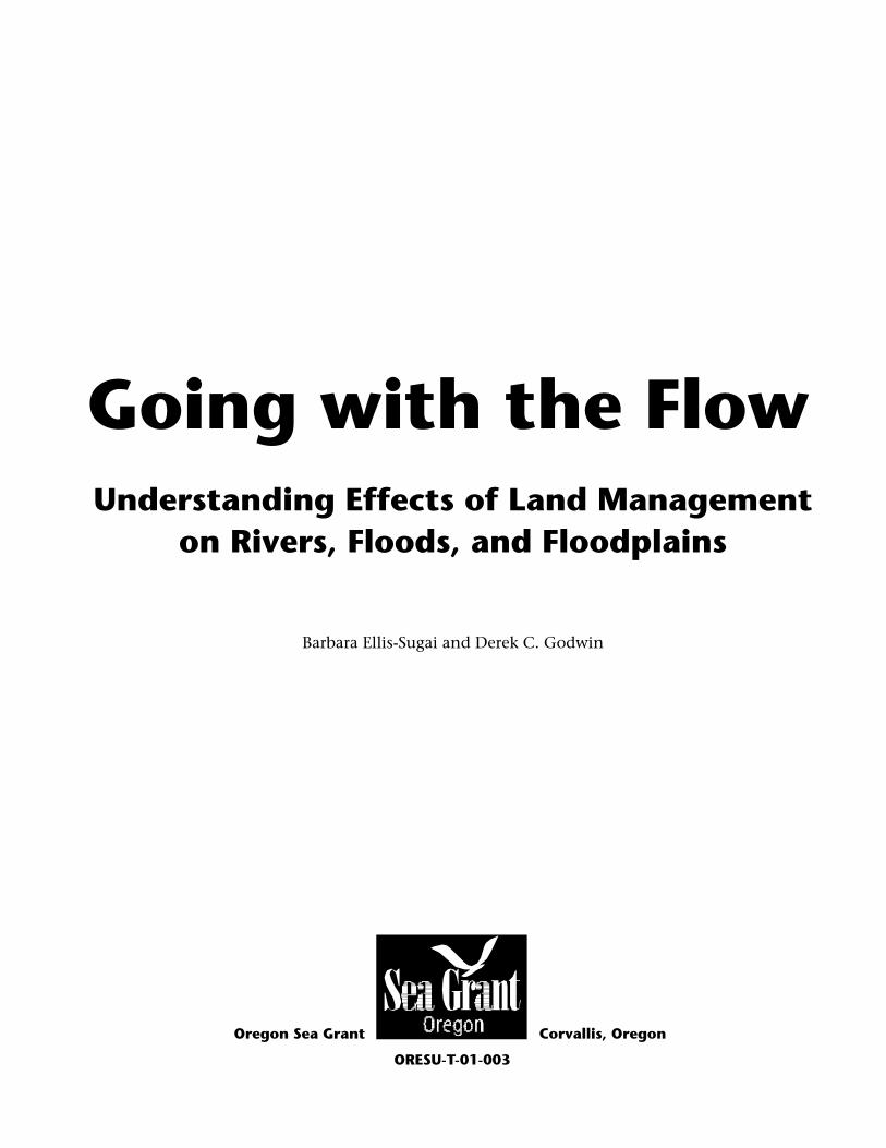
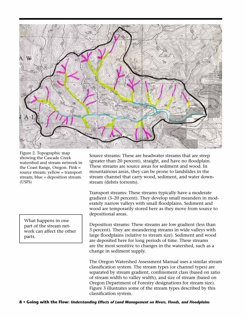
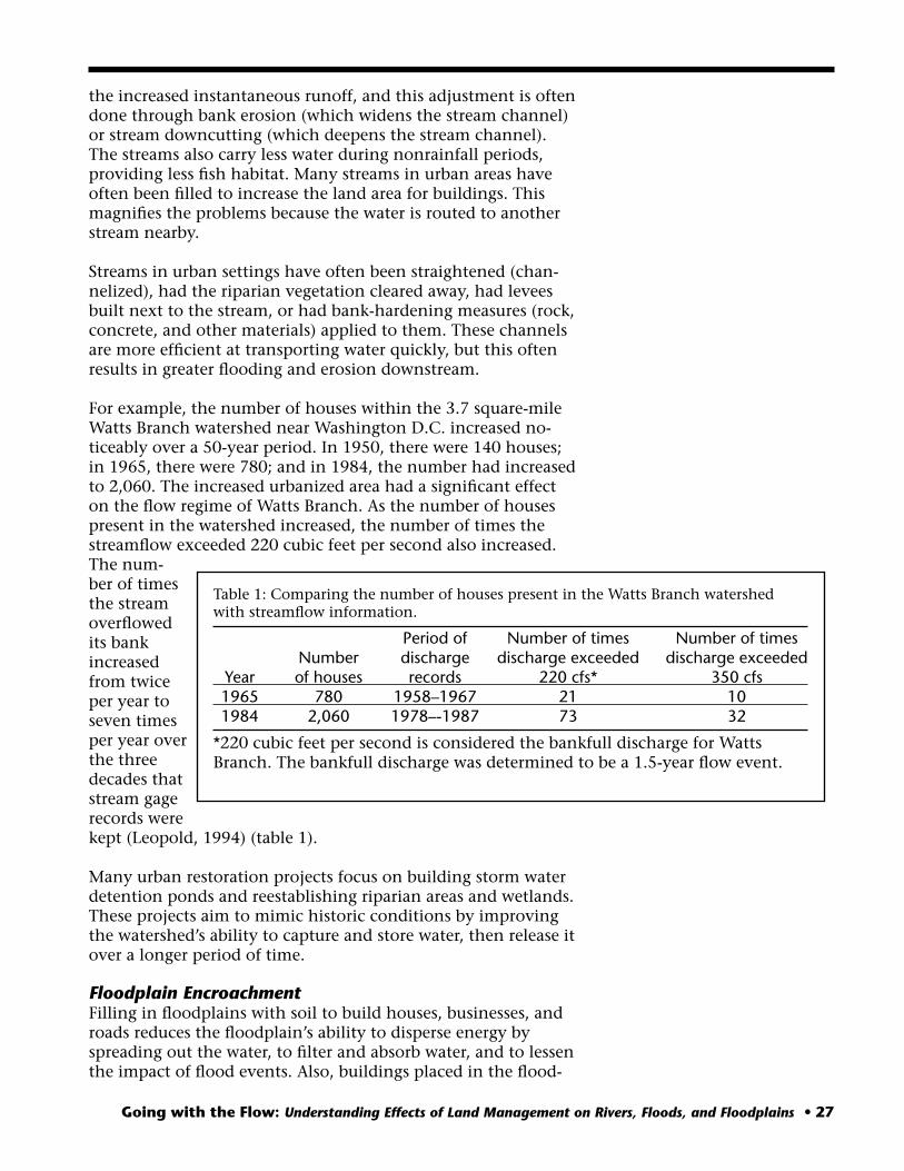

Bailey Creek Case Study continued
ldquoUpperrdquoBaileyCreekmdashrelocated and constructed as a ditchprior to 1952
D = Ditchline to capture flow from tributaries
Edge of lake
Willows
Parking area
Road
Old channel
Old channel remnant
ldquoLowerrdquo Bailey Creekmdashrelocated and constructed as a ditch prior to relocation of ldquoUpperrdquo Bailey Creek
Figure 22 Map of Bailey Creek Illustrates remnant old channel (mapped from aerial photos and ground surveys) Illustrates Bailey Creek as a ditch along west edge of flood plain Illustrates ditch line along each edge of flood plain probably constructed to capture flow from tributaries and route to Mercer Lake (USFS)
Cross-section above channelized section of creek (WidthDepth ratio = 23)
Cross-section across channelized section (WidthDepth ratio = 64)
Figure 23 Comparisons of cross-sections across Bailey Creek The dashed line is a cross-section measured above the channel and is relatively undisturbed The solid line is a cross-section measured midway down the channelized and straightened section of Bailey Creek Note the difference in the widthdepth ratios and the amount of downcutting that has taken place in the channelized section of the creek (USFS)
Continued
Going with the Flow Understanding Effects of Land Management on Rivers Floods and Floodplains bull 33
34 bull Going with the Flow Understanding Effects of Land Management on Rivers Floods and Floodplains
Bailey Creek Case Study continued
Figures 24a and 24b Stream evolution and adjustment in the ldquoupperrdquo Bailey Creek Bailey Creek is increasing its sinuosity by eroding outside banks and depositing sediment on the inside point bars Vegetation is beginning to be established on the point bars (USFS)
The bank erosion and downcutting within the straightened channel have increased sediment production and caused a delta to grow at the mouth of Bailey Creek A series of air photos from 1952 to 1999 shows the growth of the delta (figshyures 25a and 25b) Based on topographic field surshyveys of the delta the edge of the delta progressed out into the lake by 12 feet in one year (Septemshyber 1998ndash99)
The Siuslaw National Forest acquired Enchantshyed Valley in the early 1990s In 1995 planning was begun to restore a meandering stream channel in the valley In 1999 a new meandering channel was built in the lower part of the valley Figure 26 is a map of the new channel The conshystructed channel was built to flow in the vicinity of the historic channel and to function similarly The new channel is designed to carry the annual high flow within its banks but to allow higher flows to inundate the floodplain more frequently It is also designed to have a gradishyent sinuosity and avershyage stream flow similar to the historic meandering
channel All of these changes in addition to establishing native riparian vegetation are expected to support the normal changes in stream pattern without excessive erosion and downcutting
Continued
Bailey Creek Case Study continued
Growth of delta
Figures 25a and 25b Air photos showing the growth of the delta at the mouth of Bailey Creek from 1952 (left) to 1999 (right) 1952 air photo has been enlarged to show scale similar to 1999 photo (USFS)
Straightened channel
Ditch
Edge of lake
Parking area
Road
Channel constructed in 1999
Old meander scars
Figure 26 Map of newly constructed channel of Bailey Creek (USFS)
Going with the Flow Understanding Effects of Land Management on Rivers Floods and Floodplains bull 35
36 bull Going with the Flow Understanding Effects of Land Management on Rivers Floods and Floodplains
Glossary Bankfull dischargemdashthe amount of stream flow that is equal to a peak flow event that occurs on avershy
age every 12 to 2 years This flow might not be literally to the top of the stream banks Barbmdashin-stream structure consisting of boulders and riprap-sized rock that diverts the streamflow where
highest velocities occur during bankfull discharge The Natural Resources Conservation Service deshysigned these structures to provide erosion control until vegetation can be established on stream banks
Braided channelmdashsegment of a stream that has more than two main channels carrying streamflow during a bankfull discharge flow event
Channelizemdashto mechanically alter a streamrsquos bed and banks to cause the stream to flow straight Check dammdashstructure usually made of boulders and smaller rocks used for grade control in a stream Cobblemdashsize class for rocks that have a diameter ranging from 64 to 256 millimeters (25 to 10 inches) Confinementmdasha measure of how much the stream channel is laterally constrained within the valley
floor A stream channel is defined as confined when the valley width is less than two times the chanshynel width moderately confined when the valley width is between two and four times the channel width and unconfined when the valley width is greater than four times the channel width (OWEB Watershed Assessment Manual 1999)
Debris torrentmdashlandslide that has entered the stream channel and flows as a mixture of water sedishyment and debris
Depositional segment of streammdasha segment with a gradient or slope of less than three percent Sedishyment and wood are deposited here for long periods of time
Dikemdashmound of rock and earth that borders a stream to keep the stream from flooding into the adjacent area Typically these have been built to prevent the stream from flooding into its floodplain
Downcutmdashthe erosion of the stream bed causing a decrease in elevation across the stream channel Entrenchmentmdasha measure of how much the streamflow is vertically contained in a stream channel
during flood events This is a ratio of the floodprone area width divided by the bankfull width (width of channel at normal high flow) The floodprone area is determined from the width at an elevation associated with two times the maximum bankfull depth Typical ratios for entrenched streams are less than 14 for moderately entrenched streams between 14 and 22 and for slightly entrenched streams greater than 22 (Rosgen 1994 Catena paper)
Floodplainmdashland next to stream where water overflows during floods Flow event (ldquo15-year flow eventrdquo)mdashthe statistical representation of an amount of streamflow A 15-year
flow event is a peak stream flow that occurs every 15 years on average Gradientmdashslope of the stream channel measured as vertical distance divided by horizontal distance Groinmdashsimilar to a barb an in-stream deflector made of boulders and rock designed to divert streamflow
and prevent erosion of streambanks Headwater streammdashthe segment of stream located where it is formed in a channel by the accumulashy
tion of surface and subsurface flow Nurse logmdashterm used for logs on which tree seeds sprout and grow Point barmdashsediment deposit formed on the inside bend of a stream Sinuositymdashamount of curvature in the stream channel Slopemdashsame as gradient the vertical distance divided by the horizontal distance Step poolmdashpools in a stream formed by the scour of water plunging over a step created by a log or boulshy
ders Stream gaging stationmdashpermanent location along a stream where the streamrsquos elevation is continushy
ously measured with gaging instruments A hydrologist measures the streamrsquos velocity and flow at difshyferent elevations at the station The hydrologist combines the elevation and streamflow information to create a continuous record of streamflow
Stream networkmdashterm used to describe the stream and its tributaries upstream of a given point Wedge of sedimentmdashthe accumulation of excessive amounts of sediment deposited in an area
Going with the Flow Understanding Effects of Land Management on Rivers Floods and Floodplains bull 37
Literature Cited Branch W E 1997 Flood control regulation of the 1996 flood in the Columbia and Willamette
River basins In Laenen A (ed) 1997 The Pacific Northwest Floods of February 6ndash11 1996 Proceedings of the Pacific Northwest Water Issues Conference Portland Oregon October 7ndash8 1996 American Institute of Hydrology
Corps of Engineers 1964 Floodplain information Lane County Oregon V Volumes Summary Report
Coulton K G 1997 The Pacific Northwest floods lessons learned In Laenen A (ed) 1997 The Pacific Northwest Floods of February 6ndash11 1996 Proceedings of the Pacific Northwest Water Issues Conference Portland Oregon October 7ndash8 1996 American Institute of Hydrology
Ellis-Sugai B 1999 Lateral channel migration and bank erosion along the Marys River Benton County Oregon Wildland Hydrology JuneJuly pp 105ndash111 American Water Resources Assoshyciation
Federal Interagency Floodplain Management Task Force 1992 Floodplain Management in the United States An Assessment Report Volume 1 Summary Report Federal Emergency Manageshyment Agency FIA-17 Washington DC
Laenen A 1997 Calculating the odds The probability of a 100-year flood event In Laenen A (ed) 1997 The Pacific Northwest Floods of February 6ndash11 1996 Proceedings of the Pacific Northwest Water Issues Conference Portland Oregon October 7ndash8 1996 American Institute of Hydrology
Leopold L 1994 A View of the River Cambridge MA Harvard University Press mdashmdashmdash 1962 Rivers American Scientist 50511ndash537 Montgomery D R and J M Buffington 1993 Channel classification prediction of channel
response and assessment of channel condition Report TFW-SH10-93-002 prepared for the SHAMW committee of the Washington State TimberFishWildlife Agreement
mdashmdashmdash 1997 Channel-reach morphology in mountain drainage basins Geological Society of America Bulletin 109596ndash611
mdashmdashmdash 1998 Channel processes classification and response In Naiman R and R Bilby (eds) River Ecology and Management Lessons from the Pacific Coastal Ecoregion New York NY Springer-Verlag
Oregon Watershed Assessment Manual 1999 Developed by the Watershed Professionals Network for the Governorrsquos Watershed Enhancement Board Salem Oregon Copies can be ordered from the Oregon Watershed Enhancement Board in Salem Oregon Phone 503-986-0178
Pacific Northwest Water Issues Conference 1997 Portland OR American Institute of Hydrology Reckendorf F 1997 Much of the flood damage was predictable flooding in Salem In Laenen
A (ed) 1997 The Pacific Northwest Floods of February 6ndash11 1996 Proceedings of the Pacific Northwest Water Issues Conference Portland Oregon October 7ndash8 1996 American Institute of Hydrology
Rosgen D L 1996 Applied River Morphology Pagosa Springs CO Wildland Hydrology Stream Corridor Restoration Principles Processes and Practices 1998 The Federal Interagency
Stream Restoration Working Group Available on the Web at wwwusdagovstream_restoration Can be downloaded off the Web or ordered in hard-copy format with color photos and diashygrams Also available on a CD Hard copies can be ordered from the National Technical Inforshymation Service at 1-800-533-NTIS or from their Web site at wwwntisgovyellowbkInty821 htm All of this information is available at the wwwusdagovstream_restoration Web site
Williams P B 1994 Flood control vs flood management Civil Engineering 645 51ndash54
38 bull Going with the Flow Understanding Effects of Land Management on Rivers Floods and Floodplains
Resources for Further Information In addition to the Literature Cited on page 37 the following are recommended for further reading
Books Bastasch R 1998 Waters of Oregon A Source Book on Oregonrsquos Water and Water Management
Corvallis OR Oregon State University Press Gordon N D T A McMahon and B L Finlayson 1992 Stream Hydrology An Introduction for
Ecologists New York NY John Wiley amp Sons Leopold L 1997 Water Rivers and Creeks Sausalito CA University Science Books
Manuals Rutherfurd I D K Jerie and N Marsh 1999 A Rehabilitation Manual for Australian Streams
Cooperative Research Center for Catchment Hydrology Department of Civil Engineering Monash University Clayton VIC 3168 Phone (03) 9905 2704
Articles Frissell C A W J Liss C E Warren and M D Hurley 1986 A hierarchical framework for
stream habitat classification viewing streams in a watershed context Environmental Manageshyment 10199ndash214
Galay V J 1983 Causes of river bed degradation Water Resources Research 191057ndash1090 Lotspeich F B and W S Platts 1982 An integrated land-aquatic classification system North
American Journal of Fisheries Management 2138ndash149 Nakamura F and F Swanson 1993 Effects of coarse woody debris on morphology and sediment
storage of a mountain stream system in western Oregon Earth Surface Processes and Landshyforms 1843ndash61
Nunnally N R 1985 Application of fluvial relationships to planning and design of channel modshyifications Environmental Management 917ndash426
Ralph S C G C Poole L L Conquest and R J Naiman 1994 Stream channel morphology and woody debris in logged and unlogged basins of western Washington Canadian Journal Fisheries and Aquatic Science 5137ndash51
Rosgen D 1994 A classification of natural rivers Catena 22169ndash199
Environmental Protection Agency Documents Ecological Restoration a tool to manage stream quality Document EPA 841-F-95-007 Has chapters on restoration restoration and the Clean Water Act linking restoration practices to water quality parameters evaluating cost-effectiveness of restoration and case studies
Watershed Tools Directory Document EPA 841-B-95-005 Has several hundred one-page descriptions of methods and techniques for evaluation and correcshytion of watershed problems
To order hard copies of the above documents fax (513-5669-7168) or mail request (with docushyment title and number your address organization and phone number) to NCEPI 11029 Ken-wood Rd Bldg 5 Cincinnati OH 45242 Also available on the Web at httpwwwepagov OWOWwatershedhtml
Going with the Flow Understanding Effects of Land Management on Rivers Floods and Floodplains bull 39
ISBN 1-881826-27-9
Going with the Flow Understanding Effects of Land Management on Rivers Floods and Floodplains bull 39
ISBN 1-881826-27-9

ISBN 1-881826-27-9