Embed Size (px)
Citation preview

June 19, 2015
CIT
Y O
F T
ITU
SV
ILL
E
Golf Course Redevelopment
Report
Background
Research
Case Studies
Prepared by the City of Titusville Community Development Department

City of Titusville, Community Development Department
Page 1 of 16
Table of Contents
I. Background
II. Current Policy
III. Redevelopment Issues
IV. Golf Courses in the City of Titusville
a. Royal Oak Golf Course
b. La Cita Golf Course
V. Next Steps
Figure 1. Existing Comprehensive Plan Future Land Use and Zoning map: Royal Oak
Figure 2. Existing Comprehensive Plan Future Land Use and Zoning map: La Cita
Appendices (Case Studies)
A. Reflection Bay (Palm Beach County)
B. Mizner Trail (Palm Beach County)
C. American Golfers Club (Broward County)
D. Country Club Lakes Estates (Brevard County)

City of Titusville, Community Development Department
Page 2 of 16
I. Background:
On April 14, 2015, City Council approved Ordinance No. 11-2015, which established a
moratorium for the redevelopment of golf courses. The moratorium is for a period of one year
and will sunset on April 13, 2016, unless extended by Council. The purpose of the moratorium
is to allow the Staff time to study the implications of redeveloping golf courses; gather input from
the public; and develop recommendations and policies regarding such redevelopments.
This report was prepared by the Community Development Department in response to direction
from City Council. This study assesses the status of golf courses within the City of Titusville;
analyzes issues involved in redeveloping golf courses; identifies current policies and regulations
affecting golf courses; and identifies issues that may be considered when developing
Comprehensive Plan and Land Development Regulation changes to govern the future
redevelopment of golf courses within the City. Included within this report are examples of golf
courses in other Florida jurisdictions that were either approved or are currently being considered
for redevelopment.
II. Current Policy:
Golf courses are not currently addressed in the Goals, Objectives, Policies and Strategies of the
City’s Comprehensive Plan. The Land Development Regulations (LDR) reference golf courses
in the Open Space and Recreation (OR), Planned Unit Development Zoning (PUDZ), Airport
Impact Area overlay District (AIA), Urban Village (UV) and Regional Mixed Use (RMU) zoning
districts. In those zoning districts golf courses are used to describe types of open space, but no
criteria for golf courses are established within the LDRs. The definition of “Common Open
Space” mentions golf courses and reads as follows:
Common Open Space: A parcel or parcels of land or an area of water, or a combination
of land and water within a site designated or planned as open space and intended for
the use or enjoyment of residents of the development and/or the general public. Such
common open space may be in the form of active or passive recreational area, including,
but not limited to, playgrounds, golf courses, nature trails and lakes. A common open
space shall be improved to the extent necessary to complement the residential,
commercial, industrial or other uses and may contain compatible structures for the
benefit and enjoyment of the users. Parking areas, road rights-of-way, or minimum yards
and spacing between dwelling units shall not be included in determining common open
space.
If golf courses are to be defined, categorized, or regulated in a different manner within the City,
goals, objectives and policies will need to be drafted and adopted by City Council into the
Comprehensive Plan and redevelopment criteria into the LDRs.
III. Redevelopment Issues:
There are many issues associated with the redevelopment of golf courses. A small sample of
issues has been compiled by staff to illustrate how redeveloping golf courses can affect
surrounding developments.

City of Titusville, Community Development Department
Page 3 of 16
Redevelopment Issues
Loss of Open Space: Golf courses serve as open space, and provide unique views to
developments that were constructed around their perimeters.
Land Use Compatibility: The existing golf course use is a very low intensity use that may be
surrounded by low intensity residential uses. Any proposed land use amendment will need
to address the established land uses surrounding the golf course.
Stormwater Management: Golf courses typically provide stormwater storage from
surrounding developments. This stormwater storage allows for the course to be adequately
watered by using stormwater runoff from the course and surrounding developments.
Access: The development patterns surrounding golf courses are typically restrictive in
regards to the amount of points available to provide access for redevelopment.
Density: Densities in redevelopment proposals are not always consistent with the existing
residential developments that surround the golf courses within the City.
Buffers: Redevelopment proposals will decrease the distances between existing
developments and proposed uses/structures.
Height: Proposals for new uses/structures have the potential to be a different scale/height
than the existing developments adjacent to the golf course.
Form of Development: Redevelopment proposals have the potential to be of a different
architectural style, form or scale as compared to the existing uses/structures adjacent to the
golf course.
View-shed: The design, natural features, foliage and water features within the golf course
create unique views for adjacent developments.
Environmental: Heavy use of fertilizers, herbicides and pesticides used to maintain the
course could remain within the soil and cause health and safety hazards if not remediated.
IV. Golf Courses in the City of Titusville:
There are currently two golf courses within the city limits for a total land area of approximately
260 acres. They are Royal Oak golf course and La Cita golf course. The following analysis will
provide further information for each course.
A) Royal Oak Golf Course:
Royal Oak golf course was established in 1962. The course was designed by Dick Wilson, an
architect of sixty or more golf courses. In the past, the Royal Oak golf course was home to the
Canadian PGA. Since its development, the surrounding land was divided into 29 platted

City of Titusville, Community Development Department
Page 4 of 16
subdivisions that include both single-family and multi-family residential developments. These
developments were platted between 1965 and 2004.
The general location of Royal Oak is south of Harrison Street, west of Barna Avenue, north of
Knox McRae Drive, and east of Park Avenue. The golf course is bisected by Country Club
Drive, with half of the course north of Country Club Drive and the other half south of Country
Club Drive. The clubhouse and maintenance facilities are accessed by Country Club Drive and
are centrally located on the course. The golf course property is approximately 150 acres in size
and has an 18-hole golf course, driving range, stormwater system with outfalls from the
surrounding platted subdivisions, and clubhouse facilities.
The golf course property has two City of Titusville Comprehensive Plan Future Land Use (FLU)
designations and two zoning districts. The FLU designations are Recreation and Conservation.
Generally, the Recreation FLU is applied to the fairways, greens and cart paths, while the
Conservation FLU is applied to the stormwater ponds and water hazards on the golf course.
The zoning designations on the course are General Use (GU) and Open Space and Recreation
(OR). The boundaries of the GU zoning follow the boundaries of the Recreation FLU
designation and the OR zoning follow the boundaries of the Conservation FLU. The GU zoning
district allows for uses such as agricultural pursuits, packaging and sale of agricultural products,
cemeteries, veterinarians and single family homes at a density of one dwelling unit per three
acres. The OR zoning district allows for uses such as public and private parks, golf courses,
stormwater management systems, general recreation activities and single family homes at a
density of one dwelling unit per five acres. The land use and zoning map for Royal Oak golf
course are attached as Figure 1. The clubhouse is within the Recreation FLU and GU zoning
designation.
B) La Cita Golf Course:
La Cita Golf Course was platted and developed in the mid 1980’s. The course was designed by
Ron Garl, who has designed in excess of 250 courses around the world. Since development of
the golf course, the surrounding land was divided into 27 subdivisions that include single-family,
multi-family and low intensity commercial developments. These developments were platted
between 1981 and 2005.
The general location of La Cita is south of Country Club Drive, west of the Florida East Coast
Railroad, north of Knox McRae Drive, and east of Barna Avenue. The golf course is bisected by
Raney Road, half of the course is east of Raney Road and the other half is west of Raney Road.
The clubhouse facilities are accessed by Country Club Drive and are located on the northern
portion of the course. The golf course property is approximately 115 acres in size and contains
an 18-hole golf course, stormwater system and clubhouse facilities.
The golf course property has two Future Land Use (FLU) designations and two zoning districts.
The FLU designations on the property are Recreation and Conservation. Generally, the
Recreation FLU is applied to the fairways, greens and cart paths, while the Conservation FLU is
applied to the stormwater ponds and water hazards on the golf course. The zoning
designations on the course are Single Family Medium Density/Planned Unit Development (R-

City of Titusville, Community Development Department
Page 5 of 16
1B/PUD) and Open Space and Recreation/Planned Unit Development (OR/PUD). The
boundaries of the R-1B/PUD zoning follow the boundaries of the Recreation FLU designation
and the OR/PUD zoning follow the boundaries of the Conservation FLU. The R-1B zoning
district allows for single family detached dwellings, public and private parks, family day care
homes and community residential homes. The OR zoning district allows for uses such as public
and private parks, golf courses, storm water management systems, general recreation activities
and single family homes at a density of one dwelling unit per five acres. The land use and
zoning map for La Cita golf course are attached as Figure 2. The clubhouse is within the
Recreation FLU and R-1B/PUD zoning designation.
V. Next Steps:
Public Participation: Staff will coordinate with stakeholders and interested parties to gather
input from the public.
Develop Comprehensive Plan Amendments: Based on feedback staff receives from the public
and elected and appointed officials, amendments to the Comprehensive Plan will be
developed.
Draft Land Development Regulations: Using the input from the public and amendments to the
Comprehensive Plan, staff will draft amendments to the Land Development Regulations to
create the tools needed to allow for golf courses to be redeveloped in accordance with the
Comprehensive Plan.

City of Titusville, Community Development Department
Page 6 of 16
FIGURE 1 – Future Land Use and Zoning map: Royal Oak


City of Titusville, Community Development Department
Page 7 of 16
FIGURE 2 – Future Land Use and Zoning map: La Cita


City of Titusville, Community Development Department
Page 8 of 16
Appendix A
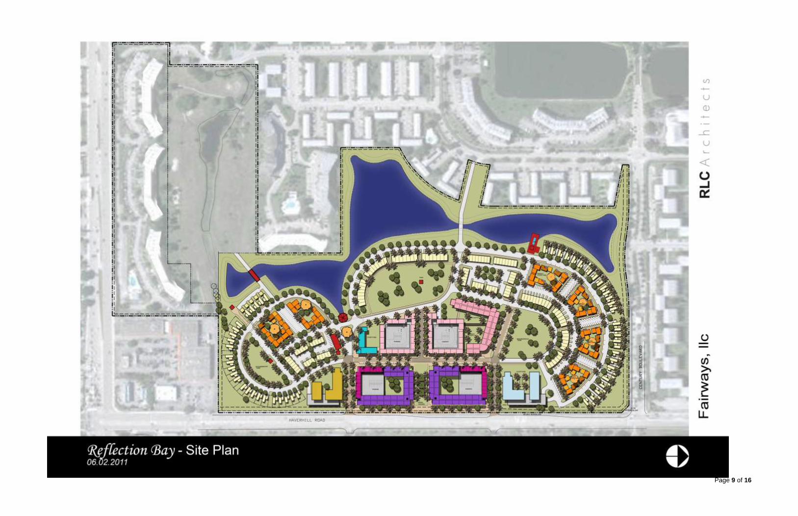
Reflection Bay, Palm Beach County
This case study analyzes Reflection Bay, which is a redevelopment of the Turtle Bay Country
Club, adjacent to Century Village in Palm Beach County. The golf course is located on the
northwest corner of the intersection of Okeechobee Boulevard and Haverhill Road. The former
Turtle Bay Country Club was an 18-hole golf course approximately 70.15 acres in size.
The concept plan to redevelop the Turtle Bay Country Club, named “Reflection Bay” proposes
to construct 680 residential units, a 100-bed Congregate Living Facility, a 15,000 square foot
community center, 17,500 square feet of medical office and 32,500 square feet of commercial
space. In addition, the plan proposed to leave 12 acres of land as open space that can be
utilized as a “pitch and putt” golf area between the new development and the existing multifamily
dwellings within Century Village. The concept plan for Reflection Bay is on the next page.
Reflection Bay was approved by the Palm Beach County Commission on February 28, 2013.
Two applications were required for the proposed redevelopment; a request to remove 57 acres
of land from an existing Planned Unit Development (PUD), and a request to rezone the same 57
acres to Traditional Neighborhood Development (TND) zoning. The proposed development
also requested 12 variances to various sections of the Palm Beach County Code. The
requested variances included items such as: maximum block length, number of curb cuts,
alleyway requirements, building coverage, and building height.
The public hearings on this proposal occurred over thirteen months, with the first hearing before
the Zoning Commission in December of 2011. During the first public hearing of the approved
rezoning presented to the Palm Beach County Commission on January 24, 2013, there were
236 public comment cards submitted. There were 123 in opposition, 109 in support and 4 cards
that did not indicate opposition or support. Submitted into the record at the meeting was a
petition of support from the owner/applicant with 1,180 signatures. Those opposing the project
sited issues such as: too many strip malls in the area, security concerns, drainage issues,
compromised emergency response time, increase in traffic, taxes, noise, children, population,
quality of life will be compromised, reduced property values, and reduced green space and
recreation. The request was passed by a 4-2 vote by the Palm Beach County Commission on
February 28, 2013.
Acres Residential Dwellings Commercial Space Other
70.15 total 57 acres of
redevelopment
689 dwelling units Condos, Townhomes, Apartments, Live/Work
100 Bed A.L.F. 84,000SF Commercial
15,000SF Community Center 12 Acre “Pitch-and-Putt” Golf Facility
Page 9 of 16

Page 10 of 16
Appendix B
Mizner Trail, Palm Beach County
This case study analyzes Mizner Trail, which is a redevelopment of the Mizner Trail golf course
near Boca Raton in Palm Beach County. The golf course is located on the southwest corner of
West Camino Real and South Military Trail. The former Mizner Trail golf course was an 18-hole
golf course approximately 130 acres in size.
The concept plan on the next page proposes to construct 288 dwelling units; however, the most
recent approved by the County Commission includes 252 dwelling units. The recently approved
plan includes 115 zero-lot-line homes, 45 townhomes, 92 condominiums or apartments, and a
Congregate Living Facility. According to the conceptual plan the development will provide in
excess of 70% open space and limit building heights to 35 feet. In addition the existing 15,000
square foot clubhouse will be renovated and will include a fitness center, outdoor pool, tennis
court and lounging areas.
The Palm Beach County Commission approved the Mizner Trail/Boca Del Mar redevelopment
on June 26, 2014. The redevelopment was subject to multiple public hearings spanning from
September 2011 to June of 2014. Notifications of the most recent public hearings were mailed
in January of 2014. In total, 1,927 notifications were mailed and 1,631 responses were received
regarding the proposed project. Of the 1,631 responses, 1,298 were in opposition and 333
were in support of the project. Those members opposing the project sited issues such as: loss
of landscaping installed by the City of Boca Raton (due to a median reconfiguration), loss of
open space, squeezing new homes into existing development, loss of property value, increase
in traffic, and the developer not considering existing residents. Those in support of the project
referenced beautifying the community, increase in tax revenues, jobs, and new residents.
The development was ultimately passed by a 5-2 vote at the June 26, 2014 Palm Beach County
Commission meeting. Based on information gathered from the Palm Beach County Planning
Department, the development was approved by the County Commission, but is currently in
litigation.
Acres Residential Dwellings Commercial Space Other
130
252 Dwelling Units Total 115 Zero-lot-line Homes
45 Townhomes 92 Condos/Apartments
Type I CLF with 6 beds
15,000SF Community Center
70% Open space will remain

Page 11 of 16

Page 12 of 16
Appendix C
American Golfers Club, Broward County
This case study analyzes the American Golfers Club, which is a redevelopment of the American
Golfers Club Course in Fort Lauderdale. The golf Course is located east of U.S. 1 between
Commercial Boulevard and Oakland Park Boulevard. The former American Golfers Club golf
course was an 18-hole public golf course approximately 67 acres in size.
The concept plan to redevelop American Golfers Club proposes to construct 36 single family
homes on 21.82 acres in a gated subdivision and dedicate a 4 acre tract of land to the City as a
passive park. The remaining 40 acres of property in this proposal will remain as park and open
space, creating buffers between existing single family homes and the proposed homes. The
concept plan shows the 36 homes would have access only to Federal Highway (U.S. 1) via a
landscaped boulevard street.
The requested rezoning for this project was from Recreation and Open Space (P) to Residential
Single Family/Low Density District (RS-4.4). The requested single family district is the most
restrictive single-family district in the City of Fort Lauderdale. The RS-4.4 allows for 4.4 dwelling
units per acre; however, this project is limited by the Future Land Use designation of Irregular
Residential to 1.7 dwelling units per acre. The concept plan on the next page illustrates the
layout of the proposed redevelopment. The new homes will be adjacent to the Coral Ridge golf
course and will buffer existing single family development by leaving open space between new
homes and existing homes. The open space surrounding the new development will be utilized
as a practice golf facility.
The rezoning for the property was approved at the Fort Lauderdale City Commission on
December 17, 2013 by at 5-0 vote. Based on minutes from the Fort Lauderdale Planning and
Zoning Board, no one from the public was present to speak on this item at the public hearing.
The Planning and Zoning Board passed the item in a 9-0 vote on October 16, 2013.
Acres Residential Dwellings Commercial Space Other
67 Total 21.82 Acres of Redevelopment
36 Single-Family Homes
N/A 4 Acre park dedicated
to the city.

Page 13 of 16
Page 14 of 16
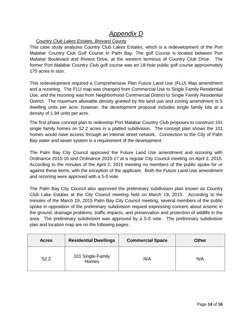
Appendix D Country Club Lakes Estates, Brevard County
This case study analyzes Country Club Lakes Estates, which is a redevelopment of the Port
Malabar Country Club Golf Course in Palm Bay. The golf Course is located between Port
Malabar Boulevard and Riviera Drive, at the western terminus of Country Club Drive. The
former Port Malabar Country Club golf course was an 18-hole public golf course approximately
170 acres in size.
This redevelopment required a Comprehensive Plan Future Land Use (FLU) Map amendment
and a rezoning. The FLU map was changed from Commercial Use to Single Family Residential
Use, and the rezoning was from Neighborhood Commercial District to Single Family Residential
District. The maximum allowable density granted by the land use and zoning amendment is 5
dwelling units per acre; however, the development proposal includes single family lots at a
density of 1.94 units per acre.
The first phase concept plan to redevelop Port Malabar Country Club proposes to construct 101
single family homes on 52.2 acres in a platted subdivision. The concept plan shows the 101
homes would have access through an internal street network. Connection to the City of Palm
Bay water and sewer system is a requirement of the development.
The Palm Bay City Council approved the Future Land Use amendment and rezoning with
Ordinance 2015-16 and Ordinance 2015-17 at a regular City Council meeting on April 2, 2015.
According to the minutes of the April 2, 2015 meeting no members of the public spoke for or
against these items, with the exception of the applicant. Both the Future Land Use amendment
and rezoning were approved with a 5-0 vote.
The Palm Bay City Council also approved the preliminary subdivision plan known as Country
Club Lake Estates at the City Council meeting held on March 19, 2015. According to the
minutes of the March 19, 2015 Palm Bay City Council meeting, several members of the public
spoke in opposition of the preliminary subdivision request expressing concern about arsenic in
the ground, drainage problems, traffic impacts, and preservation and protection of wildlife in the
area. The preliminary subdivision was approved by a 5-0 vote. The preliminary subdivision
plan and location map are on the following pages.
Acres Residential Dwellings Commercial Space Other
52.2 101 Single-Family
Homes N/A N/A

City of Titusville, Community Development Department
Page 15 of 16

City of Titusville, Community Development Department
Page 16 of 16


![[XLS]s3.amazonaws.com · Web viewLast Hill Golf & R.v. Park Lewis Estates Golf Course Mayfair Golf & Country Club Mccall Lake Golf Course-championship Course Mckenzie Meadows Golf](https://img.pdfslide.net/doc/110x75/5b3867137f8b9a5a518d6124/xlss3-web-viewlast-hill-golf-rv-park-lewis-estates-golf-course-mayfair.jpg)