Embed Size (px)
Citation preview
GOSE-R AWG Annual Meeting June 23-26, 2008<Soundings> AWG Annual 1
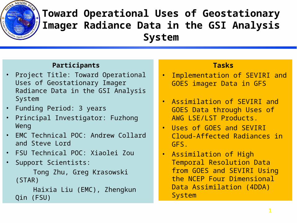
Toward Operational Uses of Geostationary Imager Radiance Data in the GSI Analysis System
Participants
• Project Title: Toward Operational Uses of Geostationary Imager Radiance Data in the GSI Analysis System
• Funding Period: 3 years
• Principal Investigator: Fuzhong Weng
• EMC Technical POC: Andrew Collard and Steve Lord
• FSU Technical POC: Xiaolei Zou
• Support Scientists:
Tong Zhu, Greg Krasowski (STAR)
Haixia Liu (EMC), Zhengkun Qin (FSU)
Tasks
• Implementation of SEVIRI and GOES imager Data in GFS
• Assimilation of SEVIRI and GOES Data through Uses of AWG LSE/LST Products.
• Uses of GOES and SEVIRI Cloud-Affected Radiances in GFS.
• Assimilation of High Temporal Resolution Data from GOES and SEVIRI Using the NCEP Four Dimensional Data Assimilation (4DDA) System
GOSE-R AWG Annual Meeting June 23-26, 2008<Soundings> AWG Annual 2
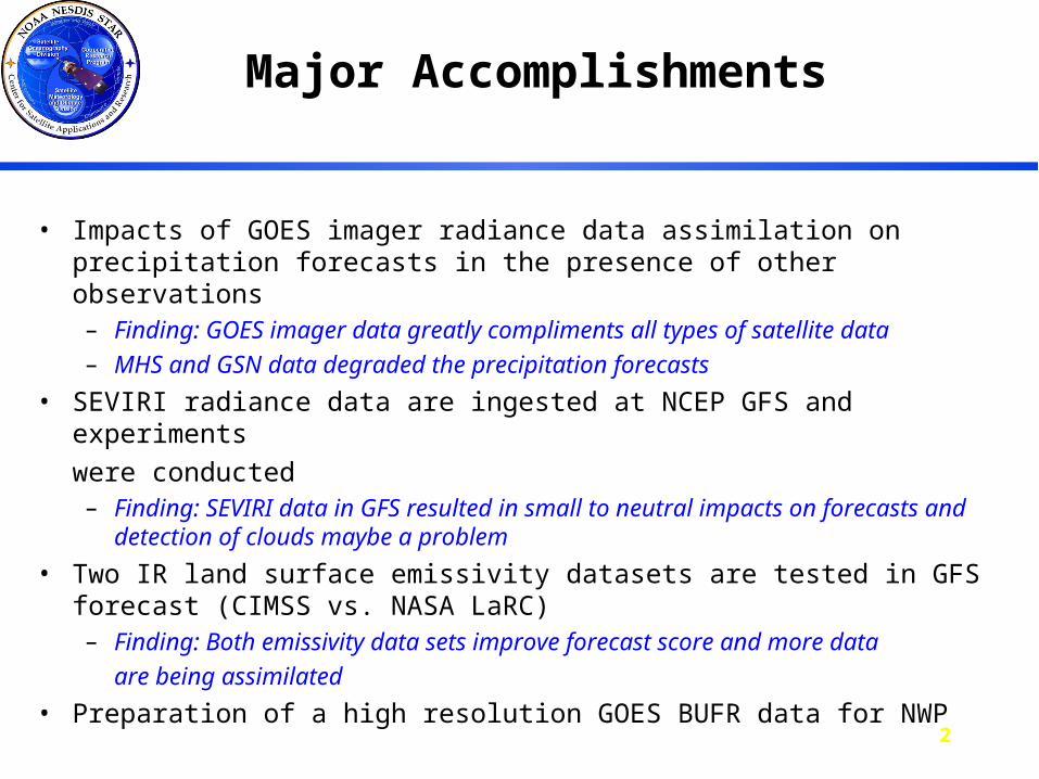
Major Accomplishments
• Impacts of GOES imager radiance data assimilation on precipitation forecasts in the presence of other observations– Finding: GOES imager data greatly compliments all types of satellite data
– MHS and GSN data degraded the precipitation forecasts
• SEVIRI radiance data are ingested at NCEP GFS and experiments
were conducted– Finding: SEVIRI data in GFS resulted in small to neutral impacts on
forecasts and detection of clouds maybe a problem
• Two IR land surface emissivity datasets are tested in GFS forecast (CIMSS vs. NASA LaRC)– Finding: Both emissivity data sets improve forecast score and more data
are being assimilated
• Preparation of a high resolution GOES BUFR data for NWP
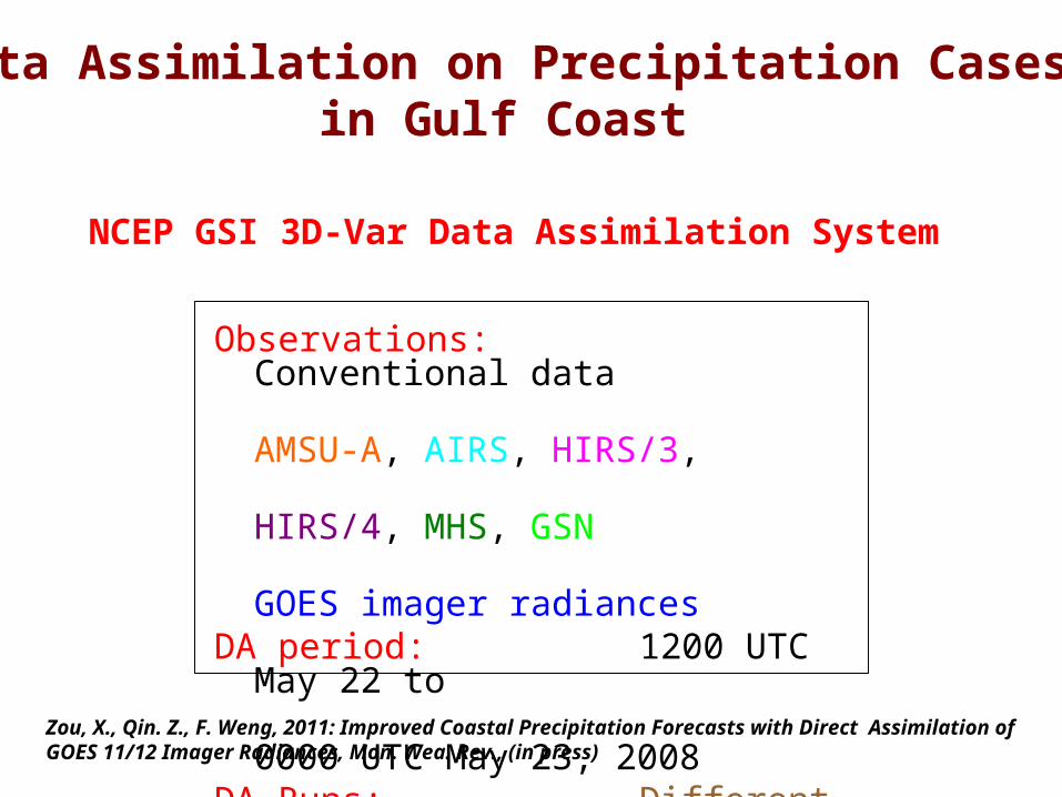
NCEP GSI 3D-Var Data Assimilation System
Observations: Conventional data AMSU-A, AIRS, HIRS/3, HIRS/4, MHS, GSN GOES imager radiancesDA period: 1200 UTC May 22 to 0000 UTC May 23, 2008DA Runs: Different Combinations of Satellite Observations
Data Assimilation on Precipitation Cases in Gulf Coast
Zou, X., Qin. Z., F. Weng, 2011: Improved Coastal Precipitation Forecasts with Direct Assimilation of GOES 11/12 Imager Radiances, Mon. Wea. Rev., (in press)
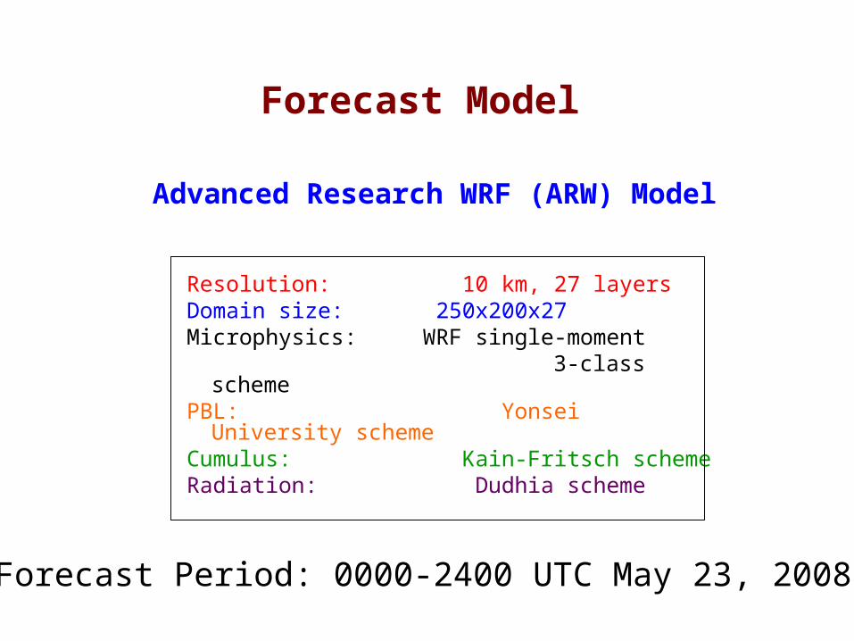
Advanced Research WRF (ARW) Model
Resolution: 10 km, 27 layersDomain size: 250x200x27Microphysics: WRF single-moment 3-class schemePBL: Yonsei University schemeCumulus: Kain-Fritsch schemeRadiation: Dudhia scheme
Forecast Model
Forecast Period: 0000-2400 UTC May 23, 2008
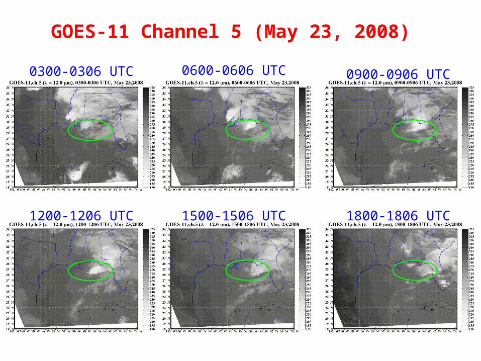
GOES-11 Channel 5 (May 23, 2008)
0300-0306 UTC 0600-0606 UTC 0900-0906 UTC
1200-1206 UTC 1500-1506 UTC 1800-1806 UTC
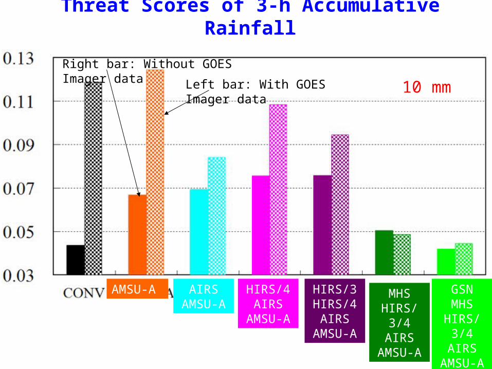
Threat Scores of 3-h Accumulative Rainfall
10 mm
MHSHIRS/3/4
AIRSAMSU-A
AMSU-A
Right bar: Without GOES Imager data
Left bar: With GOES Imager data
GSNMHS
HIRS/3/4AIRS
AMSU-A
HIRS/3HIRS/4AIRS
AMSU-A
HIRS/4AIRS
AMSU-A
AIRSAMSU-A
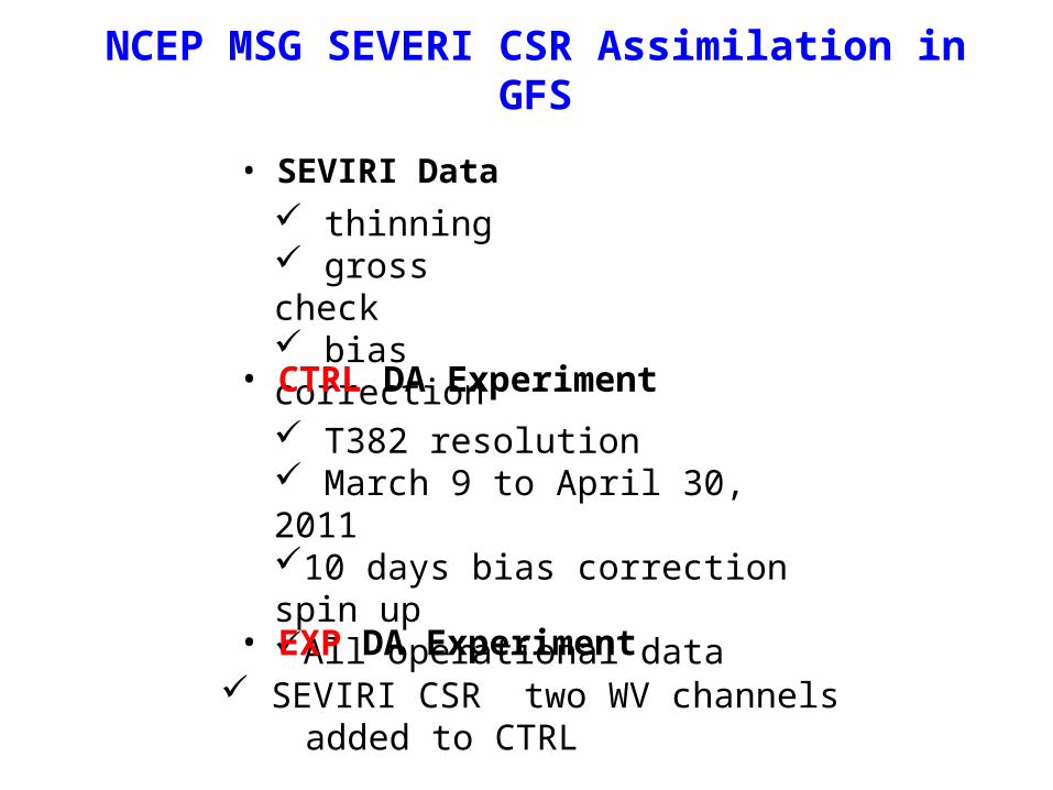
NCEP MSG SEVERI CSR Assimilation in GFS
• SEVIRI Data thinning gross check bias correction
• CTRL DA Experiment
T382 resolution March 9 to April 30, 201110 days bias correction spin upAll operational data
• EXP DA Experiment SEVIRI CSR two WV channels added to CTRL
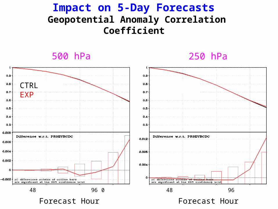
Impact on 5-Day Forecasts Geopotential Anomaly Correlation Coefficient
0 48 96 144 0 48 96 144
Forecast Hour Forecast Hour
500 hPa 250 hPa
CTRLEXP
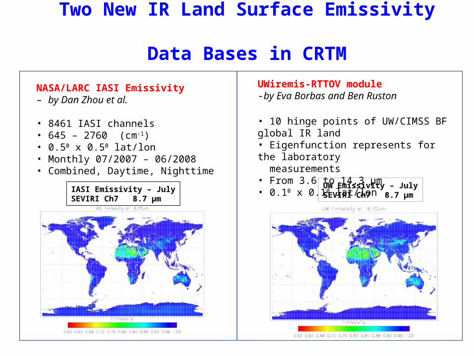
Two New IR Land Surface Emissivity Data Bases in CRTM
NASA/LARC IASI Emissivity– by Dan Zhou et al.
• 8461 IASI channels• 645 – 2760 (cm-1)• 0.50 x 0.50 lat/lon• Monthly 07/2007 – 06/2008• Combined, Daytime, Nighttime
UWiremis-RTTOV module -by Eva Borbas and Ben Ruston
• 10 hinge points of UW/CIMSS BF global IR land• Eigenfunction represents for the laboratory measurements• From 3.6 to 14.3 µm• 0.10 x 0.10 lat/lon .
IASI Emissivity – JulySEVIRI Ch7 8.7 µm
UW Emissivity – JulySEVIRI Ch7 8.7 µm
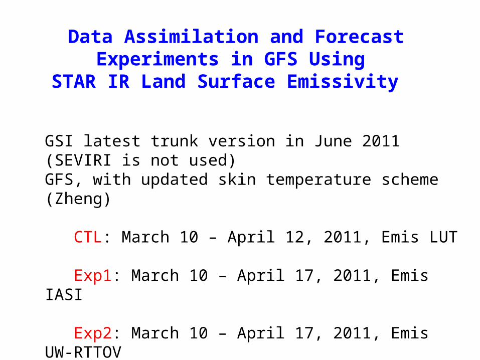
Data Assimilation and Forecast Experiments in GFS Using
STAR IR Land Surface Emissivity
GSI latest trunk version in June 2011 (SEVIRI is not used)GFS, with updated skin temperature scheme (Zheng)
CTL: March 10 – April 12, 2011, Emis LUT
Exp1: March 10 – April 17, 2011, Emis IASI
Exp2: March 10 – April 17, 2011, Emis UW-RTTOV
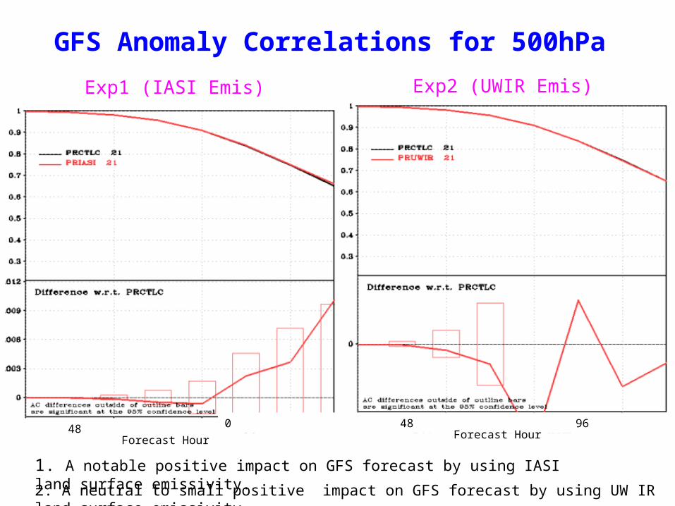
GFS Anomaly Correlations for 500hPa
1. A notable positive impact on GFS forecast by using IASI land surface emissivity.
Exp1 (IASI Emis) Exp2 (UWIR Emis)
2. A neutral to small positive impact on GFS forecast by using UW IR land surface emissivity.
0 48 96 144Forecast Hour
0 48 96 144Forecast Hour
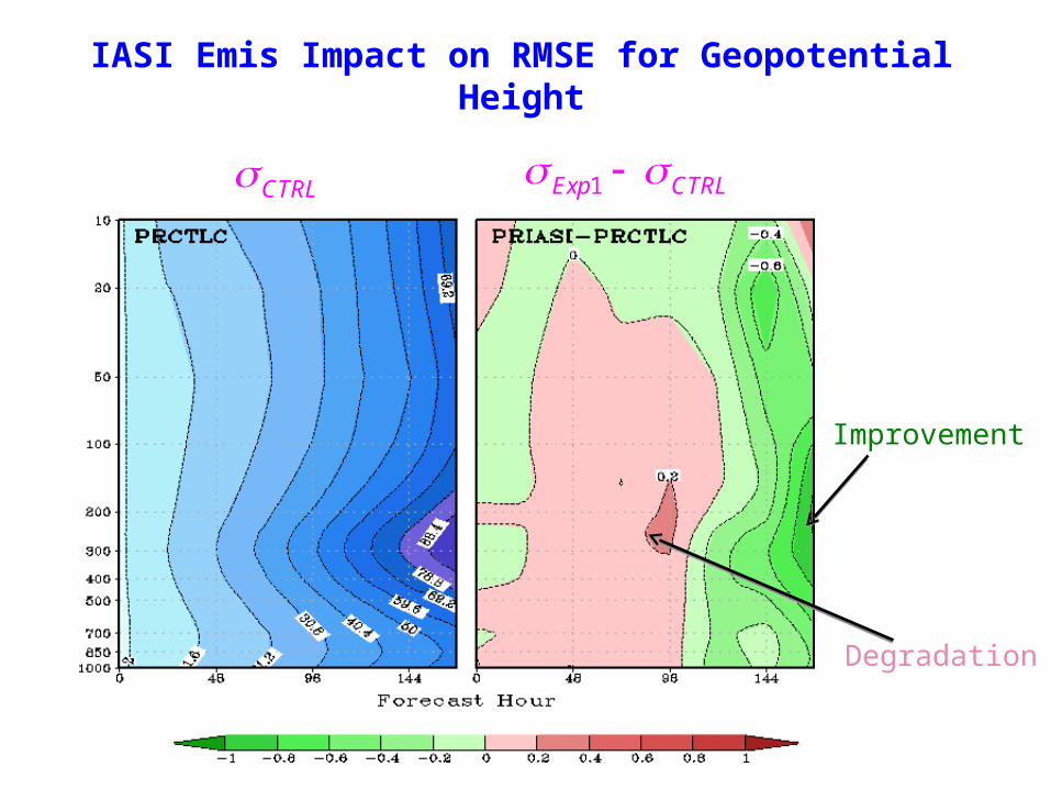
IASI Emis Impact on RMSE for Geopotential Height
Exp1 CTRL
Improvement
Degradation
CTRL
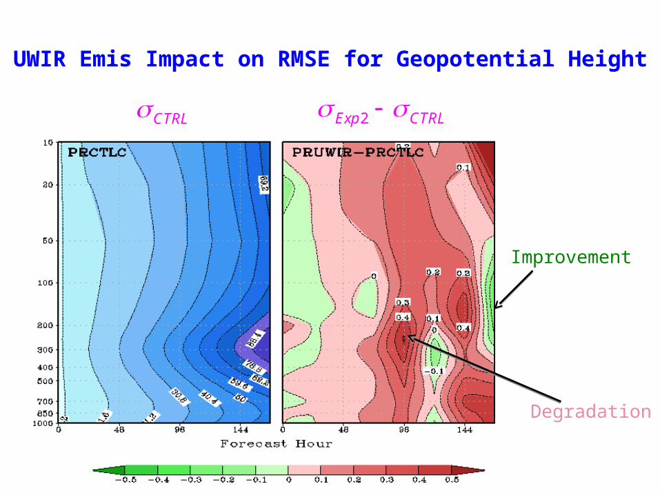
UWIR Emis Impact on RMSE for Geopotential Height
Improvement
Degradation
2Exp CTRL CTRL
GOSE-R AWG Annual Meeting June 23-26, 2008<Soundings> AWG Annual 14
Backup Slide
14
GOSE-R AWG Annual Meeting June 23-26, 2008<Soundings> AWG Annual 15
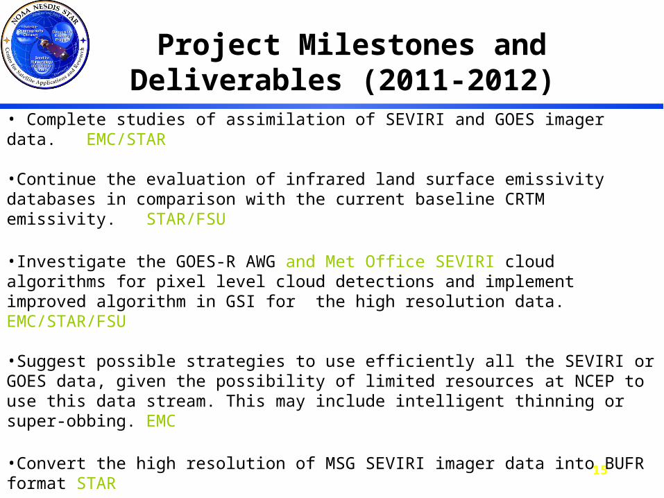
Project Milestones and Deliverables (2011-2012)
• Complete studies of assimilation of SEVIRI and GOES imager data. EMC/STAR
•Continue the evaluation of infrared land surface emissivity databases in comparison with the current baseline CRTM emissivity. STAR/FSU
•Investigate the GOES-R AWG and Met Office SEVIRI cloud algorithms for pixel level cloud detections and implement improved algorithm in GSI for the high resolution data.EMC/STAR/FSU
•Suggest possible strategies to use efficiently all the SEVIRI or GOES data, given the possibility of limited resources at NCEP to use this data stream. This may include intelligent thinning or super-obbing. EMC
•Convert the high resolution of MSG SEVIRI imager data into BUFR format STAR
By the end of the first year, we deliver assessment reports on uses of IR land surface emissivity data bases and recommend a best emissivity data set for operational implementation to CRTM. Also, an improved cloud detection algorithm will be interfaced into GSI for experiments.
GOSE-R AWG Annual Meeting June 23-26, 2008<Soundings> AWG Annual 16
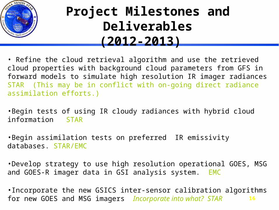
Project Milestones and Deliverables(2012-2013)
• Refine the cloud retrieval algorithm and use the retrieved cloud properties with background cloud parameters from GFS in forward models to simulate high resolution IR imager radiances STAR (This may be in conflict with on-going direct radiance assimilation efforts.)
•Begin tests of using IR cloudy radiances with hybrid cloud information STAR
•Begin assimilation tests on preferred IR emissivity databases. STAR/EMC
•Develop strategy to use high resolution operational GOES, MSG and GOES-R imager data in GSI analysis system. EMC
•Incorporate the new GSICS inter-sensor calibration algorithms for new GOES and MSG imagers Incorporate into what? STAR
By the end of the second year, we deliver assessment reports on uses of GOES and SEVIRI IR clouds-affected radiances and on experimental results of the high resolution data in GFS/WRF.
GOSE-R AWG Annual Meeting June 23-26, 2008<Soundings> AWG Annual 17
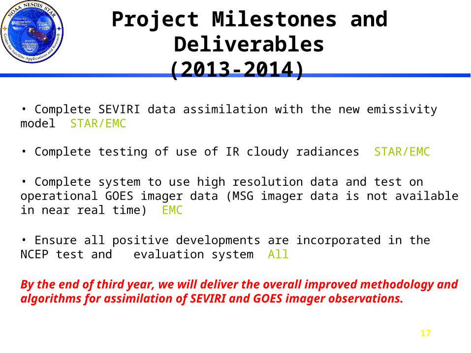
Project Milestones and Deliverables(2013-2014)
• Complete SEVIRI data assimilation with the new emissivity model STAR/EMC
• Complete testing of use of IR cloudy radiances STAR/EMC
• Complete system to use high resolution data and test on operational GOES imager data (MSG imager data is not available in near real time) EMC
• Ensure all positive developments are incorporated in the NCEP test and evaluation system All
By the end of third year, we will deliver the overall improved methodology and algorithms for assimilation of SEVIRI and GOES imager observations.