Embed Size (px)
Citation preview
WPI Brief GPSDNM, #1 assuredcommunications™ HARRIS PROPRIETARY DATA
GPS-Denied Navigation and Mapping
Technology for DTRA
Ken Graves
Senior Product Line Manager
Harris Corporation
July 31, 2010
WPI Brief GPSDNM, #2 assuredcommunications™ HARRIS PROPRIETARY DATA
GPSDNM Program Overview
• Sponsored by Defense Threat Reduction Agency (DTRA)
• 3 year, $3.8M program
• CHI Systems (Now Harris) Prime, Honeywell Sub
• Key Performance Parameters– Accuracy:
• Threshold - 30 feet after 4 hours
• Objective - 10 feet after 12 hours
– Physical Requirements:• Threshold - <10 lb, multiple components, no component larger than 5”x4”x3”
• Objective – One component, <3 lb, < 12 cubic inches
– Start Up Time:• Threshold – cold start in < 5 minutes
• Objective – Instantaneous start
– Mapping Information:• Threshold and Objective – Display user location on moving map (preferably
FalconView, make mapping software easy to use, similar to Garmin
WPI Brief GPSDNM, #3 assuredcommunications™ HARRIS PROPRIETARY DATA
Technical Approach
• Hardware and firmware improvements by Honeywell– Improve existing DRM-4000 with better gyros
– Improved calibration algorithms
– Still essentially pedometry-based
– MIL-STD-810F hardening
• Software Innovations from Harris/CHI– Algorithms for real-time track correction based on user movements and
structure geometry
– Algorithms for track correction based on movements and tracks of multiple users
– Map display software
– Real-time transmission of tracks
– Software embedded on PDA

WPI Brief GPSDNM, #4 assuredcommunications™ HARRIS PROPRIETARY DATA
Technical Progression
• Spiral 0 – Location: Honeywell DRM-5 with internal GPS– Microcomputer: Sony U280 or OQO UMPC/Windows XP– Software: Harris/CHI situational awareness and mapping software– Comms: WiFi or commercial UHF data radio
• Spiral 1– Location: Honeywell DRM-5000
• Smaller internal space requirement• External USB power• 16-channel commercial GPS daughter board internal• Improved heuristics for GPS “jump” and transition to DRM
– Microcomputer: • Nomad hardened PDA/Windows Mobile 6. • Yuma hardened Tablet for base station display
– Software: Improved Harris/CHI situational awareness software, with interface to FalconViewand Garmin devices
– Comms: military tactical data radio supplied by DTRA or commercial UHF– Single power supply
• Spiral 2– Location: Honeywell DRM-5000 plus high accuracy HG-1930 IMU, hardened cases– Microcomputer: Nomad hardened PDA and Toughbook hardened notebook. – Software: Harris/CHI situational awareness software, user constraint algorithms, track
correction algorithms, DRM control algorithms.– Comms: multiple military tactical voice/data radios from SELEX, Harris, others

WPI Brief GPSDNM, #5 assuredcommunications™ HARRIS PROPRIETARY DATA
Technical Progression
Spiral 0: DRM-5, OQO Computer, external
GPS, Harris/CHI SA software, UHF data
radio Spiral 1: DRM-4000/5000, Nomad hardened
PDA, DTRA or commercial UHF data radio,
improved Harris/CHI SA and navigation
software, power supply
Spiral 2: DRM-5000 plus HG-1930 IMU,
Nomad hardened PDA, military voice/data
radios, improved Harris/CHI SA software and
track correction algorithms
WPI Brief GPSDNM, #6 assuredcommunications™ HARRIS PROPRIETARY DATA
Results – Spiral 1
• Spiral 1 prototype tested in underground tunnel complex at Fort Hood, June 2008. 1st major test of the system.
• Environment has heavy magnetic influence due to steel reinforced concrete, motors, rails, vault doors, etc.
• DRM-5000 inconsistent in this environment; some good results, some not so good.
– Some issues with device calibration due to intermittent GPS and stride length calibration
– Issues with metal safety equipment such as oxygen generators and safety harness clips affecting magnetometer output
– Issues with initial direction of travel
– DRM-5000 inconsistent in this environment; some good results, some not so good.
– Gyros in DRM-5000 not likely to allow us to meet accuracy KPP of the program
• Inconsistent radio communications did not allow multi-track correction algorithms to work to their best ability.
• Testing was not a loss
– Many good tracks, plus a good body of track data to work with.
– Estimated 2-4% accuracy over the distance traveled, average distance 900 meters
WPI Brief GPSDNM, #7 assuredcommunications™ HARRIS PROPRIETARY DATA
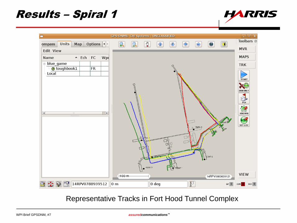
Results – Spiral 1
Representative Tracks in Fort Hood Tunnel Complex
WPI Brief GPSDNM, #8 assuredcommunications™ HARRIS PROPRIETARY DATA
Results – Spiral 2
• Spiral 2 prototype tested multiple times in underground tunnel complex and building complex at Fort Hood from April to December 2009.
• Environment still has heavy magnetic influence.
• Harris/CHI Track correction algorithms significantly improved location results for both the DRM-5000 alone, and for the DRM-5000/HG-1930 IMU combination.
– Straightening
– Orthogonality
– Initial orientation
– Transition from GPS to GPS-denied
– Special calibration to compensate for local magnetic influence of safety gear
• HG-1930, with far better gyro performance allowed much better directional stability than the DRM-5000
• Good radio communications allowed multi-track correction algorithms to work to their best ability.
• Overall error less than 1% of distance travelled in final set of tests.
WPI Brief GPSDNM, #9 assuredcommunications™ HARRIS PROPRIETARY DATA
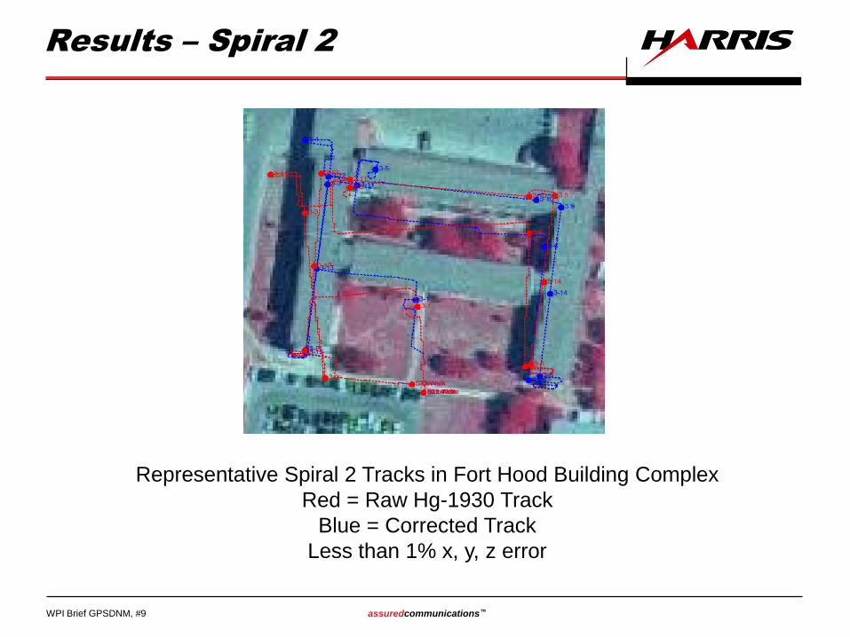
Results – Spiral 2
Representative Spiral 2 Tracks in Fort Hood Building Complex
Red = Raw Hg-1930 Track
Blue = Corrected Track
Less than 1% x, y, z error
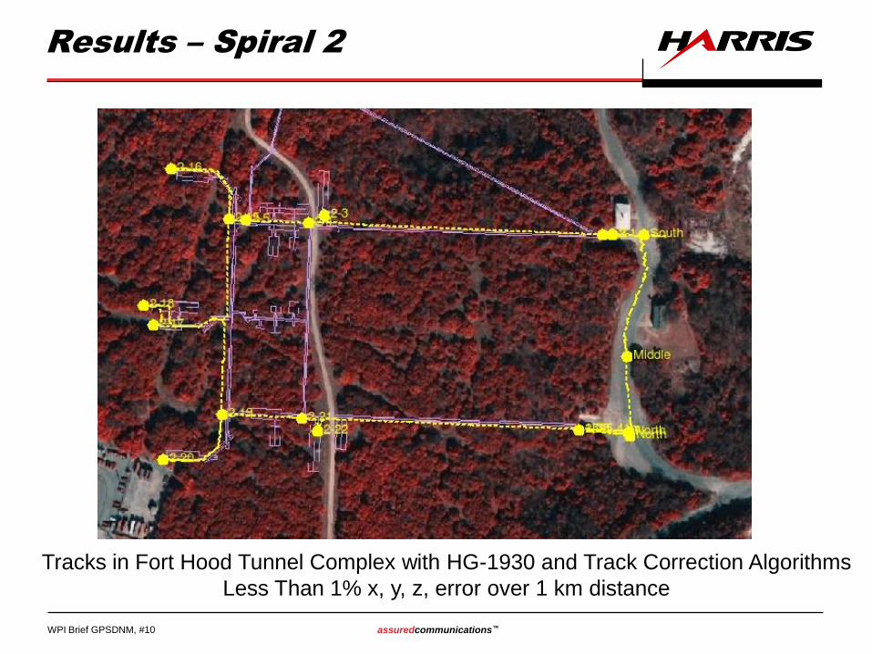
WPI Brief GPSDNM, #10 assuredcommunications™ HARRIS PROPRIETARY DATA
Results – Spiral 2
Tracks in Fort Hood Tunnel Complex with HG-1930 and Track Correction Algorithms
Less Than 1% x, y, z, error over 1 km distance
WPI Brief GPSDNM, #11 assuredcommunications™ HARRIS PROPRIETARY DATA
Conclusions
• 3 of 4 KPPs Met
• Accuracy KPP not met under all circumstances
• DRM-5000/HG-1930 in combination with Harris/CHI Track Correction algorithms produced better than 1% accuracy in most cases
• Better accuracy needed for this customer
• DRM-5000/HG-1930 combination not practical for non-military users:
– Too expensive ~ $12-14K; needs to be less than $3K
– Too power hungry; 3-5 watts; needs to be less than 500 mW
– Too big, although it met KPP for size; needs to fit into a shirt pocket
• Specialized communications required to get data out of tunnels or heavily constructed buildings for real time tracking
– MANET
– Repeaters
– Mesh
WPI Brief GPSDNM, #12 assuredcommunications™ HARRIS PROPRIETARY DATA
Future Direction
• Smaller, lighter, higher performance, and less power
hungry IMU devices are now becoming available.
– Use same algorithms with these devices
– Would need to harden the devices
– Really need to have IMU, onboard processing, power, and
possibly a MANET radio within a single small box
• Users don’t want to use a bunch of software on a PDA to
perform location tracking; A black box with no user
interface would make many users extremely happy
• Inertial navigation by itself is only part of the solution
– Radio ranging
– UWB
– SLAM
WPI Brief GPSDNM, #13 assuredcommunications™ HARRIS PROPRIETARY DATA