Embed Size (px)
Citation preview

GRANULAR MATERIAL SOURCES PC
INVESTIGATION
RAE/EDZO, N.W.T.
Submitted by Fred Coiling, Geotechnical Advisor, Community Grandar Program, Engineering Division, Department of Public Works.

1 . 1 . 1 1 . 2 1 .3 1.4 1.5 2 . 2 .1 2 .2 2.3 2 .4 3 . 3 .1 3 .2 3.3 4 " 4.1 5. 5 . 1 5 . 2 5 .3 6 . 6 .1 6 .2
6 .3
6 .4 7 . Ref'
TABLE OF CONTENTS
Acknowledgements Executive Summary
INTRODUCTION General Ceotechnical Investigation Procedure Specifications & Terminology Volume Estimates Restoration & Regulations TERRAIN ANALYSIS Regional Setting Geology & Geomorphology Drainage Environments of Deposition. GRANULAR SOURCES & ASSESSMENT Existing Sources Potential Sources Quarries / Ridge Complex SITE INFORMATION SUMMARY Table 1: Granular Inventory GRANULAR RESOURCE EVALUATION Supply and Demand Rae Access Road Assessment COST ESTIMATES Mosquito Creek - Load, Haul and Stockpile Site 1/Site 2 - Winter Load, Haul
Russell Lake Pit - Load, Haul, Place
Drill, Blast, Crush and Stockpile RECOMMENDATIONS
and Stockpile
and Compact
ces Glossary of Terms
APPENDICES
er en
1 1 1 2 7 8 9 9
10 13 1 3 1 4 1 4 18 23 29 30 31 31 33 34 35 35
35
36 36 37
Appendix 1 Granular Needs Assessment: Capital Projects, +
Appendix 2 Geotechnical Data 1990, Laboratory Test Results, Granular Material Breakdown, Assessment Tables.
Grain Size Curves, Cross Sections.
This stlldy w a s produced in association with various departments within the G.N.W.T. and local community representatives. The following are the '
individuals and organisations associated with this report.
AcknowledPements
Terry Hauff Manager, Mapping, Municipal and Community Affairs, G.N.W.T., Yellowknife.
e
Dan Konelsky Senior Administration Officer, Hamlet of Rae/Edzo.
Dave Kristensen Project Officer, Department of Transportation, G.N.W.T., Yellowknife.
Debbie Maracle Divisional $ecretary, Department of Public Works, Engineering Division, G.N.W.T., Yellowknife.
Wayne Nesbitt Project Officer, Department of Public Works, Engineering Division, G.N.W.T., Yellowknife.
Dave White Municipal Affairs Officer, Municipal and Community Affairs, Hamlet of RaeEdzo. -
The Hamlet of Rae/Edzo, which was incorporated on April 1, 1975, is a mature and growing community of approximately 1,443 people that needs' a reliable and convenient source of all types of granular material.
This report presents the results of a geotechnical study, conducted under the objectives and guidelines of the Community Granular Program, to determine the 20-year demand for granular materials and the best means of satisfying that demand.
In summary, the 20-year demand for granular materials in the community is nearly 360,000 cubic meters. This demand is primarily related to the development of a large residential area adjacent to Fort Rae and the maintenance of community facilities.
In general, pitrun granular materials of sufficient quality and quantity to meet the 5-year forecast demand are NOT available in the vicinity of Rae/Edzo.
An examination of supply and demand will indicate that during the 1991/92 fiscal year, there will be a deficit of all grades of granular material from existing sources. Development of potential sowces will satisfy the community's foreseen needs to 1994/95 and beyond through the implementation of a large scale "blast and crush" quarry operation. A quarry and stockpile operation, for both select and embankment material, should be implemented during the 1991/92 fiscal year and then continue on an "as and when needed" basis.
Implementation of a Granular Source Management Plan by the Hamlet of Rae/Edzo, based on the technical recommendations of this report and local concerns, is recommended at the earliest possible date.
1. INTRODUCTION
The geotechnical studies undertaken by the Community Granular Section are an integral part of the Community Granular Program. The goals, principles, definitions and methodology of these reports are discussed in this section.
1.1 General
The Community Granular Program, Engineering Division, D.P.W., provides the capital resources for identifying, laboratory testing, developing, and restoring granular sources for all non-taxed based communities in the N.W.T. The objective is to process, stockpile, and manage granular supplies to ensure materials are available for planned community development projects, ongoing maintenance, and private use, at a reasonable cost.
To meet this objective, geotechnical investigations are planned for various communities throughout the N.W.T. and are priorized on the basis of the granular needs in the communities. These needs are derived through an analysis of the 5 year capital plans and the 20 year capital needs as,sessment of every GNWT Department, the N.W.T. Housing Corporation, the Federal Government and where available, the private sector, as of November, 1989. Highly speculative needs such as resource development projects (Le. oil and gas) are beyond the scope of these studies.
The intent of this report is to precisely define the community's available granular resources and its granular needs over a 20 year horizon and develop options for the management of those resources that ensure the community's long term needs are met. The report and recommendations will enable the community, through the consultative process, to develop a comprehensive Granular Resource Development and Management Plan that will provide control of the extraction, development, use and restoration of granular resource areas.
1.2 Geotechnical Investigation Procedure
This granular materials study is a multi-phased investigative and assessment process that may be broken down as follows:
1
Terrain Analysis - regional setting - geology and geomorphology - drainage - permafrost distribution
Resource Description and Assessment - review of pertinent information - air photograph interpretation - ground reconnaissance and sampling - material quantity assessment - material quality assessment - ground ice and permafrost assessment - evaluation of all sources - access routes - source summary
- granular material breakdown - 5 year needs assessment - 20 year needs projections - needs summary
- comparison of resources and needs - development of options - development of estimates - selection of options
Granular Needs Assessment
Recommendations
1.3 Specifications and Terminology
A number of systems have been devised for classifying granular materials that are based on soil characteristics and engineering properties of the material. The Community Granular Section uses the following standards, criteria and specifications to describe the material in the granular sources discussed in this report. In addition, a Glossary of Terms is to be found following Section 8.
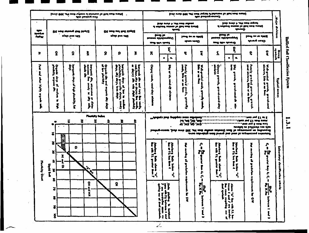
1.3.1 Classification of Soils
The Unified Soil Classification System (USC) is used to identify various types of ,soils through visual description in situ and in the laboratory and through tests such as Atterburgh Limits and sieve analysis. The USC system is shown on the following page.
2
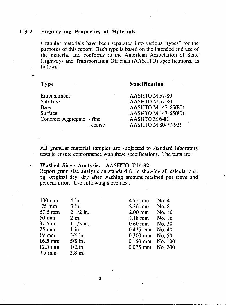
1.3.2 Engineering Properties of Materials
Granular materials have been separated into various "types" for the purposes of this report. Each type is based on the intended end use of the material and conforms to the American Association of State Highways and Transportation Officials (AASHTO) specifications, as follows:
TY Pe Specification
Embankment AASHTO M 57-80 Sub-base AASHTO M 57-80 Base AASHTO M 147-65(80) Surface AASHTO M 147-65(80) Concrete Aggregate - fine AASHTO M 6-81
- coarse AASHTO M 80-77(92)
All granular material samples are subjected to standard laboratory tests to ensure conformance with these specifications. The tests are:
Washed Sieve Analysis: AASHTO Tll-82: Report grain size analysis on standard form showing all calculations, eg. original dry, dry after washing amount retained per sieve and percent error. Use following sieve nest.
q
100 mm 75 mm
67.5 mm 50 mm 37.5 m 25 mm 19 rrun 16.5 mm 12.5 mm 9.5 mm
4 in. 3 in. 2 112 in. 2 in. 1 112 in. 1 in. 314 in. 518 in. 112 in, 3.8 in.
4.75 mm 2.36 mm 2.00 mm 1.18 mm 0.60 mm 0.425 mm 0.300 mm 0.150 rnrn 0.075 mm
No. 4 No. 8 No, 10 No. 16 No. 30 NQ. 40 No. 50 No. 100 No. 200
3
Dry Sieve Analysis: AASHTO T27-82: Sieve down to No. 4 (4.75 mm) using sieve nest indicated in specification. Prepare grain size curve on standard form.
Lab Crushing: Crush to required maximum size using laboratory jaw crusher. Size will be given on sample information.
Atterberg Limits: AASHTO T89-81 Method A. T90-81: Report summary list of sample numbers with liquid limit, plastic limit, and plasticity index. Report on standard form.
Visual Description and Classification: Give a brief visual description of sample content as per example. Classify the material as per Unified Soils system and AASHTO system including group index. Report on standard form.
Natural Moisture Content: AASHTO T265-79: Supply summary list showing sample number and moisture content. Also complete lab data copies.
Magnesium Sulphate Soundness, AASHTO T104-77 (1982): Report the loss on each coarse fraction and the total loss by the weighted average based on the grading of the original sample.
Los Angeles Abrasion, AASHTO T96-77: Depending on the sample, use the appropriate grading, and report the loss as a percentage.
Modified Proctor Standard Proctor, AASHTO T99-81: Report results of five (5) points and prepare proctor curve on standard form.
4

Petrographic Analysis, MTC LS-609: Using coarse aggregate report PN number and flakiness index.
Fractured Face Count, MTC LS-607: Report as percentage of original sample mass. Refer to AASHTO T4-35, Section 2.
Flat and Elongated Particle Count, MTC LS 608: Report as percentage of original sample mass.
Hydrometer Analysis: AASHTO T88-81: Supply all lab data and grain size curve. Plot results of grain size on Contractor's standard grain size distribution curve.
Washed Sieve Analysis: Minus 0.075 mm: AASHTO Tl 1-82. Organic Content: AASHTO T267.
It is important to note that all samples may not have to be subjected to the full range of test procedures,
It should be noted also that ground thermal analysis and the engineering properties of permafrost unique to northern periglacial environments are taken into consideration in all situations.
1.3.3 Environments of Deposition
The properties of any granular material vary with its gradation, moisture content, vertical position in relation to the surface of the ground, and geographic location. Time and climate influence the weathering process of mechanical and chemical disintegration that breaks the material down into progressively smaller particles. The term gradation refers to the relative size of these particles in a deposit.
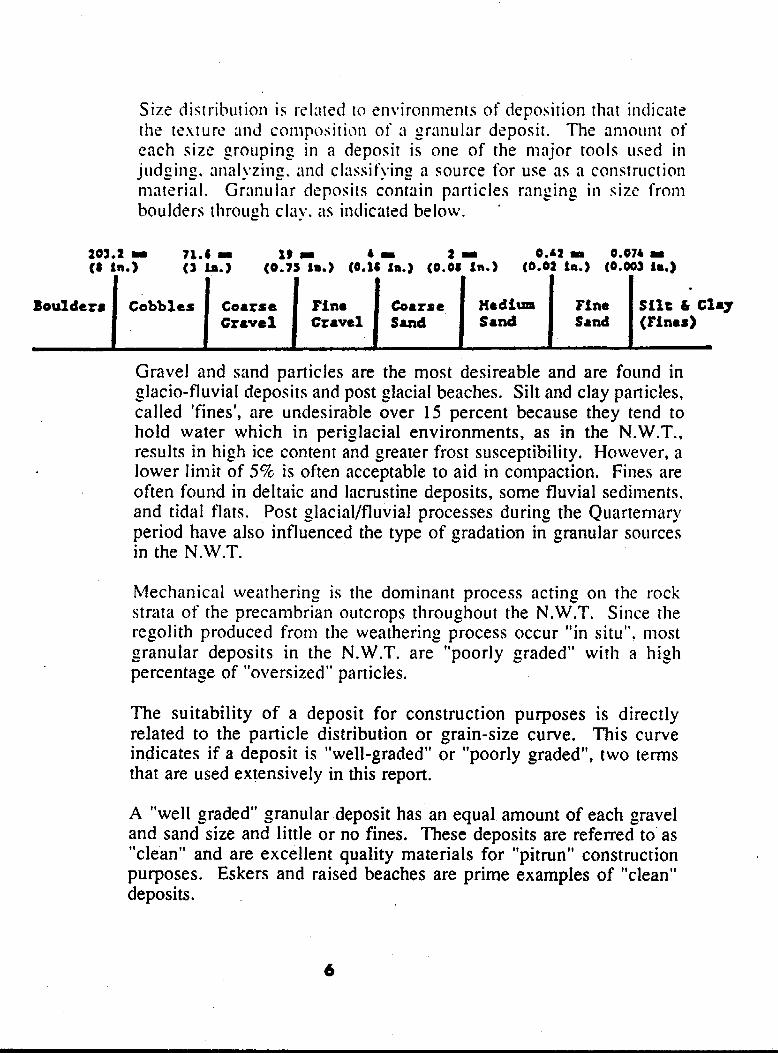
201.2 - 71.4 I 19 I I r 2 - 0.42 m 0,07b œ ( 8 in.) (a b.) (0.7s in.) (0.16 h) (0.08 Sm.) (6.02 in.) (0.003 in.)
Boulder8 silt & Clay Flnc X d i w coarse Fin. Coarse Cobbles
I
Gravel (Pi nu) Sand Sand Sand Ccavsl - I
Gravel and sand particles are the most desireable and are found in rrlacio-fluvial deposits and post glacial beaches. Silt and clay particles, h e d 'fines', are undesirable over 15 percent because they tend to hold water which in periglacial environments, as in the N.W.T., results in high ice content and greater frost susceptibility, However, a lower limit of 5% is often acceptable to aid in compaction. Fines are often found in deltaic and lacrustine deposits, some fluvial sediments. and tidal flats. Post glacial/fluvial processes during the Quartenlary period have also influenced the type of gradation in granular sources in the N.W.T.
Mechanical weathering is the dominant process acting on the rock strata of the precambrian outcrops throughout the N.W.T. Since the regolith produced from the weathering process occur ln situ". most
percentage of "oversized" particles.
I t *
b oranular deposits in the N.W.T. are "poorly graded" with a high
The suitability of a deposit for construction purposes is directly related to the particle distribution or grain-size curve. This curve indicates if a deposit is "well-graded" or "poorly graded", two terms that are used extensively in this report.
A "well graded" granular deposit has an equal amount of each gravel and sand size and little or no fines, These deposits are referred to as "clean" and are excellent quality materials for "pitrun" construction purposes. Eskers and raised beaches are prime examples of "clean" deposits.
6
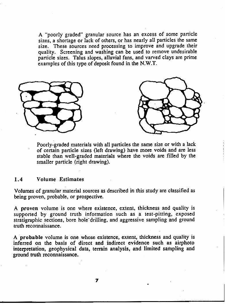
Poorly-graded materials with all particles the same size or with a lack of certain particle sizes (left drawing) have more voids and are less stable than well-graded materials where the voids are filled by the smaller particle (right drawing).
1.4 Volume Estimates
Volumes of granular material sources as described in this study are classified as being proven, probable, or prospective.
A proven volume is one where existence, extent, thickness and quality is supported by ground truth information such as a test-pitting, exposed stratigraphic sections, bore hde-drilling, and aggressive sampling and ground truth reconnaissance.
A probable volume is one whose existence, extent, thickness and quality is inferred on the basis of direct and indirect evidence such as airphoto interpretation, geophysical data, terrain analysis, and limited sampling and ground truth reconnaissance.
7 c

A prospective volume is one whose existence, extent, thickness and quality is suspected on the basis of limited direct evidence. such as airphoto interpretation, remote sensing information, or imaging radar techniques. There is no sampling or ground truth reconnaissance.
1.5 Restoration and Regulations
Pit planning, design, and restoration are important aspects of granular resource development. Environmentaily, the development of any granular sources offers the potential for drainage and erosion problems, habitat destruction, and the disturbance of wildlife. In many communities in the N.W.T., excessive scarring of the surrounding terrain is a major concern. These reports take into account the economic and environmental factors of pit abandonment and reclamation. Guidelines to minimize the impact of pit development and quarry operations are available in the INAC (1982) publication "Environmental Guidelirkes Pits and Quarries". At all stages of pit planning, design and operation, methods that ensure final pit restoration are stressed.
Permafrost can be expected throughout the N.W.T. and results in a variety of environmentally, sensitive problems related to pit abandonment and restoration; thus pit development in permafrost environments must be planned well in advance and special techniques used during the extraction of material.
Territorial land use regulations are to be followed in all development plans, without exception, especially in the areas of land use permits, explosives, and pit abandonment.
Y P ? . E 9 . 9 E
J L.
2. TERRAIN ANALYSIS
2 .1 Regional Setting
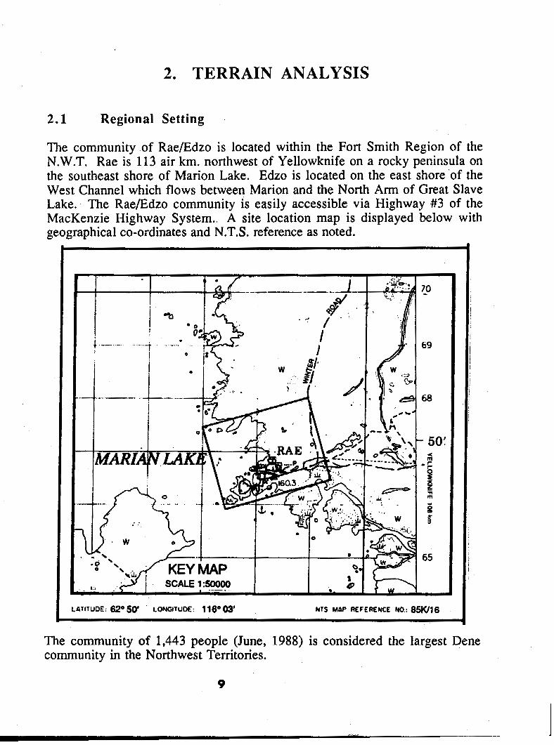
The community of Rae/Edzo is located within the Fort Smith Region of the N.W.T. Rae is 113 air km, northwest of Yellowknife on a rocky peninsula on the southeast shore of Marion Lake. Edzo is located on the east shore 'of the West Channel which flows between Marion and the North Arm of Great Slave Lake. The Rae/Edzo community is easily accessible via Highway #3 of the MacKenzie Highway System.. A site' location map is displayed below with geographical Co-ordinates and N.T.S. reference as noted.
"
The community of 1,443 people (June, 1988) is considered the largest Dene community in the Northwest Territories.
9

2.2 Geology and Geomorphology
Rae/Edzo is located on the boundary between the Slave Structural Province of the Canadian Shield and the extensive Interior Plains physiographic region. Rae is located on a peninsula of hilly rock outcrops and lowlands. Edzo is located on a large plain that exhibits little relief. Elevation at Marion Lake is 156m.
The bedrock of the study area is situated within the Bear Slave Upland Subprovince (Rae) and the Great Slave Plain Subprovince (Edzo) respectively. The Rae area consists of a massive rock ridge complex with a distinct north- south structural trend as viewed below.
The bedrock consists mostly of granites, granitic-gneiss, quartz and diorite. The carbonate bedrock of the Edzo area is overlain by thick Paleozoic strata of sandstone and shale. The age of the rock strata around Rae is Archean whereas around Edzo it is of Cambrian age. Two stratigraphic formations are found around the Edzo area: the La Martre Falls Formation, a green and red soft shale, and the Old Fort Island Formation, a white to grey fine grained quartz sandstone.
10
I . -. "
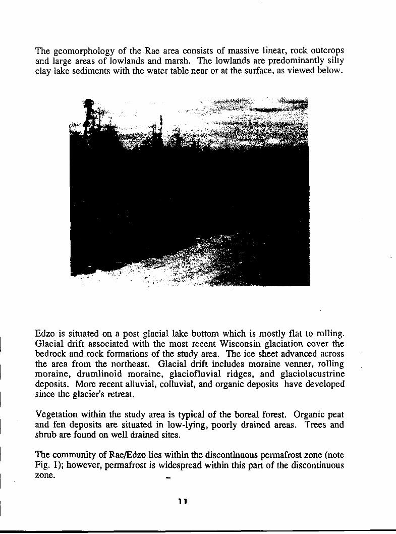
The geomorphology of the .Rae area consists of massive linear, rock outcrops and large areas of lowlands and marsh, The lowlands are predominantly silty clay lake sediments with the water table near or at the surface, as viewed below.
Edzo is situated on a post glacial lake bottom which is mostly flat to rolling. Glacial drift associated with the most recent Wisconsin glaciation cover the bedrock and rock formations of the study area. The ice sheet advanced across the area from the northeast. Glacial drift includes moraine venner, rolling ,
moraine, drumlinoid moraine, glaciofluvial ridges, and glaciolacustrine deposits. More recent alluvial, colluvial, and organic deposits have developed since the glacier's retreat.
Vegetation within the study area is typical of the boreal forest. Organic peat and fen deposits are situated in low-lying, poorly drained areas. Trees and shrub are found on well drained sites.
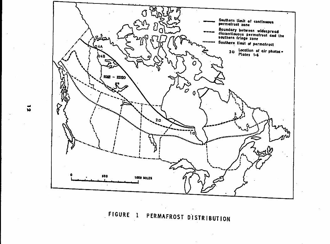
The community of Rae/Edzo lies within the discontinuous permafrost zone (note Fig. 1); however, permafrost is widespread within this part of the discontinuous zone. I
11
I I I I 1
2
2.3 Drainage
The proximity of Great Slave Lake and Marian Lake affect the drainage pattem of the RaeEdzo area. Drainage is mostly north to south or southeast following the structural lineation of the region. Numerous small lakes and ponds are formed in closed bedrock depressions. A combination of lowlands, a high water table, and thick organic deposits produce extensive areas of muskeg and peatlands creating a "blocked drainage" pattern.
2 .,4 Environments of Deposition
To explain the existing borrow and potential sources of granular material in the vicinity of RaeEdzo, the processes that have resulted in the accumulation of suficial deposits in the region need to be addressed. With respect to RaeEdzo, there are two ways in which surficial granular material are formed.
The most widespread type of granular source found in the region is related to glacial materials deposited directly from glacier ice to f o m glacial drift and morainal deposits. Silty clay till is the sediment most commonly~associated with these deposits around the Edzo area and a Stoney sandy til1 is found around Rae. The till is often less than one meter thick within the Rae area and overlie bedrock whereas around Edzo the till is from 1 to 10 meters thick and overlie thick Cambrian rock strata.
A second type of granular source are the glaciolacustrine sands, silts and clay formed in glacial lakes associated with the ice sheet. There sediments can range in thickness from 1 to 10 meters and are found at ground surface throuehout a large part of the study area. Where silt and clay are abundant, drainage IS poor and thick organic deposits have developed forming large areas of peatland.
13
3. GRANULAR SOURCES AND ASSESSMENT
This section provides an overview of the various existing and potential granular sources within the study area. Each source is described in terms of location, genesis, volume, engineering properties, and development considerations. Test results are found in Appendix 2.
3.1 Existing Sources
There are two borrow sources presently in use in the vicinity of Rae/Edzo. The Russell Lake pit is locakd approximately 6.5 km. north of Rae. The community has used this large sand and gravel source for a numb& of years. The Edzo sand pit is located adjacent to Highway #3 approximately one kilometre from Edzo. A crushed stockpile of 19mm material is located at the Frank Channel, 16 km. from Rae.
3.1.1 Crushed Stockpile
At the Frank Channel, just west of the Rae Access and Highway #3 intersection, approximately 4,500 m3 of crushed 19mm material remains for use by the community. The stockpile is about 16 kilometres from the Hamlet of Rae/Edzo.
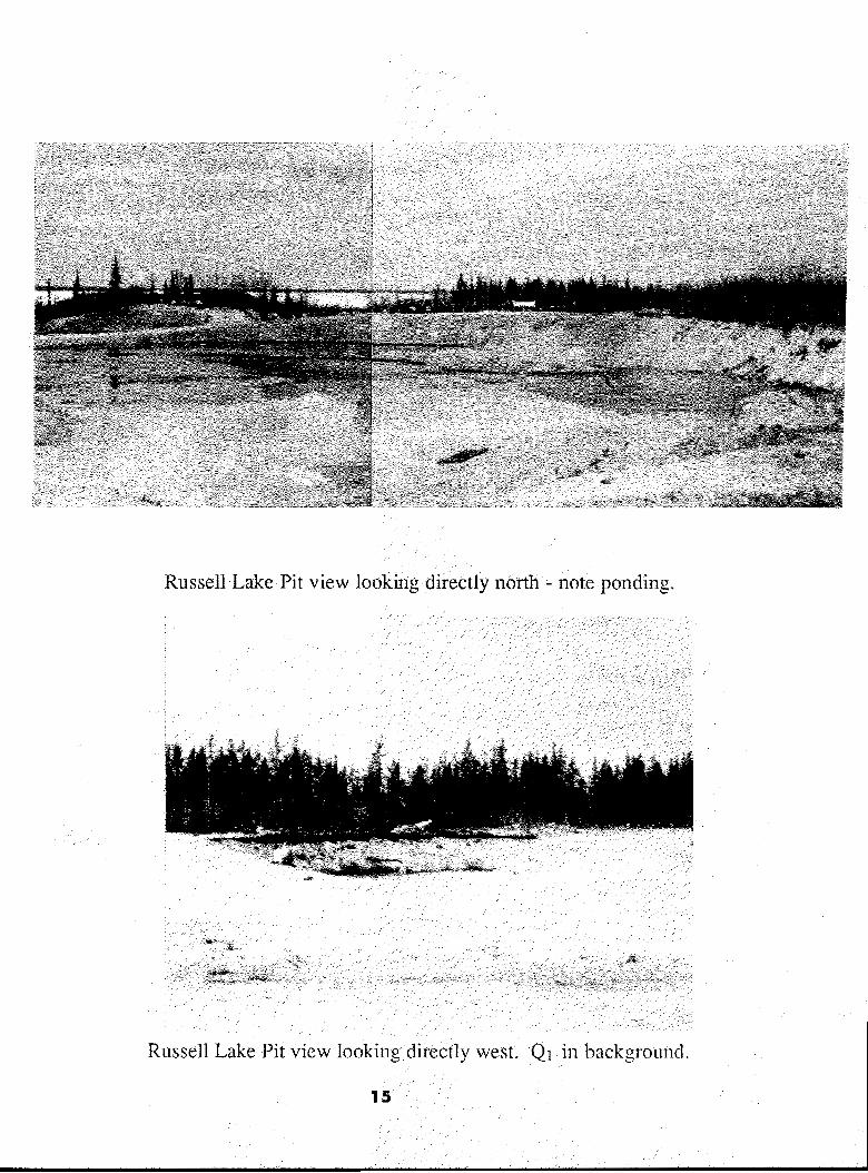
3.1.2 Russell Lake' Pit
Description/Genesis: This source represents a large glaciolacustrine sand and silt deposit adjacent to Marian Lake. Recent post glacial accumulations of organic and colluvial sediments have covered the deposit. The source is located 6.5 kilometres north of Rae along a good, al l season, access road. Continual excavation has resulted in a large spreading pit. Material composition and texture changes with depth and geographic location. The pit is well drained in northwest and southern areas but ponding has developed in the central and eastern sections of the pit as seen in the photograph on the following page.
Quantity: The pit is large - over 500 meters in length and 200 meters in width; however, the deposit is mostly depleted in the south and central sections, with excavation occurring in the north and northwest corner of the pit. It is estimated that approximately 8,000 m3 of sand and gravel remain in this area of the pit.
14
I I I I I I I I I I I I I I I I I I I
Russell Lake Pit view looking directly north - note ponding.
Russell Lake Pit view looking directly west. QI i n backgroLmd.

Development Considerations: This site should be used until depletion as a source of embankment and subbase material owing to its proximity to the community, available access, and proven volume. Excavation should continue i n the northwest corner, The community has used this site for a number of years and it would seem logical to cantinue to excavate this source till depletion. Eventually, development will be restricted in the west because of a large continuous rack ridge and in the north because of Marian Lake. The area to the east has potential but the cornnlunity has restricted land development in this area.
16

3.1 .3 Edzo Sand Pit
DescriptionlGenesis: This source represents a large glaciolacust.rine s;znd deposit overlain by a thin layer of silty clay till.. The sand was reworked by Inodern post glacial beach processes related to the erosional and depositional phases of Great Slave Lake,
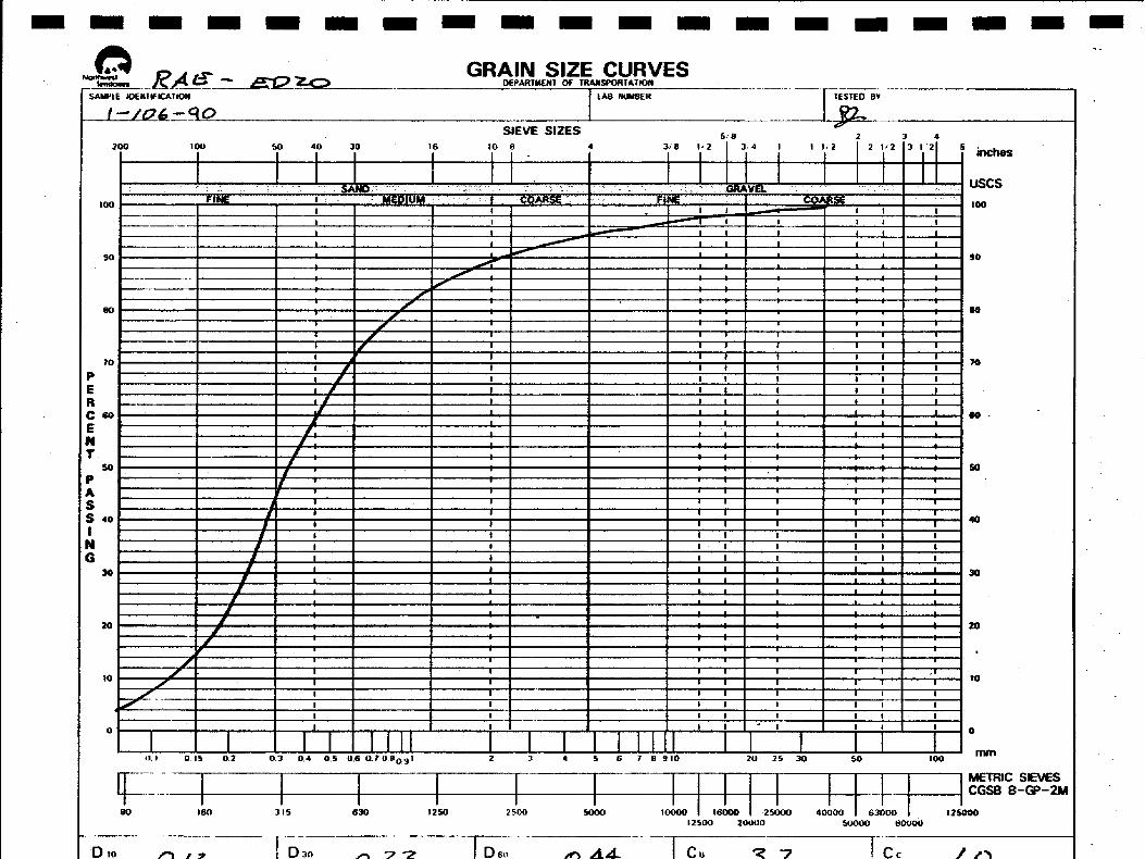
Quantity: The pit is nlastly dcplctcd to the east and north but has been re-opened to the west. Approximately 6,000 rn3 of sand exists in various small stockpiles throughout. the pit. One such stockpile can be viewed below. The view is from the middle of the pit. looking northeast,
Test Resulk Sample 7-1.06-90 was removed from one of the numerous small stockpiles located randomly throughout the pit. Sample 7-306-90 consisted of 3.3.5% gravel, 85,0% sand, and 1.S% fines. The material is a poorly graded sand with little binding or compaction properties, Approximately 50% passed the No. 4 sieve (fine sand).
Development Consideration: Even as a general fill, the Edzo sand pit has little value as a granular source. The material could be used as a "blend" source for crushing or in combination with another "pitnrn" source for construction purposes.
1 7

I I I I I I I I I I I I I I I I 1 I I
3 . 2 Potential Sources
Potential s o u m s of "pitrun" granular material in the vicinity of KaeJEdzo are limited with respect to quality and quantity. However, access to so~~rces is fair. to good along winter or all season roads or cxistillg cut-lines,
nescriptionlGenesis: Sites 1 and 2 arc located approximat-cly 3.2 kilomctm and 1 .X kilometrcs along a cutline trail north and slightly east of Rae. They are part of a ridge complex that is covered by thick glacial till (note Source Location Map). Site 1 i s over 2 meters higher t h a n the surrounding terrain which is highly saturated with water. Thick vegetation covers the ridge. The material is mostly a Stoney, sandy till. Boulders and cobbles cover the ridge and were found throughout the tcst holes, Site 1 is seen below. The view i s northeast.
1

Quantity
Test Res1
Site 2 is about 3 meters higher than the s-urrounding terrain and covered with boulders up to 100 centimeters. Vegetation on the ridge is dense. Again the material consists mostly of a stoney, sandy, t i l l . A view of Site 2 is seen below, The view is dircct.ly west from the junction of two cutlines (note Source Ixmtion Map), Note cross- section #8-106-90, Appcndix 2.
Several test holes were dug along both Sites 1 and 2. There is approximately 30,000 m3 of material along Site 1 and 35,000 1113 at Site 2. Unproven volumes are probably much higher.
dts: Sample 8-106-90 was extracted from Site 2. Results indicated a poorly graded sand with cobbles and boulders. Numerous test holes were dug on both ridges in December, 1979 and results indicated that the material consisted of poor to well graded sands with large pebbles and cobbles. Generally, test results indicate that this material would be suited as "pikrun" embankment or sub-grade fill.

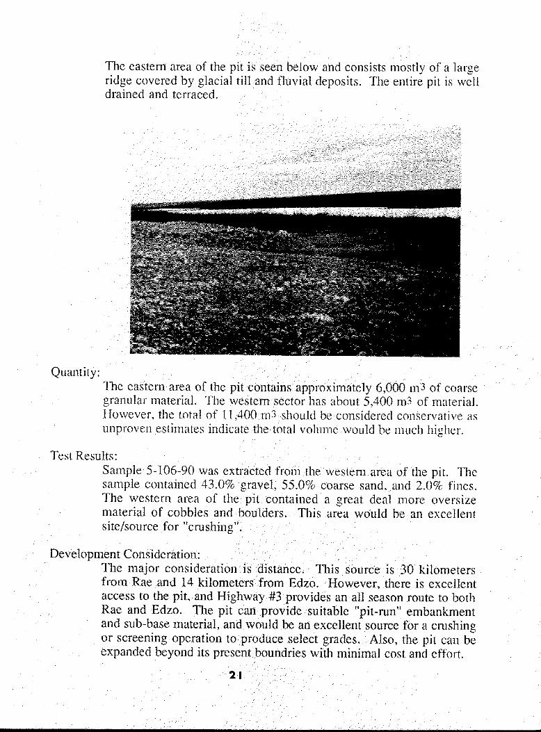
The eastem area 0% the p i t is seen below ancl consists mostly of a Xnrge ridge covered by glacial till and fluvial deposits. ?11e entire pit is well drained and terraced.
The major consideration is distance. This source is 30 kilometers from Rae and 14 kilometers from Edzo. However, there is excellent access to the pit, and Highway #3 provides an all season soute to both Rae and Edzo. The pit can provide suitable ''pitmn" embankment and sub-base material, and would be an exccllent source for a crushing or screening operation to produce select grades. Also, the pit can be expanded beyond its present boundries with rnini~nal cost and effort.

MARION LAKE
ROCK
LEGEND * - SHORElPEAAKES - Ex€srlt& ROADS
SITE I 1 ROCK
ROCK
ROCK
ROCK . &
P
ROCK
A U SUSON ACCESS ROAD
6.0 km
Ya - ROCK c
I
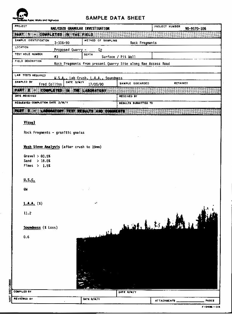
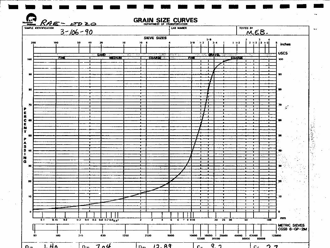
3.3 Quarries / Bedrock Sources
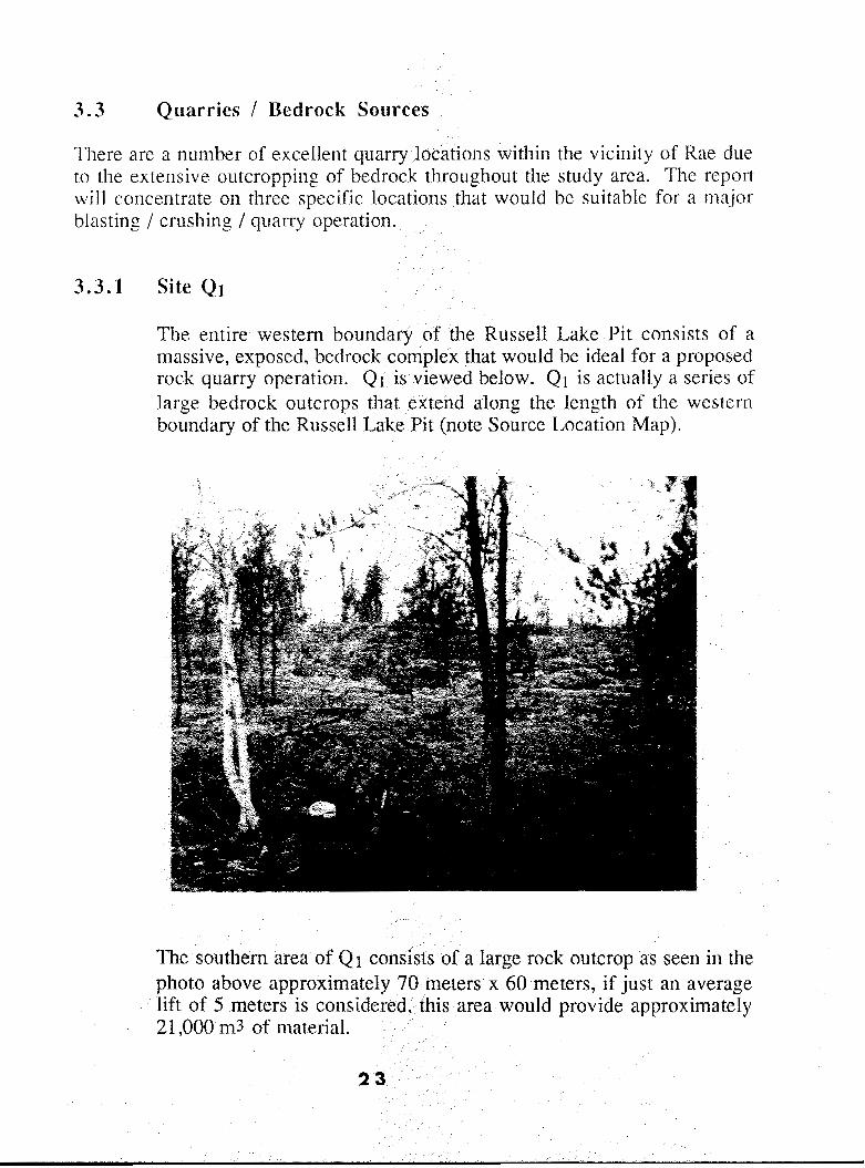
The entire western boundary of the Russell1 Lake Pit consists o:f a massive, exposed, bedrock complex that would be ideal for a proposed rock quarry operation. QI is viewed below. QI is actually a series of large bedrock outcrops that extend along the length of thc wcstcrn boundary of the Russell Lake Pit (note Source Location Map).
The southern area of Q I consists of a large rock outcrop as seen i n the photo above approximately 70 meters x 60 meters, if just an average lift of 5 meters is considered, this area would provide approximately 21,000 rn3 of material.
23

Rock samples taken from QI indicate an abrasion rate of only 1 1.2% and a soundness percentage weight loss of O h % . This indicates an excellent blasting and crushing material. Once crushed to 191nrn, the material produced a well-graded gravel.

I I
An overview of the newly constructed Rae access The road was built using blasted rock from local Icr~gth as seen i n Fig. 2.
I I I I I I I 1
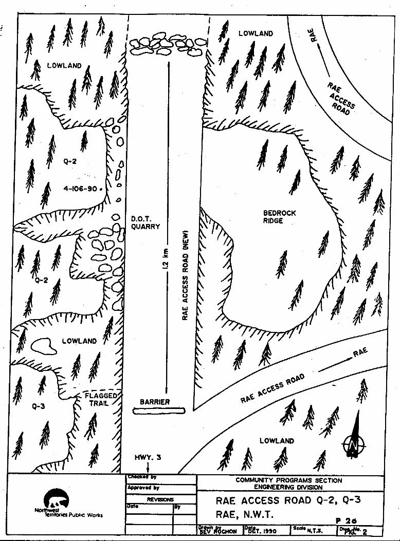
D.O.T. QUARRY
BARRIER
BEDROCK RIDGE
With 311 average S meter lift, this location would produce over 63,000 n$ of matcrial (1.40111 x 90111 x Sm),
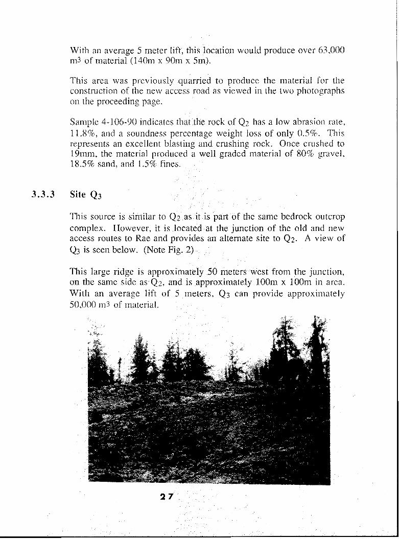
3.3 .3 Site Q 3
l l i s source is similar to Q 2 as it is part of the same bcdrock outcrop complex. However, i t is located at the junction of the old and new access routes to Rae and provides an alternate site to Q 2 . A view of Q3 is seen below. (Note Fig. 2)
This large ridge is approximately SO meters west from the junction, on the same side as Q z , and i s approximately I O O m x lOOm i n area. With an average lift of 5 meters, Q? can provide approxirnately 50,000 1113 of matcrial.
2 7

Qz = 0.6 kilometers, west side, new Rae Access Road
Blasted material from Q 2 was used in the construction of the Rae Access Road
2 8
4. SITE INFORMATION SUMMARY
The following table is an inventory of all existing and potential granular resources in the vicinity Qf RaeEdzo., Associated with each site is the U.S.C., distribution, volume, grade, and processing required. Samples were taken when and where possible; test results are available for viewing in Appendix 2, $
c
2 9
30
4.0 TABLE 1: GRANULAR INVENTORY, RAE/EDZO 1990
Poorly graded sand and gravel, 1 1,400 Embankment & Pitrun / Screen /
high percentage oversize Select Grades Crush
3edrock Quarry 1 oo,ooo+ Embankment & Blast and Quarry
3edrock Quarry 1 13,000+ Embankment & Blast and Quarry Select Grades Operation
Select Grades Operation
5. GRANULAR RESOURCE EVALUATION
5.1 Supply and Demand (Note Appendix 1)
As shown in Table 1, the total amount of granular material from all EXISTING sources is approximately 15,500 m3 of which 10,000 m3 (1990 data) is considered embankment and subbase and 4,500 m3 (1989 survey) select. Material from the Edzo sand pit was partially included as this deposit should only be considered as a source of "blend".
TABLE 1
AVAILABLE MATERIAL / EXISTING SOURCES
Existing Source Grades (m3) Totals (m)
EmbankmenVSubbase Select
Frank Channel 4,500 Russell Lake Pit 8,000 Edzo Sand Pit 3,000
Total CU. m. 1 1,000 4,500 15,500
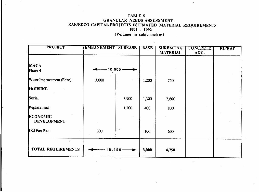
Of a total ten year forecast demand of approximately 242,990 m3 of granular material between 1990 and 1999, there is .available approximately 15,500 m3 of material within the vicinity of Rae/Edzo for use in local capital projects, at the beginning of 1990/91 fiscal year. Please note Appendix 1 for granular needs assessment data/information.
Table 2 is a summary of the material requirements (from needs assessment tables - Appendix 1) for all proposed capital projects from 1990 through 1999.
31
MATERI.
TABLE 2
AL REQUIREMENTS (m3)
YEAR EMBANKMENT/SUBBASE SELECT Increment Cumulative Increment Cumulative
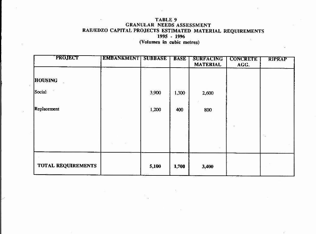
1991/92 18,400 1 8,400 7,750 7,750 1992/93 10,900 29,800 6,175 13,925 1993/94 9,800 39,100 4,800 18,725 1994195 5,300 44,400 5,175 23,900 1995/99 69,720 114,120 57,770 8 1,670
An examination of supply and demand will indicate that during the 1991/92 fiscal year, there will be a deficit of all grades of granular material from existing sources.
91/92 91 j92 Embankment/Subbase (m3) Select Grades (m3)
11,000 (existing) - 18,400 (required) 4,500 (existing) - 7,750 (required)
= -7,400 = -3,250
It is obvious that even if the material needs for granular materials are not 100% realized, there will exist a major deficit of embankment/subbase material during the 91/92 fiscal year. Select grades will also be depleted but not to the same degree. Future requirements of all grades of granular material during 91/92 in part, and definitely beyond 91/92, will certainly have to be met by the development of potential-sources. These sources will have to be adequate to provide for over 44,ooOm3 of embankment and subbase and 24,000 m3 of select material between the years 1991 and 1995 just to satisfy the short term granular needs of the community, If the total material needs are 100% realized.

5 . 2 Kac Access Road
Construction will begin during the 1991 field season. A number of large rock outcrops will be "blasted" t.o provide material for the road and for "right-of" way".
It i s recommended that the development of any quarry related to the production of granular material along the access route - including Q 2 and Q 3 - should be discussed with representatives of DOT as the projects are closely connected.
33
5.3 Assessment
Development of identified potential sources will be required to satisfy the long term granular needs of the community. The study indicates that potential sources of "pitrun" within the vicinity of Rae/Edzo will not satisfy the volume demand for embankment/subbase material. As well, identified sources lack the quantity and quality necessary for the cost-effective production of select grades.
The present study concludes that a "drill/blast/crushing" operation is necessary to produce and stockpile the required grades of granular material for use in local capital projects.
Approximately 25,000 m3 of material should be produced and stockpiled to satisfy the immediate needs of the community. A "quarry blast" operation can . then be continued on an as-needed basis to satisfy the high volume demand for embankmenthubbase material.
6. COST ESTIMATES
The following preliminary cost estimates are related to the production of granular material from bedrock and "pitrun" sources in the vicinity of Rae/Edzo, The estimates involve the mobilization, hauling, site development, and/or drilling, blasting, crushing, and blending to generate specific volumes of various grades of granular material. Unit price bid summaries from the Hamlet of Rae/Edzo, Stan Dean and Sons, Robinson's Trucking and Curry Construction were AVERAGED to achieve a production cost per meter.
6.1 Mosquito Creek - Load, Haul and Stockpile
A preliminary.cost estimate to haul and stockpile 11,OOO m3 of embankment and subbase material the 30 kilometers from the Mosquito Creek. Pit to Rae, is approximately $300.630 or $27.33 m3. This material could be stockpiled in Rae as a source of embankment and subbase or as an ideal source for "crushing" to produce a select grade. By extending the pit boundaries, upwards of 15,000 m3 could be excavated. The haul could be completed during the summer or fall months and is based on the use of 6 twelve metric trucks, a haul time of 83 minutes, and a 12 hour shift. A haul to Edzo would be one-half the price but the majority of future capital projects are centered around the Rae community.
6.2. Site 1 / Site 2 - Winter Load, Haul and Stockpile
A preliminary cost estimate to winter excavate, haul and stockpile 50,000 m3 of embankment material from Site 1 and Site 2 is approximately $378.500 or $7.60 m3. However, this material is not suited for direct placement on the silty clay sediments of the lowland areas that surround Rae. Blasted rock greater than 30 centimeters (12") should be used as a base similar to the construction profile of the new Rae Access Road. The haul would have to take place in winter and is based on the use of 6 twelve metric trucks, a haul time of 6 minutes, and a 12 hour shift. At best, the material could only be used as general fill over bedrock or wherever ground conditions allow direct placement.
6 .3 Russell Lake Pit - Load, Haul, Place and Compact
Historically, the unit price averages between $7.00 - $12.00/cubic depending on the size of the project and volume of material needed.
6.4 Drill, Blast, Crush and Stockpile
A preliminary cost estimate to quarry and crush the bedrock outcrop
met re
s in the vicinity of Rae/Edzo to produce 25,000 m3 of all grades of granular material is approximately $587.000 or $23.48 m3. The work would involve drilling and blasting the bedrock in a 4 ft. x 4 ft, x 10 ft. deep pattern (1.82m x 1.82m x 3rn) to produce different sized material. The granular material would be "sized" to produce three stockpiles. All material greater than 6" (150mm) would be used for embankment and subbase. Material less than 6" (150mm) would be crushed to produce 2" (50mm) and 3/4" (19mm) select grades. A "drill and blast" operation could produce large quantities of embankment material, depending on the hole pattern and type of explosive used, on an as-and- when needed bases.
7. RECOMMENDATIONS
It is recommended that, as soon as possible, the Municipality of Rae/Edzo implement a Granular Resource Development and Management Plan based on this report and modified as is appropriate by legitimate local concerns that are properly beyond the scope of this report.
The specific technical recommendations of this report are:
1.
2.
3.
4.
5.
6 .
Continue to use the existing sources (NW comer, Russell Lake Pit) until depletion which is expected to be in 1990/91, for all grades of granular material.
Develop a "quarry and crushing" operation during the 91/92 fiscal year to produce 25,000 m3 of all grades of granular material. A quarry location should be localized and restricted to either the western side (QI) of the Russell Lake Pit or along the newly constructed Rae Access Road (Qz,Q3). The material should be "sized" to produce embankment, as well as 25mm and 19mm grades.
Once a stockpile of material has been established, a quarry operation should be continued on an as-and-when needed basis to supply the long term granular volume for embankment material required for future capital projects.
The Mosquito Creek Pit can provide upwards of 11,000 m3 of embankment/subbase material or provide an excellent granular source for crushing. This deposit should be used as a sole source for a major capital project in the vicinity of Edzo,. as the cost/m3 to haul to Rae is considerably higher.
It is not recommend to develop Site 1 or Site 2 at this time. These sources would not provide an adequate quality of material; however, it may be necessary to consider these deposits in future years of fiscal restraints,
Since the requirements beyond 1995/96 are uncertain, review and reconsider source potential and requirements in 1994/95.
37
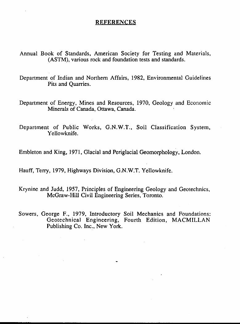
REFERENCES
Annual Book of Standards, American Society for Testing and Materials, (ASTM), various rock and foundation tests and standards.
Department of Indian and Northern Affairs, 1982, Environmental Guidelines Pits and Quarries.
Department of Energy, Mines and Resources, 1970, Geology and Economic Minerals of Canada, Ottawa, Canada.
Department of Public Works, G.N.W,T., Soil Classification System, Yellowknife.
Embleton and King, 197 1, Glacial and Periglacial Geomorphology, London.
Hauff, Terry, 1979, Highways Division, G.N.W.T. Yellowknife.
Krynine and Judd, 1957, Principles of Engineering Geology and Geotechnics, McGraw-Hill Civil Engineering Series, Toronto.
Sowers, George F., 1979, Introductory Soil Mechanics and Foundations: Geotechnical Engineering, Fourth Edition, MACMILLAN Publishing Co. Inc., New York.
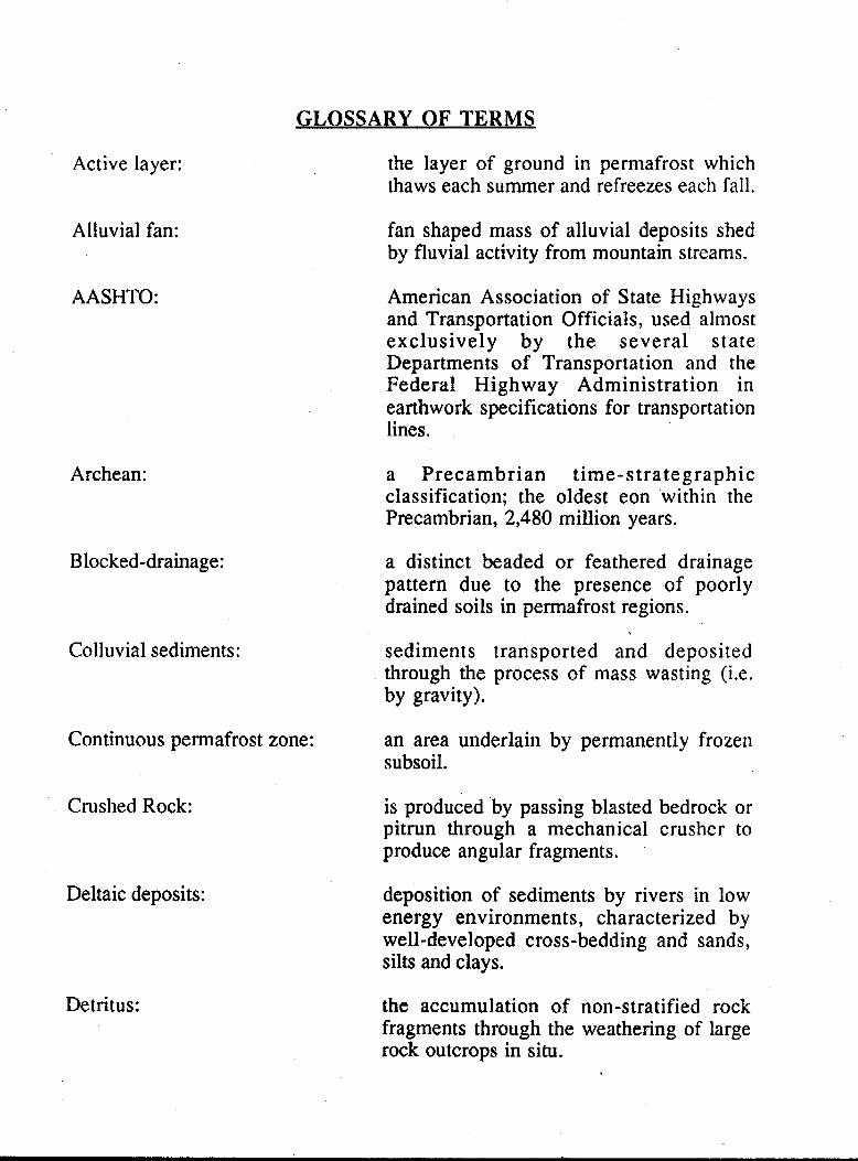
GLOSSARY OF TERMS
Active layer:
Alluvial fan:
AASHTO:
Archean:
Blocked-drainage:
Colluvial sediments:
Continuous permafrost zone:
Crushed Rock:
Deltaic deposits:
Detritus:
the layer of ground in permafrost which thaws each summer and refreezes each fall.
fan shaped mass of alluvial deposits shed by fluvial activity from mountain streams.
American Association of State Highways and Transportation Officials, used almost exclusively by the several state Departments of Transportation and the Federal Highway Administration in earthwork specifications for transportation lines.
a Precambrian t ime-strategraphic classification; the oldest eon within the Precambrian, 2,480 million years.
a distinct beaded or feathered drainage pattern due to the presence of poorly drained soils in permafrost regions.
sediments transported and deposited through the process of mass wasting (i.e. by gravity).
an area underlain by permanently frozen subsoil.
is produced 'by passing blasted bedrock or pitrun through a mechanical crusher to produce angular fragments.
deposition of sediments by rivers in low energy environments, characterized by well-developed cross-bedding and sands, silts and clays.
the accumulation of non-stratified rock fragments through the weathering of large rock outcrops in situ.

Lacrustine deposits:
Mass Movement:
Mechanical weathering:
Metamorphism:
Organic Layer:
Outwash Plan:
Oversize Material:
Peat:
Periglacial environment:
Permafrost:
Permafrost Table:
silts and clays deposited in lake water and later exposed either by the lowering of the water level or by the elevation of the land.
surface movements of earth materials caused primarily by gravity; known also as Mass Wasting.
relates to the physical breakdown of rocks, at or near the earth's surface, by external processes (such as wind and water).
extensive change of rocks or mineral due to great changes in temperature, pressure, and chemical environment.
that portion of the soil which contains decomposed or partially decomposed vegetation.
a broad, gently sloping sheet of outwash deposited by melt water streams flowing in front of or beyond a glacier.
this refers to rock particle size as gravel particles larger than 75 mm (3") in diameter are usually considered to be too large to be used for most geotechnical uses.
unconsolidated compressible material consisting of partially decomposed remains of plants.
depositional an& erosional environments modified by cold climates (subglacial).
the thermal condition in soil or rock where temperatures below O" C persist over at least two consecutive winters and the intervening summer.
the interface between the active layer and permafrost zone.
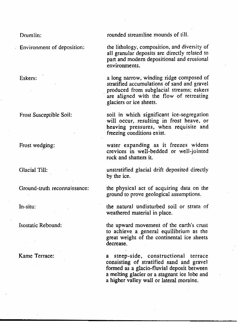
Drumlin:
Environment of deposition:
Eskers:
Frost Susceptible Soil:
Frost wedging:
Glacial Till:
Ground-truth reconnaissance:
In-situ:
Isostatic Rebound:
Kame Terrace:
rounded streamline mounds of till.
the lithology, composition, and diversity of all granular deposits are directly related to part and modem depositional and erosional environments.
a long narrow, winding ridge composed of stratified accumulations of sand and gravel produced from subglacial streams; eskers are aligned with the flow of retreating glaciers or ice sheets.
soil in which significant ice-segregation will occur, resulting in frost heave, or heaving pressures, when requisite and freezing conditions exist.
water expanding as it freezes widens crevices in well-bedded or well-jointed rock and shatters it.
unstratified glacial drift deposited directly by the ice.
the physical act of acquiring data on the ground to prove geological assumptions.
the natural undisturbed soil or strata of weathered material in place.
the upward movement of the earth's crust to achieve a general equilibrium as the great weight of the continental ice sheets decrease.
a steep-side, constructional terrace consisting of stratified sand and gravel formed as a glacio-fluvial deposit between a melting glacier or a stagnant ice lobe and a higher valley wall or lateral moraine,

Pitrun:
Raised beaches:
Regolith:
Solifluction:
Syncline:
Talus slope:
Territory Land Use Regulations:
USC:
Varved sediments:
Wisconsin glaciation:
unprocessed gravel containing a minimum of 35% coarse aggregate larger than #4 sieve.
beaches formed,during times of high water level and then stranded by the lowering of the water level or by the elevation of the land.
unconsolidated mantle of weathered rock and soil material on the earth's surface.
in subarctic regions, fine rock fragments when saturated with water, spread slowly down slope and along valley floors.
a trough or downfold in the rocks.
the accumulation of small fragments (scree) in the millimeter-to-meter range from cliffs or steep walls that maintain a uniform slope (commonly about 30") as it grows.
provides regulatory control for maintaining sound environmental practice for any land use'activity on all lands under Federal control in the territories.
United Soil Classification System, used for foundation engineering such as dams, buildings, road earthwork specifications, and aifield design.
distinct band representing the annual deposit in sedimentary materials.
the latest of the various ice sheets of the Pleistocene epoch, approximately 10,000 years ago.
APPENDIX 1
Granular Needs Assessment Tables Tables 2 - 9
Appendix 1
GRANULAR NEEDS ASSESSMENT
As previously indicated, the granular requirements for Rae/Edzo have been developed from each G.N.W.T. Department's 5 year capital plan and 20 year capital needs assessment, as well as information from the NWTHC, Federal Agencies and the private sector. The various projects were analyzed for their granular requirements and this information was used as the basis for establishing a 20 year granular needs projection by the type of materials required.
The information upon which this report is based is as accurate as could be found in November, 1989. To revise it and the conclusions drawn from it to keep them up to date has been impossible. Therefore, comparison with the approved capital plan for 90/91 will certainly show differences. However, the objective has been to make a reasonable assessment of needs for granular materials in Rae/Edzo for the period noted. Since the changes brought about each year by the capital planning process will tend to reduce the quantities required and, to some extent the substitution of one project for another will probably have a relatively small effect on the totals, this approach is considered fair and reasonable. Furthermore, continual surveillance of the sources and the quantities extracted will show when additional sources must be developed.
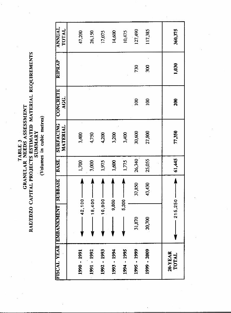
The analysis shows that Rae/Edzo requires approximately 243,000 m3 of granular materials for fiscal years 1990/91 through 1998/99. This information is shown in part on the following pages, as is a summary of the projected requirements for fiscal years 1998/99 through 2000/2009. Detailed information for this later period is available from'office files. If consulted, the data should be considered rather speculative at best.
For the purpose of this report, granular materials have been separated into five major types: embankment, subbase, base, surfacing .and concrete aggregate. However, base, surfacing, and concrete aggregate are often referred to collectively as "select grades". The reaion for this is that embankment and subbase materials are often used directly from a source as "pitrun" while select grades are obtained through the processing of the material by washing, screening or crushing.
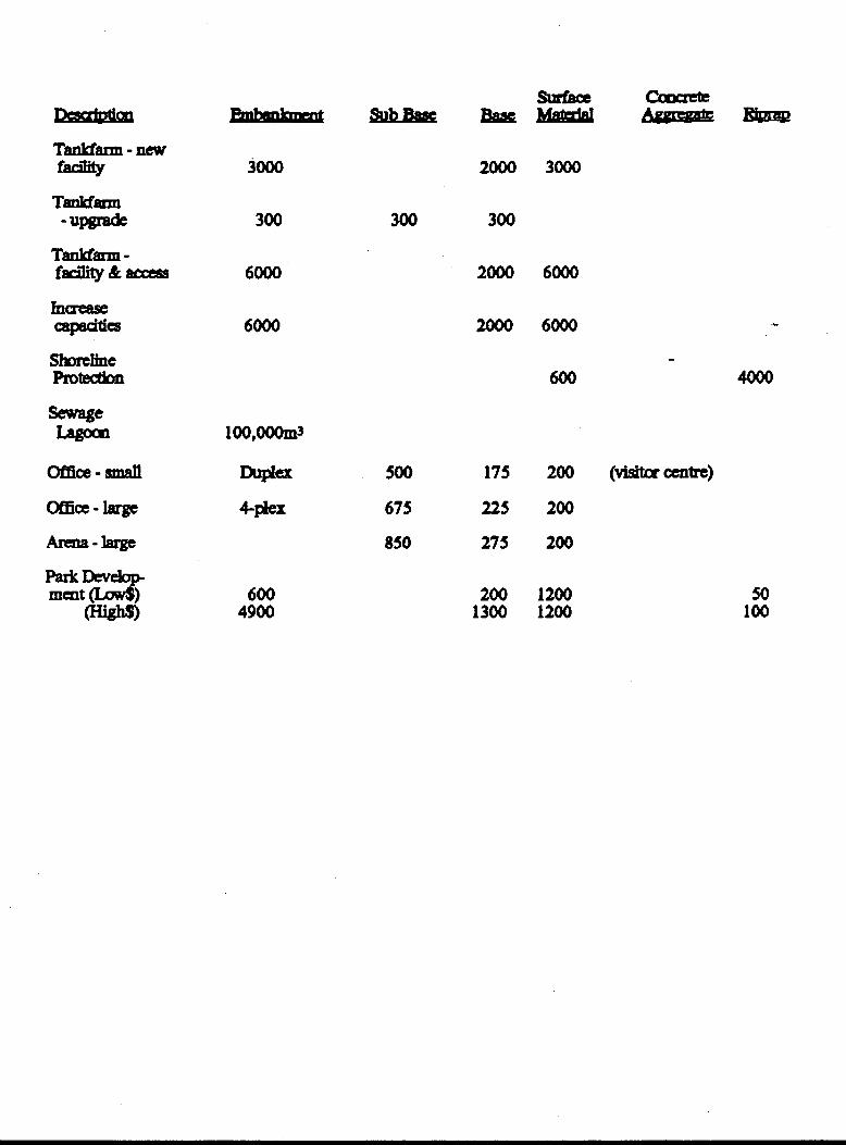
Table 2 represents the granular material breakdown of capital projects that was used to develop this section of the report. This infomation was then used to derive the granular needs assessment tables for individual fiscal years displayed in Table 3.

TABLE 2: CAPITAL PROJECTS
~ M u I ~ Mated11 Breakdown (in cubic me-)
4900
600
sr;lrfaoc mmvk "mu " 450 300
17s 300
3750 2250
1300 200
2500 1500
2500 1500
l o o 0 0
5000 3000
80 100
1300 1200
200 1200
loo0
175 200
100 200
175 200
22s 200
-
10
100
50

Efabnba ah&s€
600
600
350
400
200
' 200 -
300
500
675
500
300
500
675
675
300
so0
500
81000
w 200
200
100
100
50
50
100
175
225
175
100
175
225
225
100
175
175
16200
Mm€d s\afaa
200
200
200
200
100
100
200
200
200
200
200
200
200
200
200
200
200
jqoo
1700
5400
50
50
50
200
100
100
100
100
600 4900
2000 3000
300 300
500 175 200 (visilmecntrt)
675 225 200
850 275 200
200 1200 1300 1200
50 100
8 8 8 c*l
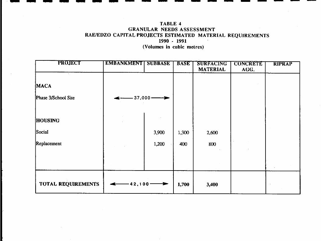
TABLE 4 GRANULAR NEEDS ASSESSMENT
RAE/EDZo CAPITAL PROJECTS ESTIMATED MATERIAL REQUIREMENTS 1990 - 1991
(Volumes in cubic metres)
PROJECT
MACA
Phase 3/SchooI Site
HOUSING
Social
Replacement
TOTAL REQUIREMENTS
EMBANKMENT SUBBASE
3,900
1,200
-42,100-
BASE
1,300
400
SURFACING MATERIAL
3,400
CONCRETE RIPRAP
38
m-
oo
8 d
O
O
O
O
O
Y
8
m
e
UJ 2
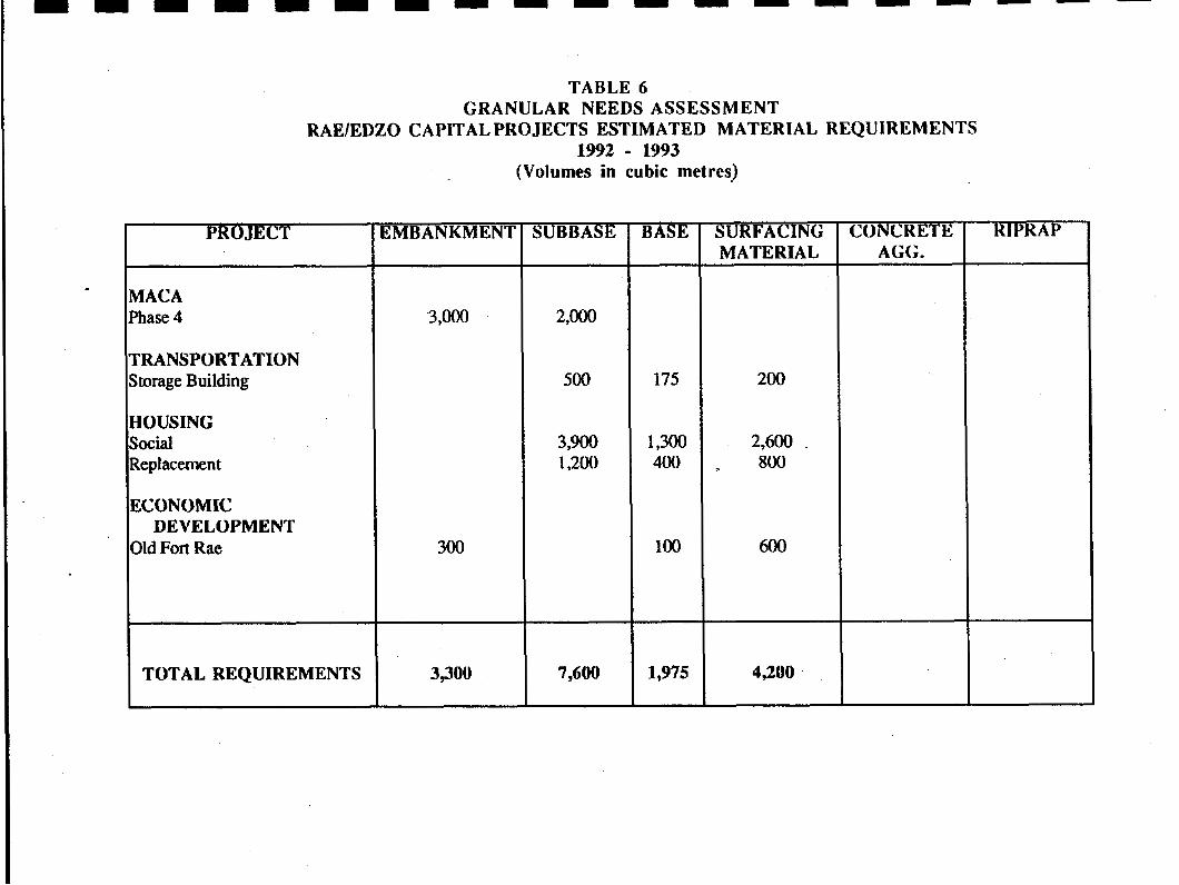
TABLE 6 GRANULAR NEEDS ASSESSMENT
RAElEDZO CAPITAL PROJECTS ESTIMATED MATERIAL REQUIREMENTS 1992 - €993
(Volumes in cubic metres)
PROJECT 1 EMBANKMENT
I dACA %hase 4 3 ,O00
;RANSPORTATION ltorage Building
CCONOMIC
Ild Fort Rae DEVELOPMENT
300
TOTAL REQUIREMENTS 1 3 3 0
SUBBASE
7,600
BASE
175
1,300 400
€ 0 0
1,975
SURFACING MATERIAL
200
2,600 . 800
600
4,200 .
CONCRETE AGG.
RIPRAP

TABLE 7 GRANULAR NEEDS ASSESSMENT
RAElEDZO CAPITAL PROJECTS ESTIMATED MATERIAL REQUIREMENTS 1993 - 1994
(Volumes in cubic metres)
PROJECT
MACA
Phase 4
HOUSING
S o c i a l
Replacement ~~
TOTAL REQUIREMENTS
EMBANKMENT
2,500
2,500
SUBBASE
73300
BASE
1,200
400
1,600
SURFACING MATERIAL
2,400
800
3,200
RIPRAP
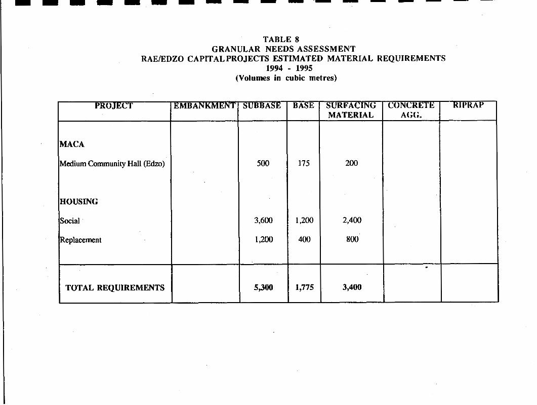
TABLE 8 GRANULAR NEEDS ASSESSMENT
RAElEDZU CAPITAL PROJECTS ESTIMATED MATERIAL REQUIREMENTS 1994 - 1995
(Volumes in cubic metres)
PROJECT
MACA
vledium Community Hall (Edzo)
3OUSING
h i a l
teplacement
TOTAL REQUIREMENTS
EMBANKMENT sUBBAsE
500
3,600
1,200
BASE
175
1,200
4w
1,775
SURFACING MATERIAL
200
3,400
RIPRAP
I I I
ID
I I I I
APPENDIX 2
Geotechnical Data 1990
Laboratory Test Results Grain Size Curves
Cross Sections

I I I I I I I 1 I I I I I I I I I I I
SAMPLE DATA SHEET
LOCATION North End - Russell Lake Pit
#1
Sample taken from north terminus o f existing pit
TEST HOLE NUMBER DEPTH 1 .5 meters I
FIELD DESCRIPTION
L 4 B TESTS REQUIRED V i s u a l . W.S.A., U.S.C.
I
RLPUESTED COMPLETION DATE D/M/ Y RESULTS SUBMITTED x)
Visual Descriptfon
Sand, trace o f gravel, subangu
Wash Sieve Analysis
Gravel > 5.5% Sand > 90.5% Fines > 4.0%
U.S.C.
SP
lar, trace non-plastic fines, light brown.
- .ED
I PEvIEYED BY M T E WM/Y ATTACHMENTS P A W S
O1 O1
.. 06 I I I I I I I
I 1 I I t I I' I I' ' I l 1 I 06
001
Sm
O01

SAMPLE DATA SHEET
TEST MOLE NUMBER #2
DEPTH 2.0 meters
FIELD DESCRIPTION Adjacent t o o l d t e s t pits above area o f present excavation
I RESULTS SUBMITTED To
V i sua1
Gravel and sand. subangular, t r a c e non-plast ic f ines, light brown, maximum s i z e 20 cm.
Wash Sieve Analysis
Gravel > 62.0% Sand > 37.0% Fines > 1.0%
u.s.c
GW
-
.ED BY I
REVIEWED BY M T € WY/Y ATTACHMENt8 PAWS
F-O486 - 016

..
"
- . - .. . .
UJW
O
I"
I' ,. . , . . I, ra
I 8 O1 II
91 1 I I I
0cb)oS 001 I
OOL I

RUSSELL LKE PIT - RAE, N.W.T.
TEST HOLE PROFILE Al 2-106-90
"
0.3M ORWNIC,BLACK, ROOTS, MOSS.
0.92M COARSE GRAVEL AND SAND, COBBLES UP TO IScm, SUBROUNDED NON-STRATFIED, LITTLE FMES, APPROXMATELY 60% GRAVEL, 40% SAND.
O.8M COARSE SAND WITH 30% FINE
GRAVEL 2 - 3 ~ " ~ GRAVEL, SUBROUNDED, TRACE OF: FHE%
LARGE BOULDERS.
-w DY COMMUNlTY PROGRAMS SECTION "
SAMPLE Ar 2-106-90 CROSS SECTION boio Bv RUSSELL LAKE PIT, RAE, N.W.T. RE-
, ENGWEERPIG DlVlSlON
~ , , w o r # s
Proposed quarry - 92
#3
Rock Fragments from present Quarry S i t e along Rae Access Road
TEST HOLE NUMBER DEPTH Surface / P i t Wall I
FIELD DESCRIPTION
L A B TESTS REoUlRED W.S.A.. Lab Crush, L.A.A.. Soundness
I REPULSTED COYPLLTDN DATE D/M/Y RESULTS SUBMITTED TO
Visual
Rock Fragments - granitic gneiss
Wash Sieve Analysis ( a f t e r crush to 19m)
Gravel > 80.5% Sand > 18.0% Fines > 1.5%
U.S.C.
GW
L.A.A. (%)
11.2
Soundness
0.6
I )€VIEWED BY DATE W W Y
ATTACHMENl3 PAGES
I-
..
..
., . .. .I
.. ..

SAMPLE DATA SHEET
. .
LAa TESTS R E W I R E D W,S,A. , crush 19m, U A , soundness . . . . . . . .
I REQUESTED EOYPLETM DATE D/M/Y RESULTS SUBMITTED TO
V i sua1
Rock Fragments, granltic gneiss
Wash Sfeve Analysis
Gravel > 80.0% Sand > 18.5% Fines > 1.5%
U.S.C.
GW
Soundness (% Loss)
O. 5%
I REVIEWED BY ATTACHYENl3 PAGES
F-0486 -OIS

". .

SAMPLE DATA SHEET
S4MPLE IDENTIFICATION METHOD OF SAMPLINO 5- 106-90 Hand Shovel
LOCATION Mosquito Creek P i t - 30 km. from Rae
85 1.0 meters I Test Hole in center o f p i t towards sout'h access route; qreat deal o f oversize
TEST HOLE NUMBER DEPTH
FIELD DESCRIPTION
L4B TESTS REQUIRED
I
REQUESTED COMPLETDM DATE D/M/Y RESULTS SUBMITTED TO
Uash Sieve Analysis
Gravel > 43.0% Sand > 55.0% Fines > 2.0%
U.S.C.
SP I
CWPILED BY
-.
.. '

1 I I 1 I I I U I
MOSQUITO CREEK PIT km 223 HWY. 3
TEST HOLE PROFIL€ # 5-106-90
-.
i "
O.% COARSE S A M WITH 20% FNE @RAVEL.
BEDROCK
-ma by C W W Y PROGRAMS SECTION - Apprwd-, E N W E E W WlSlON .
.- .,a MOSQUITO CREEK PIT
SAMPLE # 5-106-90 CROSS SECTION I

PROJECT RAE/EDZO GRANULAR INVESTIGATION I P R O J E C T NUMBER
90-9170-106
! C r a T l n N S ide Bor row, nor th s ide km, 227.4
f 6
""
TEST HOLE NUMBER DEPTH I
1.5 meters l___ . ~
FIELD DESCAIPT!ON - Large s j d e borrow on N o r t h s i d e o f Hwy. 83 a t km. 227.4 - shale
Visual
Gravel and sands, f l a t pieces of shale? trace slightly pas t i c f ines, dark brown t o black , subangular t o angular , f r i a b l e , m o i s t ,
Hash Sieve Analysis
Gravel > 58.0% Sand > 33.0% F ines > 9.0%
LL > 32 PL Z 24 PI > 8
t SIEVE SIZES
Llscs 100
SIDE BORROW km 227.4 HWY. 3
TEST HOLE PROFILE Ac 6-106-90
0.4M THICK, DENSE ORGANIC LAYER, BLACK, ROOTS
0.6M ELONGATED F U T SHALE, SOME COARSE SAND1 SHALE DETRITUS Ls FRIABLE, BLACK, LAYERED.
0.3M, FINE SAND, HIGH CLAY CONTENT, DENSE.
0.24 COARSE SAND, POORLY GRADED, TRAC€ FNES. FROZEN G R O W .
Ch0ck.Q bY COMMUNITY PROGRAMS SECTION Approvd by - ENGINEERNG DNWON
REVWKms SIDE BORROW km 227.4 HWY. 3 bot.
!-"" SAMPLE # 6406-90 CROSS SECTION

1 1 I I II I 1
I
SAMPLE IDENTIFICATION 7 - 107-90
METHOD OF SAMPLINO Hand Shovel
~ ~ l r o r ~ n n i Old Sand Pit a t Edzo
I"~""- . ~ .- -_^I__ l"""-_
TEST HOLE NUMBER 0,8 meters - encountered pe mafrost
FIELD DESCRIPTION Large sand p l ' t a t Edzo - numerous small sand s t o c k p i l e s
"
W. DATE D/M/Y S A M P L E D I S C A R D E D
-~ RETAINED
"
Wash Sleve Analysis
Gravel > 13.5% Sand > 85.0% Fines > 1.5%
U.S.C.
SP
COMPILED BY L
E-0486 - O16

L.
-.

SAMPLE DATA SHEET
TEST HOLE N U M B E R #8
Large area n a r t h o f Rae o f poorlyg raded shands a n d gravels "" - .. .. . . 1 DEPTH
1,8 meters - encountcred b drock . .. .. .. - . " FIELD DESCRIPT!ON
_I"X."-. "" .. .. . -
Visual
Sand and gravels, l i g h t b r o w n , s u b r o u n d e d
Wash Sieve Analysis
Gravel > 44% Sand > 51% Fines > 5%
SITE 2 1 RAE, N.W.T.
TEST HOLE PROFILE # 8-106-90
I !2
LARGE B0UU)ERS ON SURFACE MORETHAN100un 0.2M ORGAMC LAYER
0.8M POORLY GRADED STRATIFIED LAYERS OF SAND CLND GRAVEL, TRACE OF EWES.
BEDROCK
SITE 2, RAE, N.W.T. t SAMPLE # 8-106-90 CROSS SECTION
SpuMicWorln