Embed Size (px)
Citation preview

Green River Locks and Dams 3, 4, 5 and 6 and Barren River Lock and Dam 1 Disposition Feasibility Study, Kentucky
August 2014 Main Report

Green and Barren Rivers Locks and Dams Disposition Feasibility Study • US Army Corps of Engineers • August 2014
i
Executive Summary
Green River Locks and Dams 3 through 6 and Barren River Lock and Dam 1 were authorized by Congress for navigation, but are no longer in use. The facilities and the pools are no longer operated for navigation purposes by the U.S. Army Corps of Engineers (USACE); however, the U.S Army still has administrative accountability of the properties, and USACE periodically inspects the facilities.
The Green River Locks and Dams 5 and 6 ceased operations in 1951 due to a marked decline in navigation traffic, coupled with increasing operation and maintenance costs. In May 1965, Green River Dam 4 failed, which resulted in the closure of Green River Lock and Dam 4 and also Barren River Lock and Dam 1, as navigation beyond that lock and dam was no longer possible. Green River Lock and Dam 3 remained in operation until 1981 when it was closed due to declining boat traffic.
Since the failure of Green River Dam 4, USACE has conducted multiple investigations concerning the feasibility of restoring navigation to the Upper Green River System. These studies have consistently found that the economic benefits from commercial navigation operations would be insufficient to support restoring navigation. In 2004, the USACE conducted a study to assess the impacts of deauthorization of the Green River Locks and Dams 3 - 6 and Barren River Lock and Dam 1 and relinquishment of the federal government’s interest in the property and facilities; the study also contained recommendations concerning construction and disposal alternatives. No action was taken at that time with respect to the study’s recommendations; therefore, the USACE maintains the properties in a caretaker status.
The purpose of this study is to update the analysis and recommendations of the 2004 study regarding the possible deauthorization and relinquishment of federal control of the facilities. The 1993 study (study focused on improvements to the existing facilities located at Lock and Dam 3 at Rochester, Kentucky), 2004 study and this reevaluation were accomplished under the original authority of Section 216 of the Flood Control Act of 1970 (P.L. 91-611). This is a general authority for the Secretary of the Army to review completed projects, when found advisable due to changed physical, economic or environmental conditions. This study also supports the objectives of the 10 June 2010 Presidential Memorandum ‘Disposing of Unneeded Federal Real Estate’ and Section 6002 of the Water Resources Reform and Development Act of 2014, which requires the Secretary of the Army to identify property that is excess to project needs and to notify and work with the General Services Administration for the disposal of all excess property.
This study reevaluated current uses of the facilities, including the pools formed by the dams and the impacts if the pool were to be lost, either by demolition or failure of the lock and/or dam. The study reassessed the condition and safety of the structures. Finally, the study discussed alternative means to potentially dispose of the facilities in the future following deauthorization of the navigation purpose, as well as potential entities interested in owning the facilities.
Four alternatives for deauthorization and possible disposition were evaluated for each site:
1. Alternative 1 (No action). All locks and dams would remain in federal ownership in caretaker status. The USACE would remain responsible for the facilities.
2. Alternative 2 (Congressional Deauthorization Only). Only request Congressional deauthorization of commercial navigation for Green River Locks and Dams 3, 4, 5, and 6 and Barren River Lock and Dam 1.
3. Alternative 3 (Deauthorization, Dam Removal, Lock Fill and Installation of Warning Signs). Request Congressional deauthorization of commercial navigation for Green River Locks and Dams 3, 4, 5, and 6 and Barren River Lock and Dam 1. Dispose of the properties after the dams are removed and the lock

Green and Barren Rivers Locks and Dams Disposition Feasibility Study • US Army Corps of Engineers • August 2014
ii
chambers are filled with materials from the demolition of the dam. Excess dam materials would be disposed of onsite along the lock approaches or in an approved offsite location. Three warning signs would be equally spaced and installed on the lock side chamber walls.
4. Alternative 4 (Deauthorization, Lock Stabilization, Installation of Barricade and Warning Signs). Request Congressional deauthorization of commercial navigation for Green River Locks and Dams 3, 4, 5, and 6 and Barren River Lock and Dam 1. Dispose of the properties after the locks are modified (for example, by constructing a bulkhead) to ensure stability and pool retention before disposal. To impede access to the river side lock wall, the land side miter gates would be barricaded. Three warning signs would be equally spaced and installed on the lock side chamber walls.
The recommended plan (Alternative 2) is to only request Congressional deauthorization of commercial navigation for Green River Locks and Dams 3, 4, 5, and 6 and Barren River Lock and Dam 1. There are no costs associated with the recommended plan.
In accordance with ER 200-2-2, the project as proposed, is in compliance with the National Environmental Policy Act (NEPA) and all other applicable laws and regulations governing environmental and cultural resources. An Environmental Assessment (EA) and draft Finding of No Significant Impact (FONSI) along with the Study were circulated for a 30-day public and agency review (see Appendix D for additional detail). The EA and comments from the public and state and Federal resource agencies supported a finding of no adverse impacts from implementing the recommended alternative.
Following Congressional deauthorization of commercial navigation at these facilities, a logical next step would be to seek disposal of these properties and facilities through the established USACE and GSA procedures as outlined in the Federal Property and Administrative Services Act of 1949 and Army regulations. The safety concerns identified at Green River Locks and Dams 3 through 6 and at Barren River Lock and Dam 1 would be addressed at each site by installing barricades on miter gates, as well as updating signage at the sites. This maintenance work would be funded through the established Operation and Maintenance budget process.

Green and Barren Rivers Locks and Dams Disposition Study, Kentucky • US Army Corps of Engineers • August 2014
iii
Contents 1 Introduction .......................................................... 1
2 Study Authority and History .................................. 2
3 Study Area ............................................................ 4
4 USACE Projects in the Basin ................................... 5
4.1 Navigation System ......................................... 5 4.2 Multipurpose Reservoirs ................................ 5 4.3 Flood Risk Management Projects ................... 6 4.4 Continuing Authorities Projects ..................... 6
5 Prior Studies and Reports ...................................... 8
6 Existing Conditions .............................................. 10
6.1 Green River Lock and Dam 3 ........................ 10 6.2 Green River Lock and Dam 4 ........................ 11 6.3 Green River Lock and Dam 5 ........................ 12 6.4 Green River Lock and Dam 6 ........................ 13 6.5 Barren Lock and Dam 1 ................................ 14
7 Real Estate Interests at the Sites ......................... 16
8 Disposal of United States Real Property ............... 17
8.1 Disposal by GSA ........................................... 17 8.2 Disposal by the USACE ................................. 17 8.3 General Disposal Discussion ......................... 18
9 Non-Navigation Facilities in the Navigation Pools 19
9.1 Water Intakes in the Green River Navigation Pools 19 9.2 Ferries in the Green River Pools ................... 20
9.3 Boat Ramps in the Green & Barren Pools..... 20 9.4 Canoeing on the Green & Barren Rivers ...... 20
10 Plan Formulation ................................................ 21
10.1 Problems and Opportunities ....................... 21
Problem Identification ......................... 21 10.1.1 21 10.1.2 Opportunity Statements ...................... 21
10.2 Planning Objectives and Constraints ............ 21
10.2.1 Objective ............................................. 21 10.2.2 Constraints .......................................... 21
10.3 Alternative Plans ......................................... 22 10.4 Screening Criteria ........................................ 23 10.5 Comparison of Alternative Plans ................. 24
10.5.1 Alternative 1(No Action) ...................... 24 10.5.2 Alternative 2 (Congressional Deauthorization Only) ......................................... 24 10.5.3 Alternative 3 (Remove Dam, Fill Lock and Warning Signs) .................................................... 24 10.5.4 Alternative 4 (Stabilize Lock, Barricade and Warning Signs) .................................................... 26
11 Recommended Plan ............................................ 26
12 Mitigation Requirements .................................... 26
13 Conclusions ........................................................ 27
14 Recommendation ............................................... 28
Figures Figure 3.a: Green River Watershed ...................................................................................................................... 4 Figure 4.a: Green River Watershed Navigation and Multipurpose Reservoir Locations ......................................... 6
Tables 2.1Recent History Leading to the 2014 Disposition Study ..................................................................................... 2 4.1Pertinent Data for the Green and Barren Rivers Locks and Dams..................................................................... 5 7.1Real Estate Interests at Each Lock and Dam Site ............................................................................................ 16 9.1Water Intakes in the Green and Barren Pools ................................................................................................ 19 9.3Boat Ramps in the Green & Barren Pools ...................................................................................................... 20 9.2Ferries in the Green River Pools .................................................................................................................... 20 9.4Canoe Liveries in the Study Area ................................................................................................................... 20 9.5Observed Boat and Canoe Use on the Green River ........................................................................................ 20

Green and Barren Rivers Locks and Dams Disposition Study, Kentucky • US Army Corps of Engineers • August 2014
iv
Photos Photo 6.a: Green River Lock 3 (2013) ................................................................................................................. 10 Photo 6.b: Green River Dam 3 (2013) ................................................................................................................. 10 Photo 6.c: Green River Lock and Dam 4 (2013)................................................................................................... 11 Photo 6.d: Green River Lock and Dam 5 (2013) .................................................................................................. 12 Photo 6.e: Green River Lock and Dam 6 (2013) .................................................................................................. 14 Photo 6.f: Barren River Lock and Dam 1 (2013) .................................................................................................. 15
Plates Plate 1: Study Area Map Plate 2: Green Lock and Dam 3 Map Plate 3: Green Lock and Dam 3 Information Plate 4: Green Lock and Dam 4 Map Plate 5: Green Lock and Dam 4 Information Plate 6: Green Lock and Dam 5 Map
Plate 7: Green Lock and Dam 5 Information Plate 8: Green Lock and Dam 6 Map Plate 9: Green Lock and Dam 6 Information Plate10: Barren Lock and Dam 1 Map Plate 11: Barren Lock and Dam 1 Information
Appendices A. Cultural Resources Investigation B. Geotechnical and Structural Analyses C. Hydrologic and Hydraulic Analyses D. Environmental Assessment
E. Environmental Baseline Survey F. Real Estate Interests G. USFWS Coordination H. Public Involvement

Green and Barren Rivers Locks and Dams Disposition Feasibility Study • US Army Corps of Engineers • August 2014
1
1 Introduction The purpose of this study is to evaluate the condition and use of existing navigation facilities located on the Green and Barren Rivers between Brownsville, Kentucky and Rochester, Kentucky on the Green River, and at Greencastle, Kentucky on the Barren River. These facilities include Locks and Dams 3, 4, 5, and 6 on the Green River and Lock and Dam 1 on the Barren River. These facilities are the focus of this study because they are no longer used for navigation. (There are two other navigation facilities on the Green River. Lock and Dam 1 near Spotsville, Kentucky and Lock and Dam 2 at Calhoun, Kentucky are still used for commercial navigation. This study does not include these two locks and dams.) This study would be used to make recommendations regarding the deauthorization of the facilities and identifies actions the USACE will take using established USACE authorities and operation and maintenance (O&M) budget process. The study could also serve as a foundation for future actions considering disposal of the facilities. This study serves as the decision document supporting the Chief’s Report to Congress requesting such deauthorization. Upon a favorable finding regarding deauthorization of the facilities, the sites could then be considered for disposal at a future time in accordance with the Federal Property and Administrative Services Act of 1949 and Army regulations.
Green and Barren Rivers Locks and Dams Disposition Feasibility Study • US Army Corps of Engineers • August 2014
2
2 Study Authority and History This study was authorized by Section 216 of the Flood Control Act of 1970 (P.L. 91-611), which is a general authority for the Secretary of the Army to review completed projects due to changed physical, economic or environmental conditions.
This effort was initially funded as part of the Fiscal Year 1995 Energy and Water Resource Appropriation Bill, and the resulting study found that there would be insufficient benefits from commercial navigation operations to support restoration of navigation. Currently, the U.S. Army Corps of Engineers (USACE) maintains the properties in a caretaker status.
In 1998, a Phase 1 cultural resources examination was undertaken of property associated with Locks and Dams 3, 4, 5, and 6 along the Green River and Lock and Dam 1 on the Barren River in south-central Kentucky. No evidence of either prehistoric or undisturbed historic-era remains was encountered and no further archaeological studies are recommended on these parcels. The locks and dams themselves are considered eligible for the National Register of Historic Places (NRHP) and the required level of documentation needed on these navigation facilities remains to be coordinated with the Kentucky State Historic Preservation Officer (KY-SHPO).
To date, the USACE has completed a brief historical overview of the Green and Barren Navigation System and prepared archival quality photo documentation of all existing structures. A report containing this information was completed in July 2000.
Additionally, an environmental baseline survey (EBS) was performed in February 2000 to determine the possibility that the sites have been contaminated by HTRW; or, that the potential exists for contamination by such materials. Some indications of the presence, or potential presence, of hazardous or toxic materials were noted at almost all of the properties surveyed during the EBS. However, based on the information reviewed and physical observations, there is no evidence that significant amounts of hazardous materials were ever stored, handled, transported, disposed or otherwise released at any of the locks and dams within the study area.
A feasibility study was performed in 2004 that recommended deauthorization and disposal of Green River Locks and Dams 3 - 6 and Barren River Lock and Dam 1. The recommended alternative consisted of demolishing the dam at Green River Lock and Dam 6 (which would restore 6 - 8 miles of the Green River to its natural conditions at Mammoth Cave) and filling the lock chambers at Green River Locks and Dams 3-5 and Barren River Lock and Dam 1.
2.1Recent History Leading to the 2014 Disposition Study

Green and Barren Rivers Locks and Dams Disposition Feasibility Study • US Army Corps of Engineers • August 2014
3
A decision on how to proceed with the recommendations in the 2004 feasibility study was not reached until 2008, and project funding was not available until 2013. In the intervening 10 years since the study was complete, changes have taken place. Therefore, it is necessary to update the existing conditions at each lock and dam, recommended plan, cost estimates, the prior analysis conducted to ensure compliance with the National Environmental Policy Act (NEPA), public coordination and study reviews. The Review Plan for this study was approved on 22 October 2013, and the Independent External Peer Review Exclusion Request was approved on 18 December 2013.

Green and Barren Rivers Locks and Dams Disposition Feasibility Study • US Army Corps of Engineers • August 2014
4
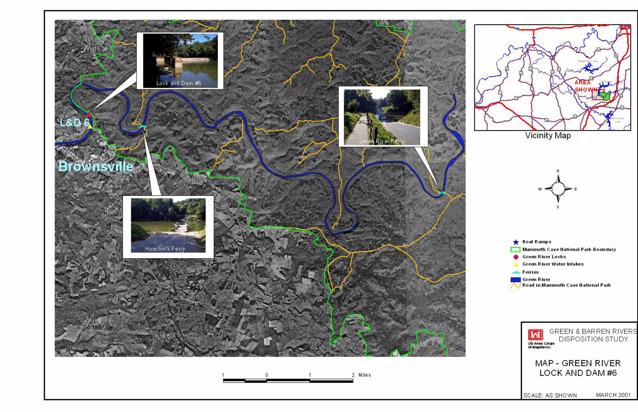
3 Study Area The Green River Basin has a drainage area of 9230 square miles and stretches from west-central Kentucky into north-central Tennessee. Basin topography varies from gently rolling in the east to the moderately rugged Western Kentucky coalfields regions and then into a broad floodplain as the river enters the Ohio River just upstream of Henderson, Kentucky. Major tributaries include the Barren, Rough and Nolin rivers. See Plate 1.
Figure 3.a: Green River Watershed

Green and Barren Rivers Locks and Dams Disposition Feasibility Study • US Army Corps of Engineers • August 2014
5
4 USACE Projects in the Basin Water resource development in the Green River Basin area consists of the navigation system as well as four multipurpose reservoirs and six local flood risk management projects. These are discussed in Sections 4.3 and 4.4.
4.1 Navigation System The navigation system consists of six structures located on the Green and one structure each on the Barren and Rough rivers. Locks and Dams 1 to 4 on the Green River and Lock and Dam 1 on the Barren River were built by the Commonwealth of Kentucky prior to 1886 and purchased by the U. S. Government under authorization of the River and Harbor Act of 11 August 1888. Green River Lock and Dam 6 was constructed in 1906 and Lock and Dam 5 followed in 1934. The system was modified and improved by the United States to provide slack water navigation from the mouth to Bowling Green at mile 30 on Barren River and mile 8 on Nolin River.
The Lock and Dam Projects are all located in Kentucky; approximate locations (shown on Figure 4.a) are as follows:
Green River Lock and Dam 1: Spotsville, Henderson County, Green River mile 9.1.
Green River Lock and Dam 2: Calhoun, McLean County at Green River mile 63.1.
Green River Lock and Dam 3: near Rochester, in Ohio and Muhlenberg Counties at Green River mile 108.5.
Green River Lock and Dam 4: Woodbury, Butler County at Green River mile 149.0.
Green River Lock and Dam 5: Butler and Warren Counties at Green River mile 168.1.
Green River Lock and Dam 6: Brownsville, Edmonson County at Green River mile 181.7.
Barren River Lock and Dam 1: near Greencastle in Warren County at Barren River mile 15.0.
Green River Lock and Dam 1 near Spottsville, Kentucky and Lock and Dam 2 at Calhoun, Kentucky are still used for commercial navigation; this study does not include these two locks and dams.
4.2 Multipurpose Reservoirs The primary purpose of the Green River Basin reservoirs (shown on Figure 4.a) is managing flood waters; however, they are also used for recreation, water supply and managing natural resources. These multipurpose projects are integral units in the system for flood risk management for the Ohio and Mississippi rivers. Estimated damages prevented by the completed projects exceed $200 million since their completion. Communities along the banks of the Green River are afforded significantly lower annual flood risk by the four reservoirs in the upper basin.
The multipurpose reservoir system consists of the following projects:
Barren River Lake: Allen, Barren and Monroe Counties, Kentucky, on the Barren River.
Green River Lake: Taylor, Adair and Casey Counties, Kentucky on the Green River.
Nolin Lake: Edmonson, Grayson, Hardin and Hart Counties, Kentucky, on the Nolin River.
Rough River Lake: Breckinridge, Grayson and Hardin Counties, Kentucky, on the Rough River.
4.1Pertinent Data for the Green and Barren Rivers Locks and Dams

Green and Barren Rivers Locks and Dams Disposition Feasibility Study • US Army Corps of Engineers • August 2014
6
4.3 Flood Risk Management Projects The Rough River and Barnett Creek Channel Improvements were authorized by the Flood Control Act of 1944. Work consisted of approximately 9 miles of clearing the channel and the banks of the lower 64 miles of the river. The project was turned over to local authorities for O&M in July 1961.
4.4 Continuing Authorities Projects Congress has provided nine legislative authorities under which the Secretary of the Army, acting through the Chief of Engineers, is authorized to plan, design and construct certain types of water resource projects without additional and specific Congressional authorization. These authorities are called the Continuing Authorities Program (CAP) when referred to as a group. The authorities are for specific purposes. Continuing Authority Projects in the study area are as listed:
Cypress Creek Channel Clearing (§1208). Under the authority of §208 of the Flood Control Act of 1954, the USACE may study and construct in-stream clearing and snagging projects to reduce damage caused by
1 The § symbol is shorthand for “section”; §205 is equivalent to “section 205”.
Figure 4.a: Green River Watershed Navigation and Multipurpose Reservoir Locations

Green and Barren Rivers Locks and Dams Disposition Feasibility Study • US Army Corps of Engineers • August 2014
7
overbank flooding. The Cypress Creek project consisted of clearing an average 120-foot minimum width from the mouth of Cypress Creek to Pond River mile 18.4. The project was completed in November 1963.
Panther Creek Channel Clearing and Cleaning (§205). Under the authority of §205 of the Flood Control Act of 1948, the USACE may study and construct works to manage the risk posed by overbank flooding. The Panther Creek project was completed in 1968 and consisted of clearing and snagging the channel and constructing a berm on each side averaging 20 feet in width from the mouth upstream to the confluence of the two forks at mile 22.6, upstream 13 miles on the North Fork and upstream 10 miles on the South Fork.
Green River-Calhoun-Streambank Erosion (§14): Section 14 of the Flood Control Act of 1946 provides authority to stabilize riverbank erosion where that erosion threatens public facilities. Two separate §14 projects were completed in this area. Both projects are located on the right bank of the Green River at Calhoun, just upstream of Green River Lock and Dam 2. The first involved placing riprap on the bank to protect a sewer line. The second project was upstream of the first, and consisted of placing riprap on the bank to protect the City of Calhoun’s municipal water intake. The projects were completed in 1994.
Green River Handy Riparian Restoration Project (§1135) Under the authority of §1135 (b) of WRDA 1986, USACE may plan, design and build modifications to existing USACE projects, or areas degraded by USACE projects for the purpose of restoring aquatic habitats for fish and wildlife. Green River Lake eliminated out-of-bank flooding in the project area. Prior to impoundment, the project area experienced out-of-bank flooding with each 5-year storm event. Today, out-of-bank flooding occurs only with an approximate 100-year event. In the thirty plus years of Green River Lake’s existence, there has been no flooding of the bottomlands. This severely restricts natural recruitment and reforestation, as floods are the primary method of seed dispersal for many bottomland hardwood trees. Without this regeneration the riverbanks have lost natural protection against wind and wave action, runoff and other factors contributing to erosion. To restore this natural process, approximately 800 linear feet of riverbank was stabilized using a combination of plantings, rock protection and two bend way weirs. These weirs were specifically designed for this location to intercept flow from Russell Creek and redirect it toward the middle of Green River. The project was completed in 2003.

Green and Barren Rivers Locks and Dams Disposition Feasibility Study • US Army Corps of Engineers • August 2014
8
5 Prior Studies and Reports 1953 Survey Report - A review of prior reports titled, Review of Prior Reports on Green and Barren Rivers.
Kentucky for Navigation, recommended modernization of the lower 103 miles of the Green River consisting of (a) reconstruction of Lock and Dam 2, (b) reconstruction of Dam 2, (c) partial rehabilitation of Dam 1, (d) widening the channel to 200 feet and deepening it to 9 feet, and (e) the provision of guide fenders and cells at restricted bridge openings. As a result of this favorable report, the lower river modernization was authorized and construction completed in 1956.
1960's Studies – USACE undertook a review of the Green River Navigation System pursuant to study authorities provided by resolution of Committee on Public Works of the United States Senate and House of Representatives. Multiple studies investigated alternatives for replacing and modernizing Green River Locks and Dams 3, 4, and 5; and Barren River 1 including the provision for a 9-foot depth channel. Constructing a multipurpose reservoir near Rochester, Kentucky was also considered. Estimated benefit/cost ratios ranged from 0.54 to 1.0 and significant opposition to the proposed Rochester Lake developed. Commodity and market studies conducted during this time frame included a coal market study by the Paul Weir Company of Chicago, Illinois with stages 1 and 2 of the study completed in 1966; and studies conducted by the Battle Memorial Institute of Columbus, Ohio, which addressed primarily commodities other than coal.
Failure of Dam 4 - On 24 May 1965, Dam 4 on the Green River failed. In July 1965, a report on the failure was completed which concluded that insufficient economic justification existed to repair the dam.
Rehabilitation of Dam 1 - A 1968 Report of Rehabilitation of Dam 1 on the Green River recommended that USACE construct a new concrete filled cellular sheet pile dam just downstream of the existing structure. The work was completed in 1970.
Green and Barren River Environmental Impact Statement - Completed in December 1975, the Final Environmental Impact Statement, Continued O&M, Green and Barren Rivers, Kentucky was completed pursuant to the National Environmental Policy Act of 1969.
1978 Preliminary Feasibility Report, Green and Barren Rivers, Kentucky - This study investigated numerous alternatives for restoring navigation to the Upper Green River System, including the previously considered Rochester Lake Alternative. The alternatives in this study were found to be marginally beneficial; therefore, the study was terminated.
1990 Reconnaissance Study, Green and Barren Rivers Navigation – This reconnaissance study was completed in March 1990 and focused on reestablishing nine-foot draft navigation to Bowling Green, Kentucky by replacing Lock and Dam 3 at Rochester, Lock and Dam 4 at Woodbury and renovating Lock and Dam 1 on the Barren River to reach Bowling Green with four barge tows. Navigation-only and multipurpose lake projects with navigation were evaluated. The reconnaissance study concluded that replacement of Lock and Dam 3 at Rochester was the only potentially economically feasible alternative.
1993 Feasibility Study for Navigation Improvements to the Green River - This study focused on improvements to the existing facilities located at Lock and Dam 3 at Rochester, Kentucky. The study found that there were insufficient benefits from commercial navigation to support any type of improvement.
1994 Green and Barren Rivers Flood Control Reconnaissance Study - This screening level study effort was conducted to determine any possible candidate sites for further study under the Continuing Authority Program. No sites were identified.
1995 - Green River - McLean County Kentucky Reconnaissance Study - This study evaluated flooding within McLean County, Kentucky and its county seat located at Calhoun. No structural improvements were identified, but the study did produce additional flood and stream data and new floodplain mapping. The

Green and Barren Rivers Locks and Dams Disposition Feasibility Study • US Army Corps of Engineers • August 2014
9
referenced data was provided to the local sponsor (Office of the McLean County Judge Executive) in the form of a Geographical Information System (GIS) database.
2000 Green River Lake Reoperation (MOU between The Nature Conservancy (TNC) and USACE) - Green River Lake Reoperation became the first USACE project to receive approval for permanent operation for ecological benefits downstream of a USACE reservoir as part of the Sustainable Rivers Project (SRP), a joint effort of USACE and TNC. The SRP is executed under a Memorandum of Understanding (MOU) between USACE and TNC signed in 2000, and was sparked by an initial collaboration to restore native biodiversity of the Green River by changing the water release schedule for Green River Dam. In 2002, USACE began a three-year trial period of reoperating the Dam to mimic natural conditions; the reoperation was made permanent in 2005.
2004 Green River Locks and Dams 3, 4, 5 and 6 and Barren River Lock and Dam 1 Navigation Disposition Study - The study evaluated current uses of the pools formed by these dams and the impacts on those uses if the pool were to be lost, either through demolition or failure of the lock and/or dam. The study assessed the condition and safety of the structures. The recommended plan was to deauthorize all the projects and dispose of the properties after recommended construction is completed at each sites. The recommended construction consisted of demolishing the dam at Green River Lock and Dam 6 and filling the lock chambers at Green River Lock and Dams 3 - 6 and Barren Lock and Dam 1 with engineered stone.
2011 Green River Lock and Dam 3 (Rochester Dam) - Rochester Dam was found in several previous studies to no longer fulfill the authorized purpose of commercial navigation on the Green River. However, pool three above the dam is the primary water supply for several communities in the area. This study developed three dam stabilization options for local governments to consider. Other work for the study included an in-depth environmental analysis of the river habitat as well as a mussel survey that included a search for any endangered species that could potentially be impacted by any future construction. The study was prepared under the authority provided by §22 of the Water Resources Development Act (WRDA) of 1974, known as the Planning Assistance to States program.
2011 Green River Section 729 Initial Watershed Assessment (IWA) - The Green River IWA identified existing conditions within the watershed, highlighted the major water resource problems of the watershed and discussed the potential scope and objective of a Final Watershed Assessment based on a shared vision for the watershed. Throughout the planning process, water quality and enhanced community engagement were identified as immediate needs in the watershed. Sedimentation, agricultural inputs, incompatible land use and water supply are some of the predominant water quality concerns in the watershed. The conclusion of the IWA recommended drafting a watershed assessment management plan to define the objectives of the Final Watershed Assessment.

Green and Barren Rivers Locks and Dams Disposition Feasibility Study • US Army Corps of Engineers • August 2014
10
6 Existing Conditions
6.1 Green River Lock and Dam 3 Green River Lock and Dam 3 is located at Green River mile 108.5 near Rochester, Kentucky. Locally, the facility is also known as the Rochester Dam. The normal pool elevation is 379.9. The pool formed by this dam either borders or lies within Ohio and Butler Counties. Towns located near the river in Pool 3 are Rochester, Cromwell, Aberdeen, Morgantown and part of Woodbury. Plate 2 shows the area around the pool formed by Lock and Dam 3.
Built in the period from 1833 to 1838 to enhance commercial navigation, the facility consists of a 353 foot long fixed-crest overflow dam (rock-filled timber crib structure covered with derrick stone) and a 35.8 foot by 137.5 foot stone masonry navigation lock. The dam abuts a shallow rock outcrop that also serves as part of the fixed-crest overflow control for the upper pool. In 1848, a mill was constructed on the rock bluff at the left abutment, and a portion of the rock outcrop was excavated to create a “mill race” that channeled water to power the mill. The facilities were acquired by the federal government in 1895.
In 1981, USACE closed the lock to navigation and placed the facility in “caretaker” status. Since the 1960s, USACE has undertaken studies to evaluate the feasibility of a replacement lock and dam near the existing site, as well as studies to address the condition of the existing structures. However, no documented repairs have been performed on the lock since 1977 (replacement of the lower gates and installation of new operating mechanisms) and no documented repairs have been performed on the dam since 1966 (derrick stone placed on the timber face of the dam).
The esplanade, although cracked, can still adequately support light cars and trucks. The lock walls, constructed of cut stone masonry, are in good condition. Their alignments are straight and there are no signs of settlement. There are some root intrusions under the first layer of limestone blocks on the riverside. The riverside lock wall is losing some of its limestone blocks on the downstream end of the wall. This loss is far enough away from the downstream miter gates that it should not have an effect on the gates’ structural integrity. The portions of
the miter gates that are visible appear to be in good condition. The gates are not mitered completely due to some debris stuck between them but the pool has not been compromised due to heavy siltation and woody vegetation growth in front of the upstream and especially the downstream gates. All structural members look sound, and all connections and welds appear to be intact. There are some visible signs of the metal rusting and pitting, but their condition is good overall. The upstream guide wall is made of timber cribbing and appears to be in good condition. The downstream guide wall is made of timber cribbing and is leaning at approximately 20
Photo 6.b: Green River Dam 3 (2013)
Photo 6.a: Green River Lock 3 (2013)

Green and Barren Rivers Locks and Dams Disposition Feasibility Study • US Army Corps of Engineers • August 2014
11
degrees. It appears that this wall would collapse if it were not for the roots of some adjacent trees holding it up. If the wall were to collapse, it would not have an impact on the rest of the project. The dam appeared intact and stone fill was observed for the entire length of the dam.
The property at Green Lock and Dam 3 is adjacent to residential and agricultural areas, and as such, is easily accessible to the public. At this site, the lockmaster’s house and a maintenance shed are still standing. The roof systems and walls are intact and the buildings are not in any danger of imminent collapse. On several occasions, transients have taken up residence in these structures. Fishermen have been observed out on the lock walls fishing in the tailwater of the dam. Since routine maintenance is no longer performed on the project, significant siltation occurs around the miter gates and in the lock approaches. Considerable debris has accumulated in the area downstream of the lower miter gates, and the upstream approach has heavy siltation.
A Phase I cultural resources reconnaissance undertaken on this facility encountered no evidence of either prehistoric or undisturbed historic archaeological remains. Through documentation of the history and architecture of this facility, USACE has determined that the lock and dam are considered eligible for listing on the NRHP as part of a navigation system. The Phase I cultural resources reconnaissance report and summary of history and architecture report (Appendix A) were coordinated with the KY-SHPO, who concurred in the findings of the reports and that the lock and dam components are considered eligible for the NRHP.
6.2 Green River Lock and Dam 4 The Green River Lock and Dam 4 is located at Woodbury in Butler County, Kentucky at Mile 149.0 on the Green River. Plate 4 shows the area of the lock and dam and the area up to Lock and Dam 5. The normal pool prior to 1965 was 396.1. This pool either borders or lies in Butler and Warren Counties. Part of Woodbury and the community of Glenmore are located near the river in Pool 4.
The facilities were constructed by the Commonwealth of Kentucky in the 1830s and acquired by the federal government in 1886. The navigation structure consists of a 35.8 foot by 137.5 foot lock; and timber cribbing and rock fill dam approximately 409 feet long. The dam failed in May of 1965 and the lock was closed to traffic at that time. The property and all buildings were deeded to the City of Woodbury, which now operates the Green River Museum in one of the former lockmaster’s dwellings. The plan and cross-sections of the lock and dam are shown on Plate 5.
Photo 6.c: Green River Lock and Dam 4 (2013)

Green and Barren Rivers Locks and Dams Disposition Feasibility Study • US Army Corps of Engineers • August 2014
12
Photo 6.d: Green River Lock and Dam 5 (2013)
In the 48 years since the breach occurred, the upstream approach to the lock has silted in completely and has significant tree growth. From a stability standpoint, the majority of the project is in satisfactory condition. The exception to this observation is a portion of the upstream guard wall, which is in a condition of failure. This wall has settled and rotated landward significantly, and is in a state of total failure. The walls of the lock, constructed of cut stone masonry, show signs of significant surficial weathering with weeds and brush growing through the walls in several places. However, the walls do not show evidence of settlement or movement that would cause concern from a stability standpoint. The miter gates appear to be in good condition. The majority of the dam is gone due to the breach. Significant siltation has occurred downstream of the right bank abutment of the dam which has stabilized the remaining portion of the dam.
As with Green River Lock and Dam 3, the site is readily accessible and there is ample evidence of unauthorized activity at the site. Fishermen venture across the lock gates to the riverward lock wall to fish.
A Phase I cultural resources reconnaissance undertaken on this facility encountered no evidence of either prehistoric or undisturbed historic archaeological remains. Through documentation of the history and architecture of this facility, USACE has determined that the lock and dam are considered eligible for listing on the NRHP as part of a navigation system. The Phase I cultural resources reconnaissance report and summary of history and architecture report (Appendix A) were coordinated with the KY-SHPO, who concurred in the findings of the reports and that the lock and dam components are considered eligible for the NRHP.
6.3 Green River Lock and Dam 5 The Green River Lock and Dam 5 is located at Mile 168.1 in Warren and Butler Counties, Kentucky near the confluence with Bear Creek. The pool is 13.6 miles long, and the normal pool elevation is 411.0. This pool either borders or lies within Butler, Warren, and Edmonson Counties. The City of Brownsville is located along the river in Pool 5. Plate 6 shows the Pool 5 area. According to the 1932 Ohio River Navigation Charts, Lock and Dam 5 also provided navigation for approximately eight miles of navigation on Bear Creek.
The first navigation lock at the site was constructed in 1900. A new lock and dam were built in 1933-1934, and the new lock was put in operation in 1934. The old lock and dam, slightly downstream of the present lock and dam, were removed in 1934. The locks were deactivated in August 1951. The lock is 56 feet wide by 360 feet long. The dam is 301.2 feet long. Plate 7 shows a plan and cross sections of the lock and dam.
The lock walls and dam, which are concrete, appeared to be stable and in good condition. There is some minor weathering and spalling of surficial concrete, but the lock walls do not show evidence of settlement or movement that would cause concern from a stability standpoint. This lock system also used two sheet pile cells as part of the riverside upstream guide walls. These cells, which are linked together by walkway planks, appear to be in very good condition. The miter gates are also in good condition. The miter gates are holding back a significant amount of silt and tree growth. At least ¾ of the upper gates and over half of the lower gates are covered by silt. There is a two-story concrete operations building immediately adjacent to the locks. It is also in good condition. This is one of the two projects in this study that are relatively modern and were operated hydraulically rather than manually.

Green and Barren Rivers Locks and Dams Disposition Feasibility Study • US Army Corps of Engineers • August 2014
13
This site is relatively remote, not being located near any population centers. However, there is evidence that the site is visited regularly, despite its remoteness. Fishing from the riverside lock wall appears to be a regular activity, since remnants of campfires, trash, and discarded fishing tackle have been observed at the site.
A Phase I cultural resources reconnaissance undertaken on this facility encountered no evidence of either prehistoric or undisturbed historic archaeological remains. Through documentation of the history and architecture of this facility, USACE has determined that the lock and dam are considered eligible for listing on the NRHP as part of a navigation system. The Phase I cultural resources reconnaissance report and summary of history and architecture report (Appendix A) were coordinated with the KY-SHPO, who concurred in the findings of the reports and that the lock and dam components are considered eligible for the NRHP.
6.4 Green River Lock and Dam 6 The Green River Lock and Dam 6 and its pool are located entirely in Edmonson County at Brownsville, Kentucky at Green River Mile 181.7. The normal pool elevation is 420.9. There are no urban areas in Pool 6, most of which lies within the Mammoth Cave National Park. Plate 8 shows the Pool 6 area.
The lock and dam were built in 1904-1905 and put into operation in 1906. USACE ceased operation of the lock in 1951. The lock chamber is 36 feet wide by 145 feet long and the dam is 220 feet wide. The lock and dam are constructed of concrete on timber piles. In 1989, a z-pile cutoff wall was constructed upstream and across the upper miter gate to reduce seepage around the gates. This wall was braced with a strut to the miter gates, and the gates were encased in concrete up to elevation 421. This work was performed to stop major seepage through the lock chamber, and end-around seepage occurring through the right bank. Plate 9 shows a plan view and cross sections of the lock and dam.
From a stability standpoint, there are some items of concern related to this lock and dam. The most notable concern is the seepage through and around the upstream land-side lock wall and sheet pile cutoff located upstream of the upstream miter gates. Low areas/sinkholes are still evident in the right bank directly behind the lock wall, indicating seepage is still occurring. Also, water was observed seeping under the land wall into the lock chamber. However, the seepage observed in the lock chamber adjacent to the land wall has been noted as clear for the last several inspections, which may indicate that the movement of material has ceased. Previous inspections have noted seepage through the wall at monolith joints just above the water surface (the lock chamber is always at lower pool as the lower miter gates are no longer in place); however this was not as obvious during the December 2013 inspection due to high water.
Drought in the summer of 2001 led to the unusual condition of having the upper pool actually slightly below the top of the dam, meaning that no water was flowing over the dam. This was the only time in recent history when direct observations of the dam were possible. Observations made at that time revealed that seepage was occurring through the structure at the dam/abutment interface on the left bank and at the dam/river wall interface. Seepage was also observed through a horizontal crack approximately 30 feet in length in the weir about 1.5 feet below the crest. Seepage was occurring through the z-pile wall, which appears to be in a partial state of failure.
At the end of the lower approach wall, where the wall runs into the bank, the wall appears to have settled and rotated outward at the top. Upstream, the upper approach wall directly above the sheet pile cutoff wall is in a state of failure. The downstream miter gates have been cut off and are lying in the chamber. The upper gates were encased in concrete to a height equal to the dam.
The USACE had an interest in maintaining the pool behind Lock and Dam 6 during the early operational years of the Nolin Lake and Dam Project. Lock and Dam 6 backed a pool up to the tailwater levels of the Nolin Lake and

Green and Barren Rivers Locks and Dams Disposition Feasibility Study • US Army Corps of Engineers • August 2014
14
Dam. In a worst-case scenario, the pooled water would serve to dissipate the energy associated with maximum discharges released through the Nolin Lake and Dam facility. In the 1980's, a design study and reconstruction of the tailwater areas of Nolin Lake were completed, making the interface with the Lock and Dam 6 pool no longer an operational consideration at the upstream end.
The pool from Lock and Dam 6 backs up into the Department of the Interior’s Mammoth Cave National Park. The water from the navigation pool has arrested natural cave development for nearly 100 years.
A Phase I cultural resources reconnaissance undertaken on this facility encountered no evidence of either prehistoric or undisturbed historic archaeological remains. Through documentation of the history and architecture of this facility, USACE has determined that the lock and dam are considered eligible for listing on the NRHP as part of a navigation system. The Phase I cultural resources reconnaissance report and summary of history and architecture report (Appendix A) were coordinated with the KY-SHPO, who concurred in the findings of the reports and that the lock and dam components are considered eligible for the NRHP.
6.5 Barren Lock and Dam 1 The Barren River Lock and Dam 1 is located in Warren County, Kentucky at Barren River Mile 15. The normal pool elevation is 412.0. The pool extends upstream to approximately River Mile 30, in Bowling Green. This pool is located entirely within Warren County. Bowling Green is the only community on the Barren River in Pool 1. Plate 10 shows the Pool 1 area.
The Commonwealth of Kentucky built the original lock and dam in 1841. The federal government acquired the facility in February 1886. A new lock was built by the USACE in 1933-1934 at the same site, and was put into operation in September 1934. The locks are constructed of concrete, the newer lock being founded on timber piles. The dam is timber crib construction founded on timber piles with a concrete cap. The old lock is 35.6 feet wide by 143 feet long and was no longer used following the completion of the new lock in 1934. The newer lock is 56 feet wide by 360 feet long. The dam is approximately 276 feet long. The new lock closed to traffic after the failure of the dam at Green River Lock and Dam 4, in May 1965, since navigation beyond that point was not possible. Plate 11 shows a plan view and cross sections of the lock and dam.
The lock walls, which are concrete, are in good condition, with the exception of minor weathering. The downstream side of the dam has some surficial damage, as indicated by zones of turbulent water flow. The lock walls do not show evidence of settlement or movement that would cause concern from a stability standpoint. The miter gates are in good condition. The two-story control tower is missing windowpanes and has evidence of bullet holes, but there is no exposed reinforcing and the overall condition of the concrete is good. The lock and guide walls are in good condition. The old lock chamber was put out of service by placing a concrete cutoff wall
Photo 6.e: Green River Lock and Dam 6. Bottom-left: the downstream miter gates are lying at the foot of the lock chamber. (2013)

Green and Barren Rivers Locks and Dams Disposition Feasibility Study • US Army Corps of Engineers • August 2014
15
across the upstream sill, and putting rock fill in the rest of the chamber. This concrete cutoff wall appears to be in good condition. There is not much evidence of the rock fill in the chamber.
The downstream concrete apron of the dam has been undermined. Some sections of the apron have shifted and settled due to loss of the underlying fill. The void under the downstream apron of the dam has been there for quite some time. During the December 2013 inspection, the lower pool was up on the downstream apron and significant water was flowing over the dam so signs of under-seepage could not be observed. The dam is constructed from timber cribbing and rock fill with a concrete cap founded on timber piling.
A Phase I cultural resources reconnaissance undertaken on this facility encountered no evidence of either prehistoric or undisturbed historic archaeological remains. Through documentation of the history and architecture of this facility, USACE has determined that the lock and dam are considered eligible for listing on the NRHP as part of a navigation system. The Phase I cultural resources reconnaissance report and summary of history and architecture report (Appendix A) were coordinated with the KY-SHPO, who concurred in the findings of the reports and that the lock and dam components are considered eligible for the NRHP.
Photo 6.f: Barren River Lock and Dam 1 (2013)

Green and Barren Rivers Locks and Dams Disposition Feasibility Study • US Army Corps of Engineers • August 2014
16
7 Real Estate Interests at the Sites Appendix F contains a complete description of the real estate holdings and the history of the sites. Table 7.1 summarizes the real estate holdings at each site. Acreages displayed in the “Right Bank” and “Left Bank” columns represents remaining real estate holdings after the transfers noted in the “Comments” column.
7.1Real Estate Interests at Each Lock and Dam Site
Green and Barren Rivers Locks and Dams Disposition Feasibility Study • US Army Corps of Engineers • August 2014
17
8 Disposal of United States Real Property The disposal of Green River Locks and Dams 3, 4, 5, and 6 and Barren River Lock and Dam 1 are not included in the recommended plan. However, following Congressional deauthorization of commercial navigation at these facilities, a logical next step would be to seek disposal of these properties and facilities; potential environmental effects would need to be considered by the appropriate agency before such action could occur. The USACE has completed several real estate disposal actions since 1995 at Green River Locks and Dams 3, 4, 5, 6 and Barren River Lock and Dam 1 (additional detail is located in Appendix F). These disposal/out-grant actions were part of a larger Corps effort to identify and dispose of civil works real property that was excess to the operational needs of the Corps and were part of a coordinated effort between Headquarters, Division, and the District. The properties were generally not located in the near vicinity of the current lock and dam structures (i.e. generally real property held over from prior transfers from the State and/or lands adjacent to the old lock structures that had been removed and were located upon real estate that clearly was not required to operate the "newer" structures). Future disposal of the remaining property listed in Table 7.1, including the lock and dam structures, would not occur until Congress deauthorized the navigation purpose of the facilities. Disposal of the facilities would ultimately allow future owners to determine the most appropriate use of the facilities since they are no longer used for their intended purpose of navigation (e.g., maintenance of the facilities to ensure existence of the pools for water supply or removal of the low-head dams to address safety concerns and provide ecological benefits). Disposal of the facilities would also relieve the Corps of unnecessary operation and maintenance costs in addition to liability concerns associated with trespassing and dam safety.
If the property is disposed of in the future and there is no specific legislation directing the disposal, the property would be disposed of in accordance with the Federal Property and Administrative Services Act of 1949 and Army regulations. The disposal process begins with an estimate of the current fair market value. The Department of Defense has a delegation of authority from GSA that allows the USACE to dispose of excess real property with a estimated fair market value is less than $50,000. This delegation does not preclude GSA from disposing of property on behalf of the USACE.
8.1 Disposal by GSA If the facilities are to be disposed of by GSA, a Report and Recommendation of Excess (RROE) is prepared and submitted, along with environmental and cultural resources clearances, through the Great Lakes and Ohio River Division to USACE headquarters for approval. When approval of the RROE is received, the USACE would screen the property with the Department of Defense for interests. If there is no Department of Defense interest, a SF 118 - Report of Excess Real and Related Personal Property would then be prepared and forwarded to the appropriate GSA regional office. GSA would perform the disposal including screening with the Department of Housing and Urban Development, and Federal, state and local governments.
Early coordination with GSA’s Real Property Utilization and Disposal Division indicates the properties would most likely be accepted for disposal “as is”, subject to physical inspections by GSA staff. The USACE would remain the responsible landholding agency during the disposal process.
8.2 Disposal by the USACE If the facilities are to be disposed of by the USACE, a RROE is prepared and submitted, along with environmental and cultural resources clearances, through the Great Lakes and Ohio River Division to USACE headquarters for approval. After approval of the RROE is received, environmental and cultural resources requirements are completed and the property is screened with nondefense federal agencies, the Department of Defense, Department of Housing and Urban Development, Federal, state, and local governments for any interest. If no interest is expressed, the property would be disposed of by negotiated or competitive sale to the public.

Green and Barren Rivers Locks and Dams Disposition Feasibility Study • US Army Corps of Engineers • August 2014
18
Any conveyance of the property would be by quitclaim deed. Conveyance would be made subject to existing easements for public roads and highways, public utilities, railroads and pipelines; and to reservations, exceptions and any other outstanding rights contained in or referred to in patents issued by the United States of America. The United States would not retain any liability for the property disposed of.
The Louisville District real estate administrative costs for processing a disposal action would vary depending on specifics of the project but are estimated to be approximately $20,000 per site.
8.3 General Disposal Discussion Deauthorization of the projects is not anticipated to alter the United States’ ownership of the structures in the waterway. The purpose of seeking deauthorization is to allow the District to dispose of the lands and structures. There is also precedent for disposing of locks and dams in Kentucky via special legislation as evidenced by the successful transfer of Kentucky River Locks and Dams 5-14 that occurred in the 1990’s. Special legislation was drafted that directed the District to dispose of the lands and structures to a state agency. The disposal of the Green and Barren River Locks and Dams could follow similarly.
After deauthorization, currently no permits or licenses would be required from the Commonwealth to maintain the structures in the waterway. The Louisville District’s Regulatory Office has advised that the structures would be grandfathered-in and not require permit actions (if no modifications were undertaken). However, it is likely that a section 404 permit under the Clean Water Act along with a section 10 permit under the Rivers and Harbors Act would be required of a new owner if the structures were modified.
Green and Barren Rivers Locks and Dams Disposition Feasibility Study • US Army Corps of Engineers • August 2014
19
9 Non-Navigation Facilities in the Navigation Pools
9.1 Water Intakes in the Green River Navigation Pools Kentucky Revised Statute 151.120 defines public water as: "Water occurring in any stream, lake, groundwater, subterranean water or other body of water in the Commonwealth which may be applied to any useful and beneficial purpose is hereby declared to be a natural resource and public water of the Commonwealth…”
Water withdrawals must be permitted under state law, with the exception of water used in the generation of electricity and single domestic users. This requirement applies even if the land surrounding the water source is privately owned (including underground reservoirs, irrigation, storage or sediment impoundments). In addition to the traditional uses of drinking water and industrial process water, authorization is required for such diverse uses as deep mine and quarry dewatering operations, golf course withdrawals for irrigation, trout farms, artificial waterfalls, coal prep plant recycling ponds, etc.
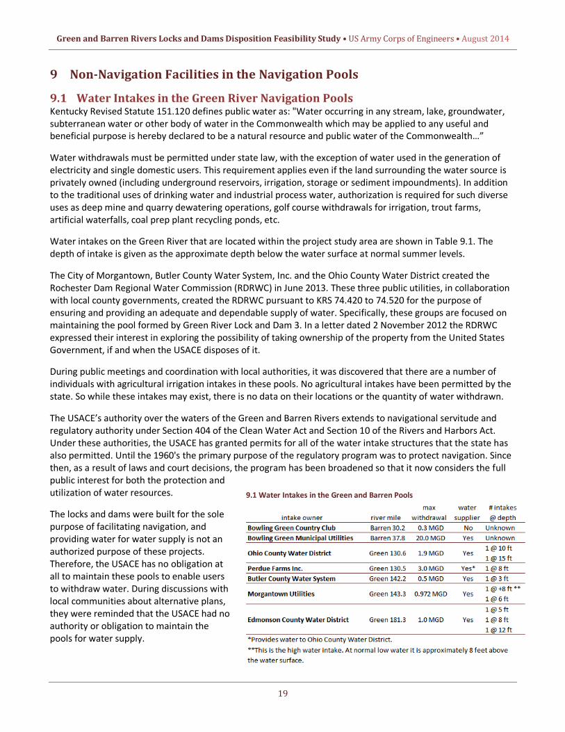
Water intakes on the Green River that are located within the project study area are shown in Table 9.1. The depth of intake is given as the approximate depth below the water surface at normal summer levels.
The City of Morgantown, Butler County Water System, Inc. and the Ohio County Water District created the Rochester Dam Regional Water Commission (RDRWC) in June 2013. These three public utilities, in collaboration with local county governments, created the RDRWC pursuant to KRS 74.420 to 74.520 for the purpose of ensuring and providing an adequate and dependable supply of water. Specifically, these groups are focused on maintaining the pool formed by Green River Lock and Dam 3. In a letter dated 2 November 2012 the RDRWC expressed their interest in exploring the possibility of taking ownership of the property from the United States Government, if and when the USACE disposes of it.
During public meetings and coordination with local authorities, it was discovered that there are a number of individuals with agricultural irrigation intakes in these pools. No agricultural intakes have been permitted by the state. So while these intakes may exist, there is no data on their locations or the quantity of water withdrawn.
The USACE’s authority over the waters of the Green and Barren Rivers extends to navigational servitude and regulatory authority under Section 404 of the Clean Water Act and Section 10 of the Rivers and Harbors Act. Under these authorities, the USACE has granted permits for all of the water intake structures that the state has also permitted. Until the 1960's the primary purpose of the regulatory program was to protect navigation. Since then, as a result of laws and court decisions, the program has been broadened so that it now considers the full public interest for both the protection and utilization of water resources.
The locks and dams were built for the sole purpose of facilitating navigation, and providing water for water supply is not an authorized purpose of these projects. Therefore, the USACE has no obligation at all to maintain these pools to enable users to withdraw water. During discussions with local communities about alternative plans, they were reminded that the USACE had no authority or obligation to maintain the pools for water supply.
9.1 Water Intakes in the Green and Barren Pools

Green and Barren Rivers Locks and Dams Disposition Feasibility Study • US Army Corps of Engineers • August 2014
20
9.2 Ferries in the Green River Pools
There are four ferries that have operated in the navigation pools of the Green River. Table 9.2 summarizes them.
The ferries’ approaches at all of these locations are also used for boat ramps by recreational boaters.
9.3 Boat Ramps in the Green & Barren Pools The Green and Barren Rivers are used by recreational boaters as well as by commercial fishermen fishing for mussels, catfish, and buffalo fish. Table 9.3 lists boat ramps in the study area. An exhaustive list of boat ramps is available through the Kentucky Department of Fish & Wildlife Resources.
9.3 Boat Ramps in the Green & Barren Pools
9.4 Canoeing on the Green & Barren Rivers Canoeing may be found anywhere on the Green and Barren Rivers, but it occurs most frequently in Mammoth Cave National Park near Green River Lock and Dam 6. Data for boat and canoe use in the National Park is provided in Table 9.5, while Table 9.4 lists the canoe liveries operating in the study area. Currently, the National Park Service Rivers, Trails and Conservation Assistance Program is working with the Barren River Area Development District on a Blueway Water Trail for the Green River. The stretch of the Green River, already popular with canoeists and kayakers, is expected to see increased usage with the development of the Blueway Water Trail. The proposed Green River Blueway Water Trail would eventually extend 300 miles from the tailwaters of Green River Lake Dam to the confluence with the Ohio River.
9.2 Ferries in the Green River Pools
9.4 Canoe Liveries in the Study Area
9.5 Observed Boat and Canoe Use on the Green River

Green and Barren Rivers Locks and Dams Disposition Feasibility Study • US Army Corps of Engineers • August 2014
21
10 Plan Formulation The purpose of this study is to first provide information necessary to make final recommendations to Congress as to deauthorization of the facilities at five lock and dam sites; and second, to provide information to ultimately facilitate the future disposal of these facilities after deauthorization has been approved. The study structure approximates a typical USACE feasibility study; however, it does not include a traditional Benefit Cost Ratio (BCR) and supporting economic analysis because there is not a formal planning procedure that specifies how to account for, quantify and compare costs associated with the deauthorization, modification and disposal of these facilities.
10.1 Problems and Opportunities
10.1.1 Problem Identification Five locks and dams on the Green and Barren Rivers are no longer used for navigation and have fallen into
disrepair. The USACE remains responsible for these facilities despite there being no USACE federal interest in repairing, operating or maintaining them.
Use of the pools formed by the dams has expanded beyond the original authorized purpose of navigation. As an example, multiple communities now depend on the pools formed by these facilities for water supply.
There are safety concerns relative to life and property associated with the lock and dam structures at each site that require attention.
10.1.2 Opportunity Statements Altering structures to lessen the risk of injuries associated with unauthorized entry upon the sites.
Restoring natural river flow wherever practical to provide ecosystem restoration opportunities in partnership with stakeholders and existing USACE authorities.
Identifying potential interested parties to facilitate disposal if the facilities are deauthorized.
Preservation of local transportation routes and local water supplies.
10.2 Planning Objectives and Constraints
10.2.1 Objectives Provide information necessary to make final recommendations to Congress as to deauthorization of the
facilities at five lock and dam sites.
Relieve USACE of continued O&M responsibilities and exposure to continued and future exposure to liability associated with these facilities.
10.2.2 Constraints Ecosystem benefits from removal of the dams (under alternative 3) are not specifically evaluated as part of
this study. USACE has the authority to plan, design, and build projects to benefit the environment. These projects require a local sponsor; none has been identified yet.
Absent specific authority, the interdepartmental waiver rule operates to preclude a Federal agency from paying compensation to another Federal agency for damage caused to that Federal agency's property (e.g. ferry ramp extensions).
There is not an overriding USACE policy favoring the investment of federal funds in order to dispose of structures and associated real property that no longer serve a USACE mission.

Green and Barren Rivers Locks and Dams Disposition Feasibility Study • US Army Corps of Engineers • August 2014
22
USACE does not have an authority to expend funds to modify water supply systems or assist other entities to modify theirs. Consequently, impacts to municipal water supplies should be avoided.
10.3 Alternative Plans The various studies conducted, beginning in 1965 and running through 1993, established that there would be insufficient benefits from commercial navigation to support any type of navigation improvements to these facilities. Therefore, no alternatives that involved the restoration of commercial navigation to the study area were considered. Further, since the authorized purpose of the projects is commercial navigation, it was concluded that these facilities are no longer serving their authorized purpose and that it would be in the federal interest to deauthorize the projects and dispose of the properties. Therefore, the alternatives considered included no action and various options for disposal.
To facilitate the formulation of alternative plans, the 2004 technical investigations were reevaluated in the course of this study. Reports on these investigations are contained in the appendices. The investigations and analyses in these appendices contain information on the following:
A. An investigation of the cultural resources
B. Detailed data on the structures’ condition, and measures necessary to maintain structural integrity
C. Hydrologic and hydraulic analyses for the Green and Barren Rivers in their existing condition and with the dams removed, either by demolition or failure
D. An environmental assessment of all of the alternatives considered, including no action
E. An environmental baseline survey investigating the possible presence of hazardous, toxic, and radiological waste
F. A complete investigation of the real estate interests at each site
G. Coordination with the U.S. Fish and Wildlife Service
H. A description of comments received during the public review of the study
Each alternative was considered for every site. A more detailed description of each alternative follows.
Alternative 1 (No Action)
With the “no action” alternative, the locks and dams would remain in federal ownership in caretaker status and the federal government would not make any alterations to the facilities. The USACE would remain responsible for the facilities. At present, the USACE spends approximately $10,000 per year for all of the sites to inspect the properties and maintain “No Trespassing” signage. While trespassing is prohibited, there is ample evidence that the sites are frequently used, even those that are relatively remote. With a “no action” alternative, this would likely continue.
Alternative 2 (Congressional Deauthorization Only)
Request Congressional deauthorization of commercial navigation for Green River Locks and Dams 3, 4, 5, and 6 and Barren River Lock and Dam 1.
Alternative 3 (Deauthorization, Dam Removal, Lock Fill and Installation of Warning Signs)
Request Congressional deauthorization of commercial navigation for Green River Locks and Dams 3, 4, 5, and 6 and Barren River Lock and Dam 1. Remove all dams, fill locks, and ultimately dispose of the properties. The

Green and Barren Rivers Locks and Dams Disposition Feasibility Study • US Army Corps of Engineers • August 2014
23
excess dam materials would be disposed of onsite along the lock approaches or in an approved offsite location. Three warning signs would be equally spaced and installed on the lock side chamber walls.
Alternative 4 (Deauthorization, Lock Stabilization, Installation of Barricade and Warning Signs)
Request Congressional deauthorization of commercial navigation for Green River Locks and Dams 3, 4, 5, and 6 and Barren River Lock and Dam 1. Dispose of the properties after the locks are modified to ensure stability and pool retention before disposal. To impede access to the riverside lock wall, the landside miter gates would be barricaded. Three warning signs would be equally spaced and installed on the lock side chamber walls.
10.4 Screening Criteria Each alternative was evaluated for its impact on unauthorized entry, water supply, boat ramps, ferries, other facilities, environmental effects and cost. These criteria were considered to be significant factors in evaluating the recommended plan for Green River Locks and Dams 3, 4, 5, and 6 and Barren River Lock and Dam 1. The subsequent text outlines the criteria and highlights how they were considered. Further deliberation was also given to what actions could be accomplished by the Louisville District through existing authorities and the established O&M budgetary process and what required specific legislative action by Congress.
Unauthorized Entry: Access to all of the lock and dam sites cannot be fully controlled. However, some measures can be taken to deter entry and possibly reduce injuries associated with unauthorized entry upon the property. The array of measures considered ranges from no action to filling the lock chambers with rock. In screening the measures, it was determined that signage and blocking access to the riverside lock chamber wall provided the optimal balance of potential measures. These maintenance activities can be accomplished through the established O&M budgetary process and are not included in the recommended plan.
Water Supply: A paramount concern for communities in the study area is the impact of any recommendation on the community’s water supply. This variable identifies if any activity taken at the Lock and Dam site would have an impact on water intakes. During screening, an impact to public water supply by an alternative was considered negative and that alternative was eliminated from consideration based on the constraints identified in Section 10.2.2. In addition, the USACE does not have an authority to expend funds to modify water supply systems or assist other entities to modify theirs. From a USACE perspective, water supply at these facilities is considered to be a state or local responsibility since navigation is currently the only Congressionally authorized purpose at these facilities.
Boat Ramps: There are multiple boat ramps in each of the pools formed by the locks and dams. Consideration was given to how each alternative would impact the ability to operate the boat ramp and if any modification to the ramp would be required in connection with a recommended alternative.
Ferries: Ferries that cross the Green River in Edmonson County and in Rochester, KY provide transportation linkages for several communities in the study area. Impacts associated with each alternative were evaluated and mitigation for the potential loss of the ferry crossing was considered. As described in Section 10.2.2, the interdepartmental waiver rule operates to preclude a Federal agency from paying compensation to another Federal agency for damage caused to that Federal agency's property.
Other Facilities: This variable considered water intakes and utility transmission lines by private individuals and corporations. The facilities identified ranged from poultry processing plants to private golf course irrigation intakes.
Environmental Considerations: Environmental considerations at each site focus on returning the river to pre-impoundment flow conditions. At several locations in the study area, this aspiration competes with social-

Green and Barren Rivers Locks and Dams Disposition Feasibility Study • US Army Corps of Engineers • August 2014
24
economic considerations such as transportation linkages in Edmonson County and water supply in Muhlenberg County. At all of the sites there is an overlay of interest in cultural resources – specifically in acknowledging the historical role that these locks and dams have played in shaping the economic and cultural landscape of the region and nation.
10.5 Comparison of Alternative Plans
10.5.1 Alternative 1(No Action) There is interest from various local and federal entities (see Appendix I – Public Involvement) in acquiring the properties at Green River Locks and Dams 3, 4, 5, and 6 and Barren River Lock and Dam 1. With alternative 1, the no action plan, the complete transfer of the properties and structures is not possible without Congressional deauthorization.
There are stability concerns associated with Green River Lock and Dam 6, which could result in the failure of the dam and lock wall. If the lock wall suddenly fails, flow would be diverted toward the abutment, significantly widening the existing channel or even creating a new channel. Bank erosion would be severe as the river is redirected and flows increase. The water supply intake for the Edmonson County Water District is 1,500 feet downstream of the dam on the right bank and could be affected by a catastrophic failure. In addition to the damage that could occur at the water intakes, sudden failure of the lock and/or dam would have serious consequences for the ferries. The loss of the Lock and Dam 6 pool would likely render the ferries inoperable except during high water. These two ferries are transportation links in the region, and their loss would have substantial impacts to the community.
Under alternative 1, all facilities would remain in caretaker status and no alterations to the structures would be completed to address the current conditions of the locks or dams.
With this alternative, the USACE would remain responsible for the facilities and maintain “No Trespassing” signage and conduct periodic inspections. However, the risk to boaters associated with the presence of low head dams would continue.
10.5.2 Alternative 2 (Congressional Deauthorization Only) Alternative 2 exclusively seeks Congressional deauthorization of commercial navigation at Green River Dams 3, 4, 5, and 6 and Barren River Lock and Dam 1.
Following Congressional deauthorization of commercial navigation at these facilities, a likely consequence is future action to dispose of the facilities. The facilities would be disposed of through the established USACE and GSA procedures pursuant to the Federal Property and Administrative Services Act of 1949 and Army regulations. The disposal would take place incrementally as funds become available through the established USACE O&M budget process. Additionally, safety related maintenance (barricades at the miter gates and signage) and ecosystem restoration opportunities would also be pursued through established USACE authorities and budgetary process. While the installation of warning signs and barricades are reasonable measures to address public safety concerns due to illegal access, extensive measures (such as removal of all dams and filling or removal of the associated lock chambers) would need to be taken to remove all risk; these actions would require modifications to water intake structures and other potential uses provided by the facilities. In addition, the risk of structural failures (particularly at Green River Lock and Dam 6) remains; any structural failures could have consequences to downstream communities.
10.5.3 Alternative 3 (Deauthorization, Dam Removal, Lock Fill and Installation of Warning Signs) If alternative 3 were implemented at all sites, the lock chambers would be filled, reducing public safety concerns by lessening the risk of injuries associated with unauthorized entry while stabilizing Green River Lock 6.

Green and Barren Rivers Locks and Dams Disposition Feasibility Study • US Army Corps of Engineers • August 2014
25
Removing the dams would also reduce the risk to boaters who may inadvertently be carried over the dam and become trapped in the hydraulic effect (rotating current) at the downstream base of the dam. This was illustrated in April 2014 when a johnboat went over Barren River Dam 1, resulting in a drowning fatality.
Warning signs would be installed on the landside lock chamber walls at all of the facilities to deter unauthorized entry upon the property
There are also potential aquatic ecosystem restoration benefits associated with the removal of Green River Dams 3, 4, 5, and 6 and Barren River Lock and Dam 1. These benefits are most apparent at Green River Dam 6, which is just downstream of Mammoth Cave National Park. Running 27 miles through the park, the Green River is one of North America’s most biologically diverse rivers. Additionally, the cave itself holds the world’s most diverse cave ecosystem. Removing the dam would enhance the cave ecosystem; would enhance the river ecosystem returning approximately 6 - 8 miles to its former free-flowing state; and would bolster recreational opportunities available through canoeing, kayaking and camping. It is expected that both Edmondson County and the City of Brownsville would see a positive economic benefit from the removal of Dam 6 associated with increased canoe and kayak activity. Habitat for threatened and endangered species would be increased as well.
While the USACE has authority to plan, design, and build projects to benefit the environment, these projects require a local sponsor. Throughout the study process, the Corps was not able to identify a local or state agency willing to share in the costs of dam removal for environmental purposes. Therefore, USACE could not recommend the removal of the dams for environmental reasons.
It would be problematic to remove all dams given multiple communities dependence upon the pools for water supply. Water supply is not an authorized purpose of this project; however, over the years, the local communities have come to depend on the pool impounded by Green River dams 3 and 5 for their water supply. Specifically, removing Green River dam 6 would have serious impacts on the public water supply and Rochester Ferry. Five water intakes for potable water are located in the Green River Lock and Dam 3 pool. These intakes serve three water districts that provide water for the residents of Ohio County, Butler County, Muhlenberg County and the City of Morgantown. Additionally, the Perdue Farms processing facility also has a water intake at river mile 130.4 in Cromwell for their poultry processing facility. Appendix C contains a profile showing the effects of removing the dam on the pool level. These intakes would not function if the dam were removed. Replacing these intakes with wells is not a viable alternative, as there is not an aquifer capable of meeting the demand. In addition, the USACE does not have an authority to expend funds to modify water supply systems or assist other entities to modify theirs. The USACE does have the capability to undertake a water study through Section 22 of the 1974 Water Resources and Development Act with a local sponsor. However, under this program, the USACE may not participate in any formal design or implementation activities. If alternative 3 were implemented, the ferry crossings in Mammoth Cave National Park would be affected by the removal of Green River Dam 6. The two ferries affected, Green River Ferry and Houchins Ferry, would require modifications to remain operable. Public support for removing the dam is questionable unless provisions are made for the continued ability of the ferries to operate. Views opposing the cessation of the ferry operation have been expressed in public meetings, in coordination with Edmonson County officials and in the media. Both of these ferries are operated and maintained by the National Park Service and absent specific authority, the interdepartmental waiver rule operates to preclude a Federal agency from paying compensation to another Federal agency for damage caused to that Federal agency's property. Consequently, USACE would not have the ability to implement modifications to the ferry ramps that would be necessary if Green River Dam 6 was removed.

Green and Barren Rivers Locks and Dams Disposition Feasibility Study • US Army Corps of Engineers • August 2014
26
This alternative would request Congressional deauthorization of commercial navigation for Green River Locks and Dams 3, 4, 5, and 6 and Barren River Lock and Dam 1. After the recommended construction is complete, all of the properties would be disposed of through the normal USACE and GSA property disposal procedures.
10.5.4 Alternative 4 (Deauthorization, Lock Stabilization, Installation of Barricade and Warning Signs)
To lessen the risk of injuries associated with unauthorized entry, the upstream and downstream miter gates would be gated with barricades on the landside miter gates at Green River Locks and Dams 3, 4, 5, and 6 and Barren River Lock and Dam 1. At all of the sites, accumulated silt and vegetation in all of the lock chambers is substantial enough to provide a means of egress. Sediment is expected to continue to collect in the lock chamber provided the upstream miter gates remain closed. If alternative 4 were implemented, it would only partially address the safety concerns at all of the sites, as the risk to boaters still remain with the continued presence of low head dams.
This alternative would request Congressional deauthorization of commercial navigation for Green River Locks and Dams 3, 4, 5, and 6 and Barren River Lock and Dam 1. After the recommended construction is complete, all of the properties would be disposed of through the normal USACE and GSA property disposal procedures.
11 Recommended Plan The primary goal of this disposition study is to deauthorize the Locks and Dams and identify potentially interested parties and actions necessary to dispose of the properties at a future time. The draft of this study was circulated for public comment during February 2014 and included construction recommendations for several of the Lock and Dams and the removal of Green River Lock and Dam 6. Those actions are no longer recommended due to the expense and the potential to pursue dam removal through existing USACE authorities or via action by another federal agency.
Consequently, the recommended plan (Alternative 2) was revised and seeks to delineate what action is required by Congress and what can be accomplished by the Louisville District through existing authorities and the established O&M budgetary process. While there are opportunities for ecosystem restoration and improved safety at all of the sites, deauthorization of commercial navigation is the sole action that is required of Congress.
While each site was considered separately, the final recommended plan considered the Green and Barren river system as a whole. By leaving all the locks and dams, there would be no social impacts or further negative environmental impacts. As a whole, the plan minimizes adverse social impacts, causes no further negative environmental impacts and facilitates the future disposal of the properties in the most efficient manner. Finally, there are no additional annual O&M costs or construction associated with the recommended plan. Future "one-time" activities (installation of signage, installation of barricades, disposal) and associated cost estimates will be handled on a case-by-case basis through the established O&M budget process.
12 Mitigation Requirements As a result of archaeological investigations, no prehistoric or undisturbed historic archaeological remains were documented. Therefore, under the described plan no prehistoric or undisturbed historic archaeological remains would be affected. Documentation of the history and architecture of these facilities has determined that the locks and dams are considered eligible for listing on the NRHP. Under the described plan, Congressional deauthorization of commercial navigation would have no adverse effect.

Green and Barren Rivers Locks and Dams Disposition Feasibility Study • US Army Corps of Engineers • August 2014
27
The KY-SHPO has commented that the future disposition of Green River Locks and Dams 3, 4, 5 and 6 and Barren River Lock and Dam 1 would have an adverse effect on these NRHP eligible properties. Transfer from Federal ownership is considered an adverse effect. Further consultation with the KY-SHPO and other interested parties would be undertaken to determine appropriate mitigation measures for inclusion in a Memorandum of Agreement (MOA) to address project effects. Development of a MOA would be completed prior to implementing this plan.
Although some coordination on possible mitigation alternatives for cultural resource impacts was completed under the 2004 study, further coordination with the KY-SHPO and other interested parties would be required if the properties are disposed of and/or altered. Through recent coordination with the KY-SHPO, there is no anticipation for further formal studies, but current photo documentation of the resources would be required.
The timing for the consultation would be dependent upon the receipt of funding to undertake Section 106 consultation needed for MOA development. The Section 106 consultation and execution of a MOA would be completed prior to the commencement of any disposal activities. As part of the Section 106 consultation process the USACE would notify the Advisory Council on Historic Preservation of the undertaking affecting NHRP eligible properties. This timing was coordinated with the KY-SHPO and is documented in the 26 March 2014 comment letter, which is included in Appendix A.
13 Conclusions • The existing navigation facilities at Green River Locks and Dams 3 through 6 and at Barren River Lock and
Dam 1 are not serving the federal authorized purpose of commercial navigation and cannot reasonably be expected to do so in the foreseeable future.
• Green River Locks and Dams 3 and 5 are serving incidental purposes, namely water supply, and while there is significant nonfederal interest in maintaining these pools for that purpose, there is no USACE authority to maintain them for that purpose.
• Safety concerns were identified at Green River Locks and Dams 3 through 6 and at Barren River Lock and Dam 1. These safety concerns would be addressed at each site by installing barricades on miter gates, as well as updating signage at the sites. This maintenance work would not require any additional NEPA compliance activities and would be funded through the established O&M budget process.
• Following Congressional deauthorization of commercial navigation at these facilities, a likely consequence in the future is disposal of the properties through the established USACE and GSA procedures pursuant to the Federal Property and Administrative Services Act of 1949 and Army regulations. The disposal would take place incrementally as funds become available through the established USACE O&M budget process. Because established procedures exist for disposal and conveyance of federal property, it is my opinion that no additional authorization is required from Congress to dispose of the facilities.
• The study identified potential opportunities for ecosystem restoration in the Upper Green River System. There are standing authorities for ecosystem restoration projects of this nature which can be pursued by the USACE in partnership with other federal non-federal interests.

Green and Barren Rivers Locks and Dams Disposition Feasibility Study • US Army Corps of Engineers • August 2014
14 Recommendation In view of the conclusions set forth, and after considering the expected social, economic, and environmental impacts, I recommend the following actions regarding the disposition of the formerly used navigation facilities on the Green and Barren Rivers, Kentucky:
The Green River Locks and Dams 3, 4, 5, and 6 and Barren River Lock and Dam 1 should be deauthorized for commercial navigation, as they are no longer serving this authorized purpose.
The recommendation contained herein reflect the information available at this time and current Departmental policies ·governing formulation of individual projects. They do not reflect program and budgeting priorities inherent in the formulation of a national Civil Works construction program nor the perspective of higher review levels within the Executive Branch. Consequently, the recommendation may be modified before they are transmitted to Congress as proposals for authorization and implementation funding. However, prior to transmittal to Congress, the States, interested Federal agencies, and other parties would be advised of any modifications and would be afforded an opportunity to comment further.
c~~ Colonel, Corps of Engineers District Engineer
28