Embed Size (px)
Citation preview
i
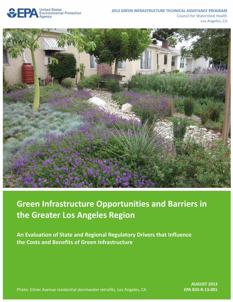
Green Infrastructure Opportunities and Barriers inthe Greater Los Angeles Region
An Evaluation of State and Regional Regulatory Drivers that Influencethe Costs and Benefits of Green Infrastructure
AUGUST 2013Photo: Elmer Avenue residential stormwater retrofits, Los Angeles, CA EPA 833-R-13-001
2012 GREEN INFRASTRUCTURE TECHNICAL ASSISTANCE PROGRAMCouncil for Watershed Health
Los Angeles, CA
ii
About the Green Infrastructure Technical Assistance Program
Stormwater runoff is a major cause of water pollution in urban areas. When rain falls in undevelopedareas, the water is absorbed and filtered by soil and plants. When rain falls on our roofs, streets, andparking lots, however, the water cannot soak into the ground. In most urban areas, stormwater isdrained through engineered collection systems and discharged into nearby waterbodies. Thestormwater carries trash, bacteria, heavy metals, and other pollutants from the urban landscape,polluting the receiving waters. Higher flows also can cause erosion and flooding in urban streams,damaging habitat, property, and infrastructure.
Green infrastructure uses vegetation, soils, and natural processes to manage water and create healthierurban environments. At the scale of a city or county, green infrastructure refers to the patchwork ofnatural areas that provides habitat, flood protection, cleaner air, and cleaner water. At the scale of aneighborhood or site, green infrastructure refers to stormwater management systems that mimicnature by soaking up and storing water. These neighborhood or site-scale green infrastructureapproaches are often referred to as low impact development.
EPA encourages the use of green infrastructure to help manage stormwater runoff. In April 2011, EPArenewed its commitment to green infrastructure with the release of the Strategic Agenda to ProtectWaters and Build More Livable Communities through Green Infrastructure. The agenda identifiestechnical assistance as a key activity that EPA will pursue to accelerate the implementation of greeninfrastructure.
In February 2012, EPA announced the availability of $950,000 in technical assistance to communitiesworking to overcome common barriers to green infrastructure. EPA received letters of interest fromover 150 communities across the country, and selected 17 of these communities to receive technicalassistance. Selected communities received assistance with a range of projects aimed at addressingcommon barriers to green infrastructure, including code review, green infrastructure design, and cost-benefit assessments. The Council for Watershed Health was selected to receive assistance to identifygreen infrastructure barriers and opportunities in state and regional programs, policies, and regulationsand guidance on local code and ordinance evaluations.
For more information, visit http://water.epa.gov/infrastructure/greeninfrastructure/gi_support.cfm.

iii
Acknowledgements
Principal USEPA Staff
John Kemmerer, USEPA Region IXTamara Mittman, USEPAChristopher Kloss, USEPA
Community Team
Mike Antos, Council for Watershed HealthNancy L.C. Steele, Council for Watershed HealthCathy Chang, Water Replenishment District of Southern CaliforniaMichael Gagan, Kindel GaganShelley Luce, Santa Monica Bay Restoration CommissionCaryn Mandelbaum, Environment Now
Consultant Team
Martina Frey, Tetra TechKimberly Brewer, Tetra TechChristy Williams, Tetra TechYvana Hrovat, Tetra TechPeter Sherman, Tetra Tech
Special thanks to Noah Garrison of the Natural Resources Defense Council for providing comments onthe draft report.
Photos used in the report are credited to the U.S. Environmental Protection Agency unless otherwisenoted.
This report was developed under EPA Contract No. EP-C-11-009 as part of the 2012 EPA GreenInfrastructure Technical Assistance Program.

i
Contents
1 Introduction ........................................................................................................................................ 1
2 Green Infrastructure in the Los Angeles Region ................................................................................. 2
3 Green Infrastructure Costs and Benefits............................................................................................. 6
4 Defining the Regional Regulatory Context for Green Infrastructure ................................................10
4.1 State Regulations and Programs.................................................................................................10
4.1.1 Global Warming Solutions Act of 2006 (AB 32) .................................................................. 10
4.1.2 Sustainable Communities and Climate Protection Act of 2008 (SB 375)............................ 10
4.1.3 Water Conservation Act of 2009 (SBx7-7) .......................................................................... 12
4.1.4 Water Efficient Landscape Ordinance (AB 1881)................................................................ 13
4.2 Regional Regulations and Programs...........................................................................................15
4.2.1 Final Waste Discharge Requirements for Municipal Separate Storm Sewer System (MS4)Discharges within the Coastal Watersheds of Los Angeles County, Except ThoseDischarges Originating from the City of Long Beach MS4.................................................. 15
4.2.2 Water Quality Control Plan for the Los Angeles Region: Basin Plan for the CoastalWatersheds of Los Angeles and Ventura Counties ............................................................ 18
4.2.3 TMDL Implementation Plans............................................................................................... 19
4.2.4 Greater Los Angeles County Region Integrated Regional Water Management Plan ......... 20
4.2.5 Groundwater Adjudications in the Central and West Coast Basins.................................... 22
5 Overcoming Barriers to Green Infrastructure at the Local Level......................................................26
5.1 Municipal Service Areas and Associated Codes, Ordinances, Policies, and Guidance ...............27
5.2 Education of Staff .......................................................................................................................30
5.3 Conducting the Review...............................................................................................................30
5.4 Common Barriers and Issues ......................................................................................................32
5.5 Developing an Action Plan..........................................................................................................32
6 Summary and Conclusions ................................................................................................................35
7 References.........................................................................................................................................37
Attachment A: Green Infrastructure Identification of Barriers and Opportunities Checklist Tool........... A-1

ii
Tables
Table 1. Green infrastructure practices applicable to the Los Angeles Region ............................................ 3
Table 2. Relative water quality improvement, volume reduction, and recharge performance of greeninfrastructure practices................................................................................................................................. 7
Table 3. Additional green infrastructure benefits ........................................................................................ 8
Table 4. Codes, ordinances, policies, and guidance documents related to municipal service areas .........28
1 Introduction
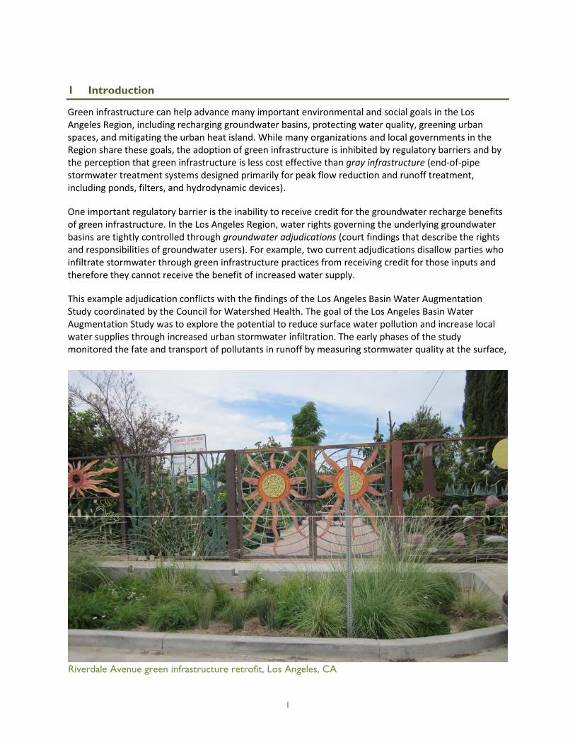
Green infrastructure can help advance many important environmental and social goals in the LosAngeles Region, including recharging groundwater basins, protecting water quality, greening urbanspaces, and mitigating the urban heat island. While many organizations and local governments in theRegion share these goals, the adoption of green infrastructure is inhibited by regulatory barriers and bythe perception that green infrastructure is less cost effective than gray infrastructure (end-of-pipestormwater treatment systems designed primarily for peak flow reduction and runoff treatment,including ponds, filters, and hydrodynamic devices).
One important regulatory barrier is the inability to receive credit for the groundwater recharge benefitsof green infrastructure. In the Los Angeles Region, water rights governing the underlying groundwaterbasins are tightly controlled through groundwater adjudications (court findings that describe the rightsand responsibilities of groundwater users). For example, two current adjudications disallow parties whoinfiltrate stormwater through green infrastructure practices from receiving credit for those inputs andtherefore they cannot receive the benefit of increased water supply.
This example adjudication conflicts with the findings of the Los Angeles Basin Water AugmentationStudy coordinated by the Council for Watershed Health. The goal of the Los Angeles Basin WaterAugmentation Study was to explore the potential to reduce surface water pollution and increase localwater supplies through increased urban stormwater infiltration. The early phases of the studymonitored the fate and transport of pollutants in runoff by measuring stormwater quality at the surface,
Riverdale Avenue green infrastructure retrofit, Los Angeles, CA
1

2
as it infiltrates through the soil, and in groundwater. The results of the study showed that stormwaterinfiltration had no negative impacts on groundwater quality (Los Angeles and San Gabriel RiversWatershed Council 2010).
Later phases of the study included a feasibility analysis for two groundwater basins in the WaterReplenishment District of Southern California to identify the most effective locations for stormwatercapture projects to enhance water quality and groundwater recharge. The analysis identified high-priority locations for stormwater capture projects using spatial analyses and several models thatconsidered important siting factors such as geologic conditions, pre-existing contamination, anddewatering, as well as local water quality objectives. This report emphasized the need for a multi-agencyapproach to water quality and groundwater recharge projects to exploit multiple project benefits andenhance feasibility (Water Replenishment District of Southern California 2012).
To better understand and address the regulatory and perceived cost barriers to green infrastructure,theU.S. Environmental Protection Agency (USEPA) and the Council for Watershed Health conducted aqualitative assessment of state and regional regulations, programs, policies, and plans. This assessmentdefines the regional regulatory context for green infrastructure by (1) identifying opportunities formeeting multiple regulatory goals and requirements with green infrastructure, and (2) analyzingpossible barriers to green infrastructure implementation.
This report is divided into four sections. The first section defines green infrastructure and identifies themost appropriate practices for the Los Angeles Region. The next section discusses the multiple benefitsof green infrastructure for water supply, water quality, other environmental benefits, and communitylivability. The third section presents the results of a review of state and regional regulations, programs,policies, and plans. This section (1) describes how green infrastructure can meet the goals andrequirements of multiple state and regional regulations, and (2) analyzes provisions that mightcomplicate green infrastructure implementation. Finally, because the implementation of greeninfrastructure practices is determined largely by local codes and ordinances, the fourth section describesa process to identify opportunities for and barriers to green infrastructure in local regulations.
2 Green Infrastructure in the Los Angeles Region
Green infrastructure uses vegetation, soils, and natural processes to manage water and create healthierurban environments. At the scale of a city or county, green infrastructure refers to the patchwork ofnatural areas that provides habitat, flood protection, cleaner air, and cleaner water. At the scale of aneighborhood or site, green infrastructure refers to stormwater management systems that mimicnature by soaking up and storing water. These neighborhood or site-scale green infrastructureapproaches are often referred to as low impact development.
Most types of green infrastructure that have been implemented nationally are applicable in the LosAngeles Region, assuming modifications based on the local climate. Three local stormwater designmanuals were consulted to determine the types of green infrastructure most appropriate for the LosAngeles Region (CASQA 2010; County of Los Angeles Department of Public Works 2009a, 2009b). Basedon these manuals, Table 1 lists and defines the green infrastructure practices best suited to the Region.Note that green roofs are not included on the list because many designs would require irrigation tothrive). The USEPA generally does not consider dry wells a green infrastructure practice, but they areincluded on the list because they offer stormwater volume reduction and groundwater rechargebenefits.

3
Table 1. Green infrastructure practices applicable to the Los Angeles Region
Green InfrastructurePractice Description
Ve
geta
ted Bioretention
cellsa,b
Also known as rain gardens, bioretention cells are shallow, vegetated basins thatcollect and absorb runoff from rooftops, sidewalks, and streets. Bioretention mimicsnatural hydrology by infiltrating and evapotranspiring runoff. Rain gardens are versatilefeatures that can be installed in almost any unpaved space. (Source: USEPA 2012a)
Bioretentionstrips/swales
a,bAlso known as bioswales, bioretention strips are vegetated, mulched, or xeriscapedchannels that provide treatment and retention as they move stormwater from oneplace to another. Vegetated swales slow, infiltrate, and filter stormwater flows. Aslinear features, vegetated swales are particularly suitable along streets and parkinglots. (Source: USEPA 2012a)
Infiltrationbasins, swales,and trenches
a,b
Infiltration trenches are generally larger at their widest surface point than they aredeep, and they do not contain any perforated pipes or drain tiles to distribute and/orfacilitate subsurface fluid infiltration. (Source: USEPA 2012b)
Downspoutdisconnection toa pervious area
Disconnecting downspouts involves rerouting rooftop drainage pipes to drain rainwaterto permeable areas instead of the storm sewer, which allows stormwater to infiltrateinto the soil. (Source: USEPA 2012a)
Planter boxes(withinfiltration)
Planter boxes are urban rain gardens with vertical walls and open bottoms that collectand absorb runoff from sidewalks, parking lots, and streets. Planter boxes are ideal forspace-limited sites in dense urban areas and as a streetscaping element. (Source:USEPA 2012a)
Constructedwetlands
a,bConstructed wetlands use natural processes involving wetland vegetation, soils, andtheir associated microbial assemblages to assist, at least partially, in treating aneffluent or other source water. These systems are engineered and constructed inuplands, outside waters of the United States, unless the water source can serve asignificant restoration function to a degraded system. (Source: USEPA 2005)
No
n-V
ege
tate
d Rainwatercapture
Rerouting of rooftop drainage pipes to drain rainwater to rain barrels, cisterns, orunderground vaults for storage and reuse. (Source: USEPA 2012a)
Permeablepavement
bPaved surfaces that infiltrate, treat, and/or store rainwater where it falls. Permeablepavements may be constructed from pervious concrete, porous asphalt, permeableinterlocking pavers, and several other materials. These pavements are particularly costeffective where land values are high and where flooding is a problem. (Source: USEPA2012a)
Dry wells,includingundergrounddetention andinfiltrationfacilities/galleries, andinjection wells
b,c
A well or injection well is a bored, drilled, or driven shaft, or a dug hole, whose depth isgreater than its largest surface dimension; an improved sinkhole; or a subsurface fluiddistribution system used to discharge fluids underground (40 CFR 144.3). A subset ofinjection wells are Class V wells, which are typically a shallow on-site disposal systemused to place various non-hazardous fluids below the land surface (40 CFR 144.80).
A dry well means a well, other than an improved sinkhole or subsurface fluiddistribution system, completely above the water table so that its bottom and sides aretypically dry except when receiving fluids. (Source: USEPA 2012b)
a. Vegetated with native plant palette including trees, shrubs, and grasses.b. Includes amended soil where soil is type D.c. USEPA generally does not consider dry wells a green infrastructure practice. Dry wells are not intended as treatmentsystems; they reduce stormwater flow rate and volume and help recharge groundwater only.

Downspout disconnection at the High Point development, Seattle, WA
4
It may not be possible to implement green infrastructure on every parcel due to constraints that may bepresent on the site. Final Order (R4-2012-0175, NPDES Permit CAS004001), hereafter referred to as theMunicipal Stormwater Permit, and related local ordinances and guidelines describe development sitecharacteristics that increase the likelihood that specific green infrastructure techniques may betechnically infeasible. According to the Municipal Stormwater Permit, the potential limitations to certaintypes of green infrastructure, primarily infiltration best management practices (BMPs), include(LARWQCB 2012):
Infiltration rate of saturated in-situ soils is less than 0.3 inch/hour and it is not feasible to amendthe in-situ soils to attain an infiltration rate necessary to achieve reliable performance ofinfiltration or bioretention BMPs;
Seasonal high groundwater is within 5–10 feet of the surface;
Sites within 100 feet of a groundwater well used for drinking water;
Brownfield development sites where infiltration poses a risk of causing pollutant mobilization;
Other locations where pollutant mobilization is a documented concern, i.e., at or nearproperties that are contaminated or store hazardous substances underground;
Sites with potential geotechnical hazards; and
Smart growth and infill or redevelopment locations where the density and/or nature of theproject would create significant difficulty with complying with the on-site volume retentionrequirement.
The City of Los Angeles (2012) LID ordinance includes similar potential limitations as those included inthe Municipal Stormwater Permit, with an additional requirement to place infiltration BMPs at least 10–25 feet away from buildings and avoiding placement of infiltration BMPs on or near steep slopes.
Detailed geotechnical investigations to confirm infiltration rates or geotechnical hazards can beperformed to address potential localized soils issues. If, upon detailed investigation, soils are confirmedto have low infiltration rates, engineered soil can be used with or without underdrains, though anadditional volume of stormwater must be treated if underdrains are employed.
Where groundwater contamination is known to occur or for projects near brownfield sites, greeninfrastructure facilities can be equipped with liners to ensure that localized contamination will not betransported further. This principle can also be applied to sites that are in proximity to a groundwaterwell. An analysis of the remediated site can identify areas where soil is uncontaminated or containspollutants that do not pose a risk to groundwater via infiltration; if the site layout is flexible, these areascan be set aside preferentially for green infrastructure practices.
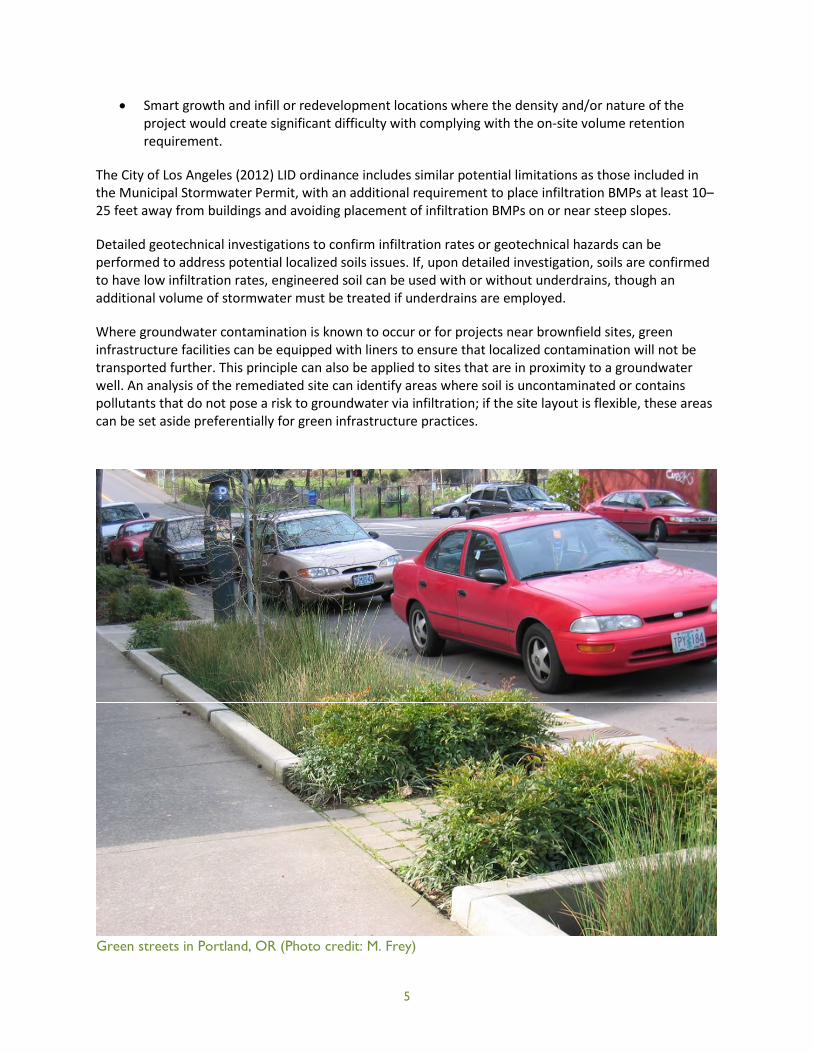
Green streets in Portland, OR (Photo credit: M. Frey)
5

6
3 Green Infrastructure Costs and Benefits
Developers and local agencies must balance gray and green infrastructure when developing orredeveloping a property or when installing or replacing stormwater and drainage infrastructure.Traditionally engineered gray infrastructure had been the default choice for decades before low impactdevelopment and green infrastructure came to prominence. Now that green technologies have beentested and shown to be successful in a variety of settings both nationally and internationally, developersand agencies are weighing the costs, benefits, and applicability of green infrastructure replacing orsupplementing gray infrastructure to determine the best choices for each project. There is a perceptionthat green infrastructure is not as cost-effective as gray infrastructure. If lifecycle costs and the multiplebenefits of green infrastructure are considered, however, green infrastructure can be shown to providemore value than gray infrastructure at comparable cost.
Green infrastructure has been shown to be cost-effective when compared with traditional grayinfrastructure approaches (see inset box, this page), though it can have higher installation costs forsome projects, including potentially in redevelopment and retrofit settings common to the Los AngelesRegion. (This is not always the case because of the site-specific nature of infrastructure opportunitiesand constraints; retrofitting gray infrastructure can also be costly.) Green infrastructure can beintegrated into other infrastructure improvement projects to help mitigate costs.
From a life cycle perspective, it is important to compare the long-term costs of maintenance andreplacement between green and gray infrastructure. The vegetation characteristic of many greeninfrastructure practices becomes enhanced as it grows over time, whereas gray infrastructure’sengineered materials only deteriorate over the long term. The maintenance required for greeninfrastructure practices typically does not require heavy equipment or specialized expertise, whereasmaintaining gray infrastructure’s pipes, forebays, basins, and embankments can be more costly.
Regarding performance, green infrastructure’s mix of physical and biological processes can achievebetter water quality and quantity management than more traditional stormwater technology provides.These practices restore the hydrologic function of the urban landscape, managing stormwater at itssource and reducing or eliminating the need for gray infrastructure. An important objective of greeninfrastructure is to reduce stormwater runoff volume, which improves water quality by reducingpollutant loads, erosion, and sedimentation; these benefits are well-documented (Table 2). When green
infrastructure is employed as part of a larger-scalestormwater management system (i.e., the greeninfrastructure practices do not retain all of thestormwater generated on site), it reduces thevolume of stormwater that requires conveyanceand treatment through conventional means (e.g.,detention ponds).
Green infrastructure practices can be integratedinto existing features of the built environment,including streets, parking lots, and landscapedareas. In terms of accommodating siteconstraints, green infrastructure can be practicalat scales both small (individual parcel) and large(neighborhood/landscape/regional), whereas gray
Resource for Valuing Green InfrastructureBenefits
The Center for Neighborhood Technology’sThe Value of Green Infrastructure: A Guide toRecognizing its Economic, Environmental, andSocial Benefits provides local municipalities withtool for determining the economic value ofgreen infrastructure by quantifying anddetermining the value for each greeninfrastructure benefit (CNT 2010).http://www.cnt.org/repository/gi-values-guide.pdf
7
infrastructure is most practical at large scales (ECONorthwest 2011). Site-dispersed green infrastructurepractices can be the best option for achieving a minimum level of stormwater managementperformance in highly urbanized and infill situations where development density is desired and offsitemitigation is not a preferred alternative.
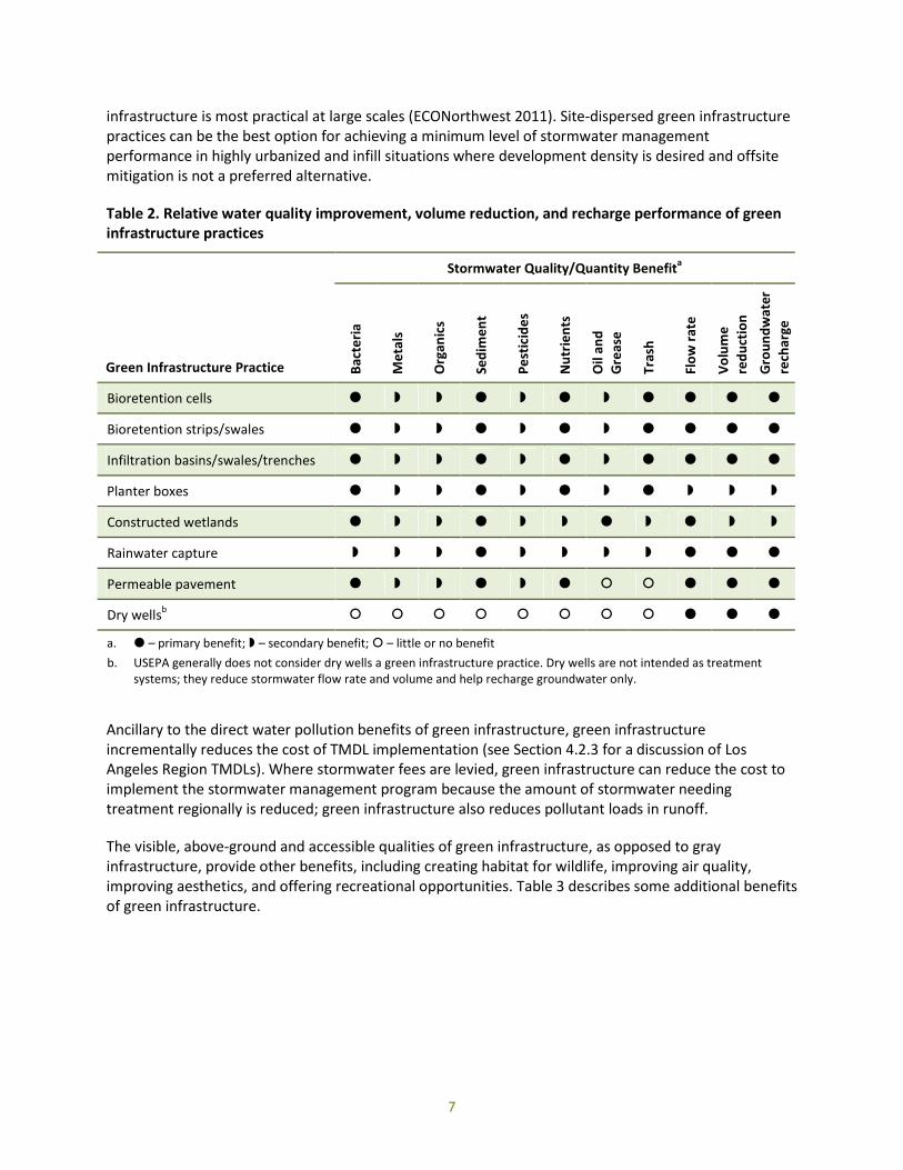
Table 2. Relative water quality improvement, volume reduction, and recharge performance of greeninfrastructure practices
Green Infrastructure Practice
Stormwater Quality/Quantity Benefita
Bac
teri
a
Me
tals
Org
anic
s
Sed
ime
nt
Pe
stic
ide
s
Nu
trie
nts
Oil
and
Gre
ase
Tras
h
Flo
wra
te
Vo
lum
e
red
uct
ion
Gro
un
dw
ater
rech
arge
Bioretention cells
Bioretention strips/swales
Infiltration basins/swales/trenches
Planter boxes
Constructed wetlands
Rainwater capture
Permeable pavement
Dry wellsb
a. – primary benefit; – secondary benefit; – little or no benefit
b. USEPA generally does not consider dry wells a green infrastructure practice. Dry wells are not intended as treatmentsystems; they reduce stormwater flow rate and volume and help recharge groundwater only.
Ancillary to the direct water pollution benefits of green infrastructure, green infrastructureincrementally reduces the cost of TMDL implementation (see Section 4.2.3 for a discussion of LosAngeles Region TMDLs). Where stormwater fees are levied, green infrastructure can reduce the cost toimplement the stormwater management program because the amount of stormwater needingtreatment regionally is reduced; green infrastructure also reduces pollutant loads in runoff.
The visible, above-ground and accessible qualities of green infrastructure, as opposed to grayinfrastructure, provide other benefits, including creating habitat for wildlife, improving air quality,improving aesthetics, and offering recreational opportunities. Table 3 describes some additional benefitsof green infrastructure.

8
Table 3. Additional green infrastructure benefits
Benefit Description
Reduce irrigation Green infrastructure in Los Angeles will use native plant species, which will reduce the needfor irrigation. This reduces demand for potable and recycled water and the energyconsumption and CO2 emissions associated with treatment and delivery of the water.
Reduce flood risk Los Angeles has a history of major flood events that have caused significant propertydamage. Green infrastructure can decrease the severity of flooding by reducing stormwatervolume and delaying peak flows.
Improve airquality
Green infrastructure improves air quality by increasing vegetation, specifically trees, thatabsorb air pollutants, including carbon dioxide (CO2), nitrogen dioxide (NO2), ground-levelozone (O3), sulfur dioxide (SO2), and particulate matter that is 10 µm or smaller (PM10). In amodeling study, Nowak et al. (2006) estimated total annual removal of those pollutants byU.S. urban trees at 711,000 metric tons, valued at $3.8 billion. Reduced air pollution benefitshuman health through lowered incidence and severity of respiratory ailments and reducescosts associated with air quality regulation compliance (ECONorthwest 2011).
Reducegreenhouse gases
Green infrastructure’s ability to sequester carbon in vegetation can help to meetgreenhouse gas emission goals by contributing to a carbon sink.
Mitigate urbanheat island
Green infrastructure practices that include trees and other vegetation can reduce the urbanheat island effect, which is the phenomenon of urban area temperatures that are severaldegrees higher than surrounding rural land uses. USEPA (2012) indicates that annual meanair temperature can be 1.8 °F to 5.4 °F higher in urban centers, or up to 22 °F higher in theevening. Tree cover reduces temperatures through shading and evapotranspiration.Reducing urban heat islands through tree planting achieves energy reduction (reducedelectricity demand, air pollution emissions from electricity generation) and can reduce theincidence and severity of heat-related illnesses.
Improve propertyaesthetics
Green infrastructure that includes attractive vegetation can improve property aesthetics,which can translate into increased property values.
Provide habitatfor urban wildlife
Vegetated green infrastructure can provide habitat for urban wildlife, particularly birds andinsects, even at small scales of implementation.
Offer recreationalopportunities
Larger-scale green infrastructure facilities that include public access, such as constructedwetlands, offer recreational opportunities (e.g., fishing, bird-watching).
Improve publichealth
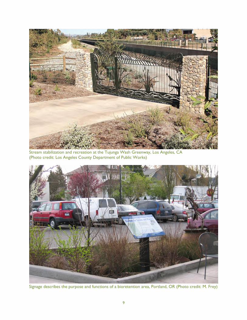
Some evidence exists that residents’ health and well-being are improved by the presence oflarger-scale green space that offers recreational opportunities (Stratus Consulting 2009).Riparian area improvements that enhance stream stability can include recreational trails forwalking, running, and biking (e.g., the Tujunga Wash Greenway project in Los Angeles). Also,creation of parks, green space, and plaza space into which green infrastructure can beintegrated can create gathering spaces for local residents, which fosters social connections.
Improve publicsafety
Green infrastructure can be used in concert with public safety measures to enhancewalkability. Green streets that include curb bump-outs at pedestrian crossings improvepedestrian safety by slowing traffic and decreasing the distance that pedestrians must travelin the roadway.
Educate the public The visible nature of green infrastructure offers enhanced public education opportunities,especially when signage is used to inform viewers of the features and functions of thevarious types of facilities (e.g., sign describing the function of a bioretention practice).
9
Stream stabilization and recreation at the Tujunga Wash Greenway, Los Angeles, CA(Photo credit: Los Angeles County Department of Public Works)
Signage describes the purpose and functions of a bioretention area, Portland, OR (Photo credit: M. Frey)
10
4 Defining the Regional Regulatory Context for Green Infrastructure
Green infrastructure and its associated benefits provide opportunities to meet many regulatoryobjectives that focus on environmental protection and resource conservation. To better understand theregulatory benefits of green infrastructure, a set of state and regional regulations was selected by theproject partners for review to determine if green infrastructure met one or more goals or requirements.These regulations also were analyzed to determine whether they posed any limitations or barriers togreen infrastructure implementation. Each review below includes a summary of the relevant parts of theregulation and a discussion of green infrastructure considerations.
4.1 State Regulations and Programs
We reviewed four state regulations and initiatives: the Global Warming Solutions Act of 2006 (AssemblyBill 32), Sustainable Communities and Climate Protection Act of 2008 (Senate Bill 375), WaterConservation Act of 2009 (Senate Bill x7-7), and Water Efficient Landscape Ordinance (Assembly Bill1881).
4.1.1 Global Warming Solutions Act of 2006 (AB 32)
With the Global Warming Solutions Act of 2006,1 the State requires reporting and verification ofstatewide greenhouse gas emissions, including setting emission limits to 1990 levels by 2020. The goal ofthe bill is to reduce global warming impacts (air quality, decreased water supply from reduced snowpackin the Sierra Nevada Mountains, rising sea level, damage to marine ecosystems, and human healthimpacts—specifically heat-related illness). The focus of AB 32 is to reduce greenhouse gas emissions, towhich green infrastructure can contribute through tree planting (shading, evapotranspiration, reducingthe urban heat island). Vegetated practices are capable of sequestering more carbon than grayinfrastructure through photosynthesis. AB 32 (§ 38561.f) does not require carbon sequestrationprojects, but such projects are considered voluntary efforts to contribute to the overall greenhouse gasreduction goals of the bill. The bill does not provide a provision for reimbursement by the state to localagencies and school districts for costs associated with implementation, so it is important thatgreenhouse gas emission reduction efforts provide multiple benefits as part of a larger strategy ofenvironmental improvement. AB 32 does not pose any barriers to green infrastructure, nor does itspecifically encourage installation of green infrastructure. A community could implement a city-wideprogram of urban greening that includes planting trees and installing a network of vegetatedstormwater features that would remove carbon dioxide from the atmosphere and have additionalground-level air quality benefits. Additionally, recharging the region’s aquifers with treated stormwaterwould reduce the demand for energy-intensive imported water.
4.1.2 Sustainable Communities and Climate Protection Act of 2008 (SB 375)
The Sustainable Communities and Climate Protection Act of 20082 focuses mainly on transit planning,with goals of reducing greenhouse gases and traffic and addressing access to affordable housing. SB 375neither encourages nor poses barriers to green infrastructure, but it does present opportunities forgreen infrastructure projects to be integrated into transit and affordable housing projects undertaken tomeet the requirements of SB 375. In general, green infrastructure can be incorporated into such
1California Health and Safety Code §§38500–38599
2California Health and Safety Code §65080, §65400, §65583, §65584, §65587, §65588, §14522, §21061, and §21159

Streetscape improvements that include porous pavement and bioretention, Hermosa Beach, CA
11
projects without adversely affecting their feasibility or practicality, and they can enhance water qualityperformance, aesthetics, and livability at the same time.
Section 1(g) mentions walkability as a policy emphasis that could affect transit choices. There are anumber of ways that walkability can be improved for new developments, but in the already urbanizedsetting of the Los Angeles Region, retrofits to existing streetscapes would be necessary to improvepedestrian access and safety. For example, walkability can be improved with streetscape retrofits thatwiden sidewalks and reduce the distance pedestrians have to travel to cross the street (e.g., curbbumpouts). These types of street improvements can accommodate small-scale green infrastructurepractices, specifically tree planter boxes, bioretention areas with low-profile vegetation, permeablepavement, or a combination of the three. The Hermosa Beach Pier Avenue Streetscape ImprovementProject is an excellent example of green infrastructure incorporated into a public safety andbeautification project.

12
4.1.3 Water Conservation Act of 2009 (SBx7-7)
The Water Conservation Act of 20093 focuses on urban and agricultural water conservation throughincreased water use efficiency and advancements in overall regional water management. For urbanwater use, the act specifically requires that water suppliers achieve increases in per capita water useefficiency (but not total water use). Section 10608.16(a) sets forth that “The state shall achieve a 20-percent reduction in urban per capita water use in California on or before December 31, 2020,” with aninterim target of 10-percent reduction by December 31, 2015. The act references the Water EfficientLandscape Ordinance (see Section 4.1.4) as the water efficiency performance standard that urban watersuppliers should assume for irrigated urban landscapes to determine per capita targets (otherassumptions are made for indoor water use and non-residential use).
Water conservation requirements would tend to favor drought-tolerant plant palettes for vegetatedgreen infrastructure practices to reduce watering requirements during the establishment period andduring periods of excessive heat or extended drought. This could be achieved by choosing native orclimate-adapted vegetation for stormwater BMPs that could be sustained without supplemental water.
Bioretention area with low-maintenance plantings and hardscape (Photo credit: M. Frey)
3California Water Code §10608 and §§10800–10853
13
The use of non-vegetated green infrastructure, specifically permeable pavement and downspoutdisconnection, would not require watering. These practices, in fact, would augment supply compared tothe same area of impervious surface because infiltration of stormwater would replenish thegroundwater supply.
Rainwater capture in rain barrels, cisterns, and vaults would provide an on-site supply of water forresidential or commercial reuse, such as supplemental landscape watering, toilet flushing, or coolingsystem makeup, which could reduce the demand for potable or recycled water. Rainwater harvestingcan be an effective means of reducing water demand even if the amount of stored rainfall meets only aportion of the user's water needs in periods of no or low rainfall.
4.1.4 Water Efficient Landscape Ordinance (AB 1881)
Assembly Bill (AB) 1881, the Water Conservation in Landscaping Act of 2006,4 required local agencies toadopt the Model Water Efficient Landscape Ordinance developed by the California Department of WaterResources, or a comparable local ordinance, by 2010. This measure is aimed at achieving potentiallysignificant water savings by improving irrigation systems and water use behavior under the premise thatexisting water-saving irrigation technology combined with current best practices for system design,installation, and maintenance can reduce residential and commercial water use. Selection of water-efficient, drought-tolerant plants for landscaping is another key component of the model ordinance.
For new or rehabilitated landscapes 2,500 square feet or greater, the ordinance requires completion ofa landscape documentation package and water efficient landscape worksheet to document landscapeplans and develop water budgets, irrigation scheduling, maintenance schedules, and irrigation audits.For existing landscapes larger than one acre, irrigation surveys and audits are required to evaluate wateruse and provide recommendations to prevent water waste. For metered landscapes, water use needs tobe reduced below the Maximum Applied Water Allowance according to the formula provided in theModel Ordinance. Local agencies are required to prevent runoff from irrigation overspray or drainageissues.
The model ordinance language explicitly encourages and recommends stormwater features integratedinto the landscape (§ 492.15) and does not consider nonirrigated stormwater facilities to be "waterfeatures" that need to be included in the water budget calculation. The ordinance lists the followingpractices (§ 492.6):
Infiltration beds, swales, and basins that allow water to collect and soak into the ground;
Constructed wetlands and retention ponds that retain water, handle excess flow, and filterpollutants; and
Pervious or porous surfaces (e.g., permeable pavers or blocks, pervious or porous concrete, etc.)that minimize runoff.
4California Civil Code §1353.8, California Government Code §65591, California Public Resources Code §25401.9, and California
Water Code §535
14
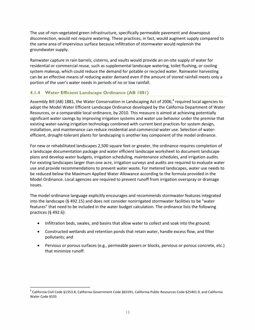
Xeriscape and rain barrel, Elmer Avenue, Los Angeles, CA
15
Successful establishment of vegetated green infrastructure practices, such as bioretention andstormwater planters, require irrigation initially to develop deep plant root systems. The language of themodel ordinance acknowledges a plant establishment period, typically one to two years, during whichplants are vulnerable to low moisture conditions and should be irrigated during dry periods. Properselection of climate-adapted plants can eliminate the need to irrigate beyond the plant establishmentperiod and can minimize the amount of water needed in the first two years. Additionally, the use of dripor microspray irrigation systems and soil moisture sensors can minimize water inputs while meeting theplants’ moisture needs.
To summarize, the Model Water Efficient Landscape Ordinance does not deter the use of greeninfrastructure and in fact specifically recommends the use of green infrastructure-type practices, giventhat the stormwater features employ the same principles as water-efficient landscaping (i.e., selectinglocally adapted plants or xeriscape and maximizing water use efficiency).
4.2 Regional Regulations and Programs
The following section summarizes five regional regulations selected by the project partners for review. Asynopsis is presented of how green infrastructure can be used to meet related requirements and howeach might pose a barrier to green infrastructure implementation. Each summary concludes withrecommendations on how these barriers could be overcome, as applicable.
4.2.1 Final Waste Discharge Requirements for Municipal Separate Storm Sewer System(MS4) Discharges within the Coastal Watersheds of Los Angeles County, ExceptThose Discharges Originating from the City of Long Beach MS4
The Los Angeles Regional Water Quality Control Board (Board) issued a Municipal Stormwater Permit(Final Order R4-2012-0175, NPDES Permit CAS004001) for Municipal Separate Storm Sewer System(MS4) discharges originating from the Coastal Watersheds of Los Angeles County (County), with theexception of the City of Long Beach. The Municipal Stormwater Permit was signed November 8, 2012.
The overall goal of the Municipal Stormwater Permit is to regulate surface runoff conveyed throughMS4s with the intent of restoring impaired waters and preventing further impairments caused by thisrunoff. As part of this goal, one of the key elements of the Municipal Stormwater Permit is to encouragethe use of green infrastructure and low impact development design principles for new andredevelopment projects throughout the County.
The Municipal Stormwater Permit’s provisions require green infrastructure as a means to achieve on-site retention of the Stormwater Quality Design Volume (SWQDv), which is defined as “runoff from (a)the 0.75-inch, 24-hour rain event or (b) the 85th percentile, 24-hour rain event, as determined from theLos Angeles County 85th percentile precipitation isohyetal map, whichever is greater.” The MunicipalStormwater Permit encourages green infrastructure by:
Requiring post-construction BMPs for certain categories of new and redevelopment projects;
Requiring certain new development street and roadway projects to follow USEPA guidanceregarding Managing Wet Weather with Green Infrastructure: Green Streets to the maximumextent practicable;
Listing infiltration, bioretention and rainfall harvest (all considered green infrastructurecomponents) as high priority post-construction BMPs;
16
Including strict hydromodification management criteria that require maintaining pre-projecthydrology for certain categories of new and redevelopment projects;
Recommending impervious surface be minimized for new and redevelopment projects byminimizing soil compaction, employing LID, and mimicking the predevelopment water balancethrough infiltration, evaporation, and rainfall harvesting;
Requiring that each permittee develop an inventory of retrofit opportunities within the publicright-of-way to address stormwater impacts and in coordination with Total Maximum Daily Load(TMDL) implementation plans; and
Outlining TMDL provisions and related waste load allocations for permittees.
The Municipal Stormwater Permit outlines a set of alternative compliance strategies that can be used ininstances where retention of the full SWQDv cannot be achieved on site. These include achievingequivalent stormwater treatment using:
Biofiltration (bioretention that allows for discharge of runoff to an underdrain and requirestreatment of 1.5 times the SWQDv that is not retained on site);
Offsite infiltration (using infiltration or bioretention facilities to intercept the balance of theSWQDv that is not retained on site); or
Regional groundwater replenishment projects (pollutant reduction and infiltration of thebalance of the SWQDv that is not retained on site to replenish groundwater supplies that have adesignated beneficial use).
The two types of offsite projects need to be located in the same subwatershed as the development orredevelopment site.
The alternative compliance options offer flexibility to allow for higher density development as part oftransit-oriented, Smart Growth, or economic development strategies, and they recognize thatdevelopment might occur in areas unsuitable for stormwater infiltration. The Municipal StormwaterPermit’s performance standards and alternative compliance options seek to achieve multiple regionalwater management objectives for water quality protection, stormwater volume reduction, andgroundwater recharge for beneficial use through a combination of green infrastructure practices andother stormwater management strategies.
17
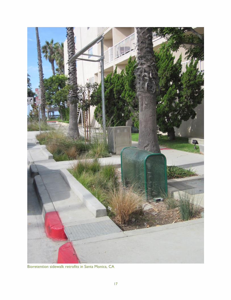
Bioretention sidewalk retrofits in Santa Monica, CA

18
4.2.2 Water Quality Control Plan for the Los Angeles Region: Basin Plan for the CoastalWatersheds of Los Angeles and Ventura Counties
The Water Quality Control Plan for the Los Angeles Region: Basin Plan for the Coastal Watersheds of LosAngeles and Ventura Counties (Basin Plan) was adopted by the Los Angeles Regional Water QualityControl Board in 1994 to preserve and enhance water quality and protect the beneficial uses of allregional waters. The Basin Plan does so through designation of beneficial uses for surface waters andgroundwater and setting of quantitative and qualitative objectives along with implementation programsdesigned to protect these uses.
The Basin Plan recognizes nonpoint source pollution’s role in the degradation of California’s waterbodiesand sets numeric and narrative water quality objectives for surface waters and groundwater. Greeninfrastructure is further encouraged directly and indirectly in the Basin Plan through:
Outlining numeric objectives for surface waters and groundwater for the region’s constituentsof concern;
Providing narrative objectives for hydrology and habitat;
Requiring that all cities and counties in the region develop and implement comprehensive urbanrunoff control programs that focus on water quality improvement through the implementationof BMPs, including post-construction BMPs; and
Requiring the California Department of Transportation (Caltrans) to participate in a programsimilar to the comprehensive urban runoff control programs outlined above and specificallycalling out reduction of direct discharges and runoff velocity, use of grassed channels, curbelimination, infiltration practices, and detention/retention practices as desired outcomes of theprogram.
In addition to outlining water quality objectives and beneficial uses, the Basin Plan also describes thecharacteristics of surface waters and groundwater basins in the region. Seawater intrusion is listed as anissue specific to the Central and West Coast groundwater basins. This issue is being dealt with throughartificial recharge systems, spreading basins, and injection wells.
The Basin Plan further describes the lower aquifers of the Central and West coast basins as consistinggenerally of good quality water but explains that large plumes of saline water have been trapped behindthe barrier of injection wells in the West Coast basin, resulting in high concentrations of chloride.Additionally, quality of water in parts of the upper aquifers of both basins is degraded by organic andinorganic pollutants.
The Basin Plan, similar to the IRWMP, recognizes the important role that green infrastructure plays inproviding water quality improvements, groundwater recharge and reduction of seawater intrusionimpacts. The Basin Plan’s discussion of groundwater quality emphasizes the importance of properplanning, siting, and design of green infrastructure practices to prevent pollutants from being mobilizedto groundwater supplies.
19
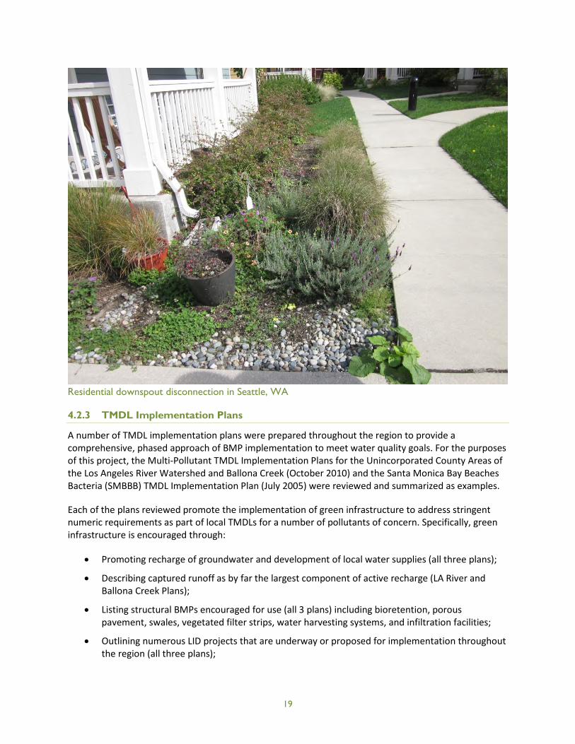
Residential downspout disconnection in Seattle, WA
4.2.3 TMDL Implementation Plans
A number of TMDL implementation plans were prepared throughout the region to provide acomprehensive, phased approach of BMP implementation to meet water quality goals. For the purposesof this project, the Multi-Pollutant TMDL Implementation Plans for the Unincorporated County Areas ofthe Los Angeles River Watershed and Ballona Creek (October 2010) and the Santa Monica Bay BeachesBacteria (SMBBB) TMDL Implementation Plan (July 2005) were reviewed and summarized as examples.
Each of the plans reviewed promote the implementation of green infrastructure to address stringentnumeric requirements as part of local TMDLs for a number of pollutants of concern. Specifically, greeninfrastructure is encouraged through:
Promoting recharge of groundwater and development of local water supplies (all three plans);
Describing captured runoff as by far the largest component of active recharge (LA River andBallona Creek Plans);
Listing structural BMPs encouraged for use (all 3 plans) including bioretention, porouspavement, swales, vegetated filter strips, water harvesting systems, and infiltration facilities;
Outlining numerous LID projects that are underway or proposed for implementation throughoutthe region (all three plans);

20
Explaining the importance of numerous proposed projects (e.g., Obregon County Park,Crescenta Valley County Park and Tujunga Wash Greenway projects) that replenish groundwaterand recharge aquifers;
Calling out infiltration as one of the more simple and inexpensive approaches to beneficial reuseof runoff and recharge of groundwater basins (all three plans);
Encouraging integrated water resources management focusing on the re-use of stormwater andgroundwater infiltration throughout the watershed (SMBBB TMDL Plan), and
Describing potential West Coast basin benefits from recharge via re-used stormwater runoff(SMBBB TMDL Plan).
The plans outline watershed-specific goals for BMP implementation, specifically LID and greeninfrastructure BMPs, and therefore are strong drivers of green infrastructure implementation in theregion. Modeling efforts associated with TMDLs can help to quantify the benefits of the BMPs in termsof stormwater volume and pollutant load reduction and groundwater recharge. These results can helpinform future green infrastructure planning.
4.2.4 Greater Los Angeles County Region Integrated Regional Water Management Plan
To define a clear direction for the sustainable management of water resources for the next 20 years inthe Greater Los Angeles Region, a Leadership Committee of key stakeholders formed in 2006 andprepared an Integrated Regional Water Management Plan (IRWMP). The IRWMP provides acomprehensive set of solutions and associated costs to address water supply needs, treatment of localgroundwater and stormwater, in-stream water quality, and habitat improvement.
The IRWMP is intended to improve the sustainability of water resources and ecological health of localwatersheds in conjunction with assisting local jurisdictions in complying with regulatory mandates suchas TMDLs. The IRWMP includes quantitative goals for measurable progress and accountability, furtherensuring that water quality improvement and water resources sustainability measures are implemented.The IRWMP encourages green infrastructure through:
Objectives to protect, restore, and enhance natural processes and habitats, including identifyingplanning targets for restoration of riparian and wetland habitats;
An objective to sustain infrastructure for local communities, encouraging replacement of agingsystems with more integrated flood management and green infrastructure systems; and
Water quality improvement objectives that:
o Recommend achieving compliance with TMDLs through a combination of runoff volumereduction and capturing and treating runoff from developed areas;
o Call for the reduction and reuse of 150,000 acre-feet/year (approximately 40 percent) of dryweather urban runoff and capture and treatment of an additional 170,000 acre-feet/year(approximately 50 percent);
o Call for the reduction and reuse of 220,000 acre-feet/year (approximately 40 percent) ofstormwater runoff from developed areas, and capture and treatment of an additional270,000 acre-feet/year (approximately 50 percent);

o Highlight LID BMPs for their stormwater capture, pollutant reduction, and groundwaterrecharge benefits to meet the above goals, and
o Recommend the reduction of stormwater runoff volumes through impervious surfacereduction, swales, cisterns, and other on-site BMPs that capture and/or infiltrate runoff,identifying how important these measures are to augment local water supplies throughnatural recharge.
Identification of more than 1,500 stakeholder projects and project concepts, many of whichinvolve green infrastructure elements, to help achieve IRWMP objectives throughout the region.
The IRWMP provides more general recommendations encouraging the use of green infrastructure andestablishes a framework for implementation of such measures through a series of qualitative andquantitative objectives. As such, specific barriers and limitations to green infrastructure measures arenot explicitly called out in the IRWMP.
Because one of the key goals of the IRWMP is groundwater replenishment, groundwater quality issuesthroughout the IRWMP region should be considered when siting green infrastructure projects. TheIRWMP indicates that groundwater quality in some portions of the region has been degraded byelevated levels of nitrates and plumes of volatile organic compounds (VOCs). Groundwatercontamination has also occurred in some locations from the historic use of methyl tertiary butyl ether(MTBE). For instance, MTBE was discovered in groundwater wells in the City of Santa Monica in 2003
21
Porous pavement and xeriscape in Los Angeles, CA
22
and VOCs have been detected at 1,000 times above the established maximum contaminant levels in theBaldwin Park area. Groundwater clean-up efforts are being coordinated by various agencies and citiesthroughout the region.
The authors of the IRWMP recognize the importance of green infrastructure in improving groundwaterquality and replenishing local supplies. When siting potential green infrastructure projects, carefulattention should be paid to areas with contaminated groundwater. This can be achieved through GISmapping of these areas and either re-siting, use of green infrastructure BMPs that are not infiltration-based, or use of liners and underdrains for infiltration BMPs to avoid mobilizing contaminants.
The IRWMP also specifies that projects aimed at reducing runoff via on-site BMPs also preserve orenhance flood protection levels. Thus, careful attention should be paid to designing such BMPs for bothwater quality enhancement and flood protection purposes as much as feasible.
4.2.5 Groundwater Adjudications in the Central and West Coast Basins
Additional regional regulatory5 drivers that potentially affect the use of green infrastructure in the LosAngeles Region include two groundwater adjudications that address the Central and West Coast Basins.The discussion below examines whether the court judgments resulting from these groundwateradjudications pose barriers to the implementation of green infrastructure stormwater infiltrationprojects in those areas and how ongoing litigation to amend those judgments could potentially addressthese issues.
In most areas of California, overlying land owners may extract percolating groundwater and put it tobeneficial use without approval from the State Board or a court. California does not have a permitprocess for the regulation of groundwater use (excluding subterranean streams). In several basins,6
however, groundwater use is subject to regulation in accordance with court decrees adjudicating thegroundwater rights within each basin. These groundwater adjudications establish specifically who isentitled to extract groundwater and how much each entitled party may extract annually. The courttypically appoints a Watermaster to report on annual extractions and to enforce the judgments toensure, for example, that a party does not extract more than its entitled extraction rights.
Two specific groundwater adjudications apply to the Central and West Coast Basins. These basinsunderlie a 420-square mile area of the Los Angeles Coastal Plain and include all or parts of 43 cities witha population of 4 million people. Groundwater supplies 40% of the water demand in the area. Theadjudications fix extraction rights in the West Coast Basin at 64,468 acre-feet and in the Central Basin at217,367 acre-feet. The extraction rights are roughly double the natural safe yield in each basin asdefined in the early 1960s. Both judgments presuppose artificial replenishment will occur to make upthe difference between the amount of water naturally replenished by storm water and underflow andthe amount of groundwater extracted under the judgments.
Artificial replenishment is provided by the Water Replenishment District. The District charges aReplenishment Assessment on each acre-foot of groundwater extracted in order to buy or produce the
5Regulatory here is used in the broad sense of legal structures and decisions.
6There are approximately 22 adjudicated groundwater basins in California.
http://www.water.ca.gov/groundwater/gwmanagement/court_adjudications.cfm. Other means of regulating groundwater inthe State include: overlying property rights; statutory authority; groundwater management districts or agencies; groundwatermanagement plans; and city and county ordinances.
23
imported water, recycled water and conserved stormwater necessary to replenish the groundwaterextracted. The 2012–2013 Replenishment Assessment is $244 per acre-foot.
Central and West Coast Basin Groundwater Judgments
The adjudication of groundwater extraction rights in the West Coast Basin was concluded in 1961(California Water Service Company, et al. vs. City of Compton, et al., C506806). Judgment in the CentralBasin case was entered in 1965 (Central and West Basin Water Replenishment District, et al. vs. CharlesE. Adams, et al., C786,656).7
While the judgments make provision for groundwater extraction rights, they do not provide forgroundwater storage and the extraction of stored water. As a result, municipalities and others withgroundwater extraction rights may not extract stored water over and above their respective extractionrights and they may not extract stored water without paying the Replenishment Assessment.
7http://www.water.ca.gov/watermaster/centralbasin_judgment/index.cfm
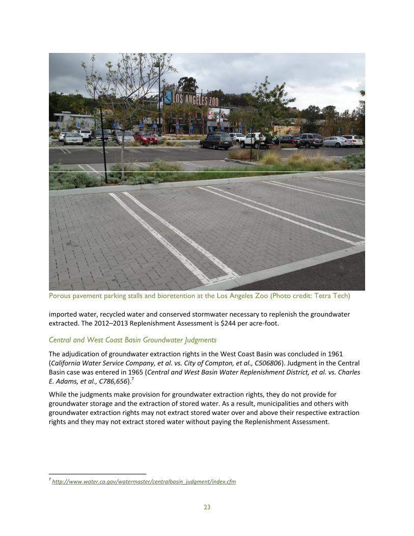
Porous pavement parking stalls and bioretention at the Los Angeles Zoo (Photo credit: Tetra Tech)

24
Potential Barriers/Disincentives to Green Infrastructure Projects Posed By Groundwater Adjudications
The judgments thus provide no incentive, and in fact are barriers, to municipalities with extraction rightsthat might otherwise invest in green infrastructure stormwater infiltration projects to meet TMDLrequirements and to enhance their groundwater supply.
Conditions that would promote the implementation of green infrastructure projects that couldsupplement groundwater recharge include the allowance for groundwater recharge projects by partiesto the judgments (e.g., stormwater infiltration), flexibility to use the Central and West Basins for thestorage of captured water, and the ability to extract or gain credit for such captured and storedgroundwater as long as it could be demonstrated that the infiltrated water reached the usablegroundwater basins and increased the natural supply above previously determined amounts. Equitableand clear rules, rights, and processes regarding these areas will promote the implementation of greeninfrastructure.
Potential Effect of Ongoing Litigation
In May 2009, petitions to amend both judgments were filed by the Water Replenishment District andparties representing a majority of extraction rights in both basins. The amendments would create alegally-certain framework for individual and regional storage projects. They would permit parties to takeadvantage of the 450,000 acre-feet of available storage capacity in the two basins (120,000 acre-feet inthe West Coast Basin and 330,000 acre-feet in the Central Basin). Most importantly, would permit aparty to extract water it stores without that extraction counting against its judgment extraction rightsand without paying a Replenishment Assessment on the extraction of the water it stores.
The judgment amendment motions before the court note that the work to allow for groundwaterstorage has been a long-term, professionally facilitated effort and that the proposed amendments aresupported by the parties holding well over fifty percent of the water rights in both Basins, as well as theWatermaster, and the Water Replenishment District of Southern California, the local agency responsiblefor groundwater replenishment.
The motions indicate that the amendments will provide the region with essential opportunities to satisfywater demands, that the amendments provide the legal certainty needed to encourage basin users tooptimize their use of the basins by taking advantage of available storage capacity and investing in wateraugmentation projects and projects to increase the use of recycled water. The motions assert that bymaking the water supply more reliable and by opening access to lower-cost supplies, theseimprovements to the judgments will provide significant benefits to the people who depend upon thebasins and that, as a result, the basins’ water users and the region as a whole will be more self-sufficientnow and into the future. The motions further assert that the economic value of these benefits to theregion is more than $500,000,000, and that the amendments will encourage economic benefitsincluding:
Increased local supply through increased storage;
Increased reliability of supply, especially during a drought or imported supply restriction;
Increased use and development of recycled water;
Increased efficiency in the capture of storm flow and other local supplies; and
Increased use of now-underutilized groundwater pumping rights.

25
Bioretention with xeriscape incorporated into the right-of-way, Los Angeles, CA(Photo credit: Tetra Tech)
26
Overall, the proposed amendments to the Central and West Coast Basin groundwater adjudicationswould appear to address existing provisions that discourage investment in green infrastructure. A trial inconnection with the proposed judgment amendments is scheduled for January 2014. There is no way ofknowing, of course, whether these motions will be adopted and the judgments amended to explicitlyprovide for groundwater storage. Based on available information, however, it is clear that the proposedamendments reflect significant work to facilitate groundwater recharge, storage and use in these basinsand it appears they would provide a clear and workable framework that will, if adopted, support thepotential for increased use of certain types of green infrastructure projects.
In summary, the amendments would recognize groundwater storage as supporting beneficial use,provide available resources in the respective basins for such storage, and put in place specific processesand requirements that address groundwater storage and use in the Central and West Coast Basins in anequitable manner and in a manner that does not disrupt groundwater rights held under the existingjudgments.
They would provide clarity that is much needed if entities are expected to invest in improving localgroundwater resources. Under the amendments, water augmentation projects could be developed andpotentially used to increase the yield of the basins. Again, under the amendments, no replenishment feewould be assessed against the extraction of augmented water. In this way an entity that contributes tothe costs of a water augmentation project could benefit from the project without being penalized by anassessment on water that it in whole or in part contributed.
5 Overcoming Barriers to Green Infrastructure at the Local Level
As discussed previously, state and regional policies and programs can drive green infrastructureimplementation. At the local level, municipal codes and ordinances,8 policies, and guidance documentsalso can create barriers to or encourage green infrastructure implementation. Such barriers vary fromone municipality to the next and can create an uneven regulatory landscape that developers need tonavigate to implement green infrastructure in the region. Within a single municipality, differentneighborhoods might have different zoning rules governing density, infrastructure features, and otherrequirements that can affect how green infrastructure can be incorporated into development projects.
To identify municipal code obstacles, a local government must conduct an audit of applicabledocuments. An audit involves coordinating with and educating staff in relevant municipal service areas,reviewing documents that guide municipal activities, and interpreting and prioritizing findings. Thefollowing sections describe a process by which a local government can assess its codes, ordinances,policies, and guidance to remove barriers to green infrastructure and strengthen language that wouldencourage or require green infrastructure implementation. A Green Infrastructure Identification ofBarriers and Opportunities Checklist Tool, which was adapted for the local development conditions andresource protection priorities of the Los Angeles Region, is provided in Appendix A to facilitate the audit.
8Municipal codes and ordinances refer to laws that are enacted and enforced by a village, town, city or county government.
27
5.1 Municipal Service Areas and Associated Codes, Ordinances, Policies, andGuidance
The first step in conducting an audit is to identify all of the appropriate municipal service areas whoseregulations or policies in some way impact the implementation of green infrastructure. Note that manyof the common green infrastructure barriers exist in regulations not immediately associated with waterquality or environmental issues. The following is a list of the service areas that should be included in agreen infrastructure audit that focuses on the Los Angeles Region’s key issues of infill development;redevelopment; and water conservation, reuse, and recharge:
Public works
Planning
Public health and safety
Economic development
Legal/municipal attorney
The following are descriptions of each service area’s potential green infrastructure interactions. Thecodes,9 ordinances, policies, and guidance documents associated with each service area are presented inTable 4.
Public Works
The public works service area typically encompasses street design, asset maintenance, and engineering.Green infrastructure implementation can be supported or inhibited through street and right-of-waydesign, paving requirements, and infrastructure design, such as requirements for curb and gutter andstringent pavement requirements that do not allow the use of permeable materials. Further, if greeninfrastructure practices are publicly owned or maintained, public works maintenance staff will becharged with the inspection and maintenance of the facilities. Finally, the public works service area
9Where specific standards are referenced, probable code location(s) are also listed.
Code and Ordinance Review Resources
The Center for Watershed Protection’s (1998) Better Site Design: A Handbook for ChangingDevelopment Rules in Your Community, available at www.cwp.org, outlines 22 guidelines for betterdevelopments and provides a detailed rationale for each principle. Better Site Design also examinescurrent practices in local communities, details the economic and environmental benefits of bettersite designs, and presents case studies from around the country.
USEPA’s (2009) Water Quality Scorecard: Incorporating Green Infrastructure Practices At Municipal,Neighborhood, and Site Scales, guides municipal staff through a review of relevant local codes andordinances across multiple municipal departments to ensure that these codes work together tosupport a green infrastructure approach. It can be downloaded atwww.epa.gov/dced/pdf/2009_1208_wq_scorecard.pdf.

28
could impact green infrastructure implementation through the development and application of post-construction BMP performance standards for treatment, channel protection, and flood control toprotect infrastructure and receiving streams.
Planning
The planning service area includes site plan review, building inspections, zoning, code enforcement andperhaps a green building program. It is imperative that green infrastructure practices be considered andincorporated early in the site planning process—with regard to parking lot and building requirements—and then implementation confirmed throughout all development phases and post-construction.Planning codes need to be evaluated for requirements that oversupply impervious surfaces (e.g., roads,driveways, sidewalks, parking) and discourage Smart Growth.
Public Health and Safety
Allowances for and obstacles to rainwater harvesting and water conservation are typically found incodes, policies and guidance implemented by departments that deal with public health issues. Inaddition, fire codes should also be evaluated to determine if they prohibit narrow streets, curbbumpouts, alternative cul-de-sac designs, and other modifications to street design.
Economic Development
The economic development service area may include incentives to develop within brownfield areas thatwould encourage redevelopment in lieu of greenfield development. Further, the creation of taxincremental financing districts can stimulate new private investment and enhance real estate values inurban areas that are unlikely to attract development otherwise. Incentivizing redevelopment can reducethe demand for greenfield development and focus development in areas with existing infrastructure.
Legal/Municipal Attorney
The legal department should be involved in any discussions that may involve code changes to evaluateramifications and help craft specific code language. Education of legal staff regarding the science ofgreen infrastructure and its importance and multiple benefits should occur early in the audit process.
Table 4. Codes, ordinances, policies, and guidance documents related to municipal service areas
Service Area/Topic Location
Public Works
Street and sidewalk design standards Municipal Code: Streets and Sidewalks, Zoning – All Zones;Complete/Smart Streets Guidelines
Curb and gutter design standards Municipal Code: Streets and Sidewalks, Zoning – All Zones
Paving standards Municipal Code: Streets and Sidewalks
Public post-construction stormwater BMPinspection standard operating procedures
Stormwater manual or internal operating procedure documents
Post-construction BMP performancestandards
Municipal Code: Drainage, Stormwater, Development/Subdivision;Local Stormwater Design Guidance

29
Service Area/Topic Location
Planning
Density allowances Municipal Code: Zoning – All Zones
Transit or existing infrastructuredevelopment incentives
Municipal Code: Zoning, Transit Overlay Zone, Tax IncrementalFinancing (TIF) Zone; Local or Regional Transportation Plan(s);Downtown/Neighborhood Development Plans; TIF Design Guidelines
Off-street parking requirements Municipal Code: Zoning – All Zones; Off-Street Parking; ParkingOverlay Zone
Landscaping requirements Municipal Code: Zoning – All Zones, Landscaping, Tree Protection
Setback requirements Municipal Code: Zoning – All Zones
Open space requirements Municipal Code: Zoning – All Zones
Driveway, alley, garage requirements Municipal Code: Zoning – All Zones
Greenfield or infill development Incentives Municipal Code: Mixed Use Development Zones, Agricultural Zones,Open Space Zones; Downtown/Neighborhood Development Plans;Capital Improvement Plan
Critical area, wetland or waterwayprotection
Municipal Code: Zoning, Drainage, Flood Zone, Sensitive AreaProtection Zone; Watershed Plan
Buffer requirements Municipal Code: Zoning, Drainage, Flood Zone, Sensitive AreaProtection Zone; Watershed Plan
Off-site mitigation allowances Municipal Code: Drainage, Stormwater, Development/Subdivision;Local Stormwater Design Guidance
Tree protection standards Municipal Code: Zoning – All Zones, Landscaping, Tree Protection;Urban Forestry Guidance
Private post-construction stormwater BMPinspection authority
Municipal Code: Drainage, Stormwater, Public Nuisance
Private post-construction stormwater BMPinspection standard operating procedures
Stormwater manual or internal operating procedure documents
Maintenance and private inspectionagreement requirements
Municipal Code: Drainage, Stormwater, Development/Subdivision;Local Stormwater Design Guidance
Green building requirements Municipal Code: Green Buildings
Public Health and Safety
Cistern and rain barrel requirements Municipal Code: Zoning, Plumbing, Building, Water Conservation
Maintenance and private inspectionagreement requirements
Municipal Code: Drainage, Stormwater, Development/Subdivision;Local Stormwater Design Guidance
Gutter disconnection allowances Municipal Code: Plumbing, Building
Rainwater reuse allowances Municipal Code: Plumbing, Building, Health
Emergency vehicle street requirements Municipal Code: Fire, Streets and Sidewalks
Economic Development
Tax incremental financing districts Municipal Code: TIF District Zones
Brownfield incentives Municipal Code: Zoning
30
5.2 Education of Staff
Many aspects of municipal management can support or inhibit the implementation of greeninfrastructure practices, and some are more straightforward to understand than others. Municipal staffmight not understand their role in preventing green infrastructure or how their work could be altered toinstead promote it. Staff are charged by the governing body of their municipality with achieving acertain level of service to residents with regard to their particular service area, i.e., transportationplanners plan and design safe and efficient streets. Achieving this level of service is their primaryconcern and objective, so it might require some education to inform them of the purpose andimportance of changes needed to remove high-priority obstacles to green infrastructure. In addition,staff have detailed knowledge of the codes, policies and guidance documents that guide their work andtherefore may be of great help in identifying barriers during the audit process.
It is likely that municipal staff will have concerns about green infrastructure related to safety, access,and maintenance. For example, in an attempt to minimize impervious area, green infrastructureprinciples recommend narrower streets and cul-de-sacs and smaller parking areas. Often, firedepartments and public works departments express concerns regarding safety and access, engineeringdepartments object because of conflicts with the State Streets and Highway Code, and engineering andpublic works departments have concerns about maintenance of distributed BMPs, especially on privateland and in the public right-of way.
The easiest and fastest way to educate staff may be to convene a round table meeting of all appropriatestaff. The meeting would include a brief training regarding the benefits of green infrastructure (seeSection 3) and each service area’s role in promoting or inhibiting green infrastructure. After this training,a moderated discussion regarding which particular codes, policies, or guidance documents should beaudited would be helpful to ensure nothing is overlooked at the onset of the process. The suggesteddocuments in Table 4 could be used to initiate discussion and a blank copy of the Green InfrastructureIdentification of Barriers and Opportunities Checklist Tool (Attachment A) could be distributed to elicitadditional input or ideas. The meeting should also be used to request the documents discussed if theyare not readily available to audit staff. The documents being reviewed should be in an electronic formatthat is easily searchable, if possible. Participants in this round table meeting would be considered greeninfrastructure contacts for future questions regarding the audit process.
5.3 Conducting the Review
There are multiple approaches to conducting an audit of local codes, policies, and guidance documents,but one of the most straightforward is to treat the exercise as a targeted keyword search to locate theanswers to each of the questions included in the Tool. The first step should be to generally becomefamiliar with a key part of the municipal code, namely the zoning code. The specific contents of thezoning regulations may vary, however generally housing unit density, setbacks, off-street parking spacerequirements, lot size minimums and maximums can be found in the zoning regulations. Manymunicipal codes will have a section describing landscaping requirements for off-street parking andscreening between land uses, but this also might be defined specific to certain zones. Some municipalcodes will have an off-street parking section of the code as well that define landscaping requirements,pavement type, and other requirements, while other municipal codes may refer to different sections ofthe code that focus on these items.
31
The auditor can save time during the audit process by briefly reviewing these sections in advance tobecome familiar with the location of particular information. In addition, the auditor should considereach question in the Tool and search for certain key words that can help to identify green infrastructureobstacles. The following key words should be searched and associated text evaluated for greeninfrastructure implications:
Pervious
Bioretention
Driveways
Greenfield
Wetland
Rain barrel
Sensitive area
Infiltration
Outfall
Riparian
Island
Impervious
Infill
Alley
Buffer
Cistern
Stormwater
Retention
Water quality
Channel
Banking
Mature tree
Permeable
Transit
Open space
Swales
Graywater
Rain
Detention
Flood
Mitigation
Curb and gutter
Context-sensitive design
When completing the Tool, when the answer to a question is no, be sure to indicate the section orsections of the code, policy, or guidance document where barriers exist. It is helpful to include the exactlanguage from the reference document and any recommendations for removing the barrier for futurereference when prioritizing barriers and developing an action plan. For example:
GOAL #1 KEY QUESTIONS IMPORTANCE COMMENTS
Does the code definition ofimpervious area distinguish betweenimpervious area connected to thestorm drain system (effectiveimpervious area) and disconnectedimpervious area?
NO – The only specific definition of imperviousarea is the square footage of a lot multiplied byits runoff coefficient (Sec. 2-168). Code alsorefers to “impermeable surface” (Sec. 51A-8.611(c)(1)(B)(i)), which is not defined, and“nonpermeable coverage,” (Sec. 51A-10.101(19))defined as “coverage with any pavement that isnot “permeable pavement.”
Recommendation: Provide specific definitiondistinguishing connected and disconnectedimpervious area and revise Sec. 51A definition toinclude rooftops and other nonpermeablesurfaces.
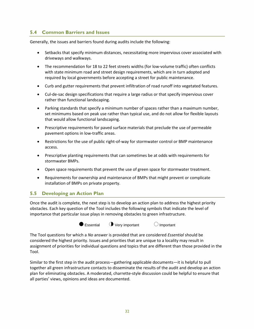
32
5.4 Common Barriers and Issues
Generally, the issues and barriers found during audits include the following:
Setbacks that specify minimum distances, necessitating more impervious cover associated withdriveways and walkways.
The recommendation for 18 to 22 feet streets widths (for low-volume traffic) often conflictswith state minimum road and street design requirements, which are in turn adopted andrequired by local governments before accepting a street for public maintenance.
Curb and gutter requirements that prevent infiltration of road runoff into vegetated features.
Cul-de-sac design specifications that require a large radius or that specify impervious coverrather than functional landscaping.
Parking standards that specify a minimum number of spaces rather than a maximum number,set minimums based on peak use rather than typical use, and do not allow for flexible layoutsthat would allow functional landscaping.
Prescriptive requirements for paved surface materials that preclude the use of permeablepavement options in low-traffic areas.
Restrictions for the use of public right-of-way for stormwater control or BMP maintenanceaccess.
Prescriptive planting requirements that can sometimes be at odds with requirements forstormwater BMPs.
Open space requirements that prevent the use of green space for stormwater treatment.
Requirements for ownership and maintenance of BMPs that might prevent or complicateinstallation of BMPs on private property.
5.5 Developing an Action Plan
Once the audit is complete, the next step is to develop an action plan to address the highest priorityobstacles. Each key question of the Tool includes the following symbols that indicate the level ofimportance that particular issue plays in removing obstacles to green infrastructure.
Essential Very important Important
The Tool questions for which a No answer is provided that are considered Essential should beconsidered the highest priority. Issues and priorities that are unique to a locality may result inassignment of priorities for individual questions and topics that are different than those provided in theTool.
Similar to the first step in the audit process—gathering applicable documents—it is helpful to pulltogether all green infrastructure contacts to disseminate the results of the audit and develop an actionplan for eliminating obstacles. A moderated, charrette-style discussion could be helpful to ensure thatall parties’ views, opinions and ideas are documented.

33
Some of the most challenging issues to reach consensus include:
Residential street and road widths. The recommendation for 18 to 22 feet streets widths (forlow volume traffic) often conflicts with state minimum road and street design requirements,which are in turn adopted and required by local governments before accepting a street forpublic maintenance. Fire departments also object to the narrower streets because they believethey are not wide enough for fire trucks to navigate.
Culs-de-sac. The recommendation that a cul-de-sac have a radius of 35 feet or less can conflictwith state DOT standards. This standard is related to transport of liquid fuels.
Use of grass swales and bioretention areas rather than curb and gutter. The major objection tothis recommendation comes from local engineering and public works departments that areconcerned about the maintenance of the swales and street edges and the use of swales onsteeply sloped areas.
Use of one sidewalk rather than two. Planning departments often object to this ordinancerevision because they believe it conflicts with their goal of providing walkable communities.
Reducing residential setback and frontage requirements to encourage cluster development.Planning staff are concerned that the reduced setback/frontage requirements would beincompatible with existing neighborhoods built under traditional subdivision requirements.
In most cases, the resistance to ordinance changes arises from competing local government service areaobjectives and concerns. For example, the planning, public works, and fire departments may have toresolve internal issues to determine the extent to which street widths can be reduced in a subdivision.For each issue, it will be important to show how other communities have overcome barriers throughcreative design, construction standards, and approval process requirements, among other strategies.
Prior to the conclusion of the charrette, it is important to assign a department responsible forimplementing the recommended actions. The action items and parties responsible should besummarized and distributed after the meeting.

1•Notify s
2•Requestthought
3•OrganizGI bene
4•Requestmeeting
5•Reviewto answ
6
•For eachsection,barrier.
7
•Using thprioritizterm.
8•Hold a mbarriers,
Code/Ordinance Audit Process
34
ervice area coordinators of the pending audit.
copies of codes, ordinances, policies or guidance documentsto be applicable to GI implementation.
e roundtable meeting of service area coordinators to discussfits and roles and establish GI contacts for future efforts.
additional documents identified during the roundtable.
development code and conduct a keyword and topic searcher the questions contained in the Tool.
barrier identified, note the applicable documents (e.g., codetechnical manual) and include the language that poses a
e relative importance symbols in the Tool, develop aed list of barriers to be addressed in the short versus long
oderated meeting with GI contacts to address high prioritydevelop action items, and identify responsible parties.
35
6 Summary and Conclusions
Stormwater has been identified as a valuable and reliable resource for groundwater augmentation tohelp ensure long-term regional water self-reliance for Southern California and reduce the region’sreliance on imported water (Natural Resources Defense Council 2009; Los Angeles and San GabrielRivers Watershed Council 2010; Water Replenishment District of Southern California 2012). Regionalgroundwater recharge projects are planned or underway to implement this strategy. Smaller-scale greeninfrastructure projects have the potential, when considered collectively, to contribute to groundwatersupplies while meeting other objectives, specifically water quality improvement and otherenvironmental and community benefits.
Green infrastructure in the Los Angeles Region must reflect local development opportunities andenvironmental constraints. In the already developed, highly urbanized areas of Los Angeles County,green infrastructure will mostly be implemented as retrofits or infill redevelopment, which can constrainthe footprint of stormwater facilities and require creative site designs. Green infrastructure designsmust also meet water conservation goals, which can be achieved by selecting native and locally adaptedplants and using permeable hardscape, as exemplified by the Elmer Avenue Neighborhood RetrofitProject’s functional landscaping.
From a regulatory perspective, there are numerous drivers that encourage the use of greeninfrastructure, particularly those with goals geared toward water quality improvement (e.g., theMunicipal Stormwater Permit, Integrated Regional Water Management Plan, Basin Plan, and TMDLimplementation plans). These regulations strongly encourage or specifically require the use of greeninfrastructure to meet hydrologic and water quality objectives. Other regulations create opportunitiesfor green infrastructure implementation as part of other projects that aim to create more sustainable,livable communities, such as the Sustainable Communities and Climate Protection Act’s transportationand affordable housing requirements. Green infrastructure can be used as a strategy to meet climatechange goals (e.g., those set forth in the Global Warming Solutions Act) by incrementally increasingvegetative cover that can serve as a carbon sink, reducing other air pollutants, offsetting imported waterneeds, and reducing building energy cooling.
The current status of water rights in the Central and West Coast Groundwater Basins, governed by theCentral and West Coast Basin Judgments, creates potential disincentives for the entities consideringimplementing water capture, recharge, and storage because the judgments lack a system to account for,credit, or pay for that water, and users would be charged a replenishment fee to extract the water theystored. Ongoing litigation seeks to address these shortcomings by amending the judgments to establisha system that accounts for additional water storage and eliminates replenishment fees on extraction ofstored water.
The next challenge facing Los Angeles communities is to incorporate green infrastructure standards andrequirements into local codes and ordinances so that it becomes business as usual for most or allpermitted development projects. An audit of relevant codes and ordinances is an important first step toidentify and remove barriers to green infrastructure. Subsequently, communities can begin creatingincentives for voluntary green infrastructure implementation, if desired and feasible. Constraints relatedto funding for green infrastructure can pose challenges, but grant opportunities, such as California’sProposition 84 for flood control and water supply improvements, can help to promote greeninfrastructure. Eventually, the aim is for green infrastructure to become business as usual for developersand municipalities while contributing to local and regional water quality and hydrologic objectives,achieving water replenishment goals, and improving community livability and quality of life.
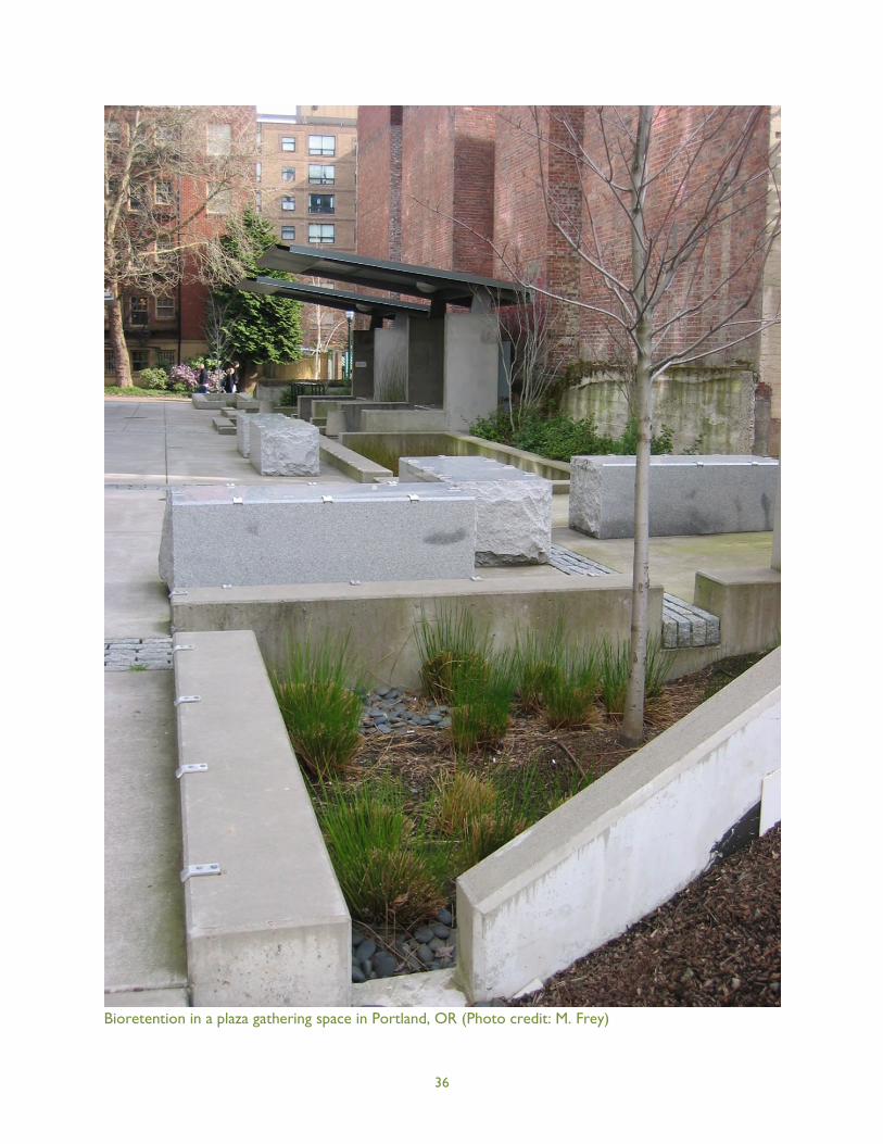
36
Bioretention in a plaza gathering space in Portland, OR (Photo credit: M. Frey)
37
7 References
California Regional Water Quality Control Board, Los Angeles Region (LARWQCB). 2012. Order No. R4-2012-0175, NPDES Permit No. CAS004001. Waste Discharge Requirements for MunicipalSeparate Storm Sewer System (Ms4) Discharges within the Coastal Watersheds of Los AngelesCounty, Except Those Discharges Originating from the City of Long Beach MS4.http://www.swrcb.ca.gov/rwqcb4/water_issues/programs/stormwater/municipal/la_ms4/2012/Order%20R4-2012-0175%20-%20A%20Final%20Order%20revised.pdf. Accessed March 5, 2013.
California Stormwater Quality Association (CASQA). 2010. Low Impact Development Manual forSouthern California: Technical Guidance and Site Planning Strategies.http://www.casqa.org/LID/SoCalLID/tabid/218/Default.aspx. Last updated April 2012. AccessedNovember 23, 2012.
Center for Neighborhood Technology (CNT). 2010. The Value of Green Infrastructure: A Guide toRecognizing its Economic, Environmental, and Social Benefits. http://www.cnt.org/repository/gi-values-guide.pdf. Accessed November 23, 2012.
Center for Watershed Protection. 1998. Better Site Design: A Handbook for Changing Development Rulesin Your Community. Center for Watershed Protection, Ellicott City, MD.
City of Los Angeles. 2012. Ordinance No. 181899. http://www.lastormwater.org/wp-content/files_mf/finallidordinance181899.pdf. Accessed March 5, 2013.
County of Los Angeles Department of Public Works. 2009a. Low Impact Development Standards Manual.http://dpw.lacounty.gov/wmd/LA_County_LID_Manual.pdf. Last updated January 2009.Accessed November 23, 2012.
County of Los Angeles Department of Public Works. 2009b. Stormwater Best Management PracticeDesign and Maintenance Manual for Publicly Maintained Storm Drain Systems.http://dpw.lacounty.gov/ldd/publications/Stormwater%20BMP%20Design%20and%20Maintenance%20Manual.pdf. Last updated May 2009. Accessed November 23, 2012.
ECONorthwest. 2011. Economic Benefits of Green Infrastructure: Chesapeake Bay Region.ECONorthwest, Eugene, OR.
Los Angeles and San Gabriel Rivers Watershed Council. 2010. Water Augmentation Study: Research,Strategy, and Implementation Report. Los Angeles and San Gabriel Rivers Watershed Council,Los Angeles, CA.
Natural Resources Defense Council. 2009. A Clear Blue Future: How Greening California Cities CanAddress Water Resources and Climate Challenges in the 21st Century.http://www.nrdc.org/water/lid/files/lid_hi.pdf. Accessed May 9, 2013.
Nowak, D.J., D.E. Crane, and J.C. Stevens. 2006. Air pollution removal by urban trees and shrubs in theUnited States. Urban Forestry & Urban Greening 4: 115–123.
38
Stratus Consulting. 2009. A Triple Bottom Line Assessment of Traditional and Green InfrastructureOptions for Controlling CSO Events in Philadelphia’s Watersheds. Office of Watersheds, City ofPhiladelphia Water Department. Philadelphia, PA.
USEPA. 2005. National Management Measures to Protect and Restore Wetlands and Riparian Areas forthe Abatement of Nonpoint Source Pollution.http://water.epa.gov/polwaste/nps/wetmeasures/upload/2005_08_19_NPS_wetmeasures_ch2.pdf. Last updated July 2005. Accessed November 23, 2012.
USEPA. 2009. Water Quality Scorecard: Incorporating Green Infrastructure Practices At Municipal,Neighborhood, and Site Scales. http://www.epa.gov/dced/pdf/2009_1208_wq_scorecard.pdf.Accessed February 27, 2013.
USEPA. 2012a. What is Green Infrastructure?http://water.epa.gov/infrastructure/greeninfrastructure/gi_what.cfm. Last updated March 21,2012. Accessed November 23, 2012.
USEPA. 2012b. Storm Water Drainage Wells.http://water.epa.gov/type/groundwater/uic/class5/types_stormwater.cfm. Last updatedSeptember 28, 2012. Accessed November 23, 2012.
Water Replenishment District of Southern California. 2012. Stormwater Recharge Feasibility and PilotProject Development Study. Prepared for the Water Replenishment District of SouthernCalifornia, Lakewood, CA, by the Council for Watershed Health, Geosyntec Consultants, and theSanta Monica Bay Restoration Commission.

39
This page is intentionally blank.

A-0
Attachment A:
Green InfrastructureIdentification ofBarriers and OpportunitiesChecklist Tool
Photo: Elmer Avenue residential stormwater retrofits, Los Angeles, CA

The Green Infrastructure Identification of Barriers and OpportunitiesChecklist Tool is tailored to the Los Angeles Region’s key priorities of infilldevelopment, redevelopment, and water conservation/reuse/recharge. Thechecklist was developed originally to perform audits of local codes andordinances for local government clients based on experience with otherchecklists, such as the Center for Watershed Protection’s Codes andOrdinances Worksheet and EPA’s Water Quality Scorecard.
This tool is intended to be used by local governments in the Los Angelesregion to determine whether their codes and ordinances pose barriers togreen infrastructure practices and to highlight opportunities for greeninfrastructure to be encouraged or required in codes. For additionalguidance on the code review process for local governments, see Section 5 ofthis report and the Center for Watershed Protection’s Better Site Design: AHandbook for Changing Development Rules in Your Community (1998),which contains the Codes and Ordinances Worksheet mentioned above (seewww.cwp.org for details).
The process of changing codes to encourage green infrastructure is notwithout challenges, most of which can be overcome through education andnegotiations with other departments. It is very likely that municipal staff willhave concerns about green infrastructure related to safety, access, andmaintenance. For example, in an attempt to minimize impervious area,green infrastructure principles recommend narrower streets and cul-de-sacsand smaller parking areas. Often, fire departments and public worksdepartments express concerns regarding safety and access, engineeringdepartments object because of conflicts with the State Streets and HighwayCode, and engineering and public works departments have concerns aboutmaintenance of distributed BMPs, especially on private land and in publicright-of way. Developers often have concerns about feasibility of greeninfrastructure BMPs if there is inflexibility in other code requirements.
Parking lot bioretention, Wilsonville, OR(Photo credit: M. Frey)
A-i
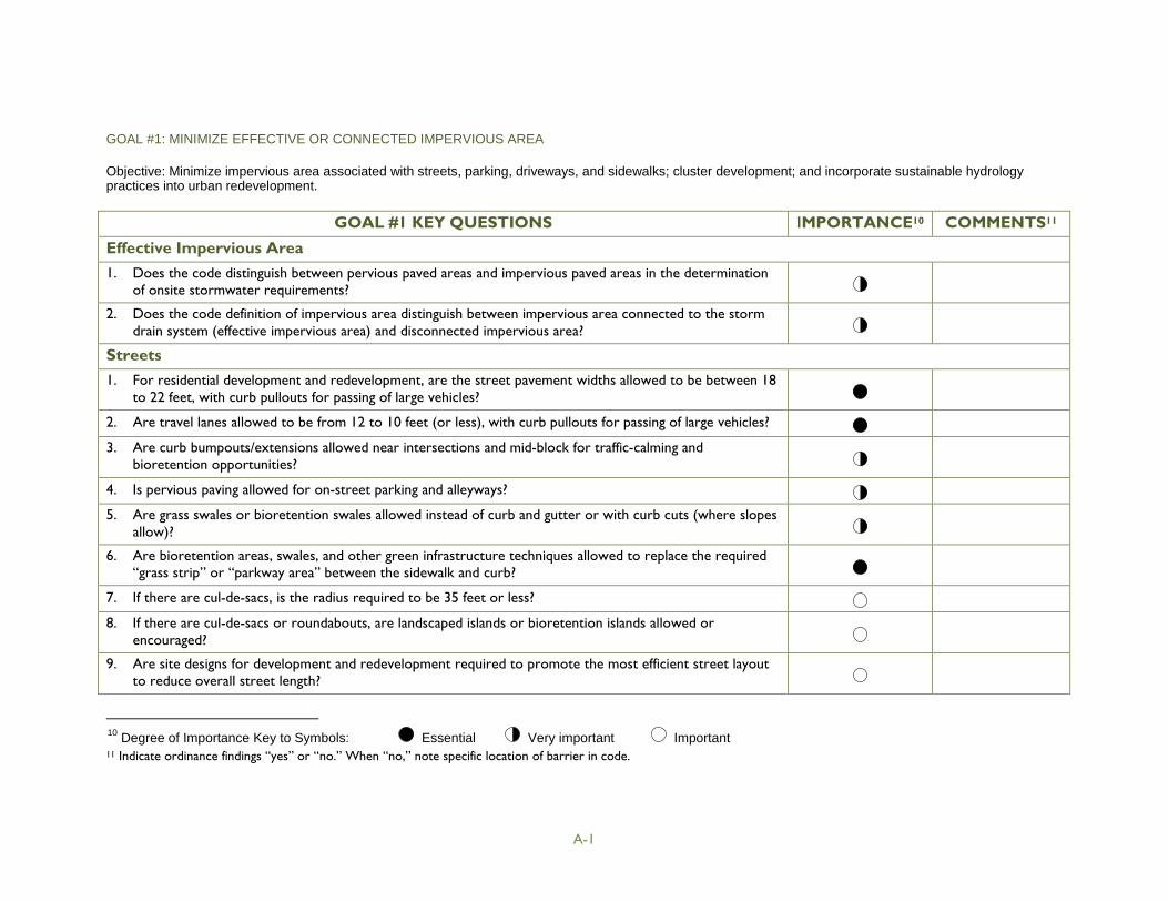
A-1
GOAL #1: MINIMIZE EFFECTIVE OR CONNECTED IMPERVIOUS AREA
Objective: Minimize impervious area associated with streets, parking, driveways, and sidewalks; cluster development; and incorporate sustainable hydrologypractices into urban redevelopment.
GOAL #1 KEY QUESTIONS IMPORTANCE10 COMMENTS11
Effective Impervious Area
1. Does the code distinguish between pervious paved areas and impervious paved areas in the determinationof onsite stormwater requirements?
2. Does the code definition of impervious area distinguish between impervious area connected to the stormdrain system (effective impervious area) and disconnected impervious area?
Streets
1. For residential development and redevelopment, are the street pavement widths allowed to be between 18to 22 feet, with curb pullouts for passing of large vehicles?
2. Are travel lanes allowed to be from 12 to 10 feet (or less), with curb pullouts for passing of large vehicles?
3. Are curb bumpouts/extensions allowed near intersections and mid-block for traffic-calming andbioretention opportunities?
4. Is pervious paving allowed for on-street parking and alleyways?
5. Are grass swales or bioretention swales allowed instead of curb and gutter or with curb cuts (where slopesallow)?
6. Are bioretention areas, swales, and other green infrastructure techniques allowed to replace the required“grass strip” or “parkway area” between the sidewalk and curb?
7. If there are cul-de-sacs, is the radius required to be 35 feet or less?
8. If there are cul-de-sacs or roundabouts, are landscaped islands or bioretention islands allowed orencouraged?
9. Are site designs for development and redevelopment required to promote the most efficient street layoutto reduce overall street length?
10Degree of Importance Key to Symbols: Essential Very important Important
11 Indicate ordinance findings “yes” or “no.” When “no,” note specific location of barrier in code.
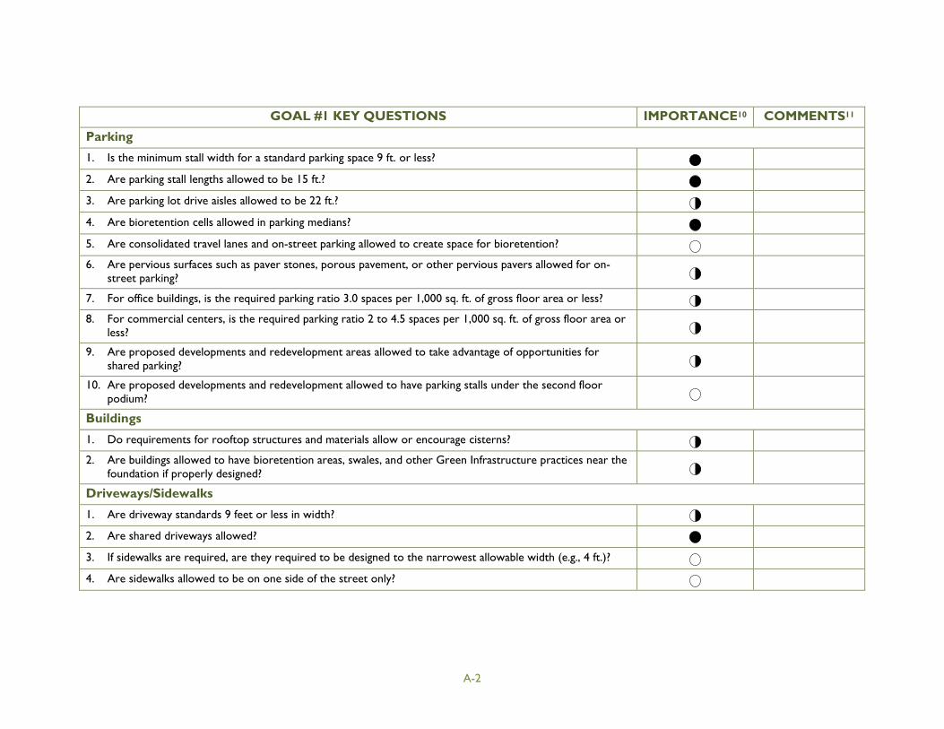
A-2
GOAL #1 KEY QUESTIONS IMPORTANCE10 COMMENTS11
Parking
1. Is the minimum stall width for a standard parking space 9 ft. or less?
2. Are parking stall lengths allowed to be 15 ft.?
3. Are parking lot drive aisles allowed to be 22 ft.?
4. Are bioretention cells allowed in parking medians?
5. Are consolidated travel lanes and on-street parking allowed to create space for bioretention?
6. Are pervious surfaces such as paver stones, porous pavement, or other pervious pavers allowed for on-street parking?
7. For office buildings, is the required parking ratio 3.0 spaces per 1,000 sq. ft. of gross floor area or less?
8. For commercial centers, is the required parking ratio 2 to 4.5 spaces per 1,000 sq. ft. of gross floor area orless?
9. Are proposed developments and redevelopment areas allowed to take advantage of opportunities forshared parking?
10. Are proposed developments and redevelopment allowed to have parking stalls under the second floorpodium?
Buildings
1. Do requirements for rooftop structures and materials allow or encourage cisterns?
2. Are buildings allowed to have bioretention areas, swales, and other Green Infrastructure practices near thefoundation if properly designed?
Driveways/Sidewalks
1. Are driveway standards 9 feet or less in width?
2. Are shared driveways allowed?
3. If sidewalks are required, are they required to be designed to the narrowest allowable width (e.g., 4 ft.)?
4. Are sidewalks allowed to be on one side of the street only?
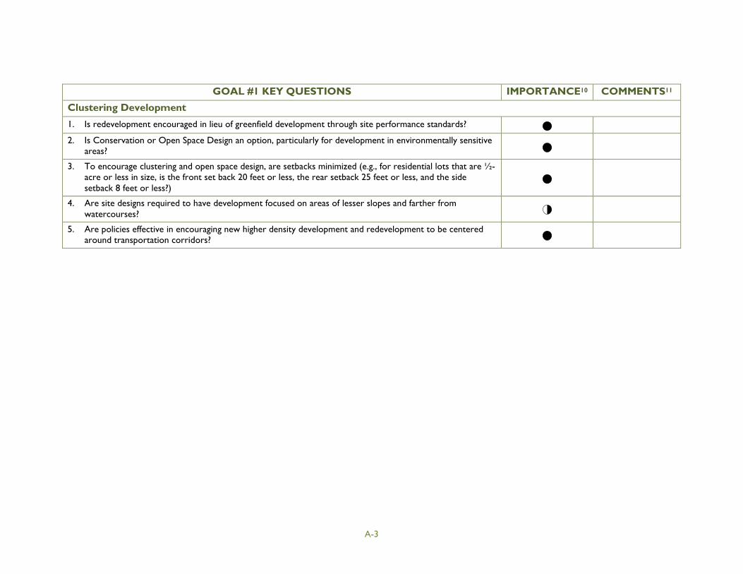
A-3
GOAL #1 KEY QUESTIONS IMPORTANCE10 COMMENTS11
Clustering Development
1. Is redevelopment encouraged in lieu of greenfield development through site performance standards?
2. Is Conservation or Open Space Design an option, particularly for development in environmentally sensitiveareas?
3. To encourage clustering and open space design, are setbacks minimized (e.g., for residential lots that are ½-acre or less in size, is the front set back 20 feet or less, the rear setback 25 feet or less, and the sidesetback 8 feet or less?)
4. Are site designs required to have development focused on areas of lesser slopes and farther fromwatercourses?
5. Are policies effective in encouraging new higher density development and redevelopment to be centeredaround transportation corridors?
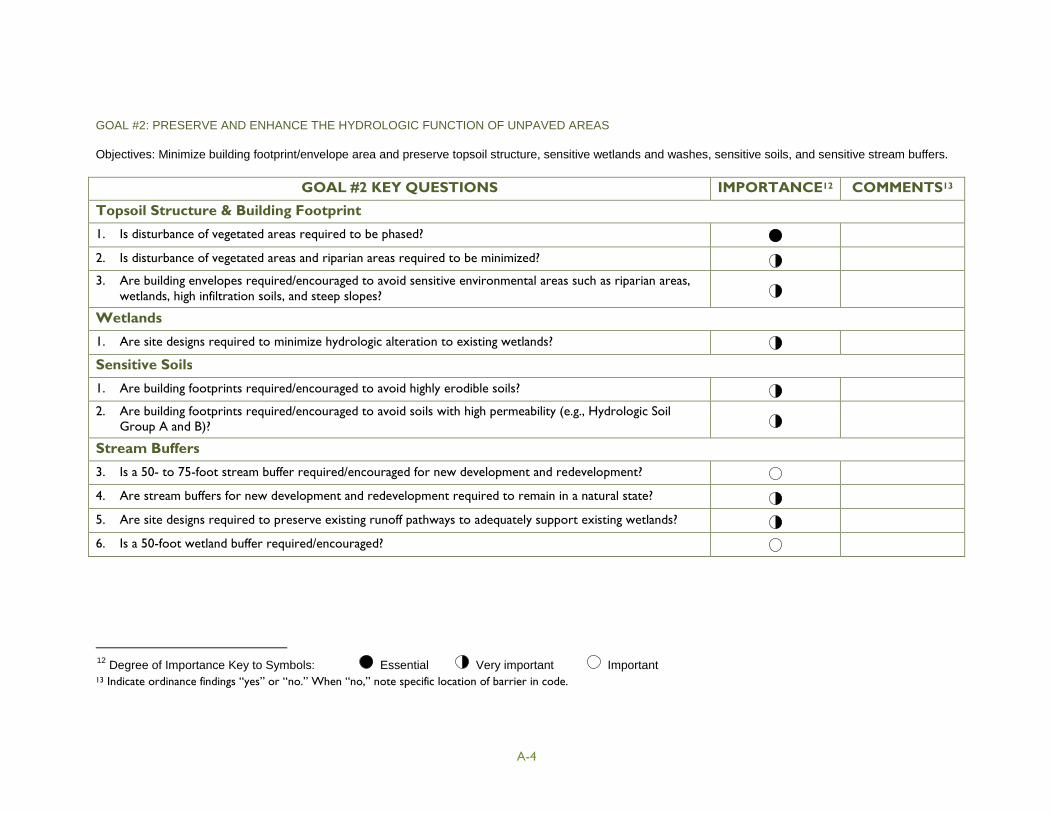
A-4
GOAL #2: PRESERVE AND ENHANCE THE HYDROLOGIC FUNCTION OF UNPAVED AREAS
Objectives: Minimize building footprint/envelope area and preserve topsoil structure, sensitive wetlands and washes, sensitive soils, and sensitive stream buffers.
GOAL #2 KEY QUESTIONS IMPORTANCE12 COMMENTS13
Topsoil Structure & Building Footprint
1. Is disturbance of vegetated areas required to be phased?
2. Is disturbance of vegetated areas and riparian areas required to be minimized?
3. Are building envelopes required/encouraged to avoid sensitive environmental areas such as riparian areas,wetlands, high infiltration soils, and steep slopes?
Wetlands
1. Are site designs required to minimize hydrologic alteration to existing wetlands?
Sensitive Soils
1. Are building footprints required/encouraged to avoid highly erodible soils?
2. Are building footprints required/encouraged to avoid soils with high permeability (e.g., Hydrologic SoilGroup A and B)?
Stream Buffers
3. Is a 50- to 75-foot stream buffer required/encouraged for new development and redevelopment?
4. Are stream buffers for new development and redevelopment required to remain in a natural state?
5. Are site designs required to preserve existing runoff pathways to adequately support existing wetlands?
6. Is a 50-foot wetland buffer required/encouraged?
12Degree of Importance Key to Symbols: Essential Very important Important
13 Indicate ordinance findings “yes” or “no.” When “no,” note specific location of barrier in code.

A-5
GOAL #3: HAVEST RAINWATER TO ENHANCE POTABLE & NONPOTABLE WATER SUPPLY
Objectives: Through plumbing code provisions, enhance rainwater harvesting and water conservation. Through the building and zoning code, allow the use ofrooftop runoff disconnection and rainwater harvesting by routing rainwater to natural and landscape areas throughout the site.
GOAL #3 KEY QUESTIONS IMPORTANCE14 COMMENTS15
Plumbing Code
1. Are interior or exterior cisterns allowed?
2. Is a BMP maintenance plan required?
3. Is harvested rainwater allowed to be used for nonpotable interior uses such as toilet flushing?
4. Are personal treatment systems allowed to be used for potable water supply?
Building and Zoning Code
1. Can rooftop runoff be disconnected and distributed throughout the site via contours and drainageways todischarge into natural areas or landscape areas?
2. Are interior or exterior cisterns allowed?
3. Can rain barrels be placed within standard zoning setback areas for new development and redevelopment?
4. Do zoning and building provisions allow cisterns to be placed on rooftops to harvest rainwater?
5. Is a BMP maintenance plan required?
14Degree of Importance Key to Symbols: Essential Very important Important
15 Indicate ordinance findings “yes” or “no.” When “no,” note specific location of barrier in code.

A-6
GOAL #4: ALLOW AND ENCOURAGE MULTI-USE STORMWATER CONTROLS
Objectives: Allow and encourage stormwater controls as multiple use in open space areas and landscaped areas.
GOAL #4 KEY QUESTIONS IMPORTANCE16 COMMENTS17
Landscaped Areas
1. Does the code and zoning ordinance allow or promote development of an urban tree canopy?
2. Are bioretention areas allowed to be constructed in the development’s designated landscape areas, ifproperly designed?
3. Are bioretention areas given “credit” as landscape area to count as a percent of the required landscaping?
4. Are landscaping plans required to consider less water-intensive, native vegetation?
5. Do landscaping requirements allow plantings conducive to bioretention, bioswales, rain gardens, and otherGreen Infrastructure BMPs?
6. Do tree planting requirements allow use of rain gardens, tree boxes, and other Green Infrastructure BMPs?
7. If irrigation is required, are weather-based or moisture-based irrigation controls required?
Open Space Areas
1. Are there open space preservation requirements or incentives for new development and redevelopment?
2. Is preserved open space required to be managed in a natural condition?
3. Are Green Infrastructure structural techniques such as constructed wetlands, swales, and bioretentionareas allowed to be constructed in a development’s designated open space, if properly designed?
4. Are Green Infrastructure structural techniques such as constructed wetlands, swales, and bioretentionareas given “credit” as open space to count as a percent of the required open space area, if properlydesigned?
5. Does protection of sensitive, natural areas and habitat qualify as credit for local open space dedication?
16Degree of Importance Key to Symbols: Essential Very important Important
17 Indicate ordinance findings “yes” or “no.” When “no,” note specific location of barrier in code.
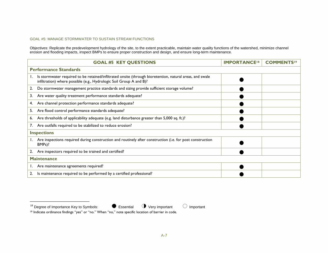
A-7
GOAL #5: MANAGE STORMWATER TO SUSTAIN STREAM FUNCTIONS
Objectives: Replicate the predevelopment hydrology of the site, to the extent practicable, maintain water quality functions of the watershed, minimize channelerosion and flooding impacts, inspect BMPs to ensure proper construction and design, and ensure long-term maintenance.
GOAL #5 KEY QUESTIONS IMPORTANCE18 COMMENTS19
Performance Standards
1. Is stormwater required to be retained/infiltrated onsite (through bioretention, natural areas, and swaleinfiltration) where possible (e.g., Hydrologic Soil Group A and B)?
2. Do stormwater management practice standards and sizing provide sufficient storage volume?
3. Are water quality treatment performance standards adequate?
4. Are channel protection performance standards adequate?
5. Are flood control performance standards adequate?
6. Are thresholds of applicability adequate (e.g. land disturbance greater than 5,000 sq. ft.)?
7. Are outfalls required to be stabilized to reduce erosion?
Inspections
1. Are inspections required during construction and routinely after construction (i.e. for post constructionBMPs)?
2. Are inspectors required to be trained and certified?
Maintenance
1. Are maintenance agreements required?
2. Is maintenance required to be performed by a certified professional?
18Degree of Importance Key to Symbols: Essential Very important Important
19 Indicate ordinance findings “yes” or “no.” When “no,” note specific location of barrier in code.
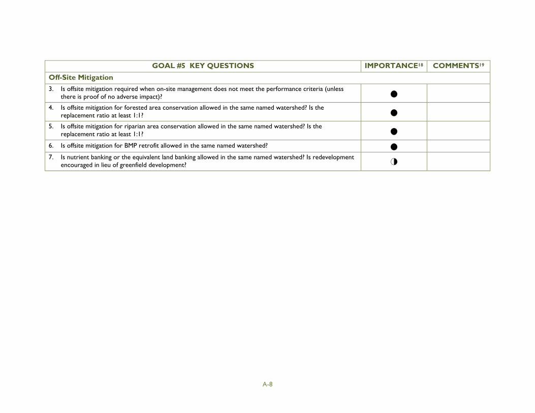
A-8
GOAL #5 KEY QUESTIONS IMPORTANCE18 COMMENTS19
Off-Site Mitigation
3. Is offsite mitigation required when on-site management does not meet the performance criteria (unlessthere is proof of no adverse impact)?
4. Is offsite mitigation for forested area conservation allowed in the same named watershed? Is thereplacement ratio at least 1:1?
5. Is offsite mitigation for riparian area conservation allowed in the same named watershed? Is thereplacement ratio at least 1:1?
6. Is offsite mitigation for BMP retrofit allowed in the same named watershed?
7. Is nutrient banking or the equivalent land banking allowed in the same named watershed? Is redevelopmentencouraged in lieu of greenfield development?