Embed Size (px)
Citation preview
GROUNDWATER AND DROUGHT MANAGEMENT IN THE SOUTHERN AFRICAN DEVELOPMENT
COMMUNITY (SADC)
COMPONENT 2
REGIONAL GROUNDWATER DROUGHT MANAGEMENT SUPPORT
Contract 003D:
Regional Groundwater Monitoring Network
Groundwater Monitoring Guidelines
FINAL REPORT
October 2011
Groundwater and Drought Management Project i
Regional Groundwater Monitoring Network-Groundwater Monitoring Guidelines, October 2011
Contents
1. THE REGIONAL MONITORING VISION ............................................................. 1
1.1 The vision .......................................................................................................... 1
1.2 The need for regional groundwater monitoring in SADC ................................... 2
1.3 Status of monitoring .......................................................................................... 4
1.4 Information needs ............................................................................................. 6
1.5 Issues and challenges....................................................................................... 7
2. OPTIONS AND CHOICES ................................................................................... 8
2.1 Regional monitoring – the issues ...................................................................... 8
2.2 Data gathering ................................................................................................ 10
2.3 Data processing .............................................................................................. 12
2.4 Data sharing – Transboundary Aquifers.......................................................... 13
2.5 Options ............................................................................................................ 14
3. NETWORK DESIGN .......................................................................................... 18
3.1 Background ..................................................................................................... 18
3.2 Integrated monitoring guidelines ..................................................................... 18
3.3 The monitoring network design ....................................................................... 20
3.4 Monitoring network objectives ......................................................................... 23
3.5 Coverage ........................................................................................................ 24
4. THE PILOT STUDY ........................................................................................... 26
4.1 Pilot Programme Summary ......................................................................... 26
4.2 Results and Lessons Learnt ........................................................................ 26
4.3 Implications for a Regional Monitoring System ........................................... 28
5. NETWORK MAINTENANCE AND THE FUTURE ............................................. 30
5.1 Basic guidelines for network maintenance ...................................................... 30
5.2 The Future – Phase 2 and beyond .................................................................. 30
Groundwater and Drought Management Project ii
Regional Groundwater Monitoring Network-Groundwater Monitoring Guidelines, October 2011
List of Figures
Figure 1 Cyclicity of rainfall – an example from Kasempa district, Zambia ................. 4
Figure 2 The Data Cycle .......................................................................................... 19
Figure 3 Scheme for designing a groundwater monitoring programme .................... 22
List of Tables
Table 1 Status of groundwater monitoring in SADC region as at 2002 ...................... 6
Groundwater and Drought Management Project 1
Regional Groundwater Monitoring Network-Groundwater Monitoring Guidelines, October 2011
1. THE REGIONAL MONITORING VISION
1.1 The vision
In large parts of the SADC region groundwater resources form critically important sources of supply both to rural and urban communities. Climate ranges from humid tropical to semi-arid and arid within the SADC region. Within this large range water availability varies from ephemeral surface waters and mainly low yielding groundwater sources to a limited number of higher yielding groundwater sources, perennial rivers and lakes. The most vulnerable areas, however, are the semi-arid savannah lands characteristic of much of the central part of the SADC region where drought has become a regular occurrence that needs to be managed rather than a crisis that leads to an emergency. With declining levels of rainfall due to climate change, periods of potential recharge to marginal aquifer systems will diminish. Demographic growth means that demand on the diminishing store of groundwater will increase. It is because of this increasing stress on the finite groundwater resources of the region that monitoring of recharge to and abstraction from the aquifers is becoming critical to the survival of local populations and of their agricultural activities. The need for monitoring to inform the management of the resource between Member States has never been so compelling. The forecasting and provision of early warning of drought depends on a regional scale ability to comprehensively and consistently monitor an agreed set of ‘drought indicators’. Evaluation and presentation of these data and information for use by Member State governments will enable timely implementation of drought mitigation and coping strategies. Underpinning this requirement are suitable data synthesis and analysis methodologies and tools such as the SADC Hydrogeology Map (see Figure 4), dynamic drought vulnerability maps, groundwater scarcity maps, surface and groundwater seasonal storage indices and other GIS-based thematic products. There is also supplementary supporting knowledge about environmental demand for groundwater within groundwater dependant ecosystems (GDEs), and of the overall value of groundwater in the national and regional economic context. All of these drought mitigation strategies are essential to achieve effective protection of the wellbeing of the respective populations. Although considerable progress has been made with drought forecasting, drought preparedness, mitigation strategies and food security, little has yet been achieved that addresses water security through the long-term monitoring of groundwater systems. People rarely die from malnutrition or thirst in a drought event, but many domestic livestock die from lack of water and, because of reduced access to clean water and decreased sanitation standards, people become more exposed to water borne disease. A significant challenge is the development of a trusting relationship between Member State groundwater resources organisations and between the groundwater resources organisations themselves. For any such regional project to be successful, Member States need to contribute willingly their data to create a comprehensive regional database to be held by the SADC Groundwater Management Institute (GMI). Member States have been encouraged to take part in developing the vision of a proposed regional monitoring process and have been given ‘ownership’ of the
Groundwater and Drought Management Project 2
Regional Groundwater Monitoring Network-Groundwater Monitoring Guidelines, October 2011
regional groundwater monitoring system. Indeed, their role in managing transboundary aquifers (TBAs) fully appreciated the complexity of TBAs, in which the international element may only be a hydraulic connection between a river with cross-border riparian rights with an aquifer which is wholly located in one member state. The next challenge is to start to develop a nucleus regional monitoring network which member states will develop to their own requirements but which will collectively report to the GMI data centre. The initial vision (the Phase 2 Objective) is of a nucleus network, with at least one monitoring site in each member state, focussing on the larger aquifers including the basement aquifer that will demonstrate the value of the data gathered on a regional scale for purposes such as drought prediction and ultimately for determination of trigger levels to action emergency strategies. The subsequent ‘fleshing out’ of the network will be the responsibility of Member States who will be encouraged to improve coverage and the density of the observation network. The ultimate vision is a network of water level and water quality gathering points reporting to a regional data centre. The centre will then be responsible for Quality Assurance (QA) of the data, preparing it within a database format and disseminating the assimilated and interpreted data back to member states. This vision is regarded as a critical step towards regional drought mitigation. It is also regarded as an important builder of trust and collaboration between member states which hitherto have shown a reluctance to share data and their own respective national experience in groundwater management. This Guidelines Report considers the options available to SADC to achieve this vision and recommends best practice practical means of achieving that vision. The Guidelines Report is intended as a record of the pilot ‘proof of method’ work undertaken within the pilot monitoring study and also as a manual that can form the basis of the Phase 2 roll out of the monitoring network at regional scale. It is not intended as a comprehensive guideline document, and reference to appropriate text books and other manuals will also be required for detailed descriptions of techniques and data gathering, and databasing techniques.
1.2 The need for regional groundwater monitoring in SADC
The Southern African Development Community (SADC) fosters cooperation and mutual benefit from the available resources within the region. Its member countries are Angola, Botswana, DRC, Lesotho, Mauritius, Malawi, Mozambique, Namibia, Madagascar, Seychelles, South Africa, Swaziland, Tanzania, Zambia, and Zimbabwe. This mutual co-operation within SADC has revealed that water is a key resource that can benefit greatly from co-operation between all member states within the SADC Region. The development and management of water resources by SADC Member States has traditionally focused on surface waters. However, increasing aridity and diminished surface resources has increased the dependency on groundwater for both domestic and commercial water needs. SADC developed a Groundwater Management Programme (GMP) in recognition of this increasing dependency on groundwater. The overall objective of the GMP is to promote the sustainable
Groundwater and Drought Management Project 3
Regional Groundwater Monitoring Network-Groundwater Monitoring Guidelines, October 2011
development of groundwater resources at a regional level, with ongoing programmes of research, assessment, exploitation and protection, with a particular emphasis on the management of groundwater resources into and through periods of drought, on drought proofing communities and on coping strategies to deal with drought. There is currently inadequate detailed information about regional groundwater resources and the transboundary nature of many of the aquifers. This makes the sustainable management and allocation of the resource systems and, in particular, the transboundary systems, difficult. The management of Transboundary Watercourses is progressing with SADC Members States helping to create and establishment several River Basin Organizations: Limpopo River Basin Commission (LIMCOM), Orange-Senqu River Basin Commission (ORASECOM), Okavango River Basin Commission (OKACOM), the Rovuma Basin Committee, and Zambezi River Basin Commission (ZAMCOM). However, transboundary aquifers (TBAs) have not yet been addressed and a programme of regional groundwater monitoring is proposed that will start to provide basic data with which to manage the TBAs and the larger regional aquifers. Another issue is that water resources managers and policy-makers are fixated on surface water, and all too often ignore the reserves of groundwater and soil water, as well as the water used to produce tradable goods as ‘virtual water’. The hydrological cycle substantially affects and is impacted by other major global ‘security areas’, which include climate change, food security, energy security – and the international co-operation required to deliver regional, state, and human security. The growing interest in groundwater by the international water, security and legal communities partially redresses the inadequacies. In the case of groundwater, unseen and often unhelpfully associated with some kind of mystical property, management cannot sensibly begin for a number of reasons. These include:
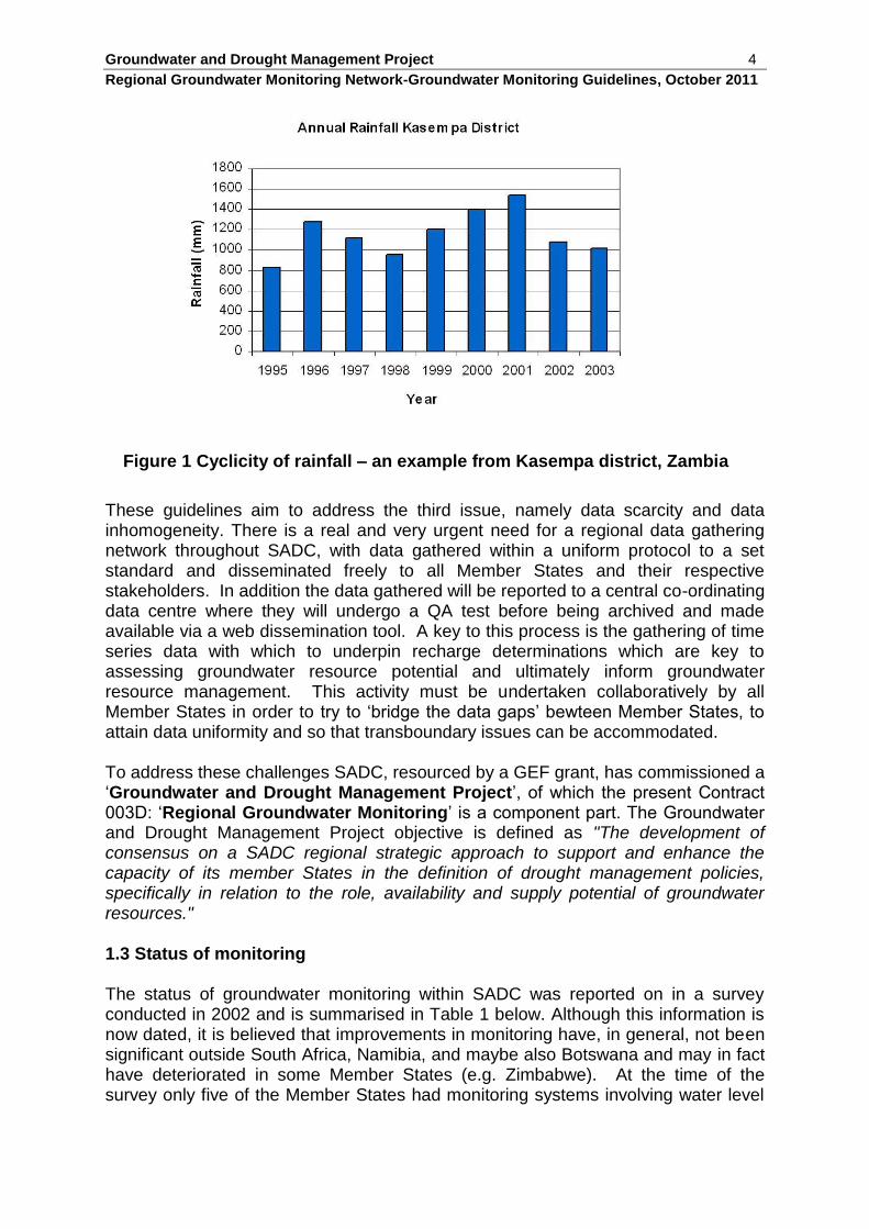
1. Water scarcity – demand exceeding resource potential with the cyclicity of season and drought periods (Figure 1).
2. Lack of a regionally accepted and co-ordinated groundwater management vision.
3. Data scarcity and data inhomogeneity between member states.
Groundwater and Drought Management Project 4
Regional Groundwater Monitoring Network-Groundwater Monitoring Guidelines, October 2011
Figure 1 Cyclicity of rainfall – an example from Kasempa district, Zambia
These guidelines aim to address the third issue, namely data scarcity and data inhomogeneity. There is a real and very urgent need for a regional data gathering network throughout SADC, with data gathered within a uniform protocol to a set standard and disseminated freely to all Member States and their respective stakeholders. In addition the data gathered will be reported to a central co-ordinating data centre where they will undergo a QA test before being archived and made available via a web dissemination tool. A key to this process is the gathering of time series data with which to underpin recharge determinations which are key to assessing groundwater resource potential and ultimately inform groundwater resource management. This activity must be undertaken collaboratively by all Member States in order to try to ‘bridge the data gaps’ bewteen Member States, to attain data uniformity and so that transboundary issues can be accommodated. To address these challenges SADC, resourced by a GEF grant, has commissioned a ‘Groundwater and Drought Management Project’, of which the present Contract 003D: ‘Regional Groundwater Monitoring’ is a component part. The Groundwater and Drought Management Project objective is defined as "The development of consensus on a SADC regional strategic approach to support and enhance the capacity of its member States in the definition of drought management policies, specifically in relation to the role, availability and supply potential of groundwater resources."
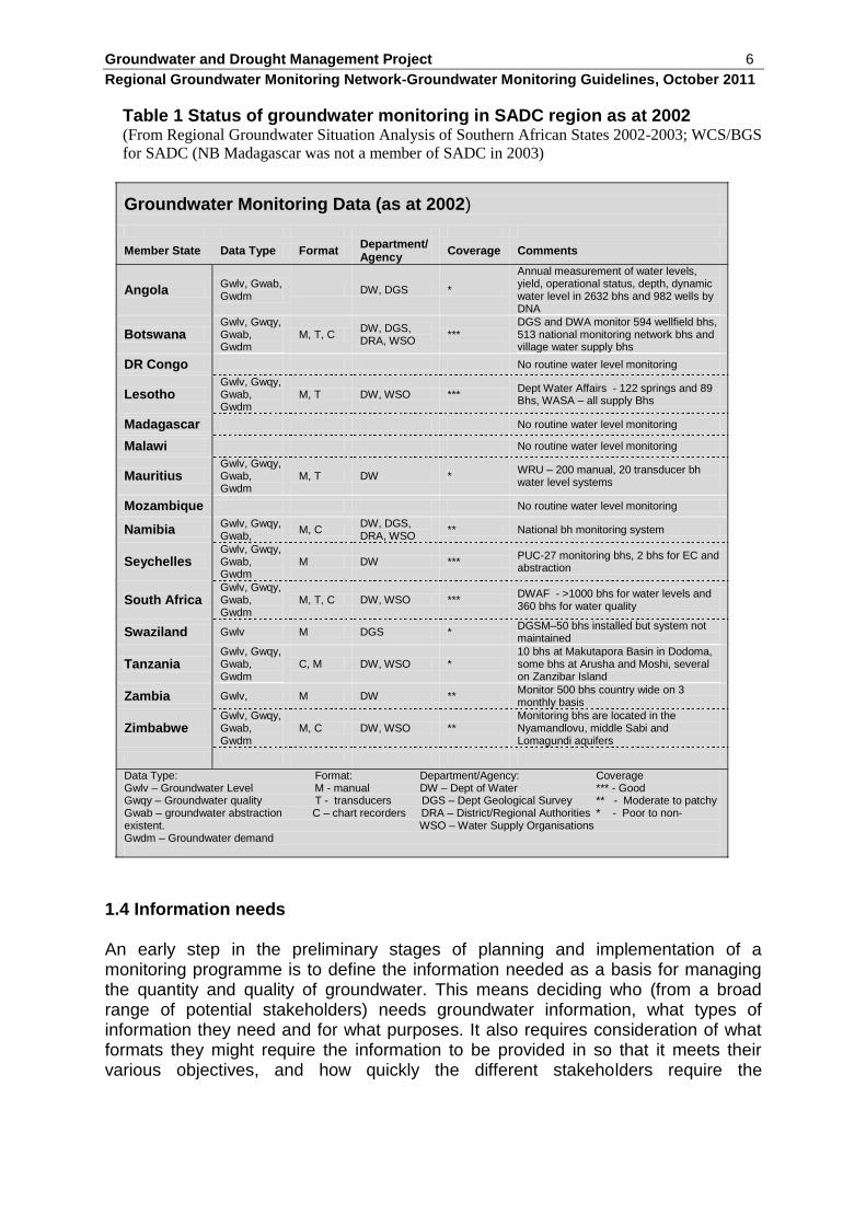
1.3 Status of monitoring The status of groundwater monitoring within SADC was reported on in a survey conducted in 2002 and is summarised in Table 1 below. Although this information is now dated, it is believed that improvements in monitoring have, in general, not been significant outside South Africa, Namibia, and maybe also Botswana and may in fact have deteriorated in some Member States (e.g. Zimbabwe). At the time of the survey only five of the Member States had monitoring systems involving water level
Groundwater and Drought Management Project 5
Regional Groundwater Monitoring Network-Groundwater Monitoring Guidelines, October 2011
and some type of water quality measurements that comprised any form of national network. Some monitoring was also carried out in the majority of the remaining Member States, but it was generally carried out by several institutions in a piecemeal fashion (with respect to both frequency and number of monitoring points) or was only carried out locally, usually for wellfields or areas of intensive groundwater abstraction. Furthermore, much of the local scale and wellfield monitoring was undertaken by private companies, water utilities or as part of specific projects with little or no data ultimately reaching the national groundwater management authority or being compiled into any form of national groundwater database. In some countries (e.g. Malawi, Mozambique and DRC) no time series hydrogeological data of any type were being collected in 2002, which is particularly significant in a country such as Malawi where groundwater is such an important resource to its rural communities.
Groundwater and Drought Management Project 6
Regional Groundwater Monitoring Network-Groundwater Monitoring Guidelines, October 2011
Table 1 Status of groundwater monitoring in SADC region as at 2002 (From Regional Groundwater Situation Analysis of Southern African States 2002-2003; WCS/BGS
for SADC (NB Madagascar was not a member of SADC in 2003)
Groundwater Monitoring Data (as at 2002)
Member State Data Type Format Department/ Agency
Coverage Comments
Angola Gwlv, Gwab, Gwdm
DW, DGS *
Annual measurement of water levels, yield, operational status, depth, dynamic water level in 2632 bhs and 982 wells by DNA
Botswana Gwlv, Gwqy, Gwab, Gwdm
M, T, C DW, DGS, DRA, WSO
*** DGS and DWA monitor 594 wellfield bhs, 513 national monitoring network bhs and village water supply bhs
DR Congo No routine water level monitoring
Lesotho Gwlv, Gwqy, Gwab, Gwdm
M, T DW, WSO *** Dept Water Affairs - 122 springs and 89 Bhs, WASA – all supply Bhs
Madagascar No routine water level monitoring
Malawi No routine water level monitoring
Mauritius Gwlv, Gwqy, Gwab, Gwdm
M, T DW * WRU – 200 manual, 20 transducer bh water level systems
Mozambique No routine water level monitoring
Namibia Gwlv, Gwqy, Gwab,
M, C DW, DGS, DRA, WSO
** National bh monitoring system
Seychelles Gwlv, Gwqy, Gwab, Gwdm
M DW *** PUC-27 monitoring bhs, 2 bhs for EC and abstraction
South Africa Gwlv, Gwqy, Gwab, Gwdm
M, T, C DW, WSO *** DWAF - >1000 bhs for water levels and 360 bhs for water quality
Swaziland Gwlv M DGS * DGSM–50 bhs installed but system not maintained
Tanzania Gwlv, Gwqy, Gwab, Gwdm
C, M DW, WSO * 10 bhs at Makutapora Basin in Dodoma, some bhs at Arusha and Moshi, several on Zanzibar Island
Zambia Gwlv, M DW ** Monitor 500 bhs country wide on 3 monthly basis
Zimbabwe Gwlv, Gwqy, Gwab, Gwdm
M, C DW, WSO ** Monitoring bhs are located in the Nyamandlovu, middle Sabi and Lomagundi aquifers
Data Type: Format: Department/Agency: Coverage Gwlv – Groundwater Level M - manual DW – Dept of Water *** - Good Gwqy – Groundwater quality T - transducers DGS – Dept Geological Survey ** - Moderate to patchy Gwab – groundwater abstraction C – chart recorders DRA – District/Regional Authorities * - Poor to non-existent. WSO – Water Supply Organisations Gwdm – Groundwater demand
1.4 Information needs An early step in the preliminary stages of planning and implementation of a monitoring programme is to define the information needed as a basis for managing the quantity and quality of groundwater. This means deciding who (from a broad range of potential stakeholders) needs groundwater information, what types of information they need and for what purposes. It also requires consideration of what formats they might require the information to be provided in so that it meets their various objectives, and how quickly the different stakeholders require the
Groundwater and Drought Management Project 7
Regional Groundwater Monitoring Network-Groundwater Monitoring Guidelines, October 2011
information. Information needs must be specified in sufficient detail so that design criteria for the monitoring and assessment system can be defined. Defining the information needs depends on the issues of concern. For the most part, the issues of concern are uncertainty over how the main aquifer systems perform under stress and whether the TBAs identified by Struckmeirer et al. (2006) are active systems which need managing or which are inactive. Knowledge needs to be enhanced in order to better manage the available resources. The key issues, water scarcity, climate change, drought vulnerability, increasing demand, groundwater mining and groundwater quality, need to be evaluated in terms of current derogation and the potential for derogation in the future. The key is the identification of what to measure and where to measure it. It is also important that the respective stakeholders understand what is being done and why the monitoring and assessment work is of importance to them. IGRAC (2008) describe the following monitoring objectives;
Related to groundwater status and development:
Provide groundwater data for (sustainable) development of the groundwater resources.
Provide data for determining the best locations for groundwater abstraction.
Provide periodical information on the actual status of groundwater for management or for publication.
Related to protection of groundwater systems and the environment:
Provide data for protection of groundwater systems from over-exploitation.
Provide data for protection of nature conservation areas from unacceptably declining groundwater tables.
Provide data for control of saline water intrusion or up-coning in aquifers.
Provide data for control of land subsidence caused by groundwater abstraction.
Provide data for protection of aquifers from contamination by diffuse sources of pollution.
1.5 Issues and challenges
The technical challenges of data gathering, archiving, processing, analysing and disseminating are relatively straightforward. Different items of hardware can be incorporated into the pilot study in order to test which are and which are not appropriate for use in the prevailing conditions. Unfortunately, however, the current project timeframe does not allow significant assessment of the monitoring system but it does achieve proof of method. It is thus fairly certain that adjustments to the monitoring protocol and to this manual may be needed in the future. It is also clear that a significant challenge for the future will be the installation and maintenance of the proposed regional monitoring network during the post-project hiatus while the GMI is established.
Groundwater and Drought Management Project 8
Regional Groundwater Monitoring Network-Groundwater Monitoring Guidelines, October 2011
2. OPTIONS AND CHOICES
2.1 Regional monitoring – the issues
There are a number of issues affecting the regional monitoring of groundwater. These not only include the physical measurement of parameters such as depth to water in a well and water quality, but also include a range of social and economic factors that are impacted by groundwater utilisation that should not be divorced from the physical monitoring activity. In addition, groundwater may be transboundary in character adding a complicating dimension to its management. The main part of transboundary aquifer analysis (TBA) is the assessment of its hydrogeological situation. In principle, application of the hydrogeological methods is the same for national and international aquifers. More internationally specific are the processes of classification and zoning of the aquifers, while data comparison and harmonisation across the border is the main technical challenge. Non-technical challenges are primarily related to other aspects of TBAs, such as the socio-economical and political situation in the border region. The assessment of shared groundwater comprises:
1) Delineation and description, inventory/characterisation.
2) Classification, diagnostic analysis and zoning.
3) Data harmonisation and information management. The classification provides stakeholders with information necessary for decision-making. This includes addressing problems that may develop and opportunities that could be forgone in the absence of co-ordinated groundwater resources development and management. The stakeholders also need to know those aquifers likely to be responsive to TBA management, and zones in these aquifers that should be targeted for highest positive impacts. Data harmonisation and information management are important in the international context. They are difficult to carry out and may be politically sensitive. At the same time, they are also an opportunity for building trust and mutual understanding among the involved parties. From an economic perspective, groundwater is a unique type of good. Some groundwater resources are continually renewed and considered as a ‘flow of goods’ while in non-renewable aquifers groundwater is a ‘stock’. From basic economic theory, groundwater is a so-called ‘common pool’ resource. This basically means that the ability to withhold potential users from appropriating and using groundwater is limited (open access) while using the resources by one user will diminish the availability of groundwater for others. Appropriation of groundwater is technically easy and groundwater abstraction may depend on the location of demand without need for storage and distribution infrastructure. The quality of groundwater is generally such that only limited treatment is needed. The availability may be subject to seasonality, allocation of the
Groundwater and Drought Management Project 9
Regional Groundwater Monitoring Network-Groundwater Monitoring Guidelines, October 2011
secure and clean source may be required on a local basis and more specifically on a shared transboundary basis. Aquifers are diffusive in nature and hence hydrogeological effects of an intervention in the aquifer at one location migrate through the aquifer to other locations. For example, groundwater pumping may derogate other users. A spillage of a toxic substance could migrate in a plume and contaminate sources down-gradient. A groundwater user at one location may affect the groundwater availability and quality at other locations and influence other users ability to source clean groundwater. When the impact is across a state border, it is apparent that the issue of such economic externalities is critical in the management of transboundary aquifer management. The notion of sustainability and concepts such as ecosystem services also provides groundwater with a non-use value. Groundwater is of great importance in sustaining ecological systems such as groundwater fed wetlands, base flow to rivers, habitat, sustaining soils and inhibiting sea water intrusion. In the socio-economic analysis of groundwater use and demand it is important to include groundwater dependent ecosystem sustainability in the countries sharing the aquifer system. Various types of ecosystems are directly or indirectly dependent on groundwater. River ecosystems are dependent on a groundwater sustained baseflow. Without this continuity most fluvial flora and fauna would not survive. Also lakes and wetlands may be totally or partly groundwater-fed. Without the groundwater influx these lakes and wetlands might dry up or have shallow water depth resulting in a change of the aquatic ecosystem. Discharging groundwater may have a specific chemical and or temperature signature that favours the development of particular terrestrial ecosystems that would not develop in other habitats. When developing groundwater resources for productive use assessment is needed of where and how much groundwater is needed to sustain the ecological functions in the area to determine what part of the overall groundwater resource is environmentally committed. The environmental aspects may not be obvious but relate to resource sustainability. Groundwater may sustain eco-systems, known as terrestrial groundwater-dependent ecosystems. Groundwater resources are thus partly environmentally committed while the aquifer may act to migrate and transform interventions in one state into hydrogeological and environmental consequences in another state. The concept of sustainability is associated with groundwater resources depletion and the possible compromising of future use. People also value the non-use recreational aspects of natural environment since it provides essential ecological services for the human society. In the environemnatl context ‘sustainability’ is based on the motivation for the preservation of the natural environment. Many human activities use water (a natural capital source) which is often non-substitutable (drinking and sanitation, watering, crop production, industrial activities). A socio-economic assessment starts with analyzing which human activities are deployed in a certain area and how much water (more specifically groundwater) is needed support it. Water use can be categorized geographically, temporally (seasonality, trends) and functionally (domestic, agricultural and industrial). Another way of categorizing water use is by prioritization (based on
Groundwater and Drought Management Project 10
Regional Groundwater Monitoring Network-Groundwater Monitoring Guidelines, October 2011
essence and substitutability). For example, groundwater use for basic survival normally has a higher priority than for food production, and groundwater use for food production is preferred over industrial use.
2.2 Data gathering
A fundamental question is ‘what to measure and where to measure it?’. The corollary to these questions is ‘how to measure it’ and ‘how to send the readings to the data gathering office’, indeed what to do with the data? There are numerous existing guideline documents that assist in both design and operation of monitoring networks (e.g. McKenzie et al., 1994; IGRAC, 2008). Mackenzie et al. (1994) suggests that SADC Member States should monitor groundwater levels in the larger aquifer units to enable management of groundwater resources and to monitor and protect those resources. To do this, groundwater monitoring networks, where present, are to be monitored and data are stored and archived so that they can be used for subsequent interrogation and analysis. The existing networks have developed in response to local demands, in ways related to geology, groundwater abstraction and ideas of how to gather and store data. This has led to differing methods used to monitor, collect and store data in different Member States. There is, therefore, a definite need for a regional strategy to standardise collection and collation of data, to ensure best practice and data collection in a cost-effective manner. Information from the 15 SADC Member States was collected by consultation with national representatives from a questionnaire and regional reports reviewing groundwater monitoring networks. This information included listings of reported monitoring sites, hydrogeology, length of record, etc. These data enabled an initial analysis of systems currently in use throughout the region. A review of the international literature was also undertaken to sample broader experience and select practices relevant to the demands for data in the SADC region. This recognised the need for a classification of groundwater monitoring boreholes common to SADC nations. This classification allows an accurate assessment of the relative effectiveness, in both scientific and financial terms, of regional monitoring programmes, and ensures that the same criteria for selection are used. The classification has three categories:
Reference or indicative monitoring sites. These sites are a subset of national networks, used to provide detailed, long-term information for resource management. These sites are located in areas away from abstraction points. They monitor natural groundwater level fluctuations.
National monitoring sites. These sites provide groundwater level data to monitor resource variations for national management of groundwater resources.
Local monitoring sites. These sites are located for specific purposes such as wellfield management, and may be considerably influenced by local abstraction processes
Groundwater and Drought Management Project 11
Regional Groundwater Monitoring Network-Groundwater Monitoring Guidelines, October 2011
Technical problems that need to be eliminated and organisational and requirements needing to be met include:
Technical deficiencies
Often monitoring wells have not been drilled specifically for data gathering and may not have been purpose-designed.
In many cases boreholes have been turned into observation wells because of insufficient productivity. In such observation wells water level measurements might not be representative of water level fluctuations in the aquifer as a whole (incorrect location of the well, wrong placement of the screens, corrosion or encrustation of the screens, etc.).
In some observation wells, the limits of the aquifer being monitored are not well defined. For example, borehole drilling may penetrate a series of aquifers that are then actually monitored in a ‘composite’ manner.
Transducer failure caused by lack of regular maintenance and problems caused by poor well construction or other technical problems leading to inaccurate measurements.
Equipment liable to be stolen or vandalized needs to be adequately protected.
Organisational requirements
Maintenance is carried out by a qualified person equipped with the necessary tools and spare parts.
The water level needs to be manually dipped at regular intervals (usually when a logger is downloaded (if manually) at, say three monthly intervals, in order to validate the logger data.
The continuity of groundwater level monitoring is important. Monitoring wells must not be converted to production wells temporarily or permanently at times of water shortage.
The incoming field data as well as the data entered in the database need to be checked.
Field reports of pumping in nearby wells, reasons for malfunction of the recorders, maintenance requirements, reasons for sudden water level fluctuations etc. need to be recorded.
Even manual measurements can be unreliable (reading errors, addition and subtraction mistakes).
What data should be collected? Following the idea of working upwards from a small beginning it is acknowledged that data gathering commences with high frequency groundwater level and, where possible, rainfall observations. This will provide indicative data for critical aquifers (initially selected TBAs in the pilot project) for which only a conceptual understanding may yet be available. Groundwater level data gathered at high frequency allows trends to be observed, diurnal and seasonal cycles to be recognised and impacts of external influences found. Measurement of rainfall allows trends to be measured
Groundwater and Drought Management Project 12
Regional Groundwater Monitoring Network-Groundwater Monitoring Guidelines, October 2011
and types of rainfall event to be observed. Comparison between high frequency groundwater level data and rainfall data allows initial estimates of recharge to be made, the delay between rainfall event and recharge to be measured, critical rainfall event and ambient conditions that cause recharge to be observed and long term changes in patterns to be recorded. As resources become available aspects of water quality can be monitored, perhaps, on wider frequency. Parameters should include total dissolved solids, pH, Eh, Dissolved O and the eight major ions: Na, Ca, Mg, K, No3, K, Cl and HCO3. These data, collected over a number of years, will provide invaluable information on the process and mechanics taking place within the selected TBAs and will go a long way towards elucidating the risk potential of cross border derogation.
2.3 Data processing
A similar process of evaluating the available options can be applied to the processing of the data once it is received at the data centre. Questions needed to be asked are:
Where should the data be collected and why?
In general data gathering should be at a focus node away from the effects of borehole pumping, within an aquifer at which a representative sample of the aquifer behaviour can be recorded along with the respective observations on socio-economic, institutional and environmental change. The location should be physically accessible to facilitae maintenance.
How should the data be archived and made both nationally and regionally available?
Manual collection option: The data are gathered manually and reported as hard copy to be digitised at the data centre. Issues – intensive in labour and risk of data loss in transit.
Automatic reporting option:
The data need to be stored twice, once in a simple format suitable for archiving (e.g. CSV) and once in a database which will be used for dissemination. Once the data are transmitted to the data centre, appropriate digital code will be used to send the data to the storage location and the back-up location. Once the data are in an external database web pages can be written that use the data in the database to display ‘live’ hydrographs on the website.
A possible methodology could be:
1) Telemetred data received by modem.
2) Raw data is saved to CSV archive backup.
3) Data is QA’d and corrected.
4) Corrected data is sent to internal and external databases.
5) Web scripts use external database to display hydrographs.
Groundwater and Drought Management Project 13
Regional Groundwater Monitoring Network-Groundwater Monitoring Guidelines, October 2011
The data management plan needs to adopt best practice for archiving, back-up, accessibility and for all adopted QA procedures. The data need to be secure so that they cannot be altered other than by the data centre. The data could be made available on a password protected web site and presented as real-time data and as daily and monthly averaged data.
2.4 Data sharing – Transboundary Aquifers
A pilot implementation of monitoring sites in one region and in one TBA will act as bilateral reference/indicative site reporting to neighbouring countries via a SADC-wide data centre. A collaborative approach between Member States will benefit neighbouring countries which strategically should pool resources needed to solve problems. To co-ordinate action, transboundary institutions need to be put in place. Institutions contain both rules and the organizations that will develop the need to comply with those same rules. Around the world, there is an enormous diversity in organizations within states that deal with groundwater management. These range from totally state-planned management with central government ministries and district-operating governmental agencies in one state to situations where groundwater management takes place locally. There are states where groundwater management is carried out by several organizations at multiple levels and in various sectors within the government, the market and the civil society. In this latter case of so-called groundwater governance (different) parts of the management are carried out by ministries, governmental agencies, companies, NGOs, users organizations and informal structures. The organizations dealing with groundwater management have a particular role with corresponding tasks, a mandate and set responsibilities. None of the organizations, however, have a mandate or jurisdiction that crosses the national borders and that is why transboundary institutionalization is a complex issue. It is the state government that is allowed to handle international and transboundary issues. However, management of transboundary groundwater by co-operation is limited to governmental level and it prevents possible solutions being found by other organizations dealing with groundwater management. There is no clear-cut solution for the institutional structure needed for transboundary aquifer management except that it needs to be context-specific and be based on the hydrogeological, socio-economic, political and socio-cultural aspects within the countries involved. There is, however, much to learn from the experiences in dealing with transboundary rivers and lakes. The Rhine Commission, for example, has more than 50 years experience. It makes sense to learn from river basin organizations and even to combine the management of internationally shared rivers, lakes and groundwater within such institutional structure. In essence, however, transboundary groundwater management institutional activities are not principally different from activities that need to be done in case of national groundwater management. The activities include in an iterative approach through:
the monitoring of the groundwater system status and dynamics as well as the groundwater use and needs,
Groundwater and Drought Management Project 14
Regional Groundwater Monitoring Network-Groundwater Monitoring Guidelines, October 2011
the development of institutional instruments (the rules) that enable that groundwater needs are met in an sustainable way,
the implementation of these instruments,
monitoring whether the implemented measures are effective,
monitoring of groundwater stakeholders compliance with the rules,
methods of dispute resolution. Some of these activities may already be carried out by individual states and their organizations dealing within groundwater management. Institutionalizing regional groundwater management should be approached as an ongoing process of social learning. In this process it makes sense to start at a low-profile and low-risk level, then ‘learn by doing’ and using that knowledge to develop a process for dealing with more complex issues. It seems logical to start this process with the exchange of ideas and information on low-profile issues by non-political stakeholders like scientists and groundwater system researchers. Then in the following phases an exchange of more sensitive information could be organized and the monitoring carried out cooperatively or at least coordinated multi-laterally. In subsequent phases the activities of monitoring, problem identification, solution generation, implementation and even compliance monitoring should increasingly by carried out in a cooperative or even joint fashion. To this end, it is sensible to start with the physical aspects of groundwater resources and ultimately work towards role of the proposed SADC Groundwater Management Institute. Groundwater management, either in the national or the international context, is about making informed decisions. Informed decisions can only be made by using relevant and up to date information based on collected and analyzed ‘groundwater data'. Transboundary aquifer resources management should prioritise the generation of this information based on internationally accepted standards and make it accessible in a uniform and transparent way. Special effort should be placed in delivering information symmetrically to all stakeholders via various channels and at various platforms taking into account the different perspectives of the various stakeholders. One of the most complicating factors is the large number of individuals on the ground who determine the status of a groundwater system. That large number makes monitoring of the groundwater use and the users complicated and costly. Hard monitoring data are, therefore, essential prerequisites to implementing any form of transboundary governance.
2.5 Options
Monitoring options need to be assessed in terms of manpower and cost, potential for introducing data loss and errors, time delay between collection and assimilation and the need to end up with a digital database that can be interrogated. The options can be divided between the physical monitoring measuring options and the data reporting, assimilation, processing and dissemination options. Physical monitoring options
Water level
Groundwater and Drought Management Project 15
Regional Groundwater Monitoring Network-Groundwater Monitoring Guidelines, October 2011
Electronic dipper – a graduated tape containing wires to a sonde that in contact with water causes an audible sound or switches on alight. Depth to water level is read off graduated tape to datum such as top of borehole casing.
Rope and weight – lower until weight is immersed, mark point on rope adjacent to measuring datum, raise and measure distance between datum mark and wet rope.
Tape measure and chalk – rub chalk along tape measure. Lower end of tape into water, note reading adjacent to measuring datum, raise and subtract reading at the point where the chalk has been removed by contact with water.
Automatic digital recording pressure transducer – provides real time measurement of head above the transducer which is converted into water level. Some types of transducer need correcting also for barometric pressure measured in a similar transducer but left in the air column near surface in the well or borehole. Needs periodic calibration with manual measurement.
Water quality
Well head measurement of specific electrical conductance, pH, Dissolved O2 and temperature can be made manually from a pumped sample with guidance from equipment manuals.
Determination of major ion concentrations (Na, Ca, Mg, K, HCO3, Cl, NO3, SO4) are best done in the laboratory from a manually collected bailed sample. Sampling protocols vary between laboratories and with determinands required.
Sampling for biological assay can only be done manually and samples need to be taken immediately to the laboratory.
Automatic digital recording measurements of groundwater temperature and specific electrical conductivity are made using specific sondes positioned below the water table for. Water temperature is normally recorded on head transducers designed primarily to measure water level.
Rainfall
Standard raingauge and measuring flask. Need to be manually read every day during rains and kept clean. Careful siting is needed away from buildings and trees.
Automatic digital rain event recorder – the tipping bucket recorder. This automatically records the date and time that a specific volume of rainwater has been received – i.e. when each of a pair of balanced buckets is filled, tipped and emptied.
Evaporation and evapotransporation
Evaporation pan can be used to measure open water evaporation manually.
Groundwater and Drought Management Project 16
Regional Groundwater Monitoring Network-Groundwater Monitoring Guidelines, October 2011
Evaporation can be determined from an automatic weather station and reported digitally.
Human indicators
Indicators of community wellbeing include incidence of stomach ailments, cattle ownership, capability to trade etc. These need to be counted and reported as hard copy.
Status of groundwater abstraction equipment – needs to be manually recorded and reported.
Groundwater level trends can be used to indicate onset of drought to indicate when appropriate change in social and agricultural behaviour can be undertaken to mitigate detrimental effects.
Data reporting assimilation, and data storage and dissemination options:
Data submission
Hard copy sent by post, or transmitted by phone or email. Labour intensive, risk of errors or total loss.
Digital downloading of automatic equipment to notebook computer taken to site. Fool-proof but labour intensive.
Telemetric reporting of automatic recording data directly to a data receiving centre by cell phone, satellite or web link.
Data assimilation
Enter hard copy and verbally reported data into database. Labour intensive and liable to introduced errors.
Manually downloaded data on notebook field computer needs to be transferred to central database. Risk of data loss.
Digital data transmitted to modem and directly assessed by data sorting code as listed data in database able to carry out QA procedures for recognition of data out of range.
Data processing
Digital processing and graphing, running means etc.
Data dissemination
Manual presentation as hard copy.
Download via password protected web-link via telephonic links to remote computers.
The options available suggest that groundwater level, groundwater temperature, groundwater specific electrical conductance and rainfall event quantities (as well as any automatic weather station output) can best be measured using automatic reporting equipment and reported digitally directly to a data centre. Some form of
Groundwater and Drought Management Project 17
Regional Groundwater Monitoring Network-Groundwater Monitoring Guidelines, October 2011
ground maintenance, equipment calibration and data verification are, however, still needed on aperiodic basis. The options for all other data, including water quality and community wellbeing, need manual determinations reported as hard copy or converted to a digital report for onward transmission to the data centre. Reporting by hand is not favoured as it is both labour intensive and liable to create data errors and losses. Automatic digital reporting to the data centre is clearly a viable option. All data need eventually to be entered into a database for assessment, QA and evaluation before they can be presented graphically in a variety of formats and delivered to the user. Delivery can either be hard copy by hand or web based dissemination in a form that can be interrogated by the data user. The data user is key to evaluation options and the user community needs to be asked what data they need and in what form. To date the response has been almost entirely in favour of a web delivered data system backed by the data store and with a user friendly front end.
Groundwater and Drought Management Project 18
Regional Groundwater Monitoring Network-Groundwater Monitoring Guidelines, October 2011
3. NETWORK DESIGN
3.1 Background Given consent and guidance of Member States a network can be designed and installed that satisfies both regional inter-state needs and enhances national understanding of water resource and its potential to support abstraction and sustain ecosystems. That system should be based on three discrete scalar components comprising:
Local maintenance – periodic validation of measurements by manual observation, cleaning and security.
Regional gathering of data by telemetry to a central institution owned by the SADC member states and dissemination of value added data to Member States.
Bilateral management of shared groundwater units with guidance from a central institution.
The system should be operationally effective, long-lasting and able to provide reliable and consistent data into the future; a groundwater monitoring system thus should have the following characteristics:
Comprehensive – needs to spatially sample the key aquifer zones with sufficient density of sampling points in order to be able to determine both baseline (‘natural’) variations as well as anthropogenic impacts (e.g. abstraction, quality degradation, etc.).
Robust – needs to comprise robust and reliable monitoring equipment capable of operating without operator intervention in remote areas for long periods of time. Should be telemetry based for interrogation and real time acquisition of data if possible.
Operator ‘Friendly’ – needs to be easy to maintain and operate, with standardised spare parts and easy removal. Also should be easy to download in the event of telemetry failure – avoidance of data loss.
Integrated – should be fully integrated into any existing national groundwater monitoring system network. It also needs to be integrated into the proposed regional network, and if feasible into an existing data telemetry system such as HYCOS to minimise development requirements.
Cost Effective – since the requirement for groundwater monitoring is not well recognised by financial planners it is essential that any new network should be as cost effective as possible (i.e. minimum cost without compromising reliability, data quality and operational aspects).
3.2 Integrated monitoring guidelines
How should the data be evaluated and utilised?
Groundwater and Drought Management Project 19
Regional Groundwater Monitoring Network-Groundwater Monitoring Guidelines, October 2011
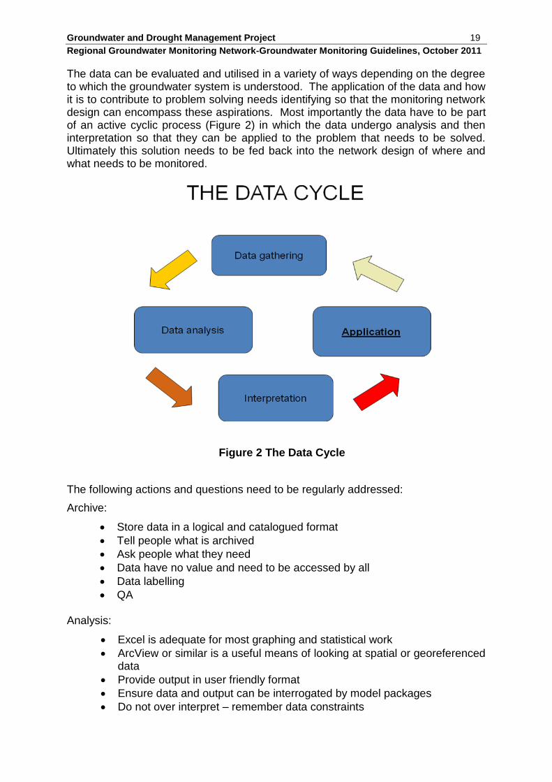
The data can be evaluated and utilised in a variety of ways depending on the degree to which the groundwater system is understood. The application of the data and how it is to contribute to problem solving needs identifying so that the monitoring network design can encompass these aspirations. Most importantly the data have to be part of an active cyclic process (Figure 2) in which the data undergo analysis and then interpretation so that they can be applied to the problem that needs to be solved. Ultimately this solution needs to be fed back into the network design of where and what needs to be monitored.
Figure 2 The Data Cycle
The following actions and questions need to be regularly addressed:
Archive:
Store data in a logical and catalogued format
Tell people what is archived
Ask people what they need
Data have no value and need to be accessed by all
Data labelling
QA
Analysis:
Excel is adequate for most graphing and statistical work
ArcView or similar is a useful means of looking at spatial or georeferenced data
Provide output in user friendly format
Ensure data and output can be interrogated by model packages
Do not over interpret – remember data constraints
Groundwater and Drought Management Project 20
Regional Groundwater Monitoring Network-Groundwater Monitoring Guidelines, October 2011
Use:
Do data gathered satisfy objectives?
Are all data relevant?
Are frequencies satisfactory?
Is data density satisfactory?
Are data limitations acceptable?
Are data and analyses cost effective?
Are the analyses getting to the users?
Is the monitoring feeding management and policy?
Review:
Periodic review to ensure data are: o Satisfying objectives, i.e. for management o Cost effective o Of required quality o Proper QA o Revision needed as situation changes, so needs and priorities
change o Is there an easier way of doing it?
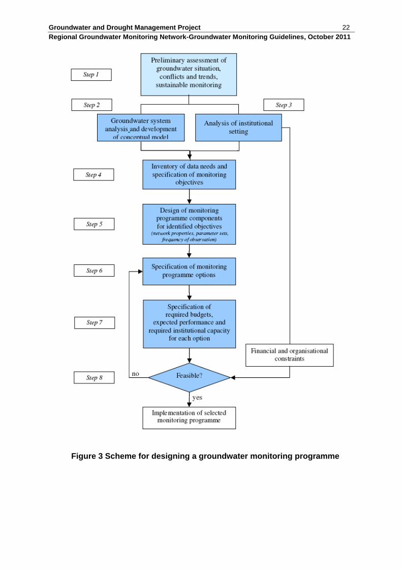
3.3 The monitoring network design IGRAC (2008) describe an idealised eight stage design procedure for a monitoring network (Figure 3).
Step 1: Preliminary assessment of the groundwater situation, the problems and trends as well as the size of a sustainable groundwater monitoring programme
This step helps to evaluate whether systematic groundwater monitoring is going to be worthwhile and defines what the objectives and scope of the monitoring programme should be. The activities are aimed at providing a rapid overview of the groundwater situation, the problems and key issues for monitoring.
Step 2: Analysis of the groundwater system and development of a conceptual model
This step involves analysis of the groundwater system (aquifer and flow systems) and the preparation of a conceptual model based on the available hydrogeological and hydrological information and understanding. The conceptual model provides the technical framework for the groundwater monitoring network design while groundwater quality data, if available, should be used to inform the framework.
Step 3: Analysis of the institutional setting
This step concerns an inventory of the institutions involved in groundwater exploitation, management and protection as well as analysis of their roles, mandates, tasks and related budgets and manpower. This evaluation provides an understanding of the scope and limitations related to extending or improving groundwater monitoring.
Groundwater and Drought Management Project 21
Regional Groundwater Monitoring Network-Groundwater Monitoring Guidelines, October 2011
Step 4: Inventory of data needs and specification of monitoring objectives
The inventory of data needs includes all the users of groundwater data and their individual data needs. Monitoring objectives may include provision of data for assessment, development, use, management and protection of groundwater resources.
Step 5: Design of groundwater monitoring programme components for identified objectives
This step concerns analysis of the monitoring objectives and translation into components of the monitoring programme. Each monitoring objective leads to a monitoring component with its own specific requirements (area to be covered, preferential network set-up, parameters needed, frequency of sampling, etc.). By bringing the components together in a scheme, the various functions and needs of the monitoring programme will become apparent.
Step 6: Specification of monitoring programme options
It is good practice to consider a limited number of possible monitoring programme options, for instance with increasing level of complexity but constrained by the available resources. Options may differ with respect to the scope of the programme, the area covered or the properties involved (e.g. network density, frequency of observation, etc.). Specification of the options to be considered should be done in consultation with representatives of the institutions responsible for groundwater management and monitoring. The details should be clearly specified in maps and/or tables.
Step 7: Specification of required budget, expected performance and necessary institutional capacity for each option considered
To prepare for the selection process, requires analysis of each monitoring programme option:
a) Calculation of investments and annual costs involved in the monitoring programme;
b) Description of the information level expected (areas covered, objectives covered, estimated accuracy, etc). Strengths and weaknesses should be indicated;
c) Analysis of institutional capacity and human resources needed and of possible limitations.
Step 8: Evaluation of feasibility and selection of best monitoring programme option
This step includes evaluation of the feasibility of the monitoring programme options on the basis of the information resulting from Step 7 and selection of the best monitoring programme option for implementation. New options may have to be specified (Step 6) and analysed (Step 7) if none of the programme options considered turns out to be feasible or worthwhile.
Groundwater and Drought Management Project 22
Regional Groundwater Monitoring Network-Groundwater Monitoring Guidelines, October 2011
Figure 3 Scheme for designing a groundwater monitoring programme
Groundwater and Drought Management Project 23
Regional Groundwater Monitoring Network-Groundwater Monitoring Guidelines, October 2011
3.4 Monitoring network objectives The objectives of the monitoring network include:
Calculation of recharge and aquifer reaction to rainfall events.
Identification of trends in groundwater quantity, quality, demand etc.
Development of baseline information.
Spatial distribution of groundwater parameters.
Development of early warning mechanisms with respect to drought, climate change, over abstraction etc.
Variation of specific quality parameters relating to anthropogenic impacts.
In the first instance it is only the first three objectives that will be addressed, the others can build upon these as resources and the will to share on a regional scale develops. For example, annual sampling of groundwater at monitoring points can commence as funds are made available, with well-head tests and analytical results forming a long term time series of data. These data all contribute to baseline knowledge of the aquifer and all will allow long term trends to be identified which may connect with phenomena such as climate variability, drought cycles, change in demography or land use, etc. Spatial distribution of groundwater parameters is scale dependent and the usefulness of the baseline data so derived depends on the distribution of the monitoring points. It is unlikely, given the regional scale of aquifers within SADC, that this objective will be achieved in the foreseeable future. The scale dependency is important when considering regional scale observations and what they mean in terms of local scale impact. The overall scale can be summarised: Continental → Regional → National → Aquifer unit → Catchment → sub-catchment While the local scale comprises: Wellfield → Group of wells (e.g. village scale) → Isolated well (e.g. cattle station) Development of an early warning scheme, for drought for example, is an important objective which essentially justifies investment in the monitoring programme. Within each topic area a set of triggers can be devised which trigger an alarm to a developing situation, be it the onset of periodic drought conditions, long term decline in effective rainfall as a result of climate variation, groundwater mining, groundwater pollution, loss of terrestrial groundwater dependent ecosystems, etc. As triggers are set off in any group of monitoring sites, so the potential danger area becomes broader and the severity of the impending situation can be assessed. Mitigating measures and coping strategies can then be implemented accordingly. The final objective is perhaps the most difficult. Although water quality analysis in Objective 2 will identify elevated nitrate concentrations, other nitrogen species and organic pollutants will not be monitored. Organic pollutants, in particular, are expensive to sample and analyse and, unless there is knowledge of which pollutants
Groundwater and Drought Management Project 24
Regional Groundwater Monitoring Network-Groundwater Monitoring Guidelines, October 2011
to look for, can be ineffective. Organic pollutants should only be included if a known product used in agriculture or an industrial spill is involved. Microbial assay is also expensive, but periodic tests for faecal coli and other pathogens should be carried out at intervals. Again, trigger levels can be set based on the WHO guideline levels of ions, compounds and microbial populations in drinking water. Given the objectives of the monitoring programme a balance needs to be attained between these objectives and cost. It is normal to focus work on problem areas and those areas where demand is greatest (see South African example, Figure 4). This is the more so in water quality monitoring where frequency of sampling, density of sampling points and selected analytical determinands collectively amount to significant commitment and significant expenditure. In the first instance it is preferable to install conductivity monitors that can be downloaded through a telemetric system with periodic manual checks on specific electrical conductance. 3.5 Coverage The data requirements need to translate into a physical monitoring network that incorporates establishment and density of the network, selection of parameter sets and frequency of observation. Of key importance is the network density. The choice of a monitoring network depends on the variability of the parameter data to be observed. If the spatial variability of a measured parameter is high (significant correlation between the records of observation points only exists over short distances) monitoring points will only yield locally representative values. If the spatial variability of data is low, monitoring points can be representative for a larger area beyond the observed data. As a general rule producing a reliable spatial image of locally representative parameters requires closely spaced monitoring points. Collection of such locally representative data from a widely-spaced network can, on the other hand, only be considered as random samples from a large population, which may not produce a representative picture. A widely spaced network may not produce a statistically reliable picture. If locally representative phenomena with a high degree of variability need to be studied, a specially designed local network with sufficient density is the best option. If the investigations are intended to cover a larger region then selected pilot areas with such specially designed local networks are the favoured option. It is this route that this project will pursue. Individual monitoring points in a large aquifer are called ‘indicative points’. These are only representative for the response of a part of the larger groundwater system to the stresses upon it. An ‘indicative point’ is a snapshot of the groundwater system under stress and it is indicative of the overall behaviour of the system, and groundwater managers thus receive characteristic information on the actual status of the system and are alerted to possible trends. This information makes it easier to start planning further development or mitigation if the system is in danger. However, for greater development of large groundwater systems, indicative monitoring points are not sufficient and a denser distributed network of points will be needed. Nevertheless, at this early level of network development, ‘indicative points’ are valuable and are to be recommended. Besides, as networks grow the density usually increases towards a better distributed network.
Groundwater and Drought Management Project 25
Regional Groundwater Monitoring Network-Groundwater Monitoring Guidelines, October 2011
In order to build on the current understanding of each of the SADC major aquifers and TBAs it is first necessary to bring together all the available data and knowledge. This should incorporate geological, hydrogeological, socio-economical, environmental and institutional information. Review and assessment of this knowledge needs to be carried out to identify areas of data scarcity that constrain the proper management of any groundwater unit in order to target better data collection. Almost without exception, time series water level and water quality data will be absent or lacking. It is very apparent that these are two parameters that need to be tackled as a priority for groundwater monitoring and will greatly add to knowledge and understanding of the larger groundwater units in the SADC region. The network design will take into account:
The distribution and extent of strategic TBAs.
The siting and distribution of monitoring sites to ensure representativeness.
The number or density of monitoring sites and the controlling budget.
The integration of regional reference sites into national monitoring networks.
The technical requirements for data collection and storage (i.e. monitoring hardware and software; telemetry etc.) applicable in a regional and national context.
The operational sustainability of a regional network by individual Member States and/or SADC GMI is an important part of the design. This includes security of equipment against theft and vandalism, frequency of maintenance, minimal operational manpower, user friendly data access, etc. The design needs to be such that it can be organic and grow both in density and coverage as well in the number of observed parameters. The supporting database needs also to be able to cope with expansion of parameters as well as numbers of monitoring sites. The initial emphasis at the pilot stage has been on coupled monitoring sites on each side of a national border within a single transboundary aquifer. Emphasis has been given to monitoring TBAs following their identification and subsequent highlighting on the SADC Hydrogeological Map. Subsequent investigation of the TBAs (Wellfield, 2011) shows that few are active and only two of the cited TBAs may cause possible concern in future years regarding cross-border derogation. Both of these TBAs are to be instrumented, one as pilot to this study and one as a parallel World Bank funded project. However, as TBAs are no longer, for the most part, seen as a threat to good neighbours, it is considered appropriate that going forward the TBA emphasis be downgraded and that the proposed regional monitoring network focused instead on the larger and more productive aquifers within the SADC region.
Groundwater and Drought Management Project 26
Regional Groundwater Monitoring Network-Groundwater Monitoring Guidelines, October 2011
4. THE PILOT STUDY
The pilot study component of the project was undertaken essentially to field test the concept of utilisation of proprietary borehole water level data loggers coupled to a satellite data transmssion system so as to facilitate data gathering and data capture into a central data storage node. This database node was then configured to automatically QC the incoming data, as well as to provide data and a number of processed outputs to a website to be accessed by regional users. The following provides a summary of the pilot programme together with the results and possible implications for a regional groundwater monitoring network. Full details of the pilot programme are contained in Annex A.
4.1 Pilot Programme Summary
The pilot programme was established on the Eastern Kalahari/Karoo aquifer which traverses Botswana and Zimbabwe. Two groundwater monitoring sites were installed in the Maitengwe Wellfield in Botswana. These utilised a system which could be operated independently of local services using solar power and satellite telemetry. The equipment was enclosed within locked weather-resistant and vandal-proofed cabinets which were attached to the boreholes using universal mounting clamps. The equipment for two further boreholes is awaiting deployment.
Pressure transducers are incorporated into the system to measure groundwater level, temperature and, at one site, specific electrical conductance (SEC). These data are requested by a surface logger on an hourly or 2-hourly basis where they are stored whilst awaiting successful transmission using the Iridium short burst data (SBD) service. In the event of long-term communication difficulties or damage to the surface equipment, all pressure transducers were initialised manually to ensure a complete backup of all groundwater parameters onsite. The internal capacity of the transducers will hold at least 10 years data at the 2-hourly defined frequency.
The data from these sites are transmitted across the Iridium satellite constellation and eventually stored in raw format in a SQL server database in Johannesburg which is operated by AST. Thereafter, a local server in Wellfield Consulting (Gaborone) runs a query which obtains all new field data and stores it internally within a MySQL database and on a further remote MySQL database hosted on the web. Consequently, complete duplicate datasets are held within three secure databases in three different locations.
The data can be accessed locally using a data portal on the Gaborone server or via a project website (http://transboundary.oomodels.info), which access their respective MySQL databases. All data are processed and quality checked on each user request for information from either interface. The website includes a graphical package to allow the user to view and manipulate real-time and historical data. All raw and processed data can be downloaded from the local server or the website in CSV format. Moreover the metadata from each site are also available on the website. 4.2 Results and Lessons Learnt
The pilot project has demonstrated that data can be gathered remotely and transmitted successfully to a data centre for assimilation and preparation for web-based dissemination. The tenure of the project has so far not allowed comparisons
Groundwater and Drought Management Project 27
Regional Groundwater Monitoring Network-Groundwater Monitoring Guidelines, October 2011
to be made between the different types and makes of water level transducers that have been installed, although this will become apparent post-project as monitoring continues to report to the computer held currently at the Wellfield Consulting Services office in Gaborone. In the meantime, a number of lessons have been learnt which will be useful to inform the role out of the regional Phase 2 programme anticipated for the future.
A key lesson learnt is the role of Government in locating appropriate and secure borehole sites which can be adopted for monitoring purposes. The involvement of the Department of Water Affairs was vital both in site selection and in maintenance of site and field equipment in Botswana and this is likely to be the case elsewhere as well. Experience in Zimbabwe was different where sites were identified on a farm that neither had good security nor any Government agency to maintain them.
Another key lesson learnt is that site installation is expensive in mobilisation and man-power, and a well thought through protocol is needed to ensure a completely successful installation. Therefore it is recommended that a full check of the system is undertaken immediately after installation, which ideally requires a surface logger that can be interrogated onsite. Otherwise, returning to a remote site to modify settings or the setup is an expensive option.
The site installation comprises a narrow metal box-tower sitting over the monitoring borehole. Painted yellow with danger stickers visible, the towers will attract attention whereas a neutral muted coloured structure might not. Hopefully the danger stickers will provide adequate protection from curiosity. However, the towers are no higher than chest height and hands can easily get at the solar power unit on top of the tower. A higher tower perhaps 2 m or more in height would place the solar panel unit out of reach. Additionally, the solar panels should be made flush with the top of the cabinet so making them more difficult to remove.
Dipping the monitoring holes is difficult and bailing them to acquire a sample is impossible. This is because of the square mounting bracket used for the cabinets which limits access to the borehole. The well caps should be completely removed in future if these brackets are used again as the dip hole in the borehole top is too small for access.
The memory on the onsite logger in the surface telemetry box is insufficient and it cannot be interrogated onsite. If there is a communication failure, it has only 2.5 days available memory during which time the site needs to be accessed and the fault rectified. The downhole transducer loggers have backup capacity, but bringing them to the surface, downloading, then manually sorting all the data is difficult, and really should never be necessary.
The pilot system has only one-way communications to the monitoring sites. It is not possible to do anything remotely, e.g. change measurement frequency, request instant readings. For future development remote interrogation and site control could be a big time and money saver.
The Pilot Study has highlighted the need for careful and thorough investigation of potential monitoring sites before any installation is considered. A potentially useable site should be:
As secure as possible from public scrutiny and access
Supported by a Government Agency, such as Department of Water
Groundwater and Drought Management Project 28
Regional Groundwater Monitoring Network-Groundwater Monitoring Guidelines, October 2011
Unaffected by local abstraction regimes ie not within a wellfield area
Accessible for periodic maintenance and measurement validation
The potential monitoring site investigation should include both discussions with Government Agency’s as well as detailed field reconnaisance in order to rank available sites according to suitability so that the optimum monitoring points can be located.
4.3 Implications for a Regional Monitoring System
The pilot project has successfully demonstrated automated real-time groundwater data collection, transmission, data processing and website dissemination from remote locations. It has therefore clearly indicated the potential to use a system of this nature to monitor groundwater across the SADC region.
The regional monitoring network will only succeed with the collaboration of Member State agencies such as Departments of Water. This was apparent in the different attitudes towards site selection and maintenance of equipment received from the relevant groundwater management agencies in Botswana and in Zimbabwe. In the event, installation of the equipment in Zimbabwe was not carried out during the tenure of the project despite the equipment being available and tested in Gaborone by the end of October. This was because of logistical problems and difficulties over importing equipment into Zimbabwe, exacerbated by the fact that Zimbabwe Customs were temporarily unable to process imports.
Going forward it is clear that an issue will be the acquisition of equipment for and by each Member State in the Phase 2 roll out. This may best be done by holding a central pool of ‘SADC’ equipment which can be drawn down in accordance to an agreed allocation by each Member State so as to avoid issues regarding individual national import taxes and other duties. Similarly, a central ‘pool’ of essential spares and facilities for provision of maintenence may be necessary and could play a major role in the ‘sustainability’ of the regional monitoring system.
The Phase 2 project will also definitely need to facilitate site investigation and selection as well as installation in each Member State to ensure standardisation of installation and conformance to regionally agreed specifications.
The telemetric linkage and data flow may be improved if direct communication with the satellite communications system could be achieved, rather than a series of intermediary links such as the current linkage to Pretoria. Once a larger (Phase 2) network is rolled out and a central data centre (at the GMI) is established the data centre should be equipped with this direct communication.
The processing and assembly of charted data into a web-based data base has worked well during the pilot programme despite some initial teething problems. These, however, were overcome by rewriting data handling and processing script to overcome errors that had arisen and the pilot system is now working well.
In the less remote locations, GPRS/GSM telemetry using the mobile phone network could be considered rather than satellite communications, as this would minimise data transmission costs and reduce power consumption to a level where battery operation would be feasible. However, considerable caution should be exercised when assessing this option due to the relatively unreliable and discontinuous nature

Groundwater and Drought Management Project 29
Regional Groundwater Monitoring Network-Groundwater Monitoring Guidelines, October 2011
of cell phone networks over much of the SADC region, and for reliability satellite communications is considered the best option.
Groundwater and Drought Management Project 30
Regional Groundwater Monitoring Network-Groundwater Monitoring Guidelines, October 2011
5. NETWORK MAINTENANCE AND THE FUTURE
5.1 Basic guidelines for network maintenance
A key to the basic maintenance and future development of the regional scale monitoring system is the engagement of the Member States. This not only includes the strongly groundwater dependent states in the semi-arid savannah plateau areas but also those States better endowed with surface water resources.
The physical maintenance of the monitoring system depends on both ground personnel to maintain field equipment and transmission systems and on the activities of the central data centre - which is expected to be situated at the SADC GMI. Ground personnel will also need to validate data gathering by periodically measuring groundwater level, water specific electrical conductance and temperature by hand and reporting to the data centre.
The data centre needs to continue to process incoming data, QA the data, process them and present them in chart form for web-based dissemination. At the same time the data centre need also to be promoting the value of the data by presenting examples of existing long term data sets within the SADC region which illustrate the onset and passage of drought.
All these activities require resourcing and a first step towards this is to identify a potential funding agency and apply for the resources needed to continue the work that has only now begun with the present Pilot study project. To this end a draft ToR will be prepared within the scope of the Pilot Project to be used as the basis of this submission.
The Pilot Study has proved the concept of the regional scale monitoring system and has proved the concept of using automatic transducers and satellite communication to gather the data. The success of the pilot project processing and data presentation work has also proved the concept of semi-automatic web-based data dissemination.
5.2 The Future – Phase 2 and beyond
The pilot phase project has developed a proof of method that can be rolled out across the SADC region. The next challenge is to establish a network of observation points that encompasses all the Member States so that each country has at least one observation point recording on a significant aquifer on which people are dependent for supply. This is the Phase 2 project which is scheduled to commence in 2012. The purpose of this simple regional network is to engage Member States and to demonstrate the value to them of regional scale data gathering. Among the planned demonstrations will be illustrations of the role of long term groundwater level data in predicting the onset of drought and using those data to determine trigger levels at which an agreed set of emergency actions can be implemented. These may differ from state to state, DRC, for example, is unlikely to suffer groundwater drought, whereas drought is almost endemic in the semi-arid savannah lands to the south.
The humid tropics, will, however, benefit from long term water quality data. Measurement of specific electrical conductance and temperature will provide
Groundwater and Drought Management Project 31
Regional Groundwater Monitoring Network-Groundwater Monitoring Guidelines, October 2011
warnings regarding potential change to the chemistry of the groundwater in a monitoring borehole. Change in either parameter may indicate dewatering of a shallow permeable layer, onset of anthropogenic pollution or some other element of change.
Together, long term water level, specific electrical conductivity and temperature data are valuable indicators of change. The demonstration to Member States and their stakeholders will include the use of trends and ranges for determining change as well as demonstration of examples of drought onset using existing datasets (e.g. Polokwane area, South Africa showing the 1992 drought event time series).
Having attracted the attention of Member States and having installed at least one monitoring site in each country the Phase 2 ‘roll out’ needs also to empower Member States with the concept of increasing coverage and density of monitoring stations reporting centrally for analysis on a regional basis. It will be useful if some form of incentive be given for so doing as there will remain a temptation to retain existing and proposed national scale monitoring systems in-state rather than add them to the regional scale system.
Once up and running the Phase 2 monitoring network can be allowed to expand at a rate dictated by individual Member States. Clearly there is likely to be an imbalance with countries such as Botswana, South Africa and Namibia likely to take a leading initiative in expanding the regional monitoring network over countries such as Malawi and Tanzania.
The Phase 2 project should also include automatic real time rainfall event recording and reporting at as many regional scale monitoring sites as possible. These data, returned to the central data centre, can be used in conjunction with water level hydrographs to determine recharge and to assess recharge processes in terms of the rainfall density and duration that is needed to create recharge under a given range of ambient conditions.
The Phase 2 ‘roll out’ needs to use the experience from the current Pilot Project as the foundation on which to establish a regional scale monitoring system. The success of the Phase 2 project, however, will depend on two significant uncertainties:
the will of the Member States to take part and develop the monitoring system
to a density that is truly representative of the region, and
the creation of a regional data centre at the SADC GMI.