Embed Size (px)
Citation preview
Environmental Restoration Division Manual: ERD-AG-003Process for Use of the Natural Attenuation P.901(Groundwater Mixing Zone) Alternative Revision: O
Date: 9/01/98Pape: 1 of 11
GROUNDWATER MIXING ZONE GUIDELINE
I. Process for Use of the Natural Attenuation (Groundwater Mixing Zone) Alternative
This guideline describes the process required for establishing groundwater mixing zones, demonstrationcriteria required for pursuing the natural attenuation alternative and the use of groundwater models ingroundwater mixing zone applications. The SCDHEC Guidance on Mixing Zone Applications (1995)was followed for preparation of this guideline.
DetailsThe State of South Carolina Water Classifications and Standards (R.61-68 and R.61-69) apply to allgroundwater of the state. Active cleanup measures are required for contaminants at concentrations thatexceed regulatory limits (State Primary Drinking Water Standards). R.61-68 allows for establishment of“groundwater mixing zones”, where contaminants may exceed maximum contaminant levels (MCLS) ifcertain conditions are met. Groundwater mixing zones are areas down-gradient from a source ofcontamination where concentrations are decreasing as a result of contaminant degradation, volatilizationand/or mixing with the natural waters of the formation.
Each proposed mixing zone requires unique hydrogeologic information and assessment, depending on thecontaminants present and conditions at the site. Natural attenuation as a remedial option may lend itselfto the types of contaminants and conditions that exist at SRS.
Conditions for Establishing Groundwater Mixiruz ZonesThe conditions for establishment of a groundwater mixing zone include:
Reasonable measures have been taken or binding commitments made to minimize the addition ofcontaminants to groundwater and/or control the migration of contaminants in groundwater.
The groundwater in question is confined to a shallow geologic unit that has little or no potential of beingan underground source of drinking water, and discharges or will discharge to surface waters withoutcontravening the surface water standards set forth in R.61-68.
The contaminant(s) in question occur on the property of the applicant, and there is minimum possibilityfor groundwater withdrawals (present or future) to create drawdown such that contaminants would flowoff-site.
The contaminants are not dangerously toxic, mobile or persistent.
The steps required for reviewing the conditions with respect to a specific site under consideration for amixing zone application are:
Ste~ 1 – Determine the relative toxicity of the contaminants present in groundwater. If contaminants areespecially toxic (e.g. dioxin), use of the natural attenuation alternative is not practical.
Environmental Restoration Division Manual: ERD-AG-003Process for Use of the Natural Attenuation P.9.1(Groundwater Mixing Zone) Alternative Revision: O
Date: 9/01/98Page: 2 of 11
MU – DetermiIIe the relative PerSiSteIICe and II_IobilitY Of the Contaminants in the aquifer(s). If thecontaminants are long-lived (e.g. PCBS) or highly mobile in groundwater, use of the natural attenuationalternative is not practical.
w - Detefine which aquifer(s) are effected bY existing contamination”
Steu 4- Evaluate the source of the contamination and the likelihood for additional spreading ofcontaminant plume(s). Take into account source removal or mitigation (by capping, or through active orpassive treatment, etc.), the type of contaminants (i.e., VOCS vs. metals or radioactive compounds), andthe potential for additional contaminant transport.
Steu 5- Consider the likelihood of additional contamination of groundwater via transport ofcontaminant(s) through the soil column to groundwater. As part of this, consider vadose zone transportparameters; thickness of the vadose zone, vertical groundwater velocity, recharge rate, fW, cationexchange capacity, etc. Use of vadose zone transport models (e.g. MEPAS or SESOIL) or relevantequations may aid in this assessment.
Ste~ 6- Determine the potential for future use of shallow groundwater aquifers as a source of drinkingwater.
SW – Review aIIaIYtical data tO WCertaiII that contamination iS Iifited to shallow aquifers, andcompare hydraulic head measurements in shallow and deep aquifers to assess vertical flow potential andpossible flow across confining (or semi-confining units).
MU! - COnSUlt hydrostratigraphic maPS and POtentiOmetriC maPS tO es@blish the relationship betweenflow in effected aquifer units/zones and surface water features. If aquifer(s) are discharging to surfacewater, compare contaminant concentrations from the well or CPT location nearest the discharge point tosurface water standards (set forth in R.61-68).
=- CheCk Contaminant Ph-Ime maPS tO ensure that contaminant plume(s) do not extend beyond SRSproperty boundaries or into adjacent operable unit(s). Assess the possibility of co-mingling contaminantplumes. Jf co-mingling plumes exist, the concentrations of contaminants entering the operable unit understudy must be considered as part of the groundwater mixing zone application.
S&d!L– CheCk for IIearbY ProcJuction Wells, and dete~ne the potential effects of pumping oncontaminant plume geometry.
If the four conditions for establishing a groundwater mixing zone are met, a case may be made for use ofthe natural attenuation remediation alternative. In order to accomplish this, a groundwater mixing zoneapplication must be approved by DHEC.
Demonstration Criteria for the Mixirw Zone AbdicationPer DHEC guidance, the following must be specifically addressed in the mixing zone application.Typically, most of these criteria are part of the RURFI document.
Demonstration that the source has been removed, remediated, ardor contained to minimize additionalcontamination of the aquifer and/or prevent exposure to any receptor (also part of the first condition).
Environmental Restoration Division Manual: ERD-AG-003Process for Use of the Natural Attenuation P.9.1(Groundwater Mixing Zone) Alternative Revision: O
Date: 9/01/98Page: 3 of 11
Demonstration that contamination in groundwater has been completely characterized by establishing thetypes and concentrations of contaminants that exist at the site.
Definition of the horizontal/vertical extent of soil and/or groundwater contamination and plumemovement.
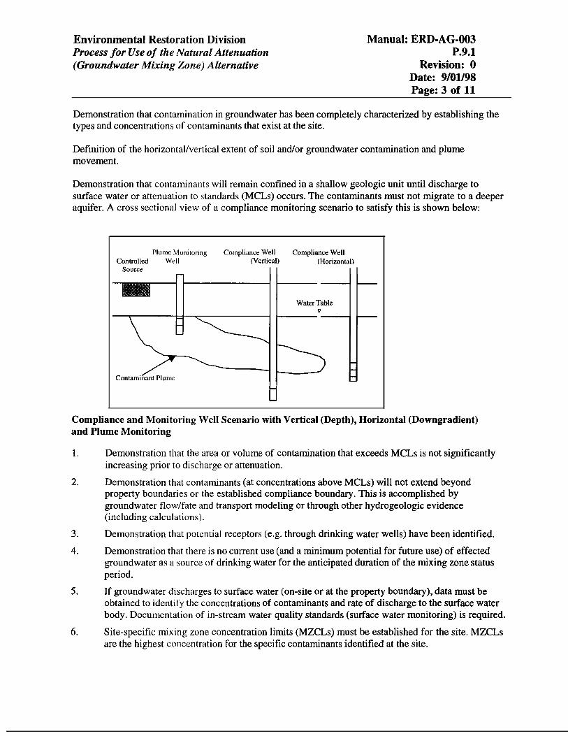
Demonstration that contaminants will remain confined in a shallow geologic unit until discharge tosurface water or attenuation to standards (MCLS) occurs. The contaminants must not migrate to a deeperaquifer. A cross sectional view of a compliance monitoring scenario to satisfy this is shown below:
Plume Monitoring Compliance Well Compliance WellControlled Well (Verticat) (Horimntat)
Source
Water Tablev
Hu
Compliance and Monitoring Well Scenario with Vertical (Depth), Horizontal (Downgradient)and Plume Monitoring
1. Demonstration that the area or volume of contamination that exceeds MCLS is not significantlyincreasing prior to discharge or attenuation.
2. Demonstration that contaminants (at concentrations above MCLS) will not extend beyondproperty boundaries or the established compliance boundary. This is accomplished bygroundwater flow/fate and transport modeling or through other hydrogeologic evidence(including calculations).
3. Demonstration that potential receptors (e.g. through drinking water wells) have been identified.
4. Demonstration that there is no current use (and a minimum potential for future use) of effectedgroundwater as a source of drinking water for the anticipated duration of the mixing zone statusperiod.
5. If groundwater discharges to surface water (on-site or at the property boundary), data must beobtained to identify the concentrations of contaminants and rate of discharge to the surface waterbody. Documentation of in-stream water quality standards (surface water monitoring) is required.
6. Site-specific mixing zone concentration limits (MZCLS) must be established for the site. MZCLSare the highest concentration for the specific contaminants identified at the site.
Environmental Restoration Division Manual: ERD-AG-003Process for Use of the Natural Attenuation P.9.1(Groundwater Mixing Zone) Alternative Revision: O
Date: 9/01/98Page: 4 of 11
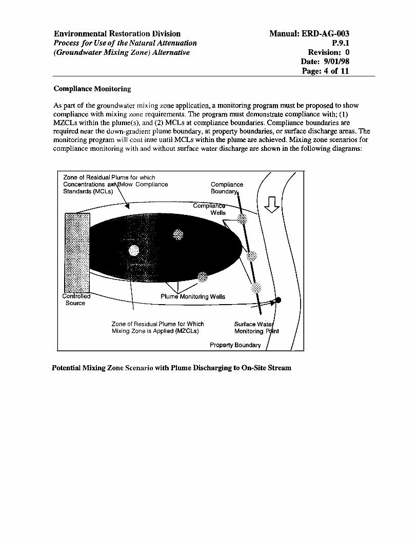
Compliance Monitoring
As part of the groundwater mixing zone application, a monitoring program must be proposed to showcompliance with mixing zone requirements. The program must demonstrate compliance with; (1)MZCLS within the plume(s), and (2) MCLS at compliance boundaries. Compliance boundaries arerequired near the down-gradient plume boundary, at property boundaries, or surface discharge areas. Themonitoring program will cent inue until MCLS within the plume are achieved. Mixing zone scenarios forcompliance monitoring with and without surface water discharge are shown in the following diagrams:
Zone of Residual Plume for whichConcentrations ar Below Compliance
\Compliance
Standards (MCLS) Boundaryl {{
Zone of Residual Plume for Which
H
Surface WateMixing Zone is Applied (MZCLS) Monitoring P mt
Property Boundary / I
Potential Mixing Zone Scenario with Plume Discharging to On-Site Stream
Environmental Restoration Division Manual: ERD-AG-003Process for Use of the Natural Attenuation P.9.1(Groundwater Mixing Zone) Alternative Revision: O
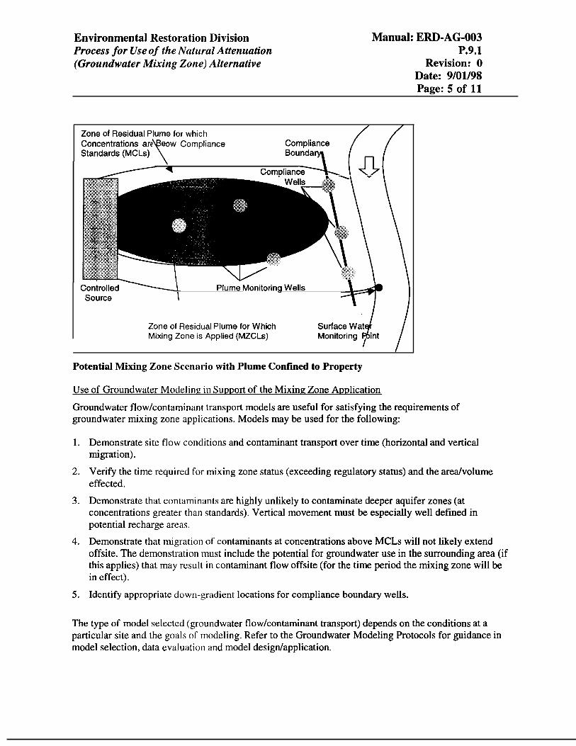
Date: 9/01/98Page: 5 of 11
Zone of Residual Plume for whichConcentrations are elow Compliance
‘T
ComplianceStandards (MCLS) Bounda ~\
Comtiiance+1<)
ControlledSource
Plume Monitoring WellsI
Zone of Residual Plume for Which
f
Surface WatMixing Zone is Applied (MZCLS) Monitoring P int
Potential Mixing Zone Scenario with Plume Confined to Property
Use of Groundwater Modeling in Support of the Mixing Zone Application
Groundwater flow/contaminant transport models are useful for satisfying the requirements ofgroundwater mixing zone applications. Models maybe used for the following:
1.
2.
3.
4.
5.
Demonstrate site flow conditions and contaminant transport over time (horizontal and verticalmigration).
Verify the time required for mixing zone status (exceeding regulatory status) and the areaholumeeffected.
Demonstrate that contaminants are highly unlikely to contaminate deeper aquifer zones (atconcentrations greater than standards). Vertical movement must be especially well defined inpotential recharge areas,
Demonstrate that migration of contaminants at concentrations above MCLS will not likely extendoffsite. The demonstration must include the potential for groundwater use in the surrounding area (ifthis applies) that may result in contaminant flow offsite (for the time period the mixing zone will bein effect).
Identify appropriate down-gradient locations for compliance boundary wells.
The type of model selected (groundwater flow/contaminant transport) depends on the conditions at aparticular site and the goals of modeling. Refer to the Groundwater Modeling Protocols for guidance inmodel selection, data evaluation and model desigdapplication.

Environmental Restoration Division Manual: ERD-AG-003Process for Use of the Natural Attenuation P.9.1(Groundwater Mixing Zone) Alternative Revision: O
Date: 9/01/98Page: 6 of 11
Definitions
Analytical element method – a means of using the principle of superposition to combine the solutions tomany analytical equations. Anal ytical functions representing stresses such as wells, line sinks andcircular recharge areas and features, such as an impermeable bartier, are summed and expressed in termsof discharge potential.
Analytical model – a model that uses closed-form solutions to the governing equations applicable togroundwater flow and transport processes.
Application verijcation – using the set of parameter values and boundary conditions from a calibratedmodel to approximate acceptably a second set of field data measured under similar hydrologic conditions.
Boundary condition – a mathematical expression of a state of the physical system that constrains theequations of the mathematical model.
Calibrated model – a model for which all residuals between calibration targets and correspondingmodeling outputs, or statistics computed from residuals, are less than pre-set acceptable values.
Calibration - the process of refining the model representation of the hydrogeologic framework, hydraulicproperties and boundary conditions to achieve a desired degree or correspondence between the modelsimulations and observations of the groundwater flow system.
Calibration targets – measured, observed, calculated or estimated hydraulic heads or groundwater flowrates that a model must reproduce, at least approximately, to be considered calibrated. The calibrationtarget includes the value of the head or flow rate and its associated error of measurement, so that undueeffort is not expended attempting to get a model application to closely reproduce a value, which is knownonly to within an order of magnitude.
Code ver@ation – software testing that includes comparison with analytical solutions and other similarcodes to demonstrate that the code used represents its mathematical foundations.
Computer code – the assembly of numerical techniques, bookkeeping, and control language thatrepresents the model from acceptance of input data and instructions to delivery of output.
Conceptual model – an interpretation or working description of the characteristics and dynamics of thephysical system.
Converged Solution - the solution resulting from the iterative solution process.
Convergence Criterion - the amount of acceptable solved parameter differences between iterationsolutions in the iterative solution process. This is typically a limiting parameter defined by the user innumeric groundwater models.
Darcy’s Law - the basic equation of flow for groundwater systems. Flow velocity (rate) equals hydraulicconductivity times the gradient.
Environmental Restoration Division Manual: ERD-AG-003Process for Use of the Natural Attenuation P09.1(Groundwater Mixing Zone) Alternative Revision: O
Date: 9/01/98Page: 7 of 11
Deterministic process – a process in which there is an exact mathematical relationship between theindependent and dependent variables in the system.Dirichlet condition – specified head boundaries for which head is given.
Domain - the area of a groundwater system being modeled.
Dupuit assumptions – assumptions applied to an unconfined aquifer; 1) flow lines are horizontal andequipotential lines are vertical, and 2) the horizontal hydraulic gradient is equal to the slope of the freesurface and is invariant with depth.
Fideli@ – the degree to which a model application is designed to resemble the physical hydrogeologicsystem.
Finite-di~erence method – a numerical technique for solving a system of equations using a rectangularmesh representing the aquifer and solving for the dependent variable in a piece-wise manner.
Finite-element method – a numerical technique for solving a system of equations using an irregulartriangular or quadrilateral mesh representing the aquifer and solving for the dependent variable in acontinuous manner.
Flow model - a groundwater model that solves for heads (and resultant flow directions and magnitudes).
Gradient - the measure of the head changes in a groundwater system. For an unconfined aquifer, the slopeof the water table surface is essentially equal to gradient.
Grid - the collection of nodes in a numeric groundwater model.
Groundwaterflow model – an application of a mathematical model to represent a site-specificgroundwater flow system.
Hydraulic Head - the term used to represent the energy of the groundwater system at any particular point.Head is essentially equivalent to the water table in unconfined aquifers. Head is measured in length(height) units like feet or meters from a datum elevation (such as mean seal level).
Heterogeneity - a term indicating that a parameter changes spatially.
Homogeneity - a term indicating that a parameter does not change spatially.
Hydraulic conductivity - the measure of a porous media’s ability to transmit water. Used in Darcy’s Lawas the proportionality constant between the gradient and flow velocity terms.
Hydrodynamic dispersion - the combined effects of molecular diffusion and mechanical dispersion. Alsocommonly just called dispersion.
Hydraulic properties – properties of soil and rock that govern the transmission (e.g., hydraulicconductivity, transrnissivit y, and leakance) and storage (e.g. specific storage, storativity and specificyield) of water.
Environmental Restoration Division Manual: ERD-AG-003Process for Use of the Natural Attenuation P.9.1(Groundwater Mixing Zone) Alternative Revision: O
Date: 9/01/98Page: 8 of 11
Hydrostratigraphic units - units that are delineated based on hydrogeological as well as geologicalparameters.
Iterative soiution - the process and result of finding an answer by using better and better approximatesolutions. A technique commonly used in numeric groundwater models. Each cycle of the process iscalled an iteration.
Inverse method – a method of calibrating a groundwater flow model using a computer code tosystematically vary inputs or input parameters to minimize residuals or residual statistics.
Mathematical model – mathematical equations expressing the physical system and including simplifyingassumptions. The representation of a physical system by mathematical expressions from which thebehavior of the system can be predicted.
Mechanical dispersion - a physical process that represents the mixing of solutes due to variations in flowvelocities. These variations are due to three primary factors: (1) variations in pore sizes, (2) differences inpath lengths, and (3) variations of velocities within each pore due to friction at the pore walls.
Method o$characteristics (MOC) - a numerical method to solve solute transport equations byconstruction of an equivalent of ordinary differential equations using moving particles as reference points.Also known as the particle-in-cell method.
Model – an assembly of concepts in the form of mathematical equations that portray understanding of anatural phenomenon.
Molecular d[j%.sion - a chemical process at the molecular level that causes areas of higher concentrationsto want to equilibrate with areas of lower concentrations.
Nodes - the discrete points in numeric groundwater models where we solve for head.
Numerical methods – a set of procedures used to solve the equations of a mathematical model in whichthe applicable partial differential equations are replaced by a set of algebraic equations written in terms ofdiscrete values of state variables at discrete points in space and time. Those in common use are the finite-difference method, finite-elelment method, boundary-element method and analytical element method.
Over-calibration – achieving artificially low residuals by inappropriately fine-tuning model parametersand not performing application verification.
Random walk – a method of tracking a large number of particles with the number of particles proportionalto solute concentration, and each particle advected deterrninistically and dispersed probabilistically.
Residual – the difference between the computed and observed values of a variable at a specific time andlocation.
Sensitivi~ – the degree to which the model result is affected by changes in a selected model inputrepresenting h ydrogeologic frame work, hydraulic properties and boundary conditions.
Environmental Restoration Division Manual: ERD-AG-003Process for Use of the Natural Attenuation P.9.1(Groundwater Mixing Zone) Alternative Revision: O
Date: 9/01/98Page: 9 of 11
Simulation – one complete execut ion of a groundwater modeling program, including input and output.
Sink – a process or a feature from which water is extracted from the groundwater flow system.
Steady-State - if a groundwater system does not change over time, then the system is in a steady-statecondition. Also refers to the type of numeric modeling where results are not expected to change overtime.
Stochastic – consideration of subsurface media and flow parameters as random variables.
Stochastic model – a model representing groundwater parameters as random variables.
Stochastic process – a process in which the dependent variable is random (so that prediction of its valuedepends on a set of underlying probabilities) and the outcome at any instant is not known with certainty.
Transient - if a groundwater system changes over time, then the system is in a transient condition. Alsorefers to the type of numeric modeling where the results reflect changes over time.
Transport model - a groundwater model that solves for concentrations of solutes.
Water balance - a process of equating the water inflows to a groundwater system with the water outflows,accounting for any changes in storage of water in the system.
Environmental Restoration Division Manual: ERD-AG-003Process for Use of the Natural Attenuation P.9.1(Groundwater Mixing Zone) Alternative Revision: O
Date: 9/01/98Page: 10ofll
References
Anderson, M.P. and Woessner, W .W., 1992, Applied Groundwater Modeling, Simulation ofFlow and Advective Transport, Academic Press, Inc., San Diego, California.
Appel, C.A. and Reilly, T. E., U.S. Geological Survey, 1994, Summary of Selected Computer ProgramsProduced by the U.S. Geological Survey for Simulation of Ground-Water Flow and Quality, U.S.Geological Survey Circular 1104
ASTM, Designation D 5447-93, Standard Guide for Application of a Ground-Water Flow Model to aSite-Specific Problem, American Society for Testing and Materials, Philadelphia, Pennsylvania.
ASTM, Designation D 5490-93, Standard Guide for Comparing Ground-Water Flow Model Simulationsto Site-Specific Information, American Society for Testing and Materials, Philadelphia, Pennsylvania.
ASTM, Designation D 5609-94, Standard Guide for Defining Boundary Conditions in Ground-WaterFlow Modeling, American Society for Testing and Materials, Philadelphia, Pennsylvania
ASTM, Designation D 5610-94, Standard Guide for Defining Initial Conditions in Groundwater-FlowModeling, American Society for Testing and Materials, Philadelphia, Pennsylvania.
ASTM, Designation D 5611-94, Standard Guide for Conducting a Sensitivity Analysis for a GroundWater Flow Model Application, American Society for Testing and Materials, Philadelphia, Pennsylvania.
ASTM, Designation D 5718-95, Standard Guide for Documenting a Ground-Water Flow ModelApplication, American Society for Testing and Materials, Philadelphia, Pennsylvania.
ASTM, Designation C-7, Draft No. 4, 1995, Standard Guide for Calibrating a Ground-water Flow ModelApplication, American Society for Testing and Materials, Philadelphia, Pennsylvania.
ASTM, Designation D-1, Draft No. 5, 1995, Standard Guide for Application of a Solute transport Modelto a Site-Specific Ground-Water Problem, American Society for Testing and Materials, Philadelphia,Pennsylvania.
ASTM, Designation D 1821000295.1, Draft, Standard Guide for Subsurface Flow and TransportModeling, American Society for Testing and Materials, Philadelphia, Pennsylvania.
Domenico, P.A. and Schwartz, F. W., 1990, Physical and Chemicrd Hydrogeology, John Wiley and Sons,Inc.
SCDHEC, 1995, Ground-Water Mixing Zone Guidance Document.
Spitz, K. and Moreno, J., 1996, A Practical Guide to Groundwater and Solute Transport Modeling, JohnWiley and Sons, Inc.
Environmental Restoration Division Manual: ERD-AG-003Process for Use of the Natural Attenuation P09.1(Groundwater Mixing Zone) Alternative Revision: O
Date: 9/01/98Page: 11 of 11
References - cont.
van der Heijde, P.K.M. et al., U.S EPA, 1988, Groundwater Modeling: An Overview and Status Report,EPA/600/2-89/028, International Groundwater Modeling Center, Holcomb research Institute, ButlerUniversity, Indianapolis, Indiana
van der Heijde, P.K.M. and Elnawawy, O. A., U.S EPA, 1992, Quality Assurance and Quality Control inthe Development and Application of Ground-Water Models, EPA/600/R-93/011, InternationalGroundwater Modeling Center, Butler University, Indianapolis, Indiana
U.S. EPA, 1988, Guidance for Conducting Remedial Investigations and Feasibility Studies UnderCERCLA, Interim Final, EPA/540/G-89/O04
Wang, H.F. and Anderson, M. P., 1982, Introduction to Groundwater Modeling, W.H. Freeman andCompany, New York, New York.