Embed Size (px)
Citation preview

VOLUME 1
HUMAN SETTLEMENT
PLANNING
AND DESIGN
G u i d e l i n e s f o r
Compiled under the patronage of the Department of Housingby CSIR Building and Construction Technology
50
GUIDELINES FOR HUMAN SETTLEMENT PLANNING AND DESIGN
Chapter 5.3 Hard open spaces
Table 5.3.13: Dimensions and distances (continued)
Scale and proportions. • Hard open space witha certain sense ofenclosure: below thethreshold of 18° thespace loses its senseof enclosure as onecan see beyond itsedges (Moughtin1992, p 99).
• Limit plaza size tocreate small, human-scaled spaces. Amaximum size of235 m2 is appropriatewith several smallplazas better thanone large one.
• To maintain a senseof enclosure, theangle between twobuildings, attached ordetached, should notexceed 135º. 1
• Scale of squares(Moughtin 1992,p 42):Large plazas: 21-24 mTown or villagesquare: 57 m x 143 mCity quarter: 800 mradius. 2
Landscaping andfurniture.
• Provide one linearmetre of seating forevery m2 of squarearea (Paumier 1990,p 33).
• To enablecommunication,benches should be amaximum of 1,2 mapart. The minimumdistance for normalconversation is 0,6 m.To ensure that nointeraction takesplace, benches shouldbe a minimum of 3 mapart (Bentley 1987,p 74). 3
Squares

Table 5.3.13: Dimensions and distances (continued)
Landscaping andfurniture (continued).
• Bollards with thedimensions of 500mm (height) and aminimum of 300 mm(width) can alsodouble as seating(Cartwright 1980,p 67).
• Design litter binspreferably not higherthat 800 mm. Shouldthey be any higher,there would beseating constraints onthe bins and childrenwould have difficultyin dumping theirrubbish (Cartwright1980, p 111). 4
• Plan for at least 20%of the square to belandscaped.
Squares (continued)
Travelling distance. • Distances from publictransport facilities,home and workinfluence thepositioning ofmarkets andeconomic thresholds.
- Driving thresholdof 5-minute drive@ 60 km/h:market can belocated 3,2 kmaway (Untermann1984).
- Walking thresholdof 5 minute walk@ 6,4 km/h:market can belocated at 0,5 kmaway (Untermann1984).
51
GUIDELINES FOR HUMAN SETTLEMENT PLANNING AND DESIGN
Hard open spaces Chapter 5.3
Markets

52
GUIDELINES FOR HUMAN SETTLEMENT PLANNING AND DESIGN
Chapter 5.3 Hard open spaces
Table 5.3.13: Dimensions and distances (continued)
Market layout. • Dead spaces and stallfacades longer than35 m, should beavoided. Shorterblocks between 18and 25 m are moreappropriate (Behrensand Watson 1996,p 215), with 8 mbeing the optimumlength forfunctionality andpermeability. A zig-zag layout caneffectively facilitatemovement on bothsides. 1
Walking distances. • In some cases peoplecannot walk longdistances. Pedestrianscarrying packages ortending to childrenare more aware oftime and distanceand may be willing towalk an absolutemaximum of 300 m(Untermann 1984).
• Increase the numberof formal publictransport stops, asthis may decrease theappearance of ad hocstops, especially byminibus taxis.Shorten the walklength to a maximumof 150 m in highdensity and mixed-use areas. In lowerdensities, stops canbe located further(up to 400 m apart).
Markets (continued)
Public transport stops and stations

53
GUIDELINES FOR HUMAN SETTLEMENT PLANNING AND DESIGN
Hard open spaces Chapter 5.3
Management guidelines to promotemultifunctional use of hard open spaces
Critical issues are currently facing many cities alike. Ifwe want to secure the liveability and vitality of urbansettlements, the preservation of public spaces and thetransformation of hard open spaces to serve newpurposes and accommodate multifunctional uses, iscrucial. However, these spaces have to be effectivelymanaged in order not to become neglected andconsequently vulnerable to the many pressures ofcontemporary urban development.
Despite limited local authority powers and resources,local authorities have to practise sound judgementand good management in terms of monitoring thesuccess of hard open spaces and responding toconsumer needs. A positive and integrated approachto planning, designing and managing space isessential. It is essential to prioritise key issues andconcentrate efforts where they will produce tangibleresults.
Through involvement and commitment, communities,the private sector (developers, banks, investors) andlocal governments can and have to play an active rolein initiatives to protect and manage hard open spaces.
URBED (1994, p 151) proposes the following to beincluded in local authorities’ planning processes withregard to open spaces:
• Form multidisciplinary management groups for allopen spaces, integrating all relevant departments(planning, economic development, engineering,parks and recreation, cultural services).
• Periodically review the situation in a representativeforum.
• Do profile and performance analysis on usage,pedestrian flows, attractions, access, and theamenities within hard open spaces.
• Promote research and study tours on the city’spublic spaces.
• Publish promotional material and encouragetourism and multifunctional usage.
There is thus a very important strategic planningcomponent involved in giving care and attention tohard open spaces. This should be coupled with a strongmarketing campaign to attract investment.
Apart from planning and design, the followingmanagerial aspects should be considered:
• Who is responsible for factors that affect thefunction and appearance of hard open spaces?
• Who is responsible for activity and timemanagement?
• Who is responsible for funding (maintenance,management)?
It should be borne in mind that the use of hard openspace could change over time due to changes in usergroups and land uses. Multifunctional use can thusmore easily be accommodated and managed within aspace with a sense of permanence (well defined withinurban structure) and robustness (compatiblebuildings). Spaces should be able to accommodatechanging use over time, diverse activities andtemporary diversity with a change in intensity.
In addressing the crucial issues of effectivemanagement, it is believed that hard open spaces canplay a vital role in ensuring vibrant and sustainableurban settlements.
54
GUIDELINES FOR HUMAN SETTLEMENT PLANNING AND DESIGN
Chapter 5.3 Hard open spaces
BIBLIOGRAPHY
Alexander, C (1977). A pattern language. OxfordUniversity Press, New York.
Attoe, W and Logan, D (1989). American urbanarchitecture: Catalysts in the design of cities.University of California Press, Los Angeles.
Behrens, R and Watson, V (1996). Making urbanplaces: Principles and guidelines for layout planning -contemporary policy issues. UCT Press, Cape Town.
Bentley, et al (1987). Responsive environments: Amanual for designers. The Architectural Press, London.
Cartwright, RM (1980). The design of urban space: AGLC manual. The Architectural Press, London.
Chermayeff, S and Alexander, C (1963). Communityand privacy. Penguin, Middlesex.
CSIR, Division of Building Technology (1985).Guidelines for the provision of engineering servicesand amenities in residential township development.Pretoria.
Curran, R J (1983). Architecture and the urbanexperience. Van Nostrand Reinhold, New York.
Francis, M et al (1984). Community open space:Greening neighborhoods through community actionand land conservation. Island, Washington.
Goldsteen, J B (1994). Designing America: creatingurban identity. Van Nostrand Reinhold, New York.
Gosling, D and Maitland, B (1984). Concepts of urbandesign. St Martin’s, New York.
Holm, Jordaan and Associates (1998). Hard OpenSpaces. Unpublished report prepared for the CSIR,Pretoria.
Iwashita, H (1988). Pocket Park. Process Architecture.Process Architecture Publishing, Tokyo.
Jordaan, G J (1987). An urban design strategy forplacemaking in city centres. A discourse submitted tothe Faculty of Architecture of the University of theWitwatersrand, Johannesburg.
Kostof, S (1992). The city assembled: the elements ofurban form through history. Thames & Hudson,London.
Kostof, S (1991). The city shaped: urban patterns andmeanings through history. Thames & Hudson, London.
Lynch, K and Hack, G (1984). Site planning. 3rdEdition. MIT, London.
Miller, C G (1988). Carscape. Washington Street Press,Columbus, Indiana.
Moughtin, L (1992). Urban design: street and square.Butterworth-Heinemann, Oxford.
Patricia, T and Adler, D (1984). New metric handbook,The Architectural Press, London.
Paumier, C B (1990). Designing the successfuldowntown. Urban Land Institute, New York.
Rapoport, A (1977). Human aspects of urban form.Oxford Pergamon Press.
Rubenstein, H M (1992). Pedestrian malls,streetscapes, and urban spaces. John Wiley, New York.
Southworth, M and Ben-Joseph, E (1997). Streets andthe shaping of towns and cities. McGraw-Hill, NewYork.
Sugar House, Master plan document prepared for theSalt Lake City Corporation.
Tibbalds, F (1992). Making people-friendly towns:improving the public environment in towns and cities.Longman, United Kingdom.
Turner, T (1996). City as landscape: a postmodern viewof design and planning. Spon, London.
Unknown (1985). Design guidelines for the pedestriancorridor and major public open spaces. City ofBellevue, Bellevue.
Untermann, R K (1984). Accommodating thepedestrian: Adapting towns and neighbourhoods forwalking and bicycling. Van Nostrand Reinhold, NewYork.
URBED (1994). Vital and viable town centres: meetingthe challenge. HMSO, London.
Uytenbogaardt, R, Dewar, D and Todeschini, F (1997).A philosophic approach to settlement-making.Unpublished report prepared for the CSIR, Pretoria.
Van Zyl, WC (1997). Activities and behaviour of usersof public open space. Unpublished report. Town andRegional Planning, University of Pretoria.
White, R R (1994). Urban environmental management:environmental change and urban design. John Wiley,New York.
Wiseman, C (1981). Street Furniture: How can itsdesign be upgraded, in Urban Open Spaces. Rizzoli,UJA.
Soft open spaces
Chapter 5.4
5.4
TABLE OF CONTENTS
INTRODUCTION. . . . . . . . . . . . . . . . . . . . . . . . . . . . . . . . . . . . . . . . . . . . . . . . . . . . . . . . . . . . . . . . . . . . 1
THE ROLE OF SOFT OPEN SPACES. . . . . . . . . . . . . . . . . . . . . . . . . . . . . . . . . . . . . . . . . . . . . . . . . . . . . . 1
Soft open space needs of settlement ecosystems. . . . . . . . . . . . . . . . . . . . . . . . . . . . . . . . . . . . . . . . . . 1
Soft open space needs of identifiable user groups . . . . . . . . . . . . . . . . . . . . . . . . . . . . . . . . . . . . . . . . 1
GUIDELINES FOR THE PLANNING AND DESIGN OF NETWORKS OF SOFT OPEN SPACE . . . . . . . . . . . . . 7
GUIDELINES FOR THE PLANNING AND DESIGN OF GENERIC FORMS OF SOFT OPEN SPACE . . . . . . . . . 9
BIBLIOGRAPHY . . . . . . . . . . . . . . . . . . . . . . . . . . . . . . . . . . . . . . . . . . . . . . . . . . . . . . . . . . . . . . . . . . . 17
i
GUIDELINES FOR HUMAN SETTLEMENT PLANNING AND DESIGN
Soft open spaces Chapter 5.4

ii
GUIDELINES FOR HUMAN SETTLEMENT PLANNING AND DESIGN
Chapter 5.4 Soft open spaces
LIST OF FIGURES
Figure 5.4.1 Spatial diagram illustrating multi-functionality and flexibility, protection, and linkage . . . . . . . . .6
Figure 5.4.2 Spatial diagram illustrating the basic cross-sectional components of a riverine environment . . . . . . . . . . . . . . . . . . . . . . . . . . . . . . . . . . . . . . . . . . . . . . . . . . . . . . . . . . . . . . . . . .15
Figure 5.4.3 Sportsfield markings and dimensions . . . . . . . . . . . . . . . . . . . . . . . . . . . . . . . . . . . . . . . . . . . . . . .16
LIST OF TABLES
Table 5.4.1 The soft open space needs of identifiable user groups . . . . . . . . . . . . . . . . . . . . . . . . . . . . . . . . . .2
Table 5.4.2 Guidelines for the planning and design of networks of soft open space . . . . . . . . . . . . . . . . . . . .7
Table 5.4.3 Guidelines for the planning and design of generic forms of soft open space . . . . . . . . . . . . . . . . .9

INTRODUCTION
Soft open spaces are open, or unbuilt, spaces within asettlement, with a predominantly vegetated or poroussurface. Access into soft open spaces ranges from theirbeing totally unrestricted, to temporarily or user-restricted, to entirely private. This sub-chapter isconcerned with local and sub-metropolitan public andsemi-public soft open space, and to a lesser extentwith larger private soft open spaces that arefunctionally and aesthetically related to public softopen space.
THE ROLE OF SOFT OPEN SPACES
The role of soft open space in settlement systems isessentially to (a) enable ecological processes tocontinue to occur sustainably and safely withinenvironments significantly altered by human action,and (b) accommodate a variety of socio-economiccommunity needs, and to a lesser extent to providebarriers that contain and manage settlement growth.These roles are not necessarily exclusive to particularspaces as, ideally, outdoor spaces should perform asmany roles as possible.
Soft open space needs of settlementecosystems
The elements that are common to all ecosystemsinclude flows of energy and the cycling of materials,self-regulatory mechanisms with positive and negativefeedbacks, and linked subsystems. These flows,feedbacks and linkages within, and betweensettlements and their surrounding biophysicalenvironment can be conceptualised as a settlementmetabolism, made up of a variety of “extractive” and“absorptive” demands.
“Extractive” demands are inputs of renewable andnon-renewable resources, extracted from thebiophysical environment. They can take the form of,inter alia, daily inputs of clean water, air, food, fibre,and energy which are required to satisfy thesettlement metabolism. Once resources are extracted,they are either consumed, stored or transformed intoexportable products or wastes.
“Absorptive” demands take the form of thebreakdown, processing and recycling of solid, liquidand gaseous wastes and heat that inevitably arise asthe by-products of urban metabolic processes, whichare absorbed by the biophysical environment. Theycan take the form of, inter alia, daily outputs ofsewage, garbage and smoke. The release of theseoutputs often requires the installation of a system ofutility services, particularly to deal with liquid and solidwaste. Since these waste products cannot generally beexported to other regions, they usually have to beabsorbed and recycled within the immediate
biophysical environment.
Soft open spaces play a key role in enabling these“extractive” and “absorptive” processes to functionsustainably within settlements. In terms of extraction,they facilitate the renewal of resources through therecycling of biodegradable wastes, and the productionof food, fibre and fuel. In terms of absorption, theyfacilitate the purification of wastes through thecleansing and regulating of water, and the filtering ofair. In order for these ecological processes to functionwithin settlements, soft open spaces should be (a)appropriately located, (b) sufficiently large, (c)sufficiently interconnected, and (d) appropriatelyvegetated.
• In terms of location, soft open spaces shouldincorporate particularly sensitive naturalenvironments, like wetlands, rivers, coastlines andremnant patches of indigenous flora, which arenecessary to maintain the diversity of indigenousflora and fauna habitats within a settlement.
• In terms of quantity, soft open spaces should besufficiently large, to maintain the seed banks andbreeding stocks necessary to preserve the flora andfauna, and to enable the biophysical environmentto renew resources and absorb and recycle liquidand solid waste. In other words, a balance needs toexist between the natural and built environment soas not to overload the system and exceed thecapacity of the soft open space system to performits life-enhancing and regenerative role.
• In terms of connection, soft open spaces should besufficiently interconnected to enable local fauna tomove and breed. Settlement formation fragmentspreviously intact natural habitats, and can lead tothe isolation of indigenous species within asettlement.
• In terms of vegetation, the surfacing of soft openspaces should be suited to its ecological location.The choice of vegetation within a soft open spacedetermines the variety of habitats for animal life,and hence the diversity of flora and fauna.
Soft open space needs of identifiableuser groups
In planning soft open spaces that can perform theirother role of accommodating a variety of humanneeds, an understanding of the range of current andanticipated end-user needs within and surrounding asite is necessary. In order to achieve this understandingit is useful to consider needs in terms of individual usergroups. It is important to note, however, that no onesoft open space has, or should have, one identifiableuser group - a central argument to be made is thatbetter soft open spaces accommodate the greatestpossible number of user groups and needs.
1
GUIDELINES FOR HUMAN SETTLEMENT PLANNING AND DESIGN
Soft open spaces Chapter 5.4

2
GUIDELINES FOR HUMAN SETTLEMENT PLANNING AND DESIGN
Chapter 5.4 Soft open spaces
Empirical studies of the needs of different user groupsclearly illustrate that need is both diverse and dynamic.User needs typically vary considerably according tosuch factors as age, gender, culture, income and levelsof mobility and, consequently, the needs of anindividual, as well as the composite needs of aparticular geographical community, change over time.There are nevertheless many needs that are commonto all users:
• All users require a degree of comfort from thenatural elements, and the choice of a shady or asunny place to rest.
• All users need to feel safe. Feelings of safety andsecurity relate both to protection from fast-movingvehicular traffic, and to the avoidance of hiddenplaces of refuge where potential muggers orrapists may lurk.
• All users require opportunities for activeengagement with other people and with spaces. Inother words, people need accessible and well-known public places in which to wait for, and makearrangements to meet, their friends, as well asspaces in which games and sports can be played.
• All users require opportunities for passiveengagement with other people. In other words,people need accessible and well-known publicplaces where they do not have to be alone, where they know something will always be happening,and where they can engage in “people watching”and maybe even establish social encounters.
• All users also require opportunities to escape fromintense concentrations of people and activity.
A problem with the literature available on soft openspace is the limited availability of empirical studiesspecific to South Africa. The available literature dealstypically with different age, gender and incomegroups - there is comparatively little empirical workthat discusses how needs vary across cultural and socio-economic groups. Table 5.4.1 summarises the needs ofuser groups as dealt with in the literature.
Table 5.4.1: The soft open space needs of identifiable user groups
• To feel secure - young children often have difficultytolerating visual separation from their parents orminders. Visual separation is in fact often the mainsource of anxiety.
• To play - young children tend to play inventive, orimitation, games by themselves, and usually focustheir attention on a fairly small play space.
• Visual, aural and tactile stimuli, to explore andexperience new sensations.
• Play spaces located close to benches orembankments that survey the space.
• Stimulating (but safe, in terms of height and waterrisks) play objects that can expand their growingsense of spatial relations, and around which theycan invent games. Spaces and objects should bescaled to their size and strength.
• Soft play surfaces to prevent injury.
• Protection from fast-moving vehicular traffic.
2-5 YEAR-OLD CHILDREN
Psychological needs Physical needs

3
GUIDELINES FOR HUMAN SETTLEMENT PLANNING AND DESIGN
Soft open spaces Chapter 5.4
• To play: 6-12 year olds tend to play in groups, andtherefore focus their attention on a larger play space.
• A sense of adventure (i.e. unpredictability in theway certain spaces are designed, e.g. hedgemazes): 6-12 year olds need to be able to discover,and be stimulated by, new spaces and objects, andbe inventive in developing games. A sense ofadventure is especially important for youngerchildren, as physical and creative play developsmotor skills and innovation, which are necessaryfor physical as well as intellectual development.
• To be challenged by the space (e.g. crossing riverson stepping stones or logs, without falling in andgetting wet).
• Challenging play objects, and discovery spaces - thereis less pretence in the play of 6-12 year olds than inyounger age groups. More objects and playequipment are therefore required, and play spaces(sometimes needing game markings) need to belarger to accommodate contact games (150 -1 000 m2)and ball games (300 -1 500 m2). Spaces and objectsshould be scaled to their size and strength.
• Soft play surfaces to prevent injury when falling orwrestling.
• Protection from fast-moving vehicular traffic.
The psychological and physical open space needs of 6-12 year olds can be met in relatively larger playspaces, which enable a clear flow of movement andenable “big play” activity (150 - 1 500 m2). The mostobvious examples of such spaces would be“adventure” playgrounds, parks or linear parkwayswith streams, and playspaces in schools. Like 2-5 yearolds, they can, however, play virtually anywhere.
Children aged 6-12 years tend to play on a daily orweekly basis. Attempts should therefore be made tolocate public open spaces that address the needs of 6-12 year olds within ± 500 m of spatial concentrationsof these users (e.g. primary schools or homes).
Appropriate soft open spaces Frequency and access needs
The psychological and physical open space needs of 2-5 year olds can be met in relatively small play spaces (±60 m2). Children can play virtually anywhere andeverywhere. Appropriate play spaces can thereforetake the form of parts of other open spaces likewidened footways on roads experiencing light trafficvolumes, or squares. The implication of this is thatchild play should be a consideration in the planningand design of all public open spaces.
2-5 year olds tend to play on a daily basis. Attemptsshould therefore be made to locate public open spacesthat address the needs of pre-school children, within ±500 m of spatial concentrations of these users (e.g.créches).
Table 5.4.1: The soft open space needs of identifiable user groups (continued)
Appropriate soft open spaces Frequency and access needs
Psychological needs Physical needs
6-12 YEAR-OLD CHILDREN

4
GUIDELINES FOR HUMAN SETTLEMENT PLANNING AND DESIGN
Chapter 5.4 Soft open spaces
• Passive engagement with people - older childrenand young adults are also more likely to go topublic places on their own to seek chanceencounters with other children or young adults (i.e.to “hang out”).
• Active engagement with people - as children growolder their need for space, expansive team games,and sports practice, increases.
• To be challenged by the space.
• Play surfaces, sometimes with game markings(300 - 1 500 m2). With older children, play equip-ment increasingly becomes less important thanuninterrupted play space.
• Visible and busy places in which to socialise, whichare comfortable to sit in and talk.
• Challenging and stimulating spaces and objects.
Psychological needs Physical needs
• Passive engagement with other people - retiredpeople tend to use public spaces in a frequent,routine manner, mainly in the morning and earlyafternoon, when there is sunshine and leastcompetition for seating with teenagers andchildren.
• To be visually stimulated by aesthetically pleasingenvironments.
• Seating around the perimeters and near theentrances of spaces, as it is here that there is oftena greater feeling of safety provided by passers-by,and friends are more likely to be spotted.Maximum comfortable walking distances also tendto be shorter for elderly people than for youngeruser groups, so seating close to entrances is moreconvenient.
• Seating in sheltered areas that offers choicebetween shade and sun, and protection from thewind.
• Stimulating public art, and game markings (e.g.chess, shuffleboards).
• Flat or gently sloping pathways.
Psychological needs Physical needs
The psychological and physical open-space needs ofolder children and young adults can be met in adiverse range of soft open spaces. Parks, linearparkways and sportsfields can meet more activeengagement needs, while pocket parks in morecentral locations can meet more passive engagementneeds.
Older children and young adults tend to meet andplay on a daily or weekly basis. Attempts shouldtherefore be made to locate public open spaces thataddress the needs of older children and young adults,within ± 500 m of spatial concentrations of theseusers (e.g. secondary schools, homes). Specialised orless frequently used spaces (e.g. sportsfields used forrelatively less frequent competitive sports events) canoften be located further away, and accessed by bicycleor public transport.
Appropriate soft open spaces Frequency and access needs
ELDERLY PEOPLE
Table 5.4.1: The soft open space needs of identifiable user groups (continued)
13-19 YEAR OLD TEENAGERS AND YOUNG ADULTS

Table 5.4.1: The soft open space needs of identifiable user groups (continued)
ELDERLY PEOPLE (continued)
5
GUIDELINES FOR HUMAN SETTLEMENT PLANNING AND DESIGN
Soft open spaces Chapter 5.4
The psychological and physical open space needs ofelderly people can be met in all public open spaces,but to a lesser extent in active recreation spaces likesportsfields.
Elderly people tend to use open spaces on a daily andweekly basis, and tend to tire more rapidly fromwalking than younger groups. Attempts shouldtherefore be made to locate public open spaces thataddress the needs of elderly people within ± 400 m ofspatial concentrations of these users (e.g. old-agehomes, or neighbourhoods accommodating manyelderly people).
Appropriate soft open spaces Frequency and access needs
• To feel safe - the specific needs of women in publicopen spaces focus primarily on the issue of crimeand safety. Very often, as a result of the incidenceof sexual assault and harassment, women areafraid or reluctant to use public open space ontheir own. Women need to feel a sense of controlin public spaces, in terms of being able to orientatethemselves easily and leave the space quickly, andsee who else is in the space.
• Spaces that do not contain hidden refuges orcorners, and have dimensions that enable womento identify potential dangers easily.
• Spaces with numerous possible exit points, whichare overlooked by surrounding activities.
• Comfortable places, close to play spaces, in whichto sit and mind small children in the case of child-minding parents.
• Hardened pathways for pushing prams, in the caseof child-rearing parents.
Psychological needs Physical needs
• Hardened (but not slippery) pathways along the thoroughfares of spaces, as well as to more secluded spaces.
• Flat or gently sloping pathways that do not exceed a gradient of 1:12, and have a cross-sectional camber (orbanking) that does not exceed 1:60.
• Pathways that are sufficiently wide to accommodate wheelchairs. As wheelchairs are typically 70 cm wide,the minimum width should be in the region of 90 cm.
WOMEN
WHEELCHAIR USERS
Physical needs (detailed guidelines are provided in SABS Code of Practice 0246:1993)
• Seating, and soft surfaces on which to lie, as open spaces are inevitably used by vagrants as a place to liveduring the day. In addition, public open spaces are sometimes used as places to sleep during the night, whennight shelters are either unused or unavailable. The permanent presence of large numbers of vagrants,however, often discourages other user groups from using the space, and compromises often need to be sought.
• Protection from the sun, wind and rain.
• Water points and, where applicable, ablution points.
VAGRANTS
Physical needs
6
GUIDELINES FOR HUMAN SETTLEMENT PLANNING AND DESIGN
Chapter 5.4 Soft open spaces
The roles relating to ecological and human need havethe following implications for the way soft openspaces within settlement systems should be plannedand designed (Figure 5.4.1):
• Soft open spaces should perform a variety ofhuman and ecological functions, and theconfiguration of these spaces should be able toaccommodate changing functions over time. Thesoft open space system therefore needs toaccommodate a diversity of open space forms,that can be shared by a diversity of user groups.Multi-functionality has two dimensions - a singlesoft open space should be able to performdifferent functions, and a space performing a
particular function should serve a variety ofdifferent users.
• In order for vital ecological processes - likedrainage, groundwater recharge, or air and waterpurification - to continue functioning within humansettlements, and for flora and fauna speciesdiversity to be maintained, key natural areas needto be protected from development, andincorporated into a settlement’s soft open spacesystem. Understanding the qualities of the naturalenvironment in each place, integrating it in thedesign of settlements, and respecting thefunctioning of its dynamic systems, are all critical inmaking human settlements both sustainable andunique.
• Larger soft open spaces and remnants of naturallandscapes need to be linked by corridors of softopen space. These linkages facilitate a range ofcontinuous recreational opportunities, and act asconduits for indigenous species, potentiallyfacilitating the movement of pollinators and thedispersal of seed from one space to another. Thismovement of pollinators and seed enables naturalsystems to be protected far more effectively than inthe case of unconnected natural remnants.
Despite the need for multifunctionality, the diversityof ecological and human needs discussed abovenecessitates that not all spaces are the same. Networksof soft open space can be made up of the followingtypical forms: pristine areas, parkways, parks,sportsfields, servitudes, and urban agriculture. Thefollowing two sections provide, respectively, guidanceon the planning and design of networks of soft openspace, and guidance on the planning and design ofindividual forms of soft open space.
Table 5.4.1: The soft open space needs of identifiable user groups (continued)
WORKERS
• Relief from intense commercial, business andindustrial activity. Workers mainly use public openspaces for active and passive engagement duringtea and lunch breaks, as a stimulating and pleasingplace to meet, relax and eat.
• Spaces that are easily accessible from places of work.
• Sheltered spaces that provide a choice betweenshade and sun, wind protection, seating and softsurfaces to lie on.
• Stimulating public art.
Psychological needs Physical needs
• Workers take lunch breaks on a daily basis. Attempts should therefore be made to locate public openspaces, that address the needs of workers, within ± 300 m of spatial concentrations of these users (e.g. officeblocks, industrial parks).
Frequency and access needs
Figure 5.4.1: Spacial diagram illustrating multi-functionality and flexibility, protection and linkage

GUIDELINES FOR THE PLANNING ANDDESIGN OF NETWORKS OF SOFT OPENSPACE
Important considerations in the planning and designof networks of soft open space are: (a) location, (b)
quantity (i.e. how much space there should be relativeto other land uses), (c) connection (i.e. how individualspaces should connect with each other), and (d)vegetation (i.e. the nature of surfaces, and the balancebetween “pristine” and “artificial” landscapes).
7
GUIDELINES FOR HUMAN SETTLEMENT PLANNING AND DESIGN
Soft open spaces Chapter 5.4
Table 5.4.2: Guidelines for the planning and design of networks of soft open space
The location of networks should incorporate remnantpatches of representative indigenous flora, andsensitive natural areas like wetlands, slopes, rivers andcoastlines that are critical to the continued operationof natural systems.
Empirical studies indicate that the needs of frequentspace users can be accommodated in most forms ofspace. The question of how far users should have towalk or travel in order to gain access to soft openspace amenities therefore relates more to access to anetwork of space, than access to individual genericspace forms. A distance of 500 m is recommended asthe maximum a person should have to walk to gainaccess to the network. When determining thepedestrian catchment area of a public soft open spacenetwork in accordance with a maximum 500 mwalking distance, it is important to avoid simplymeasuring off the relevant walking distance on acompass and drawing a perfect circle around thespace. Barriers like water courses, railways lines andlimited access freeways often inhibit pedestrianmovement, making a circle around the space anunrealistic reflection of the potential pedestriancatchment area.
Sustaining ecological processes Accommodating user needs
LOCATION
Networks of pristine or natural open space should besufficiently large, to maintain the seed banksnecessary to preserve the flora and the breedingstocks necessary to preserve fauna species, and toenable the biophysical environment to renewresources and absorb and recycle liquid and solidwastes. This is a contextual issue, depending on thenature of the resources or wastes in question, and thediversity of habitats for indigenous flora and fauna.
Networks should be sufficiently large toaccommodate the amount and frequency of need, yetsufficiently small to avoid reducing gross residentialdensities to levels that do not provide the necessarythresholds of support. Quantity relates more to thetotal amount of space within a settlement and theaccess that users have to this space than to the sizeand dimensions of individual forms of space.Appropriate quantities of space are a contextualissue, with geographical location and residentialdensity being important considerations. Decisionsrelating to quantity cannot therefore be made purelyon the basis of formulas or on cumulative totalsresulting from the mechanistic application ofstandards for individual space types. Internationalcomparisons indicate that open space should typicallyaccount for between 10% and 17% of land in adevelopment - depending on factors such aspopulation density and proximity to natural openspace.
Sustaining ecological processes Accommodating user needs
QUANTITY
8
GUIDELINES FOR HUMAN SETTLEMENT PLANNING AND DESIGN
Chapter 5.4 Soft open spaces
Table 5.4.2: Guidelines for the planning and design of networks of soft open space(continued)
QUANTITY (continued)
An important way of reducing the land required toaccommodate user and ecological soft open spaceneeds, is the sharing of amenities by different users,and the multifunctional use of the space. SouthAfrican society can no longer afford the luxury, withinan urbanising area, of having certain spaces set asidefor single open space use. Wherever possible,different but compatible uses should beaccommodated on the same open space. In essence, ashift in concern from quantity to quality is required.
The vegetation covering those portions of a networkof soft open space that primarily accommodateecological need should obviously be as pristine ornatural as possible, and when these portions of thenetwork have been significantly degraded, they needto be rehabilitated. The advantages of locallyindigenous vegetation relate primarily tomaintenance costs, pollution avoidance, theenhancement of uniqueness in settlement formation,and biodiversity. Indigenous vegetation typicallyrequires less irrigation and fertiliser than exoticspecies.
The vegetation covering of those portions of anetwork that primarily accommodate human needessentially need to incorporate areas of shade andwind protection, soft durable surfaces for playinggames, and hardened durable pathways for frequentpedestrian, bicycle and wheelchair movements. Whenpossible, local indigenous plant species that havethese characteristics should be used in landscaping. Insituations where indigenous plant species are notsuited to the requirements and functions of the openspace, exotic species that are suited to the climate ofthe region, and which do not present an invasivedanger to pristine environments, should be used.Whenever possible, established trees should beincorporated into landscape designs.
Sustaining ecological processes Accommodating user needs
Sustaining ecological processes Accommodating user needs (continued)
VEGETATION
Networks of soft open space should be sufficientlyinterconnected to enable the movement ofpollinators and the dispersal of seed from habitat tohabitat. These connections are necessary at a range ofscales. At the larger scale they connect naturalfeatures such as mountains, coastlines and rivers. Atthe smaller scale they connect remnant patches ofindigenous habitats.
Networks of soft open space should be connected tocreate continuous recreational walking, jogging, andcycling opportunities, not possible in spatiallyisolated spaces.
Sustaining ecological processes Accommodating user needs
CONNECTION

GUIDELINES FOR THE PLANNINGAND DESIGN OF GENERIC FORMS OFSOFT OPEN SPACE
Important considerations in the planning and designof generic forms of soft open space are:
• location - where different forms of soft open spaceshould be located within human settlements;
• access - the maximum distance users should haveto travel in order to use different forms of softopen space;
• size and dimensions - the area, width and length ofdifferent forms of soft open space;
• use capacities and thresholds - the number andfrequency of users a space can accommodatebefore the space begins to degrade, and thenumber and frequency of users that are requiredfor efficient utilisation;
• edges - the boundaries and definition of differentforms of soft open space;
• surfaces - the appropriate horizontal covering ofdifferent forms of soft open space; and
• public furniture - the physical objects in differentforms of soft open space.
Parkways • Parkways can be located along water courses, adjacent to floodplains determined by the1:50 year floodline, in order to act as part of the major stormwater management system.
• Parkways can be located as links between larger spaces, and can incorporate buffer areasaround incompatible or unsafe land uses.
9
GUIDELINES FOR HUMAN SETTLEMENT PLANNING AND DESIGN
Soft open spaces Chapter 5.4
Table 5.4.3: Guidelines for the planning and design of generic forms of soft open space
LOCATION
Parks • Larger parks should be located in areas with no or limited access to natural amenities (inthe form of mountains or coastlines). They should be fairly evenly distributed throughouta settlement, and where possible, connected by parkways.
• Larger parks can be juxtaposed to, and incorporate, urban agriculture, fuelwood planting,solid waste disposal and nature conservation sites, in order to enhance multifunctionalityand visual interest.
• Smaller parks can be located within easy walking distance (i.e. ± 300 m) of workers situatedwithin busy commercial and industrial centres in order to create contrasting spaces of reliefwithin predominantly residential areas, so as to create easily surveilled child-play spaces,and within school clusters, which create safe, shared playtime spaces.
Sportsfields • Larger competitive sportsfields should be located within clusters of schools and close toprivate sports clubs, in order to facilitate the sharing of amenities between different usergroups and to avoid under-utilisation. Schools can have allocated times of use during theday, while sports clubs can use the amenities mainly during the evening.
• Competitive sportsfields should be located close to public transport services, in order tofacilitate the access of visiting teams.
• Sportsfields can be located on low-lying land adjacent to water courses and incorporatedinto parkways, in order to act as part of the major stormwater management system inthe event of severe storms.

Playspaces • Wherever possible, playspaces should be incorporated with other public open spaces (forreasons of multifunctionality).
• Playspaces can be located within clusters of primary schools and close to pre-school andday-care facilities, in order to facilitate the shared use of these amenities as safe andstimulating play-time areas.
• Playspaces can be located within parks, relatively close to entrance points (but awayfrom busy perimeter roads) and traversing pathways, so that they are areas of greatestpublic surveillance and safety.
10
GUIDELINES FOR HUMAN SETTLEMENT PLANNING AND DESIGN
Chapter 5.4 Soft open spaces
Urban • Urban agriculture can be practised on land located next to sources of irrigation water,agriculture in the form of rivers and stormwater retention ponds.
• In instances where lower-income farmers need to walk to the cultivated lands on a dailybasis, urban agriculture should be located close to residential areas.
• Where appropriate, urban agriculture should be located close to markets.
• Urban argriculture is a useful way of productively utilising residual under-utilised landsuch as servitudes.
Parks • As larger parks serve sub-metropolitan as well as local users, maximum distances willsometimes be greater than maximum walking distances (i.e. ± 500 m or 10 min). Theimplication of this is that parks will often need to be accessed by bicycles or public transport.
• As smaller parks are likely to be used on a daily basis by children, elderly people andworkers, and are accessed by foot, they should be located within 300 m to 700 m ofusers. The maximum time spent walking to a smaller park should therefore beapproximately 10 min.
Sportsfields • School sportsfields should be located within easy walking distance (i.e. ± 300 m) ofschool buildings - with primary schools requiring closer locations than secondary schools,and should be located within 500 m to 1 500 m of other user groups (e.g. sports clubs).
Playspaces • Playspaces should be located within easy walking distance (i.e. ± 300 m) of primary schoolbuildings and créches, and should be located within 500 m to 1 500 m of other users. Asplayspaces sometimes serve children from surroundings areas, maximum distances willoccasionally be greater than maximum walking distances (i.e. ± 500 m or 10 min.).
Table 5.4.3: Guidelines for the planning and design of generic forms of soft open space(continued)
LOCATION (continued)
ACCESS

Pristine areas • It is not possible to generalise about the ideal size for pristine areas, or the width ofeffective corridors, as these will vary between flora and fauna communities. Whereappropriate, land preserved as a pristine area should be nodal, as opposed to linear, inorder to minimise exposure to human activity.
• In the case of wetlands and drainage courses, setbacks which protect development fromflood waters should ensure that development is restricted to at least above the 1:50 yearfloodline. The setback also makes provision for a vegetated strip which protects watercourses from pollutants, prevents bank erosion, secures habitat for birds and otherwildlife, and provides recreational opportunities through trails. The required width ofsuch a strip depends on soil and water-travel characteristics, slope, climate, vegetationtype, and the scale and density of proposed development (Figure 5.4.2).
11
GUIDELINES FOR HUMAN SETTLEMENT PLANNING AND DESIGN
Soft open spaces Chapter 5.4
Table 5.4.3: Guidelines for the planning design of generic forms of soft open space(continued)
Parkways • The length, and therefore size, of a linear parkway depends on the particular context.Widths should, for surveillance and safety reasons, not exceed ± 300 m, with a width of25-50 m making it easier for more vulnerable users to identify and avoid potentialdangers.
Parks • The area and dimensions of a park vary according to the functions the park is intendedto perform, and to proximity to the natural environment. Larger parks should be able toaccommodate a variety of collective events like carnivals, fairs and concerts. Parks thatare between 6 ha and 10 ha in size, with widths of between 200 m and 300 m, andlengths of between 300 m and 500 m, are generally flexible enough to accommodatethese events.
• The area and dimensions of smaller parks also vary according to the functions they areintended to perform. Smaller parks should, however, be small enough to maintain asense of intimacy, and enable easy visibility and recognition (i.e. ± 25 m maximum). Suchparks should therefore be between 450 m2 and 1 000 m2 in size, with widths of between15 m and 25 m, and lengths of between 30 m and 40 m.
Sportsfields • The area and dimensions of a sportsfield cluster vary according to the quantity andrange of sports to accommodated, their respective field dimensions, and the degree towhich field markings can be overlaid to reduce space requirements. The specific fielddimensions of common outdoor sports are illustrated in Figure 5.4.3. It should be notedthat the dimensions of larger field sports like cricket, rugby and soccer can varyconsiderably, and that only competitive matches need the specified field dimension andmarking. Non-representative team games, social league games and other informalsporting activities do not necessarily require the specified field dimensions.
• soccer: 65 m X 105 m (6 825 m2)• rugby: 69 m X 125 m (8 625 m2)• cricket oval: 128 m X 128 m (16 384 m2)• hockey: 50 m X 87 m (4 350 m2)• volley ball: 9 m X 18 m (162 m2)• basketball: 14 m X 26 m (364 m2)• netball: 15 m X 30 m (450 m2).
SIZE AND DIMENSIONS

12
GUIDELINES FOR HUMAN SETTLEMENT PLANNING AND DESIGN
Chapter 5.4 Soft open spaces
Playspaces • The area and dimensions of a playspace vary according to the nature of the playequipment (e.g. whether or not small animals are kept within the space), and whether ornot the playspace is part of a larger soft open space. Playspaces should however be smallenough to enable easy supervision and recognition (i.e. ± 25 m maximum). Playspacesshould therefore be between 450 m2 and 1 000 m2 in size, with widths of between 15 mand 25 m, and lengths of between 30 m and 40 m.
• It should be kept in mind that the size and surface of playspaces could have an impact ontheir use, especially in areas where sufficient resources are not available to keep them ina state conducive to play activities. The result could be that smaller play spaces are usedfor rubbish dumping, parking, etc. It might prove to be more suitable in some instancesto develop these as hard open spaces to allow for various games requiring a hard surface.
Table 5.4.3: Guidelines for the planning and design of generic forms of soft open space(continued)
SIZE AND DIMENSIONS (continued)
Pristine areas • It is important that the frequency and the volume of users do not reach a point wherethey compromise the environment and interfere with the natural functioning of theecosystem - this varies according to context.
Sportsfields • The use threshold of sportsfield clusters depends on the size of the cluster, the numberof schools and sports clubs that share the amenity, the capacity of the fields, the surfaceof the fields and the levels of use that are required to maintain efficiency.
• Different surfaces have different capacities. When considering the sharing ofsportsfields, it is necessary to establish whether certain levels of sharing are feasible froma surface capacity point of view. In Cape Town, for example, a (kikuyu) grass playing fieldcan typically accommodate only six matches or practices per week, before the surfacebegins to degrade.
Playspaces • Playspaces primarily serve the open-space needs of children. The use threshold ofplaygrounds depends on the demographic characteristics of the local community, andwhether or not schools and créches make formal use of these amenities.
Parks and • Parks and parkways should be defined by perimeter roads and fronting buildings, in parkways order to improve surveillance and safety. Visual access or visibility is important in order
for people to feel free to enter a space.
• Parks and parkways with direct road access should be protected by traffic barriers (e.g.trees, bollards or railing), in order to prevent cars from parking in the space, and preventsmall children from running into busy streets. Trees, in particular, provide a definitevisible line of transition between built areas and open spaces, and provide shade andwindbreaks.
• The fencing of parks facilitates collective events where entrance fees are charged (e.g.fairs, open-air theatre). It is important that only a few parks in a settlement are fencedoff, to minimise restrictions on public access, and that entrance points relate toapproaches from public transport stops and major pedestrian desire lines.
EDGES
USE CAPACITIES AND THRESHOLDS

Sportsfields • Sportsfield clusters should be defined by perimeter roads and fronting buildings, inorder to provide surveillance and safety. Depending on the nature of the amenity-sharing, fencing to limit public access to specific user groups may be required. In theseinstances surrounding properties can back onto the space directly without adverselyaffecting safety.
13
GUIDELINES FOR HUMAN SETTLEMENT PLANNING AND DESIGN
Soft open spaces Chapter 5.4
Table 5.4.3: Guidelines for the planning and design of generic forms of soft open space(continued)
EDGES (continued)
Playspaces • Free-standing playgrounds should be defined by fronting buildings, in order to provideshelter from the wind and sun, and enable adults to survey the space from surroundinghouses.
• Free-standing, unfenced playgrounds with direct road access should be protected bytraffic barriers (e.g. trees, bollards or railing), in order to prevent cars from parking inthe space, and prevent small children from running into busy streets.
Urban • In most instances urban agriculture needs to be fenced in order to prevent theft and agriculture vandalism, and protection from stray animals.
Pristine areas • Surfaces should be left in a natural (i.e. locally indigenous) state, and river banks shouldbe vegetated with riparian vegetation to decrease and slow water runoff.
Parks and • Surfaces should match the frequency with which the space is used. Heavily utilised parkways spaces should be paved or gravelled, while less utilised spaces can have a soft surface.
• Surfaces should include hardened, tractive pathways of ± 90 cm with gradients notexceeding 1:12, in order to facilitate the easy movement of wheelchair users, pedestriansand cyclists. Pathways should run through and across the space, in order to createcontinuous walks and limit any fragmentation of urban areas as a result of the space,and should also lead to more secluded viewing sites.
• Portions of larger parks (± 50 m x ± 50 m) should be left unplanted and open, in orderto accommodate informal ball games and other forms of play that require free space(e.g. kite-flying).
• Retention and retarding stormwater ponds should be incorporated as water features, inorder to improve the landscaping and recreational interest of the space, and for the dualpurpose of stormwater attenuation. Paths crossing water courses, in the form of bridgesor stepping stones, should be made into challenging child-play objects.
• Plant and tree landscaping should avoid the creation of hidden places of refuge, in orderto reduce opportunities to commit crimes in the space.
SURFACES

14
GUIDELINES FOR HUMAN SETTLEMENT PLANNING AND DESIGN
Chapter 5.4 Soft open spaces
Table 5.4.3: Guidelines for the planning and design of generic forms of soft open space(continued)
Playspaces • Areas of intense play and heavy use, requiring high durability, should have a hardenedsurface, while areas where children are likely to fall and hurt themselves should have asoft surface.
• Surfaces should demarcate playspaces for children of different age groups. Small softspaces suit young children of pre-school age in their predominantly passive engagementactivities, while larger soft spaces suit the more robust contact games of older children.
Sportsfields • Surfaces should be appropriate to the range of sports to be accommodated. The use ofan indigenous grass is preferable for ecological reasons. While the cost of establishingindigenous grasses, like buffalo, is often significantly higher, maintenance is cheaper. Insome cases, an artificial surface (e.g. astroturf) could be appropriate. Astroturf can beused 24 hours a day, but the capital cost is high. It does not, however, need regularmaintenance or reinstatement.
• There should be a differentiation between playing fields. In some instances (e.g.climatic conditions), less important, non-competitive fields can be surfaced withearth. The advantage of earth surfaces is that there is no limit to use, andmaintenance costs are reduced.
• Where possible and appropriate, field markings should be overlaid in different colours,to enable the same space to be used for a number of different sports.
• If parking space is provided within the sportsfield cluster, hard surface field markings(e.g. basketball, netball) can be overlaid onto the space so that the parking area can alsobe used as a sports facility when demand for parking is low.
Servitudes • To reduce maintenance costs, and increase habitats for indigenous flora and fauna,servitudes should be surfaced with indigenous vegetation.
SURFACES (continued)
Parkways • Public furniture can include benches and waste bins at viewing sites.
Parks • Public furniture in larger parks can include benches and waste bins close to entrancesand play areas for less mobile elderly people and minding parents, child play equipmentaway from busy perimeter roads, and ablution blocks where required.
• Public furniture in smaller parks can include children’s play equipment, public art or astimulating water feature to add to the uniqueness and character of the space, benchesand tables (for lunch eaters, newspaper readers, board games, etc.), and game markings(e.g. hop-scotch).
Sportsfields • Public furniture can include benches and stands for spectators. In the case of public fieldsshared with sports clubs, adults who work during the day can only play sport at night,and therefore often need lighting as well.
• Depending on the size of the sportsfield cluster, and the range of user groups, collectiveservice points in the form of changing-rooms with toilets and taps can be provided.
PUBLIC FURNITURE

15
GUIDELINES FOR HUMAN SETTLEMENT PLANNING AND DESIGN
Soft open spaces Chapter 5.4
Table 5.4.3: Guidelines for the planning and design of generic forms of soft open space(continued)
Playspaces • Public furniture can include interactive and challenging play objects (e.g. woodenbuilding blocks, stepping stones), play equipment (e.g. slides), and benches overlookingplay areas.
• Free-standing playgrounds with formalised use arrangements may require water pointsfor drinking and toilet facilities.
Urban • Appropriate public objects in spaces used for urban agriculture are likely to relate to agriculture water irrigation systems and storage facilities for farming implements.
PUBLIC FURNITURE (continued)
Development zone
Transition zonePristine zone
Transition zone
Development zone
Horizontal component
Floodplain
Riparian vegetation
Ver
tical
com
pone
nt
Pristine zone: An undisturbed natural environment with locally indigenous riparian vegetation andnatural habitats for flora and founa
Transition zone: A porous vegetated strip which enables water infiltration, further protects the watercourse from pollutants, prevents soil erosion, and provides altered habitats for floraand fauna - the zone contains 'soft' land-use activities like sport and recreationalamenities, and organic plant cultivation
0
Approximate scale:
100 200m
Figure 5.4.2: Spatial diagram illustrating the basic cross-sectional components of a riverine environment

16
GUIDELINES FOR HUMAN SETTLEMENT PLANNING AND DESIGN
Chapter 5.4 Soft open spaces
Rugby
Netball Basketball Volleyball
CricketHockey Soccer
69m
87m
125m
30m
15m
18m
50m
65m
128m
26m
105m
14m 9m
Figure 5.4.3: Sportsfield markings and dimensions

BIBLIOGRAPHY
Altman, I and Zube, E H (eds) (1989). Public places andspaces, pp 33-37. Plenum Press, New York.
Behrens, E and Marnewick, G (1996). Settlementsunder the floodlines. Muniviro, Vol 13, No 2, pp 9-12.
Behrens, R (1998). Research in progress. UrbanProblems Research Unit, University of Cape Town.
Boys, J (1984). Women and public space, in Matrix, A,Making Space: women and the man-madeenvironment, Pluto, London.
Burgess, C (1997). Guguletu Park, Contract DocumentsTender Specification, April, NY. 133.134.
Butler, G D (1958). Recreation areas: Their design andequipment, Ronald Press, New York.
Calthorpe, P (1993). The next American metropolis.Ecology, community and the American Dream.Princeton Architectural Press.
Carr, S, Francis, M, Rivlin, L G and Stone, A M (1992).Public space, University Press, Cambridge.
Cooper, Marcus C and Francis, C (eds) (1990). Peopleplaces: Design guidelines for urban open space, VonNostrand Reinhold, New York.
Cranz, G (1981). Women in urban parks, in Stimpson,C R, Dixler, E, Nelson, M J and Yatrakis, K B (eds),Women and the American city, University of ChicagoPress.
De Lange, F W and Vorster, J C (1989). Walkingdistances by income group, by mode and by trippurpose, PG1/89. South African Roads Board,Department of Transport: Chief Directorate NationalRoads, Pretoria.
Dewar, D and Todeschini, F (1996). Urban managementand economic interaction. The African institute forPolicy Analysis and Economic Integration, University ofCape Town.
Eriksen, A (1985). Playground Design, Van NostrandReinhold, New York.
Ewing, R, Heflin, C C, DeAnna, M and Porter, D R(1995). Best development practices doing the rightthing and making money at the same time. JointCentre for Environmental and Urban Problems, FloridaAtlantic University / Florida International University.
Ferguson, R (ed) (1994). Urban revisions: currentprojects for the public realm. MIT, Cambridge,Massachussetts and London.
Franck, K A and Paxson, L (1989). Women and urbanpublic space: research, design and policy issues, inAltman, I and Zube, E H (eds), Public places and spaces.Plenum Press, New York.
Gasson, B (1993). Rapid urbanisation resulting in theneed for low cost neighbourhoods. Theenvironmentally viable city: a performance concept.Conference paper, School of Architecture andPlanning, University of Cape Town.
Gasson, B (1998). Research in progress, School ofArchitecture and Planning, University of Cape Town.
Guma, M (1985). Sotho male initiation rites in anurban setting. Dissertation submitted in partialfulfilment of the requirements for the degree ofBachelor of Social Science (Honours) in SocialAnthropology, University of Cape Town.
Heseltine, P and Holborn, J (1987). Playgrounds,Mitchell Publishing Company Ltd, London.
Howe, D A (1992). Creating Vital Communities:Planning for Our Ageing Society. PlanningCommissioners Journal, Issue 7, p 1.
Kennedy, M and Kennedy, D (eds) (1997). Designingecological settlements, ecological planning andbuilding: Experiences in new housing and in therenewal of existing housing quarters in Europeancountries, Dietrich Reiner, Berlin.
Le Grange, L and Robins, S (1997). Wetton /Landsdowne Road corridor area: The identification ofculturally significant places and opportunities,prepared for the City Planner’s Department, CentralSubstructure, Cape Town.
Lee, R G (1972). The social definition of outdoorrecreation places. In Burch, B (ed), Social behaviors,natural resources and the environment, pp 68-84.Harper & Row, New York.
Leggett, S (1977). Planning flexible learning places,McGraw-Hill, USA.
Lofland, L (1984). Women and urban public space,Women and Environments, Vol 6.
Matthews, M H and Vujakovic, P (1995). Private worldsand public spaces: Mapping the environmental valuesof wheelchairs users, Environment and Planning A, Vol27, No 7, July.
Monchaux, S (1981). Planning with children in mind: anotebook for local planners and policy makers, NewSouth Wales Department of Environment andPlanning, Sydney.
17
GUIDELINES FOR HUMAN SETTLEMENT PLANNING AND DESIGN
Soft open spaces Chapter 5.4

18
GUIDELINES FOR HUMAN SETTLEMENT PLANNING AND DESIGN
Chapter 5.4 Soft open spaces
Moore, R C, Goltsman, S and Iacofano, D (1987).Planning, design and management of outdoor settingsfor all children, MIG, Berkeley.
Nguta, F (1992). Khayelitsha residents’ opinion on theneed for natural open space and the future ofdriftsands as a multi-use area, National BotanicalInstitute, Kirstenbosch, Cape Town.
Ninham Shand in association with MLH, Oberholzer, B(1993). Constantia valley riverine open space study.Phase 2: Spaanschemat, Grootboschkloof andPrinskasteel Rivers. Local Council of the ConstantiaValley, October.
People Opposing Women Abuse (1997). Rape inJohannesburg; The results of an ongoing surveillanceproject (Press Release). POWA, Johannesburg.
SABS 0246:1993. Code of practice for accessibility ofbuildings to disabled persons. South African Bureau ofStandards, Pretoria.
Schnebli, D (1972). Environments for children, in KepesG (ed), Arts and the Environment. Braziller, New York.
Spirn, A W (1986) The granite garden: Urban natureand human design. Basic Books, New York.
Underwood, R T (1991). The geometric design of roads.Macmillan, Melbourne.
Urban Problems Research Unit (1996). Principles andguidelines for local public outdoor space provision.Phase 1 Project Report. Environmental Planning Unit,Town Planning Branch, City Planner’s Department,Cape Town.
Urban Problems Research Unit (1998). Soft openspaces. Unpublished report prepared for the CSIR.Pretoria.
Valentine, G (1990). Women’s fear and the design ofpublic space, Built Environment, Vol 16, No 4.
Van den Berg, O and Vergnani, T (1986). Providingservices for pre-school children in South Africa. Reportof an investigation conducted on behalf of theSouthern African Association for early ChildhoodEducation. University of the Western Cape.
Weinstein, C S and Davis, T (eds) (1987). Spaces forchildren: The built environment and childdevelopment. Plenum, New York.
Wilkinson, F (ed) (1980). Innovation in playenvironments. Croom Helm, London.
Wright, P H (1996). Highway Engineering. 6th Edition,John Wiley, New York.
Public facilities
Chapter 5.5
5.5

TABLE OF CONTENTS
THE ROLE AND FUNCTION OF PUBLIC FACILITIES. . . . . . . . . . . . . . . . . . . . . . . . . . . . . . . . . . . . . . . . . . 1
TYPES OF PUBLIC FACILITY . . . . . . . . . . . . . . . . . . . . . . . . . . . . . . . . . . . . . . . . . . . . . . . . . . . . . . . . . . . 1
Functional categories of public facilities . . . . . . . . . . . . . . . . . . . . . . . . . . . . . . . . . . . . . . . . . . . . . . . . 1
Relationships between public facilities. . . . . . . . . . . . . . . . . . . . . . . . . . . . . . . . . . . . . . . . . . . . . . . . . . 3
QUALITATIVE GUIDELINES . . . . . . . . . . . . . . . . . . . . . . . . . . . . . . . . . . . . . . . . . . . . . . . . . . . . . . . . . . . 6
The principle of reinforcement. . . . . . . . . . . . . . . . . . . . . . . . . . . . . . . . . . . . . . . . . . . . . . . . . . . . . . . . 6
The principle of continuity . . . . . . . . . . . . . . . . . . . . . . . . . . . . . . . . . . . . . . . . . . . . . . . . . . . . . . . . . . . 6
The principle of discontinuity . . . . . . . . . . . . . . . . . . . . . . . . . . . . . . . . . . . . . . . . . . . . . . . . . . . . . . . . . 6
The principle of externalisation . . . . . . . . . . . . . . . . . . . . . . . . . . . . . . . . . . . . . . . . . . . . . . . . . . . . . . . 6
The principle of hierarchical concentration along major routes . . . . . . . . . . . . . . . . . . . . . . . . . . . . . . 7
The principle of hierarchical association of public space and public facilities . . . . . . . . . . . . . . . . . . . . 7
PROCEDURAL GUIDELINES . . . . . . . . . . . . . . . . . . . . . . . . . . . . . . . . . . . . . . . . . . . . . . . . . . . . . . . . . . . 7
Determine the nature of the residential settlement . . . . . . . . . . . . . . . . . . . . . . . . . . . . . . . . . . . . . . . 7
Prepare an inventory of existing public facilities . . . . . . . . . . . . . . . . . . . . . . . . . . . . . . . . . . . . . . . . . . 8
Prepare a profile of the target population . . . . . . . . . . . . . . . . . . . . . . . . . . . . . . . . . . . . . . . . . . . . . . 8
QUANTITATIVE GUIDELINES . . . . . . . . . . . . . . . . . . . . . . . . . . . . . . . . . . . . . . . . . . . . . . . . . . . . . . . . . . 8
BIBLIOGRAPHY . . . . . . . . . . . . . . . . . . . . . . . . . . . . . . . . . . . . . . . . . . . . . . . . . . . . . . . . . . . . . . . . . . . 18
i
GUIDELINES FOR HUMAN SETTLEMENT PLANNING AND DESIGN
Public facilities Chapter 5.5
ii
GUIDELINES FOR HUMAN SETTLEMENT PLANNING AND DESIGN
Chapter 5.5 Public facilities
LIST OF TABLES
Table 5.5.1 Functional categories of public facilities . . . . . . . . . . . . . . . . . . . . . . . . . . . . . . . . . . . . . . . . . . . . . .2
Table 5.5.2 Compatibility matrix . . . . . . . . . . . . . . . . . . . . . . . . . . . . . . . . . . . . . . . . . . . . . . . . . . . . . . . . . . . . .4
Table 5.5.3 Quantitative guidelines - Educational facilities . . . . . . . . . . . . . . . . . . . . . . . . . . . . . . . . . . . . . . . .9
Table 5.5.4 Quantitative guidelines - Health facilities . . . . . . . . . . . . . . . . . . . . . . . . . . . . . . . . . . . . . . . . . . . .12
Table 5.5.5 Quantitative guidelines - Recreational facilities . . . . . . . . . . . . . . . . . . . . . . . . . . . . . . . . . . . . . . .14
Table 5.5.6 Quantitative guidelines - Cultural facilities . . . . . . . . . . . . . . . . . . . . . . . . . . . . . . . . . . . . . . . . . . .14
Table 5.5.7 Quantitative guidelines - Administrative facilities . . . . . . . . . . . . . . . . . . . . . . . . . . . . . . . . . . . . .16
LIST OF FIGURES
Figure 5.5.1 Relationships between public facilities . . . . . . . . . . . . . . . . . . . . . . . . . . . . . . . . . . . . . . . . . . . . . . .3
Figure 5.5.2 Educational facility cluster . . . . . . . . . . . . . . . . . . . . . . . . . . . . . . . . . . . . . . . . . . . . . . . . . . . . . . . .5

THE ROLE AND FUNCTION OF PUBLICFACILITIES
This sub-chapter gives guidance on the planning ofpublic facilities within residential settlements. Publicfacilities are defined as those basic services whichcannot be supplied directly to the individual dwellingunit and as a result are utilised away from theindividual residential dwelling unit within the publicenvironment. Public facilities satisfy specific individualor community needs - including safety and security,communication, recreation, sport, education, health,public administration, religious, cultural and social.
Public facilities, as the name implies, are generallyregarded as the responsibility of government, whethercentral, regional or local, and more often than not areprovided by government institutions. However, publicfacilities are also provided privately, when thegovernment-provided services are perceived to beinadequate.
TYPES OF PUBLIC FACILITY
Public facilities can be classed as higher-order, middle-order, lower-order and mobile, depending on the sizeof the area that they serve.
• Higher-order public facilities:These facilities generally serve the entire region,metropolitan area or city (e.g. hospitals,universities) and are not provided for in the layoutplanning process for single residential settlements.The location of these public facilities is determinedby analysing the most suitable and accessiblelocation for the greatest number of people.Essentially, these facilities are planned in terms ofan overall development framework.
• Middle-order public facilities: These are facilities which serve a number of diverseand different communities (e.g. high schools,clinics). These facilities are essential to individualresidential settlements, but the facilities serve athreshold population which exceeds an individualsettlement, and therefore are supported by anumber of settlements.
• Lower-order public facilities: These are facilities which are utilised by a single ora limited number of residential communities (e.g. acréche or pre-primary school) and which aregenerally provided for in the design and layout ofresidential settlements.
• Mobile public facilities:These are facilities which move from one locationto another, serving a large number of communities.Many problems with regard to the spatial locationof public facilities are increasingly being solved
(especially in less mobile communities) through theuse of mobile public facilities - such as clinics, postoffices and public telephones. Through mobilefacilities the ideal of allocating scarce resources,whilst at the same time serving the greatestnumber of people, can be achieved.
Functional categories of public facilities
Public facilities can also be defined in terms of thefunction that they serve (i.e. education, health,recreation, culture and administration). Table 5.5.1illustrates the hierarchical categories and also indicateswhether the facilities are publicly or privatelyprovided, and the order of the facility.
GUIDELINES FOR HUMAN SETTLEMENT PLANNING AND DESIGN
Public facilities Chapter 5.5
1

2
GUIDELINES FOR HUMAN SETTLEMENT PLANNING AND DESIGN
Chapter 5.5 Public facilities
Créche/nursery school Local/middle order Generally privately provided
Primary school Local/middle order Generally public provided, but
may be private
Secondary school Middle order Generally public provided, but
may be private
Tertiary facilities (colleges, technikons Higher order Generally publicly provided
and universities)
Adult learning centres Middle order Generally public provided, but
may be communal
Mobile clinics Mobile Publicly provided
Clinics Middle order Publicly and privately provided
Hospitals Higher order Publicly and privately provided
Playgrounds Lower/middle order Publicly provided
Sports fields Middle order Publicly provided
Sports clubs Middle order Usually privately provided
Sports stadiums Higher order Publicly provided
Libraries Middle order Publicly provided
Community centres Lower/middle order Publicly provided
Religious centres (churches, Lower/middle order Privately provided
synagogues, mosques, etc.)
Cemeteries Middle order Publicly provided
Magistrate’s court Higher order Publicly provided
Table 5.5.1: Functional categories of public facilities
FUNCTIONAL CATEGORY OF PUBLIC FACILITY NATURE OF FACILITY PROVISION: PUBLIC OR PRIVATE
Educational facilities
Health facilities
Recreational facilities
Cultural facilities
Administrative facilities

Relationships between public facilities
Table 5.5.2 is a compatibility matrix which attempts toidentify the degree of compatibility between variouspublic facilities when related to one another. Thedegrees of compatibility are defined below.
• Compatible: There are interrelationships orlinkages between the facilities and they can belocated close to, or clustered with, one another.
• Neutral: There are no obvious linkages orinterrelationships between facilities; their locationtogether would have no benefits or disadvantages.
• Incompatible: The facilities are unsuitable to belocated in close proximity or adjoining one anotheras their uses are contradictory.
Complex and intricate patterns and relationships existbetween various public facilities. An example ofrelationships and interrelationships between variouspublic facilities is given in Figure 5.5.1.
The relationships depicted in the example refer to
• individual facilities (e.g. individual school buildingswith their own individual playing or exercise areas);and
• shared facilities, including
- specialised facilities (e.g. main hall, mainlibrary), and
- sport facilities (e.g. swimming pools, tenniscourts).
Figure 5.5.1: Relationships between public facilities(Smit and Hennessy 1995)
The shared facilities will not exclusively serve theschools but also be accessible to the public.
It is these interrelationships that present theopportunity for the clustering of facilities. Essentiallythere are two types of facility cluster:
Community
Pupils Pupils
PupilsPupils
School School
SchoolSchool
Hall LibrarySportsground
Sportsground
Workshop
Community
3
GUIDELINES FOR HUMAN SETTLEMENT PLANNING AND DESIGN
Public facilities Chapter 5.5
Municipal offices/pay points Middle order Publicly provided
Post offices Middle order Publicly provided
Police stations Middle order Publicly provided
Fire stations Middle/higher order Publicly provided
Old age homes Middle order Publicly provided
Children’s home Higher order Publicly provided
Information centres Middle order Publicly provided
Table 5.5.1: Functional categories of public facilities (continued)
FUNCTIONAL CATEGORY OF PUBLIC FACILITY NATURE OF FACILITY PROVISION: PUBLIC OR PRIVATE
Administrative facilities (continued)

4
GUIDELINES FOR HUMAN SETTLEMENT PLANNING AND DESIGN
Chapter 5.5 Public facilities
Multipurpose facility clusters
A multipurpose facility cluster is a multifacetedfacility under one roof or more, which offers a rangeof services such as social services, recreation, health,economic activity, in one location. Multipurposefacility clusters are generally located together withone or the other structural elements of urbansettlements (at a transport stop/interchange, urbansquare, market, sports field, etc).
The multipurpose facility cluster concept providesfor a flexible grouping of facilities at an accessiblelocation. Each cluster is essentially a social hub andthe size and number of services provided willdepend on the demand and needs of surroundingliving environments.
Multipurpose facility clusters can range frommetropolitan development nodes to local clustersof telephones, bus stops and post boxes.
The specific composition of a single facility clusteris dependent upon:
• its location relative to the transport network;
• its location within the metropolitan area;
• the size of the community/(ies) from which itdraws support;
• community-identified needs; and
• the size of service area for facilities.
The advantages of establishing multipurposefacility clusters are outlined below:
• convenience, as all services are located in onecentre and people can accomplish a number oftasks within a single journey, which equates tosavings in terms of money, time and effort andhas the net effect of improving quality of life;
• a reduction in the cost of providing publicfacilities through the sharing of resources,equipment and land;
• exposure for public facilities and encouragement
FACILITYEducational facilitiesCrech/Nursery schoolPrimary schoolSecondary schoolTertiary facilitiesAdult learning centres
HospitalsClinicsMobile clinics
PlaygroundsSports fieldsSports fieldsSports stadiumsCultural facilitiesLibraries
Religious centresCommunity centres
Cemeteries
Health facilities
Recreational facilities
Administrative facilitiesMagistrate courtMunicipal officesPost officesPolice stationsFire stationsOld age homeChildren's homeInformation centres
CompatibleNeutralIncompatible
Key:
FAC
ILIT
IES
Edu
catio
nal f
acilit
ies
Prim
ary
scho
olS
econ
dary
sch
ool
Terti
ary
faci
litie
sA
dult
lear
ning
cen
tres
Hea
lth fa
cilit
ies
Mob
ile c
linic
sC
linic
sH
ospi
tals
Rec
reat
ion
faci
litie
sP
layg
roun
ds
Pos
t offi
ces
Mun
icip
al o
ffice
sM
agis
trate
s co
urt
Adm
inis
trativ
e fa
cilit
ies
Cem
eter
ies
Rel
igio
us c
entre
sC
omm
unity
cen
tres
Libr
arie
sC
ultu
ral f
acilit
ies
Spo
rts s
tadi
ums
Spo
rts c
lubs
Spo
rts fi
elds
Info
rmat
ion
cent
res
Chi
ldre
n's
hom
eO
ld a
ge h
ome
Fire
sta
tions
Pol
ice
stat
ions
Cre
che/
Nur
sery
sch
ool
Table 5.5.2: Compatibility matrix

of their use;
• integration of different communities;
• a reduction of inequalities in the provision offacilities;
• the provision of greater security; and
• the offsetting of transport costs.
Functional clusters
Another concept which is becoming increasinglypopular in terms of public facility provision is thecreation of functional clusters of facilities. Theconcept applies to all functional categories ofpublic facilities; however, most research hasfocused on educational and related facilities. As aresult, the proposals detailed below referspecifically to education. They could, however, beapplied to other functional categories of publicfacilities.
Current thinking proposes to externalise theprovision of educational facilities from within localareas and cluster them together around a hub ofshared specialised facilities. In terms of this concepta number of educational buildings are looselyclustered together with residential and commercialfacilities, around a hub of specialised facilities. Thehub is easily accessible in terms of public transport.The specialised hub is a communal facility that canbe used by the entire community. The schoolplaygrounds and fields are shared among theschools and are also available for use by thecommunity after hours and on weekends.
Individual schools within the education cluster canbe enclosed separately if so desired, but the sharedfacilities should be easily accessible to the publicand should be integrated into the builtenvironment. These shared facilities need not bephysically attached to individual schools but shouldalways be easily accessible - not more than a fewminutes’ walk.
The functional cluster concept is illustrated inFigure 5.5.2.
Figure 5.5.2: Educational facility cluster (after Leggett et al 1977)
The advantages of clustering functional facilitiesare summarised as follows:
• convenience, as all services are located in onecentre;
• the sharing of high-cost elements can reducecosts considerably (e.g. specialised facilities likelaboratories and space-extensive facilities likelibraries) ;
• exposure for public facilities and theencouragement of their use;
• the integration of different communities;
• a reduction in inequalities in the provision offacilities;
• the offsetting of transport costs;
• a cutting down on the amount of land required;
• the promotion of full use of buildings;
• lower building costs;
• lower running costs;
• minimum maintenance costs;
• a large catchment area, less susceptible tolocalised demographic changes.
Drama
ParkingSchool School
Gyms
Communityrecreation& phys ed
School School
The hub
Playfields
Communityart centre
Music
Parking
5
GUIDELINES FOR HUMAN SETTLEMENT PLANNING AND DESIGN
Public facilities Chapter 5.5

6
GUIDELINES FOR HUMAN SETTLEMENT PLANNING AND DESIGN
Chapter 5.5 Public facilities
QUALITATIVE GUIDELINES
This section involves an elaboration of the principles ofreinforcement, continuity, discontinuity, externalisation,concentration and hierarchical association, as outlinedin Chapter 3. These principles form the basis of urbanstructuring and have vast implications for theorganisation of public facilities.
The principle of reinforcement
• Public facilities should be located adjacent to publicspaces. The net effect of the association of thesetwo structural elements is that the urban form isstrengthened and defined creating a logicalpattern within the urban settlement which is easilyrecognised by its inhabitants. As a general rule themost important and largest of public facilitiesshould be associated with the largest and mostimportant open spaces.
• Public facilities can be used to define hard openpublic spaces and create a sense of definition andenclosure, as well as to improve the security of thepublic open space by providing surveillance fromthe public-facility buildings.
• Higher- and middle-order public facilities should belocated in dominant positions relative to openspace and movement systems - especially those thatcater for public transport. This has the effect ofstrengthening their importance and significancefor the community as they become symbolic focalpoints within settlements. This can be achieved byaligning roads to key public facilities (i.e.community centres and religious facilities) to createvistas and enable the associated informal activitiesto spill out into the adjoining open spaces.
• Through the reinforcement of these structuralelements, convenience, choice and efficiency inresource use are achieved.
• The clustering of a number of public facilitiestogether can lead to intensive utilisation by a largenumber of people, and, through the creation of“load centres” can generate the largest demand forutility services. Clusters of public facilities cantherefore be used to “pull” service mainseconomically through a settlement, with thefacilities - and the public spaces they abut -accommodating a range of services often notsupplied to single residential erven.
The principle of continuity
• Soft open spaces should be linked togetherthroughout settlement systems in order to form acontinuous web of recreation space leading throughthe built environment. Public facilities can beclustered adjacent to these open spaces, which can
then be accessed by defined pedestrian paths leadingthrough the open space system. In addition, theopen space can serve a dual purpose in that it canprovide recreational playgrounds and sportsfields forclusters of schools and the community.
• A diverse and continuous network ofmultifunctional open and flexible movementroutes should weave through settlement systemsand connect public facilities. The placement ofpublic facilities at regular and convenient intervalsalong these routes will ensure that they are easilyaccessible by all modes of movement.
• Those public facilities which serve numerouscommunities or the region as a whole will need tobe located along major transport routes, whichform part of the public transport systems andwhich are punctuated by public transport stops atfrequent intervals. This will ensure that publicfacilities are easily accessible to all sectors of thepopulation. The location of public facilities alongthese routes will provide exposure of the facilitiesto the greatest number of people, therebyencouraging their use.
The principle of discontinuity
• Higher-order and middle-order public facilitiesshould be located on stop-start activity streets, inorder to create thresholds high enough to supportfacilities and also ensure that the people can gaindirect and easy access to facilities.
• Public spaces (public facilities and open spaces) canbe used as mechanisms to create areas of intenseactivity and tranquil settings, thereby creating arange of spaces from very public through to veryprivate. These provide for variation within theurban fabric and add interest and diversity tosettlements.
The principle of externalisation
• Public facilities should be placed in positions ofmaximum exposure along major transportationroutes. The exposure of these facilities enablescomplex patterns of facility use between differentneighbourhoods and serves to integrate ratherthan isolate residential neighbourhoods.
• The clustering and sharing of facilities is not onlymore efficient but can also have a positive impacton development and result in increasing privateinvestment, as it creates potential sites for localbusiness and generates more concentrated activityand travel patterns.
• Public facilities that are functionally related can belocated in clusters outside predominantlyresidential areas, to allow for resource-sharing and

the multifunctional use of buildings and space,thereby creating efficiency in layout plans byreducing the amount of space required for thefacilities - reducing costs and reducing the numberof trips required to access certain public facilities.
• If facility provision is integrated with publictransport, and several facilities are locatedtogether in one place which is easily reached by caror foot, this will:
- provide convenience as the number of trips isreduced;
- save resources as different services can sharespace;
- transmit signals for future investment;
- provide advantages in terms of the efficientprovision and operation of public transport;and
- provide advantages for utility-servicesreticulation.
The principle of hierarchicalconcentration along major routes
Public facilities serve different purposes and thereforethe location of a public facility will depend on thespecific function that it performs. One needs toevaluate what purpose and function the facility willserve and then decide on the best location. Behrensand Watson (1996) define the following five categoriesof public facility on the basis of locational requirement:
• Public facilities that distribute emergency vehicles(ambulances, fire engines, etc) should be locatedon higher-order multifunctional routes thatintersect with regional or primary distributors.
• Public facilities that need to be visible andaccessible to the greatest number of people requireeasy access to public transport stops andinterchanges and high levels of exposure to moreintense activity routes (i.e. libraries, communitycentres, post offices etc).
• Public facilities that need to be visible andaccessible to the greatest number of people, butlocated in a safe, quiet environment require easyaccess to public transportation stops andinterchanges, but should be locate a block or twoback from intense activity routes (i.e. primary andsecondary schools, day-hospitals and clinics).
• Public facilities that need to be accessible topedestrians and that need safe and quietsurroundings should be located within theresidential area within walking distance of the
residents homes (i.e. créches and churches).
• Public facilities that need to be as visible and asaccessible to pedestrians as possible should belocated within walking distance of the userhousehold on busier road intersections.
The principle of hierarchical associationof public space and public facilities
• The main focusing elements of integrated land-useenvironments are public facilities, as they are thecollective communal gathering places for thesurrounding population.
• Public facilities that are provided for in settlementscan be divided into two categories - those thatserve a single group or community (homogeneousfacilities) and those that serve multiplecommunities (heterogeneous facilities):
- Homogeneous facilities are very local in natureand are generally found within residentialsettlements and serve a particular community(i.e. a church or créche);
- Heterogeneous facilities, on the other hand,serve a variety of different groups and are morepublic in nature. These tend to be found inlocations that are accessible to the greatestnumber of people. The location of these publicfacilities should be closely linked to thetransport system (especially public transport).
• The clustering of public facilities will result in theformation of facility clusters, ranging frommetropolitan development nodes to local clusters.The hierarchy of such centres is closely liked to theirlocation and accessibility, with the higher-ordercentres being located at points of maximumaccessibility (i.e. intersection of major transportroutes).
PROCEDURAL GUIDELINES
When planning for public facilities for residentialsettlements it is necessary to analyse the site andtarget population in order to determine the type ofpublic facilities required for a specific development.
The following procedures should be undertaken inorder to determine what facilities are required.
Determine the nature of the residentialsettlement
Before any planning is done, one needs to determinewhat type of development is being planned and in thisregard it is important to distinguish between“greenfield” sites and “infill” sites.
7
GUIDELINES FOR HUMAN SETTLEMENT PLANNING AND DESIGN
Public facilities Chapter 5.5

• Greenfield sites are large vacant tracts of land andusually involve the provision of a large number ofnew housing units; as a result these sites willrequire a number of new public facilities to servethe needs of the future residents.
• Infill sites generally involve filling up the vacantland in and around existing settlements; in thesecases there are usually facilities in close proximityand the development tends to be small in nature.
Therefore the planning of public facilities for differentforms of settlement will vary.
Prepare an inventory of existing publicfacilities
In order to determine what facilities are required bythe target community, one needs to evaluate whatfacilities exist in the surrounding areas, whether thesefacilities are operating at full capacity, and whetherthey will be adequate to serve the needs of theproposed new living environment.
One will need to create a public facilities plan showingthe existing and proposed public facilities in the area.This will give an indication of what is available andwhat is over- and underutilised, by providing anindication of what is required within the new livingenvironment.
The creation of an inventory applies not only to thelower and middle-order facilities, but also to thehigher-order and mobile facilities as, if they provide agood service and are easily accessible (especially bypublic transportation), these will be utilised bycommunities.
Prepare a profile of the targetpopulation
It is necessary to have a complete profile of thepopulation for which the public facilities are intended,in order to determine what facilities that communityrequires. An incomplete population profile can resultin facilities which are inappropriate (i.e. the provisionof a créche in an area where the population is ageing).
One needs to determine the following:
• Age and gender profile (gender ratios, householdage structure and size).One needs to determine what age group andgender one will be serving, in order to determinewhat types of facility will be required (i.e. anageing population will require access to healthfacilities, as opposed to educational facilities).
• Income profile (household expenditure andincome).The income and various areas of income
expenditure of the target group for which thepublic facility is intended need to be determined inorder to establish whether the community canafford the public facility and whether it isappropriate.
• The level of public facility provided. This needs to accord with what the community canafford and must be prioritised by the communityitself, in order to ensure that limited financialresources are converted into services that arerequired and which will be well utilised by thecommunity.
• Cultural profile.The mix of population in a given area is likely todetermine what public facilities are required. Thesocial structure will ultimately shape the demand forpublic facilities, eliminating the need for some, andplacing greater emphasis on the need for others.
• Discuss community priorities.In some instances the target community hasalready been identified and their needs and wantsin terms of public facilities can be determinedthrough public participation and survey. This willgive a clear idea of what a particular communityrequires in terms of public facilities. Where a targetcommunity does not exist, one can analyse similarsurrounding communities in order to determinewhat types of public facilities are needed.
QUANTITATIVE GUIDELINES
In the past, public facilities were provided through theapplication of a set of standards relating to theprovision of different types of public facility. Thesetended to be rigid and inflexible and, as a result, it wasdecided instead to provide a set of guidelines for theprovision of public facilities (see Table 5.5.3 - 5.5.7). Asthe name implies, these are meant to guide theplanning of public facilities and cannot be applieduniformly across the board. The context must beevaluated and the guidelines adapted to suit thespecific situation at hand.
International comparisons indicate that publicfacilities and amenities should together generally takeup between 15% and 25% of land in a development(Behrens and Watson 1996). Of this combinedamount, ± 33% should be taken up by public facilities,and ± 66% taken up by public open spaces. An idealbreakdown of private (i.e. housing, commerce andindustry), and semi-public (i.e. roadways andfootways) use of land is in the region of 50-60%private, 15-25% semi-public and 15-20% public. Thefollowing tables provide guidelines in respect oflocation, access, size and dimensions and thresholds.
8
GUIDELINES FOR HUMAN SETTLEMENT PLANNING AND DESIGN
Chapter 5.5 Public facilities

9
GUIDELINES FOR HUMAN SETTLEMENT PLANNING AND DESIGN
Public facilities Chapter 5.5
Table 5.5.3: Quantitative guidelines - Educational facilities
Créche/nursery
school
These are
community-specific
facilities which
should be within
walking distance of
residential units.
Facilities can be
clustered with pre-
primary schools,
primary schools,
community centres,
etc. (This does,
however, result in
the externalisation
of facilities beyond
individual
residential
settlements).
Should be accessible
by pedestrian
pathways without
having to cross
major streets.
Where streets are
crossed these should
be minor streets.
Maximum travel
time: 10 minutes
(whether by foot or
vehicle).
A maximum
walking distance of
750 m.
Minimum size for
facility: 130 m2
• 50 m2 per 45
children served.
• Minimum area
per playlot: 20 -
30 m2.
• One third of the
total area should
be used for
circulation,
administrative
and ancillary
uses.
Estimated
minimum
population:
5 000.
Facility Location Access Size and Use capacities dimensions and thresholds

10
GUIDELINES FOR HUMAN SETTLEMENT PLANNING AND DESIGN
Chapter 5.5 Public facilities
Table 5.5.3: Quantitative guidelines - Educational facilities (continued)
Primary school Should be located
within easy reach of
the local areas
which it is intended
to serve. As a result
it needs to be
located close to, but
not necessarily
along, a public
transport route.
Primary schools can
be combined with a
number of other
facilities to form a
cluster (i.e. a high
school, community
hall, playground,
park, etc).
Should ideally be
accessible by foot,
bicycle and vehicle.
Maximum travel
time: 20 minutes
(whether by foot,
bicycle or by
vehicle).
Maximum walking
distance: 1,5 km.
Buildings and
recreational space
are the two
components of a
school which
physically occupy
the site.
The minimum size
of a primary
school site is
estimated at
2,4 ha and is
made up as
follows:
Buildings: 1,4 ha
Recreational
space: 1 ha.
If exact numbers
are known, one
can do a
calculation based
on the following:
• 40 pupils per
classroom and
50 m2 per
classroom.
• One third of the
area for
circulation,
administrative
and ancillary
uses.
• Recreational
area: 1 ha
(playing fields).
Estimated
minimum
population: 3 000
- 4 000.
Facility Location Access Size and Use capacities dimensions and thresholds

Tertiary facilities Regional facilities
located along
major transport
routes with
public transport
stops.
11
GUIDELINES FOR HUMAN SETTLEMENT PLANNING AND DESIGN
Public facilities Chapter 5.5
Table 5.5.3: Quantitative guidelines - Educational facilities (continued)
High school School should be
situated on a
major transport
route with public
transport stops.
Maximum travel
time: 30
minutes.
Maximum
walking distance:
2,25 km.
The minimum
size of a high
school is
estimated at 4,6
ha and is made
up as follows:
Buildings: 2,6 ha
Recreational
space: 2 ha.
If exact numbers
are known then
one can do a
calculation based
on the following:
• 40 pupils per
classroom and 50
m2 per classroom.
• One third of the
area for
circulation,
administrative
and ancillary
uses.
• The recreational
area can be
calculated
according to the
type of sports to
be offered - refer
Sub-chapter 5.5,
Table 5.4.3, for
the dimensions
of sportsfields.
Estimated
minimum
population: 6 000
- 10 000.
Facility Location Access Size and Use capacities dimensions and thresholds
Regional scale of facility means that it would be planned for in
terms of a development framework and not when designing
specific living environments.

12
GUIDELINES FOR HUMAN SETTLEMENT PLANNING AND DESIGN
Chapter 5.5 Public facilities
Mobile clinic Mobile facilities
which move from
community to
community -
therefore there is
no fixed location.
Must be accessible
by foot.
Maximum walking
distance: 1 km.
These are self-
contained units.
Space is, however,
required to park
and operate the
clinic: this can be
done from a local
park, community
centre, church, etc.
A mobile facility
will serve a
population of about
5 000 people.
Adult learning
centres
Adult learning centres are not usually provided as stand-alone facilities and generally
“double up” with some other form of facility (i.e. a community centre, hall, school etc).
No figures have therefore been given as the most efficient provision is through doubling
up where existing space is adapted for adult learning classes.
Table 5.5.4: Quantitative guidelines - Health facilities
Table 5.5.3: Quantitative guidelines - Educational facilities (continued)
Facility Location Access Size and Use capacities dimensions and thresholds
Facility Location Access Size and Use capacities dimensions and thresholds

13
GUIDELINES FOR HUMAN SETTLEMENT PLANNING AND DESIGN
Public facilities Chapter 5.5
Hospitals These are regional
facilities, which
must be located
along major
transport routes in
close proximity to
public transport
stops.
Clinic Clinics should be
accessible to the
greatest number of
people and as such
should be located
close to public
transport stops.
The facility need
not be located
along a major route
and can be located
a block or two back,
in quieter
surroundings.
Maximum walking
distance: 2 km.
Where it is not
possible for the
facility to be placed
within walking
distance, it must be
easily reached via
public transport,
with a maximum
walk of 5 minutes
from the public
transport stop to
the facility.
Maximum travel
time of 30 minutes
to reach the facility.
The size of the clinic
will vary according
to the number of
people the clinic
will serve - the more
people the greater
number of services
required, and as a
result the larger the
facility.
The following
guidelines are
suggested:
• 0,1 ha per 5 000
people
• 0,2 ha per
10 000 people
• 0,5 ha per
20 000 people
• 1 ha per 40 000
people
• 1,5 ha per 60 -
80 000 people.
An estimated
minimum of 5 000
people.
Table 5.5.4: Quantitative guidelines - Health facilities (continued)
Regional scale of facility means that they would be planned
for in terms of a development framework and not when
designing specific living environments.
Facility Location Access Size and Use capacities dimensions and thresholds

14
GUIDELINES FOR HUMAN SETTLEMENT PLANNING AND DESIGN
Chapter 5.5 Public facilities
Sports stadiums Regional facilities,
located along major
transportation
routes in close
proximity to public
transportation
stops.
Sports clubs
Playgrounds
Sportsfields
Table 5.5.5: Quantitative guidelines - Recreational facilities
Facility Location Access Size and Use capacitiesdimensions and thresholds
See Sub-chapter 5.4 Table 5.4.3
These are generally privately provided and therefore fall beyond the scope of thisdocument.
Regional scale of facility means that they would be planned for
in terms of a development framework and not when designing
specific living environments.
Table 5.5.6: Quantitative guidelines - Cultural facilities
Libraries Should be easily
accessible,
preferably on main
thoroughfare
convenient to main
traffic and
transportation
routes.
Libraries can be
combined with a
number of other
facilities to form a
convenient cluster
i.e. schools,
community centres,
etc.
Libraries should be
within walking
distance of the
communities they
are to serve.
Walking distance:
1,5 km - 2,25 km.
Where it is not
possible to provide
the facility within
walking distance, it
should be within 5
minutes walking
distance of a public
transport stop.
Maximum travel
time: 20 - 30
minutes.
Libraries require a
minimum of two
books per capita
and the size of the
library will depend
upon the
population being
served.
The suggested
minimum size is
130 m2.
Libraries can serve
populations of
5 000 - 50 000.
Facility Location Access Size and Use capacitiesdimensions and thresholds

15
GUIDELINES FOR HUMAN SETTLEMENT PLANNING AND DESIGN
Public facilities Chapter 5.5
Cemeteries
Religious centres
(churches,
synagogues,
mosques, etc)
The location will
generally depend
on the community
being served and
the existing
facilities in the area
surrounding the
site.
Churches can be
clustered with other
public facilities such
as playgrounds,
community centres,
halls, etc, in order
to promote
multifunctionality.
Churches are
generally
community facilities
and should be
located within
walking distance for
members.
Maximum walking
distance: 1,5 km.
The maximum
travel time by foot
or public transport
or vehicle: 20
minutes.
There is no common
uniform agreement
as to the adequate
size of a church site.
The size will depend
on the facilities
provided (i.e. if
there is a religious
school attached, the
site will be much
larger).
A site can therefore
range from 150 m2 -
3 000 m2.
It is estimated that
approximately
2 000 people are
required to support
a single church.
Table 5.5.6: Quantitative guidelines - Cultural facilities (continued)
Community
centres
A community centre
provides a variety
of services to a
number of
residential
communities and, as
such, it should be
easily accessible to
these communities,
preferably on a
main thoroughfare
in close proximity to
public transport
stops.
Where possible,
community centres
should be within
walking distance.
The suggested
distance is 1,5 km -
2,25 km. Where it
is not possible to
provide the facility
within walking
distance it should
be within 5 minutes
walking distance of
a public transport
stop.
A maximum travel
time of 20 - 30
minutes is
recommended.
The estimated
minimum size is
5 000 m2.
This may vary
according to the
amount of sharing
undertaken with
other public
facilities such as
parks, libraries,
playgrounds, and
schools.
A minimum
population of about
10 000 people.
Facility Location Access Size and Use capacitiesdimensions and thresholds
Cemeteries are generally not considered as a land use which is compatible with
residential land use and, as a result, they are not dealt with in this document.

16
GUIDELINES FOR HUMAN SETTLEMENT PLANNING AND DESIGN
Chapter 5.5 Public facilities
Police stations Community police
stations should be
located central to
all the communities
which they are
required to serve
and should be on a
main thoroughfare
- so that emergency
vehicles can be
easily dispatched to
adjoining
communities.
Where possible,
people should be
able to access their
community police
station on foot - a
walking distance of
1,5 km is
recommended.
Maximum travel
time: 20 minutes.
Varies between
0,1 ha - 1 ha,
depending on the
type of facility
provided.
Estimated minimum
population:
25 000.
Post offices Post offices
generally serve a
number of
communities and, as
a result, need to be
visible and
accessible to the
surrounding
population. As such,
they should be
located along
activity routes
within easy walking
distance of public
transport stops.
Where possible,
communities should
be able to access
the post office on
foot - the maximum
walking distance is
2 km.
The maximum
travel time per
foot/vehicle: 30 - 40
minutes.
These have
generally moved
into commercial
shopping nodes
and, as such, the
rental will be a
determining factor
when deciding on a
minimum size.
The minimum
recommended size
is 500 m2.
Estimated minimum
population:
11 000 people.
Municipal
offices/pay points
These facilities
require high levels
of exposure and
must be easily
accessible by public
transport.
Should be accessible
by public transport.
Maximum travel
time: 30 minutes.
The minimum size
for municipal
offices is
3 000 m2.
A minimum
population of
50 000 people.
Magistrates court This is a provincial facility and courts are planned and provided for by the provincial
administration.
Table 5.5.7: Quantitative guidelines - Administrative facilities
Facility Location Access Size and Use capacitiesdimensions and thresholds

17
GUIDELINES FOR HUMAN SETTLEMENT PLANNING AND DESIGN
Public facilities Chapter 5.5
Community
information
centres
These are aimed at
providing
information to
communities on the
various services and
activities available
to them. They
should be easily
accessible, and
visible to as many
people as possible.
They would be
located on busier
road intersections.
They should be
within 1 km
walking distance of
residents or easily
accessible by some
means of public
transport with a
maximum journey
time of 15 minutes.
The size of the
facility will depend
upon funds
available but the
building need not
be bigger than
100 m2.
Estimated minimum
population:
22 000 people.
Children’s home This is a regional
facility and would
be provided in
terms of a
development
framework based
on statistics
regarding homeless
children.
Not applicable to
the planning of
residential
settlements.
Average erf size:
2 ha.
One children’s
home is required
per 200 000 people.
Old age home
Fire stations Fire stations
distribute
emergency vehicles
to the area and as a
result, they should
be located on
higher-order
multifunctional
routes that intersect
with primary or
regional
distributors.
Fire stations are a
higher-order facility
- not generally
planned for within
a residential
community nor one
that residents
would require
access to on a
regular basis.
Average erf size:
1,2 ha.
Estimated minimum
population: 60 000
people.
Table 5.5.7: Quantitative guidelines - Administrative facilities (continued)
Facility Location Access Size and Use capacitiesdimensions and thresholds
Old age homes are generally provided by the private sector, based on need and
demand, and are therefore not dealt with in this guideline.
18
GUIDELINES FOR HUMAN SETTLEMENT PLANNING AND DESIGN
Chapter 5.5 Public facilities
BIBLIOGRAPHY
American Public Health Association (1960). Planningthe neighbourhood. Public Administration, USA.
Association for Consulting Town and Regional Planners(1994). Ruimtelike riglyne vir uitlegbeplanning virmiddel- en lae inkomstebehuising. TPA, Pretoria.
Behrens, R and Watson, V (1996). Making urban places- Principles and guidelines for layout planning. UCT,Cape Town.
CSIR, Division of Building Technology (1995).Atteridgeville Centre for the Disabled. CSIR, Pretoria.
CSIR, Division of Building Technology (1994). StanzaBopape Health & Community Centre. CSIR, Pretoria.
CSIR, Division of Building Technology (1995). Guidelinesfor the provision of engineering services and amenitiesin residential townships. CSIR, Pretoria.
DeChiara, J and Koppelman, L (1975). Urban Planningand Design Criteria. Van Nostrand Reinhold.
Devas, N and Rakodi, C (eds) (1993). Managing fastgrowing cities. Longman, Singapore.
Gauteng Department of Education (1996). Norms andguidelines for reservation of school erven. GautengProvincial Administration. Johannesburg.
Green, C and Hennessy, K (1996). Joint Efficienciesassociated with the clustering of school and associatedfacilities in a high-density activity corridor. CSIR,Pretoria.
Hack, G and Lynch, K (1984). Site Planning Good CityForm. MIT.
Jackle, J A, Brunn, S and Roseman, C C (1976). Humanspatial behaviours: A social geography. Duxburg.
Leggett, S, Brubaker, C W, Cohodes, A and Shapiro, A S(1977). Planning flexible learning places. McGraw-Hill.
Lynch, K (1981). Good city form. MIT.
Massam, B H (1980). Spatial search. Permagon.
Nation, S (1996). Interim report: Guidelines onCommunity learning centres. CSIR, Pretoria.
Nation, S (1996). Research report: Survey ofAtteridgeville schools. CSIR, Pretoria.
Roth, G (1987). The private provision of public servicesin developing countries. Oxford University.
Smit, W and Hennessy, K (1995). Taking South Africaneducation out of the ghetto: An urban planningperspective. UCT Press and Buchu Books, Cape Town.
South Africa: Department of Transport (1996). Short-to medium-term accessibility improvement strategiesfor low-income areas. DoT, Pretoria.
Suid-Afrika, Departement van Samewerking enOntwikkeling (1985). Ruimtelike Standaarde virUitlegbeplanning. Departement van Samewerking enOntwikkeling. DSA, Pretoria.
Turner, A (ed) (1980). Cities of the poor. (Chapter byAlan Turner on Planning and Development Standards.)Croom Helm. London.
Van der Schyff, Baylis, Gericke & Druce (1998). Publicfacilities. Unpublished report prepared for the CSIR,Pretoria.
K2
Land subdivision
Chapter 5.6
5.6

TABLE OF CONTENTS
INTRODUCTION. . . . . . . . . . . . . . . . . . . . . . . . . . . . . . . . . . . . . . . . . . . . . . . . . . . . . . . . . . . . . . . . . . . . 1
QUANTITATIVE GUIDELINES FOR LAND SUBDIVISION . . . . . . . . . . . . . . . . . . . . . . . . . . . . . . . . . . . . . . 1
Allow for density and diversity . . . . . . . . . . . . . . . . . . . . . . . . . . . . . . . . . . . . . . . . . . . . . . . . . . . . . . . 1
Consider the range of housing types required . . . . . . . . . . . . . . . . . . . . . . . . . . . . . . . . . . . . . . . . . . . 2
Consider the site context . . . . . . . . . . . . . . . . . . . . . . . . . . . . . . . . . . . . . . . . . . . . . . . . . . . . . . . . . . . . 2
Accommodate change . . . . . . . . . . . . . . . . . . . . . . . . . . . . . . . . . . . . . . . . . . . . . . . . . . . . . . . . . . . . . . 4
Enhance the use of resources . . . . . . . . . . . . . . . . . . . . . . . . . . . . . . . . . . . . . . . . . . . . . . . . . . . . . . . . 4
QUANTITATIVE GUIDELINES . . . . . . . . . . . . . . . . . . . . . . . . . . . . . . . . . . . . . . . . . . . . . . . . . . . . . . . . . . 4
Block size . . . . . . . . . . . . . . . . . . . . . . . . . . . . . . . . . . . . . . . . . . . . . . . . . . . . . . . . . . . . . . . . . . . . . . . . 4
Land utilisation . . . . . . . . . . . . . . . . . . . . . . . . . . . . . . . . . . . . . . . . . . . . . . . . . . . . . . . . . . . . . . . . . . . . 5
Erven size and arrangements . . . . . . . . . . . . . . . . . . . . . . . . . . . . . . . . . . . . . . . . . . . . . . . . . . . . . . . . . 5
Generic block subdivision options . . . . . . . . . . . . . . . . . . . . . . . . . . . . . . . . . . . . . . . . . . . . . . . . . . . . . 6
Services . . . . . . . . . . . . . . . . . . . . . . . . . . . . . . . . . . . . . . . . . . . . . . . . . . . . . . . . . . . . . . . . . . . . . . . . . . 9
BIBLIOGRAPHY . . . . . . . . . . . . . . . . . . . . . . . . . . . . . . . . . . . . . . . . . . . . . . . . . . . . . . . . . . . . . . . . . . . 11
i
GUIDELINES FOR HUMAN SETTLEMENT PLANNING AND DESIGN
Land subdivision Chapter 5.6

ii
GUIDELINES FOR HUMAN SETTLEMENT PLANNING AND DESIGN
Chapter 5.6 Land subdivision
LIST OF FIGURES
Figure 5.6.1 Diversity created by different lot sizes and shapes . . . . . . . . . . . . . . . . . . . . . . . . . . . . . . . . . . . . . .2
Figure 5.6.2 Conceptual diagram depicting the grid layout . . . . . . . . . . . . . . . . . . . . . . . . . . . . . . . . . . . . . . . . .6
Figure 5.6.3 Conceptual diagram depicting the loop subdivision layout . . . . . . . . . . . . . . . . . . . . . . . . . . . . . . .7
Figure 5.6.4 Conceptual diagram depicting the cul-de-sac subdivision layout . . . . . . . . . . . . . . . . . . . . . . . . . . .7
Figure 5.6.5 Conceptual diagram depicting the woonerf subdivision layout . . . . . . . . . . . . . . . . . . . . . . . . . . . .8
Figure 5.6.6 Conceptual diagram depicting the cluster subdivision layout . . . . . . . . . . . . . . . . . . . . . . . . . . . . .9
Figure 5.6.7 Optimising service infrastructure through erf layout . . . . . . . . . . . . . . . . . . . . . . . . . . . . . . . . . . . . .9

INTRODUCTION
One of the most basic design decisions facingsettlement planners, is how the land will be dividedand used to provide for new development. Factorsthat influence this decision include the physicalconditions of the site, market forces, surroundingpatterns of development, and regulatory limitations.The size of the site also often influences developmentoptions; large parcels of several hectares can offermany opportunities for creative and diverse landplans, while small sites usually offer a more limitednumber of possibilities.
More formally, a subdivision could be defined as thedivision of any improved or unimproved land for thepurposes of sale, lease, or financing. For this reasonlegal processes have been established to ensure thefollowing:
• proper registration and title for individual parcelsof land;
• accurate identification of land by way of survey;• establishment of rights to tenure and occupation;• security for financing/cost recovery;• identification of boundaries for development;• a formal procedure of conducting subdivision; and• allowance for taxation.
The abovementioned are achieved throughapplication of various forms of legislation such as theProvincial Ordinances, Deeds Registry Act, LandSurvey Act, and more recently the DevelopmentFacilitation Act.
In simplified terms, the role of subdivision in thiscontext is as follows:
• to identify public versus private land;
• to create portions of land (erven) which suit thepurposes for which they are intended (i.e.industrial versus residential versus open spaceversus undeveloped land etc);
• to establish a vehicle for implementation of policyor overall planning philosophy; and
• to identify land which is unusable for settlementpurposes either as a result of physical ortopographic limitations.
QUALITATIVE GUIDELINES FOR LANDSUBDIVISION
Allow for density and diversity
• Encourage higher densities at strategic points (likepublic transport stops and adjacent to higheramenity areas such as parks), and along significantpublic transport routes. The higher densities wouldprovide the economies of scale to support thefacilities and/or transport service. This could beachieved by providing for smaller lots, and lotscapable of supporting higher density developmentat these positions and along these routes in thesettlement.
• Larger land uses like sport stadiums, large “green”spaces, industrial and large commercial sites shouldoccur at the edges of districts where they do notdisrupt the fine-grain mix of uses. There, they canbe “shared” by a number of districts.
• A diversity of stand sizes should be provided toaccommodate a range of activities but thefollowing points should be kept in mind:
- the need for business and home-basedenterprises to locate in close proximity toconcentrations of economic activities (takingadvantage of agglomeration economics) andalong arterial routes (to ensure optimal accessand exposure);
- the ability of land-uses and building forms toact as noise buffers to external noise sourcessuch as major roads, railways or industries;
- the capacity of potential mixed-use lots, initiallydeveloped for housing, to efficiently convert toor add a business use; and
- opportunities to allocate highly accessiblestrategic sites on transport routes to larger scaleindustrial or distribution uses.
It is therefore necessary to try to attain the highestresidential densities and greater mix of land use alongmajor connection streets and in close proximity tocommercial concentrations.
1
GUIDELINES FOR HUMAN SETTLEMENT PLANNING AND DESIGN
Land subdivision Chapter 5.6

2
GUIDELINES FOR HUMAN SETTLEMENT PLANNING AND DESIGN
Chapter 5.6 Land subdivision
Consider the range of housing typesrequired
South Africa’s human settlements portray a range ofdelivery systems and a variety of ways in whichcommunities participate in the housing process. Theculmination of these lead to a wide variety of housingtypes. Housing types differ in terms of materials,permanence, design, internal and external finishes,size and density, layout on the site and in relation toeach other, number of stories and functions. There arealso certain house types geared specifically towardsthe rental market and others which are for privateownership. The determination of house type isdependent on:
• residents or households, understood within theirsocietal context and described in terms of suchqualities as age, gender, opinions, beliefs and skillsof members;
• the dwelling and how it is used by householdmembers;
• existential context or setting of the householdwhich includes relations with various socialgroupings, including family groups,neighbourhood groupings, labour associations;wider political and economic conditions of thesociety; and a household’s material conditions,including qualities of site and climate and thehouseholds access to resources; and
• the individual dwelling within the broadersettlement, with qualities of form, substance,function, meaning and locality.
• It is therefore necessary to provide a range ofresidential lot sizes to suit the variety of dwellingand household types within the area, anddimensions that meet user requirements. A varietyof both lot sizes and housing types throughoutsettlements facilitate housing diversity and choiceand meet the projected requirements of peoplewith different housing needs. Figure 5.6.1 is arepresentation of a layout that achieves a diversityof lot sizes and shapes.
Figure 5.6.1: Diversity created by different lot sizesand shapes
Consider the site context
It is important to keep in mind that land subdivisiondoes not occur in a vacuum but is largely influenced bythe surrounding natural features as well as the existingadjacent settlement structure. The success of a site’ssubdivision in achieving a distinct identity and “senseof place” can be measured in terms of how well thedesign relates to the specific site and its wider urbancontext. The context and site analysis are thereforecrucial means through which the design will achievethese outcomes, and will also identify any featuresthat will add value to a development by accentuatingits “uniqueness” or “character”.
The purpose of context analysis is to ensure that newsubdivision and development is connected to, andintegrated with, surrounding natural and developedareas, including planned and committed developmentfor adjacent sites. The site analysis will ensure that sitefeatures (natural and cultural assets) and constraints(including noise, soil erosion, poor drainage, salinesoils and fire risk) inform the layout decisions toenhance local identity.
Natural features
The land form and its features on which asettlement is developed, are the foremostdeterminants of that settlement’s form. Inconsidering the landscape, we are seeking itscharacter. The prominent features of thelandscape (ranges of hills on the horizon, plateaus)can be employed actively as sites or passively asvistas. They can be used as major vista objectivesfrom points within the city or as special sites forbuildings. Some are better left in their naturalstate.

Topography
Land subdivision should aim to accentuate diversityin land form, and the topography of the site is themost important structural element to start with.Topography is a major determinant of a site planbecause topography influences the type and cost ofdevelopment, controls the direction and rate ofwater runoff, adds variety to the landscape,influences the weather and climate, and affects thetype of vegetation and wildlife. High costs relatingto grading and site improvements are associatedwith hillside sites. From an environmentalperspective, as the slope increases, erf sizes shouldalso increase to prevent excessive run-off. Wherethe cost of improving lots needs to be kept to aminimum, gently rolling, well-drained land is mostdesirable. Very flat sites present problems of sewerand storm drainage that can raise costs ofimprovement. Flat sites must be sculptured intocontours and elevations that create variety in thesiting of the houses as well as a functioninginfrastructure system (ULI 1990).
Soil conditions
If the soil conditions are good for cultivation thereis a reason for large private plots, allotments orother areas the residents can use for foodproduction. Heaving clays or collapsible sandsoften require costly foundation solutions. In orderto cover these costs and make the development inlower income areas more viable, erf sizes need tobe decreased to provide more cost effectivesolutions.
Streams and flood plains
Stream patterns need to be taken into account inthe subdivision of a site in order to ensure that thesubdivided land drains effectively. No subdivisionmay take place within the 50-year flood plain ofstreams and rivers, which often results in this landbeing set aside for open space.
Plant cover
It is important to retain as much of the existingplant cover as possible during the subdivisionprocess. Established foliage (mature trees) gives an“established” feel to a new development and couldbe preserved in most cases in a land subdivision,with minimal cost implications.
Frontage
Whenever possible within the subdivision layout,residential erven should be orientated to maximisethe northern aspect. In the case of blocksubdivision of smaller erven, it is preferable toorientate the blocks to run east-west rather than
north-south as fairly narrow dwelling units withina north-south block configuration tend to over-shadow one another. However, in some instances(e.g. KwaZulu-Natal) it is not always possible ornecessary to have erven subdivided in order tomaximise the northern aspect.
Wind
Changes in wind direction during the variousseasons can be utilised within subdivision layout toassist, to a limited degree, with creating a moredesirable micro-climate within the settlement. It isoften to the overall settlement advantage if blocksubdivision can be orientated to allow cool summerbreezes to move through the settlement whilewinter winds are diverted. The influence of windson the settlement pattern can be seen to beparticularly important in the coastal regions whichtend to be more susceptible to wind patterns.Micro-climates should also be taken into accountwith particular reference to land sea breezes andanabatic and katabatic winds which couldinfluence the micro-climate.
Noise
A site constraint that has a profound impact on thequality of place of a settlement and which can berectified by layout and land-use planning is noisepollution. Effective noise buffering can beachieved where settlements - abutting externalnoise-sources such as arterial routes, railways orindustries - provide lots capable ofaccommodating:
• non-residential uses which provide a shield toresidential uses behind;
• home-business uses with the workplaceproviding the buffer; and/or
• dwelling layouts which locate the more noise-sensitive rooms away and protected from thenoise source (see also Ecologically sound urbandevelopment, Sub-chapter 5.8.2).
Cultural features
No population group or community is completelyhomogeneous, but different people have varyingneeds, preferences, aspirations, tastes andexpectations. The relevant characteristics, needsand constraints of the community or anticipatedtarget market are crucial informants that shouldguide land subdivision - especially with regard tolevels of affordability (income profile) andcommunity and individual preferences (e.g. itshould be determined whether provision must bemade for agricultural activities, whether there willbe need for large communal stands, etc). A further
3
GUIDELINES FOR HUMAN SETTLEMENT PLANNING AND DESIGN
Land subdivision Chapter 5.6

4
GUIDELINES FOR HUMAN SETTLEMENT PLANNING AND DESIGN
Chapter 5.6 Land subdivision
example could be if the community tends to livewithin an extended family structure, larger ervenwould need to be created to allow for theincremental development of the dwelling unit.Whether the community is highly mobile or not isan additional feature which would result inalternative subdivision layout patterns.
An aspect that needs consideration in this regard isthat of social networks. These networks should bereflected in the planning layout in order toincrease the complexity and enrich the physicalplan. The subdivision of an area into blocks,streets, courtyards and houses, should becoordinated with the size and organisation ofcommunities, street committees and other groupswith common interests. A strong connectionbetween such groups and the plan couldencourage residents’ own initiatives and influencethem to take more responsibility for their livingenvironment (Hifab 1998).
Accommodate change
For settlements to be flexible over time, the layoutmust be able to accommodate mixed and changingland uses. It is therefore important to ensure that areasonable variety of house types is attainable, inorder to ensure adaptability over time. It is alsonecessary to plan for future/expected developmentsthat will impact on the settlement like a major urbancentre or railway station. In these cases, lotdimensions and development should be designed tofacilitate future intensification.
When undertaking land subdivision one needs toprovide a certain number of larger erven toaccommodate various public facilities. In the past thesefacilities were usually located in a centralised positionwithin the residential precincts. These facilities, due totheir location, are unable to cater for changingcommunity needs as they serve a limited range of users.If those users’ needs change, the facility could becomeobsolete. If, however, the erven that are toaccommodate community facilities are located alongroutes of high accessibility, the facilities’ catchmentarea increases and is also more diverse, and the chancesof its sustainability over time therefore increases.
Enhance the effective use of resources
To enhance the land and energy resource efficiency ofa layout the following design factors should beconsidered:
• maximise the number of solar-oriented lots; • maximise the number of lots;• minimise the slope of roadways and lots; and• minimise total costs for on-site infrastructure.
QUANTITATIVE GUIDELINES
Block size
The geometry of the block and the size andrelationship between blocks is a basic determinant ofurban form. While it does have inherent flexibility ofarrangement and use, it is also the source of greatdifficulty where urban accent is needed. A block canbe too long or too short - too long to provide rhythmicrelief and lateral access, and too short to allowsubstantial development. The size of blocks will beinfluenced by the expected nature and mix of land-useactivity on the site and the attempt to optimiseefficiencies in terms of pedestrian and vehicularmovement.
The subdivision of settlements into a specific blocktype has an impact on the movement and circulationsystems within the settlement. The large scaleproduction of motor vehicles has also resulted in thedevelopment of superblocks which allowed for areduction in the number of intersections to facilitateoptimum traffic movement along the length of theblocks, while at the same time reducing traffic flowsthrough the residential precincts. The standardapplication of the superblock layout to the majority ofresidential settlement layouts has proven problematicin areas of low car ownership, as the superblock hasbeen found to constrain pedestrian movement.
In areas of low car ownership, fairly short blocks ofapproximately 100 m in length are most appropriate.As the block length decreases, the number of throughconnection increase for pedestrian movement. On theother hand, shorter block lengths imply that morestreet area needs to be constructed, which in turnincreases the costs and also results in fewer ervenbeing provided with a resultant loss in gross density.
Block widths have not been found to exhibit the sameproblems as block lengths, as the maximum widths ofblocks usually does not exceed 60 m in length. Aconsideration in establishing appropriate block widthsis safe road intersection spacings. It has, however,been identified that intervals of between 30 to 40 mare necessary, in order to provide for adequate drivervisibility and safe clearance (Behrens and Watson1996).
The scaling down of large blocks could be beneficial increating a sense of belonging, especially for children.In a low-income development like Joe Slovo Village inPort Elizabeth (Hifab 1998), micro-community units of10 to 20 people make their own plot cluster layouts.The bigger the group, the larger the combinedresources which can be used for the common activities.Smaller groups might work more easily together. InJoe Slovo Village, 12 families are found to be a suitablenumber to form a micro-community around a commonspace. The group decides on the layout and how to

use the central space, e.g. as a park, a playground, orfor gardening, etc.
Land utilisation
In order to assess the efficiency of land utilisationwithin the proposed block subdivision, Behrens andWatson (1996) have identified the following methodsto access layout efficiency:
• Network length: area ratioThis ratio measures the length of road network inrelation to the area served. In general, the lowerthe value of the ratio the more efficient thenetwork. A suggested target value is 150 - 230m/ha.
• Network length: dwelling unit ratioThis ratio measures the length of road networkrelative to the number of dwellings within agiven area. In general, the lower the value ofthe ratio the more efficient the network. Thearea and dwelling unit ratios need to beconsidered in conjunction, because narrowererven in a two erf-deep block, implies a longerroad network for the same erf area. A suggestedtarget value is 5 - 10 m/du.
• Frontage: depth ratioThis ratio measures the width of an erf relative tolength. In general, the greater the ratio (i.e. theshorter the erf frontage) the more efficient thelayout. Narrowing erf frontages and reducing plotsizes effectively reduces the network length per erfand increases erf densities. A suggested targetvalue is between 1:5 and 1:3.
• Residential density Density measures have two interrelatedcomponents. The first is the density of residentialdwellings. Gross residential density expresses thenumber of dwelling units divided by total site area,and net residential density expresses the number ofdwelling units divided by that part of the site takenup by residential use only. The second is thedensity of population, expressed as the number ofpeople divided by the site area. Appropriatedensities are specific to a range of social, economicand environmental factors - with a gross density ofover 50 du/ha likely to be appropriate in mostdeveloping urban areas of South Africa.
• Land utilisation indexThe index, or land use budget, identifies theproportional use of land. Land uses areconventionally broken down into residential,commercial, industrial, public facilities, publicamenities and movement. Appropriateproportions of land uses, particularly commercial,industrial and public amenity uses, are contextspecific. However, as a rule of thumb, at the local
area layout scale, residential, commercial andindustrial uses should take up approximately 55%of land, public facilities and amenitiesapproximately 25%, and movement less than 20%.
These tools of evaluation may be used to assess thebenefit of the use of various block designs in aproposed subdivision layout. It should, however, becautioned that these indicators should only be used asa guide. The context of the site which is to besubdivided, as well as both the physical and culturalcontext of the site, may result in one form ofsubdivision being preferable to another. This isdespite the land efficiency index indicating that analternative subdivision is preferable from a technicalefficiency perspective.
Erven size and arrangements
The housing type or land use which is to occupy the erfgenerally determines the dimensions and the extent ofthe required erf. Single detached and semi-detacheddwellings usually should have a minimum erf width of8 m while the minimum width of erven for rowhousing is identified by Behrens and Watson (1996) asbeing not less than 5 m to ensure that acceptable sizedrooms can be created. Multi-unit developments suchas cluster housing and blocks of flats, offices or shops,have much wider and larger erven and can evenoccupy an entire block.
According to Chakrabarty (1987) an erf dimension witha frontage: depth ratio of 1:2 is generally acceptable.Behrens and Watson (1996) identify that ratios ofbetween 1:5 and 1:3 are also acceptable. It is howeverimportant that the erf is of suitable dimensions for thestructure being accommodated on it.
In order to achieve higher densities the size ofsubdivided land can be reduced. According to Dewarand Uytenbogaardt (1995) erf sizes of 60-100 m2 areentirely adequate for habitable purposes. Byencouraging vertical expansion into 2, 3 and 4-storeywalk-up forms, the density of an area can be increased.The increase in density should go hand-in-hand withthe provision of effective public and recreational spacesand streets to counter the lack of space on the smallerstands. When planning for erf sizes of theseproportions, specific attention needs to be given todetail such as privacy, ventilation, roof slopes etc. Forexample, when making use of shared walls betweendwelling units (party walls) due to the cost and spaceadvantages, sound privacy could be a problem andproper care must be taken to minimise this.
As smaller stands reduce the potential for on-siteagricultural activities, providing extra rooms for sub-letting, running a small business from home etc.,larger stands that provide the opportunity to use theavailable area for these types of income-generatingactivities also need to be provided. This should,
5
GUIDELINES FOR HUMAN SETTLEMENT PLANNING AND DESIGN
Land subdivision Chapter 5.6
6
GUIDELINES FOR HUMAN SETTLEMENT PLANNING AND DESIGN
Chapter 5.6 Land subdivision
however, not be seen as a reason why all stands shouldbe big enough to accommodate this kind of activitysince not all of them will be used for that purpose.
The impact of residential density on the cost of serviceprovision is different for each service. The total cost ofwater and sewerage provision, for example, increasesas density increases, with larger and more expensivepiping requirements. On the other hand, becausecosts are shared by more users, the net cost is lower.The cost of other services such as street lightingremains fairly constant irrespective of density (Behrensand Watson 1996). It is also found that certain servicesonly become viable at a certain density, such as publictransport, for example, which requires densities in theregion of 50 to 100 dwelling units per hectare to beviable.
As density increases, so servicing costs of a particularland subdivision would increase. Increased densitiesresult in an increase in the number of serviceconnections which have to be installed and possibly ahigher standard of services to cope with the increaseddemand. Bulk service contribution payments whichare usually made to the local authority for theconstruction of the bulk services network to deliverservices to the proposed subdivided site, are based onthe proposed density of the development on the siteand consequently the increased demand. The exactformulae which local authorities use to determine bulkservices vary between local authorities and also varyaccording to the service which is being provided.
Generic block subdivision options
Grid layout
Figure 5.6.2: Conceptual diagram depicting the gridlayout
Positive aspects
• The grid layout is possibly seen as the mostpermeable form of settlement layout, as trafficand pedestrians are able to penetrate andcirculate indiscriminately within the settlementarea.
• The grid subdivision pattern does notnecessarily have to fit a rigid rectilinear pattern,but could also follow a more curvilineararrangement.
• By virtue of its accessibility, the grid subdivisionpattern tends to allow for the stimulation ofgreater economic opportunities, especially atthe intersections of the grid.
• Grids may be aggregated or disaggregated intocoarser or finer levels of resolution.
Negative aspects
The high degree of accessibility within the gridlayout tends to have negative cost implications inrelation to other block subdivision patterns. It isdifficult to achieve the same network length: arearatios, network length: dwelling unit ratios, andresidential densities of alternative subdivisionpatterns.
Aspects to ensure optimal design
• Short block lengths tend to increase theservicing costs, at the same time they also resultin a high number of cross streets increasingtraffic hazards and travel time through the area.

• The longer the block becomes the smaller thenetwork length per dwelling unit becomes, thesmaller the average road length, and the lowerthe costs of road development and servicereticulation. The length of the block is,however, a trade-off with pedestrian movementwithin the settlement. Blocks cannot beexcessive in length as pedestrian movementthrough the overall grid system decreases asblocks increase in length.
• Crosswalks through long blocks may beprovided especially where a nearby shoppingcentre, school or park is located in order toprevent a larger number of residents of aneighbourhood being forced into circuitousroutes in order to reach their destinations. It is,however, important that if crosswalks areutilised, they are clearly identifiable and wellmaintained.
• By reducing the width of the erven whilekeeping the erf size constant, it is also foundthat a more economic grid block subdivision canbe created. It should, however, also becautioned that the width of the erven cannotbe narrowed without taking into account thefunctionality of the erf and the proposedhousing type to be located on the erf.
• In order to further increase the width of theblock in relation to its length, the introductionof pan-handle stands to produce a 4-stand deepblock can be seen as an alternative.
Loop subdivision layout
Figure 5.6.3: Conceptual diagram depicting the loopsubdivision layout
Positive aspects
• Loop layouts can be seen as a common form ofaccess street.
• The loop type layout provides greater efficiencyin terms of network length : area ratios,network length : dwelling unit ratios, andresidential densities, than the grid subdivisionpattern.
• In high-mobility areas the loop subdivisionpattern reduces vehicular movement throughthe residential environment.
Negative aspects
• The loop subdivision pattern is usuallyassociated with the creation of superblocks,which tend to constrain pedestrian movement.
• Loops have been found to increase the numberof intersections on distributor roads.
Aspects to ensure optimal design
• As in the case with the grid subdivision layout,the loop subdivision layout can also be mademore economical by narrowing the width oferven and increasing the block length withinthe loop.
• In order to lessen the number of intersectionswhich loops may make with the surroundingdistributor road, the shape of the loop may bealtered to the “P-loop” design which effectivelyreduces the number of intersections by half.
Cul-de-sac subdivision layout
Figure 5.6.4: Conceptual diagram depicting the cul-de-sac subdivision layout
Positive aspects
• The length of the cul-de-sac can be seen to havelittle impact on cost efficiency, as the entirelength of the road is fully utilised.
7
GUIDELINES FOR HUMAN SETTLEMENT PLANNING AND DESIGN
Land subdivision Chapter 5.6

8
GUIDELINES FOR HUMAN SETTLEMENT PLANNING AND DESIGN
Chapter 5.6 Land subdivision
• The cul-de-sac type layout also assists in theseparation of traffic and pedestrian movementin close proximity to the houses.
• In certain cases the cul-de-sac can also beutilised as an activity or play area, reducing theamount of additional open space required inthe overall layout, which in turn would impacton the overall land budget.
• Servicing costs can be reduced as the ervensurrounding the cul-de-sac are serviced by wayof an extension of the main service line.
Negative aspects
• Where culs-de-sac are relatively short, localauthorities tend be hesitant in taking over themaintenance of such small areas of road.
• Refuse removal is also a concern of the localauthority, as waste removal trucks are too largeto enter the cul-de-sac if no turning circles areprovided. In these cases the residents may berequired to place their waste on the access roadat the entrance to the cul-de-sac.
• It is also important that stormwater be carefullyconsidered within this type of design in order toensure that it can drain out of the cul-de-sac.
• Problems have also been identified in terms ofcirculation within culs-de-sac in that access tothe interior erven can be impeded by ablockage at the open end, and that traffic atthe open end can become undesirably high ifthe streets are too long and access to a largenumber of homes are provided.
• Culs-de-sac can be highly negative when utilisedin the design for subdivisions in communitieswhich rely heavily on pedestrian circulation, inthat they tend to constrain the free movementpedestrians through the settlement.
Aspects to ensure optimal design
• The only significant efficiency aspect which canbe identified is, as in the previous examples, toreduce the width of the stand whilemaintaining the size of the erf.
• The restrictions which culs-de-sac exhibit to themovement of pedestrians through thesettlement can be alleviated to some degree ifpedestrian crosswalks are provided betweenthe heads of two adjacent culs-de-sac.
Woonerf subdivision layout
Figure 5.6.5: Conceptual diagram depicting thewoonerf subdivision layout
Positive aspects
• This type of sub-division is characterised byfairly small stands usually of approximately150 m2 in extent. Therefore fairly high netdensities of up to 62 dwelling units per ha canbe achieved according to Kitchin (1989).
• Houses are usually attached or semi-detached,facing onto a paved court. Although vehiclesare allowed to move along the street, theirprogress is restricted by the street design whichis orientated more towards pedestrianmovement and other activities.
• The accommodation of play areas within theroad reserve should impact positively on theland-use budget, as less land will need to be setaside for open space.
Negative aspects
• As with the cul-de-sac design it has been foundthat stormwater runoff needs to be carefullyconsidered, as large built and paved areas resultin increased runoff.
• The different boundary setbacks of the housingunits as well as the paving and landscape designof the play court areas can result in an increasein the total layout cost.

Cluster
Figure 5.6.6: Conceptual diagram depicting thecluster subdivision layout
Positive aspects
• Where physical characteristics of the site to besubdivided, such as slope or dolomiticconstraints, prevent the creation of thestandard subdivision layout, alternativepedestrian-based layouts may have to beconsidered.
• In order to ensure that stable foundations arecreated in these cases at affordable cost levels,dwelling units have to be accommodated in arow-housing type of configuration.
• It has been identified by GAPP Architects (1997)that densities of over 55 dwelling unit per grosshectare can be achieved using this type ofsubdivision design.
• Access to the individual units is by way ofpedestrian walkways, with a centralised parkingcourt provided for residents who may own a car.It is seen as sufficient access for communitieswho rely predominantly on pedestrian mobility.
Negative aspects
• The consequence of the site constraints (forexample dolomitic risk zone requires suitablestructural base and standard of services) wouldbe that the individual erven would be onaverage between 60m2 to 90m2 in extent.
• Due to the density and coverage of the site,mainly hard spaces are created which wouldhave to be designed carefully.
Services
The subdivision and block layout have very tangibleimplications on the cost and maintenance of services(Figure 5.6.7). Not only the size of stands, but also theshape thereof has an influence on the layout and costof services. The overall cost for infrastructure provided
9
GUIDELINES FOR HUMAN SETTLEMENT PLANNING AND DESIGN
Land subdivision Chapter 5.6
Figure 5.6.7: Optimising service infrastructure through erf layout

10
GUIDELINES FOR HUMAN SETTLEMENT PLANNING AND DESIGN
Chapter 5.6 Land subdivision
along any given street stays more or less the sameregardless of the number of stands serviced along thestreet. Therefore, the narrower the street frontage ofthe stands, the more dwelling units share in the cost ofthe services and the lower the infrastructure cost perdwelling unit. It is therefore usually better to providenarrow, deep stands.
It is generally accepted that manholes are required atapproximately 100 m interval for the maintenance andrepair of services such as sewerage as well asoptimising the cost for the installation of such services.It is also necessary that block lengths are kept asstraight as possible as any changes in direction of theservices requires an additional manhole to be added(see sub-chapter 5.1).
Service reticulation can also be seen to influence themore detailed subdivision of the block into individualerven. Services can either be reticulated in the middleof the block or running within the road reserve. Themid-block reticulation of sewerage, water supply,electrification and telecommunication cables is oftenfavoured in lower income areas for cost reasons. Bynot having to contend with traffic loads and otherservices in the road reserve, services located at mid-block can be laid at shallower depths.
Apart from these advantages there are some hitches
associated with mid-block reticulation, resulting fromits location. Gaining access to the services in the mid-block is often found to be problematic with ownersrefusing access to council workers purely due toowners being at work during the day. Illegal seconddwelling units which are constructed to the rear ofstands are often over the mid-block services, whichresults not only in additional inaccessibility but theweight of the structure on the services may also resultin damage.
When erven are smaller than 10 m in length, itbecomes inefficient to design conventional two-erfdeep blocks, as the block widths of 20 m have provedto be dangerous from a vehicular perspective.Numerous subdivision patterns, like pan-handle ervenor blocks with pedestrian-only routes, can increase thenumber of erven between road reserves. The latterassumes that erven within the centre of the block willnever require private vehicular access. Four-erf deepsubdivision patterns offer servicing advantages, asmore erven can be serviced from a single servicerunning in the road reserve. It should be notedhowever, that households often prefer erven withstreet frontages because of the trading opportunitiesthey offer, better security by being in the public viewand the awkward toilet locations that can result oninner erven.
BIBLIOGRAPHY
Atkins, G (1981). Principle of planning and clarificationdesign for low income housing developments inZimbabwe. Ministry of Local Government and Housing- Housing Development Services.
Behrens, R and Watson, V (1996). Making urban places- Principles and guidelines for layout planning. UCTPress.
Chakrabarty, B K (1987). Conventional PlanningPractice and Optimisation in Residential Layout. ThirdWorld Planning Review. Vol 9, No 2, pp 117-133.
Chakrabarty, B K (1991). Optimization in residentialland subdivision. Journal of Urban Planning andDevelopment. Vol 117, No1, pp 1-14.
DeChiara, J and Koppelman, L (1975). Urban Planningand Design Criteria. Van Nostrand Reinhold Company.
Dewar, D and Uytenbogaardt, R S (1995). Creatingvibrant urban places to live: A primer. HeadstartDevelopments, Cape Town.
GAPP Architects and Urban Designers (1997). WinnieMandela upgrading project: A pre-feasibility report ona strategy for developing 4000 higher density unitswith special emphasis on walk-up apartments,prepared on behalf of Khayalami MetropolitanCouncil.
Hifab International AB (1998). Assessment of the SouthAfrican Housing Programme - Draft Report.Swedesurvey Inregia.
Kitchin, A K (1989). Alternative Township Layouts (andHousing Configurations) - A report on an analysis ofcertain FHA Projects and other information with aview to ascertaining specific areas for furtherattention.
Lynch, K and Hack, G (1984). Site Planning. MIT Press.
Spreiregen, P D (1981). Urban design: The architectureof town and cities. Krieger publishing company,Florida.
Turner, A (Ed) (1980). Cities of the Poor. Croom Helm,London.
Urban Land Institute (ULI) (1990). Residentialdevelopment handbook. ULI, Washington.
Van der Schyff, Baylis, Gericke and Druce (1998).Subdivision. Unpublished report prepared for theCSIR. Pretoria.
Western Australia Planning Commission (1997).Liveable neighbourhoods: Community design code,Government of Western Australia, WAPC, Perth.
11
GUIDELINES FOR HUMAN SETTLEMENT PLANNING AND DESIGN
Land subdivision Chapter 5.6

12
GUIDELINES FOR HUMAN SETTLEMENT PLANNING AND DESIGN
Chapter 5.6 Land subdivision

Public utilities
Chapter 5.7
5.7

TABLE OF CONTENTS
PUBLIC UTILITIES . . . . . . . . . . . . . . . . . . . . . . . . . . . . . . . . . . . . . . . . . . . . . . . . . . . . . . . . . . . . . . . . . . . 1
FOCUS AREAS . . . . . . . . . . . . . . . . . . . . . . . . . . . . . . . . . . . . . . . . . . . . . . . . . . . . . . . . . . . . . . . . . . . . . 1
Utilities: A means to an end . . . . . . . . . . . . . . . . . . . . . . . . . . . . . . . . . . . . . . . . . . . . . . . . . . . . . . . . . . 1
Site- and community-specific characteristics. . . . . . . . . . . . . . . . . . . . . . . . . . . . . . . . . . . . . . . . . . . . . . 1
Linkages . . . . . . . . . . . . . . . . . . . . . . . . . . . . . . . . . . . . . . . . . . . . . . . . . . . . . . . . . . . . . . . . . . . . . . . . . 2
Process . . . . . . . . . . . . . . . . . . . . . . . . . . . . . . . . . . . . . . . . . . . . . . . . . . . . . . . . . . . . . . . . . . . . . . . . . . 2
QUALITATIVE GUIDELINES . . . . . . . . . . . . . . . . . . . . . . . . . . . . . . . . . . . . . . . . . . . . . . . . . . . . . . . . . . . 2
Hierarchy of collective utility points . . . . . . . . . . . . . . . . . . . . . . . . . . . . . . . . . . . . . . . . . . . . . . . . . . . . 2
Planning of utilities to optimise fulfilment of entrepreneurial, social, recreation and other needs. . . . . . . . . . . . . . . . . . . . . . . . . . . . . . . . . . . . . . . . . . . . . . . . . . . . . . . . . . . . . . . . . . . . . . . . . . . . 3
QUANTITATIVE GUIDELINES . . . . . . . . . . . . . . . . . . . . . . . . . . . . . . . . . . . . . . . . . . . . . . . . . . . . . . . . . . 5
Collective utility points primarily serving lower-order collective public utility points . . . . . . . . . . . . . . 5
Thresholds and time and distance standards . . . . . . . . . . . . . . . . . . . . . . . . . . . . . . . . . . . . . . . . . . . . . 6
Planning, space and engineering considerations . . . . . . . . . . . . . . . . . . . . . . . . . . . . . . . . . . . . . . . . . . 6
Upgrades, operation and maintenance, links, and detailed design. . . . . . . . . . . . . . . . . . . . . . . . . . . . 6
Collective utility points primarily serving higher-order collective utility points. . . . . . . . . . . . . . . . . . 12
THE GUIDELINES - A CAUTIONARY REMARK . . . . . . . . . . . . . . . . . . . . . . . . . . . . . . . . . . . . . . . . . . . . 14
CONCLUSION. . . . . . . . . . . . . . . . . . . . . . . . . . . . . . . . . . . . . . . . . . . . . . . . . . . . . . . . . . . . . . . . . . . . . 14
BIBLIOGRAPHY . . . . . . . . . . . . . . . . . . . . . . . . . . . . . . . . . . . . . . . . . . . . . . . . . . . . . . . . . . . . . . . . . . . 16
i
GUIDELINES FOR HUMAN SETTLEMENT PLANNING AND DESIGN
Public utilities Chapter 5.7

ii
GUIDELINES FOR HUMAN SETTLEMENT PLANNING AND DESIGN
Chapter 5.7 Public utilities
LIST OF TABLES
Table 5.7.1 Quantitative guidelines for lower-order public collective utility points . . . . . . . . . . . . . . . . . . . . . .7
LIST OF FIGURES
Figure 5.7.1 Conceptual diagram of key spatial relationships relating to collective utilities withingreenfield projects . . . . . . . . . . . . . . . . . . . . . . . . . . . . . . . . . . . . . . . . . . . . . . . . . . . . . . . . . . . . . .4
Figure 5.7.2 Conceptual diagram of key spatial relationships relating to collective utilities within upgrade projects . . . . . . . . . . . . . . . . . . . . . . . . . . . . . . . . . . . . . . . . . . . . . . . . . . . . . . .5
PUBLIC UTILITIES
The purpose of this sub-chapter is to describeguidelines for the planning of public utilities. Utilitiesare, for the purposes of this sub-chapter, defined asengineering services including water, sanitation, roads,stormwater drainage, energy supply, solid-wasteremoval, communications in the form of telephones,and postal collection and delivery.
Collective utilities and residential utilities are definedas follows:
• Collective services (utilities) are those servicesconsumed off-site, to satisfy either community ordomestic service needs. Community service needsrelate to movement, drainage, public safety,outdoor manufacturing, market trading and socialinteraction. In the case of domestic needs, theservice is transported to the household site forconsumption within the dwelling or on the site. Inthe case of community needs the service is usedwithin the public environment. Collective servicesinclude water supply in the form of publicstandpipes, sanitation in the form of public toilets,roads and stormwater drainage, energy supply inthe form of metered electricity dispensers in publicmarkets, the lighting of public places (includingstreet lighting), solid waste removal in the form ofrubbish collection points, and communications inthe form of public telephones and post-collectionpoints.
• Residential services (utilities) are those servicesconsumed on-site, to satisfy domestic householdservice needs. The service is used either in theindividual dwelling, or on the site. Residentialservices include water supply in the form of houseor yard taps, sanitation in the form of in-house orout-house toilets, energy supply in the form ofelectricity or gas, solid waste removal in the formof kerbside rubbish collection, and communicationsin the form of private telephones and postaldelivery (Behrens and Watson 1996, p 81).
Many forms of collective utilities are described in theavailable literature. But, invariably, these are designedand built for single utilities, e.g. as water points,communal ablution blocks, or as post-delivery points.The purpose of this sub-chapter is to go beyond thesesingle-utility views, and show how multi-utilitycollective points can provide convenience, beattractive in their own right, and go a long way toresolving the health threats presented by the litter,poor drainage and physical danger so prevalent incommunities, especially where large numbers ofpeople gather every day (e.g. taxi ranks and informalmarkets).
FOCUS AREAS
The sub-chapter has four focus areas, as follows:
• Utilities in settlements are only a means to an end.
• The provision of utilities cannot be divorced fromsite-specific and community-specific characteristics.
• Link and internal infrastructure (utility) provision,the process of settlement formation, and theplanning and design of collective utility systems.
• The processes of planning and design,construction, operation and maintenance, and theupgrading and eventual replacement of utilitysystems.
Utilities: A means to an end
Utilities in settlements, whether collective or tohouseholds, are only a means to an end. The “end”can be variously defined but it certainly includes, forthe households living in that settlement, greaterhealth and safety and greater access to income-earning opportunities and amenities. Understandingof this is essential in
• addressing the end by the most appropriate means(which may not be an engineering service, buteducation, or institutional change);
• integrating the utility with other means to thesame end; and
• selecting levels of service and standards.
The decision to provide utilities in a settlement, andwhat utilities, how and when, must be part of anintegrated decision-making and (particularly)prioritisation process; then the investment in a utilitymust be part of a package of interventions.
Site- and community-specificcharacteristics
The provision of utilities, whether collective or tohouseholds, cannot be divorced from site-specificcharacteristics (e.g. topography) or from community-specific characteristics (e.g. institutional structure,affordability). For example, one community may haveno need for collective utilities, whereas another may beunable to afford (in the financial sense) anything butcollective services.
No one should have difficulty with the concept thatsite-specific characteristics such as topography arefundamental to the provision of utilities. It may,however, be of value to consider why and howcommunity-specific characteristics would affect theprovision of utilities. For example, the assumption
1
GUIDELINES FOR HUMAN SETTLEMENT PLANNING AND DESIGN
Public utilities Chapter 5.7

2
GUIDELINES FOR HUMAN SETTLEMENT PLANNING AND DESIGN
Chapter 5.7 Public utilities
that certain health- and safety-related ends will beachieved if certain levels of service of utilityinfrastructure are provided, and that, ifcomplementary services are also provided, it willconstitute a sufficient holistic package of health andsafety, might be true for more affluent South Africans.
The assumptions are, however, probably not true forthe less affluent. In a total public sector budget forhealth and safety services, for example, too muchemphasis on only one aspect (say, water andsanitation) could - for the less affluent - reduce theresources available for other services. There is anevident need for a holistic view of the range of urbanservices (including utilities) before decisions are madeon basic need levels, and before investments are made.
Linkages
This focus is on the relationship between link andinternal infrastructure (utility) provision on the onehand and the process of settlement formation on theother, as well as on the planning and design ofcollective public utility systems.
These links, together with the fourth focus area, lie atthe heart of this sub-chapter. These two foci leaddirectly to the development of appropriate guidelineson: (1) the integration of issues relating to theprovision of utility infrastructure, and issues relating toland-use planning and settlement formation; and (2)the planning and design of collective public utilitysystems - indicating key functional interrelationshipswith other planned elements.
Process
The focus concerns the process of planning and design,the construction, operation and maintenance process,and the upgrading and eventual replacement of utilitysystems, whether collective or to households.
It must be noted that selection of utilities and theirlevels of service, and the planning and design of theselected utilities, are, wittingly or (often) unwittingly,made in the context of a set of planning, design,construction, operation, maintenance and upgradingassumptions. These assumptions relate to the followingquestions:
• How will the utility, its level of service, and thechosen technology suit conditions expected inpractice? Examples of these conditions are
- geotechnical and groundwater conditions;- type of housing and its density; and- frequency of use of the utility (for example: how
many persons per utility, and how much of eachday are they using the utility?).
• How will the utility be constructed (i.e.workmanship)?
• How will the utility be operated and maintained?
- by the individual users; or- by the corporate agency (community, NGO,
private company, local government)?
• Other elements upon which the success ofalternatives is dependent (principally, assumptionsas to institutional capacity, enforcement ofregulation, monitoring of use, adequacy of fundingfor operation and maintenance, and so on).
• What complementary services are required? Forexample, if a collective water service is provided,will sanitation also be provided, or at least a meansof dealing with sullage, and vice versa?
It must further be noted that the (majority) reportedexperience of operation of collective utilities in SouthAfrica is that incorrect use of these facilities, abuse andvandalism are widespread; also that maintenanceoften ranges from insufficient to non-existent. Thisshould heavily influence design and constructiondecisions, and should also require that the process ofcollective utility provision, including that of utilitymanagement, be done with greater care.
QUALITATIVE GUIDELINES
Hierarchy of collective utility points
A hierarchy of collective utility points ranges over acontinuum from
• lower-order collective utility points withinprimarily residential areas, mostly used on single-purpose trips from the house to the utility pointand back; to
• higher-order collective utility points at publicgathering points such as at modal interchanges,public markets or community centres, often usedon the way to or from home or to (in addition topatronising the utility point) work, school,recreation, shopping or some other destination(s).
In practice, it is found that the following differ greatlyfrom the one end of the hierarchy to the other:
• thresholds and catchments;
• space standards;
• numbers of users at any one time;
• distribution of use through the day and throughthe week; and

• the type of utility needed, and the combinations ofthese with each other and with other facilities.
As an example, consider the lowest-order end of thehierarchy. The great majority of the usership of afacility in a residential area is often that residentwithin a catchment defined by a walking distancewithin (depending on the facility) a number ofminutes of the facility. If the population within thatwalking distance is large enough (i.e. above thethreshold), the facility is potentially sustainable.However, the usership of a facility at a publicgathering point - for example a modal interchange - isless dependent on the walking distance to that facility,and thus on its catchment, than it is dependent on thenumbers of people who change modes at thatinterchange, the attractiveness of other facilities (e.g.the market) there, and so on. An example at thehigher-order end of the hierarchy would be a modalinterchange at a major road intersection at the edgeof an urban area - few people have their homes closeby, but many people spend time there waiting fortransport - and thus need and would probably makeuse of the utilities there.
A significant implication of Chapters 2 and 3 is that, asnew settlements are planned and existing settlementsare grown in terms of these concepts of settlementformation, land uses will mix to a far greater degreethan at present. Given that, there will be more publicgathering points at lower levels and thus more needfor collective utility points that serve both residencesand public gathering.
Where a full range of residential utilities cannot forvarious reasons (of which affordability is often one) besupplied to each residential site, it may be worthwhileto supply some of these at an accessible, collectivepoint. If these utilities could also satisfy the collectiveneeds of a taxi rank or a market, that would be moreefficient - but such a situation would be the exception.However, it is very likely that, at even a lower-ordercollective utility point, a couple of small entrepreneurswill set up - selling food, or providing a repair service,for example. This emphasises both the hierarchicalnature of the demand for utilities and the need toprovide a hierarchy of collective utility points.
The design of any collective utility point will besimplified by an assessment of the design demandseparately by the extent to which it concerns bothlower-order and higher-order collective utilitydemand, and then by their aggregation. Thisdistinction is important in terms of design elementssuch as the location and utility mix of the collectivepoint. Thus the following section deals primarily withlower-order collective public utility points, and thesection after that with higher-order collective utilitypoints.
Planning of utilities to optimisefulfilment of entrepreneurial, social,recreation and other needs
In Chapter 3, the planning of settlements to createfavourable spatial conditions for entrepreneurs hasbeen laid down as a primary determinant ofsettlement-planning. In addition, how collectiveutility points can be located to reinforce theseentrepreneurial conditions and maximise their accessto users has been specified as a very significantcontribution that this sub-chapter can make tosuccessful settlement-planning. However, howcollective utility points can be located to support andenhance social, recreation, education, safety and otherneeds in a settlement, is of equal importance.
Several mutually reinforcing means are describedwhereby conditions can be optimised to fulfilentrepreneurial, social, recreation, education, safetyand other needs. Principally these are
(1) concentrate local through-movement on stop-startactivity routes;
(2) provide accessible public spaces which createopportunities for collective activity;
(3) incorporate public markets as an element ofessential public infrastructure;
(4) cluster facilities (including utilities) to enableresource-sharing;
(5) integrate open spaces with utility services; and
(6) align trunk utilities to important routes.
(1) - (4) Location of collective utility pointsto maximise their access to users
Collective utility points (e.g. public standpipes,public telephones, post collection points, solid-waste collection points, metered electricitydispensers, and public toilets) should be clusteredaround public markets and hard open spaces, tocreate favourable small-scale manufacturing andtrading conditions. Also, in cases where theseutilities perform residential functions as well, theyenable local residents to satisfy several needs in asingle trip. The clustering of utility points providesthe utilities necessary for small trading operations,and attracts potential consumers to specific pointsin space.
Public facilities are intensively used by largenumbers of people, and, through the creation of“load centres”, can generate a large demand forutilities. As a result they can be used to “pull”service mains economically through a settlement,with facilities and the public spaces they abut,
3
GUIDELINES FOR HUMAN SETTLEMENT PLANNING AND DESIGN
Public utilities Chapter 5.7
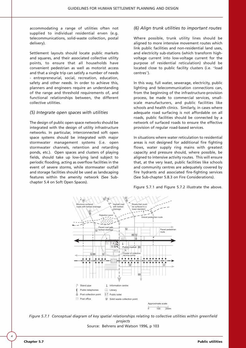
4
GUIDELINES FOR HUMAN SETTLEMENT PLANNING AND DESIGN
Chapter 5.7 Public utilities
accommodating a range of utilities often notsupplied to individual residential erven (e.g.telecommunications, solid-waste collection, postaldelivery).
Settlement layouts should locate public marketsand squares, and their associated collective utilitypoints, to ensure that all households haveconvenient pedestrian as well as motorist accessand that a single trip can satisfy a number of needs- entrepreneurial, social, recreation, education,safety and other needs. In order to achieve this,planners and engineers require an understandingof the range and threshold requirements of, andfunctional relationships between, the differentcollective utilities.
(5) Integrate open spaces with utilities
The design of public open space networks should beintegrated with the design of utility infrastructurenetworks. In particular, interconnected soft openspace systems should be integrated with majorstormwater management systems (i.e. openstormwater channels, retention and retardingponds, etc.). Open spaces and clusters of playingfields, should take up low-lying land subject toperiodic flooding, acting as overflow facilities in theevent of severe storms, while stormwater outfalland storage facilities should be used as landscapingfeatures within the amenity network (See Sub-chapter 5.4 on Soft Open Spaces).
(6) Align trunk utilities to important routes
Where possible, trunk utility lines should bealigned to more intensive movement routes whichlink public facilities and non-residential land uses,and electricity sub-stations (which transform high-voltage current into low-voltage current for thepurpose of residential reticulation) should belocated close to public facility clusters (i.e. “loadcentres”).
In this way, full water, sewerage, electricity, publiclighting and telecommunication connections can,from the beginning of the infrastructure-provisionprocess, be made to commercial services, small-scale manufacturers, and public facilities likeschools and health clinics. Similarly, in cases whereadequate road surfacing is not affordable on allroads, public facilities should be connected by anetwork of surfaced roads to ensure the effectiveprovision of regular road-based services.
In situations where water reticulation to residentialareas is not designed for additional fire fightingflows, water supply ring mains with greatestcapacity and pressure should, where possible, bealigned to intensive activity routes. This will ensurethat, at the very least, public facilities like schoolsand community centres are adequately covered byfire hydrants and associated fire-fighting services(See Sub-chapter 5.8.3 on Fire Considerations).
Figure 5.7.1 and Figure 5.7.2 illustrate the above.
Figure 5.7.1 Conceptual diagram of key spatial relationships relating to collective utilities within greenfieldprojects
Source: Behrens and Watson 1996, p 103

They indicate the spatial relationships of utilitieswithin, respectively, a “greenfield” and an“upgrade” project.
QUANTITATIVE GUIDELINES
Collective utility points primarily servinglower-order collective public utilitypoints
Densities, alternatives and hierarchies
The effect of two contextual factors needs to bemade clear in respect of any standards for lower-order collective public utility points.
The density of the area
For example, in densely populated areas, 15-25dwelling units per standpipe (a rough guide of thethreshhold for a standpipe) can be achieved byplacing a standpipe at the end of each street, andat a maximum distance of 100 m. In more sparselypopulated areas, a walking distance greater thanthe Redistribution and Development Programmestandard of 250 m should not be exceeded, almostirrespective of the threshhold. The walkingdistance will probably prevail over threshholdcriteria.
The availability of residential utilities
For example, in an area which (say) lacks a door-to-door postal service and solid-waste collectionservice, but where residential sites each have a toiletand a standpipe, the need for collective toilets andstandpipes will be much lower than where these arenot provided on residential sites. However, at aresidential area collective utility point where saysolid waste, postal and telephone facilities areprovided, collective toilets and standpipes willnevertheless have to be provided for the users ofthe telephones, nearby entrepreneurs and theircustomers, and passers-by.
Table 5.7.1 provides only a rough guideline, and thecontext of the specific area being served must beinvestigated, particularly with respect to densitiesand alternative options to the collective utility.
In addition, the place on the hierarchy of thecollective points being designed must be borne inmind. For example, if a lowest-order point, toserve 20 dwelling units, includes one waterstandpipe, a second-order point centred aroundsolid-waste collection, public telephones and postboxes could adequately also have only onestandpipe. Although the other utilities here maybe serving 200 or more dwelling units, thestandpipe is not also serving 200 dwelling units,
5
GUIDELINES FOR HUMAN SETTLEMENT PLANNING AND DESIGN
Public utilities Chapter 5.7
Figure 5.7.2 Conceptual diagram of key spatial relationships relating to collective utilities within upgradeprojects
Source: Behrens and Watson 1996, p 111

6
GUIDELINES FOR HUMAN SETTLEMENT PLANNING AND DESIGN
Chapter 5.7 Public utilities
but is the standpipe for only its immediate area of20 dwelling units - and for passers-by, etc, asdescribed above.
Thresholds and time and distancestandards
Design decisions regarding public utilities relatemainly to (i) the population catchments they serve(conversely the thresholds that they require in order tobe sustainable), and hence the numbers of each facilityrequired in any given area, and (ii) the distance thatuser households have to travel to gain access to them.
The specific demographic and socio-economic profileof each community should be used to plan and provideits public utilities, as indeed it should be used for anyother public facilities, especially those servingprimarily residential areas. For example, it is possiblethat a greater proportion of investment would berequired for pre-school facilities within the first fiveyears of a new settlement than for secondary andtertiary education.
Behrens and Watson (1996) point out that standardsfor individual facilities and amenities areconventionally assessed by considering their “optimal”spatial requirements in isolation of each other. Thisleads to a number of problems. For example,formulating space standards in isolation restricts thepotential of resource sharing and multi-functional useto reduce land requirements. In conditions of resourcescarcity this is essential - in cases where neither thelocal authority nor the relevant governmentdepartment can afford to develop the plannedfacilities or maintain public open spaces, land remainsvacant and unattended.
Planning, space and engineeringconsiderations
In the absence of detailed information regardingutility performance standards, Table 5.7.1 providesrough guidelines on location, time and distance, sizeand dimensions and user threshold standards. Whenused in conjunction with user threshold standards, theset of time and distance standards can act asbenchmarks to check the accessibility of utilitylocations. For these utility points, which are accessedprimarily by pedestrians, the standards assume anaverage walking speed of 3 km/h, or 50 m/min.
Depending on the supporting threshold population,some facilities should be sited in locations accessible topedestrians, while others should be sited in locationsaccessible to public-transport users, as well as to alimited number of pedestrians in the local area. Timeand distance standards are therefore more applicableto lower-order, pedestrian-orientated facilities - thelocations of higher order facilities are determinedmore by the public transport system, or by other
reasons for the public to gather, than by time anddistance ranges.
Upgrades, operation and maintenance,links, and detailed design
Provision for upgrading
• The assumption up to now is that public waterstandpipes (for example) are needed becausethe residential stands do not have their ownstandpipes, or that these are over-used (e.g.several families on each stand, sharing one tap).In another example, there has been theassumption that postal delivery boxes areneeded because there is no door-to-doordelivery service. This situation may change ifthe services are upgraded - the need forcollective utility points would reduce to theextent that each household now received aservice at its door or to its site. The designguidelines for these higher levels of service maybe found in Chapter 6 onwards (the postalservice is not addressed).
• The conversion of collective to on-sitehousehold services should take place throughincremental in-situ upgrading projects as thecommunity circumstances improve. The needfor communal toilets, ablution facilities, laundrycentres and standpipes placed at walkabledistances from houses would fall away as on-site (residential) services are provided. Thepublic spaces on which these stand could thenbe rezoned for residential, business orinstitutional purposes. The prevailingcircumstances would dictate.
• With respect to piped services, the design of thelink mains, trunk mains and the pipe networkfor formal townships should allow forupgrading to individual site connections,leading directly to greatly increased waterdemand in the future. This design philosophy,together with the phased construction/provisionof water mains and pipelines only alongimportant movement routes and to collectivewater utility points, will provide ample capacityto satisfy the peak demand at the publicstandpipes.
• The design approach of pipe networks forinformal settlements should take cognisance ofthe permanent or temporary nature of thesettlement, and the final layout if thesettlement is to be upgraded. If a settlement istemporary, the pipe network should bedesigned to satisfy the minimum (RDP 1994)levels for walking distances and consumption.

7
GUIDELINES FOR HUMAN SETTLEMENT PLANNING AND DESIGN
Public utilities Chapter 5.7
Collective waterstandpipes
• Collectivestandpipes areplanned atpositions inresidential areasto satisfy theminimum servicelevels, but shouldalso be informedby communityneeds.
• For maintenanceconsiderations itmight bepreferable toplace collectivestandpipes onprivateresidential sites(maintenanceresponsibility onowner - seeChapter 9).
• Alternatively, thestandpipes couldbe constructedon public openspace adjacent toa residential sitewhose ownerwould take onthe maintenancetask.
• In denselypopulated areasa maximumdistance of 100m and a walkingtime of twominutes arepreferable.
• In more sparselypopulated areas,a walkingdistance of 250m (DWAF 1994,p 15) should notbe exceeded.
• Water standpipeand structureshould becustomised tosuit thecommunityneeds.
• Considerationsincludeacceptable liftingheights, animalwatering,whethercontainers arewashed atstandpipes,whetherhosepipes areused to fillnarrow-mouthedcontainers, needfor bulk filling,etc..
• Considerprovision ofseating or atleast an area forqueuing orwaiting (the areaaround thestandpipes isoften used forsocialising).
• In denselypopulated areasa norm of 15-25dwelling unitsper standpipe isacceptable.
Table 5.7.1: Quantitative guidelines for lower-order public collective utility points
UTILITY LOCATION ACCESS SIZE AND USE CAPACITIES AND DIMENSIONS THRESHOLDS
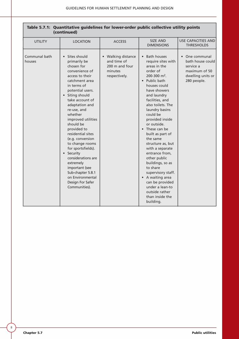
8
GUIDELINES FOR HUMAN SETTLEMENT PLANNING AND DESIGN
Chapter 5.7 Public utilities
Table 5.7.1: Quantitative guidelines for lower-order public collective utility points(continued)
Communal bathhouses
• Sites shouldprimarily bechosen forconvenience ofaccess to theircatchment areain terms ofpotential users.
• Siting shouldtake account ofadaptation andre-use, andwhetherimproved utilitiesshould beprovided toresidential sites(e.g. conversionto change roomsfor sportsfields).
• Securityconsiderations areextremelyimportant (seeSub-chapter 5.8.1on EnvironmentalDesign For SaferCommunities).
• Walking distanceand time of 200 m and fourminutesrespectively.
• Bath housesrequire sites withareas in theorder of 200-300 m2.
• Public bathhouses couldhave showersand laundryfacilities, andalso toilets. Thelaundry basinscould beprovided insideor outside.
• These can bebuilt as part ofthe samestructure as, butwith a separateentrance from,other publicbuildings, so asto sharesupervisory staff.
• A waiting areacan be providedunder a lean-tooutside ratherthan inside thebuilding.
• One communalbath house couldservice amaximum of 50dwelling units or280 people.
UTILITY LOCATION ACCESS SIZE AND USE CAPACITIES AND DIMENSIONS THRESHOLDS

9
GUIDELINES FOR HUMAN SETTLEMENT PLANNING AND DESIGN
Public utilities Chapter 5.7
Table 5.7.1: Quantitative guidelines for lower-order public collective utility points(continued)
Communal toilets • Sites shouldprimarily bechosen forconvenience ofaccess to theircatchment areain terms ofpotential users.
• Sites on whichcommunaltoilets areplaced could beconverted toresidential orbusiness siteswhen upgradingof utilities takesplace.
• Where possiblethey should belocated next tofacilities likeschools, clinicsand libraries, sothat when (if)individualisedsanitation isprovided, theycan simply beincorporatedinto the publicfacilities. In thisway redundantservice provisioncan be avoided.
• Walkingdistance andtime of 75 mand 1,5 minutesrespectively.
• Varioussanitationtechnologies aredescribed inChapter 10. Thefactors whichinfluence thechoice of eachof the particularsanitationsystems aredetailed.
• Subject to theconstraintsinfluencing thechoice, most, ifnot all, of thesesanitationsystems can beused forcommunaltoilets.
• If residentialsites do not havetheir owntoilets, it isproposed that areasonable levelof conveniencefor the users ofpublic toilets canbe attained ifthe ratio is amaximum oftwo households(12 people) pertoilet.
• If the communaltoilets aresupplementaryto toilets onresidential sites,their numbercan be reducedaccordingly.
UTILITY LOCATION ACCESS SIZE AND USE CAPACITIES AND DIMENSIONS THRESHOLDS

10
GUIDELINES FOR HUMAN SETTLEMENT PLANNING AND DESIGN
Chapter 5.7 Public utilities
Sources of information: WHO 1979; CSIR 1994; Behrens and Watson 1996; Kerr 1989; Kerr 1990; Ninham Shand1997; various personal communications)
Table 5.7.1: Quantitative guidelines for lower-order public collective utility points(continued)
Solid-wastecollection points
• Sites shouldprimarily bechosen forconvenience ofaccess to theircatchment areain terms ofpotential users.
• Small containerscan be placed onsidewalks,whereas largerskips requirelarger sites.(See alsoChapter 11)
• Walkingdistance andtime of 100 mand two minutesrespectively(skip).
• Hard-standingareas need ± 24 m2 for thetrucks loadingand off-loadingthe containers.
• Size ofcontainers varyfrom 85 l to6 m3 capacity
• Smallercontainers (upto 210 lcontainer) aremounted on anaxle/pivot shaftmounted on twosupportingpillars toprevent dogsoverturningthem.
• A maximum of100-150dwelling unitsshould beserviced by onesolid-wastecollection point(skip).
• Average solidwaste generatedby low-incomeurbanhouseholds is0,2 m3/capita/year at anaverage densityof 300 kg/m3 -and for middle-incomehouseholds0,75 m3/ capita/year withdensity of 215 kg/m3.
• Example: If low-incomehouseholds(average of 5,6persons/household)generate 22 lper week (1,12 m3/year),the number ofhouseholdsserved by acontainerserviced weeklywould be:- 4 per 85 l
container- 9 per 210 l
container- 270 per 6 m3
container(skip).
(See also Chapter 11)
UTILITY LOCATION ACCESS SIZE AND USE CAPACITIES AND DIMENSIONS THRESHOLDS

11
GUIDELINES FOR HUMAN SETTLEMENT PLANNING AND DESIGN
Public utilities Chapter 5.7
Sources of information: WHO 1979; CSIR 1994; Behrens and Watson 1996; Kerr 1989; Kerr 1990; Ninham Shand1997; various person communications)
Table 5.7.1: Quantitative guidelines for lower-order public collective utility points(continued)
Public telephones • Need to behighly visibleand accessible tothe populationserved.
• Should belocated alongactivity routeswithin easywalkingdistance.
• Walkingdistance of200 m.
• Telkom SA provides public telephonesafter a needs analysis and projectedfuture demand exercise has been doneto confirm the viability of the specificinstallation.
Postal collectionand delivery points
• Preferable tohave smallerpostal collectionand deliverypoints evenlyspacedthroughout theresidential area.
• Need to behighly visibleand accessible tothe populationserviced.
• Should belocated alongactivity routeswithin easywalkingdistance.
• Walkingdistance andtime ofrespectively 250 m and fiveminutes.
• Appropriatedimension of a50 box structureis 0,6 m wide x0,9 m long onplan.
• Pillar-type postboxes areusually providedfor postingletters, butparcels, insuredmail, etc, needto be handed ina post offices(see Sub-chapter5.5, Table 5.5.7).
• One postcollection point(one collection/delivery box persubscriber) couldserve 200-1000dwelling units.
UTILITY LOCATION ACCESS SIZE AND USE CAPACITIES AND DIMENSIONS THRESHOLDS
12
GUIDELINES FOR HUMAN SETTLEMENT PLANNING AND DESIGN
Chapter 5.7 Public utilities
• The opportunities for upgrading thetechnology of sanitation, in the form ofdescriptions of each of the sanitationalternatives, are dealt with in Chapter 10.Should the upgrade be to toilets on eachresidential site, the need for public toilets willfall away and the site on which these have beenerected can be transferred to privateownership.
• As informal areas are upgraded and developedinto formal settlements, the transportable postbox structures can “move” with the users andcan be made a permanent structure.
• The upgrading of refuse collection services, tocollection from the sidewalk outside individualsites, would make redundant the facilitiesprovided at solid-waste collection points. Thesecould either be relocated to other areas still inneed of such facilities, or removed, and theservice would cease.
Operation and maintenance
Correct operation and maintenance, to enable theutility to provide at all times at least a minimumlevel of the intended service, is extremelyimportant. However, the operation andmaintenance of the collective utility point canoften be a problem.
To reduce the incidence of utilities being out ofaction, and hence reduce construction, operationand maintenance costs, as well as inconvenience tousers, public participation should attempt toensure “ownership” and identified responsibility ofindividuals or households for the operation,maintenance and cleaning of the utility that theywill directly depend upon. The likely effectivenesswill be increased if training of local inhabitants inthe operation and maintenance of the utilityaccompanies the infrastructure development.Conversely, design of the utility should takecognisance of the capacity and resources of localinhabitants to facilitate this local operation andmaintenance. With respect to operation andmaintenance, there are thus two issues:
• it must be established who is to be responsible;and
• design the components for easy operation andmaintenance.
Even more important than training in maintenanceof the collective utility point, because it mustinvolve all users, must be training in the use of thearea. It must be inculcated that good operationalpractices and maintenance are the responsibility ofeveryone who comes to the utility point. Thus
everybody must see it as their duty to (forexample):
• turn taps off after use;
• clean up the area - remove rubbish;
• remove sediment from the standpipe apron,and ensure that the outlet to the soakaway isunblocked at all times; and
• notice when taps are dripping even afterhaving been turned off, and to notify (and toknow whom to notify) those responsible forroutine maintenance, so that they can replacethe washer or other faulty component.
Despite all precautions, however, problemsfrequently arise in practice. A periodically out-of-order collective utility can lead to the users callingfor its replacement by an on-site service, whetherthis option is affordable or not, or undesirable forany other reason. This is despite there beingnothing intrinsically unacceptable about the levelof service provided by the collective point, but itsoperational record has given it (and, often, othercollective utilities) a bad reputation.
Personal safety is an important issue in respect ofsome collective utility points, especially bathhouses and communal toilets. There are manyreported instances of users feeling unsafe at theutility point and/or on the walk there and back. Itis because users have been attacked (the bathhouses even became the hiding places of criminals)that some of the few bath houses of the past weredemolished (Huchzermeyer 1996, pp 26, 27) (SeeSub-chapter 5.8.3).
Link infrastructure
For load capacities of link infrastructure, theappropriate chapters from Chapter 6 onwardsshould be referred to.
Detailed design
The detailed design of collective utility points isbeyond the scope of these guidelines. (Refer, forexample, to Ninham Shand (1997), for a recentdiscussion of more detailed issues on collectivewater points.)
Collective utility points primarily servinghigher-order collective utility points
Design considerations
Opportunities for trading, small-scale manufacturing,repairs and servicing, and other economic activitiesexist at places where large numbers of people

13
GUIDELINES FOR HUMAN SETTLEMENT PLANNING AND DESIGN
Public utilities Chapter 5.7
gather or through which large numbers ofpedestrians move.
Reference in this section is thus to guidelines forcollective utility points primarily serving publicgathering places such as at modal interchanges,bus and taxi ranks, areas of high-volume pedestriantraffic (inner city), major vehicle-entry points toresidential areas, along major pedestrian routes torailway stations, etc, public markets or communitycentres. These utility points are, often, also usedon the way to or from home or to (in addition topatronising the utility point) work, school,recreation, shopping or other destination(s).
Design decisions regarding these relate mainly to
• planning considerations, particularly thelocation of one component relative to another(e.g. high-use utilities at a rail station should beas close as possible to the main pedestrian routebetween the platform exit and the taxi rank);
• space standards, particularly related to thenumbers of users at any one time, and thedistribution of use through the day andthrough the week;
• engineering considerations;
• provision for upgrading;
• operation and maintenance; and
• link infrastructure.
Whereas the guidelines of the previous sectionswould obviously not be of value in determining thelocation of collective utility points at publicgathering places, they are of value in determiningthe number of each at the various gatheringplaces.
The forms and functions of public gathering placeswill vary enormously from one location to another,and each resultant physical form of the collectivefacility must vary accordingly.
In the planning of new local mixed-use areas,provision should be made for space for sites fortrading, but nothing should be designed and builtuntil trading has begun on the site and potentialshoppers are living in the vicinity.
With respect to the planning of space for and thedesign of utilities, there are major differencesbetween public gathering places, including tradingcentres, in outlying settlements and those in themore established parts of the city, including theinner city. The inner city collective utility need ismostly for management of what is already there,
and its upgrading, whereas in outlying settlementsthe need is to facilitate economic development.
Engineering considerations for the inner city andoutlying areas are also different. The extensivepresence of underground services below sidewalks,which calls for care in the excavation offoundations for stalls, is one example. The outlyingareas, on the other hand, are often withoutengineering services. There is often thus a need tobring utilities to the outlying market areas but insuch a way that these also cater for local residents.In another example, there are space constraints inthe inner city - thus it might not be acceptable toplace a refuse skip on a sidewalk in the inner city.
The planning of the market areas, taxi and busranks, public toilets, access for service andemergency vehicles, pedestrian routes andcirculation areas lies within the field of urbandesign and architectural disciplines. In existingtrading areas, railway stations, bus and taxi ranks,information can be gathered by means of vehicleand pedestrian movement counts, which will assistin the planning process.
Planning, space and engineeringconsiderations
Utilities for the public gathering places must bedesigned in accordance with the engineeringguidelines contained in Chapter 6 onwards. Totake public toilets in modal interchanges areas asan example, provision of these should be linked tothe number of people passing through, gatheringor trading, etc. Thus large pedestrian standsrequire more utilities. For information ondetermining the numbers of toilets, SABS 400:1990is of value.
Small-scale manufacturing, repair services andcooking activities require electricity (or otheralternative energy sources). Electricity supply canbe provided through pre-paid card or code-operated dispensers, which are mounted undercover in lock-up stalls hired by the entrepreneurs.
In other respects, the comments in Table 5.7.1 applyhere as well.
Provision for upgrading, operation andmaintenance, links, and detailed design
Certain facilities/services fulfil a need of thecommunity even as the opportunities forimprovement present themselves. Markets wouldalways be a need, if the locality generates incomefor the beneficiaries. Similarly, sanitation facilitiesat public open spaces or taxi ranks would notnecessarily fall into disuse were there upgrading orimproved circumstances for the community.

14
GUIDELINES FOR HUMAN SETTLEMENT PLANNING AND DESIGN
Chapter 5.7 Public utilities
In other respects, the comments of the previoussection under the same heading apply here as well.
THE GUIDELINES - A CAUTIONARYREMARK
Much of the preceding, it has to be admitted, is tosome or other extent “unproven”. With fewexceptions, each provision of collective utility points inSouth Africa has tended to share one or more of thefollowing characteristics:
• provision as an ad hoc reaction by the authoritiesto a land invasion, or gradual overcrowding of asettlement (and overloading of existing services) -as a stopgap which is not improved upon until thenext health scare, bout of political unrest, orpopulation influx;
• as a single-utility provision (e.g. collective water inone place, collective sanitation elsewhere, andpostal delivery in a third place), with no attemptbeing made to co-ordinate provision for thegreater convenience of the users; and
• a few years after construction, the utility is poorlymaintained, vandalised, and/or abused - and oftenas a consequence avoided by those who, it hadbeen planned, would use the utility.
The last couple of years has seen a dramatic increase inthe number of attempts to provide collective utilities inthe manner described in this sub-chapter, and in theeffort and skill devoted to these attempts. This isespecially in respect of those places where largenumbers of people gather every day (the modalinterchange with informal market, for example). Everysituation is so very different from any other that designguidelines must necessarily be broad. These situationaldifferences arise in terms of size, in-town or suburbanor outlying area location, type and intensity of activity,history, socio-economic groups using the place,presence (or absence) and state of existing utilities, andjuxtaposition of magnets (the markets, public transportboarding points, office or shop destinations, etc).
It should, however, be noted that, understandably inthe current situation of financially-strapped localauthorities (who are usually the developers of thesecollective utilities), the available resources have had tobe given to the worst situations, which usually hasmeant those affecting the largest numbers of users.Thus the projects available for study, whether projectsbeing planned or already built, are generally at placeswhere large numbers of people gather each day
• to break their commuting journey (i.e. interchangebetween some combination of walk-taxi-bus-train
(less frequently, car or truck; even less frequently,cycle));
• to shop; or
• (often) to do both.
Even in respect of these public-gathering types of use,the available effort is thus going mostly into situationswith the largest concentrations of people, rather thaninto the planning and design of collective utility pointsto serve smaller-scale taxi stops or trading areas.
Very little of the current effort is going into higher-order collective utility points designed for use byresidents of the immediate vicinity. Even theManenberg bath house, built to cater for adevelopment where the houses were initially notfitted with hot water cylinders, is one of the fewexceptions (and it is more than ten years old).
Thus many of the collective utility points presentlybeing designed (certainly, almost all of those abovethe lowest order) are for the upgrading of alreadyplanned situations. Already planned in this contextincludes
• existing situations where pressure of users, andoften the congested and polluted circumstancesthat have arisen, have to be addressed urgently;and
• situations in townships already built and settled,which may not yet have become problems, but arein an early stage of growth and obviously need tohave collective utilities provided before unhygienicor otherwise undesirable circumstances arise.
CONCLUSION
Extensive enquiries failed to find in a single example inSouth Africa the application of most, let alone all, ofthe principles set out in these guidelines - which is notin the least surprising. One of the purposes of thisdocument is to modify key aspects of the planningphilosophy that has governed the development of ourcities - especially to free them from rigid adherence toconcepts of the inward-looking neighbourhood unitand from a road hierarchy that is unfriendly to publictransport.
Thus no suitable examples were found of planninglayouts that specifically allowed for collective utilitypoints, accommodating multiple utilities in a designedrelationship with public transport (especially taxis),informal marketing and the nearby residential area.Such forms of development have never before beenadvocated by the authorities - and, if they have been

built at all, have not been built and operated for longenough for lessons to be learnt. All stakeholders areunfamiliar with the concept - land-owners, residents,taxi associations, informal traders and professionalsalike. If there are existing situations that are nowbeing replanned with some of this sub-chapter’sprinciples in mind, they are each unique experimentsnot just in planning and engineering design, but alsoin processes of social understanding, small businessdevelopment, negotiation and, not least, politicaldynamics.
Even the examples found of collective utility pointswithin residential areas are inadequate in that nonewere designed as multi-utility clusters. All areprimarily single-purpose, with some other usesperhaps added as an afterthought. Their locations are
often not satisfactory, even for that single purpose.Their integration into the needs of the communitythey serve, and especially their surveillance by thatcommunity (let alone their operation andmaintenance - if any - by that community) have notbeen thought through.
Nevertheless, despite the untried nature of much ofthe planning and engineering philosophy underlyingthis sub-chapter, the shortage of touchable casestudies, and the fact that the jury is still out on nearlyall of them, it is believed that this sub-chapter is asignificant step forward in a desirable planningdirection, to the great advantage of the users(residents, taxi drivers and passengers, traders andothers) that will have the convenience of collectiveutilities.
15
GUIDELINES FOR HUMAN SETTLEMENT PLANNING AND DESIGN
Public utilities Chapter 5.7

16
GUIDELINES FOR HUMAN SETTLEMENT PLANNING AND DESIGN
Chapter 5.7 Public utilities
BIBLIOGRAPHY
African National Congress (ANC) (1994). TheReconstruction and Development Programme.Umanyano, Johannesburg.
Bartone, C et al (1994). Toward environmentalstrategies for cities. Urban Management ProgrammeReport No. 18. UNCHS (Habitat) / The World Bank /UNDP. Washington.
Behrens, R and Watson, V (1996). Making urbanplaces: principles and guidelines for layout planning.Urban Problems Research Unit, University of CapeTown.
Cairncross, S and Feachem, R G (1993). Environmentalhealth engineering in the tropics. (2nd ed.) JohnWiley, Chichester.
City of Cape Town (1996). Nyanga Station precinctdevelopment framework. Report by City Planner’sDepartment to Urban Planning Committee. 22November.
City of Cape Town (1997). Nyanga Station precinctdevelopment: Urban, landscaping and architecturaldesign brief. Draft: City Planner’s Department.
CSIR (1994). Guidelines for the provision ofengineering services and amenities in residentialtownship development. Revised edition, NationalHousing Board. Pretoria.
Development Bank of Southern Africa (1993a). Socio-economic enhancement of development projects.Construction and development series: No. 1. DBSA.Midrand.
Development Bank of Southern Africa (1993b).Interim guidelines for labour-based constructionprojects. Construction and development series: No. 2.DBSA. Midrand.
Feachem, R G, Bradley, D J, Garelick, H and Mara, D D(1983). Sanitation and disease: Health aspects ofexcreta and wastewater management. Published forthe World Bank. John Wiley. Washington DC.
Genthe, B and Seager, J (1997). The effect of watersupply, handling and usage on water quality inrelation to health indices in developing communities.Water Research Commission Report Nr. 562/1/96.Water Commission. Pretoria.
Greater Johannesburg Transitional MetropolitanCouncil (1997). Greater Johannesburg economicdevelopment study tour of Cape Town, Port Elizabethand Durban. GJTMC. Johannesburg.
Greater Johannesburg Transitional MetropolitanCouncil, Southern MLC (1997a). Development andmanagement of street trading markets: A proceduralguide for the Southern Metropolitan Local Council.Southern MLC. Johannesburg.
Greater Johannesburg Transitional MetropolitanCouncil, Southern MLC (1997b). Informal tradingprojects within the outlying areas and the informalsettlements 97/98. Local Economic DevelopmentDepartment. Southern MLC. Johannesburg.
Huchzermeyer, M (1994). Public obligation versusindividual liberty: Considerations in the provision ofliving environments for the lowest income sector onwell-located land in Cape Town, with reference to theWingfield site. Project report for Master’s Degree inCity Planning and Urban Development, University ofCape Town, October.
Huchzermeyer, M (1996). Nyanga: Interviewing ofresidents and roleplayers. Project report for ODA.Draft, May.
Kalbermatten, J M, Julius, D S and Gunnerson, C G(1980a). Appropriate technology for water supply andsanitation. Vol 1: Technical and economic options.World Bank. Washington DC.
Keep South Africa clean organisation (1997). One mancontract.
Kerr, C (Ed) (1989). Community water development.Intermediate Technology Publications. London.
Kerr, C (Ed) (1990). Community health and sanitation.Intermediate Technology Publications. London.
Mayet, M A G (1994). Domestic waste generation inthe urban core of the DFR. MSc dissertation, Universityof Natal.
Milne, C (1994). Guidelines for emerging contractordevelopment. Construction and development series:No. 5. DBSA. Midrand.
Ninham Shand (1997): Design of water delivery toreduce health risks. Report for NaSCO of DWAF. Draft.October 1997.
Ninham Shand (1998). Appropriate guidelines on theplanning and design of collective public utility systems,as a planned element of settlement systems.Unpublished report prepared for the CSIR, Pretoria.
Okun, D A and Ernst, W R (1987). Community pipedwater supply systems in developing countries: Aplanning manual. World Bank Technical Paper No. 60.World Bank, Washington DC.

Palmer Development Group (1996). Evaluation of solidwaste practice in developing urban areas of SouthAfrica. WRC report No. 629/1/96. Pretoria.
SABS 400:1990. Code of practice for the application ofthe National Building Regulations. South AfricanBureau of Standards, Pretoria.
South Africa, Department of ConstitutionalDevelopment (1997). Municipal service options: aguideline for local authorities. Government Printers.Pretoria.
South Africa, Department of Water Affairs (1994).Water supply and sanitation policy: White Paper:Water - an indivisible national asset. GovernmentPrinter. Cape Town.
South Africa, Department of Water Affairs (1996).White Paper: National sanitation policy. NationalSanitation Task Team. Draft. Government Printer.Pretoria.
South Africa: Department of Water Affairs (1997).White Paper on a national water policy for SouthAfrica. Government Printer. Pretoria.
Sulabh International Social Service Organisation (nd).Sulabh public toilets and bath complexes. New Delhi.
Wates Meiring and Barnard (1997). Report on wastegeneration sub-project. Report to Department ofWater Affairs, No. 3064/1505/4/S. Pretoria.
Wegelin-Schuringa, M and Kodo, T (1997). Tenancyand sanitation provision in informal settlements inNairobi: Revisiting the public latrine option.Environment and urbanisation. October, pp 181-190.
WHO International Reference Centre for CommunityWater Supply (1979). Public standpost water supplies -a design manual. Technical paper 14. The Hague,December.
17
GUIDELINES FOR HUMAN SETTLEMENT PLANNING AND DESIGN
Public utilities Chapter 5.7

18
GUIDELINES FOR HUMAN SETTLEMENT PLANNING AND DESIGN
Chapter 5.7 Public utilities

Environmental design for
safer communities
Chapter 5.8.1
5.8.1

TABLE OF CONTENTS
THE ROLE OF ENVIRONMENTAL DESIGN IN PREVENTING CRIME IN SOUTH AFRICAN CITIES AND TOWNS . . . . . . . . . . . . . . . . . . . . . . . . . . . . . . . . . . . . . . . . . . . . . . . . . . . . . . . . . . . . . . . . . . . . . . 1
THE CONCEPT OF CRIME PREVENTION THROUGH ENVIRONMENTAL DESIGN . . . . . . . . . . . . . . . . . . . . 1
PRINCIPLES OF CRIME PREVENTION THROUGH ENVIRONMENTAL DESIGN . . . . . . . . . . . . . . . . . . . . . . 2
Surveillance and visibility . . . . . . . . . . . . . . . . . . . . . . . . . . . . . . . . . . . . . . . . . . . . . . . . . . . . . . . . . . . . 2
Territoriality and defensible space . . . . . . . . . . . . . . . . . . . . . . . . . . . . . . . . . . . . . . . . . . . . . . . . . . . . . 4
Access and escape routes . . . . . . . . . . . . . . . . . . . . . . . . . . . . . . . . . . . . . . . . . . . . . . . . . . . . . . . . . . . . 5
Image and aesthetics . . . . . . . . . . . . . . . . . . . . . . . . . . . . . . . . . . . . . . . . . . . . . . . . . . . . . . . . . . . . . . . 6
Target-hardening . . . . . . . . . . . . . . . . . . . . . . . . . . . . . . . . . . . . . . . . . . . . . . . . . . . . . . . . . . . . . . . . . . 7
THE APPLICATION OF THE PRINCIPLES OF CRIME PREVENTION THROUGH ENVIRONMENTAL DESIGN . . . . . . . . . . . . . . . . . . . . . . . . . . . . . . . . . . . . . . . . . . . . . . . . . . . . . . . . . . . 7
BIBLIOGRAPHY . . . . . . . . . . . . . . . . . . . . . . . . . . . . . . . . . . . . . . . . . . . . . . . . . . . . . . . . . . . . . . . . . . . . 9
i
GUIDELINES FOR HUMAN SETTLEMENT PLANNING AND DESIGN
Environmental design for safer communities Chapter 5.8.1

ii
GUIDELINES FOR HUMAN SETTLEMENT PLANNING AND DESIGN
Chapter 5.8.1 Environmental design for safer communities
LIST OF FIGURES
Figure 5.8.1.1 Increase opportunities for passive surveillance . . . . . . . . . . . . . . . . . . . . . . . . . . . . . . . . . . . . . .2
Figure 5.8.1.2 Importance of sufficient and adequate lighting . . . . . . . . . . . . . . . . . . . . . . . . . . . . . . . . . . . . .3
Figure 5.8.1.3 Route layout and pedestrian movement . . . . . . . . . . . . . . . . . . . . . . . . . . . . . . . . . . . . . . . . . . .3
Figure 5.8.1.4 Location of small open spaces . . . . . . . . . . . . . . . . . . . . . . . . . . . . . . . . . . . . . . . . . . . . . . . . . . .3
Figure 5.8.1.5 Landscaping and visibility . . . . . . . . . . . . . . . . . . . . . . . . . . . . . . . . . . . . . . . . . . . . . . . . . . . . . .3
Figure 5.8.1.6 Identifiable neighbourhood character . . . . . . . . . . . . . . . . . . . . . . . . . . . . . . . . . . . . . . . . . . . .4
Figure 5.8.1.7 Network of small neighbourhood parks . . . . . . . . . . . . . . . . . . . . . . . . . . . . . . . . . . . . . . . . . . .4
Figure 5.8.1.8 Clearly definable edges . . . . . . . . . . . . . . . . . . . . . . . . . . . . . . . . . . . . . . . . . . . . . . . . . . . . . . . .5
Figure 5.8.1.9 Avoid ending roads on vacant or undeveloped land . . . . . . . . . . . . . . . . . . . . . . . . . . . . . . . . .5
Figure 5.8.1.10 Ensure visibility of ablution facilities . . . . . . . . . . . . . . . . . . . . . . . . . . . . . . . . . . . . . . . . . . . . . .6
Figure 5.8.1.11 The image of the building . . . . . . . . . . . . . . . . . . . . . . . . . . . . . . . . . . . . . . . . . . . . . . . . . . . . . .7
Figure 5.8.1.12 Plan for surveillance . . . . . . . . . . . . . . . . . . . . . . . . . . . . . . . . . . . . . . . . . . . . . . . . . . . . . . . . . .7

THE ROLE OF ENVIRONMENTALDESIGN IN PREVENTING CRIME INSOUTH AFRICAN CITIES AND TOWNS
Preventing crime has become a key challenge togovernment in post-apartheid South Africa. However,a review conducted for the National Crime PreventionStrategy (NCPS) in 1997, of the extent to whichenvironmental design for crime prevention is beingimplemented, suggests that there is little experienceto draw from in South Africa. Design professionalsalso rarely use crime pattern analysis in the designprocess. Therefore, a careful regard of the extent towhich environmental design is being utilised toprevent crime is crucial if environmental designchanges are to address the real problems.
In this regard, government’s core policy document, theNCPS, places environmental design firmly on theagenda. In addition, the White Paper on LocalGovernment expects local authorities to play a key rolein implementing two of the four focus areas of theNCPS, namely environmental design and promotingpublic values and education.
Apart from government legislation, the public is alsopressurising local government to respond to the crimeissue. Communities participating in workshops todevelop Land Development Objectives (LDOs),required by the Development Facilitation Act, have inmany cases prioritised the need for greater safetyabove all other needs. Local and internationalbusiness interests have also highlighted the impact ofcrime on tourism and foreign investment. With this inmind, a focus on crime prevention throughenvironmental design is indeed warranted.
Crime in South Africa affects different people andparts of the city in different ways. This has importantimplications for planning and the prioritisation ofdesign interventions. Crime patterns and trends inpoorer areas such as townships and informalsettlements differ from those in wealthier suburbs,which in turn differ from those in inner city areas.
The poorer inhabitants of the city are generally mostvulnerable to violent crime, but they do experience asignificant proportion of property crime. Suburbanresidents are more likely to be the victims ofproperty crime, and they experience comparativelylow levels of violence. In inner city areas, violentcrimes targeting property predominate.Environmental design can make an impact on sometypes of crime in each of these settings, as well asalleviate the fear of crime.
Given this present situation, the next section willshortly define the concept of crime preventionthrough environmental design. This will be followedby the fundamental principles of environmentaldesign to prevent crime, accompanied by some of the
important recommendations to be considered whenapplying these principles to settlement planning.Finally, the application of these principles will behighlighted.
THE CONCEPT OF CRIME PREVENTIONTHROUGH ENVIRONMENTAL DESIGN
The notion of adapting and exploiting theenvironment, particularly the built environment, toassist with crime prevention is not new. Take, forexample, the defensive walls that were built aroundmedieval towns to protect the inhabitants fromintruders. This was, in effect, using environmentaldesign as part of a strategy to prevent crime.
During this century numerous studies have beenconducted and many documents written on therelationship between environmental design and crime.Over the past 30 to 35 years, a number of schools ofthought have emerged around the idea of crimeprevention through environmental design. Theinternational literature and the main components ofrecent thinking on the subject are outlined in thefollowing South African publications, namely, Safer byDesign (Kruger et al 1997), Environmental Design forSafer Communities in South Africa (Napier et al 1998)and The History of Crime Prevention throughEnvironmental Design: A Comparative Study (Meyerand Qhobela 1998).
Today, it is generally accepted that certain types ofcrime can be limited if the environment is designedappropriately. Design initiatives form an integral partof crime prevention strategies in countries likeCanada, the United Kingdom, the United States ofAmerica and The Netherlands. A great deal of researchon the topic has been done internationally andnumerous publications are available. However, littleresearch has been done as yet in South Africa.
Environmental design as currently practised is oftenindistinguishable from target-hardening (for example,building higher walls and securing property againstcrime). Target-hardening is, however, only onecomponent of environmental design to prevent crime.
Crime prevention through environmental design canbe defined as the implementation of measures toreduce the causes of, and the opportunities for,criminal events, and to address the fear of crimethrough the application of sound design andmanagement principles to built environments.
Understanding crime is critical to its prevention.Whether or not a crime occurs depends on theinteraction of several elements. These elementsinclude the physical and social environment in which acrime occurs, the presence of active or passive forms ofsurveillance, the perpetrator, and the target or victim
1
GUIDELINES FOR HUMAN SETTLEMENT PLANNING AND DESIGN
Environmental design for safer communities Chapter 5.8.1

2
GUIDELINES FOR HUMAN SETTLEMENT PLANNING AND DESIGN
Chapter 5.8.1 Environmental design for safer communities
of a crime. The form of the built environment caninfluence these elements and several design principlesare fundamental in designing to reduce crime.
PRINCIPLES OF CRIME PREVENTIONTHROUGH ENVIRONMENTAL DESIGN
A number of basic principles emerge as fundamentalin designing to reduce crime. While these principlesare universal in the design of safer environments, theyhave been adapted to suit the characteristics anddynamics of South African cities. Most of these citieswere shaped by apartheid planning principles, whichcontribute to the crime problems. With this in mind,crime prevention through environmental designbecomes an even greater challenge.
The backdrop for these principles is, therefore, theSouth African city. This is the typical physical and socialsetting within which designers and decision makersare working, and fundamental restructuring is crucialif equitable and safer cities are to be achieved.
These basic principles are
• surveillance and visibility;• territoriality and defensible space;• access and escape routes;• image and aesthetics; and• target hardening.
These principles are applied throughrecommendations for crime prevention at three levels:city, neighbourhood and site. The following sectionwill highlight only a few of the recommendations forthe city and neighbourhood levels, since these aredirectly relevant to settlement-making. A morecomplete set of recommendations can be found in thepublication: Environmental Design for SaferCommunities in South Africa (Napier et al 1998).
Surveillance and visibility
Passive surveillance is the casual observance of publicand private areas by users or residents in the course oftheir normal activities. It can also be referred to as thepresence of “protective eyes”. The extent of visualcontact people have with a space and whether theirpresence is visible determine whether they canintervene and whether users feel safe.
Passive surveillance depends on a range of factorsincluding the placing of windows, doors and otheropenings, the distances between buildings, the sizes ofpublic spaces, vacancy rates and degrees and types ofuse. The zoning of city areas and the functionality ofbuildings are key elements in determining whetherprotective eyes are present day and night, or not.Multifunctional land uses, rather than monofunctionalzoning are required to ensure long hours of use.
Active surveillance refers to surveillance by police orother agents whose express function is to patrol an area.
Surveillance is improved if there is good visibility.Visibility is the degree to which an environment ismade visible by elements such as lighting anduninterrupted lines of sight. Dark or twisting streets,alleys, entrances and doorways can act as havens forpotential offenders and increase residents’ andvisitors’ fear of crime. The way in which lighting isdesigned and positioned, and the way roads and pathsare laid out can obviate many of these problems andrender environments and users visible to anyone in theenvironment.
The following are a number of the ways to ensuresurveillance.
• Design and zone streets and squares to allow longhours of use and so act as organising elements forthe location of varieties of facilities.
Figure 5.8.1.1 Increase opportunities for passivesurveillance
These facilities can then ensure the presence ofprotective eyes, both in the day and at night.
• Design neighbourhoods so that people areencouraged to intervene quickly and effectively tomodulate crime.
This can be promoted in a number of ways - forexample, through the proximity of buildings to eachother; the number of people accommodated there;the orientation of the buildings and how this impactson surveillance; the design of shared entrances andaccess routes; the human scale of the area; and theprovision of inviting and well-defined outdoor spaceswhich are conducive to users meeting andcommunicating (see Hard Open Spaces (Sub-chapter5.3), specifically, functions of hard open space and usergroups).

• Ensure sufficient and adequate lighting is providedalong streets to improve surveillance.
Figure 5.8.1.2 Importance of sufficient and adequatelighting
The lighting of public spaces improves surveillance andvisibility, allowing users to see and anticipate possibledanger. Lighting can also be used to guide peoplealong safer routes. Therefore, the pools of light fromstreetlights should overlap to form a continuous bandof light along pedestrian routes and in front ofentrances. The position of streetlights should alsocoincide with bus stops or, ideally, there should behigher levels of lighting at such places.
• Encourage pedestrian traffic and direct peoplealong certain routes as this optimises passivesurveillance.
Figure 5.8.1.3 Route layout and pedestrianmovement
The more the street is used, the greater the potentialfor passive surveillance. Surveillance by pedestrians ismore effective than surveillance from passing cars. Allpaths and pedestrian routes should be in areas wherethere is surveillance, good lighting, controlledvegetation and high levels of activity (see MovementNetworks (Sub-chapter 5.1), specifically, mixedpedestrian-vehicle routes).
• Locate small neighbourhood parks and otherpublic open spaces so that they can be overlookedby buildings and/or well-used streets.
Figure 5.8.1.4 Location of small open spaces
In order to optimise passive surveillance, the locationof small open spaces is important. As they serve aneighbourhood cohesion function, these spaces shouldbe strategically located within the neighbourhood (seeSoft Open Spaces (Sub-chapter 5.4), specifically, thelocation, size and dimension of parks).
• Ensure high levels of visibility when landscapingparks, public squares or pedestrian routes.
Figure 5.8.1.5 Landscaping and visibility
Where possible, the entirety of an open space shouldbe visible to users of such a space and to passers-by.Trees, bushes and other landscape features canobstruct sight lines and provide cover for potentialoffenders and criminal activities, but if selected andmaintained properly, can ensure visibility.
Pedestrians takeshortcuts overprivate land
Route layout facilitates pedestrian movement
Route layout discourages pedestrian movement
Correct
Wrong
3
GUIDELINES FOR HUMAN SETTLEMENT PLANNING AND DESIGN
Environmental design for safer communities Chapter 5.8.1

4
GUIDELINES FOR HUMAN SETTLEMENT PLANNING AND DESIGN
Chapter 5.8.1 Environmental design for safer communities
Territoriality and defensible space
The comment has been made that residents of SouthAfrican cities should be encouraged to again assumeownership of their neighbourhoods. This is essentiallya case of territoriality. Territoriality is a sense ofownership of one’s living or working environments.Places can be designed and managed in ways thatencourage owners/users to take responsibility forthem through a concept such as “defensible space”.Spaces are defensible if people are able to exercisecontrol over them.
The benefits of increased territoriality includeavoiding wasted or “dead” space through the use ofareas for explicit purposes, and the greater likelihoodof intervention by passive observers because they feelresponsible for their environments. The design ofbuilding edges and the delineation of boundaries tomark private, semi-public and public spaces make theuse of spaces unmistakable to people frequenting thecity and increase the chances that they will be ownedand maintained by their users.
Territoriality and defensible space can be encouragedin a number of ways.
• Avoid tracts of vacant land without designateduses or control. All spaces should have an explicitpurpose and be the clear responsibility of someindividual or group.
Open spaces without designated uses, which presentthemselves as vacant or abandoned land, are likely tobecome sites for crime. Land is one of the mostvaluable assets a city has. It should have value addedto it through its development rather than be allowedto become a drain on the city’s resources. Buffer stripsused to separate land uses, racial or income groups,degenerate into vacant land and should not beencouraged. Since this land does not “belong” toanyone, it is likely that no sense of ownership willdevelop, and no one will take any responsibility for it.
• Design the public realm so as to increase people’sability to read the built environment. Create anidentifiable neighbourhood character through thelayout, architecture, street furniture, landscaping,as well as consistency in the approaches utilised.
When people understand the language of the builtenvironment, their relationship to it improves. Thisreduces the fear of crime because people are able tolocate themselves in the neighbourhood, even if therefor the first time. The built environment also plays amajor role in establishing an identity. Betteridentification with the surrounding environment willincrease the sense of involvement and responsibilitypeople feel towards each other and, therefore, whathappens within this environment.
Figure 5.8.1.6 Identifiable neighbourhood character
• Design a network of small neighbourhood parksrather than open spaces which are too large to beeffectively controlled by residents.
Figure 5.8.1.7 Network of small neighbourhoodparks
The size of public open spaces impacts both onvisibility and the community’s ability to manage and“control” them. Large open spaces do not lendthemselves to a feeling of safety unless they canattract sufficient numbers of people and promote aconvivial atmosphere. Smaller open spaces or small

parks linked through the street network allow peopleto pass through, stop and chat. Therefore, encouragethe establishment of more small open spaces ratherthan a few large but unmanageable ones. Thesurrounding communities should also be encouragedto take responsibility for these smaller public spacesthrough community committees which can befacilitated by local authorities.
• The edges of public open spaces and privateproperties should be clearly defined so that bothresidents and passers-by can readily recogniseboundaries between public, semi-public andprivate spaces.
Figure 5.8.1.8 Clearly definable edges
The definition of boundaries improves the potentialfor ownership to be understood and exercised overdifferent spaces (see Soft Open Spaces (Sub-chapter5.4), specifically, edges of parks and play spaces).There are a number of ways to define edges:
• through planting;• with a low wall or fence;• through lighting;• by changing the surface level;• by using different surface materials; and
• through the use of street furniture or otherprominent landmarks.
Access and escape routes
Access and escape routes are available to both theoffender and the victim. Areas of safety that have highlevels of passive surveillance and public visibility canact as safe spaces for potential victims.
The sites of certain types of criminal events are oftendeliberately chosen by the offender, before the act, foraccess to escape routes. Car highjackings are also oftenplanned to allow quick escape. The layout of transportroutes and the juxtaposition of different types ofspace influence the ease of access and escape. Areas ofrefuge (e.g. vacant land where people can hide) whichhave clear routes of escape from a crime are obvioushavens for offenders. An example would be tracts ofopen or agricultural land near a neighbourhood,where stolen goods from thefts can be hidden.
There are a number of ways to limit easy access andescape routes for criminals and promote escape routesfor victims through environmental design.
• Carefully plan the location, size and design of largeopen spaces such as large parks and golf courses soas to avoid their becoming areas of refuge andescape for offenders.
Open spaces that are not visible in their entirety and donot lend themselves to constant surveillance can presenta problem. Crime statistics suggest a correlationbetween the location of incidents of housebreaking andaccess to large open spaces. Both the size and locationof these areas are important factors to consider.
• Avoid ending roads on vacant or undevelopedland. Rather ensure that these end at propertyedges, at controlled open spaces or in recognisedpedestrian paths.
5
GUIDELINES FOR HUMAN SETTLEMENT PLANNING AND DESIGN
Environmental design for safer communities Chapter 5.8.1
Figure 5.8.1.9 Avoid ending roads on vacant or undeveloped land

6
GUIDELINES FOR HUMAN SETTLEMENT PLANNING AND DESIGN
Chapter 5.8.1 Environmental design for safer communities
Culs-de-sac leading to and ending on vacant landprovide escape routes and should be avoided wherepossible. If there is control over dead ends by theimmediate residents, a degree of responsibility can beexercised over the public space.
• Provide clearly marked and logical pedestrianroutes at transport interchanges, to exits, entrancesand other functions to avoid confusion and peoplewandering into unsafe areas. Also incorporateinformal traders into any crime preventionstrategy.
The entire modal interchange should be designed toprovide safe pedestrian routes. Opportunistic crimedepends largely on making use of a target’svulnerability. Struggling to find one’s way withoutdirections and wandering around aimlessly canincrease vulnerability. If routes are clearly marked, apotential victim can locate a route of escape moreeasily. Informal trading can also cause congestion andbottlenecks on pavements. This congestion increasesthe chances of crimes, such as pick-pocketing and bag-snatching, being committed. To circumvent thiscongestion, pedestrians have to walk in the road,resulting in increased danger and vulnerability. Ifinformal traders are incorporated into hawkersassociations and awarded designated areas at, forexample, transport interchanges, they can becomevaluable contributors to the passive policing of thepublic realm.
Image and aesthetics
The image projected by buildings or public areas in thecity has been clearly linked to levels of crime andparticularly to the fear of crime. This link is oftenreferred to as “crime and grime”. Urban decay and theresultant degradation make people using these areasfeel unsafe.
The design and the management of spaces in the cityare both important if precincts are not to becomeactual or perceived “hot spots” for crime. Vacant land,especially if not maintained, and unoccupied buildingsparticularly, contribute to decay as do uncleared litterand the breakdown of services.
The image of spaces can be improved by ensuringhuman scale in design, using attractive colours ormaterials, providing adequate lighting, and designingfor high levels of activity.
The following, are some recommendations thataddress the issues of image and aesthetics.
• Ensure effective maintenance if environmentaldesign interventions are to be successful inreducing crime.
The functioning and maintenance of streetlights and
roads, as well as cleaning of the roads and care of thelandscape, all have major implications for crimeprevention. Maintenance directly impacts on visibilityand access, as well as preventing places from becominglocations for criminal activity.
• Toilet blocks in parks should be clearly visible fromall sides, designed as an attractive feature, wellmaintained and preferably near busy areas of theopen space.
Figure 5.8.1.10 Ensure visibility of ablution facilities
The first impulse of designers is to hide ablutionfacilities and to design them as purely utilitarianstructures. Users then become vulnerable to attack.Features like walls or hedges around the facilitiesobstruct vision and provide hiding places for potentialoffenders and criminal activities.
• When designing buildings or hard open spaces,take into account their public image, as well as thedurability and ease of maintenance of thematerials.
Figure 5.8.1.11 The image of the building

The positioning of buildings in relation to the streetand the choice of materials create an image thatcontributes to, or detracts from, the character of thestreet and ultimately the character of the area. Amore friendly face projected towards the street or citysquare (hard open spaces) can encourage a sense ofsafety for pedestrians and, therefore, promote moreactivity in the street, square or other public open spacein front of it. It can also create a more human scaleand contribute to a specific environmental character.Together, these aspects can then increase a sense ofbelonging and security in users.
• Design and manage buildings and public spaces sothat they can be easily maintained and kept “grimefree”.
International research has shown that the appearanceof a public place affects perceptions of safety. Areaswhich are badly maintained and dirty increase the fearof crime. They may also encourage criminal activity,because such places show no clear ownership and adisinterested management unlikely to providesurveillance or security. The slogan “no grime, nocrime” refers to the positive impact of a cleanenvironment.
Target-hardening
Target-hardening is the physical strengthening ofbuilding facades or boundary walls to reduce theattractiveness or vulnerability of potential targets.Walls around houses and burglar bars on windows arethe most common examples.
Target hardening is often the first solution that occursto residents and designers because it physically reducesopportunities for crime. However, the commonmistake is to violate other principles in the process. Iftarget-hardening in buildings obstructs lines of sightor provides unsurveyed havens, the hardening isunlikely to be an effective crime prevention strategy inthe long term.
A positive way to promote target-hardening isthrough the application of appropriate barriers andfences.
• Barriers such as garden fences and security wallsshould allow for surveillance and be visuallyattractive to reduce opportunities for, and alleviatethe fear of, crime.
Figure 5.8.1.12 Plan for surveillance
High garden walls are not necessarily safe. On the onehand they make the street unsafe by reducingopportunities for passive surveillance from thebuilding behind. On the other hand, they make thebuilding or entire building complex unsafe as theyremove the possibility for passive surveillance by casualpassers-by or police patrols. Considering this, it isbetter to replace high walls with a more transparentfence or barrier. Setbacks and recesses in propertywalls can also become ideal places for potentialoffenders to hide and wait. This is especially pertinentin South Africa with the number of vehiclehighjackings occurring. Therefore, existing recessesshould be well lit at night and not contain shrubs thatcan provide cover.
THE APPLICATION OF THEPRINCIPLES OF CRIME PREVENTIONTHROUGH ENVIRONMENTAL DESIGN
The most important point is that, in any givensituation, these principles all need to work together tobe effective as crime-preventive measures. At the sametime they need to be working along with otherplanning principles for the planning of well-functioning settlements.
It is unrealistic, however, to expect to be able toprevent all types of crime using the same methods, orthat crime prevention through environmental designalone can solve all types of crime. Therefore, a soundunderstanding of the crime patterns in a locality isessential in that particular types of crime can beaddressed through particular design responses. Giventhat crime patterns differ, interventions should notonly take into account the ease of implementation,but also consider which problems are more conduciveto resolution through design measures and, thus,where the impact is likely to be greatest.
7
GUIDELINES FOR HUMAN SETTLEMENT PLANNING AND DESIGN
Environmental design for safer communities Chapter 5.8.1
8
GUIDELINES FOR HUMAN SETTLEMENT PLANNING AND DESIGN
Chapter 5.8.1 Environmental design for safer communities
Furthermore, an integrated planning approach isnecessary. A coordinated layout of roads, sites andbuildings will offer a greater chance for theachievement of a safer design.
Crime prevention through environmental design canbe proactive or reactive. In other words, designprinciples can be applied at the initial design stage,anticipating potential problems, or implementedreactively as retrofit design changes once a problemhas developed. It is suggested that the preventiveapproach is more cost-effective.
Related to this are the potential areas of application.As mentioned in Chapter 2, there are at present threegeneric urban conditions prevailing. These aregreenfield or undeveloped sites, urban restructuringand the upgrading of informal settlements. Theopportunity to incorporate crime prevention principlesshould be utilised when planning developments forthese conditions.
Recent crime studies have identified three major areasfor intervention in terms of crime prevention andthese coincide with the three prevailing urbanconditions in need of attention. They are
• preventive action (proactive crime preventivedevelopment) on undeveloped sites or areas;
• inner city restructuring as part of overall urbanrestructuring; and
• the upgrading of informal settlementsincorporating crime-preventive principles.
In the past, interventions have largely focused on thewealthier parts of the city, where they are easier toimplement, rather than those areas with the greatestneed or where the most impact is likely. Identifyingappropriate areas and crime problems forenvironmental design to target requires detailedcase studies and the analysis of crime patterns inparticular localities.
Those areas with the highest levels of crime in SouthAfrica - townships and informal settlements - couldbenefit most from focused environmental designinterventions as part of broader development andlocal crime prevention strategies. State interventionsin the built environment should prioritise those areaswhere planning has been lacking, or where existingfeatures are conducive to criminal victimisation.
In contrast to townships and informal settlements,areas like the inner city, often considered the naturaltargets of design interventions, have comparativelylow levels of certain crimes. But the crimes that areprevalent in these public places (for example muggingand robbery) are particularly likely to raise citizens’fear of crime. This impacts on the way the city is used
and, by implication, its growth and development.
It must, however, be emphasised that crimeprevention measures are likely to have the greatesteffect when applied in the initial stages of newdevelopments. Development programmes aimed atan improved quality of life should be supported asthe most effective way of addressing both the causesof crime and the opportunities for crime. Forexample, adequately spacious housing with privacyfor the residents and appropriate communal spacesfor community socialisation, would go further inaddressing crime than attempts to intervene at alater stage.
In South African cities some opportunities exist for thecreation of whole new precincts. Here the full rangeof urban design measures for safer places can bebrought to bear by planners and developers with theadded benefit of contributing to safer environments.
The above recommendations dealing with crimeprevention are in most cases no different from basicdesign principles for well-functioning urbanenvironments. It is surprising then, that - whenanalysing city precincts in the country - many of theprinciples have been ignored to the detriment of thecity’s residents. What seems to be lacking is anawareness that cities, neighbourhoods, buildings andopen spaces can be designed to be safer.
Communities are demanding safer living environmentsand local government is expected to deliver. Withinthis climate everyone involved should make adeliberate attempt to focus on incorporating crimeprevention strategies into current and futuredevelopment plans.
Safety and security is not a luxury; it is a necessity.Safer environments for the few are not good enough.Therefore, the greatest challenge is to achieve safecities and towns for all their residents and, along withthem viable and sustainable communities. For this tohappen social crime prevention and safer design mustbecome an integral part of the culture of all peopleinterested in a better tomorrow and a safer lifestyle.
BIBLIOGRAPHY
Beck, A and Willis, A (1995). Crime and Security:Managing the risk to safe shopping. Perpetuity Press,Leicester.
Bottoms, A E (1996). Environmental criminology inPreventing crime and disorder (targeting strategiesand responsibilities) edited by Trevor Bennett,University of Cambridge, Institute of Criminology.Cambridge Cropwood Series.
Carter, R L and Hill, K Q (1979). The criminal’s image ofthe city. Pergamon, New York.
Coleman, A (1985). Utopia on trial: Vision and reality inplanned housing. Hilary Shipman, London.
Davidson, R N (1981). Crime and environment. CroomHelm, London.
Eck, J E. (nd) Preventing crime at places.http://www.ncyrs.org/works/chapter7.htm.
Eck, J E and Weisburd, D (eds) (1995). Crime and place.Crime prevention studies Vol. 4. Criminal Justice Press,New York and The Police Executive Research Forum,Washington D.C.
Ekblom, P (1995). Less crime, by design. Annals of theAmerican Association of Political and Social Sciences,May, p 117.
Ekblom, P and Pease, K (1995). Evaluating crimeprevention (Strategic approaches to crime prevention),Crime and Justice Journal, Vol 19.
Ekblom, P (1996). Towards a discipline of crimeprevention: a systemic approach to its nature, rangeand concepts. In preventing crime and disorder(targeting strategies and responsibilities). Universityof Cambridge Institute of Criminology, CopwoodSeries, Cambridge.
Ekblom, P (1997). Gearing up against crime: A dynamicframework to help designers keep up with theadaptive criminal in a changing world, InternationalJournal of Risk, Security and Crime Prevention,October.
Gardiner, R A (1978). Design for safe neighbourhoods.The environmental security planning and designprocess. National Institute for Law Enforcement andCriminal Justice, Law Enforcement AssistanceAdministration and United States Department ofJustice.
Hirschfield, A and Bowers, K J. The development of asocial demographic and land use profiler for areas ofhigh crime. British Journal of Criminology. Vol 37, No 1.
Jeffrey, C R (1977). Crime prevention throughenvironmental design. Sage, Beverly Hills.
Jones, H U W (1993). Crime and the urbanenvironment. Avebury, Aldershot.
Kruger, T, Meyer, T, Napier, M, Pascolo, E, Qhobela, M,Shaw, M, Oppler, S, Niyabo, L and Louw, A (1997). Saferby design. Towards effective crime prevention throughenvironmental design for South Africa. ISS MonographSeries, No 16, Nov.
Meyer, T and Qhobela, M (1998). The history of crimeprevention through environmental design: Acomparative study. BOU/E9816. CSIR, Pretoria.
Napier, M, Du Plessis, C, Liebermann, S, Kruger, T,Shaw, M, Louw, A and Oppler, S (1998). Environmentaldesign for safer communities in South Africa.BOU/E9814. CSIR, Pretoria.
Newman, O (1972). Defensible space: Crimeprevention through urban design. Macmillan,London.
Newman, O (1973). Architectural design for crimeprevention. US Department of Justice, LawEnforcement Assistance Administration and NationalInstitute of Law Enforcement and Criminal Justice.
Newman, O (1976). Design guidelines for creatingdefensible space. National Institute of LawEnforcement and Criminal Justice, Law EnforcementAssistance Administration and United StatesDepartment of Justice.
Osborn, S and Bright, J (1989). Crime prevention andcommunity safety. A practical guide for localauthorities. National Association for the Care andResettlement of Offenders, London.
Osborn, S and Shaftoe, H (1996). Crime - the localsolution: Current practice. Local GovernmentAssociation and The Local Government ManagementBoard, UK.
Pease, K (1994). Crime Prevention in The Oxfordhandbook of criminology, Maguire, M (et al), pp 673-674. Caledon Press, Oxford.
Poyner, B (1983). Design against crime - Beyonddefensible space. Butterworths, London.
Poyner, B and Webb, B (1992). Crime free housing.Butterworth Architecture, Oxford.
Residential development handbook for SnohomishCounty community: Techniques to increase liveability,affordability and community viability (1992). Preparedfor Snohomish County Tomorrow by MAKERSArchitecture and Urban Design.
9
GUIDELINES FOR HUMAN SETTLEMENT PLANNING AND DESIGN
Environmental design for safer communities Chapter 5.8.1
10
GUIDELINES FOR HUMAN SETTLEMENT PLANNING AND DESIGN
Chapter 5.8.1 Environmental design for safer communities
Putterill, M S and Bloch, C (1978). Providing for leisurefor the city dweller. UPRU, David Philip, Cape Town.
Read, T and Oldfield, D (1995). Local crime analysis.Police Research Group, HMSO, London.
Shearing, C D and Stenning, P C (1995). From thePanopticon to Disney World: the development ofdiscipline in Situational crime prevention - Successfulcase studies edited by Ronald V. Clarke. Harrow andHeston, New York.
Stanley, P R A (1976). Crime prevention throughenvironmental design. Research report for the SolicitorGeneral of Canada.
Taylor, B P and Harrel, A V (nd). Physical environmentand crime. http://www.aic.gov.au/index.html.
Van der Hoek, L (1994). Handboek ruimtelijke aanpakvan sociale veiligheid en criminaliteitsperventie in degemeentelijke praktijk. by Ruimte-adviesbureau Area.Rotterdam: Uitgeverij Photh, Bussum.
Van der Voordt, T J M (1997). Environmental designand crime prevention in the Netherlands - The Delftchecklist. Delft University of Technology, Faculty ofArchitecture. Paper presented at conference CrimePrevention: Towards a European Level. Noordwijk, TheNetherlands, 11-14 May.
Wekerle, G R and Whitzman, C (1995). Safe cities -Guidelines for planning, design and management.Van Nostrand Reinhold, New York.
Wilson, J Q and Kelling, G L (1982). Broken Windows.The Atlantic Monthly, March, Vol 249, No 3. pp 29-38.

Ecologically sound urban
development
Chapter 5.8.2
5.8.2

TABLE OF CONTENTS
INTRODUCTION. . . . . . . . . . . . . . . . . . . . . . . . . . . . . . . . . . . . . . . . . . . . . . . . . . . . . . . . . . . . . . . . . . . . 1
CONCEPTS UNDERLYING ECOLOGICALLY SOUND URBAN DEVELOPMENT. . . . . . . . . . . . . . . . . . . . . . . 1
Carrying capacity . . . . . . . . . . . . . . . . . . . . . . . . . . . . . . . . . . . . . . . . . . . . . . . . . . . . . . . . . . . . . . . . . . 1
Cumulative impact . . . . . . . . . . . . . . . . . . . . . . . . . . . . . . . . . . . . . . . . . . . . . . . . . . . . . . . . . . . . . . . . . 1
Sustainability. . . . . . . . . . . . . . . . . . . . . . . . . . . . . . . . . . . . . . . . . . . . . . . . . . . . . . . . . . . . . . . . . . . . . . 1
Sustainable cities. . . . . . . . . . . . . . . . . . . . . . . . . . . . . . . . . . . . . . . . . . . . . . . . . . . . . . . . . . . . . . . . . . . 2
ECOLOGICAL GUIDELINES FOR SETTLEMENT-MAKING . . . . . . . . . . . . . . . . . . . . . . . . . . . . . . . . . . . . . . 2
Geological considerations. . . . . . . . . . . . . . . . . . . . . . . . . . . . . . . . . . . . . . . . . . . . . . . . . . . . . . . . . . . . 2
Hydrological considerations . . . . . . . . . . . . . . . . . . . . . . . . . . . . . . . . . . . . . . . . . . . . . . . . . . . . . . . . . . 6
Atmospheric considerations . . . . . . . . . . . . . . . . . . . . . . . . . . . . . . . . . . . . . . . . . . . . . . . . . . . . . . . . . 10
Biodiversity considerations . . . . . . . . . . . . . . . . . . . . . . . . . . . . . . . . . . . . . . . . . . . . . . . . . . . . . . . . . . 11
BIBLIOGRAPHY . . . . . . . . . . . . . . . . . . . . . . . . . . . . . . . . . . . . . . . . . . . . . . . . . . . . . . . . . . . . . . . . . . . 13
i
GUIDELINES FOR HUMAN SETTLEMENT PLANNING AND DESIGN
Ecologically sound urban development Chapter 5.8.2

ii
GUIDELINES FOR HUMAN SETTLEMENT PLANNING AND DESIGN
Chapter 5.8.2 Ecologically sound urban development
LIST OF TABLES
Table 5.8.2.1 Geotechnical classification for urban development . . . . . . . . . . . . . . . . . . . . . . . . . . . . . . . . . .3
Table 5.8.2.2 Additional development costs due to geotechnical parameters . . . . . . . . . . . . . . . . . . . . . . . . .4
Table 5.8.2.3 Stormwater pollution for selected urban uses . . . . . . . . . . . . . . . . . . . . . . . . . . . . . . . . . . . . . .9
LIST OF FIGURES
Figure 5.8.2.1 The sequential nature of erosion, sedimentation and flooding . . . . . . . . . . . . . . . . . . . . . . . . .6
Figure 5.8.2.2 Encroachment into floodplains . . . . . . . . . . . . . . . . . . . . . . . . . . . . . . . . . . . . . . . . . . . . . . . . . ..7
Figure 5.8.2.3 Average percentage of impervious coverage by land use . . . . . . . . . . . . . . . . . . . . . . . . . . . . . .8

INTRODUCTION
This sub-chapter highlights some of the environmentalconcerns that need to be taken into considerationduring layout planning for local areas. This sub-chapter should, due to its cross-cutting nature, be readin conjunction with all other chapters. Urbanmanagement strategies and technological solutionsare not addressed, and the guidelines are confined tomitigation through local layout planning. The aim is toprovide generic guidelines to create a generalawareness of environmental issues in local layoutplanning.
The overall aim of ecologically sound urbandevelopment is to minimise the negative impact ofdevelopment on the environment, thus limiting theecological footprint of development while movingtowards greater sustainability over the longer term.The generic guidelines relate to the reciprocalrelationship between the natural environment andhuman settlement activities.
CONCEPTS UNDERLYINGECOLOGICALLY SOUND URBANDEVELOPMENT
Carrying capacity
Despite technological sophistication, humankindremains in a state of “obligate dependence” on theproductivity and life-support services of the ecosphere.It is thus important for any development to takecognisance of the environment’s carrying capacitywhich is defined as its maximum persistentlysupportable load.
The fundamental question for resource economics iswhether the physical output of remaining species andbiophysical processes, and the waste-assimilationcapacity of the ecosphere, are adequate to sustain theanticipated load of human economy into the nextcentury, while maintaining the general life-supportfunctions of the ecosphere.
The impact of human settlements extends beyondtheir geographic locations. The true ecologicalfootprint of a city is the corresponding area ofproductive land and aquatic ecosystems required toproduce the resources used, and to assimilate thewastes produced by a defined population at aspecified material standard of living, wherever onearth that land may be.
Cumulative impact
It is important to assess the natural environment usinga systems approach that will consider the cumulativeimpact of various actions. Cumulative impact refers tothe impact on the environment which results from theincremental impact of the actions when added toother past, present and reasonably foreseeable futureactions regardless of what agency or personundertakes such actions. Cumulative impacts can resultfrom individually minor but collectively significantactions taking place over a period.
Sustainability
Sustainable development implies the adoption of aholistic view of the interdependent relationshipbetween human society and the natural environment.It acknowledges the links between the impact ofhuman activities (particularly economic activities) onthe functioning of physical and social environments,and vice versa. Sustainable development is alsoconcerned with “development” - that is, the meetingof essential human needs and improvements in thequality of life. Sustainable development has beenpresented, therefore, as the means for providing anintegrating framework for the reconciliation ofhuman economic and social needs with the capacity ofthe environment to meet such needs in the long term.
The most commonly quoted definition of sustainabledevelopment is attributed to the Brutland Report:“development that meets the needs of the presentgeneration without compromising the ability of futuregenerations to meet their own needs” (WorldCommission on Environment and Development 1990).
Perhaps the most succinct description is provided byHolland (1992, p 242), who states that sustainabledevelopment: “is about recognising that this is theonly planet we’ve got. It requires that we giveconsideration to the rights of future generations tomake a living on the planet, and also to the rights ofother species to share the world”.
Fowke and Prasad (1996, p 62) identified a number ofprinciples at the core of the sustainable developmentconcept. The principles include the following:
• intergenerational and intragenerational equity -involves accepting that the current generationshould not leave a degraded environment for thenext generation, and recognition that equitywithin the present generation is a legitimate andnecessary goal;
• integration of economy and environment -acknowledging the linkages between the health ofboth the economy and the natural environment;
• dealing cautiously with risk, uncertainty and
1
GUIDELINES FOR HUMAN SETTLEMENT PLANNING AND DESIGN
Ecologically sound urban development Chapter 5.8.2

2
GUIDELINES FOR HUMAN SETTLEMENT PLANNING AND DESIGN
Chapter 5.8.2 Ecologically sound urban development
irreversibility - adoption of the precautionaryprinciple and an anticipatory approach to potentialdevelopment impacts;
• conservation of biological diversity - maintainingthe variety of life forms and ecological integrity;and
• recognition of the global dimension - acceptingthat the impact of national, state and local policiesand activities is not spatially or temporallyconfined.
No one of these principles can be given priority overthe others: such is the nature of theirinterdependence.
Sustainable development is not a straightforwardconcept. It does not, therefore, provide us with simplelist of do’s and don’ts regarding human activities andthe environment. Moreover, it places the responsibilityback on society as a whole, rather than on science orsome other “rational” decision-making medium, tomake choices about how we live today, what kind oflife future generations will lead and howenvironmental quality (upon which human society is sofragilely dependent) will be maintained. It isincreasingly being recognised that local decisions holdthe key to the quality of life in the urban environmentand that linkages between urban and globalsustainability are growing in importance.
Sustainable cities
It is becoming increasingly obvious that the future ofthe world will be an urban one. But cities and urbanareas are also becoming the places whereenvironmental problems are concentrated.
Expanding cities cause an ever-increasing loss inagricultural and bush land, introducing more andmore pollution into waterways and the atmosphere.Biodiversity and native vegetation are lost due tourban and agricultural expansion. Cities in thedeveloped world experience environmental problemssuch as pollution and congestion stemming fromwealth and over-consumption, while the urbanpopulace in the developing world is prone toenvironmental problems associated with extremepoverty and a lack of infrastructure. A poor qualityenvironment leads to apathy and ultimately toacceptance of crime.
Despite it’s many flaws it also needs to be recognisedthat the city in itself is a valuable resource. The citysustains economic, social and cultural life as we knowit, and is a centre for innovation, economic growth,education and civilisation.
ECOLOGICAL GUIDELINES FORSETTLEMENT-MAKING
The following section provides guidelines forconsidering ecological factors when designing localliving areas to ensure the most suitable location ofdifferent land uses in a specific area.
Geological considerations
Undertake a detailed geological survey of thearea
In approaching this task it is recommended that thedocument Guidelines for urban engineeringgeological investigations (1997), published jointlyby the South African Institute of Engineering andEnvironmental Geologists (SAIEG) and the SouthAfrican Institute of Civil Engineering (SAICE), bereferred to.
An understanding of the geological characteristicsof a terrain is essential for settlementestablishment, for the following reasons:
• there are different structural requirements forfoundations on different soil types (e.g.collapsible soil, clay, undermined areas);
• the cost of development, suitable land uses anddensity of development differ for various soiltypes;
• the geological features of the site determinethe drainage features and patterns and thelocation of aquifers;
• slope and soil type indicate susceptibility toerosion; and
• areas of seismic activity and radioactivity needto be identified.
Van der Merwe (1997, p 6) describes the mostsuitable terrain conditions for urban developmentas having a smooth surface gradient with slope lessthan 12 degrees. This costs less to develop and canbe developed at higher densities with less effect onerosion. Accessibility should not be restricted bytopography (plateau areas). Suitable terrainsshould also have:
• no potential for slope instability features (landslides, mud flows);
• easy excavation for foundations and installationof services (normal depth of 1,5 m required);
• foundations above the ground water level orperched water table, with adequatepermeability;

• development above the 1:50-year floodline;
• adequate surface and subsurface drainageconditions, with minimal erosion potential;
• no problematic soils (for example heaving clays,compressible clays, sand with some collapsepotential, or dispersive soils) that will requireexpensive remedial measures, as well as nodamaging differential subsidence or movement(less than 5 mm total movement at the surfaceallowed);
• no potential for surface subsidence due to thepresence of dolomite (sinkholes) orundermining; and
• an area large enough to accommodate theprojected population growth.
All these conditions need to be identifiedbeforehand, as they impact on the suitability (Table5.8.2.1) and development cost (Table 5.8.2.2) of thearea.
3
GUIDELINES FOR HUMAN SETTLEMENT PLANNING AND DESIGN
Ecologically sound urban development Chapter 5.8.2
A Collapsible soil Any collapsible horizon Any collapsible horizon A least favourable situation
or consecutive horizons or consecutive horizons for this constraint does
less than 750 mm in more than 750 mm in not occur.
depth.* depth.
B Seepage Permanent or perched Permanent or perched Swamps and marshes.
water table more than water table less than 1,5 m
1,5 m below ground below ground surface.
surface.
C Active soil Low predicted soil-heave Moderate predicted High predicted soil-heave
potential.* soil heave potential. potential.
D Highly Low expected soil Moderate expected soil High expected soil
compressible soil compressibility.* compressibility. compressibility.
E Erodability of soil Low. Intermediate. High.
F Difficulty of Scattered or occasional Rock or hardpan Rock or hardpan
excavation to 1,5 m boulders less than 10% pedocretes between 10 pedocretes more than 40%
depth of the total volume. and 40% of the total of the total volume.
volume.
G Undermined Undermining at a depth Old undermined areas to a Mining within 100 m of
ground greater than 100 m below depth of 100 m below the surface or where total
the surface (except where surface where slope extraction mining has
total extraction mining closure has ceased. taken place.
has not occurred).
H Instability in areas Possibly unstable. Probably unstable. Known sinkholes and
of soluble rock dolines.
Table 5.8.2.1: Geotechnical classification for urban development
CONSTRAINT MOST FAVOURABLE INTERMEDIATE LEAST FAVOURABLE

Table 5.8.2.1: Geotechnical classification for urban development (continued)
4
GUIDELINES FOR HUMAN SETTLEMENT PLANNING AND DESIGN
Chapter 5.8.2 Ecologically sound urban development
I Steep slopes Between 2 and 6 degrees Slopes between 6 and 18 More than 18 degrees
(all regions). degrees and less than 2 (Natal and Western Cape).
degrees (Natal and More than 12 degrees
Western Cape). (all other regions).
Slopes between 6 and
12 degrees and less than
2 degrees (all other
regions).
J Areas of unstable Low risk. Intermediate risk. High risk (especially in
natural slope areas subject to seismic
activity).
K Areas subject to 10% probability of an Mining-induced seismic Natural seismic activity
seismic activity event less than 100 cm/s2 activity more 100 cm/s2. more than 100 cm/s2.
within 50 years.
L Areas subject to A “most favourable” Areas adjacent to a Areas within a known
flooding situation for this known drainage channel drainage channel or
constraint does not occur. or floodplain with slope floodplain.
less than 1%.
* These areas are designated as 1A, 1C, 1D, or 1F areas where localised occurrences of the constraint may arise.Source: SAIEG (1997)
CONSTRAINT MOST FAVOURABLE INTERMEDIATE LEAST FAVOURABLE
A Collapsible soil + 10% on infrastructure + 20% on Infrastructure
+ 10% on building development + 20% on building development
B Seepage + R7 000 per hectare under (4) + R20 000 per hectare under (4)
Reclamation Reclamation
C Active soil + 10% on infrastructure + 20% on infrastructure
+ 10% on building development + 20% on building development
D Highly compressible soil + 10% on infrastructure + 20% on infrastructure
+ 10% on building development + 20% on building development
E Erodability of soil + 5% on roads and streets + 5% on roads and streets
+ 5% on drainage + 5% on drainage
F Difficulty of excavation to 1,5 m + 12,5% on water supply + 12,5% on water supply
+ 12,5% on sanitation + 12,5% on sanitation
G Undermined ground + 10 - 20% on infrastructure + 30 - 40% on infrastructure
+ 10 - 20% on building + 30 - 40% on building
development development
PARAMETER CLASS 2 CLASS 3
Table 5.8.2.2: Additional development costs due to geotechnical parameters

Identify geological materials with economicvalue
Identify, describe and quantify geological materialswith economic value (ecological resources) such asconstruction materials, through an engineeringgeological investigation. Sand (calcareous) can beused as building sand and general fill material.Sand (silica) is used for glass-making, foundry sand,metallurgical uses, sand-blasting, filter sand, paintand filler manufacture, tile manufacture,adhesives, and standard sands for use inlaboratories. Calcrete is used in cementmanufacturing and as a road aggregate.
For low-income developments, assess thepotential and appropriateness of the localgeological materials for their use in unsealedroads
Through the assessment of the geological structureof local materials, their stage of weathering, thelocal hydrological conditions and climate, anengineering geologist would be able to selectappropriate materials for use in unsealed roads.Unsealed roads, being dynamic systems, areaffected far more by traffic, environmental andmaterial conditions than sealed roads. The materialis probably the principal component of the totalsystem affecting performance and behaviour.
The requirements of durable coarse materials havebeen identified as follows (Paige-Green 1997):
• an ability to provide an acceptably smooth andsafe road surface without excessivemaintenance (i.e. freedom from corrugation,potholes, ruts and oversize material);
• stability in terms of resistance to deformationunder both wet and dry conditions (i.e.essentially resistance to ruts and shearing);
• an ability to shed water without excessivescouring;
• resistance to the abrasive action of traffic anderosion by wind and water;
• freedom from excessive dust;
• freedom from excessive slipperiness in wetweather without causing excessive tyre wear;and
• low cost and ease of maintenance.
To fulfil these requirements, durable coarsematerials must have
• suitable particle-size distribution;• appropriate cohesion;• adequate material strength; and• adequate aggregate hardness.
Assess the risk of developing on shallowdolomite
A geological survey should be undertaken toassess the risk of development on high riskshallow dolomite. Shallow dolomite is a particularcause for concern where the absence of aprotective overburden blanket and the presenceof joints and dykes leave an area highlyvulnerable to sinkhole formation. The geologicalhazard in shallow dolomite conditions appears tobe broadly related to
Table 5.8.2.2: Additional development costs due to geotechnical parameters (continued)
5
GUIDELINES FOR HUMAN SETTLEMENT PLANNING AND DESIGN
Ecologically sound urban development Chapter 5.8.2
H Instability on soluble rocks + 30 - 40% on infrastructure Not feasible - life threatening
+ 30 - 40% on building
development
I Steep slopes + 25% on infrastructure + 50% on infrastructure
+ 5% on building development + 15% on building development
J Areas of unstable natural slopes + 25% on infrastructure + 50% on infrastructure
+ 5% on building development + 15% on building development
K Areas subject to seismic activity + 10% on building development + 20% on building development
L Areas subject to flooding + 5% on total development + 10% on total development
PARAMETER CLASS 2 CLASS 3
Source: Williams (1993)

6
GUIDELINES FOR HUMAN SETTLEMENT PLANNING AND DESIGN
Chapter 5.8.2 Ecologically sound urban development
• the depth of dolomitic bedrock;• the nature of overlying material; and• the nature of the joints and dykes in the
dolomitic bedrock.
There are moral and financial implications tovarious parties if development proceeds ondolomite. Chapter 6 provides a list of generalprecautions for such developments.
Identify areas with potential subsidence dueto undermining or reworked ground
The development potential (height of buildings)can be restricted on undermined areas.Alternatively, additional development costs couldbe incurred due to the additional reinforcementrequired in foundations.
Assess the erosion potential of an area byassessing the local rainfall pattern, prevailingwind direction, vegetation and soil type
Areas with a high erosion potential should bedeveloped at lower densities, with more permeablesurfaces. The removal of vegetation and topsoil byconstruction vehicles accelerates natural processessuch as runoff, streamflow and erosive siltation(sedimentation) downstream, resulting in higherflooding potential and the decreased ecologicalfunctioning of streams. Slope, soil type andvegetation are the main factors controllingoverland flow. The interaction between thesefactors should be assessed before developmenttakes place (Figure 5.8.2.1).
Figure 5.8.2.1: The sequential nature of erosion,sedimentation and flooding
Source: Walesh (1989)
Hydrological considerations
This section is complementary to Chapter 6, in whichthe detailed design and management of thestormwater system are described.
Identify groundwater recharge zones
Groundwater recharge zones (wetlands andaquifers) should preferably not be developed, orthey should at least be appropriately developed (atlower densities with appropriate land uses) toallow for the infiltration of water.
The following activities can pollute thegroundwater and special precautionary measuresshould be taken with regard to their location:
• landfills discharge leachate that may containorganic compounds like methane and benzene(residential garbage) or trace elements like zinc,chromium and lead (industrial landfills);
• some urban stormwater runoff infiltrates thewater table and contaminates thegroundwater;
• failures in septic tank systems release sewageeffluent into the surrounding soil, and thegroundwater downslope of such systems istherefore vulnerable to contamination;
• spills and leakages of petroleum products(petrol and diesel storage tanks) are knownsources of groundwater and soil pollution;
• mining operations interfere with thegroundwater and often degrade its quality; and
• the use of pesticides in agricultural activitiesposes a water-pollution threat.
Identify the 1:50-year floodline andfloodplains around rivers
No development should be allowed in the 1:50-year floodline determined by an engineer, mainlyfor safety reasons and the protection of property.
The requirements laid down by the NationalBuilding Regulations and Building Standards Act(Act 103 of 1977) in terms of development withinthe 1:50-year floodline area are based only onsafety considerations without proper considerationand understanding of the underlying naturalstreamflow processes. The Town Planning andTownships Ordinance (Ordinance 15 of 1986) alsomakes provision in Regulation 44(3) for theextension of floodline areas up to 32 m from thecentre of a stream in instances where the 1:50-yearfloodline is less than 62 m wide in total. In order to
Erosion
Beforedevelopment development
DuringdevelopmentAfter
Seve
rity
of p
robl
em Flooding

improve this situation and to prevent backfillingand encroachment, additional measures will haveto be implemented. These measures and guidelinescould include the following:
• The 1:50-year floodline restriction should beseen as a minimum requirement for safetyreasons only.
• Buffer zones with a minimum width of 10 mshould be provided between the 1:50-yearfloodline area (32 m) and any proposeddevelopment, to ensure that no developmenthas a direct impact on the natural flow of riversand streams. No earthworks should be allowedwithin the buffer zone of any development.
• Where the 1:50-year floodline (32 m) and the10 m buffer strip is not sufficient to cover areasfrequently inundated by streamflow, additionalland should be excluded from development toensure that the stream and its natural processesare not directly impacted upon by a singledevelopment, to the detriment of all otherdevelopments upstream or downstream.
• In principle, properties that are severelyimpacted upon by floodlines, buffer zones andwetland areas should not be modified toincrease the development area. Increasedrights to the remaining area that could bedeveloped should be investigated.
• Stormwater management on site shouldbecome the norm rather than the exceptionthroughout the entire catchment basins ofurban streams, as development on every sitecontributes to urban stormwater runoff. Thesites adjacent to streams are usually the onesmost affected by a lack of stormwatermanagement throughout the drainage basin.
• The floodplain has the potential to be utilisedfor urban agriculture, if carefully managed (SeeChapter 2).
No backfilling should be allowed in the 1:50-year floodline. No concrete channelling ofrivers should be permitted
Land adjacent to streams is usually sought after bydevelopers for high-density developments orbusiness developments. In order to gain morevaluable land for development it is commonpractice to modify the 1:50-year floodplain byfilling it up, thereby creating artificially steepstream banks of highly erodable material (Figure5.8.2.2). The cumulative impact of these practicesand the total disregard for geomorphological andhydrological processes have disastrous effectsduring flooding. Further engineering efforts toreduce flooding - such as levees, concrete channels,damming and piping further destroy stream bedsand habitats like ponds and wetlands.
7
GUIDELINES FOR HUMAN SETTLEMENT PLANNING AND DESIGN
Ecologically sound urban development Chapter 5.8.2
Figure 5.8.2.2: Encroachment into floodplainsSource: Walesh (1989)

8
GUIDELINES FOR HUMAN SETTLEMENT PLANNING AND DESIGN
Chapter 5.8.2 Ecologically sound urban development
The volume of water that runs down these streamswill at least be constant or increase, due todevelopment within its catchment area.Modification to the floodline on one side of thestream will have a direct effect on the position ofthe floodline on the opposite side of the stream.Consecutive backfilling and 1:50-year floodlinemodifications usually result in very narrow, steepartificial stormwater sewers replacing urbanstreams and their associated ponding areas such aswetlands, which cater for storm events and bank-overtopping. This type of modification is especiallyevident on commercial and business sites withstream frontage and it is usually required thatmore land for development must be provided andthat parking requirements are adhered to.
Reduce imperbeable surface cover
New towns and suburbs are usually established onvacant land or natural veld on the outskirts ofexisting urban areas. In terms of hydrology, thesevacant areas have not been extensively modified interms of permeability, vegetation cover, and soilcompactness, and the runoff from these sites canbe accommodated by the existing stream channelsand floodplains. Water loss through runoff isminimal in natural areas, compared to developedareas.
The development of single units on large erven,results in an increase in stormwater runoff due tothe change from largely pervious surfaces on site toimpervious surfaces.
Land subdivision causes increased densities andincreased impervious surface coverages, resulting inhigher stormwater runoff from the site. As intensity
of land use increases, so the amount of impervioussurface tends to increase (Figure 5.8.2.3).
Due to the variety of residential types, town-planning schemes differentiate betweenresidential use mainly in terms of the number ofunits (density) per erf or hectare. Use is controlledby factors such as the height, coverage and floorarea ratio applicable to the site.
The introduction of paving on residential sites isnot covered by the “coverage” definition and istherefore totally ignored. Paved driveways,parking areas, hard landscaping, pools and tenniscourts all add to the list of impervious surface areason residential sites that are not at present takeninto consideration in assessing applications forresidential development. In theory, these pavedareas could increase the impermeability of a site to100%, especially in areas of high-densitytownhouse or cluster developments with restrictedspace for gardening.
Roads (including street surfaces, sidewalks anddriveways) are a major contributor to impervioussurfaces in residential areas - 63% and 65%respectively for high density and multifamilydevelopments (Real Estate Research Corporation1974, p 174).
Increased impermeability is not only directlyrelated to increased runoff, it has also been shownto have a direct relationship with the pollutantloading of stormwater. The pollutant loading ofstormwater increases with the percentage ofimpervious cover (Marsh 1991, p 161).
Different land-uses, residential densities and
2025
3038
65
75
85
95
100
90
80
70
60
50
40
30
20
10
01 1/2 1/3 1/4 1/8
Indu
stria
l
Com
mer
cial
Sho
ppin
gce
ntre
s
Residential lot size (acres)
Per
sent
impe
rvio
us
Figure 5.8.2.3: Average percentage of impervious coverage by land use

percentage of impermeable cover all result indifferent pollution loadings. (Table 5.8.2.3).
Limit stormwater runoff from parking sites
It is accepted that provision will have to be madefor private vehicle parking, even in areas wherepublic transport services are provided and wherethe design and locality of business areas encouragepedestrian use. The design of these parking areascould be improved, especially in terms of drainageand water pollution. Parking areas are designedand constructed as sealed surfaces in order to drainstormwater effectively to the nearest stormwatersewer or culvert and from there to the neareststream. Polluted stormwater from these parkingareas finds its way into the nearest stream, whereit decreases water quality and increases erosionand flooding downstream.
Various methods are presently being used to solvethe problem of impermeable parking lots. Thesemethods range from permeable grass paving tobioswales and porous parking surfaces, such asgravel (Thompson 1996, p 60).
Bioswales have been used successfully inminimising the effect of stormwater runoff fromparking areas as well as for filtering pollutionelements. In essence, bioswales refer to a series oflinear retention basins that move the runoff fromparking lots as slowly as possible, along a gentleincline planted with indigenous vegetation. Thevegetation, as well as check-dams at intervals,causes the runoff to pond and infiltrate throughthe topsoil and plant roots into the water table.
This process prevents rapid runoff and also filtersout certain pollutions. It has been estimated thatthese bioswales could draw off about 21 mm ofrainfall over a 24-hour period, and that 60-70% ofthe suspended solids that cause water pollutioncould be captured by this system (Thompson 1996,p 62).
Porous parking surfaces such as gravel could alsobe used to improve the infiltration of rainwater,especially in conjunction with asphalt driving lanes.The parking areas or stalls consist of gravel whilethe lanes in between are constructed of normalasphalt or other hard-wearing, impermeablematerial.
The potential impact of parking areas associatedwith large-scale business and commercialdevelopments should be minimised by reducing thenumber of bays required, secondly by taking intoaccount that multiple-storey parking garages aremore desirable and thirdly, by using various designsand materials such as described above to furtherminimise the effects of parking lots on runoff andpollution.
More detailed design guidelines for parking spacescan be found in Sub-chapter 5.3, which deals withhard open spaces.
Chapter 6 provides a more detailed description ofland uses that have the potential to pollute waterresources.
9
GUIDELINES FOR HUMAN SETTLEMENT PLANNING AND DESIGN
Ecologically sound urban development Chapter 5.8.2
Table 5.8.2.3: Stormwater pollution for selected urban uses
Residential, large lot (1 acre) 12% 3,0 0,3 0,06 0,20
Residential, small lot (0,25 acre) 25% 8,8 1,1 0,40 0,32
Townhouse apartment 40% 12,1 1,5 0,88 0,50
High rise apartment 60% 10,3 1,2 1,42 0,71
Shopping centre 90% 13,2 1,2 2,58 2,06
Central business district 95% 24,6 2,7 5,42 2,71
LAND USE DENSITYa NITROGENb PHOSPHORUSb LEADb ZINCb
a Based on percentage of the land covered by impervious (hard surface) material.b Pounds per acre of land per year.
Source: Marsh (1991)
10
GUIDELINES FOR HUMAN SETTLEMENT PLANNING AND DESIGN
Chapter 5.8.2 Ecologically sound urban development
The layout plan should make provision for anappropriate level of sanitation services
It is only when services such as access roads, water,electricity, sewer, stormwater management andsolid-waste removal are available that a particularland-use can reach its full potential.
Many studies indicate that high-density residentialdevelopment without adequate services (informalsettlements) is a major threat both to humanhealth and ecosystem functioning. Contaminationof stormwater runoff by high levels of nutrient andfaecal bacterial loads and litter, mainly frominformal settlements, create a more serious threatto water quality than the discharge from a sewageworks.
The adequate provision of services during theconstruction and development of residential areasis, however, not the end of the process. Continuousmonitoring and maintenance of these systems is ofthe utmost importance.
Developed areas with acceptable levels of modernsanitation can also contribute significantly torunoff pollution. This is primarily a consequenceof poor maintenance, which results in leakingsewers, especially during dry weather, when theseleaking sewers contribute to the maintenance offlow in streams. During rain events poorconstruction and maintenance of sewers andmanholes result in stormwater runoff infiltratingthe sewer system. This overloads the sewersystem, with resultant overflow of sewerageeffluent onto the land surface and potential“flooding” of the wastewater treatment works byexcessive inflow (Jagals 1997, p 33).
Both a lack of services and poorly maintainedservices pose or cause risk to human and animallife. The following measures can help reduce thecost of services, and improve their performance:
• design layouts to reduce the length andtherefore the cost of providing services;
• inform and educate the residents about thefunction and use of urban services;
• provide services that are cost-effective, both interms of installation and maintenance;
• provide a level of service that is affordable tothe residents and acceptable to the localauthority; and
• incorporate stormwater design in theresidential layout design, which should bedesigned in harmony with the topography andnatural features.
Refer to Chapter 10 for options for - and theimplications of - alternative sanitation systems.
Atmospheric considerations
The orientation and layout of erven shouldprovide for north-facing housing units
Topographic aspects such as the slope andorientation of the site play a role in the solarenergy gain or loss enjoyed in houses. Adevelopment on a steep south-facing slope will becolder than a similar development on the otherside of the hill because it receives less solarradiation (see also Chapter 12.2).
Reduce the abundance of concrete andasphalt, and increase the amount ofvegetation and open water
This will create higher volumetric heat capacitiesand greater rates of latent heat flux, therebylowering air temperatures. Urbanisation can causesignificant changes in atmospheric conditions nearthe ground. In heavily built-up areas of largercities, these changes extend hundreds of metersabove the ground, producing a distinct climatevariant - the urban climate. Generally speaking,the urban climate is warmer, less well lighted, lesswindy, foggier, more polluted and often rainierthan the regionwide climate. The desirableclimatic effects of vegetated areas provide therationale for the inclusion of parks and greenbeltsin the urban area.
Determine the prevailing wind direction ofthe area and orientate erven and movementnetworks accordingly
Wind exposure promotes heat loss in winter, butcan be used for ventilation and cooling in warmerclimates. In addition, the prevailing wind directionhas an influence on the dispersion of dust, noiseand odour. Avoid creating windtunnels andprovide windbreaks in the form of trees in areaswith high winds.
Consider the location of industrial areasupwind of the living area
Most industrial emissions of air pollutants arereferred to as point sources, which means that theycome from a localised source. The ambient or“surrounding” levels of air pollutants from pointsources depend on:
• the distance from the plant;• the properties of the chemicals involved;• the local topography; and• the atmospheric conditions.

Promote the use of public transport (see alsoSub-chapter 5.2)
The incomplete combustion of fossil fuels by motorvehicle emissions are a major source of air pollutionassociated with urban development. Significantemissions of greenhouse gases and respiratoryirritants are emitted by diesel and petrol vehicles.Traffic-dense urban areas with high hydrocarbonand nitrogen oxide emissions lead to the formationof ozone and photochemical smog.
The amount of air pollution generated will usuallydepend on the frequency of private vehicle travel,the distances travelled and the congestionexperienced during a trip. The most serious airpollution from motor vehicles typically occursduring morning rush hour, due to substantialcongestion, increased pollution caused by coldengines and the more static nature of coldmorning air.
At local level, traffic control should aim to providean even traffic flow to reduce the air pollutioncaused by vehicles stopping and pulling away. Thiscan be done by having fewer stop signs and bysynchronising traffic lights on major roads.
Higher-density areas with sufficient publicfacilities within walking distance could result inincreased pedestrianisation and a decline inprivate vehicle use.
Parking requirements should be investigated indetail to evaluate their contribution to people’sinclination to travel by car rather than use othermodes of transport. Where no fee is charged forparking at major business and commercial nodes,this encourages private vehicle movement.
Consider noise sources taking into accounttemperature, prevailing wind direction andlocal topography
Although excessive noise levels could be generatedduring construction it should be recognised thatbusiness/commercial nodes could also generatenoise on a continuous basis during normaloperation. Vehicle movement, especially heavydelivery vehicles after hours, could create noisenuisance. Promotions at shopping centresincluding loud music and or restaurants open tilllate could be the cause of complaints fromsurrounding residents.
• The screening of walls and thick vegetationcould reduce/contain the impact of noise to acertain extent.
• Noise impact assessments might becomemandatory for all major shopping centre and
entertainment complexes.
• Additional measures, such as the soundproofingof venues, might become standard procedure,especially for entertainment venues.
• Time limits could be placed on the duration ofconcerts.
Consider the provision of buffer zones aroundland uses that generate excessive levels ofnoise, dust or odour
Buffer zones around industries, to limit the impactof emissions ranging from gases and odours tonoise and light spill, are seldom used in SouthAfrica and are poorly developed. Buffer zones areusually required where residential and industrialland-uses are located side by side. It is generallyaccepted that levels of emissions decrease, or arediluted, with increasing distance from a source. Asafe distance could in theory be determined for aparticular industry type, where emission levels onits boundary would be considered acceptable inresidential areas.
Such buffer zones are commonly associated withwastewater treatment plants in South Africa. Abuffer distance of 1 000 m from the building thatgenerates the emissions is the norm in GreaterJohannesburg at present. Offensive odours areusually the reason for the establishment of thesebuffer zones around wastewater treatment plants.
Apart from buffer zones surrounding mine-tailingdams (1 000 m), and buffer zones around nuclearfacilities (up to 18 km for Koeberg), no bufferdistance guidelines for a range of industriescausing off-site impacts exist to assist urbanmanagers in South Africa. Careful thought has tobe given to the design and management of bufferzones to prevent their becoming hideouts orescape routes for criminals and scenes of criminalactivity (see Sub-chapter 5.8.1).
Biodiversity considerations
Areas with a high degree of biodiversityshould be developed as open spaces or low-density residential areas
The impact of residential development on soil,vegetation and wildlife is mostly associated withthe large areas of vacant land, usually at the edgeof urban areas, that are required for residentialdevelopment.
Natural vegetation (veld) is also heavily impactedupon by expanding urban areas - a process knownas “urban creep”. Residential development is lesssensitive to steep gradients, rock, and various soil
11
GUIDELINES FOR HUMAN SETTLEMENT PLANNING AND DESIGN
Ecologically sound urban development Chapter 5.8.2
12
GUIDELINES FOR HUMAN SETTLEMENT PLANNING AND DESIGN
Chapter 5.8.2 Ecologically sound urban development
types. It is therefore found on land which is notsuitable for most other urban land-use. Thedevelopment of vacant land (veld) for residentialuse results in the destruction of the habitats ofvarious kinds of wildlife. Gardens and lawns mayattract a variety of wildlife, but are seldom areplacement for the species that once inhabitedthe area.
The negative effects of development onbiodiversity can, however, be limited byappropriate densities, careful site planning anddesign.
The development of sites near urban rivers andstreams, or the incorporation of these streams inlandscape proposals, is a further cause for concern.Natural systems such as streams have been formedand have evolved over thousands of years in direct
relationship to the surrounding topography, soiltype and vegetation cover. Extensive vegetationclearing and levelling usually changes theimmediate topography to such an extent that thenatural watercourses may cease to exist. Extensivelandscaping of urban streams to “fit in” with theproposed development usually results in thecreation of a dam or large enough water feature tocreate the very popular “waterfront” type ofdevelopment. The mere construction of a dam in afree-flowing stream has an impact on aquatic life,water temperature, stream velocity, sediment loadand water quality.
Sites containing streams, rocky outcrops andindigenous vegetation of note should be carefullyconsidered and, if possible, incorporatedsuccessfully and sensitively into the settlement.

BIBLIOGRAPHY
Arnold, C L and Gibbons, C J (1996). Impervious surfacecoverage - The emergence of a key environmentalindicator. Journal of the American PlanningAssociation. Spring, pp 243-258.
Brink, E (1998). Ecologically Sound UrbanDevelopment. Unpublished report. CSIR, Pretoria.
Fowke, R and Prasad, D K (1996). Sustainabledevelopment, cities and local government. AustralianPlanner, Vol 33, No 2, pp 61-66.
Holland, I (1992). “The new ethnic” in J Smith (ed) Theunique continent, University of Queensland Press,Queensland, pp 239-245.
Jagals, P (1997). Stormwater runoff from typicaldeveloped and developing South African urbandevelopments - definitely not for swimming. WaterScientific Technology, 35 (11-12) pp 133-140.
Marsh, W M (1991). Landscape planning:environmental applications. John Wiley, New York.
Mugavin, D (1995). Environmental design of off-streetcar parks. Australian Planner. 32 (4), pp 228-232.
Paige-Green, P (1997). Geological materials forunsealed roads. Proceedings on the Conference forGeology for Engineering, Urban Planning and theEnvironment, 12-14 November.
Real Estate Research Corporation (1974). Cost ofsprawl - Environmental and economic cost ofalternative residential development patterns at theurban fringe.
SAIEG (1997). Guidelines for urban engineeringgeological investigations.
Thompson, W (1996). Let that soak in. LandscapeArchitecture. November, pp 60-67.
Van der Merwe, D S (1997). Extended Phase 1engineering geological investigations for structureplans in the South African context. Proceedings on theConference for Geology for Engineering, UrbanPlanning and the Environment, 12-14 November.
Walesh, S G (1989). Urban surface water management.John Wiley, New York.
White, K D and Meyers, A L (1997). Stormwatermanagement. Civil Engineering. July, pp 50-51.
Williams, A A B (1993). Cost modelling of geotechnicalfactors in terrain evaluation. CSIR, Pretoria.
World Commission on Environment & Developmentand Commission for the Future (1990). Our commonfuture (Australian edition), Oxford University Press,Melbourne.
13
GUIDELINES FOR HUMAN SETTLEMENT PLANNING AND DESIGN
Ecologically sound urban development Chapter 5.8.2

14
GUIDELINES FOR HUMAN SETTLEMENT PLANNING AND DESIGN
Chapter 5.8.2 Ecologically sound urban development

Fire safety
Chapter 5.8.3
5.8.3

TABLE OF CONTENTS
INTRODUCTION. . . . . . . . . . . . . . . . . . . . . . . . . . . . . . . . . . . . . . . . . . . . . . . . . . . . . . . . . . . . . . . . . . . . 1
PURPOSE OF THIS SUB-CHAPTER . . . . . . . . . . . . . . . . . . . . . . . . . . . . . . . . . . . . . . . . . . . . . . . . . . . . . . 1
THE PROBLEM. . . . . . . . . . . . . . . . . . . . . . . . . . . . . . . . . . . . . . . . . . . . . . . . . . . . . . . . . . . . . . . . . . . . . 1
PRINCIPLES OF FIRE SAFETY . . . . . . . . . . . . . . . . . . . . . . . . . . . . . . . . . . . . . . . . . . . . . . . . . . . . . . . . . . 2
EXISTING REQUIREMENTS. . . . . . . . . . . . . . . . . . . . . . . . . . . . . . . . . . . . . . . . . . . . . . . . . . . . . . . . . . . . 2
Requirements in terms of SABS 0400:1990 formal legislation for buildings . . . . . . . . . . . . . . . . . . . . . 2
Agrément Certification and MANTAG . . . . . . . . . . . . . . . . . . . . . . . . . . . . . . . . . . . . . . . . . . . . . . . . . . 2
GUIDELINES FOR FIRE SAFETY. . . . . . . . . . . . . . . . . . . . . . . . . . . . . . . . . . . . . . . . . . . . . . . . . . . . . . . . . 2
Create awareness of fire safety during the stakeholder participation process . . . . . . . . . . . . . . . . . . . 2
Ensure adequate space between groups of buildings to limit the spread of fire, to provide escape and to provide access for fire-fighting equipment. . . . . . . . . . . . . . . . . . . . . . . . . . . . . . . . . . . 3
Ensure adequate space between individual buildings to reduce the spread of fire . . . . . . . . . . . . . . . 3
Land-use arrangements . . . . . . . . . . . . . . . . . . . . . . . . . . . . . . . . . . . . . . . . . . . . . . . . . . . . . . . . . . . . . 4
Adequate water provision . . . . . . . . . . . . . . . . . . . . . . . . . . . . . . . . . . . . . . . . . . . . . . . . . . . . . . . . . . . 4
BIBLIOGRAPHY . . . . . . . . . . . . . . . . . . . . . . . . . . . . . . . . . . . . . . . . . . . . . . . . . . . . . . . . . . . . . . . . . . . . 4
i
GUIDELINES FOR HUMAN SETTLEMENT PLANNING AND DESIGN
Fire safety Chapter 5.8.3

ii
GUIDELINES FOR HUMAN SETTLEMENT PLANNING AND DESIGN
Chapter 5.8.3 Fire safety
LIST OF TABLES
Table 5.8.3.1 Safety distance recommendations for combustible and non-combustible walls in relation to size of wall opening . . . . . . . . . . . . . . . . . . . . . . . . . . . . . . . . . . . . . . . . . . . . . . . . . . . .3

INTRODUCTION
As more and more people congregate closer and closertogether in settlements as urbanisation increases, risksassociated with fire increase. In the case of moreformal settlements, the National Building Regulations,SABS 0400-1990 Part T, first published in 1987, controlfire safety in buildings, considerably limiting theincidence and spread of fires in formal areas, as well asthe damage caused by fires. It is in the case of moreinformal settlements, where fires have more recentlyhad devastating effects on life, shelter, livelihood andpossessions. By their very nature, informal settlementsare more susceptible to fire hazard due to:
• high building and occupancy densities with limitedopen areas between units;
• a lack of - or limited - electricity services(necessitating the use of flammable fuels andopen-flame cooking and lighting);
• the use of combustible building materials;
• poor structural stability;
• poor road surfaces unable to carry fire-fightingequipment;
• the lack of sufficient on-site water; and
• often, the settlements’ location in flat, wind-sweptareas.
During the two-year period from 1 September 1994 to30 September 1996, a public media search by theInstitute for Contemporary History at the University ofthe Orange Free State, revealed a total of 39 fireshaving occurred in informal settlements throughoutSouth Africa, causing 31 deaths, destroying almost4 000 informal dwellings and leaving nearly 20 000people homeless (CSIR, 1996). Of the fires, 45% hadbeen deliberately started, 8% were accidental and inthe remaining 35%, the cause was undetermined.Weather conditions, particularly dry and windyconditions, played a role in 40% of the fires. From thelimited statistics available, it is obvious that fire safetyshould be a crucial element of settlement planningand design. Fires, whether accidental or malicious, willalways be a factor with which any community has tocontend. The focus of the guidelines is therefore onhow to limit their extent and impact on thecommunity by means of layout planning and design.
PURPOSE OF THIS SUB-CHAPTER
Although layout planning and design is only one of anumber of measures which can be taken to contributeto fire safety in settlements, the purpose of this sectionis to bring about an awareness of fire safety in
settlement planning and design, and to make explicitthe settlement layout considerations that can reducethe incidence, spread and damaging consequences offires. Fire-safety issues are inherent to other parts ofthe guidelines. Specific aspects pertaining to fire safetyin terms of emergency balancing requirements areincluded in Chapter 8 (water supply). Many of thespecific guidelines relating to the provision of hardand soft open spaces (5.3 and 5.4), movementnetworks (5.1), subdivision (stand size) (5.6), and thelocation of public facilities and utilities (5.5 and 5.7)implicitly support and enhance fire safety insettlements. This fire safety section attempts tointroduce fire safety as a cross-cutting issue, worthy ofreceiving pertinent attention in a range of settlementdimensions in its own right.
THE PROBLEM
The problem of fire in human settlements can bedisaggregated into:
• cause of the fire;• spread of the fire;• escape from the fire; and• fire-fighting.
Fire in human settlements is caused predominantlyaccidentally, usually in relation to the use of variousfuel types for open-flame cooking, lighting andheating, but also deliberately as public violence andarson. Fire-safety education and law and order can bethe major factors in reducing the causes of fires.Settlement planning and design would not play amajor role in limiting the incidence of fires other thanin introducing fire safety as an issue in theparticipation process.
Once a fire has begun, its spread is influenced bynatural factors such as wind and topography. In hillyareas, settlements tend to be more dispersed, reducingthe spread of fire, but high wind speeds canexacerbate its spread. Building density (in relation tothe distances between buildings and groups ofbuildings), the use of combustible building materialsfor wall and roofs, and structural instability, all have aconsiderable influence on the spread of fire and one’sability to escape.
The ability to fight the fire depends on access tosufficient water, and access routes for fire-fightingequipment and vehicles.
Settlement planning and design has limited influenceon reducing the incidence of fire, but can significantlyaffect its subsequent spread, one’s ability to escapefrom the fire, and the fighting of the fire.
1
GUIDELINES FOR HUMAN SETTLEMENT PLANNING AND DESIGN
Fire safety Chapter 5.8.3

2
GUIDELINES FOR HUMAN SETTLEMENT PLANNING AND DESIGN
Chapter 5.8.3 Fire safety
PRINCIPLES OF FIRE SAFETY
The aims of implementing measures to limit theincidence and spread of fires are:
• to ensure the safety of people, minimising loss oflife and injury;
• to minimise loss of - and damage to - property andpossessions; and
• to minimise the negative impact on theenvironment.
EXISTING REQUIREMENTS
Existing formal requirements in terms of laws andguidelines relate predominantly to buildings, andinclude requirements of buildings in relation to eachother. This has implications for layout planning anddesign. Also, principles applicable at the building levelcan be applied and adapted to the layout level. Whereappropriate, existing requirements are incorporatedinto the guidelines presented below.
Requirements in terms of SABS 0400:1990formal legislation for buildings
All buildings erected within the boundaries of the RSA,from a fire safety point of view, should comply withPart T, Fire Protection, of SABS 0400:1990 - Theapplication of the National Building Regulations. Thefollowing requirements from sub-paragraph (1) of thegeneral requirements of Regulation T1 areappropriate to, and can be adapted for, settlementplanning and design:
• Any building shall be so designed, constructed andequipped that in case of fire:
- the protection of occupants or users therein isensured and that provision is made for the safeevacuation of such occupants or users;
- the spread and intensity of such fire within suchbuilding and the spread of fire to any otherbuilding will be minimised; and
- adequate means of access, and equipment fordetecting, fighting, controlling andextinguishing such fire, are provided.
Agrément Certification and MANTAG
The minimum fire safety requirements for a building interms of Agrément Certification conform to therequirements stipulated in Regulation T1, SABS 0400,and are intended mainly for more formaldevelopments. MANTAG (Minimum Agrément NormsTechnical Advisory Guide 1993) guidelines, on the
other hand, are mainly intended for informaldevelopments to establish some degree of fire safety.The MANTAG guidelines appropriate to settlementplanning and design relate to minimum safetydistances between any building and the lateral or rearboundary of the site or, where there are two or morebuildings on a site, the distance between each buildingand a notional boundary line between them.Minimum safety distances are determined accordingto the following:
• The fire resistance of walls: If a wall has a fireresistance of at least 30 minutes, with noopenings, there are no requirements for safetydistance. Fire resistance is measured in terms ofstructural stability, structural integrity andinsulation. Stability refers to the ability toremain standing without collapse. Integrityrefers to the ability to remain intact and notmove and buckle to create openings throughwhich flames can escape. Insulation relates tothe ability to either contain the fire within thebuilding and not to ignite any material outside,or to insulate what is inside the building frombeing ignited by a fire outside.
• The combustibility of wall and roof material: Thehigher the combustibility of the material, thegreater the safety distance required.
• The area of openings in the wall facing a particularboundary: As the area of wall covered by openingsincreases, so the safety distance requirementsincrease.
• The wall area facing a particular boundary: A wallarea of less than 7,5 m2, with no openings, has nodistance safety requirements.
• The size of groups of dwellings - if dwellings are ingroups of 20 or less, this effectively means that thespread of the fire is limited to 20 units at a time,and the safety distance between the buildings canbe reduced.
GUIDELINES FOR FIRE SAFETY
Create awareness of fire safety duringthe stakeholder participation process
• Provide education regarding fire safety in the useof open flames for cooking and lighting.
• Promote the choice of electricity within limits ofaffordability during trade-off debates in theparticipation process.

• Introduce the concept of watch towers for earlywarning, which could be operated by thecommunity and could simultaneously fulfil anumber of other uses, such as crime prevention.
Ensure adequate space between groupsof buildings to limit the spread of fire, toprovide escape and to provide access forfire-fighting equipment
• Ensure that there are fire breaks between groupsof units, which can correspond to hard or soft openspaces or movement networks. The amount ofspace is dependant on local weather and thetopography - in windswept, flat areas, more spaceis required and open spaces should be downwindof the prevailing wind direction.
• Heavy fire-fighting tanker vehicles can move onlyalong paved surfaces, but usually have fire-fightingteams capable of handling 90 m of hose, whereassmaller-terrain vehicles carry less water and have 30m hoses, but can negotiate unpaved surfaces(gravel roads or well-maintained and clear hard orsoft open spaces, including servitudes). Whereregularly spaced fire hydrants are not provided,each building should be within
- 30 m of a gravel road or a maintained open
space network which is linked to the roadnetwork at some point; or
- 90 m of a paved road.
Ensure adequate space betweenindividual buildings to reduce the spreadof fire
• Decisions regarding stand size and arrangement,and the relationship between stand size, coverageand housing type should take into considerationminimum safety distance guidelines.
• Minimum safety distance guidelines based onMANTAG requirements, but applicable to alldevelopment types, are as follows:
- In the case of both non-combustible andcombustible externally cladded walls with a fireresistance where at least the stability andintegrity are greater than 30 minutes, theminimum safety distance is according to the sizeof the opening (Table 5.8.3.1). In the case ofcombustible walls, the entire wall area isconsidered as an “opening” and therecommended safety distance can be read offTable 5.8.3.1 accordingly.
High No opening, but with No requirement No requirement
(stability and integrity at wall area of > 7,5 m2
least or > 30 minutes)No opening, but with 0,5 1,0
wall area of < 7,5 m2
< 5 1,0 2,0
5 1,5 3,0
7,5 2,0 4,0
10 2,4 4,8
30 3,8 7,6
50+ 4,5 9,0
Low ( stability and integrity Not relevant 4,5 9,0
either or both < 30 minutes)
Low, but where units Not relevant 2,0 4,0
are in groups of less than 20
High or low, but with Not relevant 4,5 9,0
combustible roof (e.g. thatch)
Table 5.8.3.1: Safety distance recommendations for combustible and non-combustiblewalls in relation to size of wall opening
FIRE RESISTANCE OF WALL AREA (m2) OF WALL MINIMUM BOUNDARY MINIMUM DISTANCE“OPENING” DISTANCE (m) BETWEEN BUILDINGS (m)
3
GUIDELINES FOR HUMAN SETTLEMENT PLANNING AND DESIGN
Fire safety Chapter 5.8.3

4
GUIDELINES FOR HUMAN SETTLEMENT PLANNING AND DESIGN
Chapter 5.8.3 Fire safety
- In the case of both non-combustible walls,combustible walls with external cladding, andcombustible roofs (e.g. thatch), even if walls arenon-combustible, where fire resistance is low(i.e. either integrity or stability or both are lessthan 30 minutes), the minimum safety distancefrom wall (or roof edge in the case ofcombustible roofs) to boundary must be 4,5 m,or there should be 9 m between buildings(Table 5.8.3.1).
The maximum safety distance of 4,5 m from wall toboundary or 9 m between buildings can be reducedto 2 m from wall to boundary or 4 m betweenbuildings, where dwellings units are in groups ofless than 20 units.
• Where space is at a premium, an option is thatwalls, possibly containing internal services, with afire resistance of at least 60 minutes, could beerected as a common wall on the boundaries,which would mean that no safety distancebetween buildings would be required. Higherdensities could thus be facilitated withoutcompromising fire safety, although there are costimplications.
Land-use arrangements
• Consider the location of watch towers at strategicplaces in the settlement. These would involve
- an early warning system to alert inhabitants ofthe occurrence to facilitate escape and rescue ofpossessions; and
- an early warning system to alert fire-fighters.
• Locate “valuable” community facilities along majormovement networks so that the areas can be easilyaccessed by heavy fire-fighting equipment. As aminimum, provide water utilities along theseroutes.
Adequate water provision
Refer to the relevant provisions of Chapter 8.
BIBLIOGRAPHY
CSIR, Division of Building Technology (1996). Firesafety in informal settlements. Interim internal report.Project No BF 041/002.
MANTAG 1993: MANTAG criteria. Booklet B2.Agrément South Africa: Pretoria.