Embed Size (px)
Citation preview
Guidelines for Wetland Compensatory Mitigation
in Wisconsin
Version 1

Guidelines Version 1, August 2013
i
CONTENTS 1) Introduction…………………………………………………………………………………… 1 2) Compensatory Mitigation Approaches……………………………………………………….. 3
A. Early Consultation……………………………………………………………………….. 3 B. Mechanisms for Providing Wetland Compensatory Mitigation…………………………. 3 C. The Watershed Approach………………………………………………………………… 4
1. Locational Factors…... ……………………………………………………………… 5 2. Wetland Cover Type Factors …………………….……………………..…………... 7 3. Timing Factors …………………………………..………………………………….. 8
3) Compensation Required to Offset Adverse Impacts………………………………………….. 10 A. Debiting Credits from an Approved Bank………………………………………………... 10
1. Bank Credit Purchase Compensation Replacement Ratio ………………………….. 11 2. Responsibilities of the Permittee…………………………………………………….. 12
B. Determining Permittee-Responsible Mitigation Requirements….………………………. 13 1. Permittee-Responsible Mitigation Ratio………………… …………………………. 13 2. Responsibilities of the Permittee…………………………………………………….. 15
4) Determining Credits Generated by a Compensation Site……………………………………... 17 A. Methods of Generating Credits…………………………………………………………… 17
1. Restoration…………………………………………………………………………… 17 2. Enhancement…………………………………………………………………………. 18 3. Creation………………………………………………………………………………. 19 4. Preservation………………………………………………………………………….. 19 5. Vegetated Buffers……………………………………………………………………. 20 6. No Credit for Stormwater or Wastewater Treatment Facilities……………………… 20
B. Credit Ratios ……………………………………………………………………………… 21 5) Compensatory Mitigation Site Planning and Operation……………………………………….. 22
A. Selecting a Suitable Compensation Site ………………………………………………….. 22 B. Preferred Target Community Types………………………………………………………. 24 C. Include Vegetated Buffers to Protect the Site…………………………………………….. 24 D. Creation of Ponds or Open–Water Habitats as Compensation are Discouraged…………. 25 E. Completing a Compensation Site Plan (CSP)……………………………………………. 25 F. Legal Requirements (Site Protections and Financial Assurances).………………………. 26 G. Long-Term Management…………………………………………………………………. 27 H. Construction and As-Built Approval …………………………………………………..… 28 I. Monitoring and Reporting ……………………………………………………………….. 29 J. Site Failure……………………………………………………………………………….. 30
6) Mitigation Banking…………………………………………………………………………… 32 A. Types of Mitigation Banks……………………………………………………………….. 32
1. Single Client…………………………………………………………………………. 32 2. General Use………………………………………………………………………….. 32
B. Roles and Responsibilities……………………………………………………………….. 32 1. Role of the Bank Sponsor……………………………………………………………. 32 2. Role of the Interagency Review Team (IRT)………………………………………… 33 3. Role of the Permitting Agencies…………………………………………………….... 34
C. Prospectus…………………………………………………………………………………… 34 D. Mitigation Bank Instrument (MBI)…………………………………………………………. 34 E. Credit Generation for a Bank……………………………………………………………….. 35 F. The Bank Service Area (BSA)……………………………………………………………… 36 G. Site Failure………………………………………………………………………………….. 36 H. Process for Establishing a Bank.……………………………………………………………. 37
1. Draft Prospectus and Scoping………………………………………………………… 37 2. Prospectus…………………………………………………………………………….. 38 3. Draft MBI review…………………………………………………………………...... 38 4. Final MBI Approval………………………………………………………………….. 39 5. Credit Release, Monitoring, Report Review and Final Approval……......................... 39
Guidelines Version 1, August 2013
ii
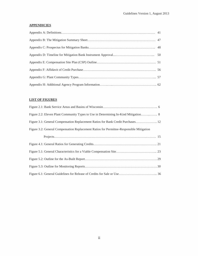
APPENDICIES
Appendix A: Definitions…………………………………………………………………………… 41
Appendix B: The Mitigation Summary Sheet……………………………………………………… 47
Appendix C: Prospectus for Mitigation Banks…………………………………………………….. 48
Appendix D: Timeline for Mitigation Bank Instrument Approval....……………………………... 50
Appendix E: Compensation Site Plan (CSP) Outline………………………………………………. 51
Appendix F: Affidavit of Credit Purchase………………………………………………………….. 56
Appendix G: Plant Community Types…………………………………………………………….... 57
Appendix H: Additional Agency Program Information……..…..………………………………….. 62
LIST OF FIGURES
Figure 2.1: Bank Service Areas and Basins of Wisconsin….……………………………………….. 6
Figure 2.2: Eleven Plant Community Types to Use in Determining In-Kind Mitigation……...……. 8
Figure 3.1: General Compensation Replacement Ratios for Bank Credit Purchases……………….. 12
Figure 3.2: General Compensation Replacement Ratios for Permittee-Responsible Mitigation
Projects………………………………………………………………….……….……… 15
Figure 4.1: General Ratios for Generating Credits………………………………………………….. 21
Figure 5.1: General Characteristics for a Viable Compensation Site……………………………….. 23
Figure 5.2: Outline for the As-Built Report…………………………………………………………. 29
Figure 5.3: Outline for Monitoring Reports…………………………………………………………. 30
Figure 6.1: General Guidelines for Release of Credits for Sale or Use……………………………... 36
Guidelines Version 1, August 2013
1
1) INTRODUCTION The fundamental objective of wetland compensatory mitigation is to offset unavoidable adverse impacts to wetlands authorized by the United States Army Corps of Engineers (USACE) and/or the Wisconsin Department of Natural Resources (WDNR). The USACE and WDNR have drafted this document to update the 2002 Guidelines for Wetland Compensatory Mitigation in Wisconsin. The United States Environmental Protection Agency (USEPA) Region V and the United States Fish and Wildlife Service (USFWS) Region 3 are participating in the preparation of these updated guidelines. This document establishes guidelines for providing required compensatory mitigation for permitted wetland impacts in Wisconsin. These guidelines are intended for agency personnel, mitigation bank sponsors, permit applicants, and others in meeting the Department of the Army (DA) requirements of Section 404 of the Clean Water Act including the United States Environmental Protection Agency 404(b)(1) Guidelines at 40 Code of Federal Regulations (CFR) Part 230, and the April 2008 Federal Rule - Compensatory Mitigation for Losses of Aquatic Resources found at 33 CFR Part 332 (Federal Mitigation Rule), Section 10 of the Rivers and Harbors Act, and WDNR requirements in Section 281.36 of the Wisconsin Statutes, Chapter NR 350 of the Wisconsin Administrative Code, 2011 State of Wisconsin Act 118, as well as other applicable federal and state statutes, regulations, guidelines, and ordinances. While use of this document will assist persons in meeting the requirements of the various programs listed above, this document allows for consideration of project-specific information in its application, and is not intended to be the sole source for compensatory mitigation information in Wisconsin. Users of these guidelines are strongly encouraged to refer to regulation such as the Federal Mitigation Rule, Wisconsin State Statutes, and Wisconsin Administrative Codes for additional information. Further, this document only applies to wetland compensatory mitigation. Federal law requires consideration of compensatory mitigation for all aquatic resource impacts, not just wetlands – including open water systems such as rivers, streams, ponds, and lakes. This document is not to be used to inform Wisconsin Department of Transportation (DOT) mitigation activities; refer to the Wisconsin Department of Transportation Wetland Mitigation Banking Technical Guideline for regulatory processes associated with Wisconsin DOT activities. The objective of the wetland compensatory mitigation guidelines is to guide the establishment of successful compensatory mitigation projects. This will be accomplished by describing standards and criteria for development for all types of wetland compensatory mitigation projects. These guidelines are meant to provide consistency to the wetland compensatory mitigation process, but do not supersede established agency rule or law. Final decisions are made on a case-by-case basis at the discretion of the permitting agencies (USACE and/or WDNR) with authority over a given wetland activity.
Guidelines Version 1, August 2013
2
Further, the guidelines should not be construed to provide opportunities to circumvent other aspects of a permitting agency’s review. Both the USACE and WDNR require that all proposed projects avoid and minimize wetland impacts to the maximum extent practicable. Agency regulations presume that most proposed projects (non-water dependent projects) can avoid wetland impacts. To obtain authorization, this presumption must be overcome by the permit applicant. Only after all efforts are made by the permit applicant to avoid and minimize adverse wetland impacts, compensatory mitigation actions are taken to offset unavoidable impacts. These guidelines are focused on this step of permitting agency review. Federal and state laws direct the agencies to utilize a watershed approach to guide the selection of compensatory mitigation location, and the functions and services the mitigation should provide. Additionally, permitting agencies will require measurable, consistent, and enforceable ecological performance standards regardless of the type of compensatory mitigation pursued (bank, permittee-responsible, etc.). In Wisconsin, wetland compensatory mitigation may be carried out by one or more of the following methods: re-establishment of a former wetland, rehabilitation or enhancement of existing wetlands, creation of new wetlands, preservation of ecologically important or threatened wetlands, and establishment of vegetated buffers. State permits and federal authorizations (hereafter referred to as permits) for wetland impacts often require wetland compensatory mitigation. Currently, the following two mechanisms may be used to fulfill this requirement: 1) the permittee purchases credits from an approved wetland mitigation bank; or 2) the permittee is responsible for completing a compensatory mitigation project. State and federal laws additionally describe compensatory mitigation through an in-lieu fee program; however, as of the date of this guidance such a program does not exist in Wisconsin. Questions regarding compensatory mitigation should be directed to the permitting agencies for clarification. Because each agency has an independent but coordinated process, it is recommended that most questions be directed to both agencies. The USACE provides information on their website at www.mvp.usace.army.mil/Missions/Regulatory.aspx. Inquiries to the USACE may be emailed to [email protected], or you may call (651) 290-5525. General information regarding the WDNR compensatory mitigation program is available at http://dnr.wi.gov/topic/Wetlands/Mitigation.
Guidelines Version 1, August 2013
3
2) COMPENSATORY MITIGATION APPROACHES A. Early Consultation
Those planning to impact wetlands should consult early in their planning process with the USACE and the WDNR to determine if mitigation is required, and to discuss which mitigation options are most appropriate for the proposed project. USACE regulations1 require project proponents include with their application either a statement describing how impacts to waters of the United States would be compensated, or a statement explaining why compensatory mitigation should not be required. When compensatory mitigation is required, it is the project proponent’s responsibility to address this requirement to facilitate the permitting agencies’ evaluation. Final decisions regarding the suitability of proposed compensatory mitigation are made by the permitting agencies. B. Mechanisms for Providing Wetland Compensatory Mitigation When considering options for successfully providing compensatory wetland mitigation, consider the options presented in B.1 and B.2 below. In general, compensatory mitigation should be located within the same BSA as the impact site, and should be located where it is most likely to successfully replace lost functions and services, taking into account such watershed scale features as aquatic habitat diversity, habitat connectivity, relationship to hydrologic sources (including the availability of water rights), trends in land use, ecological benefits, and compatibility with adjacent land uses. Finally, the permitting agencies recommend that compensatory mitigation be implemented concurrent with, or in advance of, the authorized wetland impacts to limit temporal loss of wetland functions. An applicant may choose from the following two options at the discretion of the permitting authorities.2 1. Purchasing Credits from a Mitigation Bank (see Chapter 3.A for details) 2. Development of a Permittee-Responsible Mitigation Site (see Chapters 3.B, 4, and 5 for details) It is the responsibility of the applicant to propose a method for providing compensatory mitigation when required by the permitting agencies. The permitting agencies retain authority to approve compensatory mitigation proposed. While both permitting agencies programs set preferences for mitigation banking, the agencies ultimately strive for high quality mitigation projects that replace the wetland functions that would be lost. In some cases that may mean the agencies will favor a permittee-responsible mitigation project over a mitigation bank. See Appendix H for additional information regarding each permitting agency’s program relative to compensatory mitigation selection.
1 33 Code of Federal Regulations (CFR) 325.1(d)(7) 2 Section 281.36(3r)(a), Wisconsin Statutes
Guidelines Version 1, August 2013
4
C. The Watershed Approach A major emphasis of these guidelines is a watershed approach to compensatory mitigation as described in the Federal Mitigation Rule. The watershed approach uses a landscape perspective that places emphasis on site selection, through consideration of landscape attributes that will help provide the desired wetland resource types and ensure that they are self-sustaining. The permitting agencies will implement the watershed approach with available information to determine the types and locations of compensatory mitigation activities that would best serve the watershed. This information includes current trends in habitat loss or conversion, cumulative impacts of past development activities, current development trends, the presence and needs of sensitive species, site conditions that favor or hinder the success of mitigation projects, chronic environmental problems such as flooding or poor water quality, site conditions, as well as other relevant data. The ultimate goal of the watershed approach to compensatory mitigation is to maintain and improve the quality and quantity of wetland resources within watersheds through targeted selection of compensatory mitigation sites.
A watershed approach considers the importance of landscape position and resource type of compensatory mitigation projects for the sustainability of wetland resource function within the watershed. Such an approach considers how the types and locations of compensatory mitigation projects will provide the desired wetland resource functions and continue to function over time in a changing landscape. It includes the protection and maintenance of terrestrial resources, such as non-wetland riparian areas and uplands, when those resources contribute to or improve the overall ecological functioning of wetland resources in the watershed. Compensatory mitigation requirements determined through a watershed approach should not focus exclusively on specific functions (e.g., water quality or habitat for certain species), but should provide, where practicable, the suite of functions typically provided by the affected resource.
Where practicable and appropriate, the permitting agencies will require that the location and the wetland type of compensatory mitigation be consistent with a watershed-based approach. Where reliance on a watershed plan or other permitting agency-approved approach is not practicable, the permitting agencies will use the watershed approach principles of wetland type, location and timing to evaluate opportunities to offset unavoidable adverse impacts by requiring project-specific compensation and/or credits established by wetland banks. Three key factors determine the amount of wetland compensatory mitigation required to offset unavoidable impacts: the timing of the compensatory mitigation; the wetland cover type of the compensatory mitigation; and the location of the compensatory mitigation. Compensatory mitigation that is the same wetland cover type (in-kind) and location as the permitted impact, and is completed prior to or concurrent with the permitted loss, has the greatest likelihood of replacing those wetland functions lost; therefore, the compensation ratio is the lowest. When compensatory wetland mitigation cover types that do not match the wetland cover type lost (out-of-kind), the amount of compensatory mitigation required increases because the suite of functions provided by the
Guidelines Version 1, August 2013
5
compensatory mitigation are less likely to match the functions lost from the wetland fill. Compensatory mitigation that is not completed prior to or concurrent with authorized impacts is likely to result in a temporary loss of function to the localized area, known as temporal loss. When temporal losses are anticipated, the acres of compensatory mitigation required are higher when compared to the impacted acreage. Finally, the amount of mitigation required increases the further away the mitigation site is from the impact site, from a watershed perspective. See Chapter 3 for more information regarding the adjustments to mitigation ratios. 1. Locational Factors
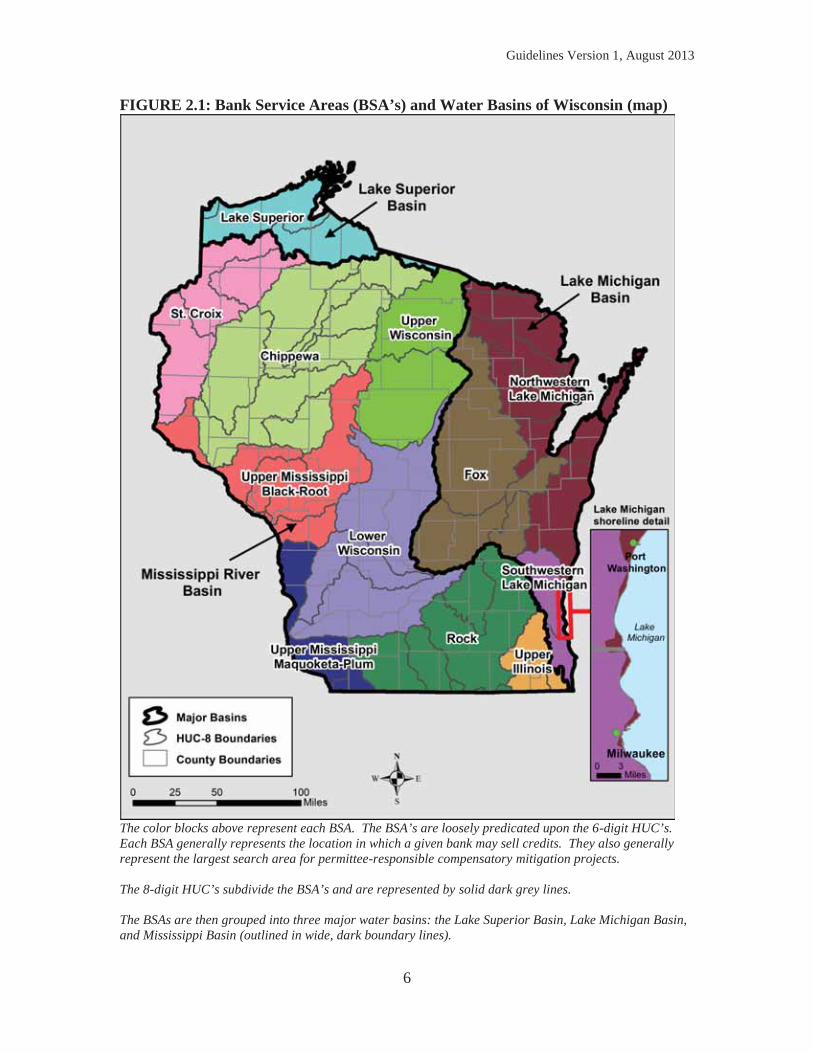
Use of banking credits is generally considered locationally appropriate if the debits are within the same approved bank service area, or BSA (Figure 2.1), as the impacted wetland. For mitigation banking, permitting agencies prefer applicants to select the nearest practicable bank site relative to the impact site. Optimally, the debit would occur in the same 8-digit Hydrologic Unit Code (HUC). Typically this is viewed as the most likely to replace lost functions, provided all other considerations are equal. See Chapter 3.A for more information. For permittee-responsible mitigation, the permitting agencies evaluate the location of the proposed compensatory mitigation relative to the term on-site as described in the Federal Mitigation Rule. This is defined to be an area located on the same parcel of land as the impact site, or on a parcel of land contiguous to or near the impact site. All other considerations equal, on-site compensation is prioritized for siting compensatory mitigation given the ecological benefits of immediate geographic connectivity of restored hydrology and vegetation. However, it is recognized that on-site compensation is not always practicable, nor environmentally preferable (e.g., compensation site would be surrounded by a parking lot). Permittee-responsible mitigation sites should be located as close to the permitted fill as possible from a watershed perspective; the initial site search should be conducted within a one-half-mile radius from the permitted fill. In most cases, the search for appropriate permittee-responsible mitigation sites should not be outside the BSA in which the proposed impacts would occur. See Chapter 3.B for more information.
Guidelines Version 1, August 2013
6
FIGURE 2.1: Bank Service Areas (BSA’s) and Water Basins of Wisconsin (map)
The color blocks above represent each BSA. The BSA’s are loosely predicated upon the 6-digit HUC’s. Each BSA generally represents the location in which a given bank may sell credits. They also generally represent the largest search area for permittee-responsible compensatory mitigation projects. The 8-digit HUC’s subdivide the BSA’s and are represented by solid dark grey lines. The BSAs are then grouped into three major water basins: the Lake Superior Basin, Lake Michigan Basin, and Mississippi Basin (outlined in wide, dark boundary lines).
Guidelines Version 1, August 2013
7
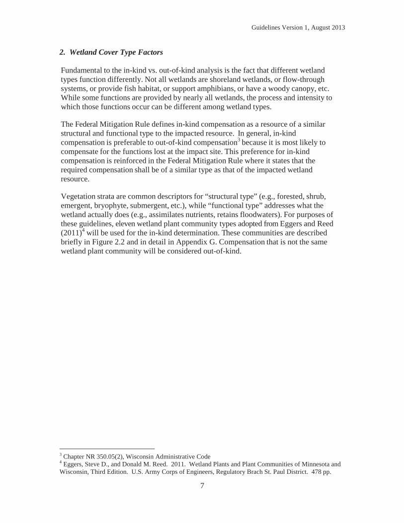
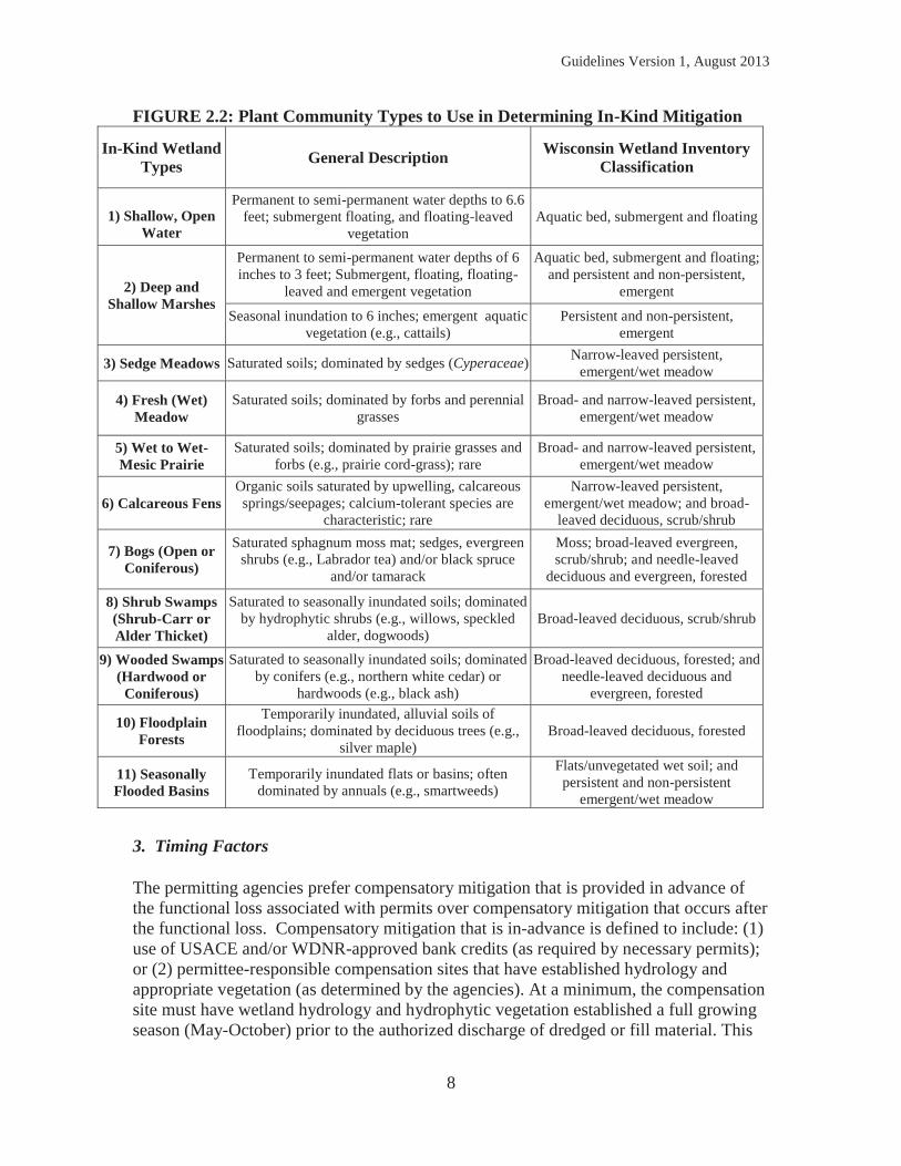
2. Wetland Cover Type Factors Fundamental to the in-kind vs. out-of-kind analysis is the fact that different wetland types function differently. Not all wetlands are shoreland wetlands, or flow-through systems, or provide fish habitat, or support amphibians, or have a woody canopy, etc. While some functions are provided by nearly all wetlands, the process and intensity to which those functions occur can be different among wetland types. The Federal Mitigation Rule defines in-kind compensation as a resource of a similar structural and functional type to the impacted resource. In general, in-kind compensation is preferable to out-of-kind compensation3 because it is most likely to compensate for the functions lost at the impact site. This preference for in-kind compensation is reinforced in the Federal Mitigation Rule where it states that the required compensation shall be of a similar type as that of the impacted wetland resource. Vegetation strata are common descriptors for “structural type” (e.g., forested, shrub, emergent, bryophyte, submergent, etc.), while “functional type” addresses what the wetland actually does (e.g., assimilates nutrients, retains floodwaters). For purposes of these guidelines, eleven wetland plant community types adopted from Eggers and Reed (2011)4 will be used for the in-kind determination. These communities are described briefly in Figure 2.2 and in detail in Appendix G. Compensation that is not the same wetland plant community will be considered out-of-kind.
3 Chapter NR 350.05(2), Wisconsin Administrative Code 4 Eggers, Steve D., and Donald M. Reed. 2011. Wetland Plants and Plant Communities of Minnesota and Wisconsin, Third Edition. U.S. Army Corps of Engineers, Regulatory Brach St. Paul District. 478 pp.
Guidelines Version 1, August 2013
8
FIGURE 2.2: Plant Community Types to Use in Determining In-Kind Mitigation
In-Kind Wetland Types General Description Wisconsin Wetland Inventory
Classification
1) Shallow, Open Water
Permanent to semi-permanent water depths to 6.6 feet; submergent floating, and floating-leaved
vegetation Aquatic bed, submergent and floating
2) Deep and Shallow Marshes
Permanent to semi-permanent water depths of 6 inches to 3 feet; Submergent, floating, floating-
leaved and emergent vegetation
Aquatic bed, submergent and floating; and persistent and non-persistent,
emergent
Seasonal inundation to 6 inches; emergent aquatic vegetation (e.g., cattails)
Persistent and non-persistent, emergent
3) Sedge Meadows Saturated soils; dominated by sedges (Cyperaceae) Narrow-leaved persistent, emergent/wet meadow
4) Fresh (Wet) Meadow
Saturated soils; dominated by forbs and perennial grasses
Broad- and narrow-leaved persistent, emergent/wet meadow
5) Wet to Wet-Mesic Prairie
Saturated soils; dominated by prairie grasses and forbs (e.g., prairie cord-grass); rare
Broad- and narrow-leaved persistent, emergent/wet meadow
6) Calcareous Fens Organic soils saturated by upwelling, calcareous springs/seepages; calcium-tolerant species are
characteristic; rare
Narrow-leaved persistent, emergent/wet meadow; and broad-
leaved deciduous, scrub/shrub
7) Bogs (Open or Coniferous)
Saturated sphagnum moss mat; sedges, evergreen shrubs (e.g., Labrador tea) and/or black spruce
and/or tamarack
Moss; broad-leaved evergreen, scrub/shrub; and needle-leaved
deciduous and evergreen, forested
8) Shrub Swamps (Shrub-Carr or Alder Thicket)
Saturated to seasonally inundated soils; dominated by hydrophytic shrubs (e.g., willows, speckled
alder, dogwoods) Broad-leaved deciduous, scrub/shrub
9) Wooded Swamps (Hardwood or
Coniferous)
Saturated to seasonally inundated soils; dominated by conifers (e.g., northern white cedar) or
hardwoods (e.g., black ash)
Broad-leaved deciduous, forested; and needle-leaved deciduous and
evergreen, forested
10) Floodplain Forests
Temporarily inundated, alluvial soils of floodplains; dominated by deciduous trees (e.g.,
silver maple) Broad-leaved deciduous, forested
11) Seasonally Flooded Basins
Temporarily inundated flats or basins; often dominated by annuals (e.g., smartweeds)
Flats/unvegetated wet soil; and persistent and non-persistent
emergent/wet meadow
3. Timing Factors The permitting agencies prefer compensatory mitigation that is provided in advance of the functional loss associated with permits over compensatory mitigation that occurs after the functional loss. Compensatory mitigation that is in-advance is defined to include: (1) use of USACE and/or WDNR-approved bank credits (as required by necessary permits); or (2) permittee-responsible compensation sites that have established hydrology and appropriate vegetation (as determined by the agencies). At a minimum, the compensation site must have wetland hydrology and hydrophytic vegetation established a full growing season (May-October) prior to the authorized discharge of dredged or fill material. This

Guidelines Version 1, August 2013
9
means that grading and seeding of the compensation site were completed prior to the growing season of that year. Performance standards applicable at that development stage, usually initial hydrology and vegetation performance standards, must be met to qualify as in-advance.
Guidelines Version 1, August 2013
10
3) COMPENSATION REQUIRED TO OFFSET ADVERSE IMPACTS This chapter identifies the number of credits generally needed for applicants to offset unavoidable adverse impacts to wetlands and provide the appropriate amount of compensatory mitigation. An appropriate offset minimally achieves no net loss of wetland functions with an adequate margin of safety to reflect anticipated success. In the absence of more definitive functional assessments, a minimum of 1.2:1 acreage replacement5 may be used as a reasonable surrogate for no net loss of wetland functions provided that all other considerations are equal. Due to the limited number of approvable quantitative functional assessment methods for Wisconsin, the guidelines employ acreage surrogates to inform general compensation requirements. Starting ratios shown in this Chapter are higher than the base of 1.2:1 described above, because in practice the compensatory mitigation proposed by applicants is often not in-kind, is outside the watershed of the proposed impact, and/or results in temporal loss. The closer a project proponent is to achieving in-kind, in advance, and on-site compensatory mitigation, the lower the ratio applied. Project applicants are responsible for submitting compensatory mitigation proposals to the permitting agencies for review and approval. Actual compensatory mitigation requirements are determined on a project-by-project basis to ensure that wetland functions and services provided by the compensation fit the watershed approach. As a matter of public service, the USACE and WDNR will strive to ensure that the mechanism and methods approved to provide compensatory mitigation are consistent. A. Debiting Credits from an Approved Bank If the applicant wishes to purchase credits from an approved mitigation bank, the proposal must be approved by the permitting agencies. The USACE maintains the official listing of compensatory mitigation banks, including credit ledger information on its Regulatory In-Lieu Fee Bank Information & Tracking System (RIBITS) website at http://geo.usace.army.mil/ribits/index.html. The WDNR also maintains a registry of approved bank sites on its web site (http://dnr.wi.gov).6 Section 3.A.1 below provides information about the compensation replacement ratio (the number of credits needed for an applicant to meet the compensation obligation). The permitting agencies must approve the wetland type and number of credits proposed for debit. A signed Affidavit of Bank Credit Purchase (see Appendix F) must be provided to the permitting agencies per their program requirements; the affidavit may be required prior to issuance of a permit.7
5 Section 281.36 (3r)(d), Wisconsin Statute 6 Chapter NR 350.13(1), Wisconsin Administrative Code 7 The DNR often requires that the affidavit be submitted to the Mitigation Coordinator before an individual permit can be granted.
Guidelines Version 1, August 2013
11
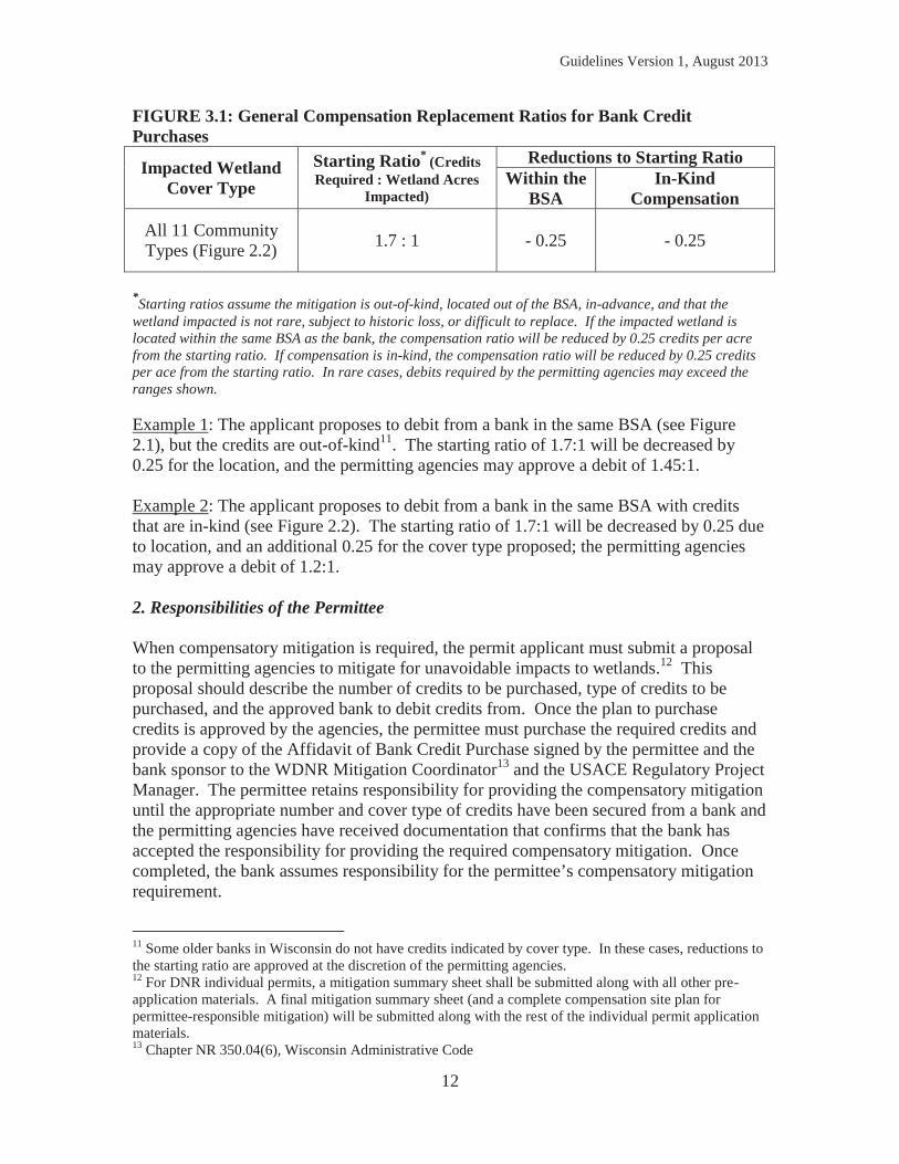
All banks in Wisconsin have bank service areas (BSAs) that guide decisions regarding the suitability of a bank site relative to the watershed location (see Figure 2.1 for a map of BSAs in Wisconsin). The permitting agencies prefer applicants to select the nearest practicable bank site relative to the impact site. Optimally, the debit would occur in the same 8-digit Hydrologic Unit Code (HUC). Typically this is viewed as the most likely to replace lost functions, provided all other considerations are equal. In addition to location concerns, the permitting agencies give preference to in-kind over out-of-kind debits. Because banks are largely established in advance of any proposed debits, negligible temporal losses are typically associated with bank debits. When banking is approved over permittee-responsible mitigation and there is no bank in the BSA with in-kind credits available, the applicant may propose to debit either out-of-kind credits, or to debit from a bank outside the BSA with in-kind or out-of-kind credits. The permitting agencies will consider the merit of the request, which is likely to be subject to higher debiting ratios if approved. Approval of debits outside the BSA is rare,8 and advance coordination with permitting agencies is strongly recommended for such proposals. 1. Bank Credit Purchase Compensation Replacement Ratio In general, the starting compensation replacement ratio is 1.7:1. This ratio is higher than the minimum ratio of 1.2:1 indicated earlier in this Chapter. The starting compensation replacement ratio presumes the debit is outside of the BSA, out-of-kind, in advance, and that the wetland type compensated for is not rare, subject to historic losses, or difficult to replace. Debits proposed within the BSA or with an in-kind plant community warrant a reduction to the starting ratio. Impacts to rare or difficult to replace types9 typically warrant an increase to the starting ratio. Additions and subtractions are cumulative, not concurrent. Typical ratios for credit purchases are given in Figure 3.1 below. A few sample calculations based on the table follow. Reductions to the starting ratio may not result in a ratio lower than 1.2:110 to comply with state law.
8 WDNR has more flexibility than USACE in approving mitigation proposals for bank credit purchases that are out-of-kind and/or outside the BSA. 9 An example of a rare wetland type is a calcareous fen. An example of a difficult to replace wetland is a sedge meadow. These examples are not exhaustive. Determinations of rarity and replacement success are often locationally specific. Project proponents should consult with the permitting agencies regarding rarity of wetland resource, and information on community type replacement success. Some additional information is also included in Appendix G. 10 Section 281.36 (3r)(d), Wisconsin Statute
Guidelines Version 1, August 2013
12
FIGURE 3.1: General Compensation Replacement Ratios for Bank Credit Purchases
Impacted Wetland Cover Type
Starting Ratio* (Credits Required : Wetland Acres
Impacted)
Reductions to Starting Ratio Within the
BSA In-Kind
Compensation
All 11 Community Types (Figure 2.2) 1.7 : 1 - 0.25 - 0.25
*Starting ratios assume the mitigation is out-of-kind, located out of the BSA, in-advance, and that the wetland impacted is not rare, subject to historic loss, or difficult to replace. If the impacted wetland is located within the same BSA as the bank, the compensation ratio will be reduced by 0.25 credits per acre from the starting ratio. If compensation is in-kind, the compensation ratio will be reduced by 0.25 credits per ace from the starting ratio. In rare cases, debits required by the permitting agencies may exceed the ranges shown. Example 1: The applicant proposes to debit from a bank in the same BSA (see Figure 2.1), but the credits are out-of-kind11. The starting ratio of 1.7:1 will be decreased by 0.25 for the location, and the permitting agencies may approve a debit of 1.45:1. Example 2: The applicant proposes to debit from a bank in the same BSA with credits that are in-kind (see Figure 2.2). The starting ratio of 1.7:1 will be decreased by 0.25 due to location, and an additional 0.25 for the cover type proposed; the permitting agencies may approve a debit of 1.2:1. 2. Responsibilities of the Permittee When compensatory mitigation is required, the permit applicant must submit a proposal to the permitting agencies to mitigate for unavoidable impacts to wetlands.12 This proposal should describe the number of credits to be purchased, type of credits to be purchased, and the approved bank to debit credits from. Once the plan to purchase credits is approved by the agencies, the permittee must purchase the required credits and provide a copy of the Affidavit of Bank Credit Purchase signed by the permittee and the bank sponsor to the WDNR Mitigation Coordinator13 and the USACE Regulatory Project Manager. The permittee retains responsibility for providing the compensatory mitigation until the appropriate number and cover type of credits have been secured from a bank and the permitting agencies have received documentation that confirms that the bank has accepted the responsibility for providing the required compensatory mitigation. Once completed, the bank assumes responsibility for the permittee’s compensatory mitigation requirement.
11 Some older banks in Wisconsin do not have credits indicated by cover type. In these cases, reductions to the starting ratio are approved at the discretion of the permitting agencies. 12 For DNR individual permits, a mitigation summary sheet shall be submitted along with all other pre-application materials. A final mitigation summary sheet (and a complete compensation site plan for permittee-responsible mitigation) will be submitted along with the rest of the individual permit application materials. 13 Chapter NR 350.04(6), Wisconsin Administrative Code
Guidelines Version 1, August 2013
13
B. Determining Permittee-Responsible Mitigation Requirements Where permitted impacts are not in the same BSA of a mitigation bank that has the appropriate number of in-kind credits available, permittee-responsible mitigation may be the next-best option. Where realistic and likely to be successful and sustainable, the location of the permittee-responsible mitigation should be as close to the permitted impacts as possible and shall utilize the principles of the watershed approach as outlined in Chapter 2.C. Permittee-responsible mitigation is typically appropriate when located within one half mile of the permitted wetland impact or within the same BSA as the permitted wetland impacts. On rare occasions when there are no permittee-responsible options within the same BSA as the permitted impacts, the applicant may propose a project located in another BSA. The permitting agencies will review this option to meet the mitigation requirement. If approved by the permitting agencies, the mitigation ratio will be a minimum of 0.25 higher to account for locational difference between the loss and mitigation site. Appendix E should be used to guide the applicant in the development of a permittee-responsible compensation site plan (CSP). This plan describes the work and performance standards proposed by the applicant for a given wetland compensatory mitigation site. Section 3.B.1, below, provides information about the compensation replacement ratio (the number of credits needed for a project applicant to meet the compensation obligation). 1. Permittee-Responsible Mitigation Ratio The starting compensation replacement ratio is 1.7 credits for every 1 acre of impacted herbaceous and shrub/scrub wetland communities, and 1.95 credits for every 1 acre of impacted forested wetland. In practice, permittee-responsible mitigation almost always requires a ratio higher than the base ratio of 1.2:1 because of landscape position, temporal loss, cover type, and site success uncertainties. As an example, the starting ratio for forested communities is higher than for herbaceous communities, primarily because of the increased temporal loss associated with the maturation time of forested communities. In cases where appropriate functional or condition assessment methods or other suitable metrics are available and approved by the permitting agencies, these methods may be used to adjust the acreage surrogates shown in below in Figure 3.2. Compensatory mitigation requirements are determined by the permitting agencies on a project-by-project basis. The starting compensation ratio may be increased if the wetland fill proposed would impact a rare wetland or a difficult to replace wetland.14 The
14 An example of a rare wetland type is a calcareous fen. An example of a difficult to replace wetland is a sedge meadow. These examples are not exhaustive. Determinations of rarity and replacement success are often locationally specific. Project proponents should consult with the permitting agencies regarding rarity of wetland resource, and information on community type replacement success. Some additional information is also included in Appendix G.
Guidelines Version 1, August 2013
14
watershed approach prioritizes in-kind compensation sited close to the proposed impact. If the permittee-responsible compensatory mitigation would result in an in-kind plant community, the agencies may approve a reduction to the starting ratio. To qualify for a ratio reduction due to avoiding temporal loss, permittee-responsible compensation sites must minimally have established hydrology and appropriate vegetation (as determined by the agencies). The compensation site must have wetland hydrology and hydrophytic vegetation established a full growing season (May-October) prior to the authorized discharge of dredged or fill material. This means that grading and seeding of the compensation site were completed prior to the growing season of that year. Performance standards applicable at that development stage, usually initial hydrology and vegetation standards, must be met to qualify as in-advance. Additions and subtractions to the starting ratio are cumulative, not concurrent. Typical ratios for permittee-responsible compensatory mitigation projects are given in Figure 3.2 below. A few sample calculations of credits required are provided after the table. Reductions to the starting ratio may not result in a ratio lower than 1.2:1 to comply with state law.15 Restoration is the preferred method16 for generating permittee-responsible credits, but a permittee-responsible compensation site plan can include wetland creation, enhancement, preservation and restoration/preservation of vegetative buffers. A combination of methods is typically required for most proposals. The methods for generating credits and general information on how much credit each method produces is in Chapter 4 below. Permittee-responsible mitigation is tied to a specific permitted activity. Excess credits generated by permittee-responsible mitigation are not eligible for sale, transfer, or use for a future proposed project. If a permittee-responsible mitigation site generates more credits than are needed to meet the requirements for mitigation as required by the given permit, those credits may not be used for a future permit or for sale or transfer unless they are processed as a bank.
15 Section 281.36 (3r)(d), Wisconsin Statute 16 Chapter NR 350.05(1), Wisconsin Administrative Code
Guidelines Version 1, August 2013
15
FIGURE 3.2: General Compensation Replacement Ratios for Permittee-Responsible Mitigation Projects
Reductions to Starting Ratio Impacted Wetland
Cover Type Starting Ratio* (Credits Required : Wetland Acres
Impacted) No Temporal
Loss In-Kind
Compensation Herbaceous and
Shrub/Scrub 1.7 : 1 - 0.25 - 0.25 Forested 1.95 : 1 - 0.50
Starting ratios assume the compensation is in the same BSA, out-of-kind, and not in advance. If compensation is in-kind, the compensation ratio typically will be decreased by 0.25 credits per acre. If compensation is provided in advance of the authorized impacts to the wetland (resulting in no temporal loss), the compensation ratio may be decreased by 0.25 credits per acre of herbaceous or shrub/scrub wetland or by 0.50 credits per acre of forested wetland. Conversely, the starting ratios may be increased if the wetland proposed for impact is rare, subject to historic loss, difficult to replace, or if the compensatory mitigation is located outside the BSA of the proposed wetland impact. These additions to the starting ratio are not shown above, as they are not frequently associated with permittee-responsible compensatory mitigation projects. Example 1: The applicant proposes a common, herbaceous, in-kind cover type on site. It is ecologically connected to the remnant wetland that would remain after any authorized fill is complete. The permitting agencies believe the project has a high likelihood of success. The mitigation site would be constructed at the same time as the proposed fill would occur. The starting ratio of 1.7:1 will be decreased by 0.25 for providing in-kind cover. The permitting agencies may approve a ratio of 1.45 credits for every wetland acre proposed for impact. Example 2: The applicant proposes a common, herbaceous, out-of-kind cover type on site to mitigate for impacts to a forested wetland. The compensatory mitigation would be ecologically connected to the remnant wetland that would remain after the permitted fill is complete. The permitting agencies believe the project has a high likelihood of success. The mitigation site would be constructed at the same time as the proposed fill would occur. The permitting agencies may approve a ratio of 1.95:1. 2. Responsibilities of the Permittee When compensatory mitigation is required, the permit applicant must submit a proposal to the permitting agencies to mitigate for unavoidable wetland impacts. The applicant should utilize the list of information required as part of a compensation site plan (CSP) in Appendix E. Permittee-responsible compensatory mitigation requires site protections to ensure that the site is protected from incompatible uses in perpetuity and that the compensatory mitigation is completed and maintained per the CSP. Once the compensation site plan is approved by the agencies and any required financial assurances are in place, the permittee is responsible for making sure the mitigation site is protected through a conservation easement or comparable legal instrument and the mitigation site is constructed and monitored and managed according to the approved CSP. Permittee-
Guidelines Version 1, August 2013
16
responsible compensation sites require years of monitoring and management post-construction, and throughout this period, the permittee is responsible for making sure monitoring reports are submitted within the timeframes stipulated in their permit(s) and/or approved CSP. Any necessary management activities to keep the site compliant with the permits must be completed and coordinated with the permitting agencies’ as appropriate. The permittee typically remains responsible for the long-term management of the mitigation site.
Guidelines Version 1, August 2013
17
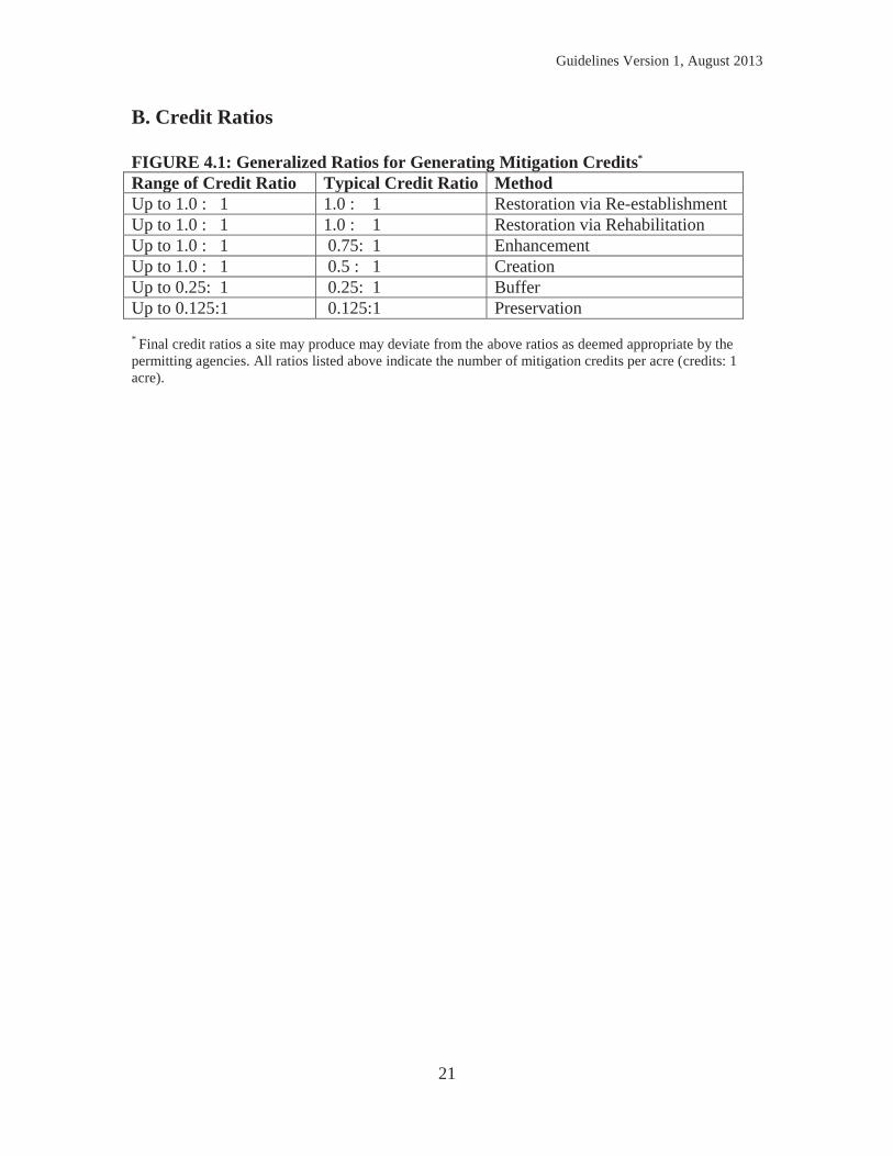
4) DETERMINING CREDITS GENERATED BY A COMPENSATION SITE This chapter describes the generalized process behind determining how many credits a compensation site may produce. This process is used in advance of completing the proposed compensatory mitigation project (permittee-responsible or bank site development) to estimate the maximum number of credits the site is likely to generate. In practice, the actual credits produced on a site are often not the same as the number of credits originally estimated. The estimated credits a site may produce is adjusted based on how well the site meets the performance standards established for the project as well as the final wetland acreage by cover type produced. Performance standards are required for all compensatory mitigation sites, and are used to assess whether the project is achieving its objectives. Performance standards relate to the objectives of the compensatory mitigation project to evaluate site development into the desired resource type, to evaluate if the site is providing the expected functions, and whether the site is attaining any other applicable metrics (e.g., acres). As such, performance standards must be based on attributes that are objective and verifiable (measurable). The permitting agencies, in consultation with the IRT, are working to develop a list of common performance standards to utilize for compensatory mitigation projects. However, this list is not complete as of the time of this document, but is anticipated to be included in subsequent iterations. Generalized ratio information can be found in Table 4.1 below. A. Methods of Generating Credits 1. Restoration Restoration is the preferred compensation method, as it tends to be more successful than other methods. This method includes re-establishment and rehabilitation. Restoration via re-establishment means the manipulation of the physical, chemical, or biological characteristics of a site with the goal of returning natural/historic functions to a former wetland. Re-establishment results in an increase in wetland acreage. This form of restoration may involve: re-establishing hydrology and topography on a site by removing fill; re-grading or re-contouring; filling ditches; removing drainage tile; re-establishing wetland plant communities via site preparation, seeding, and planting; and manipulating water levels to restore hydrology. Credit for restoration via re-establishment is often one credit for each acre restored (1:1),17 as it results in an increase in wetland acreage. Re-establishment of historic hydrology, land contours, and plant communities typically will generate the highest credit.
17 Chapter NR 350.07(3)-(4), Wisconsin Administrative Code
Guidelines Version 1, August 2013
18
Restoration via rehabilitation involves the restoration of historic (pre-European settlement) wetland conditions, functions, and services to the maximum extent practicable. Rehabilitation typically occurs in substantially degraded wetlands adversely impacted by drainage, filling, cultivation, grazing, or other disturbances. Rehabilitation occurs in existing wetlands and does not yield an increase in wetland acreage, but typically results in an appreciable increase in more than two wetland functions. Similar restoration techniques may be utilized to rehabilitate a degraded wetland as described above to re-establish a former wetland. Credit ratios may range from no credit to 1:1. 2. Enhancement Enhancement activities are conducted in existing wetlands, and typically result in an appreciable increase in one or two targeted wetland functions and values (but yield no increase in wetland acreage). Enhancement projects typically involve the excavation of existing wetlands, but in some cases enhancement of degraded wetlands (such as mowed or cropped wetlands) may also involve: altering existing wetland hydrology and topography on a site by excavation; re-grading or re-contouring; plugging or filling ditches; altering existing wetland plant communities via site preparation, seeding, and planting; and manipulating water levels. Rehabilitation is typically favored over enhancement because it typically increases a larger number of wetland functions than enhancement. While credit for enhancement can range from no credit to 1 acre of credit for each 1 acre enhanced,18 1:1 is typically not achieved, unless the functional lift proposed exceeds that which could be realized by rehabilitation (returning the wetland to its historical cover type). The appropriate level of credit must be approved by the permitting agencies based on a comparison of the current functions and services of the site to the projected functions and services of the completed compensation site. Possibly the most common example of an enhancement proposal in Wisconsin would be the excavation of an herbaceous (sedge meadow or fresh wet meadow) wetland to a deep marsh wetland (where the historical condition is not deep marsh wetland). These enhancement projects are rarely preferred by the permitting agencies, as sedge meadows, in particular, are becoming less common in comparison to deep marshes. Sedge meadows are typically difficult to establish, while deep marshes are easier to establish. In these cases, little to no credit is likely to be approved by the permitting agencies. A more desirable enhancement project would be conversion of a farmed fresh wet meadow wetland to a floodplain forested wetland (historical condition is a fresh wet meadow). In this scenario, the proposed community may be more desirable than the historic extent (particularly in the southern part of Wisconsin), and may warrant the highest amount of credit per acre (1:1 credit production to acreage ratio), provided all other considerations are met. 18 Chapter NR 350.07(4), Wisconsin Administrative Code
Guidelines Version 1, August 2013
19
3. Creation Creation refers to establishment of a wetland where one did not historically exist (based upon geophysical evidence). Mitigation projects primarily centered upon creation are not preferred because they have historically been proven less successful. Creation along the edges of existing wetlands or in landscape settings that are conducive to improving or creating certain wetland functions and services may be more acceptable. Typically, only creation that is adjacent to existing wetland and/or fits into the natural landscape will be approved for compensation. Crediting at a ratio of 1:1 is rare, but possible for creation if the creation site is low risk, the cover type fits the landscape, and the creation site is connected to other wetlands/aquatic resources and upland buffers/corridors. Lower risk refers to cases where hydrology data is sufficient to ensure that the planned hydrology would be established. This includes data from monitoring wells, surface runoff analyses, modeling and/or connection to the 1- or 2-year flood events of a river. Creation sites on the Lake Superior red clay plain are often considered a lower risk for failure. Creation sites lacking sufficient hydrology data present a higher risk of failure and will generally be credited up to 0.5:1.19 Similarly, creation sites that are isolated from other wetlands/aquatic resources and upland buffers/corridors or are otherwise expected to be at high risk will be credited up to 0.5:1, or may not be approved for any credit. Higher risk creation sites will generally be limited to 25 percent of total credits at a compensation site.
4. Preservation Preservation may be used to provide compensatory mitigation only when all the following criteria are satisfied: the resources to be preserved provide important physical, chemical, or biological functions and services for the watershed; the resources contribute significantly to the ecological sustainability of the watershed; the preservation is determined to be appropriate and reasonable; the resources are under demonstrable threat of destruction or adverse modifications; and the site will be protected in perpetuity. Preservation sites must be providing important functions that significantly improve the sustainability of the watershed. This is not restricted to exceptional natural areas. Wetlands that provide one or more high rated, and/or 3 or more medium rated, functions20 using a rapid or routine wetland assessment method, can be providing important functions. Suitable wetland assessment methods include the Wisconsin Rapid Assessment Methodology (WRAM) or other approvable methodology as determined by the permitting agencies.21 Additionally, the Floristic Quality Assessment Methodology for Wisconsin can be used to determine the condition of plant communities within a proposed preservation site.
19 Chapter NR 350.07(5), Wisconsin Administrative Code 20 USACE Special Public Notice: Guidance regarding the use of Wetland Preservation, March 2013 21 USACE has not evaluated the use of WRAM for this purpose and may recommend use of MnRAM.
Guidelines Version 1, August 2013
20
Where preservation is used to provide compensatory mitigation, to the extent appropriate and reasonable the preservation should be done in conjunction with restoration, enhancement, and/or creation and should have a long-term management plan developed for the site to address issues to ensure that the preserved area is maintained as a high quality plant community. However, on rare occasions, preservation can constitute the sole source of generating compensatory mitigation at a site with unique characteristics. Crediting ratio is often 0.125:1 (one credit for every 8 acres preserved). 5. Vegetated Buffers A minimum amount of vegetated buffer adjacent to wetland compensation sites is ideal to protect and enhance wetland functions and services. While buffers may not be required at every site, a buffer may be required22 in areas where permitting agencies and/or land managers have concerns that neighboring land uses may be detrimental to the long-term quality of the mitigation site or where the inclusion of a buffer is practicable and beneficial. Vegetated buffers may generate credits at 0.1:1 for unimproved or non-native vegetative cover and at most 0.25:1 when vegetative cover is enhanced to be dominated by native species.23 The latter involves restoring native buffer plant communities. Maintenance of buffers is required. Vegetated buffers at a bank site or permittee-responsible site shall not exceed 25%24 of total credits generated by that site. The ideal buffer is contiguous and at least 100 feet wide. Higher credit ratios are given to buffers that are not a monoculture and are dominated by a diversity of native, non-invasive plant species. For additional information on maximizing buffer credit ratios, see Chapter 5.C. 6. No Credit for Stormwater or Wastewater Treatment Facilities Some innovative facilities have been designed for treating stormwater and wastewater, using designs that create the physical, chemical and biological processes that occur in wetlands. These facilities have been referred to as bioretention basins, biofilters, or constructed wetlands and are considered artificial wetlands. While these facilities may serve an important function in alleviating impacts to natural wetlands and waterways by moderating substantially the bounce in water levels and trapping sediment loads, such single-function wetlands do not meet the intent of compensatory mitigation.25
22 Chapter NR 350.05(5), Wisconsin Administrative Code 23 Chapter NR 350.07(6), Wisconsin Administrative Code 24 The WDNR may limit the total amount of vegetated upland buffer credit to 15% per Chapter NR 350.13(5)(b), Wisconsin Administrative Code 25 Chapter NR 350.07(7), Wisconsin Administrative Code
Guidelines Version 1, August 2013
21
B. Credit Ratios FIGURE 4.1: Generalized Ratios for Generating Mitigation Credits* Range of Credit Ratio Typical Credit Ratio Method Up to 1.0 : 1 1.0 : 1 Restoration via Re-establishment Up to 1.0 : 1 1.0 : 1 Restoration via Rehabilitation Up to 1.0 : 1 0.75: 1 Enhancement Up to 1.0 : 1 0.5 : 1 Creation Up to 0.25: 1 0.25: 1 Buffer Up to 0.125:1 0.125:1 Preservation
* Final credit ratios a site may produce may deviate from the above ratios as deemed appropriate by the permitting agencies. All ratios listed above indicate the number of mitigation credits per acre (credits: 1 acre).
Guidelines Version 1, August 2013
22
5) COMPENSATORY MITIGATION SITE PLANNING AND OPERATION A. Selecting a Suitable Compensation Site This section is applicable to both permittee-responsible compensatory mitigation and mitigation bank projects. While approval of a given site is the responsibility of the permitting agencies, it is the responsibility of the applicant or bank sponsor to propose a site for providing compensatory mitigation for agency review. Permittee-responsible mitigation sites ideally are located within a one-half mile radius from the permitted impacts and typically are located within the same BSA as the impact location (see Figure 2.1). In rare occasions, a permittee-responsible mitigation site may be located outside the BSA. All banks in Wisconsin use BSA’s to guide decisions regarding the suitability of a bank site to provide compensatory mitigation for permitted wetland fill (see Figure 2.1). The permitting agencies prefer applicants to select the nearest practicable bank site relative to the impact site within the BSA. Optimally, the debit would occur in the same 8-digit Hydrologic Unit Code (HUC). Bank sites should generally consist of a minimum of 25 acres; smaller bank sizes may be considered in certain cases, such as if the proposed site is located in an urban area where larger parcels are difficult to acquire or if the site is an ideal candidate for wetland mitigation.
The compensatory mitigation project site must be ecologically suitable for providing the desired wetland functions. In determining the ecological suitability of the compensatory mitigation project site, the permitting agencies will consider, to the extent practicable, the following six factors:26
- Hydrological conditions, soil characteristics, and other physical and chemical characteristics;
- Watershed-scale features, such as habitat diversity, habitat connectivity, and other landscape scale functions;
- The size and location of the compensatory mitigation site relative to hydrologic sources (including the availability of water rights) and other ecological features;
- Compatibility with adjacent land uses and watershed management plans; - Reasonably foreseeable effects the compensatory mitigation project will have on
ecologically important aquatic or terrestrial resources, cultural sites, or habitat for threatened and endangered species; and
- Other relevant factors including, but not limited to, development trends, anticipated land use changes, habitat status and trends, the relative locations of the impact and mitigation sites in the stream network, local or regional goals for the restoration or protection of particular habitat types or functions (e.g., re-establishment of habitat corridors or habitat for species of concern), water
26 33 CFR 332.3(d)
Guidelines Version 1, August 2013
23
quality goals, floodplain management goals, and the relative potential for chemical contamination of the aquatic resources.
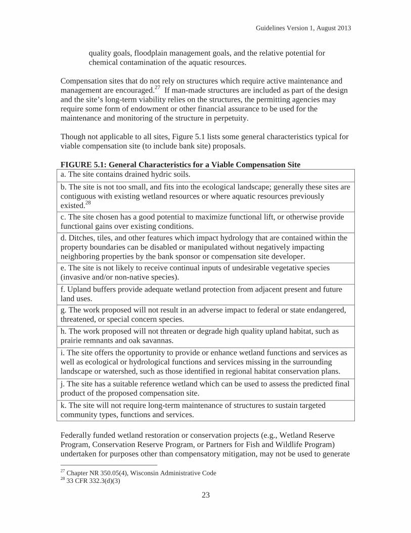
Compensation sites that do not rely on structures which require active maintenance and management are encouraged.27 If man-made structures are included as part of the design and the site’s long-term viability relies on the structures, the permitting agencies may require some form of endowment or other financial assurance to be used for the maintenance and monitoring of the structure in perpetuity. Though not applicable to all sites, Figure 5.1 lists some general characteristics typical for viable compensation site (to include bank site) proposals. FIGURE 5.1: General Characteristics for a Viable Compensation Site a. The site contains drained hydric soils. b. The site is not too small, and fits into the ecological landscape; generally these sites are contiguous with existing wetland resources or where aquatic resources previously existed.28 c. The site chosen has a good potential to maximize functional lift, or otherwise provide functional gains over existing conditions. d. Ditches, tiles, and other features which impact hydrology that are contained within the property boundaries can be disabled or manipulated without negatively impacting neighboring properties by the bank sponsor or compensation site developer. e. The site is not likely to receive continual inputs of undesirable vegetative species (invasive and/or non-native species). f. Upland buffers provide adequate wetland protection from adjacent present and future land uses. g. The work proposed will not result in an adverse impact to federal or state endangered, threatened, or special concern species. h. The work proposed will not threaten or degrade high quality upland habitat, such as prairie remnants and oak savannas. i. The site offers the opportunity to provide or enhance wetland functions and services as well as ecological or hydrological functions and services missing in the surrounding landscape or watershed, such as those identified in regional habitat conservation plans. j. The site has a suitable reference wetland which can be used to assess the predicted final product of the proposed compensation site. k. The site will not require long-term maintenance of structures to sustain targeted community types, functions and services. Federally funded wetland restoration or conservation projects (e.g., Wetland Reserve Program, Conservation Reserve Program, or Partners for Fish and Wildlife Program) undertaken for purposes other than compensatory mitigation, may not be used to generate 27 Chapter NR 350.05(4), Wisconsin Administrative Code 28 33 CFR 332.3(d)(3)
Guidelines Version 1, August 2013
24
mitigation credits. However, the permitting agencies may allow credit to be generated for activities over and above the scope of a federally funded restoration or conservation project. B. Preferred Target Community Types The Federal Mitigation Rule directs agencies to strive for in-kind compensatory mitigation over out-of-kind as part of the watershed approach. When in-kind compensation is not possible, permitting agencies prefer to see sites restored to vegetative communities that have historically experienced the greatest loss in the impacted BSA. Sedge meadows and forested wetlands have experienced the highest occurrence of loss in the state, so it is particularly important to attempt to restore these communities in areas that have experienced high percentages of this cover type loss. While the site often dictates the type of wetland cover possible, persons developing compensatory mitigation site proposals that include these communities will have a higher likelihood of being approved by the permitting agencies. C. Include Vegetated Buffers to Protect the Site Upland buffers protect wetlands and provide habitat and corridors that increase ecological functions and services of compensation sites. Adequate buffers may be required as part of approved compensation sites.29 If no upland buffer is present on site, permitting agencies may require a vegetated wetland buffer of the same width. Site-specific conditions may be considered in determining what constitutes an adequate buffer. The following general characteristics of successful upland buffers should be considered when selecting a site and planning the compensation site design. An optimal buffer width is at least 100 feet wide or to the edge of the sub-watershed of the wetland, if less than 100 feet. Permitting agencies may require a wider buffer to ensure the upland buffer is large enough to adequately filter run-off entering the site. The buffer area should contain a dense herbaceous ground layer, except when a shrub or forest community is the goal. Rills and gullies due to erosion should not be present inside the buffer area; any area disturbed during construction must be stabilized and vegetated as quickly as possible with an annual grass cover crop. Seed mixes used in the buffer area may not contain reed canary grass (Phalaris arundinancea) or giant reed grass (Phragmites australis); other invasive species may be restricted on a project-by-project basis. In addition, invasive grasses such as cheat grass/downy brome (Bromus tectorum), smooth brome grass (Bromus inermis), and quack grass (Elymus repens) are discouraged in upland buffer areas because they can make future prairie restoration difficult. Some additional restoration activities on the adjacent buffer (e.g., restoring appropriate native prairie), if integral to the ecological success of the site, may be appropriate for additional compensatory mitigation credit (see Chapter 4.A.5). Any buffer restoration
29 Chapter NR 350.05(5), Wisconsin Administrative Code
Guidelines Version 1, August 2013
25
efforts that qualify for the higher (0.25:1) crediting ratio must have developed buffer site goals, objectives, performance standards, and appropriate monitoring and management plans in the CSP. If planting is done in buffer zones, the seed should be local Wisconsin genotype, originated in Wisconsin or the first tier counties from adjoining states. D. Creation of Ponds or Open-Water Habitats as Compensation are Discouraged Past experience with compensatory mitigation projects in Wisconsin and elsewhere in the United States has shown that creation of small ponds with a ring of emergent vegetation has had a poor track record in terms of species diversity, nuisance species invasions, and water quality problems. The use of scrapes has also been problematic in Wisconsin; when scrapes are dug too deep they often result in creation of an unvegetated pond. Typically, an area that is found to hold water year-round and is not vegetated will not be given credit.30 E. Completing a Compensation Site Plan (CSP) Once a site has been approved by the permitting agencies (in consultation with the Interagency Review Team for banks), the applicant or bank sponsor shall prepare a CSP.31 The CSP is synonymous with the mitigation plan described in the Federal Mitigation Rule.32 An outline of this document can be found in Appendix E; all content listed in Appendix E is mandatory for a CSP to be considered complete. The CSP must include performance standards which are used to assess whether the project is achieving its objectives. Performance standards relate to the objectives of the compensatory mitigation project to evaluate site development into the desired resource type, to evaluate if the site is providing the expected functions, and whether the site is attaining any other applicable metrics (e.g., acres).33 As such, performance standards must be based on attributes that are objective and verifiable (measurable). The permitting agencies, in consultation with the IRT, are working to develop a list of common performance standards to utilize for compensatory mitigation projects. However, this list was not complete in time for publication of this document, but is anticipated to be included in subsequent iterations. Project proponents should consult with the permitting agencies in advance of completing a CSP to discuss the proposed project, and the performance standards recommended to evaluate project success. For banking, a CSP is part of the mitigation bank instrument (MBI). For permittee-responsible mitigation, the CSP is a stand-alone document. Once the permitting agencies approve the CSP, the CSP is either incorporated (physically or by
30 Chapter NR 350.05(3), Wisconsin Administrative Code 31 Chapter NR 350.08, Wisconsin Administrative Code 32 33 CFR 332.4(c) 33 33 CFR 332.5
Guidelines Version 1, August 2013
26
reference) into any permit issued, or portions of the CSP may be incorporated into the permit as special conditions. F. Legal Requirements (Site Protection and Financial Assurances) Permitting agencies require that all compensation sites (permittee-responsible and mitigation banks) be protected with a conservation easement or comparable legal instrument in perpetuity34,35. The site protection mechanism proposed must be approved by the permitting agencies.
The legal site protection document must, to the extent appropriate and practicable, prohibit incompatible uses (e.g., clear cutting or mineral extraction) that might otherwise jeopardize the objectives of the compensatory mitigation project. Where appropriate, multiple instruments recognizing compatible uses (e.g., fishing or walking paths) may be used.
The legal site protection document must contain a provision requiring 60-day advance notification to the permitting agencies before any action is taken to void or modify the instrument, management plan, or long-term protection mechanism, including transfer of title to, or establishment of any other legal claims over, the compensatory mitigation site.
Generally the easement should be in place before construction begins. Permitting agency contacts can provide an acceptable conservation easement or comparable template. Often the WDNR will be the grantee of the site protection instrument but on occasion, another entity such as a federal, tribal, state, or local resource agency, non-profit conservation organization, or private land manager may serve as the grantee, subject to permitting agency approval.
In addition to site protection through legal instruments, financial assurances are generally required for construction of all mitigation sites, as well as for subsequent site monitoring and management activities.36 The applicant or bank sponsor should work with the permitting agencies to determine the specific needs for their proposal. In general, financial assurances are required to ensure a high level of confidence that the compensatory mitigation project will be successfully completed, in accordance with applicable performance standards. In cases where an alternate mechanism is available to ensure a high level of confidence that the compensatory mitigation will be provided and maintained (e.g., a formal, documented commitment from a government agency or public authority) the permitting agencies may determine that financial assurances are not necessary for that compensatory mitigation project37. Any financial assurances required will be conditioned within any permit or MBI executed for the compensation site.
34 Section 281.36(8m)(a), Wisconsin Statute; Chapter NR 350.11(1), Wisconsin Administrative Code 35 33 CFR 332.7(a)(1) provides flexibility on this requirement for government property. 36 Chapter NR 350.10, Wisconsin Administrative Code 37 This is a USACE flexibility, see 33 CFR 332.3(n)
Guidelines Version 1, August 2013
27
The amount of the required financial assurances is determined by the permitting agencies, in consultation with the project sponsor, and is based on the size and complexity of the compensatory mitigation project, the degree of completion of the project at the time of project approval, the likelihood of success, the past performance of the project sponsor, and any other factors the permitting agencies deem appropriate. Cost should be quoted as fair-market value of the materials and services to be rendered. Financial assurances may be in the form of performance bonds, escrow accounts, casualty insurance, letters of credit, legislative appropriations for government sponsored projects, or other appropriate instruments, subject to the approval of the permitting agencies. In determining the assurance amount, the permitting agencies shall consider the cost of providing replacement mitigation, including costs for land acquisition, planning and engineering, legal fees, mobilization, construction, and monitoring.
Financial assurances are phased out once the compensatory mitigation project has been determined by the permitting agencies to be successful in accordance with its performance standards. The permit (or CSP for permittee-responsible) or MBI (banks) specifies the conditions under which the financial assurances are to be released to the permittee, sponsor, and/or other financial assurance provider, including, as appropriate, linkage to achievement of performance standards, adaptive management, or compliance with special conditions.
A financial assurance must be in a form that ensures that the permitting agencies will receive notification at least 120 days in advance of any termination or revocation. For third-party assurance providers, this may take the form of a contractual requirement for the assurance provider to notify the permitting agencies at least 120 days before the assurance is revoked or terminated.
Financial assurances shall be payable at the direction of the permitting agencies to their designee or to a standby trust agreement, assurances are often made payable to the WDNR38. When a standby trust is used (e.g., with performance bonds or letters of credit) all amounts paid by the financial assurance provider shall be deposited directly into the standby trust fund for distribution by the trustee in accordance with the permitting agencies instructions.
G. Long-Term Management The approved CSP (codified in any permit issued for permittee-responsible mitigation) or MBI (for mitigation bank sites) must include a long-term management plan. This plan must identify the legal mechanisms and party responsible for ownership and all long-term management and protection of the mitigation project site39. The responsible party should make adequate provisions for the operation, maintenance, and long-term management of the compensatory mitigation project site. In addition to 38 WDNR requires financial assurances be made payable to the “State of Wisconsin, Department of Natural Resources” per Chapter NR 350.10(4)(d), Wisconsin Administrative Code 39 Chapter NR 350.09(4)(b)-(c), Wisconsin Administrative Code
Guidelines Version 1, August 2013
28
identifying legal mechanisms and responsible parties above, the long-term management plan should include a description of long-term management needs, the annual cost estimate for these needs, and identify the funding mechanism that will be used to meet those needs. In some cases to ensure the integrity of the site, a long-term financing mechanism may be required; appropriate mechanisms include non-wasting endowments, trusts, contractual arrangements with future responsible parties, and other appropriate financial instruments. The applicant or bank sponsor should work with the permitting agencies to determine if a long-term financing mechanism will be required and if so, who the grantee will be, how much will be required, and what mechanism is most appropriate. The CSP (and/or permit for permittee-responsible) or MBI (for banks) may include provisions allowing the permittee or sponsor to transfer the long-term management responsibilities of the mitigation site to a land stewardship entity (e.g. public agency, non-governmental organization, private land manager), but only when approved in advance by the permitting agencies. The entity need not be identified in the original permit or MBI, as long as the future transfer is approved by the permitting agencies. The CSP (for permittee-responsible) or MBI (for banking) must address the financial arrangements and timing of any necessary transfer of long-term management funds to the steward. Where needed, the acquisition and protection of water rights should be secured and documented in the CSP (permittee-responsible) or MBI (bank). H. Construction and As-Built Approval Once a CSP has been approved and is incorporated into any necessary permit (permittee-responsible) or the MBI is signed (for a bank), construction on the site(s) can begin. The permittee or bank sponsor is responsible for providing an as-built report to the permitting agencies (permittee-responsible) or IRT (mitigation bank) by the date stipulated in the CSP/permit (permittee-responsible) or MBI (mitigation bank)40. This report will summarize the construction activities and note any changes to the construction plan that occurred following the format outlined in Figure 5.2. If immediate corrective actions are needed, these must be identified along with a timeline for when the work will be completed. This document will act as the “Year Zero” monitoring report and will serve as the basis for the construction inspection.
40 Chapter NR 350.09(2), Wisconsin Administrative Code
Guidelines Version 1, August 2013
29
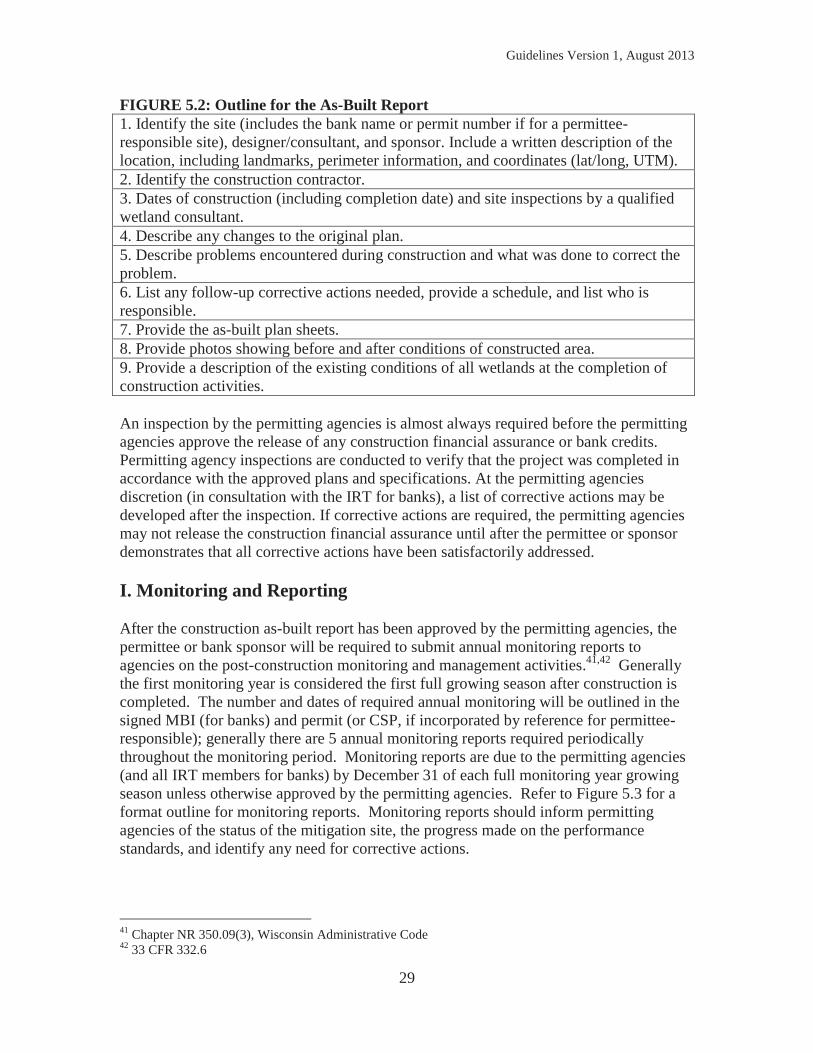
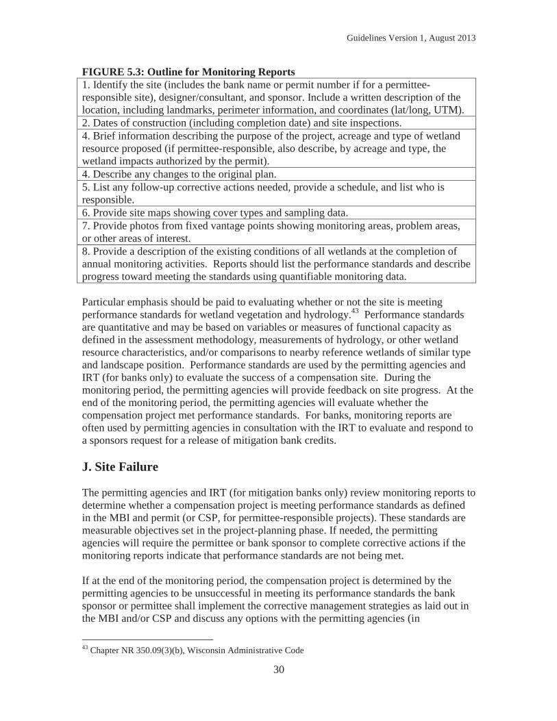
FIGURE 5.2: Outline for the As-Built Report 1. Identify the site (includes the bank name or permit number if for a permittee-responsible site), designer/consultant, and sponsor. Include a written description of the location, including landmarks, perimeter information, and coordinates (lat/long, UTM). 2. Identify the construction contractor. 3. Dates of construction (including completion date) and site inspections by a qualified wetland consultant. 4. Describe any changes to the original plan. 5. Describe problems encountered during construction and what was done to correct the problem. 6. List any follow-up corrective actions needed, provide a schedule, and list who is responsible. 7. Provide the as-built plan sheets. 8. Provide photos showing before and after conditions of constructed area. 9. Provide a description of the existing conditions of all wetlands at the completion of construction activities. An inspection by the permitting agencies is almost always required before the permitting agencies approve the release of any construction financial assurance or bank credits. Permitting agency inspections are conducted to verify that the project was completed in accordance with the approved plans and specifications. At the permitting agencies discretion (in consultation with the IRT for banks), a list of corrective actions may be developed after the inspection. If corrective actions are required, the permitting agencies may not release the construction financial assurance until after the permittee or sponsor demonstrates that all corrective actions have been satisfactorily addressed. I. Monitoring and Reporting After the construction as-built report has been approved by the permitting agencies, the permittee or bank sponsor will be required to submit annual monitoring reports to agencies on the post-construction monitoring and management activities.41,42 Generally the first monitoring year is considered the first full growing season after construction is completed. The number and dates of required annual monitoring will be outlined in the signed MBI (for banks) and permit (or CSP, if incorporated by reference for permittee-responsible); generally there are 5 annual monitoring reports required periodically throughout the monitoring period. Monitoring reports are due to the permitting agencies (and all IRT members for banks) by December 31 of each full monitoring year growing season unless otherwise approved by the permitting agencies. Refer to Figure 5.3 for a format outline for monitoring reports. Monitoring reports should inform permitting agencies of the status of the mitigation site, the progress made on the performance standards, and identify any need for corrective actions.
41 Chapter NR 350.09(3), Wisconsin Administrative Code 42 33 CFR 332.6
Guidelines Version 1, August 2013
30
FIGURE 5.3: Outline for Monitoring Reports 1. Identify the site (includes the bank name or permit number if for a permittee-responsible site), designer/consultant, and sponsor. Include a written description of the location, including landmarks, perimeter information, and coordinates (lat/long, UTM). 2. Dates of construction (including completion date) and site inspections. 4. Brief information describing the purpose of the project, acreage and type of wetland resource proposed (if permittee-responsible, also describe, by acreage and type, the wetland impacts authorized by the permit). 4. Describe any changes to the original plan. 5. List any follow-up corrective actions needed, provide a schedule, and list who is responsible. 6. Provide site maps showing cover types and sampling data. 7. Provide photos from fixed vantage points showing monitoring areas, problem areas, or other areas of interest. 8. Provide a description of the existing conditions of all wetlands at the completion of annual monitoring activities. Reports should list the performance standards and describe progress toward meeting the standards using quantifiable monitoring data. Particular emphasis should be paid to evaluating whether or not the site is meeting performance standards for wetland vegetation and hydrology.43 Performance standards are quantitative and may be based on variables or measures of functional capacity as defined in the assessment methodology, measurements of hydrology, or other wetland resource characteristics, and/or comparisons to nearby reference wetlands of similar type and landscape position. Performance standards are used by the permitting agencies and IRT (for banks only) to evaluate the success of a compensation site. During the monitoring period, the permitting agencies will provide feedback on site progress. At the end of the monitoring period, the permitting agencies will evaluate whether the compensation project met performance standards. For banks, monitoring reports are often used by permitting agencies in consultation with the IRT to evaluate and respond to a sponsors request for a release of mitigation bank credits. J. Site Failure The permitting agencies and IRT (for mitigation banks only) review monitoring reports to determine whether a compensation project is meeting performance standards as defined in the MBI and permit (or CSP, for permittee-responsible projects). These standards are measurable objectives set in the project-planning phase. If needed, the permitting agencies will require the permittee or bank sponsor to complete corrective actions if the monitoring reports indicate that performance standards are not being met. If at the end of the monitoring period, the compensation project is determined by the permitting agencies to be unsuccessful in meeting its performance standards the bank sponsor or permittee shall implement the corrective management strategies as laid out in the MBI and/or CSP and discuss any options with the permitting agencies (in
43 Chapter NR 350.09(3)(b), Wisconsin Administrative Code
Guidelines Version 1, August 2013
31
consultation with the IRT for banks) to complete the project. If the site is not meeting standards even after the planned corrective strategies have been exhausted, the permitting agencies or sponsor (as appropriate) should consider pursuing one of several options for permitting agency approval, including, but not limited to the following:44
1. The monitoring period may be extended by the permitting agencies while imposing a compliance schedule specifying corrective actions to be taken by the permittee or bank sponsor and deadlines for completing these actions.
2. A third party approved by the permitting agencies may pursue access to the financial assurance funds to complete remedial corrective actions at the site.
3. A third party approved by the permitting agencies may pursue access to the financial assurance funds to develop an alternate site if the permitting agencies determine that the existing site is not a viable compensation site.
4. The number of credits originally estimated to be produced on the site may be reduced to reflect the inability of the site to meet the performance standards. This may reduce the number of credits available for sale (mitigation banks), or may result in insufficient compensation for impacts authorized by permitting agencies (permittee-responsible) – requiring the permittee to provide additional compensation to fulfill permit requirements.
5. The compensatory mitigation project may be modified, or performance standards may be revised. Unless a natural disaster occurs, performance standards may only be revised when the new standards would provide ecological benefits that are comparable or superior to the originally approved mitigation project. This requires approval from the permitting agencies.45
The permittee or bank sponsor (as appropriate) must obtain permitting agency approval for the course of action proposed. Permitting agency evaluation is completed on a case-by-case basis, factors considered include: the permittee or bank sponsor’s willingness to work with the agencies, past work accomplished on the site, and existing site conditions. The permitting agencies will document the reasons for any course of action selected.
44 33 CFR 332.7(c) contains additional information on adaptive management. 45 33 CFR 332.7(c)(4)
Guidelines Version 1, August 2013
32
6) MITIGATION BANKING Mitigation banking involves a formal administrative framework in which wetlands are restored, enhanced, preserved, or created expressly for the purpose of providing compensatory mitigation in advance of authorized impacts to similar resources. Once the plan to purchase credits is approved by the agencies, permittees must purchase the required credits. The permittee retains responsibility for providing the compensatory mitigation until the appropriate number and cover type of credits have been secured from a bank and the permitting agencies have received documentation that confirms that the bank has accepted the responsibility for providing the required compensatory mitigation. Once this is completed, the bank assumes responsibility for the permittee’s compensatory mitigation requirement. Wetland bank credits earned on a given site are initially estimated using the ratios shown in Figure 4.1 (final numbers are determined post-construction and depend on how well the site meets established performance standards and the final wetland acreage provided). These credits are available for use by the bank sponsor or by other permittees to compensate for adverse wetland impacts resulting from permitted activities (i.e. “debits”). Purchase of in-kind credits within the BSA of the permitted impact is preferred. Optimally, the debit would occur within the same 8-digit HUC as the proposed impact. Prospective bank sponsors should not construe or anticipate the establishment of a mitigation bank as ultimate authorization for specific projects, as excepting such projects from any applicable requirements, or as pre-authorizing the use of credits from that bank for any particular project.46 A. Types of Mitigation Banks 1. Single Client— Single client banks are developed to produce credits for sale or use by the bank sponsor or by a single client of the sponsor. The client or sponsor may be an individual, a corporation, a governmental unit, a municipality, or an association. 2. General Use— General use banks are developed to produce credits for sale or use by permittees. General use banking results in a transfer of the legal and financial responsibility for executing compensatory mitigation from the permittee to the bank sponsor. General use banks are described as private commercial banks in RIBITS. B. Roles and Responsibilities 1. Role of the Bank Sponsor The bank sponsor prepares the prospectus and the mitigation bank instrument or MBI (Chapter 5.E and Appendix E).47 Refer to the USACE website for the most current MBI
46 Chapter NR 350.13(4), Wisconsin Administrative Code 47 Chapter NR 350.13(2)-(3), Wisconsin Administrative Code
Guidelines Version 1, August 2013
33
template (http://www.mvp.usace.army.mil/Missions/Regulatory/MitigationBank.aspx). See Appendix D and Chapter 6.H below for the process for developing a mitigation bank. The bank sponsor is solely responsible for setting the cost of bank credits. The bank sponsor is entirely financially responsible for establishing a bank site (or sites) in accordance with an approved MBI, administration of the accounting of debits and credits and submitting ledgers to the permitting agencies, conducting required corrective actions, providing required monitoring and status reports to the IRT, and assuring long term maintenance and protection of the site(s). Each time an approved credit transaction occurs, documentation is required that confirms that the bank has accepted the responsibility for providing the required compensatory mitigation. The sponsor must provide notification to the USACE and WDNR. This notification may be provided by using the Affidavit of Bank Credit Purchase48 (Appendix F) signed by the sponsor and permittee. The sponsor may not sell credits without permitting agencies approval to ensure that debits occur only for agency authorized wetland impacts. Each affidavit shall reference the USACE and/or WDNR permit numbers for which the compensatory mitigation was required, the permittee to whom the credit was sold, and the location of the impact site for which the permit is being issued. Mitigation bank sponsors are responsible for tracking the number of credits of each of the eleven plant community types available for sale and shall provide the USACE updates to load into the RIBITS (Regulatory In-lieu fee and Bank Information Tracking System) website. The sponsor must submit an annual credit ledger report to the permitting agencies by January 30th which shows all activity from the preceding calendar year. Annual ledger reports must include the beginning and ending balances of available credits by credit type, all credit deposits and withdrawals, and other changes in credit availability, such as the release of additional credits or the suspension of credit sales. Annual credit ledger reports are mandatory for every year until all credits have been sold and the bank is formally closed. 2. Role of the Interagency Review Team (IRT) Representatives of the USACE, U.S. Environmental Protection Agency (EPA), the U.S. Fish and Wildlife Service (FWS), Natural Resources Conservation Service, the WDNR and other state, tribal, or local regulatory agencies, as appropriate to a particular site, may comprise the IRT at the discretion of the USACE as the lead federal agency. The primary role of the IRT is to provide the permitting agencies feedback for use when considering whether to approve mitigation banks. The IRT reviews the prospectus and MBI, and comments on the expected credits the site may produce. At the discretion of the USACE, IRT members may participate in the execution of an MBI.49 After site
48 USACE may accept other forms of notification, such as an updated ledger or contract to purchase. 49 While WDNR is a member of the IRT, it also has independent authority to review and approve banks per Chapter NR 350.13(2), Wisconsin Administrative Code
Guidelines Version 1, August 2013
34
construction, the IRT reviews and provides the permitting agencies comments on the as-built, site monitoring reports, site performance, and proposed credit releases. To accomplish its’ duties, members of the IRT may visit prospective and existing bank sites during the bank development process, site construction, subsequent monitoring periods, and after monitoring is completed. The IRT is convened by the USACE. The WDNR may serve as a co-chair if the bank will also be used to satisfy state requirements. The goal is to reach IRT consensus on the specifics of bank development, the bank instrument, and on preliminary and final credit determinations. However, final decisions are made by the lead permitting agencies. 3. Role of the Permitting Agencies The permitting agencies determine the appropriate compensation required for a given permit. If purchase of bank credits is the selected approach, the permitting agencies will determine the compensation ratio (see Chapter 3.A) that is appropriate considering the specifics of the wetland impact and the bank site selected. While permitting agencies strive to require consistent mitigation approaches, these decisions are made independently by each permitting agency in support of their own program requirements. The permitting agencies are responsible for ensuring that all appropriate documentation is received, including the Affidavit of Bank Credit Purchase. The permitting agencies are responsible for enforcement of the conditions of the permit, including compensation requirements. C. Prospectus50 Prior to submittal of a draft MBI, a bank sponsor must submit a prospectus, which is a conceptual plan that summarizes the proposed project.51 The prospectus must provide information at a sufficient level of detail to facilitate meaningful comments from the permitting agencies, IRT members, and the public. The prospectus must contain the information in Appendix C. The prospectus phase is used to inform the public and permitting agencies about the proposal and provide an opportunity to comment about the proposal, including whether or not a proposed bank site holds potential. D. Mitigation Bank Instrument (MBI)52 The mitigation bank instrument (MBI) is the legal document for the establishment, operation, and use of a mitigation bank. The MBI is the record regarding the objectives and administration of the bank. It also includes the CSP, providing specific information regarding bank site development and performance standards.53 The terms and conditions 50 33 CFR 332.8(d)(2-5) 51 Chapter NR 350.12(1), Wisconsin Administrative Code 52 33 CFR 332.8(d)(6-8) 53 Chapter NR 350.12(3), Wisconsin Administrative Code
Guidelines Version 1, August 2013
35
of the MBI may be amended, subject to notification of all IRT members and approval by the signatories. It is strongly recommended that the MBI be developed using the template found on the USACE website (http://www.mvp.usace.army.mil/Missions/Regulatory/MitigationBank.aspx), and incorporate the information found in Appendix E. E. Credit Generation for a Bank The number of credits a bank site may produce is estimated up front by the sponsor and this estimate is subject to approval by the permitting agencies in consultation with the IRT. See Chapter 4 for more information. The total estimated credits will be stated clearly in the MBI. No more than 25% of the credits for a mitigation bank site can be the result of creation.54 Interim credits may be released as interim performance standards are met.55 Final credit release requires a wetland delineation be completed at the end of the monitoring period.56 Final credit release amounts may differ from the estimated final release credits based on the actual wetland acreage by cover type delineated on site and the permitting agencies evaluation of how well the site met all final performance standards. If final performance standards are not being met as proposed by the end of the typical monitoring period, the bank sponsor may opt to pursue one of several options as described in Chapter 6.G on site failure below. The terms of the credit release schedule must be specified in the MBI. The credit release schedule is proposed by the sponsor and approved by the lead permitting agencies, and may provide for an initial release of a limited number of credits once the instrument is approved and other appropriate milestones are achieved. An example of a general credit release schedule is shown in Figure 6.1. 54 Chapter NR 350.13(5)(a), Wisconsin Administrative Code 55 Chapter NR 350.13(6), Wisconsin Administrative Code 56 Chapter NR 350.07(2), Wisconsin Administrative Code
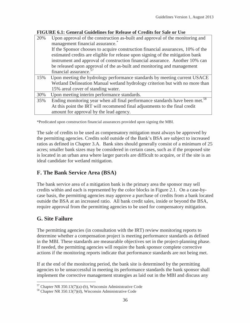
Guidelines Version 1, August 2013
36
FIGURE 6.1: General Guidelines for Release of Credits for Sale or Use 20% Upon approval of the construction as-built and approval of the monitoring and
management financial assurance.* If the Sponsor chooses to acquire construction financial assurances, 10% of the
estimated credits are eligible for release upon signing of the mitigation bank instrument and approval of construction financial assurance. Another 10% can be released upon approval of the as-built and monitoring and management financial assurance.57
15% Upon meeting the hydrology performance standards by meeting current USACE Wetland Delineation Manual wetland hydrology criterion but with no more than 15% areal cover of standing water.
30% Upon meeting interim performance standards. 35% Ending monitoring year when all final performance standards have been met.58
At this point the IRT will recommend final adjustments to the final credit amount for approval by the lead agency.
*Predicated upon construction financial assurances provided upon signing the MBI. The sale of credits to be used as compensatory mitigation must always be approved by the permitting agencies. Credits sold outside of the Bank’s BSA are subject to increased ratios as defined in Chapter 3.A. Bank sites should generally consist of a minimum of 25 acres; smaller bank sizes may be considered in certain cases, such as if the proposed site is located in an urban area where larger parcels are difficult to acquire, or if the site is an ideal candidate for wetland mitigation. F. The Bank Service Area (BSA) The bank service area of a mitigation bank is the primary area the sponsor may sell credits within and each is represented by the color blocks in Figure 2.1. On a case-by-case basis, the permitting agencies may approve a purchase of credits from a bank located outside the BSA at an increased ratio. All bank credit sales, inside or beyond the BSA, require approval from the permitting agencies to be used for compensatory mitigation. G. Site Failure The permitting agencies (in consultation with the IRT) review monitoring reports to determine whether a compensation project is meeting performance standards as defined in the MBI. These standards are measurable objectives set in the project-planning phase. If needed, the permitting agencies will require the bank sponsor complete corrective actions if the monitoring reports indicate that performance standards are not being met. If at the end of the monitoring period, the bank site is determined by the permitting agencies to be unsuccessful in meeting its performance standards the bank sponsor shall implement the corrective management strategies as laid out in the MBI and discuss any 57 Chapter NR 350.13(7)(a)-(b), Wisconsin Administrative Code 58 Chapter NR 350.13(7)(d), Wisconsin Administrative Code
Guidelines Version 1, August 2013
37
options with the permitting agencies (in consultation with the IRT) to complete the project. If the site is not meeting standards even after the planned corrective strategies have been exhausted, the sponsor should consider pursuing one of several options for permitting agency approval, including, but not limited to the following:59
1. The monitoring period may be extended by the permitting agencies while imposing a compliance schedule specifying corrective actions to be taken by the bank sponsor and deadlines for completing these actions.
2. A third party authorized by the permitting agencies may pursue access to the financial assurance funds to complete remedial corrective actions at the site.
3. A third party approved by the permitting agencies may pursue access to the financial assurance funds to develop an alternate site if the permitting agencies determine that the existing site is not a viable compensation site.
4. The number of credits originally estimated to be produced on the site may be reduced to reflect the inability of the site to meet the performance standards. This may reduce the number of credits available for sale.
5. The compensatory mitigation project may be modified, or performance standards may be revised. Unless a natural disaster occurs, performance standards may only be revised when the new standards would provide ecological benefits that are comparable or superior to the originally approved mitigation project. This requires approval from the permitting agencies.60
The bank sponsor must obtain permitting agency approval for the course of action proposed. Permitting agency evaluation is completed on a case-by-case basis in consultation with the IRT, factors considered include: the bank sponsor’s willingness to work with the agencies, past work accomplished on the site, and existing site conditions. The permitting agencies will document the reasons for any course of action approved. H. Process for Establishing a Bank Establishing a mitigation bank is a 5-step process. Each step in this process is outlined below as required by the Federal Mitigation Rule. Refer to Appendix D for a summary timeline of the bank instrument approval process (steps 1 through 4). While the key steps and approvals below indicate USACE as the lead, sponsors must also receive approval from the WDNR throughout the bank development process if they intend to sell credits to offset authorized impacts under Wisconsin state law.61 Step 1: Draft prospectus and Scoping62 Bank sponsors may choose to submit a draft prospectus (refer to Appendix C). This is encouraged to identify potential issues early so that the sponsor may address those issues prior to the start of the formal review process. The USACE will provide copies of the draft prospectus to the WDNR and IRT for comments. The USACE must provide 59 33 CFR 332.7(c) contains additional information on adaptive management. 60 33 CFR 332.7(c)(4) 61 Chapter NR 350.12, Wisconsin Administrative Code 62 33 CFR 332.8(d)(3)
Guidelines Version 1, August 2013
38
comments back to the sponsor within 30 days of receipt of the draft prospectus, unless notification including the reason for a delay is provided to the sponsor. Any comments from the IRT will also be forwarded to the sponsor by the USACE. A site visit is optional at this stage in the review process but, if determined necessary, should be conducted as soon as feasible. Step 2: Prospectus63 The bank sponsor prepares and submits a prospectus to the USACE for review. The USACE will evaluate the prospectus for completeness and notify the sponsor if the submittal is complete or if additional information is required. Within 30 days of USACE receipt of a complete prospectus, USACE will issue a public notice announcing the proposal and share the prospectus with the WDNR and other IRT agencies for feedback. The USACE may schedule a meeting with the IRT to discuss the project. Comments received from the WDNR, IRT, and from others in response to the public notice will be provided to the sponsor. The USACE will make a determination whether or not the project has potential and provide it to the sponsor. If the USACE determines the project has potential, the sponsor will be provided a template MBI (a current template is available at the USACE website http://www.mvp.usace.army.mil/Missions/Regulatory/MitigationBank.aspx) and other necessary information (refer to Appendix E). Additional timing information can be found in the Federal Mitigation Rule. Step 3: Draft MBI review64 Phase 3 of the bank review process is initiated when the bank sponsor submits the draft Mitigation Bank Instrument (MBI). It is highly recommended that the draft MBI be developed using the template available at the USACE website (http://www.mvp.usace.army.mil/Missions/Regulatory/MitigationBank.aspx), it must contain the CSP information in Appendix E.65 After submittal, the USACE has 30 days to determine if the draft MBI is complete and notify the bank sponsor of the completeness determination (including any request for additional information if required). Once complete, copies of the MBI are distributed to the IRT. The IRT has 30 days to comment on the draft MBI, starting 5 days after the date of distribution to the IRT. A site visit, if proposed, should be completed during this time if seasonal conditions allow (review of draft MBI’s submitted in winter may be delayed until the growing season begins). If field review will extend the review period, USACE will notify the sponsor of the delay and the reason for delay as soon as possible. Within 90 days of receipt of a complete draft MBI, the USACE will provide a status update to the sponsor. The update will indicate that the bank is generally acceptable provided that certain changes or updates are provided with the submittal of the final MBI. If the bank is not likely to be approved, USACE will identify the issues that contribute to this position and provide it to the sponsor. The WDNR will provide notice to the public that a complete draft bank instrument has been found generally acceptable and will make copies of any of the plans and other documentation available for review by any person who requests such.
63 33 CFR 332.8(d)(2), (4), and (5) 64 33 CFR 332.8(d)(6) and (7) 65 USACE required information is listed at 33 CFR 332.8(d)(6)(ii) and (iii).
Guidelines Version 1, August 2013
39
Step 4: Final MBI Approval66 The sponsor will submit a final MBI with supporting documentation that explains how the final instrument addresses the comments provided by the IRT in Step 3 of the review process. The sponsor is also responsible for providing the final MBI directly to the IRT members. If USACE determines that the final MBI has not satisfactorily addressed the comments raised in Step 3, they will determine what actions may be necessary and provide this information to the sponsor. Once an acceptable final MBI has been provided, the USACE will advise the IRT whether or not they intend to approve the MBI. Any member of the IRT may submit a written request for dispute resolution to the USACE within 15 days of this advisement. If no dispute process is initiated, the USACE will inform the sponsor that the signature process for executing the MBI may be initiated. Once three copies of the final MBI have been signed by the sponsor, USACE will obtain signatures from other IRT agencies with an interest in signing the MBI, and will finalize the instrument. One copy of the executed MBI will be retained by USACE, the second and third copies will be provided to the sponsor and the WDNR. The bank will be listed as “approved” on the Corps’ RIBITS webpage and the statewide registry of approved banks on the WDNR webpage. Once all signatures are obtained, the MBI is considered complete and the bank sponsor may begin construction at the bank site. Step 5: Credit Release, Monitoring, Report Review and Final Approval In order for credits to be released the sponsor must request a release, which requires submittal of documentation to USACE demonstrating that the appropriate milestones for credit release have been achieved. This documentation is typically provided via submittal of an as-built report (which documents construction activities during “year 0”), and subsequent monitoring reports. The Federal Mitigation Rule states that submission of monitoring reports is required to assess the development and condition of compensatory mitigation projects and banks, but the content and level of detail for those reports must be commensurate with the scale, scope, and type of project.67 The USACE Regulatory Guidance Letter 08-0368 addresses the minimum information needed for monitoring reports. Monitoring requirements are typically based on the performance standards for the site and thus may vary from one project to another. Upon receipt of a request for credit release the USACE shall provide copies of the request and supporting documentation provided by the sponsor to the IRT. The IRT agencies must provide comments to USACE within 15 days of receiving the documentation. However if USACE determines that a site visit is necessary, IRT comments are due within 15 days after the site visit. The site visit should be scheduled with the IRT members as soon as practicable. After full consideration of any comments received, USACE must then determine if the appropriate milestones have been achieved and whether credits should be released. The USACE has 30 days from the close of the IRT comment period to make this decision and provide written notification to the sponsor. If a credit release is approved, this notification will detail the number of credits
66 33 CFR 332.8(d)(8) 67 See 33 CFR 332.6(a)(1). 68 http://www.usace.army.mil/Portals/2/docs/civilworks/RGLS/rgl08_03.pdf
Guidelines Version 1, August 2013
40
to be released, as well as any additional comments for the sponsor. Adjustments to the estimated credits proposed for release will be explained. When the sponsor submits a request for the final release of credits (typically associated with the final year’s monitoring report and the final wetland delineation and/or as laid out in the MBI), the USACE must complete the coordination required in the two paragraphs above and determine final credit allocation (including consultation with the IRT) for the bank.
Guidelines Version 1, August 2013
41
Appendix A. DEFINITIONS For the purposes of this document the following terms are defined below. Those terms including a “*” are verbatim from the USACE regulations at 33 CFR Part 332.2. Additions to the federal definitions are indicated by “[]” parenthesis. For purposes of this guidance, these definitions should be applied to wetland resources. Adaptive Management* The development of a management strategy that anticipates likely challenges associated with mitigation projects and provides for the implementation of actions to address those challenges, as well as unforeseen changes to the project. It requires consideration of risk, uncertainty, and dynamic nature of compensatory mitigation projects and guides modification of these projects to optimize performance. It includes the selection of appropriate measures that will ensure that aquatic resource functions are provided and involves analysis of monitoring results to identify potential problems of a compensatory mitigation project and the identification and implementation of measures to rectify those problems. Affidavit of Bank Credit Purchase Legal documentation of proof of credit purchase prepared by the Bank Sponsor and signed by the Sponsor and the Debtor purchasing credits. Authorization In this document used interchangeably with the term “permit.” Can refer to U.S. Army Corps of Engineers Section 10 Rivers and Harbors Act or Section 404 Clean Water Act authorizations or Wisconsin Department of Natural Resources wetland permits. Bank Instrument A document that contains specifications pertaining to the establishment, operation, and maintenance of a mitigation bank, and identification of the goals, objectives, and procedures for operation of the bank. Bank Sponsor Any public or private entity responsible for establishing and, in most cases, operating a mitigation bank. Basin A large region drained by a single lake or river system. There are three basins in Wisconsin: Lake Superior Basin, Lake Michigan Basin, and the Mississippi River Basin. Buffer* An upland, wetland, and/or riparian area that protects and/or enhances aquatic resource functions associated with wetlands, rivers, streams, lakes, marine, and estuarine systems from disturbances associated with adjacent land uses. Compensation or Compensatory Mitigation* The restoration (re-establishment or rehabilitation), establishment (creation), enhancement, and/or in certain circumstances preservation of aquatic resources for the purposes of offsetting unavoidable adverse impacts which remain after all appropriate and practicable avoidance and minimization has been achieved.
Guidelines Version 1, August 2013
42
Compensatory Mitigation Project* A project implemented by the permittee as a requirement of a DA [and/or state wetland] permit (i.e. permittee-responsible mitigation), or by a mitigation bank or in-lieu fee program. Compensation Crediting Ratio The ratio applied per acre to determine the credits generated by a given wetland compensatory mitigation method. Compensation Replacement Ratio This ratio determines the amount of wetland compensatory mitigation required by the permitting agencies to offset unavoidable adverse impacts to wetlands. Compensation Site Plan A comprehensive document prepared by a project proponent or bank sponsor that provides a thorough description of a proposed compensation project. The information presented in the CSP includes the information required in the “mitigation plan” by the Federal Mitigation Rule and NR 350, Wis. Adm. Code. For permittee-responsible mitigation, the CSP is a stand-alone document. For mitigation banking, the CSP is included in the mitigation bank instrument (MBI). Condition* The relative ability of an aquatic resource to support and maintain a community of organisms having a species composition, diversity, and functional organization comparable to reference aquatic resources in the region. Creation (establishment*) The manipulation of the physical, chemical, or biological characteristics present to develop an aquatic resource that did not previously exist at an upland site. Creation results in a gain in aquatic resource area and functions. Credit* A unit of measure (e.g. a functional or areal measure of other suitable metric) representing the accrual or attainment of aquatic resource functions at a compensatory mitigation site. The measure of aquatic functions is based on the resources restored, established, enhanced, or preserved. Days* Calendar days. Debit* A unit of measure (e.g. a functional or areal measure of other suitable metric) representing the loss of aquatic functions at an impact or project site. The measure of aquatic resource functions is based on the resources impacted by the authorized activity. Degraded Wetland A wetland subjected to deleterious activities such as drainage, grazing, cultivation, increased stormwater input, introduction of non-native and/or invasive species, or partial filling, to the extent that natural wetland characteristics are severely compromised and wetland functions and services are substantially reduced. Enhancement* The manipulation of physical, chemical, or biological characteristics of an aquatic resource to heighten, intensify, or improve a specific aquatic resource function(s). Enhancement results in the gain of selected aquatic resource function(s), but
Guidelines Version 1, August 2013
43
may also lead to a decline in other aquatic resource function(s). Enhancement does not result in a gain in aquatic resource area. Establishment* (creation) The manipulation of the physical, chemical, or biological characteristics present to develop an aquatic resource that did not previously exist at an upland site. Creation results in a gain in aquatic resource area and functions. Functions* The physical, chemical, and biological processes that occur in ecosystems. Functional Values This term is used by the WDNR to describe the physical, chemical, and biological processes or attributes that occur in a wetland system and how society finds certain functional values beneficial. See the functions and services definitions. In-Kind* A resource of similar structural and functional type to the impacted resource. [For purposes of these guidelines, wetland plant communities are used for the in-kind determination. See definition for wetland cover type.] Interagency Review Team (IRT)* An interagency group of federal, tribal, state, and/or local regulatory and resource agency representatives that reviews documentation for, and advises the district engineer on, the establishment and management of a mitigation bank or an in-lieu fee program. [Prior to the 2008 federal mitigation rule, this team was known in Wisconsin as the Mitigation Bank Review Team (MBRT).] Management Actions taken at a compensation site to establish and maintain desired habitat and human use conditions including water level manipulations, herbicide application, mechanical plant removal, prescribed burning, fencing, signage, and vandalism repair. Mitigation Banking A system of accounting for wetland impacts and compensation that includes sites where wetlands exist in perpetuity. These wetlands provide transferable credits to be subsequently applied to compensate for adverse impacts to other wetlands authorized by State and Federal permits. In general, a bank sells credits to permittees whose compensatory mitigation obligations are then transferred to the bank sponsor. The operation and use of a mitigation bank are governed by a mitigation banking instrument. Mitigation Banking Instrument* The legal document for the establishment, operation, and use of a mitigation bank. Mitigation Bank* Site A site, or suite of sites, where resources (e.g. wetlands, streams, riparian areas) are restored, established, enhanced, and/or preserved for the purpose of providing compensatory mitigation for impacts authorized by DA [and WDNR wetland] permits. In general, a mitigation bank sells compensatory mitigation credits to permittees whose obligation to provide compensatory mitigation is then transferred to the mitigation bank sponsor. The operation and use of a mitigation bank are governed by a mitigation bank instrument.
Guidelines Version 1, August 2013
44
Monitoring Plan A specific program of data collection, conducted, analyzed, and reported by a project proponent or bank sponsor, which documents the physical, biological, hydrological, and human-use characteristics of compensation site wetlands. The main purpose of the monitoring plan is to document the progress and achievement of performance standards. Out-of-kind* A resource of different structural and functional type from the impacted resource. [For purposes of these guidelines, out-of-kind refers to a different wetland plant community type than that of the impacted wetland. See definition for wetland cover type.] Performance Standards* Observable or measurable physical (including hydrological), chemical and/or biological attributes that are used to determine if a compensatory mitigation project meets its objectives. [Performance standards are agreed to in advance by the bank sponsor/applicant and permitting agencies.] Permit For purposes of this document, used interchangeably with the term “authorization.” Can refer to Wisconsin Department of Natural Resources wetland permits or U.S. Army Corps of Engineers permits. Permittee-Responsible Mitigation* An aquatic resource restoration, establishment, enhancement, and/or preservation activity undertaken by the permittee (or an authorized agent or contractor) to provide compensatory mitigation for which the permittee retains full responsibility. Preservation* The removal of a threat to, or preventing the decline of, aquatic resources by an action in or near those aquatic resources. This term includes activities commonly associated with the protection and maintenance of aquatic resources through the implementation of appropriate legal and physical mechanisms. Preservation does not result in a gain of aquatic resource area or function. Re-establishment* (a form of restoration) The manipulation of the physical, chemical, or biological characteristics of a site with the goal of returning natural/historic functions to a former aquatic resource. Re-establishment results in rebuilding a former aquatic resource and results in a gain in aquatic resource area and function. Reference Aquatic Resource* A set of aquatic resources that represent the full range of variability exhibited by a regional class of aquatic resources as a result of natural processes and anthropogenic disturbances. Rehabilitation* (a form of restoration) The manipulation of the physical, chemical, or biological characteristics of a site with the goal of repairing natural/historic functions to a degraded aquatic resource. Rehabilitation results in a gain in aquatic resource functions, but does not result in a gain in aquatic resource area.
Guidelines Version 1, August 2013
45
Release of Credits* A determination by the district engineer [and WDNR], in consultation with the IRT, that credits associated with an approved mitigation plan are available for sale or transfer, or in the case of an in-lieu fee program, for fulfillment of advance credit sales. A proportion of the projected credits for a specific mitigation bank or in-lieu fee project may be released upon approval of the mitigation plan, with additional credits released as milestones specified in the credit release schedule are achieved. Restoration* The manipulation of the physical, chemical, or biological characteristics of a site with the goal of returning natural/historic functions to a former or degraded aquatic resource. For the purpose of tracking net gains in aquatic resource area, restoration is divided into two categories: re-establishment and rehabilitation. RIBITS (Regulatory In-lieu fee and Bank Information Tracking System) An electronic mitigation bank ledger system developed by the USACE with support from the USEPA and the U.S. Fish and Wildlife Service to provide public information on mitigation banking. RIBITS allows users to access information on the types and numbers of mitigation bank sites, service areas, and available credits. Riparian Areas* Lands adjacent to streams, rivers, lakes, and estuarine-marine shorelines. Riparian areas provide a variety of ecological functions and services and help improve or maintain local water quality. Service Area* The geographic area within which impacts can be mitigated at a specific mitigation bank or in-lieu fee program, as designated in its instrument. [In Wisconsin, service areas are defined by the Bank Service Areas (BSA) as shown in Figure 2.1, although impacts may be mitigated outside of a designated service area at an increased ratio.] Services* The benefits that human populations receive from functions that occur in ecosystems. [By definition, services are not equivalent to functional values but will not be separately distinguished within this document. See Functional Values.] Temporal Loss* The time lag between the loss of aquatic resource functions caused by permitted impacts and the replacement of aquatic resource functions at the compensatory wetland mitigation site. Higher compensation ratios may be required to compensate for temporal loss. When the compensatory mitigation project is initiated prior to, or concurrent with, the permitted impacts, the district engineer [and/or WDNR] may determine that compensation for temporal loss is not necessary, unless the resource has a long development time. Watershed* A land area that drains to a common waterway, such as a stream, lake, estuary, wetland, or ultimately the ocean. [Used interchangeably with “contributing area.” Sub-watershed refers to a portion of a watershed, and this term is often used to mean a localized area.]
Guidelines Version 1, August 2013
46
Watershed Approach* An analytical process for making compensatory mitigation decisions that support the sustainability or improvement of aquatic resources in a watershed. It involves consideration of watershed needs, and how locations and types of compensatory mitigation projects address those needs. A landscape perspective is used to identify the types and locations of compensatory mitigation projects that will benefit the watershed and offset losses of aquatic resource functions and services caused by activities authorized by DA [and WDNR] permits. The watershed approach may involve consideration of landscape scale, historic and potential aquatic resource conditions, past and projected aquatic resource impacts in the watershed, and terrestrial connections between aquatic resources when determining compensatory mitigation requirements for DA [and WDNR] permits. Wetlands Areas that are inundated or saturated by surface or groundwater at a frequency and duration sufficient to support, and that under normal circumstances do support, a prevalence of vegetation adapted typically for life in saturated soil conditions. Wetland Cover Type Dominant plant community types used to evaluate in-kind comparisons. For the purposes of this document, all wetlands are arranged in one of eleven community types as described by Eggers and Reed (2011)69: 1) shallow, open water, 2) deep or shallow marshes, 3) sedge meadows, 4) fresh (wet) meadows, 5) wet to wet-mesic prairies, 6) calcareous fens, 7) open or coniferous bogs, 8) shrub-carrs or alder thickets, 9) hardwood or coniferous swamps, 10) floodplain forests, and 11) seasonally flooded basins.
69 Eggers, Steve D., and Donald M. Reed. 2011. Wetlands Plants and Plant Communities of Minnesota and Wisconsin, Third Edition. U.S. Army Corps of Engineers, Regulatory Branch St. Paul District. 478 pp.

Guidelines Version 1, August 2013
47
Appendix B. THE MITIGATION SUMMARY SHEET The Mitigation Summary Sheet is required for Wisconsin Department of Natural Resources (Department) Wetland Individual Permit (IP) applications. Compensatory wetland mitigation is required for all Department IP projects. The Applicant, or his/her consultant, shall compile a one-page document with the following information. The Mitigation Summary Sheet shall be submitted as a draft prior to the required pre-application meeting. A copy shall then be submitted along with all other required Department IP application materials.
Mitigation Summary Sheet 1. Applicant’s name, address, phone number, and email address: 2. Agent or Consultant’s name, address, phone number, and email address: 3. Bank Service Area (BSA) where proposed wetland impact would occur: 4. Brief project description: 5. Brief description of how project will impact wetlands: 6. Proposed/expected wetland impacts by wetland cover type and delineated acreage: ____ acres of shallow/open water
____ acres of deep/shallow marshes ____ acres of sedge meadow ____ acres of fresh (wet) meadow ____ acres of wet to wet-mesic prairie ____ acres of calcareous fen ____ acres of open bog/coniferous bog ____ acres of shrub-carr/alder thicket ____ acres of hardwood/coniferous swamp ____ acres of floodplain forest ____ acres of seasonally flooded basin
7. Compensation Approach (if bank credits are not selected, explain why) ____ a. Purchase credits from an approved bank site. -Has a mitigation bank been contacted? If so:
-What bank(s) was contacted? -Is the proposed impact in the primary BSA of the bank? -If not in the same BSA, explain why.
____ b. Permittee-responsible mitigation. -If this option is being pursued, contact the DNR Wetland Mitigation
Coordinator for the Compensation Site Plan requirements.
Guidelines Version 1, August 2013
48
Appendix C. PROSPECTUS FOR MITIGATION BANKS The following information is used to review a proposed mitigation bank in Phase 2, and is strongly recommended to be submitted for Phase 1: I. Owner. Identify the bank sponsor, landowners, and any agent for the sponsor. II. Agent. Identify consultants or experts to be involved in design of the compensation
site, and list the qualifications of the sponsor’s team to successfully complete the type(s) of mitigation project(s) proposed, including information describing any past such activities by the sponsor.
III. Objectives. Elaborate on the broad purpose and specific objectives of the proposed
mitigation bank. IV. Maps.
A. Provide a map of the proposed bank service area that shows the location of the bank site, county boundaries, and major municipalities; B. Provide a plat or land ownership map with the bank site outlined, and adjacent properties; C. Provide soils mapping, topographic mapping and a map with recent aerial imagery with the following information/layers included on each:
o Boundaries of the proposed compensatory mitigation site; o Adjacent county highway information; o Public or utility infrastructure such as pipelines, transmission lines, rail lines; o Floodways or flood risk insurance zones (if applicable); o Hydrologic flow structures on or adjacent to the site including tiles, drainage
ditches, berms, weirs, etc.
V. Narrative. Prepare a BRIEF narrative that describes: o Existing land use; o Proposed areas, by plant community, of wetland and upland that will be
restored (by re-establishment and by rehabilitation – list separately), enhanced, established (created), or preserved (e.g., “15 acres of shallow marsh restored by rehabilitation, 10 acres of sedge meadow enhanced, 25 acres of wet prairie restored, 20 acres of tallgrass prairie restored, and 5 acres of southern deciduous forest preserved”). Do not propose multiple restoration options for a single piece of land (e.g., do not propose to “restore 10 acres to prairie or savannah or deciduous forest”);
o How the proposed project will increase specific wetland functions and services above the pre-project levels;
o Ecological suitability of the site to achieve the objectives, as stated above; o Proposed ownership arrangements and long-term management strategy for the
mitigation bank or in-lieu fee project sites (e.g., “DNR, who manages adjacent
Guidelines Version 1, August 2013
49
property, has indicated an interest in owning and managing the site long-term”);
o The technical feasibility of the proposed mitigation bank (e.g., “this kind of restoration has proven successful on XX sites in comparable landscape positions in this ecoregion”).
VI. Hydrology. Include documentation of any existing or anticipated right of the
landowner or others to remove water, soil, minerals or biomass from within or adjacent to the site boundary (e.g., irrigation pumps or rights to withdraw surface or groundwater that would otherwise be assumed to provide wetland hydrology for the site). Also include documentation of any existing or anticipated right to drain water through, from, or onto the bank site or impound water on the bank site (e.g., tile outlets onto the property, ditches through the property, flooding easements, flowage easements, drainage easements, maintenance easements). Provide assurance that there are sufficient water rights to support long-term sustainability of the wetland mitigation site.
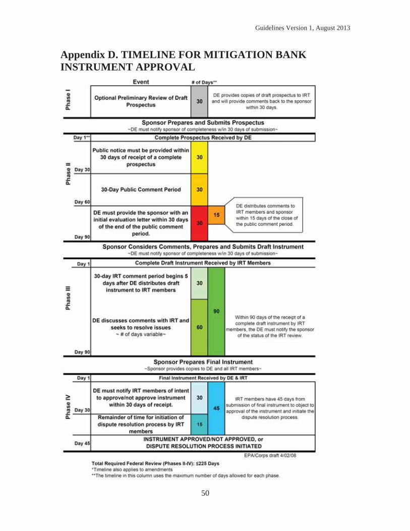
Guidelines Version 1, August 2013
50
Appendix D. TIMELINE FOR MITIGATION BANK INSTRUMENT APPROVAL
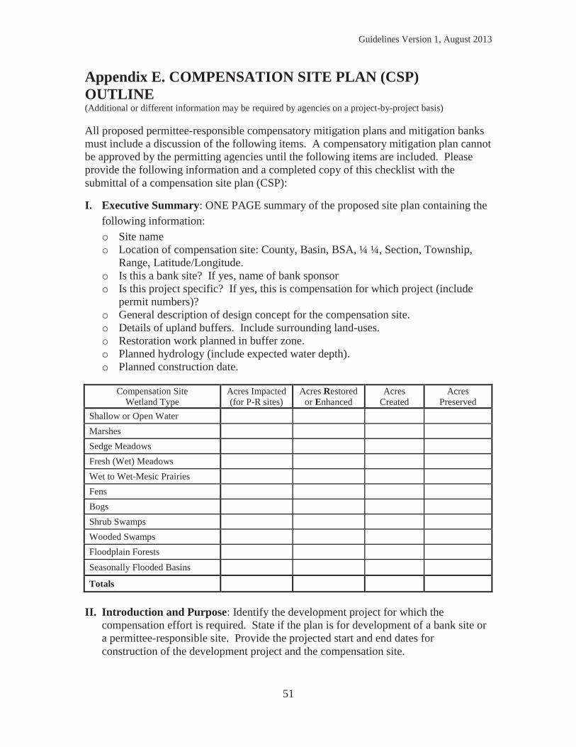
Guidelines Version 1, August 2013
51
Appendix E. COMPENSATION SITE PLAN (CSP) OUTLINE (Additional or different information may be required by agencies on a project-by-project basis) All proposed permittee-responsible compensatory mitigation plans and mitigation banks must include a discussion of the following items. A compensatory mitigation plan cannot be approved by the permitting agencies until the following items are included. Please provide the following information and a completed copy of this checklist with the submittal of a compensation site plan (CSP):
I. Executive Summary: ONE PAGE summary of the proposed site plan containing the following information: o Site name o Location of compensation site: County, Basin, BSA, ¼ ¼, Section, Township,
Range, Latitude/Longitude. o Is this a bank site? If yes, name of bank sponsor o Is this project specific? If yes, this is compensation for which project (include
permit numbers)? o General description of design concept for the compensation site. o Details of upland buffers. Include surrounding land-uses. o Restoration work planned in buffer zone. o Planned hydrology (include expected water depth). o Planned construction date.
Compensation Site
Wetland Type Acres Impacted (for P-R sites)
Acres Restored or Enhanced
Acres Created
Acres Preserved
Shallow or Open Water Marshes Sedge Meadows Fresh (Wet) Meadows Wet to Wet-Mesic Prairies Fens Bogs Shrub Swamps Wooded Swamps Floodplain Forests
Seasonally Flooded Basins
Totals
II. Introduction and Purpose: Identify the development project for which the
compensation effort is required. State if the plan is for development of a bank site or a permittee-responsible site. Provide the projected start and end dates for construction of the development project and the compensation site.
Guidelines Version 1, August 2013
52
III. Identify Plan Developers and Expertise: In order to develop a high quality wetland compensation project, a significant level of professional expertise and experience is required. Depending on the complexity of the selected site, a team of experts may be required for planning, design, construction, inspection, monitoring, and maintenance. This interdisciplinary team may include plant ecologists, hydrologists, soil scientists, hydrogeologists, contractors, engineers, and wildlife biologists. The CSP should list the personnel working on the project and include reference to past projects and qualifications. Provide the names and professional experience information for the personnel responsible for investigating the proposed site and preparing the site plan, construction plans, and specifications.
IV. Site Selection: A description of the factors considered during the site selection process. This should include consideration of the watershed needs, on-site alternatives where applicable and the practicability of accomplishing ecologically self-sustaining wetland restoration, establishment, enhancement, and/or preservation at the compensatory mitigation site. Explain why the proposed site was chosen of all the site alternatives considered. Provide the detailed site location by County, Township, Range, and Quarter-Quarter section. Locate the site on the USGS 1:24,000 quadrangle map.
V. Mitigation Objectives: A description of the wetland type(s) and acres that will be restored, created, enhanced and/or preserved. A discussion of the wetland functions and services and how these functions and services address the needs of the watershed. The watershed approach shall be implemented according state and federal law and Chapter 2.C.
VI. Baseline Information: A description of the ecological characteristics of the proposed compensatory mitigation site and, in the case of an application for a federal or state required permit, the impact site. This should include descriptions of historic and existing conditions and other site characteristics appropriate to the wetland resource proposed as compensation.
o survey of current contours; o summary of historic and current on-site land uses; o description of current zoning designations; o description of nearby land uses; o description of any known historic/archeological resources on the site; o assessment of the geology and soils on site using the county soil survey and
some representative borings; o description of current hydrology including channelized and un-channelized
flows, groundwater, and tiling information; o description of the present flora; o description of fauna using the site; o NRCS and WWI mapping of the site; o wetland delineation in accordance with the 1987 Corps of Engineers Wetland
Delineation Manual and any applicable Regional Supplement(if wetland currently exists on the site);
Guidelines Version 1, August 2013
53
o wetland functions and services assessment of any wetlands existing on the site;
o floodplain mapping of the site; o description of any state navigable waters on or near the site; o description of the site in context of other wetlands, wildlife habitat, and
natural areas (corridor concepts); and o NHI search results.
VII. Site Map: The site map should be at a scale of 1 inch = 400 feet and should show
1 foot contours. A map should also be provided showing a clear outline of the property boundaries, showing the boundaries of all current and proposed vegetative communities, and any other pertinent current or proposed land features.
VIII. Mitigation Work Plan: Detailed written specifications and work descriptions for the compensatory mitigation project, including, but not limited to, the geographic boundaries of the project; construction methods, timing, and sequence; source(s) of water, including connections to existing waters and uplands; methods for establishing the desired plant community; plans to control invasive plant species; the proposed grading plan, including elevations and slopes of the substrate; soil management; and erosion control measures. For stream mitigation projects, the mitigation work plan may also include other relevant information, such as plan form geometry, channel form (e.g., typical channel cross-section), watershed size, design discharge, and wetland area plantings.
IX. Determination of Credits: A description of the number of credits to be provided,
including a brief explanation of the rationale for this determination (wetland assessment method). For permittee-responsible mitigation, this should include an explanation of how the compensatory mitigation project will provide the required compensation for the unavoidable impacts to aquatic resources resulting from the permitted activity.
X. Performance Standards: Ecologically-based standards (hydrology, plant survival,
species composition, habitat features, etc.) that will be used to determine whether the compensatory mitigation project is achieving its objectives. Performance standards are a list of quantifiable objectives that must be met so that the project can be objectively evaluated to determine if the site is developing in to the desired resource type, providing the expected functions and services, and attaining any other applicable metric. Specific requirements and additional guidance for performance standards can be provided by permitting agencies upon request but are often set on a case-by-case basis.
XI. Monitoring Requirements: Provide a description of the parameters to be monitored,
a description of the monitoring methods, and a monitoring schedule. The site attributes to be monitored and level of monitoring effort proposed should be sufficient to determine if the compensatory mitigation project is on track to meet the performance standards and provide the functional improvements described in the site
Guidelines Version 1, August 2013
54
objectives. Monitoring will also indicate need for corrective actions and trigger points for management activities; therefore, the monitoring plan should also have provisions for determining whether adaptive management is needed at various points throughout the monitoring period and provide alternatives as discussed in the adaptive management plan. A schedule for reporting monitoring results to the permitting agencies must also be included. Specific requirements and guidance on site monitoring can be provided by permitting agencies upon request but are often set on a case-by-case basis.
XII. Maintenance Plan: A description and schedule of maintenance requirements to
ensure the continued viability of the resource once initial construction is completed.
XIII. Long-Term Management Plan: Descriptions of how the compensatory mitigation project will be managed after performance standards are achieved to ensure the long-term sustainability of the resource. The party responsible for the long-term management must be identified. In addition, if the nature of the long-term management proposed is sufficient to warrant funding dedicated to that task, a long-term financing mechanism must also be identified.
XIV. Adaptive Management Plan70: This plan should address strategies to address
unforeseen issues associated with site conditions or other components of the compensatory mitigation plan. This plan will guide decisions for revising the original construction plan and implement measures to address both foreseeable and unforeseen circumstances that could adversely affect the success of the compensatory mitigation project. The plan must identify the party or parties responsible for implementing the adaptive management plan.
XV. Implementation Schedule: Provide details on timelines for the construction
work, plantings, inspections, and follow-up monitoring. Identify other permits that may be required for the construction work. Except for cases involving after-the-fact permits, construction of the compensation site must occur before or at the same time as construction of the development project.
XVI. Site Protection Instrument: A description of the legal arrangements and
documents including verification of site ownership used to ensure the long-term protection of the compensatory mitigation site. Contact the permitting agencies for appropriate templates of conservation easements or comparable legal instruments.
XVII. Financial Assurances: A description of financial assurances that will be provided
and how they are sufficient to ensure a high level of confidence that the compensatory mitigation project will be successfully completed and managed for the long-term, in accordance with the required ecological performance standard. The financial assurance can be in the form of performance bonds, escrow accounts, or other appropriate instruments approved by the permitting agencies. For government agencies or a public authority, permitting agencies may accept a formal, documented
70 Chapter NR 350.09(4), Wisconsin Administrative Code

Guidelines Version 1, August 2013
55
commitment to funding the project or bank program as an acceptable assurance on a case-by-case basis (e.g., documentation that funds allocated by a legislature or from bonding are encumbered for a specific project). Contact the permitting agencies for appropriate templates of acceptable financial assurances.
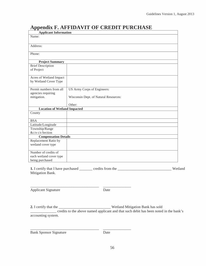
Guidelines Version 1, August 2013
56
Appendix F. AFFIDAVIT OF CREDIT PURCHASE Applicant Information Name: Address: Phone: Project Summary Brief Description of Project
Acres of Wetland Impact by Wetland Cover Type
Permit numbers from all agencies requiring mitigation.
US Army Corps of Engineers: Wisconsin Dept. of Natural Resources: Other:
Location of Wetland Impacted County
BSA Latitude/Longitude Township/Range &1/4-1/4 Section
Compensation Details Replacement Ratio by wetland cover type
Number of credits of each wetland cover type being purchased
1. I certify that I have purchased _______ credits from the _____________________________ Wetland Mitigation Bank. _____________________________________ _______________ Applicant Signature Date 2. I certify that the ____________________________ Wetland Mitigation Bank has sold ______________ credits to the above named applicant and that such debit has been noted in the bank’s accounting system. _____________________________________ _______________ Bank Sponsor Signature Date
Guidelines Version 1, August 2013
57
Appendix G. PLANT COMMUNITY TYPES The following eleven plant community descriptions shall be used in applying the requirement that mitigation should be in-kind when possible. The permitting agencies have opted to use the wetland community type classifications as defined in the book, “Wetland Plants and Plant Communities of Minnesota and Wisconsin,” by Steve Eggers and Donald Reed (2011)71: 1) shallow or open water, 2) marshes, 3) sedge meadows 4) fresh (wet) meadows, 5) wet to wet-mesic prairies, 6) calcareous fens, 7) bogs, 8) shrub swamps, 9) wooded swamps, 10) floodplain forests, and 11) seasonally flooded basins. Any permitted wetland impacts will be defined by one of the eleven community types above when evaluating if the compensation proposed is in-kind. The permittee must attempt to mitigate for these losses by generating permittee-responsible credits or purchasing wetland mitigation bank credits that are of the same type as the impacted wetland. Compensatory mitigation done “out-of-kind” shall be subject to a higher credit ratio as explained in Chapter 3. 1. Shallow or Open Water Shallow, open water plant communities generally have water depths of less than 6.6 feet. Submergent, floating and floating-leaved aquatic vegetation including pondweeds, water-lilies, water milfoil, coontail, and duckweeds characterize this wetland type. Size can vary from a one-quarter-acre pond, to a long oxbow of a river or shallow bay of a lake. Floating vegetation may or may not be present depending upon the effects of the season, wind, availability of nutrients, and aquatic weed control efforts. 2. Marshes (Deep or Shallow Marshes) Marshes are characterized by emergent aquatic plants growing in permanent to seasonal, shallow water. Species of shallow, open water communities, as well as those found in sedge meadows and seasonally flooded basins, also occur in marshes. Species characteristic of sedge meadows and seasonally flooded basins also occur in marshes and may colonize muskrat lodges, floating mats, and muck soils exposed during droughts or artificial drawdowns. Emergent aquatic plants typically become established and spread when water levels are low or when the marsh substrate is exposed, and then persist when water levels rise. However, if water levels rise too quickly, or rise to levels higher than normal, emergent vegetation may not survive, or may rise to the water surface as floating mats. Muskrats can eat through emergent vegetation, creating open water areas within the marsh that favor waterfowl use. Unchecked, muskrats can eliminate emergent vegetation, leaving an open water area until the next drought or drawdown allows emergent vegetation to recover. Deep marsh plant communities have standing water depths of between 6 inches and 3 or more feet during the growing season (Shaw and Fredine, 1971). Herbaceous emergent, floating, floating-leaved, and submergent vegetation compose this community, with the major dominance by cattails, bulrushes, pickerelweed, giant bur-reed, common reed, wild rice, pond weeds and/or water-lilies. 71 Eggers, Steve D., and Donald M. Reed. 2011. Wetlands Plants and Plant Communities of Minnesota and Wisconsin, Third
Edition. U.S. Army Corps of Engineers, Regulatory Branch St. Paul District. 478 pp.
Guidelines Version 1, August 2013
58
Shallow marsh plant communities have soils that are saturated to inundated, by standing water up to 6 inches in depth, throughout most of the growing season (Shaw and Fredine 1971). Herbaceous emergent vegetation such as cattails, bulrushes, arrowheads, and lake sedges characterize this community. Floating and floating-leaved vegetation strata are typically reduced and the submergent vegetation stratum is absent. 3. Sedge Meadows
Sedge meadows are dominated by the sedges (Cyperaceae) growing on saturated soils. Most of the sedges present are in the genus Carex, but also present are those of Eleocharis (spike-rushes), Scirpus (bulrushes), and Cyperus (nut-grasses). Grasses (Poaceae), especially Canada bluejoint grass, and true rushes (Juncus), may also be present. 4. Fresh (Wet) Meadows Fresh (wet) meadows are dominated by grasses, such as redtop grass and reed canary grass, and by forbs such as giant goldenrod, growing on saturated soils. The grass family (Poaceae) and aster family (Asteraceae) are well represented in fresh (wet) meadows. The forbs and grasses of these meadows tend to be less competitive, more nutrient demanding, and often shorter-lived species than the sedges of the sedge meadow community. Therefore, fresh (wet) meadows may represent younger communities that indicate recent disturbances of other inland fresh meadows by drainage, siltation, cultivation, pasturing, peat fires and/or temporary flooding. Once established, the forbs and grasses of the fresh (wet) meadow community may persist for extended periods of time. Many fresh (wet) meadows in Wisconsin are dominated by reed canary grass (Phalaris arundinacea), a very aggressive, invasive species that can form near monotypes persisting for decades. Disturbances such as artificial drainage, plowing, mechanized land-clearing, road construction, excessive sediment and/or nutrient inputs, allow reed canary grass to outcompete native plant assemblages. Not all fresh (wet) meadows in Wisconsin are dominated by non-native and/or invasive species. For example, the native Canada blue-joint grass (Calamagrostis canadensis) can dominate fresh (wet) meadow communities that may include a diversity of native forbs. 5. Wet to Wet-Mesic Prairies Wet to wet-mesic prairies are open, herbaceous plant communities dominated by native grass and grass-like species; at least half of the vegetative cover is made up of true grasses (Curtis 1971). These communities are similar to fresh (wet) meadows, but are dominated by native grasses and forbs associated with prairies such as prairie cord-grass, big bluestem, switchgrass, narrow reedgrass, gayfeather, New England aster, culver’s root, prairie dock and sawtooth sunflower. Wet to wet-mesic prairie communities predominantly occur south of the vegetation tension zone; however, some prairie communities are found in sandy barrens and wet swales north of the tension zone. Prior to European settlement, vast expanses of prairie existed in southern Wisconsin. Prairies evolved with fire and fire is essential to maintenance of prairies. Without periodic burns, prairies become subject to invasion by woody vegetation. European settlement brought two things to the
Guidelines Version 1, August 2013
59
prairie: the plow and fire suppression. Once the prairie sod was broken, and the wet prairies were drained, the deep, black soils proved to be among the most productive farmland in the world. More than 99 percent of prairies in Wisconsin were destroyed by the conversion to agricultural use. Prairies that were not plowed under were hayed or intensively grazed for decades resulting in degradation and changes in species composition. Remaining remnant prairies often suffer because of fire suppression and may be lost without intensive management. Given this nearly total loss of prairie, it is not surprising that many prairie species once common in Wisconsin are now threatened or endangered. Two prairie orchids, the western prairie fringed orchid and white lady’s-slipper, are prime examples. 6. Calcareous Fens Calcareous fens are the rarest wetland plant community in Wisconsin, and probably one of the rarest in North America. These are plant communities of saturated, seepage sites that have an internal flow of groundwater rich in calcium and magnesium bicarbonates, and sometimes calcium and magnesium sulfates as well (Curtis 1971). The calcium and magnesium bicarbonates and sulfates precipitate out at the surface, creating a harsh, alkaline soil condition. Only a select group of calcium-tolerant plants, referred to as calciphiles, can tolerate these conditions. Healthy (unaltered) calcareous fens are sedge-dominated by Carex species (e.g. sterile sedge (C. sterilis), prairie sedge (C. prairea), common stiff sedge (C. tetanica), Buxbaum’s sedge (C. buxbaumii) as well as beaked spike-rush (Eleocharis rostellata), twig –rush (Cladium mariscoides) and hair beak-rush (Rhynchospora capillacea). Characteristic grasses and forbs include wild timothy, Ohio goldenrod, Grass-of-Parnassus, common valerian, brook lobelia, and lesser fringed gentian. Shrubby cinquefoil and sage willow are characteristic shrubs. Included are species disjunct from the tundra, alpine meadows, and salt marshes. Therefore, calcareous fens are described as a hybrid community by Curtis (1971). 7. Bogs (Open or Coniferous Bogs) Bogs are a specialized wetland community found on saturated, acidic, peat soils that have low concentrations of minerals (e.g. calcium, magnesium) and essential nutrients (phosphorus, nitrogen). They support a unique assemblage of trees, low shrubs, sedges and forbs growing on a mat of Sphagnum mosses (Curtis 1971). In Wisconsin, most bogs are found north of the vegetation tension zone. Open bogs are composed of a carpet of living Sphagnum moss growing over a layer of acidic peat. Sedges, forbs and/or the low shrubs of the heath family (Ericaceae) colonize the Sphagnum moss mat, usually stunted trees of black spruce and/or tamarack may be present. Lack of forest is probably due to: conditions too wet for the tree species; Sphagnum moss mat too thin to support trees; recurrent fires; summer frosts; and/or lack of a seed source for the tree species. Coniferous bogs are similar to open bogs in plant community composition except that mature trees of black spruce and/or tamarack are the dominant canopy species growing on the Sphagnum moss mat. Sphagnum moss is the dominant groundlayer species. Sedges, orchids, and pitcher plants that have endured the shaded conditions are typically present, along with the heath family (Ericaceae) shrubs.
Guidelines Version 1, August 2013
60
8. Shrubs Swamps (Shrub Carrs or Alder Thickets) Shrub swamps are wetland plant communities dominated by woody vegetation less than 20 feet in height and with a dbh of less than 6 inches. Shrub swamps in Wisconsin are categorized as shrub-carrs and alder thickets depending on the dominant shrub species. Both occur on organic soils (peat/muck) as well as on hydric mineral soils. Shrub-carrs are plant communities composed of tall, deciduous shrubs growing on saturated to seasonally flooded soils. Dominant shrubs are typically willows, red-osier dogwood, silky dogwood, or gray dogwood. Groundlayer species typically include some of the ferns, forbs, grasses, and sedges of sedge meadow and fresh (wet) meadow communities. The diversity of groundlayer species is dependent on degree of shrub canopy cover, degree of disturbance, water source, and other factors. For example, disturbed shrub-carrs may have a groundlayer dominated reed canary grass, an invasive species. Relatively undisturbed shrub-carrs can have a high diversity of groundlayer species. Alder thickets are a tall, deciduous shrub community similar to shrub-carrs except that speckled alder is dominant. Speckled alder can pioneer exposed peat or alluvial soils because of its tiny seeds and ability to fix nitrogen. Alder thickets are generally found in and north of the vegetation tension zone. 9. Wooded Swamps (Hardwood or Coniferous Swamps) Wooded swamps are forested wetlands dominated by mature conifers and lowland hardwoods. They are usually associated with ancient lake basins and retired riverine oxbows. Wooded swamps include the northern wet-mesic forest and the southern wet and wet-mesic hardwood associations described by Curtis (1971). Hardwood swamps are dominated by deciduous hardwood trees and have soils that are saturated during much of the growing season, and may be inundated by as much as a foot of standing water (Shaw and Fredine 1971). Hummocky microtopography is a frequent trait. Dominant trees include black ash, red maple, yellow birch balsam poplar, quaking aspen and, south of the vegetation tension zone, silver maple. Northern white cedar can be a sub-dominant species in stands within and north of the vegetation tension zone. American elm is still an important component of this community, although its numbers have been greatly reduced by Dutch elm disease. Soils are often peats or mucks, but can include hydric mineral soils. Vernal pools often occur in wooded swamps. These consist of depressions within upland forests that are ponded early in the growing season, and then dry down for the majority of the growing season. The herb layer may be sparse to absent given the alternating periods of ponding and drawdown. Coniferous swamps are forested wetlands dominated by lowland conifers, primarily northern white cedar and tamarack, growing on soils that are saturated during much of the growing season, and that may be temporarily inundated by as much as a foot of standing water. Balsam fir is a component in some stands. Soils are usually organic (peat/much) but not as acidic and not as poor in nutrients and minerals as those of coniferous bogs. Instead, soils vary from somewhat mineral-poor and acidic, to
Guidelines Version 1, August 2013
61
mineral-rich and alkaline. Tamarack typically dominates on the former soils, and northern white cedar on the latter. A continuous Sphagnum moss mat is not present. Coniferous swamps occur primarily in and north of the vegetation tension zone. However, several large tamarack swamps occur south of the tension zone. 10. Floodplain Forests Floodplain forests are wetlands dominated by mature, deciduous hardwood trees growing on alluvial soils associated with riverine systems. The soils are inundated during flood events, but are usually somewhat well-drained for much of the growing season (Shaw and Fredine 1971). The most characteristic feature of floodplains is the alluvial soil that is constantly being deposited in some locations and eroded away in others. Floodplain forests typically include the northern and southern wet-mesic hardwood forest associations described by Curtis (1971). Dominant hardwoods include silver maple, green ash, river birch, swamp white oak, plains cottonwood, American elm, and black willow. The shrub layer is typically sparse to lacking because of frequent flooding. Woody vines are more prevalent in floodplain forests than any other forested wetland community. Examples include wild grape, Virginia creeper and moonseed. The herbaceous groundlayer can be sparse and include jewelweed, nettles, and certain sedges. In some cases, reed canary grass has invaded and formed a monotypic groundlayer. 11. Seasonally Flooded Basins Seasonally flooded basins are poorly drained, shallow depressions that typically have standing water for a few weeks each year, but are usually dry for much of the growing season. These basins include kettles in glacial deposits (e.g. prairie potholes), low spots in outwash plains, or depressions in floodplains. They are frequently cultivated. However, even when cultivated, wetland vegetation can become established if the planted crop is stressed or drowned out. Typical species include smartweeds, beggarticks, nut-grasses, and wild millet. One unique aspect of seasonally flooded basins is that the alternating periods of flood and drought can eliminate perennial plants so that annual plant species typically dominate the community.
Guidelines Version 1, August 2013
62
Appendix H. ADDITIONAL AGENCY PROGRAM INFORMATION In response to the February 2013 public notice soliciting comments on the draft version of these guidelines, the permitting agencies agreed that some additional information was appropriate to include in an appendix to provide members of the public additional insight into the permitting agencies specific program requirements. This appendix has been developed to provide additional information regarding: 1. USACE Watershed Approach (33 CFR Part 332.3(c)) 2. USACE “Soft” Preference for Banking Debits (33 CFR Part 332.3(b)) 3. WDNR Preference for Banking Debits (Wisconsin State Statute 281.36(3r)(a) and (b)) 1. USACE Watershed Approach The USACE must use a watershed approach to establish compensatory mitigation requirements in permits to the extent appropriate and practicable. Where a watershed plan is available, the USACE will determine whether the plan is appropriate for use in the watershed approach for compensatory mitigation. In cases where the USACE determines that an appropriate watershed plan is available, the watershed approach should be based on that plan. Where no such plan is available, the watershed approach should be based on information provided by the project sponsor or available from other sources. The ultimate goal of a watershed approach is to maintain and improve the quality and quantity of aquatic resources within watersheds through strategic selection of compensatory mitigation sites.
a. Considerations. (i) A watershed approach to compensatory mitigation considers the
importance of landscape position and resource type of compensatory mitigation projects for the sustainability of aquatic resource functions within the watershed. Such an approach considers how the types and locations of compensatory mitigation projects will provide the desired aquatic resource functions, and will continue to function over time in a changing landscape. It also considers the habitat requirements of important species, habitat loss or conversion trends, sources of watershed impairment, and current development trends, as well as the requirements of other regulatory and non-regulatory programs that affect the watershed, such as storm water management or habitat conservation programs. It includes the protection and maintenance of terrestrial resources, such as non-wetland riparian areas and uplands, when those resources contribute to or improve the overall ecological functioning of aquatic resources in the watershed. Compensatory mitigation requirements determined through the watershed approach should not focus exclusively on specific functions (e.g., water quality or habitat for certain species), but should provide, where practicable, the suite of functions typically provided by the affected aquatic resource.
(ii) Locational factors (e.g., hydrology, surrounding land use) are important to the success of
compensatory mitigation for impacted habitat functions and may lead to siting of such mitigation away from the project area. However, consideration should also be given to functions and services (e.g., water quality, flood control, shoreline protection) that will likely need to be addressed at or near the areas impacted by the permitted impacts.
Guidelines Version 1, August 2013
63
(iii) A watershed approach may include on-site compensatory mitigation, off-site compensatory mitigation (including mitigation banks or in-lieu fee programs), or a combination of on-site and off-site compensatory mitigation.
(iv) A watershed approach to compensatory mitigation should include, to the extent practicable, inventories of historic and existing aquatic resources, including identification of degraded aquatic resources, and identification of immediate and long-term aquatic resource needs within watersheds that can be met through permittee-responsible mitigation projects, mitigation banks, or in-lieu fee programs. Planning efforts should identify and prioritize aquatic resource restoration, establishment, and enhancement activities, and preservation of existing aquatic resources that are important for maintaining or improving ecological functions of the watershed. The identification and prioritization of resource needs should be as specific as possible, to enhance the usefulness of the approach in determining compensatory mitigation requirements.
(v) A watershed approach is not appropriate in areas where watershed boundaries do not exist, such as marine areas. In such cases, an appropriate spatial scale should be used to replace lost functions and services within the same ecological system (e.g., reef complex, littoral drift cell).
b. Information needs. (i) In the absence of a watershed plan determined by the USACE to be appropriate for use in the watershed approach, the USACE will use a watershed approach based on analysis of information regarding watershed conditions and needs, including potential sites for aquatic resource restoration activities and priorities for aquatic resource restoration and preservation. Such information includes: current trends in habitat loss or conversion; cumulative impacts of past development activities, current development trends, the presence and needs of sensitive species; site conditions that favor or hinder the success of compensatory mitigation projects; and chronic environmental problems such as flooding or poor water quality.
(ii) This information may be available from sources such as wetland maps; soil surveys; U.S. Geological Survey topographic and hydrologic maps; aerial photographs; information on rare, endangered and threatened species and critical habitat; local ecological reports or studies; and other information sources that could be used to identify locations for suitable compensatory mitigation projects in the watershed.
(iii) The level of information and analysis needed to support a watershed approach must be commensurate with the scope and scale of the proposed impacts requiring a USACE permit, as well as the functions lost as a result of those impacts.
c. Watershed scale. The size of watershed addressed using a watershed approach should not be larger than is appropriate to ensure that the aquatic resources provided through compensation activities will effectively compensate for adverse environmental impacts resulting from activities authorized by USACE permits. The USACE should consider relevant environmental factors and appropriate locally developed standards and criteria when determining the appropriate watershed scale in guiding compensation activities.
Guidelines Version 1, August 2013
64
2. USACE “Soft” Preference for Banking Debits. When considering options for successfully providing the required compensatory mitigation, the USACE shall consider the type and location options in the order presented in paragraphs a through e. In general, the required compensatory mitigation should be located within the same watershed as the impact site, and should be located where it is most likely to successfully replace lost functions and services, taking into account such watershed scale features as aquatic habitat diversity, habitat connectivity, relationships to hydrologic sources (including the availability of water rights), trends in land use, ecological benefits, and compatibility with adjacent land uses. Compensatory mitigation projects should not be located where they will increase risks to aviation by attracting wildlife to areas where aircraft-wildlife strikes may occur (e.g., near airports).
a. Mitigation bank credits. When permitted impacts are located within the service area of an approved mitigation bank, and the bank has the appropriate number and resource type of credits available, the permittee's compensatory mitigation requirements may be met by securing those credits from the sponsor. Since an approved instrument (MBI including CSP and appropriate real estate and financial assurances) for a mitigation bank is required to be in place before its credits can begin to be used to compensate for authorized impacts, use of a mitigation bank can help reduce risk and uncertainty, as well as temporal loss of resource functions and services. Mitigation bank credits are not released for debiting until specific milestones associated with the mitigation bank site's protection and development are achieved, thus use of mitigation bank credits can also help reduce risk that mitigation will not be fully successful. Mitigation banks typically involve larger, more ecologically valuable parcels, and more rigorous scientific and technical analysis, planning and implementation than permittee-responsible mitigation. Also, development of a mitigation bank requires site identification in advance, project-specific planning, and significant investment of financial resources that is often not practicable for many in-lieu fee programs. For these reasons, the USACE should give preference to the use of mitigation bank credits when these considerations are applicable. However, these same considerations may also be used to override this preference, where appropriate, as, for example, where an in-lieu fee program has released credits available from a specific approved in-lieu fee project, or a permittee-responsible project will restore an outstanding resource based on rigorous scientific and technical analysis.
b. In-lieu fee program credits. Where permitted impacts are located within the service area of an approved in-lieu fee program, and the sponsor has the appropriate number and resource type of credits available, the permittee's compensatory mitigation requirements may be met by securing those credits from the sponsor. Where permitted impacts are not located in the service area of an approved mitigation bank, or the approved mitigation bank does not have the appropriate number and resource type of credits available to offset those impacts, in-lieu fee mitigation, if available, is generally preferable to permittee-responsible mitigation. In-lieu fee projects typically involve larger, more ecologically valuable parcels, and more rigorous scientific and technical analysis, planning and implementation than permittee-responsible mitigation. They also devote significant resources to identifying and addressing high-priority resource needs on a watershed scale, as reflected in their compensation planning framework. For these reasons, the USACE should give preference to in-lieu fee program credits over permittee-responsible mitigation, where these considerations are applicable. However, as with the preference for mitigation bank credits, these same considerations may be used to override this preference where appropriate. Additionally, in cases where permittee-responsible
Guidelines Version 1, August 2013
65
mitigation is likely to successfully meet performance standards before advance credits secured from an in-lieu fee program are fulfilled, the USACE should also give consideration to this factor in deciding between in-lieu fee mitigation and permittee-responsible mitigation.
c. Permittee-responsible mitigation under a watershed approach. Where permitted impacts are not in the service area of an approved mitigation bank or in-lieu fee program that has the appropriate number and resource type of credits available, permittee-responsible mitigation is the only option. Where practicable and likely to be successful and sustainable, the resource type and location for the required permittee-responsible compensatory mitigation should be determined using the principles of a watershed approach as outlined in paragraph (c) of this section.
d. Permittee-responsible mitigation through on-site and in-kind mitigation. In cases where a watershed approach is not practicable, the USACE should consider opportunities to offset anticipated aquatic resource impacts by requiring on-site and in-kind compensatory mitigation. The USACE must also consider the practicability of on-site compensatory mitigation and its compatibility with the proposed project.
e. Permittee-responsible mitigation through off-site and/or out-of-kind mitigation. If, after considering opportunities for on-site, in-kind compensatory mitigation as provided in paragraph (b)(5) of this section, the USACE determines that these compensatory mitigation opportunities are not practicable, are unlikely to compensate for the permitted impacts, or will be incompatible with the proposed project, and an alternative, practicable off-site and/or out-of-kind mitigation opportunity is identified that has a greater likelihood of offsetting the permitted impacts or is environmentally preferable to on-site or in-kind mitigation, the USACE should require that this alternative compensatory mitigation be provided.
3. WDNR Preference for Banking Debits Section 281.36 of Wisconsin Statutes states the WDNR gives preference for wetland individual permittees to complete the required mitigation obligation through the purchase of wetland mitigation bank credits over the establishment of a permittee-responsible wetland mitigation site. An excerpt from Section 281.36 reads as follows: “(3r) Mitigation; In Lieu Fee Subprogram. (a) The department shall establish a mitigation program that applies only to the issuance of wetland individual permits and that allows mitigation to be accomplished by any of the following methods:
1. Purchasing credits from a mitigation bank located in this state. 2. Participating in the in lieu fee subprogram, if such a subprogram is established under par. (e). 3. Completing mitigation within the same watershed or within one-half mile of the site of the
discharge.
(b) Under the mitigation program, mitigation as specified in par. (a) 1. and participation in the in lieu fee subprogram, if established under par. (a) 2. shall be the preferred types of mitigation.”